landscape reconstruction at waterfall · pdf filelandscape reconstruction at waterfall gully...
TRANSCRIPT

Landscape Reconstruction atWaterfall Gully
Sir Samuel Davenport's use of land in thelate 1800's
By Aaron J Yanner
October 2005
Thesis submitted in partial fulfillment of the Degree ofBachelor of Archaeology with Honors in the Department ofArchaeology, Faculty of Education, Humanities, Law andTheology at Flinders University of South Australia
1
Table of Contents1. Introduction..............................................................................................................................5
1.1 Aims:....................................................................................................................................51.2 Chapter Outline.................................................................................................................5
2. Theory and Literature Research..........................................................................................72.1 Introduction .....................................................................................................................7
2.1.1 Early Archaeology.............................................................................................72.1.2 Settlement Patterns..........................................................................................72.1.3 Historical Archaeology....................................................................................72.1.4 Landscape Archaeology...................................................................................8
2.2 Landscape Archaeology and Cultural Landscapes.....................................................82.3 Pioneer industries and early agriculture in South Australia....................................9
2.3.1 Viticulture and Wine making.........................................................................92.3.2 Olives and Olive oil........................................................................................102.3.3 Tobacco............................................................................................................10
2.4 Review of prior reports of the Beaumont and Waterfall Gully area.....................112.4.1 The Village of Beaumont...............................................................................112.4.2 Waterfall Gully area.......................................................................................11
3. Methodology..........................................................................................................................123.1 Research Parameters......................................................................................................12
3.1.1 Study Area.......................................................................................................123.1.2 Time Period.....................................................................................................12
3.2 Archaeological Investigation........................................................................................123.2.1 Surveys.............................................................................................................12
3.3 Historic Research............................................................................................................123.3.1 Texts.................................................................................................................123.3.2 Historic Photos...............................................................................................133.3.3 Maps..................................................................................................................13
4. Historical Background..........................................................................................................144.1 Setting the scene.............................................................................................................144.2 Early years........................................................................................................................144.3 Davenport first arrives in Australia............................................................................144.4 Davenport's civil service...............................................................................................154.5 Beaumont and Waterfall Gully.....................................................................................164.6 The Industries of Beaumont.........................................................................................17
4.6.1 Olive press and wine cellar..........................................................................174.6.2 Olives and olive oil.........................................................................................184.6.3 Vines and wine...............................................................................................19
4.7 Final years........................................................................................................................205. Results.....................................................................................................................................21
5.1 The Village of Beaumont...............................................................................................215.1.1 Gleeville............................................................................................................215.1.2 The Davenport Olives....................................................................................245.1.3 Beaumont House............................................................................................255.1.4 Olive Press and Wine Cellar.........................................................................28
5.2 Waterfall Gully.................................................................................................................29
2

5.2.1 Samuel Finn's cottage....................................................................................295.2.2 Finn's Cottage 1, 74 Waterfall Gully Road.................................................295.2.3 Finn's Cottage 2, “The Olives,” 93 Waterfall Gully Road .......................325.2.4 Woolshed, Woolshed Gully...........................................................................325.2.5 Apple Store, Woolshed Gully.......................................................................355.2.6 Olive Orchard, 116 Waterfall Gully Road..................................................36
5.3 Other sites around Mount Lofty..................................................................................365.3.1 The Youth Hostel...........................................................................................365.3.2 Keir's Cottage..................................................................................................385.3.3 “Davenport's Hut”..........................................................................................42
6. Discussion...............................................................................................................................436.1 Wine, vine and olive oil..................................................................................................43
6.1.1 Vineyards.........................................................................................................436.1.2 Olives................................................................................................................456.1.3 The Cellar........................................................................................................46
6.2 Some of those employed by Davenport.....................................................................476.2.1 Samuel Finn ....................................................................................................476.2.2 John Kier..........................................................................................................486.2.3 Other huts and other workers.....................................................................48
6.3 The Houses of Sir Davenport.......................................................................................496.4 Other activities at first creek and beyond.................................................................52
6.4.1 Livestock..........................................................................................................526.4.2 Other Agricultural Industries......................................................................53
6.5 Conclusions.....................................................................................................................546.6 Conservation ..................................................................................................................556.7 Difficulties.......................................................................................................................55
7. References...............................................................................................................................57Appendix A: Maps......................................................................................................................59Appendix B: Measurements.....................................................................................................62
Keir's Cottage.........................................................................................................................62The Woolshed.........................................................................................................................63
Illustration IndexIllustration i: Plan of the Village of Beaumont from 1848 (Simpson 1993) 15Illustration ii: Davenport's sketch of his Cellar showing how his oil is made(Davenport 1875a) 17Illustration iii: Gleeville in 1902 (Cleland 1949) 20Illustration iv: Gleeville as it is today 22Illustration v: The barn behind Gleeville 22Illustration vi: The rows of the Davenport Olives facing towards Gleeville 23Illustration vii: An olive tree that has become many in the Davenport Olives 24Illustration viii: Beaumont House 24Illustration ix: The Door to Beaumont House 25
3
Illustration x: Beaumont House side on 26Illustration xi: Barn at Beaumont House 26Illustration xii: The Chilean Mill from the Cellar 27Illustration xiii: Slate Tank at Willunga much like the tanks that Davenport used27Illustration xiv: Surveyor's map drawn by J. C. Lovely on the 27 August 1903 ofsections 1005 & 1053 in Waterfall Gully 28Illustration xv: Samuel Finn's cottage as it stands today 29Illustration xvi: A window at Finn's cottage 29Illustration xvii: Samuel Finn's Cottage at Chamber's Gully - No date 30Illustration xviii: Samuel Finn's Cottage some time after 1903 30Illustration xix: Exposed Wall at "The Olives" 31Illustration xx: The remains of the Woolshed 31Illustration xxi: Layout of the Woolshed ruin 32Illustration xxii: The east wall of the Woolshed 33Illustration xxiii: Pile of horse shoes found at the Woolshed 34Illustration xxiv: Stone with fabric 'glued' to it 34Illustration xxv: Rusty remains of a blade 34Illustration xxvi: Sketch of the Apple store 35Illustration xxvii: The Youth Hostel 36Illustration xxviii: The ruin of Keir's Cottage 37Illustration xxix: The layout / floorplan of Keir's Cottage 39Illustration xxx: The fireplace in the "Master Bedroom" 40Illustration xxxi: The fireplace in the "Family Room" 40Illustration xxxii: Map of Beaumont showing where the vineyards and olive groveswere before subdivisions 45Illustration xxxiii: Map showing the extent of possible grazing land 51Illustration xxxiv: Map of Waterfall Gully showing the detail of Finn's garden and thepossible extent of Davenport's experimental garden 53Illustration xxxv: Clelands conservation park area (National Parks and Wildlife SA1983) 58Illustration xxxvi: Cleland Conservation park map showing historic locations(National Parks and Wildlife SA 1983) 59Illustration xxxvii: Land in Waterfall Gully area that Davenport owned (National Parksand Wildlife SA 1983) 60
4
1. IntroductionSir Samuel Davenport founded two villages in South Australia, Macclesfield and Beaumont. He
Introduced the olive oil industry to Australia and owned great tracks of land at First Creek, also known
as Waterfall Gully. This thesis looks at what Davenport was doing with his land in Waterfall Gully and
by extension, Beaumont, where he lived during this time.
1.1 Aims:
• To discover what agricultural pursuits Davenport was involved in.
• To locate evidence of Davenport's agricultural pursuits in Waterfall Gully.
• To create a picture that reflects the pursuits undertaken in Beaumont and Waterfall Gully.
1.2 Chapter Outline
Chapter two, the archaeological theory of landscape archaeology will be looked at. This is
because the only way to find out the history of the land, is to look at the land and landscape, which is
precisely what landscape archaeology is about. Some of the pioneering industries that Davenport
concerns himself with are examined here as well. Finally previous works on the area concerned are
looked at.
Chapter three outlines the methods used to carry out the research. This includes archaeological
investigation, historical research as well as giving the parameters of the study.
Chapter four details the historical background of Sir Samuel Davenport. Starting with his father,
George Davenport and his links to the colony and reasons for sending his sons to Australia to
Davenport's early life traveling abroad. This chapter includes Davenport's experiences in Australia and
the history of Beaumont as well as his industrial pursuits.
Chapter five is the body of work, outlining the research carried out on each site identified. The
results are segmented into three sections; Beaumont, Waterfall Gully, Other sites around Mt Lofty.
Here is were each site is looked at and the data relevant to it presented.
In chapter six it is discussed how each site relates to Davenport and what it means. This chapter,
too, is segmented. the first part “Wine, vine and olive oil” looks at what is historically put fourth as
Beaumont's only industry and Davenport's primarily concern during this time. “Some of those
employed by Davenport,” looks at the men who worked in Waterfall Gully and the slopes of Mount
5

Lofty for Davenport, what they did and when they did it. “The Houses of Sir Davenport” looks at
exactly that, the houses he lived in and why he moved from one to the other. Finally “Other activities at
first creek and beyond” look at what else Davenport was doing with his land. After that the thesis is
concluded.
6
2. Theory and Literature Research
2.1 Introduction
Landscape archaeology is a relatively new subspeciality within historical archaeology. (Yamin
& Metheny 1996). Essentially landscape archaeology is the study of a landscape to reconstruct previous
human modification to it. '... Landscape archaeology is increasingly a rubric for the study not just of
gardens and formal landscapes but of land use over time...' (Beaudry 1996).
2.1.1 Early Archaeology
The first major geographical studies used in archaeology in the early 1900's were stratigraphy,
and it was only used for the chronological ordering of data (Willey & Sabloff 1993). Before that point
archaeologists had only looked at artifacts in a descriptive, typological and iconographical point of
view (Willey & Sabloff 1993). By the 1940's archaeologists had been looking at 'area synthesis,' but
only as a way of ordering archaeological material in to a spatialtemporal framework (Willey & Sabloff
1993). The results of these area synthesis studies of sites was a diagram which had chronological
periods in a vertical column and geographical subdivisions on the horizontal (Willey & Sabloff 1993).
2.1.2 Settlement Patterns
Between 1940 and 1960 archaeologists became interested in context and function, proposing
that artifacts are '...to be understood as the material relics of social and cultural behavior' (Willey &
Sabloff 1993). As a part of contextualfunctional studies, the settlement patterns, how past peoples
placed themselves on the landscapes in relation to natural features and other peoples, was used to find
clues about the '...understanding of socioeconomic adaptations and sociopolitical organizations'
(Willey & Sabloff 1993). One such study in 1946 of the Viru Valley (Peru) by Willey, 'Prehistoric
Settlement Pattern in the Viru Valley,' made use of aerial photography, and detailed maps made of the
sections of the valley (Willey & Sabloff 1993). Now, settlement pattern studies are almost a 'mandatory
first step,' for any archaeological investigation of prehistoric societies studying social or political
change (Willey & Sabloff 1993).
2.1.3 Historical Archaeology
In more resent years, it has occurred to many archaeologists that archaeology need not only be
about ancient and 'barbaric' cultures (Daniel 1975). Historical Archaeology has gradually developed,
7
helped along with the development of 'folk' museums in Sweden, Wales, Norway and the like (Daniel
1975). Journals about various parts of history have also been published, Medieval Archaeology founded
in 1957, Industrial Archaeology founded in 1966 both in Britain (Daniel 1975). The Society for
Historical Archaeology was founded in 1967 in the USA and publishes the Journal of Historical
Archaeology (Daniel 1975). In the USA, Colonial Williamsburg is considered to be a classic example
of historical, or colonial, archaeology at it's best (Daniel 1975). In Australia Historical archaeology has
been practised since the late 1960's (Birmingham & Murry 1987), but has no real comparable example
to Colonial Williamsburg (Jack 1985).
2.1.4 Landscape Archaeology
Landscape archaeology is a relatively new subspecialty within historical archaeology. (Yamin
& Metheny 1996). The topic's genesis is generally quoted as being W. G. Hoskin's 1955 work entitled
'Making of the English landscape' (Williamson 1998). The book made some, all be it little, use of
archaeological evidence, mostly for medieval villages, but was focused on the landscape field shapes,
settlement patterns as well as buildings (Williamson 1998).
2.2 Landscape Archaeology and Cultural Landscapes
To study the (cultural) landscape as an artifact provides a vital link to the past (Beaudry 1996).
As the site is agricultural and wide spread, it is necessary to look at more than just the buildings in the
study area. The area being as large as it is, roads and access to the individual sites is important
information, as well as where and how crops were laid out. It will be necessary to 'reconstruct' the
landscape before it can be understood as an 'artifact.'
Early efforts of reconstruction of historical landscapes were based on documentary research
alone, for example; Colonial Williamsburg during the 1930s and 1940s (Beaudry 1996). 'The results
may have been aesthetically pleasing, but often they were intellectually unsatisfactory, for historical
records tend to be spotty, incomplete, vague and subject to multiple interpretations' (Beaudry 1996). It
is therefore important to back up any research done with archaeology as it is the only real way of
getting any hard data about the form, style and content of past landscapes (Beaudry 1996).
Beaudry (1996) states that archeology is the only means at hand for recovering precise information
about the earlier configuration and content of landscapes and former gardens.
It is important to look at the landscape as a whole, so as to keep each site in context with the
8
original meaning. Davenport's farming area covers quite a large area and it is how each site relates to
each other and the areas in between that will revel the picture of the C19 Mediterranean influenced
farming.
2.3 Pioneer industries and early agriculture in South Australia
As Davenport may have used different farming techniques as well as pioneering the growing
different crops to his contemporary English born SA citizens, it is of importance to see in what ways he
differed. This will help to interpret the site as a whole, knowing what parts of the farm were typical and
what parts were new or uncommon.
Davenport's agricultural interests were quite extensive. He experimented with a lot of
Mediterranean crops and industries, but focused and in some cases pioneered, only a few. The olive,
and vine where probably his primary focus, as well as taking great interest in almonds and sericulture,
as well as tobacco.
2.3.1 Viticulture and Wine making.
'One of the earliest preoccupations of the settlers, and one which has persisted and prospered,
was that of viticulture for making wines and spirits' (Birmingham 1979:158).
Land preparation in the earliest vineyards consisted of digging a deep hole for each cutting, with the
intervening spaces untilled. This meant that in periods of heavy rainfall the vine roots became
waterlogged and rotted, and Shepherd recommended deep trenches rather than individual holes. Several
vineyards of the 1830s and 1840s were planted in deep trenches, and their parallel lines can still often
be seen clearly as 'crop marks' James King's at Irrawang for example, or William Cox's at Mulgoa.
Deep trenching was costly, however, and later writers make it clear that it had long been abandoned in
favour of allover ploughing to a depth of 2030 cm. (Birmingham 1979:158)
After the growing comes the wine making. Its essential processes are extremely simple, readily
comprehended and practised by a large proportion of European peasants. Essentially, wine making
requires the conversion by yeasts of much of the sugar in the grapes into carbon dioxide and alcohol, a
process begun by the 'wild' yeasts on the grape skins at picking time, and continued by the true wine
yeasts which take over after about thirtysix hours. It is first necessary to crush the grapes so that juice
is released, traditionally done by treading the grapes in an enclosed container from which the juices or
'must' can flow freely, but later done mechanically in perforated cylinders provided with vanes that
9

strip the grapes from their stalks. (Birmingham 1979:159)
The second stage is fermenting. Fermenting vats were usually built of brick or cement, so that they may
be found in situ. Modern fermentation vats in the larger wineries are often about 20 000 litres capacity
but they can be as small as 2000 litres. Other materials can also be used red gum as at Bleasdale, for
example, or Dr Kelly's wellknown slate vats which still survive at Tintara. Vats made of imported
wood were valuable items, and certainly subject to reuse. Maturing and storage casks might also be
found, although the same problem of reuse probably arises. Again the archaeologist should be on the
lookout for the iron hoops (about 5 cm wide) which may be all the white ants have left of a once
flourishing establishment. (Birmingham 1979:160)
In South Australia too, early settlers began to plant vineyards close to the early settled district; Adelaide
has even managed to retain one of these within 7 km of the city centre Patrick Auld's Auldana Vineyard
and cellars at Magill, purchased in 1842 and planted in 1852. (Birmingham 1979:166)
2.3.2 Olives and Olive oil
Samuel Davenport said in an address to the Chamber of Manufactures; 'A few and favored parts only of
the globe can grow the olive ... South Australia can, therefore South Australia should grow it' (1875a:
14). Olives, like grapes, were a Mediterranean crop which early attracted the new settler in a land where
soil and climate appeared very similar to Mediterranean conditions, as was made explicit in the
Australian Agricultural Co. 's Charter. (Birmingham 1979:176)
In 1844 olive cultivation was introduced into South Australia around the Adelaide Gaol to give
employment to the prisoners, and on a large scale by Sir Samuel Davenport on the Beaumont Estate,
Adelaide, where some of the trees survive. (Birmingham 1979:176)
Crushing was usually done with a Chilean mill turning slowly in a stone bed, crushing olive stones as
well as the fruit to extract all the oil. The pulp is then collected into loosewoven sacks and pressed in a
simple log or screw press. Oil exudes through the sacks and is collected in pure water, the oil floating
to the top, any impurities sinking. A second pressing after the application of hot water yields the final
oil (Birmingham 1979:176).
2.3.3 Tobacco
Tobacco, another warm climate crop that seemed to promise well for the colony, was an early
introduction. (Birmingham 1979:176)
10
The early Australian leaf, with all the problems of adaptation, must have been a very basic chew or
smoke; most of it was used to make a liquor to be painted on sheep suffering from the scab.
After harvesting the leaves must be cured before they are ready for manufacture. Curing involves
drying by sun, airdraught or by flues in a kiln. The former methods produce dark brown to black leaf;
only the latter can retain the yellow stage of the drying colour change. (Birmingham 1979:176)
2.4 Review of prior reports of the Beaumont and Waterfall Gully area
2.4.1 The Village of Beaumont
Only one “report” could be found for anything in the Beaumont area. That report is the
architectural history of Beaumont House, by Taylor (1989) for the National Trust of South Australia.
The report has very detailed study of the land title information for the land directly relating to
Beaumont House.
E.R. Simpson has written two books that have relevant information to Davenport and his
activities in the area. Both of these book are concerned mostly with the history of the village or
Beaumont House, as the titles do suggest. “The Clelands of Beaumont,” (1989) is about how the
Cleland family were involved in Beaumont, whilst “Beaumont House, the land and its people,” (1993)
is a history of Beaumont centralized around Beaumont House and its owners.
“Paddocks Beneath: a History of Burnside from the Beginning” by Warburton (1981) and “The
First Hundred Years: A History of Burnside in South Australia” by Coleman (1956) both include
sections on Beaumont. Whilst Cleland's “The village of Beaumont” (1949) is very specifically a history
of Beaumont, including sections on people and places.
2.4.2 Waterfall Gully area
The “Assessment of Historic Remains, Cleland Conservation Park” by Reynolds (1989) as well
as the “Cleland Conservation Park Management Report” (1983) both have valuable data concerning
various sites within the conservation park. As Davenport owned a lot of the land that is now the part of
the park, many of the sites mentioned in the reports relate to Davenport. Probert (1988) wrote a detailed
report on the history of the ruin “Keir's Cottage.” Keir, being a worker for Davenport and the property
being within Davenport's land, the report is quite relevant.
11
3. Methodology
3.1 Research Parameters
3.1.1 Study Area
The study area is in the city of Burnside, east of Adelaide. The majority of the areas looked at
are situated along Waterfall Gully Road, along the way to Waterfall Gully. The two resedentces where
Davenport lived, Clarmont and Beumont House, will be looked at in less detail. Within Waterfall Gully
are several areas that are the focus of the study, that which the rest of the gully is put into perspective
with. These areas include two possible locations for the cottage of Davenport's gardener; a ruin refered
to as 'The Woolshed,' just in Woolshed Guly; Olive trees that may have been planted by Davenport;
and various river modifications and dry stone walling.
3.1.2 Time Period
The time period of most consern starts when Davenport takes up resedence on Beumont in
1846, until his death in 1906. The Waterfall Gully area and it's upper slopes that Davenport were
purchaced at diferant times, so only the relevant time for each section needs to be considered.
3.2 Archaeological Investigation
3.2.1 Surveys
The surveys for each site will vary with access to each location. Some locations are private
property, so access is limited. Where able, mesuring of a site will be carried out. If mesuring is not an
option, as is the case with some sites, sketches with as much detail will be made. Photos of sites and
important details will be taken.
3.3 Historic Research
3.3.1 Texts
Adelaide library held copies of items like Davenport's letters as well as his early publications on
agriculture. First hand information on what was going on is invaluble data. There are many articales on
Davenport already, most with only a historic angle, even an article written about Davenport back in
1874 has been found. The data taken from these texts can be used to locate areas of significance, whilst
the surveys can be used to possibly proove or disprove the historic record.
12

3.3.2 Historic Photos
Where a historic photo exists, it will be examined for inforomation that may not be in the
written record. Items, crops or other buildings in the background of a photo may give a vital piece of
information, by locating something that documents did not give a place for. Historic photos of sites
give an insight to what the site looked like many years ago, relaing data that there may have been no
evedence left to suggest.
3.3.3 Maps
Many maps exist of the area, but only some have information about Davenport's activities.
Older maps are likely to include places or features that are no longer there, but only if the map maker
thought it of importance. It is in combining the information on the maps with other historic information
a new picture of what the land looked like may emerge.
13
4. Historical Background
4.1 Setting the scene
George Davenport (1782 –1846) was a banker of both Oxford and Great Wigston in Leicester
(Brown 1980; p122). He was also the Stewart of the Earl of Macclesfield of Shireburn Castle (Brown
1980; p122). George eventually became one of the directors of the ‘South Australian Company’ and
director of their bank the ‘South Australian Banking Company’ (Brown 1980; p122.). He was involved
with the SAC almost since is inception and became a director in 1844 (Simpson 1993; p7). On the 22
of October 1839, George paid £4416 for a special survey of 1787 in South Australia (Brown 1980;
p122). George sent his oldest son, George Francis Davenport, out to Adelaide to conduct his business
in the new colony (Brown 1980; p122). Francis arrived in 6th of February 1840 with his wife (Simpson
1993; p7) Francis applied for 6060 hectares near Port Lincoln, but instead bought an area south of
Adelaide now known as Macclesfield (Brown 1980; p122).
4.2 Early years
Samuel Davenport was born in Shirburn, Oxfordshire, in England on March 5th, 1818 (Brown
1980; p122 & Simpson 1993; p6). He was the fourth child of George Davenport and his wife, Jane
Devereux Davies (Brown 1980; p122).
In Davenport's youth, it is said that he dove into icy waters to save the live of a drowning man
(Brown 1980; p123 & Simpson 1993; p7). He succeeded to save the man, but was left with a badly
inflamed lung that made life in the cold climate of England difficult for him (Brown 1980; p123).
Doctors advised Davenport to find a warmer climate, and as a result, he traveled abroad to Southern
Europe; Italy, Span and the South of France (Brown 1980; p123). Whilst in Europe, Davenport studied
the Arts of Cultivation of the Vine, Orange, Citron, Olive and Almond (Brown 1980; p123). According
to Simpson (1993, p7) it is generally thought that he stayed for two years.
4.3 Davenport first arrives in Australia
On the 1st of June 1842 Davenport married Margaret Fraser, only daughter of William Lennox
Cleland (Brown 1980; p123). Three months later, Samuel Davenport, his wife Margaret and his brother
Robert Davenport, all left for Australia (Brown 1980; p123). Upon arrival Samuel Davenport and
14
Margaret traveled south to Macclesfield and moved into a furnished cottage (Brown 1980; p123). Two
months after their arrival in Adelaide, Francis, their elder brother, contracted typhoid fever and died
(Brown 1980; p123). It fell to Davenport to run his father’s many interests in the colony as well as
tending to his own (Brown 1980; p123). Davenport saw Macclesfield as an English country village, and
so supplied land for a common that was named in his honour ‘Davenport Square’ (Brown 1980; p124).
To make things easier for his children in the new colony, George gave them each an allowance,
as Davenport wrote in his letters, ‘your provisioning for us an annual allowance was a very wise one. It
give time for us to gain colonial experience and ascertain the value proportionately of stock and how to
make them produce an annual return without our being crowded with fears for a years or two of the
extent of our extent.’ (Davenport 1980). This turned out to be very helpful as Davenport had trouble
finding markets for produce (Brown 1980; p123) and wrote: ‘the surplus of wheat, horned cattle, sheep,
horses etc., finds no vent of any importance, and unless some internal means of using it arise one sees
no chance at doing much in any way.’ (Davenport 1980)
‘Soon after his arrival Samuel planted six Spanish chestnuts, 2000 vine cuttings of about 25
different species and 1600 almond trees’ (Brown 1980; p124). Davenport asked his father to send out to
him seeds of the ‘tender shelled’ almonds, so he could graft them on to the existing hardshelled
almonds (Brown 1980; p124). He also made a request for certain olive seeds, to be sent from
Montpelier, in France (Brown 1980; p124).
Margaret also worked hard in the garden, establishing trees and flowers, roses, fuchsia,
geraniums, mignonette ad sweet briar to name a few (Brown 1980; p124).
4.4 Davenport's civil service
Governor Grey appointed Davenport as a magistrate, and was Gazetted on the 17 of October
1845 (Brown 1980; p124). In 1846 Mr. Jacob Hagen went overseas and Major Robe invited Davenport
to take Hagen’s seat in the Legislative Council (Brown 1980; p124). Davenport was at first hesitant,
but accepted. During this time, he saved on accommodation in Adelaide by not staying in Adelaide.
Davenport instead rode the 95 kilometre round trip from Macclesfield to Adelaide and back everyday
as required leaving at 4am and retuning the same day (Brown 1980; p124). He retired from public
office in August 1867.
Davenport was president of the Royal Agricultural and Horticultural Society, (Brown 1980;
15
p126) and during his time as such, wrote the ninetyfour pamphlet ‘Some new industries for South
Australia’ (1864) and ‘The cultivation of the olive’ (1870).
Four years later the agricultural Bureau of South Australia issued his ‘Notes on the olive and its value
to country suitable for it’s Growth.’
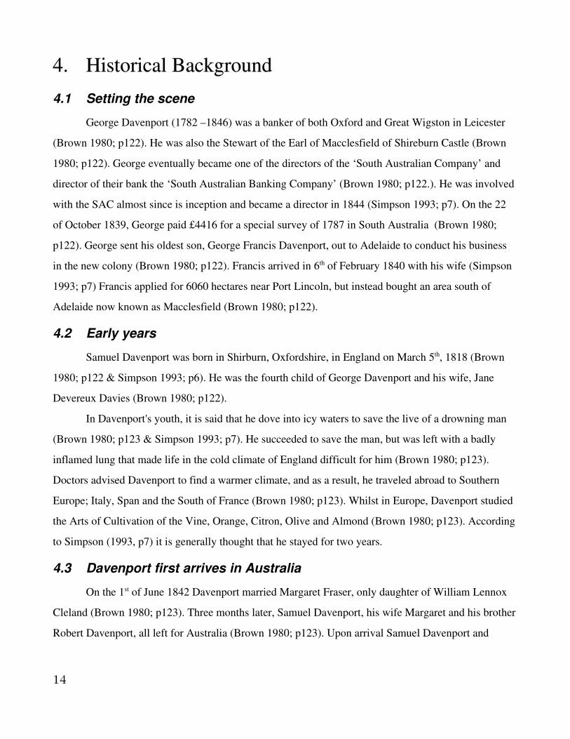
4.5 Beaumont and Waterfall Gully
Edward Burton Gleeson’s land was acquired
by the bank and put it up for government auction in
1846 (Brown 1980; p126). Davenport bought this
land and renamed it ‘Beaumont,’ then divided the
land into onehectare blocks, which he resold
immediately (Brown 1980; p126). He picked the site
of Beaumont one day whilst riding into Adelaide
from Macclesfield, to attend his parliamentary
duties (Coleman 1956; p151). He paid £700 for the
eightyacre section, with a house and out buildings
named Gleeville (Coleman 1956; p150). Gleeville is
the south west corner of Beaumont, now numbered
1 Dashwood road (Coleman 1956; p150). As with
Macclesfield, he set aside land for a town square,
the Beaumont Common (Brown 1980; p126).
Davenport immediately planted 11 hectares of land
with vines and established some olive trees (Brown
1980; p126). The olive trees were from John Bailey’s Garden, and had been imported by the South
Australian Company in 1845 (Simpson 1986; p69). Some of those olive trees still stand today; the line
of the old driveway to Gleeville from the south end of Devereux road is now a small reserve in
Beaumont known as the Davenport olives (Simpson 1986; p69). The soil being ‘a red loam resting at
no great depth upon lime (Dow 1874; p11).
One of the first residents on the section was Bishop Angus Short, ‘…who chose the highest and
coolest corner of the section…’ with a sectional creek (Coleman 1956; p151). ‘Archaeological evidence
16
Illustration i: Plan of the Village of Beaumontfrom 1848 (Simpson 1993)
suggests that he (Short) twice extended an original cottage…’ ending with ten or eleven rooms in all
(Coleman 1956; p152). Bishop Short, around 1852, writes in his diary how he had planted at Claremont
(the name of his house) olives, which he had procured from Davenport (Simpson 1986; p69).
Davenport lived in Gleeson’s Gleeville house until 1855, when he bought Claremont cottage
from Bishop Short, renaming it Beaumont House (Brown 1980; p126). The house cost Davenport
£2,100 (Coleman 1956; p152). Beaumont was intended as a gentleman’s villa, being off main roads
and on a hill, its ‘character never was modified by the needs of passing traffic or a surrounding
population dependant on it for services’ (Coleman 1956; p150). The orchard round the residence, by
1874, contained about fifteen acres of almonds, olives, mulberries, oranges, apricots, loquats, plumbs,
cherries, quinces, nectarines, peaches, pears, and apples, all but the apples did well, as they had blight
(Dow 1874; p11).
4.6 The Industries of Beaumont
4.6.1 Olive press and wine cellar
The only industry that developed at Beaumont came out of vines and olives (Brown 1980;
p126). Davenport’s wine and olive press was made of slate coloured sand stone, obtained from around
the neighborhood and was roofed with galvanized iron, the rainwater from the roof is collected into a
35,000 gallon cemented tank (Dow 1874; p11). Between the galvanized iron and a thin ceiling timber
was a foot of seaweed used as insulation (Dow 1874; p11). A small piece of land near the cellar is
planted with olive seedlings preparatory to transplanting (Dow 1874; p11).
17

4.6.2 Olives and olive oil
Davenport had managed to make a gallon of good
oil in 1864, but had been unable to crush the stones
(Simpson 1986; p69). By 1866, using a sausage machine
he made five gallons on oil (Simpson 1986; p69).
Davenport succeeded in making a small quantity of olive
oil in 1872 with ‘primitive appliances’ (Dow 1874; p10).
In 1873, the following year, he improved his methods and
obtained the necessary machinery for production of oil,
producing 150 gallons of oil of excellent quality (Dow
1874; p10). The oil was made from 75 cwt of olives, with
about 45 cwt being purchased from neighbors at 6s per
cwt (Dow 1874; p10). The olives at Beaumont were
picked by children for 5d for filling a 2gallon bucket
(Dow 1874; p10).
The olives at Beaumont are grown partly in the
orchard surrounding Davenport’s residence, Beaumont
house, and partly in the form of a hedge round a seven
and a half acre vineyard (Dow 1874; p10). The trees in this hedge were four feet apart, and eight feet
high, being 12 years old [In 1874], have closeknit branches between them forming an ‘impenetrable’
hedge (Dow 1874; p10). This style of planting did hinder the productiveness of the olive trees (Dow
1874; p10), but would have been more productive than a fence.
The extraction of the oil takes place in a portion of Davenport’s extensive building for making
and storing wine (Dow 1874; p10).The factory was on the edge of the gulch formed by the runoff from
the Beaumont hills (Simpson 1986; p73). The olives were cracked by a corn crusher (Simpson 1986;
p72), then the fruit is put into a Chilean mill of Scotch granite, the two rollers being 3 feet in diameter
and one ton each, drive by a horse (Dow 1874; p10). The crushed pulp, which resembles raspberry
jam, is then into circular flat course mat bags, two feet in diameter called ‘carbos,’ and built into a pile
enclosed by a circular upright wooden frame and subjected to immense pressure by means of a lever
18
Illustration ii: Davenport's sketch of hisCellar showing how his oil is made(Davenport 1875a)

(Dow 1874; p10 & Simpson 1986; p72). The levers worked from an old gum tree, which was about
nine feet in circumference, had been pulled up roots and all, dragged to the desired location by bullocks
and put into a three foot deep hole filled over with cement (Simpson 1986; p72). From the pressure the
oil is allowed to run into a receiver containing water (Dow 1874; p10). The receiver is fitted with a pipe
that draws off the water underneath the oil, which floats on top (Dow 1874; p10). The first press, or
virgin oil, is the most valuable (Dow 1874; p10). After this is obtained, hot water is applied to the pulp,
and a second quality is obtained, which is employed largely in cloth manufacture (Dow 1874; p10).
The oil, after standing for a month to settle, is filtered into porcelain jars (Dow 1874; p10). The priced
that Davenport could get for the oil in 1874 was 10s wholesale, for the virgin oil and 8s for the second
pressings, with an unlimited demand (Dow 1874; p10).
4.6.3 Vines and wine
On the same floor as the oil mill, the grape crushing and fermenting department were situated
and underneath were the cellars used for storage (Dow 1874; p10). The wine was conveyed after
leaving the grape crusher, down into a shoot, into four fermenting vats, to of 2000 gallons and two of
600 (Dow 1874; p10). All four of the tanks were made of slate obtained from Willunga, in slabs,
forming the sides in one piece, although the large vats required slabs of seven feet long by five feet
broad and four inches deep (Dow 1874; p10).
The cellar contained 25,000 gallon of wine from a 7 year old to the latest vintage, which was
stored in one cask of 2000 gallons, four of 1000, two slate tanks of 1000 gallons and 900 gallons and
two of 800 gallons each, the rest in one 500gallon cask (Dow 1874; p10). The 2000gallon cask was
understood to have been the largest in the colonies and had to be imported from Berlin (Dow 1874;
p10).
Davenport’s vineyard was in three portions; the first, the one with seven and a half acres and
had an olive hedge, the second of five acres and the third of ten acres, all planted using the same
method (Dow 1874; p11). Another adjoining field of seven and a half acre field had been fleshly
planted in 1874 with olive seedlings (Dow 1874; p11). The fields were trenched eighteen inches deep,
by means of using a normal plough then reploughing with a deep trench plough running along the
furrow (Dow 1874; p11).
19

4.7 Final years
In 1851 Davenport was chosen to attend the London international exhibition as executive
commissioner for SA and again in 1876 at Philadelphia, in 1879 at Sydney and in 1880 at Melbourne
(Brown 1980; p129). He was knighted in May of 1884 for his efforts in those exhibitions (Brown 1980;
p126). He was then made a K.C.M.G. in 1886 (Brown 1980; p126), but I have no idea what that
actually means. The same year Cambridge University conferred upon him it’s L.L.D. (Brown 1980;
p126).
In 1893 George Fullerton Cleland, Margaret Davenport's nephew, bought Davenport's Wine and
olive oil company and renamed it to G.F. Cleland & Sons (Simpson 1993). In 1904 wine making
stopped at the cellar and became devoted to olive oil (Simpson 1993). This continued on into 1962,
when olives became too hard to source and the Village of Beaumont was becoming residential the
Cellar closed down (Simpson 1993).
Margaret Davenport died on 6 February 1902 three months before their 16th wedding
anniversary (Brown 1980; p126). Samuel Davenport died on 3 September 1906 (Brown 1980; p126).
20
5. Results
5.1 The Village of Beaumont
The Village of Beaumont was founded and planed out by Samuel Davenport. He lived in two
houses in the village, “Gleeville” then “Beaumont House,” both which still stand. Davenport grew
some of his crops nearer to his home as the park “The Davenport olives,” near Gleeville illustrates, as
well as the large amount of Olives still on the land associated with Beaumont House. Davenport's Olive
press and wine cellar building was also in Beaumont, but now no longer exists.
5.1.1 Gleeville
Located at Number 1 Dashwood Road, Beaumont, the house is currently private property. This
survey was also limited due to the private status of the house, access was granted, but time was limited.
Gleeville now consists of a large house built of stone and brick and a large barnlike building being
used as a shed. Despite the subdivision of land in the area, this property retains a large yard, full of fruit
trees and gardens.
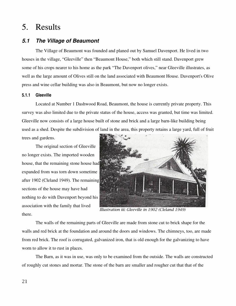
The original section of Gleeville
no longer exists. The imported wooden
house, that the remaining stone house had
expanded from was torn down sometime
after 1902 (Cleland 1949). The remaining
sections of the house may have had
nothing to do with Davenport beyond his
association with the family that lived
there.
The walls of the remaining parts of Gleeville are made from stone cut to brick shape for the
walls and red brick at the foundation and around the doors and windows. The chimneys, too, are made
from red brick. The roof is corrugated, galvanized iron, that is old enough for the galvanizing to have
worn to allow it to rust in places.
The Barn, as it was in use, was only to be examined from the outside. The walls are constructed
of roughly cut stones and mortar. The stone of the barn are smaller and rougher cut that that of the
21
Illustration iii: Gleeville in 1902 (Cleland 1949)
house. The roof of the barn is made of corrugated, galvanized iron like the house, but far less rusty.
Amongst the garden are trees of many varieties. Those trees include almond trees, mulberry
trees, a quince tree and olives. None of those can be confirmed as being part of Davenport's original
orchards. The exception to this is a single orange tree, that is the last surviving tree from from the
orange grove. The tree is quite obviously old and has died in many parts. New growth from what looks
like a near dead trunk, still flourishes and still produces oranges.
22

23
Illustration iv: Gleeville as it is today
Illustration v: The barn behind Gleeville

5.1.2 The Davenport Olives
The Davenport Olives is the name of a small reserve off of John Cleavland Drive. The reserve
consists of two rows of old olives trees, a plaque and younger trees nearer to the road. The park is
located from the back of Gleeville (from Dashwood Road) and is all that remains of the original olive
orchard planted in 1864 by Davenport. These olives were transplanted from 'Mr Bailey's Garden' and
were the first olive trees to be grown in the state (Simpson 1993). The original varieties of olives grown
here were Blanquette, Verdale, Bouquettier and Salaren (Simpson 1993).
The trees in the two rows in the park have an average circumference one meter from the ground,
of 1.87 meters. Not all the trees along the rows could be measured, as some, one meter up had
24
Illustration vi: The rows of the Davenport Olives facing towards Gleeville
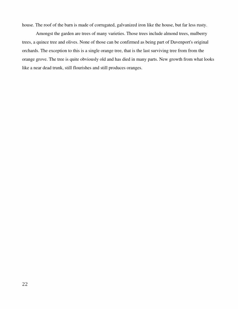
branches, whilst others were no longer one tree. The olive trees that had appeared to have become
multiple trees, all seem to have grown like the original had ripped apart. One such tree still has a piece
of dead trunk in the middle.
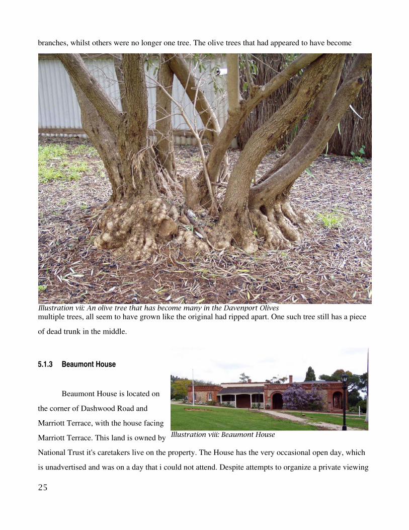
5.1.3 Beaumont House
Beaumont House is located on
the corner of Dashwood Road and
Marriott Terrace, with the house facing
Marriott Terrace. This land is owned by
National Trust it's caretakers live on the property. The House has the very occasional open day, which
is unadvertised and was on a day that i could not attend. Despite attempts to organize a private viewing
25
Illustration vii: An olive tree that has become many in the Davenport Olives
Illustration viii: Beaumont House

I was unable to gain access to Beaumont house. This house is well documented anyway, so there is
little need to go over it again. The house is in clear view from the road giving me the opportunity to
analyze some of the features.
Beaumont House is far more ornate than Gleeville. Whilst still being made of stone and brick,
far more red brick is used. The windows at the front are arched and framed by red brick the whole way
around. The red brick archway to the solid wood front door is ornately crafted. Along the side furthest
from the road running from the front of the house, back, is a series of red brick colonnades making a
porch of sorts. The stone work between the brick is very well constructed. The stone is cut in a way, so
that they fit together with only small gaps which is mortared together.
The side wall that faces the road is broken up into sections. A rendered section, a stone and
brick, like the front, a door, then another rendered section with a large chimney stack protruding from
it. The first rendered section, going back from the front, may have been constructed the same way as
26
Illustration ix: The Door to Beaumont House

the front, but with a rectangular window. The next section along is like the front, with the exception of
being a lower wall and having a rectangular window. This window is red brick framed as well, like the
arched windows at the front. The door is built out from the previous section of wall, with red brick and
the next section of wall is built out from the door, like it is stepped. The door is much more simple than
the front door and has only a small porch. The next section of wall is rendered only to a point, the
stonework is still exposed at the foundation of the wall. There are two windows in this section, both
rectangular, but both orientated differently. One is high, the other wide. The chimney on this wall is
constructed of both stone and brick, with the brick being at the sides and at the top, the large stones
make up the back wall. Where the chimney funnels up into the top brick section, appears to be made of
cement.
27
Illustration x: Beaumont House side on
Illustration xi: Barn at Beaumont House
The barn/shed building on the property is also of stone construction with red brick. The
stonework is rougher than that of the house, as lager gaps between each stone are quite apparent. The
mortar has lines, like the ones at Finn's cottage number one, but only horizontally. This probably
indicates where each level of the wall was mortared. This wall shows some indication of cracking and
repairs as well where a lighter coloured mortar is applied. The two windows on this side of the building
are both rectangular, but only slightly different from each other as is the brickwork surrounding them.
The section of land that is right on the corner of Dashwood Road and Marriott Terrace, between
Beaumont House and Dashwood road, is covered is old olive growth. It has not been looked after like
the trees of “The Davenport Olives,” but survive and give fruit all the same.
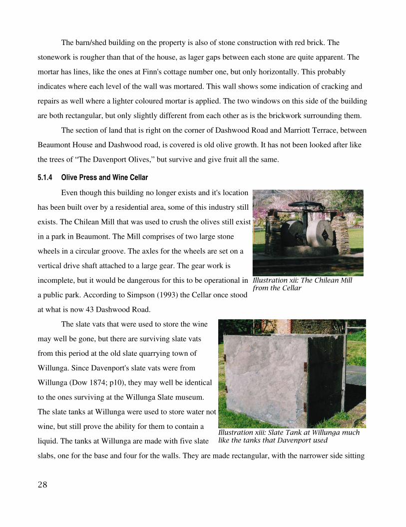
5.1.4 Olive Press and Wine Cellar
Even though this building no longer exists and it's location
has been built over by a residential area, some of this industry still
exists. The Chilean Mill that was used to crush the olives still exist
in a park in Beaumont. The Mill comprises of two large stone
wheels in a circular groove. The axles for the wheels are set on a
vertical drive shaft attached to a large gear. The gear work is
incomplete, but it would be dangerous for this to be operational in
a public park. According to Simpson (1993) the Cellar once stood
at what is now 43 Dashwood Road.
The slate vats that were used to store the wine
may well be gone, but there are surviving slate vats
from this period at the old slate quarrying town of
Willunga. Since Davenport's slate vats were from
Willunga (Dow 1874; p10), they may well be identical
to the ones surviving at the Willunga Slate museum.
The slate tanks at Willunga were used to store water not
wine, but still prove the ability for them to contain a
liquid. The tanks at Willunga are made with five slate
slabs, one for the base and four for the walls. They are made rectangular, with the narrower side sitting
28
Illustration xii: The Chilean Millfrom the Cellar
Illustration xiii: Slate Tank at Willunga muchlike the tanks that Davenport used

in from the ends of the longer sides. Two metal rods are drilled through the long sides at each end, not
to hold the smaller sides in, but the screw the two larger sides together.
5.2 Waterfall Gully
5.2.1 Samuel Finn's cottage
There are two locations given for this cottage, both along Waterfall Gully Road.
5.2.2 Finn's Cottage 1, 74 Waterfall Gully Road
The First cottage is located on the
corner of Waterfall Gully Road and
Chambers Gully Road. This is a private
residence which we were able to do a
brief survey of. The home and land
which is said to have been Finn's is
located on sections 1005 and 1053. Old
surveyor's maps indicate that the land
had been subdivided at least twice and
that Waterfall Gully Road was further
from the house than it is now.
The original cottage has been
expanded since it was first built, with the
more resent additions at the back. Early photographs illustrate some of this progression. The earliest of
the photographs, compared to the floor map plan shows the cottage may have started as a three of four
room cottage. The indication of where the fireplace is on the floor map is at the back of the room,
where the photograph has the chimney in the middle of the peek of the roof, with addition area behind
it. Although the modern floor plans do show another chimney location, it would be on the outside of
the wall in the time of this photograph. It may be that the chimney was originally in that location on the
other side of the wall, until the new room was added. That would fit the photograph better, but would
still require there to be at least one more room on the back, if not two.
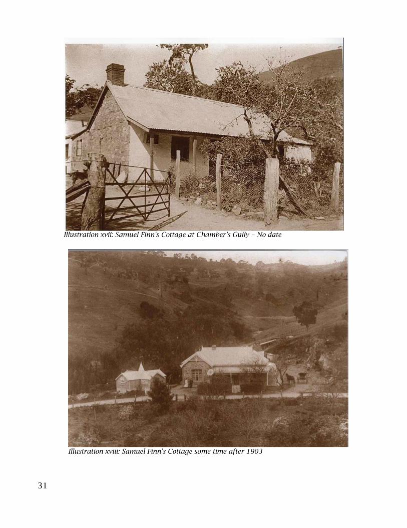
The next, more resent, historical photograph shows a much bigger house. The chimney in the
first photograph can still be seen although the “formal living” room as it is called on the floor plans has
29
Illustration xiv: Surveyor's map drawn by J. C. Lovely on the27 August 1903 of sections 1005 & 1053 in Waterfall Gully
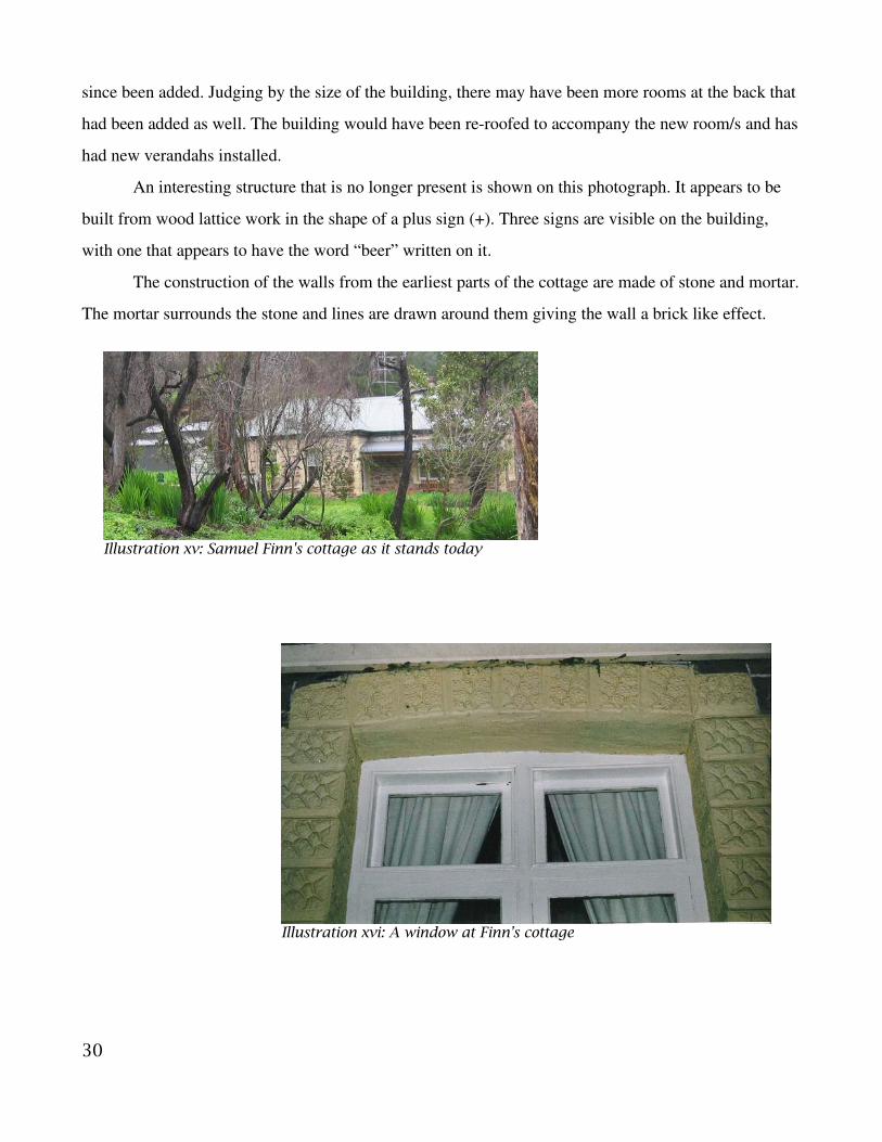
since been added. Judging by the size of the building, there may have been more rooms at the back that
had been added as well. The building would have been reroofed to accompany the new room/s and has
had new verandahs installed.
An interesting structure that is no longer present is shown on this photograph. It appears to be
built from wood lattice work in the shape of a plus sign (+). Three signs are visible on the building,
with one that appears to have the word “beer” written on it.
The construction of the walls from the earliest parts of the cottage are made of stone and mortar.
The mortar surrounds the stone and lines are drawn around them giving the wall a brick like effect.
30
Illustration xv: Samuel Finn's cottage as it stands today
Illustration xvi: A window at Finn's cottage
31
Illustration xvii: Samuel Finn's Cottage at Chamber's Gully - No date
Illustration xviii: Samuel Finn's Cottage some time after 1903

Around each door and window on this section of the building is a cream coloured plaster work. The
plaster is shaped as to look like brick work and each brick is patterned to look roughly cut, or like
stone. The rest of the building is of a modern construction and is of no interest.
5.2.3 Finn's Cottage 2, “The Olives,” 93 Waterfall Gully Road
The second cottage that is thought to be Finn's, is now
known as “The Olives.” This, also, is private property, so
access was limited. The section of original cottage, unlike the
previous, is at the back of the building. This building has had
more modifications to the original section, so there is less left
to study.
Most of the original walls have been rendered, but one
section had been left exposed. The wall shows stone
construction that looks more akin to the Woolshed than the
other cottage. The material used for mortar for this building
looks to be the same as the cottage though, so it is only the style
of stonework that differs.
5.2.4 Woolshed, Woolshed Gully
This ruin is located in a part of Cleland Conservation Park, behind a private residence along
Waterfall Gully Road, who's fenceline runs almost on top of it's south walls. Visible on the private
residence, but unaccessible is a large and old olive tree and a building known as the “apple store.”
32
Illustration xix: Exposed Wall at"The Olives"
Illustration xx: The remains of the Woolshed

Most of the ruin is dilapidated and has been covered by grass and weeds. All that remains is the
east wall, a crumbled section of the south wall and only the southern most section of the western wall.
A low wall runs from the east wall up to a ledge, the wall then climbs up and around a short way, but
this section was too difficult to record. The western foundation is visible and it has two steps on the
southern side. Rubble is scattered around the ruin, but two large piles are centered on the southeast
corner against the walls and from the ground up to level with the top of the foundation. Some large
rocks lay from the northern point of the foundation, west, towards a section of wall.
33
Illustration xxi: Layout of the Woolshed ruin

The East wall is built from mostly rubbish stone, probably quarried on site or nearby, and mud.
There is still evidence of a plaster coating, mostly on the northern end up to a feature that clearly
indicates where a wall was. The afore mentioned feature is nothing but where stones jut out no further
than 20cm. The plastering on the wall corners onto the stone indicating that this is where an internal
wall must have been. The three “windows” in this wall are framed by red brick to either side and timber
above the opening. These “windows” are set low in the wall so that the bottom of each are so near to
the ground that it is hard to tell if if fact the bottoms are level with the floor or not.
The Southern wall has deteriorated to about half the hight of the East wall, although it still
retains some plastering. The stones that are exposed on this wall do not have the muddy mortar binding
them like the East wall. The mortar may have eroded away, but it seems more likely that they had been
placed there intentionally after that part of the wall fell away.
The Rear wall is not built from the East wall but built against it and at a lower hight. The Rear
wall has no evidence of mud mortar or plastering and gives the impression that it was built as part of a
34
Illustration xxii: The east wall of the Woolshed
fence line, due to it's low height. Although only measured to be 5.08 metres long to the edge of a steep
embankment, it does continue up the embankment and turns back North. This section of the Rear wall
is lower in construction and until it straightens north, looks like little more that a pile of stone, roughly
in a line. Due to the steep embankment I did not measure this section.
The wall fraction west of the foundation is located in a way that
gives the appearance that it once helped enclose another room. There are
no indication of any additional wall that would show this and the wall
fraction has no foundation and is on a slight lean towards the rest of the
ruin.
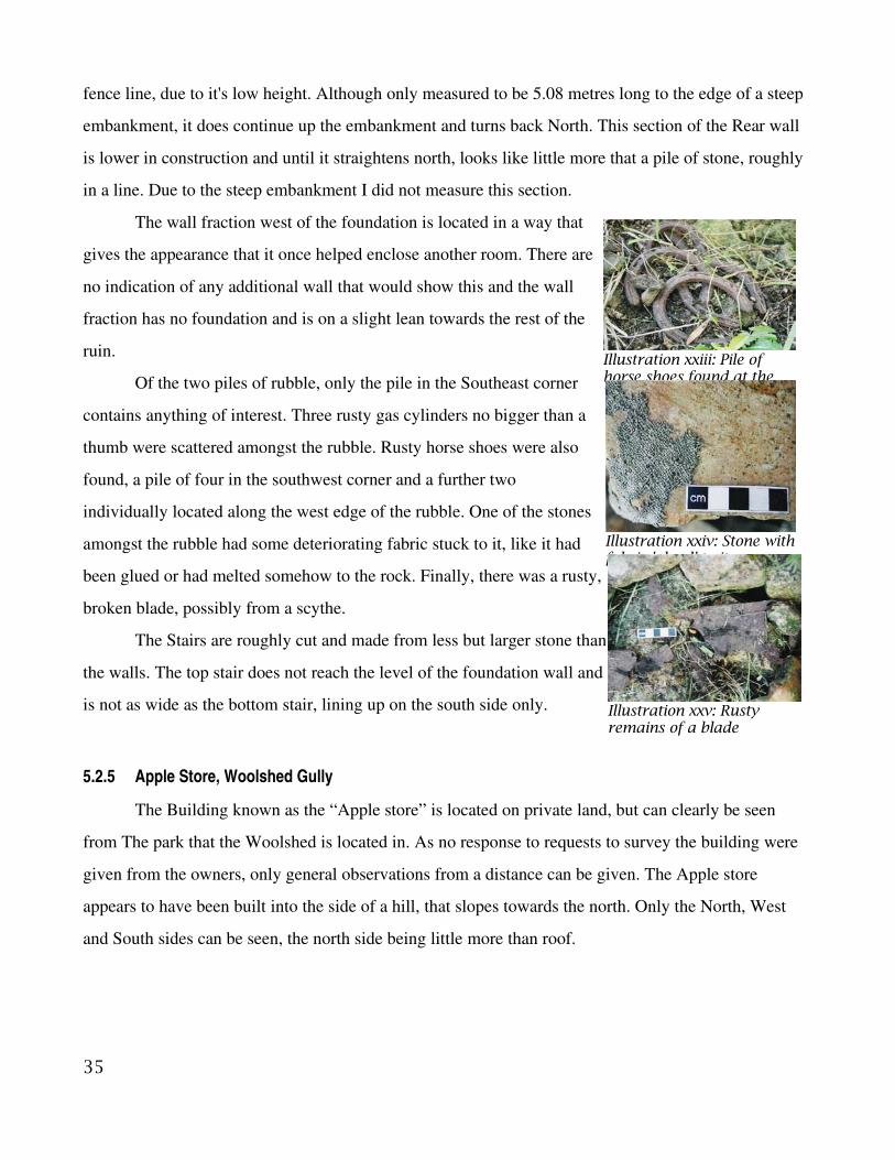
Of the two piles of rubble, only the pile in the Southeast corner
contains anything of interest. Three rusty gas cylinders no bigger than a
thumb were scattered amongst the rubble. Rusty horse shoes were also
found, a pile of four in the southwest corner and a further two
individually located along the west edge of the rubble. One of the stones
amongst the rubble had some deteriorating fabric stuck to it, like it had
been glued or had melted somehow to the rock. Finally, there was a rusty,
broken blade, possibly from a scythe.
The Stairs are roughly cut and made from less but larger stone than
the walls. The top stair does not reach the level of the foundation wall and
is not as wide as the bottom stair, lining up on the south side only.
5.2.5 Apple Store, Woolshed Gully
The Building known as the “Apple store” is located on private land, but can clearly be seen
from The park that the Woolshed is located in. As no response to requests to survey the building were
given from the owners, only general observations from a distance can be given. The Apple store
appears to have been built into the side of a hill, that slopes towards the north. Only the North, West
and South sides can be seen, the north side being little more than roof.
35
Illustration xxiii: Pile ofhorse shoes found at theWoolshed
Illustration xxiv: Stone withfabric 'glued' to it
Illustration xxv: Rustyremains of a blade
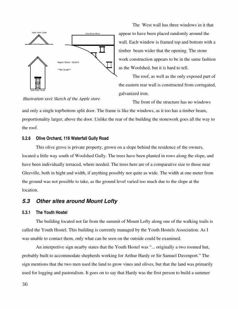
The West wall has three windows in it that
appear to have been placed randomly around the
wall. Each window is framed top and bottom with a
timber beam wider that the opening. The stone
work construction appears to be in the same fashion
as the Woolshed, but it is hard to tell.
The roof, as well as the only exposed part of
the eastern rear wall is constructed from corrugated,
galvanized iron.
The front of the structure has no windows
and only a single top/bottom split door. The frame is like the windows, as it too has a timber beam,
proportionality larger, above the door. Unlike the rear of the building the stonework goes all the way to
the roof.
5.2.6 Olive Orchard, 116 Waterfall Gully Road
This olive grove is private property, grown on a slope behind the residence of the owners,
located a little way south of Woolshed Gully. The trees have been planted in rows along the slope, and
have been individually terraced, where needed. The trees here are of a comparative size to those near
Gleeville, both in hight and width, if anything possibly not quite as wide. The width at one meter from
the ground was not possible to take, as the ground level varied too much due to the slope at the
location.
5.3 Other sites around Mount Lofty
5.3.1 The Youth Hostel
The building located not far from the summit of Mount Lofty along one of the walking trails is
called the Youth Hostel. This building is currently managed by the Youth Hostels Association. As I
was unable to contact them, only what can be seen on the outside could be examined.
An interpretive sign nearby states that the Youth Hostel was “... originally a two roomed hut,
probably built to accommodate shepherds working for Arthur Hardy or Sir Samuel Davenport.” The
sign mentions that the two men used the land to grow vines and olives, but that the land was primarily
used for logging and pastoralism. It goes on to say that Hardy was the first person to build a summer
36
Illustration xxvi: Sketch of the Apple store

house on Mount Lofty, and encouraged others to do so as well. Finally the sign states that Lady
Davenport extended this cottage to be used as a holiday house and she spent her last Christmas there in
1901.
Only the front (west side) and the two north and south walls can be seen, as the back is fenced
off. All of the visible walls are made of stone and mortar. The west wall has two windows, set either
side of the front door. The door frame is built of red brick all the way around. The front windows are
framed with red brick as well.
Of the two visible sides, the side south wall most visible. After the first of three windows from
the front, there is an obvious change in pattern to the stone work near to where the roof changes it's
slope. The stonework change leads into a section of red brick wall which ends at the second window.
Between the second window and the final window the roof changes pitch again, but the stonework
remains the same. All three windows are framed with red brick like the front.
The north wall is stepped, the front section and rear section being about the same level, with the
centre section coming out further than the rest of the side somewhat like a 'T'. The front section is built
like the front wall, with no window and a water tank. The rear section is fenced off as part of the “back
yard.” The centre section is framed on it's sides by red brick and the window set in the middle of the
wall is completely framed by red brick.
37
Illustration xxvii: The Youth Hostel

5.3.2 Keir's Cottage
This ruin is located just off of Greenhill Road in Cleland National Park, although not visible
from the road. The walls have been sealed with cement in an obvious attempt to save them from further
degradation by nature. The walls had already been subject to wear and most of the ruin was about one
metre high or less, with the exception of two walls in the middle of the structure that may be thought of
as being at least close to original hight. The two walls are the wall dividing the rooms marked as the
family room and the kitchen and the wall dividing bedroom one and bedroom two. The cottage appears
to be in to halves, being divided by a long hallway with four rooms on one side and two on the other.
The hallway runs eastwest with the bedrooms on the south side of the house.
According to Probert (1988), the cottage was built in stages, starting with two rooms in 1855,
expanded to four by 1856 and two more room added in 1858/59 and 1863/64. Probert (1988) states that
there was also a dairy, a stable and gardens.
38
Illustration xxviii: The ruin of Keir's Cottage
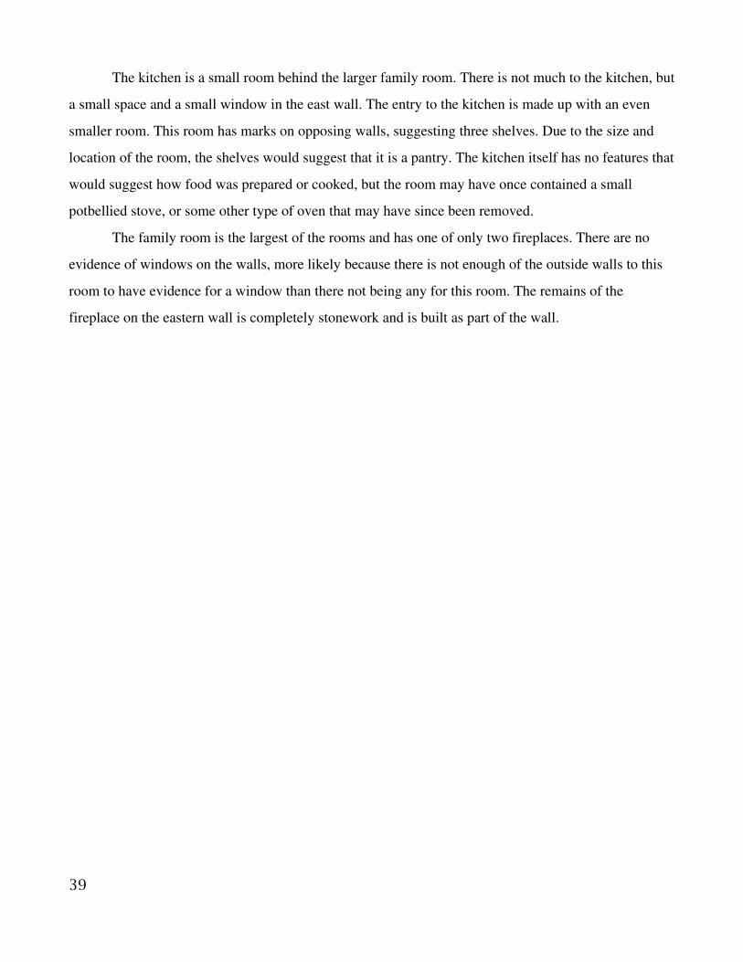
The kitchen is a small room behind the larger family room. There is not much to the kitchen, but
a small space and a small window in the east wall. The entry to the kitchen is made up with an even
smaller room. This room has marks on opposing walls, suggesting three shelves. Due to the size and
location of the room, the shelves would suggest that it is a pantry. The kitchen itself has no features that
would suggest how food was prepared or cooked, but the room may have once contained a small
potbellied stove, or some other type of oven that may have since been removed.
The family room is the largest of the rooms and has one of only two fireplaces. There are no
evidence of windows on the walls, more likely because there is not enough of the outside walls to this
room to have evidence for a window than there not being any for this room. The remains of the
fireplace on the eastern wall is completely stonework and is built as part of the wall.
39

The master bedroom
is the only other room in the
cottage with a fireplace in it.
This fireplace looks wider
and in fact is, but only by
24cm. This fireplace is also
made out of brick and some
stonework which makes it
seem like it may have been
put in after the wall was
built. The master bedroom
and the bedroom adjoining
are located east of all other
rooms, and if it were not for
the small length of wall
opposite the doorway to the
master bedroom then that
door may have been outside
from the rest of the cottage.
There were no obvious joins
that would indicate that
those rooms were extensions
to an original section. It
would be quite likely that
the master bedroom and the
adjoining room were the
original two rooms of this
cottage, due to fireplace and the location of the doors to these two rooms.
The adjoining room to the master bedroom would have been the bedroom for a younger child or
40
Illustration xxix: The layout / floorplan of Keir's Cottage

baby. It is too big to have been a walkin wardrobe, especially for a cottage this sized. If it was the
second room of the original two roomed cottage, then this would have been the bedroom, whilst the
other would have been the original family room. The much lager room with the fire place would have
become the family room.
The two bedrooms at the front are of about equal size. Bedroom two was overgrown with a prickly
bush, so none of the inside measurements were taken, but were estimated using the wall thickness and
surrounding measurements as a guide. Bedroom three had no windows, but like the family room, the
walls that would have had a window, were too low to have any window left. Both doors of these rooms
are opposite the door to the family room, possibly deigned so that any heat escaping from that fireplace
would heat those rooms as well.
With the master bedroom and it's adjoining room being most likely to be the original two
rooms, it would appear that the two other bedrooms were the next to be constructed. Although the
orientation of the new rooms to the original does not quite make sense. Both new rooms would have
had their entrances from the outside, possibly indicating a porch or even a hallway. If the next two
rooms that were built was a combination of any other two rooms, the record would have more likely
41
Illustration xxx: The fireplace in the "MasterBedroom"
Illustration xxxi: The fireplace in the"Family Room"

indicated two huts. The next room to have been added would have logically been the new family room,
as the small kitchen would have looked quite out of place where it is, without the family room. With
the cottage's final configuration, the two new bedrooms look to have been built with the family room
and kitchen, so much so that the floor plans look like the original two rooms were an extension to a
four roomed cottage. It might well be a possibility that at least one of the first two rooms that extended
the original hut no longer exists and was replaced when the new family room was added. Thus
explaining why all the rooms but the original seem to be orientated around the new family room.
5.3.3 “Davenport's Hut”
A chimney is all that remains of this building, which is currently at the entrance to the northern
enclosure of the Native fauna zone. It was built when Davenport was establishing vines nearby
(National parks and Wildlife South Australia 1983). No date for this venture is given, except for the
1870s when Davenport was buying those sections (National parks and Wildlife South Australia 1983).
A Mr. Nuisso who first built his house in 1929 later expanded his own house to incorporate
Davenport's hut (National parks and Wildlife South Australia 1983).
42

6. Discussion
6.1 Wine, vine and olive oil
6.1.1 Vineyards
J.B. Cleland (1949) says that Davenport planted vines at Beaumont extensively planting the
Sercial, Greenache, Carbonet, Doradilla, Shiraz and Sauterne varieties. Dow (1874) says that in 1874
Davenport had his vineyard in three portions. One of seven and a half acres, with an olive hedge, one of
five acres and the other of ten acres. Dow does not give the location of any of these, if they were in the
gully, higher up the slopes or even on the grounds of Beaumont House. Dow only gives a few clues to
the actual location of any of the vineyards that he mentions. One such clue is that he says that the olive
and the vine amongst other things are '...intermingled with the mansions of the wealthy, and the villas
of the comfortably independent...' (1874 pg 10) when describing the village of Beaumont. Although
that is a general description of Beaumont, Dow states that the 'olives on Beaumont...' that were
Davenport's were grown in two parts one '...partly in the form of a hedge round a seven and a half acre
vineyard.' This means that the seven and a half acre vineyard was grown somewhere on the Beaumont
House property. This is backed up by a historical photo taken in 1903 of Davenport picking grapes
west of his cellar, which was on his property in Beaumont.
The other clue to the location of Davenport's three vineyards that Dow gives is that an adjoining
field to the ten acre vineyard was planted with seven and a half acres of olive seedlings. There still
exists an olive grove along Waterfall Gully on private land that dates back to Davenport's time. There is
no adjoining vineyard to the olive grove and no obvious remains. That might be due to the National
Park and the residential area being built here, as if the vines were not removed to build houses, then
they would have been removed as weed by national parks. The five acre vineyard location was not
hinted at to by Dow at all.
Simpson (1993) writes that Davenport planted seven acres of vines in 1862 and six acres in
1872 and may have planted some without recording doing so. Dow, in 1874 notes a seven and half
acre, a five acre and a ten acre vineyard. These figures obviously do not add up. It is possible that the
two vineyards that Simpson writes about are two of the vineyards that Dow writes about. Either the
numbers are made up by the vines that Davenport “may” have planted earlier or one of the sources had
43

bad information about the acreage. According to Dow (1874) Davenport already had 22 ½ acres of
vineyard, the seven and a half being about 14 years old at the time (so planted around 1860) and the ten
acres being fairly new and not giving the five acres a time frame at all. The dates that Simpson gives
for the seven and the six acre vineyard match best with Dow's seven and a half and ten acres
respectively. The seven/seven and a half acres match reasonable well, being only a half acre out, but the
six/ten acre match is a much larger gap.
Simpson goes on to say that in 1875, a year after Dow's article, grapes were being harvested
from 13 acres of vineyard. Being that the six/ten acre vineyard was only planted about three years
earlier, it would leave only the five acre and the seven/seven and a half acre vineyards to harvest from.
Again the numbers do not add up, being only 12 or 12 ½ acres to harvest. By 1878, Simpson says that
there was 25 acres being harvested, ten of which were in full production. Once more, the numbers do
not add up. Using Dow's figures the were 22 ½ acres with 12 ½ acres that may have been ready for full
production. Simpson's figures require the planting of 12 acres somewhere, with at least three acres
planted with enough time to reach full maturity and the other nine with enough time to be harvestable.
Simpson (1993) also places all of the 25 acres of vines being harvested within the Village of Beaumont
in two parts on sections 16, 17, 18, 19, 20 and 35, 36, 37 and 38. Cleland (1945) says only that in the
1890s the vines occupied the sections 1620 and 3538 agreeing with Simpson, but gives no estimate of
size. It is possible that all of the vines that Dow mentions were being grown in Beaumont as he writes
nothing one way or the other about the location of five and ten acre vineyards. It may be possible that
at least not all of the vines Simpson says that Davenport harvested were his. Dow (1874) says that
Davenport did buy additional olives to process, so the same may be true for the grapes. Since Simpson
does not specify that the vineyards harvested from were necessarily Davenport's, it would help to
alleviate the number problem between how many acres were planted and how many were harvested.
In the 1870s Davenport bought a large area of land near Mount Lofty from Arthur Hardy
(National Parks and Wildlife 1983). This land was primarily used for livestock, but Davenport did plant
vines on the upper slopes as well (National Parks and Wildlife 1983). These vines, which is now were
the northern enclosure of the Native Fauna Zone, did not do well and eventually died out.
There was at least one vineyard in the Village of Beaumont, at Beaumont House that was either
seven or seven and a half acres vineyard that was Davenport's. The two other sections that Dow writes
44

of were most likely to have also been grown in Beaumont on the sections mentioned above, thus
locating all of Davenport's wine industry within the village itself except for the failed vines.
6.1.2 Olives
Like the vineyards, it seems that the olive groves were also grown in at least three areas. Dow
goes into little detail about the location of the groves compared to the vineyards. Dow (1874) mentions
the olives on Beaumont and the olive grove planted adjacent to the ten acre vineyard. Besides those two
areas, Davenport may have been using the olives from the grove at Gleeville. At one time he did own
them, as he planted the grove whilst he lived at Gleeville. It is unclear whether he was able to use the
olives. When Davenport moved into Beaumont House, John Fullerton Cleland moved into Gleeville
(Cleland 1949). As J. F. Cleland was Davenport's brotherinlaw (Cleland 1949) they may have come
to an arrangement about the use of the olives. Dow (1874) does mention that Davenport payed for some
of his olives, but does not say from whom exactly, just that they were neighbors.
Simpson (1993) writes about a photograph taken in 1887 showing olives on Lot 10, land owned
by Davenport. There are still olives on some of the land that was Lot 10, and they are right next to
Beaumont House. Simpson suggests that due to the apparent age of the olives in the photograph, they
would have been planted some time in the 1860s. Due to the olives proximity to Beaumont House these
would have been part of the “olives on Beaumont” that Dow mentioned:
“The olives on Beaumont are grown partly in the orchard surrounding the residence, and partly in the
form of a hedge round a seven and a half acre vineyard” (Dow 1874).
The seven and a half acres of olives that Dow (1874) writes that were planted adjoining a ten
acre vineyard was discussed previously. As was also discussed previously, the location of that vineyard
was more likely somewhere in Beaumont. If the vineyard was in the Village, then logically the
adjoining olive grove was too. This would then leaves the olive grove in Waterfall Gully with no
historical background. Simpson (1993) does make note of an “interesting planting of olives” during
1883. The olives were imported by Davenport from Spain as truncheons from the duke of Wellington's
estate (Simpson 1993). Simpson says that the location of these olives are unknown. If the olives in
Waterfall Gully are not the olive planted adjacent to the vines, then they might be the olives from
Spain. Smyth and Southwood (1986) write about the extensive olive groves that extended from
Beaumont to both sides of first creek. So it is likely that the olives remaining in Waterfall Gully were at
45
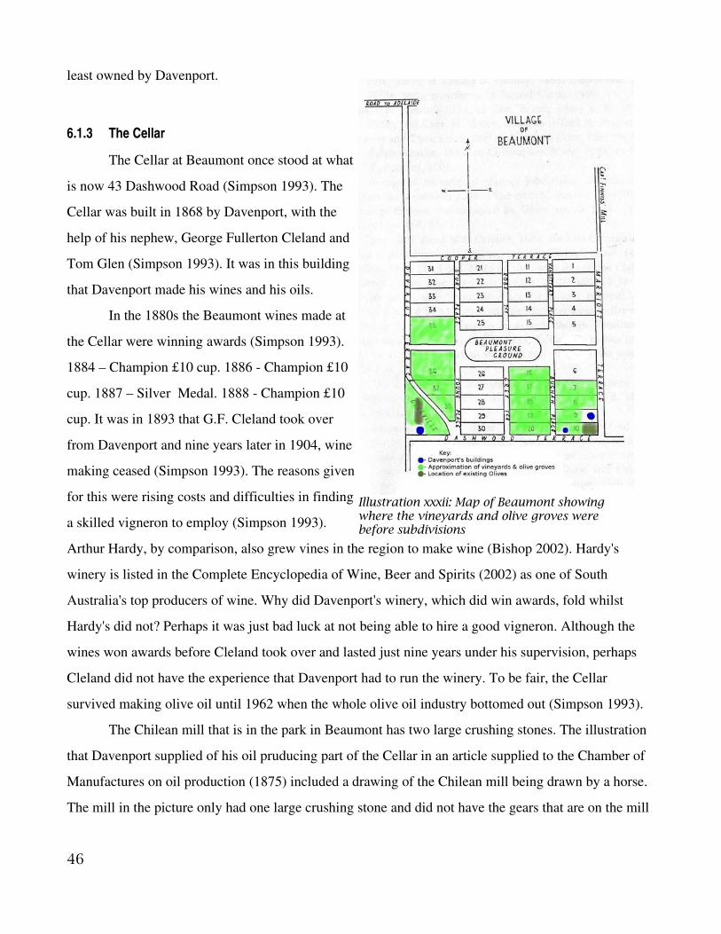
least owned by Davenport.
6.1.3 The Cellar
The Cellar at Beaumont once stood at what
is now 43 Dashwood Road (Simpson 1993). The
Cellar was built in 1868 by Davenport, with the
help of his nephew, George Fullerton Cleland and
Tom Glen (Simpson 1993). It was in this building
that Davenport made his wines and his oils.
In the 1880s the Beaumont wines made at
the Cellar were winning awards (Simpson 1993).
1884 – Champion £10 cup. 1886 Champion £10
cup. 1887 – Silver Medal. 1888 Champion £10
cup. It was in 1893 that G.F. Cleland took over
from Davenport and nine years later in 1904, wine
making ceased (Simpson 1993). The reasons given
for this were rising costs and difficulties in finding
a skilled vigneron to employ (Simpson 1993).
Arthur Hardy, by comparison, also grew vines in the region to make wine (Bishop 2002). Hardy's
winery is listed in the Complete Encyclopedia of Wine, Beer and Spirits (2002) as one of South
Australia's top producers of wine. Why did Davenport's winery, which did win awards, fold whilst
Hardy's did not? Perhaps it was just bad luck at not being able to hire a good vigneron. Although the
wines won awards before Cleland took over and lasted just nine years under his supervision, perhaps
Cleland did not have the experience that Davenport had to run the winery. To be fair, the Cellar
survived making olive oil until 1962 when the whole olive oil industry bottomed out (Simpson 1993).
The Chilean mill that is in the park in Beaumont has two large crushing stones. The illustration
that Davenport supplied of his oil pruducing part of the Cellar in an article supplied to the Chamber of
Manufactures on oil production (1875) included a drawing of the Chilean mill being drawn by a horse.
The mill in the picture only had one large crushing stone and did not have the gears that are on the mill
46
Illustration xxxii: Map of Beaumont showingwhere the vineyards and olive groves werebefore subdivisions

today. Although no mention of this was found is would appear that sometime between Davenport's
paper and the mills removal from the Cellar it was upgraded to use some kind of engine instead of the
horse. I would imagine that it most likely would have been a steam powered stationary engine. The
advantages would have been not having to keep a horse on site, as well as being able to have the second
stone wheel.
6.2 Some of those employed by Davenport
John Kier and Samuel Finn were in the employ of Davenport and both lived on Davenport's
land. Finn lived along Waterfall Gully road and Keir lived much higher, near to what is now Greenhill
road. They were not the only people, but they are the only ones who have buildings still associated with
them.
6.2.1 Samuel Finn
As was mentioned before, there is apparently two locations of Finn's cottage, one on the corner
of Waterfall Gully Road and Chambers Gully Road, with the other further along Waterfall Gully Road.
Any mention of a location for Finn's cottage historically is generally being between Waterfall Gully
Road and Chambers Gully Road. All of the historic photographs claiming to be of Finn's cottage also
seem to back this up. The City of Burnside's tour guide for Waterfall Gully, however say that the
cottage known as Finn's cottage at the corner of Chambers Gully, was originally built by a James
Durbridge (Smyth & Southwood 1986). It was not until 1864 that Finn moved in (Smyth & Southwood
1986). Finn was Davenport's gardener, possibility head gardener (Smyth & Southwood 1986). Before
that time, Durbridge was leasing the land from Davenport and built a slab hut and established gardens
and orchards and finally in 1864 added a stone house of two rooms (Smyth & Southwood 1986).
The second cottage, “The Olives,” was built in 1893 around an earlier wattle and daub two
roomed hut used by one of Davenport's workers (Smyth & Southwood 1986). Smyth and Southwood
(1986) theorize that the hut was built for Finn, as he looked after the extensive olive groves that
extended from Beaumont to both sides of first creek. This may explain why Finn moved from one two
roomed hut to another two roomed hut only slightly up the road. If Finn did live in the wattle and daub
hut, then the prospects of moving to a stone hut with gardens already established. Smyth and
Southwood (1986) do not say if Durbridge replaced the slab hut with the stone hut, extended or kept
both. If the slab hut was not destroyed prior to Finn's moving, then there is a whole two rooms more of
47
reasons that Finn may have moved from “The Olives.” There is no mention of why Durbridge may
have moved from his cottage, or where he went.
In 1903 the land was subdivided and the portion of the land that the cottage is on was purchased
by Christopher Faehrmann (Smyth & Southwood 1986). Faehrmann also worked for Davenport, but at
the vines and olives on Beaumont (Smyth & Southwood 1986). It is during this time that the cottage is
expanded and tearooms, a boarding house and a restaurant established (Smyth & Southwood 1986).
6.2.2 John Kier
Keir's cottage, like Finn's, was not built by or for him. The land was first granted to James
Warland in 1851, who built a two roomed cottage in 1855 (Probert 1988). The hut was probably only
used as a camp for when Warland came out to check his livestock (Probert 1988). By 1856 the hut had
four rooms and a dairy house and was occupied by William Brewer and his family (Probert 1988).
Brewer operated the “Wine Shanty” which still stands on the opposite side of Greenhill Road (Probert
1988). From 1859 until 1873, James Warland and his family lived in the cottage, adding another two
rooms to make a six roomed cottage they called “View Point” (Probert 1988). In 1873 Warland retired
to a house in Burnside and leased out the cottage and land to Henry Lyons Roe (Probert 1988). This
section of land was finally purchased by Davenport in 1874 (Probert 1988). Keir moved into the
property around 1875 (Probert 1988). Keir was employed by Davenport as a shepherd according to the
Cleland Conservation Park management report published in 1983. Probert (1988) says simply that he
was an “overseer” of the property. Keir worked for Davenport until 1894/95 when his son, William
Keir took over the job (Probert 1988). Although Bishop (2002) says that William Keir was listed as a
grape grower in1892. Possibly the Keir's had their own vines, or W. Keir worked of Davenport as a
grape grower before taking over his father's job. Keir's job as an overseer is not clear on what his duties
were, so that grape grower was a part of his job.
6.2.3 Other huts and other workers
The Youth Hostel, which became Davenport's summer house, was once a hut for sheepherders.
It is not known if the hut was built by Davenport or Arthur Hardy, but if it was built by Hardy before he
sold the land to Davenport, then there may have been a period where Davenport was using it for his
sheepherders before converting it.
Beyond the association with the failed vines nothing is known about “Davenport's Hut.” Was it
48
built for Davenport to stay at whilst he established or looked after the vines? Or was it built for a
worker, like Finn, to do so? Could it be a shepherd's hut and the association coincidental? Was it built
for an unknown worker, especially moved up near the vines to look after them? The land here was
initially used for grazing sheep, before being planted with the illfated vines (National parks and
Wildlife South Australia 1983). The possibility that this hut was built for a shepherd before the vines
were established seems at least as likely as it being built for someone to look after the vines from.
Records from the East Torrens District Council Assessment books of 1852 state that Davenport
built houses for four of his workers (National parks and Wildlife South Australia 1983). The houses
were built near Waterfall Gully Road, Three of which were two roomed and made of stone, whilst the
fourth had three rooms and had ten acres of garden (National parks and Wildlife South Australia 1983).
Their location is unknown (National parks and Wildlife South Australia 1983) and quite possibly no
longer exist. According to Smyth & Southwood (1986) a building known as “Homelands” Tea Gardens
at 98100 Waterfall Gully Road, older parts of the houses are meant to be cottages built by Davenport
for his workers. It is likely that they are two of the four cottages mentioned, with the other two possibly
having been incorporated into other houses, not knowing their history.
Smyth & Southwood (1986) write that Davenport hired twelve Chinese shepherds to work for
him in 1847. The shepherds lived in wattle and daub huts in amongst the hills (Smyth & Southwood
1986). No numbers were given to how many huts were built for the Chinese shepherds, but it may not
necessarily have been twelve. If the men were left to build the huts themselves, or if they had family
that lived with them, it would be more likely that it may have been one shepherd to a hut. It is quite
likely that some of the shepherds may otherwise have bunked together in a hut. Two to a hut would
mean only six huts would be needed, three to a hut, only four. “The olives” is said to have been built
from a wattle and daub hut, so it might be likely that it may have once been one of the huts for the
Chinese Shepherds. That does not rule out Finn may have once lived there, as no date is given for his
first starting to work for Davenport.
6.3 The Houses of Sir Davenport
Davenport originally moved to the area so that he could be closer to Adelaide to attend his
parliamentary duties in 1846 (Coleman 1956 & Simpson 1993). Having originally moved into the
preexisting house of Gleeville staying there until 1857. Gleeville, was built by Edward Gleeson, a
49

wooden gabled house imported from India around 1839 (Cleland 1949). It was in this section that
Davenport lived in as the first additions, three stone rooms, were not added until 1877 (Cleland 1949).
This alteration was done during John Fullerton Cleland's time in the house from about 1852 to
1895/1901 (Cleland 1949). Cleland (1949) says that J.F. Cleland lived with his youngest son before his
death in 1901, but that his wife died at the house in 1895. It is also this time that J.F. Cleland's eldest
Dr. William Lennox Cleland inherited Gleeville but took up residence there after he retired in 1912
(Cleland 1949). The original wooden section of Gleeville had to be pulled down in 1903, due to white
ants (Cleland 1949). Sometime between when Dr. W.L. Cleland inherited Gleeville and he moved in,
four more rooms were added (Cleland 1949). More modifications came in 1929, the same year Dr.
W.L. Cleland's wife, Matilda Lauder, died and their son inherited the place (Cleland 1949). It is clear
that there is nothing left of the house that Davenport lived in, as he lived only in the wooden section
pulled down in 1903 and moved out before the first stone rooms were built in 1877.
Davenport's final house, Beaumont House, was built by Bishop Short in 1849 and called it
“Claremont” (Taylor 1989). Short first least the land from Davenport buying it later in 1855 (Taylor
1989). Coleman (1956) writes that Short twice extended an original cottage, possibly from one or even
two shepherd's huts. It also could have all been built by Short, but done in stages. By the time that
Short was done with it, Claremont had at least ten rooms (Coleman 1956). Davenport bought the land
back in 1857, renaming the house to Beaumont House and lived there until his death in 1906 (Taylor
1989). The property pasted to his nephew, Howard Davenport, who sold it to Major Vincent in 1907
(Cleland 1949). Vincent made extensive alterations to Beaumont House, before selling it to R.W.
Bennet in 1911 (Cleland 1949). The House is now currently in the care of National Trust.
It would seem the reason for the move was simply that Beaumont House was a better house and
location than Gleeville. Gleeville was a small wooden house, whilst Short had built a large, stone
mansion by comparison. It is a wonder why Davenport did not just make Gleeville larger by extending
it as well. There are also no reports that Davenport ever extended, renovated or did any of the like to
Beaumont House. Perhaps it was home renovation that was Davenport's weakness, as he seemed to
have no trouble doing anything else that he set his mind to. It could just as easily be because he was so
busy with everything else that the only way to get a better home to live in was to buy a new one.
The is one other reason that Davenport may have been eager to find a new house. Cleland
50
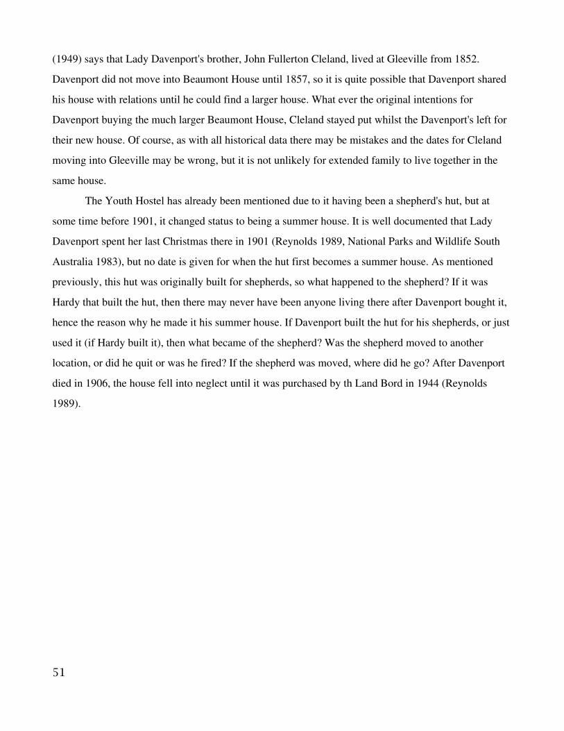
(1949) says that Lady Davenport's brother, John Fullerton Cleland, lived at Gleeville from 1852.
Davenport did not move into Beaumont House until 1857, so it is quite possible that Davenport shared
his house with relations until he could find a larger house. What ever the original intentions for
Davenport buying the much larger Beaumont House, Cleland stayed put whilst the Davenport's left for
their new house. Of course, as with all historical data there may be mistakes and the dates for Cleland
moving into Gleeville may be wrong, but it is not unlikely for extended family to live together in the
same house.
The Youth Hostel has already been mentioned due to it having been a shepherd's hut, but at
some time before 1901, it changed status to being a summer house. It is well documented that Lady
Davenport spent her last Christmas there in 1901 (Reynolds 1989, National Parks and Wildlife South
Australia 1983), but no date is given for when the hut first becomes a summer house. As mentioned
previously, this hut was originally built for shepherds, so what happened to the shepherd? If it was
Hardy that built the hut, then there may never have been anyone living there after Davenport bought it,
hence the reason why he made it his summer house. If Davenport built the hut for his shepherds, or just
used it (if Hardy built it), then what became of the shepherd? Was the shepherd moved to another
location, or did he quit or was he fired? If the shepherd was moved, where did he go? After Davenport
died in 1906, the house fell into neglect until it was purchased by th Land Bord in 1944 (Reynolds
1989).
51
6.4 Other activities at first creek and beyond
6.4.1 Livestock
In 1844, a year after Davenport
arrived in South Australia he had 100
head of cattle and 1000 ewes (Simpson
1993). There seems to be far less records
for Davenport's ventures into livestock
than his other pursues. The only reference
that mentioned livestock and a date that
that referred to Waterfall Gully in any
way was Reynolds (1989). “Wild dogs
were a menace for sometime, killing
many sheep and as a result Davenport
switched to grazing cattle and horses in the 1890s” (Reynolds 1989). Smyth & Southwood (1986) write
that Davenport hired twelve Chinese shepherds to work for him in 1847 only a year after moving to the
area. It is not until 1875 that Keir moved in and was hired by Davenport (Probert 1988) that there is any
further reference to Davenport hiring shepherds.
That the building known as the wool shed is attributed to being Davenport's seems the largest
piece of evidence that he grazed sheep here at all. The wool shed's low windowlike openings suggest
that it was used for shearing as well as storage. There is no date given to it being built or it being
abandoned although Davenport subdivided most of his land along there in 1903 (Reynolds 1989) the
fate of the building itself seems to not be known. The first mention of a livestock industry is 1847,
when Davenport hired the Chinese shepherds. Since the shepherds would need a place to shear the
sheep and to store the wool the wool shed would need to be contemporary to that.
Besides the wool shed, there are only two buildings within Davenport's land that are linked to
livestock. Keir's cottage and the Youth Hostel, both at one time housed shepherds. Keir was known to
have worked for Davenport as a shepherd, but the Youth Hostel is harder to pin to Davenport. The
Youth Hostel was built for a shepherd, but it may have been built by Hardy before Davenport bought
the land and never used as such. “Davenport's hut” as discussed earlier may have been used by
52
Illustration xxxiii: Map showing the extent of possible grazingland
shepherds, but it is usually associated to a nearby area of land that one had fail vines.
Where the livestock grazed is not entirely clear, as locations of crops, gardens and huts that one
were in the Gully but no longer are not clear either. The livestock probably grazed wherever there was
not at crop for them to ruin. Woolshed Gully, having the wool shed is a likely place, as well as there
being no evidence of crops there. The land around Keir's cottage, being a shepherd, was likely used as
well. None of the upper slopes of Davenport's land, except the failed vines, was used to cultivate crops,
so was all likely to have been used for the livestock.
6.4.2 Other Agricultural Industries
As was previously mentioned, Finn's cottage had it's own gardens and orchards, but he was not
the only one. As also mentioned before, Davenport built huts for some of his workers in Waterfall
Gully, with at least one of them having a ten acre garden and the others three acres of land (National
parks and Wildlife South Australia 1983). Such large gardens probably left the gardeners with left
overs to sell of their own accord.
Marked on the Burnside Council District map 1856 – 1860 is a spot, near a mark indicating
Samuel Finn's garden. The spot marks the locations of an Experimental garden. National Parks and
Wildlife South Australia (1983) say that Davenport used Waterfall Gully to test imported plants. They
list tobacco, mulberry, vines, French olives, fennel and other herbs. As discussed before, Davenport
grew the majority of his vines in Beaumont, with little evidence that he grew vines in the Gully. Olives,
too, were primarily grown in Beaumont, but was know to have been grown in the Gully. Any olives
grown in the gully were unlikely to have been part of an experimental garden, as Davenport would have
already known how well olives grew. The mulberries were the primary food of the silk worm, for the
industry of Sericulture that Davenport was interested in. Tobacco was grown by Davenport as early as
1844, for a remedy for scab on sheep (Simpson 1993). Tobacco and Sericulture were suggested by
Davenport as potential new industries in his pamphlet entitled “Some new industries for South
Australia, silkworm, mulberry, olives, tobacco.” Sericulture in particular was important enough for
Davenport to write an article (1876) encouraging people to take an interest in it. The industry died out
in the 1890s regardless (Simpson 1993).
53

The building near the wool shed, known
as the apple store, infers that there must have
been apples to store. Since this building is also
attributed to Davenport, it implies that
Davenport grew apples. Dow (1874) relates how
Davenport grew apples and a number of other
varieties of fruit near his residence. Dow (1874)
states that all the fruits are doing well, but the
apples have blight. It is not clear if it was just
that year that the apples had blight, or even if
Davenport ever grew apples elsewhere. Dow
says nothing about the goings on in the Gully
and Davenport may have had more apple trees
that were fine down there. The apple store may
have been built by Davenport, but that does not
mean that he was the only one that used it. As
mentioned above, at least two of his workers had
their own gardens and they may have grown the
apples that gave the store house it's name.
6.5 Conclusions
It would appear that all of Davenport's “important” work was done in the Village of Beaumont.
The vast majority of information found was about vines, wine making, olives and olive oil, with special
detail to the vineyards and groves in the village itself. It happened to be the larger, more comprehensive
sources that made little reference, if any to what Davenport was doing in Waterfall Gully and beyond.
That information was left to reports like the Cleland Conservation Park Management report and a
report on Keir's cottage.
The industry that formed in Beaumont of vines and olives possibly spilled into Waterfall Gully,
as an olive grove possibly dating to Davenport still exists as proof. The experimental gardens also
54
Illustration xxxiv: Map of Waterfall Gully showing thedetail of Finn's garden and the possible extent ofDavenport's experimental garden

supposably had both vines and olive trees. Smyth and Southwood (1986) go as far to say that the olive
groves extended from Beaumont to both sides of first creek.
Other industries that Davenport dipped in also gt some exposer. Sericulture, the raising of
silkworms and tobacco were both pushed by Davenport in articles he wrote. Tobacco was one of the
plants in his experimental garden, as was the mulberry tree, the food of the silkworms. The other fruits
said to be in Davenport's gardens did not get this exposure. Dow lists almonds, oranges, apricots,
loquats, plumbs, cherries, quinces, nectarines, peaches, pears, and apples as being grown by Davenport.
Why is there no article about any of these? Did they not grow well in the climate? Dow said that they
all did well with exception to the apples that had blight. It is more likely that none of those fruit are
anywhere nearly as commercealy viable as growing grapes for wine.
The livestock industry of sheep and cattle must have had some importance to Davenport, as he
purchased a large quantity of land to be in it. He may not have written papers on it, like he did for
Sericulture or growing olives, but it was not an industry that needed to be introduced to colonists. It
was this venture that covered most of Davenport's land and was something that Davenport was doing
since he arrived in Australia.
6.6 Conservation
This is not a particularly big issue, as practically every site has protection of some type.
Beaumont House and Gleeville and both in the national trust, the Youth Hostel is in good hands and in
a conservation park. Keir's cottage is protected by National Parks and Wildlife South Australia, with an
inoperative interpretive sign. Keir's cottage has even had the conservation measures of sealing the ruin
and has little weeds surrounding it.
There is the one issue of the wool shed at Woolshed Gully. In 1989 Reynolds recommends that
the remaining wall be capped with mortar and the three lintel timbers that were still in place above the
openings preserved. None of this has occurred. The same report recommended stabilization and
maintenance to Keir's cottage, which has been done. the wool shed has since deteriorated and only one
of the lintel timbers are in their original position, as the openings have since deteriorated. This ruin
needs some protection soon, else there will be nothing left to protect.
6.7 Difficulties
It remains to be said that looking for agricultural remains in a conservation park, where the
55
crops are considered weeds, is not an easy thing. The only remains in the park area were three ruins and
the Youth Hostel, which was restored from ruin. There are other ruins in the park, but they do not relate
to Davenport. The other problem faced is that of the subdivision of the land that occurred. Most of the
prime growing land is now private land, meaning two things. The first is that access is going to be
limited to known sites, if granted at all. The second is that sites may exist on private land that do not
come to light for various reasons, like the owner does not think 'x' is old or does not think 'x' is anyone
else's business.
The vagueness of locations given for crops and various huts obviously make locating them
difficult, most of the accuracy was reserved for crops and buildings within Beaumont. The exact
number of buildings that was built in the Gully by Davenport is not known and the buildings that are
known are not all well documented, if at all.
56
7. ReferencesBeaudry, M. C. 1996. “Why Gardens?” in Yamin, R. & Metheny, K. B. (ed.) Landscape Archaeology:Reading and interpreting the American Historical Landscape. The University of Tennessee press.Knoxville.
Birmingham, J. 1979. “Grapes, Hops, Olives, Tobacco and Timber.” in Birmingham, J., Jack, I. &Jeans, D. (eds.) Australian Pioneer Technology: Sites and Relics. Heinemann Educational AustraliaPty. Ltd. Richmond, Victoria.
Birmingham, J. & Murry, T. 1987. “Historical Archaeology in Australia: A Handbook.” NationalEstate Grants Programme.
Bishop, G. C. 2002. “The best light wines? Winemaking in the Mount Lofty Ranges, South Australia18391937.” in Martin, R. (ed.) Views form the Hills: Essays in the History of the Adelaide Hills.Mount Lofty Districts Historical Society Inc. Adelaide.
Brown, J. 1980. “Town Life in Pioneer South Australia.” Rigby. Adelaide.
Cleland, J. B. 1949. “The Village of Beaumont.” in Royal Geographical Society of Australia, SouthAustralian Branch: Proceedings for the session 194849 Volume L December 1949. York GateLibraries.
Coleman, D. 1956. “The First Hundred Years: A history of Burnside in South Australia.” TheCorporation of the City of Burnside. Adelaide.
Daniel, G. 1975. “A Hundred and Fifty Years of Archaeology.” Duckworth. Great Britain.
Davenport, S. 1875. “The cultivation of the olive, and manufacture of its fruit.” in South AustralianIndustries and Manufactures. Papers read before the Chamber of Manufactures. W.C. Cox,Government Printer. Adelaide.
Davenport, S. 1875. “Sericulture.” in South Australian Industries and Manufactures. Papers readbefore the Chamber of Manufactures. W.C. Cox, Government Printer. Adelaide.
Davenport, S. 1980 “Letters of Samuel Davenport, chiefly to his father, George Davenport, 184249.”in Baldwin, B. S. South Australiana. Libraries Board of South Australia. Adelaide.
Dow, J. L. 1874. “Agriculture in South Australia.” Freason & Bro., Adelaide.
Jack, I. 1985. “The archaeology of Colonial Australia.” in Dyson, S. L. (ed.) Comparative studies inthe Archaeology of Colonialism. BAR International Series. Oxford.
Jeans, D. 1979. “Rural Technology in Australia.” in Birmingham, J., Jack, I. & Jeans, D. (eds.)Australian Pioneer Technology: Sites and Relics. Heinemann Educational Australia Pty. Ltd.Richmond, Victoria.
Joseph, R., Protz, R. & Broom, D. 2002. “The Complete Encyclopedia of Wine, Beer and Spirits.”Carlton Books. London.
National Parks and Wildlife South Australia. 1983. “Cleland Conservation Park Management Report.”National Parks and Wildlife South Australia. Adelaide.
57
Probert, M. 1988. “Keir’s Cottage, Cleland Conservation Park.” Research paper for the heritageCommittee, National Parks and Wildlife Service Social Club, November, 1988. Unpublished.
Reynolds, Y. L. 1989. Assessment of Historic Remains, Cleland Conservation Park. Unpublished.
Simpson, E. R. 1986. “The Clelands of Beaumont.” Beaumont Press. Adelaide.
Simpson, E. R. 1993. “Beaumont House: The land and its people.” Beaumont Press. Adelaide.
Smyth, E. & Southwood, D. 1986. “City of Burnside South Australia: Tour Guide No.4: WaterfallGully.” Hyde Park Press.
Taylor, R. 1989. “Beaumont House: A report on the architectural development of parts of the building.”Report to the National Trust of South Australia. Unpublished.
Willey, G. R. & Sabloff, J.A. 1993. “A History of American Archaeology.” W.H. Freeman andCompany. New York.
Williamson, T. 1998. “Questions of preservationand destruction.” in Everson, P. & Williamson, T.(ed.) The archaeology of landscape. Manchester University Press. Manchester.
Warburton, E. 1981. “The Paddocks Beneath: A history of Burnside from the beginning.” TheCorporation of the City of Burnside. Adelaide.
Yamin, R. & Metheny, K. B. 1996. “Preface: Reading Historical Landscape.” in Yamin, R. & Metheny,K. B. (ed.) Landscape Archaeology: Reading and interpreting the American Historical Landscape. TheUniversity of Tennessee press. Knoxville.
58
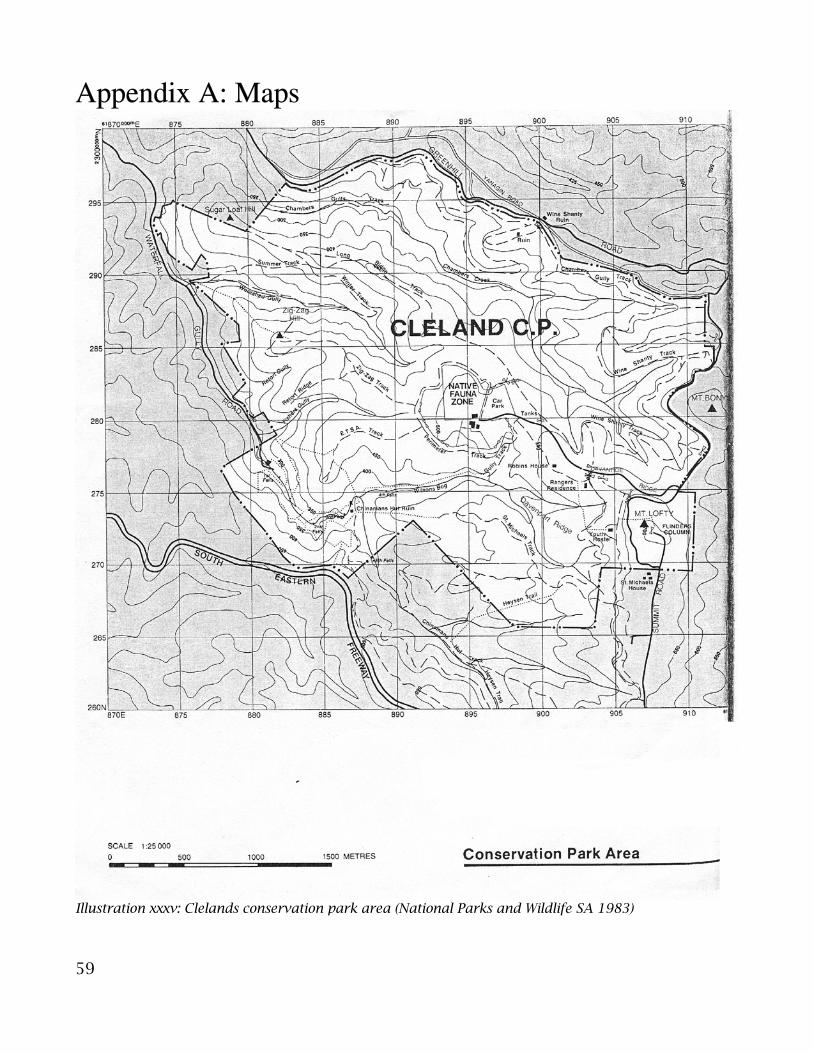
Appendix A: Maps
59
Illustration xxxv: Clelands conservation park area (National Parks and Wildlife SA 1983)
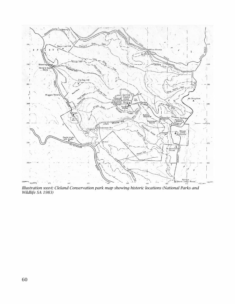
60
Illustration xxxvi: Cleland Conservation park map showing historic locations (National Parks andWildlife SA 1983)

61
Illustration xxxvii: Land in Waterfall Gully area that Davenport owned (National Parksand Wildlife SA 1983)

Appendix B: MeasurementsKeir's Cottage
62
Description of Measurement Meters Bearing Back Bearing
Average Wall width 0.4
Hight at highest point 2.32
Outside Walls:North wall 7.38 90° 270°
South wall - 93° 269° West edge to Window 1 5.2 Window 1 width 0.89 Window 1 hight from ground 1.15 Window 1 to Window 2 4.39 Window 2 width 0.86 Window 2 hight from ground 1.1 Window 2 to Window 3 1.85 Window 3 width 0.44 Window 3 hight from ground 1.24 Window 3 to east edge 1.79 Total 15.15
West wall - 0° 182° North end 5.69 South end 4.54 Door 1.12 Total 11.35
East wall - South end 4.55 North end 4.89 Protrusion - Both Sides 1.8 Width 0.4 To the end of the wall 0.48
Inside walls:Family Room:North wall 4.32
West wall 4.92
South wall - East of door 1.4 West of door 2.29
East wall - North of fireplace 1.41 South of fireplace 1.86 fireplace length 1.62 Total 4.89
Master Bedroom:North wall 3.38
South wall - West of fireplace 1.69 East of fireplace 0.61 fireplace length 1.86 Total 4.16
East wall - North of door 1.34 South of door 1.39
West wall 4.11
Bedroom 2:North wall 2.4
South wall 3.26
East wall 3.77
West wall 4.15
Bedroom 3:North wall 2.39
South wall 3.27
East wall 4.15
West wall 3.75
Bedroom 4:North wall 2.82
South wall 2.84
East wall 3.78
West wall North of door 1.37 South of door 1.39
Kitchen:North wall 1.78
South wall 0.86
East wall - North of window 1.2 South of window 3.66 Window width 0.55 Window hight from ground 1.12 Total 5.41
West wall 2.73
Pantry:Back wall 1.83
North wall 0.62
South wall 0.65
Wall width 0.27
North inside east wall 0.44
South inside east wall 0.44
North outside east wall 0.8
South outside east wall 0.78
Shelf height -0.720.450.47
North wall west half 2.75
North wall east half 2.38
South wall west half 2.7
South wall east half 2.26
Ground to 1st shelf 1st to 2nd shelf 2nd to Top shelf
Hallway:
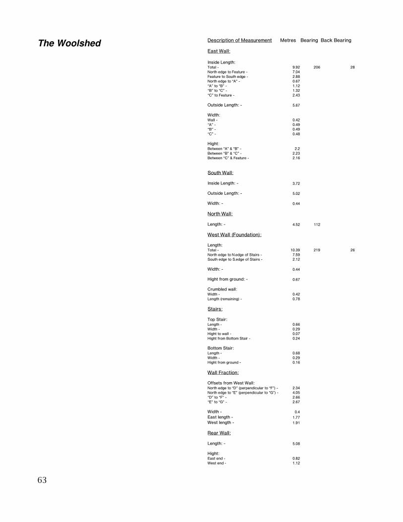
The Woolshed
63
Description of Measurement Metres Bearing Back Bearing
East Wall:
Inside Length:Total - 9.92 206 28North edge to Feature - 7.04Feature to South edge - 2.88North edge to “A” - 0.67“A” to “B” - 1.12“B” to “C” - 1.32“C” to Feature - 2.43
Outside Length: - 5.67
Width:Wall - 0.42“A” - 0.49“B” - 0.49“C” - 0.48
Hight:Between “A” & “B” - 2.2Between “B” & “C” - 2.23Between “C” & Feature - 2.16
South Wall:
Inside Length: - 3.72
Outside Length: - 5.02
Width: - 0.44
North Wall:
Length: - 4.52 112
West Wall (Foundation):
Length:Total - 10.39 219 26North edge to N.edge of Stairs - 7.59South edge to S.edge of Stairs - 2.12
Width: - 0.44
Hight from ground: - 0.67
Crumbled wall:Width - 0.42Length (remaining) - 0.78
Stairs:
Top Stair:Length - 0.66Width - 0.29Hight to wall - 0.07Hight from Bottom Stair - 0.24
Bottom Stair:Length - 0.68Width - 0.29Hight from ground - 0.16
Wall Fraction:
Offsets from West Wall:North edge to “D” (perpendicular to “F”) - 2.34North edge to “E” (perpendicular to “G”) - 4.05“D” to “F” - 2.66“E” to “G” - 2.67
Width - 0.4East length - 1.77West length - 1.91
Rear Wall:
Length: - 5.08
Hight:East end - 0.82West end - 1.12