landscape strategy - lancashire county council · bibliography 120 acknowledgements 122 ... 7...
TRANSCRIPT

Landscape StrategyEnvironment Directorate

Environment Directorate
Published by Environment DirectorateLancashire County CouncilDecember 2000Design - Graphics Unit - Environment Directorate
Copies of this document from:Environment DirectorateLancashire County Council Cross Street Winckley House Preston PR1 8RDWeb: www.lancashire.gov.ukTel: 01772 264115
Web: www.lancsenvironment.com© LCC & Countryside Agency
supported by:

The Lancashire Landscape Strategy was commissioned by Lancashire County CouncilEnvironment Directorate with grant aid fromthe Countryside Agency and financial supportfrom the following local authorities;Blackburn with Darwen Borough Council,Burnley Borough Council,Chorley Borough Council,Fylde Borough Council.Hyndburn Borough Council,North Yorkshire County Council,Pendle Borough Council,Preston Borough Council,Ribble Valley Borough Council,South Ribble Borough Council,West Lancashire District Council,Wyre Borough Council.
The study was prepared for LancashireCounty Council by:Environmental Resources ManagementEaton House,Wallbrook Court,North Hinksey Lane, Oxford OX2 0QS
Geological Map based onBritish Geological Survey Information.
Based upon the Ordnance Survey mapping with the permission of the Controller of Her Majesty’s Stationery Office © Crown copyright. Unauthorised reproductioninfringes Crown copyright and may lead toprosecution or civil proceedings.Lancashire County Council.Licence Nº LA 076716 2000.
A Landscape Strategy for Lancashire Landscape StrategyA Landscape Strategy for Lancashire Landscape Strategy

CONTENTS1 Introduction 1
1.1 The Scope and Context for this Study 1
1.2 Approach and Methodology 1
1.3 Structure of the Report 2
2 Forces for Change 5
2.1 Introduction 5
2.2 Built Development 5
2.3 Infrastructure 8
2.4 Mineral Extraction and Landfill 10
2.5 Agriculture and Land Management 12
2.6 Forestry and Woodland 17
2.7 Tourism and Recreation 19
2.8 Water Bodies & Water Quality 22
2.9 Air Quality and Climate Change 23
3 Landscape Strategy 25
4 Implementing the Strategy 103
4.1 How to Use the Landscape Strategy 103
4.2 Guiding Principles 104
4.3 Recognise and Enhance Local Distinctiveness 105
4.4 A Positive Approach Towards Landscape Change 107
4.5 An Integrated Approach to Landscape Resources 110
4.6 Monitor Landscape Change 113
Glossary 117
Bibliography 120
Acknowledgements 122
A Landscape Strategy for Lancashire Landscape StrategyA Landscape Strategy for Lancashire Landscape Strategy
ii
LIST OF FIGURES Page
Figure 1 Study Area 3
Figure 2 Landscape Character Types & Landscape Character Areas 26 & 27
LIST OF PHOTOGRAPHS
Photograph Title and Credit PageNo.
1 New residential development in an upland rural landscape. Mike Williams 6
2 Development on the M6 at Junction 34. 7
Lancashire County Council
3 Coal Clough Windfarm near Holme Chapel. 9
© Countryside Agency/ Mike Williams
4 Mere Sands Wood Nature Reserve in former sand pit. 11
Steve Browne
5 Poorly maintained hedge. Lancashire County Council 13
6 Woodland in the Arnside and Silverdale AONB 17© Countryside Agency/ Mike Williams
7 Visitor pressure, Nick of Pendle. Lancashire County Council 20
8 Lancaster Canal at Galgate. Mike Williams 21
9 Well maintained limestone walls using local materials. 106Mike Williams
10 Newly laid hedge. Lancashire County Council 108
11 Newly created wetland, Ulnes Walton, Peter Jepson 111
12 Management of recreation and access at Warton 113Crag Quarry. Mike Williams
Cover illustration: Parlick, Forest of Bowland - Landscape Character Type 4.© Countryside Agency/Mike Williams
Downholland Moss. Mike Williams
A Landscape Strategy for Lancashire Landscape StrategyA Landscape Strategy for Lancashire Landscape Strategy
iii

(1) Countryside Agency and Scottish Natural Heritage (1999) Interim Landscape Character Assessment Guidance.
A Landscape Strategy for Lancashire Landscape StrategyA Landscape Strategy for Lancashire Landscape Strategy
1
1 IntroductionIn October 1999, Environmental ResourcesManagement (ERM) were commissioned byLancashire County Council, in partnership withthe Countryside Agency, District Councils,Blackburn with Darwen Unitary Authority,North Yorkshire County Council and CravenDistrict Council, to undertake acomprehensive integrated landscapeassessment of Lancashire including the urbanareas and to produce a landscape strategyinformed by the landscape characterassessment process.
The overall study consists of two separatereports, a Landscape Character Assessment anda Landscape Strategy. This report, thelandscape strategy, builds upon the landscapecharacter assessment, but does not deal withthe urban landscape character types. Itprovides an overview of forces for changeaffecting the landscape of the study area as awhole; a landscape evaluation, strategies andrecommendations for each individuallandscape character type; and broad guidanceon priorities and actions for implementing thelandscape strategy as a whole.
The timescale of the Landscape Strategy is tobe concurrent with and reviewed during thereview period of the next Joint LancashireStructure Plan 2001-2016.
1.1Scope and Purpose of the StrategyThe study area (Figure 1) includes all of theadministrative county of Lancashire andBlackpool and Darwen Unitary Authority, andpart of the Craven District of North Yorkshireup to the boundary of the Yorkshire DalesNational Park. For the purpose of the report,the study is referred to as a Landscape Strategyfor Lancashire. The landscape characterassessment, on which the strategy is based,describes the evolution of the landscape(highlighting distinctive features) and describesthe specific character of each of the twentyone landscape character types (and threeurban landscape character types) that occur.
The purpose of the landscape strategy is toinform the new Structure Plan and local planpolicies on landscape, inform supplementaryplanning guidance, to guide and inform the
development control process, to guide andinform project planning and landscapemanagement by the Lancashire CountrysideService and others, and to promote publicawareness of landscape character and theimportance of conservation and enhancementof landscape.
Recommendations made in this Strategy shouldnot be construed as necessarily representingpresent or future planning or other policy ofthe local authorities concerned.
The strategy report has three main objectives:
• to review the forces for change that areaffecting the landscape, highlighting key issuesand implications of different forms ofdevelopment and land use change forlandscape character and quality;
• for each landscape character type, to identifykey environmental features and the specificimplications of change, as well as appropriatestrategies and actions to manage and guidelandscape change in a positive way;
• to produce an overview of strategic issues forLancashire, identifying the key actions thatneed to be taken to bring about positivelandscape change, including the developmentof landscape indicators and targets forchange.
1.2Approach and MethodologyPreparation of the landscape strategy hasinvolved extensive research, analysis, evaluationand consultations, as well as workshops withrepresentatives of the partnership authorities.In particular, the partnership authorities havegiven guidance on the format for the strategy,to ensure that it is as useful and accessible aspossible for a wide range of differentapplications, from planning and environmentalassessment through to day to day landmanagement. The methodology used is inaccordance with the new Interim LandscapeCharacter Assessment Guidance (1) . Theprincipal stages in the process of preparing thestrategy have been:
• to identify changes in the landscape thathave taken place this century and that areanticipated to occur in the foreseeable future,through a combination of field observations
1

(from the landscape character assessment),desk study and consultations with a widerange of local authority and governmentagency staff;
• to evaluate the key environmental features ofeach landscape character type, encompassingnot just visual and aesthetic features, but thefull range of ‘environmental capital’ associatedwith each type - that is habitat, historic, builtenvironment and recreational features; andcultural and perceptual qualities such aswilderness and tranquillity;
• to explore the implications for eachlandscape character type of development,land use change and other factors, assessingthe specific effects on landscape character,quality and key environmental features; anddeveloping strategies and recommendationsto counter adverse landscape change andoptimise beneficial landscape change;
• to formulate a general vision for thelandscapes of the County in discussion withthe partnership authorities, focusing onthemes of local distinctiveness,accommodating landscape change, anintegrated approach, and monitoringlandscape change - providing broad guidanceon priorities, actions and responsibilities.
1.3Structure of the ReportFollowing this Introduction:
Section 2 presents an analysis of the ongoingforces for change to the County’s landscape.Each sub-section summarises the key issuesrising from each force for change.
Section 3 introduces the key environmentalfeatures, forces for change and implications,strategies and recommendations for eachlandscape character type, and presentspotential local indicators of landscape changebased on key characteristics.
Section 4, the final section, describes how andby whom the strategy should be used. It givesan overview of strategic issues and prioritiesfor Lancashire, indicating the main actions andresponsibilities of the partner organisations,community groups and individuals who may beinvolved in the implementation of the Strategy.It concludes by presenting a proposedprogramme for monitoring theimplementation of the landscape strategy.
A Landscape Strategy for Lancashire Landscape StrategyA Landscape Strategy for Lancashire Landscape Character Assessment
2

A Landscape Strategy for Lancashire Landscape StrategyA Landscape Strategy for Lancashire Landscape Strategy
3
Figure 1: Study Area

A Landscape Strategy for Lancashire Landscape StrategyA Landscape Strategy for Lancashire Landscape Strategy
4

2.
Forces for Change2.1IntroductionThe landscape, ecological and historicalresources of Lancashire are constantlychanging in response to human activity andnatural processes.Throughout the county’slong history, changes in agriculture, industry,society and the environment have had aprofound and lasting influence over thelandscape. In recent decades, change hasbeen driven by a diverse range of increasinglyinternational forces, such as global climatechange or agri-environmental policy dictatedby the European Union (EU).
The pace of change is rapid and theimplications for change are difficult to assess.Change which is regarded as negative by somemay be seen as an improvement by others;perceptions and values change with time; andnew elements introduced to the landscapemay eventually be regarded as valuablelandscape features. Guardians of thelandscape must therefore be democratic andtransparent about their decision makingprocesses, ensuring that all changes aremanaged to retain and enhance the qualitieswhich make the Lancashire landscape sospecial.
The Rio Earth Summit set a global agenda forsustainable development and was a catalyst foraction on environmental policy andbiodiversity in the UK. In recent years, therehas been a strong commitment to natureconservation and planning for biodiversitywhich is reflected in the UK BiodiversityStrategy, European Union designations such asSpecial Protection Areas and Ramsar sites, andgrant funding for schemes such as CountrysideStewardship and the Woodland GrantScheme. The emphasis is on providingincentives to counteract the destruction andfragmentation of habitats; there is alsoincreasing emphasis on providing public accessto the countryside and on encouraging theinvolvement of communities in decisions abouttheir local environment (Local Agenda 21).
This section examines the driving forcesbehind landscape change in Lancashire, setting
change in a long term context and analysingtrends for the future. It is based upon a deskreview of relevant planning and policydocuments and upon wide consultation withlocal authorities, agencies and interest groups.
2.2BUILT DEVELOPMENTIncreased personal mobility and advances intelecommunications technology have made allrural areas relatively accessible. These trends,in combination with an enhanced perceptionof rural life and a decline in the importance ofagricultural land, are placing increasingpressures upon the Lancashire countryside toaccommodate built development.
2.2.1Residential DevelopmentToday, housing represents the main pressurefor built development in the county(Lancashire is second only to GreaterManchester in the figures for net additionaldwelling provision 1991-2006 for the NorthWest Region). The county is expected toaccommodate a maximum of 63,200 newdwellings between 1996 and 2016,representing 21.8% of the regional total of321,000.(1)
Draft Regional Planning Guidance for theNorth West states that Lancashire has thecapacity to accommodate its own housingrequirements without placing pressure on theGreen Belt or the best and most versatileagricultural land. However the national trendtowards smaller household units is having asignificant impact and will increase the landtake required. (2) This is leading to pressuresfor the use of greenfield sites in the future,with consequences for loss of landscapecharacter, historical and ecological resources.This is particularly important in the Fylde(15d) where the cumulative impacts of pastand present suburbanisation places moreimportance on those areas which retain theirrural characteristics.
As a region the North West suffers fromrelatively low confidence about high qualityresidential design. Most developments are astandard product, with no reference to locallandscape character, regional styles and buildingmaterials. This is a particular concern in
A Landscape Strategy for Lancashire Landscape StrategyA Landscape Strategy for Lancashire Landscape Strategy
5(1) RPG 13, HMSO 1996 in Lancashire Structure Plan 1996-2016 (8th Draft).(2) Lancashire Structure Plan 1991-2006, 1997.

relation to recent housing developments onthe fringes of existing settlements asstandardised designs and layouts are a threatto the identity and individuality of Lancashire’stowns and villages. Such developments mayhave a detrimental landscape impact, but newdevelopments may also represent a positiveopportunity to enhance the appearance ofsettlements by the adoption of careful andconsidered design and choice of materialswhich reflect the positive characteristics of thelocality.
Changes in the county’s industrial base and thecontinuing decline of traditional manufacturingindustry, coupled with the condition of someof the building stock and the requirements ofmodern living ensures that there will beincreased pressure for substantive changewithin urban areas. Draft RPG for the NorthWest op cit indicates that at least 74,000dwellings will need clearing over the next 25years. A similar pressure has already beenwitnessed in relation to redundant industrialand commercial buildings, particularly mills, aswell as chapels and halls. Growing demand forresidential housing and retail space withinurban areas will contribute further to thatpressure.
More recently, the Government’s Urban TaskForce (1) has highlighted regeneration of urbanareas, the ‘recycling’ of existing land andbuildings and brownfield development as someof the key means to engender an urban
renaissance. However there is a risk that theessentially 19th century urban character ofmuch of Lancashire’s older towns may bevirtually lost in the absence of a positiveregeneration policy that takes account of thisheritage. Further guidance is anticipated in theforthcoming Urban White Paper.
Unlike areas of the Midlands and the South,Lancashire retains a large number of traditionalbarns which have not yet been converted.The county archaeology service advises onaround 600 such applications per year. Therelatively high level of barn conversions inLancashire can be regarded as a positiveopportunity to increase the county’s ruralhousing stock without the need for newbuildings. Converted farm buildings mayprovide an ideal location for rural businessesto act as a catalyst for local training andemployment and they represent a means forpreserving historic structures which areimportant local landscape features. Howeverthe trend may lead to negative landscapeimpacts in sensitive, remote and oftenprominent rural locations and also to the lossof key features related to architecturally orhistorically important barns. Barn conversionsalso place considerable pressure on dwindlingpopulations of barn owls and various speciesof bats. Most historic building conversions aresubject to strict design guidance, but plannersmay find it more difficult to control theincremental development of the immediatesurroundings. Ornamental garden plants,garden fences, driveways, car parking andpower lines all contribute to the suburbanisedcharacter that often accompanies this sort ofdevelopment. Barn conversions are currentlya particularly significant force for change in theRibble Valley and Pendle Districts (LandscapeCharacter Areas 5e, 6a, 13a,) where the relativeproximity of urban centres, good roads and alarge number of derelict agricultural buildingshas resulted in a high proportion ofapplications for the conversion of barns tohousing.
Regional Planning Guidance places strongemphasis upon making best use of the existingroad network, particularly strategic transportcorridors, for the location of newdevelopment. This has significant implicationsfor the disproportionate expansion of villages
A Landscape Strategy for Lancashire Landscape StrategyA Landscape Strategy for Lancashire Landscape Strategy
6(1) Towards an Urban Renaissance, Urban Task Force, 1999, E and FN Spon.
Photo 1 New residential development in an upland rural landscape.
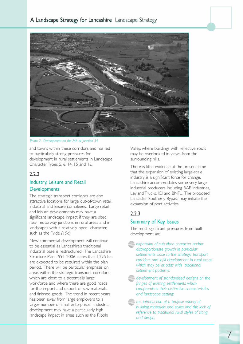
and towns within these corridors and has ledto particularly strong pressures fordevelopment in rural settlements in LandscapeCharacter Types 5, 6, 14, 15 and 12.
2.2.2Industry, Leisure and RetailDevelopmentsThe strategic transport corridors are alsoattractive locations for large out-of-town retail,industrial and leisure complexes. Large retailand leisure developments may have asignificant landscape impact if they are sitednear motorway junctions in rural areas and inlandscapes with a relatively open character,such as the Fylde (15d).
New commercial development will continueto be essential as Lancashire’s traditionalindustrial base is restructured. The LancashireStructure Plan 1991-2006 states that 1,225 haare expected to be required within the planperiod. There will be particular emphasis onareas within the strategic transport corridorswhich are close to a potentially largeworkforce and where there are good roadsfor the import and export of raw materialsand finished goods. The trend in recent yearshas been away from large employers to alarger number of small enterprises. Industrialdevelopment may have a particularly highlandscape impact in areas such as the Ribble
Valley, where buildings with reflective roofsmay be overlooked in views from thesurrounding hills.
There is little evidence at the present timethat the expansion of existing large-scaleindustry is a significant force for change.Lancashire accommodates some very largeindustrial producers including BAE Industries,Leyland Trucks, ICI and BNFL. The proposedLancaster Southerly Bypass may initiate theexpansion of port activities.
2.2.3Summary of Key IssuesThe most significant pressures from builtdevelopment are:
• expansion of suburban character and/ordisproportionate growth in particularsettlements close to the strategic transportcorridors and infill development in rural areaswhich may be at odds with traditionalsettlement patterns;
• development of standardised designs on thefringes of existing settlements whichcompromises their distinctive characteristicsand landscape setting;
• the introduction of a profuse variety ofbuilding materials and styles and the lack ofreference to traditional rural styles of sitingand design;
A Landscape Strategy for Lancashire Landscape StrategyA Landscape Strategy for Lancashire Landscape Strategy
7
Photo 2. Development on the M6 at Junction 34.

• barn conversions in rural locations which maydetract from the local landscape character -most are for residential development, althoughthey would represent an ideal opportunity forrural employment;
• a legacy of older buildings in urban areas inneed of adaptation or modernisation - thereis particular scope for urban regeneration inLancashire, with pressures for the appropriatere-use of historic buildings;
• potential for loss of urban character throughcontinuing clearance programmes;
• expansion of industrial, leisure and retaildevelopments and their concentration instrategic transport corridors.
2.3INFRASTRUCTURE
2.3.1Road Expansion and ImprovementsDespite government policy favouring thewidening and improvement of the existingroad network rather than the construction ofnew routes, there remains potential for roadimprovements to have significant impacts onlandscape character and on ecological andhistorical resources. Such improvements are aresponse to the forecasted massive increase incar ownership nationally - the number of carscould rise by 150,000 in the period 1991-2006 and road traffic could increase bybetween 33% and 66% (1).
Expansion of the road network, particularly inthe ‘Strategic Transport Corridors’ (2) may furtherfragment the countryside destroying valuedlandscapes, landscape patterns and historic andhabitat features. Increased accessibility in onearea may lead to a loss of tourism, jobs andservices elsewhere, although the relativeinaccessibility of some sensitive areas (such asArnside and Silverdale and The Forest ofBowland), which have a network of narrowlanes, helps to retain their characteristicisolation.
Proposed strategic improvement of the Fyldecoast easterly bypass, the Lancaster southerlybypass and improvements to the Trans PennineRoute threaten to increase built developmenton the fringes of many settlements and therecent extension of the M65 between
Blackburn and Clayton Brook has increasedpressure for development close to the newjunctions. However, if they are managedcarefully, modern road verges andembankments can introduce significant areasof semi-natural habitat into landscapes whichotherwise contain very little.
Minor road improvements in rural areas tendto have an urbanising influence as they bringadditional lighting, signage and an element ofstandardisation to the countryside. Forinstance, road developments in the IndustrialFoothills and Valleys (Landscape Character Areas6a and 6b) have had a degrading influence onthe rural landscapes fringing large settlementsas the new roundabouts , kerbs andengineered embankments have created astandard ‘roadscape’ which could be anywherein the country. Traffic calming and safetymeasures designed to reduce rural speedingand improve sightlines also tend to have asimilar homogenising influence. Some ofLancashire’s rural junctions have a distinctivepattern of railings. These and historic waysidemarkers are particularly vulnerable to theimpacts of new road schemes.
2.3.2RailwaysRail travel has significant advantages overprivate road transport in terms of its impacton the environment.
Improved access to the rail network by theplanned move to open rural stations, agreed inprinciple with the rail industry (3) will give morepeople the opportunity to travel by train, withpositive benefits to landscape andenvironment. Line-side improvements fornature conservation would make a valuableaddition to wildlife corridors andimprovements to the physical appearance andsetting of stations would be a positivecontribution to many settlements. A numberof disused railway lines have already becomevaluable wildlife habitats.
2.3.3Overhead Transmission Lines andCommunications Masts Overhead transmission lines are particularlyprominent in open and isolated landscapes.
A Landscape Strategy for Lancashire Landscape StrategyA Landscape Strategy for Lancashire Landscape Strategy
8(1) Lancashire Structure Plan 1991-2006, Lancashire County Council, 1997.(2) Lancashire Structure Plan 1991-2006, Policy 33, Lancashire County Council, 1997.(3) Lancashire Structure Plan 1991-2006, Lancashire County Council, 1997.

On a smaller scale they may also be visuallyintrusive where they appear on the skyline ofridgetops, for example in Landscape CharacterAreas 7a and 7b, Mellor Ridge and UphollandRidge.
Single high communication masts or towersare associated with civil aviation, defenceindustries and the telecommunicationsindustry. Many have permitted developmentrights and are not necessarily subject toplanning constraints.
Telecommunication masts can be particularlyintrusive in landscapes with a remote ruralcharacter and high points are under particularpressure (for instance in Landscape CharacterTypes 1,2 3 and 4). National policy ontelecommunications is designed to facilitatethe growth of existing systems.The rapidexpansion of the mobile telephone networkhas already had a significant landscape impactin remote, rural landscapes, such as LandscapeCharacter Areas 20a (Arnside and Silverdale) and5i, 12a, and 7c where a number of mastsseem visually intrusive.
It is difficult to predict whether thedevelopment of new masts will continue to bea significant force for change in the future asthis technology is constantly being updated.Policy in the Lancashire Structure Plan 1991-
2006 seeks to minimise the impact of newdevelopment by encouraging multiple use ofmasts and existing structures.
2.3.4Wind TurbinesLancashire’s extensive upland areas in theForest of Bowland and the Pennine fringestogether with the County’s coastline have highwind speeds and are locations favoured bythe wind energy industry for wind turbines.However, many of these areas are highly visiblefrom centres of population and in attractiverural locations so new wind farms couldpotentially have a wide visual impact. Theexisting windfarms on hill sides at CoalClough, Caton Moor and near the ChelkerReservoir, are man made elements on bleakremote hillsides, which have varying degrees ofimpact on the surrounding landscape.
As the finite resources of fossil fuels dwindleand wind turbine technology improves, it islikely that wind turbines will become morecommercially viable. (1) However, thepredominance of urban development on thecoast may be a significant constraint on theapproval of large wind turbine developmentsin this area. However, parts of the Fylde, theareas around Morecambe Bay and the east
A Landscape Strategy for Lancashire Landscape StrategyA Landscape Strategy for Lancashire Landscape Strategy
9(1) New and Renewable Energy - Prospects for the 21st Century. Conclusions in Response to the Public Consultation, Department of Trade and Industry, 2000.
Photo 3. Coal Clough Windfarm near Holme Chapel.

Lancashire uplands are relatively undeveloped and therefore may be the subject of pressurefor extensive turbine developments.
2.3.5Underground CablesExtensive new and replacement cablingschemes for information and digital technology,gas and electricity can pose significant threatsfor hedges, roadside and hedgerow maturetrees and occasionally other features andhabitats.
2.3.6Summary of Key IssuesThe most significant pressures forinfrastructure which have implications forlandscape are:
• ongoing, piecemeal road improvements, suchas widening and straightening, insensitivedesign of signs and roadside furniture andtraffic calming, which together have acumulative impact;
• growth in levels of rural traffic which has animpact on tranquillity and remoteness;
• the fragmentation of habitats and historiclandscape patterns as a result of linearinfrastructure developments;
• the homogenising influence of roadlandscapes on local landscape character;
• the opening of rural rail stations may have apositive impact by reducing traffic levels;
• additional pylons, overhead transmission linesand communication masts;
• increasing pressure to establish large windturbine developments.
2.4MINERAL EXTRACTION ANDLANDFILL
2.4.1Mineral ExtractionLancashire contains extensive mineralresources, some of which are of national andregional significance. The most important ofthese are construction minerals such aslimestone, gritstone, sand and gravel, and shale
which are used as crushed rock aggregates orin the production of building products such ascement or bricks. The policy framework forcontrol of new mineral developments isprovided by the Lancashire Structure Plan andthe emerging Lancashire Minerals and WasteLocal Plan. National policy (1) has determinedthe levels of aggregate provision to be made ineach region. The Lancashire Structure Plansets out the contribution to be made inLancashire 1992-2006. This amounts to 11million tonnes of sand and gravel (20% ofregional total) and 88.8 million tonnes ofcrushed rock (74% of the regional total).
Minerals can only be worked where theyoccur. Detailed policies for the control of newmineral workings are included in the emergingLancashire Minerals and Waste Local Plan.Planning decisions on proposals will be madehaving regard to their overall environmentalimpact and landscape impact will be animportant determining consideration. There ispotential for extended or new mineraloperations to have negative implications forvisual amenity, landscape character,archaeological and ecological resources,although detailed restoration plans are alwaysrequired. Landscape impacts can also resultfrom quarry traffic.
Restoration of completed mineral workingsoffers a positive opportunity to bring landback into productive use and/or to maximiseits amenity or ecological value. A fine exampleis the Mere Sands Nature Reserve, a formersand pit. However, where extensive sand andgravel extraction is restored as part of aleisure complex, permanent structures,infrastructure, gardens and sports facilities maydiminish rural character and natureconservation value.
Lancashire has limited peat resources and onlyone large scale extraction site and a smallnumber of smaller extraction sites.TheLancashire Minerals and Waste Local Planreflects national policy (as set out in PPG 13),which states that any future peat extractionshould be restricted to areas which havealready been damaged by recent humanactivity or are of no nature conservation value.Peat extraction is a particularly negative,though limited, force for change both in visualterms and because peat often conservesvaluable organic archaeological remains which
A Landscape Strategy for Lancashire Landscape StrategyA Landscape Strategy for Lancashire Landscape Strategy
10(1) Mineral Planning Guidance 6: Guidelines for Aggregate Provision in England, April 1994.

are indicators of Lancashire’s past climate andland use.
At present Lancashire has no deep oropencast mining operations and only a smallnumber of drift mines are worked. Futuredeep mining is unlikely to be a consideration,although new open cast coal mining (should itbe permitted) would represent a significantforce for change in the future, particularly inthe Industrial Foothills and Valleys.
2.4.2Abandoned Mineral WorkingsAbandoned quarry landscapes are common inLancashire, particularly in the east where thequarrying industry has left an indelible markon the landscape around Rossendale. Largeareas remain abandoned and opencast andunderground workings, spoil heaps, hushings,tramways and inclined planes are dramaticindicators of past activity. Whilst importantfeatures may have been lost throughreclamation schemes in the past and alsothrough neglect, the heritage associated withthese sites can contribute to excitingopportunities for positive restoration andprotection - many are a catalyst for localeconomic regeneration (1) .
2.4.3Landfill and Waste DisposalDisposal of waste by landfilling in disusedmineral workings or by landraising on thecoastal plain has been the primary means ofwaste management in Lancashire. However,European and UK Government policy isrequiring a reduction in the use of landfillingand an increase in other more sustainableforms of waste management such as recyclingor incineration. The Lancashire Minerals andWaste Local Plan proposes a reduction of25% in land filling by 2006: the plan indicatesoverall that no new landfill sites are neededbefore 2006, but safeguards two particularsites for future land filling in the longer term. Inthe longer term it is anticipated that furtherreductions in landfilling of degradeable wastewill be sought, in line with european nationalwaste strategies.There will be a continuingrequirement for landfill capacity all be it on areduced scale and additional facilities are likelyto be required post 2006 as exisitingauthorised capacity becomes exhausted.Thedetailed approach will be developed throughrenewing the Lancashire Structure Plan &Waste Local Plan Policies.
New waste treatment, transfer facilities andrecycling operations generate significant heavygoods traffic and the proximity principle,together with the use of the Strategic Road
A Landscape Strategy for Lancashire Landscape StrategyA Landscape Strategy for Lancashire Landscape Strategy
11(1) Olwen Todd-Jones, Landscape Design 284, 1999.(2) Lancashire Structure Plan 1991-2006, Policy 34, Lancashire County Council, 1997.
Photo 4. Mere Sands Wood Nature Reserve in former sand pit.

Network (2) will place pressure on certainlandscape types, although planning policiesmean that such facilities are likely to belocated within existing urban areas.
A significant proportion of sludge produced bysewage disposal works in the county isdisposed of in landfill sites, although newcontrols to prevent the disposal of untreatedsewage and sewage sludge at sea will lead toan increased demand for new treatmentdisposal facilities, with localised implications forlandscape character and visual amenity.
Fly-tipping of household and garden waste is agrowing concern and if it becomes establishedin a location, more permanent elements ofdegradation may follow. It continues to be aforce for change in urban areas and in ruralareas which are close to urban areas, such asLandscape Character Areas 6a, 6b, 4g,3a and 4c.
Summary of Key Issues for MineralExtraction and LandfillThe principal pressures for change arising frommineral extraction are:
• the impacts of extractive workings bothduring operation and following restoration,together with the impact on historic sites,industrial archaeology and characteristicpatterns of fields, woodlands and settlements;
• the visual impact of traffic associated withmineral workings, especially on traffic routesthrough rural areas;
• landscape implications of future wastetransfer, landfill and processing operations.
2.5AGRICULTURE AND LANDMANAGEMENT
2.5.1An Overview of Farming in LancashireAgriculture represents the major land use inLancashire and has an important role to playin safeguarding the environment and ruraleconomy. The total area of farmland inLancashire is approximately 211,101 hectares,excluding common land which totals 7,350hectares. Permanent pasture predominates andaccounts for approximately 57% of
Lancashire’s agricultural land. It isconcentrated in the Coastal Plain, UndulatingLowland Farmland, Valley Floodplains , LowCoastal Drumlins, Drumlin Field, IndustrialFoothills and Valleys and Moorland Fringe.Rough grazing is also a major land use (18%)and is located on the moors and heaths of theMoorland Hills and Moorland Plateaux whilecrops and fallow account for 13%, mostly onthe Coastal Plain.
Nearly 14% of Lancashire’s agricultural land isclassed as grades 1 or 2 (mostly in the Fyldeand West Lancashire) compared to a nationalaverage of 16%. 42% of the county’s land isclassified as being of grades 4 and 5. Thiscompares to 21% nationally and highlights thesevere limitations faced by some ofLancashire’s farmers. The size of holdings inLancashire is on average smaller thanelsewhere in the country. Holdings of lessthan 50 hectares account for 78% of allholdings and 26% of holdings are less than 5hectares. This may reflect the relatively largenumber of horticultural holdings, which aregenerally small. The average farm size is 40hectares although there has been a small butnoticeable increase in larger holdings over 100hectares over the last decade.
The dominance of permanent pasture is areflection of Lancashire’s relatively dampclimate and the suitability of soils forgrassland. Sheep and beef farming isimportant throughout the uplands. Dairying isimportant in the Ribble and Lune Valleys, theFylde and much of the lowland farmland.Cereals are grown on the coastal plain andhorticulture is important on the mosses ofWest Lancashire. Lancashire has a relativelyhigh proportion of rented farmland (42%compared to 35% nationally) althoughbetween 1987 and 1997 there was anincrease in the amount of privately ownedland.
Two percent of the county’s workforce isemployed in agriculture (compared to 1.8%nationally) although in some rural areas thefigure rises to 25%. However, in the period1987 to 1997 there has been a 14% reductionin the agricultural workforce - studies haveshown that for every job lost in agriculture 2.5jobs are lost in ancillary industries (1) .
A Landscape Strategy for Lancashire Landscape StrategyA Landscape Strategy for Lancashire Landscape Strategy
12(1) All figures from the MAFF Census 1997, in Farming and Rural Issues in Lancashire, FRCA 1999.

2.5.2Agricultural SubsidiesThe economy of the agricultural sector isdriven by the changing structure of economicsubsidies available through central governmentand the European Union. The followingsections set out the pattern of subsidies in thepast five years and provides some indication ofhow the agricultural sector may be funded inthe future.
Subsidies Available from the Ministry ofAgriculture, Fisheries and Food (MAFF)MAFF’s agricultural support schemes includeboth direct support schemes and agri-environment schemes. Direct supportschemes target lowland and upland beef andsheep producers and producers of combinablecrops. Dairy producers are indirectlysupported through a complex system ofintervention and quotas, whilst pigs, poultryand horticultural units do not receive directsubsidies. Agri-environment schemes includemany initiatives designed to sustain landscapebeauty and diversity, protect wildlife habitats,conserve archaeological and historic featuresand improve opportunities for people to enjoythe countryside. In Lancashire there are 400Countryside Stewardship agreements; 6 farmscovering 372 hectares under the Organic AidScheme; 16 farms involved in the HabitatScheme; and 4 agreements covering 1745hectares in the Moorland Scheme (1) .
European Union - Objective 5b FundingIn 1994 parts of England were designated asObjective 5b areas because of a high relianceon agriculture as part of the local economy. InLancashire the Objective 5b area is in the NEportion of the county and broadlycorresponds to areas also classified as LessFavoured Areas. The Objective 5b programmeaims to strengthen local economies bygenerating and increasing incomes for localresidents whilst sustaining environmentalquality. Although funding of existing projects isto continue until 2001, no new registrationshave been permitted since October 1999.Recent initiatives include The Lancashire FarmTourism Initiative, where grants training andmarketing advice assist with the developmentof new farm tourist enterprises, and theNorthern Uplands Moorland RegenerationProject, which helps moorland owners andfarmers to improve the economicperformance of their farming and shootingenterprise, as well as the environmentgenerally. The Forest of Bowland AONB wasalso assisted by a Leader II designation whichaimed to develop community projects topromote local culture and heritage andenhance the environment, while alsocontributing to the local economy andemployment
A Landscape Strategy for Lancashire Landscape StrategyA Landscape Strategy for Lancashire Landscape Strategy
13(1) Farming and Rural Land Use Issues in Lancashire, FRCA, 1999.
Photo 5 Poorly maintained hedge.

The Bowland InitiativeThe Bowland Initiative was established (alongwith a programme in Bodmin Moor, Cornwall)to test whether it was possible to produce acombined package of measures that addressedboth economic and environmental issues. Theobjective is to increase the rural community’sawareness of the potential economic value ofenvironmental quality and to adopt anintegrated competitive approach to marketingfarm and forestry which is based onenvironmental criteria. The initiative operateswith primary funding from Objective 5b andMAFF across the whole Objective 5b area ofLancashire (January 1999-June 2001).Landowners are provided with a free businessand environmental appraisal, assistance withbusiness planning, grants for certain capitalinvestments, diversification and tourismdevelopment and payments for maintainingand restoring farm landscapes and wildlifehabitats.
Countryside StewardshipCountryside Stewardship is an incentivescheme which aims to make conservation partof land management practice and increasesustainable management on a long term basis.It is available throughout the whole ofLancashire, although interested parties whichfall within the Bowland Initiative area mustseek access to Countryside Stewardshipthrough the Bowland Initiative Project.Applications are invited for a range of habitatconservation schemes for semi-naturalgrassland, heath, wetlands, mosslands, riparianhabitats, coastal habitats and moorland.Proposals to establish field margins onagricultural land, restore orchards and fieldboundaries and provide permissive access arealso encouraged. Proposals should addressthe schemes main objectives of landscape,wildlife, history and access. CountrysideStewardship has proved to be popular inLancashire; in 1991-1998 there have been 459agreements (compared to 400 in Cumbria and345 in Northumberland. (1)
Rural Development RegulationThe Rural Development Regulation (RDR)became operational from 1 January 2000 andis the latest phase of the reform to theCommon Agricultural Policy (CAP). It lays thefoundation for a new European framework in
which reforms in agriculture will becomplemented by integrated measures tosupport rural development and protect andimprove the environment.
The RDR seeks to simplify the framework forsupporting rural development by groupingregulations into “accompanying measures” and“non accompanying” measures:
• accompanying measures cover CountrysideStewardship, organic aid, early retirement,LFA compensatory allowances andafforestation of farmland;
• non- accompanying measures coverinvestment in agricultural holdings, aid foryoung farmers, training, marketing andprocessing grants, other forms of forestryand general rural development similar tothose measures in Objective 5b areas (2) .
It is too early to predict how the RDR willinfluence the dynamics of the agriculturalsector, but the new package of grants willcontinue to encourage environmentalmeasures as a fundamental aspect of theagricultural economy.
2.5.3Review of Farming Types in LancashireThe changing pattern of agricultural subsidieshas a varying impact on different types offarming and therefore in different parts of thecounty:
• Dairy - a decline in milk prices and theimpact of BSE on calf and dairy stockvalues has led to a decrease in profitability.The strong pound continues to reduceprofitability and force smaller producersout of business. This will encourage theamalgamation of farm units, although lowermilk prices and less labour means this maynot necessarily lead to intensification ofproduction. The vast sheds associated withintensive dairy farms have implications forvisual amenity and there may be a greaterrisk of pollution from slurry storage andwaste management. The smaller, remoteproducers with relatively higher costs formilk collection are most at risk
• Lowland beef cattle and sheep - the declineof dairy farming may encourage somefarmers to change to beef and sheep, but
A Landscape Strategy for Lancashire Landscape StrategyA Landscape Strategy for Lancashire Landscape Strategy
14(1) Personal communication, Kirsty McKay-Martin, FRCA 27.6.00.(2) Rural Development Regulation, Consultation on Implementation in England, MAFF, 1999.
the combined impact of BSE and a risk ofoversupply mean that profits are low.Former dairy farms may be relativelyaccessible to markets and may force themore remote beef and sheep producers todiversify or leave farming. Since 1998prices for finished lamb have fallensignificantly with detrimental effects forboth lowland and upland producers.Expansion and possible intensification ofoperations increases competition withupland producers and may result in theamalgamation of farm units.
• beef cattle and sheep (Less Favoured Areas)- anxiety about low incomes is exacerbatedby concerns about the impacts of theCountryside Bill (designations andincreased public access) and lack of pensionprovision for an ageing population offarmers. With lower profitability, the nextgeneration are leaving farming and manyupland farms are likely to be abandoned oramalgamated into large estates, especially ifpressure is increased by new competitionfrom the lowlands. Commoning is also indecline with relatively few young grazierswith the will or expertise to managecommons flocks. The remaining commongrazing land is under pressure from urbanexpansion or reversion to scrub. However,an increased commitment to developingregional red meat brands (as encouragedby the Bowland Initiative) could bringpositive benefits.
• Cereals and general cropping - the arablesector is under pressure to improvestorage and handling facilities but marketprices and therefore profitability are low.The result may be further intensification ofproduction, with potential loss ofhedgerows and increased use of chemicalfertilisers, but could equally be in theopposite direction in order to reduce inputcosts. The main impact of CAP reforms isexpected to be an increase in the relativeprofitability of oilseeds and protein crops incomparison to cereals. The currentproposals appear to discourage rotationalcropping and integrated crop managementsystems which are of benefit to theenvironment through increased biodiversityalthough farm assurance schemesincreasingly involve optimising inputs usedand environmental care.
• Pigs and poultry - profitability is affected bythe strong pound, increased input costs anda general oversupply in Europe. However,the increase in the popularity of whitemeat has been a positive boost. Thebanning of battery cages in 2012 will havea significant impact on poultry farmers asmany producers will look to free rangeproduction on larger areas of land. In 2003battery farmers will be legally required toreduce their stocking density by 20%, whichcould lead to an equivalent expansion inthe area needed for the same number ofhens. The ultimate outcome could be theconcentration of poultry farming into asmall number of very large producers.
• Horticulture - remains unsupported bygrants and is also threatened by the strongpound. Further pressure will arise from theforthcoming Climate Change Levy, which willrequire glasshouse producers to pay a taxon their use of gas, electricity and coal inan effort to reduce CO2 production.Supermarkets have also reduced theviability of large wholesale markets as theyapproach a small number of largeproducers forcing smaller producers out ofthe market. Climate change, and inparticular rising sea levels is also aconsiderable threat to horticulture whichtends to be located on low lying, drainedpeats close to the coast. The implicationsof this may be the abandonment ofhorticulture in favour of other farming oramalgamation into larger and moreintensive units.
2.5.4DiversificationPoor profits in all sectors of the agriculturaleconomy are fuelling a general trend towardsthe diversification of farming activities.Innovative marketing and quality assurance arerequired to ensure that less productive cropsand livestock provide a viable alternative totraditional farming. Farms are also becomingincreasingly active in the fields of tourism andrecreation.
Alternative products such as industrial crops(flax and hemp for example) and theproduction of biomass fuel may be importantas the Non-Fossil Fuel Obligation (NFFO)requires regional electricity companies to
A Landscape Strategy for Lancashire Landscape StrategyA Landscape Strategy for Lancashire Landscape Strategy
15

obtain a proportion of their power fromrenewable energy sources. This represents animportant opportunity, especially in thelowlands, where the skills and infrastructurerequired are generally already in place.
There is likely to be a continued transition toorganic production, both of livestock andcrops, particularly now that increased supportis available. For example, organic beefproducers have developed a small but growingmarket for organic meat and have organisedthemselves into a marketing organisationknown as the “Organic Livestock MarketingCo-operative”. Currently organic productionin Lancashire is limited in scale and extentalthough there are good opportunities in WestLancashire, where supermarkets may raisedemand for organic vegetables.
There is considerable scope in Lancashire forfurther development of accommodation andrecreational facilities in rural areas, althoughthis is a very competitive sector. Those farmbusinesses most in need of an additionalincome source are often the least able to raisethe high levels of investment capital requiredto establish accommodation or recreational/leisure facilities. Tenant farmers will also beinhibited from developing schemes due to therestrictions of tenancy agreements. However,the availability of grant aid via the FarmTourism Initiative should go some way toalleviating this problem.
Other farm based businesses, such as passivelets and storage, may be constrained byaccessibility. In remote rural areas thedevelopment control process may also limitthis type of diversification.
Many farmers have alternative sources ofincome, particularly if they have access toregional town centres. There has also been asignificant increase in hobby farming, whichmay bring related problems of short termmanagement regimes and lack of traditionalagricultural skills. Horse paddocks and‘horsiculture’ are a particular feature of thistrend and may be associated with a relativelycluttered landscape character. and in particulararound urban centres. The abandonment ofurban fringe areas (such as parts of Chorley,Blackburn, Hyndburn, Rossendale and Pendle)by full time farmers and their replacementwith ‘hobby farmers’ ranging from scrap
merchants to owners with substantial capitalto invest, is having a significant landscapeimpact.
2.5.5Summary of Key Issues for theAgricultural Sector
• The influence of national policies, driven bythe changing structure of agriculture andother rural development subsidies at aEuropean level.
• A decline in traditional land managementpractices due to intensification has causedthe removal of biologically diverse anduncommon habitats including herb-rich haymeadows and pastures and some naturalwet grasslands. It has also led to formallycommon and characteristic wildlife speciesbecoming rare. It may also lead to theabandonment of traditional buildings,degradation of field boundaries etc.Conversely, complete abandonment of theuplands and commons could in future leadto the neglect of habitat and even to scrubencroachment, although these effects canbe positive in nature conservation terms.
• Erosion of peat based soils has implicationsfor soil quality and places the richarchaeological record at risk.
A wholesale fall in agricultural markets may leadto the abandonment or amalgamation of farmsas the next generation perceives agriculture tobe an unattractive option.The forecasts (1)
suggest that over the next 5 years between10% and 15% of full time farmers will go outof business. Agri-environment schemes andgrant aided diversification will help in the shortterm, but the agricultural economy is in crisisand change threatens rural economies,landscape character, visual amenity and skills.Lancashire farmers and growers could benefitby marketing themselves as environmentallyfriendly producers from a county whichnevertheless retains a high diversity of habitatsand wildlife overall.
• Diversification of farm businesses continuesto supplement agricultural incomes, withbenefits for managing traditional attractivefarming landscapes, although some areashave more potential for landscape
A Landscape Strategy for Lancashire Landscape StrategyA Landscape Strategy for Lancashire Landscape Strategy
16(1) Farming and Rural Issues in Lancashire, FRCA, January 1999.

enhancement through diversification thanothers. Diversification may not always bebeneficial in landscape terms.
• The poor agricultural economy and increasingcompetition from lowland farms may make itdifficult for upland farmers to make a livingfrom their land and cause abandonment.
• An increase in part time ‘hobby’ farming withrelated farm fragmentation, loss oftraditional farm boundaries and decline intraditional land management strategies infavour of short term gains.
• The influence of policies of large retail chainson agricultural practice is becoming anincreasingly important factor in landscapeterms by imposing restrictions andconditions on the environment in whichtheir crops are grown.
2.6FORESTRY AND WOODLANDApproximately 14,000 hectares of land inLancashire is wooded, representing a relativelylow 4.6% of woodland cover (compared to8% for England (1) . Woodland is scatteredover the whole county, but is particularlysparse on the uplands of east Lancashire andon large areas of highly productive land in thewest of the county. Over 60% of thewoodland is found in the districts of the Ribble
Valley and Lancaster. The composition of thewoodland is approximately 60% broad-leaved,30% coniferous and 10% mixed; woodland ofcoppice origin covers less than 1% of the area.Ancient woodland is also important andcovers 34% of the total wooded area. It isconcentrated on the steep sided river andstream slopes of the Ribble,Wyre and LuneRiver catchments and in the Arnside andSilverdale AONB.
In Lancashire the Forestry Commission ownsapprox. 2000 of the 14,000 ha totalwoodland cover. Despite there being relativelylittle forestry tradition, the proximity to goodtransport links and major timber processingindustries does offer great potential. 65% ofprivate woodlands are less than 5 hectaresand the only sizeable area of woodland isGisburn Forest, which was planted in the1950’s. Here the land is owned by NorthWest Water (one of the largest woodlandowners in the county) and leased to theForestry Commission.
Woodland on farms comprises 20% of thetotal area of woodland in Lancashire. In arecent farmers’ attitude survey to woodlandplanting and management (2) it was found thatof the 50 farmers interviewed 60% of farmershad considered woodland planting but 80% ofthese had shelved the idea because of theeconomic climate and the lack of suitable land.
A Landscape Strategy for Lancashire Landscape StrategyA Landscape Strategy for Lancashire Landscape Strategy
17(1) England Forestry Strategy, Forestry Commission, 1999.(2) Farmers’ Attitude Survey - A Survey of 50 Farmers in Lancashire to determine their attitude to Woodland Planting and Management, Dr Margaret Bell, 1998-9.
Photo 6. Woodland in the Arnside and Silverdale AONB.

It would appear that there was also a lack ofunderstanding and guidance as to the benefitsof woodland creation and management. Thesurvey confirmed the general lack of a treeplanting tradition or culture amongst farmersin Lancashire.
2.6.1Government PolicySince the turn of the century successivegovernments have pursued policies of forestexpansion through felling controls, plantingincentives and afforestation. The ForestryCommission is the government’s leaddepartment for forestry and current policiesfor forestry development in England areexpressed through the England ForestryStrategy, (1) which focuses on the delivery ofpublic benefit via delivery of four programmesfor forestry:
• rural development;
• economic regeneration;
• access, recreation and tourism; and
• environment and conservation.
These programmes, delivered via integratedpartnership working, will ensure the quality ofnew woodlands and the management formultiple benefits of existing woodland.
IncentivesThe Woodland Grants Scheme (WGS) ismanaged by the Forestry Commission. It isthe principal government incentive schemeencouraging new planting and woodlandmanagement on privately owned land.Incentives available include one-off paymentsper hectare for restocking and annualpayments for management and enhancingpublic access. Payments are also available forbringing abandoned woodland back intomanagement. The creation of holistic ForestPlans by private woodland owners is alsosupported by the WGS system. In additionthe Farm Woodland Premium Scheme offersgrants to farmers to plant trees on improvedagricultural land. Of the 10,481 ha of privatelyowned woodland in Lancashire, 4,347 ha aremanaged with assistance from WGS (or other)grants. (2)
Countryside Stewardship is also available as agrant source for small-scale woodland plantingon farms.
TargetingRecently the Forestry Commission introduceda scoring system for targeting WGS forwoodland creation. It is based on theprovision of public benefit. The EnglandForestry Strategy also identifies four prioritiesfor woodland creation: the creation of largerwoodlands, where they can deliver greaterbenefits; the creation of woodland on theurban fringe; the restoration of formerindustrial land; and reversing the fragmentationof ancient woodland.
Indicative Forestry StrategyThe expanding forest resource is todayrequired to fulfil a diverse range objectivesfrom timber production, landscapeenhancement, employment, wildlifeconservation farm diversification andeducation. In Lancashire, an Indicative ForestryStrategy (3) identifies areas in whichafforestation would be preferred (much of thelowlands with the exception of productiveagricultural land) and areas which would beparticularly sensitive to forestry (high gradeagricultural land, AONBs and areas over 300mabove sea level). ‘Sensitive areas’ do notpreclude tree and woodland planting, althoughthe Strategy states that:
• special landscape features are ofparamount importance;
• there will be an emphasis on the renewaland enhancement of existing woodlands,hedgerows and hedgerow trees;
• new planting must be sympathetic withexisting landscape character ;
• where it is part of agriculturaldiversification planting should be in keepingwith a highly productive and well orderedlandscape;
• where it occurs on land 300m above sealevel planting should consist of nativespecies and not intrude on thepredominantly open, unenclosed uplands.
A Landscape Strategy for Lancashire Landscape StrategyA Landscape Strategy for Lancashire Landscape Strategy
18(1) Forestry Commission,The England Forest Strategy.(2) Personal communication - Kit Brown, Assistant Conservator, Forestry Commission 27.6.00.(3) An Indicative Forestry Strategy for Lancashire, Lancashire County Council, October 1994

2.6.2Opportunities and Current InitiativesThere is great potential to deliver publicbenefit via woodland creation andmanagement in Lancashire. A number ofinitiatives have been developed in order toachieve this:
• The Bowland Initiative Woodland Project ispart of the Bowland Initiative which aims tosupport farmers and rural businesses in theObjective 5b area. The initiative promotessustainable woodland management byoffering advice and financial assistance,adding value to woodland products toprovide opportunities for incomegeneration, and initiating training inwoodland skills including farm woodlandmanagement, deer and squirrelmanagement and small business skills.There is also some scope for creating newnative woodland (1)
• The Millennium Forest of Burnley is fundedby the Millennium Commission andForestry Commission in partnership withBurnley Borough Council, North WestWater, Lancashire County Council, privatelandowners, local business and thecommunity. With a total budget of £3.5mthe project aims to create 500 ha of newwoodland, restore 200 ha of neglectedwoodland, plant 2000 specimen treeswithin Burnley (to create an ‘UrbanArboretum’) and encourage an arts andeducation programme to raise publicappreciation of trees. By 2001 it is hopedthat woodland cover in Burnley will beincreased from 3% to 7%, only 3% short ofthe average for Britain. The Forest ofBurnley applies for grants on behalf ofprivate landowners to ensure that they donot incur costs.
• ELWOOD is an ambitious schemepromoted by a partnership betweenGroundwork, local authorities, the ForestryCommission, Lancashire Wildlife Trust andthe National Urban Forestry Unit. It aimsto contribute to economic regenerationthrough environmental improvements andjob opportunities by developing a networkof locally initiated woodland schemes. Thewoodlands will form the focus forrecreation, education and cultural activities
and will provide a quality environment forlocal communities.
2.6.3Summary of Key Issues for Forestry
• Inadequate realisation of the wide range ofpublic benefits to Lancashire that woodlandscan provide.
• Ensuring the development and extension ofpartnership initiatives such as ELWOOD, theBurnley Millennium Forest and the BowlandInitiative.
• Lack of a forestry tradition and smallwoodland resource which hamperswoodland management and provides pooreconomic return.
• Restructuring of existing woodlands usingForest Design Plans to achieve multi-purpose woodlands.
• The impact of woodland management grantson improving biodiversity and public access.
• Lack of management and naturalregeneration in many small semi-naturalwoodlands due to livestock grazing andalso deer.
• Encouragement of sustainable woodlandmanagement through the development ofmarkets for woodland products to preventdeterioration of the woodland resource.
• Increasing the area of woodland cover asoutlined in the England Forestry Strategyand ensuring that local forestry strategiesare cross-compliant.
2.7TOURISM AND RECREATIONTourism is a significant economic activity inLancashire; in 1991 there were 51,000 peopleemployed in tourism-related activities.(2) Asignificant proportion of visitor trade iscentred upon Blackpool, the most popularholiday resort in Britain in 1996 when itattracted 20 million visitors (and provided30,000 jobs). The nearby coastal resorts ofMorecambe, Cleveleys, Fleetwood and LythamSt Annes also attract millions of visitors eachyear.
Tourist pressure is however not confined tothese honeypot destinations and the increasingpopularity of informal country breaks and
A Landscape Strategy for Lancashire Landscape StrategyA Landscape Strategy for Lancashire Landscape Strategy
19(1) The Forest of Bowland - The Potential for Creating New Native Woodland, English Nature (Rigby Jerram), 1999.(2) A Tourism Strategy for Lancashire, Lancashire County Council, 1995.

countryside activities places pressure uponrural Lancashire. Walking, especially in opencountryside is a major recreational pursuit andproposed new open access legislation couldchange patterns of existing activity. There isincreasing interest in visits to sceniccountryside such as the Forest of Bowland, theWest Pennine Moors and Arnside andSilverdale, as well as to historic sites, such asGawthorpe Hall,Turton Tower and HelmshoreMill. The quality of the county’s landscape andits associated natural attractions including itswildlife are in themselves highly important ineconomic terms through tourism andrecreation. Recent studies (1) have shown thatthe natural environment in the MorecambeBay area and at the RSPB reserve at LeightonMoss make a significant contribution to thelocal economy in this way.
Appropriate tourist development in rural areascan help to diversify local economies, enhancethe countryside and create new jobs.Initiatives such as the Bowland TourismEnvironment Fund may be successful in raisingmoneys from the tourism industry forenvironmental care/management. Farmdiversification is recognised as an importantway of maintaining the viability of small farmholdings, allowing farmers to remain on the
land and continue to practice traditionalfarming activities. However increases in traffic,litter, signage and built development maythreaten visual amenity and landscapecharacter.
Caravans, chalets and holiday villages mayintrude on the rural nature of some areas asthey create a built environment often similar inscale to villages and introduce infrastructure,buildings and domestic features such asgardens. Key areas under particular threat arethe Fylde (Landscape Character Area 15d) andNorth Fylde Mosses (16a) because they areclose to coastal resorts. Restored gravel pitsare also often a focus for intensive recreationaluse, as at Dock Acres, where there areproposals for a holiday village and leisurecentre.
There are ongoing pressures for multi-purposeentertainment, recreation and retail centres.Such developments often require extensiveland and generate large volumes of traffic asthey increasingly cater for a range of interests.Sites are often chosen for their proximity tolarge populations and may place pressuresupon land within the Strategic TransportCorridors (2) However, these large scaleleisure developments may represent a positive
A Landscape Strategy for Lancashire Landscape StrategyA Landscape Strategy for Lancashire Landscape Strategy
20(1) Morecambe Bay Strategy, October 1996.(2) Lancashire Structure Plan 1991-2006, Policy 33, Lancashire County Council, 1997.
Photo 7. Visitor Pressure, Nick of Pendle.

catalyst for the regeneration of derelict landand can help to steer pressure away frommore sensitive areas and attractions.
Golf courses can be intrusive features in thelandscape where their design introducesuncharacteristic features such as formalornamental planting blocks, mown amenitygrass or bunkers to an otherwise rural scene.They are often proposed as part of arecreational development at historic countryhouses and can represent a threat to theintegrity of historic designed landscapes.
Equestrian centres are an opportunity for ruraldiversification, although large indoor ridingschools, stables and paddocks withfloodlighting can be detrimental to landscapecharacter. At particular risk are rural areas onthe fringes of settlements.
The rising popularity of canal holidays offers apositive opportunity to utilise the extensivecanal network in Lancashire which totals 164.8km (1) . The Ribble Link Trust plans toconstruct a link between the Lancaster Canaland the River Ribble, creating a navigable linkbetween the Ribble Estuary and the LancasterCanal and allowing boats to enter the Leedsand Liverpool Canal. This new link willincrease the length of the navigablewatercourse and will provide a range of newopportunities for tourism and recreation, suchas marina developments. (2) There is also likelyto be increased pressure for new marinas on
the existing Lancaster Canal. The LancasterCanal is the largest and most species-richwater body in the county. At present thenumber of boat movements on the Canal is atnear optimum levels for wildlife, but there is arisk that new developments for recreation andthe increase in boat traffic on the Ribble LinkExtension, may cause conflict with natureconservation interests; research undertaken atLiverpool University (3) indicates that increasedboat traffic above a fairly low thresholdsignificantly reduces biodiversity and increaseserosion.
2.7.1Summary of Key Issues for Tourism andRecreationThe unique landscape, historical and ecologicalqualities of Lancashire are vulnerable to thechanging pressures from tourism andrecreation. These include:
• erosion of tracks, footpaths and associatedvegetation through walking, horse riding,mountain biking are county wide, but areparticularly visible in upland areas;
• realising the economic potential of the naturalenvironment without detriment to theenvironmental resource;
• pressure for amenity and recreational facilitiessuch as golf courses and marinas, which areoften associated with new housing or hoteldevelopments, and holiday villages andcaravan parks - all of which may haveadverse impacts on landscape character ;
• increase in traffic levels, particularly on quietrural roads , which may erode theircharacter ;
• significant landscape impacts arising from thespread of large scale multi-purpose recreationdevelopments on the outskirts of urbancentres;
• effects on water quality and pressure onnature conservation interests as a result ofthe rising popularity of canal holidays.
A Landscape Strategy for Lancashire Landscape StrategyA Landscape Strategy for Lancashire Landscape Strategy
21(1) Lancashire - A Green Audit, Lancashire County Council, 1990.(2) Local Environment Agency Plan. Ribble Consultation Draft,The Environment Agency, 1999.(3) Effects of Pleasure-Boat Traffic on Macrophyte Growth in Canals, K J Murphy and J W Eaton, in Journal of Applied Ecology (1983), 20, 713-729, Dept of Botany,University of Liverpool.
Photo 8. Lancaster Canal at Galgate.

2.8WATER BODIES & WATER QUALITY Lancashire’s upland streams, large lowlandrivers and estuaries vary considerably involume, quality and biological value. On thewhole water quality in the rivers is good. Evenwith industrial and sewage discharges themajority of rivers ( 72%) are classified as Class1a, 1b (‘good’) or 2 in accordance with thestandard UK river water quality classificationscheme. Only 5% are classified as Class 4(‘bad’). (1)
Local water channels, such as streams andditches, are of particular nature conservationinterest, as are ponds, lakes and the county’s118 reservoirs. Many of Lancashire’s waterbodies are man-made and originate fromhistoric marl pits, mill lodges or more recentsand and gravel extraction.
Areas of high pond density are found in partsof the Coastal Plain and Undulating LowlandFarmland (particularly in Landscape CharacterAreas 15b, 15c, 15d, 5c, 5d, 5h). They are oflandscape and heritage interest, as well asvaluable habitats for wildlife. Numerous pondshave been infilled in the past during phases ofagricultural intensification. The remainingponds are under continual threat fromdevelopment, changes in agricultural practices,infilling and nutrient enrichment. Their value isgreatly increased when they form part of alinked network of habitats and theirfragmentation is therefore also a considerablerisk to their wildlife value. Other importantwater bodies include meres and tarns, such asLeighton Moss and Martin Mere.
Lancashire’s rivers and streams vary from thefast flowing upland streams and rivers ofBowland and East Lancashire to the widemeandering rivers Lune, Ribble and Wyre.Lancashire’s two canals; the Leeds andLiverpool and the Lancaster canal and theircorridors are important landscape features.
The increased use of river and canal corridorsfor recreation can disturb plant and bird life inparticular and, locally cause bank erosion. Inrivers such as the Wyre, historic waterabstraction rights may cause artificially lowflows, leading to detrimental effects to faunaand flora and the loss or deterioration ofwetland features. Variations in agricultural
practices and increases in visitor pressure mayresult in the increased occurrence ormagnitude of these problems.
Slurry and silage liquor discharges from farmswith inadequate containment facilities, thespreading of slurry to land and dischargesfrom small private sewage works treatmentworks and septic tanks all contribute to risingammonia levels in rivers. Run-off from fieldscontaining fertilisers and pesticides may alsobe extremely damaging to water quality inlocal water courses (eutrophication). Thisform of pollution can effect water quality forflora and fauna and in particular fish and canbe minimised by the development of bufferstrips between fields and water-courses tolimit run-off from agricultural areas. It is likelythat the move to more intensive dairyingoperations will result in increased levels ofslurry and there is a risk that any increase inholiday homes and caravans not linked to themain sewage network will result in risingammonia levels throughout the river network,in particular in rural areas.
Increased residential and commercialdevelopment threatens water courses as theexisting sewer capacity may becomeinadequate. The consequences include thedeterioration of water quality or an increase inthe scale and number of sewage treatmentworks, particularly on the fringes of largeurban areas.
Large chemical, industrial and landfill sites (suchas the concentration along the open coastalmarsh near Fleetwood), are of particularconcern because there is a risk of leachate anddischarges into water courses. Although strictcontrols are placed on the level and type ofdischarges permitted, the expansion of existingoperations or siting of new factories in thearea raises the potential for poor storage andaccidental spillage, with subsequentcontamination of groundwater and watercourses. Proposals for redevelopment ofindustrial areas may also lead to the discoveryof contaminated land which will requireappropriate remediation techniques to reducethe risk of contamination of groundwater andlocal water courses.
All major roads are constructed with drainagesystems designed to remove surface water andpollutants and drain into the nearest available
A Landscape Strategy for Lancashire Landscape StrategyA Landscape Strategy for Lancashire Landscape Strategy
22(1) Figures from North West Water 1998, in Lancashire - A Green Audit, Lancashire County Council, 1990.

watercourse. Road improvements place anadded burden on the aquatic environmentaffecting both the risk of flooding and theincreased pollution load. Similarly increases inurban development and industrial activityinfluences the amount of waste produced andplace increased demands on waterresources. (1)
2.8.1Summary of Key Issues for WaterQuality and River FlowsThe most significant pressures on water flowsand quality are:
• loss of ponds and coastal wetland habitats;
• bank erosion from recreational pressures;
• water abstraction lowering water levels;
• eutrophication and raised ammonia levels asa result of increases in farm slurryproduction and residences not linked tothe sewage network;
• increased residential and commercialdevelopment placing pressure upon sewercapacities;
• the potential impact of chemical andindustrial industries especially whereexpansion of existing operations or thesiting of new operations occurs;
• increased run off from new roads and builtdevelopment into nearby water courses.
2.9AIR QUALITY AND CLIMATECHANGEThe release of pollutants into the air mayinfluence air quality and climate change. Airpollution can also affect health andbiodiversity; sensitive species such as lichens,habitats which are naturally low in nutrients,and habitats on acid soils or in acid waters areparticularly at risk. Air quality in Lancashire islikely to be far better now than in the past.This is evidenced by the spread of pollutionsensitive lichen species into areas where theywere previously absent. (2) Nevertheless, airquality is a significant issue in Lancashire asindustrial areas along the coast are close tosensitive wetland and upland habitats.
The global climate is expected to change as aresult of burning fossil fuels, methane andnitrous oxide from agriculture, industry andwaste disposal. Expert judgement suggeststhat climate change in North West Englandwill result in increased temperatures (0.1 o/cto 0.3 o/c per decade), more winter rainfall(between 6% and 14% increase by 2050’s),higher wind speeds, fewer winter frosts,perhaps more variable weather, higher sea-levels and perhaps more stormy weather andhigher wave heights. (3)
Climate change is already happening andprojections into the next century suggest thatit will influence a great many physical, chemical,biological and human activities, includingchanging the appearance of the landscape,coastline and urban infrastructure. Globalwarming is accompanied by the prospect ofworld wide sea level rise. The average globalsea level rise is expected to be 6 cm perdecade over the next century (4) , mainlycaused by thermal expansion of the oceansand melting of low level land ice.
In Lancashire the coastal zone will be subjectto increasing risk of tidal inundation from acombination of high tides, tidal surges and highwaves in the Irish Sea. Much of Lancashire hasa low lying coastline which is already at riskfrom flooding. Increased wind speeds mayalso threaten coastal copses. Lancashire’sexisting coastal defences do not take accountof climate change induced wave height and thefrequency of tidal surges. The loss of mudflatsand salt marshes would have major impact onthe internationally significant bird feedinggrounds found in the extensive bays andestuaries. Ports, harbours, resorts, coastalindustries and occupations such as farming orfishing are also vulnerable to more extremetidal events. Dredging of harbours may alsoneed to be increased as a result of increasedsilt levels bought in by rivers and wind blownmaritime silt driven by the increased speed ofsouth westerly winds.
The uplands too could change significantly incharacter as a result of warmer, wetterconditions. The changes could affect soils,moorland vegetation and those upland animaland plant communities which are adapted to arelatively cold maritime climate. There will bean inward migration of new species, anoutward migration of marginalised species and
A Landscape Strategy for Lancashire Landscape StrategyA Landscape Strategy for Lancashire Landscape Strategy
23(1) Local Environment Agency Plan,Wyre Consultation Report, Environment Agency 1997. (2) Biological Heritage Sites: Guidelines for Site Selection,Lancashire County Council, 1998. (3) Everybody has an Impact - Climate Changes in the North West of England, An Initiative of the North West Climate Group.September 1999. (4) As stated by the Intergovernmental Panel on Climate Change ‘Business as Usual’ scenario, 1990.
an increased risk of upland fires which damagethe economy of upland estates and theirecological value.
2.9.1Summary of Key Issues for Air Qualityand Climate ChangeThe most significant pressures from airpollution and climate change are:
• potential loss of inter-tidal and other coastalhabitats and biodiversity due to rising sealevels;
• loss of species at the edge of their range dueto the impacts of species competition andmigration;
• impact on sensitive species such as lichenswhich are particularly susceptible to airpollution;
• gradual changes in wildlife communities inresponse to climate change, pests and firehazard;
• increase in tidal surges, high waves andcoastal winds which will have implications forcoastal defence works.
A Landscape Strategy for Lancashire Landscape StrategyA Landscape Strategy for Lancashire Landscape Strategy
24

3.
Landscape StrategyThe strategies for each landscape charactertype are based on the landscapecharacterisation set out in the accompanyingLandscape Character Assessment report. Thelandscape characterisation provides aclassification of the landscape into landscapeunits and a baseline description of landscapecharacter. The landscape character types andlandscape character areas identified in thestudy are presented in Figure 2.
The landscape character type strategies takethe analysis a step further; the descriptionsform the basis for an analysis of landscapesensitivity and vulnerability to change,developing key recommendations to guidepositive landscape change. Each of thelandscape character type strategies includes:
• Key environmental features - Thoseenvironmental features which make themost critical contribution to the characterof the landscape. The notes identify keyenvironmental features for each landscapecharacter type and record why they areimportant. These features do notnecessarily occur in all the landscapecharacter areas within a particularlandscape type.
• Local forces for change and their landscapeimplications - those forces for changewhich in the context of existing AONBdesignations and prevailing planning policiesgenerally, are likely to have most impact onlandscape character in each landscapecharacter type.
• Strategy - this section identifies the strategyfor each landscape character type, basedon the identification of key environmentalfeatures and local forces for change.Recommendations to guide landscapechange are provided for each strategy.
• Potential indicators for monitoring landscapechange - potential indicators are based onkey environmental features which are : a)subject to change under existing pressures,and b) which can be developed to giveactual indicators which can be measured insome way. Economic pressure for changesare offset by controls (principally the
planning system) and incentives (e.g.Countryside Stewardship). They mayinform a broad county-wide programmefor monitoring landscape change ( and theimplementation of the strategy) which isdescribed in Section 4 (and in thesupplementary report ‘MonitoringLandscape Change ‘).
A Landscape Strategy for Lancashire Landscape StrategyA Landscape Strategy for Lancashire Landscape Strategy
25

A Landscape Strategy for Lancashire Landscape StrategyA Landscape Strategy for Lancashire Landscape Strategy
26

A Landscape Strategy for Lancashire Landscape Strategy
Figure 2: Landscape Character Types & Landscape Character Areas
Key and Full List of Landscape Character Areas on page 26. Scale approx 1:325,000 at A3 page size
27

A Landscape Strategy for Lancashire Landscape StrategyA Landscape Strategy for Lancashire Landscape Strategy
28

1a
1b
1
MOORLANDPLATEAUX
Character Areas
1a South Pennine Moors
1b High Bowland Plateaux
Key Environmental Features
• A perception of remoteness, isolation andwildness because of the altitude, absence oftrees and settlement, as well as expansiveviews;
• Unenclosed mosaic of upland habitats,including blanket bog habitat, wetheathland, dry heathland and acid grasslandwhich together support an internationallyimportant range of bird species.
• Heather moorland and blanket bog is ofinternational importance, supporting aspecialist flora and associated fauna(including upland bird communities) andrepresenting a habitat of which the UK has7-13% of the global resource.
• Important archaeological landscape withmuch prehistoric interest (burial mounds,cairns) which provides a significantarchaeological and paleo-environmentalresource.
• Strong cultural associations - powerfulinfluence on and inspiration for the writingof the Bronte sisters, among others.
• Distinctive landform of terraces and gritstoneedges reflecting the underlying geology andprocess of weathering. Frost weatheredcrags and regoliths are prominent features.
• Quarries and hushings - several natural andquarried locations are geological SSSIs. Thelimestone hushings are unique nationally.
Local Forces for Change and theirLandscape Implications
• Applications for new wind farm developmentsas these elevated landscapes have thepotential for relatively high wind speeds.The Moorland Plateaux are also underpressure for communication masts. Bothtypes of development have the potential toclutter skylines which form a backdrop toviews across Lancashire. They may alsodisrupt the special visual and perceptualqualities of openness, remoteness, wildnessand isolation which are associated with thislandscape type.
• Abandonment of hill farming due to theongoing economic pressures on agricultureand the changing structure of agriculturalsubsidies. This may lead to the loss ofgrazed upland grass swards. Conversely,such abandonment may lead to an increaseand improvement in nature conservationterms to habitats such as blanket bog orheather moor as well as increased diversityin areas of land formerly improved foragriculture.
• Moorland drainage - there are continuingpressures for the drainage of blanket bogsin some areas.
• Pressures for informal recreation which maycause erosion to moorland habitats andimportant archaeological sites. This isparticularly relevant in south eastLancashire (LCA 1a) where the MoorlandPlateaux are on the far western fringes ofthe Pennines. Here the moorlandlandscapes are often in a slightly degradedcondition as they are close to some of themost extensive urban areas in Lancashire.
A Landscape Strategy for Lancashire Landscape StrategyA Landscape Strategy for Lancashire Landscape Strategy
29

• Expansion of existing gritstone quarries inRossendale is likely to occur withincurrently permitted limits as the planningpermissions are extensive and run for longperiods. However there is pressure locally
for new permissions. Heald Moor nearBurnley has extensive areas of incompletelyrestored open cast coal workings, which itis proposed to rework prior to restoration.
A Landscape Strategy for Lancashire Landscape StrategyA Landscape Strategy for Lancashire Landscape Strategy
30
Landscape Strategy for the Moorland PlateauxStrategy Recommendations
Conserve the distinctive remote • severely restrict all forms of built development and new quarrying
character of the open moor
• avoid vertical structures on skylines in applications for communication masts and wind
farms
• avoid large-scale tree planting - natural regeneration and the planting of native
woodlands may occasionally be appropriate on a small-scale in the sheltered valleys or
clough heads
• ensure that visitor facilities such as car parks, signs and interpretation boards are not
located on the Moorland Plateaux and discourage vehicular access
Conserve the valuable mosaic of • recognise and respect the special importance of the
moorland habitats blanket bog as a habitat and a unique archaeological or palaeo-environmental resource
- the peat should not be further depleted or degraded.
• conserve remnant ancient semi-natural woodlands
• monitor levels of grazing so that the quality of moorland habitats is conserved
• prevent the encroachment of other land uses to reduce the threat of habitat
fragmentation
• maintain a balance between bracken and acid grassland - avoid the excessive use of
herbicides to control bracken where it leads to the degradation of vegetation
• educate visitors so that the risk of accidental fires/vandalism is reduced as the peat is
particularly susceptible and would take decades to recover
Conserve and manage • undertake more detailed survey, assessment and
archaeological sites evaluation of the resource
• use the assets of the historic environment to explain the origins and development of
moorland
• ensure that archaeology is recorded or not disturbed in all land management proposals
Restore eroded areas of moorland • manage recreation on the fringes of the Moorland
where recreation has caused Plateaux by deflecting pressures from the more
degradation eroded areas and restoring degraded habitats and native woodlands
Restore gritstone quarries • consider opportunities for the phased restoration of gritstone quarries, recognising that
they are often prominent landscape features and have an intrinsic archaeological value,
and that tree planting will rarely be appropriate
• retain striking landscape features and maximise opportunities for ecological and historic
benefits
Restore the degraded mosaic of • in particular seek to restore areas of degraded
upland habitats blanket bog by changing grazing regimes
• fill in moorland drainage grips to reverse the impacts of past drainage and re-establish
active blanket bogs

Strategy Recommendations
• where feasible extend the mosaic of moorland habitats downslope into the Moorland
Fringes (landscape type no 4) with the aim of creating a softer transition between the
grazed pastures and the upland moors.
Potential Local Indicators for Monitoring Landscape Change on the Moorland PlateauxPotential Indicators Pressure for change Preferred direction
of change
Blanket bog and heather moor Loss due to over-grazing, Increaseburning/managed fires and erosion from recreational pressures
Exposed vast skies Increased clutter by wind farms, Maintaincommunication masts and power lines
A Landscape Strategy for Lancashire Landscape StrategyA Landscape Strategy for Lancashire Landscape Strategy
31

A Landscape Strategy for Lancashire Landscape StrategyA Landscape Strategy for Lancashire Landscape Strategy
32

2a
2b
2c
2d
2e
2f2g
2
MOORLAND HILLS
Character Areas
2a West Pennine Moors
2b Central Bowland Fells
2c Longridge Fell
2d Waddington Fell
2e Pendle Hill
2f White Moor/Burn Moor
2g Beacon Fell
Key Environmental Features
• Exposed upland rolling landform affords longdistance views across the valleys and todistant hill sides.
• A sparse settlement pattern of isolatedstone farmsteads (and rarely, clusteredupland valley hamlets) contributes to thecharacteristic sense of remoteness.
• Rushy and waterlogged marginal pasturesprovide valuable habitats for breedingwading birds.
• Dry stone walls of roughly hewn blocks withthrough stones reflect the exposed, uplandsetting and provide distinctive, memorablelandscape patterns.
• Heather-clad hillsides produce dramaticswathes of colour in the autumn.
• Semi-natural clough woodlands reflect thetopography and are important wildlifehabitats.
• Large woodland blocks, both deciduous andconiferous, provide shelter and habitats forwildlife.
• Streams and brooks create the distinctivedeeply incised, narrow gullies on thesmooth fell sides.
• Wealth of historical and archaeologicalinterest reflects the historic evolution of thearea and exploitation of its elevated profileeg Bronze Age tumuli on Waddington Fell.
Local Forces for Change and theirLandscape Implications
• Pressure for expansion of settlement and theconversion of existing vernacular dwellingsand farm buildings on the Moorland Hillsmay dramatically reduce the characteristicsense of exposure and isolation. Suchdevelopment may also impinge on thehistoric setting of traditional vernacularbuildings and walls, which are focal points inmany views. Any associated ornamentalgarden planting of trees, shrubs would beprominent in this open, sweeping landscapeand the requirements for furthercommunication and service lines may alsohave a suburbanising influence.
• Restructuring of commercial forestryplantations may influence the shape ofprominent plantations - in most cases newForest Plans will promote positivelandscape change; the outlines of existingplantations will become softer, withincreased use of more broadleaved speciesand a more organic shape which reflectsthe local topography.
• Pressures for wind turbine developments andcommunication masts are likely to continue.Such developments can be intrusive if theycreate a cluttered skyline, particularlywhere the Moorland Hills form a backdropto local views. In some cases the presenceof existing vertical structures has thepotential to create a cumulative impactwhich would be detrimental to thelandscape character. Such developmentsand the infrastructure associated with themcan be damaging to blanket bog habitat inparticular.
A Landscape Strategy for Lancashire Landscape StrategyA Landscape Strategy for Lancashire Landscape Strategy
33

• Increasing pressures for recreation,particularly along the ridges, may damagethe character and ecological value of theMoorland Hills. Eroded footpaths andparking adjacent to viewpoints areparticular concerns, as it may be intrusive inisolated rural moorland areas. The impactsof fly-tipping and litter may also beintrusive.
• Loss of stone walls and field patterns, whichare gradually falling into disrepair due tothe poor agricultural economy and theirlack of practical use. In time, this will leadto the erosion of traditional and attractivefield patterns.
A Landscape Strategy for Lancashire Landscape StrategyA Landscape Strategy for Lancashire Landscape Strategy
34
Landscape Strategy for the Moorland HillsStrategy Recommendations
Conserve the distinctive, historic • avoid further construction of dwellings away from
character of the open moor existing clusters of buildings in isolated hamlets and farmsteads and encourage a built
form and landscape design which respects the inherent vernacular character associated
with the exposed Moorland Hills
• encourage the sympathetic renovation of derelict moorland farm buildings , giving
particular emphasis to the potential impacts of new tracks and services. Consider
whether such buildings might best be conserved in a derelict state
• restrict ribbon development and retain characteristic open spaces and mature trees
within settlements
• buildings and walls should be of local stone (or the nearest match possible)
• ensure proposals for woodland creation are appropriate in terms of species, scale and
shape
• restrict the approval of further communication masts - there may be scope to
amalgamate services onto a single mast
• visitor facilities and access routes require careful siting and design - using local materials
- in these sensitive landscapes
Conserve the wealth of • avoid damage to archaeological sites through
archaeological landscapes recreation, agriculture and forestry – archaeological
in the Moorland Hills assessment prior to all forms of development should be carried out where appropriate
• consider the wider setting of historic or archaeological sites in all land management and
site development schemes
Retain the characteristic pattern of • restore walls, respecting local differences in style
gritstone walls and construction
• give priority to stone walls which form prominent patterns in long distance views,
historic boundary walls and walls alongside footpaths/roads and near farms/settlements
Enhance the existing valuable • reverse drainage of blanket bog by blocking existing
mosaic of moorland habitats drainage grips
• encourage extensive forms of agriculture, particularly in relation to grazing
Improve the shape and structure of •encourage softer plantation outlines with shapes
existing forestry plantations designed to integrate with local topography and with a relatively high proportion of
broadleaves - this can be achieved through the Forest Plans process
• incorporate biodiversity objectives into the design of plantations
• give priority to planting which develops links to other existing woodlands

Strategy Recommendations
Restore characteristic clough • manage existing ancient semi-natural woodlands
woodlands • encourage stockproofing of woodlands to allow regeneration
• gradually remove invasive exotic species
• plant new woodlands within cloughs to link existing fragmented woods and improve
habitats, shelter and scenic value, avoiding valuable existing grassland habitats or flushes
Potential Local Indicators for Monitoring Landscape Change on the Moorland HillsPotential Indicators Pressure for change Preferred direction
of change
Condition and length of dry Deterioration because of neglect Repairstone walls and eventual loss
Area of semi-natural clough Loss due to neglect and lack of Increasewoodland management
Sparse settlement pattern Increase in planning applications Maintainwith loss of sense of exposure and rural isolation
Condition and existence of Conversion or demolition, or Sensitivetraditional buildings encroachment of new built restoration
development on their landscape setting
Exposed vast skylines Cluttered by wind Maintainfarms/communication masts and power lines
Blanket bog and heather Loss due to over-grazing, Increasemoorland burning/unmanaged fires and
erosion from recreational pressure
A Landscape Strategy for Lancashire Landscape StrategyA Landscape Strategy for Lancashire Landscape Strategy
35

A Landscape Strategy for Lancashire Landscape StrategyA Landscape Strategy for Lancashire Landscape Strategy
36

3a
3
ENCLOSED UPLANDS
Character Areas
3a Rossendale Hills
Key Environmental Features
• A high, exposed undulating open plateau witha distinctive pattern of enclosure;
• Network of gritstone walls and historic tracksreinforces the landscape pattern andprovides evidence of the extent of upland18th and 19th century enclosure;
• Wet/rushy pasture conveys an impression ofa poorly managed landscape, but mayprovide habitats for breeding birds.
• Blanket bog crowns the high summitsproviding both landscape diversity,biodiversity and an importantarchaeological resource.
• Abandoned coal mines with day holes andbell pits reflect the area’s land use historyand industrial legacy.
• Quarries contribute to the character of thelandscape and its hummocky, unevenlandform.
• Distinctive pattern of settlement at highaltitude, including clusters of dwellings andshort `urban’ terraces which reflect thearea’s industrial past as miner-farmer smallholdings and squatter settlements.
• Reservoirs provide water and recreationalresources as well as supporting wildfowland wader species.
Local Forces for Change and theirLandscape Implications
• Abandonment or amalgamation ofagricultural holdings due to economicpressures in the agricultural sector. Thefuture of much of the farmland is thereforeuncertain. It may be left to becomederelict with the spread of rushes andsubsequently scrub over formerly enclosedland. Alternatively it may be subject tomore intensive farming practices as farmsare amalgamated. There is also a trendtowards farm diversification with the use offarm buildings for alternative uses. In allthese scenarios there is a risk that thecharacteristic stone walls, upland farmbuildings and historic upland enclosures willcontinue to become degraded and derelict.
• Growth of small holdings and hobby farmers.This trend relates to the decline inagricultural land uses and the purchase ofagricultural holdings by non-farmers. It mayresult in degraded pasture, overgrazedpaddocks and a plethora of sheds, jumpsand abandoned troughs etc which may beunsightly.
• Conversion of agricultural buildings toresidential uses. This form of developmentcan be visually intrusive as the services(roads, transmission lines) and ornamentalgarden fences/plants associated withresidential development are often poorlyintegrated with the upland landscape.
• Extensive new woodland planting throughthe Forest of Burnley and Elwood initiativescould be a positive force for change,counteracting the longer standing trend toalready low levels of woodland cover dueto neglect and grazing pressure.
• Incremental residential developmentassociated with the characteristic highaltitude settlements may lead to theinappropriate development of an ‘urban’ or‘suburban’ landscape in this sensitive uplandsetting.
A Landscape Strategy for Lancashire Landscape StrategyA Landscape Strategy for Lancashire Landscape Strategy
37

• Growth of informal recreation, takingadvantage of the extensive network ofpaths and bridleways and the potential useof reservoirs for water sports andabandoned quarries for countrysiderecreation. The growing use of four wheeldrive vehicles and mountain bikes is aparticular threat to the open uplandlandscapes and may lead to the erosion ofvaluable blanket bog habitats. There arelocal pressures to use historic mineral sitesfor recreational uses.
A Landscape Strategy for Lancashire Landscape StrategyA Landscape Strategy for Lancashire Landscape Strategy
38
Landscape Strategy for the Enclosed UplandsStrategy Recommendations
Conserve the distinctive high • consider the management options for abandoned
altitude field enclosures agricultural landholdings, including allowing some areas to regenerate naturally and the
management of others to promote restoration of upland habitats
• repair upland enclosures and stone walls giving priority to those walls which are
prominent, those which are historically important, and those which continue to have a
stockproofing function
• conserve the base course and foundation of stone walls in areas where agricultural
land has been abandoned as evidence of historic moorland enclosures
Conserve landscape features • avoid tree planting on historic mineral workings
associated with historic mineral • avoid re-engineering (filling in or flattening out) of
workings spoil heaps
• encourage conservation and enhancement of re-colonised mineral sites which may
have developed considerable biodiversity interest
Conserve the distinctive historic • stabilise and conserve some of the abandoned
settlement pattern farmstead ruins which represent an important part of the area’s cultural history
• ensure new development is well-integrated with the existing settlement pattern;
incremental residential development and infill may be intrusive and may disrupt the
distinctive pattern of isolated short terraces and clusters of buildings
• avoid the addition of further tall structures (communication masts and pylons) which
may have a cumulative negative visual impact
• discourage the proliferation of makeshift ancillary buildings associated with new
residential development and small holdings
Enhance the existing areas of • promote extensive grazing regimes
blanket bog on the peat capped • manage intensive recreational uses
summits of Cribden Hill, • where possible raise the local water table by blocking drainage grips
Crawsowbooth, Lumb and • restrict deep excavation works , such as those required for large scale structures such
Broadclough as pylons and turbines
Enhance the abandoned quarry • deflect visitors from dangerous, unstable parts of
sites for nature conservation, the quarry and from sensitive habitats and
recreation and heritage purposes archaeological sites

A Landscape Strategy for Lancashire Landscape StrategyA Landscape Strategy for Lancashire Landscape Strategy
39
Strategy Recommendations
• carry out ecological and archaeological survey before conservation/restoration
proposals are formulated
• retain the inherent historic cultural interest of the site and the archaeological features
• create new habitats and retain key landscape and ecological features
• encourage interpretation of heritage, ecological, geological and landscape features
Enhance the extensive inter- • deflect recreational pressure away from sensitive
connecting network of footpaths upland habitats
and packhorse trails • consider options for recreational use with appropriate signage and use of materials for
surfacing etc.
Create broadleaved woodland on • planting should reflect the landform and in
the fringes of the Enclosed Uplands particular avoid open upland summits
• where appropriate, encourage the creation of new semi-natural woodland in particular
by natural regeneration of native trees in stockproofed enclosures and including
vestiges of ancient semi-natural woodland. Give priority to upland oak woodland, which
is a UK priority habitat.
• encourage the regeneration of woodland along small tributary valleys and intersecting
valley sides and heads that penetrate the uplands.
• encourage woodland regeneration in areas of formerly improved agricultural land
linked to new valley woodlands and avoiding areas of wildlife value
Potential Local Indicators for Monitoring Landscape Change in the Enclosed Uplands
Potential Indicators Pressure for change Preferred direction of change
Blanket bog Loss and erosion due to increased Maintaingrazing, drainage and burning and recreational pressure
Gritstone walls Loss due to neglect and farm Repairdiversification
Geological, archaeological and Damage or destruction due to Sympatheticwildlife features of abandoned neglect or unsympathetic use management and/ormines and quarries restoration
Semi-natural woodlands Loss due to lack of regeneration Increase (only onor, conversely, increase due to new lower elevations)planting initiatives
Distinctive settlement pattern Infill development and settlement Maintainexpansion

A Landscape Strategy for Lancashire Landscape StrategyA Landscape Strategy for Lancashire Landscape Strategy
40

4a
4b
4c
4d
4e4e
4f
4g4i
4h
4d
4d
4j
4
MOORLAND FRINGE
Character Areas
4a Trawden Fringe
4b Rossendale Moorland Fringe
4c Blackburn Moorland Fringe
4d Bowland Gritstone Fringes
4e Bowland Limestone Fringes
4f Longridge Fell Fringes
4g South Pendle Fringe
4h Leck Fell Fringe
4i North Pendle Fringe
4j West Pennine Fringes
Key Environmental Features
• Dry stone walls of roughly hewn blocks withdistinctive construction styles and wall copingscreate strong patterns within the landscape,reflect the underlying geology and are alsoof historical/cultural interest.
• Elevated and often long distance views overthe surrounding landscape from lay-bys andviewpoints.
• Undulating landform with stunted hawthornsand gorsey roadsides give texture to thelandscape and provide a transition betweenthe ordered lowlands and wild uplands.
• Enclosed archaeological sites, dating fromthe Iron Age, which survive in thesemarginal locations as they have not beendestroyed by the intensity of activity takingplace lower down in the river valleys.
• Distinctive vernacular architecture ofasymmetric stone dwellings housing livingquarters and barns under one roof (laithehouses), stone terraced cottages andfarmsteads reflect the underlying geologyand provide an insight into the lifestyle ofthe former inhabitants.
• Victorian reservoirs demonstrate theimportance of the landscape for waterstorage as well as providing importantwildfowl and wader habitats.
• Small semi-natural clough woodlands arevaluable ecological habitats and prominentlandscape features.
• Isolated farmhouses, cottages and short linesof buildings are often prominent on thesteep slopes.
Local Forces for Change and theirLandscape Implications
• Neglect of landholdings due to economicdecline in the agricultural sector - farms inthese marginal areas may no longer beeconomically viable. There is a possibilitythat landholdings may be partiallyabandoned and left to regenerate as scrub;elsewhere they may be neglected so thatthe characteristic diverse mosaic of pasture,scrub and meadow is altered; or, if farmsare at lower elevations, farmland may beamalgamated to form larger units, withsubsequent removal of field boundaries,improved drainage and increasedfertilisation. In each case there is a risk thatthe small-scale rural landscape featuresassociated with these landscapes, such asstone walls, gate posts and traditional farmbuildings, may be lost or fall into disrepair.
• Conversion of farm buildings to residentialuses. This is becoming a significant forcefor change in areas which have relativelygood access to motorways or local towns.Residential development in such isolatedrural locations requires sensitive design toavoid visually intrusive ‘suburban’architectural details. There is also a risk
A Landscape Strategy for Lancashire Landscape StrategyA Landscape Strategy for Lancashire Landscape Strategy
41

that the ornamental plants, garden fences,access roads, car parking, power lines andother residential paraphernalia will beprominent and inappropriate, particularly inelevated areas.
• Pressure for recreation and visitor facilities,such as caravan sites, car parks andaccommodation. These developments may beprominent in long views (as at Longridge 4f).The Moorland Fringe has a relatively smallscale landscape pattern which could easily beoverwhelmed by large-scale developments oractivities.
• Localised pressure for expansion of urbanareas onto the steep, highly visible moorlandfringes, for instance in the Longridge area (4f).Built development in such a location wouldbe prominent in long views.
• Increased traffic as a result of visitor pressuresand farm diversification may cause damageto local stone walls and verges.
• Continuing stone quarrying in Rossendale iscreating new landforms locally.
A Landscape Strategy for Lancashire Landscape StrategyA Landscape Strategy for Lancashire Landscape Strategy
42
Landscape Strategy for the Moorland FringeStrategy Recommendations
Conserve the remote, multi- • encourage the reversion of improved grassland
textured character and nature within the higher enclosures to an acid
conservation interests of the grassland/heather cover - the long term aim should be the extension of the moorland
Moorland Fringe landscape downslope and reversion to a more diverse neutral grassland in lower
enclosures
• where possible, remove invasive non-native species
• conserve and enhance species-rich hay meadows, wet pastures and wet flushes
• conserve semi-natural ancient woodlands and ensure proposals for woodland creation
are appropriate in terms of species, scale and shape
Conserve the distinctive built • encourage a built form which respects the simple
character of the Moorland Fringe architecture of farmsteads and cottages and reflects the characteristic settlement
pattern of small, isolated clusters of dwellings and individual farmsteads
• new built development on steep, prominent slopes should be carefully integrated into
the landscape with tree planting and a network of stone walls
• avoid ribbon development along the steep, narrow dead-end lanes leading up to the
upper slopes; it would be prominent in views to the moors and would disrupt the
characteristic small-scale settlement pattern
• restrict new built development on the upper slopes, particularly near skylines
• conserve the Victorian architecture of the reservoirs
• the use of local building materials should be encouraged
• avoid small-scale ‘improvements’ to roads and buildings which may cumulatively have an
urbanising influence, such as road widening, kerbing and road lighting
• seek design solutions to road safety issues which retain the character of the enclosed
narrow lanes, walls and verges
Enhance opportunities for • conserve and maintain the historic network of
informal recreation footpaths and packhorse trails
• promote informal recreation through marketing, appropriate signage and good
management

Strategy Recommendations
Enhance the characteristic diverse • seek sustainable management options for areas of
landcover pattern abandoned farmland to ensure that neglect does not lead to adverse change in
landscape or ecological terms
Restore local field patterns in areas • encourage the repair and restoration of stone walls,
where they are degraded giving priority to prominent locations, such as walls alongside footpaths and those
which are highly visible in gateway views
• use local stone and appropriate local styles of wall construction
• restrict commercial activities which would lead to an increase in heavy goods vehicles,
such as road haulage and plant storage and therefore pressure to ‘improve’ lanes
Restore and recreate valuable • where possible, restore species-rich hay meadows,
habitats wet pastures and wet flushes using a locally native seed source
Restore broadleaved woodland and •consider the location of future planting carefully to
scrub in appropriate locations at the ensure it will be well integrated with the local
head of valleys and near some topography, existing landcover and field patterns
farmsteads
• ensure tree planting is associated with scrub and natural regeneration so that there is a
soft transition to upland moor
• avoid planting in areas with important landscape features or habitats, such as
unimproved grassland, landform features, striking stone wall patterns or archaeological
sites
• manage ancient semi-natural woodland
Restore quarry sites sensitively • ensure quarry reclamation schemes respect the critical, prominent location in the
landscape at the interface with the open moorland
• extensive re-engineering of landforms will generally not be appropriate
• seek to achieve landscape, biodiversity, archaeology and recreation objectives
Potential Local Indicators for Monitoring Landscape Change on the Moorland Fringe
Potential Indicators Pressure for change Preferred direction of change
Dry stone walls/gateposts Deterioration due to neglect, farm Repairabandonment and traffic pressure
Distinctive vernacular buildings Conversion to residential uses Sensitive conversion
Diverse field pattern of scrub Loss due to farm abandonment or Maintainand pasture amalgamation of farm units
A Landscape Strategy for Lancashire Landscape StrategyA Landscape Strategy for Lancashire Landscape Strategy
43

A Landscape Strategy for Lancashire Landscape StrategyA Landscape Strategy for Lancashire Landscape Strategy
44

5a
5b
5c
5d
5e
5f5g
5h
5i
5j
5k
5i5
UNDULATING LOW-LAND FARMLAND
Character Areas
5a Upper Hodder Valley
5b Lower Hodder and Loud Valley
5c Lower Ribble
5d Samlesbury-Withnell Fold
5e Lower Ribblesdale (Clitheroe to Gisburn)
5f Lower Ribblesdale (Gisburn to Hellifield)
5g South Bowland Fringes
5h Goosnargh-Whittingham
5i West Bowland Fringes
5j North Bowland Fringes
5k Cuerden – Euxton
Key Environmental Features
• Wooded river corridors and gorges provide asense of enclosure, sheltered habitats anddistinctive patterns on the valley sides.Many are also historic sites for early water-powered industry.
• Hedgerows and hedgerow trees define thefield pattern in contrast with the moorlandfringe farmland, where stone wallsdominate over hedgerows. They alsoprovide sheltered habitats which are
important wildlife links between thewooded cloughs and outlying woodlands.
• Small mixed woodlands provide importanthabitats and cover for wildlife andcontribute to the overall appearance of a‘wooded’ farmland. They reflect animportant phase in landscape evolutionwhen 19th century estate woods andshelterbelts were developed for gameshooting.
• Historic villages, stone bridges and stone wallsreflect the local geology; many villages areclustered at river crossing points and thereis a dispersed pattern of farms andcottages on the rural roads along the valleysides.
• Limestone outcrops and knolls (in some ofthe character areas) provide a sharpcontrast to the gentler rolling formations ofthe grazing land and provide shelter forsheep. They are also important forbiodiversity.
• Roman remains and roads reflect theimportance of the area during Romanoccupation - the routes of Roman roadsare visible in sections of existing roads andtracks.
• Historic drove roads support woodland,scrub and tall herb strips.
• Country houses, and estates are importantin terms of architecture and landscapedesign - they indicate the county’s growingwealth in the 18th and 19th centuries.
Local Forces for Change and theirLandscape Implications
• The expansion of farm woodlands throughthe Elwood Initiative could be a positiveforce for change, linking wooded rivercorridors and increasing the number ofsmall scale mixed farm woodlands.
• A decline in mature hedgerow and parklandtrees which are a valuable ecologicalresource and important hedgerowboundary markers. The presence of manytrees provides the impression of a wellmanaged, healthy landscape. There is littleevidence of regeneration in hedgerows orof new planting to replace existing ageingor declining trees.
A Landscape Strategy for Lancashire Landscape StrategyA Landscape Strategy for Lancashire Landscape Strategy
45

• Continuing quarrying for limestone is alteringthe landform locally but restorationpresents opportunities for the creation forthe creation of distinctive limestonehabitats (area 5e).
• Increasing pressures for residentialdevelopment on the edges of settlements,such as Ribchester, influences the landscapesetting and approach to these small ruralsettlements. Many new developments useimported inappropriate materials such asred brick, which can be intrusive in thisrural setting.
• Barn conversions and new developmentscentred around existing farm buildings mayalter the scale and character of ruralsettlement and affect the intrinsic historicinterest of the farms. Design guidancemay ensure reasonable minimum standardsof architectural design, but it is moredifficult to control the overall appearanceof gardens, fencing, access roads, drivewaysand power lines. There is a risk that thisform of suburbanisation will have adetrimental impact on areas with a deeplyrural character.
• Pressure for amalgamation or expansion ofbeef/dairy farms may result in the erosionof the characteristic pattern of fields,hedges and woods and introduction oflarge scale sheds and visually intrusivematerials. Such large buildings may beintrusive in this rural setting and metal-roofed barns may be extremely prominentin views from surrounding upland areas.The storage of silage may also have asignificant visual impact.
• Intensive agricultural management involvingchemical fertiliser and herbicideapplications, affects herb-rich hay meadows(for example around Slaidburn, area 5a) ,unimproved neutral pastures (for examplealong the Hodder, area 5b) and nutrientstatus of the rivers.
• Water abstractions for urban areas mayreduce water levels in rivers such as theHodder and Ribble. This would influencespecies diversity and fisheries.
• Pressure for visitor facilities including aproliferation of signs, car park provision andrural restaurants, may result insuburbanisation of the landscape.
A Landscape Strategy for Lancashire Landscape StrategyA Landscape Strategy for Lancashire Landscape Strategy
46
Landscape Strategy for Undulating Lowland FarmlandStrategy Recommendations
Retain the characteristic pattern of • encourage the natural regeneration of river corridor
river corridor and valley side woodlands by excluding grazing where this does
woodlands not conflict with other biodiversity interest
• initiate a programme for the gradual removal of conifer species where appropriate and
their replacement with locally native broadleaves
• conserve ancient semi-natural woodlands
Conserve the distinctive rural • encourage continued hedgerow management,
hedgerow network re-planting gaps and planting of a new generation of hedgerow saplings to conserve
the hedgerow network
Conserve the lowland herb-rich • avoid agricultural improvements and application
haymeadows and unimproved of artificial fertilisers which decrease species
neutral grasslands diversity of these grasslands
• conserve species-rich grass verges and increase species diversity by management where
appropriate
• encourage conservation management techniques, grazing and cutting regimes, which
promote unimproved grassland
• avoid road widening, improvement works, cable and pipeline laying which would affect
species rich grass verges

Strategy Recommendations
Conserve the limestone reef knolls • encourage traditional management and
typical of the Ribble Valley conservation of limestone grassland on reef knolls
• enhance existing quarries by developing species-rich grassland as part of planning
conditions and by undertaking a range of other habitat creation measures
• perpetuate groups of trees which visually mark individual reef knolls so as to minimise
any adverse effects on limestone flora
Conserve rural built features such • avoid road improvements which would affect
as stone bridges, historic villages the setting or structure of stone bridges or walls
and stone walls
• encourage the use of the appropriate local limestone or gritstone to ensure new
buildings and materials reflect the local architecture of the area
• avoid using inappropriate or alien materials such as red brick and concrete tiles in
historic villages
Conserve the Roman history and • conserve Roman Roads, ensuring road
industrial archaeology of the area improvements do not obscure their continued visual presence in the landscape
• conserve settings of historical and archaeological features, for example the fort and
Roman settlement at Ribchester
• conserve local features such as small farm lime kilns which signify the past use of
limestone as a soil conditioner
Conserve country houses and • conserve the settings to country houses, encouraging
parkland as features of the continued management of grounds as parkland -
landscape including planting of parkland trees
• ensure entrances are not affected by road alterations or built development
• avoid loss of integrity by division into multiple ownership or loss to agriculture
• retain traditional parkland features such as railings, kissing gates and veteran trees
Conserve the distinctive settings • ensure new development on the edges of villages
to rural settlements reflects the characteristic clustered form; development should be sited to retain views
to landscape features and landmarks, such as church towers on the approaches to
villages.
• avoid ribbon development which would disrupt the characteristic clustered form of
settlements and the rural character of local roads
• maintain stone walls, which are often located on the outskirts of villages such as
Slaidburn, respecting local differences in style and construction
• encourage tree planting as an integral part of new development, creating links with
existing farm woodlands and the network of hedgerows
Enhance the wooded character of • promote the planting of new woodland to link
the lowland landscape existing woods and hedgerows, aiming for a continuous network of trees, hedgerows
and woods where this does not conflict with other habitats of biodiversity significance
• encourage planting of small farm woodlands which are a feature of the lowland
agricultural landscape and provide `stepping stones’ for wildlife between larger
woodlands
• promote the restoration where appropriate of semi-natural habitats to increase the
resource and to develop linkage and corridors for wildlife
A Landscape Strategy for Lancashire Landscape StrategyA Landscape Strategy for Lancashire Landscape Strategy
47

Strategy Recommendations
• encourage use of species which are typical of the area such as lowland oak woods,
alder in wetter places and ash woodland where the soils are moist and/or base-rich
Restore and maintain historic rural • new built development based around the restoration
buildings of farm buildings should pay attention to the siting, scale and design of traditional rural
buildings, retaining the compact form and using local materials
• building conversions and change of use, such as conversion of barns to residential
dwellings, should have regard to scale and local materials
• encourage the treatment of boundaries and surroundings to conversions to be in
keeping with their rural setting
Potential Local Indicators for Monitoring Landscape Change in Undulating Lowland Farmland
Potential Indicators Pressure for change Preferred direction of change
Mixed farm woodland Increase as a result of the Elwood Increaseinitiative, or decrease because of neglect/mismanagement
Hedgerow network Decrease because of ongoing Increaseneglect or removal due to agricultural intensification or the amalgamation of farm units
Historic villages, stone buildings Increase in conversions of Sensitive conversion and walls traditional farm buildings to
residential uses, but risk that landscape setting is lost
Designed estate landscapes Decrease in area and quality of Maintaindesigned estate landscapes due to a combination of changes in land ownership and neglect.
A Landscape Strategy for Lancashire Landscape StrategyA Landscape Strategy for Lancashire Landscape Strategy
48

6a
6b
6c
6d
6a
6b
6
INDUSTRIAL
FOOTHILLS AND
VALLEYS
Character Areas
6a Calder Valley
6b West Pennine Foothills
6c Cliviger Gorge
6d Adlington-Coppull
Key Environmental Features
• Hedgerow trees and parkland treescontribute to the well-treed character ofthe landscape; parkland providesopportunities for survival of specimen andveteran trees.
• Semi-natural woodlands alongside watercourses are now rare and importanthistoric landscape features as well as richecological habitats.
• Species-rich grasslands survive locally, addingcolour and biodiversity and reflecting pastland use history of small, sometimes parttime farms.
• Large country houses and designed parklandsindicate the importance of the urbanfringes as ideal locations for wealthy
industrialists and provide pockets ofincreased species diversity.
• Stone walls are an important link to pastfarming activities and maintain the ruralessence of the area.
• Older stone public buildings such aschurches, halls, and pubs reflect pastbuilding styles and quality.
• Historic field patterns indicate past land usebefore the age of extensiveindustrialisation, urbanisation and intensiveagriculture.
• Mills, other industrial buildings and terracesof brick or stone reflect a strong industrialheritage associated with textile industries.
• Spoil heaps, quarries, and areas of reclaimedland remain as clues to the pastexploitation of the land; some nowsupport unique and other valuable habitats.
Local Forces for Change and theirLandscape Implications
• Pressure for expansion of urban areas byinfill and edge development threatens to‘suburbanise’ the countryside. Lighting,access roads, footpaths, out-of-town retailand leisure developments and businessparks are diminishing the distinctivelandscape character of the IndustrialFoothills and Valleys. Pylons threaten eventhe most rural areas of the fringelandscapes and dominate views. Pressuresfor built development are likely to continueas the area is relatively accessible to theM65 and a range of urban centres
• The Forest of Burnley initiative has alreadyled to extensive new woodland planting inthe Burnley area (6a). Hyndburn Districttoo has been the focus of much newplanting since 1987. The planting of treesthrough the Elwood initiative will alsoincrease woodland cover throughout theIndustrial Foothills and Valleys. Such recentinitiatives counteract a longer standingtrend to decline in already low levels ofwoodland cover, due to a combination ofneglect, grazing pressures, builtdevelopment and occasional felling. Thistrend represents a degradation oflandscape character and quality which may
A Landscape Strategy for Lancashire Landscape StrategyA Landscape Strategy for Lancashire Landscape Strategy
49

be particularly serious in areas which areunder pressure for new development,where woodland would provide a relativelyrobust landscape setting. There is also a riskthat designed parkland landscapes will beneglected and gradually decline, although theForest of Burnley is seeking to reverse thistrend locally .
• Increasing visitor pressures including theprovision of cafes, parking viewpoints,footpaths and signage, particularly whereviews are easily accessible to urbanpopulations. There is a risk that thecumulative impact of visitor facilities mayerode the rural character of the landscape.
• Ongoing dereliction of former industrialheritage will lead to the potential loss oflandscape features of industrial heritageinterest. Mill buildings, chimney stacks andmill lodges are striking landmark featureswhich contribute to the character andidentity of the settlements, however manyof these are now disused and/or poorlymaintained. Small reservoirs adjoiningurban areas have also become abandoned.
• Fragmentation of land uses due to thedecline of the agricultural sector and therapid expansion of small-holdings andhorsiculture. The growth of these smallerlandholdings may contribute to anincreased clutter and lack of visual unity.They may also be associated with thedegradation of semi-natural habitats andtraditional farmland features, such as stonewalls, historic field patterns and farmbuildings.
• Standardisation of roads due to upgrading oflanes and minor rural roads in areas wherethere are intense pressures for newdevelopment. The introduction of mini-roundabouts, lighting, signage, verges andkerbs tends to obscure and standardisedistinctive local landscape character and thelandscape associated with such roads anddevelopments is often bland and suburbanin character.
• Major landfills and working quarries presentan opportunity to create new landscapesby their restoration.
A Landscape Strategy for Lancashire Landscape StrategyA Landscape Strategy for Lancashire Landscape Strategy
50
Landscape Strategy for the Industrial Foothills and Valleys
Strategy Recommendations
Conserve valuable habitats • wherever possible discourage intensive agricultural practices, such as drainage and
fertilisation, in areas with species-rich grasslands, hay and wet meadows
• conserve ancient semi-natural woodlands
Conserve built industrial heritage • identify and evaluate the resource, encouraging and making provision for conservation
where appropriate
Conserve the pattern and • respect the small scale, dispersed pattern of
distinctive settings to settlements farmsteads and densely settled villages and maintain a clear distinction between urban
fringes and rural areas
• ensure new development does not extend onto prominent hillsides
• maintain consistency of building materials, details and design and avoid nondescript
suburban styles
• consider alternative designs for highway improvements which respect landscape
character, aiming for a strategic approach which overcomes the cumulative impact of
small-scale changes (such as highway traffic calming and lighting schemes) and
incremental improvements
Enhance the characteristic field • encourage the restoration/repair of degraded
pattern sections of principal stone walls, giving priority to walls alongside footpaths and lanes,
around settled areas and in view from the road and lane network

Strategy Recommendations
• restore hedgerows in the lower, more sheltered areas, giving priority to those which
are of visual, historic or ecological importance
Enhance opportunities for • provide quality interpretation and signage which
informal recreation responds to local distinctiveness
• give careful consideration to the siting and design of car parks and visitor facilities - they
should be well-screened by trees and woodlands
Restore and enhance the existing • manage and regenerate existing broadleaved
woodland resource woodlands
• augment and link existing woodlands, especially those of semi-natural origin
• promote shelter, screening and visual containment around settlement centres and new
developments
• design new woodland schemes to reflect the species composition and character of
existing local woodlands
• appropriate natural regeneration may often be more desirable than new planting
• reflect the historic character and design of parkland landscapes
Restore semi-natural habitats • wherever possible, restore remnant species-rich grassland, hay meadows
and wet meadows
• encourage part time farmers to take account of (and manage) the environmental
features on their land when planning their farming activities
• encourage appropriate grazing regimes
Create new distinctive landscapes • seek opportunities for creative landscape design
in association with new through new semi-natural and mixed woodland planting and habitat creation, including
development new greens, ponds, cycleways, avenues etc and on land associated with existing
transport corridors
• maximise opportunities for tree planting in association with new development and
infrastructure
• seek opportunities for informal recreation in association with new woodland planting
and habitat creation schemes and infrastructure
Potential Local Indicators for Monitoring Landscape Change in the Industrial Foothills and Valleys
Potential Indicators Pressure for change Preferred direction of change
Semi-natural woodlands and Loss due to lack of regeneration Increasehedgerow trees and fragmentation, or conversely,
increase due to new planting initiatives
Historic designed landscapes Loss of historic character due to Maintain/Sensitiveneglect/lack of management, new restoration/development management
Historic field patterns Loss due to fragmentation of land Maintain/Repairuses and expansion of small-holdings
Mills, other industrial buildings Loss due to demolition, neglect Maintain/and terraces and/or lack of maintenance Sensitive conversion
A Landscape Strategy for Lancashire Landscape StrategyA Landscape Strategy for Lancashire Landscape Strategy
51

A Landscape Strategy for Lancashire Landscape StrategyA Landscape Strategy for Lancashire Landscape Strategy
52

7a
7b
7c
7
FARMED RIDGES
Character Areas
7a Mellor Ridge
7b Upholland Ridge
7c Langthwaite Ridge
Key Environmental Features
• Rounded ridge profiles of the gritstoneoutcrops set them apart from the adjacentlowland agricultural landscapes and oftenprovide important buffers between ruraland urban landscapes.
• Mosaic of mixed farmland and woodlandforms a textural backdrop to thesurrounding lowlands. Broadleavedwoodlands on the hill sides are importantvisually as well as supporting valuable fern,bryophyte and bird species.
• Ridge-top settlements and roads, from whichthere are long views over the surroundinglowlands.
• Distinctive vernacular architecture includingstone built villages, farmsteads and shortterraces of cottages, reflect the industrialhistory of these areas.
• In-bye pastures and hay meadows on theupper hill sides form an important elementof the farmland mosaic.
• Views over the surrounding lowlands fromvillages, footpaths, parking places and picnicsites, serve as reminders of the possibleearly strategic use of the ridges.
• Designed landscapes and country houses ,some adapted for new uses, reflect thelong history and suitability of the ridges forsettlement.
Local Forces for Change and theirLandscape Implications
• Pressure for ribbon development and largehouses on the highly visible ridges mayerode the rural character of the landscapebackdrop and overall setting of the ridgevillages.
• The development of prominent verticalelements, such as communication masts,would be particularly visible and could leadto cluttering of the skyline on thedistinctive rounded ridge profile.
• The ongoing decline in woodland cover dueto neglect, mismanagement or agriculturalintensification could alter the balance of thelocal landscape pattern; the mosaic of fieldsand woodland is prominent in views fromthe surrounding lowlands. The loss of farmwoodlands would also lead to a decline inwildlife habitats. However, initiatives such asElwood may have a significant impact onthe landscape through new planting.
• Changes in the agricultural sector leading tothe loss of hedgerows and changes in theproportion of landscape elements. Thelandscape pattern of the Farmed Ridges issimilar to that of the Undulating LowlandFarmland, although the upstanding ridgeensures that the former is far moreprominent. The Farmed Ridges aretherefore particularly sensitive to changessuch as hedgerow removal and theamalgamation of fields and farm units. Thiswould also cause a decline in wildlifehabitats.
A Landscape Strategy for Lancashire Landscape StrategyA Landscape Strategy for Lancashire Landscape Strategy
53

Landscape Strategy for the Farmed RidgesStrategy Recommendations
Conserve the character of the • new development should reflect the pattern of
ridge settlements clustered settlements of local stone buildings and short terraces to counteract the
pressures for ribbon development and reflect the characteristic settlement pattern;
some settlements (eg Mellor) are clustered, but others are loose-knit, with buildings
strung out along ridgetop roads.
• consider softening abrupt urban edges with woodland planting which links to the
hillside woodlands
Maintain the balance of rural • resist agricultural expansion into, or close to,
landscape elements existing deciduous woodlands and promote their management
• maintain hedgerows to conserve the historic field pattern
• encourage planting of small scale farm woodlands which provide `stepping stones’ for
wildlife between larger woodlands
• conserve the rural setting of individual farms by ensuring new built development does
not encroach
Conserve the hedgerow network • manage the hedgerow network to ensure it remains
to maintain a strong field pattern intact, particularly where historic field patterns are visible
• wherever possible, manage hedgerows for species diversity and wildlife habitats
Conserve the smooth, uncluttered • minimise vertical structures on the skyline
skyline of ridges • conserve views over the surrounding lowlands
Conserve the function of the ridge • retain the rural character of the ridge by minimising
as a rural buffer the use of urban elements such as kerbs and street lights outside settlements
Enhance hedgerows where they • plant hedgerow trees to ensure a new generation of
appear degraded or gappy trees replace the existing generation
• replant degraded sections of hedgerow which contribute significantly to the
characteristic overall pattern
Enhance settlement character • ensure new built development respects local materials and styles; stone built farmsteads
and village buildings are characteristic
• enhance settings to settlements by creating gateways to the settlements and resisting
ribbon development
• retain views over the lowlands which is an important historic feature of the ridge-top
settlements
• encourage strategic tree planting as a backdrop to new development; it will form the
skyline in many views
Restore broadleaved woodlands • aim to extend woodlands on the ridge sides using native species
• encourage the planting of woodlands around settlements to provide enclosure and a
rural setting to settlements
Restore buildings and landscape • encourage sympathetic conversion of buildings of industrial heritage
features of industrial heritage and • give priority to the conservation and restoration of ancient semi-natural woodlands
wildlife interest • retain the short terraces associated with the
weaving industry
• conserve and enhance the nature conservation interest associated with abandoned
industrial sites and structures
A Landscape Strategy for Lancashire Landscape StrategyA Landscape Strategy for Lancashire Landscape Strategy
54

Potential Local Indicators for Monitoring Landscape Change on the Farmed Ridges
Potential Indicators Pressure for change Preferred direction of change
Ridge-top skylines Increased clutter from Maintaincommunication masts and new built development
Prominent landscape pattern Changes in the proportion of Maintain Patternon hill sides landscape elements due to
encroachment of new built development, agricultural change and the decline of farm woodlands
Distinctive vernacular character Loss of vernacular character of Sympathetic design of settlements settlements due to pressure for of new development
new development (especially in fill and ribbon development)
A Landscape Strategy for Lancashire Landscape StrategyA Landscape Strategy for Lancashire Landscape Strategy
55

A Landscape Strategy for Lancashire Landscape StrategyA Landscape Strategy for Lancashire Landscape Strategy
56

8a
8
SETTLED VALLEYS
Character Areas
8a Irwell
Key Environmental Features
• Deep incised valley profile with steps andterraces and deep sided cloughs reflectingthe underlying geology and weatheringprocesses.
• Sense of enclosure provided by the steep-sided profile and presence of woodland,emphasising contrast with the urban form.
• Remnant broadleaved woodland, on thevalley sides and in the side cloughssupporting important urban wildlife.
• Characteristic linear pattern of terracedurban settlement on the valley floor andfollowing the contours on the lower southfacing slopes from which there arefrequently views out to the woodland,pastures and the moorland edges.
• Distinctive impressive stone built industrialand civic buildings of the 19th century arethe dominating elements of the built fabric.
• Surviving vernacular structures such aspackhorse bridges and older terraces ofweaver’s cottages provide evidence of theimportant role that these valleys played inour industrial history.
• Impressive feats of Victorian engineering toretain the valley sides.
• Gritstone walls create a distinctive,prominent field pattern. They provideshelter and habitat for wildlife, and are alsoof considerable historical and culturalinterest.
Local Forces for Change and theirLandscape Implications
• Pressure for expansion of urban areas ontothe steep, highly visible valley sides maydetract from the characteristic wooded,rural backdrop to the valley towns andtheir typical linear form. There is also a riskthat new built development will lead to thecoalescence of adjacent valley settlementsand the loss of their distinctive identity.
• A decline in woodland cover due to acombination of neglect, grazing andoccasional felling, threatens to erode thetypical wooded landscape setting of thevalley towns. These remaining Irwell Valleywoodlands are a limited valuable ecologicalresource which merit conservation.
• Increasing pressures for recreation,particularly along the valley floor, maydamage the character and ecological valueof the river corridors.
• Ongoing dereliction of former industrial areaswill lead to the potential loss of landscapefeatures of industrial heritage interest.Disused mill buildings, chimney stacks andmill ponds are striking landmark featureswhich contribute to the character andidentity of the valley settlements.
A Landscape Strategy for Lancashire Landscape StrategyA Landscape Strategy for Lancashire Landscape Strategy
57

Landscape Strategy for the Settled Valleys
Strategies Recommendations
Conserve the distinctive character • new development should be of high density,
of the valley settlements reflecting the characteristic compact, linear terraced settlement form
• counteract the impact of degraded urban edges with woodland planting which links
to the existing valley slope woodlands
• encourage the use of local building materials, such as gritstone
• promote the conservation of and/or reuse of existing stone buildings
Conserve and manage all existing • exclude grazing from clough woodlands
woodlands • encourage the conservation of ancient semi-natural woodlands.Where the
regeneration of native species is desirable and feasible remove non-native species
gradually
Retain the characteristic pattern of • restore walls, respecting local differences in style
gritstone walls on valley sides and construction.
• walls which are close to settlements, roads and footpaths should be considered
priorities for action
Develop new opportunities for • promote linear ‘greenway’ routes linking to the
informal recreation and existing Irwell Valley Trail
environmental improvements • encourage measures which seek to restore or
within the valleys enhance river or stream networks and their habitats
Restore broadleaved woodlands in • extend and link existing woodlands along the lower
areas where woodland cover has hillsides and terraces to link areas of ancient
become denuded woodland preserved within the deep side cloughs
• restoration should include a combination of natural regeneration and new planting
• give priority to woodlands around existing valley settlements to provide enclosure,
particularly in areas where developments have extended up the hillsides and onto the
valley terraces
• upland oak woodlands (recognised in the UK Biodiversity Action Plan ) should also be
priority for restoration/conservation
Convert and manage buildings and • support the restoration and sensitive conversion of
landscape features of industrial buildings and structures of industrial heritage
heritage interest interest
• respect, conserve and enhance the nature conservation interest associated with mill
lodges, races and leats
Restore quarries • avoid re-engineered landforms and the use of extensive woodland belts which are
rarely appropriate
• restore quarries which are prominent in the landscape (on the crest of the valley
slopes) so that they are retained as local landscape features
• enhance the nature conservation and heritage value of quarries, allowing recreational
uses which are sympathetic to their distinctive character
A Landscape Strategy for Lancashire Landscape StrategyA Landscape Strategy for Lancashire Landscape Strategy
58

Potential Local Indicators for Monitoring Landscape Change in the Settled Valleys
Potential Indicators Pressure for change Preferred direction of change
Valley side broadleaved Decrease due to neglect, grazing Maintain/woodland and occasional felling Regenerate
Gritstone walls Decrease due to neglect Repair
Historic industrial Ongoing dereliction Repair/Sensitivebuildings/bridges Restoration
A Landscape Strategy for Lancashire Landscape StrategyA Landscape Strategy for Lancashire Landscape Strategy
59

A Landscape Strategy for Lancashire Landscape StrategyA Landscape Strategy for Lancashire Landscape Strategy
60

9a 9b9c
9d
9e
9
RESERVOIR VALLEYS
Character Areas
9a Rivington
9b Turton-Jumbles
9c Haslingden Grane
9d Belmont
9e Roddlesworth
Key Environmental Features
• Open valley profile with gently sloping sides,influenced by glacial activity.
• Dominated by numerous large reservoirs withcharacteristic ornate Victorian detailing.The reservoirs provide water resourcesand support important populations ofwintering wildfowl and waders; they arealso a focus for recreation.
• A well-wooded landscape with broadleavedand coniferous plantations bordering andlinking reservoirs. The extensive woodlandcreates a relatively robust landscape, ableto accommodate large numbers of people.
• Important semi-natural habitats, includingwetlands, marginal plant communities(particularly in the draw-down zone),species-rich grasslands and hay meadows.
• Remains of abandoned settlement, includingfarms, roads and quarries, for instance atHaslingden Grane, and general absence ofmodern settlement.
• Evidence of historical mineral extraction inthe form of mines and quarries, usually forsandstone. Many have been reclaimed andprovide an important nature conservationand/or recreation resource as well asprominent landscape features.
• A designed landscape at Lever Park ofnational historic importance.
Local Forces for Change and theirLandscape Implications
• Pressures for recreation and the inevitableconflicting interests that can arise, forinstance between active noisy pursuits, suchas water sports, and passive informalactivities, such as walking and cycling.
• The ongoing restructuring of the largerwoodlands owned by North West Watershould create a more robust woodlandstructure with a diverse tree canopy and anincrease in the proportion of broadleavedtrees. Woodland management plans canhelp to ensure that the valleys have thecapacity to absorb large numbers of visitorsand recreation activities. However, there is arisk that woodland management (especiallyunder-planting and planting up of clearings)will lead to the loss of nesting sites (eg forredstarts) and a decline in habitats suitablefor species such as tree pipits.
• Continuing decline of pre-reservoir farmbuildings and boundaries followingabandonment and demolition.
A Landscape Strategy for Lancashire Landscape StrategyA Landscape Strategy for Lancashire Landscape Strategy
61

Landscape Strategy for the Reservoir ValleysStrategy Recommendations
Conserve the distinctive built • conserve and repair distinctive 19th century century
character of the Reservoir Valleys features, such as crenellated dressed stone walls and towers
• conserve the historic pattern of pre-reservoir settlement and farmland on some valley
slopes (eg 9c)
Conserve and manage all existing • encourage the re-structuring of conifer plantations
woodlands via the Forest Plan process (particularly in 9b)
• actively manage woodlands, replanting as appropriate to maintain well structured,
diverse native woodlands
• remove non-native invasive species
• encourage natural regeneration as well as new planting, particularly in the vicinity of
semi-natural ancient woodland, maintaining woodland glades where appropriate
Conserve the important historic • ensure new planting reflects and enhances the
designed landscape at Lever Park historic design of the park
• give priority to the conservation, repair and management of key landscape and
architectural features, such as avenues, rides, views, bridges, cascades and embankments
Enhance valuable wildlife habitats • conserve the species-rich hay meadows and pastures which are an important element
alongside some reservoirs in the West Pennine Moors - management of reservoir
embankments should also take account of existing or potential nature conservation
interest
• conserve former quarries as valuable habitats - restrict planting in these areas
• investigate scope for manipulating water levels to maintain and create shoreline habitats
- many of the reservoirs in the West Pennine Moors support important draw-down
zone vegetation, including nationally important species
• provide artificial nesting habitats as appropriate
• remove non-native invasive species from key wildlife sites
• limit recreational disturbance at key locations for wildlife
• avoid creating new engineered banks, culverts and other constructed forms of water
management as part of new schemes
Enhance opportunities for • maintain and repair footpaths and all visitor facilities
informal recreation • extend footpaths along river corridors and to adjacent settlements, aiming to provide a
variety of routes with access for the disabled, passive recreation and those interested in
more active pursuits
• visitor facilities should be designed to minimise landscape impacts - they should be well
screened by woodland planting
Restore broadleaved • establish new semi-natural woodland in formerly
woodlands in areas where wooded cloughs/gullies
woodland cover has become • extend and link existing woodlands, giving priority
denuded or highly fragmented to linking areas of ancient woodland and developing links between areas of semi-natural
habitat
• restoration should aim at natural regeneration where appropriate
• encourage woodland restoration around existing buildings, campsites, picnic facilities and
car parks
A Landscape Strategy for Lancashire Landscape StrategyA Landscape Strategy for Lancashire Landscape Strategy
62

Potential Local Indicators for Monitoring Landscape Change in the Reservoir Valleys
Potential Indicators Pressure for change Preferred direction of change
Victorian architectural details Possible dereliction or damage due Repair/Maintainto recreational developments, but ongoing presumption in favour of repair/maintain
Extensive mixed woodland Likely to be managed positively; Maintainneglect would lead to serious degradation and loss of important woodland landscapes
Areas of species-rich pasture Loss of species-richness due to Maintain/Increaseagricultural improvement
A Landscape Strategy for Lancashire Landscape StrategyA Landscape Strategy for Lancashire Landscape Strategy
63

A Landscape Strategy for Lancashire Landscape StrategyA Landscape Strategy for Lancashire Landscape Strategy
64

10a
10b10
WOODED RURAL
VALLEYS
Character Areas
10a Wyre Valley
10b North Bowland Valleys
Key Environmental Features
• Deeply incised, wooded cloughs create astrong pattern on the hillsides and providesheltered habitats for wildlife.
• Upland semi-natural oak woodland which isa rare woodland type and survives in thesheltered cloughs.
• Local areas of landslip on the steep valleysides create a distinctive hummocky localtopography.
• Steep landform of stepped terraces on theharder geology and steep drops where thesofter shales have been eroded away.
• Waterfalls which add to the natural charmof the upper valleys.
• Herb-rich meadows and pastures and wetmeadows along the valley floor are ofconsiderable interest for natureconservation.
• Charcoal hearths, sawpits and coppice stoolsindicate a past history of woodlandmanagement.
• Historic mills and their associated lodges andleats which are important examples of localindustrial architecture and indicate the pastuse of the rivers to harness power.
• Tiny valley settlements, clustered aroundrivers and streams, often with historic stonebridges, are contained within the steep-sided valleys.
• Occasional small reservoirs, aqueducts andgravel pits add significantly to therecreational and nature conservation value.
Local Forces for Change and theirLandscape Implications
• The decline of important semi-naturalwoodland habitats due to a combination ofneglect and grazing by stock . There hasbeen very little new planting and grazingoften minimises opportunities for naturalregeneration. Invasion by non-nativespecies may also be a problem in someareas. The degradation of semi-naturalwoodlands is serious in a county where thisresource is limited. There may also belong term implications for the visualcharacter of the landscape.
• Changing patterns of agriculture mayinfluence the character of the WoodedRural Valleys as agricultural intensification(including the increased use of fertiliser andpesticides) and the amalgamation of fieldsleads to a loss of species-rich meadows.
• Conversion of redundant farm buildings,historic mills, etc to desirable residentialproperties could reduce the remotecharacter based on small scale farming andrural industry.
A Landscape Strategy for Lancashire Landscape StrategyA Landscape Strategy for Lancashire Landscape Strategy
65

Landscape Strategy for the Wooded Rural Valleys
Strategy Recommendations
Conserve the secluded tranquil • in general restrict built development which would
character of the Wooded Rural detract from the tranquillity of the rural valley
Valleys landscape
• new development should reflect the small scale, clustered pattern of the existing
buildings; large-scale development and standardised layouts are inappropriate
• ensure new buildings are well integrated with extensive broadleaved woodland or trees
• avoid ‘urban style’ lighting, construction materials and standardised details, which
cumulatively can lead to the erosion of the peaceful rural landscape character
Conserve vernacular architectural • consider opportunities for the conversion of mills
features, such as derelict mills and and barns to new visitor uses and rural/woodland
barns and their related landscape industries
features
• aim to stabilise ruins and undertake localised woodland clearance to enhance their
immediate landscape setting, as well as their contribution to the secluded ‘romantic’
character of the valley landscape
• conserve the races, mill ponds, leats and meadows which relate to the derelict mill
sites, recognising and enhancing their nature conservation interests
Conserve distinctive topographic • restrict activities such as quarrying, which might
features alter the distinctive incised ravine and gorge landform of the valleys
• avoid new woodland planting in areas of topographic/geological interest and consider
wider views to these features when planning strategic planting schemes
Conserve and manage existing • exclude grazing or manage grazing as appropriate
broadleaved woodland and other • gradually remove invasive non-native species
semi-natural habitats • conserve and manage ancient semi-natural woodlands
• conserve herb-rich meadows and pasture and other wet meadows
Enhance opportunities for informal • manage visitor access to deflect attention from the
recreation more sensitive habitats
• extend and manage footpaths to create an inter-connecting network
Restore broadleaved woodland in • avoid planting near significant features, such as
key sites where it may be designed areas of landslip and exposed crags/edges
to enhance local landscape character (of visual and geological interest)
• avoid areas of nature conservation interest eg species rich grassland along the valley
floor and sides
• aim to create an attractive balance between pasture and woodland, maximising the
characteristic patchwork of light and shade
• give priority to planting on areas of improved pasture where woodland cover has been
denuded; encourage natural regeneration, particularly in the vicinity of ancient semi-
natural woodlands
A Landscape Strategy for Lancashire Landscape StrategyA Landscape Strategy for Lancashire Landscape Strategy
66

Potential Local Indicators for Monitoring Landscape Change in the Wooded Rural Valleys
Potential Indicators Pressure for change Preferred direction of change
Upland semi-natural oak Decrease due to neglect and lack Maintain/woodland of natural regeneration and Regenerate
management
Herb-rich grassland and wet Decrease due to agricultural Maintain/Increasemeadows intensification
Historic mills Conversion to residential uses Sympathetic restoration
A Landscape Strategy for Lancashire Landscape StrategyA Landscape Strategy for Lancashire Landscape Strategy
67

A Landscape Strategy for Lancashire Landscape StrategyA Landscape Strategy for Lancashire Landscape Strategy
68
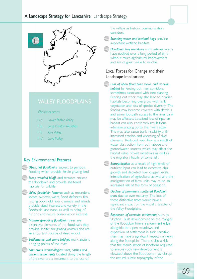
11a
11b
11c
11d11
VALLEY FLOODPLAINS
Character Areas
11a Lower Ribble Valley
11b Long Preston Reaches
11c Aire Valley
11d Lune Valley
Key Environmental Features
• Open, flat floodplains subject to periodicflooding which provide fertile grazing land.
• Steep wooded bluffs and terraces enclosethe floodplain and provide shelteredhabitats for wildlife.
• Valley floodplain features such as meanders,levées, oxbows, weirs, flood defences, flaxretting pools, old river channels and islandsprovide visual interest and variety in thefloodplain landscape, as well as being ofhistoric and nature conservation interest.
• Mature spreading floodplain trees aredistinctive elements of the floodplain; theyprovide shelter for grazing animals and arean important source of dead wood.
• Settlements and stone bridges mark ancientbridging points of the river.
• Numerous archaeological sites, castles andancient settlements located along the lengthof the river are a testament to the use of
the valleys as historic communicationcorridors.
• Standing water and lowland bogs provideimportant wetland habitats.
• Floodplain hay meadows and pastures whichhave evolved over a long period of timewithout much agricultural improvementand are of great value to wildlife.
Local Forces for Change and theirLandscape Implications
• Loss of open flood plain views and riparianhabitat by fencing out river corridors,sometimes associated with tree planting.Fencing out stock may also lead to riparianhabitats becoming overgrow with rankvegetation and loss of species diversity. Thefencing may become covered with detritusand some footpath access to the river bankmay be affected. Localised loss of riparianhabitat can also, conversely result fromintensive grazing up to the river’s edge.This may also cause bank instability, withincreased erosion and widening of riverchannels. Reduced river flow as a result ofwater abstraction from both above andgroundwater sources, which may affect thehabitat value of wet meadows, as well asthe migratory habits of some fish.
• Eutrophication as a result of high levels ofnutrient input can lead to excessive algalgrowth and depleted river oxygen levels.Intensification of agricultural activity and theamalgamation of farm units may cause anincreased risk of this form of pollution.
• Decline of prominent scattered floodplaintrees due to over-maturity. The loss ofthese distinctive trees would have asignificant impact on the visual character ofthe Valley Floodplains.
• Expansion of riverside settlements such asSkipton. Built development on the marginsof the floodplain forms a prominent edgealongside the open meadows andexpansion of settlement in such sensitivesites may have a significant impact on viewsalong the floodplain. There is also a riskthat the manipulation of landform requiredto ensure such new development iselevated above the flood zone may disruptthe natural, subtle topography of the
A Landscape Strategy for Lancashire Landscape StrategyA Landscape Strategy for Lancashire Landscape Strategy
69
floodplain bluffs and terraces. In addition,such development may affect the landscapesettings of archaeological sites and historicriverside castles, particularly along the RiverLune.
• Loss of semi-natural wet meadow habitatsdue to the trend towards furtheragricultural intensification and amalgamationof farm units, particularly in dairy farmingand also to improved flood defencemeasures.
• Pressures for sand and gravel extraction arelikely to continue. This activity may have asignificant visual impact on the tranquil,open floodplain landscapes, although theremay be long term opportunities forwetland habitat creation once theextraction is complete.
• Increasing pressures for recreation,particularly along the valley floor in theform of caravan parks, car parks,restaurants signage etc may damage thecharacter of the landscape and urbanise anotherwise rural landscape.
A Landscape Strategy for Lancashire Landscape StrategyA Landscape Strategy for Lancashire Landscape Strategy
70
Landscape Strategy for the Valley Floodplains
Strategy Recommendations
Conserve valuable floodplain • encourage low intensity grazing in the remaining
habitats semi-natural habitats, which include mire, fen, flushes, marshy grassland and wet
meadow
• manage riparian habitats to avoid erosion due to over-grazing, while also restricting the
unchecked growth of riparian vegetation
• monitor levels of nutrients in river channels
• conserve dry grassland on bluff slopes
Conserve a natural river form • avoid engineered solutions to water management, such as canalisation, bank hardening
and river straightening
• conserve natural river floodplain features, such as meanders, oxbows, old river
channels, ponds and islands
Conserve historic and • avoid damage to archaeological sites through
archaeological sites in the Valley recreation, agriculture and tree planting. Archaeological assessment prior to all forms
Floodplains of development should be carried out where appropriate.
• consider the setting of historic and archaeological sites when planning and
implementing all landscape management action
Conserve the distinctive stone • restore and maintain the characteristic network of
walls in the Aire Valley stone walls in 11c (the Aire Valley)
Enhance woodland planting on the • consider opportunities to extend and link
outer fringes of the Valley woodlands on the fringes of the floodplain with existing woodlands on the valley
Floodplains sides
• encourage the use of natural regeneration where appropriate
• avoid areas of ecological and geological interest
• respect the characteristic sinuous form of the floodplain bluffs and any existing
floodplain fringe woodlands
Enhance opportunities for • initiate a programme of tree planting to ensure that
maintaining the distinctive character there is a new generation of locally native
of the floodplain trees specimen floodplain trees
• encourage planting of native black poplar as feature trees on the floodplain from
locally provenanced cuttings

Strategy Recommendations
Enhance opportunities for • create greenway networks along river banks which
informal recreation connect into urban areas
• ensure river bank management schemes (for habitat enhancement or water flow
management) do not lead to reduced access to the river corridor
• manage public access to sensitive river banks and wet meadows to avoid river bank
erosion due to trampling and the disturbance of key wildlife habitats
• provide opportunities (both physical and intellectual) to appreciate the historical and
natural assets of the Valley Floodplains
Restore wetland habitats in areas • investigate feasibility of restoring seasonal
where they have been lost or inundation to grasslands alongside water
degraded courses
• seek opportunities for wider wetland habitat restoration or creation on the valley floor
Restore a natural river form in • seek opportunities to restore a more natural river
areas where it has been lost form in areas where it has been engineered
Ensure built development on the • encourage the conservation of existing trees, as well
fringes of the floodplain is visually as additional tree planting on the outer fringes of the
integrated within this rural landscape floodplain. The aim should be to provide a sense
setting of containment and a visual marker at the edge of the floodplain and some screening
to soften the appearance of the built up edge.
• localised planting of floodplain woodlands may be appropriate in some locations (for
instance in 11c) to screen and integrate large scale housing, warehouse and commercial
developments
• avoid ribbon development along transport corridors (and the floodplain) at a distance
from existing settlement centres
• conserve long open views across and along the floodplains
• restore and maintain historic bridges and crossing points
Restore sand and gravel extraction ensure every opportunity is taken to create and
sites manage a new range of wetland habitats to deliver biodiversity objectives
Potential Local Indicators for Monitoring Landscape Change in the Valley Floodplains
Potential Indicators Pressure for change Preferred direction of change
Mature floodplain trees Decline due to over-maturity Increase
Open flat floodplain pastures Decrease due to pressures for built Maintaindevelopment, recreation and sand and gravel extraction
Archaeological sites Most are protected, but pressures for Sympathetic built development could impinge management/on their landscape settings Maintain settings
Wetland habitats Decrease due to pressures from Maintain/Increasegrazing and recreation
Hay meadows and pastures Decrease due to water abstraction Maintain/Increaseand agricultural intensification
A Landscape Strategy for Lancashire Landscape StrategyA Landscape Strategy for Lancashire Landscape Strategy
71

A Landscape Strategy for Lancashire Landscape StrategyA Landscape Strategy for Lancashire Landscape Strategy
72

12a
12b
12c
12a
12
LOW COASTAL
DRUMLINS
Character Areas
12a Carnforth – Galgate - Cockerham
12b Warton - Borwick
12c Heysham - Overton
Key Environmental Features
• Low whale-back hills - an eroded lowdrumlin form - surrounded by flat lowlandsand shallow river valleys.
• Well-managed species rich hedgerowsprovide a strong field pattern andreinforce the distinctive undulatingtopography.
• Areas of standing water with marginal fensand swamps and mosslands in lowlandsbetween drumlins provide importantwetland habitats
• Hill top copses emphasise the drumlin formand provide shelter for wildlife.
• Lynchets and old field banks are a distinctivefeature in some fields.
• Winding country lanes provide a series ofcontrasting open, then enclosed views ofthe surrounding countryside.
• Settlement is concentrated on the shallowvalley slopes, above poorly-drained land; thelarger towns are typically at river crossings.
Local Forces for Change and theirLandscape Implications
• Leisure and recreation developments basedon former sand and gravel quarries mayintroduce urban features into the rurallandscape.
• Significant expansion of urban areas andsurrounding rural settlements results inerosion of field patterns, loss of woodlandand the amalgamation of adjoiningsettlements. Continued development couldresult in large scale suburbanisation andloss of landscape character. Builtdevelopment also has implications for inter-drumlin wetlands where they are drainedto allow built development to take place,such as on the outskirts of Lancaster.
• Pressure for communication masts ondrumlin hill tops would clutter the profileof the landform.
• Highway related development may be athreat to landform through the use of cutand fill (for instance along the LancasterSoutherly Bypass). Infrastructureencourages the development of retail,leisure and large scale industry atmotorway junctions. This may erode thedistinctive landform of the area as well asincreasing urbanisation of the rurallandscape.
• Agricultural change, such as expansion andamalgamation of farms, would result in theloss of the already limited number offeatures such as hedgerow trees and copsesleading to weakening of the field pattern anda reduction in ecological interest.
A Landscape Strategy for Lancashire Landscape StrategyA Landscape Strategy for Lancashire Landscape Strategy
73

Landscape Strategy for the Low Coastal Drumlins
Strategy Recommendations
Conserve the inter-drumlin • site sand and gravel quarries away from sensitive wetland sites
wetlands • avoid drainage of wetlands for built development or highway improvements
Conserve the pattern of discrete • avoid ribbon development which will lead to the
rural settlements amalgamation of adjacent dispersed settlements
• planting may help to delineate boundaries of settlements
Conserve the hedgerow and • avoid further fragmentation of the hedgerow
woodland network network, designing built development around the existing landscape structure and
designing planting to enhance structure and wildlife habitats
• give priority to hedgerows which contribute to the characteristic hedgerow network
and those adjacent to semi-natural grasslands
• avoid amalgamation of fields which will erode the strong landscape pattern
• conserve ancient semi-natural woodlands
Enhance the number of rural • planting hedgerow trees and managing hedgerows for wildlife will enhance their status
landscape features as features
• new farm woodlands and copses should remain small in scale and enhance hill top
copses as features of the landscape
• creation of small field ponds may add to the diversity of the landscape and
enhance the nature conservation value of the landscape
Enhance settlements • new built development which responds to the local vernacular will enhance the
character of existing settlements character of existing settlements
• design cues which are taken from the historic core of settlements (rather than the
enveloping new development) will be more beneficial to the settlement’s overall
character
• small scale planting may be used to screen unsightly developments and enhance visual
amenity on urban fringes
Restore sand and gravel quarries • former sand and gravel quarries should be restored to a mosaic of wetland habitats
Potential Local Indicators for Monitoring Landscape Change on the Low Coastal Drumlins
Potential Indicators Pressure for change Preferred direction of change
Wetland habitats Drainage due to agricultural Maintain/Increasepractices or new built development
Species-rich hedgerows Decrease due to agricultural Maintain/Increaseintensification and new built development
A Landscape Strategy for Lancashire Landscape StrategyA Landscape Strategy for Lancashire Landscape Strategy
74

13a
13b
13c
13
DRUMLIN FIELD
Character Areas
13a Gargrave Drumlin Field
13b Bentham - Clapham
13c Docker - Kellet - Lancaster
Key Environmental Features
• Rounded drumlins create a distinctive,undulating topography; the alignment of thedrumlins reflects the direction of glacial iceflow. The lush green pasture contrasts withthe colour and profile of the distant fells.
• Small mixed woodlands punctuate thelandscape, provide foci and give scale tothe landscape.
• Sheltered marshy hollows between drumlinscontrast with the smooth open hilltops andprovide visual texture and wetland habitats.
• Strong field patterns with distinctive stonewalls and hedgerows enhance landformand provide visual texture. The walls reflectthe underlying solid geology.
• Dispersed pattern of stone villages, hamletsand farmsteads which are sited in shelteredlocations on the mid-slopes of drumlins.Larger settlements are clustered atsignificant road junctions or river crossings.
Historic houses and designed parklandprovide visual and ecological diversity.
Local Forces for Change and theirLandscape Implications
• Amalgamation/diversification of farms mayinfluence field sizes and field boundaries.Field expansion would weaken the strongfield pattern and reduce ecological interest.Agricultural change is difficult to predict inthe current economic climate, but recentsymptoms include new farm buildings, fieldenlargement and occasional signs of gappyhedges.
• Pressure for communication masts ondrumlin hill tops would clutter the profileof the landform.
• The continued neglect of farm woodlands willlead to a their decline and loss oflandscape structure. The prominent hill topcopses, which are such visual features ofthe landscape, would be particularlyvulnerable to this type of neglect.
A Landscape Strategy for Lancashire Landscape StrategyA Landscape Strategy for Lancashire Landscape Strategy
75
Landscape Strategy for the Drumlin Field
Strategy Recommendations
Conserve the distinctive rolling • minimise vertical elements, such as communication
landform masts, to retain the uncluttered, open character of the landscape
• shelter built development within the undulating landform - avoid ridgelines or hill tops
Conserve the character of small • careful visual analysis should be undertaken before
woodlands extending small scale mixed woodlands to large scale woodlands
• opportunities for new planting should reflect existing scale and character, ensuring the
survival of the characteristic hill top copses
Conserve semi-natural habitats • conserve and restore inter-drumlin wetlands and semi-natural grasslands wherever
these occur
• conserve and restore ancient semi-natural woodlands
Conserve characteristic settlement • avoid ribbon development which may detract from
patterns the characteristic dispersed pattern of groups of buildings in a rural setting
• ensure new development is associated with tree planting (of native trees) which links
to the existing network of woods and hedgerows
• restrict built development on the skyline of drumlins; buildings should be sited on the
mid-slopes, above poorly drained land
Conserve historic houses and • preserve the settings to country houses, encouraging
designed parkland continued management of grounds as parkland
• ensure entrances are not affected by road alterations or built development
• avoid loss of integrity by division into multiple ownership and retain as permanent
pasture
• retain traditional parkland features such as railings, kissing gates and veteran trees
Conserve field boundaries which • maintain stone walls, particularly around clusters
give the landscape a strong pattern of buildings and settlements
• planting up gaps in hedgerows will enhance the hedgerow network
• plant hedgerow trees to promote their survival as valuable elements of the landscape
Restore quarries to enhance • ensure quarry restoration has regard to landscape
landscape character and biodiversity, as well as archaeological and cultural value
Potential Local Indicators for Monitoring Landscape Change in the Drumlin Field Landscapes
Potential Indicators Pressure for change Preferred direction of change
Hill-top skylines Increased clutter from Maintain
communication masts and new
built development
A Landscape Strategy for Lancashire Landscape StrategyA Landscape Strategy for Lancashire Landscape Strategy
76

Potential Indicators Pressure for change Preferred direction of change
Diverse pattern of distinctive Decrease due to agricultural Manage/Maintain stone walls, hedgerows and intensification with field hedgerow trees enlargement and loss due to lack
of management or maintenance
Hill-top copses and small Decrease due to lack of management Manage/Increasewoodlands
A Landscape Strategy for Lancashire Landscape StrategyA Landscape Strategy for Lancashire Landscape Strategy
77

A Landscape Strategy for Lancashire Landscape StrategyA Landscape Strategy for Lancashire Landscape Strategy
78

14a
14b
14
ROLLING UPLANDFARMLAND
Character Areas
14a Slaidburn - Giggleswick
14b Lothersdale and Cringles
Key Environmental Features
• An intact network of drystone walls, often oflimestone creates a distinctive landscapestructure and reflects the historicparliamentary enclosure of marginal land.The limestone walls are generally in goodcondition.
• Limestone outcrops, crags and knolls occuron the exposed edges and provide a sharpcontrast to the gentler rolling formations ofthe grazing land and provide shelter forsheep.
• Lush green pastures and isolated herb richhay meadows and pastures provide acontrast to the muted hues of theMoorland Hills backdrop.
• Winding, narrow lanes bordered by stonewalls suggest a sense of enclosure in anexposed landscape.
• Stunted wind-blown hawthorns and gorse onroadsides and steeper hillsides whichaccentuate the sense of the exposeduplands and provide important tree nestingspots for birds.
• Beech stands on the steeper rocky slopesprovide distinctive landmarks particularlywhen seen against the skyline.
• Isolated stone farmsteads, stone barns andwalled circular enclosures are visual featuresas well as being important historically andculturally; clustered stone villages are sitedon south facing slopes and there are somelinear settlements.
Local Forces for Change and theirLandscape Implications
• Limestone quarries are changing thelandform locally and are particularly visiblein a rolling landscape.
• Changing patterns of forestry and re-structuring of plantations will have an impacton the visual character of the landscape.
• Changes in emphasis in the agriculturalsector, whether it be intensification,amalgamation or lack of management,would have an impact on the proportionand distribution of landcover elements andthe condition of features such as stonewalls and farm buildings.
• Pressure for development of prominentvertical elements such as communicationmasts and wind farms which would beparticularly visible on the open, rollingsummits.
A Landscape Strategy for Lancashire Landscape StrategyA Landscape Strategy for Lancashire Landscape Strategy
79

Landscape Strategy for the Rolling Upland Farmland
Strategy Recommendations
Conserve the character of the • conserve the remaining unimproved grasslands and
rural pastoral landscape hay meadows by employing traditional management practices and avoiding the use of
artificial fertilisers;
• reducing existing grazing pressure will ensure pastures continue to form a contrast with
the muted hues of the surrounding Moorland Hills.
• the repair of dry stone walls using traditional techniques and materials
Conserve the rocky outcrops and • site quarries and communication masts away from
limestone knolls characteristic distinctive rocky knolls or outcrops which are visual
of the landscape landmarks.
• manage limestone grasslands to meet biodiversity objectives
Conserve stands of beech and • Encourage walling around stands of beech trees to
walled enclosures restrict grazing and allow natural regeneration of the next generation of trees
• maintain walled enclosures to ensure their survival
Conserve the upland built • encourage a built form which respects the grouped nature of buildings on isolated farms.
character
• choice of materials is vital in this upland location; new buildings should be constructed
of stone (preferably from local quarries)
Enhance the pattern of forestry • encourage the use of Forest Plans to minimise the impact of forest re-structuring on the
landscape
• the restructuring of existing plantations should aim to create natural shapes which fit the
local topography, an appropriate scale of woodland and an increase in the proportion of
broadleaved species
• enhance and restore ancient semi-natural woodland
Restore limestone quarries to be • quarries present an opportunity for habitat creation
sympathetic to landscape character and management for wildlife and may provide sites of geological or visual interest.
Potential Local Indicators for Monitoring Landscape Change on the Rolling Upland Farmland
Potential Indicators Pressure for change Preferred direction of change
Limestone walls Decrease due to lack of Repair/Maintainmanagement
Historic beech stands and Decrease due to maturity and Managewalled enclosure lack of management
Stone farmsteads and barns Loss of integrity of vernacular Sympatheticstone architecture as a result of restorationnew buildings/additions and the use of new types of farm machinery,or overall neglect
A Landscape Strategy for Lancashire Landscape StrategyA Landscape Strategy for Lancashire Landscape Strategy
80

15a
15b15c
15d
15e
15f
15
COASTAL PLAIN
Character Areas
15a Ormskirk - Lathom - Rufford
15b Longton - Bretherton
15c Croston - Mawdesley
15d The Fylde
15e Forton - Garstang - Catterall
15f Knott End - Pilling
Key Environmental Features
• Large, geometric arable fields reflecting thehistory of enclosure of the land andallowing long views over the landscape.This area has the highest survivingconcentration of fields originating from themedieval open field system in Lancashire.
• Colourful arable fields including poppies andcorn marigold are important for their visualand biodiversity value and as a reflection offarming history.
• Marl pit and brick pit ponds reflect pastextraction of clays and provide animportant wildlife habitat for aquatic plants,great crested newt and a wide range ofaquatic invertebrates, including some rarespecies.
• Historic brick built farms including highlydistinctive red brick barns with ornate
brickwork detailing reflect the culture andhistory of the working landscape;
• Estate plantations, shelter belts and parklandtrees provide a sense of enclosure, abackdrop to views and shelter for wildlife.
• Pockets of semi-natural woodland alongbrooks and watercourses provide valuableshelter and habitats for wildlife (such asflocks of pink-footed geese), as well asrecreational potential and links with thehistoric landscape.
• Meandering rural lanes respond to the locallandform and provide a contrast inexperience from the straight lanes of thesurrounding Mosslands.
• A potentially rich archaeological record withinthe peat on the fringes of the Mosslandsmay provide clues as to early settlementand land use before drainage andimprovement.
Local Forces for Change and theirLandscape Implications
• Continued suburbanisation and large scaleresidential development will create harshedges to local villages and introduceurbanising elements into a rural landscape.It may also result in the loss of locallandscape features on the edges of ruralsettlements such as hedges, banks andmature trees. Infill development maydisrupt the characteristic spacing oftraditional settlement and impinge on thesetting of older buildings. All builtdevelopment is likely to be prominent inthis relatively open landscape. Pressure forsuch development is particularly intense onthe fringes of the major coastal urban areasand in the vicinity of the M6 motorwaycorridor.
• A decline in the biodiversity of the landscapecaused by field expansion and agriculturalintensification. This includes the use ofherbicides causing the loss of arable weedsand eutrophication resulting in loss ofpasture herbs and aquatic vegetation. Mostof the very few surviving remnants of thediverse semi-natural habitat mosaic whichmade up this landscape before modernintensive agriculture continue to be under
A Landscape Strategy for Lancashire Landscape StrategyA Landscape Strategy for Lancashire Landscape Strategy
81

threat from agricultural intensification andrecreation.
• Pressure for communication masts, electricitypylons and other prominent developmentswhich will be particularly prominent onlocal skylines.
• Conversion of historic brick-built barns foruse as residential dwellings or for intensiveagricultural practices. There are manyexamples of insensitive conversion, whereharshly coloured imported bricks and otherinappropriate materials are poorlyintegrated with the historic buildings andwhere the wider landscape setting ofgroups of farm buildings has been severelycompromised.
• Fragmentation of historic estates and theirassociated designed parklands, trees,shelterbelts and coverts as a result ofchanges in land ownership andopportunities for development. This maylead to the loss or degradation of historiclandmark woodlands which are keyfeatures in this relatively large scale openagricultural landscape.
• Sand and gravel extraction may result insignificant landscape change, involving thesubstitution of intensively managed pasture
and arable farmland with water bodies andother new habitats of nature conservationand recreational potential.
• Degradation and loss of field ponds due to acombination of drainage, pollution (fromagricultural run-off) and in-filling. Theseponds are important cultural remnants (ofthe historic marl pits) and have becomevaluable refuges for wildlife in an intensivelyfarmed landscape.
• Pressures for recreational facilities,particularly in the Fylde on the fringes ofBlackpool. There are particular pressuresfor the development of golf courses andstatic caravan sites, as well as substantialleisure complexes close to the M6 corridor.These facilities represent an additionalurbanising influence in the rural fringeareas.
• Waste Management developments includingtreatment works and landraising has had aninfluence on local landscape characterincluding the Wyre estuary. Futureexpansion and phased restoration of theJameson Road landfill site will result infurther land raising adjacent to the Wyreestuary, forming areas of high ground.
A Landscape Strategy for Lancashire Landscape StrategyA Landscape Strategy for Lancashire Landscape Strategy
82
Landscape Strategy for the Coastal Plain
Strategy Recommendations
Conserve distinctive field patterns • encourage retention and enhancement of hedgerows
and related landscape features and hedgerow trees especially in relation to hedgerows of visual, historic and wildlife
and landforms importance
• initiate programmes of tree planting, particularly on the fringes of settlements and in
locations where trees will help to screen infrastructure and other developments
• retain alignments of roads and tracks and restrict over-engineered alterations
• restrict further future landraising or other waste management developments in areas
not previously affected by landfill to avoid damage to field patterns or interruptions to
long views over the landscape
Conserve remnants of former • protect and conserve wet and other semi-natural
agricultural habitat mosaics agricultural grasslands
• encourage the conservation and restoration of arable field margins with traditional
arable weeds
Conserve remaining field ponds • restrict infilling of ponds and their loss as a result of development (through the
development control process)

Strategy Recommendations
• ensure new development retains field ponds and promotes their conservation as
landscape features
• wherever possible, create new field ponds
• develop buffers around field ponds designed to provide terrestrial habitat and visual
diversity as well as to minimise the impacts of pollution/eutrophication from agricultural
run-off
Enhance the distinctive character • resist infill ribbon development along open lanes
and landscape setting of rural (particularly near Pilling)
settlements • retain and enhance historic landscape features, including verges, hedgerows and open
spaces within settlements
• encourage the use of local materials, particularly in older settlements
• encourage tree planting using native species(including black poplar of local provenance
where appropriate) within and on the fringes of rural settlements to improve views
and approaches to the built edge
• retain existing field boundaries and use as a framework for new development
• avoid introduction or proliferation of suburban building styles, materials and layouts
• consider the landscape setting of historic buildings and restrict inappropriate new
development in such areas
Enhance the river corridor •consider the landscape setting of historic buildings encourage habitat enhancement eg
landscapes creation of wet fringes, riverside woodlands, pools, riffles and meanders
• protect water courses from the impacts of eutrophication by adopting best practices
for the application of agricultural fertiliser and pesticides, creating buffer zones and
encouraging programmes for nutrient removal
• minimise the number of pollution incidents caused by a variety of built developments
by developing appropriate arrangements for water catchment and run-off
Enhance opportunities for • improve access to water courses for angling and
informal recreation walking (including disabled access)
• ensure development proposals protect and enhance on-site features and promote
wider access to water courses
Enhance landscapes associated with• improve drainage arrangements to limit pollution
major infrastructure developments and flood water retention
such as the M6 and M55 corridors
• consider tree planting in areas where it can integrate new development or
infrastructure, but take care to avoid mass tree planting in characteristic open
landscapes and avoid screening key views
Restore, retain, manage and replant • encourage hedgerow laying, replanting and gapping
hedgerows and hedgerow trees up, giving priority to those hedgerows which contribute to the overall hedgerow
pattern and those which provide links between hedgerows and to semi-natural habitats
• encourage the use of headlands and field margins to arable fields to reduce damage by
agricultural machinery
• where possible restore the historic structure and character of designed landscapes by
encouraging parkland tree planting, boundary repair and the retention of designed
features
A Landscape Strategy for Lancashire Landscape StrategyA Landscape Strategy for Lancashire Landscape Strategy
83

Strategy Recommendations
Restore broadleaved woodlands • encourage planting in riparian buffer zones
particularly in the vicinity of wherever this will not conflict with access
watercourses requirements for flood defence purposes or ecological interests
• manage grazing levels and introduce fencing to allow regeneration of existing
woodlands
• conserve and restore ancient semi-natural woodland
Restore completed sand and gravel • former sand and gravel workings should be restored
workings to a mosaic of wetland habitats including appropriate informal recreation
Potential Local Indicators for Monitoring Landscape Change on the Coastal Plain
Potential Indictors Pressure for change Preferred direction of change
Field ponds Decrease as a result of agricultural Increasedrainage schemes/pollution and infilling
Historic brick barns Conversion to residential use - Sympatheticpotential loss of landscape setting restoration
Designed parkland landscape Fragmentation due to changes in Maintain/land ownership and new built Sympathetic development, as well as an overall Management lack of management
A Landscape Strategy for Lancashire Landscape StrategyA Landscape Strategy for Lancashire Landscape Strategy
84

16a
16b
16c
16d
16e
16f
16g
16
MOSSLANDS
Character Areas
16a North Fylde Mosses
16b South Fylde Mosses
16c Martin Mere and South West Mosses
16d Skelmersdale Mosses
16e Tarleton Mosses
16f Heysham Moss
Key Environmental Features
• Low lying flat landscape, which providesextensive uninterrupted views for greatdistances.
• Market gardening and arable production arehighly productive and provide a pattern ofcolours and textures year round.
• Remnant mosses and fen carr are importantsemi-natural wetland habitats whichprovide a glimpse of the landscape beforeit was drained and exploited for agriculturein the late 18th and 19th centuries.
• Field patterns which are distinctive andpreserve the historic patterns of mosslandreclamation.
• Drainage ditches form an importantnetwork of semi natural wetland habitatsespecially in West Lancashire.
• Rural roads and tracks, which are unlit andprovide clear views of the night sky in thearea. Many are raised on embankmentswith ditches, culverts and bridges.
• Farms and isolated houses at end of dead-end tracks on low sand and gravel orboulder clay ridges; loose-knit, linearsettlements are strung out along embankedroads.
• Potentially rich archaeological sites, which aregradually revealed as the remaining tracesof peat are desiccated and blown away.The peat contains evidence of earlysettlement on the fringes of the Mosslands,which were exploited for reeds/rushes,grazing and fuel.
Local Forces for Change and theirLandscape Implications
• Pressure for suburbanisation and theexpansion of settlements. For instance infillwithin villages with a loose-knit structureand linear ribbon development along tracksto isolated farmsteads threatens to impingeon the historic patterns of settlement andthe landscape setting of older dwellings andfarms. New development, particularly thatcontaining vertical elements such as pylons,will often be visually dominant in this flat,open landscape. The lighting associatedwith new buildings and infrastructure mayreduce the inherent tranquillity of theMosslands and diminish the characteristicviews to the night sky.
• The impacts of drainage and flood control onimportant wetland habitats, such as mosses,ditches and fen carr. Such habitats, whichhave been subject to a lowered water table(due to agriculture or abstraction fordevelopment) may lose their characteristicvegetation and are susceptible to scrubencroachment by birch, pine andrhododendron. Drainage may also haveserious potential impacts on peat coveredarchaeological evidence. For instance, itwould affect organic remains such as seeds,wood causeways, tracks and evidence ofhuman occupation.
• Loss of peat through erosion and oxidationas a result of intensive agriculture has beensignificant in arable and horticultural areas
A Landscape Strategy for Lancashire Landscape StrategyA Landscape Strategy for Lancashire Landscape Strategy
85

and will ultimately lead to the loss of thishigh quality agricultural land.
• Climate change may in time lead to anincrease in the probability of storm surgesand potentially severe flooding in the low-lying Mosslands. Subtle changes to marshand mossland habitats may be sufficient tolead to the decline of rare species, whichmay become isolated in fragmentedcommunities with minimal scope formigration. However, climate change mayalso provide opportunities for differentspecies to thrive. Flooding and stormsmay have negative impacts on thehorticultural sector, although highertemperatures would reduce heating bills inglasshouses.
• The decline of small mixed woodlands andshelterbelts, particularly on Martin Mereand South West Mosses is generally dueto neglect, although there is some evidencethat these woodlands are used for shootinggame. The woodlands are valuable forwildlife and are visually prominent in theopen landscape.
• Water-borne pollution results from intensiveagricultural practices when chemicals frompesticides and fertilisers run-off into ditchesand local water courses. There is a riskthat such run-off will damage the delicatelybalanced nutrient levels of the marshes andwetlands on the western fringes of theMosslands.
A Landscape Strategy for Lancashire Landscape StrategyA Landscape Strategy for Lancashire Landscape Strategy
86
Landscape Strategy for the Mosslands
Strategy Recommendations
Conserve the distinctive character • limit development in the Mosslands, particularly that
and landscape structure of the which obscures views of the flat open landscape or
Mosslands which introduces new vertical elements
• conserve woodland blocks, particularly those associated with historic landscapes
• maintain the large geometric field patterns and avoid the amalgamation of fields
• counteract the impact of abrupt built edges (on low ridges) with wooded planting as
buffers
• avoid new lighting in the landscape
• limit the extent of mineral and peat extraction with restoration to wetland habitats
Conserve historic settlement • conserve the wider landscape setting of older houses
patterns and building styles and historic halls
• avoid infill ribbon and other development which would detract from the characteristic
rural settlement pattern
• avoid the use of incongruous building materials and building styles
• encourage small scale planting in association with new development to help integrate it
within the landscape, while framing the characteristic long views
Conserve important habitats • conserve the hunting grounds and nesting sites of barn owls
• retain roosting sites and feeding grounds, especially long grass and water habitats for
bats. Special care should be made in the conversion or renovation of farm buildings
• avoid the formation of habitat links between grey and red squirrel populations and
manage existing woodlands to encourage red squirrels.
• encourage management of arable field margins as refuges for scarce weed species and
food sources for seed eating birds
• conserve the important network of drainage ditches and bank-side habitats and
woodlands as semi natural habitats.

Strategy Recommendations
• encourage practices which preserve winter feeding grounds of geese and swans
• monitor levels of water abstraction to retain key wetland habitats
• monitor water quality, particularly downstream of major industry
Enhance the character and wildlife • encourage the retention and improvement of
value of water courses and their riparian habitats, particularly in areas where water
environs courses are intensively managed
• restrict surface water run-off from new developments
• explore options for introducing meanders, ox-bows, reed beds and other areas of open
water and riparian buffer zones to maximise habitat value and minimise the impacts of
water borne pollutants
Enhance the character and • careful siting, design and the use of local materials
landscape setting of settlements is essential in this open, flat landscape where most development is likely to be
prominent
• encourage natural regeneration and avoid the use of non-native species in gardens and
in the vicinity of settlements
• limit tree planting to areas where there is established tree cover
• avoid tall or vertical structures
Restore the relict mosslands • raise local water tables and seal the margins of the remaining relict mosslands by
blocking existing drainage channels
Potential Local Indicators for Monitoring Landscape Change on the Mosslands
Potential Indicators Pressure for change Preferred direction of change
Remnant mosslands Decrease due to ongoing drainage Maintain/Increase
Isolated farmsteads Loss of isolation due to new Maintainresidential development
Riparian habitats Loss of ecological interest due to Maintain/Increaseerosion/drainage or built development
A Landscape Strategy for Lancashire Landscape StrategyA Landscape Strategy for Lancashire Landscape Strategy
87

A Landscape Strategy for Lancashire Landscape StrategyA Landscape Strategy for Lancashire Landscape Strategy
88

17a
17b
17
ENCLOSED COASTALMARSH
Character Areas
17a Clifton and Hutton Marsh
17b Cockerham Coast
Key Environmental Features
• Level, expansive tracts of large scale farmlandwith a geometric field pattern allow longviews to distant land marks.
• Drainage ditches are important semi-naturalwetland habitats in a man-madeenvironment.
• Sea dykes support a more diverse andnatural land cover, including species-richgrassland and gorse scrub. Banks, ditchesand boundaries preserve the historicsequence of coastal reclamation andcorresponding changes in drainagetechnology.
• Areas of open water and flooded grasslandsprovide valuable wetland habitats and afeeding ground for geese and other birds.
• Coastal grazing marsh provides importantfeeding grounds for wintering geese, swansand waders and for rare upper salt marshplant communities
• Remnant areas of marsh are importantrefuges for local wildlife.
• Areas of raised land resulting from landfillingactivities form areas of high ground whichmay resemble coastal cliffs.
Local Forces for Change and theirLandscape Implications
• Pressures for built development and majorinfrastructure would be prominent in longviews and may restrict views from theCoastal Plain (15) to the coastline. Itwould also lead to the loss of the open,isolated character of the Enclosed CoastalMarsh. The development of pylons,communication masts, sewage works andother buildings would be intrusive in thisflat, exposed landscape and there may alsobe risks that the run-off from builtdevelopment and landfill may containpollutants which might damage sensitivewetland habitats.
• The changing economy of the agriculturalsector is a significant influence on thecondition and character of the EnclosedCoastal Marsh. Horticulture has recentlysuffered a slight decline and the viability ofthe sector is increasingly dependent on thepolicy of national supermarkets. There is arisk that glasshouses will be underused orfall into disrepair if there are local changesto the economy of horticulture and thiswould have severe landscape impacts.
• Agricultural intensification, with its associateddrainage and risk of eutrophication has thepotential to damage valuable wetlandhabitats, while also leading to further lossof hedgerows and field patterns.
• Climate change may increase the risk ofstorm surges with flooding and loss ofinter-tidal habitats, with consequences forland uses and wetland habitats. It may alsoinfluence the local balance of species.
• Policies for managed retreat and coastalinundation may be influential in the futuremanagement of the Enclosed CoastalMarshes and would represent a significantand positive force for change.
A Landscape Strategy for Lancashire Landscape StrategyA Landscape Strategy for Lancashire Landscape Strategy
89

• Waste management developments includingtreatment works have already had asignificant influence on local landscapecharacter, particularly on the northernbanks of the Ribble. The future expansionand phased restoration of the Cliftonlandfill site is particularly relevant and will
result in further landraising adjacent to theRibble Estuary, forming areas of highground (approximately 15m high) whichwill be restored to agriculture.
• Improvements to water quality in the RibbleEstuary may influence the use of the areafor leisure activities.
A Landscape Strategy for Lancashire Landscape StrategyA Landscape Strategy for Lancashire Landscape Strategy
90
Landscape Strategy for the Enclosed Coastal Marsh
Strategy Recommendations
Conserve the expansive landscape • conserve the dead-end lanes which restrict through
and remote character of the traffic
Enclosed Coastal Marsh
• resist infill ribbon development alongside open lanes
• conserve the characteristic long views to the Ribble Estuary from the farmland inland
by restricting the development of infrastructure (such as pylons and masts) and by
resisting further future landraising proposals in areas previously affected by waste
management developments.
• conserve the historic pattern of coastal reclamation sea dykes and defences
Conserve valuable wetland habitats • restrict the drainage of adjacent farmland
• create buffer zones to minimise the impacts of water borne pollutants on wetlands
• encourage the management of dykes and ditches for nature conservation, as well as
water management
• monitor water quality to ensure that all new developments meet water quality
standards
• avoid further reclamation of remnant areas of marsh by landfilling and landraising and
avoid ecologically insensitive flood defence works
Enhance opportunities for informal • encourage the development of connecting footpaths
recreation and cycleways which link the Estuary to settlements inland and complete the remaining
sections of the Lancashire Coastal Way
• provide interpretation facilities
• deflect visitors from the more sensitive wetland habitats
Restore wetland habitats and • promote the restoration of marshes from reclaimed
species land where possible to enhance wildlife value
• encourage planting of native black poplar from locally provenanced cuttings
Potential Local Indicators for Monitoring Landscape Change on the Enclosed Coastal Marshes
Potential Indicators Pressure for change Preferred direction of change
Coastal grazing marsh habitats Decrease due to drainage and Maintainpollution from agricultural/landfill run-off
Historic pattern of sea dykes Fragmentation due to agricultural Maintainand defences intensification/built development

18a
18b
18c
18d
18e
18
OPEN COASTAL
MARSH
Character Areas
18a Ribble Marshes
18b Hest Bank - Silverdale Marshes
18c Wyre Marshes
18d Lune Marshes
18e Pilling and Cockerham Marshes
Key Environmental Features
• Valuable saltmarsh habitats which providerelatively undisturbed habitats fornumerous wetland flora and fauna.Theremaining ungrazed marshes (restricted tothe Wyre estuary) are particularlyattractive and valuable in ecological terms.The saltmarshes of Morecambe Bay aresome of the most important examples ofthis habitat in Britain.
• Maze of creeks, channels, gutters, drainageditches and brackish pools which etch adistinctive pattern in the surface of themarsh and which are important semi-natural habitats.
• Coastal clay cliffs adjoining the open marshsupport a rich assemblage of wild flowers.
• Historic roads/tracks and bridges allowingaccess to the sea, which indicates theprogressive drainage and settlement of thearea, and evidence of important coastalindustries, such as the brine wells to thewest of Pilling.
• Relict land uses including ruined sea walls,lines of stakes marking successive retreatsof sea defences, landing jetties, saltevaporation pans, fisheries, ferry points, drydocks and quays.
• Expansive sandbanks, mudflats and shallowwaters provide habitats for a range ofworms, crustaceans and shellfish, as well asan ideal spawning and nursery area for fishand even basking sharks.
• Bird life brings movement - the area isimportant as a feeding ground for geese,swans, ducks and waders and thesaltmarshes are a vital link for migratingbirds.
Local Forces for Change and theirLandscape Implications
• The threat of water-borne pollutants fromsome of the major industrial premises isongoing. The sites are monitored to ensurethat current environmental qualitystandards are maintained, but there isalways a risk of accidental spillage, or thatthe continued redevelopment of the sitesmay lead to the discovery of contaminatedland. Such contamination could have asevere impact on the delicately balancedecosystem of the Open Coastal Marsh.
• Degradation of valuable wetland habitatsdue to polluted run-off from adjacentfarmland and intensive agricultural practicessuch as drainage, intensive sheep grazingand hedgerow removal. Drainage and thelowering of local water tables may lead todrying out on the fringes of mosses andmarshes so that these habitats arevulnerable to the invasion of birch andwillow scrub.
• Rising sea level as a result of climate change.There is likely to be an increased risk offlooding, high tides and tidal surges. Existingflood defences would provide much protection,but there is a risk that the extensive mudflatsand saltmarshes in the Morecambe Bay and
A Landscape Strategy for Lancashire Landscape StrategyA Landscape Strategy for Lancashire Landscape Strategy
91

Ribble Estuary would be lost. This would havea major impact on the internationallysignificant bird feeding grounds in theseareas.
• Pressures for recreation and visitor facilitieson the fringes of the marsh can lead toproblems such as erosion and fly-tipping.Car parks are often visually intrusive inthese fragile, open landscapes and may leadto serious erosion.
• The enhancement of coastal defences inresponse to the threat of climate changeand associated flooding. Such majorinfrastructure works may have damagingeffects on the natural environment,including flooding or erosion on anadjoining coastline.
• Policies for managed retreat and coastalinundation may be influential in the futuremanagement of the Open Coastal Marshesand would represent a significant andpositive force for change.
A Landscape Strategy for Lancashire Landscape StrategyA Landscape Strategy for Lancashire Landscape Strategy
92
Landscape Strategy for the Open Coastal MarshStrategy Recommendations
Conserve valuable wildlife habitats • monitor and control levels of grazing on the Morecambe Bay saltmarshes
• monitor and control discharges from local water courses to ensure the risk of
contamination and eutrophication is minimised
• avoid further reclamation by landfilling, landraising and other activities
• avoid further enclosures of salt marsh and ecologically insensitive flood defence works
• conserve the plant communities on coastal clay cliffs
• manage ditches and drainage channels to maximise wildlife benefits and maintain an
appropriate balance between freshwater and saltwater
Conserve the expansive landscape • keep built development and infrastructure to an
and tranquillity of the Open Coastal absolute minimum
Marsh
• any built structure should be low and constructed to minimise visual impact in views
across the marsh
• avoid vertical structures, such as communication masts or telegraph poles
Enhance coastal defences • manage the use of coastal defences for informal recreation which is compatible with
wildlife conservation interest
• wherever possible, consider ‘soft’ engineering options which will maximise benefits to
wildlife habitats
Enhance opportunities for • improve interpretation facilities in relation to
informal recreation wildlife, natural and historic features, including the history of successive reclamation and
coastal defences
• ensure boardwalks and signed trails provide access to circular routes while avoiding the
risk of erosion
• deflect visitor pressure from the more sensitive nature conservation sites
• site car parks away from sensitive coastal marsh habitats

Potential Local Indicators for Monitoring of Landscape Change on the Open Coastal Marsh
Potential Indicators Pressure for change Preferred direction of change
Saltmarsh habitats Decrease due to impacts of Maintainwater-borne pollutants, drainage and potential rises in sea level
Relict land uses - lines of Deterioration due to neglect Maintainstakes, ruined sea walls, jetties and dereliction etc.
A Landscape Strategy for Lancashire Landscape StrategyA Landscape Strategy for Lancashire Landscape Strategy
93

A Landscape Strategy for Lancashire Landscape StrategyA Landscape Strategy for Lancashire Landscape Strategy
94

19a
19a
19
COASTAL DUNES
Character Areas
19a Fylde Coast Dunes
Key Environmental Features
• Hummocky landform provides shelteredhollows and microclimatic zones within itscore.
• Windswept grassland and bare sand whichconveys a sense of exposure to coastalelements and allows unobscured views outto sea.
• Valuable habitats, including dune slacks,dune heath, shingle and sandy shingle, all ofwhich are recognised as a priority forconservation in the UK Biodiversity Plan.
• Potential archaeological sites in areas whereevidence of human activity is buriedbeneath shifting dunes – and in the inter-tidal area
• St Annes Dunes are a remnant of a largelynatural landscape type, rare in terms of thelimited extent of human modification
Local Forces for Change and theirLandscape Implications
• Climate change could bring sea level risesand storm surges which might change therate of sediment input to dunes and eventhe location of sand dunes along thecoast. Pressures for hard sea defenceworks to combat this risk may themselvesalter the dynamics of sand movement.
• Pressures for the construction of servicessuch as sewers, pipelines etc. which maydestroy small relict areas of valuable dunehabitat and further fragment the smallremaining tracts of dune.
• Recreation pressures are an ongoing forcefor change in this confined area of dunes.The key problem is erosion by tramplingwhich may lead to the degradation ofnatural grass swards and the destabilisationof the dunes. Litter is also a visual eyesore.
• Sand extraction elsewhere on the coastcould potentially lead to loss of dunehabitat, although studies have shown thatthe sand is accreting in this area so rapidlythat sand extraction at current rates wouldnot have a significant impact.
• Lowered water table due to developmentand increased water abstraction affectingdune slack and pools.
A Landscape Strategy for Lancashire Landscape StrategyA Landscape Strategy for Lancashire Landscape Strategy
95

Landscape Strategy for the Coastal Dunes
Strategy Recommendations
Conserve dune systems • avoid further fragmentation by development including golf courses
• maintain the role of natural coastal processes in coastal defence
• monitor the area of sand dunes and rates of accretion/erosion of sand especially in
relation to storms, sand extraction and the impact of constructed defence schemes
elsewhere on the coast
Conserve natural sand dune • restrict vehicular access
vegetation
• minimise the potential for erosion by trampling, grazing or mowing
• restrict invasion by sea buckthorn, gorse, birch and pine
• manage the dune habitats to meet biodiversity objectives
Enhance opportunities for informal • design visitor facilities to minimise landscape
recreation impacts and ensure they are sited well inland from sensitive dune systems
• provide boardwalks to give access to the dunes without risking damage by erosion
• monitor and control levels of litter and fly-tipping
Restore natural dune grasses in • fence off areas suitable for restoration of sand dune
areas where they have become vegetation so that there is minimal risk of trampling while the grasses become
degraded established
• restore/create dune slack habitat
Potential Local Indicators for Monitoring Landscape Change on the Coastal Dunes
Potential Indicators Pressure for change Preferred directionof change
Dune habitats Decrease due to fragmentation by Maintain/Increaseinfrastructure development and erosion by recreational pressures
A Landscape Strategy for Lancashire Landscape StrategyA Landscape Strategy for Lancashire Landscape Strategy
96

20a
20
WOODED LIME-STONE HILLS ANDPAVEMENTS
Character Areas
20a Arnside and Silverdale
Key Environmental Features
• Semi-natural broadleaved woodlands andyew woodlands (many of them SSSIs) arehighly valued for their cultural andconservation interest. Yew provides wintercolour and contrast within the native ashwoodlands, ancient examples of whichcontain small leaved lime and showevidence of former coppicing.
• Species rich and semi natural calcareousgrasslands are of particular importance forrare flora and insects, particularlybutterflies.
• Rocky outcrops, limestone scars andlimestone pavements provide microclimatesfor rare plants. English Naturerecommends that the Morecambe BayPavements (eg Gait Barrows NNR) shouldbe a candidate for designation under EUlegislation as a Special Area ofConservation.
• Abandoned limestone quarries, ironstone andcopper mines colonised by vegetation areoften valuable habitats for wildlife or usedfor recreation.
• Lime kilns reflect the processing of lime forlimewash, plaster and later as a soilconditioner and are features in thelandscape.
• Wetlands including pools, reed beds and amarl lake (Hawes Water) provide contrastto the dry hills and support nationally rarebirds including bittern, marsh harrier andbearded tit.
• Dry stone walls are a distinctive silver colourand well maintained - they are visuallyattractive and provide ecological andcultural interest.
• Semi-natural broadleaved woodlands(including coppiced woodlands) shelterwildlife and are valued for their cultural andconservation interest.
• Visible historic features, such as the hill fortat Warton Crag, industrial archaeology,areas of parkland and historic fieldpatterns are of cultural interest. Parklandlandscapes include valuable habitats forveteran trees.
Local Forces for Change and theirLandscape Implications
• Changes in agricultural patterns and farmmanagement are the most significant forcefor change. Under-use of some areas offarmland and especially reduction in grazingleads to scrub encroachment and ultimatelythe loss of species-rich grassland.Intensification of agriculture on theremaining farmland resulting in risingnutrient levels also leads much morequickly to a loss of species rich grasslands,changes in texture and colour of thegrazing land and changes in landscapecharacter. More intensive management ofgrassland could also lead to increases inpolluting run-off into adjacent wetlandssuch as Hawes Water and Leighton Moss.
• A decline in the permanent agriculturalworkforce leads to neglect of routine farmmaintenance such as disrepair of stonewalls, substitution of hedgerows by post and
A Landscape Strategy for Lancashire Landscape StrategyA Landscape Strategy for Lancashire Landscape Strategy
97

wire fencing and lack of farm woodlandmanagement.
• The trend to produce silage as a winterfeed rather than to take a hay crop involveschanges in grassland managementtechniques and will lead to loss of speciesrich hay meadows.
Amalgamation of farms to fewer, largerfarms may lead to expansion of fields,changed management techniques andselling off of vernacular farm buildings forother uses.
• The continued rise in visitors may result inincreases in traffic, leading to pressure onnarrow lanes, conversion of local farmbuildings, expansion of car parks and theloss of pastures to amenity uses. Sensitivelandscapes, such as the limestonepavements and semi-natural habitats, maybe affected by erosion and disturbancefrom high numbers of visitors.
• Continuing pressure for recreationaldevelopments such as caravan sites, campsites and golf courses may have significantvisual impact, even in this well woodedlandscape. There have also been planningapplications for larger scale developments,such as holiday villages, which may havesignificant impacts in this diverse, sensitiveAONB landscape.
• Removal of loose stone and smalllimestone outcrops to improve agriculturalaccess results in loss of local stone featuresand sometimes pockets of associatedspecies-rich grassland.
• Acquisition and management of land fornature conservation in particular to createhabitat for rare bird species and also toconserve nationally rare limestone andwetland habitats will lead to a positivechange in the appearance of the protectedhabitats, as well as having natureconservation benefits.
A Landscape Strategy for Lancashire Landscape StrategyA Landscape Strategy for Lancashire Landscape Strategy
98
Landscape Strategy for the Wooded Limestone Hills and Pavements
Strategy Recommendations
Conserve the diverse mosaic of • discourage the conversion of unimproved grazing
habitats to improved pasture and amenity grassland in order to maintain bio-diversity,
particularly of the limestone grasslands, and prevent polluting run-off into adjacent
areas
• discourage the drainage of wetland habitats and encourage the restoration and
management of such features
• resist amalgamation of farms to conserve the scale of buildings and pastures
• avoid intensification of farming in specific areas and decline in others which would alter
the balance, colour and texture of landcover and landscape elements
• conserve the integrity of all limestone pavements and other outcrops
Conserve landscape condition • promote the conservation and maintenance of
and natural beauty hedgerows and walls, encouraging permanent agricultural workforce who undertake
routine maintenance
• control erosion of sensitive landscapes, using signs and careful location of car
parks/visitor facilities to direct visitors away from sensitive habitats
• visitor facilities and car parks should pay particular attention to siting and design, using
local materials and avoiding urbanising elements
Conserve traditional management • encourage management of diverse grassland
techniques meadows for hay crops rather than intensive silage production
• encourage conservation woodland management practices such as coppicing and
pollarding

Strategy Recommendations
• encourage appropriate grazing management
Conserve the character of the • conserve ancient semi-natural woodlands and
woodland and farmed landscapes encourage the management of small farm woodlands, giving priority to woodlands and
hedgerows which provide links between semi-natural habitats
• control the rise in horse paddocks and try to maintain historic field boundaries rather
than post and rail fences which are incongruous elements
Conserve the traditional farming • support new and existing rural enterprises,
landscape particularly where these promote the continued viability of farms, that are in keeping
with landscape character and quality, and are of particular benefit to the local economy
Characteristic woodland landscapes •give priority to the conservation and enhancement of ancient semi-natural woodlands
Restore landscape condition • encourage the restoration of hedgerows and walls where they have been removed, and
promote the conservation and restoration of ancient field patterns
Restore redundant buildings • encourage new uses for old or redundant farm buildings, paying particular attention to
the scale, character and use of materials of existing farm buildings
Restore redundant quarries • manage redundant quarries in a sympathetic manner, having regard to their visual,
wildlife, recreational, geological and historic interest. Many quarries present an
opportunity for habitat creation, management for wildlife and for interpretation of
historic and natural features
Potential Local Indicators for Monitoring Landscape Change in the Wooded Limestone Hillsand Pavements
Potential Indicators Pressure for change Preferred direction of change
Semi-natural grasslands Decrease due to agricultural Maintain/Increaseintensification, rising nutrient levels and scrub encroachment
Drystone walls Loss due to neglect and Repairamalgamation of fields, although increased grant aid for restoration may counteract this trend
Semi-natural broad-leaved Increase due to natural regeneration Increase/Managewoodland and scrub encroachment. Coppicing
may lead to loss of woodland cover where over grazing is not prevented
Historic mines and quarries No significant change predicted as Maintain/no longer worked, although may be Sympatheticthreatened by visitor use and managementerosion
Limestone outcrops Loss due to agricultural improvement, Maintainrecreational development etc
A Landscape Strategy for Lancashire Landscape StrategyA Landscape Strategy for Lancashire Landscape Strategy
99

A Landscape Strategy for Lancashire Landscape StrategyA Landscape Strategy for Lancashire Landscape Strategy
100

21a
21
LIMESTONE FELLS
Character Areas
21a Leck Fell
Key Environmental Features
• Upland limestone fells support importantsemi-natural grassland plant communities.
• Underground cave systems providegeological interest and attract cavers andpotholers to the area.
• Ancient semi-natural woodland within gillsand on steeper slopes are important foruncommon plants.
• Heather-clad hillsides produce dramaticswathes of colour in late summer.
• Limestone pavements provide shelteredenvironments for rare plants and ferns.
• Dry stone walls and field barns reflect theexposed, upland setting and underlyinggeology and provide distinctive, memorablelandscape patterns.
• Long straight enclosure walls of later 18th orearly 19th century date, reflecting past landmanagement of the high fells.
Local Forces for Change and theirLandscape Implications
• Increasing pressures for recreation,particularly around popular cave systemsand limestone pavements, may damage thecharacter and ecological value of theselimestone features. Eroded footpaths andparking adjacent to viewpoints areparticular concerns, as it may be intrusive inisolated rural moorland areas. The impactsof fly-tipping and litter may also beintrusive.
• Potential pressure for wind turbinedevelopments and communication masts is apossibility, however such proposals are likelyto be resisted, both within and in closeproximity to the Yorkshire Dales NationalPark. Such developments are intrusive ifthey create a cluttered skyline, particularlywhere the Limestone Fells form abackdrop to local views.
• Continuing deterioration in the uplandfarming economy could lead to stone wallsgradually falling into disrepair and theerosion of distinctive field patterns. Intime, this could lead to significantlandscape change since most existing wallsare well maintained.
A Landscape Strategy for Lancashire Landscape StrategyA Landscape Strategy for Lancashire Landscape Strategy
101

Landscape Strategy for the Limestone Fells (Leck Fell only)
Strategy Recommendations
Conserve the distinctive limestone • manage access to avoid damage to sensitive habitats
features of the open fells e.g. limestone cliffs, screes and pavements
• encourage maintenance of limestone walls and field barns to retain the historic field
patterns of the fells
Conserve the remote character • resist the approval of wind turbine and
of the fells communication mast developments, particularly on skyline locations
• any proposals for future visitor facilities require careful siting and design - using local
materials - in these sensitive landscapes
Conserve characteristic clough • manage ancient semi-natural woodlands
woodlands
• stockproof and manage grazing in remaining broadleaved woodland to allow natural
regeneration
Enhance the existing valuable • manage heather moorland to encourage heather
mosaic of upland habitats regeneration
Potential Local Indicators for Monitoring Landscape Change on the Limestone Fells (Leck Fell only)
Potential Indicators Pressure for change Preferred direction of change
Area of calcareous grassland Erosion due to over grazing Manage and protect
Area of semi-natural clough Loss due to neglect and lack of Increasewoodland management
Area of heather moorland Loss of heather moorland as a Manageresult of over grazing
Condition and length of dry Deterioration because of neglect Repairstone walls and eventual loss of historic field
patterns
Condition and existence of Conversion or demolition Sensitive restoration traditional field barns
A Landscape Strategy for Lancashire Landscape StrategyA Landscape Strategy for Lancashire Landscape Strategy
102

4.
Implementing the Strategy4.1How to Use the Landscape Strategy The Landscape Strategy for Lancashire is basedon a detailed characterisation of the county’slandscape resources which can be used tohelp guide its future conservation,development and enhancement. The studywill assist in understanding and promotingregional and local landscapes and provides astrategic framework to ensure landscapeconsiderations are taken into account in allaspects of environmental decision-making.
Experience elsewhere suggests that there is awide range of applications and uses forlandscape character assessment. By analysinglocal forces for change and their implicationsfor landscape change, and by recommendingways to bring about positive landscape change,the Landscape Strategy is designed to guidethe process of making judgements and takingdecisions on landscape issues. The principalapplications include:
• planning - eg development plan policies,studies of development capacity forhousing, minerals and other forms ofdevelopment, development control,planning consultations on forestry andagricultural developments;
• environmental assessment - eg strategicenvironmental assessment of policies, plansand programmes and environmentalassessment of major development projects;
• land management - eg guiding woodlandexpansion, targeting resources for landmanagement, evaluating the effectiveness ofagri-environment funding;
• economic development and regeneration- eg tourism strategies and marketing,environmental benefits from newdevelopment, urban fringe enhancement,reclamation and restoration;
• monitoring landscape change - developingindicators of landscape change in order tomonitor rates and patterns of change. Thisinformation can be used to target areas forconservation or enhancement.
• local landscape assessment – the Strategyforms a context study for production ofmore local landscape assessments andstrategies by District Councils, as have beencarried out at West Lancashire and Pendle.
Used in conjunction with Lancashire’s HistoricLandscape Assessment, the study can also be ofvalue in researching key relationships betweenlandscape elements, physiographic and culturalfactors.
The Strategy can be used by everybodyinvolved in the planning, design andmanagement of landscapes. It provides acommon source of baseline information and isdesigned to encourage inter-agency co-operation. Box 4.1 suggests the roles andresponsibilities of the County Council’spartners in implementing the Strategy anddemonstrates how they might use thematerial.
A Landscape Strategy for Lancashire Landscape StrategyA Landscape Strategy for Lancashire Landscape Strategy
103

Box 4.1 Applying and Implementing the Landscape Strategy - a Partnership Approach
• County Councils and Unitary Authorities - strategic policy development, co-ordination and prioritisation of environmental
and rural development policies and decision making, funding for key initiatives. Guidance in implementing the development
control process, including preparation of development briefs and conditions and contributions to evidence at public
inquiry. Development of capacity studies, preparation of frameworks for project implementation and promotion and co-
ordination of Strategy recommendations. .
• Government agencies in particular the Countryside Agency, the Environment Agency, MAFF, FRCA,The Forestry
Commission, English Nature, English Heritage - prioritisation and targeting action to implement the Strategy, funding for
key initiatives.
• District Councils - guidance in implementing the development control process, including preparation of development
briefs and conditions, and contributions to evidence at public inquiry, consideration of landscape issues in planning policy
development, development capacity studies, analysis of the landscape setting of towns and villages, preparation of
frameworks for project implementation, input to Countryside Design Summaries, developing more detailed local landscape
assessments and studies using the Strategy as a guide.
• Landowners and land managers – using the Strategy to inform decision making on land management issues and their long
term planning.
• Public sector and other countryside managers - targeting funds to achieve optimal landscape benefits, providing a benchmark
for monitoring future landscape change, improving awareness of landscape issues through promotion and interpretation.
• Developers - promoting the benefits of high quality, distinctive environments as a setting for new development and the
value of reflecting local identity by using characteristic settlement patterns and local buildings materials as a model for the
layout and design of new developments.
• Local community groups, parish councils and voluntary organisations - input to local community projects and initiatives e.g.
Village Design Statements, Local Heritage Initiatives, influencing relevant policy action by others - by encouraging
agencies/NGOs and local authorities to draw on the landscape character approach, improving awareness of landscape
issues and the cumulative impacts of small-scale landscape change.
• Educational establishments and researchers - promoting an understanding of landscape character and the influence of
landscape change. Researchers from a range of academic fields should benefit from the systematic approach adopted by
the study and from the availability of a baseline description of the landscape at a point in time.
4.2Guiding PrinciplesThe Landscape Strategy is designed to act as a catalyst for positive landscape change. It highlights theprincipal forces for landscape change and anticipates their potential implications for landscape character.It also provides guidance to help accommodate change in a positive way. There is an emphasis on thepotential for landscape enhancement and on finding opportunities to strengthen distinctive characterthrough the design and management of new and existing landscapes. This guidance is not intended tobe prescriptive, but provides a starting point for action.
The remainder of this final chapter identifies ‘guiding principles’ for Lancashire’s landscapes, drawing onthe material within the strategic analysis of landscape character in each of Lancashire’s 21 landscapecharacter types. These guiding principles are:
• Recognise and enhance local distinctiveness
• A positive approach towards landscape change
• Adopt an integrated approach to landscape resources
• Monitor landscape change
A Landscape Strategy for Lancashire Landscape StrategyA Landscape Strategy for Lancashire Landscape Strategy
104
There are roles for a range of organisations intackling the issues raised and the followingsections set out the guiding principles forimplementing the Strategy and therecommended approach for each principle.
4.3
Recognise and Enhance LocalDistinctivenessThe Landscape Strategy defines localdistinctiveness by identifying the speciallandscape characteristics, features and patternswhich make local landscapes instantlyrecognisable to those who live and work inthem. It takes account of all the landscapeswithin the study area, not just those which arerecognised by special designations. By givingparticular emphasis to the intrinsic value oflocal places, it suggests the need to conserveand enhance the relatively ordinary landscapeswhich provide the setting to towns andvillages.
4.3.1
Ensure Landscape Change ReinforcesLocal Landscape CharacterThe Landscape Strategy promotes landscapediversity and local distinctiveness. The vastmajority of forces for landscape change areacting to reduce the inherent variety oflandscape character - schemes for newhousing estates, roads and services tend to bebuilt to a standardised design. The Strategyaims to counteract this trend by recognisinglocal distinctiveness and ensuring that futurelandscape change reinforces the inherentcontrasts in landscape character described inthe landscape character assessment.
This has important implications for landscapedesign and management. The landscape is adynamic phenomenon; it is always in flux, buthigh standards and attention to detail willensure that landscape change is a positiveinfluence on landscape character and localdistinctiveness.
Recommended Approach
• Avoid a standardised approach to design -the Landscape Strategy can inform theprocess of negotiation between planningofficers and developers by identifying keylandscape issues for an area and measuringhow effectively these are addressed inproposals.
• Specify how proposals for landscape changecan reinforce local landscape character -developers can be required to use thematerial in the landscape characterassessment and to demonstrate how theirproposals are designed to reflect locallandscape character through conservation,enhancement, restoration etc.
• Encourage the use of local building materialsand locally native species - through a reviewof the design guidance available todevelopers.
• Prioritise resources - focus action where it islikely to be most effective -the Strategysections for each landscape character typeinclude recommendations on howresources can be prioritised for maximumeffect
• Encourage creative options for landscapechange - particularly in relation to tree andwoodland planting and other habitatcreation. There is often scope to build onand enhance the identified local landscapecharacter. New tree and woodlandplanting should reflect the local scale andpattern of topography, hydrology and fieldpatterns, but these have often becomedegraded and there may be positiveopportunities for landscape change.
4.3.2Apply the Strategy to Urban as well asRural LandscapesThe Landscape Strategy applies to the wholelandscape ie settlements as well as rural areas.It is particularly important to consider thecharacter and relative sensitivity of urbanlandscapes in historic core areas, olderindustrial age districts and landscapes on thefringes of towns and villages, which areconstantly in transition and under particularpressure for change. Many settlements are
A Landscape Strategy for Lancashire Landscape StrategyA Landscape Strategy for Lancashire Landscape Strategy
105

sited on the boundary between one type oflandscape and the next - often because earlysettlers required access to different types ofland. The landscape character assessmentprovides clues for the design of newdevelopment on the fringes of towns andvillages by identifying distinctive combinationsof landscape elements, patterns and features.
Recommended Approach
• Consider the characteristic pattern of localsettlement and ensure that newdevelopment contributes to a recognisedpattern, rather than overwhelming it. Newdevelopment provides opportunities forlandscape enhancement, for instance in theform of new tree planting and theprovision of open spaces. The pattern ofnew buildings and spaces should reflect theexisting form - be it clustered around a
village green, terraces which follow steepcontours or small groups of larger buildingssurrounded by small-scale dispersedsettlement.
• Conserve the distinctive settings to ruralsettlement and maintain the contrastbetween urban and rural areas. Largehousing estates and bypass schemes on thefringes of settlements may cut off villagesand towns from their landscape setting.Such schemes risk blocking local views andfootpaths and damaging the subtle visualrelationship between local field patternsand the pattern of streets and buildings. Inmost cases, the Landscape Strategyprovides a starting point and context forfurther studies which might identify theviews, approaches, landmarks and distinctivelandscape settings of specific settlements.
• Use local building materials for local stonewalls, as well as buildings. In some cases
A Landscape Strategy for Lancashire Landscape StrategyA Landscape Strategy for Lancashire Landscape Strategy
106(1) English Heritage, Streets for All, 2000
Photo 9. Well Maintained Limestone Walls Using Local Materials.
local stone or brick may no longer beavailable, but there is a wider variety ofmaterials available than ever before and itwill always be possible to obtain a closematch.
• Consider the cumulative impact of small-scalechanges (such as standard highwayimprovements and lighting) which canimpose a relatively urban character in ruralareas - particularly on the fringes of builtup areas. Safety issues should beapproached in an innovative way;alternative design solutions (using adifferent choice of materials, signage, roadmarkings etc) (1)
• Promote, identify and refine thecharacterisation approach within urbanareas. The landscape character assessmentprovides a very broad classification oflandscape character types within urbanareas. Further work is required to refinethis initial work and to develop moredetailed analysis of the character andrelative sensitivity of urban areas. TheLandscape Strategy and the HistoricLandscape Assessment provide a valuablecontext for this work.The forthcomingLancashire Historic Urban AssessmentProgramme will provide a strategic viewregarding built heritage character andarchaeological potential. This will besubmitted for adoption by Local Authoritiesas Supplementary Planning Guidance.
4.3.3Encourage Local ActionLocal people are best placed to understandand interpret their landscapes. They have awealth of knowledge which can be tapped byplanners, countryside managers and evendevelopers. Most Parish Councils wouldwelcome the opportunity for proactivedialogue with local planning officers, ratherthan responding defensively to planningapplications.
Recommended Approach
• Encourage community initiatives whichenhance people’s appreciation andunderstanding of local landscape charactereg Village Design Statements, Parish Maps
and studies associated with the LocalHeritage Initiative. There is scope to offercommunities more practical involvement inlocal landscape interpretation andmanagement schemes.
• Develop an index of source material whichmight assist local groups with their researchinto the character and history of their locallandscape.
• Develop a website to publicise and promoteinformation on opportunities, resourcesand new initiatives.
4.4A Positive Approach TowardsLandscape Change4.4.1
The ‘environmental capital’ concept The ‘environmental capital’ concept looks atthe attributes of a given feature and asks whythese are important. The Strategy doesn’t justrecord what is there – it explains why the keyenvironmental features are important. Theymight be visual attributes, valuable habitats,distinctive field patterns or sites which reflectimportant historic/archaeological heritage,which are valuable for a variety of reasons. Inpractice, priority is given to a) protecting orconserving features which provide important,rare, non-substitutable attributes; and b)securing at least no net loss and wherepossible a gain in attributes which aresubstitutable and important. This may meanlosing the original feature, provided acompensatory increase in the valued attributecan be guaranteed in an appropriate location.
Recommended Approach
• Use the key environmental features to assistthe development control process - thepresence of identified key environmentalfeatures should be a prompt for extremecaution. A development which is expectedto have an impact on such features may bea candidate for refusal or for stringentplanning conditions which ensure that anyenvironmental capital lost is replaced. TheLandscape Strategy can provide a baselinefor the environmental impact assessment(EIA) of major developments of all kinds;
A Landscape Strategy for Lancashire Landscape StrategyA Landscape Strategy for Lancashire Landscape Strategy
107

built development, roads, mineral extractionetc. The impacts of development onidentified key environmental features wouldbe a focus for an EIA and proposals formitigation would have to demonstrate thatenvironmental capital is conserved.
• Give priority to the conservation of keyenvironmental features and minimise anyloss of ‘non-substitutable’ environmentalcapital by avoiding landscape change inthese locations. Every opportunity shouldbe taken to seek gains in ‘substitutable’assets by ensuring that any loss of habitator landscape features is replaced by habitatcreation or planting elsewhere.
• Direct landscape change appropriate tolandscape character. Change should beappropriate to each landscape charactertype. Some landscapes are more able toaccommodate development withoutdetracting from their distinctive landscapecharacter. They are typically well managedlandscapes, with an intact network of fieldboundaries, a unity of architecturalcharacter and a degree of enclosureprovided by landform, trees and woodlandcover. Perceptual aspects, such astranquillity and remoteness, are alsoimportant. The Strategy does not identifywhich types of landscape are best suited todifferent types of development, but it doesprovide key information to inform
decisions on which types of developmentare appropriate in which landscapes. Italso indicates how development can bedesigned to ‘fit’ different types of landscape.Landscape management is relevant too, aslandscapes can be managed to increasetheir relative robustness and capacity toaccommodate change.
• Take advantage of radical landscape changeby adopting creative solutions for natureconservation, heritage, recreation or newdevelopment in areas where the characterof the landscape has become degraded.Landscape character assessment canprovide a model for creating newlandscapes, restoring habitats andinterpreting local landscape patterns, forinstance on derelict or brownfield sites.
4.4.2Adopt Proactive Measures forLandscape Enhancement in Areas underParticular Pressure for ChangeLandscapes on the fringes of settlements, areaswhich have good access to infrastructure,town centres, brownfield sites, and evenlandscapes which are becoming popular forrecreation are under particular pressure forchange. Such areas should be a focus forattention and a priority for action to managechange so that it has a positive impact. The
A Landscape Strategy for Lancashire Landscape StrategyA Landscape Strategy for Lancashire Landscape Strategy
108Photo 10. Newly Laid Hedge.

Strategy identifies which forces for change arelikely to be most influential in the differentlandscape character types through thesections entitled local forces for change andtheir landscape implications.
Recommended Approach
• Give priority to brownfield sites whererestoration/recreation offers directopportunities to create new landscapecharacter which reflects the surroundingurban landscape context.
• Give priority to landscape enhancement onthe fringes of settlements, in areas wherethere are pressures for recreation andalongside public roads and footpaths wheresuch schemes are likely to have maximumvisual impact.
• Encourage new planting which reflects theidentified local landscape character andwhich is designed to fulfil a specific function;for instance as a visual screen, to providecontainment, to enhance appreciation oflandscape character or to reflectcommunity values.
• Ensure visitor facilities do not damagesensitive sites, such as prominent skylines,and sites of archaeological interest or highecological value.
4.4.3Consider the Wider Context Many small developments and changes cangradually erode landscape character over timeif the wider context is not considered for eachplanning application or land managementdecision.The Landscape Strategy will help tocounteract this trend by setting sites within abroader landscape classification and byhighlighting areas where long views, a hierarchyof field patterns or specific landscape featuresmake an important contribution to overalllandscape character. Reference to thelandscape character assessment and thehistoric landscape character assessment (inpreparation) may provide clues to landscapecharacter and features which might provide amodel for design; and reference to thelandscape strategies for each landscapecharacter type could reveal potential impacts
which should be taken into account in designdevelopment.
Recommended Approach
• Research the evolution of landscapecharacter and local landscape heritage in thebroad area surrounding a site as a pre-requisite to design. Refer to the LandscapeCharacter Assessment descriptions andLancashire’s Historic Landscape CharacterAssessment as a starting point, bearing inmind that a site close to the boundarybetween landscape character types mayshare some of the characteristics of theadjacent area.
• Assess the proposed character and pattern ofnew proposals (for built development orlandscape management) within the contextof the wider landscape - the extent of thearea considered depends on the characterof the landscape; sites within areas with arelatively enclosed landscape (rolling, welltreed etc.) will have a more confinedinfluence than those which are in openlandscapes with long views, or areas whichare overlooked in views from adjacentuplands.
• Consider the hydrological implications oflandscape change, including drainage, run-off, and potential pollution, which can havea widespread impact.
• Assess the broader landscape implications ofproposals for the conversion of farmbuildings, as well as the architectural merit ofthe proposals - Lancashire has a relativelyhigh number of applications for theconversion of farm buildings into dwellings.Where such conversions are in sensitivelandscapes, the associated power lines, carparks, garden plants, fences and drivewayscan potentially have more visual impactthan the buildings themselves.
• Consider the full range of possibleenvironmental impacts, including pollution ofair and water, traffic, noise and socio-economic impacts, as well as the potentialvisual impact of views from a range ofvantage points.
• Take account of perception, as well as visuallandscape characteristics - newdevelopment may lead to impacts on
A Landscape Strategy for Lancashire Landscape StrategyA Landscape Strategy for Lancashire Landscape Strategy
109

remoteness, tranquillity and dark night skies;landscapes which evoke a strong perceptiveresponse are inherently sensitive to changeand may not be suitable for some types ofnew development.
4.4.4Take Account of TimeLandscapes inevitably mature and change withtime and the Landscape Strategy advocatespositive and sustainable landscapemanagement, particularly in relation to fieldboundaries. Farmers have little economicincentive to conserve hedgerows, stone wallsand hedgerow trees, yet these landscapefeatures make a valuable contribution to thevisual character and structure of the landscape.
Recommended Approach
• Secure funding for long-term, creativelandscape management to ensure that theintended landscape character is achievedand maintained. Agri-environmentalmeasures, such as CountrysideStewardship, fulfil an important function inthis respect, but only a proportion ofapplications are approved for funding. TheLandscape Strategy could help to promotethe issue and demonstrate how landscapemanagement proposals can make aneffective contribution to the enhancementof landscape character and habitats, and theconservation of cultural and historiclandscapes.
• A proactive approach to the managementand repair of field boundaries is required.Priority should be given to those fieldboundaries which form prominent patternsin long views, those which define fieldmargins alongside public roads andfootpaths and those which are close tofarms and settlements. Field stone walls,banks, ditches or hedgerows which arehistoric boundaries and hedgerows whichprovide critical wildlife corridors may alsobe a priority for conservation action.
4.5An Integrated Approach to LandscapeResourcesThe character, condition and relative sensitivityof the county’s landscape resource isinfluenced by a wide range of factors from theeconomy of the agricultural sector to UKGovernment policy on renewable energy andEU directives on nature conservation. TheLandscape Strategy suggests implications for arange of different disciplines and partnerorganisations and it is essential that landscapeissues are tackled in an integrated, cross-disciplinary way. There is also an increasedneed to share and co-ordinate information tomaximise opportunities for funding. TheCounty Council is committed to a partnershipapproach and will take the lead in promotingand co-ordinating the implementation of theStrategy.
4.5.1Maximise Opportunities for NatureConservationData and advice are available fromgovernment agencies, such as English Nature,the Environment Agency and the ForestryCommission, but there is also a wealth of site-specific information held by local wildlife trusts,County Councils and other local authorities,conservation groups and individualsthroughout the study area. The Strategyhighlights the basic principles for integratingnature conservation interests into proposalsfor all forms of landscape change. They are setout below and apply to environmentaldecision making in all the landscape charactertypes.
At a strategic scale, the hierarchy of natureconservation designations (EU, national andlocal: including geological andgeomorphological sites and features) arerelevant considerations and broad (often EUfunded) initiatives for environmentalenhancement or economic development, suchas the Bowland Initiative and Elwood, shouldalso be taken into account when promotingnature conservation opportunities.
A Landscape Strategy for Lancashire Landscape StrategyA Landscape Strategy for Lancashire Landscape Strategy
110

Recommended Approach
Take every opportunity to enhance naturalhabitats, taking particular care in relation tonon-substitutable environmental capital(see also key environmental features) andseeking specialist advice on the technicaland practical implications of proposals forlandscape change. Proposals for new builtdevelopment may often be enhanced byincorporating principles for natureconservation and sustainable landscapemanagement. This includes adaptation ofagricultural buildings which may beimportant for bats and owls.
• Maximise the area of habitats and the linksbetween them - The more extensive thehabitat, the higher the prospects that it mayhold sustainable populations of scarcespecies of flora and fauna. If habitats arelinked by ‘corridors’ of hedgerows, verges,water courses or shelterbelts, there areopportunities for species to migrate andthe overall nature conservation potential ofan area is enhanced. Conversely, if the area
of a habitat is progressively eroded orfragmented by development, disturbance,pollutants etc, or if a critical hedgerow linkis broken, the ecological value of the areamay be reduced. It is therefore alwaysessential to consider the wider context;there may be opportunities to restore keywildlife corridors which would provideenormous nature conservation benefits atminimal expense.
• Research local habitats and species as afundamental pre-requisite to developingproposals for landscape change. There is awider range of species available than everbefore, but the vast majority are exoticswhich are not native to north westEngland. It is important to ensure that allproposals for new planting and habitatmanagement use species which are nativeto the locality and that they group specieswhich are associated with each other intheir natural context (eg The ForestryCommission’s ‘New Native Woodlands’initiative). It is always advisable to seek
A Landscape Strategy for Lancashire Landscape StrategyA Landscape Strategy for Lancashire Landscape Strategy
111Photo 11. Newly Created Wetland, Ulnes,Walton.

local sources of seed or cuttings,particularly in areas with key habitats whichare recognised in the UK BiodiversityStrategy.
4.5.2Maximise Opportunities forConserving Landscape Heritage andEnhancing Historic LandscapeCharacterThe characteristics of all Lancashire’slandscapes have been shaped by humanactivity and the layers of historic and culturalinterest provide a valuable depth of meaningand understanding. Specific historic features(Bronze Age sites, hill forts, medieval streetpatterns, bridges and parish churches) are anobvious focus for attention, but the inherentscale, shape and character of field patterns,commons and woodlands is the product oflocal patterns of land use begun thousands ofyears ago. Lancashire is particularly wellknown for its industrial heritage and siteswhich demonstrate the historic evolution ofthe mills, terraces, canals and landscapesassociated with the Industrial Revolution are ofinternational importance.
Proposals for landscape change must takeaccount of the full range of heritagedesignations, from scheduled ancientmonuments and listed buildings to sites on theLancashire Sites and Monuments Register(SMR), but it is also essential to consider thewider landscape setting of historic sites and toexploit the opportunities for archaeologicalrecording or historic research which may arisefrom proposals for development.
Recommended Approach
• Respect built heritage, historic landscapesand archaeological sites, as well as theregion’s valuable historic designedlandscapes. Planning and managementdecisions should be supported andinformed by careful research to ensure thatproposals reflect their historic landscapecontext. Schemes for mitigation orenhancement will always be required andshould be designed in response toresearched evidence on the detailed layoutof the site.
Encourage archaeological research - Ourknowledge of historic landscapes is in aconstant state of flux; the overall picturechanges in response to new evidence fromspecific sites and the evolution of broadertheories for historic patterns of humanactivity and landscape change. Newinformation constantly comes to light andopportunities for new development orlandscape management are a potentialcatalyst for gathering new archaeological orhistoric evidence. Development projectsrequire archaeological assessment , but allschemes can yield valuable information andall should be seen as an opportunity forfurther research.
• Encourage understanding, appropriate accessand enjoyment of the historic landscapethrough interpretation and practicalconservation projects which are designedto meet the needs of a wide range ofusers, including primary schools, familiesand those with an interest in academicresearch. Basic information should beavailable in all relevant languages anddisabled access should be a consideration.Links should be sought between thehistoric environment and quality of life:local distinctiveness, particularly insettlement areas, is largely derived from thehistoric environment.
4.5.3Manage Recreation and AccessLancashire has a wealth of attractive naturallandscapes, many of which (eg the WestPennine Moors and the open coastal marshes)are adjacent to urban areas or easily accessedfrom the network of motorways and localroads. It is important to ensure that accessdoes not damage or detract from theresource the public come to enjoy. Nationaland international policy for all forms ofenvironmental management reflects afundamental commitment to increased publicaccess. This will require careful managementto ensure a variety of user groups are cateredfor and that the landscape character and keyenvironmental features of specific sites areconserved for the future.
A Landscape Strategy for Lancashire Landscape StrategyA Landscape Strategy for Lancashire Landscape Strategy
112

Recommended Approach
• Deflect pressures away from sensitive sites -restrict access to areas where there is ahigh risk of erosion/wildlife disturbance.
• Look for opportunities to promote informalrecreation and green tourism throughmarketing, interpretation, appropriatesignage and positive management foraccess.
• Give careful consideration to the design ofcar parks and visitor facilities. The size,scale, layout and choice of materials shouldreflect the character of the local landscape.It is particularly important to avoid astandardised, ‘corporate’ style and to ensurethat these key centres for landscapeinterpretation provide a high quality modelfor others to follow.
4.6Monitor Landscape ChangeMonitoring rates of environmental changeenables a) justification for existing and futurepolicy, b) assessment of the practicaleffectiveness of existing policy and c) can beused to modify policy in the light of actualtrends. The information obtained from aprogramme of monitoring rates and patternsof landscape change can be used for a varietyof purposes, including decision making indevelopment control, land managementmatters and the identification of priorities andtargets for funding and enhancement.Information about local or regional landscapesalso provides a vital component of nationaland international evidence for globalenvironmental change. There is thereforeincreasing emphasis on the development ofindicators for monitoring trends. It is intended
A Landscape Strategy for Lancashire Landscape StrategyA Landscape Strategy for Lancashire Landscape Strategy
113
Photo 12. Management of Recreation and Access at Warton Crag Quarry.

that the implementation of the LandscapeStrategy will be assessed through a programmefor monitoring landscape change.
4.6.1Monitor Change across the WholeStudy AreaThe Landscape Strategy can be used as a basisfor monitoring and potential indicators formonitoring landscape change are suggested foreach landscape character type.
Recommended Approach
• Ensure the monitoring programme takesaccount of the different landscape charactertypes found within the study area (with theexception of the urban landscape charactertypes) - It will be necessary to use sampleareas from each landscape character type;the samples should be stratified accordingto the landscape character areas. It issuggested that the monitoring programmeis based on information from two sampleareas within each landscape character area.One of these sample areas should be
generated randomly, the other should bechosen to be as possible typical of thelandscape character area concerned interms of its landscape attributes and alsobe relatively susceptible to the potentiallandscape changes identified in thelandscape strategies for each landscapecharacter type.
• Indicators may be used to monitor bothpositive and negative landscape change - theaim should be to assess theimplementation of the Strategy throughoutthe study area.
4.6.2Develop Realistic Indicators from thoselandscape features identified as potential indicatorsThe programme for monitoring landscapechange can use data from a range of differentsources; a selection is shown in Box 4.2.
It is essential that the programme applies asystematic, robust methodology and that thesame indicators can be measured in the sameway, in the same place at different times.
A Landscape Strategy for Lancashire Landscape StrategyA Landscape Strategy for Lancashire Landscape Strategy
114
Box 4.2 Potential Sources of Information for Monitoring Landscape Change
• Countryside 2000 (a new satellite based data-set) - detailed land cover/field patterns/land use. May be cost implications;
• Lancashire County Council’s Aerial Survey - land use and land cover. May be scope to compare with earlier surveys;
• Lancashire County Council Habitat Survey - a Phase 1 Habitat Survey for the county;
• English Nature - habitat surveys and records for SSSIs, nature reserves and designated areas, as well as data from a range
of nature conservation initiatives;
• DETR Derelict Land Survey - details of derelict land reclaimed;
• Countryside Stewardship Records - number of applications for landscape management grants. These are held by the
FRCA;
• Forestry Commission Records - the changing structure of Forestry Commission woodlands and the number of
applications for grant aid eg for the Woodland Grant Scheme. There is also a Forestry Commission Habitat Survey;
• Lancashire County Council SMR, Historic Landscape Characterisation and other Historic Environment Records - and
other data for historic/archaeological sites;
• Environment Agency - detailed records of river quality and flow;
• Lancashire Pond Loss Survey;
• Records of planning applications - held by the relevant local authorities
• Minerals Planning Applications - held by Lancashire County Council;
• Biological Heritage Site database and annual review – held by Lancashire County Council

Recommended Approach
• Indicators are based on key environmentalfeatures – which are subject to changeunder existing pressures. They should bemeaningful to the layman and ideally shouldcapture public attention; obscure,theoretical measures would not beappropriate.
• Data used should be readily available andmeasurable - if it is not available (forinstance through the sources listed in Box4.2) it should be capable of being collectedeasily. There may be a case for resourcesto be made available to collect key data, ifit is critical to the study.
The potential indicators of landscape changesuggested for each landscape character typeprovide a point of reference for monitoringchange. Certain of these are developed intomeasurable indicators for monitoringlandscape change, as set out in Box 4.3. Theprogramme is designed to provide a generalmeans for comparing landscape change indifferent parts of the study area and may besupplemented by additional surveys using theother potential indicators identified in theLandscape Strategy. It is also useful to setmeasurable targets for achieving therecommendations within the LandscapeStrategy for Lancashire.The suggested targetsfor landscape change are contained in aseparate supplementary report.
A Landscape Strategy for Lancashire Landscape StrategyA Landscape Strategy for Lancashire Landscape Strategy
115
Box 4.3 Suggested Programme for Monitoring the Implementation of the Strategy
The following indicators should be measured in standard sample 1km x 1km squares, one identified atrandom, one selected deliberately, in each of the 81 Landscape Character Areas :
• field size
• area and condition of particular land cover
• area and condition of broadleaved woodland
• condition and length of field boundaries
• condition and existence of vernacular buildings
• no of successful applications for new built development
* note: some indicators can be measured across the whole study area e.g. area of broadleavedwoodland and no. of successful applications for built development.

A Landscape Strategy for Lancashire Landscape StrategyA Landscape Strategy for Lancashire Landscape Strategy
116
GLOSSARYLandscape Technical Terms with an explanation of how the terms arebeing used in the context of the LandscapeAssessment and Strategy.
Analysis - the process of breaking thelandscape down, usually in descriptive terms,into its component parts in order tounderstand how it is made up.
Approach - the step-wise process by which alandscape assessment is undertaken.
Assessment - an umbrella term used toencompass all the many different ways oflooking at, describing, analysing and evaluatinglandscape.
Character - a distinct pattern or combinationof elements that occurs consistently in aparticular landscape.
Character Area - a unique geographic areawith a consistent character and identity, whichforms part of a landscape character type.
Character Type - a generic term for landscapewith a consistent, homogeneous character.Landscape character types may occur indifferent parts of the county, but whereverthey occur, they will share commoncombinations of geology, topography,vegetation or human influences.
Characteristic - an element that contributes tolocal distinctiveness (eg narrow winding lanes,vernacular building style).
Classification - a process of sorting thelandscape into different types, each with adistinct, consistent and recognisable character.
Description - description of what a landscapelooks like. This is usually carried out in asystematic manner, but it may also includepersonal reactions to the landscape.
Element - a component part of the landscape(eg hedges, roads, woods).
Feature - a prominent, eye-catching element(eg wooded hilltop, church spire).
Landcover - combinations of land use andvegetation that cover the land surface.
Landform - combinations of slope andelevation that produce the shape and form ofthe land surface.
Landscape - the term refers primarily to thevisual appearance of the land, including itsshape, form and colours. However, thelandscape is not a purely visual phenomenon;its character relies on a whole range of otherdimensions, including geology, topography, soils,ecology, archaeology, landscape history, landuse, architecture and cultural associations.
Other Technical TermsAncient woodland - woodland which has hada continuous woodland cover since at least1600AD and has only been cleared forunderwood or timber production. It is anextremely valuable ecological resource, with anexceptionally high diversity of flora and fauna.
Blanket bog - upland peat bog formed underconditions of high rainfall. It drapes over themoorland plateaux and obscures mosttopographic features. Depending onmanagement the vegetation can vary from wetsphagnum dominated communities tomoorland grasses and ericaceous shrubcommunities.
Brownfield site - a development site which isre-using land previously developed.
Bryophytes - plant species belonging to thedivision Bryophyta, comprising mosses andliverworts.
Cairn - a mound of rough stones built as amonument or landmark - the most commonexamples being clearance cairns , when stoneswere cleared from a field in preparation forcultivation, and funerary cairns covering gravesor burial chambers.
Carr woodland - marsh or fen woodland inwaterlogged terrain. Characteristic treesinclude alders and willows.
Clough - a local north England term for asmall, steep-sided valley.
Commoning - the use of common land bypersons holding a ‘right of common’.
Coppicing - the traditional method ofwoodland management in which trees are cutdown to near the ground to encourage theproduction of long, straight shoots, which cansubsequently be harvested.
Crenellated - a building with battlements orloopholes (narrow vertical slits in high walls).
A Landscape Strategy for Lancashire Landscape StrategyA Landscape Strategy for Lancashire Landscape Strategy
117

Drumlin - a streamlined, elongated egg-shapedhillock of glacial drift formed under a movingglacier during the ice age. The long axis of thehillock is aligned parallel to the direction of theice flow. Drumlins usually occur in swarms or‘fields’.
Eutrophic - the state of a water body when ithas an excess of nutrients usually derived fromagricultural fertilisers. The process by which awater body becomes overloaded with plantnutrients is known as eutrophication and leadsto a dense plant population, thedecomposition of which kills animal life bydepriving it of oxygen.
Flax retting pool - a shallow pool with waterinput and output in which bundles of flax wereplaced and weighted down (with rocks) for afew weeks. The vegetable matter on the outerstems of the flax rotted down in the water torelease the fibres of linen, which could then becombed out in the water and recovered intolinen thread. Flax retting pools often haverocks and preserved organic matter on thebottom.
Flush - an area of soil enriched by transportedmaterials either dissolved mineral salts or rockparticles. Wet flushes are found surroundingsprings and rivulets and appear as bright green,rushy areas on a hill slope.
Gill - local North England term for a rapidlyflowing mountain stream.
Greenfield site - development site, usually onthe fringes of a settlement, which has notpreviously been used for built development.
‘Horsiculture’ - term used to describe areas onthe fringes of settlements which aredominated by horse paddocks, stable buildingsand associated paraphernalia.
Hushing - a method for working quarries; theponded waters from dammed streams werereleased in a torrent to scour away topsoil andloose rock and expose the high qualityminerals or rocks beneath. Such areas arevisible today as a confusing tangle of drywatercourses, hollows and conical spoilheaps.
Laithe house - a North England term for adwelling which incorporates a barn under thesame roof.
Limestone pavement - a glacially planed andsmoothed surface of bare limestone which hassubsequently been dissected by vertical joints(grykes).
Lynchets - cultivation terraces dating from theCeltic period; they are often visible in uplandareas, where they were abandoned at someearly date when cultivation and settlementmoved down into the heavier and morerewarding soils of the valleys.
Marl pit - small pit resulting from theextraction of marl (a calcareous clay ormudstone) which has often subsequently beenfilled with water to form a small field pond.
Mere - a natural lake.
Mill lodge - local term for a mill pool.
Mill race or mill leat - a narrow man-madechannel used to divert water to power awater-mill.
Mosslands - flat low-lying, peatlands, derivedfrom former bogs and mires, typically drainedby a network of ditches and supportingintensive agriculture. Relict areas of formernatural vegetation are rare.
Open-field system - an area of arable landwith common rights after harvest or whilefallow. The fields date from the medievalperiod and are usually without internaldivisions (hedges, walls or fences).
Outcrop - the emergence of a stratum, vein orrock at the surface.
Oxbow lake - a crescent-shaped lakeoccurring on a river floodplain. It originated asa river meander, but has since beenabandoned after there has been lateralerosion at the neck of the meander and theriver has changed course.
Palaeo-environmental - ancient fossilenvironments, which are typically analysedthrough techniques such as pollen analysis andradio-carbon dating.
Pollarding - a traditional woodlandmanagement practice in which the branches ofa tree are cut back every few years toencourage new long, straight shoots forharvesting. Differs from coppicing because thecuts are made at sufficient distance from theground to prevent them from being eaten byanimals.
A Landscape Strategy for Lancashire Landscape StrategyA Landscape Strategy for Lancashire Landscape Strategy
118

Provenanced - obtained from place of origin.
Reef knoll - a dome-like mass of limestonewhich has grown upwards from a reef (line ofrocks in the tidal zone of a coast) in order tokeep pace with the deposition of surroundingsediments. The reef knoll may be exposed bydenudation and, because of its poorlydeveloped joint system and its shape, it tendsto resist erosion and to form a cone-shapedhill.
Regolith - the layer of loose, broken, rockymaterial covering the surface of the bedrock.It includes all types of rock waste, togetherwith superficial deposits of alluvium, peat,wind-blown sand and glacial drift.
Remediation - process by which acontaminated or damaged site is repaired andbrought back into more general use.
Riparian habitat - riverbank habitat
Semi-natural vegetation - any type of naturalvegetation which has been influenced byhuman activities, either directly or indirectly.
Scree - an accumulation of fragmented rockwaste below a cliff or rock face, formed as aresult of weathering. The rock waste typicallyforms a fan shaped scree slope with a concaveslope. It is devoid of vegetation.
Tarn - local name for a small upland lake.
Vernacular - buildings constructed in the localstyle, from local materials. Concerned withordinary rather than monumental buildings.
Veteran tree - a tree which is of great age forits species and is of interest biologically,culturally or aesthetically.
AbbreviationsAONB - Area of Outstanding Natural Beauty
BAP - Biodiversity Action Plan
BNFL - British Nuclear Fuels Ltd.
CCA - Countryside Character Area (refers tothe broad landscape character areas describedon the Countryside Agency’s Character Mapof England)
DETR - Department of the Environment,Transport and the Regions
EIA - Environmental Impact Assessment
EU - European Union
FRCA - Farming and Rural ConservationAgency
LNR - Local Nature Reserve
MAFF - Ministry of Agriculture, Fisheries andFood
NGO - Non-Governmental Organisations
NNR - National Nature Reserve
PPG - Planning Policy Guidance (national)
RPG - Regional Planning Guidance
RSPB - Royal Society for the Protection ofBirds
SMR - Sites and Monuments Record
SSSI - Site of Special Scientific Interest
A Landscape Strategy for Lancashire Landscape StrategyA Landscape Strategy for Lancashire Landscape Strategy
119

BibliographyEd. Paul Bahn, The Dictionary of Archaeology.Harper Collins, 1992.
Dr Margaret Bell, Farmers’ Attitude Survey- A Survey of 50 Farmers in Lancashire to
determine their Attitude to Woodland Plantingand Management, 1998-9.
Countryside Agency and Scottish NaturalHeritage, Interim Landscape CharacterAssessment Guidance, 1999.
Countryside Commission, LandscapeAssessment Guidance, (CCP 423). CountrysideCommission, 1993.
Countryside Commission, LandscapeAssessment: a Countryside Commission Approach(CCD 18). Countryside Commission, 1987.
Countryside Commission, CountrysideCharacter Volume 2:The North West (CCP 536).The Countryside Commission, 1998.
Countryside Commission, The Arnside andSilverdale Landscape (CCP 528). TheCountryside Commission, 1997.
Countryside Commission, The Forest ofBowland Landscape (CCP 399). TheCountryside Commission, 1992.
Alan Crosby, A History of Lancashire.Phillimore, 1998.
Cumbria County Council, Cumbria LandscapeClassification. Cumbria County Council, 1995.
Department of Trade and Industry, New andRenewable Energy - Prospects for the 21stCentury, Conclusions in Response to the PublicConsultation, 2000.
English Heritage, Streets for All, 2000
English Nature, Liverpool Bay Natural AreaProfile. English Nature, 1997.
English Nature, Urban Mersey Basin NaturalArea Profile. English Nature, 1999.
English Nature et. al, Morecambe Bay. TheSecrets of the Sands. Morecambe BayPartnership, 1999
English Nature, Cumbria Fells and Dales NaturalArea Profile. English Nature, 1999.
English Nature, SSSI Notifications.
English Nature et. al, A Biodiversity Audit ofNorth West England Volume 1. RegionalBiodiversity Steering Group for North WestEngland, 1999.
English Nature, Wildlife Habitats in Lancashire.Lancashire County Council, 1993.
English Nature, Natural Areas in the North WestRegion. English Nature 1999.
English Nature, Lancashire Plain and ValleysNatural Area Profile. English Nature, 1999.
English Nature, Forest of Bowland Natural AreaProfile. English Nature, 1999.
English Nature, The Forest of Bowland - ThePotential for Creating New Native Woodland,1999.
The Environment Agency, Local EnvironmentAgency Plan, Ribble Consultation Draft, 1999.
The Environment Agency, Local EnvironmentAgency Plan,Wyre Consultation Report, 1997.
Forestry Commission, England Forestry Strategy,1999.
FRCA, Farming and Rural Planning Issues inLancashire, 1999.
Harper Collins, Dictionary of British History.Harper Collins 1997.
Alison Hirst, The Southern Pennines NaturalArea Profile. English Nature, 1997.
Intergovernmental Panel on Climate Change,‘Business as Usual’ Scenario, 1990.
Lancashire County Council, Lancashire StructurePlan, 1991-2006, 1997.
Lancashire County Council, An IndicativeForestry Strategy for Lancashire, 1994.
Lancashire County Council, A Tourism Strategyfor Lancashire, 1995.
Lancashire County Council, Lancashire - A Green Audit, 1990.
Lancashire County Council, Biological HeritageSites: Guidelines for Site Selection, 1998.
Land Use Consultants (on behalf of SCOSPA),South Pennines Landscape Character Assessment.Standing Conference of South PennineAuthorities.
MAFF, Rural Development Regulation,Consultation on Implementation in England,1999.
A Landscape Strategy for Lancashire Landscape StrategyA Landscape Strategy for Lancashire Landscape Strategy
120

Minerals Planning Guidance and Guidelines forAggregate Provision in England, April 1994.
Morecambe Bay Strategy,Morecambe Bay Partnership,1996.
MSc Environmental Planning Students, JohnMoores University, Liverpool. Draft LandscapeStrategy for Wyre. Wyre Countryside Service.1995.
KJ Murphy and JW Eaton, Effects of PleasureBoat Traffic on Macropyhte Growth in Canals,Journal of Applied Ecology (1983) 20, 713-729,Dept of Botany, University of Liverpool.
North West Climate Group, Everybody has anImpact - Climate Change in the North West ofEngland, 1999.
Olwen Todd Jones, Where there was brass,there’s heritage, in Landscape Design # 284.The Landscape Institute 1999.
Oliver Rackham, The History of the Countryside.Weidenfeld and Nicholson, 1995.
A.E.Trueman, Geology and Scenery in Englandand Wales. Pelican Books, 1971.
Urban Task Force, Towards an UrbanRenaissance, 1999, E and FN Spon.
John Whittow, Geology and Scenery in Britain.Chapman and Hall, 1992.
John Whittow, The Penguin Dictionary ofPhysical Geography. Penguin, 1984.
A Landscape Strategy for Lancashire Landscape StrategyA Landscape Strategy for Lancashire Landscape Strategy
121

ACKNOWLEDGEMENTSERM would like to acknowledge the help andsupport provided by Steering Group membersand all those consultees who have contributedto the study.
The Steering Group for the project consisted of:
Olwen Todd-Jones - Lancashire County Council;
John Darlington - Lancashire County Council;
Clare Warburton - Countryside Agency;
Malcolm Barnett- North Yorkshire County Council;
Amanda Houston and Andrew Hill - West Lancashire District Council;
Julie Winterbottom - Fylde Borough Council;
Julie Dunn - Chorley Borough Council;
Dean Blackhurst - Wyre Borough Council;
Stewart Bailey and Mike Kirby- Ribble Valley Borough Council.
Contributing Consultees
Consultation Workshops:
Lancashire County Council – Geoff Morries,Phil Megson, Sam Turner, Lindy Andrews,Jonathan Haine, Peter Jepson, Nik Bruce,Dave Brackley, Joyce Holden, Rob Wilsher,Nick Osborne, Dave Oyston, Ian Hart, GillIlett, Steve Edwards, Dave Padley,Tarja Wilson,Chris Woodruff, Pauline Goodridge,Will Horsfall,
The Countryside Agency – Ken Burgess
The Forestry Authority – Mike Ingoldby
Groundwork East Lancashire – Adele Adams
North West Water – Brian Tollitt
CPRE – John Nairne
The Environment Agency – Dermot Smith,Heather Airlie, Mark Atherton
Lancashire Federation of Women’s Institutes– Mary Roe
FRCA – Lucinda Thomas, Gill Travis
Clayton-le-Woods Parish Council – Eileen Whiteford
Timber Growers Association– The Hon. Ralph Assherton
Lancashire Wildlife Trust – Dave Dunlop
English Heritage – Andrew Davison
Craven District Council – Jay Everett,Matthew Collins
Pendle Borough Council – Dave Morris
Rossendale Borough Council – John Elliman,Anne Storah
South Ribble Borough Council – Helen Patten
Burnley Borough Council – Peter Milward
Hyndburn Borough Council – Guy Kenyon,Erica Eden
Wyre Borough Council – Mark Sims,Adrian Pringle, Alison Bowden
Preston Borough Council – Philip Carr
Blackburn with Darwen Borough Council – Dave Wiggins
Additional consultations:Lancashire County Council – Peter Iles,Joy Ede, Don Mckay, Andrew Mullaney,John Geldard
North West Water (Forestry) – Dave Blount
Forest of Burnley – Keith Wilson
FRCA – Kirsty Mckay-Martin
NFU – Veronica Waller
Country Landowners Association – Jolyon Dodgson
The Forestry Authority – Keith Jones
English Nature – Jon Hickling
The House Builders Federation – Paul Bloomfield
Groundwork Blackburn – Peter Wilmers
Lancaster City Council – Steve Gray,Ian Henderson
A Landscape Strategy for Lancashire Landscape StrategyA Landscape Strategy for Lancashire Landscape Strategy
122
