landslide causal factors and landslide remediatial options · landslide causal factors and...
TRANSCRIPT
1
LANDSLIDE CAUSAL FACTORS AND
LANDSLIDE REMEDIATIAL OPTIONS
Mihail E. Popescu, Illinois Institute of Technology, Chicago, USA
Abstract Landslides and related slope instability phenomena plague many parts of the world. A wealth of experience has been accumulated in recent years in understanding, recognition and treatment of landslide hazards but our knowledge is still fragmentary. Particular area requiring attention concerns the selection and design of appropriate, cost-effective remedial measures, which in turn require a clear understanding of the conditions and processes that caused the landslide. Much progress has been made in developing techniques to minimize the impact of landslides, although new, more efficient, quicker and cheaper methods could well emerge in the future. Landslides may be corrected or controlled by one or any combination of four principle measures: modification of slope geometry, drainage, retaining structures and internal slope reinforcement. There are a number of levels of effectiveness and levels of acceptability that may be applied in the use of these measures, for while one slide may require an immediate and absolute long-term correction, another may only require minimal control for a short period. This report is intending to discuss some problems related to landslide causes and landslide remedial measures as resulted from the work of UNESCO WP/WLI Working Group on Causes of Landslides and IUGS WG/L Commission on Landslide Remediation in the framework of the United Nations International Decade for Natural Disaster Reduction (1990-2000). The example of the cliff instability phenomena on the Black Sea shore in Romania illustrating the relationship between causation and remediation in landslide works is presented and discussed. Keywords: landslide, causal factors, remedial measures, back analysis 1. Foreword Landslides are frequently responsible for considerable losses of both money and lives, and the severity of the landslide problem worsens with increased urban development and change in land use. Given this understanding it is not surprising that landslides are rapidly becoming the focus of major scientific research, engineering study and practices, and land-use policy throughout the world. International cooperation between workers concerned with the fields of geology, geomorphology, soil and rock mechanics have recently been contributing to improve our understanding of landslides, notably in the framework of the United Nations International Decade for Natural Disaster Reduction (1990-2000). This provided the environment for establishing the
2
International Geotechnical Societies’ UNESCO Working Party on World Landslide Inventory (abbreviated WP/WLI). The Working Party was formed from the International Association for Engineering Geology Commission on Landslides and Other Mass Movements, the International Society for Soil Mechanics and Foundation Engineering Technical Committee on Landslides and nominees of National Groups of the International Society for Rock Mechanics. The WP/WLI was initiated at the 5th International Symposium on Landslides, Lausanne, 1988 and affiliated with the International Union of Geological Sciences in 1994 when became the IUGS Working Group on Landslides (abbreviated WG/L). The distribution of landslides has only been mapped in limited areas, thus restricting interpretation to local criteria. In order to develop models for slope instability applicable over wide areas, there is a need to analyse the causal factors controlling the occurrence of landslides, hence the need to establish the World Landslide Inventory. The “corner stone” of the World Landslide Inventory is the Landslide Report (WP/WLI, 1990). The Working Party’s working definition of a landslide is “the movement of a mass of rock, earth or debris down a slope” (Cruden, 1991) and recognizes that the phenomena described as landslides are not limited either to the land or to sliding; the word has a much more extensive meaning than its component parts suggest. The criteria used by the Working Party in the classification of landslides follow Varnes (1978) in emphasizing type of movement and type of material. Movements are divided into five types: falls, flows, slides, spreads and topples. The divisions of materials are: rock, debris and earth. In reality there is a continuum of mass movements from falls through slides to flows. In many instances it is difficult to determine whether masses of material fell or slid, and similarly there are a number of instances where material both slid and flowed. Very large falls can result in various types of flow involving fluidisation with either water or air. DOE (1994) recognizes the existence of complex landslides where ground displacement is achieved by more than one type of mass movement and emphasizes that this should not be confused with landslide complex, which is an area of instability within which occur many different types of mass movement. Cruden and Varnes (1996) suggest that landslide complexity can be indicated by combining the five basic types of movement and the three divisions of materials. If the type of movement changes with the progress of movement, then the material should be described at the beginning of each successive movement. For example a rock fall which was followed by the flow of the displaced material can be described as a rock-fall debris-flow. The name of a landslide can become more elaborate as more information about the movement becomes available. Adjectives can be added in front of the noun string defining the type of landslide to build up the description of the movement. “The processes involved in slope movements comprise a continuous series of events from cause to effect” (Varnes, 1978). When preparing a Landslide Report for a particular site, of primary importance is the recognition of the conditions which caused the slope to become unstable and the processes which triggered that movement. Only an accurate diagnosis makes it possible to properly understand the landslide mechanisms and thence to propose effective remedial measures. This report is intending to discuss some problems related to landslide causes and landslide remedial measures as resulted from the work of UNESCO WP/WLI Working Group on Causes of Landslides and IUGS WG/L Commission on Landslide Remediation in the framework of the United Nations International Decade for Natural Disaster Reduction (1990-2000). The example of the cliff instability phenomena on the Black Sea shore in Romania illustrating the relationship between causation and remediation in landslide works is presented and discussed. 2. Landslide Causal Factors In every slope there are forces which tend to promote downslope movement and opposing forces which tend to resist movement. A general definition of the factor of safety, F, of a slope results from comparing the downslope shear stress with the shear strength of the soil, along an assumed or known rupture surface. Starting from this general definition, Terzaghi (1950) divided landslide causes into external causes which result in an increase of the shearing stress (e.g. geometrical changes, unloading the slope toe, loading the slope crest, shocks and vibrations, drawdown, changes in water regime) and internal causes which result in a decrease of the shearing resistance (e.g. progressive failure, weathering, seepage erosion).
3
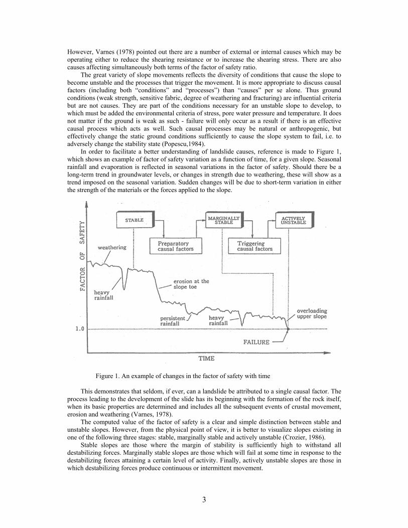
However, Varnes (1978) pointed out there are a number of external or internal causes which may be operating either to reduce the shearing resistance or to increase the shearing stress. There are also causes affecting simultaneously both terms of the factor of safety ratio. The great variety of slope movements reflects the diversity of conditions that cause the slope to become unstable and the processes that trigger the movement. It is more appropriate to discuss causal factors (including both “conditions” and “processes”) than “causes” per se alone. Thus ground conditions (weak strength, sensitive fabric, degree of weathering and fracturing) are influential criteria but are not causes. They are part of the conditions necessary for an unstable slope to develop, to which must be added the environmental criteria of stress, pore water pressure and temperature. It does not matter if the ground is weak as such - failure will only occur as a result if there is an effective causal process which acts as well. Such causal processes may be natural or anthropogenic, but effectively change the static ground conditions sufficiently to cause the slope system to fail, i.e. to adversely change the stability state (Popescu,1984). In order to facilitate a better understanding of landslide causes, reference is made to Figure 1, which shows an example of factor of safety variation as a function of time, for a given slope. Seasonal rainfall and evaporation is reflected in seasonal variations in the factor of safety. Should there be a long-term trend in groundwater levels, or changes in strength due to weathering, these will show as a trend imposed on the seasonal variation. Sudden changes will be due to short-term variation in either the strength of the materials or the forces applied to the slope.
Figure 1. An example of changes in the factor of safety with time This demonstrates that seldom, if ever, can a landslide be attributed to a single causal factor. The process leading to the development of the slide has its beginning with the formation of the rock itself, when its basic properties are determined and includes all the subsequent events of crustal movement, erosion and weathering (Varnes, 1978). The computed value of the factor of safety is a clear and simple distinction between stable and unstable slopes. However, from the physical point of view, it is better to visualize slopes existing in one of the following three stages: stable, marginally stable and actively unstable (Crozier, 1986). Stable slopes are those where the margin of stability is sufficiently high to withstand all destabilizing forces. Marginally stable slopes are those which will fail at some time in response to the destabilizing forces attaining a certain level of activity. Finally, actively unstable slopes are those in which destabilizing forces produce continuous or intermittent movement.
4
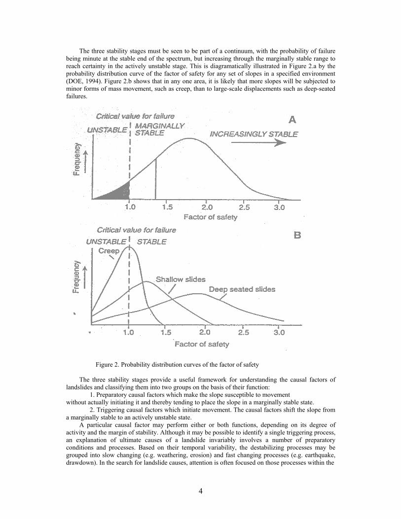
The three stability stages must be seen to be part of a continuum, with the probability of failure being minute at the stable end of the spectrum, but increasing through the marginally stable range to reach certainty in the actively unstable stage. This is diagramatically illustrated in Figure 2.a by the probability distribution curve of the factor of safety for any set of slopes in a specified environment (DOE, 1994). Figure 2.b shows that in any one area, it is likely that more slopes will be subjected to minor forms of mass movement, such as creep, than to large-scale displacements such as deep-seated failures.
Figure 2. Probability distribution curves of the factor of safety The three stability stages provide a useful framework for understanding the causal factors of landslides and classifying them into two groups on the basis of their function:
1. Preparatory causal factors which make the slope susceptible to movement without actually initiating it and thereby tending to place the slope in a marginally stable state.
2. Triggering causal factors which initiate movement. The causal factors shift the slope from a marginally stable to an actively unstable state. A particular causal factor may perform either or both functions, depending on its degree of activity and the margin of stability. Although it may be possible to identify a single triggering process, an explanation of ultimate causes of a landslide invariably involves a number of preparatory conditions and processes. Based on their temporal variability, the destabilizing processes may be grouped into slow changing (e.g. weathering, erosion) and fast changing processes (e.g. earthquake, drawdown). In the search for landslide causes, attention is often focused on those processes within the
5
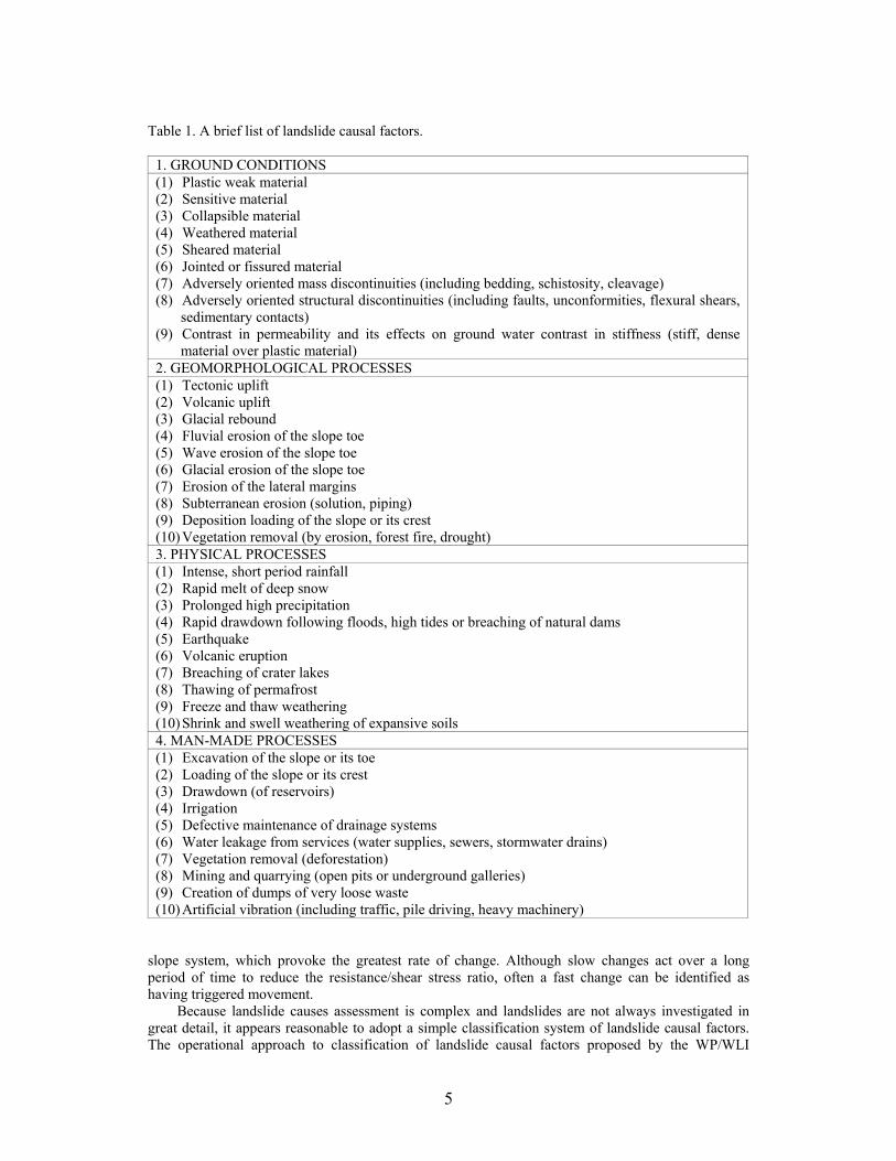
Table 1. A brief list of landslide causal factors.
1. GROUND CONDITIONS (1) Plastic weak material (2) Sensitive material (3) Collapsible material (4) Weathered material (5) Sheared material (6) Jointed or fissured material (7) Adversely oriented mass discontinuities (including bedding, schistosity, cleavage) (8) Adversely oriented structural discontinuities (including faults, unconformities, flexural shears,
sedimentary contacts) (9) Contrast in permeability and its effects on ground water contrast in stiffness (stiff, dense
material over plastic material) 2. GEOMORPHOLOGICAL PROCESSES (1) Tectonic uplift (2) Volcanic uplift (3) Glacial rebound (4) Fluvial erosion of the slope toe (5) Wave erosion of the slope toe (6) Glacial erosion of the slope toe (7) Erosion of the lateral margins (8) Subterranean erosion (solution, piping) (9) Deposition loading of the slope or its crest (10) Vegetation removal (by erosion, forest fire, drought) 3. PHYSICAL PROCESSES (1) Intense, short period rainfall (2) Rapid melt of deep snow (3) Prolonged high precipitation (4) Rapid drawdown following floods, high tides or breaching of natural dams (5) Earthquake (6) Volcanic eruption (7) Breaching of crater lakes (8) Thawing of permafrost (9) Freeze and thaw weathering (10) Shrink and swell weathering of expansive soils 4. MAN-MADE PROCESSES (1) Excavation of the slope or its toe (2) Loading of the slope or its crest (3) Drawdown (of reservoirs) (4) Irrigation (5) Defective maintenance of drainage systems (6) Water leakage from services (water supplies, sewers, stormwater drains) (7) Vegetation removal (deforestation) (8) Mining and quarrying (open pits or underground galleries) (9) Creation of dumps of very loose waste (10) Artificial vibration (including traffic, pile driving, heavy machinery)
slope system, which provoke the greatest rate of change. Although slow changes act over a long period of time to reduce the resistance/shear stress ratio, often a fast change can be identified as having triggered movement. Because landslide causes assessment is complex and landslides are not always investigated in great detail, it appears reasonable to adopt a simple classification system of landslide causal factors. The operational approach to classification of landslide causal factors proposed by the WP/WLI

6
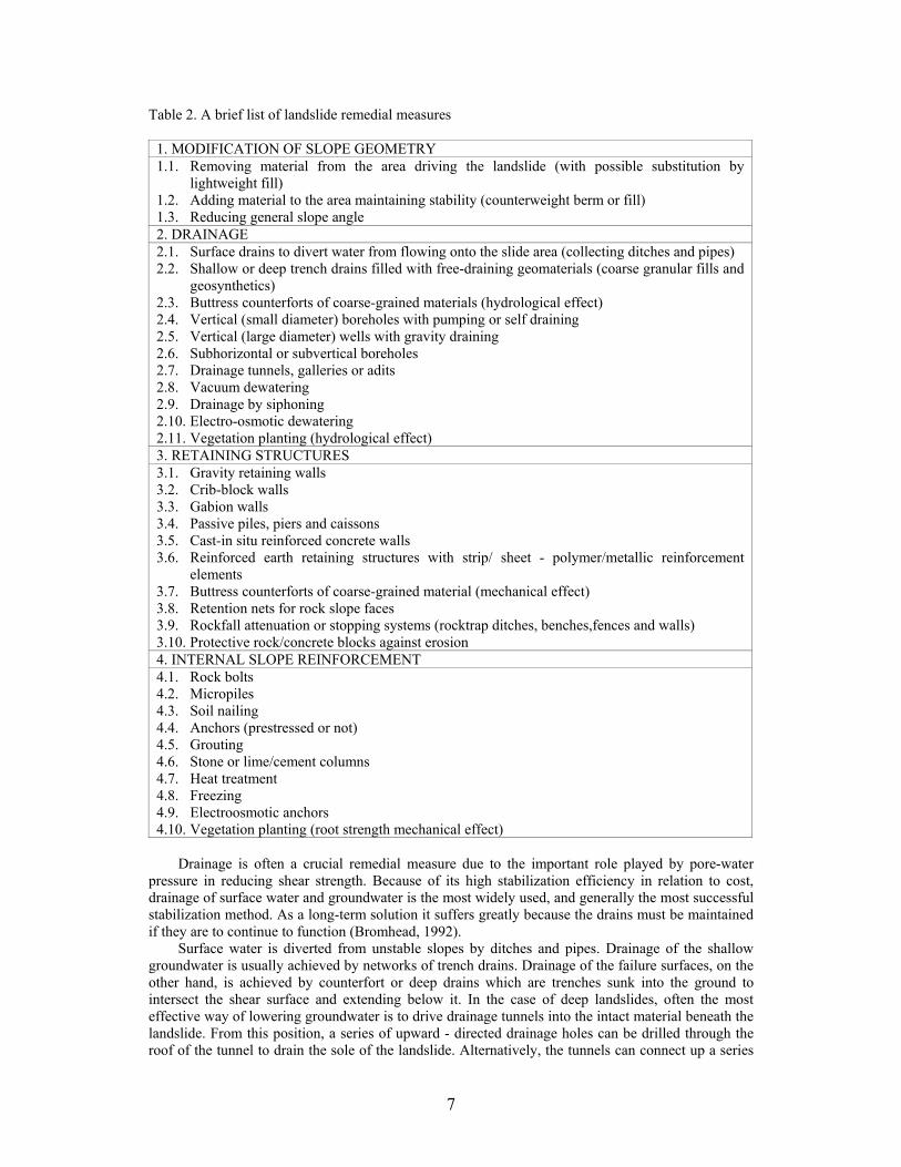
Working Group on Causes of Landslides (WP/WLI, 1994) is intended to cover the majority of landslides. It involves the consideration of the available data from simple site investigation and information furnished by other site observations. Landslide causal factors are divided according to their effect (preparatory or triggering) and their origin (ground conditions and geomorphological, physical or man-made processes). Ground conditions may not have a triggering function, while any ground condition or process may have a preparatory function. Table 1 is a short checklist of landslide causal factors arranged in four practical groups according with the tools and procedures necessary for documentation. Ground conditions or the material and mass characteristics of the ground, can be mapped on the surface of the landslide and the surrounding ground and explored in the subsurface by drilling, trenching and adits. Mechanical characteristics can be determined by testing. Geomorphological processes, or changes in the morphology of the ground, can be documented by pre-existing maps, aerial photographs, surveys of the landslide, or careful observation over time by the local population. Physical processes concern the environment and can be documented at the site by instrumentation, such as rainfall gauges, seismographs or piezometers. Careful local observations over time of water wells or damage from earthquakes may be acceptable substitutes. Variations in mechanical properties with distance from the surface may, in some circumstances, indicate changes of these properties with time. Man-made processes can be documented by site observations and from construction or excavation records at the site. Separate identification of artificial and natural landslides is useful for both administrative and theoretical reasons. The format of the table lends itself to the creation of simple databases suited to much of the database management software now available for personal computers. The information collected can be compared with summaries of other landslides (WP/WLI, 1991) and used to guide further investigations and mitigation measures. 3. A Brief List And Short Comments On Landslide Remedial Measures Correction of an existing landslide or the prevention of a pending landslide is a function of a reduction in the driving forces or an increase in the available resisting forces. Any remedial measure used must provide one or both of the above results. Many general reviews of the methods of landslide remediation have been made. The interested reader is particularly directed to Hutchinson (1977), Zaruba and Mencl (1982), Schuster (1992), Bromhead (1992) and Fell (1994). In order to help including relevant information on the landslide remediation in a standard format in the Landslide Report (WP/WLI, 1990), the IUGS WG/L Comission on Landslide Remediation (Popescu, 2001) has prepared a short checklist of landslide remedial measures as given in Table 2. The measures are arranged in four practical groups, namely: modification of slope geometry, drainage, retaining structures and internal slope reinforcement. Hutchinson (1977) has indicated that drainage is the principal measure used in the repair of landslides, with modification of slope geometry the second most used method. These are also generally the least costly of the four major categories, which is obviously why they are the most used. The experience shows that while one remedial measure may be dominant, most landslide repairs involve the use of a combination of two or more of the major categories. For example, while restraint may be the principal measure used to correct a particular landslide, drainage and modification of slope geometry, to some degree and by necessity, are also utilized. Modification of slope geometry is a most efficient method particularly in deep seated landslides. However, the success of corrective slope regrading (fill or cut) is determined not merely by size or shape of the alteration, but also by position on the slope. Hutchinson (1977) provides details of the “neutral line” method to assist in finding the best location to place a stabilizing fill or cut. There are some situations where this approach is not simple to adopt. These include long translational landslides where there is no obvious toe or crest; situations where the geometry is determined by engineering constraints; situations where the unstable area is and thus a change in topography, which improves the stability of one area may reduce the stability of another.
7
Table 2. A brief list of landslide remedial measures
1. MODIFICATION OF SLOPE GEOMETRY 1.1. Removing material from the area driving the landslide (with possible substitution by
lightweight fill) 1.2. Adding material to the area maintaining stability (counterweight berm or fill) 1.3. Reducing general slope angle 2. DRAINAGE 2.1. Surface drains to divert water from flowing onto the slide area (collecting ditches and pipes) 2.2. Shallow or deep trench drains filled with free-draining geomaterials (coarse granular fills and
geosynthetics) 2.3. Buttress counterforts of coarse-grained materials (hydrological effect) 2.4. Vertical (small diameter) boreholes with pumping or self draining 2.5. Vertical (large diameter) wells with gravity draining 2.6. Subhorizontal or subvertical boreholes 2.7. Drainage tunnels, galleries or adits 2.8. Vacuum dewatering 2.9. Drainage by siphoning 2.10. Electro-osmotic dewatering 2.11. Vegetation planting (hydrological effect) 3. RETAINING STRUCTURES 3.1. Gravity retaining walls 3.2. Crib-block walls 3.3. Gabion walls 3.4. Passive piles, piers and caissons 3.5. Cast-in situ reinforced concrete walls 3.6. Reinforced earth retaining structures with strip/ sheet - polymer/metallic reinforcement
elements 3.7. Buttress counterforts of coarse-grained material (mechanical effect) 3.8. Retention nets for rock slope faces 3.9. Rockfall attenuation or stopping systems (rocktrap ditches, benches,fences and walls) 3.10. Protective rock/concrete blocks against erosion 4. INTERNAL SLOPE REINFORCEMENT 4.1. Rock bolts 4.2. Micropiles 4.3. Soil nailing 4.4. Anchors (prestressed or not) 4.5. Grouting 4.6. Stone or lime/cement columns 4.7. Heat treatment 4.8. Freezing 4.9. Electroosmotic anchors 4.10. Vegetation planting (root strength mechanical effect)
Drainage is often a crucial remedial measure due to the important role played by pore-water pressure in reducing shear strength. Because of its high stabilization efficiency in relation to cost, drainage of surface water and groundwater is the most widely used, and generally the most successful stabilization method. As a long-term solution it suffers greatly because the drains must be maintained if they are to continue to function (Bromhead, 1992). Surface water is diverted from unstable slopes by ditches and pipes. Drainage of the shallow groundwater is usually achieved by networks of trench drains. Drainage of the failure surfaces, on the other hand, is achieved by counterfort or deep drains which are trenches sunk into the ground to intersect the shear surface and extending below it. In the case of deep landslides, often the most effective way of lowering groundwater is to drive drainage tunnels into the intact material beneath the landslide. From this position, a series of upward - directed drainage holes can be drilled through the roof of the tunnel to drain the sole of the landslide. Alternatively, the tunnels can connect up a series
8
of vertical wells sunk down from the ground surface. In instances where the groundwater is too deep to be reached by ordinary trench drains and where the landslide is too small to justify an expensive drainage tunnel or gallery, bored sub-horizontal drains can be used. Another approach is to use a combination of vertical drainage wells linked to a system of sub-horizontal borehole drains. Schuster (1992) discusses recent advances in the commonly used drainage systems and briefly mentions less common used, but innovative, means of drainage, such as electro-osmotic dewatering, vacuum and siphon drains. Buttress counterforts of course-grained materials placed at the toe of unstable slopes often are successful as a remedial measure. They are listed in Table 2 both under “Drainage” when used mainly for their hydrological effect and “Retaining Structures” when used mainly for their mechanical effect. During the early part of the post-war period landslides were generally seen to be “engineering problems” requiring “engineering solutions” involving correction by the use of structural techniques. This structural approach initially focused on retaining walls but has subsequently been diversified to include a wide range of more sophisticated techniques including passive piles and piers, cast-in-situ reinforced concrete walls and reinforced earth retaining structures. When properly designed and constructed these structural solutions can be extremely valuable, especially in areas with high loss potential or in restricted sites. However fixation with structural solutions has in some cases resulted in the adoption of over-expensive measures that proved to be less appropriate than alternative approaches involving slope geometry modification or drainage (DOE, 1994). Over the last several decades there has been a notable shift towards “soft engineering” non-structural solutions including classical methods such as drainage and modification of slope geometry but also some novel methods such as lime/cement stabilization, grouting or soil nailing (Powel, 1992). The cost of non-structural remedial measures is considerably lower when compared with the cost of structural solutions. On the other hand structural solutions such as retaining walls involve opening the slope during construction and often require steep temporary cuts. Both these operations increase the risk of failure during construction for over-steeping or increased infiltration from rainfall. In contrast, the use of soil nailing as a non-structural solution to strengthen the slope avoids the need to open or alter the slope from its current condition. Environmental considerations have increasingly become an important factor in the choice of suitable remedial measures, particularly issues such as visual intrusion in scenic areas or the impact on nature or geological conservation interests. An example of “soft engineering” solution, more compatible with the environment, is the stabilization of slopes by the combined use of vegetation and man-made structural elements working together in an integrated manner known as biotechnical slope stabilization (Schuster, 1992). The basic concepts of vegetative stabilization are not new - vegetation has a beneficial effect on slope stability by the processes of interception of rainfall, and transpiration of groundwater, thus maintaining drier soils and enabling some reduction in potential peak groundwater pressures. Except these hydrological effects, vegetation roots reinforce the soil, increasing soil shear strength while tree roots may anchor into firm strata, providing support to the upslope soil mantle through buttressing and arching. A small increase in soil cohesion induced by the roots has a major effect on shallow landslides. The mechanical effect of vegetation planting is not significant for deeper seated landslides, while the hydrological effect is beneficial for both shallow and deep landslides. However, vegetation may not always assist slope stability. Destabilizing forces may be generated by the weight of the vegetation acting as a surcharge and by wind forces on the vegetation exposed, though both these are very minor effects. Roots of vegetation may also act adversely by penetrating and dilating the joints of widely jointed rocks. For detailed information on the research into the engineering role of vegetation for slope stabilization refer to Greenway (1987) and Wu (1991). In addition the “Geotechnical Manual for Slopes” (Geotechnical Control Office of Hong Kong, 1981) includes an excellent table noting the hydrological and mechanical effects of vegetation. The concept of biotechnical slope stabilization is generally cost effective as compared to the use of structural elements alone; it increases environmental compatibility, and allows the use of local natural materials. Interstices of the retaining structure are planted with vegetation whose roots bind together the soil within and behind the structure. The stability of all types of retaining structures with open gridwork or tiered facings benefits from such vegetation. An example of a composite vegetated geotextile/geogrid reinforced structure named “Biobund” was presented by Barker (1991).

9
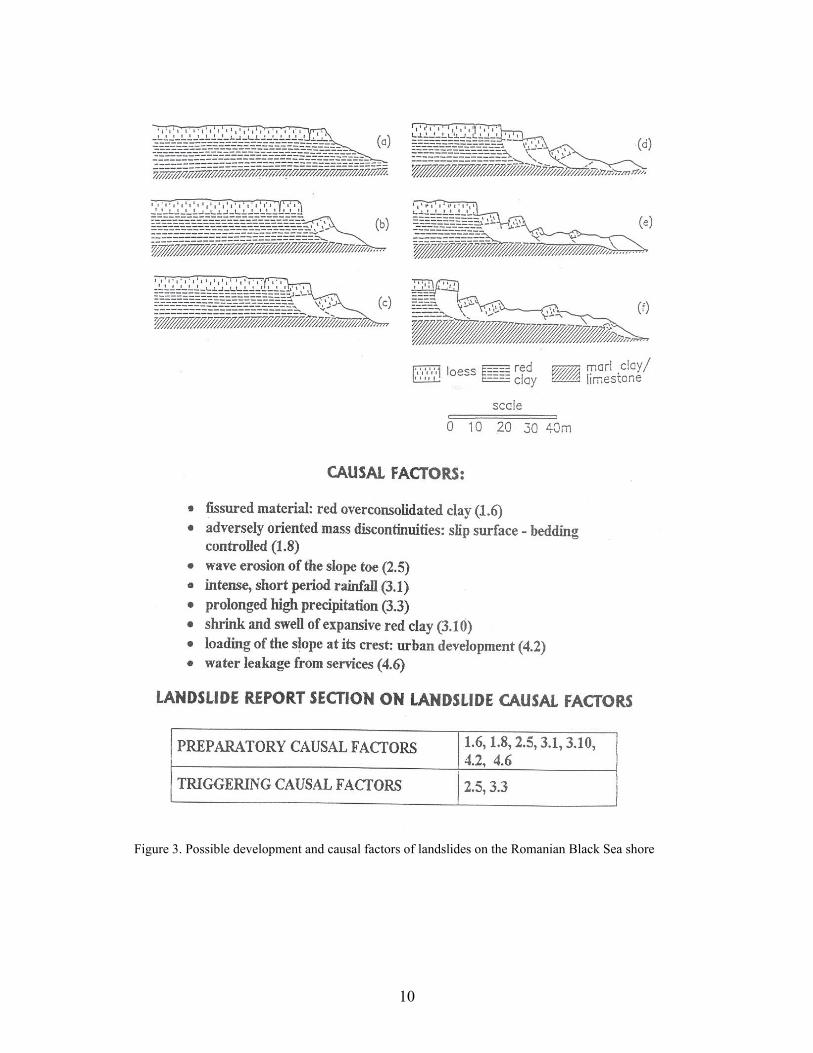
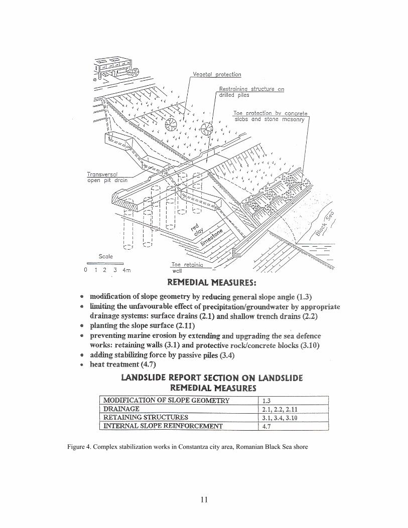
The example of stabilization scheme of a landslide in Constanza city on the Black Sea shore in Romania is used to illustrate features focused upon in the above discussion (Popescu, 1999). The large coastal landslides along the Black Sea shore in Romania are well known instability phenomena that evolve in time and space. An important feature of these landslides is the geological sequence including a red, over-consolidated, fissured clay underlying a loess layer at the ground surface. The underground water level is generally located at the base of the loess layer. The red clay is overlying a hard marl clay or limestone. The investigation of most landslides has shown that the basal slip surface is bedding - controlled and seated in the red clay layer. The cliff retreat follows cycles similar to those reported on the southern coast of England and on the northern coast of France (Hutchinson et al., 1991). Most prominent is the major cycle of a large, rapid landslide followed by slow erosion, but of importance is also the annual climate - driven cycle, causing large soil strength variations between spring, summer and autumn. The mechanism of rear scarp retrogression caused by successive landslips is illustrated by the cartoons in Figure 3. Continued erosion of the toe of the slope results in a series of landslips. Each slide leads to the removal of the lateral support of the main landslide blocks upslope, and progressively worsens the stability of the system. Each slope failure causes reduction of the lateral stress in its close vicinity, which in turn makes the red clay to mechanically expand and reduce its strength. Physical swelling is not possible in short term due to the low permeability of the clay. After a period of time, however, water flows into the area, reduces the clay shear strength and causes further failure. Each slide leaves a steep rear scarp, which rapidly degrades to a flatter slope. The pile-up of debris on the rear of the main slide constitutes a loading, which together with the generation of undrained porewater pressures, and the continuance of marine erosion at the toe, acts to destabilize the main slide, and cause further movement. By considering the factors that are contributing to the coastal landslides in the area of Constanza city the following approaches to stabilization have been undertaken (Figure 4): (1) Prevention of marine erosion by extending and upgrading the existing sea defenses along the cliff toe; (2) Limiting the unfavorable effect of the groundwater/precipitation by providing appropriate drainage systems and monitoring the water supply network to identify areas of leakage where pipes need to be either repaired or replaced; (3) Regrading and planting the slope surface; (4) Adding stabilizing force to the slope by installing stabilizing piles bored through the sliding mass to the stable underlying material. The reinforced concrete piles were 1.08 m in diameter, 20 m long, staggered in plan and tied together at their top by a 3 m wide deck slab, which carried a walking pathway. The causal factors that have contributed to the coastal landslides in the area of Constanza city have been grouped under two main headings: (1) preparatory and (2) triggering, as shown in the table presented within Figure 3. By considering those factors, which have contributed to the coastal landslides, a number of stabilization approaches have been identified, as summarized in Figure 4. Using numbers selected from the checklists presented in Tables 1 and 2 rather than words, landslide reports can be compiled which are independent of language and thus more amenable to digital processing (Popescu, 1996). 4. Levels Of Effectiveness And Acceptability That May Be Applied In The Use Of Remedial Measures Terzaghi (1950) has written that, “if a slope has started to move, the means for stopping movement must be adapted to the processes which started the slide”. For example, if erosion is a causal process of the slide, our thoughts on remediation would involve armoring the slope against erosion, or removing the source of erosion. An erosive spring can be made non-erosive by either blanketing with filter materials or drying up the spring with horizontal drains etc.
10
Figure 3. Possible development and causal factors of landslides on the Romanian Black Sea shore
11
Figure 4. Complex stabilization works in Constantza city area, Romanian Black Sea shore
12
The greatest benefit in understanding landslide-producing processes and mechanisms lies in the use of this understanding to anticipate and devise measures to minimize and prevent major landslides. The term major should be underscored here because it is neither possible nor feasible, nor even desirable, to prevent all landslides. There are many examples of landslides that can be handled more effectively and at less cost after they occur. Landslide avoidance through selective locationing is obviously desired - even required - in many cases, but the dwindling number of safe and desirable construction sites may force more and more the use of landslide - susceptible terrain. Selection of an appropriate remedial measure depends on: a) engineering feasibility, b) economic feasibility, c) legal/regulatory conformity, d) social acceptability, and e) environmental acceptability. Engineering feasibility involves analysis of geologic and hydrologic conditions at the site to ensure the physical effectiveness of the remedial measure. An often-overlooked aspect is making sure the design will not merely divert the problem elsewhere. Economic feasibility takes into account the cost of the remedial action to the benefits it provides. These benefits include deferred maintenance, avoidance of damage including loss of life, and other tangible and intangible benefits. Legal-regulatory conformity provides for the measure meeting local building codes, avoiding liability to other property owners, and related factors. Social acceptability is the degree to which the remedial measure is acceptable to the community and neighbors. Some measures for a property owner may prevent further damage but be an ugly eyesore to neighbors. Environmental acceptability addresses the need for the remedial measure to not adversely affect the environment. De-watering a slope to the extent it no longer supports a unique plant community may not be environmentally acceptable solution. Just as there are a number of available remedial measures, so also are there a number of levels of effectiveness and levels of acceptability that may be applied in the use of these measures. We may have a landslide, for example, that we simply choose to live with; one that poses no significant hazard to the public, but one also that requires periodic maintenance for example, through removal, due to occasional encroachment onto the shoulder of a roadway. The permanent closure of the Manchester - Sheffield road at Mam Tor in 1979 (Skempton et al., 1989) and the decision not to reopen the railway link to Killin following the Glen Ogle rockslide in U.K. (Smith, 1984) are well known examples of abandonment due to the effects of landslides where repair was considered uneconomic. Most landslides, however, must usually be dealt with sooner or later. How they are handled depends on the processes that prepared and precipitated the movement, the landslide type, the kinds of materials involved, the size and location of the landslide, the place or things affected by or the situation created as a result of the landslide, available resources etc. The technical solution must be in harmony with the natural system, otherwise the remedial work will be either short lived or excessively expensive. In fact landslides are so varied in type and size, and always, so dependent upon special local circumstances, that for a given landslide problem there is more than one method of prevention or correction that can be successfully applied. The success of each measure depends, to a large extent, on the degree to which the specific soil and groundwater conditions are correctly recognized in investigation and applied in design. The failure to properly recognize and apply these conditions could result in the failure of the remedial works as illustrated by the example of the main landslide at Craco, South Italy (Del Prete, Petley, 1982). A retaining wall built on lines of contiguous piles to arrest the movement of the reactivated ancient landslide at Craco actually caused a dramatic increase in landslide activity and the final collapse due to a combination of the following three unfavorable effects: (i) the retaining wall was founded on piles which did not penetrate beyond the surface of sliding; (ii) the wall was located in a position where additional loading causes a reduction in the stability condition; (iii) the impervious wall acted as a dam to the flow of groundwater resulting in an increase in pore water pressure behind the contiguous piles. As many of the geological features, like the sheared discontinuities, are not well known in advance, it is better to put remedial measures in hand on a “design as you go basis”. That is the design has to be flexible enough for changes during or subsequent construction of remedial works.
13
5. Landslide Activity And Hazard Mitigation Slope movements can take very different configurations from rock topple to mudflow, can involve a variety of materials from hard rock to sensitive clay and loess, and can result from a variety of phenomena from rapid snow melt to earthquakes. Leroueil (1996) defined the following four possible different stages of landslide activity:
1. Pre-failure stage, when the soil mass is still continuous. This stage is mostly controlled by progressive failure and creep;
2. Onset of failure characterized by the formation of a continuous shear surface through the entire soil or rock mass;
3. Post-failure stage which includes movement of the soil or rock mass involved in the landslide, from just after failure until it essentially stops;
4. Reactivation stage when the soil or rock mass slides along one or several pre-existing shear surfaces. This reactivation can be occasional or continuous with seasonal variations of the rate of movement.
When associated to slopes, risk has often been considered in terms of failure which indeed represents an important proportion of the encountered problems, particularly when risk is examined in terms of loss of lives. This, however, does not satisfy all the geotechnical engineering needs. For linear structures or infrastructures, such as bridges, roads, railway tracks, pipelines, etc. in zones of precarious stability, the concern is related to the magnitude of movement and rate of movement rather than to failure as such. The elements at risk can be classified into four categories: individuals, properties and goods, activities, and social functions. Each of these categories can suffer consequences from the landslide itself or from landslide induced phenomena. For example, destruction of a house by a landslide is a direct consequence of the event whereas flooding of a town due to the damming of a river by a landslide is an indirect consequence. All these elements have to be considered in a risk analysis. Hazard is the probability that a phenomenon such as a first-time slope failure or an active landslide reaching a given rate of movement occurs. When the failure stage is concerned, the hazard is directly related to the probability that the triggering factor to reach a critical value leading to failure. For the pre-failure and reactivation stages, the hazard associated to a rate of movement is related to the probability that the aggravating factor reaches a given value leading to this rate. For the post-failure stage, the hazard associated to a given rate of movement is very much governed by the materials involved and the predisposition factors, and thus it is more difficult to be defined. When dealing with a slope of precarious stability and/or presenting a risk which is considered too high, there are three main options:
1. Do nothing to the slope and possibly reduce its possible consequences; 2. Do nothing but install a warning system in order to insure or improve the safety of people; 3. Improve the safety of the slope to a satisfactory level in order to reduce the risk to an
acceptable level. When the size of the moving or potentially moving mass is too large or when the cost associated to mitigation is too high, the possibility to relocate the structure elsewhere should be examined. Obviously, it is preferable to consider such a possibility during the planning stage. It is worth noting that warning systems do not modify the hazard but contribute to reducing the consequences of the landslide and thus the risk, in particular the risk associated to the loss of life. Many types of warning systems have been proposed and the selection of an appropriate one should take into account the stage of landslide activity:
1. At pre-failure stage, the warning system can be applied either to revealing factors or to aggravating factors. The revealing factors can be for example the opening of fissures or the movement of given points on the slope; in such cases, the warning criterion will be the magnitude or rate of movement. When the warning system is associated to triggering or aggravating factors, there is a need to firstly define the relation between the magnitude of the controlling factors and the stability condition or the rate of movement of the slope. The warning criterion can be a given pore water pressure, a given stage of erosion, a minimum negative pore pressure in a loess deposit, etc. It can be also based on rainfall; for example, in South Korea, the hourly rainfall and the cumulative rainfall during a two-day period were combined in an alarm criterion.

14
2. At failure stage, the warning system can only be linked to revealing factors, generally a sudden acceleration of movements or the disappearance of a target.
3. At post-failure stage, the warning system has to be associated to the expected consequences of the movement. It is generally associated with the rate of movement and run out distance.
4. Inform the public or the users of facilities about the dangers. 6. Ground Investigation, Monitoring And Back Analysis Of Slope Failures To Design Remedial Works Ground investigation involves a combination of topographic survey, sub-surface investigation, laboratory testing, monitoring of ground movement and groundwater studies which are carried out with the view to assessing stability conditions and suitability of remedial options. If the stability analyses undertaken to determine the effectiveness of proposed remedial measures are not representative in respect with the material parameters, geometry and location of the rupture surfaces and pore water conditions, then the solution chosen may ultimately prove to be inappropriate or unsuccessful (Morgenstern, 1992). A pragmatic approach of living with landslides and reducing the impact of landslide problems in urban areas is well illustrated by the strategy adopted to cope with landslide problems at Ventnor, Isle of Wight, U. K. (Lee et al., 1991). Ventnor is an unusual situation in that the whole town lies within an ancient landslide complex. The spatial extent and scale of the problems at Ventnor indicated that total avoidance or abandonment of the site are out of question and large-scale conspicuous engineering structures would be unacceptable in a town dependent on tourism. Instead coordinated measures have been adopted to limit the impacts of human activity that promote ground instability by planning control, control of construction activity, preventing water leakage and improving building standards. In addition, good maintenance practice by individual homeowners can be a significant help, as neglect can result in localized instability problems. Monitoring of landslides plays an increasingly important role in the context of living and coping with these natural hazards. The classical methods of land surveys, inclinometers, extensometers and piezometers are still the most appropriate ones. In future, the development of methods based on remote sensing and remote access techniques should be of primary interest (LCPC, 1994). DOE (1994) identifies the following categories of monitoring designed for slightly differing purposes but generally involving similar techniques:
(1) Preliminary monitoring involves provision of data on pre-existing landslides so that the dangers can be assessed and remedial measures properly designed or the site abandoned.
(2) Precautionary monitoring is carried out during construction in order to ensure safety and to facilitate redesign if necessary.
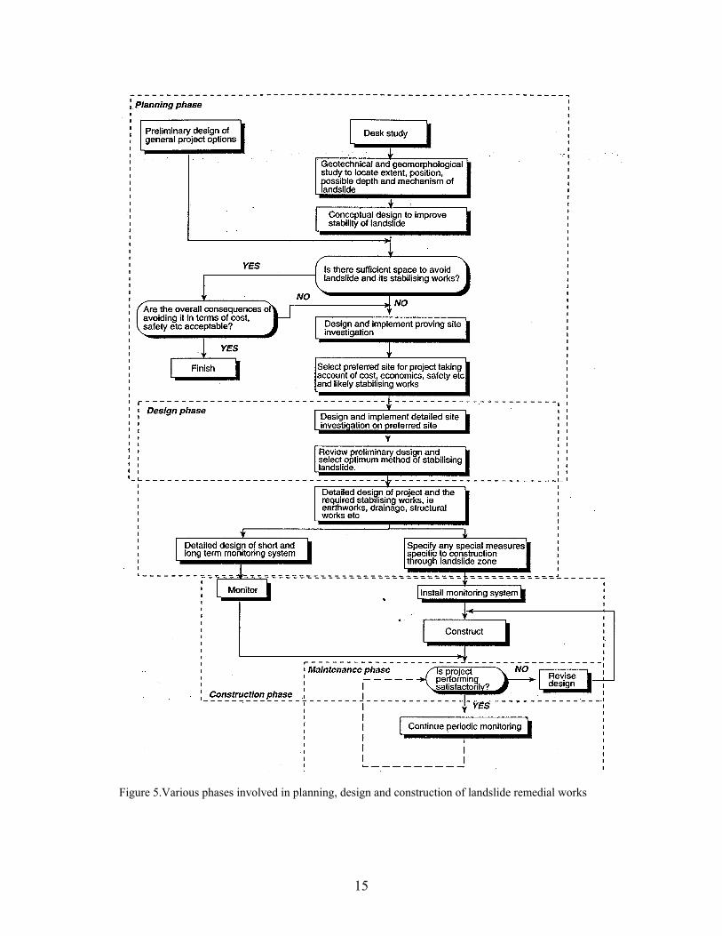
(3) Post-construction monitoring in order to check on the performance of stabilization measures and to focus attention on problems that require remedial measures. Observational methods based on careful monitoring before, during and after construction are essential in achieving reliable and cost - effective remedial measures (Brandl, 1995). The flow diagram showing the sequence of various phases involved in the planning, design, construction and monitoring of remedial works is given in Figure 5 (Kelly, Martin, 1986). Ground investigation and monitoring together provide the data necessary for performing back analysis to assess landslide mechanisms and material parameters for improved design. Post-failure investigation of landslides is potentially the most fruitful means of advancing our knowledge in slope stability field. A landslide can reasonably be considered as a full scale shear test capable to give a measure of the shear strength mobilized at failure along the slip surface.
15
Figure 5.Various phases involved in planning, design and construction of landslide remedial works
16
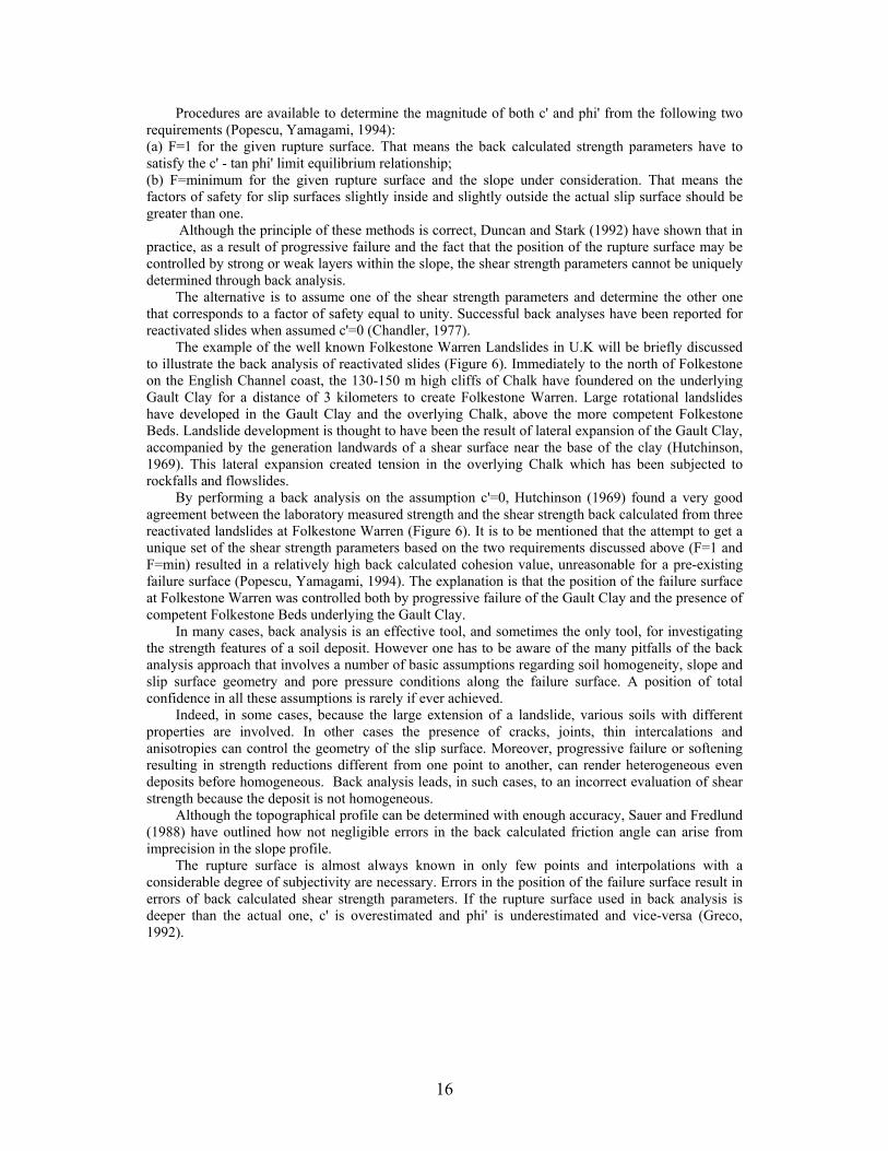
Procedures are available to determine the magnitude of both c' and phi' from the following two requirements (Popescu, Yamagami, 1994): (a) F=1 for the given rupture surface. That means the back calculated strength parameters have to satisfy the c' - tan phi' limit equilibrium relationship; (b) F=minimum for the given rupture surface and the slope under consideration. That means the factors of safety for slip surfaces slightly inside and slightly outside the actual slip surface should be greater than one. Although the principle of these methods is correct, Duncan and Stark (1992) have shown that in practice, as a result of progressive failure and the fact that the position of the rupture surface may be controlled by strong or weak layers within the slope, the shear strength parameters cannot be uniquely determined through back analysis. The alternative is to assume one of the shear strength parameters and determine the other one that corresponds to a factor of safety equal to unity. Successful back analyses have been reported for reactivated slides when assumed c'=0 (Chandler, 1977). The example of the well known Folkestone Warren Landslides in U.K will be briefly discussed to illustrate the back analysis of reactivated slides (Figure 6). Immediately to the north of Folkestone on the English Channel coast, the 130-150 m high cliffs of Chalk have foundered on the underlying Gault Clay for a distance of 3 kilometers to create Folkestone Warren. Large rotational landslides have developed in the Gault Clay and the overlying Chalk, above the more competent Folkestone Beds. Landslide development is thought to have been the result of lateral expansion of the Gault Clay, accompanied by the generation landwards of a shear surface near the base of the clay (Hutchinson, 1969). This lateral expansion created tension in the overlying Chalk which has been subjected to rockfalls and flowslides. By performing a back analysis on the assumption c'=0, Hutchinson (1969) found a very good agreement between the laboratory measured strength and the shear strength back calculated from three reactivated landslides at Folkestone Warren (Figure 6). It is to be mentioned that the attempt to get a unique set of the shear strength parameters based on the two requirements discussed above (F=1 and F=min) resulted in a relatively high back calculated cohesion value, unreasonable for a pre-existing failure surface (Popescu, Yamagami, 1994). The explanation is that the position of the failure surface at Folkestone Warren was controlled both by progressive failure of the Gault Clay and the presence of competent Folkestone Beds underlying the Gault Clay. In many cases, back analysis is an effective tool, and sometimes the only tool, for investigating the strength features of a soil deposit. However one has to be aware of the many pitfalls of the back analysis approach that involves a number of basic assumptions regarding soil homogeneity, slope and slip surface geometry and pore pressure conditions along the failure surface. A position of total confidence in all these assumptions is rarely if ever achieved. Indeed, in some cases, because the large extension of a landslide, various soils with different properties are involved. In other cases the presence of cracks, joints, thin intercalations and anisotropies can control the geometry of the slip surface. Moreover, progressive failure or softening resulting in strength reductions different from one point to another, can render heterogeneous even deposits before homogeneous. Back analysis leads, in such cases, to an incorrect evaluation of shear strength because the deposit is not homogeneous. Although the topographical profile can be determined with enough accuracy, Sauer and Fredlund (1988) have outlined how not negligible errors in the back calculated friction angle can arise from imprecision in the slope profile. The rupture surface is almost always known in only few points and interpolations with a considerable degree of subjectivity are necessary. Errors in the position of the failure surface result in errors of back calculated shear strength parameters. If the rupture surface used in back analysis is deeper than the actual one, c' is overestimated and phi' is underestimated and vice-versa (Greco, 1992).
17
Figure 6. Folkestone Warren, U.K. Section through the landslide and results of back analysis The data concerning the pore pressure on the slip surface are generally few and imprecise. More exactly, the pore pressure at failure is almost always unknown. Skempton (1977) indicated that tens of years may be required for pore pressures to equalize around an excavated slope in clay. Thus the slip surface in failed excavated slopes probably began to develop while the pore pressures within the slope were lower than they were when the slip occurred. If the assumed pore pressures are higher than the actual ones, the shear strength is overestimated. Brand et al. (1984) pointed out that rapid changes in pore pressure with rainfall triggering many landslides in Hong Kong are very difficult to predict and degree of uncertainty that exists over this can make back analysis very unreliable. Leroueil and Tavenas (1981) showed for one case that assuming the phreatic surface in a 7.5 m high slope was 1 m higher than it actually had been at failure would result in a 50 % increase in the value of c' calculated by back analysis. The fundamental problem involved is always one of data quality and consequently the back analysis approach must be applied with care and the results interpreted with caution.
18
The most important application of back analysis consists in proper design of remedial measures. It is generally assumed that the errors involved in the back analysis of a given slope failure will cancel-out by applying the back calculated shear strength in further limit equilibrium analyses of remedial measures and design new slopes in the same area. However, the assumption that there is some sort of canceling-out of errors to give a correct answer might be false in some instances. Cooper (1984) performed sensitivity studies to examine the consequences of possible errors in the values of various parameters involved in back analysis on the calculated factor of safety after stabilization of the slope by flattening and drainage. In the case where a slope is stabilized by flattening, errors due to incorrectly assumed values of c', phi', or pore pressure tend to be self-compensating, and have relatively small effects on the calculated value of factor of safety after stabilization. In the case where a slope is stabilized by drainage, errors due to incorrectly assumed values of c' and phi' also tend to be self-compensating, but errors due to incorrectly assumed pore pressures are not self-compensating, and can be quite significant. Assuming that the pore pressures were higher than they actually were at failure is unconservative, because it results in back calculated strengths that are too high. In order to avoid the questionable problem of the representativeness of the back calculated unique set of shear strength parameters a method for designing remedial works based on the limit equilibrium relationship c' - phi' rather than a unique set of shear strength parameters can be used (Popescu, 1991). Back analysis is of use only if the soil conditions at failure are unaffected by the failure. For example back calculated parameters for a first-time slide in a stiff over-consolidated clay could not be used to predict subsequent stability of the sliding mass, since the shear strength parameters will have been reduced to their residual values by the failure. A case study was presented by Romero and Domenech (1994) who used the original topography of the slope, before failure, in order to back calculate the peak strength, and the final equilibrium topography of the slope, after failure, to derive the residual strength of an over-consolidated Tertiary clay in Spain. It is also to be pointed out that if the three-dimensional geometrical effects are important for the failed slope under consideration and a two-dimensional back analysis is performed, the back calculated shear strength will be too high and thus unsafe. 7. Concluding Remarks Each major landslide is a case history in itself because the factors causing the landslide and their interplay differ from former events. That is the reason why case histories will continue to be of paramount importance in developing effective procedures to minimize the landslide impact optimizing the balance between safety and economy. Each event will contribute new observations and conclusions from which we can gain experience and which progressively improve our knowledge. Much progress has been made in developing techniques to minimize the impact of landslides, although new, more efficient, quicker and cheaper methods could well emerge in the future. Landslides may be corrected or controlled by one or any combination of four principle measures: modification of slope geometry, drainage, retaining structures and internal slope reinforcement. There are a number of levels of effectiveness and levels of acceptability that may be applied in the use of these measures, for while one slide may require an immediate and absolute long-term correction, another may only require minimal control for a short period. Whatever the measure chosen, and whatever the level of effectiveness required, the geotechnical engineer and engineering geologist have to combine their talents and energies to solve the problem. Solving landslide related problems is changing from what has been predominantly an art to what may be termed an art-science. The continual collaboration and sharing of experience by engineers and geologists will no doubt move the field as a whole closer toward the science end of the art-science spectrum than it is at present.
19
Acknowledgements Landslide causes have concerned the WP/WLI Working Group on Landslide Causes, chaired by M.E. Popescu with members P. Anagnosti, D.M. Cruden, F. Esu, J. Farkas, R. Fell, S. Novosad, K. Sassa and M. Watanabe while landslide remedial measures form the focus of the activity of the IUGS WG/L Comission on Landslide Remediation, chaired by M.E. Popescu with members P.Anagnosti, Ch. Bonnard, R. Fell, E. Krauter, W.A. Lacerda, H. Nakamura, A. Onalp and L. Valenzuela References Barker, D.H. (1991). “Developments In Biotechnical Stabilization In Britain And The Commonwealth.” Proc. Workshop on Biotechnical Stabilization, University of Michigan, Ann Arbor, A-83 to A-123. Brand, E.W., Premchitt, Y., and Phillipson, H.B. (1984). “Relationship Between Rainfall And Landslides In Hong Kong.” Proc. 4th Intern. Symp. on Landslides, Toronto, 1: 377-384. Brandl, H. (1995). “Observational Method In Slope Engineering.” Proc. Intern. Symp. 70 Years of Soil Mechanics, Istanbul, 1-12. Bromhead, E.N. (1992). “The Stability Of Slopes.” Blackie Academic & Professional, London. Chandler, R.J. (1977). “Back Analysis Techniques For Slope Stabilization Works: A Case Record.” Geotechnique, 27, 4: 479-495. Cooper, M.R. (1984). “The Application Of Back Analysis To The Design Of Remedial Works For Failed Slopes.” Proc. 4th Intern. Symp. on Landslides, Toronto, 1: 631-638. Crozier, M.J. (1986). “Landslides - Causes, Consequences And Environment.” Croom Helm, London. Cruden,D.M. (1991). “A Simple Definition Of A Landslide.” Bulletin IAEG, 43:27-29. Cruden, D.M., and Varnes, D.J. (1996). “Landslide Types And Processes.” Turner, A.K., and Schuster, R.L., editors. Landslides: Investigation and Mitigation, Transportation Research Board Special Report. Del Prete, M., and Petley, D.J. (1982). “Case History Of The Main Landslide At Craco, Basilicata, South Italy.” Geologia Applicata e Idrogeologia, XVII: 291-304. DOE: Department of the Environment (1994). “Landsliding in Great Britain” (edited by D.K.C. Jones and E.M. Lee), HMSO, London. Duncan, J.M., and Stark, T.D. (1992). “Soil Strength From Back Analysis Of Slope Failures.” Proc. ASCE Geotechn. Conf. on Slopes and Embankments, Berkeley, 890-904. Fell, R. (1994). “Stabilization Of Soil And Rock Slopes”. Proc. East Asia Symp. and Field Workshop on Landslides and Debris Flows, Seoul, 1:7-74. Geotechnical Control Office (1981). “Geotechnical Manual For Slopes.” Public Works Department, Hong Kong. Greenway, D.R. (1987). “Vegetation And Slope Stability.” Slope Stability, John Wiley & Sons Ltd., 187 - 230. Greco, V.R. (1992). “Back-Analysis Procedure For Failed Slopes.” Proc. 6th Intern. Symp. on Landslides, Christchurch, 1:435-440.
20
Hutchinson, J.N. (1969). “A Reconsideration Of The Coastal Landslides At Folkestone.” Warren, Kent. Geotechnique, 19:6-38. Hutchinson, J.N. (1977). “The Assessment Of The Effectiveness Of Corrective Measures In Relation To Geological Conditions And Types Of Slope Movement.” Bulletin IAEG, 16: 131-155. Hutchinson, J.N., Bromhead, E.N., and Chandler, M.P. (1991). “Investigations Of Landslides At St Catherine’s Point, Isle Of Wight.” Proc. Int. Conf. on Slope Stability Engineering, Isle of Wight, Thomas Telford, London, 169-179. Kelly, J.M.H., and Martin, P.L. (1986). “Construction Works On Or Near Landslides.” Proc. Symposium of Landslides in South Wales Coalfield. Polytechnic of Wales, 85-103. LCPC: Laboratoire Central des Ponts et Chaussées (1994). “Surveillance Des Pentes Instables.” Guide Technique, Paris. Lee, E.M., Moore, R., Burt, N., and Brunsden, D. (1991). “Strategies For Managing The Landslide Complex At Ventnor, Isle Of Wight.” Proc. Int. Conf. on Slope Stability Engineering, Isle of Wight, Thomas Telford, London, 219-225. Leroueil, S., and Tavenas, F. (1981). “Pitfalls Of Back Analysis.” Proc. 10th ICSMFE, Stockholm, 1: 185-190. Morgenstern, N.R. (1992). “The Role Of Analysis In The Evaluation Of Slope Stability.” Keynote paper, Proc. 6th Intern. Symp. on Landslides, Christchurch, 3:1615-1630. Popescu, M.E. (1984). “Landslides In Overconsolidated Clays As Encountered In Eastern Europe, State-Of-The-Art Report.” Proceedings 4th Intern. Symp. on Landslides, Toronto, 1:83-106. Popescu, M.E. (1991). “Landslide Control By Means Of A Row Of Piles, Keynote Paper.” Proc. Int. Conf. on Slope Stability Engineering, Isle of Wight, Thomas Telford, London, 389-394. Popescu, M.E., and Yamagami, T. (1994). “Back Analysis Of Slope Failures - A Possibility Or A Challenge?” Proc. 7th Intern. IAEG Congress, Lisbon, 4737-3744. Popescu, M.E. (1996). “From Landslide Causes To Landslide Remediation, Special Lecture.” Proc. 7th Int. Symp. on Landslides, Trondheim, 1:75-96. Popescu M.E. (1999). “The Mechanisms, Causes And Remediation Of Cliff Instability On The Western Coast Of The Black Sea. Keynote Lecture” , Proc. Int. Symp. on Slope Stability Engineering, Matsuyama, 1:67-82. Popescu M.E. (2001). “A Suggested Method For Reporting Landslide Remedial Measures.” IAEG Bulletin, 60, 1:69-74 Popescu, M.E., and Seve, G. (2001). “ Landslide Remediation Options After The International Decade For Natural Disaster Reduction (1990 - 2000), Keynote Lecture”, Proc. Conf. Transition from Slide to Flow - Mechanisms and Remedial Measures, ISSMGE TC-11, Trabzon, 73-102 Powel, G.E. (1992). “Recent Changes In The Approach To Landslip Preventive Works In Hong Kong.” Proc. 6th Intern. Symp. on Landslides, Christchurch, 3:1789-1795.

21
Romero, S.U., and Domenech, J.F. (1994). “Back-Analysis Of A Landslide In Overconsolidated Tertiary Clays Of The Guadalquivir River Valley (Spain).” Proc. 13th ICSMFE, New Delhi, 3:1099-1102. Sauer, E.K., and Fredlund, D.G. (1988). “Effective Stress, Limit Equilibrium Back-Analysis Of Failed Slopes: Guidelines.” Proc. 5th Intern. Symp. on Landslides, Lausanne, 1: 763-770. Schuster, R.L. (1992). “Recent Advances In Slope Stabilization.” Keynote paper. Proc. 6th Intern. Symp.on Landslides, Christchurch, 3:1715-1746. Skempton, A.W. (1977). “Slope Stability Of Cuttings In Brown London Clay.” Proc. 9th ICSMFE, Tokyo, 3: 261-270. Skempton, A.W., Leadbeater, A.D., and Chandler, R.J. (1989). “The Mam Tor Landslide, North Derbyshire.” Phil. Transactions of the Royal Society, London, A329: 503-547. Smith, D.I. (1984). “The Landslips Of The Scottish Highlands In Relation To Major Engineering Projects.” British Geological Survey Project 09/LS. Unpublished report for the Department of the Environment. Terzaghi, K. (1950). “Mechanisms Of Landslides.” Geological Society of America, Berkley, 83-123. Varnes, D.J. (1978). “Slope Movements And Types And Processes.” Landslides Analysis and Control. Transportation Research Board Special Report, 176:11-33. WP/WLI: International Geotechnical Societies’ UNESCO Working Party on World Landslide Inventory - Cruden, D.M., Chairman. (1990). A suggested method for reporting a landslide. Bulletin IAEG, 41:5-12. WP/WLI: International Geotechnical Societies’ UNESCO Working Party on World Landslide Inventory - Cruden, D.M., Chairman. (1991). A suggested method for a landslide summary. Bulletin IAEG, 43: 101-110. WP/WLI: International Geotechnical Societies’ UNESCO Working Party on World Landslide Inventory. Working Group on Landslide Causes - Popescu, M.E., Chairman. (1994). A suggested method for reporting landslide causes, Bulletin IAEG, 50:71-74. Wu, T.H. (1991). “Soil Stabilization Using Vegetation.” Proc. Workshop on Biotechnical Stabilization, University of Michigan, Ann Arbor, A-1 to A-32. Zaruba, Q., and Mencl, V. (1982). “Landslides And Their Control.” Elsevier.