landslide disaster working group pilot - ceosceos.org/document_management/working_groups... ·...
TRANSCRIPT

Committee on Earth Observation Satellites
Landslide Disaster Working Group Pilot: September 8th, 2016

Dr. Dalia Kirschbaum, NASA Goddard Space Flight Center, Maryland, USA Dr. Jonathan Godt, Landslide Hazards Coordinator, U.S. Geological Survey, Colorado, USA Dr. Jean-Philippe Malet, School and Observatory of Earth Sciences, University of Strasbourg, France Dr. Sigrid Roessner, GFZ German Research Centre for Geosciences, Germany
Co-leads of landslide pilot
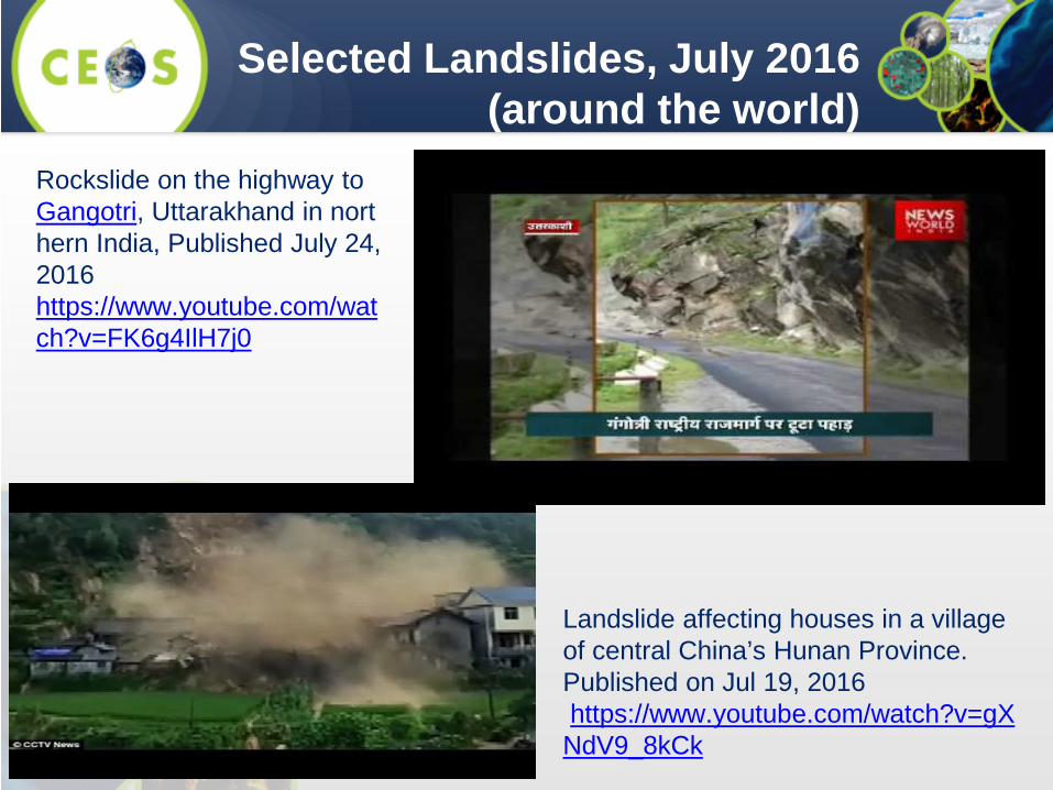
Selected Landslides, July 2016 (around the world)
Rockslide on the highway to Gangotri, Uttarakhand in northern India, Published July 24, 2016 https://www.youtube.com/watch?v=FK6g4IlH7j0
Landslide affecting houses in a village of central China’s Hunan Province. Published on Jul 19, 2016 https://www.youtube.com/watch?v=gXNdV9_8kCk
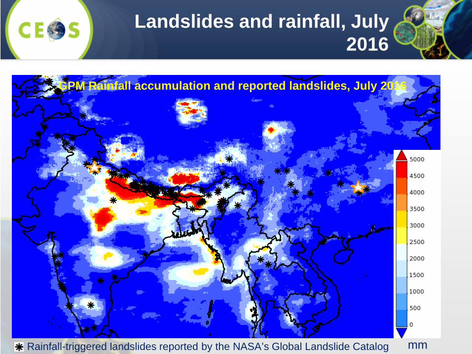
Landslides and rainfall, July 2016
GPM Rainfall accumulation and reported landslides, July 2016
mm Rainfall-triggered landslides reported by the NASA’s Global Landslide Catalog
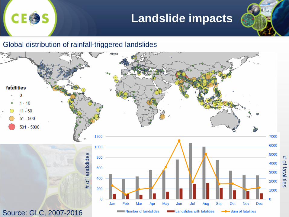
Landslide impacts
0
1000
2000
3000
4000
5000
6000
7000
0
200
400
600
800
1000
1200
Jan Feb Mar Apr May Jun Jul Aug Sep Oct Nov Dec
Number of landslides Landslides with fatalities Sum of fatalities
# of
land
slid
es # of fatalities
Source: GLC, 2007-2016
Global distribution of rainfall-triggered landslides
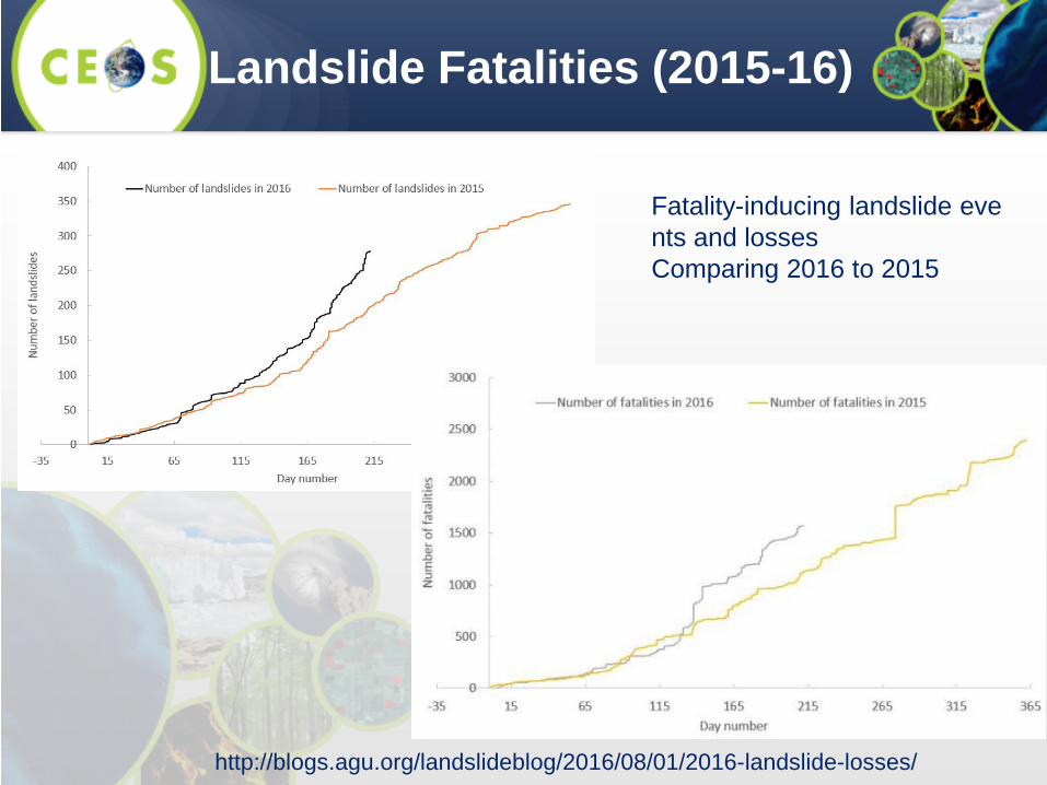
Landslide Fatalities (2015-16)
Fatality-inducing landslide events and losses Comparing 2016 to 2015
http://blogs.agu.org/landslideblog/2016/08/01/2016-landslide-losses/
7
To demonstrate the effective exploitation of Earth observations (EO) data and technologies to detect, map and monitor landslides and landslide prone hillsides, in different physiographic and climatic regions. To apply satellite EO across the cycle of landslide disaster risk management, including preparedness, situational awareness, response and recovery with a distinct multi-hazard focus on cascading impacts and risks.
Landslides Pilot: Main Goals
• December 2015: Convened first Disaster Landslide Pilot meeting (virtual)
• January-Feb 2016: Conducted survey of participants to define expertise, interests, and areas of focus
• March 2016: Introduction of potential Landslide Pilot at CEOS #5 meeting in Bonn, Germany
• April 2016: In person meeting of pilot participants in Vienna, Austria
• July 2016: Drafted CEOS DRM Landslide Pilot Plan and further defined study areas and co-leads
• August 2016: Co-lead meeting to discuss further development of study areas and Landslide Pilot Plan
• September 2016: Propose plan to CEOS Disaster WG for approval as 4th disaster pilot
• September 2016: Establish the Landslide Pilot web presence on CEOS.ORG with a summary of goals, objectives and participants
Status for Landslide WG

• Objective A – Establish effective practices for merging different Earth Observation data (e.g. optical and radar) to better monitor and map landslide activity over time and space.
• Objective B – Demonstrate how landslide products, models or services can support disaster risk management for multi-hazard and cascading landslide events.
• Objective C – Exploit the experience, data, and lessons learned from ongoing pilots (i.e., seismic hazards, floods, volcanoes).
• Objective D – Engage and partner with data brokers and end users to understand user and service requirements, user expectations, and to get feedback through the activities described in objectives A-C.
Proposed Objectives

• Leverage and exploit existing imagery, technology for processing data, and expertise provided for the other three pilots, where applicable, for rapid development and application within landslide/multi-hazard pilot activities;
• Improve coordination and sharing of satellite acquisitions and data products in support of landslide management across the existing flood, seismic, and volcano pilots to maximize utility of CEOS contributions;
• Demonstrate the value of satellite EO in the context of integrated landslide management practices.
• Capture and maximize use of lessons learned from other pilots (volcanoes, earthquakes, floods), including the participation of key contributors and end users of the pilots.
Proposed CEOS Objectives
11
Key Pilot Outputs & Deliverables
- Report on recommended practices for the combined exploitation of SAR and Optical imagery and technologies for landslide detection, mapping and monitoring”. (Objective A) - Report on effective methodologies and strategies for considering multi-hazard and cascading aspect of landslides through multi-temporal landslide mapping from multiple triggers (leveraging information/interactions with the volcano, flood and earthquake pilots) (Objective A-C) - Landslide event inventory and activity (monitoring) maps produced using optical and SAR imagery and technologies, and their combination, for selected case studies / geographical areas. (Objectives B-C) - Report on end user engagement strategies and characterize enablers, challenges, barriers to effective transfer of information, knowledge and technologies. (Objective D)
• Users: national, regional and local governments, civil protection agencies, meteorological and geological services, land use planning decision makers, disaster risk reduction specialists with NGOs and international organisations, industry (including e.g., insurance, transport, forestry sectors).
• Practitioners: landslide modelers, scientists and engineers in hydrology, water and environment ministries, meteorological and geological services, satellite data providers, volcano observatories, and value added service companies.
• Institutional bodies responsible for communication of risk (gap between technical level and shared information with communities): research institutions with operational responsibilities.
• General public: landslide event information for some of the case studies will be made available to the general public for increased awareness of these hazards and remote sensing capabilities, although the main focus of the pilot is on specialized users.
Proposed key user communities
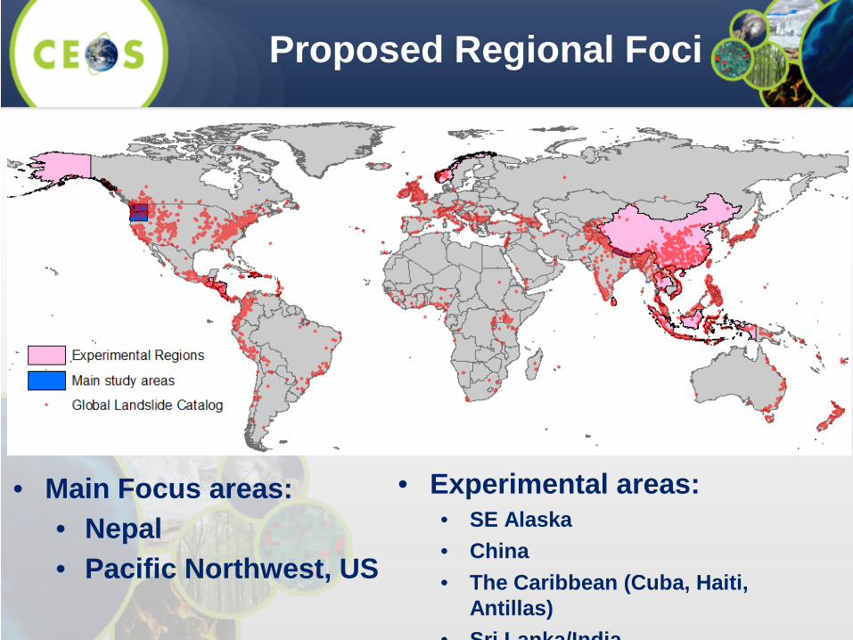
Proposed Regional Foci
• Main Focus areas: • Nepal • Pacific Northwest, US
• Experimental areas: • SE Alaska • China • The Caribbean (Cuba, Haiti,
Antillas) • Sri Lanka/India
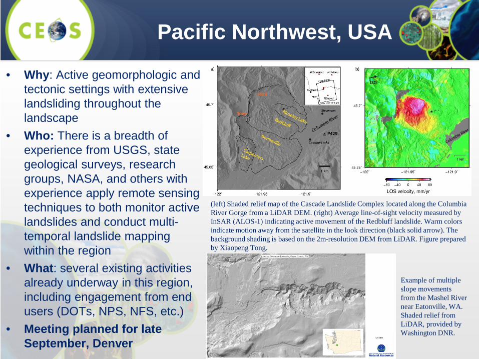
• Why: Active geomorphologic and tectonic settings with extensive landsliding throughout the landscape
• Who: There is a breadth of experience from USGS, state geological surveys, research groups, NASA, and others with experience apply remote sensing techniques to both monitor active landslides and conduct multi-temporal landslide mapping within the region
• What: several existing activities already underway in this region, including engagement from end users (DOTs, NPS, NFS, etc.)
• Meeting planned for late September, Denver
Pacific Northwest, USA
(left) Shaded relief map of the Cascade Landslide Complex located along the Columbia River Gorge from a LiDAR DEM. (right) Average line-of-sight velocity measured by InSAR (ALOS-1) indicating active movement of the Redbluff landslide. Warm colors indicate motion away from the satellite in the look direction (black solid arrow). The background shading is based on the 2m-resolution DEM from LiDAR. Figure prepared by Xiaopeng Tong.
Example of multiple slope movements from the Mashel River near Eatonville, WA. Shaded relief from LiDAR, provided by Washington DNR.
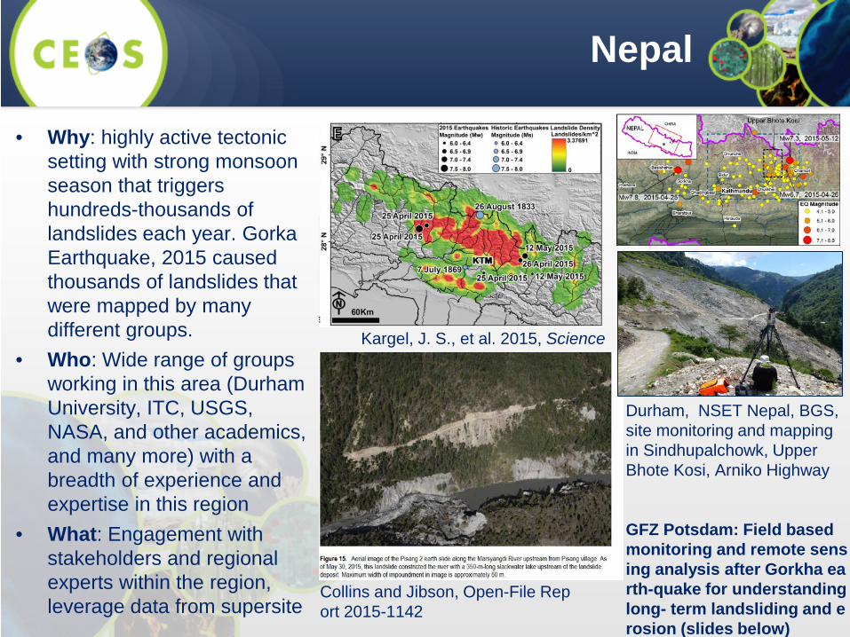
• Why: highly active tectonic setting with strong monsoon season that triggers hundreds-thousands of landslides each year. Gorka Earthquake, 2015 caused thousands of landslides that were mapped by many different groups.
• Who: Wide range of groups working in this area (Durham University, ITC, USGS, NASA, and other academics, and many more) with a breadth of experience and expertise in this region
• What: Engagement with stakeholders and regional experts within the region, leverage data from supersite
Nepal
Durham, NSET Nepal, BGS, site monitoring and mapping in Sindhupalchowk, Upper Bhote Kosi, Arniko Highway GFZ Potsdam: Field based monitoring and remote sensing analysis after Gorkha earth-quake for understanding long- term landsliding and erosion (slides below)
Kargel, J. S., et al. 2015, Science
Collins and Jibson, Open-File Report 2015-1142
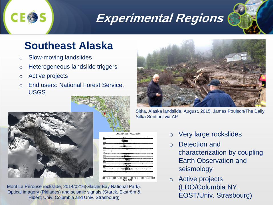
Experimental Regions
Sitka, Alaska landslide, August, 2015, James Poulson/The Daily Sitka Sentinel via AP
Southeast Alaska o Slow-moving landslides o Heterogeneous landslide triggers o Active projects o End users: National Forest Service,
USGS
o Very large rockslides o Detection and
characterization by coupling Earth Observation and seismology
o Active projects (LDO/Columbia NY, EOST/Univ. Strasbourg)
Mont La Pérouse rockslide, 2014/0216(Glacier Bay National Park).Optical imagery (Pléiades) and seismic signals (Starck, Ekström &
Hibert; Univ. Columbia and Univ. Strasbourg)

Experimental Regions
The Caribbean: Cuba, Haiti and French Antillas
o Tropical climate, active tectonic region and diverse geomorphologic settings
o Rainfall, Earthquake and Anthropogenic induced failures o Active engagement from Ministry of Energy and Mines (Cuba),
CNIGS (Haiti) and CNRS (French Antillas) o Active projects (Univ. of Strasbourg, CNES KAL-HAITI) o Also an experimental region of other Disaster Pilots (floods,
volcanoes)
Castellanos & Van Westen (2008)
Cuba
Effects of deforestation on landslide susceptibility
Haiti
Dominican Republic
Landslide dam (Jacmel, Haiti) triggered by the 2010 ETQ
Mudslide (Haiti) triggered by storm Erika (2015)

On the afternoon of May 17th, 2016, a major landslide event caused at least 92 deaths, with 109 still missing*. The site was rated highly susceptible to landslides in a new global landslide susceptibility map. IMERG data suggest that both antecedent and current rainfall as well as complex topography played a role in the slope failures. *BBC News (http://www.bbc.com/news/world-asia-36355980)
Landslides
Experimental Regions
Credit: Kirschbaum & Stanley, NASA
Sri Lanka / India
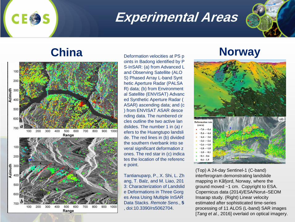
Experimental Areas
(Top) A 24-day Sentinel-1 (C-band) interferogram demonstrating landslide mapping in Kåfjord, Norway, where the ground moved ~1 cm. Copyright to ESA. Copernicus data (2014)/ESA/Norut–SEOM Insarap study. (Right) Linear velocity estimated after sophisticated time-series processing of 11 ALOS (L-band) SAR images [Tang et al., 2016] overlaid on optical imagery.
Norway
China
Deformation velocities at PS points in Badong identified by PS-InSAR: (a) from Advanced Land Observing Satellite (ALOS) Phased Array L-band Synthetic Aperture Radar (PALSAR) data; (b) from Environmental Satellite (ENVISAT) Advanced Synthetic Aperture Radar (ASAR) ascending data; and (c) from ENVISAT ASAR descending data. The numbered circles outline the two active landslides. The number 1 in (a) refers to the Huangtupo landslide. The red lines in (b) divided the southern riverbank into several significant deformation zones. The red star in (c) indicates the location of the reference point. Tantianuparp, P., X. Shi, L. Zhang, T. Balz, and M. Liao, 2013: Characterization of Landslide Deformations in Three Gorges Area Using Multiple InSAR Data Stacks. Remote Sens., 5, doi:10.3390/rs5062704.

Region Regional Point of Contact
Nepal Nick Rosser, Sigrid Roessner, Dalia Kirschbaum
Pacific Northwest, US
Jonathan Godt, Dalia Kirschbaum
Southeast Alaska Marten Geertsema Norway John Dehls
Caribbean Enrique Castellanos, Jean-
Philippe Malet China Zeng-Guang Zhou (TBD)
India / Sri Lanka TBD
Proposed regional study leads

21
Methodology
21
I. Mapping • Creating inventories • Documentation
II. Monitoring
• Routine processing over sample sites
III. EO-based Analysis • Automatic • Standardized methods to establish thresholds
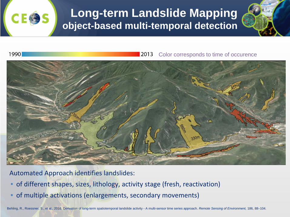
Long-term Landslide Mapping object-based multi-temporal detection
Automated Approach identifies landslides: • of different shapes, sizes, lithology, activity stage (fresh, reactivation) • of multiple activations (enlargements, secondary movements)
Behling, R., Roessner, S., et al., 2016. Derivation of long-term spatiotemporal landslide activity - A multi-sensor time series approach. Remote Sensing of Environment, 186, 88–104.
Color corresponds to time of occurence
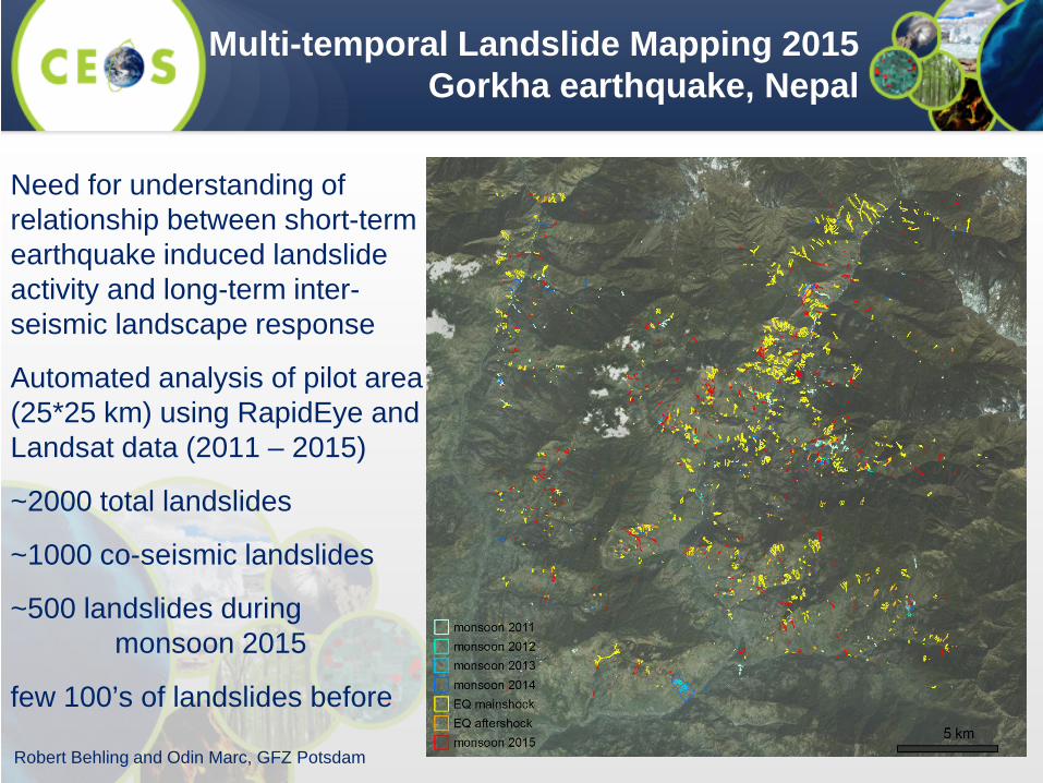
Need for understanding of relationship between short-term earthquake induced landslide activity and long-term inter-seismic landscape response
Automated analysis of pilot area (25*25 km) using RapidEye and Landsat data (2011 – 2015)
~2000 total landslides
~1000 co-seismic landslides
~500 landslides during monsoon 2015
few 100’s of landslides before
Multi-temporal Landslide Mapping 2015 Gorkha earthquake, Nepal
Robert Behling and Odin Marc, GFZ Potsdam
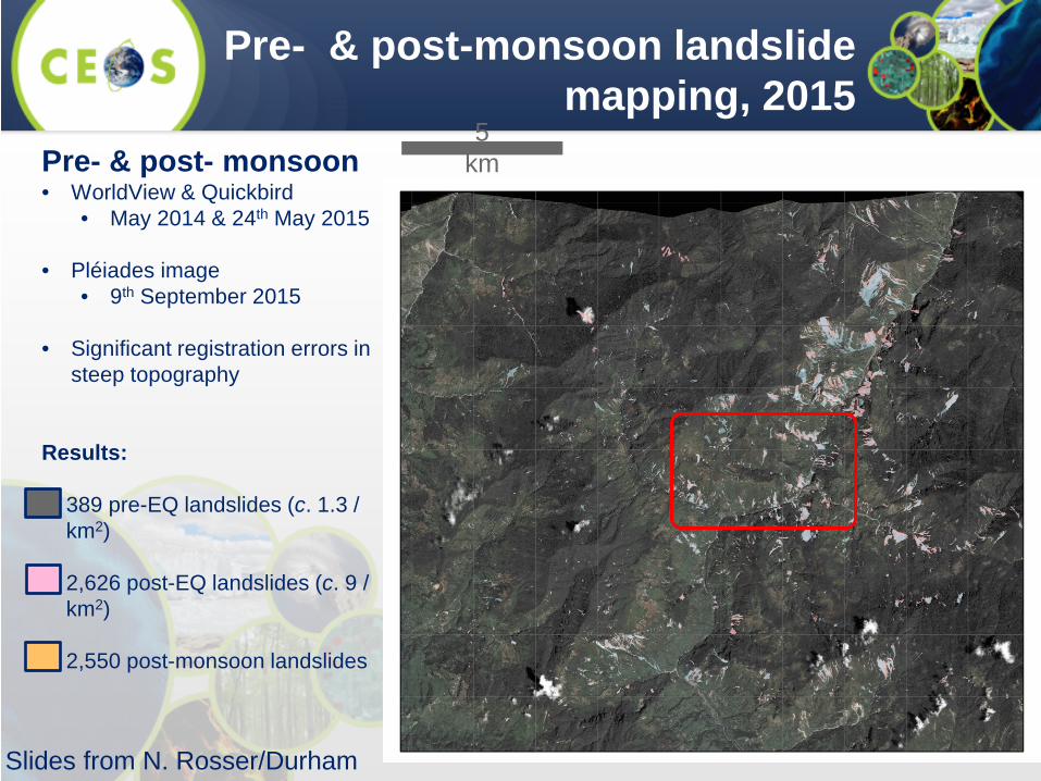
Pre- & post- monsoon • WorldView & Quickbird
• May 2014 & 24th May 2015
• Pléiades image • 9th September 2015
• Significant registration errors in
steep topography Results: • 389 pre-EQ landslides (c. 1.3 /
km2) • 2,626 post-EQ landslides (c. 9 /
km2)
• 2,550 post-monsoon landslides
5 km
Slides from N. Rosser/Durham
Pre- & post-monsoon landslide mapping, 2015

1 km
Combined EQ & monsoon landslides
Slides from N. Rosser/Durham
Pre- & post-monsoon landslide mapping, 2015
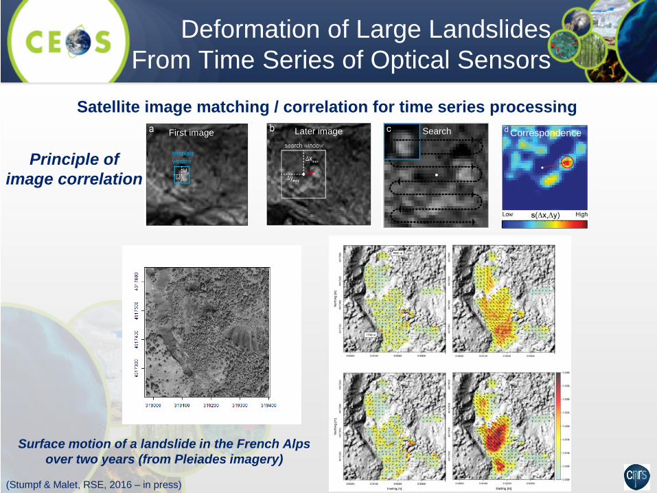
Deformation of Large Landslides From Time Series of Optical Sensors
(Stumpf & Malet, RSE, 2016 – in press)
Surface motion of a landslide in the French Alps over two years (from Pleiades imagery)
First image Later image Search Correspondence
Satellite image matching / correlation for time series processing
Principle of image correlation

Motion field at La Valette landslide (SE Franch Alps) from a stack of 8 Pléiades images
(Stumpf & Malet, RSE, 2016 – in press)
Motion field of the Debre-Sina landslide (Ethiopia) 2003–2016 from a combination of
Landsat-7 and Sentinel-2 images
Deformation of Large Landslides from Time Series of Optical Sensors
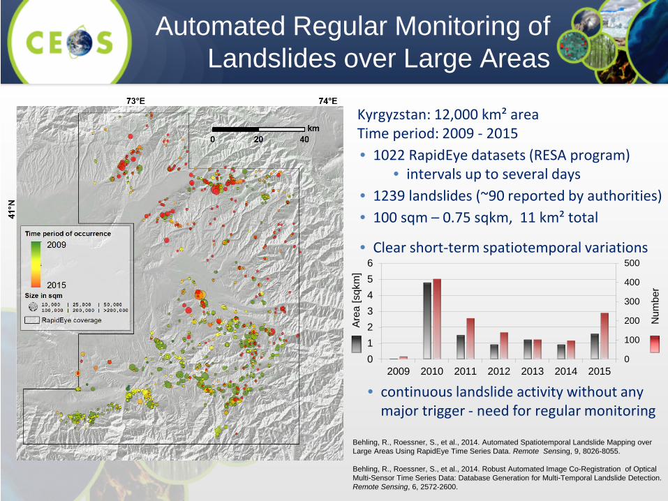
Automated Regular Monitoring of Landslides over Large Areas
Kyrgyzstan: 12,000 km² area Time period: 2009 - 2015 • 1022 RapidEye datasets (RESA program)
• intervals up to several days • 1239 landslides (~90 reported by authorities) • 100 sqm – 0.75 sqkm, 11 km² total
• Clear short-term spatiotemporal variations
0
100
200
300
400
500
0123456
2009 2010 2011 2012 2013 2014 2015
Num
ber
Are
a [s
qkm
]
• continuous landslide activity without any major trigger - need for regular monitoring
Behling, R., Roessner, S., et al., 2014. Automated Spatiotemporal Landslide Mapping over Large Areas Using RapidEye Time Series Data. Remote Sensing, 9, 8026-8055. Behling, R., Roessner, S., et al., 2014. Robust Automated Image Co-Registration of Optical Multi-Sensor Time Series Data: Database Generation for Multi-Temporal Landslide Detection. Remote Sensing, 6, 2572-2600.
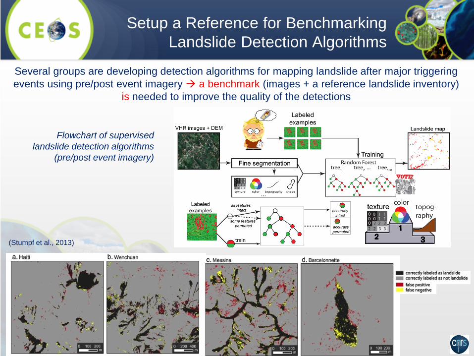
Setup a Reference for Benchmarking Landslide Detection Algorithms
Several groups are developing detection algorithms for mapping landslide after major triggering events using pre/post event imagery a benchmark (images + a reference landslide inventory)
is needed to improve the quality of the detections
Flowchart of supervised landslide detection algorithms
(pre/post event imagery)
(Stumpf et al., 2013)
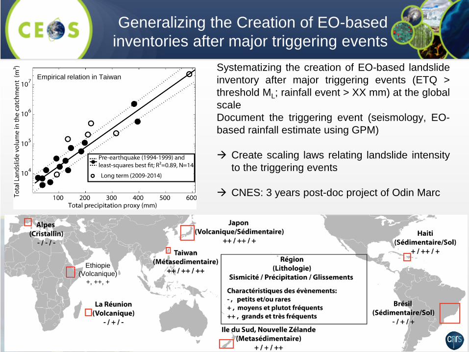
Generalizing the Creation of EO-based inventories after major triggering events
Systematizing the creation of EO-based landslide inventory after major triggering events (ETQ > threshold ML; rainfall event > XX mm) at the global scale Document the triggering event (seismology, EO-based rainfall estimate using GPM) Create scaling laws relating landslide intensity
to the triggering events
CNES: 3 years post-doc project of Odin Marc
Empirical relation in Taiwan
Ethiopie (Volcanique)
+, ++, +

IN DEVELOPMENT at pmm.nasa.gov
Global efforts
http://ojo-streamer.herokuapp.com/

32
Future: Landslide Modelling
Advanced landslide modelling tools capable of assimilating remote sensing data and products for model initialization and validation.
MODEL
map
Slide courtesy of Fausto Guzzetti
33
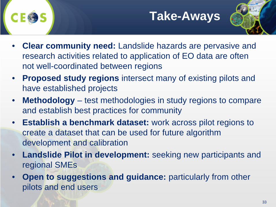
Take-Aways
• Clear community need: Landslide hazards are pervasive and research activities related to application of EO data are often not well-coordinated between regions
• Proposed study regions intersect many of existing pilots and have established projects
• Methodology – test methodologies in study regions to compare and establish best practices for community
• Establish a benchmark dataset: work across pilot regions to create a dataset that can be used for future algorithm development and calibration
• Landslide Pilot in development: seeking new participants and regional SMEs
• Open to suggestions and guidance: particularly from other pilots and end users
34
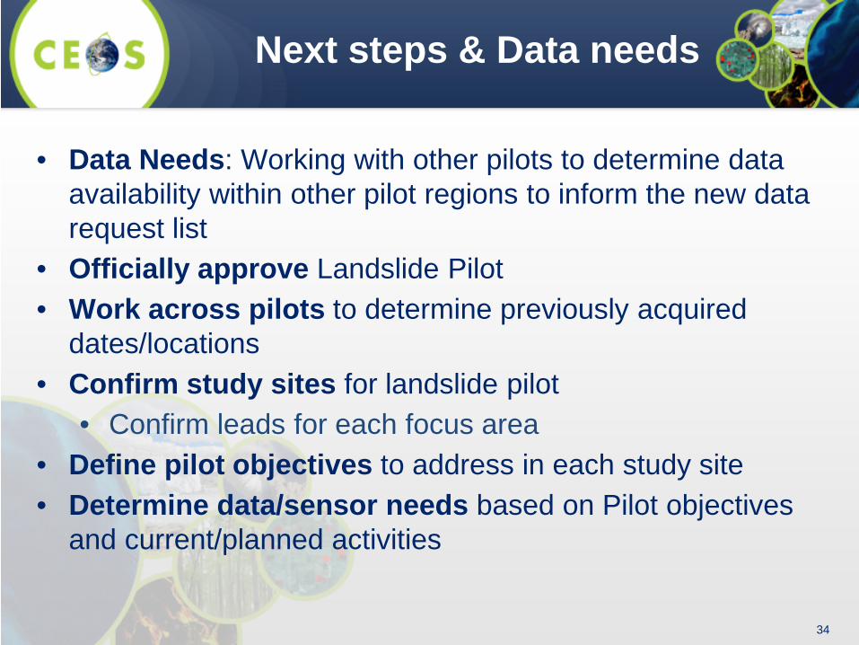
Next steps & Data needs
• Data Needs: Working with other pilots to determine data availability within other pilot regions to inform the new data request list
• Officially approve Landslide Pilot • Work across pilots to determine previously acquired
dates/locations • Confirm study sites for landslide pilot
• Confirm leads for each focus area • Define pilot objectives to address in each study site • Determine data/sensor needs based on Pilot objectives
and current/planned activities
35
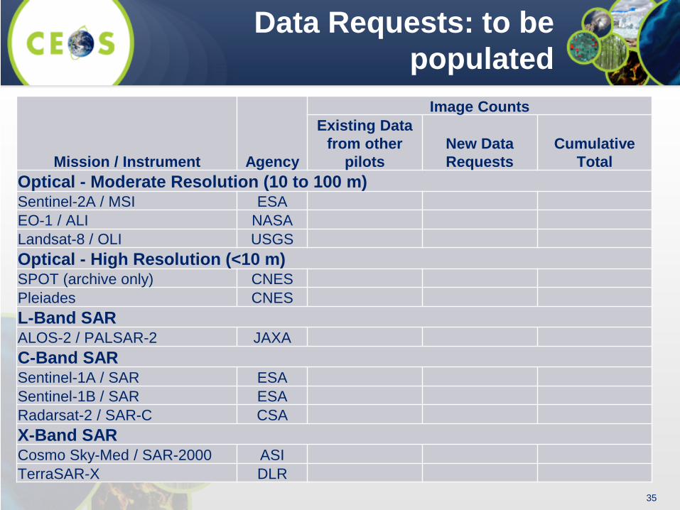
Data Requests: to be populated
Mission / Instrument Agency
Image Counts Existing Data
from other pilots
New Data Requests
Cumulative Total
Optical - Moderate Resolution (10 to 100 m) Sentinel-2A / MSI ESA EO-1 / ALI NASA Landsat-8 / OLI USGS Optical - High Resolution (<10 m) SPOT (archive only) CNES Pleiades CNES L-Band SAR ALOS-2 / PALSAR-2 JAXA C-Band SAR Sentinel-1A / SAR ESA Sentinel-1B / SAR ESA Radarsat-2 / SAR-C CSA X-Band SAR Cosmo Sky-Med / SAR-2000 ASI TerraSAR-X DLR
36
Thank you!
• Dalia Kirschbaum, [email protected] • Jonathan Godt, [email protected] • Sigrid Roessner, [email protected] • Jean-Philippe Malet, [email protected]
36

• Extra Slides

38
CEOS Landslide Pilot Survey
1. What is your area(s) of expertise or operational authority or responsibility (e.g. research focus or disaster response and recovery)?
2. In what geographic region(s) do you primarily work or have responsibility (e.g. Global, national, regional)?
3. Please rate your interest the proposed Pilot Objectives from Very important to not relevant
4. Please provide feedback on current objectives in terms of your proposed contribution and suggest ways to modify the objectives to better accommodate your expertise or the group’s collective expertise.
5. What Earth Observation data are you most interested in acquiring as part of this pilot? 6. What specific aspects of this activity do you expect to participate in for the duration of the
pilot? 7. The CEOS Landslide Pilot is in the scoping state. Who should be added to this
discussion? 8. Please recommend others who you currently work with or who may be interested in this
activity and include organization, point-of-contact name, affiliation, and email contact information.
28 Responses
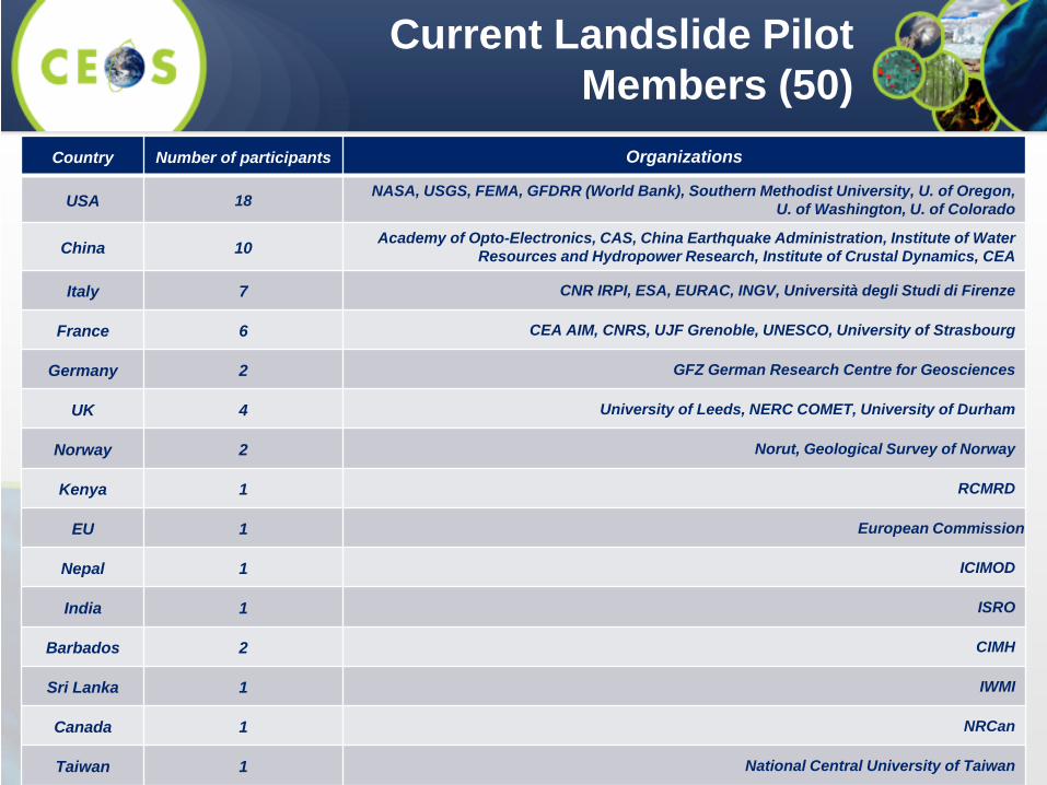
Country Number of participants Organizations
USA 18 NASA, USGS, FEMA, GFDRR (World Bank), Southern Methodist University, U. of Oregon, U. of Washington, U. of Colorado
China 10 Academy of Opto-Electronics, CAS, China Earthquake Administration, Institute of Water Resources and Hydropower Research, Institute of Crustal Dynamics, CEA
Italy 7 CNR IRPI, ESA, EURAC, INGV, Università degli Studi di Firenze
France 6 CEA AIM, CNRS, UJF Grenoble, UNESCO, University of Strasbourg
Germany 2 GFZ German Research Centre for Geosciences
UK 4 University of Leeds, NERC COMET, University of Durham
Norway 2 Norut, Geological Survey of Norway
Kenya 1 RCMRD
EU 1 European Commission
Nepal 1 ICIMOD
India 1 ISRO
Barbados 2 CIMH
Sri Lanka 1 IWMI
Canada 1 NRCan
Taiwan 1 National Central University of Taiwan
Current Landslide Pilot Members (50)
40
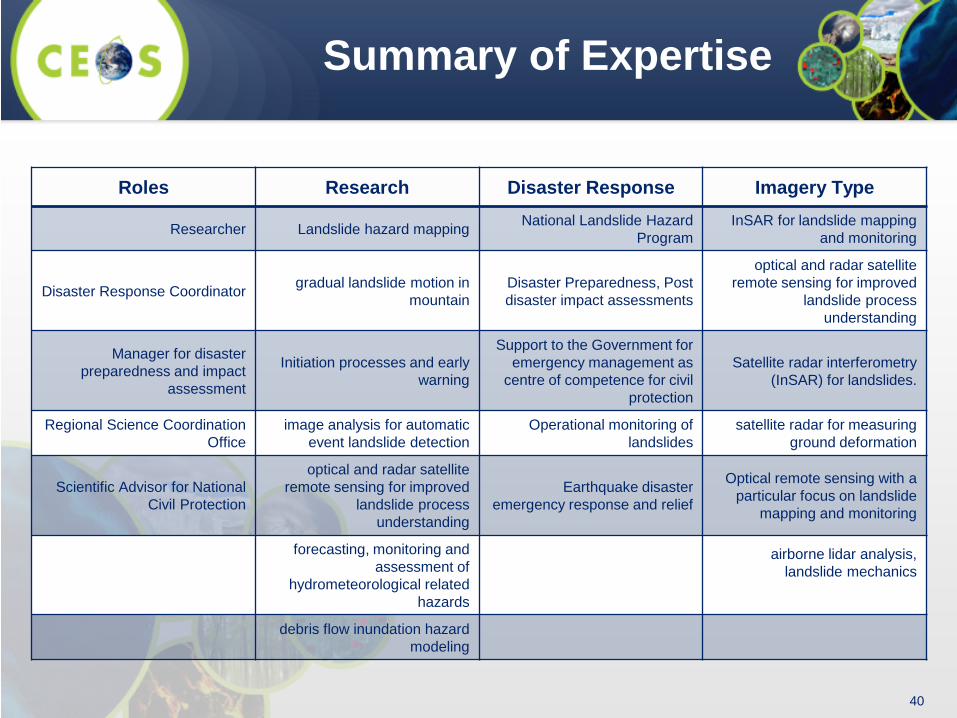
Summary of Expertise
Roles Research Disaster Response Imagery Type
Researcher Landslide hazard mapping National Landslide Hazard Program
InSAR for landslide mapping and monitoring
Disaster Response Coordinator gradual landslide motion in mountain
Disaster Preparedness, Post disaster impact assessments
optical and radar satellite remote sensing for improved
landslide process understanding
Manager for disaster preparedness and impact
assessment
Initiation processes and early warning
Support to the Government for emergency management as
centre of competence for civil protection
Satellite radar interferometry (InSAR) for landslides.
Regional Science Coordination Office
image analysis for automatic event landslide detection
Operational monitoring of landslides
satellite radar for measuring ground deformation
Scientific Advisor for National Civil Protection
optical and radar satellite remote sensing for improved
landslide process understanding
Earthquake disaster emergency response and relief
Optical remote sensing with a particular focus on landslide
mapping and monitoring
forecasting, monitoring and assessment of
hydrometeorological related hazards
airborne lidar analysis, landslide mechanics
debris flow inundation hazard modeling
41
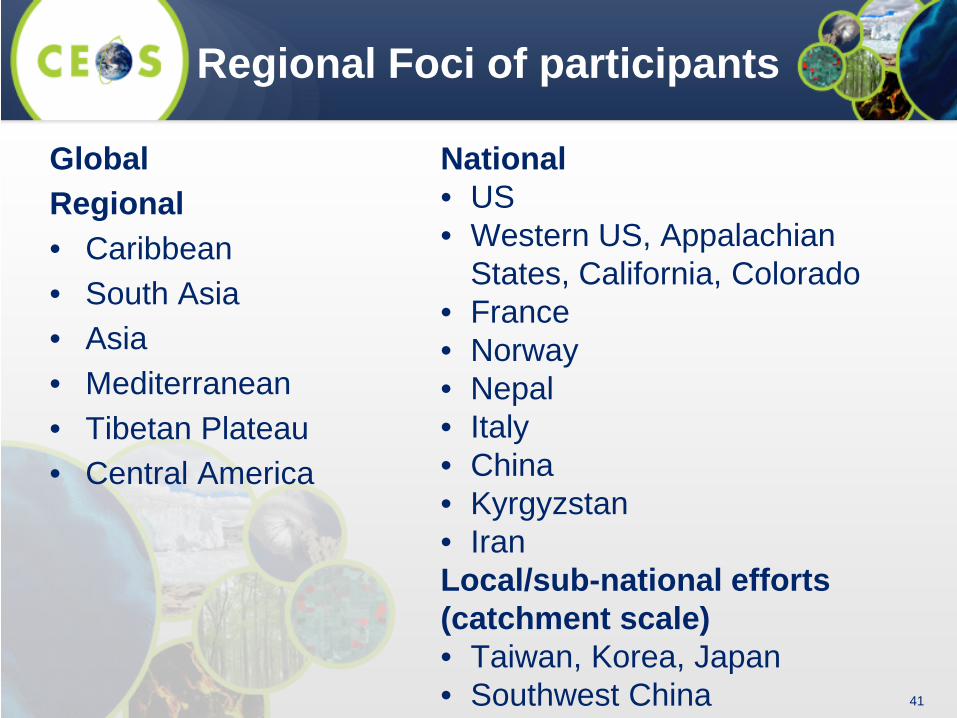
Regional Foci of participants
Global Regional • Caribbean • South Asia • Asia • Mediterranean • Tibetan Plateau • Central America
National • US • Western US, Appalachian
States, California, Colorado • France • Norway • Nepal • Italy • China • Kyrgyzstan • Iran Local/sub-national efforts (catchment scale) • Taiwan, Korea, Japan • Southwest China
42
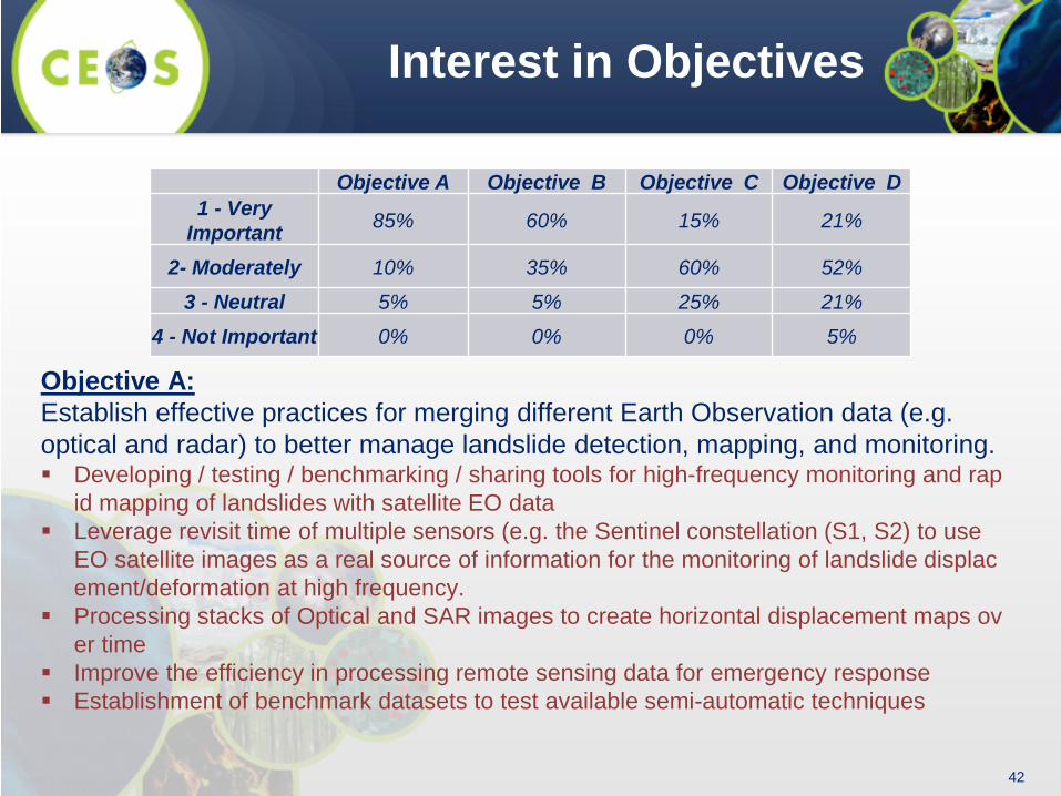
Interest in Objectives
Objective A Objective B Objective C Objective D 1 - Very
Important 85% 60% 15% 21%
2- Moderately 10% 35% 60% 52%
3 - Neutral 5% 5% 25% 21%
4 - Not Important 0% 0% 0% 5%
Objective A: Establish effective practices for merging different Earth Observation data (e.g. optical and radar) to better manage landslide detection, mapping, and monitoring. Developing / testing / benchmarking / sharing tools for high-frequency monitoring and rap
id mapping of landslides with satellite EO data Leverage revisit time of multiple sensors (e.g. the Sentinel constellation (S1, S2) to use
EO satellite images as a real source of information for the monitoring of landslide displacement/deformation at high frequency.
Processing stacks of Optical and SAR images to create horizontal displacement maps over time
Improve the efficiency in processing remote sensing data for emergency response Establishment of benchmark datasets to test available semi-automatic techniques
43
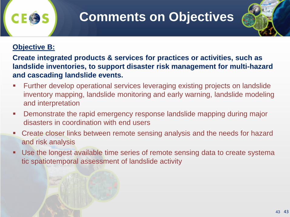
Comments on Objectives
Objective B: Create integrated products & services for practices or activities, such as landslide inventories, to support disaster risk management for multi-hazard and cascading landslide events. Further develop operational services leveraging existing projects on landslide
inventory mapping, landslide monitoring and early warning, landslide modeling and interpretation
Demonstrate the rapid emergency response landslide mapping during major disasters in coordination with end users
Create closer links between remote sensing analysis and the needs for hazard and risk analysis
Use the longest available time series of remote sensing data to create systematic spatiotemporal assessment of landslide activity
43
44
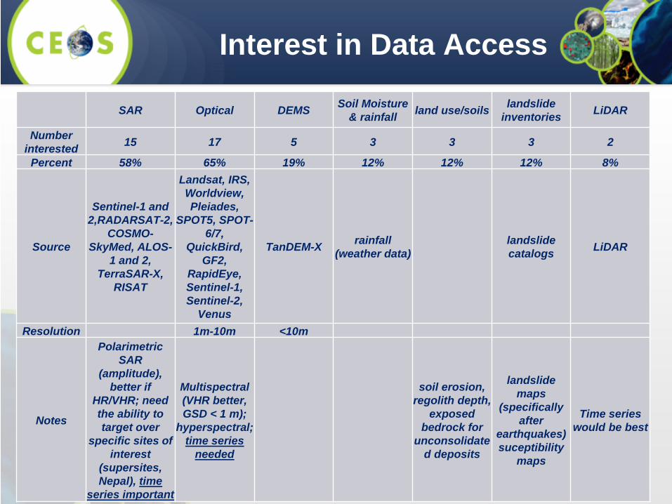
Interest in Data Access
SAR Optical DEMS Soil Moisture & rainfall land use/soils landslide
inventories LiDAR
Number interested 15 17 5 3 3 3 2
Percent 58% 65% 19% 12% 12% 12% 8%
Source
Sentinel-1 and 2,RADARSAT-2,
COSMO-SkyMed, ALOS-
1 and 2, TerraSAR-X,
RISAT
Landsat, IRS, Worldview, Pleiades,
SPOT5, SPOT-6/7,
QuickBird, GF2,
RapidEye, Sentinel-1, Sentinel-2,
Venus
TanDEM-X rainfall (weather data)
landslide catalogs LiDAR
Resolution 1m-10m <10m
Notes
Polarimetric SAR
(amplitude), better if
HR/VHR; need the ability to target over
specific sites of interest
(supersites, Nepal), time
series important
Multispectral (VHR better, GSD < 1 m);
hyperspectral; time series
needed
soil erosion, regolith depth,
exposed bedrock for
unconsolidated deposits
landslide maps
(specifically after
earthquakes) suceptibility
maps
Time series would be best
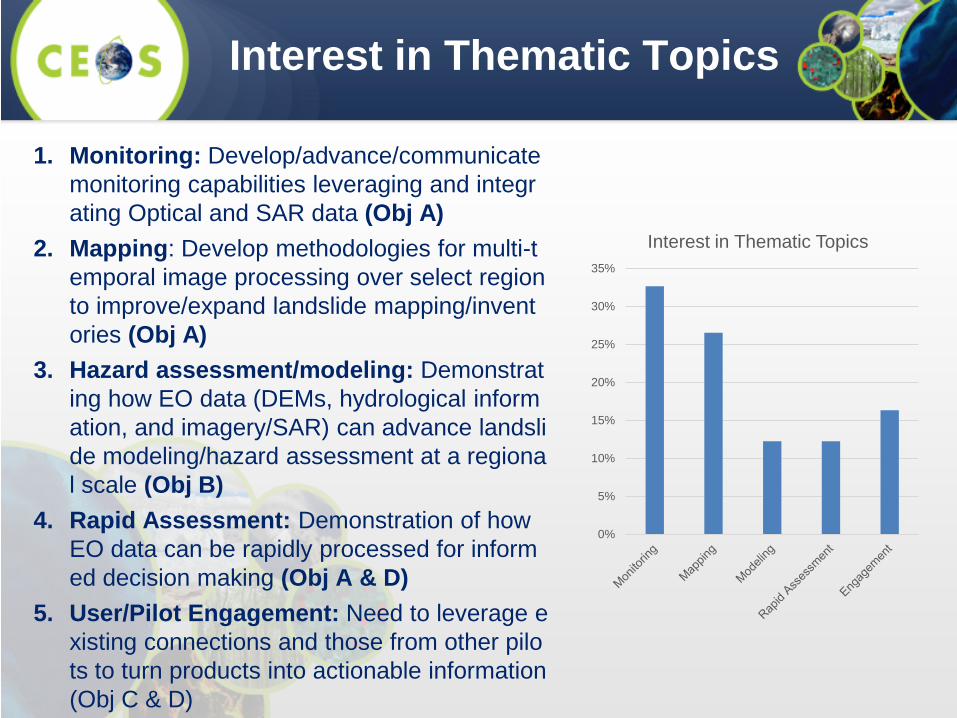
1. Monitoring: Develop/advance/communicate monitoring capabilities leveraging and integrating Optical and SAR data (Obj A)
2. Mapping: Develop methodologies for multi-temporal image processing over select region to improve/expand landslide mapping/inventories (Obj A)
3. Hazard assessment/modeling: Demonstrating how EO data (DEMs, hydrological information, and imagery/SAR) can advance landslide modeling/hazard assessment at a regional scale (Obj B)
4. Rapid Assessment: Demonstration of how EO data can be rapidly processed for informed decision making (Obj A & D)
5. User/Pilot Engagement: Need to leverage existing connections and those from other pilots to turn products into actionable information (Obj C & D)
Interest in Thematic Topics
0%
5%
10%
15%
20%
25%
30%
35%
Interest in Thematic Topics

46
Suggested regional study areas
46
1.Nepal
2.Pacific Northwest, U.S. (Oregon, Washington)
3.China (southwestern area)
4. Caribbean (focus area TBD)
Nepal 29%
China 18%
Caribbean 16%
Western US 16%
South Asia 10%
Italy 11%
Regional Expertise of Group

47
Live data stream
http://community.dur.ac.uk/nepal.2015eq
Slides from N. Rosser/Durham
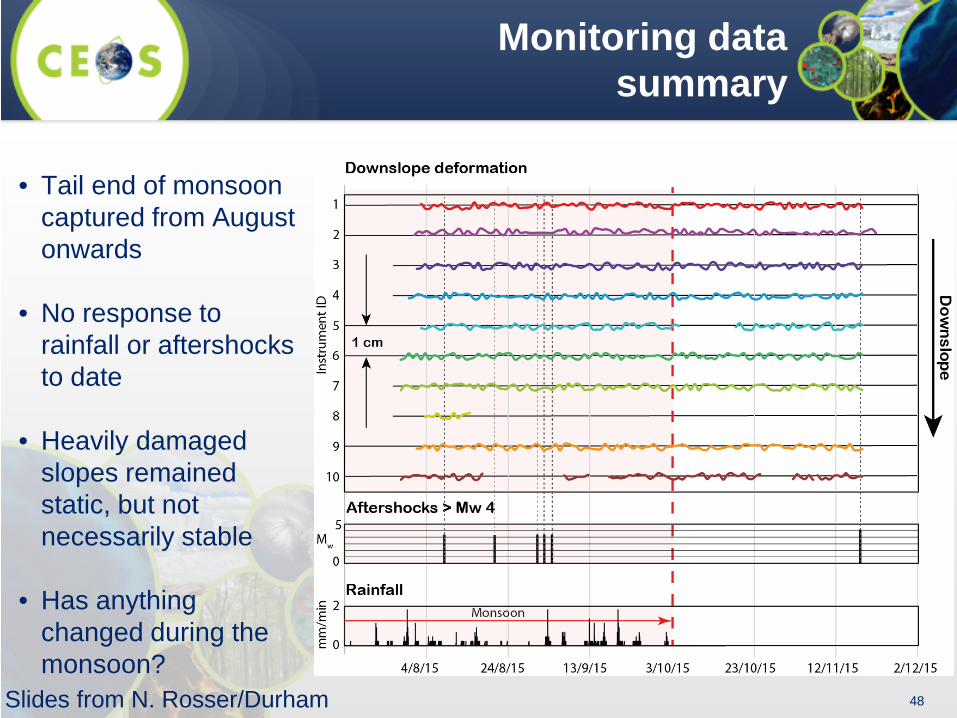
48
Monitoring data summary
• Tail end of monsoon captured from August onwards
• No response to rainfall or aftershocks to date
• Heavily damaged slopes remained static, but not necessarily stable
• Has anything changed during the monsoon? Slides from N. Rosser/Durham