landslide inventory of chittenden county, northwest...
TRANSCRIPT
1
Landslide Inventory of Chittenden County, Northwest Vermont
Vermont Geological Survey Open File Report VG2018-6
George Springston Norwich University Department of Earth and Environmental Sciences 108
Harmon Drive Northfield, VT 05663
June 30, 2018

2
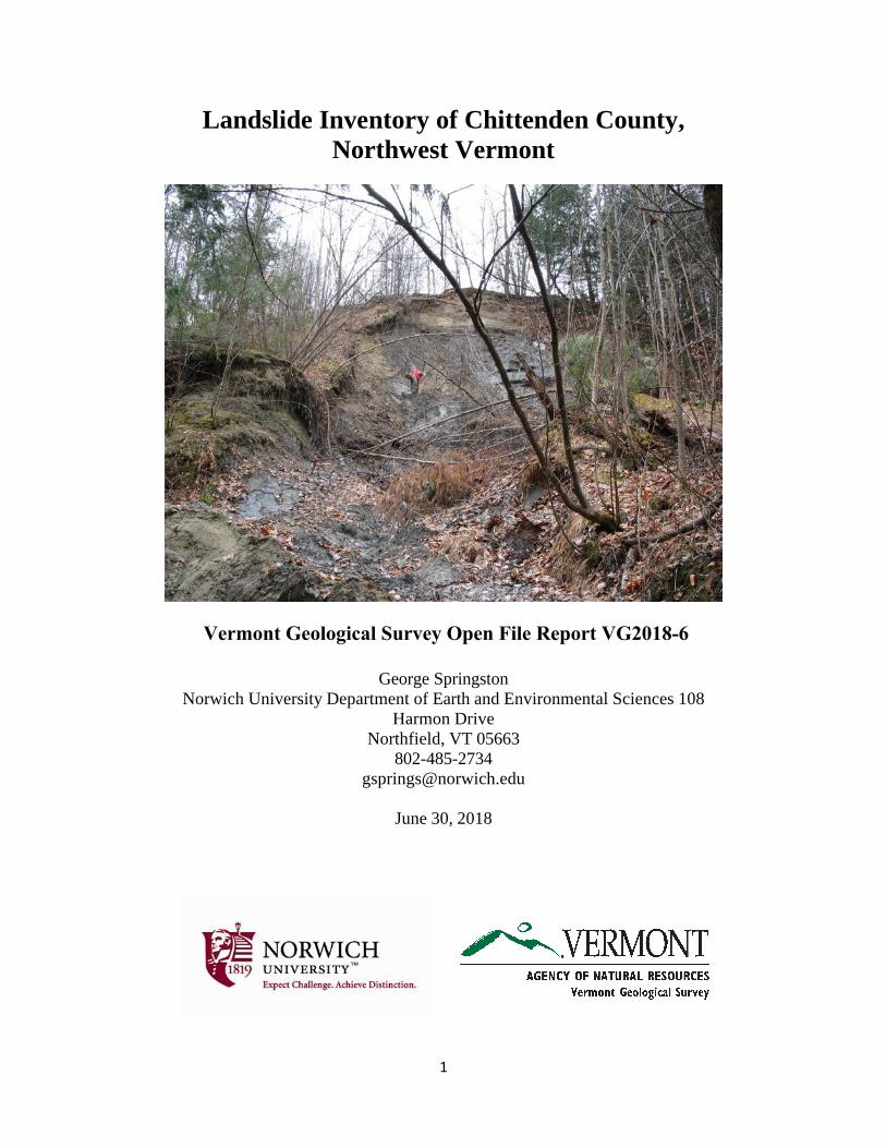
On the cover: Looking up an active landslide on the side of a landslide-gully complex, Colchester. Photo by Barry Cahoon, 2006.
3
Executive Summary
Landslides and gullies were inventoried in Chittenden County in northwest Vermont.
Over 700 features were identified using a combination of field investigations and remote sensing using lidar (light distance and ranging) topographic data and recent, high-resolution orthophotos from the Vermont Center for Geographic Information.
Most of the landslides are located close to streams at sites of active streambank toe erosion. When long-term data is available, the landslides are generally in locations that have been failing for a long time.
Unstable gullies are common in many parts of Chittenden County. Many of the actively eroding gullies in the County appear to be closely associated with stormwater runoff from developed areas. These developed areas are largely concentrated at low elevations in the western portions of the county which are also within the extent of the Champlain Sea. The sandy and silty components of the Champlain Sea deposits are highly erodible and thus, this combination of urbanization and soils that are susceptible to erosion may explain the abundance of gullying in these areas.
The principal causes of the slope failures appear to be the over-steepening of slopes due to fluvial erosion of banks and stream beds during flash floods and decreases in shear strength of soils due to increases in soil water pore pressures due to the heavy rainfall.

4
Table of Contents Page
Executive Summary 3 Introduction 5 Previous Work 7 Landslide Inventory 8 Rock Slope Failures and Debris Flow Hazards 17 Patterns of Slope Failure on Till Slopes 20 Conclusions 21 Acknowledgements 22 References 22
5
Introduction
This report presents the results of a detailed study of the existing landslide, gullies, and other slope instability indicators in Chittenden County in northwest Vermont. This study is intended to provide an accurate basis for local, state, and Federal hazard planning in the area.
The current State Hazard Mitigation Plan identifies mapping of landslides gullies, and
other slope instability hazards as an important component of hazard mitigation efforts in Vermont (http://vem.vermont.gov/plans/SHMP ). This inventory of Chittenden County is based on the Phase 1 inventory method outlined in Clift and Springston (2012).
The inventory was undertaken using a variety of sources. Sources of locations of existing
landslides and other features included: 1. Landslide Protocol study conducted for the Vermont Geological Survey (VGS) by
Clift and Springston (2012).
2. Surficial geologic mapping projects produced for the VGS. 3. Data from individual site visits conducted by the author for the VGS. 4. Data from the stream geomorphic assessment data provided by the Vermont Rivers
Program. Of critical importance is the Phase 2 field data on mass failures and eroding banks derived from the Feature Indexing Tool (FIT).
Lidar (light distance and ranging) topographic data from the Vermont Center for
Geographic Information was an essential component of the study. Lidar is very detailed airborne laser topographic mapping. Trees, buildings, and other structures have been removed in the processing in order to show the shape of the land surface. The data was used both as an accurate source for determining elevations and heights of features, and as the basis for calculating the steepness of slopes. In the slope maps shown in this report steep slopes are shown as black, intermediate slopes are gray, and flat areas are shown as white. The slope data was also classified to produce a GIS layer showing ranges of slope: 0 to 33%, 33-50%, 50-73%, 73-100%, and greater than 100%.
Interpretation of slope instability features was undertaken by viewing existing site data in combination with the coded lidar slope map, streams (1:5,000 surface waters from the Vermont Hydrologic Dataset), and recent high-resolution orthophotos.

6
Figure 1. Location map.
Brook Rd.

7
Previous Work Although there have been many studies of landslides and associated slope instability hazards in Vermont, most focus only on small areas or specific sites and a detailed inventory that is useful for hazard planning has been lacking. A detailed chronology of the earlier studies is given in Clift and Springston (2012). The only previous statewide inventory is that of Baskerville and Ohlmacher (2001), but that is a somewhat rough reconnaissance study on small-scale base maps.
Figure 2. Location of study sites for the Landslide Protocol study of Clift and Springston (2012).
8
Landslide Inventory
The inventory is shown in detail on Plate 1. A much-reduced version is shown in Figure 2. Examples of landslides in the county follow. For more detail on these sites, see Clift and Springston (2012).
A landslide is a feature formed by the downslope movement of rock and/or soil under the influence of gravity. A good general discussion of landslides is given in Highland and Bobrowsky (2008). The term “landslide” as used in this report includes a wide variety of falls, slides, and flows. The material can range from rock, through debris, to earth (predominantly <2 mm). a landslide is commonly identified by the presence of steep slopes and/or evidence of soil movement and surface or subsurface erosion. Most originate near streams, although they may extend quite far from the streams. The mass failures identified during stream geomorphic assessment studies are landslides.
Eroding banks are common along many of the streams in the county but are not included in this inventory. Eroding banks are formed by the same mechanisms as landslides, but a cutoff has been set at about 4 meters in height, with eroding banks being below that height and landslides above it. Although the distinction may seem arbitrary, it is sometimes the case that eroding banks are forming on the sides of low terraces that are themselves subject to inundation flooding. In contrast, landslides are generally high enough that they are not going to have their tops flooded (at least during normal floods of short recurrence intervals). Thus, the landslide hazard may be more of a fluvial erosion hazard than an inundation hazard.
A gully is a steep, narrow channel incised into surficial deposits. The stream is usually a first-order stream and the flow in the bottom is usually intermittent. Unstable gullies have very steep sides and commonly show signs of fresh erosion in the bed or at the gully heads. The heads of gullies have been indicated for many of the unstable gullies. These serve to give some idea of the extent of the features.
A landslide-gully complex is a gully with substantial landslides on the sides and/or at the head.
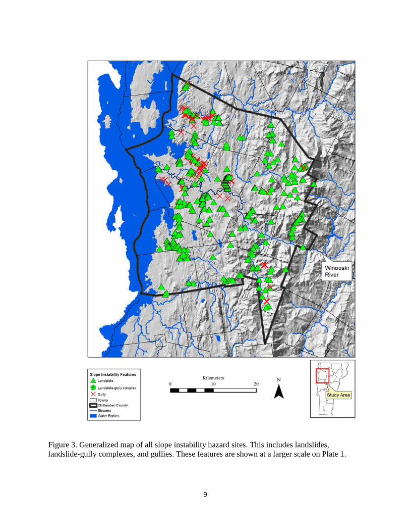
9
Figure 3. Generalized map of all slope instability hazard sites. This includes landslides, landslide-gully complexes, and gullies. These features are shown at a larger scale on Plate 1.

10
Figure 4. Slope instability hazard sites, shown along with approximate extents of the highest level of glacial Lake Vermont (Coveville level) and the Champlain Sea. Note that landslides occur throughout the County, but gullies are most concentrated within the extent of the Champlain Sea.

11
Unstable gullies are common in many parts of Chittenden County. As Figure 4 shows, they are most common at lower elevations within the extent of the Champlain Sea. Many of the actively eroding gullies in the County appear to be closely associated with stormwater runoff from developed areas. These developed areas are largely concentrated at low elevations in the western portions of the county which are also within the extent of the Champlain Sea. The sandy and silty components of the Champlain Sea deposits are highly erodible and thus, this combination of urbanization and soils that are susceptible to erosion may explain the abundance of gullying in these areas.
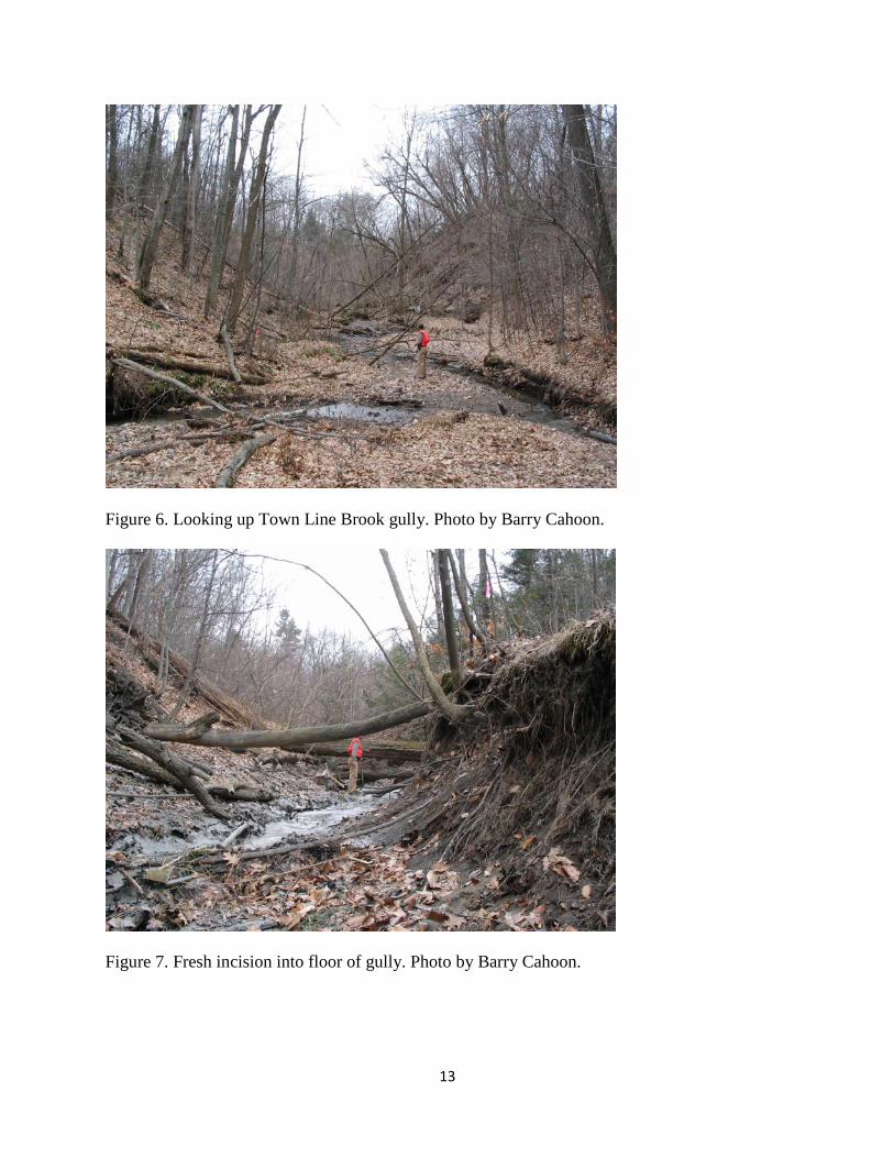
A landslide-gully complex located northwest of the Winooski/Colchester town line is
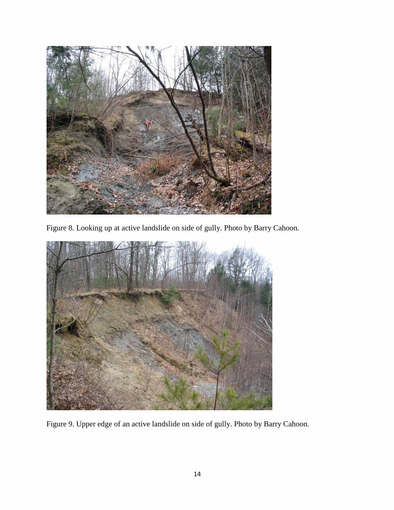
discussed below (Figure 5). Here, a stream known as “Morehouse Brook” or “Town Line Brook” has cut a steep-sided gully into a terrace with a top elevation of about 55 meters (Figure 6). The floor of the gully is freshly incised and the banks are lined with active and currently inactive landslides (Figures 7, 8, and 9). The gully drains westward into the Winooski River.
The lowest parts of the gully expose several feet of varved silt and silty clay (Figure 10). The back faces of the active slides expose roughly 40 feet of variably laminated gray silt with some silty clay laminae and showing extensive signs of deformation (faults and injections of silty clay). This material is overlain by roughly 10-12 feet of fine to medium sand. At the top of the section are several feet of pebbly medium to coarse sand. Abundant old garbage and metal were encountered on the north slope and in the bottom of the gully.
During the 2006 visit we observed active headcuts in the floor of the gully. These
indicate that the brook is actively lowering its bed (Figure 7). No bedrock was observed in the gully bottom or on the sides. The downcutting is the immediate cause of the slope failures on the gully sides. From the observed pattern of active and inactive slides, it appears that the active slides are migrating upstream in response to headcut migration. The erosion from the gully results in substantial sedimentation into the Winooski River (Figures 11 and 12).
The sides of this gully are in a very sensitive state due to the channel incision that is occurring. The cause of this incision is at least partly due to increased stormwater runoff due to urbanization in the upper parts of the gully watershed. Another cause may be a long-term pattern of aggradation and degradation in the Winooski River valley: An archaeological and geomorphological study of the Howe Farm site farther down in the Winooski valley indicates that significant aggradation occurred on the Winooski River floodplain during the nineteenth century (Thomas (1985). This was the same time period at which upland soil erosion due to land clearance was at its highest (Thomas, 1985; Bierman and others, 1997). The gully was probably undergoing active erosion during this time and may have graded itself to the new, higher, Winooski Valley floodplain. Following the peak of agricultural activity, the gully revegetated and at least partly stabilized. However, subsequent downcutting of the Winooski into its alluvium may be one cause for the incision that is active in the gully today.
Repeated measurements of landslide scarp retreat at the site reported in Bierman and others (1999) indicate episodic but active landsliding from 1995 to 1999. The 2006 site visit and recent lidar and orthophotos indicate that bank retreat has continued.

12
Figure 5. Slope instability features in Burlington, Winooski, and vicinity.
13
Figure 6. Looking up Town Line Brook gully. Photo by Barry Cahoon.
Figure 7. Fresh incision into floor of gully. Photo by Barry Cahoon.
14
Figure 8. Looking up at active landslide on side of gully. Photo by Barry Cahoon.
Figure 9. Upper edge of an active landslide on side of gully. Photo by Barry Cahoon.

15
Figure 10. Varved silty clay and clay in landslide scar on side of gully. Photo by Barry Cahoon.

16
Figure 11. Looking down landslide to mud flow at base. Photo by Barry Cahoon.
Figure 12. Confluence of gully with Winooski River. Note sedimentation. Photo by Barry Cahoon.

17
Rock Slope Failures and Debris Flow Hazards Rock slope failures and debris flows are two types of landslide that occur on steep, bedrock-dominated terrain in Vermont. Rock slope failures and the resulting talus deposits have been noted on the west flank of Mount Philo in Charlotte, but substantial areas of rock slope failure have not been identified within Chittenden County. Extensive areas of rock slope failure are found in Smugglers Notch, immediately to the east of the County and are discussed in Springston (2009). Debris slides and debris flows have been mapped on the east flank of the Green Mountains (Springston, 2017) and extensive debris flow deposits have been mapped in smugglers Notch (Springston, 2009). As further work may identify these features within the county, they are described below. Rock Slope Failures
Rock falls, topples, and slides are landslides that involve one or more large blocks that detach from a bedrock ledge. In order to keep the terminology from becoming confusing, we need to distinguish two parts of the process: how the piece falls from the cliff, and how the piece then moves down-slope after the detachment. In the first part of the process, blocks can fall directly from an overhang, topple off by rotating outward and down, or slide off a sloping surface or a pair of sloping surfaces. Slope failures that involve a block sliding on two surfaces are called wedge failures. These types of rock slope failure are shown in Figures 13a to 13d. In this report, for simplicity, the term rock fall will refer to a block detaching from the cliff by any of the processes described above.
Figure 13. Types of rock slope failure encountered at Smugglers Notch. a) Rock fall. b) Rock topple. c) Rock slide. d) Wedge failure. Note that the rock slide fails by sliding down-dip on a single surface while the wedge fails by sliding on two surfaces and moves downward parallel to the intersection of the two surfaces.

18
Figure 14. Overhang on cliffs on west side of Smugglers Notch. Knapsack for scale. Overhangs are common on both sides of the Notch. This particular one may eventually fail by sliding or toppling due to an open joint in the left-hand side. Other overhangs serve as source areas for falls. Photo 3534a, 10/2/2007.
Once the piece is detached it may fall freely through the air and land at the base, never to move again. Far more commonly however, a block bounces off some part of the cliff below, perhaps breaking off pieces of the cliff or breaking up itself. Upon impacting the talus slope below, there is a large amount of bouncing and, if it strikes in one of the debris-laden gully bottoms, it will commonly start a rock slide of boulders and cobbles (this is the origin of the light-colored slide scars so prominent on the west side of the Notch.) We will refer to such slides composed of many pieces of rock as a rock slide while we will call the sliding movement of a single block a rock block slide (Fleming and Varnes, 1991.)
At Smugglers Notch, each of the prominent rock slides that originates below the rock chutes and/or the larger rock faces serves as a source area for one or more of the debris flows which develop further down slope. Debris Flows
Although debris flows occur in a variety of geologic settings around the world and vary considerably in their characteristics, they all consist of fast-moving slurries of mud sand, gravel, and boulders and other materials encountered on the descent of a steep slope.
The debris flows at Smugglers Notch are all quite similar to one other. The flows all originate along rock slide paths at the bases of the cliffs and all of the debris flows at Smugglers Notch appear to be confined to channels, which are commonly bounded by levees of imbricated boulders and cobbles. Note that these levees are deposited by the flows themselves as the rapidly flowing muddy torrent of the debris flow spills out sideways and drops part of its load. There is
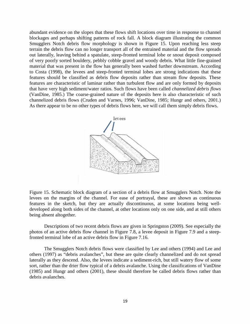
19
abundant evidence on the slopes that these flows shift locations over time in response to channel blockages and perhaps shifting patterns of rock fall. A block diagram illustrating the common Smugglers Notch debris flow morphology is shown in Figure 15. Upon reaching less steep terrain the debris flow can no longer transport all of the entrained material and the flow spreads out laterally, leaving behind a spatulate, steep-fronted terminal lobe or snout deposit composed of very poorly sorted bouldery, pebbly cobble gravel and woody debris. What little fine-grained material that was present in the flow has generally been washed further downstream. According to Costa (1998), the levees and steep-fronted terminal lobes are strong indications that these features should be classified as debris flow deposits rather than stream flow deposits. These features are characteristic of laminar rather than turbulent flow and are only formed by deposits that have very high sediment/water ratios. Such flows have been called channelized debris flows (VanDine, 1985.) The coarse-grained nature of the deposits here is also characteristic of such channelized debris flows (Cruden and Varnes, 1996; VanDine, 1985; Hungr and others, 2001.) As there appear to be no other types of debris flows here, we will call them simply debris flows.
Figure 15. Schematic block diagram of a section of a debris flow at Smugglers Notch. Note the levees on the margins of the channel. For ease of portrayal, these are shown as continuous features in the sketch, but they are actually discontinuous, at some locations being well-developed along both sides of the channel, at other locations only on one side, and at still others being absent altogether.
Descriptions of two recent debris flows are given in Springston (2009). See especially the photos of an active debris flow channel in Figure 7.8, a levee deposit in Figure 7.9 and a steep-fronted terminal lobe of an active debris flow in Figure 7.16.
The Smugglers Notch debris flows were classified by Lee and others (1994) and Lee and others (1997) as “debris avalanches”, but these are quite clearly channelized and do not spread laterally as they descend. Also, the levees indicate a sediment-rich, but still watery flow of some sort, rather than the drier flow typical of a debris avalanche. Using the classifications of VanDine (1985) and Hungr and others (2001), these should therefore be called debris flows rather than debris avalanches.
20
Patterns of Slope Failure on Till Slopes
Observations of the landslides here and elsewhere in Vermont suggest the following as a common sequence of events on till-dominated slopes in response to catastrophic flood events (Springston and Thomas, 2018). Note that the events described below will not always take place in a sequence of discrete steps. For example, a translational slide on the upper part of a landslide may be occurring at the same time that the base is being undercut by flood waters.
1. Fluvial shear results in erosion of the bank and/or bed, over-steepening the slope and, if bed erosion occurs, increasing the effective height of the slope. Dense till and lacustrine diamict typically are detached as irregular blocks. Loose materials typically are detached as single grains. At sites where the material is very strong, the stream may undercut the bank, leaving an overhang.
2. Infiltration of rainfall results in an increase in pore-pressure in the surficial material, reducing the effective shear strength of the material.
3. Translational slides occur off the upper slope, commonly carrying blocks of soil and trees, with depths of 1.5 to 5 feet (0.5 to 1.5 meters). Parts of the sliding blocks may break up into flows. A rotational slump may occur in place of or following a shallow translational slide. This type of slope failure is more common in lacustrine or ice-contact or stream terrace deposits than in till, but a few examples of rotational slumps have been observed in dense till deposits that were severely undercut by catastrophic flooding.
4. Material reaching the base of the slope may either be swept away by the stream or accumulate to form a toe deposit.
5. The water level of the stream recedes, perhaps leading to additional slope failure as the support of the water on the lower face is removed.
6. Overhangs begin to fail and translational slides and flows remove material from the upper parts of the landslide.
7. With the passage of time, mass-wasting and weathering processes begin to alter the deposits. Material continues to fall, topple, slide, or flow off of the upper slopes. Weathering of the fresh deposits becomes evident after the first winter, with the outer 0.5 to 1 inch (1 to 2.5 cm) of even the densest till beginning to soften. Rills begin to dissect parts of the upper faces and the toe deposits. Even after only a single year, pioneer vegetation such as coltsfoot and horsetails begin to colonize the slopes.
21
Conclusions This study identifies over 700 unstable slope features in Chittenden County. The maps are sufficiently accurate to help landowners and planners consider slope instability hazards.
As in the Washington County study of Springston and Thomas (2014, 2018), the current lidar topographic data was successfully used to produce an accurate and cost-effective landslide inventory. Lack of signal return from areas of heavy conifer coverage remains a problem with some of the lidar data, but it is hoped that future projects will supply increasingly detailed penetration in these areas.
As shown by Springston (2017), and Springston and Thomas (2014, 2018), most of the
landslides are located close to streams at sites of active streambank toe erosion. When long-term data is available, the landslides are generally in locations that have been failing for a long time.
Many of the actively eroding gullies in the County appear to be closely associated with
stormwater runoff from developed areas. These developed areas are largely concentrated at low elevations in the western portions of the county which are also within the extent of the Champlain Sea. The sandy and silty components of the Champlain Sea deposits are highly erodible and thus, this combination of urbanization and soils that are susceptible to erosion may explain the abundance of gullying in these areas.
Although some gullies have clearly been in existence for many years, the fact that many
of the actively eroding gullies in the county are receiving stormwater runoff from developed areas suggests that the development has destabilized or at least exacerbated the instability.
The principal causes of the slope failures appear to be the over-steepening of slopes due to fluvial erosion of banks and stream beds during flash floods and decreases in shear strength of soils due to increases in soil water pore pressures due to the heavy rainfall.
The detailed (Phase 2) stream geomorphic data from the Vermont Rivers Program is critical to understanding the patterns of stream channel adjustment that are underway in the river corridors. The mass failure locations the river studies compared very well with site location from geologic field work and from lidar. It would be highly desirable to have similar Phase 2 data available for the streams in any areas where landslide mapping is to be undertaken.

22
Acknowledgements
Funding for this work was provided by the Vermont Geological Survey through a series of contracts and grants running from 1999 to the present. In the early years this work was direct contracting with George Springston and Lori Barg. Subsequently, the funding was through grants to Norwich University.
I extend my deep appreciation to current State Geologist Marjorie Gale and former State
Geologist Laurence Becker for their consistent and enthusiastic funding for this work. This work would also not be possible without the far-sighted work of the staff of the
Vermont Rivers Program, headed by Mike Kline. Special thanks go to Mike, Barry Cahoon, Shayne Jaquith, Sacha Pealer, Staci Pomeroy, and Gretchen Alexander.
Thanks to Paul Bierman of the University of Vermont for sharing his knowledge of
gullies and landslides in the area.
References Baskerville, C.A., and Ohlmacher, G.C., 2001, Map showing slope failures and slope-movement-prone areas in Vermont: U.S. Geological Survey Geologic Investigations Series Map I-2682, 1:250,000. Bierman, Paul, Lini, Andrea, Zehfuss, Paul, Church, Amy, Davis, P. Thompson, Southon, John, and Baldwin, Lynn, 1997, Postglacial ponds and alluvial fans: Recorders of Holocene landscape history: GSA Today, v. 7, no. 10, p.1-8. Bierman, Paul, Wright, Stephen, and Nichols, Kyle, 1999, Slope stability and late Pleistocene/Holocene history, northwestern Vermont: in Wright, S.F., ed., New England Intercollegiate Geological Conference, Guidebook 91, Burlington, p.17-50. Clift, A.E., and Springston, G.E., 2012, Protocol for identification of areas sensitive to landslide hazards in Vermont: Manuscript report submitted to the Vermont Geological Survey, Montpelier, 78 p. plus 2 appendices. Costa, J.E. 1998, Rheologic, geomorphic, and sedimentologic differentiation of water floods, hyperconcentrated flows, and debris flows: In Baker, V.R., Kochel, R.C., and Patton, P.C., eds., Flood geomorphology: John Wiley and Sons, New York, p. 113-122. Cruden, D.M., and Varnes, D.J., 1996, Landslide types and processes: In Turner, A.K., and Schuster, R.L., III, eds., Landslides: Investigation and mitigation: Transportation Research Board Special Report 247, p. 36-75.

23
Fleming, R.W., and Varnes, D.J., 1991, Slope Movements: In, Kiersch, G.A., ed., The heritage of engineering geology, The first hundred years: Geological Society of America, Centennial Special Volume 3, p. 201–218. Highland, L.M., and Bobrowsky, Peter, 2008, The landslide handbook--A guide to understanding landslides: U.S. Geological survey Circular 1325, 129 p. Hungr, Oldrich, Evans, S.G., Bovis, M.J., and Hutchinson, J.N., 2001, A review of the classification of landslides of the flow type: Environmental and Engineering Geoscience: v. 7, p. 221-238. Lee, F.T., Odum, J. K., and Lee, J.D., 1994, Rockfalls and debris avalanches in the Smugglers Notch area, Vermont: U.S. Geological Survey Bulletin 2075, 33p. Lee, F.T., Odum, J. K., and Lee, J.D., 1997, Slope failures in northern Vermont: Environmental and Engineering Geoscience, v. 3, p. 161-182. Springston, G.E., 2009, Smugglers Notch Slope Instability Report, Report submitted to the Vermont Geological Survey, Waterbury, 78 p. plus 5 plates. Springston, G.E., 2017, Landslide inventory of Washington County, central Vermont: Vermont Geological Survey Open File Report VG2017-7, text plus 1 color plate, scale 1:80,000. Available at http://dec.vermont.gov/sites/dec/files/geo/HazDocs/WashingtonCtyInstability Map2017.pdf . Springston, G.E., and Gale, M.H., 2018, A lidar-based landslide inventory of Washington County, central Vermont (abs.): Geological Society of America, Northeastern Section Abstracts with Programs, v. 50, no. 2, Paper no. 12-3. Springston, G.E. and Thomas, Ethan, 2014, Landslide hazard analysis of the Great Brook watershed, Plainfield, Vermont: Report prepared for the Central Vermont Regional Planning Commission, Montpelier, Vermont, 34 p., plus 1 plate (1:10,0000). Available at http://centralvtplanning.org/wp-content/uploads/2012/03/GreatBrookLandslideReportFinal03172014.pdf Springston, G.E., and Thomas, Ethan, 2018, Landslides in the Great Brook watershed, Washington County, central Vermont (abs.): Geological Society of America, Northeastern Section Abstracts with Programs, v. 50, no. 2, Paper no. 47-1. Thomas, Peter, 1985, Archaeological and geomorphological evaluation, Burlington M5000(3) Northern Connector material supply/disposal Area, Howe Farm floodplain: Department of Anthropology, University of Vermont, Consulting Archaeology Program Report No. 54, 41p. VanDine, D.F., 1985, Debris flows and debris torrents of the Southern Canadian Cordillera: Canadian Geotechnical Journal, v. 22, p. 44-67. ChittendenCountyLandslideStudy071812018.doc