laramide minor faulting in the colorado front range minor faulting in the colorado front range ......
TRANSCRIPT
181 NEW MEXICO BUREAU OF GEOLOGY & MINERAL RESOURCES, BULLETIN 160, 2004
Laramide minor faulting in the Colorado Front RangeEric A. Erslev, Steven M. Holdaway1, Stephanie A. O’Meara2,
Branislav Jurista3, and Bjorn Selvig4
Department of Earth Resources, Colorado State University, Fort Collins, CO 80523 1Now at Chevron USA Production Company, P.O. Box 36366, Houston, TX 77236
2Now at Colorado State University/National Park Service, 1201 Oak Ridge Drive, Suite 200, Fort Collins, CO 80525 3Now at Westshore Consulting, 2534 Black Creek Road, Muskegon, MI 49444
4Now at RETEC, 23 Old Town Square, Suite 250, Fort Collins, CO 80524
Abstract The nature of Laramide basementinvolved deformation in the Rocky Mountains remains highly controversial, sparking a continuing debate between advocates of vertical, thrust and strikeslip tectonic models. The Front Range of Colorado provides an important geographic link between the northwesttrending arches of Wyoming, which are commonly attributed to thrust deformation, and the northtrending arches of the southern Rockies of New Mexico, which are commonly attributed to partitioned rightlateral transpression.
Fault separations and kinematics provide effective tests of Laramide structural models for the Front Range arch. In the center of the arch, exposures of Precambrian crystalline rocks show no evidence of consistent strikeslip separations on northstriking faults, indicating that major rightlateral displacements, if present, must be located on the margins of the arch. Fault kinematics were studied by measuring nearly 5,000 slickensided faults in Mesozoic strata flanking the Front Range arch. The overwhelming dominance of thrust and strikeslip minor faults with lowangle slickenline plunges falsifies vertical tectonic hypotheses invoking dipslip on highangle faults. Average slickenline and ideal σ1 axis trends for the minor faults range from N53°E to N80°E, with some variability due to localizedfolding and faulting. The high intersection angles of average slickenline and compression orientations with major fault strikes suggest a predominance of thrust motion on the bounding faults of the Front Range arch. The lack of northstriking, strikeslip minor faults of clear Laramide age indicates that slippartitioning was not a major contributor to regional Laramide deformation in the Colorado Front Range. The slight obliquity between the arch axis and average slickenline and compression orientations is consistent, however, with a minor component of rightlateral slip on the thrust faults that bound the Front Range of Colorado.
Introduction The Colorado Front Range (Fig. 1) is an important yet controversial part of the Rocky Mountain foreland. Its location adjacent to the Denver geological community, with its strong academic, industry, and U.S. Geological Survey components, has made the Front Range an important influencein defining our understanding of basementinvolved foreland arches. Field observations from the eastern Front Range played a key role in the development of the verticaluplift school of Laramide deformation (Prucha et al. 1965; Matthews and Work 1978) and subsequent strikesliphypotheses (Chapin and Cather 1981; Chapin 1983), whichused Front Range geologic relationships to support northward translation of the Colorado Plateau during theLaramide orogeny.
This paper will synthesize 10 years of minor fault studiesat Colorado State University that were aimed at testinghypotheses for the Laramide formation of the Front Range of Colorado. The premise of this paper is that many structural models for the Laramide development of the Front Range predict significantly different stresses and strains, which can be deduced from the characteristics of minor faults. Details of this research are partially contained in fiveM.S. theses (Selvig 1994; Jurista 1996; Fryer 1997; Holdaway1998) as well as several society field trip articles (Erslev andGregson 1996; Erslev and Selvig 1997; Erslev and Holdaway1999; Erslev et al. 1999). This work is part of the larger Continental Dynamics—Rocky Mountain Project (CDROM) studying the Rocky Mountain lithosphere from its Precambrian assembly to the present. The CDROM project is combining the fault data presented here with diverse geological and geophysical studies to help delineate the geologic evolution of the Southern Rocky Mountains.
Geologic setting and structural models
The Rocky Mountain province of the United States is a classic basementinvolved foreland orogen. Deformation during the Late Cretaceous to Eocene Laramide orogeny created an anastomosing system of basementcored arches that bound the northern and eastern margins of the ColoradoPlateau and define the elliptical sedimentary basins of theRocky Mountains. The tectonic mechanism for Laramidedeformation remains controversial with proposed mechanisms ranging from subcrustal shear during lowangle subduction (Bird 1988, 1998; Hamilton 1988) to detachment ofthe upper crust during plate coupling to the west (Lowell1983; Oldow et al. 1989; Erslev 1993). The Southern RockyMountains, here defined as the Rocky Mountains south of Wyoming, have been further complicated by multiple stagesof Tertiary faulting, igneous activity and sedimentation currently manifested by the Rio Grande rift.
The multitude of Laramide structural geometries in the Rocky Mountains has resulted in a mirroring multitude ofkinematic hypotheses. In the 1970s and 1980s hypotheseswere polarized into the antagonistic horizontal compression and vertical tectonics schools. The vertical tectonics school was dominant in the 1970s, represented by upthrust (Prucha et al. 1965) and block uplift models (Stearns 1971, 1978;Matthews and Work 1978). In the 1980s incontrovertible documentation of Precambrian basement thrust over Phanerozoic sediments (e.g., Smithson et al. 1979; Gries1983; Lowell 1983; Stone 1985) swung opinion back toward models invoking horizontal shortening and compression. Seismic profiles (Smithson et al. 1979; Gries and Dyer 1985), subthrust petroleum drilling at Laramide basin margins (Gries 1983), and balancing constraints (Stone 1984; Brown 1984; Erslev 1986; Spang and Evans 1988) have demonstrat
ed that the Laramide was dominated by lateral shorteningdue to horizontal compression.
The diversity of Laramide structural trends, with faults,folds, and arches trending in nearly every direction, hasbeen attributed to multiple stages of differently orientedcompression (Chapin and Cather 1981; Gries 1983; Bergh
and Snoke 1992), reactivation of preexisting weaknesses inthe basement (Hansen 1986; Stone 1986; Blackstone 1990;Chase et al. 1993), transpressive motions (Cather 1999a,b),indentation by the Colorado Plateau (Hamilton 1988), anddetachment of the crust (Lowell 1983; Brown 1988; Kulikand Schmidt 1988; Oldow et al. 1990; Erslev 1993). Many of
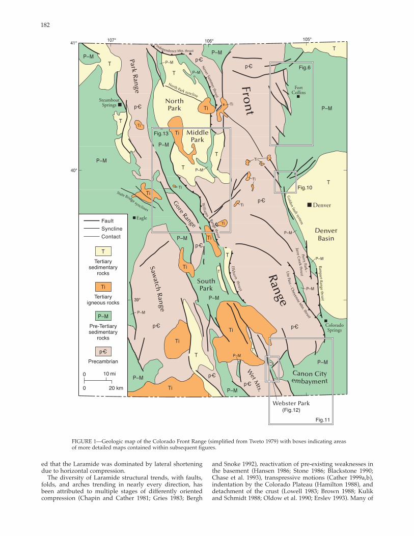
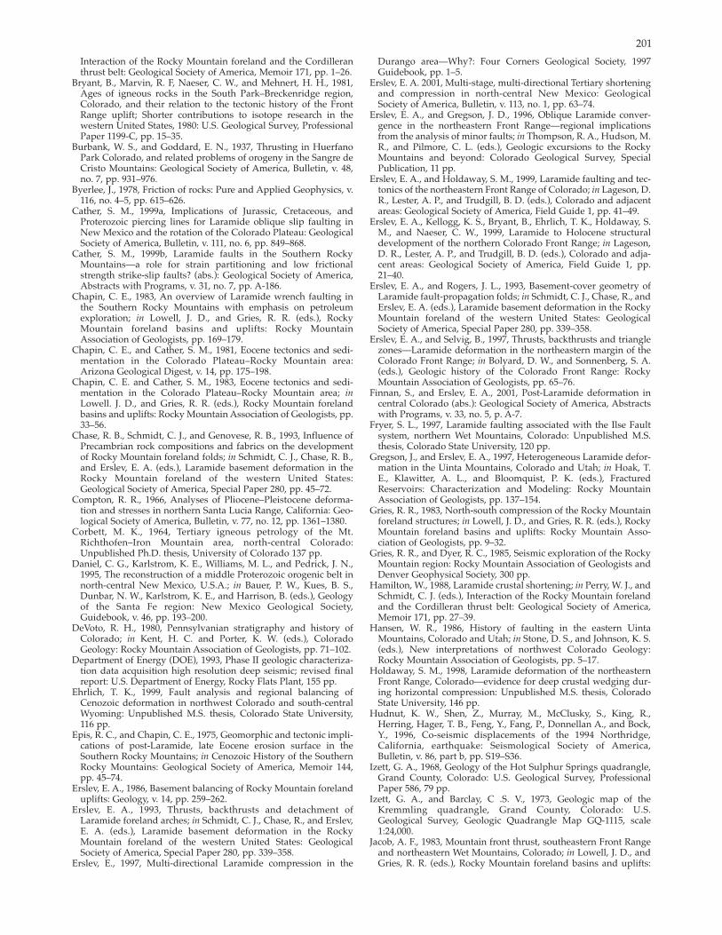
FIGURE 1—Geologic map of the Colorado Front Range (simplified from Tweto 1979) with boxes indicating areasof more detailed maps contained within subsequent figures.
182
183
these hypotheses are valid for individual areas within the foreland but their relative regional importance isnot always clear.
Laramide structures of the Front Range basement arch (Fig. 1) are very diverse. Along the eastern flankof the range, the northnorthweststriking, westdipping Golden thrust fault system (Berg 1962) west andsouth of Denver transitions to an array of northweststriking, eastdipping reverse faults to the north (Erslev 1993). Farther south, theGolden fault system merges into the Perry Park–Jarre Creek and Rampart Range thrust systems. These overlap southward with the Ute Pass–Cheyenne Mountain thrust system, which dies southward into the Canon City embayment.
On the western side of the range,Laramide geometries are overprinted by more extensive postLaramidefault and igneous systems. Still,exposures of the large displacement,lowangle Elkhorn, Williams Range,and Never Summer thrust faults indicate they defined the westernlimit of the basement arch duringLaramide deformation. Horizontal fault displacements of at least 10 km(6 mi) are documented where postLaramide plutons bow the faultsupward, forming tectonic windowsexposing Cretaceous shales underneath Precambrian rocks of the Front Range hanging wall (Ulrich1963; O’Neill 1981).
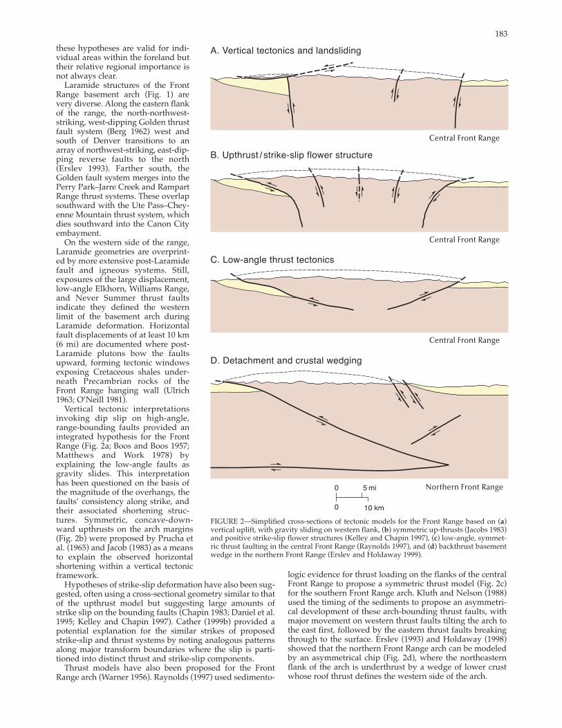
Vertical tectonic interpretations invoking dip slip on highangle,rangebounding faults provided an integrated hypothesis for the Front Range (Fig. 2a; Boos and Boos 1957;Matthews and Work 1978) byexplaining the lowangle faults asgravity slides. This interpretation has been questioned on the basis ofthe magnitude of the overhangs, thefaults’ consistency along strike, andtheir associated shortening structures. Symmetric, concavedownward upthrusts on the arch margins (Fig. 2b) were proposed by Prucha et al. (1965) and Jacob (1983) as a meansto explain the observed horizontalshortening within a vertical tectonicframework.
FIGURE 2—Simplified crosssections of tectonic models for the Front Range based on (a)vertical uplift, with gravity sliding on western flank, (b) symmetric upthrusts (Jacobs 1983) and positive strikeslip flower structures (Kelley and Chapin 1997), (c) lowangle, symmetric thrust faulting in the central Front Range (Raynolds 1997), and (d) backthrust basement wedge in the northern Front Range (Erslev and Holdaway 1999).
Hypotheses of strikeslip deformation have also been suggested, often using a crosssectional geometry similar to that of the upthrust model but suggesting large amounts ofstrike slip on the bounding faults (Chapin 1983; Daniel et al.1995; Kelley and Chapin 1997). Cather (1999b) provided a potential explanation for the similar strikes of proposed strikeslip and thrust systems by noting analogous patternsalong major transform boundaries where the slip is partitioned into distinct thrust and strikeslip components.
Thrust models have also been proposed for the Front Range arch (Warner 1956). Raynolds (1997) used sedimento
logic evidence for thrust loading on the flanks of the central Front Range to propose a symmetric thrust model (Fig. 2c) for the southern Front Range arch. Kluth and Nelson (1988)used the timing of the sediments to propose an asymmetrical development of these archbounding thrust faults, with major movement on western thrust faults tilting the arch to the east first, followed by the eastern thrust faults breaking through to the surface. Erslev (1993) and Holdaway (1998)showed that the northern Front Range arch can be modeled by an asymmetrical chip (Fig. 2d), where the northeastern flank of the arch is underthrust by a wedge of lower crust whose roof thrust defines the western side of the arch.
184
185
In addition, multistage models for Laramide deformation (e.g., Chapin and Cather 1981; Gries 1983) have suggested that the Laramide foreland may have developed sequentially about differently oriented stress and strain axes. Gries (1983) used structural geometries and sedimentary basin characteristics to propose a counterclockwise rotation of shortening and compression axes from eastwest to northsouth orientations during the Laramide. Chapinand Cather (1981) combined changes in dike orientationsand sedimentary basin geometries in the Southern RockyMountains to predict an early eastnortheast shorteningevent followed by a northeast shortening event dominatedby rightlateral strikeslip faulting. Chapin (1983) furtherdeveloped the hypothesis of Laramide rightlateral faultingalong the eastern margin of the Colorado Plateau and suggested that a number of major northstriking faults in theFront Range may be dominated by strikeslip movement.Bird (1998) combined fault geometries, kinematic information and plate geometries to propose that the SouthernRocky Mountains may have undergone multiphase, multidirectional compression related to the different convergence directions of the Farallon and Kula plates as they were subducted under North America. Unlike the counterclockwise interpretations of Gries (1983) and Chapin and Cather(1981), however, Bird predicted clockwise rotation of compression and shortening directions through time.
Recent fault analyses in southwest Colorado (Erslev 1997;Ruf 2000) and northern New Mexico (Erslev 2001) have documented sequential, multidirectional shortening and compression using minor fault analyses. In southwest Coloradonear Durango, multiple conjugate fault sets indicate thatnortheast shortening was followed by northwest shortening, and both were overprinted by postLaramide northnortheast shortening and normal faulting (Ruf 2000). Innorthern New Mexico, clear crosscutting relationshipsshow a similar sequence, with faults indicating eastnortheast and eastwest shortening cut by faults indicating northnortheast shortening (Erslev 2001). At least some of the faults associated with late stage northnortheast shorteningare post Laramide because they cut rocks as young as 24 Ma. Similar midTertiary strikeslip faults have been reported from the southern Front Range at Cripple Creek (Wawrzyniec et al. 1999) and in eastern North Park (Erslevet al. 1999).
Each of these hypotheses predict different stress histories, which can be tested by minor fault analyses. Vertical tectonic hypotheses (Fig. 2a) predict a combination of highangle dipslip faults and lowerangle normal faults resulting from gravitational collapse of the range. Upthrust hypotheses (Fig. 2b) predict a range of high to lowangle dipslip faulting. Strikeslip hypotheses (Fig. 2b) suggest that at leastsome of the minor faults paralleling the major faults shouldbe dominated by strike slip. If slip is partitioned betweenthrust and strikeslip systems, one might also expect to see stress and strain refraction patterns adjacent to major strikeslip faults. Thrust hypotheses (Figs. 2c,d) predict shortening and compression axes oriented perpendicular to the strikeof major faults and a lack slip parallel to the strike of thesefaults. Multistage, multidirectional hypotheses suggestthat Laramide fault patterns should reveal regionallyconsistent multimodal distributions of shortening and compression directions.
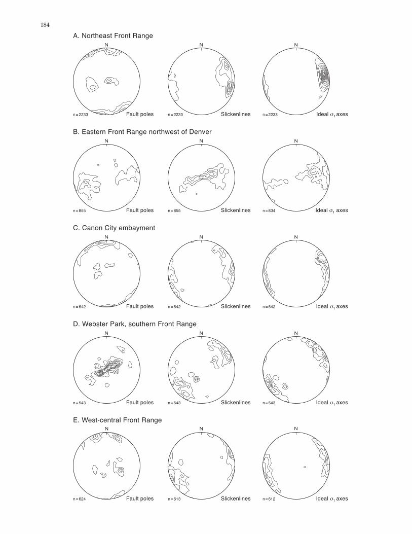
FIGURE 3—Contoured stereonet plots of poles to faults, slickenlines and ideal σ1 axes (Compton 1966) for each area. The plots are contoured using the Schmidt method (Vollmer 1992), with a 2% contour interval calculated over 40 nodes.
Minor fault analysis methods
Slickensided minor fault surfaces were measured within five areas (Fig. 1) along the flanks of the Colorado Front Range (see the appendix for individual locality data).Because this research focused on Laramide faulting, faults atlocalities of Pennsylvanian and older rocks were avoided because of the possible presence of faults related to the Ancestral Rocky Mountain and Precambrian orogenies. Similarly, localities exposing rocks younger than 40 Ma were not analyzed in detail by this paper because they are presumed to record postLaramide faulting, which was not thefocus of this study.
In general, faults with the bestpreserved slickenside lineations were found in silicacemented quartz arenites, which are common in the Cretaceous Dakota, Jurassic Morrison, and Permian Ingleside Formations. In general,slickenlines within major fault zones were rarely observed because of poor exposures and pervasive cataclasis. Because more highly folded strata have complex slickenline orientations caused by the added complexities of foldrelated slip (e.g., flexural slip) and rotation of earlyformed slickenlines, wherever possible this study concentrated on localities withstrata dipping less than 35°.
At each outcrop, slickenside strike and dip were measured as well as slickenline trend, plunge, and shear sense.Shear sense was determined using the criteria of Petit (1987)with most fault planes displaying excellent Riedel fractures and some containing calcite growth fibers. In this area, minor faults commonly form conjugate sets, with acutebisecting angles between conjugate faults ranging from 60° to 30°. Acute bisectors of conjugate strikeslip and thrust faults commonly parallel bedding with the resulting discordance of most faults to bedding ensuring that they did notreactivate preexisting bedding weaknesses.
Where possible, approximately 20 fault surfaces were measured for each fault set indicating horizontal shortening.The possibility of multiple fault sets was considered where faults did not conform to simple conjugate patterns. A key to deducing the relative ages of conjugate fault sets is the crosscutting relationships between fractures which belongto only one conjugate set. In addition overprinting of slickenlines on individual fault surfaces can give timing relationships. Where crosscutting and overprinting relationships are not evident, the chronology of fault slip can be estimated by the more complete preservation of the latest slickenlines.
Fault data for each area is presented in stereonets which plot fault plane pole, slickenline and ideal σ1 axis (Compton1966) orientations (Fig. 3). In addition, smoothed rose diagrams of slickenline and ideal σ1 axis trends are plotted in Figure 4 to provide a graphical portrayal of their angulardistribution and to identify multiple modes of slip and idealcompression directions. Rose diagrams presented in this paper are smoothed to clarify their interpretation, with the petal length for each 1° increment proportional to the number of slickenlines within 5° of each increment. Rose diagrams from northcentral New Mexico (Fig. 4f) are provided as an example of multistage, multidirectional faulting with which to compare the Front Range data. The multistage nature of faulting in this area of New Mexico is confirmed by crosscutting relationships. For instance, thenorthsouth strikeslip faults cut postLaramide strata asyoung as 24 Ma (Erslev 2001).
In areas where conjugate shear bands without slickenlines are the only available faults, shear band strikes and dips were used to estimate the orientation of the σ1 axis for each locality. The average orientation of each conjugate was calculated by eigenvector analysis and then used to find the

186
FIGURE 4—Rose diagrams of minor fault slickenline trends, both composite and separated by fault type, and ideal σ1 axis trends for Front Range localities and northcentral New Mexico (Erslev 2001,included here for comparison). Rose diagrams are smoothed by
acute bisector of the conjugate pair, which is assumed to parallel the σ1 axis. Comparisons of conjugate acute bisectors with ideal σ1 axes for localities with slickensided faults show that they are highly correlative (Fryer 1997).
Although the most direct interpretation of slickensided faults is as strain, the summation of a total strain from minor faults requires knowledge of the amount of slip on eachfault. Unfortunately, net slip could be estimated for only avery small fraction of the faults. This is particularly true for strikeslip faults, whose beddingparallel slip is difficult to measure. In addition, the lack of slip data for larger, gougefilled faults casts doubt on the regional validity of any strainvalue derived from the smaller slickensided faults.
Consequently, this paper attempts to quantify minor faultdata in terms of average slickenline and ideal σ1 axis (Compton 1966) orientations, which parallel the acute bisectors of conjugate faults. Average slip directions are given bythe orientation of the first eigenvector of the slickenline trends and plunges (Table 1). The degree of clustering isgiven by the associated eigenvalue (E1), where E1 = 1.0 indicates perfect clustering about one orientation and E1 = 0.33 indicates the absence of a single preferred orientation.
The trend of slickenlines varies with fault type. In the relatively simple, unidirectional faulting in the northeast Front Range of Colorado (Fig. 4a; Erslev and Selvig 1997; Holdaway 1998) rightlateral, thrust, and leftlateral faults form unimodal distributions, which can be combined into a trimodal rose diagram representing all fault slip trends. This trimodal spread of slickenline trends complicates their usefor discrimination of multiple shortening and compression directions.
For simple conjugate faulting, the spread in trend orientations is largely eliminated by plotting ideal σ1 axes, which are assumed to parallel the acute bisector of the conjugatesets. This technique was used by Compton (1966), whodetermined ideal σ1 axes by moving half the bisector angle(2 σ) from the slickenline towards the direction of maximum
plotting the number of trends within 5° of each 1° increment. In general, lineations with plunges greater than 45° are not included in the rose diagrams with the exception of those from the eastern Front Range near Rocky Flats.
compression within the plane containing the pole to thefault and the slickenline. For this paper, an σ angle of 25°,consistent with Byerlee (1978), was used by our SELECT program to calculate the ideal σ1 axis for each fault. Because most of the fault sets are symmetrically weighted, withequal numbers of right and leftlateral faults, and equalnumbers of thrust conjugates, small changes in σ anglescause less than 5° of change in average σ1 axis orientations. These ideal stress calculations assume fracture on ideal conjugate planes, an assumption which is violated by reactivated fault planes and some cases of threedimensional strain.
Additional methods for determining stress and strain axes are presented in the theses of Selvig (1994), Jurista(1996), Fryer (1997), and Holdaway (1998) and these will be compared in a future paper. The ideal σ1 axis technique hasadvantages over the Angelier (1990) leastsquares algorithm, which uses fault slip directions to calculate a reduced stress tensor, in that outlying measurements do not have a large influence on stress directions. For the case of fault data from the eastern and southern Front Range of Colorado(Jurista 1996; Fryer 1997; Erslev and Selvig 1997; Holdaway
TABLE 1—Average slickenline and ideal σ1 axes for the Front Range, showing average trend, plunge and eigenvalue (E1). n = number of measurements.
Slickenline Ideal σσ1 axes Location n trendplunge E1 trendplunge E1
Northeast Front 2233 08013 0.7232 07911 0.8397 Range
Eastern Front 834 08766 0.5513 07525 0.5735 Range
Canon City 642 embayment
Webster Park area 543
07606
23106
0.6697
0.6416
07504
23301
0.7393
0.7635
Western Front 612 25006 0.6485 25302 0.7189 Range

1998), the ideal σ1 method gives higher precision (reproducibility) than the Angelier (1990) method. In addition, theideal σ1 method aids in separation of faults into subsets withconsistent σ1 trends because faults are analyzed individually. By plotting ideal σ1 axes and analyzing their variabilitywith rose diagrams and eigenvector analyses, data are portrayed in a format allowing relatively unbiased evaluationof the possibility of multiple directions of shortening andcompression.
Minor fault analysesThe fault orientations and their ideal σ1 axis trends are presented as contoured stereonets (Fig. 3), rose diagrams (Fig.4), average orientations (Table 1), locality data (Appendix),and data from selected individual localities (Fig. 5). Theseorientations are sufficient to eliminate vertical tectonic models from consideration. Whereas fault plane orientations arequite variable from area to area, the slickenlines and theirideal σ1 axes strongly indicate subhorizontal slip and compression. The one exception is the highangle slickenlinesfrom the eastern Front Range northwest of Denver. Thisdata set is dominated by data from highly rotated strata inthe famous flatirons south of Boulder.
Further interpretation of the faults requires the examination of the detailed setting of the data. This section will startwith a description of the northeast Front Range near FortCollins, for which we have the largest and simplest datasets, and move to the south and west before ending with adescription of the westcentral Front Range, which has themost complicated data sets.Northeastern Front Range
The eastern flank of the Front Range exposes a diverse setof structures, with the major, northnorthweststriking faultsystems west and south of Denver bringing the crystallinerocks of the core of the Front Range up relative to theDenver Basin. However, to the north, a series of northnorthweststriking, en echelon faults transect the northtrending boundary of the range and bring the eastern basinside of the faults up relative to the western, arch side of thefaults (Figs. 6–9).
These basementinvolved faults are overlain by faultpropagation folds, which progressively transform the faulting into folding of the sedimentary cover (Erslev and Rogers1993). Dip and slipsense interpretations of the major faultshave varied dramatically through the years. Ziegler (1917)proposed motion on planar reverse and thrust faults, predicting that a 50° dipping reverse fault underlies MilnerMountain anticline (Fig. 8), the only fault large enough toactually cut through the Cretaceous Dakota Group. Boosand Boos (1957) also showed a planar reverse fault in ananalogous section but steepened the fault dip to around 80°.Prucha et al. (1965) introduced the concept of concavedownward upthrusts to the area. By increasing fault dipsdownward, from 30° dipping thrusts in the sedimentarystrata to vertical faults cutting basement, lower angle thrustfaults in the cover were explained within a vertical tectonicframework. This upthrust geometry was adopted byBraddock et al. (1970) and Le Masurier (1970) for MilnerMountain anticline, which they interpreted as being underlain by a 60° dipping reverse fault that becomes vertical atdepth. A further evolution of fault dip interpretations wascontributed by Matthews and Work (1978) who suggestedthat a planar normal fault with a dip of 80° underlies MilnerMountain anticline.
The vertical tectonic interpretations of these structures arein clear conflict with the evidence for horizontal shorteningand compression in the Rocky Mountain foreland. Recentwork at Colorado State University (Erslev and Rogers 1993;Erslev 1993; Selvig 1994; Holdaway 1998) has shown thatmajor fault dips in the Fort Collins area range from 20o to 70o
to the northeast, consistent with the early interpretations ofZiegler (1917). These angles of faulting are compatible withthe lateral contraction indicated by seismic information tothe north (Laramie Range: Brewer et al. 1982; Johnson andSmithson 1985) and south (Golden Fault: Jacob 1983; DOE1993; Erslev and Selvig 1997; Weimer and Ray 1997), whichindicate large, westdipping thrust faults overlapping thewestern margin of the Denver Basin.
Curiously enough, the thrust and reverse faults in thenortheastern Front Range cannot be directly responsible for
FIGURE 5—Stereonets of slickensided fault planes (plotted as arcs) with slickenside lineations (plotted as points),stereonets of ideal σ1 axes, and smoothed rose diagrams of ideal σ1 axis trends for individual localities from thenortheastern (A,B) and westcentral (C–F) Front Range
187
188
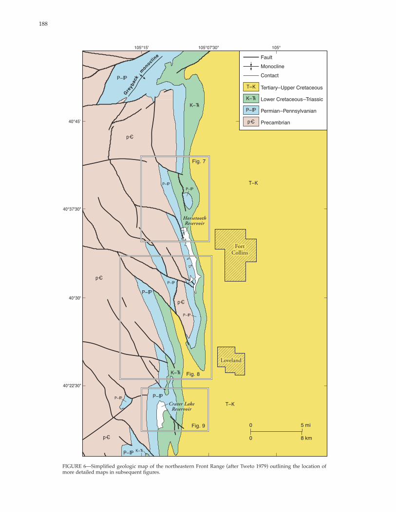
FIGURE 6—Simplified geologic map of the northeastern Front Range (after Tweto 1979) outlining the location of more detailed maps in subsequent figures.
189
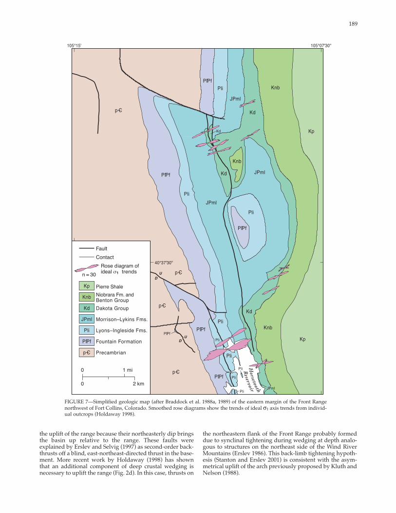
FIGURE 7—Simplified geologic map (after Braddock et al. 1988a, 1989) of the eastern margin of the Front Range northwest of Fort Collins, Colorado. Smoothed rose diagrams show the trends of ideal σ1 axis trends from individual outcrops (Holdaway 1998).
the uplift of the range because their northeasterly dip bringsthe basin up relative to the range. These faults were explained by Erslev and Selvig (1997) as secondorder backthrusts off a blind, eastnortheastdirected thrust in the basement. More recent work by Holdaway (1998) has shownthat an additional component of deep crustal wedging isnecessary to uplift the range (Fig. 2d). In this case, thrusts on
the northeastern flank of the Front Range probably formeddue to synclinal tightening during wedging at depth analogous to structures on the northeast side of the Wind River Mountains (Erslev 1986). This backlimb tightening hypothesis (Stanton and Erslev 2001) is consistent with the asymmetrical uplift of the arch previously proposed by Kluth and Nelson (1988).
190
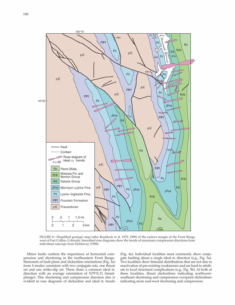
FIGURE 8—Simplified geologic map (after Braddock et al. 1970, 1989) of the eastern margin of the Front Range west of Fort Collins, Colorado. Smoothed rose diagrams show the trends of maximum compression directions from individual outcrops from Holdaway (1998).
Minor faults confirm the importance of horizontal com (Fig. 4a). Individual localities most commonly show conjupression and shortening in the northeastern Front Range. gate faulting about a single ideal σ1 direction (e.g., Fig. 5a). Stereonets of fault plane and slickenline orientations (Fig. 3a) Two localities show bimodal distributions that are not due to form 4 modes consistent with two conjugate sets, one thrust reactivation of preexisting weaknesses and are hard to attribset and one strikeslip set. These share a common ideal σ1 ute to local structural complications (e.g., Fig. 5b). At both of direction with an average orientation of N79°E11 (trend these localities, thrust slickenlines indicating northwestplunge). This shortening and compression direction also is southeast shortening and compression overprint slickenlines evident in rose diagrams of slickenline and ideal σ1 trends indicating more eastwest shortening and compression.
191
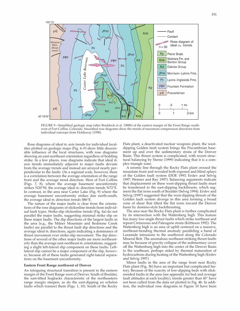
FIGURE 9—Simplified geologic map (after Braddock et al. 1988b) of the eastern margin of the Front Range southwest of Fort Collins, Colorado. Smoothed rose diagrams show the trends of maximum compression directions from individual outcrops from Holdaway (1998).
Rose diagrams of ideal σ1 axis trends for individual localities plotted on geologic maps (Fig. 6–9) show little discernable influence of the local structures, with rose diagrams showing an eastnortheast orientation regardless of bedding strike. In a few places, rose diagrams indicate that ideal σ1
axis trends immediately adjacent to major faults deviate from the average trends and instead are arrayed nearly perpendicular to the faults. On a regional scale, however, there is a correlation between the average orientation of the range front and the average trend direction. West of Fort Collins (Figs. 7, 8), where the average basement unconformity strikes N20°W, the average ideal σ1 direction trends N72°E. In contrast, in the area near Carter Lake (Fig. 9) where the average basement unconformity strikes due northsouth,the average ideal σ1 direction trends S86°E.
The nature of the major faults is clear from the orientations of the rose diagrams of slickenline trends from individual fault types. Strikeslip slickenline trends (Fig. 4a) do notparallel the major faults, suggesting minimal strike slip onthese major faults. The dip directions of the largest faults in the area (e.g., the Milner Mountain and Redstone Creek faults) are parallel to the thrust fault dip directions and the average ideal σ1 directions, again indicating a dominance of thrust movement over strikeslip movement. The dip directions of several of the other major faults are more northeasterly than the average eastnortheast σ1 orientations, suggesting a slight leftlateral slip component on these faults. Leftlateral slip cannot be a major component of the slip, however, because all of these faults generated rightlateral separations on the basement unconformity. Eastern Front Range northwest of Denver
An intriguing structural transition is present in the eastern margin of the Front Range west of Denver. South of Boulder, the easttilted hogbacks characteristic of the northeasternrange margin steepen, as do the eastdipping en echelonfaults which transect them (Figs. 1, 10). South of the Rocky
Flats plant, a deactivated nuclear weapons plant, the westdipping Golden fault system brings the Precambrian basement up and over the sedimentary strata of the DenverBasin. This thrust system is complicated, with recent structural balancing by Sterne (1999) indicating that it is a complex triangle zone.
A seismic line through the Rocky Flats plant crossed the mountain front and revealed both exposed and blind splaysof the Golden fault system (DOE 1993; Erslev and Selvig1997; Weimer and Ray 1997). Balancing arguments indicatethat displacement on these westdipping thrust faults must be transferred to the eastdipping backthrusts, which segment the flat irons south of Boulder (Selvig 1994). Erslev andSelvig (1997) suggested that the westdipping thrusts of the Golden fault system diverge in this area forming a broad zone of shear that tilted the flat irons toward the Denver basin by dominostyle backthrusting.
The area near the Rocky Flats plant is further complicatedby its intersection with the Wattenberg high. This feature has many lowangle thrust faults which strike northeast and repeat Cretaceous and Paleogene strata (Kittleson 1992). The Wattenberg high is an area of uplift centered on a massive, northeasttrending thermal anomaly paralleling a band ofLaramide intrusions to the southwest along the ColoradoMineral Belt. The anomalous northeaststriking thrust faults may be because of gravity collapse of the sedimentary coveroff the Wattenburg high into the center of the Denver Basinto the southeast, perhaps aided by thermal maturation of hydrocarbons during heating of the Wattenberg high (Erslev and Selvig 1997).
Minor faults in the area of the range front near RockyFlats plant (Fig. 3b) have an important but complicated history. Because of the scarcity of lowdipping beds with slickensided faults in the area (see appendix for bed and averagefault attitudes at each locality), trends greater than 45° have not been culled from the data set plotted in Fig. 4b. In addition, the individual rose diagrams in Figure 10 have been

192
FIGURE 10— Simplified geologic map of the eastern margin of the Front Range south of Boulder. Smoothed rose diagrams show the trends of ideal σ1 axis trends for three major domains from Selvig (1994).
plotted for domains, not individual localities, because of thecomplexity of the data set and the need for broader averaging of the data.
Fault poles (Fig. 3b) show the dominance of highanglereverse faults, often approximately paralleling the rotated bedding orientation. Slickenlines show a diffuse, near vertical maximum elongated in an eastnortheast–westsouthwest direction. Ideal σ1 axes are more horizontal, but again are distributed about an eastnortheast–westsouthwest direction. Rose diagrams showing distribution by fault typeshow the overwhelming predominance of dipslip thrust and normal faults, which probably represent rotated thrust faults. Rose diagrams for the Hoosier and Livingstondomains along the range front (Fig. 10) show ideal σ1 axis trends similar to those in the northeastern Front Range.Their oblique orientation to both the Hoosier andLivingston backthrusts as well as the northsouth range front suggests slip oblique to both structural elements.
A minor, distributed mode of eastsoutheasttrending slickenlines and ideal σ1 axes (Figs. 3b, 4b) is contributed byfaults on the flank of the Wattenburg structural high (see small rose diagram in northeast corner of Fig. 10). Selvig(1994) attributed these to gravity sliding because there is no evidence that they are rooted below the Upper Cretaceous strata.
Southern Front Range The southern Front Range arch plunges southward into the Canon City embayment where it disappears. Slip is presumably taken up on the southeastplunging Wet Mountain arch, whose relief also dissipates to the south. Tweto (1980) used unconformities and sedimentary rock distributions to show that the Front Range, Wet Mountain, and southern Sangre de Cristo arches were uplifted in the Pennsylvanian by the Ancestral Rocky Mountain orogeny (DeVoto 1980; Tweto 1980; Kluth and Coney 1981). As a result, these ranges were extensively eroded and then covered by Jurassic and Cretaceous sediments before Laramide deformation.
Laramide uplift of the Wet Mountains and Front Range was initiated in the Late Cretaceous, as indicated by synorogenic sediments deposited on their flanks (Tweto 1975; Kluth and Nelson 1988). Laramide uplift ended in earlyTertiary time, and the area formed an extensive late Eocene erosion surface, which truncates Laramide structures (Epis and Chapin 1975; Leonard and Langford 1994).
The Wet Mountain arch is bounded by northweststriking thrust faults on its eastern margin (Burbank and Goddard 1937; Logan 1966). A similarlystriking, anastomosing network of connected faults, the Ilse fault system, is found inthe central region of the Wet Mountain arch. The Ilse fault and other northweststriking faults that comprise the fault
193
system extend from the southern end of the Wet Mountains northward into central Colorado.
The Ilse fault system is bound by Precambrian rocks along most of the system’s trace. In the northern Wet Mountains west of Canon City and the Royal Gorge area, however, the Ilse fault is bordered to the east by two sedimentary inliers at Webster Park and Twelvemile Park. The two inliers are separated from the Canon City embayment to the east by Precambrian crystalline rock of the southplunging Royal Gorge anticline. The inliers themselves are separated by Precambrian crystalline rock exposures and are connected by the Ilse fault system, the northeaststriking MikesellGulch fault, and several north to northeaststriking faults.
Lovering and Goddard (1938) compared the northweststriking faults of the Wet Mountain arch to similarlystriking faults bounding the Front Range arch to the east and concluded that these faults were formed by east or northeasttrending horizontal compression. In northern Webster Park, near the town of Parkdale, Johnston (1953) used fault andslickenline attitudes to infer an east to northeast Laramide compression direction.
In contrast, Chapin (1983) noted that wide zones ofcrushed and sheared rocks adjacent to the Ilse fault are similar to those adjacent to strikeslip faults. He proposed thatthe Ilse fault is a rightlateral strikeslip fault. But lateral separations of Precambrian rocks adjacent to the Ilse fault system do not support largescale rightlateral slip. In the southern Wet Mountains, the Ilse Fault system cuts through the Precambrian San Isabel pluton with no obvious strikeslip separation. North of Webster Park, Taylor et al. (1975) mapped rightlateral separations of Precambrian rocks but these separations are only approximately 1.5 km. Approximately 3–8 km north of Twelvemile Park, the geologic map of Wobus et al. (1979) shows either no lateral separations orminor leftlateral separations.
Chapin and Cather (1981) documented the existence ofnarrow, elongate axial basins filled with Eocene clastic rocks along the eastern margin of the Colorado Plateau. Several ofthese basins, which they called Echo Park typebasins, haveno Upper Cretaceous or Paleocene strata and thus appear tohave been initiated in the Eocene, late in the Laramide orogeny. Echo Park, Chapin and Cather’s type axial basin, lies approximately 13 km west of Webster Park and Twelvemile Park and the Ilse fault system. On the east sideof the Echo Park Basin, Chapin and Cather (1983) noted amajor shear zone containing highly sheared Precambrian rocks and, at several localities, slivers of Jurassic Morrison and Cretaceous Dakota Sandstone. Chapin and Cather(1981) noted that Echo Parktype basins have numerous similarities to wrench fault basins and proposed that thesebasins formed by a combination of horizontal shorteningand rightlateral shear.
Unfortunately, slickensided minor faults were not found in the Eocene strata at Echo Park, probably because of a lack of sufficient cementation at the time of faulting. A small number of striated minor faults in the adjoining basementrocks yielded an average slip direction of S64°W38 and an average ideal σ1 axis oriented S61°W24 (Fryer 1997). The interpreted slip direction and ideal σ1 trend estimates are consistent with rightlateral obliqueslip. Unfortunately, because these minor faults were measured in Precambrian rocks, they may not represent Laramide deformation.
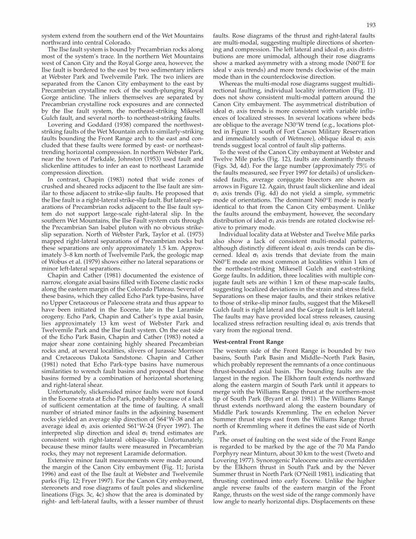
Extensive minor fault measurements were made around the margin of the Canon City embayment (Fig. 11; Jurista 1996) and east of the Ilse fault at Webster and Twelvemile parks (Fig. 12; Fryer 1997). For the Canon City embayment,stereonets and rose diagrams of fault poles and slickenlinelineations (Figs. 3c, 4c) show that the area is dominated byright and leftlateral faults, with a lesser number of thrust
faults. Rose diagrams of the thrust and rightlateral faults are multimodal, suggesting multiple directions of shortening and compression. The left lateral and ideal σ1 axis distributions are more unimodal, although their rose diagrams show a marked asymmetry with a strong mode (N60°E for ideal v axis trends) and more trends clockwise of the main mode than in the counterclockwise direction.
Whereas the multimodal rose diagrams suggest multidirectional faulting, individual locality information (Fig. 11) does not show consistent multimodal pattern around the Canon City embayment. The asymmetrical distribution ofideal σ1 axis trends is more consistent with variable influences of localized stresses. In several locations where beds are oblique to the average N30°W trend (e.g., locations plotted in Figure 11 south of Fort Carson Military Reservationand immediately south of Wetmore), oblique ideal σ1 axis trends suggest local control of fault slip patterns.
To the west of the Canon City embayment at Webster and Twelve Mile parks (Fig. 12), faults are dominantly thrusts (Figs. 3d, 4d). For the large number (approximately 75% of the faults measured, see Fryer 1997 for details) of unslickensided faults, average conjugate bisectors are shown as arrows in Figure 12. Again, thrust fault slickenline and ideal σ1 axis trends (Fig. 4d) do not yield a simple, symmetricmode of orientations. The dominant N60°E mode is nearly identical to that from the Canon City embayment. Unlike the faults around the embayment, however, the secondary distribution of ideal σ1 axis trends are rotated clockwise relative to primary mode.
Individual locality data at Webster and Twelve Mile parksalso show a lack of consistent multimodal patterns,although distinctly different ideal σ1 axis trends can be discerned. Ideal σ1 axis trends that deviate from the main N60°E mode are most common at localities within 1 km of the northeaststriking Mikesell Gulch and eaststrikingGorge faults. In addition, three localities with multiple conjugate fault sets are within 1 km of these mapscale faults,suggesting localized deviations in the strain and stress field. Separations on these major faults, and their strikes relative to those of strikeslip minor faults, suggest that the MikesellGulch fault is right lateral and the Gorge fault is left lateral. The faults may have provided local stress releases, causing localized stress refraction resulting ideal σ1 axis trends that vary from the regional trend.
Westcentral Front Range
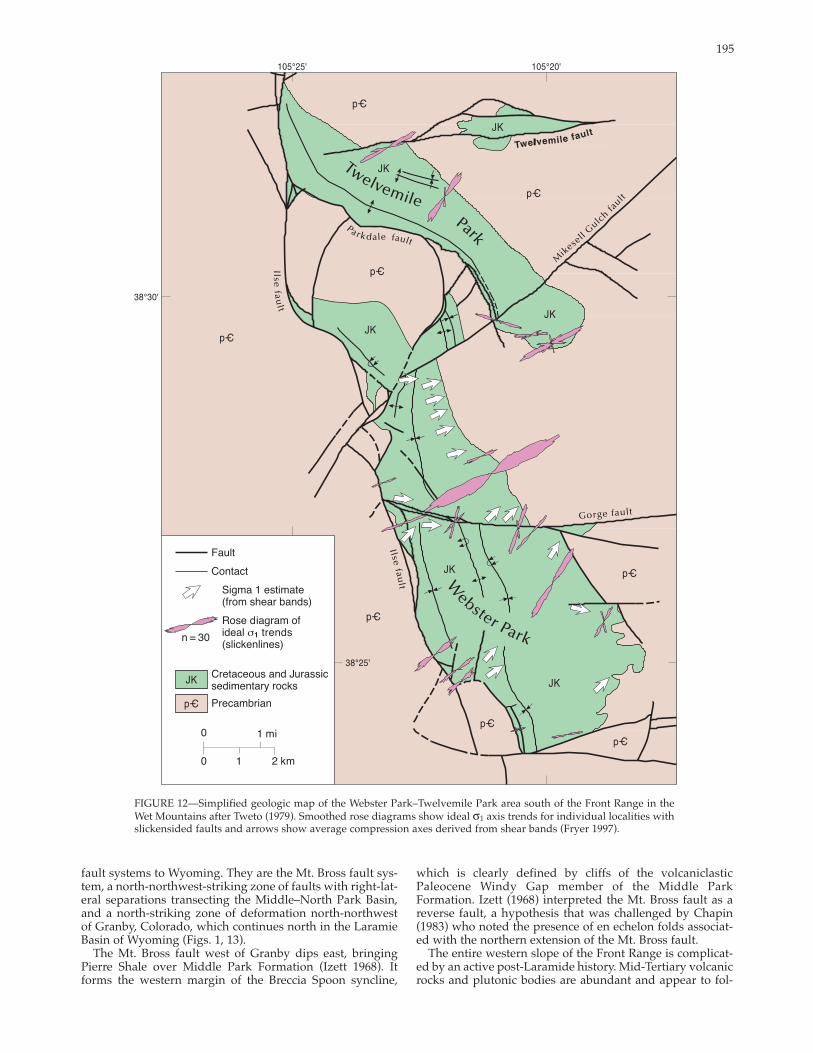
The western side of the Front Range is bounded by twobasins, South Park Basin and Middle–North Park Basin, which probably represent the remnants of a once continuous thrustbounded axial basin. The bounding faults are the largest in the region. The Elkhorn fault extends northward along the eastern margin of South Park until it appears to merge with the Williams Range thrust at the northernmost tip of South Park (Bryant et al. 1981). The Williams Range thrust extends northward along the eastern boundary of Middle Park towards Kremmling. The en echelon Never Summer thrust steps east from the Williams Range thrust north of Kremmling where it defines the east side of North Park.
The onset of faulting on the west side of the Front Range is regarded to be marked by the age of the 70 Ma PandoPorphyry near Minturn, about 30 km to the west (Tweto and Lovering 1977). Synorogenic Paleocene units are overridden by the Elkhorn thrust in South Park and by the Never Summer thrust in North Park (O’Neill 1981), indicating that thrusting continued into early Eocene. Unlike the higherangle reverse faults of the eastern margin of the Front Range, thrusts on the west side of the range commonly havelow angle to nearly horizontal dips. Displacements on these

194
FIGURE 11—Simplified geologic map of the southern margin of the Front Range and the Canon City embayment after Tweto (1979).
faults are considerable judging by the existence of thrust windows bowed up by postLaramide plutons. These windows expose Pierre Shale 9 km from the Williams Range thrust front eastsoutheast of Dillon, Colorado (Fig. 13;Ulrich 1963), and 10 km from the Never Summer thrust front north of Granby (O’Neill 1981).
Smoothed rose diagrams show ideal σ1 axis trends for individual localities with slickensided faults from Jurista (1996).
The thrust nature of the low angle faults has not been debated in recent years, although Chapin (1983) suggestedthat they might conceal underlying and adjacent strikeslipfaults. Chapin (1983) suggested two zones of potentialstrikeslip deformation in the western Front Range that might transfer rightlateral slip from the Echo Park and Ilse
195
FIGURE 12—Simplified geologic map of the Webster Park–Twelvemile Park area south of the Front Range in the Wet Mountains after Tweto (1979). Smoothed rose diagrams show ideal σ1 axis trends for individual localities with slickensided faults and arrows show average compression axes derived from shear bands (Fryer 1997).
fault systems to Wyoming. They are the Mt. Bross fault sys which is clearly defined by cliffs of the volcaniclastic tem, a northnorthweststriking zone of faults with rightlat Paleocene Windy Gap member of the Middle Parkeral separations transecting the Middle–North Park Basin, Formation. Izett (1968) interpreted the Mt. Bross fault as a and a northstriking zone of deformation northnorthwest reverse fault, a hypothesis that was challenged by Chapinof Granby, Colorado, which continues north in the Laramie (1983) who noted the presence of en echelon folds associatBasin of Wyoming (Figs. 1, 13). ed with the northern extension of the Mt. Bross fault.
The Mt. Bross fault west of Granby dips east, bringing The entire western slope of the Front Range is complicatPierre Shale over Middle Park Formation (Izett 1968). It ed by an active postLaramide history. MidTertiary volcanic forms the western margin of the Breccia Spoon syncline, rocks and plutonic bodies are abundant and appear to fol
196
FIGURE 13—Simplified geologic map of the westcentral Front Range after Tweto (1979). Smoothed rose diagrams show ideal σ1 axis trends for lumped localities (see appendix for individual locality information).
low the margin of the Front Range northward. The aptly Barclay 1973). Later tilting of Pliocene basalt flows is consisnamed Troublesome Formation is well dated by mammal tent with Neogene normal faulting along the Blue River halffossils and volcanic ash with fission track ages between 20 graben, the northern extension of the Rio Grande rift (West and 13 Ma (Izett and Barclay 1973). Near Kremmling (Fig. 1978; Kellogg 1999).13), it was deposited in localized extensional basins whose Minor faults can be difficult to find in the west slope of faults follow Laramide thrust traces. This suggests that the the Front Range due to more extensive weathering and vegTroublesome Formation may have been deposited in local etative cover resulting from the increased precipitation on ized basins caused by backsliding on thrust faults (Izett and
197
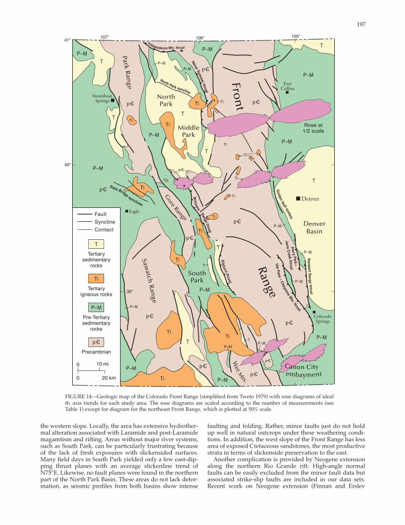
FIGURE 14—Geologic map of the Colorado Front Range (simplified from Tweto 1979) with rose diagrams of ideal σ1 axis trends for each study area. The rose diagrams are scaled according to the number of measurements (see Table 1) except for diagram for the northeast Front Range, which is plotted at 50% scale.
the western slope. Locally, the area has extensive hydrothermal alteration associated with Laramide and postLaramidemagamtism and rifting. Areas without major river systems,such as South Park, can be particularly frustrating because of the lack of fresh exposures with slickensided surfaces. Many field days in South Park yielded only a few eastdipping thrust planes with an average slickenline trend of N75°E. Likewise, no fault planes were found in the northern part of the North Park Basin. These areas do not lack deformation, as seismic profiles from both basins show intense
faulting and folding. Rather, minor faults just do not hold up well in natural outcrops under these weathering conditions. In addition, the west slope of the Front Range has less area of exposed Cretaceous sandstones, the most productive strata in terms of slickenside preservation to the east.
Another complication is provided by Neogene extensionalong the northern Rio Grande rift. Highangle normalfaults can be easily excluded from the minor fault data but associated strikeslip faults are included in our data sets. Recent work on Neogene extension (Finnan and Erslev
198
2001) has identified at least two orientations of extension: 1)northeastsouthwest extension with associated northstriking leftlateral and northweststriking rightlateral faults,and 2) eashwest extension, possibly with associated northnorthweststriking rightlateral and northnortheaststriking leftlateral faults. A mysterious, northnortheasttrending shortening event, with northstriking rightlateral andnortheaststriking left lateral faults (Wawrzyniec et al. 1999;Erslev et al. 1999; Erslev 2001), may be related to Neogene eastwest extension. But crosscutting relationships on northstriking faults commonly show strikeslip slickenlinesoverprinted by normal fault slickenline, suggesting a separate phase of postLaramide strikeslip faulting. This possibility is supported by Neogene westnorthwesttrendingfolds at State Bridge and North Park (Fig. 13; Erslev 2001).
There are two areas with good exposures of Cretaceous sandstones in the west slope: near Dillon, Colorado, west ofDenver (Kellogg 1997) and along the Colorado River nearGranby and Kremmling (Fig. 13). Maxima of fault poles,slickenlines and ideal σ1 axes (Fig. 3e) are similar to those from the northeastern Front Range (Figs. 3a), indicating conjugate thrust and strikeslip faulting about common eastnortheasttrending shortening and compression axes. Rose diagrams of west slope slickenline trends (Fig. 4e), however, show more variability for thrust and strikeslip fault types, resulting in a broad array of ideal σ1 axis trends.
Rose diagrams of ideal σ1 axes for three different subareas exposing Dakota sandstone near Dillon (Fig. 13) showcomplex, multimode orientations with an average eastnortheast orientation. In several spots, eastnortheasttrending thrust fault slickenlines are overprinted by northnortheasttrending thrust fault slickenlines. Additional complexity is added by younger normal faulting of the Blue Riverhalf graben, which may contribute some of the strikeslipslickenlines.
To the northnorthwest, one third of the way from Dillon to Kremmling, exposures of sandstones with the Pierre Shale below the welldelineated Williams Range Thrust at Ute Pass (Figs. 13, 5c) show a complex array of strikeslipand thrust faults. The two localities sampled gave average ideal σ1 axis trends of N62°E and S67°E. In combination with the faults from the Dillon area, this data suggests shortening and compression roughly normal to the Williams Range thrust. Further north, near Kremmling at outcrops on the road to Gore Pass and at exposures in Gore Canyon, strikeslip slickenlines (including two localities from Ehrlich 1999) indicate easttrending to eastsoutheast trending shortening and compression oblique to the general eastnortheast dips of the major faults and the sedimentary strata.
Along the Colorado River between Kremmling and Granby, complex faulting shows multiple orientations ofshortening and compression. The Windy Pass member ofthe Middle Park Formation spans the Cretaceous–Paleocene boundary and is locally composed of highlyindurated, verycoarse grained volcaniclastic strata that probably originated from Laramide stratovolcanoes of the Colorado Mineral Belt (Izett 1968). Conjugate thrust and strikeslip faults at a locality on the west side of the Breccia Spoon syncline next to the Mt. Bross fault (Figs. 13, 5d) show two modes of ideal σ1
axes, a major eastnortheast mode and a minor eastsoutheast mode. The eastnortheast mode is nearly perpendicularto the Mt. Bross fault, suggesting thrust motion. The eastsoutheast mode is oblique to the fault and parallels ideal σ1
axis modes west of Kremmling. The Windy Pass member on the east side of the Breccia
Spoon syncline also contains excellent slickensides (see rose diagram closest to Granby in Fig. 13), although the 80° dip of the strata makes their interpretation more difficult. Here,
individual thrust planes locally show two slickenside lineations with northnortheasttrending slickenlines overprinting northeast and eastnortheast slickenlines.
A key locality northnorthwest of Granby (stop B2 inErslev et al. 1999) exposes mixed volcaniclastic and arkosiccomponents (from Front Range crystalline rocks) in thePaleocene Middle Park Formation (Izett 1968). Three fault sets are exposed—early thrust faults with northeast and westnorthwesttrending ideal σ1 axes and late strikeslipfaults with northnorthwesttrending ideal σ1 axes. The later set of faults is probably post Laramide since they roughlyparallel strikeslip, northstriking faults (Fig. 4f) which cutthe 29 Ma (KAr; Corbett 1964) Mt. Richtofen batholith(O’Neal 1981) north of Granby at Cameron Pass. The postLaramide age of these faults is confirmed by the fact that thebatholith cuts Laramide thrusts forming the western margin of the Front Range arch.
Discussion and conclusions
Minor faults within Cretaceous and Paleocene units flanking the Front Range are strongly dominated by thrust and strikeslip faults indicating eastnortheasttrending shortening and compression. The most tightly defined ideal σ1 axes, as documented by the eigenvectors in Table 1, come from the northeastern Front Range, where en echelon mapscale faults transect the northtrending range front. Some local control of fault strains and stresses is evident in a weak correlation of ideal σ1 axes with changes in the dip directions of the Phanerozoic strata. The least welldefined ideal σ1 axes come from the complex transition area of the eastcentral Front Range northwest of Denver. In this area, the dispersion of fault data appears to be related to the steeper inclination of the strata, which suggests that earlyformed faultswere rotated by subsequent deformation. In addition, thenorthwestsoutheast thrust faulting east of the range front was probably caused by gravity sliding associated with the Wattenberg high.
Ideal σ1 axes from the southern and western flanks of the Front Range are more diffuse than those from the northeastern Front Range, with their first eigenvalues rangingbetween 0.64 and 0.67 as compared to 0.72 for the northeast Front Range (Table 1). The two study areas in the southern plunge of the range have asymmetrical distributions of idealσ1 axes with opposite senses of asymmetry. For the Canon City embayment, a clockwise asymmetry relative to the primary eastnortheast mode can be ascribed to local influences. Strata at stations with more eastwest slickenlines and ideal σ1 axes typically dip to the southeast, suggesting thatsoutheastdirected gravitational sliding and/or foldingcombined with eastnortheast tectonic stresses to control fault orientations at these localities (Jurista 1996). In theWebster Park area, the counterclockwise asymmetry of slickenlines and calculated σ1 axes relative to the primaryeastnortheast mode can be ascribed to stress refraction adjacent to mapscale strikeslip faults. Most stations withmore northeasterly ideal σ1 axes are within 1 km of these faults, and their deviations relative to the primary N60°E mode increase as the faults are approached (Fryer 1997).
The distribution of fault types is quite variable. For thenortheast Front Range (Fig. 4a), approximately equal proportions of thrust, leftlateral and rightlateral faults suggests pure shear shortening. The abundance of strikeslipfaults is surprising, considering the scarcity of parallel mapscale faults, and indicate a component of horizontal elongation perpendicular to average shortening orientations. An analogous situation may be the minor faulting associatedwith the Northridge earthquake of 1994, in which thrust faulting at depth caused strikeslip faulting and fold axisparallel extension in the hanging wall (Hudnut et al. 1996;
199
Unruh and Twiss 1998). A similar fault type distribution also is present in the Canon City embayment (Fig. 4c), an area which is also underlain by a system of southwestdirected backthrusts (Jurista 1996).
In contrast, thrust and reverse faults dominate the minor faults in the eastcentral Front Range and Webster Park areas. Both of these areas are more immediately adjacent to major thrust systems, the Golden and Ilse fault systems,which may explain the dominance of minor thrust faults. On the western part of the range, strikeslip faults becomemore dominant farther from the major thrust faults.
Slickenline and ideal σ1 axis orientations give valuableinformation on the type of strain during the Laramideorogeny. In the central and southern Front range, the general symmetry of major thrust faults with respect to the range suggests a pure shear popup structure (Fig. 2c; Raynolds 1997). In the northern Front Range, surface faults are directed mostly to the westsouthwest, although wedge models(e.g., Fig. 2d) suggest that overall transport was to the eastnortheast.
If simple shear occurred in the horizontal plane due tostrikeslip faulting, as proposed by Chapin (1983) andCather (1999a), a consistent and substantial obliquitybetween the average slickenline and ideal σ1 axis trends might be expected. This is the case for postLaramide strikeslip faulting in northern New Mexico (Fig. 4f; Erslev 2001)where rightlateral faults dominate late stage deformation.In the Front Range, however, the closeness of average slickenline and ideal σ1 axis trends (Table 1) suggests that pure shear shortening dominated Laramide Front Range deformation. The only exception to this generalization is in theeastern Front Range northwest of Denver, where the difference between the N87°Etrending average slickenline and N75°Etrending average ideal σ1 axes suggests a componentof leftlateral motion. One degree differences between average slickenline and ideal σ1 axis trends in the northeastern Front Range and Canon City embayment could be used to argue for a component of leftlateral shear. But the 2 and 3 degree differences for the Webster Park and westcentral Front Range areas suggest rightlateral shear, indicating that differences between average slickenline and stress axes may be more a function of nonrepresentative data collection than a consistent asymmetry of deformation.
These results provide a clear test of Laramide models for the development of the Colorado Front Range. The overwhelming predominance of minor faults indicating horizontal shortening and compression provides additional falsification of vertical tectonic models (e.g., Fig. 2a) invoking dipslip on highangle reverse and normal faults. Upthrust models using concave downward fault geometries to link surface thrusting with vertical tectonics in the lower crust (e.g.,Fig. 2b) could be thought to be consistent with the fault data,but they are impossible to balance at depth. In general, horizontal shortening in the upper crust is geometrically incompatible with purely vertical slip causing a lack of horizontalshortening in the lower crust without calling for an unrealistic amount of basement expansion during uplift. Onecould conceive of major shallow extension to balance theshallow horizontal shortening, perhaps in the center of the arch, but there is no evidence of extension of the required magnitude (e.g., Kelley and Chapin 1997).
The possibility of regionally significant multistage, multidirectional Laramide slip is supported only by a fewlocations in the northeastern Front Range and by locations in the western Front Range. In the northeastern Front Range, westnorthwesttrending slickenlines overprint eastnortheasttrending slickenlines in three localities. In the western Front Range, these slip orientations are also seen, and are overprinted by both northstriking normal and
strikeslip faults which cut Neogene strata. A vague bimodality in ideal σ1 axis trends from the westcentral Front Range (Fig. 4e) is permissive of multidirectional Laramide deformation, but the extensive evidence for multiple important stages of Laramide deformation seen innorthern New Mexico (Fig. 5f; Chapin and Cather 1981;Erslev 2001) and southwestern Colorado (Erslev 1997; Ruf2000) is lacking in the Front Range. Suggestions of a latenorthwestsoutheast shortening and compression in the northern and western Front Range are supported by similar observations from northwest (Gregson and Erslev 1997) andsouthwest Colorado (Erslev 1997; Ruf 2000). This change incompression directions was predicted by Bird (1998) on thebasis of plate trajectories but may also be due to latestageimpingement by the Cordilleran thrust belt (Gregson andErslev 1997). The age and significance of this northwestsoutheast shortening has not been well defined, although ithas not been observed in postLaramide rocks sampled to date (Finnan and Erslev 2001).
The question of whether the Front Range arch is consistent with large, northdirected, rightlateral displacementshas major implications to our understanding of Laramidetectonics. The major debate over whether the geology ofnorthern New Mexico indicates large (± 100 km: Chapin1983; Cather 1999a) or minimal (< 20 km: Woodward et al. 1997) northtrending rightlateral separations of Laramideage is at least partially tested by fault slip in the Front Range arch. If large Laramide rightlateral displacement did occurin the Southern Rocky Mountains, there should be compatible slip on faults in central Colorado. The Front Range is aleading candidate to pass rightlateral slip from New Mexico to Wyoming because the lower amount of throw on the Gore Fault and the curvature on the Grand Hogbacklimits the amount of strikeslip on these structures.
Geometrically, the possibility of a component of rightlateral strike slip on concavedownward faults, forming a transpressive flower or palmtree structure, is difficult to dismiss because of the possible movement of material inand out of the plane of section. But minor faults adjacent tofaults proposed as candidates for strikeslip motion (e.g.,Ilse fault, Mt. Bross fault, and faults in the northeastern Front Range) indicate shortening and compression at highangles to the fault traces. Laramide strikeslip faults are common in the margins of the Front Range, but they generally indicate shortening and compression in eastnortheasttrending directions, not northtrending directions. In general, rightlateral minor faults (Fig. 4) do not parallel thenorth to northweststriking major faults that have been proposed to carry rightlateral slip northward away from New Mexico. The exceptions to this generalization occur on thewestern slope of the range, but these faults are more logically associated with transverse westnorthwesttrending folds that deform the postLaramide Browns Park and North Park Formations of Miocene age (Erslev et al. 1999; Wawrzyniec et al. 1999; Erslev 2001).
In addition, major northward motion of the Colorado Plateau during the Laramide would suggest much more northerly slip directions than the eastnortheast–westsouthwest average slip directions given in Table 1. This could be explained by strain partitioning (Cather 1999b),where separate thrust and strikeslip systems develop aboutseparate strain axes. Cather (1999b) argued that many Laramide structures may have been influenced by preexisting weak faults which caused strain partitioning, and this isdemonstratively true along the San Andreas fault (e.g.,Zoback et al. 1987). Recent work on oblique Laramide arches where there is strong geometric evidence for oblique slip (Owl Creek Arch and Casper Mountain: Molzer and Erslev 1995; Uinta arch: Gregson and Erslev 1997; San Juan Basin:
200
Erslev 1997; Ruf 2000; Erslev 2001), however, indicates that their slickenline trends are, on average, oblique to the arches and do not indicate strain partitioning. In each case,major sets of strikeslip or obliqueslip slickensides parallelfrontal faults of the arch, confirming an oblique slip origin.This is not the case, however, for our Front Range measurements, which show that the minor faults paralleling themajor rangebounding faults typically are dipslip thrust faults.
It can be argued that thrust slip on the margins of the Front Range and Wet Mountain arches does not eliminate the possibility of major strikeslip in the interior of the arch where exposures are dominated by Precambrian crystalline rocks. A study of Precambrian contacts in the geological map of Colorado (Tweto 1979) shows only minor opportunities for significant rightlateral strikeslip separations in theinternal part of these arches. For instance, the Late Precambrian Iron Dike (Chapin 1983) cuts diagonally across the Front Range arch from Denver to North Park, with the only possible separations at the western arch flank. The contacts of the Pikes Peak and Silver Plume batholiths show very little leeway for major dextral fault separations on thecentral and southern part of the Front Range arch. In addition, for those fault zones that do show possible separations,many of them (e.g., the Ilse Fault of the Wet Mountains)intersect the sedimentary strata at the southern plunge ofthe arches where hogbacks of Phanerozoic strata show no major separations. Thus it appears that there is no room for major northdirected, rightlateral strikeslip in the Front Range of Colorado.
There is, however, evidence for a minor component ofoblique slip on many major faults in the Front Range area. Slight obliquities between the minor fault slip directions and the strike of the Ilse, Mt. Bross, and Williams Range thrusts, where ideal σ1 axes are counterclockwise rotated relative to the fault dip directions, suggest a small component of rightlateral strike slip. These suggestions of rightlateral slip are at least partially counterbalanced by oppositeobliquities suggesting leftlateral motion between faults inthe northeastern Front Range and the southern Canon Cityembayment. In the latter example, some of the discordance between the Wet Mountains fault and minor faults may bedue to the likelihood that the Wet Mountains fault is a reactivated Ancestral Rocky Mountain structure of Pennsylvanian age.
In addition, the overall geometry of the Front Range arch relative to the average slip and ideal σ1 axis trends does suggest a minor component of rightlateral motion. In thesouthern Front Range, the arch has a trend of N20°W, a trend whose normal is 10° oblique to the N60°E principalmode of fault slip and ideal σ1 axis trends in the southern Front Range. To the north, however, the arch trends due north toward its bifurcation into the Medicine Bow and Laramie arches. In this area, slickenline and ideal σ1 axis trends are more easterly, although still oblique to the arch axis. This change in the arch trend may generate a smallcomponent of rightlateral slip on the bounding faults in thenorthern Front Range. Residual northerly slip may beabsorbed in the more eastweststriking faults bounding theHanna Basin in southern Wyoming, as proposed by Cather(1999), and the Independence Mountain thrust fault (Blackstone 1977) bounding the northern margin of NorthPark. Still, we conclude that deformation of the Front Range arch was dominated by eastnortheast–westsouthwestshortening and compression, which caused major thrust faulting and subsidiary strikeslip faulting. A major challenge for the future will be the integration of the minor fault constraints into regional 3D restorations that quantify the absolute amounts of thrust and lateral slip in the Front
Range of Colorado. Acknowledgments
This research was supported by grants from the National Science Foundation (EAR9614787 and EAR9814698),E.G.&G. Rocky Flats, and from the donors of the Petroleum Research Fund, administered by the American Chemical Society. Student grants were provided by Geological Societyof America, American Association of Geologists, Rocky Mountain Association of Geologists, and Chevron U.S.A. Insights from Donald Blackstone, Bruce Bryant, Steve Cather, Chuck Chapin, Shari Kelley, Karl Kellogg, Vince Matthews, Ned Sterne, and Donald Stone provided important additions to this work. Reviews by Steve Cather, Chuck Chapin, and Basil Tikoff are gratefully acknowledged. Finally, we would like to acknowledge the importance of themultiple roles that Chuck Chapin has played in Front Range research, from the catalytic effect of his questioning of classical Front Range structural dogma to his openminded support of the sometimes contrary research of his colleagues.
References Angelier, J., 1990, Inversion of field data in fault tectonics to obtain
the regional stress, part 3, a new rapid direct inversion method byanalytical means: Geophysical Journal International, v. 103, no. 2, pp. 363–379.
Berg, R. R., 1962, Mountain flank thrusting in the Rocky Mountain foreland, Wyoming and Colorado: American Association of Petroleum Geologists, Bulletin, v. 46, no. 11, pp. 2010–2032.
Bergh, S., and Snoke, A., 1992, Polyphase Laramide deformation inthe Shirley Mountains, south central Wyoming foreland: Mountain Geologist, v. 29, no. 3, pp. 85–100.
Bird, P., 1988, Formation of the Rocky Mountains, a continuumcomputer model: Science, v. 239, no. 4847, pp. 1501–1507.
Bird, P., 1998, Kinematic history of the Laramide orogeny in latitudes 35°–49°, western United States: Tectonics, v. 17, no. 5, pp. 780–801.
Blackstone, D. L., Jr, 1977, Independence Mountain thrust fault, North Park Basin, Colorado: University of Wyoming, Contributions to Geology, v. 16, pp. 1–15.
Blackstone, D. L., 1990, Rocky Mountain foreland structure exemplified by the Owl Creek Mountains, Bridger Range, and Casper Arch, central Wyoming: Wyoming Geological Association, Guidebook 41, pp. 151–166.
Boos, C. M., and Boos, M. F., 1957, Tectonics of eastern flank and foothills of Front Range, Colorado: American Association of Petroleum Geologists, Bulletin, v. 41, no. 12, pp. 2603–2676.
Braddock, W. A., Connor, J. J., Swann, G. A., and Wolhford, D. D., 1988a, Geologic map of the Laporte quadrangle, Larimer County, Colorado: U.S. Geological Survey, Geologic Quadrangle Map GQ1621, scale 1:24,000.
Braddock, W. A., Calvert, R. H., Gawarecki, S. J., and Nutalaya, P., 1970, Geologic map of the Masonville quadrangle LarimerCounty: U.S. Geological Survey, Geologic Quadrangle Map GQ832, scale 1:24,000.
Braddock, W. A., Nutalaya, P., and Colton, R. B., 1988b, Geologicmap of the Carter Lake Reservoir quadrangle, Boulder andLarimer Counties: U.S. Geological Survey, Geologic Quadrangle Map GQ1628, scale 1:24,000.
Braddock, W. A., Calvert, R. H., Wohlford, D. D., and O’Connor, J. T., 1989, Geologic map of the Horsetooth reservoir quadrangle, Larimer County, Colorado: U.S. Geological Survey, Geologic Quadrangle Map GQ1625, scale 1:24,000.
Brewer, J. A., Allmendinger, R. W., Brown, L. D., Oliver, J. E., and Kaufman, S., 1982, COCORP profiling across the Rocky Mountain front in southern Wyoming, Part 1, Laramide structure: Geological Society of America, Bulletin, v. 93, no. 12, pp. 1242–1252.
Brown, W. G., 1984, A reverse fault interpretation of Rattlesnake Mountain anticline, Big Horn Basin, Wyoming: The Mountain Geologist, v. 21, p. 3135.
Brown, W. G., 1988, Deformation style of Laramide uplifts in the Wyoming foreland; in Schmidt, C. J., and Perry, W. J., Jr. (eds.),
201
Interaction of the Rocky Mountain foreland and the Cordilleran thrust belt: Geological Society of America, Memoir 171, pp. 1–26.
Bryant, B., Marvin, R. F, Naeser, C. W., and Mehnert, H. H., 1981, Ages of igneous rocks in the South Park–Breckenridge region, Colorado, and their relation to the tectonic history of the Front Range uplift; Shorter contributions to isotope research in the western United States, 1980: U.S. Geological Survey, Professional Paper 1199C, pp. 15–35.
Burbank, W. S., and Goddard, E. N., 1937, Thrusting in Huerfano Park Colorado, and related problems of orogeny in the Sangre de Cristo Mountains: Geological Society of America, Bulletin, v. 48, no. 7, pp. 931–976.
Byerlee, J., 1978, Friction of rocks: Pure and Applied Geophysics, v. 116, no. 4–5, pp. 615–626.
Cather, S. M., 1999a, Implications of Jurassic, Cretaceous, and Proterozoic piercing lines for Laramide oblique slip faulting inNew Mexico and the rotation of the Colorado Plateau: Geological Society of America, Bulletin, v. 111, no. 6, pp. 849–868.
Cather, S. M., 1999b, Laramide faults in the Southern RockyMountains—a role for strain partitioning and low frictional strength strikeslip faults? (abs.): Geological Society of America, Abstracts with Programs, v. 31, no. 7, pp. A186.
Chapin, C. E., 1983, An overview of Laramide wrench faulting inthe Southern Rocky Mountains with emphasis on petroleum exploration; in Lowell, J. D., and Gries, R. R. (eds.), RockyMountain foreland basins and uplifts: Rocky MountainAssociation of Geologists, pp. 169–179.
Chapin, C. E., and Cather, S. M., 1981, Eocene tectonics and sedimentation in the Colorado Plateau–Rocky Mountain area: Arizona Geological Digest, v. 14, pp. 175–198.
Chapin, C. E. and Cather, S. M., 1983, Eocene tectonics and sedimentation in the Colorado Plateau–Rocky Mountain area; in Lowell. J. D., and Gries, R. R. (eds.), Rocky Mountain foreland basins and uplifts: Rocky Mountain Association of Geologists, pp. 33–56.
Chase, R. B., Schmidt, C. J., and Genovese, R. B., 1993, Influence of Precambrian rock compositions and fabrics on the developmentof Rocky Mountain foreland folds; in Schmidt, C. J., Chase, R. B., and Erslev, E. A. (eds.), Laramide basement deformation in theRocky Mountain foreland of the western United States: Geological Society of America, Special Paper 280, pp. 45–72.
Compton, R. R., 1966, Analyses of Pliocene–Pleistocene deformation and stresses in northern Santa Lucia Range, California: Geological Society of America, Bulletin, v. 77, no. 12, pp. 1361–1380.
Corbett, M. K., 1964, Tertiary igneous petrology of the Mt. Richthofen–Iron Mountain area, northcentral Colorado: Unpublished Ph.D. thesis, University of Colorado 137 pp.
Daniel, C. G., Karlstrom, K. E., Williams, M. L., and Pedrick, J. N., 1995, The reconstruction of a middle Proterozoic orogenic belt in northcentral New Mexico, U.S.A.; in Bauer, P. W., Kues, B. S., Dunbar, N. W., Karlstrom, K. E., and Harrison, B. (eds.), Geology of the Santa Fe region: New Mexico Geological Society, Guidebook, v. 46, pp. 193–200.
DeVoto, R. H., 1980, Pennsylvanian stratigraphy and history ofColorado; in Kent, H. C. and Porter, K. W. (eds.), Colorado Geology: Rocky Mountain Association of Geologists, pp. 71–102.
Department of Energy (DOE), 1993, Phase II geologic characterization data acquisition high resolution deep seismic; revised final report: U.S. Department of Energy, Rocky Flats Plant, 155 pp.
Ehrlich, T. K., 1999, Fault analysis and regional balancing of Cenozoic deformation in northwest Colorado and southcentral Wyoming: Unpublished M.S. thesis, Colorado State University, 116 pp.
Epis, R. C., and Chapin, C. E., 1975, Geomorphic and tectonic implications of postLaramide, late Eocene erosion surface in the Southern Rocky Mountains; in Cenozoic History of the SouthernRocky Mountains: Geological Society of America, Memoir 144, pp. 45–74.
Erslev, E. A., 1986, Basement balancing of Rocky Mountain foreland uplifts: Geology, v. 14, pp. 259–262.
Erslev, E. A., 1993, Thrusts, backthrusts and detachment of Laramide foreland arches; in Schmidt, C. J., Chase, R., and Erslev, E. A. (eds.), Laramide basement deformation in the RockyMountain foreland of the western United States: Geological Society of America, Special Paper 280, pp. 339–358.
Erslev, E., 1997, Multidirectional Laramide compression in the
Durango area—Why?: Four Corners Geological Society, 1997 Guidebook, pp. 1–5.
Erslev, E. A. 2001, Multistage, multidirectional Tertiary shortening and compression in northcentral New Mexico: Geological Society of America, Bulletin, v. 113, no. 1, pp. 63–74.
Erslev, E. A., and Gregson, J. D., 1996, Oblique Laramide convergence in the northeastern Front Range—regional implications from the analysis of minor faults; in Thompson, R. A., Hudson, M. R., and Pilmore, C. L. (eds.), Geologic excursions to the RockyMountains and beyond: Colorado Geological Survey, Special Publication, 11 pp.
Erslev, E. A., and Holdaway, S. M., 1999, Laramide faulting and tectonics of the northeastern Front Range of Colorado; in Lageson, D.R., Lester, A. P., and Trudgill, B. D. (eds.), Colorado and adjacent areas: Geological Society of America, Field Guide 1, pp. 41–49.
Erslev, E. A., Kellogg, K. S., Bryant, B., Ehrlich, T. K., Holdaway, S. M., and Naeser, C. W., 1999, Laramide to Holocene structural development of the northern Colorado Front Range; in Lageson,D. R., Lester, A. P., and Trudgill, B. D. (eds.), Colorado and adjacent areas: Geological Society of America, Field Guide 1, pp. 21–40.
Erslev, E. A., and Rogers, J. L., 1993, Basementcover geometry ofLaramide faultpropagation folds; in Schmidt, C. J., Chase, R., and Erslev, E. A. (eds.), Laramide basement deformation in the RockyMountain foreland of the western United States: Geological Society of America, Special Paper 280, pp. 339–358.
Erslev, E. A., and Selvig, B., 1997, Thrusts, backthrusts and trianglezones—Laramide deformation in the northeastern margin of the Colorado Front Range; in Bolyard, D. W., and Sonnenberg, S. A. (eds.), Geologic history of the Colorado Front Range: Rocky Mountain Association of Geologists, pp. 65–76.
Finnan, S., and Erslev, E. A., 2001, PostLaramide deformation in central Colorado (abs.): Geological Society of America, Abstracts with Programs, v. 33, no. 5, p. A7.
Fryer, S. L., 1997, Laramide faulting associated with the Ilse Faultsystem, northern Wet Mountains, Colorado: Unpublished M.S.thesis, Colorado State University, 120 pp.
Gregson, J., and Erslev, E. A., 1997, Heterogeneous Laramide deformation in the Uinta Mountains, Colorado and Utah; in Hoak, T. E., Klawitter, A. L., and Bloomquist, P. K. (eds.), Fractured Reservoirs: Characterization and Modeling: Rocky MountainAssociation of Geologists, pp. 137–154.
Gries, R. R., 1983, Northsouth compression of the Rocky Mountain foreland structures; in Lowell, J. D., and Gries, R. R. (eds.), RockyMountain foreland basins and uplifts: Rocky Mountain Association of Geologists, pp. 9–32.
Gries, R. R., and Dyer, R. C., 1985, Seismic exploration of the Rocky Mountain region: Rocky Mountain Association of Geologists and Denver Geophysical Society, 300 pp.
Hamilton, W., 1988, Laramide crustal shortening; in Perry, W. J., and Schmidt, C. J. (eds.), Interaction of the Rocky Mountain foreland and the Cordilleran thrust belt: Geological Society of America, Memoir 171, pp. 27–39.
Hansen, W. R., 1986, History of faulting in the eastern UintaMountains, Colorado and Utah; in Stone, D. S., and Johnson, K. S. (eds.), New interpretations of northwest Colorado Geology: Rocky Mountain Association of Geologists, pp. 5–17.
Holdaway, S. M., 1998, Laramide deformation of the northeastern Front Range, Colorado—evidence for deep crustal wedging during horizontal compression: Unpublished M.S. thesis, Colorado State University, 146 pp.
Hudnut, K. W., Shen, Z., Murray, M., McClusky, S., King, R., Herring, Hager, T. B., Feng, Y., Fang, P., Donnellan A., and Bock, Y., 1996, Coseismic displacements of the 1994 Northridge,California, earthquake: Seismological Society of America, Bulletin, v. 86, part b, pp. S19–S36.
Izett, G. A., 1968, Geology of the Hot Sulphur Springs quadrangle,Grand County, Colorado: U.S. Geological Survey, Professional Paper 586, 79 pp.
Izett, G. A., and Barclay, C .S. V., 1973, Geologic map of the Kremmling quadrangle, Grand County, Colorado: U.S. Geological Survey, Geologic Quadrangle Map GQ1115, scale 1:24,000.
Jacob, A. F., 1983, Mountain front thrust, southeastern Front Range and northeastern Wet Mountains, Colorado; in Lowell, J. D., and Gries, R. R. (eds.), Rocky Mountain foreland basins and uplifts:
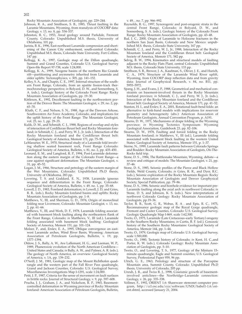
202
Rocky Mountain Association of Geologists, pp. 229–244. Johnson, R. A., and Smithson, S. B., 1985, Thrust faulting in the
Laramie Mountains, Wyoming, from reanalysis of COCORP data: Geology, v. 13, no. 8, pp. 534–537.
Johnston, R. C., 1953, Areal geology around Parkdale, Fremont County, Colorado: Unpublished M.S. thesis, University ofOklahoma, 101 pp.
Jurista, B. K., 1996, Eastnortheast Laramide compression and shortening of the Canon City embayment, southcentral Colorado:Unpublished M.S. thesis, Colorado State University, Fort Collins, 147 pp.
Kellogg, K. A., 1997, Geologic map of the Dillon quadrangle,Summit and Grand Counties, Colorado U.S. Geological SurveyOpenfile Report 97738, scale 1:24,000.
Kellogg, K. A., 1999, Neogene basins of the northern Rio Granderift—partitioning and asymmetry inherited from Laramide and older uplifts: Tectonophysics, v. 305, pp. 141–152.
Kelley, S. A., and Chapin, C. E., 1997, Internal structure of the southern Front Range, Colorado, from an apatite fissiontrack thermochronology perspective; in Bolyard, D. W., and Sonnenberg, S. A. (eds.), Geologic history of the Colorado Front Range: Rocky Mountain Association of Geologists, pp. 19–30.
Kittleson, K., 1992, Decollement faulting in the northwestern portion of the Denver Basin: The Mountain Geologist, v. 29, no. 2, pp. 65–70.
Kluth, C. F., and Nelson, S. N., 1988, Age of the Dawson Arkose, Southwestern Air Force Academy, Colorado, and implcations for the uplift history of the Front Range: The Mountain Geologist, vol. 25, no. 1, pp. 29–35.
Kulik, D. M., and Schmidt, C. J., 1988, Regions of overlap and stylesof interaction of Cordilleran thrust belt and Rocky Mountain foreland; in Schmidt, C. J., and Perry, W. J., Jr. (eds.), Interaction of the Rocky Mountain foreland and the Cordilleran thrust belt: Geological Society of America, Memoir 171, pp. 75–98.
LeMasurier, W. E., 1970, Structural study of a Laramide fold involving shallow seated basement rock, Front Range Colorado: Geological Society of America, Bulletin, v. 81, no. 2, pp. 435–450.
Leonard, E. M., and Langford, R. P., 1994, PostLaramide deformation along the eastern margin of the Colorado Front Range—acase against significant deformation: The Mountain Geologist, v. 31, pp. 45–52.
Logan, J. M., 1966, Structure and petrology of the eastern margin of the Wet Mountains, Colorado: Unpublished Ph.D thesis,University of Oklahoma, 283 pp.
Lovering, T. S. and Goddard, E. N., 1938, Laramide igneous sequence and differentiation in the Front Range, Colorado: Geological Society of America, Bulletin, v. 49, no. 1, pp. 35–68.
Lowell, J. D., 1983, Foreland deformation; in Lowell, J. D, and Gries, R. R.. (eds.), Rocky Mountain foreland basins and uplifts: Rocky Mountain Association of Geologists, pp. 1–8.
Matthews, V., III, and Sherman, G. D., 1976, Origin of monoclinalfolding near Livermore, Colorado: Mountain Geologist, v. 13, no. 2, pp. 61–66.
Matthews, V., III, and Work, D. F., 1978, Laramide folding associated with basement block faulting along the northeastern flank ofthe Front Range, Colorado; in Matthews, V., III (ed.), Laramidefolding associated with basement block faulting: GeologicalSociety of America, Memoir 151, pp. 101–124.
Molzer, P., and, Erslev, E. A., 1995, Oblique convergence on eastwest Laramide arches, Wind River Basin, Wyoming: American Association of Petroleum Geologists, Bulletin, v. 19, pp. 1377–1394.
Oldow, J. S., Bally, A. W., Ave Lallemant, H. G., and Leeman, W. P., 1989, Phanerozoic evolution of the North American Cordillera— United States and Canada; in Bally, A. W., and Palmer, A. R. (eds.), The geology of North America, an overview: Geological Society of America, v. 1A, pp. 139–232.
O’Neill, J. M., 1981, Geologic map of the Mount Richthofen quadrangle and the western part of the Fall River Pass quadrangle,Grand and Jackson Counties, Colorado: U.S. Geological Survey, Miscellaneous Investigations Map I1291, scale 1:24,000.
Petit, J. P., 1987, Criteria for the sense of movement on fault surfaces in brittle rocks: Journal of Structural Geology, v. 9, pp. 597–608.
Prucha, J. J., Graham, J. A., and Nickelson, R. P., 1965, Basementcontrolled deformation in Wyoming province of Rocky Mountain foreland: American Association of Petroleum Geologists, Bulletin,
v. 49, , no. 7, pp. 966–992.Raynolds, R. G., 1997, Synorogenic and postorogenic strata in the
central Front Range, Colorado; in Bolyard, D. W., and Sonnenberg, S. A. (eds.), Geologic history of the Colorado Front Range: Rocky Mountain Association of Geologists, pp. 43–48.
Ruf, J. C., 2000, Origin of Laramide to Holocene fractures in the northern San Juan Basin, Colorado and New Mexico: unpublished M.S. thesis, Colorado State University, 167 pp.
Schmidt, C. J., and Perry, W. J., Jr., 1988, Interaction of the Rocky Mountain foreland and the Cordilleran thrust belt: Geological Society of America, Memoir 171, 582 pp.
Selvig, B. W., 1994, Kinematics and structural models of faultingadjacent to the Rocky Flats Plant, central Colorado: UnpublishedM.S. thesis, Colorado State University, 133 pp.
Smithson, S. B., Brewer, J. A., Kaufman, S., Oliver, J. E., and Hurich, C. A., 1979, Structure of the Laramide Wind River uplift, Wyoming, from COCORP deep reflection data and from gravity data: Journal of Geophysical Research, v. 84, no. B11, pp. 5955–5972.
Spang, J. H., and Evans, J. P., 1988, Geometrical and mechanical constraints on basementinvolved thrusts in the Rocky Mountain foreland province; in Schmidt, C. J., and Perry, W. J., Jr. (eds.), Interaction of the Rocky Mountain foreland and the Cordilleran thrust belt: Geological Society of America, Memoir 171, pp. 41–52.
Stanton, H. I., and Erslev, E. A., 2001, Rotational faultbend folds: an alternative to kinkband models with implications for reservoir geometry and heterogeneity (abs.): American Association of Petroleum Geologists, Annual Convention Program, p. A191.
Stearns, D. W., 1971, Mechanisms of drape folding in the Wyoming province; in Wyoming Tectonics Symposium: Wyoming Geological Association, Guidebook 23, pp. 82–106.
Stearns, D. W., 1978, Faulting and forced folding in the Rocky Mountain foreland; in Matthews, V., III (ed.), Laramide foldingassociated with basement block faulting in the western UnitedStates: Geological Society of America, Memoir 151, p. 1–37.
Sterne, N., 1999, Laramide fault patterns between Colorado Springsand Boulder: Rocky Mountain Association of Geologists, OnTheRocks field trip.
Stone, D. S ., 1984, The Rattlesnake Mountain, Wyoming, debate—a review and critique of models: The Mountain Geologist, v. 21, pp. 37–46.
Stone, D. S., 1985, Seismic profiles of the Pierce and Black Hollow Fields, Weld County, Colorado; in Gries, R. R., and Dyer, R.C. (eds.), Seismic exploration of the Rocky Mountain Region: RockyMountain Association of Geologists and Denver Geophysical Society, Special Publication, pp. 79–86.
Stone, D. S., 1986, Seismic and borehole evidence for important preLaramide faulting along the axial arch in northwest Colorado; in Stone, D. S, and Johnson, K. S. (eds.), New interpretations of northwest Colorado Geology: Rocky Mountain Association of Geologists, pp.19–36.
Taylor, R. B., Scott, G. R., Wobus, R. A . and Epis, R. C., 1975,Reconnaissance geologic map of the Royal Gorge quadrangle, Fremont and Custer Counties, Colorado: U.S. Geological Survey, Geologic Quadrangle Map I869, scale 1:62,500.
Tweto, O., 1975, Laramide (Late Cretaceous–early Tertiary) orogeny in the Southern Rocky Mountains; in Curtis, B. F. (ed.), Cenozoichistory of the Southern Rocky Mountains: Geological Society ofAmerica, Memoir 144, pp. 1–44.
Tweto, O., 1979, Geologic map of Colorado: U.S. Geological Survey, scale 1:500,000.
Tweto, O., 1980, Tectonic history of Colorado; in Kent, H. C.,and Porter, K. W. (eds.), Colorado Geology: Rocky Mountain Association of Geologists, pp. 5–10.
Tweto, O., and Lovering, T. S., 1977, Geology of the Minturn 15minute quadrangle, Eagle and Summit counties; U.S. GeologicalSurvey, Professional Paper 959, 96 pp.
Ulrich, G. E., 1963, Petrology and structure of the Porcupine Mountain area, Summit County, Colorado: Unpublished Ph.Dthesis, University of Colorado, 205 pp.
Unruh, J. R., and Twiss R. J., 1998, Coseismic growth of basementinvolved anticlines—the Northridge–Laramide connection:Geology, v. 26, pp. 335–338.
Vollmer, F., 1992, ORIENT 1.6: Shareware stereonet computer program, http://ccl.osc.edu/cca/software/UNIX/babel11.6/orient.shtml, accessed January 21, 2004.

203
Warner, L. A., 1956, Tectonics of the Colorado Front Range: American Association of Petroleum Geologists, Rocky Mountain Section, Geological Record, pp. 129–144.
Wawrzyniec, T. F., Geissman, J. G., Melker, M., and Hubbard, M., 1999, Dextral shear east of the Colorado Plateau—a kinematic link between the Laramide orogeny and Rio Grande rifting, and a newmodel for rift tectonics (abs.): Geological Society of America, Abstracts with Programs, v. 31, no. 7, p. A115.
Weimer, R. J., and Ray, R. R., 1997, Laramide mountain flank deformation and the Golden fault zone; in Bolyard, D. W., and Sonnenberg, S. A. (eds.), Geologic history of the Colorado Front Range: Rocky Mountain Association of Geologists, pp. 49–64.
West, M. W., 1978, Quaternary geology and reported surface faulting along the east flank of the Gore Range, Summit County,
Colorado: Colorado School of Mines, Quarterly, v. 73, no. 2, 66 pp. Wobus, R. A., Epis, R. C. and Scott, G. R., 1979, Geologic map of the
Cover Mountain quadrangle, Fremont, Park and Teller Counties, Colorado: U.S. Geological Survey, Miscallaneous Investigations Map I1179, scale 1:62,500.
Woodward, L. A., Anderson, O. J., and Lucas, S. G., 1997, Mesozoic stratigraphic constraints on Laramide right slip on the east side ofthe Colorado Plateau: Geology, v. 25, no. 9, pp. 843–846.
Ziegler, V., 1917, Foothills structure in northern Colorado: Journal of Geology, v. 25, pp. 715–740.
Zoback, M. D., Zoback, M. L., Mount, V. S., Suppe, J., Eaton, J. P., Heally, J. H., Oppenheimer, D. H., Reasenberg, P. A., Jones, L. M., Raleigh, C. B., Wong, I. G., Scotti, O., and Wentworth, C. M., 1987, New evidence on the state of stress of the San Andreas Fault System: Science, v. 238, pp. 1105–1111.

204