largest earthquake recorded the largest earthquake ( magnitude 9.5) of the 20th century occurred on...
TRANSCRIPT

Largest Earthquake recorded The largest earthquake
( magnitude 9.5) of the 20th century occurred on May 22, 1960 off the coast of South Central Chile.
It generated one of the most destructive Pacific-wide tsunamis. Huge tsunami waves measuring as high as 25 meters, arrived within 10 to 15 minutes after the earthquake.
Approximately 1,655 killed, 3,000 injured, 2,000,000 homeless, and $550 million damage in southern Chile; tsunami caused 61 deaths, $75 million damage in Hawaii; 138 deaths and $50 million damage in Japan; 32 dead and missing in the Philippines; and $500,000 damage to the west coast of the United States.

1964 Great Alaska Earthquake
On March 27, 1964, at 5:36 p.m. a great earthquake of magnitude 9.2 occurred in Prince William Sound region of Alaska.
This earthquake is the second largest earthquake ever recorded in the world.
The duration of rupture lasted approximately 4 minutes.
In the first day there were 11 aftershocks with magnitudes greater than 6.0; in the next three weeks there were 9 more. Smaller aftershocks continued for more than a year

The damage totaled 300-400 million dollars (1964 dollars).
The number of deaths from the earthquake totaled 131; 115 in Alaska and 16 in Oregon and California.
The death toll was extremely small for a quake of this magnitude due to low population density, the time of day and the fact that it was a holiday (it was Good Friday), and the type of material used to construct many buildings (wood).
The Great 1964 Alaska earthquake generated catastrophic tsunami waves that devastated many towns in the Prince William Sound area of Alaska, along the Gulf of Alaska, along the West Coast of Canada and the United States, and in the Hawaiian islands.
In Alaska, the tsunami height measurements varied from 6.1 m at Kodiak Island, 9.1 m at Valdez, 24.2 m at Blackstone Bay, and 27.4 m at Chenega

Deadliest EarthquakesJanuary 23, 1556-China
The earthquake occurred near Huaxian, Shaanxi (formerly Shensi), China,. More than 830,000 people were killed.
Had an estimated magnitude of 8
Damage extended as far away as Taiyuan, the capital of Shanxi (formerly Shansi) and about 270 miles (430 km) northeast of the epicenter. There are felt reports as far away as Liuyang in Hunan, more than 500 miles (800 km) away.
Geological effects reported with this earthquake included ground fissures, uplift, subsidence, sandblows, liquefaction and landslides. Most towns in the damage area reported city walls collapsed, most to all houses collapsed and many of the towns reported ground fissures with water gushing out (ie. liquefaction and sandblows).

December 26, 2004Off the coast of Northern Sumatra a magnitude 9 undersea
earthquake shook the sea bed off the north west coast of Sumatra. Within hours multiple tsunamis had swept across the Indian Ocean ravaging coastal regions and killing over 220,000 people.


The waves spread out on their voyage of destruction

The power of tsunamis only becomes clear as they approach shallow water along the coast

But from the beaches few people recognised the danger of the white line on the horizon

Hildasan, 50, net-maker
I was repairing some fishing nets in the harbour when I saw the waters rising. I'd never seen anything like it. I began to run for my life - I knew something was very wrong. The rumbling noise, the rising water, just didn't make sense. As I ran inland the sea seemed to be roaring in the background.

Their full force is unleashed as they break on to land

Sundar Raj, 21, fisherman
I was sleeping in our boat when the sea began making a rumbling sound. I saw the water level rising. I jumped into the water and tied my boat to the wharf as the waves began lashing me from behind. I climbed on to the jetty and ran.

The killer wave strikes Kalutara Sri Lanka

“Scale of devastation Thousands are reported to have been killed, but there has been little news from the worst-hit areas where all transport and communication links were destroyed. “ bbc.co.uk 27.12.04
The AftermathEarly reports gave no hint of the scale of the disaster…….

Low lying coastal areas were left obliterated and flooded as here in Aceh province in Sumatra, Indonesia
Current reports indicate that the north and west coasts of Sumatra have experienced the worst destruction
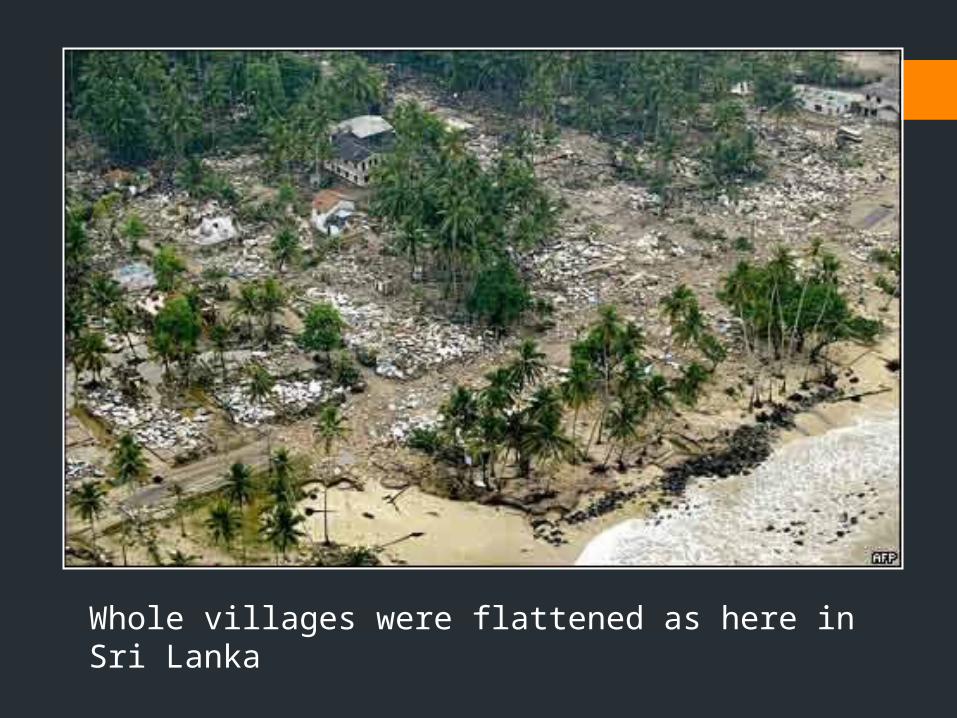
Whole villages were flattened as here in Sri Lanka

Fishing boats, which provide essential food supplies for local people here in India, have been washed ashore

Scenes which were repeated across the Indian Ocean
Sri Lanka
Phuket, Thailand

Low lying areas have been left flooded with seawater which quickly becomes contaminated with sewage and decomposing bodies
Male in the Maldives
Banda Aceh in Sumatra, Indonesia

Relief efforts, which have been slow to start, gather pace as the enormity of the disaster begins to be appreciated
French relief workers from the Medecins Sans Frontieres organisation
German relief workers prepare to depart for Sri Lanka

Haiti Earthquake 2010 The January 12, 2010, Haiti earthquake occurred in the
boundary region separating the Caribbean plate and the North America plate.
It had a magnitude of 7.1 on the Richter Scale This Earthquake resulted in severe damage and casualties in
the Port-au-Prince area. Over 220,000 people were lost and 3.5 MILLION were
affected.


Haiti's presidential palace before (top) and after the earthquake Photo: AFP/GETTY

2011 March 11 –Tohoku Japan Earthquake (9.0 magnitude) was recorded in East Asia, in the Pacific
Ocean.
Recorded near the east coast of Honshu, Japan
129 km away from Sendai, Japan 177km away from Fukushima and Yamagata 373 km away from Tokyo
Depth of only 32km
The tsunami was created by the earthquake
a huge wave (14 m) created hit the coast of Honshu and flooded Japan

Minamisanriku town, Miyagi Prefecture before the tsunami (2001).Source: Sankei Shimbunsha (2011: 31); see also SankeiPhoto (2011).Reproduced by kind permission of Sankei Books.

Minamisanriku town, Miyagi Prefecture after the tsunami (27 March 2011).Source: Sankei Shimbunsha (2011: 31); see also SankeiPhoto (2011).Reproduced by kind permission of Sankei Books.

The Unosumai district of Kamaishi City, Iwate Prefecture before the tsunami (2007).Source: Sankei Shimbunsha (2011, p. 31); see also SankeiPhoto (2011).Reproduced by kind permission of Sankei Books.

The Unosumai district of Kamaishi City, Iwate Prefecture after the tsunami (29 March 2011). Source: Sankei Shimbunsha (2011, p. 31); see also SankeiPhoto (2011).Reproduced by kind permission of Sankei Books.

• At least 15,703 people killed, 4,647 missing, 5,314 injured.
• How? Why so few in comparison?