late cretaceous volcanism in south and central texas...
TRANSCRIPT
LATE CRETACEOUS VOLCANISM IN SOUTH AND CENTRAL TEXAS STRATIGRAPHIC, STRUCTURAL, AND SEISMIC MODELS1
by
T h o m a s E. Ewing 2 and S. Christopher Ca ran 2
ABSTRACT Since their discovery in 1915, hydrocarbon traps in and around "serpentine plugs" have produced about 47
million barrels of oil, and have significant potential for additional small discoveries. Production is from isolated reservoirs within mounds of altered volcanic tuff and associated shoal-water carbonates. A review of the more than 200 volcanic centers and intrusive bodies of South and Central Texas has led to development of stratigraphic and seismic models useful in exploration and production.
The so-called serpentine plugs are largely tuff mounds formed by accumulation of volcanic ash (altered to palagonite) on the seafloor around a submarine volcanic vent. Volcanic activity peaked during deposition of the chalk and marl of the upper Austin and lower Taylor Groups (about 80 million years ago). After their eruption, the tuff mounds localized the deposition of shoal-water carbonates with good porosity and permeability. Low-permeability, organic-rich marine shale and marl of the Taylor Group capped the carbonates, serving as both a hydrocarbon source and a stratigraphic seal. Compactional draping of overlying San Miguel and Olmos sands, with minor offset faulting, created important additional traps in South Texas.
Central Texas volcanic centers are highly aligned along strike-oriented regional faults and fractures of the Balcones and Luling systems. The magmas in both Central and South Texas were ultramafic and alkaline, suggesting that partial melting occurred at depths of about 40 miles (60 kilometers). The magma rose rapidly to the surface, probably in an extensional stress regime controlled by pre-Tertiary Balcones-Luling faults.
The palagonite tuff of a typical productive volcanic center has low seismic velocity and is encased in high-velocity carbonates. The strong velocity contrast, coupled with the distinctive shape of the tuff mass, yields a characteristic seismic pattern. Modern seismic techniques, together with stratigraphic data, allow accurate delineation of buried tuff mounds and prediction of productive carbonate facies.
INTRODUCTION Cretaceous igneous rocks have been found a t more t han
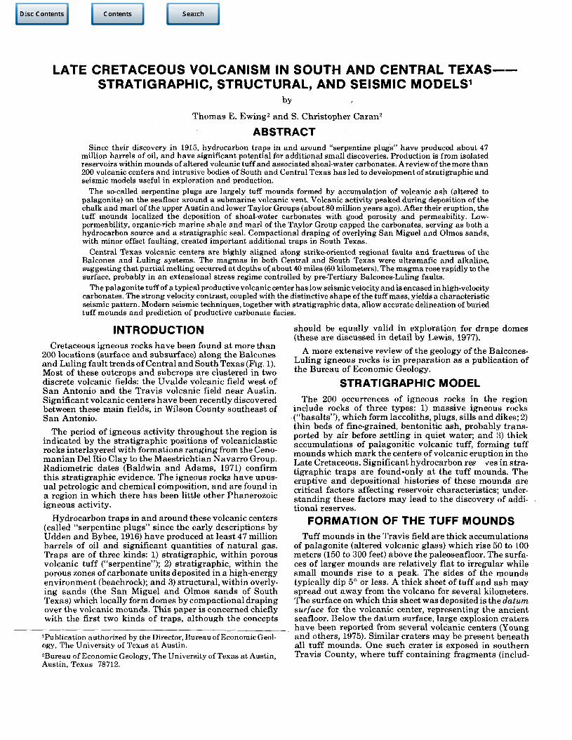
200 locations (surface and subsurface) along the Balcones and Luling fault t rends of Central and South Texas (Fig. 1). Most of these outcrops and subcrops are clustered in two discrete volcanic fields: the Uvalde volcanic field west of San Antonio and the Travis volcanic field near Austin. Significant volcanic centers have been recently discovered between these main fields, in Wilson County southeast of San Antonio.
The period of igneous activity throughout the region is indicated by the s t ra t igraphic positions of volcaniclastic rocks interlayered with formations rang ing from the Ceno-m a n i a n Del Rio Clay to the Maestr icht ian Navar ro Group. Radiometric dates (Baldwin and Adams, 1971) confirm this s t ra t igraphic evidence. The igneous rocks have unusual petrologic and chemical composition, and are found in a region in which there has been little other Phanerozoic igneous activity.
Hydrocarbon t raps in and around these volcanic centers (called "serpentine plugs" since the early descriptions by Udden and Bybee, 1916) have produced at least 47 million barrels of oil and significant quanti t ies of na tu ra l gas. Traps are of three kinds: 1) s trat igraphic, within porous volcanic tuff ("serpentine"); 2) s t ra t igraphic , within the porous zones of carbonate uni ts deposited in a high-energy environment (beachrock); and 3) structural , within overlying s ands (the San Miguel and Olmos sands of South Texas) which locally form domes by compactional draping over the volcanic mounds . This paper is concerned chiefly with the first two kinds of t raps, a l though the concepts
'Publication authorized by the Director, Bureau of Economic Geology, The University of Texas at Austin. 2Bureau of Economic Geology, The University of Texas at Austin, Austin, Texas 78712.
should be equally valid in exploration for drape domes (these are discussed in detail by Lewis, 1977).
A more extensive review of the geology of the Balcones-Luling igneous rocks is in preparat ion as a publication of the Bureau of Economic Geology.
STRATIGRAPHIC MODEL The 200 occurrences of igneous rocks in the region
include rocks of three types: 1) massive igneous rocks ("basalts"), which form laccoliths, plugs, sills and dikes; 2) th in beds of fine-grained, bentonitic ash, probably t ransported by air before settl ing in quiet water; and 3) thick accumulat ions of palagonit ic volcanic tuff, forming tuff mounds which mark the centers of volcanic eruption in the Late Cretaceous. Significant hydrocarbon res ves in strat igraphic t raps are found-only a t the tuff mounds. The eruptive and depositional histories of these mounds are critical factors affecting reservoir characterist ics; unders tand ing these factors may lead to the discovery of addit ional reserves.
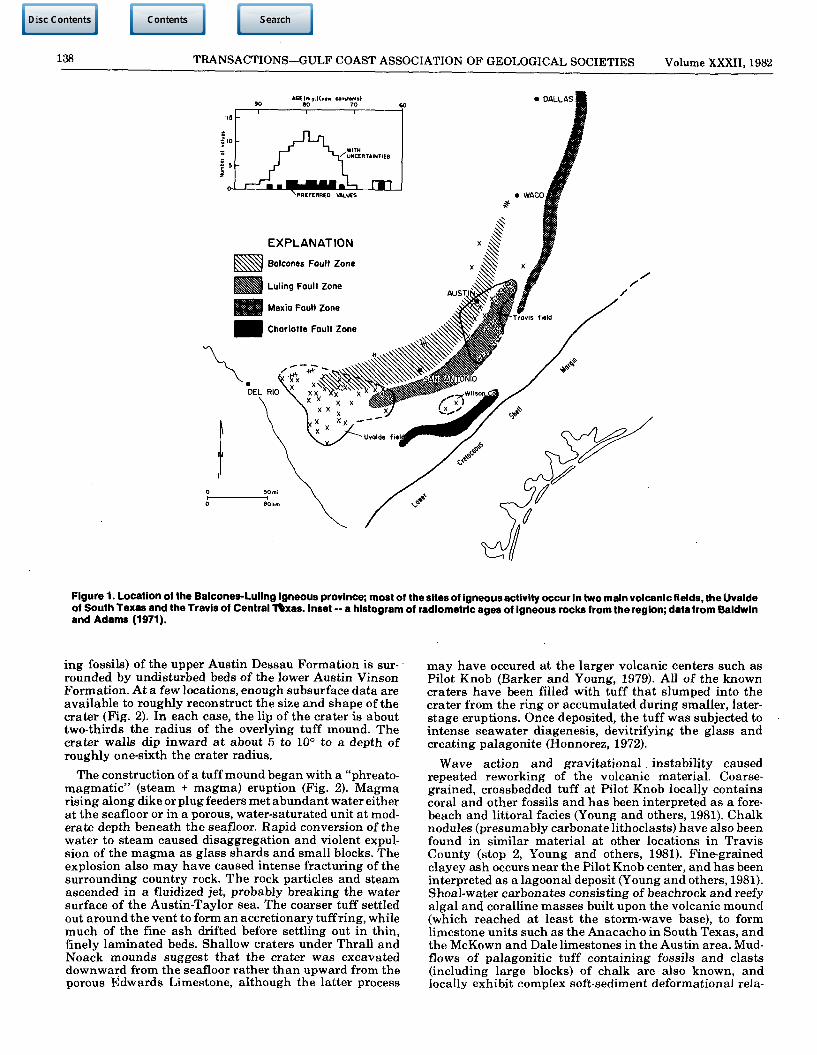
FORMATION OF THE TUFF MOUNDS Tuff mounds in the Travis field are thick accumulat ions
of palagonite (altered volcanic glass) which rise 50 to 100 meters (150 to 300 feet) above the paleoseafloor. The surfaces of larger mounds are relatively flat to irregular while small mounds rise to a peak. The sides of the mounds typically dip 5° or less. A thick sheet of tuff and ash may spread out away from the volcano for several kilometers. The surface on which this sheet was deposited is the datum surface for the volcanic center, representing the ancient seafloor. Below the da tum surface, large explosion craters have been reported from several volcanic centers (Young and others, 1975). Similar craters may be present beneath all tuff mounds. One such crater is exposed in southern Travis County, where tuff containing fragments (includ-
138 TRANSACTIONS-GULF COAST ASSOCIATION OF GEOLOGICAL SOCIETIES Volume XXXII, 1982
90 AGE(m.y.)(ntw constants)
8 0 70 &
<.. 1 I I
| , 0 yw •5 r T- i /uNCERTAINTlES
? 5
J 1 4 f L
r-^i. WmMMMmH m
Figure 1. Location of the Balcones-Luling igneous province; most of the sites of igneous activity occur in two main volcanic fields, the Uvalde of South Texas and the Travis of Central 1%xas. Inset ~ a histogram of radiometric ages of igneous rocks from the region; data from Baldwin and Adams (1971).
ing fossils) of the upper Austin Dessau Formation is surrounded by undisturbed beds of the lower Austin Vinson Formation. At a few locations, enough subsurface data are available to roughly reconstruct the size and shape of the crater (Fig. 2). In each case, the lip of the crater is about two-thirds the radius of the overlying tuff mound. The crater walls dip inward at about 5 to 10° to a depth of roughly one-sixth the crater radius.
The construction of a tuff mound began with a "phreato-magmatic" (steam + magma) eruption (Fig. 2). Magma rising along dike or plug feeders met abundant water either at the seafloor or in a porous, water-saturated unit at moderate depth beneath the seafloor. Rapid conversion of the water to steam caused disaggregation and violent expulsion of the magma as glass shards and small blocks. The explosion also may have caused intense fracturing of the surrounding country rock. The rock particles and steam ascended in a fluidized jet, probably breaking the water surface of the Austin-Taylor sea. The coarser tuff settled out around the vent to form an accretionary tuff ring, while much of the fine ash drifted before settling out in thin, finely laminated beds. Shallow craters under Thrall and Noack mounds suggest that the crater was excavated downward from the seafloor rather than upward from the porous Edwards Limestone, although the latter process
may have occured at the larger volcanic centers such as Pilot Knob (Barker and Young, 1979). All of the known craters have been filled with tuff that slumped into the crater from the ring or accumulated during smaller, later-stage eruptions. Once deposited, the tuff was subjected to intense seawater diagenesis, devitrifying the glass and creating palagonite (Honnorez, 1972).
Wave action and gravitational instability caused repeated reworking of the volcanic material. Coarsegrained, crossbedded tuff at Pilot Knob locally contains coral and other fossils and has been interpreted as a fore-beach and littoral facies (Young and others, 1981). Chalk nodules (presumably carbonate lithoclasts) have also been found in similar material at other locations in Travis County (stop 2, Young and others, 1981). Fine-grained clayey ash occurs near the Pilot Knob center, and has been interpreted as a lagoonal deposit (Young and others, 1981). Shoal-water carbonates consisting of beachrock and reefy algal and coralline masses built upon the volcanic mound (which reached at least the storm-wave base), to form limestone units such as the Anacacho in South Texas, and the McKown and Dale limestones in the Austin area. Mud-flows of palagonitic tuff containing fossils and clasts (including large blocks) of chalk are also known, and locally exhibit complex soft-sediment deformational rela-
EWING, CARAN 139
9QP 30°
Verticol exaggeration'4.5
Figure 2. A schematic model of an erupting submarine volcano.
tionships with the subjacent Austin Chalk (stops 3 and 5, Young and others, 1981). These mudflows may have formed by slumping from the tuff ring into deeper water, as shown in figure 2.
With continuing eruptions and possible regional doming, the phreatic influence on the rising magma diminished, and the eruptive style changed to subaerial lava flows and ash falls. In the Travis field, this transition is observed only at Pilot Knob (see Hill, 1890). There, eight plug-like feeders of nepheline basanite form the Knob itself, while several lava flows are known from the periphery. Tuffs of the subaerial cone are poorly exposed but they may have undergone less palagonitization than did the tuffs of the submarine mound.
In the Uvalde volcanic centers that are best exposed (Knippa and Black Waterhole localities; see Spencer, 1969), the center of a tuff ring or tuff mound is filled with massive igneous rock. At Knippa, this central mass is very large and consists of material accumulated during several eruptive phases. One or more vents are present and there is a thick, extensive unit which may have been a lava lake. At Black Waterhole, a smaller, plug-like or lake-like mass lies between coarse palagonitic tuffs to the north and south. The tuff units to the north are overlain by an extensively altered but unfragmented igneous rock identical to the main mass. Other hills mapped as massive igneous rock in the area may in fact fill the centers of tuff rings that are now concealed by float. These occurrences indicate that the steam explosions responsible for ash formation had largely ceased in the later stages oferuption as the mound rose above sea level through rapid deposition or regional doming.
ACCUMULATION OF THE CARBONATE FACIES
As mentioned above, the creation of a tuff-mound volcanic island in the Austin-Taylor sea provided a platform for shallow-water carbonate build-up, producing a facies quite different from the usual Austin and Taylor rock types. The geometry and petrology of the carbonate bodies has been studied in detail at the Elaine field, Dimmit County (Luttrell, 1977), and at Pilot Knob, Travis County (see Young and others, 1981).
Five carbonate facies have been described at the Elaine field. The open shelf extending in all directions away from the volcanic island was characterized by deposition of carbonate mudstone/wackestones containing abundant planktonic foraminifera. Nearer the volcanic center, a shoal complex developed, which included rudistid and algal patch reefs producing rudist-algal-echinoid pack-stone/boundstone, beach deposits of oyster-echinoid-algal grainstone, and a halo, of oyster-echinoid-green algal pack-stone detritus shed into deeper water. Between the volcanic island and the shoal complex was a sheltered lagoon in which rippled, burrowed oyster-echinoid-algal packstone-/wackestone were deposited, with occasional tidal washov-ers of grainstone. The shoal complex is best developed on the northeast side of the Elaine volcano, with only local shell accumulations and little reworking on the southwest flank. Luttrell suggests this distribution indicates the prevailing currents were from the northeast, which favored development of reefs and provided energy for reworking bottom sediments onto beaches and bars in that area.
140 TRANSACTIONS-GULF COAST ASSOCIATION OF GEOLOGICAL SOCIETIES Volume XXXII, 1982
At Pilot Knob, the McKown shallow-water limestone is well developed on the northeast, north, and northwest sides of the volcanic center (Young and others, 1981). The McKown is an oyster-algal grainstone beachrock (oyster-shell fragments predominant) which generally overlies volcaniclastic beachrock, mudflows, or lagoonal deposits. The source of the shelly debris composing the beachrock is not exposed in outcrop. The carbonate facies resist erosion and form a pronounced cuesta surrounding the Pilot Knob volcano; the cuesta has been breached by Onion Creek and disrupted by Balcones-trend faulting. The beachrock facies is overlain in outcrop by marls or claystones of open-shelf facies. Lagoonal deposits at Pilot Knob consist of volcanic ash locally containing small, in-place masses of colonial corals.
Shoal-water carbonates similar to the Anacacho at Elaine field and the McKown at Pilot Knob have been reported in drilling records from many buried volcanic centers and are the principal producing horizon in many of the oil fields in the area. At Thrall field, Williamson County (Fig. 3), the carbonate unit was described by Udden and Bybee (1916) as a thin, porous shell breccia on the northeast flank, becoming chalky and irregular in thickness to the southwest. This relationship is similar to that seen at both Pilot Knob and Elaine field, suggesting a regional pattern of predominantly northeast ocean currents and/or winds. At Thrall field, a mound of porous shell breccia is also located northwest of the volcano; carbonate deposition in that area appears to have been localized on a ridge (possibly a mudflow apron) extending northward from the volcanic center. Some volcanoes, notably the large Lytton Springs center, have little or no documented carbonate development.
Extensive shallow-water, high-energy carbonates (shoal complexes) are known from outcrops and from the shallow subsurface west of San Antonio; these deposits constitute a distinct stratigraphic unit, the Anacacho Formation. There were apparently two main areas of Anacacho deposition, one centered in Medina County, the other in the Anacacho Mountains of southern Kinney County (Fig. 4). The Anacacho is part of the lower Taylor Group, built upon the Austin Chalk and overlain either conformably by the Upson Clay (lower Taylor Group), or unconformably by the Escondido Formation (Navarro Group). The sub-Escondido unconformity appears to coincide with the distribution of both the Anacacho Formation and the updip Uvalde volcanic centers. W. F. Wilson (personal communication, 1981) suggests that the Anacacho consists of massed reef beach complexes built around clusters of volcanic centers. The presence of detrital fragments of tuff and igneous rock in the Anacacho, as well as the general age and geometry of the unit, appears to support this contention. Igneous masses are mapped (Barnes, 1974) in contact with Anacacho, but the precise nature of the relationship is not yet known. Work in progress (Douglas Wilson, University of Texas at Arlington) in the Anacacho Mountains may clarify this problem.
The diagenesis of the carbonate sediments has been described in detail by Luttrell (1977). The diagenetic model proposes ionic exchange by meteoric (fresh), waters beneath the beach facies and within the volcanic island, inducing dissolution of aragonite and high-magnesium calcite grains and precipitation of low-magnesium calcite and limpid dolomite. Porosity is generally enhanced in this diagenetic zone. Marine diagenesis occured within the
lagoon and the offshore environments and was characterized by abrasion and micritiztion of carbonate grains, and precipitation of aragonite and magnesium-calcite cement. Later, cementation by equant clacite and stylolite formation occurred, during burial and compaction.
STRUCTURAL MODEL The stratigraphy and diagenetic history of volcanic
rocks and associated carbonates control the quality and extent of hydrocarbon traps at volcanic centers. However, the locations of these centers seem to be controlled in turn by regional structures. The distribution of volcanic centers as presently known is not random; instead, they are aligned with identifiable structural and tectonic features. They also exhibit trends not clearly related to recognized features.
As seen in figure 1, volcanic and intrusive bodies form a broad swath through South and Central Texas, more or less along the Balcones Fault Zone. However, it has been thought for many years (Lonsdale, 1927) that no volcanic features existed near San Antonio, so that there was a gap in the volcanic trend. The recent discovery of at least two large volcanic centers in Wilson County (Roy and others, 1981) implies the volcanic trend is more continuous than previously supposed. The belt of most intense volcanic activity may form a sharply bent curve extending from northeast of Austin, southwestward to Wilson County at the bend, then west into the broad area of the Uvalde field. Future exploration may serve to bridge the gaps to the northeast and west of the Wilson County centers.
Within the Travis field (Fig. 3), the volcanic centers are conspicuously aligned, forming a well-defined trend oriented N30E, parallel to the Luling and Balcones fault trends in the area (Woodruff and Caran, 1981). This trend includes the two largest volcanoes of the field, Pilot Knob and Lytton Springs (the largest oil field in the volcanic province). Faulting is directly associated with several of the tuff mounds, and is suspected at others. The original reports on Lytton Springs, Yoast, and Buchanan oil fields inferred as much as 200 feet (60 meters) of movement on these faults after deposition of the Austin Group (immediately beneath the buried tuff mounds) but prior to Wilcox deposition (Sellards, 1932). Little recent work has been done on the history of Luling and Balcones fault movement. The earliest episode of Balcones (and, by inference, Luling) faulting has been traditionally considered to be Miocene (Weeks, 1945). The alignment of Cretaceous volcanic centers, however, shows that Luling faults existed in Central Texas in Austin-Taylor time, and localized at least the later stages of magmatic ascent.
Study of the massive igneous rocks (nepheline basanite) exposed at Pilot Knob (Barker and Young, 1979) indicates the source of the magma lay at a minimum depth of 35 ± 10 miles (60 ± 15 kilometers). The fractures along which the magma ascended were thus major structural features, extending through the entire crust to the upper mantle. None of the rocks known from the Travis field gives evidence of more differentiation than is indicated by nepheline basanite. This suggests that no large, long-lived magma reservoirs existed in the area.
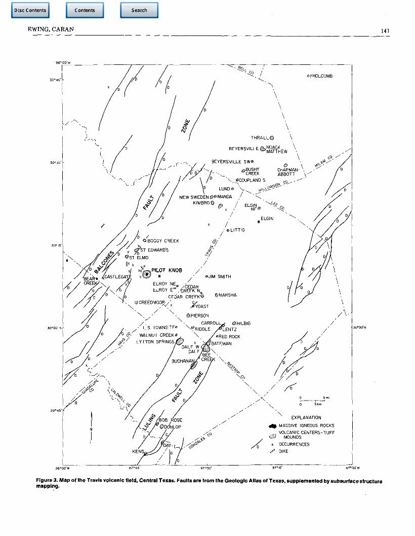
EWING, CARAN 141
Figure 3. Map of the Travis volcanic field, Central Texas. Faults are from the Geologic Atlas of Texas, supplemented by subsurface structure mapping.
142 TRANSACTIONS—GULF COAST ASSOCIATION OF GEOLOGICAL SOCIETIES Volume XXXII, 1982
~T EXPLANATION '
*% MASSIVE IGNEOUS ROCKS J \ _ _
O VOLCANIC CENTERS-TUFF MOUNDS
X OCCURRENCES V„/ U*
HW* DIKE /
!* • ,03*«*
'PINTO MTN. • 2^ 4L
LAS MORAS MTN 4 V f u R K E Y MTN.
MUSTANG HILL*
OBI HILL* ,
IREEN M T N ^ C O * * - ! ^ - ^ - ^ t
^.'BLACKjWATERHOLE .NUECES HILL . ,
*XINGE MTN *• * '
,TATLOR HILLS
KINNEY CO. MAVERICK CO.
W?^SiSpH::*;#:::*WEYMiLLER ^-^•iiffiSaSSIjK^MBUTTE , tWOODLEY
- v w x . . ^ ^ j j _ a .%NCX|O % _
X RS MATTHEWS
O X
ZAVALA CO.
^SERBA
\
.STIOHAM
^
V c < * .
_ _ _LEE PRYOR GATO C K * o" ° °
| 0 o <7° SABLE O CHAPARROSA* 0MATTHEWS « o 0
PRE5A* * o ^ *EMMA MANGUM | O ELEVEN HAMMOND
PLUMLY- HIGH * * „ - ncwooTH | " .LONESOME eHOLDSWORTM I * RANOOLPH. INDEPENDENCE I DEL MONTE, 0 1 N 0 I 0
I O SPINACH* l » TORCH*
k. r -<y DIMMlfcO ^ > i L A I N E
.INDIAN MOUND
TORTUGAS
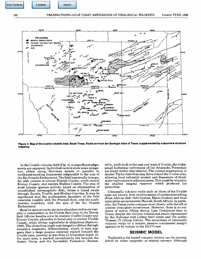
Figure 4. Map of the Uvalde volcanic field, South Texas. Faults are from the Geologic Atlas of Texas, supplemented by subsurface structure mapping.
In the Uvalde volcanic field (Fig. 4), no significant alignments are apparent. Individual centers show some elongation either along Balcones trends or parallel to northwest-trending lineaments subparallel to the axis of the Rio Grande Embayment. The field is generally triangular with corners in central Dimmit County, north-central Kinney County, and eastern Medina County. The area of most intense igneous activity, based on examination of unpublished aeromagnetic data, forms a broad swath through Zavala, Uvalde, and Medina Counties. It may be significant that the southeastern boundary of the field coincides roughly with the Pearsall Arch, and the southwestern boundary with the axis of the Rio Grande Embayment.
Massive igneous rocks are more abundant and more variable in composition in the Uvalde field than in the Travis field. Olivine basalts occur in western Uvalde County and Kinney County; phonolite is found only in central Uvalde County; while olivine nephelinite is ubiquitous (Spencer, 1969). The phonolites imply a prolonged evolution through extensive magmatic differentiation, which in turn suggests that a large magma reservoir existed beneath the Uvalde area, possibly at less than 15 kilometers depth. In the same area, a marked unconformity lies between the Austin Group and the Escondido Formation (Barnes,
1974), while both to the east and west of Uvalde, the widespread biohermal carbonates of the Anacacho Formation are found within this interval. The intense magmatism in Austin-Taylor time thus may have domed the Uvalde area, allowing local subaerial erosion and deposition of shoal-water carbonates in adjacent areas. This could be related to the shallow magma reservoir which produced the phonolites.
Ultramafic volcanic rocks such as those of the Uvalde suite are known from environments of continental rifting (East African Rift, Oslo Graben, Rhine Graben) and from intra-plate environments (Hawaii, South Africa). In particular, the Texas rocks compare most closely with the rift or oceanic intra-plate occurrences. However, there is no evidence of active rifting during Late Cretaceous time in Texas, despite the obvious extensional strain represented by the Balcones and Luling fault zones and the earlier Triassic (?) rifting history. The occurrence of ultramafic volcanic rocks on a mature, passive continental margin appears to be unique to the Gulf Coast.
SEISMIC MODEL Exploration for buried volcanic centers can be accomp
lished by either magnetic or seismic surveys. Although
EWING, CARAN 143
magnetic surveys can be highly successful in finding the volcanic centers (Jenny, 1951), data concerning the detailed geometry of the centers - essential in locating prospective porosity traps - is revealed only by seismic reflection or, of course, by drilling.
Mafic igneous rocks have high P-wave velocities of from 18,000 to 24,000 feet per second (5.4 to 6.5 kilometers per second), which is substantially higher than typical values of limestones such as the Austin (12,000 to 16,000 feet per second) or shales such as the Taylor (10,000 to 12,000 feet per second). Thus, a mass of mafic to ultramafic igneous rock should produce a strong positive reflection and may in fact reflect most of the incoming seismic energy, producing a shadow zone beneath it. Because of the high velocity of the igneous rock, there should also be a substantial pull-up of any reflectors seen below the mass.
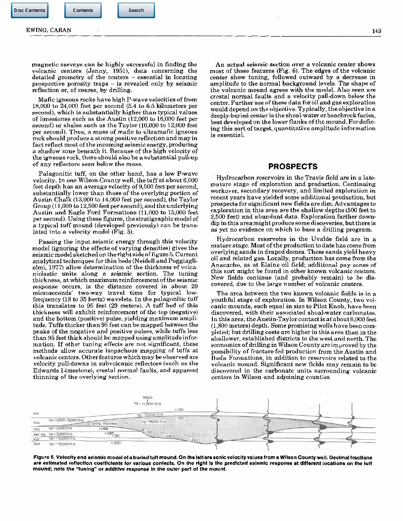
Palagonitic tuff, on the other hand, has a low P-wave velocity. In one Wilson County well, the tuff at about 6,000 feet depth has an average velocity of 9,500 feet per second, substantially lower than those of the overlying portion of Austin Chalk (13,000 to 14,000 feet per second), the Taylor Group (11,000 to 12,500 feet per second), and the underlying Austin and Eagle Ford Formations (11,000 to 15,000 feet per second). Using these figures, the stratigraphic model of a typical tuff mound (developed previously) can be translated into a velocity model (Fig. 5).
Passing the input seismic energy through this velocity model (ignoring the effects of varying densities) gives the seismic model sketched on the right side of figure 5. Current analytical techniques for thin beds (Neidell and Poggiagli-olmi, 1977) allow determination of the thickness of volca-niclastic units along a seismic section. The tuning thickness, at which maximum reinforcement of the seismic response occurs, is the distance covered in about 20 microseconds' two-way travel time for typical low-frequency (18 to 35 hertz) wavelets. In the palagonitic tuff this translates to 95 feet (29 meters). A tuff bed of this thickness will exhibit reinforcement of the top (negative) and the bottom (positive) pulse, yielding maximum amplitude. Tuffs thicker than 95 feet can be mapped between the peaks of the negative and positive pulses, while tuffs less than 95 feet thick should be mapped using amplitude information. If other tuning effects are not significant, these methods allow accurate isopachous mapping of tuffs at volcanic centers. Other features which may be observed are velocity pull-downs in subvolcanic reflectors (such as the Edwards Limestone), crestal normal faults, and apparent thinning of the overlying section.
9 5 0 0
Vp= 11,500 (1/8
+ .061
An actual seismic section over a volcanic center shows most of these features (Fig. 6). The edges of the volcanic center show tuning, followed outward by a decrease in amplitude to the normal background levels. The shape of the volcanic mound agrees with the model. Also seen are crestal normal faults and a velocity pull-down below the center. Further use of these data for oil and gas exploration would depend on the objective. Typically, the objective in a deeply-buried center is the shoal-water or beachrockfacies, best developed on the lower flanks of the mound. For defining this sort of target, quantitative amplitude information is essential.
PROSPECTS Hydrocarbon reservoirs in the Travis field are in a late-
mature stage of exploration and production. Continuing workover, secondary recovery, and limited exploration in recent years have yielded some additional production, but prospects for significant new fields are dim. Advantages to exploration in this area are the shallow depths (500 feet to 2,500 feet) and abundant data. Exploration farther down-dip in this area might produce some discoveries, but there is as yet no evidence on which to base a drilling program.
Hydrocarbon reservoirs in the Uvalde field are in a mature stage. Most of the production to date has come from overlying sands in draped domes. These sands yield heavy oil and related gas. Locally, production has come from the Anacacho, as at Elaine oil field; additional pay zones of this sort might be found in other known volcanic centers. New fields continue (and probably remain) to be discovered, due to the large number of volcanic centers.
The area between the two known volcanic fields is in a youthful stage of exploration. In Wilson County, two volcanic mounds, each equal in size to Pilot Knob, have been discovered, with their associated shoal-water carbonates. In this area, the Austin-Taylor contact is at about 6,000 feet (1,800 meters) depth. Some promising wells have been completed; but drilling costs are higher in this area than in the shallower, established districts to the west and north. The economics of drilling in Wilson County are improved by the possibility of fracture-fed production from the Austin and Buda Formations, in addition to reservoirs related to the volcanic mound. Significant new fields may remain to be discovered in the carbonate units surrounding volcanic centers in Wilson and adjoining counties.
Figure 5. Velocity and seismic model of a buried tuff mound. On the left are sonic velocity values from a Wilson County well. Decimal fractions are estimated reflection coefficients for various contacts. On the right is the predicted seismic response at different locations on the tuff mound; note the "tuning" or additive response in the outer part of the mount.

144 TRANSACTIONS-GULF COAST ASSOCIATION OF GEOLOGICAL SOCIETIES Volume XXXII, 1982
17 >'.
Figure 6. Seismic section across a burled tull mound in Wilson County. Top - uninterpreted section; bottom - Interpreted section

EWING, CARAN 145
ACKNOWLEDGMENTS The authors wish to thank Dr. Keith Young, Department
of Geological Sciences, The University of Texas at Austin, for his continuing input of ideas; also Dr. Ed Roy, Trinity University, San Antonio; Mark Eidelbach, Mark IV Energy, San Antonio; M. D. Macgregor, consultant, San Antonio; W. F. Wilson, Placid Oil Company, Dallas; and Dorchester Resources, Houston for their cooperation and encouragement. The manuscript was critically reviewed by C. M. Woodruff, Jr., of the Bureau of Economic Geology.
REFERENCES CITED Baldwin, O.D. and J.A.S. Adams, 1971, K40/Ar40 ages of
the alkalic igneous rocks of the Balcones fault trend of Texas: Texas Journal of Science, v. 22, nos. 2 and 3, p. 223-231.
Barker, D.S. and K.P. Young, 1979, A marine Cretaceous nepheline basanite volcano at Austin, Texas: Texas Journal of Science, v. 31, no. 1, p. 5-24.
Barnes, V.E., 1974, San Antonio sheet: University of Texas at Austin, Bureau of Economic Geology, Geologic Atlas of Texas.
Hill, R.T., 1890, Pilot Knob, a marine Cretaceous volcano: American Geologist, v. 6, p. 286-292.
Honnorez, J., 1972, La palagonitization, l'alteration sous-marine du verre volcanique basique de Palagonia (Sicile): Basel, Birkhauser Verlag, 130 p. (Vulkaninsti-tut Immanuel Friedlaender, ETH Zurich, no. 9).
Jenny, W.P., 1951, Aerial magnetic oil discoveries: World Oil, v. 133, no. 6, 85-91.
Lewis, J.O., 1977, Stratigraphy and entrapment of hydrocarbons in the San Miguel sands of Southwest Texas: Gulf Coast Association of Geological Societies Transactions, v. 27, p. 90-98.
Lonsdale, J.T., 1927, The igneous rocks of the Balcones Fault region of Texas: Austin, University of Texas Bulletin 2744, 178 p.
Luttrell, P.E., 1977, Carbonate diagenesis and facies distribution of the Anacacho Limestone associated with a Late Cretaceous volcano in Elaine Field, Dimmit County, Texas: The University of Texas at Austin, Master's thesis, 122 p.
Neidell, N.S. and E. Poggiagliolmi, 1977, Stratigraphic modeling and interpretation - geophysical principles and techniques: in C.E. Payton, ed., Seismic stratigraphy - applications to hydrocarbon exploration: Tulsa, AAPG Mem. 26, p. 389-416.
Roy, E.C., Jr., Eidelbach, M., andTrumbly, N., 1981, A Late Cretaceous calcarenite beach complex associated with submarine volcanism, Wilson County, Texas: Gulf Coast Association of Geological Societies Transactions, v. 31, p. 173-178.
Sellards, E.H., 1932, Oil fields in igneous rocks in Coastal Plain of Texas: AAPG Bull., v. 16, no. 8, p. 741-768.
Spencer, A.B., 1969, Alkalic igneous rocks of the Balcones province, Texas: Journal of Petrology, v. 10, pt. 2, p. 272-306.
Udden, J.A. and Bybee, H.P., 1916, The Thrall oil field: Austin, University of Texas Bulletin 1666, 78 p.
Weeks, A.W., 1945, Balcones, Luling, and Mexia Fault Zones in Texas: AAPG Bull., v. 29, no. 12, p. 1733-1737.
Woodruff, CM., Jr. and S.C. Caran, 1981, Lineaments perceived on Landsat imagery of Central Texas -applications to geothermal resource assessment, in C.A. Ruscetta and Duncan Foley, eds., Geothermal Direct Heat Program, Glenwood Springs Technical Conference Proceedings, v. 1: Salt Lake City, University of Utah Research Institute, Earth Science Laboratory, p. 258-270.
Young, K.P., D.S. Barker, and E.C. Jonas, 1975, Stratigraphy of Austin Chalk in the vicinity of Pilot Knob: Geol. Soc. of America, south-central section, ninth annual meeting field trip guidebook, 28 p.
Young, K.P., S.C. Caran, and T.E. Ewing, 1981, Cretaceous volcanism in the Austin area, Texas: Austin Geological Society Guidebook 4, 68 p.