latitude & longitude, map types, map skills · latitude & longitude, map types, map skills...
TRANSCRIPT

Latitude & Longitude,Map Types,Map Skills
September 2017

Weekly Plan
Monday 9/18-Latitude and LongitudeTuesday 9/19-Lat/Long & Map SkillsWednesday 9/20-Map Types ContinuedThursday 9/21-Geography StationsFriday 9/22-Geography Stations
Geography Test: ?

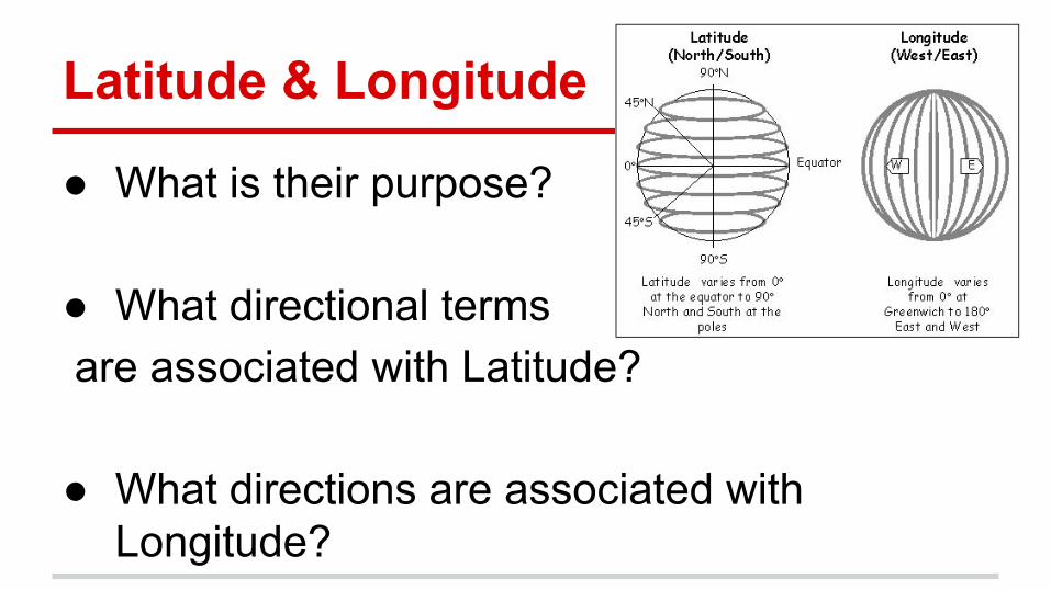
Latitude & Longitude
Warm up work starts this week :)Complete Monday’s warm up work.
Latitude & Longitude
● What is their purpose?
● What directional terms are associated with Latitude?
● What directions are associated with Longitude?

Latitude & Longitude
● In what order should the lat./long. points be written?
Find Latitude first. Then find Longitude. (Lat. Long.)(°N/S, °E/W)

Latitude and Longitude Practice
40°N, 105°W45°N, 120°W40°N, 90°W30°N, 100°W35°N, 80°W

What is the continent?
When I give you a coordinate, raise your hand to tell me the continent it is in.*Use atlas page 10-11
60°N, 105°W30°S, 135°E30°N, 0°45°N, 90°E30°S, 60°WChallenge: 25°N, 100°W

What is the country?
When I give you a coordinate, raise your hand to tell me the country it is in.*Use atlas page 12-13
15°S, 45°W60°N, 135°E30°N, 60°E45°N, 120°W

A map of Africa is shown below.
1. Which city is located near the coordinate point 5°South, 40°East ?
A. Tunis C. Accra
B. Kinshasa D. Dar es Salam
2.Which city is located on the equator?
A. Antananarivo C. Libreville
B. Cape Town D. Algiers
3. Which city shown on this map is located the furthest south in Africa.
A. Maputo C. Tripoli
B. Cape Town D. Dakar
4. In which Hemisphere is most of Africa?
A. Eastern Hemisphere
B. Western Hemisphere

Individual Practice
1. Pick up the coordinate riddle page from the front table
2. If you get finished, create your own riddle on the back of the riddle sheet to share with a classmate

Latitude & Longitude Skills
Pass back yellow folders.Work on your warm up work!

Latitude and Longitude
● Draw a globe on the back of your page● Draw lines of latitude
○ = Latitude ○ Measured in °N or °S
● Draw lines of longitude○ = Longitude○ Measured in °E or °W
**Make sure you show that the lines curve with Earth’s surface


Latitude Read & RespondUse the texts below to answer the questions.
Highlight or underline any vocabulary words you see.
We will do the first few together...

Question 1Relative location is the position of a place
compared to another place. You can use it to describe what something is next to or near. For example, you could say that Yemen is a country east of the Red Sea.
But what if you don’t know where the Red Sea is either?
Absolute location is the exact position of a place on Earth. To describe it, you can use coordinates of latitude and longitude. For example, Spanish Town, Jamaica, is located at 18°N, 77°W. Anyone can use a map to find that exact spot on the globe.
Which of the following correctly describes the relative location of Saudi Arabia?
A. Saudi Arabia shares its eastern border with Sudan.
B. Saudi Arabia is south of Ethiopia.
C. Saudi Arabia is north of Yemen.
D. Saudi Arabia is between Djibouti and Somalia.

Question 2Latitude lines run east to west around the globe.
You can remember it this way: Latitude lines are flat!Latitude lines run east to west, but they actually
give us a location that is a certain number of degrees north or south of the equator. If you were 50 degrees north of the equator, your latitude would be 50° N.
Which of the following describes a line of latitude?
A. 30°W
B. 90°S
C. 40°E
D. All of the above

Question 3In math, angles are used to describe sections of
a circle. Since the Earth is round, we measure latitude and longitude with the same measurement that we use for angles: degrees. The symbol for degrees looks like this: °
When we write the coordinates of a location, we write the latitude first (north or south) and then the longitude (east or west). We separate the two with a comma.
When a place does not land on a whole number degree, there are a few ways to describe absolute location. One way is to use decimals to describe a portion of a degree. Yerevan, Armenia, is 40.2 degrees north of the equator (latitude) and 44.5 degrees east of the Prime Meridian (longitude). It’s located at: 40.2° N, 44.5° E.
Bedford, Pennsylvania, is very close to the 40°N line of latitude but not exactly on it. Which of these is true?A. You can't describe Bedford's absolute location.B. 40° N is as close as you can describe Bedford's
latitude.C. Bedford has longitude but no latitude.D. You can describe Bedford's latitude with a
decimal.

Question 4Did you know that the region of Earth
surrounding the equator is called the tropics? This area
is between the Tropic of Cancer at 23.5° N and the
Tropic of Capricorn at 23.5° S latitude. The tropics
experiences no dramatic change in seasons because the
sun is always high in the sky. People who live north of
the Tropic of Cancer and south of the Tropic of
Capricorn—that is, farther from the equator in either
direction—experience more dramatic seasonal climate
changes.
Which of the following continents is entirely
outside of the tropics?
A. AfricaB. EuropeC. AsiaD. Australia

Question 5A hemisphere is a half of the globe. The equator splits the globe into the Northern and Southern Hemispheres. The Prime Meridian splits the globe into the Eastern and Western Hemispheres.
Even without a map, latitude and longitude tell us the hemispheres in which a place is located. For example, Foso, Lesotho, is located at 29.2° S, 27.3° E. This tells us it is south of the equator (latitude) and east of the Prime Meridian (longitude). We know from these coordinates that it’s in the Southern and Eastern Hemispheres.
Which of these coordinates describes a place in
the Northern and Western Hemispheres?
A. 100° N, 18° W
B. 29.2° S, 27.3° E
C. 30° N, 45° E
D. 2° N, 1° E

Individual Practice
1. Answer the next two questions on your own.
2. Finish your Map Mystery riddle sheet.
3. If you get finished, create your own riddle on the back of the riddle sheet to share with a classmate.

Maps and Map Skills
Pass back yellow folders.Work on your warm up work!

Let’s Discuss!
In your Yellow Notebook- Write on the following topic:
What do you think is important to have on a map in order for someone to be able to read it?
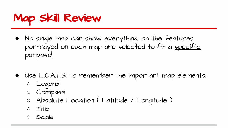
Map Skill Review
● No single map can show everything, so the features portrayed on each map are selected to fit a specific purpose!
● Use L.C.A.T.S. to remember the important map elements. ○ Legend ○ Compass○ Absolute Location ( Latitude / Longitude )○ Title ○ Scale

L.C.A.T.S.
● Legend - A guide identifying what the map’s symbols and colors represent.
● Compass - indicates the cardinal directions and the intermediate directions.
● Absolute Location - The latitude lines (N or S of the Equator) and the longitude lines (W or E of the Prime Meridian).

Absolute Location

L.C.A.T.S. Cont.
● Title - Tells you what the map is supposed to portray; what is happening, where, and when.
● Scale - Tells you the relationship between the distance on a map and actual distance on the earth.


STOP! Let’s Discuss!
● Take a minute to talk to the people at your table about what the difference between a reference map and a thematic map is.
● Be ready to have something to share, as I will call on each table to give a response.

Reference vs. Thematic Maps
● There are two main types of maps, based on their design purpose.
● Reference (or general purpose) maps depict selected details of the physical and human-made environment as accurately as possible.
● They use symbols to locate and identify important geographical features.

Reference Maps
● Some examples of reference maps include:○ Road maps, classroom wall maps, political maps ,
physical maps, satellite map and topographic maps.
● A topographic map is a special reference map that shows coastlines, cities, and rivers that use shades of different colors to show elevation differences.

Road Maps
Topography Maps

Satellite map of the Aral Sea overtime.

Reference Maps
● A political map is a reference map that shows country and state borders, capitals, and cities
● A physical map is a reference map that shows landforms such as mountains and valleys, rivers and lakes

Examples of Reference Maps
Physical Map of North America

Practice Turn to your neighbor to discuss and answer
the following questions: Look at the two maps to the right.
1. Which type of map would be more useful in determining the countries through which the Euphrates River flows?
A. Topographical Map (Physical Map)
B. Political Map
Explain your reasoning….
2. Which type of map would you use if you wanted to find out if there were mountain ranges located in Syria? Why?
A. Topographical Map B. Political Map

Thematic Maps
● Thematic (also called special purpose) maps focus on one geographic theme, or subject.○ Economic○ Climate○ Precipitation○ Vegetation○ Environmental○ Population○ Religion/Culture

Examples of Thematic Maps
Climate Map
of North America

Random Thematic Maps


Make your own digital thematic map
http://mapmaker.nationalgeographic.org/#/

Thematic Map Project
● You are going to be designing a thematic map of a continent of your choosing.
● You will have the choice of designing a climate, population, environments, or economic activity thematic map. You will use your Atlas as your primary resource (A. pg 80-81).

When designing your map...
● First. Look through your atlas to help you choose which continent you want to do and what type of thematic map you want.
● Then select a title for your map that matches your maps purpose.
● Fill these choices out on your rubric before coming to me to get your map outline.

Thematic Map Rubric