lbhf strategic flood risk assessment final dec 2016 · strategic flood risk assessment final ......
TRANSCRIPT

London Borough of Hammersmith and Fulham Strategic Flood Risk Assessment Final December 2016

Quality Management
Job No CS065246
Project London Borough of Hammersmith and Fulham Strategic Flood Risk Assessment Update
Location L:\Environment\ZWET\CS065426_RBKC_and_LBHF_SWMP_and_SFRA_Update\Rep
orts and Outputs\SFRA\LBHF SFRA Main Report_Update\
Document Ref LBHF_SFRA_Final_December_2016 Issue / Revision 45
Date December 2016
Prepared by 1 Sharla McGavock Signature (for file)
Prepared by 2 Elisabeth Rewcastle Signature (for file)
Checked by Louise Markose Signature (for file)
Authorised by Michael Arthur Signature (for file)
Revision Status / History
Rev Date Issue / Purpose/ Comment Prepared Checked Authorised
1 28/05/2014 Draft for comment LT / ER PH MA
2 4/12/2014 Final Draft SM / ER LM MA
3 03/03/2015 Final GA LM LM
4 18/02/2016 Final - Updated GA LM LM
5 05/12/2016 Final –Updated – Revised PB GW GW

Executive Summary
Introduction
This report is a Strategic Flood Risk Assessment (SFRA) for London Borough of Hammersmith and Fulham
(LBHF). This SFRA is an update to the LBHF SFRA (2010) and has been prepared in accordance with current
best practice, the National Planning Policy Framework (NPPF) and its accompanying Flood Risk and Coastal
Change Planning Practice Guidance (PPG). It utilises a number of new datasets that were not available at the
time of the 2010 SFRA, including the 2016 Surface Water Management Plan (SWMP), Areas Susceptible to
Groundwater Flooding (AStGWF) mapping and revised breach analysis using the Environment Agency
Thames Tidal Breach Modelling Study completed in 2015.
The SFRA is a study to assess present and future flood risk to the Borough from all sources and assess the
impact that development will have on flood risk. It enables LBHF to select and develop sustainable site
allocations away from vulnerable flood risk areas. The assessment focuses on existing site allocations within
the Borough but also sets out the procedure to be followed when assessing additional sites for development in
the future. The SFRA will assist LBHF in making the spatial planning decisions required to inform the Local
Plan.
Flood Risk in Hammersmith and Fulham
A thorough review of existing information and additional modelling work were used to identify the level of flood
risk from all sources present within the Borough. The SFRA identified that the most significant sources of flood
risk within the LBHF are surface water, sewer and groundwater flooding. There is also tidal flood risk
corresponding to a failure in the River Thames tidal defences.
Sewer and Surface Water Flood Risk
Sewer and surface water flooding are particularly problematic within LBHF, which has experienced significant
problems historically and during the most recent heavy rainfall events of July 2007. The 2015 SWMP outlines
the predicted surface water flood risks across the Borough, identifies flooding hotspots and provides a surface
water management strategy. Figure 7 (Appendix B) shows the spatial distribution of sewer flooding events for
the Borough, provided by Thames Water. Thames Water have stated that the areas which have in the past
been affected by such flooding should not be seen as areas to avoid future development and that the reverse
is also true - that areas with no known flooding incidents should not always be viewed as the best place to
accommodate new development. What is essential is that all development locations are assessed to ensure
discharge capacity exists or can be provided and that flood risk is not increased.
As sewer and surface water flood risk are significant, it is recommended that LBHF take an active role in future
strategic surface water management plans for London, plan for future emergencies, and provide guidance to
residents on how they can mitigate against the impacts of these types of flooding.
Groundwater Flood Risk
The majority of the southern half of the study area is at high risk of groundwater flooding from superficial
deposits overlying the London Clay bedrock. Figure 14 (Appendix B) provides an overview of groundwater
flood risk in the Borough. It is essential that groundwater flood risk is assessed in relation to any development,
particularly within areas identified in this SFRA as being at medium or high risk of groundwater flooding.
Groundwater flood risk must also be considered when designing Sustainable Drainage Systems (SuDS), in
particular the potential impact of increased infiltration SuDS on properties further down gradient.

Tidal Flood Risk
The tidal flood risk predicted within the LBHF (with the presence of the River Thames tidal defences) was
determined by the Environment Agency Flood Zone Maps. Tidal flood risk is extensive, but at present the LBHF
is defended against predicted events up to and including the 0.1% Annual Exceedance Probability (AEP) tide
level. Nevertheless, the areas benefiting from these tidal defences have the potential to experience high hazard
from a breach or during an overtopping scenario if climate change predictions are correct and the defences are
not raised. There is a low risk of fluvial flooding within LBHF.
Future Planning and Development Control
The SFRA also contains:
An initial review of flood risk at each of LBHF’s preferred future development sites;
Recommended policies to aid the Council in managing the flood risk within the LBHF;
An outline of requirements for detailed Flood Risk Assessments (FRAs); and
Advice on Sustainable Drainage Systems (SuDS) and mitigation measures to consider as part of a
development proposal.
LBHF SFRA Update February 2016
v
Contents 1. Introduction 1 1.1 Overview 1 1.2 SFRA Objectives 1 1.3 Study Area 2
2. Strategic Flood Risk Assessment Overview and Approach 6 2.1 Overview of the SFRA Process 6 2.2 SFRA Approach 10
3. The Planning Framework 14 3.1 Introduction 14 3.2 National Planning Guidance 14 3.3 Regional Policy Drivers 17 3.4 Local Planning Policy 18
4. Data Collection 23 4.1 Flood Zone Maps 23 4.2 Flood Defences 23 4.3 Breach Modelling 24 4.4 Flooding from other sources 27 4.5 Topography 28 4.6 Lost Rivers 28 4.7 Historical Flooding 28
5. Flood Risk in the London Borough of Hammersmith and Fulham 31
5.1 Introduction 31 5.2 NPPF Flood Zones 31 5.3 Assessment of Residual Risk 33 5.4 Breach Analysis 34 5.5 Climate Change 37 5.6 Residual Risk Classification 37 5.7 Sewer Flooding 39 5.8 Surface Water Flooding 40 5.9 Groundwater Flooding 41 5.10 Critical Infrastructure at Risk of Flooding 49
6. Proposed Development Sites 52
7. Future Planning and Development Control 56
8. Conclusion and Recommendations 59
Figures Figure 1-1: LBHF Borough Boundary 2 Figure 1-2: Flood Zones and Defence Locations within the Study Area 4 Figure 1-3: 1 in 100yr + Climate Change Surface Water Flood Depths and
Flooding Hotspots 5
Figure 4-1: Flood Model Node Locations 27
Figure 4-2: Number of properties flooded by overloaded sewers over the last
10 years 29
Figure 5-1: Important inputs for the 1D-2D TUFLOW model 35 Figure 5-2: Breach Locations 36 Figure 5-2: Environment Agency Areas Susceptible to Groundwater Flooding
44 Figure 5-3: Increased Potential for Elevated Groundwater 45 Figure 5-4: SuDS Suitability Mapping – Infiltration Suitability 48

LBHF SFRA Update February 2016
vi
Tables Table 2-1: Flood Risk vulnerability and flood zone ‘compatibility’ 8 Table 2-2: Flood Risk vulnerability classification 8 Table 2-3: Flood Zones and Development 12 Table 4-1: NFCDD Condition Ratings 23 Table 4-2: TE2100 Extreme Water Levels (mAOD) for the Tidal Thames 24 Table 4-3: Observed water levels (mAOD) at Hammersmith Bridge during high
tides 30 Table 5-1: Modelled Levels (m AOD) for the Tidal Thames 36 Table 5-2: Residual FD2320 Flood Hazard to People as a function of Depth
and Velocity 38 Table 5-3: Residual Flood Risk Classification within Flood Zone 3 38 Table 5-4: Review of Available Groundwater Information 42 Table 5-5: Summary of Flood Risk for Critical Infrastructure 50 Table 6-1: Summary of Flood Risk for 18 Strategic Development Sites 52
Appendices Appendix A – Guidance Documentation
Appendix A1 – Guidance for the Completion of Detailed Flood Risk
Assessment
Appendix A2 – Guidance on Mitigation Measures
Appendix B - Figures

LBHF SFRA Update February 2016
1
1. Introduction
1.1 Overview
A Strategic Flood Risk Assessment was completed on behalf of the Royal Borough of Kensington and
Chelsea (RBKC, August 2009) and the London Borough of Hammersmith and Fulham (LBHF, June
2010).The SFRA was developed in line with the now superseded Planning Policy Statement 25 –
Development and Flood Risk (DCLG, 2006)1. The SFRA was developed to inform the LBHF Local
Development Framework (LDF).
Capita URS (URS are now known as AECOM) were commissioned in 2013 to update the SFRA and to
produce a separate SFRA document for each borough. This is the SFRA report for LBHF and contains
analysis of flood risks and planning implications and recommended policies for the Borough.
The 2010 SFRA has largely been retained; however several updates and reviews were carried out. The
following summarises the scope of works for this updated document:
Identify policy updates since 2010, in particular the introduction of the National Planning Policy
Framework (NPPF, March 2012), the Flood Risk and Coastal Change Planning Practice Guidance
(PPG, March 2014) and revisions to LBHF Local Plan policies;
Identify updates related to new information available from the LBHF Surface Water Management
Plan (SWMP); and
Review and update new data sources.
The release of Planning Policy Statement 25: Development and Flood Risk in December 2006 (PPS25,
2006) emphasised the responsibility that Local Planning Authorities (LPAs) have to ensure that flood risk
is understood and managed effectively using a risk-based approach as an integral part of the strategic
planning process. PPS25 encouraged LPAs to undertake SFRAs and to use their findings and those of
other studies to inform strategic land use planning. The National Planning Policy Framework (NPPF)
document replaced the suite of Planning Policy Statements, including PPS25, on 27 March 2012. The
NPPF states:
“A Strategic Flood Risk Assessment is a study carried out by one or more planning authorities to
assess the risk to an area from flooding from all sources, now and in the future, taking account of
climate change, and to assess the impact that changes or development in the area will have on
flood risk”.
The NPPF and its accompanying Flood Risk and Coastal Change Planning Practice Guidance (PPG)
maintain the requirement to apply a risk-based, sequential approach to the location of development in order
to avoid flood risk to people and property. The key difference for flood risk policy compared to PPS25 is
that the NPPF gives Local Authorities a wider remit to interpret and implement local policies. This makes
the SFRA process all the more important in establishing suitable, reasonable and practical local
development policies to manage local flood risk.
Following the recently updated Environment Agency (EA) River Thames breach results Capita were
commissioned in 2015 to update the breach analysis and mapping outputs of the LBHF SFRA.
1.2 SFRA Objectives
In keeping with guidance presented in the NPPF and the PPG, the objectives of this SFRA update are to:
1. Identify the extent of all Flood Zones.
2. Determine the actual flood risk in Flood Zone 3 given the presence of defences.
3. Identify the rapid inundation zone (RIZ) resulting from defence failure.
4. Identify the effect of flood defence failure, including extent, depth and velocity of flooding.
5. Assess the potential increase in flood risk resulting from climate change for all sources of flooding.
1 Planning Policy Statement 25: Development and Flood Risk, December 2006.

LBHF SFRA Update February 2016
2
6. Establish the flood risk to proposed development sites within the delineated NPPF zones.
7. Determine the effect of an increase in surface water drainage as a result of the proposed development sites and highlight any areas where the drainage system is known to be inadequate.
8. Supplement current policy guidelines and provide a straightforward risk based approach to development control in the local area.
9. Provide a reference document which all parties involved in planning and flood risk can reliably turn to for initial advice.
Note that the above objectives remain the same as those in the 2010 SFRA, with the exception of updating
to account for policy changes. The potential impact of growth on future flood risk is a key driver for
development of the SFRA and for the SFRA to provide a consistent and robust evidence base for
assessment of new development.
1.3 Study Area
The study area (refer to Figure 1-1) encompasses the administrative boundary of the London Borough of Hammersmith and Fulham.
Figure 1-1: LBHF Borough Boundary
1.3.1 The Tidal Thames

LBHF SFRA Update February 2016
3
The River Thames is primarily tidally dominated through London and the most severe flood risks come
from tidal surges. Teddington is the normal tidal limit although high fluvial flows can affect parts of west
London and extreme surges can impact areas upstream of Teddington. The tidal Thames floodplain is
currently defended through a combination of raised banks and barriers, the most important being the
Thames Barrier at Woolwich. There are also eight other major barriers, 36 major industrial floodgates, 400
minor moveable structures and 337 km of tidal walls and embankments2.
These defences provide protection against tidal flooding to an estimated 1 in 1000 year standard for 2030
(as estimated when the defences were originally designed), which equals a less than 0.1% chance of
flooding each year. So far the rate of sea level rise has not exceeded that expected and the defences are
thus currently providing a greater level of protection than originally projected for 2030 (for a 1 in 1000 year
event).
The Thames Barrier does not eliminate normal tidal movements and thus high water levels can be reached
in the river that, without the river walls and banks, would flood lower lying parts of Hammersmith and
Fulham. These are similar to the areas shown on the Environment Agency's Flood Zone maps, which
represent a scenario where the area is undefended.
The Environment Agency published the Thames Estuary 2100 (TE2100) Plan in November 2012. This sets
out their recommendations for flood risk management for London and the Thames Estuary through to the
end of century and beyond. The plan puts the need for climate change adaptation at its core. It primarily
looks at tidal flooding, though other sources of flooding including high river flows as a result of heavy rainfall
and surface water flooding are also considered.
The River Thames is strongly influenced by tides along the LBHF boundary. For any given tide the peak
river levels are also influenced by fluvial flows, although this influence is often small in comparison.
1.3.2 Flood Risks
The LBHF is at a risk of flooding from a number of sources, the nature of which differs significantly. Flood
risk can be considered in terms of probability of occurrence and consequence.
The probability of flooding from the tidal River Thames is small, but the consequences are potentially high
due to high flows causing rapid inundation of low lying areas and therefore increasing the potential threat
to life. The last major flood from the River Thames in the area occurred in 1928 and resulted in a number
of people being killed within basement properties. Flood protection within the study area has improved, but
this risk cannot be removed completely. This threat is considered further in Chapter 5.
The two possibilities for flooding from the River Thames are:
A major failure of a defence wall due to breaching; and
Failure of the Thames Barrier and consequent overtopping of a defence wall (subject to climate change).
2 Lavery, S and Donovan, B (2005) Flood Risk Management in the Thames Estuary looking ahead 100 years. Phil Trans. R. Soc,
1455-1474
LBHF SFRA Update February 2016
4
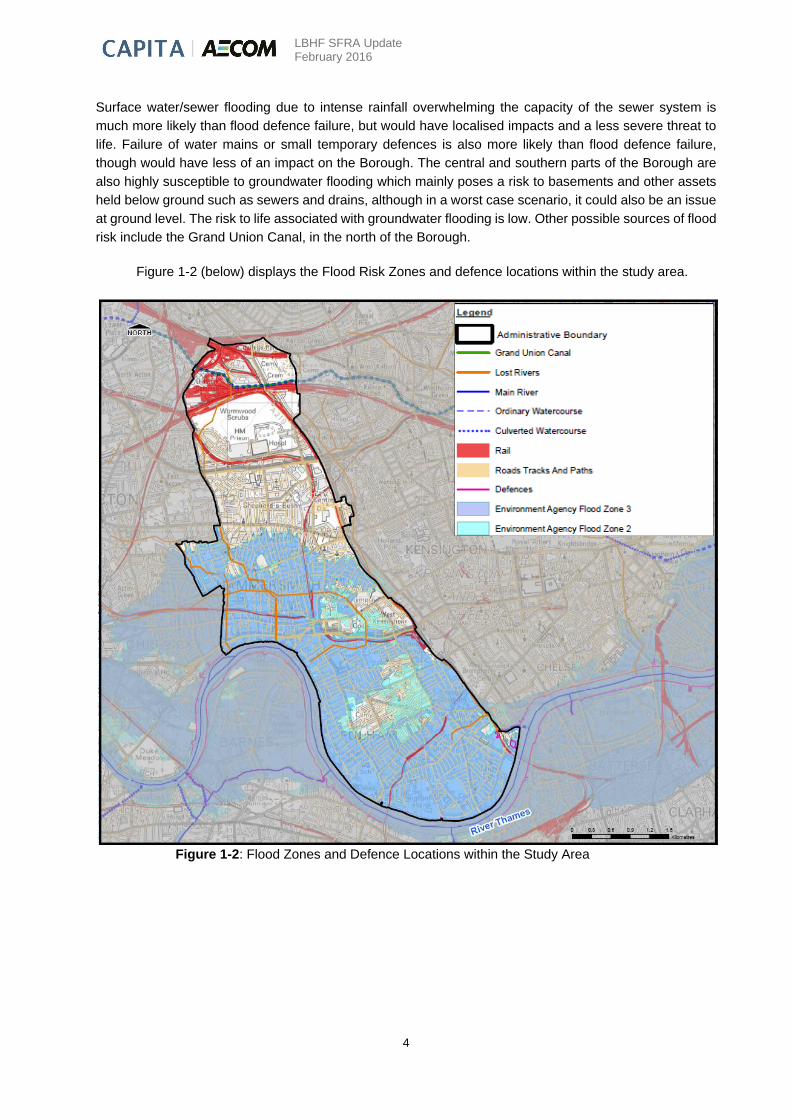
Surface water/sewer flooding due to intense rainfall overwhelming the capacity of the sewer system is
much more likely than flood defence failure, but would have localised impacts and a less severe threat to
life. Failure of water mains or small temporary defences is also more likely than flood defence failure,
though would have less of an impact on the Borough. The central and southern parts of the Borough are
also highly susceptible to groundwater flooding which mainly poses a risk to basements and other assets
held below ground such as sewers and drains, although in a worst case scenario, it could also be an issue
at ground level. The risk to life associated with groundwater flooding is low. Other possible sources of flood
risk include the Grand Union Canal, in the north of the Borough.
Figure 1-2 (below) displays the Flood Risk Zones and defence locations within the study area.
Figure 1-2: Flood Zones and Defence Locations within the Study Area
LBHF SFRA Update February 2016
5
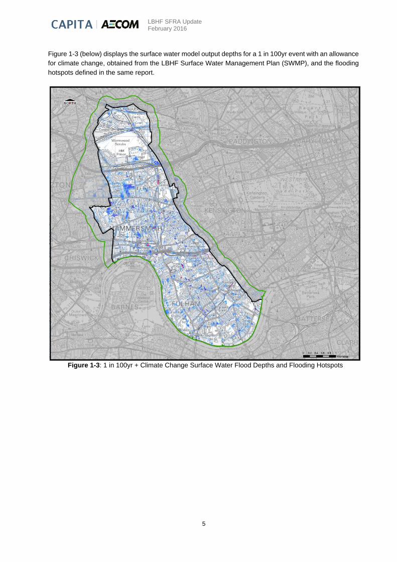
Figure 1-3 (below) displays the surface water model output depths for a 1 in 100yr event with an allowance
for climate change, obtained from the LBHF Surface Water Management Plan (SWMP), and the flooding
hotspots defined in the same report.
Figure 1-3: 1 in 100yr + Climate Change Surface Water Flood Depths and Flooding Hotspots

LBHF SFRA Update February 2016
6
2. Strategic Flood Risk Assessment Overview and Approach
2.1 Overview of the SFRA Process
The SFRA is a planning tool that can be used to inform the spatial planning process. The SFRA should be
used to refine the information relating to the areas within LBHF which may flood, taking into account all
sources of flooding and climate change. This information should form the basis of LBHF’s future flood risk
management policies. In addition the SFRA has informed the development of Local Plan policies and
provides the information to enable the Exception Test to be applied during the site allocation and
development control process.
In line with NPPF guidelines, site allocations should be made outside of the tidal or fluvial flood risk areas
defined by Flood Zones 2 and 3 (i.e. located within Zone 1) wherever possible. If there are no reasonably
appropriate Flood Zone 1 sites, allocations should be made in Zone 2 first, considering flood risk
vulnerability of land uses. Only where there are no reasonably available sites in Flood Zone 1 or 2 should
Zone 3 allocations be made. In order to demonstrate that there are no lower risk sites available the
Sequential Test needs to be carried out.
As a Borough-wide Sequential test has been undertaken by LBHF, the requirement for a Sequential Test
can be considered to have been fulfilled for all locations within the Borough, and site-specific Sequential
Tests for proposed developments within the Borough are not considered necessary. For further information
see Section 2.1.1. The Exception Test should be used, where allowed, to justify allocations or
developments in high risk areas where the need to develop is considered exceptional.
The SFRA provides some indication of deliverability of a proposed development and hence whether a
proposed development site should be considered in more detail in terms of flood risk. Risk is defined as a
function of both probability of an event occurring and the consequences should that event take place. When
considering the residual risk associated with the failure of a flood defence, consideration must be given to
both overtopping (subject to climate change) and the structural integrity of the defence. To assess residual
risk, it is necessary to model the consequence of a breach in, or the overtopping of, the flood defences in
an event with a 0.5% chance of occurring each year (1 in 200 year event). Generally, the worst case
scenario will coincide with a failure of the defences at the peak of the flood event. A two dimensional
inundation model (which has the ability to predict depth, velocity and hazard) of the defended area is
required to examine the impact of either a breach failure or overtopping during the design event. The extent
of inundation behind the defence can then be identified, and the depth and velocity of flow (within the
inundated area) monitored over time throughout the duration of the event.
In addition to tidal flood risk, sources of flooding including groundwater, overland flow and drainage systems
must also be considered when planning development. Although explicit consideration of these sources of
flooding is not a requirement for flood zone allocation, local drainage issues have the potential to cause
substantial damage and distress. When considering development proposals, known drainage and surface
water problems need to be taken into account. These are particularly pertinent in the LBHF, where there
are considerable areas at high risk of surface water, sewer and/or groundwater flooding.
All sources of flood risk including tidal, groundwater, overland flow and sewer flood risk
must be considered when planning development. When considering development proposals,
known drainage and surface water problems must be taken into account.

LBHF SFRA Update February 2016
7
2.1.1 Sequential Test
The NPPF sets out the requirement for a sequential approach, recommending that LPAs use a risk based
approach to development planning. The Environment Agency Flood Zone Map provides the basis of the
test, in which sites at lower flood risk are identified and prioritised in order of flood risk vulnerability and
their safety, in order to assist in allocation for development. A further level of analysis may be required
where development is planned behind or adjacent to existing defences in order to test the sustainability
and robustness of the mitigation measures. This SFRA provides LBHF with Flood Zone classifications for
all locations identified for development, as well as the information required to classify future allocations.
When allocating or approving land for development in flood risk areas, LPAs are expected to demonstrate
that there are no suitable alternative development sites located in lower flood risk areas. The LBHF Core
Strategy (October 2011) states that most of the Borough is at risk of some form of flooding, noting that the
part of the Borough which lies within Flood Zone 1 (in the north) is at risk from sewer and surface water
flooding. As such, the Council considers it unreasonable to restrict development in the Borough to this area
only. The Council therefore considers that the Sequential Test permits the consideration of all sites for
development, subject to meeting the requirements of the Exception Test and a completion of an appropriate
site specific Flood Risk Assessment. As a Borough-wide Sequential test has been undertaken by LBHF,
the requirement for a Sequential Test can be considered to have been fulfilled for all locations within the
Borough, and site-specific Sequential Tests for proposed developments within the Borough are not
considered necessary.
The Environment Agency has statutory responsibility and must be consulted on all development
applications allocated within medium and high risk zones, including those in areas with critical drainage
problems and for any development on land exceeding 1 hectare outside Flood Zones 2 and 3. In these
circumstances, the Environment Agency will require the Council to demonstrate that there are no
reasonable alternatives, in lower flood risk categories, available for development. Where appropriate, the
Exception Test is to be applied.
2.1.2 Exception Test
The NPPF explains where and for what type of development the Exception Test needs to be applied. For
the Exception Test to be passed:
It must be demonstrated that the development provides wider sustainability benefits to the
community that outweigh flood risk, informed by a Strategic Flood Risk Assessment where one
has been prepared; and
A site specific flood risk assessment must demonstrate that the development will be safe for its
lifetime taking account of the vulnerability of its users, without increasing flood risk elsewhere, and,
where possible, will reduce flood risk overall.
Where the Exception Test is required, it should be applied as soon as possible to all sites allocated for
development, and all planning applications other than for minor development. Both elements of the
Exception Test have to be passed before development is allocated or permitted. In some situations, for
certain types of development, it is not appropriate to use the Exception Test to justify development. The
The LBHF Core Strategy permits the consideration of all sites for development, subject to
meeting the requirements of the Exception Test and completion of an appropriate site
specific FRA. Developers are not required to apply the Sequential Test to individual
developments.

LBHF SFRA Update February 2016
8
situations where it is necessary and appropriate to apply the Exception Test are outlined in Table 2-1.
Table 2-2 provides a description of the flood risk vulnerability classification for various development types.
Table 2-1: Flood Risk vulnerability and flood zone ‘compatibility’
Flood Risk Vulnerability Classification
Essential Infrastructure
Water compatible
Highly Vulnerable
More Vulnerable
Less Vulnerable
Zone 1
Zone 2
Exception Test Required
Zone 3a Exception Test Required *
Exception Test Required
Zone 3b Exception Test Required
Key
Development is appropriate
Development should not be permitted
* LBHF policy varies from the NPPF Table in that development in all vulnerability classes is
permitted in Flood Zone 3a, subject to the Exception Test being fulfilled.
Zone 1: All land uses listed above are appropriate in this zone.
Zone 2: Water-compatible, less vulnerable and more vulnerable land uses and essential infrastructure are
appropriate in Zone 2. Highly vulnerable uses are only appropriate in this zone if the Exception Test is
passed.
Zone 3a: Water-compatible and less vulnerable uses of land are appropriate in Zone 3a. Highly vulnerable
uses should not generally be permitted in this zone; however LBHF policy varies from NPPF guidance and
allows more vulnerable land use developments if the Exception Test is passed. More vulnerable and
essential infrastructure uses should only be permitted in Zone 3a if the Exception Test is passed.
Zone 3b: According to NPPF guidance, only water-compatible uses and the essential infrastructure that
has to be there should be permitted in Zone 3b. Essential infrastructure in this zone should pass the
Exception Test and be designed and constructed to meet a number of flood risk related targets. Less
vulnerable, more vulnerable and highly vulnerable uses should not generally be permitted in Zone 3b;

LBHF SFRA Update February 2016
9
Table 2-2: Flood Risk vulnerability classification
Essential
Infrastructure
Essential transport infrastructure and strategic utility infrastructure, including
electricity generating power stations and grid and primary substations.
Highly
Vulnerable
Police stations, ambulance stations and fire stations and command centres and
telecommunications installations required to be operational during flooding.
Emergency dispersal points.
Basement dwellings.
Caravans, mobile homes and park homes intended for permanent residential
use3
Installations requiring hazardous substances consent4. Where there is a
demonstrable need to locate such installations for bulk storage of materials with
port or other similar facilities, or such installations with energy infrastructure or
carbon capture and storage installations that require coastal or water-side
locations, or need to be located in other high flood risk areas. In these instances
the facilities should be classified as “essential infrastructure”.5
More
Vulnerable
Hospitals.
Residential institutions such as residential care homes, children’s homes, social
services homes, prisons and hostels.
Buildings used for dwelling houses, student halls of residence, drinking
establishments, nightclubs and hotels.
Non–residential uses for health services, nurseries and educational
establishments.
Landfill and sites used for waste management facilities for hazardous waste6
Sites used for holiday or short-let caravans and camping, subject to a specific
warning and evacuation plan.7
Less
Vulnerable
Police, ambulance and fire stations which are not required to be operational
during flooding.
Buildings used for shops, financial, professional and other services restaurants
and cafes, hot food takeaways, offices, general industry, storage and distribution,
non–residential institutions not included in “more vulnerable” classification and
assembly and leisure.
Land and buildings used for agriculture and forestry.
Waste treatment (except landfill and hazardous waste facilities).
Minerals working and processing (except for sand and gravel working).
Water treatment works which do not need to remain operational during times of
flood.
Sewage treatment works (if adequate measures to control pollution and manage
sewage during flooding events are in place).
3 For any proposal involving a change of use of land to a caravan, camping or chalet site, or to a mobile home site or park home
site, the Sequential and Exception Tests should be applied. 4 See the Planning Practice Guidance for Hazardous Substances:
http://planningguidance.planningportal.gov.uk/blog/guidance/hazardous-substances/planning-for-hazardous-substances/
www.communities.gov.uk/publications/planningandbuilding/circularplanningcontrols 5 In considering any development proposal for such an installation, local planning authorities should have regard to planning policy
on pollution in the NPPF. 6 For definition see the Planning Practice Guidance for Waste at:
http://planningguidance.planningportal.gov.uk/blog/guidance/waste. 7 See footnote 2.
LBHF SFRA Update February 2016
10
Water
compatible
development
Flood control infrastructure.
Water transmission infrastructure and pumping stations.
Sewage transmission infrastructure and pumping stations.
Sand and gravel working.
Docks, marinas and wharves.
Navigation facilities.
Ministry of Defence defence installations.
Ship building, repairing and dismantling, dockside fish processing and
refrigeration and compatible activities requiring a waterside location.
Water-based recreation (excluding sleeping accommodation).
Lifeguard and coastguard stations.
Amenity open space, nature conservation and biodiversity, outdoor sports and
recreation and essential facilities such as changing rooms.
Essential ancillary sleeping or residential accommodation for staff required by
uses in this category, subject to a specific warning and evacuation plan.
Notes to Table 2-2:
a. This classification is based partly on Department for Environment, Food and Rural Affairs and Environment Agency
research on Flood Risks to People (FD2321/TR2)8and also on the need of some uses to keep functioning during
flooding.
b. Buildings that combine a mixture of uses should be placed into the higher of the relevant classes of flood risk
sensitivity. Developments that allow uses to be distributed over the site may fall within several classes of flood risk
sensitivity.
c. The impact of a flood on the particular uses identified within this flood risk vulnerability classification will vary within
each vulnerability class. Therefore, the flood risk management infrastructure and other risk mitigation measures needed
to ensure the development is safe may differ between uses within a particular vulnerability classification.
2.2 SFRA Approach
This SFRA was undertaken in two stages, the approach to each stage of the SFRA is as follows:
2.2.1 Stage 1
Data Collection
A critical phase in the project delivery is the collection and review of existing information. A summary of
data sources used in this assessment is provided below:
Sites likely to be developed.
Historical records of flooding including cause and extent.
Known and perceived flood risk areas, including Flood Zone Maps and details of flood
risk areas associated with groundwater and surface water drainage issues including
hotspots.
Catchment topography LiDAR (Light Detection and Ranging) data and Ordnance Survey
(OS) Mapping.
Existing investigations for the River Thames.
Current flood risk management strategies including details of flood defence assets.
8 See website for further details:
https://www.google.co.uk/url?sa=t&rct=j&q=&esrc=s&source=web&cd=1&cad=rja&uact=8&ved=0CCIQFjAA&url=ht
tp%3A%2F%2Fsciencesearch.defra.gov.uk%2FDocument.aspx%3FDocument%3DFD2321_3436_TRP.pdf&ei=W
0PrVISbDYXYOOe6gfAF&usg=AFQjCNHHGie6pNSdrv0tpGLCD3QxNlHfnQ&bvm=bv.86475890,d.ZWU

LBHF SFRA Update February 2016
11
Hydrometric data.
Sewer map and surface water modelling results from the SWMP.
DG5 Sewer Flooding Records.
Groundwater flood risk data including geological maps.
Assessment of Flood Risk
The primary objective is to assess and categorise flood risk from all sources within the study area. In
general, the following considerations have been addressed as part of the flood risk assessment process:
Identification of known and/or perceived flood risk areas, including the nature of the
flooding problem (e.g. river, canal, sewer, groundwater flooding; surface water flooding
and local under-capacity drainage; culvert blockage), providing the initial 'filter' for key
flood risk issue areas within the district.
Review of current Environment Agency Flood Zone Map to provide an initial definition of
High Risk Zone 3.
Review of flooding hotspots provided in the LBHF SWMP and identification of critical
floodplain areas.
Identification of significant structures (bridges, culverts, embankments, outfalls etc) that
will influence local hydraulics.
Identification of formal and informal flood defences that reduce flooding to development
and regeneration areas.
Definition of areas subject to development pressure and/or regeneration.
The hazard associated with rapid inundation following failure of existing defences,
breaching and overtopping has been identified (where relevant) and modelled (where
possible).
Review of Climate Change and Land Use Impacts
Consideration has been given to the implications of wider land management practices on flood risk in the
area. The delineation of Flood Zones 2 and 3, coinciding with the 1 in 1000 year (0.1% AEP) and 1 in 200
year (0.5% AEP) events respectively, has been used as an indication of how flood risk may alter laterally
as a result of climate change. Where existing river models were available, further interrogation of modelling
results has been used to determine more accurately the potential impact of climate change and land use
change on design levels. Surface water modelling outputs from the LBHF SWMP, shown in Figures 3 and
4 (Appendix B), have taken into account climate change predictions by applying increased rainfall in the
model.
2.2.2 Stage 2
This involves identifying those areas in the Borough that fall within Flood Zones 1, 2 and 3. LBHF have put
forward 18 development areas. The individual sites are overlain onto the defined flood risk zones (refer to
Figure 10 in Appendix B) and reviewed with respect to the degree of flood risk predicted to impact them.
The filtering process used to categorise these sites is summarised in Table 2-3 overleaf. In addition to
review of flood zones, which provide information on tidal flood risk only, surface water, groundwater and
reservoir inundation datasets are reviewed in order to reflect the actual flood risk to the sites from all
sources.
LBHF SFRA Update February 2016
12
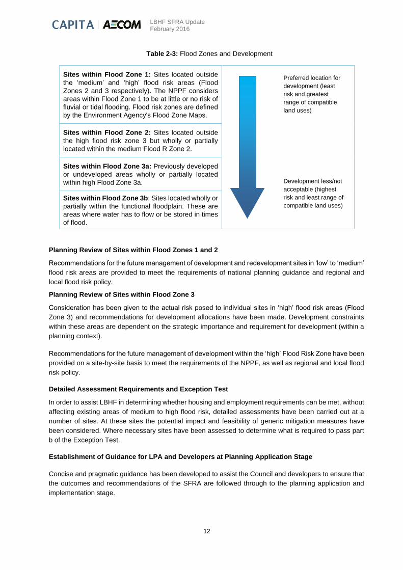
Table 2-3: Flood Zones and Development
Planning Review of Sites within Flood Zones 1 and 2
Recommendations for the future management of development and redevelopment sites in ‘low’ to ‘medium’
flood risk areas are provided to meet the requirements of national planning guidance and regional and
local flood risk policy.
Planning Review of Sites within Flood Zone 3
Consideration has been given to the actual risk posed to individual sites in ‘high’ flood risk areas (Flood
Zone 3) and recommendations for development allocations have been made. Development constraints
within these areas are dependent on the strategic importance and requirement for development (within a
planning context).
Recommendations for the future management of development within the ‘high’ Flood Risk Zone have been
provided on a site-by-site basis to meet the requirements of the NPPF, as well as regional and local flood
risk policy.
Detailed Assessment Requirements and Exception Test
In order to assist LBHF in determining whether housing and employment requirements can be met, without
affecting existing areas of medium to high flood risk, detailed assessments have been carried out at a
number of sites. At these sites the potential impact and feasibility of generic mitigation measures have
been considered. Where necessary sites have been assessed to determine what is required to pass part
b of the Exception Test.
Establishment of Guidance for LPA and Developers at Planning Application Stage
Concise and pragmatic guidance has been developed to assist the Council and developers to ensure that
the outcomes and recommendations of the SFRA are followed through to the planning application and
implementation stage.
Sites within Flood Zone 1: Sites located outside
the ‘medium’ and ‘high’ flood risk areas (Flood
Zones 2 and 3 respectively). The NPPF considers
areas within Flood Zone 1 to be at little or no risk of
fluvial or tidal flooding. Flood risk zones are defined
by the Environment Agency's Flood Zone Maps.
Sites within Flood Zone 2: Sites located outside
the high flood risk zone 3 but wholly or partially
located within the medium Flood R Zone 2.
Sites within Flood Zone 3a: Previously developed
or undeveloped areas wholly or partially located
within high Flood Zone 3a.
Sites within Flood Zone 3b: Sites located wholly or
partially within the functional floodplain. These are
areas where water has to flow or be stored in times
of flood.
Preferred location for
development (least
risk and greatest
range of compatible
land uses)
Development less/not
acceptable (highest
risk and least range of
compatible land uses)

LBHF SFRA Update February 2016
13
It is imperative to ensure that the requirements placed upon developers at the planning application stage
are robust and fit for purpose. Similarly, the ownership, roles and responsibilities of the LPA, Environment
Agency and Thames Water as appraisal bodies must also be clearly understood to ensure that the intent
of the SFRA and planning process are not lost.
LBHF as a Lead Local Flood Authority (LLFA) is only responsible for the management of Local Flood Risk.
Local flood risk is defined as surface water flooding, ordinary watercourse flooding and groundwater
flooding. This area of responsibility is defined by the Flood and Water Management Act 2010.

LBHF SFRA Update February 2016
14
3. The Planning Framework
3.1 Introduction
The purpose of this section of the report is to identify and outline those high level documents which have
to be taken into account in preparing this SFRA. The documents which have been reviewed include the
London Plan together with national planning legislation and Local Plan policies and guidance.
3.2 National Planning Guidance
Flood and Water Management Act 2010
The Flood and Water Management Act 2010 places significantly greater responsibility on Local Authorities
to manage and lead on local flooding issues. The Act and Regulations together set out the requirements
and targets Local Authorities need to meet, including:
Taking an active role leading flood risk management as LLFAs.
Cooperating with other relevant authorities to manage local flood risk.
Setting a duty to investigate flood incidents and report upon them.
Maintaining an ‘Asset Register’ of assets that have a significant influence on local flood risk.
Designating ‘features’ that have a significant influence on local flood risk.
Regulating works on ‘ordinary watercourses’.
Developing and implementing Local Flood Risk Management Strategies (LFRMS).
Providing support to the LPA, acting as the statutory consultee on the delivery of SuDS techniques
where necessary.
The Flood and Water Management Act also clarifies three key areas that influence development:
Sustainable drainage (SuDS) - the Act makes provision for a national standard to be prepared on
SuDS. Developers will be required to obtain LPA approval for the SuDS in accordance with the
Non-Statutory Technical Standards for sustainable drainage systems as part of the planning
application process.
Flood risk management structures - the Act enables the Environment Agency and Local Authorities
to designate structures such as flood defences or embankments owned by third parties for
protection if they affect flooding or coastal erosion. A developer or landowner will not be able to
alter, remove or replace a designated structure or feature without first obtaining consent.
Permitted flooding of third party land – In exceptional circumstances, the Environment Agency and
Local Authorities have the power to carry out work which may cause flooding to third party land
where the works are deemed to be in the interest of nature conservation, the preservation of
cultural heritage or people’s enjoyment of the environment or of cultural heritage.
The Flood and Water Management Act places a responsibility on the LBHF to manage and
lead on local flooding issues in the Borough, including co-operating with other relevant
authorities and regulating Sustainable Drainage Systems.

LBHF SFRA Update February 2016
15
National Planning Policy Framework (2012)
The National Planning Policy Framework9 was issued in March 2012 and outlines the national policy
including on development and flood risk assessment. This replaced with immediate effect national policy
including Planning Policy Statement 25 – Development and Flood Risk.
The NPPF requires Local Plans to be supported by a Strategic Flood Risk Assessment and develop policies to manage flood risk from all sources. Advice should be sought from the Environment Agency and other relevant flood risk management bodies, such as Lead Local Flood Authorities. Planners should use the Sequential Test as the primary decision making tool, and if this is passed and it is deemed necessary to place development in higher flood risk zones, apply the Sequential Approach to steer vulnerable development within the red line boundary to areas at lowest risk of flooding.
National Planning Policy Guidance
The Technical Guidance to the National Planning Policy Framework10 has been superseded by the
Planning Practice Guidance Flood Risk and Coastal Change11 (April 2015) which sets strict tests to protect
people and property from flooding. All local planning authorities are expected to follow the PPG. Where
these tests are not met, national policy is clear that new development should not be allowed. The main step
to be followed is designed to ensure that development is directed to the lowest risk of flooding (the
Sequential Test). Development should not be allocated or permitted if there are reasonably available sites
appropriate for the proposed development in areas with a lower probability of flooding. This is in accordance
with paragraph 101 of the NPPF.
The National Planning Practice Guidance document provides guidance on how the local planning
authorities should:
Assess flood risk;
Avoid flood risk; and
Manage and Mitigate flood risk and coastal change.
There is also information on the requirements to consult the Environment Agency, on the role of lead local
flood authorities and on flood risk in relation to minor developments. In addition, NPPF provides information
on the application of the Sequential and the Exception Tests in the preparation of a Local Plan.
The April 2015 update to the practice guidance provides additional guidance on SuDS, including:
The importance of SuDS;
When SuDS should be considered;
The SuDS discharge hierarchy;
Factors a local authority will address when considering SuDS as part of a planning application;
When SuDS are inappropriate and relevant flood risk consultees;
Applicability of Defra’s Non-statutory Technical Standards for Sustainable Drainage Systems;
Design and construction cost considerations;
Operation and maintenance considerations; and
Where to go for further SuDS advice.
As part of the April 2015 update, the practice guidance provides details on the parties responsible for assessing the suitability of SuDS practices. As per paragraph 084 from the practice guidance: The decision on whether a sustainable drainage system would be inappropriate in relation to a particular development proposal is a matter of judgement for the local planning authority. In making this judgement the local planning authority will seek advice from the relevant flood risk management bodies, principally the lead local flood authority, including on what sort of sustainable drainage system they would consider to be reasonably practicable.
9 National Planning Policy Framework (DCLG, 2012) 10 Technical Guidance to the National Planning Policy Framework (DCLG, 2012) 11 http://planningguidance.planningportal.gov.uk/blog/guidance/flood-risk-and-coastal-change/

LBHF SFRA Update February 2016
16
Non-statutory Technical Standards for Sustainable Drainage Systems, March 2015
This document, published by the Department for Environment, Food and Rural Affairs, sets out non-statutory technical standards for sustainable drainage systems. The non-statutory technical standards should be used in conjunction with the National Planning Policy Framework and Planning Practice Guidance. Non-statutory technical standards are provided for the following items:
Flood risk outside the development;
Peak flow control;
Volume control;
Flood risk within the development;
Structural integrity;
Designing for maintenance considerations; and
Construction.
All Major planning applications will need to set out who will be responsible for maintaining and inspecting the drainage system for the lifetime of the development and include a detailed SuDS maintenance plan.

LBHF SFRA Update February 2016
17
3.3 Regional Policy Drivers
The London Plan
The London Plan is the overall strategic plan for London, setting out an integrated economic, environment,
transport and social framework for the development of London over the next 20 to 25 years. Since the
London Plan was adopted in 2004 there have been several revisions to the Plan, with the most recent
revisions published in 2015. The London Plan contains a series of objectives identified by the Mayor of
London. The overarching objective of the plan is to promote sustainable development. The London Plan
indentifies five sub regions (Central London, North, East South and West). LBHF is identified as being
within the West London sub region. The London Plan also has a number of policies, some of which have
recently been revised. The policies relevant to this SFRA include:
Policy 5.11 Green Roofs
Major development proposals should be designed to include roof and site planting, especially green roofs
and walls where feasible, to deliver as many of the following objectives as possible:
Adaption to climate change.
Sustainable urban drainage.
Mitigation of climate change.
Enhancement of biodiversity.
Accessible roof space.
Improvements to appearance and resilience of the building.
Growing food.
Policy 5.12 Flood Risk Management
Strategic -The Mayor will work with all relevant agencies including the Environment Agency to address
current and future flood issues and minimise risks in a sustainable and cost effective way.
Planning decisions - Development proposals must comply with the flood risk assessment and management
requirements set out in the NPPF and the PPG over the lifetime of the development and have regard to
measures proposed in Thames Estuary 2100 Plan and Catchment Flood Management Plans.
Developments which are required to pass the Exception Test set out in the NPPF and the PPG will need
to address flood resilient design and emergency planning by demonstrating that:
a) The development will remain safe and operational under flood conditions.
b) A strategy of either safe evacuation and/or safely remaining in the building is followed under flood conditions.
c) Key services including electricity and water will continue to be provided under flood conditions.
d) Buildings are designed for quick recovery following a flood.
Development adjacent to flood defences will be required to protect the integrity of existing flood defences
and wherever possible should aim to be set back from the banks of watercourse and those defences to
allow their management, maintenance and upgrading to be undertaken in a sustainable and cost effective
way.
Policy 5.13 Sustainable Drainage

LBHF SFRA Update February 2016
18
Planning decisions - Development should utilise Sustainable Drainage Systems (SuDS) unless there are
practical reasons for not doing so, and should aim to achieve greenfield run-off rates and ensure that
surface water run-off is managed as close to its source as possible in line with the following drainage
hierarchy:
1) Store rainwater for later use.
2) Use infiltration techniques, such as porous surfaces in non-clay areas.
3) Attenuate rainwater in ponds or open water features for gradual release.
4) Attenuate rainwater by storing in tanks or sealed water features for gradual release.
5) Discharge rainwater direct to watercourse.
6) Discharge rainwater to a surface water sewer/drain.
7 Discharge rainwater to the combined sewer.
Drainage should be designed and implemented in ways that deliver other policy objectives of the Plan,
including water use efficiency and quality, biodiversity, amenity and recreation.
Sustainable Design and Construction: The London Plan Supplementary Planning Guidance
The Supplementary Planning Guidance (SPG) was published in April 2014. The document seeks to provide
additional information to support the implementation of the London Plan. The guide seeks to identify a
series of standards and measures to promote sustainable development around the themes of resource
management, adapting to climate change and pollution management, principally land, air, noise, light and
water.
With regard to water pollution and flooding, the SPG identifies the following essential standards:
All developments on greenfield sites must maintain greenfield runoff rates. On previously developed sites, runoff rates should not be more than three times the calculated greenfield rate.
Developments should utilise SuDS unless there are practical reasons for not doing so. The aspiration is to deliver SuDS schemes that provide multiple benefits, in addition to reducing flood risk.
A range of return periods up to and including the 1 in 100 year plus climate change critical storms (an additional 20-30%) should be assessed.
The guidance provides a helpful introduction to the various methods of SuDS which can be applied and
adopted as part of a development proposal.
3.4 Local Planning Policy
The Core Strategy Adopted October 2011
The Local Plan includes the Core Strategy (adopted October 2011), the Development Management Local
Plan (adopted July 2013) and Planning Guidance Supplementary Planning Document (July 2013).
The Core Strategy DPD is the overarching document of the LDF and sets out the Borough’s long term
vision for land use. The Core Strategy highlights that the risk of flooding from the River Thames and from
surface water flooding are key issues in Hammersmith and Fulham and that they have to be taken into
account when planning new development in the Borough. Proposed changes to the Local Plan recognise
the importance of groundwater flood risk in the Borough.
Policy CC2 Flooding

LBHF SFRA Update February 2016
19
Water and Flooding
The Council will expect all development to minimise current and future flood risk and the adverse effects
of flooding on people. In particular:
All development at risk of flooding should be subject to a site specific flood risk assessment,
appropriate to the scale and type of development.
Development within the High and Medium Residual Risk areas should assess the type and severity
of flood risk and manage the residual flood risks.
Contributions from development proposals will be required to assist in mitigation and/or relief
measures which will reduce the overall risk of flooding.
Development adjoining the river will be expected to maintain the integrity of river defences and set
development back in order to allow the maintenance and improvement of the defences.
In addition, the Council will strive to reduce the risk of flooding from surface water and foul water and its
contribution to fluvial flooding by requiring development proposals to include appropriate sustainable
drainage systems and systems to reduce the amount of water discharged to the foul water drainage.
Development Management Local Plan Policy DM H3
Reducing water use and the risk of flooding
The Council will require developments to reduce the use of water and minimise current and future flood
risk and the adverse effects of flooding on people by implementing the following measures:
All new build, changes of use and conversions from a less to a more vulnerable use should assess
the risk of flooding from all sources, in particular tidal, surface water and sewer flooding. Where
there is a risk of flooding, a site specific Flood Risk Assessment (FRA) will be required in
accordance with the guidance in the LBHF SFRA;
Prior to undertaking an FRA, the developer needs to address the requirements of the NPPF and,
where applicable, to carry out parts a and b of the Exception Test. Evidence that the Exception
Test has been passed will need to be included in the FRA;
All developments in the Borough will be required to incorporate Sustainable Drainage Systems
(SuDS) to reduce both the volume and speed of surface water run-off unless there are practical
reasons for not doing so;
Developments will be expected to achieve greenfield run-off rates and at least 50% attenuation of
undeveloped site’s surface water run-off at peak times, and where possible to achieve 100%
attenuation;
New self-contained basement flats will not be permitted in areas where there is a medium to high
risk of flooding and no satisfactory means of escape can be provided;
All new development should include water efficient appliances. In addition, major developments
and high water use developments should include other measures such as rainwater harvesting
and grey water re-use; and
LBHF SFRA Update February 2016
20
All new development proposals will be required to demonstrate that there is sufficient water and
wastewater infrastructure capacity both on and off site to serve the development or that any
necessary upgrades will be delivered ahead of the occupation of development.
Development Management Local Plan Policy DM A8
Basement accommodation and lightwells
New basement accommodation in existing dwellings will be permitted where:
It does not extend beyond the footprint of the dwelling and any approved extension (whether built
or not);
There is no adverse impact on the amenity of adjoining properties and on the local natural and
historic environment; and
It does not increase flood risk from any source.
All other new or extended accommodation below street level should be designed to minimise the risk of
flooding to the property and nearby properties from all sources of flooding. To minimise the risk of sewer
flooding, developments will be required to provide active drainage devices.
Where there is a medium to high risk of fluvial flooding and no satisfactory means of escape can be
provided, new self contained basement flats will not be permitted.
Planning Guidance Supplementary Planning Document Policy 1
Flood Risk Assessment
Planning applications must provide supporting information in line with the requirements of this SPD to show
that appropriate consideration has been given to all forms of flood risk. Where necessary, a drainage
strategy and information on proposed mitigation measures should be provided. There may need to be
consultation with the Environment Agency and Thames Water.
Information should be included on proposed sustainable drainage measures and any ongoing management
requirements, in consultation with the Environment Agency and Thames Water where necessary, to show
compliance with Development Plan policies on sustainable drainage. Any approved drainage measures
shall thereafter be retained and maintained in accordance with the approved details.
Proposed Submission Local Plan
LBHF has proposed changes to the Local Plan, currently in the Proposed Submission stage (September
2016). Proposed changes have been made to the key flood risk related policies, particularly in relation to
Policy DM A8, now Policy DC11 on Basements and Lightwells and Policy CC2 on Flooding which has been
split into 2 Policies: CC3 Minimising Flood Risk and Reducing Water Use and CC4 Minimising Surface
Water Run-off with Sustainable Drainage Systems.
The Core Strategy states that the Council will expect all development to minimise current and
future flood risk and the adverse effects of flooding on people. Planning applications must
provide supporting information to show that appropriate consideration has been given to all
forms of flood risk.
LBHF SFRA Update February 2016
21
The Environment Agency’s Thames Estuary 2100 Project
The Thames Estuary 2100 Project was established by the Environment Agency in 2002 with the aim of
developing a strategic flood risk management plan for London and the Thames Estuary through to the end
of the century. The project primarily looks at tidal flooding, though other sources of flooding (including high
river flows as a result of heavy rainfall and surface water flooding) are considered.
The key driver for the project was to consider how tidal flood risk was likely to change in response to future
changes in climate and people and property in the floodplain. Additional to this was an understanding that
many of the existing flood walls, embankments and barriers were getting older and would need to be raised
or replaced to manage rising water levels.
The plan divided the estuary into 23 geographical areas, known as policy units. Each policy unit has been
assessed to determine the appropriate level of flood risk management.
It confirms that the source of flooding is:
Tidal from the River Thames upstream of the Thames Barrier (probability 0.1% per annum or less
frequent, barrier controlled), flood depths up to 3 meters if the Thames Barrier were to fail.
Risk from pluvial and urban drainage sources.
LBHF is within Action Plan Zone 1 “West London”, and is in Policy Unit “Hammersmith”. The Policy is “P5:
to take further action to reduce flood risk beyond that required to keep pace with climate change”.
The Environment Agency’s vision for the Hammersmith policy unit is to enhance the already attractive
environment in this area by providing defence improvements that are designed in a sensitive way and blend
with the surroundings whilst achieving policy P5. The vision also includes greater local and institutional
awareness of the flood risk, which should influence emergency planning, land use planning and new
development.
Thames Water Five-Year Plan for 2015 to 2020
The Thames Water Five-Year Plan for 2015 to 202012 states that Thames Water intends to:
Reduce risk of internal flooding to 1,799 properties, protecting them from a 1 in 30 year storm. This
aims to “benefit many homes in... Hammersmith and Fulham”;
Ensure that new housing developments do not increase the risk of flooding for existing customers;
Investigate reducing groundwater entering sewers at fourteen locations; and
Promote more widespread use of sustainable drainage in their region to reduce dependence on
the drainage network.
In addition, the Thames Tideway Tunnel is being constructed to upgrade London’s sewer system.
12 Summary of our five-year plan (2014) Thames Water. Available at: http://www.thameswater.co.uk/about-us/17481.htm [Accessed
21st August 2014]
LBHF SFRA Update February 2016
22
Surface Water Management Plan (SWMP)
A Surface Water Management Plan (SWMP) was completed in July 2015. The document is a plan which
outlines LBHF’s preferred surface water management strategy and includes consideration of flooding from
sewers, drains, groundwater and runoff from land, small watercourses and ditches that occurs as a result
of heavy rainfall.
Analysis of the number of properties at risk of flooding has been undertaken for the rainfall event with a 1
in 100 probability of occurrence in any given year (1% Annual Exceedance Probability, AEP). A review of
the results demonstrate that 7,059 residential properties and 889 non-residential properties in the Borough
could be at risk of surface water flooding of greater than 0.1m depth during a 1% AEP rainfall event. Of
those, 845 residential properties and 64 non-residential properties could be at risk of flooding to a depth of
greater than 0.5m during the same modelled rainfall event.
Preliminary Flood Risk Assessment
A Preliminary Flood Risk Assessment (PFRA) was completed in July 2011 as part of the wider Drain
London project which involved the delivery of a Surface Water Management Plans (SWMP) – modelled at
an intermediate level – and PFRA for each of the 32 London Boroughs and the Corporation of the City of
London. The PFRA has been undertaken to assist LBHF to meet its duties as an LLFA, with the delivery
of the first stage of the Flood Risk Regulations (2009).
The PFRA is a high level screening exercise that compiles information on significant local flood risk from
past and future floods, based on readily available and derivable information. The study has not identified
any past floods that are considered to have had significant harmful consequences. Future flood risk from
extreme events is estimated to be high in the LBHF.
LBHF SFRA Update February 2016
23
4. Data Collection
4.1 Flood Zone Maps
The Environment Agency Flood Zone Maps show the extents of the 1 in 200 year return period tidal flood
event (an event with a 0.5% chance of occurring each year) and 1 in 1000 year tidal event (an event with
a 0.1% chance of occurring each year). They were prepared using a methodology based on modelling of
the estuary and two dimensional (2D) flood routing using ground data based on LiDAR.
The Environment Agency Flood Zone Maps do not take account of flood defences and, therefore, represent
a theoretical maximum extent of tidal flooding. The actual extent of flooding is mitigated by flood defences.
Therefore, the Environment Agency Flood Zone Maps provide a worst case assessment of the extent of
flooding and are consistent with the NPPF, which categorises flood risk ignoring the effects of defences.
Figure 1-2 shows the extent of Flood Zones 2 and 3 across the Borough.
4.2 Flood Defences
As discussed above, the Environment Agency Flood Zone Maps do not take account of the presence of
flood defences. The NPPF states that defended areas (i.e. those areas that are protected to some degree
against flooding by the presence of a formalised flood defence) are still at risk of flooding, and therefore
sites within these areas must be assessed with respect to the adequacy of the defences.
The tidal Thames is defended to a 1 in 1000 year standard (protection against an event with a 0.1% chance
of occurring each year), by a series of walls, embankments, flood gates and barriers, with the Thames
Barrier being the major protection for the study area. The statutory defence level (the level to which the
defences must be maintained) within the study area is 5.41m downstream of Putney Bridge and 5.54m
upstream.
The location and condition of all flood defences within the Borough has been provided by the Environment
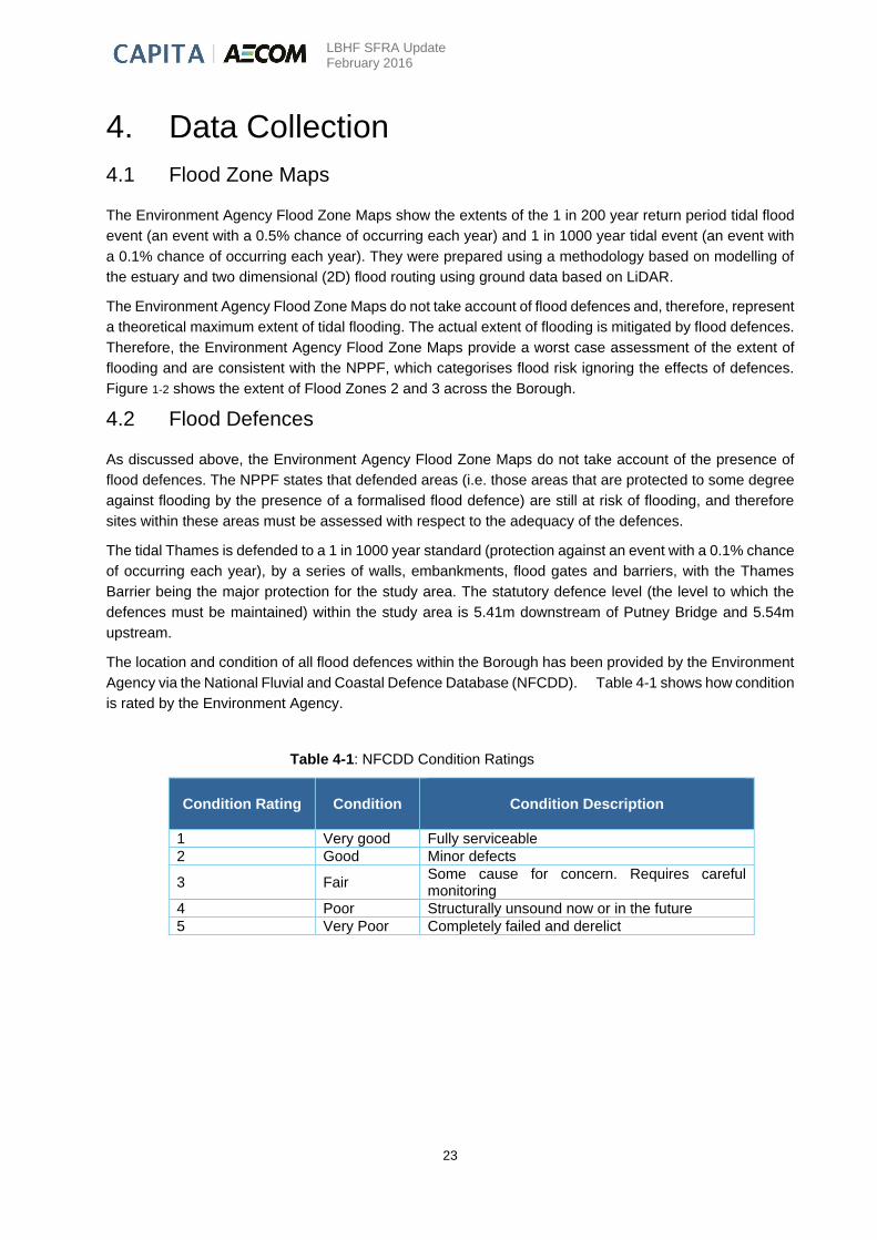
Agency via the National Fluvial and Coastal Defence Database (NFCDD). Table 4-1 shows how condition
is rated by the Environment Agency.
Table 4-1: NFCDD Condition Ratings
Condition Rating Condition
Condition Description
1 Very good Fully serviceable
2 Good Minor defects
3 Fair Some cause for concern. Requires careful monitoring
4 Poor Structurally unsound now or in the future
5 Very Poor Completely failed and derelict

LBHF SFRA Update February 2016
24
4.3 Breach Modelling
Thames Estuary (TE2100) Plan
The Thames Estuary 2100 (TE2100) Plan13 sets out the EA recommendations for flood risk management
for London and the Thames Estuary until 2100. The plan has a strong emphasis on climate change
adaptation, using the latest climate science to understand climate change impacts in the Thames Estuary.
TE2100 tidal data provided by the Environment Agency includes extreme water levels (0.5% AEP event)
in the Thames for the present day (2012)14 and future years (up to 2065 and 2100 including climate
change). The data also includes present day defence levels and the levels to which defences should be
raised in order to defend against the extreme water levels for 2100 (including climate change).
Tidal Data
Table 4-2 shows the TE2100 Extreme Water Levels (mAOD) for the tidal Thames Figure 4-1 the node
locations. A comparison of the Thames Tidal Joint Probability Extreme Water Level Model data (2008) and
the TE2100 data (2012) shows that the 2008 data provides a higher water level for all nodes within close
proximity to the LBHF. The TE2100 data also shows an increase in level between 2012 and 2100, whereas
the 2008 data shows a decrease in water level between 2005 and 2107. The TE2100 data should be
considered more reliable as the study takes into account a significant amount of climate change research
undertaken by Met Office Hadley Centre and other key organisations.
Table 4-2: TE2100 Extreme Water Levels (mAOD) for the Tidal Thames
Scenario 0.5% Annual Probability of Exceedance
for node 2.19
Present day (2012)
5.03
Future (up to 2065 including climate
change)
5.64
Future (up to 2100 including climate
change)
5.93
13Thames Estuary 2100: TE2100 Plan (2012) Environment Agency 14 “Present day” is the reference used in the original study and refers to 2012, not to the “present day” at the time of
this SFRA update (2016).

LBHF SFRA Update February 2016
25
Scenario 0.5% Annual Probability of Exceedance
for node 2.20
Present day (2012)
5.01
Future (up to 2065 including climate
change)
5.63
Future (up to 2100 including climate
change)
5.92
Scenario 0.5% Annual Probability of Exceedance
for node 2.21
Present day (2012)
4.96
Future (up to 2065 including climate
change)
5.60
Future (up to 2100 including climate
change)
5.89
Scenario 0.5% Annual Probability of Exceedance
for node 2.22u
Present day (2012)
4.49
Future (up to 2065 including climate
change)
5.58
Future (up to 2100 including climate
change)
5.88
Scenario 0.5% Annual Probability of Exceedance
for node 2.23
Present day (2012)
4.93
Future (up to 2065 including climate
change)
5.57
Future (up to 2100 including climate
change)
5.87

LBHF SFRA Update February 2016
26
Scenario 0.5% Annual Probability of Exceedance
for node 2.24 / 2.24au / 2.24ad
Present day (2012)
4.92
Future (up to 2065 including climate
change)
5.56
Future (up to 2100 including climate
change)
5.85
Scenario 0.5% Annual Probability of Exceedance
for node 2.25
Present day (2012)
4.90
Future (up to 2065 including climate
change)
5.54
Future (up to 2100 including climate
change)
5.84
Scenario 0.5% Annual Probability of Exceedance
for node 2.26
Present day (2012)
4.89
Future (up to 2065 including climate
change)
5.54
Future (up to 2100 including climate
change)
5.84

LBHF SFRA Update February 2016
27
Figure 4-1: Flood Model Node Locations
4.4 Flooding from other sources
Surface Water
The LBHF Surface Water Management Plan (SWMP), completed in April 2015, provides additional surface
water flood risk data and model outputs that were not available at the time of the original SFRA. The SWMP
outlines the Borough’s preferred surface water management strategy and includes consideration of flooding
from sewers, drains, groundwater and runoff from land, small watercourses and ditches that occurs as a
result of heavy rainfall. The SWMP is the most recent and comprehensive study of surface water flood risk

LBHF SFRA Update February 2016
28
for LBHF. Surface water model outputs completed for the SWMP and flooding hotspots defined within the
SWMP were reviewed for the SFRA update.
Sewer
Updated sewer flood risk information provided in the SWMP and updated historical sewer flooding records
provided by Thames Water were utilised to assess sewer flood risk in this SFRA.
Groundwater
The following groundwater flood risk and modelling studies have been completed since the release of the
original SFRA, and have informed this updated SFRA: Increased Potential for Elevated Groundwater Maps
(GLA 2011); Environment Agency Areas Susceptible to Groundwater Flooding Map (EA 2012); and ESI
Groundwater Flood Risk Map Version 1.1 (ESI 2014).
4.5 Topography
Remotely sensed ground level data (LiDAR) was made available for use in the SFRA by the Environment
Agency. This information is in the form of a land surface level grid with a 1m grid resolution. The nominal
vertical accuracy of LiDAR data is typically ±0.25 m. LiDAR data is available for most of the Borough and
has been utilised. Figure 2 (Appendix B) shows the topography of the study area.
4.6 Lost Rivers
Lost Rivers were once tributaries of the River Thames before they became culverted or converted into
sewers. There are three Lost Rivers in the study area; one forms the Borough boundary line with RBKC
(Counters Creek) and the other two are located in the west of the Borough at Stamford Brook and Parr’s
Ditch.
Counters Creek rose near Kensal Green cemetery and flowed roughly straight in a south-south-east
direction passing close to the present sites of Olympia, Earl's Court and Stamford Bridge. It would have
passed under the bridge carrying the King's Road and have continued to the River Thames as Chelsea
Creek15 (which is still visible). In the early 19th century Counters Creek, south of Olympia, was converted
into the Kensington Canal, but was later bought and drained by the West London Railway Company to
build a rail line extension. The stream now runs underneath the railway line in the Counters Creek Sewer.
Stamford Brook encompasses the streams draining into the River Thames at Hammersmith. The eastern
stream rose west of Wormwood Scrubs; the western stream flowed down to Ravenscourt Park, where they
joined to flow out to the River Thames at Hammersmith Creek. Stamford Brook was covered and made a
sewer in the late 19th century.
Parr's Ditch was possibly artificial, rather than a river, to divide the parishes of Hammersmith and Fulham,
it remained open until 1876 when it was converted to a sewer.
4.7 Historical Flooding
Historical flooding events and issues have been identified and assessed utilising a number of information
sources. These include the Environment Agency, LBHF, Thames Water, London Fire Brigade, Transport
for London and Network Rail. Figure 6 (Appendix B) provides an overview of historical flood incident data
for the Borough.
15 Barton, N (2000) The Lost Rivers of London. Historical Publications Limited, chpt 4, p.43-48.
LBHF SFRA Update February 2016
29
Surface Water Flooding
As part of the development of the SWMP, LBHF provided a GIS dataset of recorded flooding incidents,
predominantly from the July 2007 flood event. These are the only historical surface water flooding records
held by the Council. These records are shown in Figure 6 (Appendix B). In many cases the historic flooding
information provided is anecdotal and does not include records of flood depth or cause of flooding.
The most recent significant flood event occurred during July 2007, when intense periods of rainfall
exceeded the capacity of existing drainage systems, causing significant overland flow and ponding of
surface water in low lying areas. Many areas were affected including properties in Sands End, Parsons
Green, Fulham, Brook Green and the Cathnor Park area. 148 calls were made to LBHF’s Emergency
Planning Team to report flooding.
Other significant flood events held by LBHF include:
A storm on the night of the May 30th 1979 resulted in a surcharge of the sewer system locally
around Vera Road (SW6) and Tadmore Street (W12). This caused a number of basement
properties to flood.
In recent times there has been regular surcharging of the sewer on the north side of Shepherds
Bush Green, sufficient to cause flooding to the old public toilets which is now a nightclub.
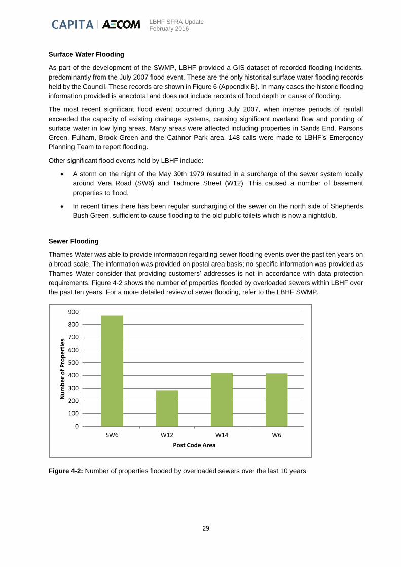
Sewer Flooding
Thames Water was able to provide information regarding sewer flooding events over the past ten years on
a broad scale. The information was provided on postal area basis; no specific information was provided as
Thames Water consider that providing customers’ addresses is not in accordance with data protection
requirements. Figure 4-2 shows the number of properties flooded by overloaded sewers within LBHF over
the past ten years. For a more detailed review of sewer flooding, refer to the LBHF SWMP.
Figure 4-2: Number of properties flooded by overloaded sewers over the last 10 years
0
100
200
300
400
500
600
700
800
900
SW6 W12 W14 W6
Nu
mb
er
of
Pro
pe
rtie
s
Post Code Area
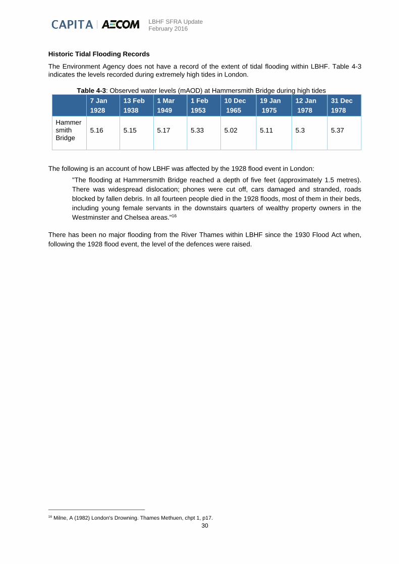
LBHF SFRA Update February 2016
30
Historic Tidal Flooding Records
The Environment Agency does not have a record of the extent of tidal flooding within LBHF. Table 4-3
indicates the levels recorded during extremely high tides in London.
Table 4-3: Observed water levels (mAOD) at Hammersmith Bridge during high tides
7 Jan
1928
13 Feb
1938
1 Mar
1949
1 Feb
1953
10 Dec
1965
19 Jan
1975
12 Jan
1978
31 Dec
1978
Hammersmith Bridge
5.16 5.15 5.17 5.33 5.02 5.11 5.3 5.37
The following is an account of how LBHF was affected by the 1928 flood event in London:
"The flooding at Hammersmith Bridge reached a depth of five feet (approximately 1.5 metres).
There was widespread dislocation; phones were cut off, cars damaged and stranded, roads
blocked by fallen debris. In all fourteen people died in the 1928 floods, most of them in their beds,
including young female servants in the downstairs quarters of wealthy property owners in the
Westminster and Chelsea areas."16
There has been no major flooding from the River Thames within LBHF since the 1930 Flood Act when,
following the 1928 flood event, the level of the defences were raised.
16 Milne, A (1982) London's Drowning. Thames Methuen, chpt 1, p17.

LBHF SFRA Update February 2016
31
5. Flood Risk in the London Borough of Hammersmith and Fulham
5.1 Introduction
The guidance detailed below has been developed to provide a clear, concise and consistent means of
assessing the feasibility and sustainability of sites and to determine appropriate flood risk mitigation
measures where required. The framework will aid LBHF and others in assessing flood risk associated with
allocations and potential development sites. It will also provide an evidence base for the flood risk related
policies in the Council’s Local Plan. Although now replaced by the NPPF, the PPS25 Practice Guide still
contains useful guidance and examples of flood risk management which can be used to manage flooding
within LBHF. However, it should be noted that defences do not eliminate the risk, only reduce the frequency
of flooding.
The NPPF aims to direct development to lower flood risk sites wherever possible. “Inappropriate
development in areas at risk of flooding should be avoided by directing development away from areas at
highest risk, but where development is necessary, making it safe without increasing flood risk elsewhere”17.
The LBHF Core Strategy (October 2011) states that due to the high risk of flooding throughout the Borough,
from a range of sources including tidal and surface water, the Sequential Test permits the consideration of
all sites for development, subject to meeting the requirements of the Exception Test and a completion of
an appropriate site specific FRA. Therefore, the Sequential Test does not need to be repeated for proposed
developments.
Table 2-1, Chapter 2, highlights the type of development considered appropriate for each Flood Zone. This
table highlights whether a development is permitted in a specific Flood Zone, whether the development is
permitted but only when the Exception Test is passed, and whether a site specific FRA is required to
support a planning application. It must be noted that this SFRA does not preclude the need for site specific
FRAs.
This chapter will present the guidance for Flood Zone 3b; Flood Zone 3a (including defended, public safety
and rapid inundation, and the feasibility of flood risk mitigation); Flood Zone 2; and Flood Zone 1. It will
then discuss issues relating to flood risk from other sources.
5.2 NPPF Flood Zones
The extent of the Flood Zones within the LBHF can be seen in Section 1, Figure 1-2 and at a larger
A3 scale in Figure 1 (Appendix B). In the LBHF the Flood Zones correspond to tidal flood risk from the
River Thames.
Flood Zone 1 – Low Probability of Tidal/Fluvial Flooding
Flood Zone 1 is the area outside of Flood Zone 2. For LBHF this is mainly the area north of Uxbridge Road
and comprises 40% of the Borough. Flood Zone 1 equates to a tidal or fluvial flood event with less than a
0.1% chance of occurring each year (1 in 1000 year event).
In accordance with the PPG Table 3, all development (essential infrastructure, highly vulnerable, more
vulnerable, less vulnerable and water-compatible development) is permitted in Flood Zone 1. All
development proposals must consider the following about the sites:
Their vulnerability to flooding from other sources as well as from river and sea flooding, including
surface water, sewer and groundwater sources.
17 The National Planning Policy Framework, March 2012

LBHF SFRA Update February 2016
32
Their potential to increase flood risk elsewhere through the addition of hard surfaces and the effect
of the new development on surface water runoff.
The LBHF Local Plan (including the Core Strategy, the Development Management Local Plan and Planning
Guidance Supplementary Planning Document) and the London Plan lay out clear guidelines for surface
water runoff requirements, which must be strictly adhered to within any development proposal. Chapter 3
provides additional detail on these policies.
Flood Zone 2 – Medium Probability of Tidal/Fluvial Flooding
Flood Zone 2 covers an area similar to that of Flood Zone 3 (discussed overleaf) with a few areas where
the zone extends further (e.g. the Dawes Road area and West Kensington). The percentage coverage of
this flood zone within LBHF is 7%. Flood Zone 2 equates to a tidal flood event which has between a 0.1%
and 0.5% chance of each year (between a 1 in 1000 and 1 in 200 year event).
Flood Zone 2 is considered suitable for water-compatible, less vulnerable, more vulnerable and essential
infrastructure. Highly vulnerable development is only allowed where the Exception Test is passed.
All development proposals must consider the following information about the sites:
Their vulnerability to flooding from other sources as well as from river and sea flooding, including
surface water, sewer and groundwater sources.
Their vulnerability to flooding from all sources over the lifetime of the development.
Their potential to increase flood risk elsewhere through the addition of hard surfaces, the effect of
the new development on surface water run-off, and the effect of the new development on depth
and speed of flooding to adjacent and surrounding property.
A demonstration that residual risks of tidal or fluvial flooding are acceptable (after existing and
proposed flood management and mitigation measures are taken into account, including flood
defences, flood resilient and resistant design, escape / evacuation (access and egress), effective
flood warning and emergency planning).
Flood Zone 3a – High Probability of Tidal/Fluvial Flooding
Flood Zone 3 covers approximately 53% of the Borough; much of the area south of the Uxbridge Road is
Flood Zone 3. Flood Zone 3 equates to a tidal flood event with a greater than a 0.5% chance of occurring
each year (1 in 200 year event).
PPG Table 3 (reproduced within Section 2, Table 2-1) states that the water-compatible uses and less
vulnerable development are allowed in this Flood Zone. According to PPG Table 3, highly vulnerable
development is not permitted (although see below for further details on LBHF policy in this respect), with
essential infrastructure and more vulnerable development required to pass the Exception Test. Essential
infrastructure should be designed and constructed to remain operational and safe for users in times of
flood.
PPG advocates that developers and Local Authorities should implement the following policy aims:
Reduce the overall level of flood risk through the layout and form of the development and the
appropriate application of sustainable drainage techniques.
Relocate existing development to land in zones with a lower probability of flooding.
Create space for flooding to occur by restoring functional floodplain and flood flow pathways and
by identifying, allocating and safeguarding open space for flood storage.
LBHF SFRA Update February 2016
33
Regeneration of land or change in land use behind existing defended areas in the Flood Zone 3 will
continue to require a more detailed assessment of the flood risk (i.e. whether the scale of risk is worth
taking), and how sustainable and effective the mitigation measures would be (i.e. whether the risk could be
managed).
An assessment of the actual risk within Flood Zone 3 is required where, due to wider sustainable
development reasons, there are no other suitable sites available in lower risk zones. For development to
proceed it must also be shown that the development will not increase flood risk elsewhere.
Due to the high risk of flooding from sources including tidal, surface water, sewer and groundwater within
LBHF, highly vulnerable developments will be considered provided the criteria above and the provision of
a suitable FRA are satisfied.
Flood Zone 3b (Functional Floodplain) – High Probability of Tidal/Fluvial flooding
Whilst prior to the development of London there would have been large areas of land close to the river that
regularly flooded, within the Borough there is now only a very small area of functional floodplain, associated
with the small section of Chiswick Mall which falls within the LBHF boundary.
Although not strictly 'floodplain' the tidal foreshore exposed each tide should be protected as this plays an
important role in the functioning of the tidal Thames.
5.3 Assessment of Residual Risk
The guidance to the NPPF deals with managing residual flood risk.
Paragraph 16 of the NPPF states that, “residual risks are those remaining after applying the sequential
approach and taking mitigating actions.” It states that:
"It is the responsibility of those planning development to fully assess flood risk, propose measures
to mitigate it and demonstrate that any residual risks can be safely managed”.
It is the developer’s responsibility to demonstrate how (in planning terms) this can be achieved and how
the residual risks will be managed. A clear distinction between commercial flood standards of protection
and management of loss of life should be explored in the FRA. A greater reliance on flood warning may be
required, which is not always a tangible alternative to accepting a lower standard of protection.
The study area is a defended area, and is considered to be an area of floodplain where the defences
substantially (but not necessarily completely) mitigate the flood risk associated with the event which has a
0.5% chance of occurring each year (1 in 200 year return period).
Within defended areas, tidal flood risk is primarily associated with overtopping and breach of defences (and
localised flooding associated with drainage systems in some locations). These risks are related to the
likelihood (standard of protection and structural integrity of defences) and consequences of flooding (depth,
speed and duration of flooding, and land use within defended area).
The consequences of defence overtopping or failure (breach) can be estimated using flood inundation
modelling and mapping. This has been undertaken at a number of locations within the Borough and is
detailed in Section 5.4.

LBHF SFRA Update February 2016
34
5.4 Breach Analysis
The Thames Barrier is designed to be robust and reliable and the Environment Agency maintains and
operates the barrier to ensure that the level of protection is maintained. The barrier gates are routinely
operated and there is a high degree of redundancy in terms of power supply and hydraulic systems. The
Thames Barrier has been closed in response to tidal conditions over 170 times since it became operational
in 1982 without any problems arising and thus has proved reliable in practice. The Thames Barrier is only
closed in response to high tidal surges (though it has also on occasion been used to reduce high level
levels in Teddington and Richmond during fluvial flood events) and thus even with the barrier operating as
intended, the predicted peak tide levels can be significantly above the ground level in LBHF. The river walls
therefore provide an important defence and a source of residual risk arises from a breach in the flood
defence wall.
Existing Environment Agency breach models were used to analyse the flood extent and hazard associated
with defence breaches at eight locations within LBHF. The Environment Agency determined suitable breach
locations by identifying areas that could be susceptible to a risk from a breach of the defences. It should
be noted that this is only an indication as it fails to account for the possibility of human interference with
the defence. Examples of human interference include vehicle impact, ship impact and excavation behind
defences. The effects of these events on the defence are not always noticed immediately, and the defence
may appear fine but later collapse under the pressure of a rising tide. It is not possible to quantify the
probability of a defence wall failure, but the probability will be greater than that of a highly engineered and
managed defence such as the Thames Barrier.
For the breach analysis it was assumed that the Thames Barrier will not fail but will be used more often in
the future as sea levels rise and other actions being studied by the TE2100 are brought into effect.
In the model, a 35 hour tidal sequence is run through the breach, spanning 3 tidal peaks. The breach is
‘open’, adopting the designated sill level throughout the simulation. Different assumptions concerning
timing of breach and barrier closure in the event of a breach upriver of the Thames Barrier would affect the
volume of water inundating the floodplain. The extent of flooding at each time step will be different
depending on the assumption of the breach.
For this study, only one peak is being modelled for different timesteps, therefore the Environment Agency
advised (on the 21st of December 2015) that two assumptions were modelled; firstly the breach occurs
before the highest peak and secondly the breach occurs near or at the top of the highest peak on the rising
limb. Modelling both assumption helps to account for this uncertainty and provides an upper and lower
estimate for each time step in regards to extent and depth (refer to Figures 8-1-1 to 8-9-2 in appendix B).
5.4.1 Approach to Breach Analysis
The Environment Agency used 1D/2D linked models to model flood defence breaches for 113 locations
along the River Thames (eight of them are within LBHF). The identified breaches were modelled using
ISIS spill units linked to 2D TUFLOW floodplain models to create 1D/2D linked models. This approach
provides significant benefit compared to the method applied in the previous study (2011/12), in that it
allows easy update of hydraulic model breach characteristics (breach sill level, width, weir coefficient and
formation over time) without the time-consuming need to change multiple TUFLOW files. This will allow
future users to readily test new defence specific breach characteristics.

LBHF SFRA Update February 2016
35
The 1D models consist of two HT boundary nodes and one spill unit. The spill unit contains the breach
width and elevation; the full breach dimensions remain consistent from the start to the end of the
simulation. One HT boundary is linked to the design water level time series generated by the 1D Thames
river model. The other HT boundary is linked to the 2D TUFLOW floodplain model via the 1D_nd_point
and 2D_bc_sx_line shape files.
Flow across the breach location is calculated in the ISIS 1D model and the generated flow hydrograph is
transferred into the TUFLOW floodplain model via a TUFLOW 2D BC SX line. The width of the 2D BC SX
line corresponds to the breach width (20 or 50m). Floodplain inundation is then simulated by the 2D
TUFLOW model.
The elevation of the 2D_bc_sx_line is set equal to the breach sill level. The 2D_bc_sx_line is situated at
the lowest elevation point within the breach buffer zone which is an enclosed circle with a radius equal to
the breach width (20m or 50m). To prevent model instability, cells directly adjacent to the 2D_bc_sx_line
are set to be the same as breach sill level using a 2D_Zplg_Breach shape file. Figure 5-1 summarises the
various important inputs of the 1D-2D model setup.
Figure 5-1: Important inputs for the 1D-2D TUFLOW model
5.4.2 Breach Locations The Environment Agency selected breach locations based on defence condition and ground level behind
the defence wall. The breaches remain open for one tidal cycle before being closed. This assumes that
(temporary or permanent) repairs would be carried out within hours of the breach occurring. The breaches
are represented by a drop from the statutory defence level to the level of the land behind the defence. The
breaches are 20m wide, a standard width for hard defences. Table 5-1 indicates the breach locations
and elevations in the Environment Agency model, and the top level of the existing defences (crest levels)
based on Environment Agency NFCDD data. Breach locations are shown in Figure 5-2 overleaf.
Breach
Centroid
NAFRA Defence
Line
Centroid Buffer
(20/50m)
1D
node
2D z-polygon
defining sill level
2D boundary SX
Line
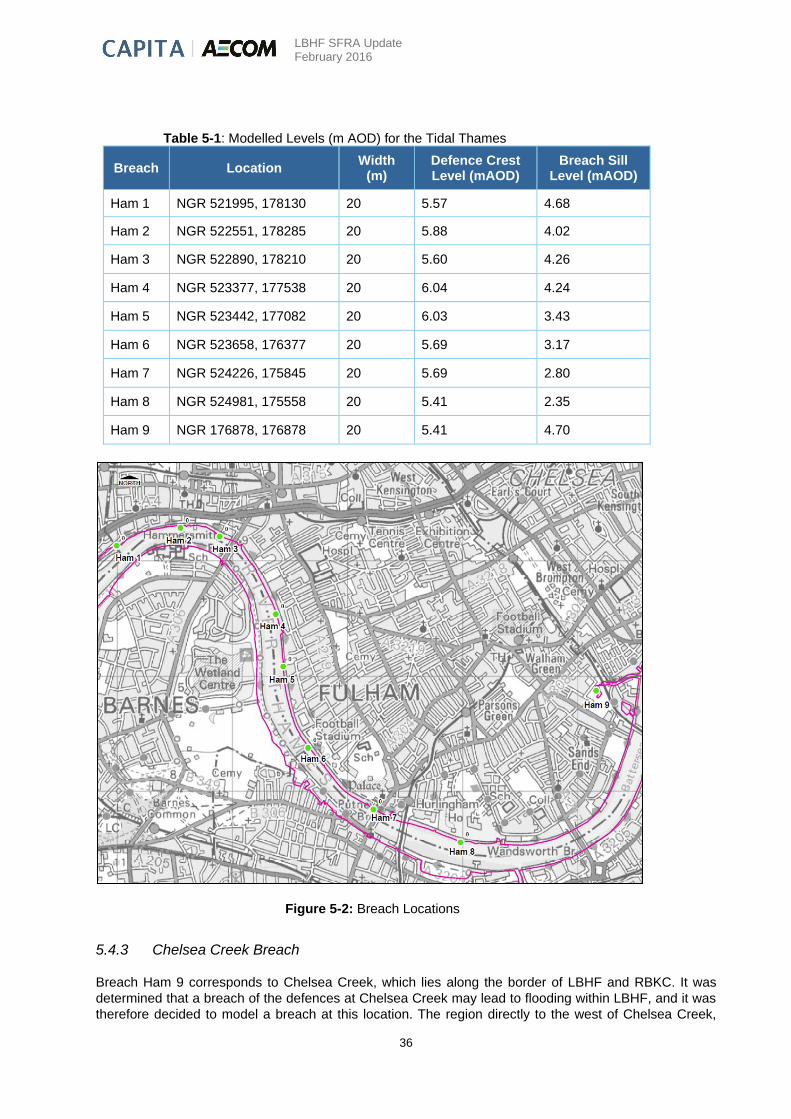
LBHF SFRA Update February 2016
36
Table 5-1: Modelled Levels (m AOD) for the Tidal Thames
Breach Location Width
(m) Defence Crest Level (mAOD)
Breach Sill Level (mAOD)
Ham 1 NGR 521995, 178130 20 5.57 4.68
Ham 2 NGR 522551, 178285 20 5.88 4.02
Ham 3 NGR 522890, 178210 20 5.60 4.26
Ham 4 NGR 523377, 177538 20 6.04 4.24
Ham 5 NGR 523442, 177082 20 6.03 3.43
Ham 6 NGR 523658, 176377 20 5.69 3.17
Ham 7 NGR 524226, 175845 20 5.69 2.80
Ham 8 NGR 524981, 175558 20 5.41 2.35
Ham 9 NGR 176878, 176878 20 5.41 4.70
Figure 5-2: Breach Locations
5.4.3 Chelsea Creek Breach
Breach Ham 9 corresponds to Chelsea Creek, which lies along the border of LBHF and RBKC. It was
determined that a breach of the defences at Chelsea Creek may lead to flooding within LBHF, and it was
therefore decided to model a breach at this location. The region directly to the west of Chelsea Creek,

LBHF SFRA Update February 2016
37
within LBHF, is currently undergoing significant residential development, which will include a network of
canals. The modelled breach was extended along the length of the canal which joins Chelsea Creek,
determined from the site plan, in order to more accurately represent the breach. This modelling has utilised
the latest TE2100 flood level as this was deemed to be the best available data at the time of modelling.
5.4.4 Overtopping Analysis
Overtopping of the defence walls is unlikely given the operation of the Thames Barrier. However, in the
unlikely event of non-closure of the barrier, overtopping could occur. The likelihood of overtopping can be
estimated by comparison of modelled water levels and defence crest levels. The TE2100 present day extreme
water level for node 2.20 is 5.01mAOD, which is below the crest level of all defences in LBHF, indicating that
overtopping of the defences is highly unlikely.
The TE2100 future dataset takes into account the effects of climate change. The future (up to 2100) extreme
water level for node 2.20 is 5.92mAOD, which exceeds the current defence crest level of all breaches except
Ham 4 and Ham 5, indicating that overtopping could occur at this tidal level at most of the breach locations.
Review of the TE2100 study information provided by the Environment Agency indicates that the defences at
breach locations Ham 1 to Ham 7 should be raised to 6.40mAOD and the defence at Ham 8 should be raised
to 6.35mAOD, which would mean that overtopping does not occur at the extreme tidal level currently predicted.
Based on this assumption no overtopping scenarios have been modelled for the LBHF.
5.5 Climate Change
A comparison between the TE2100 present day and future (up to 2100 including climate change) extreme
water levels for a 1 in 200 year tidal event indicate a significant increase in the River Thames tidal peak in
the region of the LBHF. At node 2.20, used in the breach model, the extreme water level is estimated to
increase from the present day level of 5.01mAOD to a level of 5.92mAOD by 2100.
5.6 Residual Risk Classification
For allocations where a development site is close to flood defences, consideration must be given to the
risk to public safety (risk to life). Development should not be sited where it could cause or increase risk to
public safety and/or the structural integrity of buildings and infrastructure. Consideration of the depth of
flooding, rate of inundation and safe access/egress is required to assess these risks. This assessment
is applicable to areas at residual risk of flooding, that is, risk from breach or overtopping. Environment
Agency guidance suggests that all development should have a dry access and egress in the 1 in 200 year
event (the event with a 0.5% chance of occurring each year). Greater depths may be permitted where
elevated access/egress to safe ground is provided.
DEFRA has produced a classification to determine the Flood Hazard to People as a function of depth and
velocity. The following text explains how the Flood Hazard rating has been incorporated into the Residual
Risk Classification. Figure 15 (Appendix B) shows the residual risk classifications for the Borough based on
the breach model outputs.
Residual risk classifications should be used as a basis for determining whether an area is at
risk of tidal flooding due to a breach in River Thames defences. However, it should be noted
that these provide only an indication as the possibility of human interference with defences
is not accounted for.
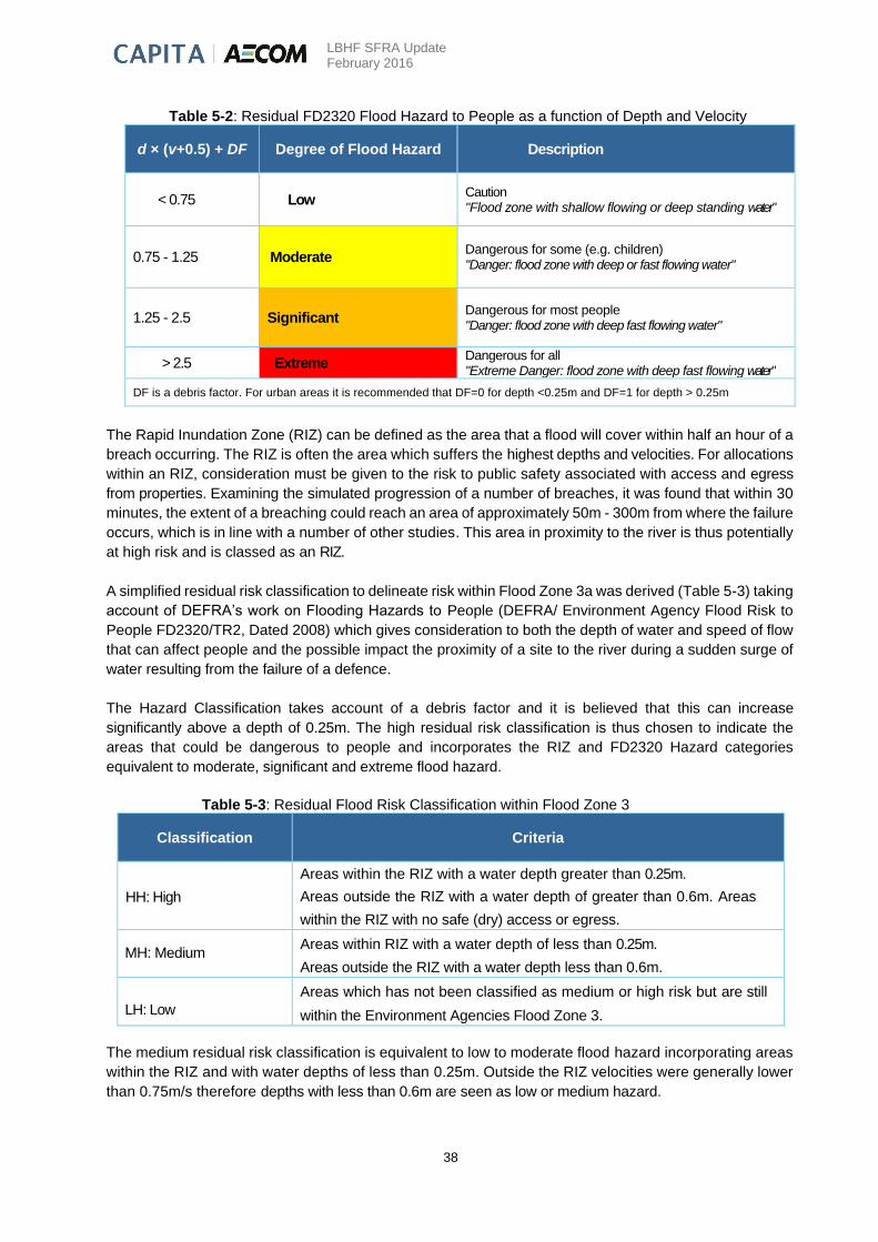
LBHF SFRA Update February 2016
38
Table 5-2: Residual FD2320 Flood Hazard to People as a function of Depth and Velocity
d × (v+0.5) + DF Degree of Flood Hazard Description
< 0.75 Low Caution "Flood zone with shallow flowing or deep standing water"
0.75 - 1.25 Moderate Dangerous for some (e.g. children) "Danger: flood zone with deep or fast flowing water"
1.25 - 2.5 Significant Dangerous for most people "Danger: flood zone with deep fast flowing water"
> 2.5 Extreme Dangerous for all "Extreme Danger: flood zone with deep fast flowing water"
DF is a debris factor. For urban areas it is recommended that DF=0 for depth <0.25m and DF=1 for depth > 0.25m
The Rapid Inundation Zone (RIZ) can be defined as the area that a flood will cover within half an hour of a
breach occurring. The RIZ is often the area which suffers the highest depths and velocities. For allocations
within an RIZ, consideration must be given to the risk to public safety associated with access and egress
from properties. Examining the simulated progression of a number of breaches, it was found that within 30
minutes, the extent of a breaching could reach an area of approximately 50m - 300m from where the failure
occurs, which is in line with a number of other studies. This area in proximity to the river is thus potentially
at high risk and is classed as an RIZ.
A simplified residual risk classification to delineate risk within Flood Zone 3a was derived (Table 5-3) taking
account of DEFRA’s work on Flooding Hazards to People (DEFRA/ Environment Agency Flood Risk to
People FD2320/TR2, Dated 2008) which gives consideration to both the depth of water and speed of flow
that can affect people and the possible impact the proximity of a site to the river during a sudden surge of
water resulting from the failure of a defence.
The Hazard Classification takes account of a debris factor and it is believed that this can increase
significantly above a depth of 0.25m. The high residual risk classification is thus chosen to indicate the
areas that could be dangerous to people and incorporates the RIZ and FD2320 Hazard categories
equivalent to moderate, significant and extreme flood hazard.
Table 5-3: Residual Flood Risk Classification within Flood Zone 3
Classification Criteria
HH: High
Areas within the RIZ with a water depth greater than 0.25m.
Areas outside the RIZ with a water depth of greater than 0.6m. Areas
within the RIZ with no safe (dry) access or egress.
MH: Medium Areas within RIZ with a water depth of less than 0.25m.
Areas outside the RIZ with a water depth less than 0.6m.
LH: Low
Areas which has not been classified as medium or high risk but are still
within the Environment Agencies Flood Zone 3.
The medium residual risk classification is equivalent to low to moderate flood hazard incorporating areas
within the RIZ and with water depths of less than 0.25m. Outside the RIZ velocities were generally lower
than 0.75m/s therefore depths with less than 0.6m are seen as low or medium hazard.
LBHF SFRA Update February 2016
39
The low residual risk part of Flood Zone 3 is that area that is not predicted to be affected by the breaching
considered but could potentially be affected if breaches were not closed within the time assumed.
The location of high velocities is dependent on the location of the breach. The modelled velocities for
the limited number of simulated breaches cannot therefore give a full picture of Flood Hazard. In reality
high velocities can be generated due to local features not picked up in the LiDAR or the grid used for flood
modelling. For example, flow into a basement may be a high hazard if it occurs rapidly without warning.
5.7 Sewer Flooding
Sewer Flood Risk Assessment
Based on customer privacy and legal issues, there was not enough detailed data available from Thames
Water to provide a detailed map for sewer flooding within LBHF. Thames Water have provided details of
sewer flooding on a postal area basis. Figure 7 (Appendix B) utilises this data and provides an overview of
the spatial distribution of sewer flooding events in the Borough. A review of this map shows a significant
number of sewer flooding incidents throughout the Borough. The LBHF SWMP provides a more detailed
analysis of sewer flood risk in the Borough, including information on Counters Creek, a former watercourse
that now forms part of the sewer system, and on the drainage network.
Sewer Flood Risk and Climate Change
As the drainage network in the LBHF is primarily combined, the sewer flood risk is intrinsically linked to the
surface water flood risk. Based on current knowledge and understanding, the effects of future climate
change are predicted to increase the intensity and likelihood of summer rainfall events, which may result
in increased frequency of combined sewer surcharge, in the absence of improvements in capacity or
function of the existing network. The effect of climate change on surface water flood risk was accounted
for in the LBHF SWMP, for which model outputs were produced for a 1 in 100 year event with an allowance
for climate change, applied as additional rainfall. The model does not account for increased load due to
population increase; nor does it account for improvements to the drainage network.
Impacts of Sewer Flooding
The impact of sewer flooding is usually confined to relatively small localised areas but, because flooding is
associated with blockage or failure of the sewer network, flooding can be rapid and unpredictable. Flood
waters from this source are also often contaminated with raw sewage and pose a health risk. The spreading
of illness and disease can be a concern to the local population if this form of flooding occurs on a regular
basis.
Management of Sewer Flood Risk
Responsibility for management of the drainage network in the Borough is shared between Thames Water,
Network Rail and Transport for London. As the LLFA, LBHF should work with the relevant authorities to
minimise sewer flood risk in the Borough. In particular, LBHF should work closely with Thames Water and
other relevant stakeholders to identify opportunities for integrated management of surface water and sewer
flood risk across the Borough.
Thames Water have elected to install anti-flood pumps (known as ‘FLIPs’) on private drains in areas
particularly susceptible to sewer flooding. The LBHF SWMP provides recommendations for drainage
network maintenance and improvement measures in the Borough.
Thames Water have stated that the areas which have in the past been affected by sewer flooding should
not be seen as areas to avoid future development and that the reverse is also true, that areas with no
LBHF SFRA Update February 2016
40
known flooding incidents should not always be viewed as the best place to accommodate new
development. What is essential is that all development locations are assessed to ensure capacity exists
within both the on and off site network, or can be provided as part of a site’s redevelopment
5.8 Surface Water Flooding
Surface Water Flood Risk Assessment
A Surface Water Management Plan (SWMP) was completed in July 2015. The document is a plan which
outlines the Borough’s preferred surface water management strategy and includes consideration of flooding
from sewers, drains, groundwater and runoff from land, small watercourses and ditches that occurs as a
result of heavy rainfall.
The chief mechanisms for flooding in the London Borough of Hammersmith and Fulham can be broadly
divided into the following categories:
Runoff from higher topography - The areas of greatest flood depths tend to be at the base of the
steeper land to the north of the Borough.
Localised surface water runoff - Within the central and southern parts of the Borough, surface water
flooding tends to be a result of localised ponding of surface water.
Sewer Flooding - Areas where extensive and deep surface water flooding is likely to be the
influenced by sewer flooding. Where the sewer network has reached capacity and surcharged, this
will exacerbate the flood risk in these areas.
Low Lying Areas - Areas such as underpasses, subways and lowered roads beneath railway lines
are more susceptible to surface water flooding.
Railway Cuttings - Four stretches of mainline railway track (in cuttings) are susceptible to surface
water flooding and, if flooded, will impact services that pass across the Borough; and
Railway Embankments - Discrete surface water flooding locations along the up-stream side of the
raised network rail embankments where water flows are interrupted and ponding can occur.
Figure 3 and Figure 4 (Appendix B) show the LBHF SWMP model outputs for surface water flood risk and
hazard for the 1 in 100 year rainfall event, with an allowance for climate change. Analysis of the number of
properties at risk of flooding has been undertaken for the rainfall event with a 1 in 100 probability of
occurrence in any given year (1% Annual Exceedance Probability, AEP). A review of the results
demonstrate that 7,059 residential properties and 889 non-residential properties in the LBHF could be at
risk of surface water flooding of greater than 0.1m depth during a 1% AEP rainfall event. Of those, 845
residential properties and 64 non-residential properties could be at risk of flooding to a depth of greater
than 0.5m during the same modelled rainfall event.
Within the LBHF, the risk of surface water flooding is present across many parts of the borough and is not
concentrated in a particular geographic area. However, a review of these statistics coupled with local
knowledge of the study area identifies that the following wards are considered to be the most at risk of
significant flooding (greater than 0.5m deep) from the 1% AEP rainfall event:
Askew
Hammersmith Broadway
Addison
LBHF should work with Thames Water and other relevant stakeholders to identify
opportunities for integrated management of surface water and sewer flood risk across the
Borough.

LBHF SFRA Update February 2016
41
Town
Shepherd’s Bush Green
Wormholt and White City
Surface Water Flood Risk and Climate Change
Based on current knowledge and understanding, the effects of future climate change are predicted to
increase the intensity and likelihood of summer rainfall events, meaning surface water flooding may
become more severe and more frequent in the future. The effect of climate change on surface water flood
risk was analysed in the LBHF SWMP, for which model outputs were produced for a 1 in 100 year event
with an allowance for climate change, applied as additional rainfall.
Impacts of Surface Water Flooding
Pluvial flooding can affect all forms of the built environment, including:
Residential, commercial and industrial properties;
Amenity and recreation facilities; and
Infrastructure, such as roads and railways, electrical infrastructure, telecommunication
systems and sewer systems.
This type of flooding is usually short-lived and may only last as long as the rainfall event. However
occasionally flooding may persist in low-lying areas where ponding occurs. Due to the typically short
duration, this type of flooding tends not to have consequences as serious as other forms of flooding, such
as flooding from rivers; however it can still cause significant damage and disruption on a local scale.
Management of Surface Water Flood Risk
The LBHF SWMP (2015) provides detailed Borough-wide surface water flood risk management options
for LBHF. Surface water flood risk is a large scale issue, present throughout London Boroughs and it is
recommended that LBHF continues in an active role in future strategic surface water management plans
for London in liaison with the Greater London Authority and Thames Water.
5.9 Groundwater Flooding
Groundwater flooding is water originating from sub-surface permeable strata which emerges from the
ground, either at a specific point (such as a spring) or over a wide diffuse location, and inundates low lying
areas. A groundwater flood event results from a rise in groundwater level sufficient for the water table to
intersect the ground surface and inundate low lying land. Flooding from groundwater tends to be long in
duration, developing over weeks or months and continuing for days or weeks.
There are many mechanisms associated with groundwater flooding, which are linked to high groundwater
levels and can be broadly classified as:
Direct contribution to channel flow.
Springs emerging at the surface.
LBHF should continue in an active role in future strategic surface water management plans
for London in liaison with the Greater London Authority and Thames Water.

LBHF SFRA Update February 2016
42
Inundation of drainage infrastructure.
Inundation of low-lying property (basements).
Geology
A geological map for the study area is provided in Figure 11 (Appendix B) reproduced from the British
Geological Survey (BGS) 1:50,000 scale geological series. The bedrock is predominantly London Clay.
Superficial deposits of sand and gravel (Kempton Park Gravel Formation) overlie the London Clay across
the southern extent of the Borough (Goldhawk Road towards the River Thames).
Superficial deposits of clay and silt (Langley Silt Member) overlie the London Clay across the area between
Westway (A40) and Goldhawk Road, and around the area of Brook Green and Hammersmith Road.
The London Clay is overlain with superficial gravels in the lower part of the Borough. These permeable
gravels outline the historic floodplain of the River Thames and may contain a perched water table. If,
following heavy rainfall, the water table within this gravel layer rises, localised groundwater flooding may
occur in excavations and basements. Along the route of 'lost' rivers, springs and rivulets which would have
usually joined the streams may still flow, as such finding their way underground, probably along the original
course of the stream18.
Groundwater Flood Risk Assessment
The data sources listed below have been reviewed to produce an overall interpretation of groundwater
flood risk in the study area.
Increased Potential for Elevated Groundwater Maps (GLA 2011).
Environment Agency Areas Susceptible to Groundwater Flooding Map (EA 2012).
ESI Groundwater Flood Risk Map Version 1.1 (ESI 2014)
Table 5-4 summarises the content of each source and how it has been used within the risk
assessment.
Table 5-4: Review of Available Groundwater Information
Source Summary Risk Assessment Application
EA Areas Susceptible
to Groundwater
Flooding (AStGWF)
Map
This data has used the top two
susceptibility bands of the British
Geological Society (BGS)
1:50,000 Groundwater Flood
Susceptibility Map. It shows the
proportion of each 1km grid
square where geological and
hydrogeological conditions show
that groundwater might emerge.
This provides an overview of proportional
area that is at high or very high risk of
groundwater flooding. The categories are
as follows:
<25% (low)
≥25%<50%(moderate)
≥ 50% <75% (high)
>=75% (very high)
18 Barton, N (1992) The Lost Rivers of London. Historical Publications Limited, chpt 10, p 134.
LBHF SFRA Update February 2016
43
Source Summary Risk Assessment Application
EA Groundwater
Flooding Database
Use of records provided within
the Draft Tier 2 SWMP (2011).
Review of predicted and known
groundwater risk locations.
GLA Increased
Potential for
Groundwater
Flooding Map
This map was produced for the
Drain London Tier 2 project and
shows those areas where there is
an increased potential for
groundwater to rise sufficiently to
interact with the ground surface
or be within 2m of the ground
surface.
This provides additional detail on areas at
risk of groundwater flooding at greater
spatial resolution than the AStGWF map.
ESI Groundwater
Flood Risk Map
Version 1.1
This map is based on a 50m
resolution groundwater model.
Likelihood is ranked according to
whether flooding is expected to
occur at a site due to extreme
groundwater levels, estimated to
have a return period of 1 in 200
years.
LBHF have access to this data, and the
mapping has been compared to the other
groundwater flood risk datasets in order to
better understand groundwater flood risk
in the Borough. However, licensing rules
do not permit reproduction or distribution
of the mapping in this SFRA.
ESI Groundwater Flood Risk Map
The most recent dataset available for use in the LBHF SFRA is the ESI Groundwater Flood Risk Map
(Version 1.1, 2014). This is based on a 50m resolution groundwater model for Scotland, England and
Wales. The ESI Groundwater Flood Risk Map is the most detailed dataset available for assessment of
groundwater flood risk within LBHF due to its 50m resolution and clear categorization of risk. However,
licensing restrictions do not permit reproduction or distribution of this data. It is recommended that LBHF
officers refer to this dataset when considering planning applications.
If more detailed data relating to the risk of groundwater flooding is required, it is recommended that the
reader contact the British Geological Survey (BGS) in order to obtain the BGS Groundwater Flooding
Susceptibility Maps, which cover consolidated aquifers (chalk, sandstone etc., termed ‘clearwater’ in the
data attributes) and superficial deposits. Within this dataset susceptibility to flooding is classified into the
following categories; very low, low, moderate, high and very high and is not restricted to identifying the risk
with 1km square grids. The dataset does not take account of the chance of flooding from groundwater
rebound.
Areas Susceptible to Groundwater Flooding
The latest Environment Agency dataset for assessing groundwater flood risk in the study is the Areas
Susceptible to Groundwater Flooding (AStGWF) map, shown in Figure 5-3. This map uses underlying
geological information to infer groundwater flood susceptibility. A review of the AStGWF map highlights
that the southern half of the study area is highly susceptible to groundwater flooding.
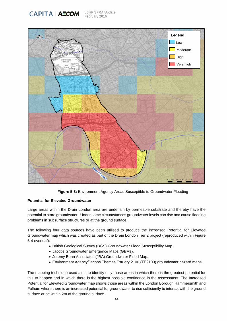
LBHF SFRA Update February 2016
44
Figure 5-3: Environment Agency Areas Susceptible to Groundwater Flooding
Potential for Elevated Groundwater
Large areas within the Drain London area are underlain by permeable substrate and thereby have the
potential to store groundwater. Under some circumstances groundwater levels can rise and cause flooding
problems in subsurface structures or at the ground surface.
The following four data sources have been utilised to produce the increased Potential for Elevated
Groundwater map which was created as part of the Drain London Tier 2 project (reproduced within Figure
5-4 overleaf):
British Geological Survey (BGS) Groundwater Flood Susceptibility Map.
Jacobs Groundwater Emergence Maps (GEMs).
Jeremy Benn Associates (JBA) Groundwater Flood Map.
Environment Agency/Jacobs Thames Estuary 2100 (TE2100) groundwater hazard maps.
The mapping technique used aims to identify only those areas in which there is the greatest potential for
this to happen and in which there is the highest possible confidence in the assessment. The Increased
Potential for Elevated Groundwater map shows those areas within the London Borough Hammersmith and
Fulham where there is an increased potential for groundwater to rise sufficiently to interact with the ground
surface or be within 2m of the ground surface.
Legend
Low
Moderate
High
Very high
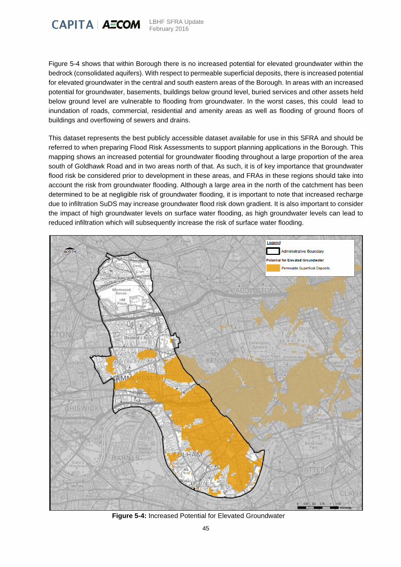
LBHF SFRA Update February 2016
45
Figure 5-4 shows that within Borough there is no increased potential for elevated groundwater within the
bedrock (consolidated aquifers). With respect to permeable superficial deposits, there is increased potential
for elevated groundwater in the central and south eastern areas of the Borough. In areas with an increased
potential for groundwater, basements, buildings below ground level, buried services and other assets held
below ground level are vulnerable to flooding from groundwater. In the worst cases, this could lead to
inundation of roads, commercial, residential and amenity areas as well as flooding of ground floors of
buildings and overflowing of sewers and drains.
This dataset represents the best publicly accessible dataset available for use in this SFRA and should be
referred to when preparing Flood Risk Assessments to support planning applications in the Borough. This
mapping shows an increased potential for groundwater flooding throughout a large proportion of the area
south of Goldhawk Road and in two areas north of that. As such, it is of key importance that groundwater
flood risk be considered prior to development in these areas, and FRAs in these regions should take into
account the risk from groundwater flooding. Although a large area in the north of the catchment has been
determined to be at negligible risk of groundwater flooding, it is important to note that increased recharge
due to infiltration SuDS may increase groundwater flood risk down gradient. It is also important to consider
the impact of high groundwater levels on surface water flooding, as high groundwater levels can lead to
reduced infiltration which will subsequently increase the risk of surface water flooding.
Figure 5-4: Increased Potential for Elevated Groundwater

LBHF SFRA Update February 2016
46
Groundwater Flood Risk and Climate Change
The impact of climate change on groundwater levels is highly uncertain. The UK Climate Impact
Programme (UKCIP) model indicates that, in future, winters may be generally wetter and summers
substantially drier across the UK. The greater variability in rainfall could mean more frequent and prolonged
periods of high or low water levels. The effects of climate change on groundwater in the UK therefore may
include increased frequency and severity of groundwater-related floods. It should be noted that although
winter rainfall may increase the frequency of groundwater flooding incidents, the potential of drier summers
and lower recharge of aquifers may counteract this effect.
Impacts of Groundwater Flooding
The main impacts of groundwater flooding are:
Flooding of basements of buildings below ground level – in the mildest case this may involve
seepage of small volumes of water through walls, temporary loss of services etc. In more
extreme cases larger volumes may lead to the catastrophic loss of stored items and failure
of structural integrity;
Overflowing of sewers and drains – surcharging of drainage networks can lead to overland
flows causing significant but localised damage to property. Sewer surcharging can lead to
inundation of property by polluted water. Note: it is complex to separate this flooding from
other sources, notably surface water or sewer flooding;
Flooding of buried services or other assets below ground level – prolonged inundation of
buried services can lead to interruption and disruption of supply;
Inundation of roads, commercial, residential and amenity areas – inundation of grassed
areas can be inconvenient; however the inundation of hard-standing areas can lead to
structural damage and the disruption of commercial activity. Inundation of agricultural land
for long durations can have financial consequences; and
Flooding of ground floors of buildings above ground level – can be disruptive, and may result
in structural damage. The long duration of flooding can outweigh the lead time which would
otherwise reduce the overall level of damages.
In general terms, groundwater flooding rarely poses a risk to life.
Groundwater Flood Risk Management
Management is highly dependent upon the characteristics of the specific situation. The costs associated
with the management of groundwater flooding are highly variable. The implications of groundwater flooding
should be considered and managed through development control and building design. Possible responses
include:
Raising property ground or floor levels or incorporating structural waterproofing measures
in basements built in areas considered to be at risk of groundwater flooding.
Provide local protection for specific problem areas such as flood-proofing properties (such
as tanking, sealing of building basements, raising the electrical sockets/TV points etc.)
The Increased Potential for Elevated Groundwater Map should be used in the initial scoping
stages to determine whether a location is at potential risk of groundwater flooding; however
it should not be used as a substitute for detailed site-specific evaluation of groundwater
flood risk. LBHF should also utilise the ESI Groundwater Flood Risk Map when considering
planning applications.

LBHF SFRA Update February 2016
47
Replacement and renewal of leaking sewers, drains and water supply reservoirs. Water
companies have a programme to address leakage from infrastructure, so there is clear
ownership of the potential source.
Major ground works (such as construction of new or enlarged watercourses) and
improvements to the existing surface water drainage network to improve conveyance of
floodwater from surface water of fluvial events through and away from areas prone to
groundwater flooding.
Most options involve the management of groundwater levels. It is important to assess the impact of
managing groundwater with regard to water resources, and environmental designations. Likewise, placing
a barrier to groundwater movement can shift groundwater flooding from one location to another. The
appropriateness of infiltration based drainage techniques should also be questioned in areas where
groundwater levels are high or where source protection zones are close by.
Infiltration SuDS
Improper use of infiltration Sustainable Drainage Systems (SuDS) could lead to contamination of the
superficial deposit or bedrock aquifers, leading to deterioration in aquifer quality status or groundwater
flooding / drainage issues. However, correct use of infiltration SuDS is likely to help improve aquifer quality
status and reduce overall flood risk.
The Environment Agency provides guidance on infiltration SuDS at the following website:
http://www.rtpi.org.uk/media/12399/suds_a5_booklet_final_080408.pdf
These documents should be considered by developers and their contractors, and by the Councils when
approving or rejecting planning applications. Other reference materials for the UK can be located on the
CIRIA website http://www.ciria.org http://www.wsud.org/ and the professional community website
http://www.susdrain.org/resources/ which provides resource links and SuDS case studies.
The areas that may be suitable for infiltration SuDS exist where there is a combination of high ground and
permeable geology. However, consideration should be given to the impact of increased infiltration SuDS
on properties further down gradient. An increase in infiltration and groundwater recharge will lead to an
increase in groundwater levels, thereby increasing the susceptibility to groundwater flooding at a down
gradient location. This type of analysis is beyond the scope of the current report, but it could be as
significant problem where there is potential for perched water tables to develop. Figure 5-3 provides the
summary outputs of the Infiltration SuDS Map across LBHF.
Due to the underlying geology the suitability for incorporating infiltration SuDS measures is largely uncertain
and developers will need to undertake infiltration tests to confirm the suitability of utilising these SuDS
measures. Developers must ensure that their proposed drainage designs comply planning policies and
with the available Environment Agency and Thames Water guidance.
Source protection zones (SPZs) should be considered when applying mitigation measures, such as SuDS,
which have the potential to contaminate the underlying aquifer. Restrictions on the use of infiltration SuDS
apply to those areas within SPZs. There are no SPZs in the Borough.
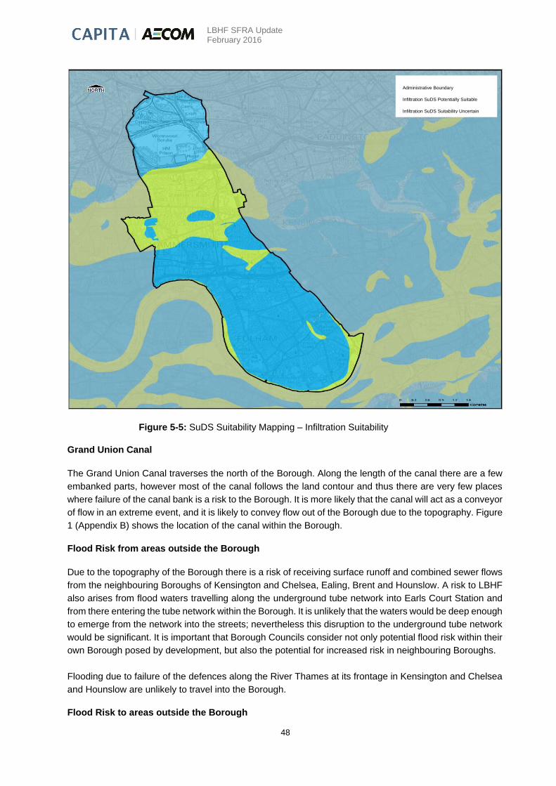
LBHF SFRA Update February 2016
48
Figure 5-5: SuDS Suitability Mapping – Infiltration Suitability
Grand Union Canal
The Grand Union Canal traverses the north of the Borough. Along the length of the canal there are a few
embanked parts, however most of the canal follows the land contour and thus there are very few places
where failure of the canal bank is a risk to the Borough. It is more likely that the canal will act as a conveyor
of flow in an extreme event, and it is likely to convey flow out of the Borough due to the topography. Figure
1 (Appendix B) shows the location of the canal within the Borough.
Flood Risk from areas outside the Borough
Due to the topography of the Borough there is a risk of receiving surface runoff and combined sewer flows
from the neighbouring Boroughs of Kensington and Chelsea, Ealing, Brent and Hounslow. A risk to LBHF
also arises from flood waters travelling along the underground tube network into Earls Court Station and
from there entering the tube network within the Borough. It is unlikely that the waters would be deep enough
to emerge from the network into the streets; nevertheless this disruption to the underground tube network
would be significant. It is important that Borough Councils consider not only potential flood risk within their
own Borough posed by development, but also the potential for increased risk in neighbouring Boroughs.
Flooding due to failure of the defences along the River Thames at its frontage in Kensington and Chelsea
and Hounslow are unlikely to travel into the Borough.
Flood Risk to areas outside the Borough
Administrative Boundary
Infiltration SuDS Potentially Suitable
Infiltration SuDS Suitability Uncertain

LBHF SFRA Update February 2016
49
Flooding within Hammersmith and Fulham poses a possible flood risk to the neighbouring Boroughs of
Kensington and Chelsea and Hounslow as a result of a breach in the defences near the borders. The risk
from LBHF arises from the breach flood waters spreading out and crossing the border. There is also the
potential for surface water to flow overland into the RBKC at several underpasses along the Borough
boundary, as well as into Hounslow and Ealing. It is essential that the Council considers not only potential
flood risk within the LBHF posed by development, but also the potential for increased risk in neighbouring
Boroughs.
5.10 Critical Infrastructure at Risk of Flooding
Critical infrastructure is infrastructure which would be critical in the event of an emergency. Figure 5A-1,
Figure 5A-2 and Figure 5A-3 (Appendix B) show the critical infrastructure at risk of tidal or surface water
flooding within the Borough. Critical infrastructure at flood risk within the Borough include fire, police and
ambulance stations, hospitals, telephone exchanges, tube stations, a council depot and main roads
(including the A4).
Table 5-5 overleaf provides a summary of flood risk for critical infrastructure in the Borough. The only
critical infrastructure shown to be as risk of residual flooding from the River Thames is Putney Bridge
Underground Station, which is located within 150m of the River Thames. A number of the critical
infrastructure properties are within regions at increased potential for groundwater flooding, and are
therefore at risk of groundwater flooding. There is also a surface water flood risk to a number of the
properties, although it must be notes that the SWMP model outputs on which these were based is not
detailed enough to define risk for individual properties.
In addition, LBHF SWMP states: “railway and tube lines that are below ground level but are not covered
are shown to have flood depths in excess of 1.5m. The nature of the railway lines does suggest a greater
susceptibility to surface water flooding, however no account has been made for drainage within these
areas. Therefore the degree of flooding should not be considered realistic.” Critical infrastructure which
falls into this category is marked ‘*’.
Critical infrastructure bodies/organisations are recommended to integrate flood resilience measures and
establish Emergency Flood Plans if not done so already as part of their business continuity plans. This will
ensure that critical services can continue to function should the site be impacted by flood waters. Critical
infrastructure providers should liaise with the council’s Emergency Planning Team to ensure an integrated
approach to flood response as outlined in the Multi-Agency Flood Plan.
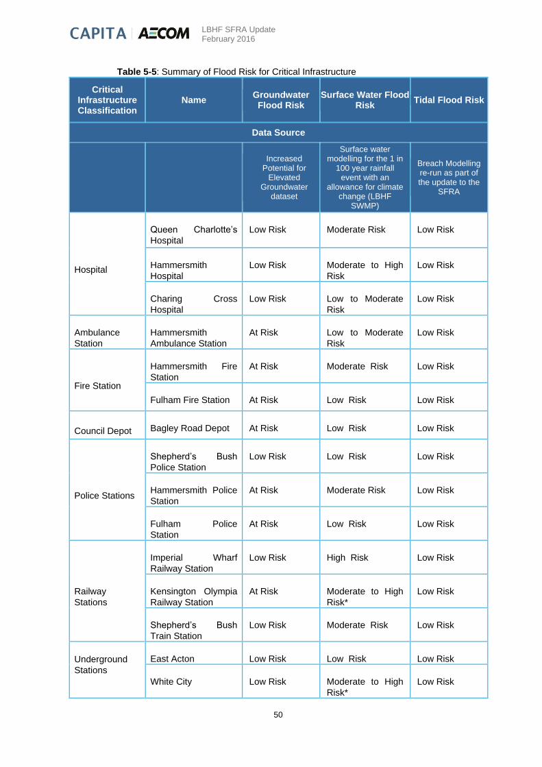
LBHF SFRA Update February 2016
50
Table 5-5: Summary of Flood Risk for Critical Infrastructure
Critical Infrastructure Classification
Name Groundwater Flood Risk
Surface Water Flood Risk
Tidal Flood Risk
Data Source
Increased Potential for
Elevated Groundwater
dataset
Surface water modelling for the 1 in
100 year rainfall event with an
allowance for climate change (LBHF
SWMP)
Breach Modelling re-run as part of the update to the
SFRA
Hospital
Queen Charlotte’s
Hospital
Low Risk Moderate Risk Low Risk
Hammersmith
Hospital
Low Risk Moderate to High
Risk
Low Risk
Charing Cross
Hospital
Low Risk Low to Moderate
Risk
Low Risk
Ambulance
Station
Hammersmith
Ambulance Station
At Risk Low to Moderate
Risk
Low Risk
Fire Station
Hammersmith Fire
Station
At Risk Moderate Risk Low Risk
Fulham Fire Station At Risk Low Risk Low Risk
Council Depot Bagley Road Depot At Risk Low Risk Low Risk
Police Stations
Shepherd’s Bush
Police Station
Low Risk Low Risk Low Risk
Hammersmith Police
Station
At Risk Moderate Risk Low Risk
Fulham Police
Station
At Risk Low Risk Low Risk
Railway
Stations
Imperial Wharf
Railway Station
Low Risk High Risk Low Risk
Kensington Olympia
Railway Station
At Risk Moderate to High
Risk*
Low Risk
Shepherd’s Bush
Train Station
Low Risk Moderate Risk Low Risk
Underground
Stations
East Acton Low Risk Low Risk Low Risk
White City Low Risk Moderate to High
Risk*
Low Risk

LBHF SFRA Update February 2016
51
Shepherd’s Bush
(Hammersmith and
City)
Low Risk Low to Moderate
Risk
Low Risk
Shepherd’s Bush
(Central)
Low Risk Low Risk Low Risk
Goldhawk Road Low Risk Low to Moderate
Risk
Low Risk
Ravenscourt Park Low Risk Moderate Risk Low Risk
Hammersmith
(Hammersmith and
City)
At Risk Low Risk Low Risk
Hammersmith
(District and
Piccadilly)
At Risk Low Risk Low Risk
Baron’s Court At Risk High Risk* Low Risk
West Kensington At Risk High Risk* Low Risk
Fulham Broadway At Risk Low Risk Low Risk
Parson’s Green At Risk Low Risk Low Risk
Putney Bridge At Risk Low Risk High Residual
Risk
Kensington Olympia At Risk Moderate to High
Risk*
Low Risk

LBHF SFRA Update February 2016
52
6. Proposed Development Sites
This section provides a summary of flood risk for 18 strategic development sites as defined by the LBHF from the Strategic Housing Land Availability Assessment (SHLAA). The assessment considers flood risk from all sources based on the strategic
scale information collated for this SFRA. Figure 10 (Appendix B) provides an overview of the site locations within the Borough.
This assessment does not remove the need for planning applications to be supported by a detailed flood risk assessment where appropriate. As stated in Chapter 2, it is recommended that developers consult the Environment Agency, LBHF, Thames
Water, the Rivers and Canal Trust and the Port of London Authority (where required) early in the development of site proposals to agree appropriate measures, informed by more detailed analysis where necessary.
Table 6-1: Summary of Flood Risk for 18 Strategic Development Sites
Site Reference (refer to Figure 10 in Appendix
B for as overview of
site locations)
Site Name
NGR Size of
site (ha) Flood Zone
Surface Water (Pluvial) Groundwater Artificial Sources Residual Risk
Summary of Risk Data Source
Approximate based on H&F strategic site information
EA Flood Zones
Surface water modelling for the 1 in 100 year rainfall event with an allowance for climate change (LBHF SWMP)
Increased Potential for Elevated Groundwater
dataset
EA Reservoir Inundation Mapping which shows
areas at risk of flooding from large reservoirs ( >
25,000 m3)
Breach Modelling re-run as part of the update to
the SFRA
1 BBC TV Centre (Plot B) 523186, 180541
5.5 1
Small areas of ponding associated with a moderate (danger for some) and significant (danger for most) hazard rating on site. Surface water flooding to Wood Lane access to site.
Low Risk. Site underlain by Langley Silt Member superficial deposits.
Low Risk from a reservoir breach. The Paddington Branch of the Grand Union Canal is located 1.3km to the north of the site. The canal does not appear to be embanked and no breach modelling for the section is available.
Low Risk
Due to the size of the site (greater than 1ha) a flood risk assessment will be required to support a planning application and should focus on the management of surface water. There would be no requirement for the site to pass the Sequential or Exception Test as it is located in Flood Zone 1 (lowest risk of flooding).
2 Former Dairy Crest Site - Aviva-Helical Bar
523400, 180963
4.9 1
Small areas of ponding associated with a moderate (danger for some) hazard rating and small area in south west corner associated with significant (danger for most) hazard rating.
Low Risk. Site underlain by Langley Silt Member superficial deposits.
Low Risk from a reservoir breach. The Paddington Branch of the Grand Union Canal is located 1.3km to the north of the site. The canal does not appear to be embanked and no breach modelling for the section is available.
Low Risk
Due to the size of the site (greater than 1ha) a flood risk assessment will be required to support a planning application and should focus on the management of surface water. There would be no requirement for the site to pass the Sequential or Exception Test as it is located in Flood Zone 1 (lowest risk of flooding).
3 M&S 523482, 180765
4.2 1
Area of deep ponding associated with a significant (danger for most) hazard rating in the south west of the site adjacent to Wood Lane.
Low Risk. Site underlain by Langley Silt Member superficial deposits.
Low Risk from a reservoir breach. The Paddington Branch of the Grand Union Canal is located 1.3km to the north of the site. The canal does not appear to be embanked and no breach modelling for the section is available.
Low Risk
Due to the size of the site (greater than 1ha) a flood risk assessment will be required to support a planning application and should focus on the management of surface water. There would be no requirement for the site to pass the Sequential or Exception Test as it is located in Flood Zone 1 (lowest risk of flooding).
4 Shepherd's Bush Market 523207,
179829 1.9 3
Areas of ponding are
associated with a moderate
(danger for some) and
significant (danger for
most) hazard rating.
Northern part of site is
underlain by Kempton Park
Gravel Formation and
shown to be at risk from
groundwater flooding. The
southern area is underlain
by the Langley Silt Member
and not shown to be at risk.
Low Risk Low Risk
The site is partly located in Flood Zone 3. In accordance with the
NPPF guidance, 'Water Compatible' and 'Less Vulnerable' land
uses are appropriate with in Flood Zone 3a, 'Essential
Infrastructure' and 'More Vulnerable' land uses require the
Exception Test to be passed. 'Highly Vulnerable' land use would
be allowed on completion of an acceptable Exception Test and
FRA.. A detailed flood risk assessment will be required to support
a planning application and must also address management of
surface water and groundwater on site.

LBHF SFRA Update February 2016
53
Site Reference (refer to Figure 10 in Appendix
B for as overview of
site locations)
Site Name
NGR Size of
site (ha) Flood Zone
Surface Water (Pluvial) Groundwater Artificial Sources Residual Risk
Summary of Risk Data Source
Approximate based on H&F strategic site information
EA Flood Zones
Surface water modelling for the 1 in 100 year rainfall event with an allowance for climate change (LBHF SWMP)
Increased Potential for Elevated Groundwater
dataset
EA Reservoir Inundation Mapping which shows
areas at risk of flooding from large reservoirs ( >
25,000 m3)
Breach Modelling re-run as part of the update to
the SFRA
5 Earls Court 2 / TFL Depot 524895,
178271 19.2 3
Areas of deep ponding on
the tracks are associated
with an extreme (danger for
all) hazard rating.
Elsewhere on site ponding
is associated with a
moderate (danger for
some) and significant
(danger for most) hazard
rating.
The site is underlain by the
Kempton Park Gravel
Formation and shown to be
at risk from groundwater
flooding.
The maximum flood
extents from a reservoir
breach scenario of the
Queen Mary and Queen
Mother Reservoirs (located
over 15km to the west of
the site) extend as far as
the site.
Low Risk
The site is located in Flood Zone 3. In accordance with the NPPF
guidance, 'Water Compatible' and 'Less Vulnerable' land uses are
appropriate with in Flood Zone 3a, 'Essential Infrastructure' and
'More Vulnerable' land uses require the Exception Test to be
passed. 'Highly Vulnerable' land uses would be allowed on
completion of an acceptable Exception Test and FRA. risk
assessment will be required to support a planning application and
must also address management of surface water and
groundwater on site.
6 Seagrave Road Car Park 525413,
177839 3.0 3
Small areas of ponding are
associated with a moderate
(danger for some) hazard
rating.
The site is underlain by the
Kempton Park Gravel
Formation and shown to be
at risk from groundwater
flooding.
The maximum flood
extents from a reservoir
breach scenario of the
Queen Mary and Queen
Mother Reservoirs (located
over 15km to the west of
the site) extend as far as
the site.
Low Risk. Breach
modelling for the SFRA is
shown to impact only a
small part of the site near
the south eastern
boundary.
The site is fully located in Flood Zone 3. In accordance with the
NPPF guidance, 'Water Compatible' and 'Less Vulnerable' land
uses are appropriate with in Flood Zone 3a, 'Essential
Infrastructure' and 'More Vulnerable' land uses require the
Exception Test to be passed. 'Highly Vulnerable' land uses would
be allowed on completion of an acceptable Exception Test and
FRA. A detailed flood risk assessment will be required to support
a planning application and must also address management of
surface water and groundwater on site.
7 1-9 Lillie Road 526177,
176180 0.7 3
Areas of ponding are
associated with a moderate
(danger for some) and
significant (danger for
most) hazard rating on site.
The eastern site boundary
is formed by the railway
cutting associated with an
extreme (danger for all)
hazard rating.
The site is underlain by the
Kempton Park Gravel
Formation and shown to be
at risk from groundwater
flooding.
The maximum flood
extents from a reservoir
breach scenario of the
Queen Mary and Queen
Mother Reservoirs (located
over 15km to the west of
the site) extend as far as
the site.
Low Risk
The site is fully located in Flood Zone 3. In accordance with the
NPPF guidance, 'Water Compatible' and 'Less Vulnerable' land
uses are appropriate with in Flood Zone 3a, 'Essential
Infrastructure' and 'More Vulnerable' land uses require the
Exception Test to be passed. 'Highly Vulnerable' land uses would
be allowed on completion of an acceptable Exception Test and
FRA. . A detailed flood risk assessment will be required to support
a planning application and must also address management of
surface water and groundwater on site.
8 Watermeadow Court 526183, 176196
0.5 3 Small and shallow area of ponding associated with a very low hazard rating.
The site is underlain by the Kempton Park Gravel Formation and alluvium. The northern part of the site is shown to be at risk from groundwater flooding.
Low Risk
Breach modelling for the SFRA has been undertaken approximately 1.4km to the west and is not shown to impact the site. As the site borders the River Thames tidal defences, it is recommended that the need for site specific breach modelling is assessed as part of a detailed FRA.
The site is fully located in Flood Zone 3. In accordance with the NPPF guidance, 'Water Compatible' and 'Less Vulnerable' land uses are appropriate with in Flood Zone 3a, 'Essential Infrastructure' and 'More Vulnerable' land uses require the Exception Test to be passed. 'Highly Vulnerable' land uses would be allowed on completion of an acceptable Exception Test and FRA. A detailed flood risk assessment will be required to support a planning application and must also address management of surface water and groundwater on site. Assessment of the need for site specific breach modelling is recommended as part of the FRA.

LBHF SFRA Update February 2016
54
Site Reference (refer to Figure 10 in Appendix
B for as overview of
site locations)
Site Name
NGR Size of
site (ha) Flood Zone
Surface Water (Pluvial) Groundwater Artificial Sources Residual Risk
Summary of Risk Data Source
Approximate based on H&F strategic site information
EA Flood Zones
Surface water modelling for the 1 in 100 year rainfall event with an allowance for climate change (LBHF SWMP)
Increased Potential for Elevated Groundwater
dataset
EA Reservoir Inundation Mapping which shows
areas at risk of flooding from large reservoirs ( >
25,000 m3)
Breach Modelling re-run as part of the update to
the SFRA
9 Currys and PC World 525796, 175658
1.2 3 Small and shallow area of ponding associated with a very low hazard rating.
Low Risk. The site is underlain by alluvium.
Low Risk
Breach modelling for the SFRA has been undertaken approximately 0.8km to the west and is shown to impact only a small part of the site. It is recommended that the need for site specific breach modelling is assessed as part of a detailed FRA.
The site is fully located in Flood Zone 3. In accordance with the NPPF guidance, 'Water Compatible' and 'Less Vulnerable' land uses are appropriate with in Flood Zone 3a, 'Essential Infrastructure' and 'More Vulnerable' land uses require the Exception Test to be passed. 'Highly Vulnerable' land uses would be allowed on completion of an acceptable Exception Test and FRA. . A detailed flood risk assessment will be required to support a planning application. Assessment of the need for site specific breach modelling is recommended as part of the FRA.
10 Riverside Studios/Queens Wharf
523118, 178147
0.6 3
No significant surface water flooding issues have been identified. The site is associated with a very low hazard rating.
The site is underlain by the Kempton Park Gravel Formation and alluvium. The southern part of the site is shown to be at risk from groundwater flooding.
The maximum flood extents from a reservoir breach scenario of the Queen Mary and Queen Mother Reservoirs (located over 15km to the west of the site) extend as far as the site.
There is a residual risk of flooding from a breach of the River Thames tidal defences to a small area in the west of the site during the 1 in 200 year return period event. Flooding is associated with a moderate hazard (danger for some).
The site is fully located in Flood Zone 3. In accordance with the NPPF guidance, 'Water Compatible' and 'Less Vulnerable' land uses are appropriate with in Flood Zone 3a, 'Essential Infrastructure' and 'More Vulnerable' land uses require the Exception Test to be passed. 'Highly Vulnerable' land uses would be allowed on completion of an acceptable Exception Test and FRA. A detailed flood risk assessment will be required to support a planning application and must also address the management of surface water and groundwater on site. Assessment of the need for site specific breach modelling is recommended as part of the FRA.
11 Junction of Western Avenue and Old Oak Road
521657, 180868
0.2 1
There are small areas of ponding associated with a moderate (danger for some) hazard rating.
Low Risk. The site is underlain by the Langley Silt Member
Low Risk Low Risk The site is located in Flood Zone 1, all uses of land are appropriate in this zone.
12 Olympia Multi-storey Car Park Maclise Road
524208, 179299
0.5 2 & 3
No significant surface water flooding issues have been identified. The site is associated with a very low hazard rating.
The site is underlain by the Kempton Park Gravel Formation and shown to be at risk from groundwater flooding.
The maximum flood extents from a reservoir breach scenario of the Queen Mary and Queen Mother Reservoirs (located over 15km to the west of the site) extend as far as the site.
Low Risk
The site is partially located in Flood Zones 2 & 3. The site layout plan should locate development in the areas of lowest flood risk within the site. A flood risk assessment will be required to support a planning application and must address the management of groundwater on site.
13 6-12 Gorleston Street 524387, 178769
0.1 1
One small area of ponding on the north east boundary associated with a moderate (danger for some) hazard rating.
The site is underlain by the Kempton Park Gravel Formation and shown to be at risk from groundwater flooding.
Low Risk Low Risk The site is located in Flood Zone 1, all uses of land are appropriate in this zone.
14 22 Bute Gardens And 11 - 17 (odd) Wolverton Gardens
523531, 178737
0.2 2
An area of ponding in the north west boundary is associated with a moderate (danger for some) hazard rating.
The site is underlain by the Kempton Park Gravel Formation and shown to be at risk from groundwater flooding.
Low Risk Low Risk The site is located in Flood Zones 2. A flood risk assessment will be required to support a planning application and must address the management of surface water and groundwater on site.

LBHF SFRA Update February 2016
55
Site Reference (refer to Figure 10 in Appendix
B for as overview of
site locations)
Site Name
NGR Size of
site (ha) Flood Zone
Surface Water (Pluvial) Groundwater Artificial Sources Residual Risk
Summary of Risk Data Source
Approximate based on H&F strategic site information
EA Flood Zones
Surface water modelling for the 1 in 100 year rainfall event with an allowance for climate change (LBHF SWMP)
Increased Potential for Elevated Groundwater
dataset
EA Reservoir Inundation Mapping which shows
areas at risk of flooding from large reservoirs ( >
25,000 m3)
Breach Modelling re-run as part of the update to
the SFRA
15 Tent site, Lots Road 526218, 176884
0.4 1, 2 & 3
No significant surface water flooding issues have been identified. The site is associated with a very low hazard rating.
Low Risk. The site is underlain by alluvium.
Low Risk
As the site borders the River Thames tidal defences, it is recommended that assessment of the need for site specific breach modelling is undertaken as part of a detailed FRA.
The site is partially located in Flood Zones 2 & 3. The site layout plan should locate development in the areas of lowest flood risk within the site (Flood Zone 1). A flood risk assessment will be required to support a planning application. Assessment of the need for site specific breach modelling is recommended as part of the FRA.
16 Favourite public house, 27 St Ann Road
523900, 180362
0.1 1
One small area of ponding is associated with a moderate (danger for some) hazard rating.
Low Risk. The site is underlain by the Langley Silt Member
Low Risk Low Risk The site is located in Flood Zone 1, all uses of land are appropriate in this zone.
17 77-89 Glenthorne Road 522846, 178736
0.1 2 & 3
Small areas of ponding is associated with a moderate (danger for some) hazard rating.
Low Risk. The site is underlain by the Kempton Park Gravel Formation.
The maximum flood extents from a reservoir breach scenario of the Queen Mary and Queen Mother Reservoirs (located over 15km to the west of the site) extend as far as the site.
Low Risk The site is partially located in Flood Zones 2 & 3. A flood risk assessment will be required to support a planning application and must address the management of surface water on site.
18 BBC Media Village 523160, 180861
1.4 1
Shallow areas of ponding on site associated with a low hazard rating and small areas associated with a moderate (danger for some) hazard rating on site.
Low Risk. The site is underlain by the Langley Silt Member
Low Risk from a reservoir breach. The Paddington Branch of the Grand Union Canal is located 1.3km to the north of the site. The canal does not appear to be embanked and no breach modelling for the section is available.
Low Risk
Due to the size of the site (greater than 1ha) a flood risk assessment will be required to support a planning application and should address the management of surface water. There would be no requirement for the site to pass the Sequential or Exception Test as it is located in Flood Zone 1 (lowest risk of flooding).
LBHF SFRA Update February 2016
56
7. Future Planning and Development Control
The SFRA is the basis upon which initial planning decisions with regard to flooding are made. The Council
are required to prioritise the allocation of land for development in ascending order from Flood Risk Zones
1 to 3. However, as development becomes necessary because of lack of suitable Zone 1 space, or for
socio-economic reasons, then it is necessary to consider development allocations in higher risk zones.
Where development is allocated within the medium flood risk zone (Zone 2) or high flood risk zone (Zone
3), the NPPF requires the Council to demonstrate that there are no reasonable alternative development
sites in lower flood risk zones. As stated in Section 2.1.1, the Council has previously conducted the
Sequential Test for the entire Borough and therefore no further application of the Sequential Test is
required. It may be necessary to apply the Exception Test, and the situations where it is necessary and
appropriate to apply this are outlined in Chapter 2, Table 2-1 of this report. The table indicates where
developments could be allowed, rejected or subject to the Exception Test.
What does that mean for Sites within Zone 1?
From a tidal and fluvial flood risk perspective, all land uses are acceptable within Flood Zone 1. Flood risk
is not considered to be a significant constraint to development and all land uses listed below are appropriate
in this zone:
Essential infrastructure;
Highly vulnerable;
More vulnerable;
Less vulnerable; and
Water compatible development.
Due to their potential impact on the local flood risk, a Flood Risk Assessment (FRA) will be required for all
developments greater than 1 ha in size.
In addition, due to the risk of surface water and sewer flooding highlighted in the LBHF SWMP, an FRA will
be required for all developments within identified surface water flooding hotspots. This will include further
consideration of surface water drainage, a recommended approach to controlling surface water discharge
and onsite mitigation measures that may be required, particularly where sewer capacity is limited.
The Flood Risk Assessment will be undertaken by the potential developer of the site. The Environment
Agency and Thames Water will be able to advise potential developers as to their specific requirements on
a site by site basis. The Council also provides advice in its Planning Guidance Supplementary Planning
Document (SPD).
What does that mean for Sites within Zone 2?
Subject to the application of the Sequential Flood Risk Test19, the NPPF specifies suitable types of
development in Zone 2 as:
Essential infrastructure;
More vulnerable;
Less vulnerable; and
Water compatible development.
19 Note that the Sequential Test has been completed by the Council for the entire Borough
LBHF SFRA Update February 2016
57
Highly vulnerable development is subject to the Exception Test.
A Flood Risk Assessment will be required for all development in this zone. The Flood Risk Assessment will
need to assess the current level of flood risk as well as the level of flood risk following development.
Development plans for the site will need to demonstrate that flood risk can be effectively and safely
managed without increasing flood risk elsewhere.
Proposals should also demonstrate that safe access and egress to the development can be maintained
during an extreme flood event and that development is set at an appropriate level so that the residual risks
are managed to acceptable levels. Appendix A2 provides details of access and egress requirements.
A further level of analysis of the affects of a breach in or overtopping of the defences in an extreme event
(usually the 0.5% AEP plus climate change) may be required if the site falls within an area which is classified
as being at High or Medium Residual Risk in order to test the sustainability and robustness of the mitigation
measures. Other flood risk constraints, such as incidents of localised flooding and other site specific
considerations will need to be addressed. Site-specific Flood Risk Assessments will be undertaken by the
developer of the site. Where required, the Environment Agency will be able to advise developers as to their
specific requirements on a site by site basis. The council also provides guidance in its Planning Guidance
SPD.
In addition, due to the risks of groundwater, surface water and sewer flooding highlighted in the LBHF
SWMP, any FRA will also need to assess these flood risks. This will include further consideration of surface
water drainage, a recommended approach to controlling surface water discharge and onsite mitigation
measures that may be required, particularly where sewer capacity is limited. For developments that include
basement proposals, FRAs will need to show how these will be adequately protected against sewer and
groundwater flood risk without increasing flood risks off-site.
What does that mean for Sites within Zone 3a?
Subject to the application of the Sequential Flood Risk Test, the NPPF specifies suitable types of
development in Zone 3a as:
Less vulnerable; and
Water compatible development.
Essential Infrastructure and More Vulnerable development are subject to the Exception Test. Highly
Vulnerable development would not generally be permitted in this zone; however certain developments in
this category may be permitted on a case-by-case basis if approved by the Council and the EA.
Any proposals for development within Flood Zone 3 will require developers to undertake a detailed site
specific Flood Risk Assessment. The Flood Risk Assessment will need to assess the current level of flood
risk as well as the level of flood risk following development. Development plans for the site will need to
demonstrate that flood risk can be effectively and safely managed without increasing flood risk elsewhere.
Proposals should also demonstrate that safe access and egress to the development can be maintained
during an extreme flood event and that development is set at an appropriate level so that the residual risks
are managed to acceptable levels.
Where the site falls within an area which is classified as being at High or Medium Residual Risk, the detailed
FRA should include a detailed assessment of the residual risks posed by the existing defences being
breached or overtopped in an extreme event (usually the 0.5% AEP plus climate change). It should be
noted that constraints to development are likely to be significant and developers should seek advice from
the Council, the Environment Agency and Thames Water as to the specific requirements for assessment.
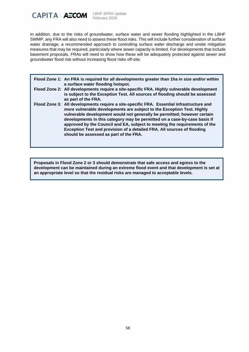
LBHF SFRA Update February 2016
58
In addition, due to the risks of groundwater, surface water and sewer flooding highlighted in the LBHF
SWMP, any FRA will also need to assess these flood risks. This will include further consideration of surface
water drainage, a recommended approach to controlling surface water discharge and onsite mitigation
measures that may be required, particularly where sewer capacity is limited. For developments that include
basement proposals, FRAs will need to show how these will be adequately protected against sewer and
groundwater flood risk without increasing flood risks off-site.
Flood Zone 1: An FRA is required for all developments greater than 1ha in size and/or within
a surface water flooding hotspot.
Flood Zone 2: All developments require a site-specific FRA. Highly vulnerable development
is subject to the Exception Test. All sources of flooding should be assessed
as part of the FRA.
Flood Zone 3: All developments require a site-specific FRA. Essential infrastructure and
more vulnerable developments are subject to the Exception Test. Highly
vulnerable development would not generally be permitted; however certain
developments in this category may be permitted on a case-by-case basis if
approved by the Council and EA, subject to meeting the requirements of the
Exception Test and provision of a detailed FRA. All sources of flooding
should be assessed as part of the FRA.
Proposals in Flood Zone 2 or 3 should demonstrate that safe access and egress to the
development can be maintained during an extreme flood event and that development is set at
an appropriate level so that the residual risks are managed to acceptable levels.
LBHF SFRA Update February 2016
59
8. Conclusion and Recommendations
The SFRA has identified that the significant sources of flood risk within the London Borough of
Hammersmith and Fulham (LBHF) are surface water and sewer flooding, and the residual risk which arises
from a possible failure in the River Thames tidal defences. There is also a high risk of groundwater flooding
in the Borough.
Sewer and surface water flooding are particularly problematic, with the Borough experiencing significant
problems historically and during the heavy rainfall events of 20th July 2007. Figure 3 (Appendix B) provides
an overview of surface water flood risk in the Borough. It is recognised that this is a large scale issue and
it is recommended that LBHF continues in an active role in future strategic surface water management
plans for London in liaison with the Greater London Authority and Thames Water. This can now be
supported by the results of the SWMP. Due to the interconnected nature of surface water and sewer
flooding in the Borough, it is essential that LBHF work closely with Thames Water to identify opportunities
for integrated surface water and sewer flood risk management.
There is a high risk of groundwater flooding throughout the central and south parts of the Borough, which
must be considered not only in terms of its own risk, but also in terms of the increased surface water flood
risk associated with high groundwater levels. Figure 14 (Appendix B) provides an overview of areas at
increased potential for groundwater flooding. The Increased Potential for Elevated Groundwater should be
used in the first instance to identify areas at potential groundwater flood risk.
Future climate change predictions imply that surface water, sewer and groundwater flooding will become
more frequent; therefore the Council needs to plan for future emergencies, become proactive in mitigating
against the risk, and provide guidance to residents on how they too can mitigate against the impacts of this
type of flooding.
There is a risk of tidal flooding throughout a large proportion of the Borough, but at present Hammersmith
and Fulham are fully defended against the 0.1% annual probability extreme tide level. Nevertheless, the
areas benefiting from these tidal defences have the potential to experience high hazard should a breach
occur. Although a breach in the defences is not expected, this is a possibility that needs to be taken into
account in planning. The SFRA has fully assessed the extent and variation of the residual risk remaining
behind defences within the Borough. Figure 15 (Appendix B) shows the areas suffering residual risk and
their classifications.
The Environment Agency released the Thames Estuary 2100 (TE2100) Plan in November 2012. The
document sets out their recommendations for flood risk management for London and the Thames Estuary
through to the end of century and beyond. The Plan puts the need for climate change adaptation at its core.
It primarily looks at tidal flooding, though other sources of flooding including high river flows as a result of
heavy rainfall and surface water flooding are also considered.
In the future, with sea level rise and climate change, the TE2100 plan predicts an increase in River Thames
water levels within the Borough. It is thought unlikely that the Thames Barrier would fail to close during a
significant tidal surge in the North Sea, but should this occur, the risks have been concluded to be low. This
is based on the defences being raised to levels laid out in the TE2100 plan. If these defences are not raised
to the identified levels, there is a severe risk of overtopping causing flooding to LBHF.
LBHF SFRA Update February 2016
60
An analysis of the risk associated with defence breaches taking into account climate change has been
undertaken within the Borough. These results indicate a significant increase in residual risk (both depth
and hazard) as a result of the predicated climate change levels and should be considered within any future
development applications.
Guidance has been given to the LPA on what types of development are suitable in each of these Flood
Zones according to the NPPF. The LBHF Core Strategy demonstrates that the Sequential Test has been
undertaken by LBHF on a Borough-wide level and determined that the Sequential Test permits the
consideration of all sites for development, subject to meeting the requirements of the Exception Test and
a completion of an appropriate site specific FRA. Therefore developers are not required to apply the
Sequential Test to individual developments. It is essential that Flood Risk Assessments submitted with
development proposals take into account the findings of this SFRA as well as the LBHF SWMP, and assess
flood risk from all sources. Proposals should also demonstrate that safe access and egress to the
development can be maintained during an extreme flood event and that development is set at an
appropriate level so that the residual risks are managed to acceptable levels. Appendix A1 provides
detailed guidance for the completion of detailed flood risk assessments and Appendix A2 provides guidance
on mitigation measures.
Where the site falls within an area which is classified as being at High or Medium Residual Risk, the detailed
FRA should include a detailed assessment of the residual risks posed by the existing defences being
breached or overtopped in an extreme event (usually the 0.5% AEP plus climate change). It should be
noted that constraints to development are likely to be significant and developers should seek advice from
the Council, the Environment Agency and Thames Water as to the specific requirements for assessment.

LBHF SFRA Update
February 2016
Appendix A
Appendix A
Appendix A – Guidance documentation

LBHF SFRA Update
February 2016
Appendix A
Appendix A
Appendix A1 - Guidance for the Completion of Detailed Flood Risk Assessment Introduction
In accordance with current planning policy guidance, the planning process discourages development in
areas vulnerable to flooding. This SFRA is not intended to be a prescriptive document, but a planning tool
to guide future development away from flood risk areas. Developers should refer to the SFRA and the
NPPF when considering future planning applications. This appendix, A.1, will present the guidance for the
developers on the requirements of a FRA for development in proposals in Flood Zones 1, 2, 3. The following
appendix, A.2, provides guidance on how specific flood risk management issues can be achieved.
Prior to development, site specific flood risk assessments will need to be undertaken to ensure that all
forms of flood risk at a site are fully addressed. An initial assessment of flood risk will be required for all
proposed developments and change of use to establish that they have met the requirements for FRAs and
flood risk reduction set out in Table 2.1 of the SFRA.
An FRA will be required for proposed developments:
that fall in the medium and high flood risk zones (Flood Zones 2 and 3).
in Flood Zone 1 which are greater than 1 ha in size or within an identified surface water flooding
hotspot
It is normally the responsibility of the applicant/developer to prepare a FRA, in consultation with the LPA.
The SFRA cannot provide this level of site specific information.
The aim of a Flood Risk Assessment (FRA) is to demonstrate how flood risk to the development and flood
risk to others, from all sources, will be managed now and in the future.
Flood Risk Assessments for proposed development in the LBHF should follow the approach recommended
by:
The Environment Agency (see its National Standing Advice to Local Planning Authorities for
Planning Applications - Development and Flood Risk in England);
NPPF and PPG; and
Local Plan policy and Planning Guidance Supplementary Planning Document.
Flood Risk Assessments for Flood Zones 2 and 3
A.1.1 Householder and Other Minor Extensions
Apart from habitable basements, domestic extensions within the curtilage of the dwelling (see General
Permitted Development Order definition of‚ minor development‛) and non-domestic extensions with a
footprint of less than 250m2, proposals will not require a detailed FRA.
These applications should demonstrate that the risk of flooding from all sources has been assessed,
including tidal, surface water, sewer and groundwater flooding.
The application should show either:

LBHF SFRA Update
February 2016
Appendix A
Appendix A
Floor levels within the proposed development set at no lower than existing levels AND, flood proofing of
the proposed development has been incorporated where appropriate
Or;
Floor levels within the extension set at 300mm above the known or modelled 0.5% (1 in 200 chance each
year) tidal and coastal flood. See:
https://www.gov.uk/planning-applications-assessing-flood-risk
And;
Consideration has been given to reducing the rate of run-off from the proposed development and/or from
the site as a whole.
A.1.1.2 Change of use from a less to a more vulnerable use
Table 2 in the PPG classifies uses by their vulnerability to flooding. For example, most commercial buildings
are less vulnerable than residential buildings and basement dwellings are more vulnerable than other
residential uses. Therefore a FRA will be required where the ground floor and/or basement of a building in
Flood Zone 2 or 3 changes from a use that is less vulnerable to one that is classified as 'more vulnerable'
or 'highly vulnerable'. Similarly, an FRA will also be required in Flood Zone 3 where a use changes from a
'water compatible' use to a 'less vulnerable' use. In Flood Zone 1, a FRA is required where a change of use
to a more or highly vulnerable use is proposed in a surface water flooding hotspot.
The FRA will need to show how any increase in vulnerability will be dealt with and in some cases the
change of use may not be permitted.
A.1.1.3 Non-Major Development
Non-major developments are where the number of additional dwellings to be constructed, or to be created
as a result of a conversion, is less than 10 and/or the site is less than 0.5ha, and for all other uses, where
the floor space to be built is less than 1000sqm and/or where the site area is less than 1ha.
Most developments in LBHF that fall into this category are small infill developments where the proposed
development is constrained by the adjoining buildings and by the streetscape in the surrounding area. The
FRA needs to balance the benefits of development against the flood risk to the development and should
be appropriate to the scale of development and to the constraints of an infill site in relation to the mitigation
measures that may be possible. The FRA must be undertaken by a suitably qualified professional.
Prior to undertaking a FRA the developer needs to address the requirements of the Exception Test (if
applicable). Evidence that the Exception Test (where necessary), has been passed will need to be included
in the FRA. The FRA should:
Determine whether the development is at flood risk from any source (e.g. surface water, sewer,
and groundwater), not just tidal flood risk. The details and maps provided in the SFRA identify
possible areas at risk from all sources of flooding - these are not definitive. The LBHF SWMP
should be referred to for further information on surface water and sewer flooding. Thames Water
should be contacted to determine the risk of surface water and sewer flooding in the vicinity and to
determine whether the proposed development will increase flood risk elsewhere. Each source of
flooding will need further detailed investigation specific to the location being developed - see
Section A.1.3 and A.1.4.

LBHF SFRA Update
February 2016
Appendix A
Appendix A
Determine whether the development will be at flood risk from any source in the future as a result
of climate change. (The effect of climate change on flooding from the River Thames was not found
to be significant in this SFRA (see Sections 5.4); therefore it will be the effect of climate change on
rainfall events which will be the primary focus).
Assess the level of residual flood risk behind the flood defences. The SFRA identifies those areas
that are at high and medium residual risk (Figures 8) and also estimates the speed of flooding from
a number of possible breach locations. This does not mean that development in this area would
necessarily be in an area of high or medium residual risk but rather that a more detailed study
needs to be carried out at site specific level to prove that there is an appropriate level of
understanding of flood risk related to the site. The site specific FRA should assess whether a
detailed breach analysis is required. Where a detailed breach analysis is required see advice in
Section A.1.3.
Demonstrate that the development will be safe (see Section A.2.1.1 and A.2.4.2), without
increasing flood risk elsewhere (A.2.1.2), and, where possible, will reduce flood risk overall (see
Section A.2.1.3). Determine whether the development will increase flood risk elsewhere.
Demonstrate the ability of the development to avoid increasing flood risk elsewhere (see Section
A.2.1):
Demonstrate how flood risk will be managed (see section A.2) and ensure any proposed flood risk
management measures will be sufficiently funded so the site can be developed and occupied safely
throughout its proposed lifetime.
Demonstrate that where proposed developments are adjacent to the River Thames, they have
been set back by 16m to allow for the future maintenance, replacement or repair of the Thames
Tidal Defences. Where this is not feasible and setback is less than 16m, the FRA must prove that
the EA have been consulted and agree on the reduced set back distance.
Demonstrate that the development is compliant with national, regional and local policy.
Ensure any proposed SuDS techniques and flood risk management measures will be sufficiently
funded to enable them to be maintained and the site occupied safely throughout its proposed
lifetime.
Further information on the details to be provided within the FRA can be found in the Environment Agency's
FRA Guidance Note 3:-
https://www.gov.uk/government/uploads/system/uploads/attachment_data/file/311509/LIT_9186.pdf
Advice on making development safe, avoiding increase to flood risk elsewhere, and reducing flood risk
overall are given in the following sections.
A 1.1.4 Major Development
Major developments will need to carry out a FRA in accordance with the advice in relation to non-major
developments above, but in addition the FRA will need to consider the potential for more mitigation
measures. All major developments within the high and medium residual risk zones should take into account
the breach results presented in the SFRA and where necessary, carry out a breach analysis, see advice in
Section A.1.2.1.
LBHF SFRA Update
February 2016
Appendix A
Appendix A
Flood Risk Assessments for Flood Zone 1
Flood Risk Assessments are required where proposed developments within Flood Zone 1 are greater than
1ha in size or are within an identified surface water flooding hotspot. The FRA must be undertaken by a
suitably qualified professional and should be appropriate for the scale of development. The potential impact
upon areas and receiving drainage systems, following the increase in runoff as a result of increase in
impermeable area, needs careful consideration.
The FRA should:
Determine whether the development is at flood risk from other sources now and in the future (e.g.
surface water, sewer, and groundwater). (The details and maps provided in the SFRA identify
possible areas at risk from all sources of flooding, these are not definitive. Each source of flooding
will need further detailed investigation specific to the location being developed - see Section A.1.3
and A.1.4).
Where flood risk from other sources is identified:
Demonstrate how flood risk will be managed.
Ensure that development is safe (see Section A.2.4.2);
Ensure that where possible flood risk is reduced overall; through sequential design, flood
resilience, mitigation measures and the use of SuDS (see Section A.2).
Assess the impact of a proposed development upon surface water drainage following an
increase in impermeable area, including the potential impact upon surrounding areas,
and ensure that flood risk is not increased elsewhere (see Section A.2.1)
Recommend the approach to control surface water discharge
Ensure any proposed SuDS techniques and flood risk management measures will be
sufficiently funded to enable them to be maintained and the site occupied safely
throughout its proposed lifetime.
The FRA should then conclude with an assessment of the scale of the impact, and the
recommended approach to controlling surface water discharge from a proposed
development.
Further Information on the details to be provided within the FRA can be found in the
Environment Agency's FRA Guidance Note 1:
https://www.gov.uk/government/uploads/system/uploads/attachment_data/file/311502/L
IT_9193.pdf and the PPG.
A.1.2.1 Developments <1ha
Proposed developments should include the appropriate application of sustainable drainage techniques so
as to maintain, or preferably reduce the existing runoff and flood risk in the area.
How to Assess Tidal Flood Risk from a Breach
Where a site specific breach analysis is required (see Section A.1.1 above) the following information should
be assessed.
Extreme tide levels in LBHF from the tidal Thames model should be obtained from the Environment Agency.
The SFRA has shown using these water levels that LBHF is protected by well-maintained defences that
will not overtop.
LBHF SFRA Update
February 2016
Appendix A
Appendix A
Consultation with the Environment Agency will be required to agree what breach location would cause the
greatest water levels at the site. A detailed site-specific analysis should be carried out by a qualified
professional and will involve:
Locating appropriate breach locations and determining the relative dimensions to be modelled. The
Environment Agency will be able to offer guidance on location of a breach, defence heights and
proposed breach widths.
2D modelling of a breach in a defence for the tidal flood event with a 0.5% annual probability,
including the impact of climate change. The breach should occur for a duration of two tide cycles.
Extraction of detailed site specific data including depths, velocities, UK flood hazard index and
speed of onset.
The depths, velocities and speed of onset can then be used to assess the risk to life and test the robustness
of mitigation schemes. The FRA also should review the acceptability of the proposed access using the
'Flood Risk to People' FD 2320 calculator.
NB: Although a breach analysis has been undertaken as part of the SFRA, it was on a broader scale and
does not provide the site specific quantitative details required.
A.1.3 How to Assess Flood Risk from Other Sources
Flood risk from 'other sources' in LBHF is described in Sections 5.7, 0 and 5.9 of this SFRA.
Thames Water should be contacted for information relating to the risk of sewer flooding at the site. Figures
12 and 14 (Appendix B) should be used to assess the risk from groundwater flooding.
All developers should refer to Figures 3 and 4 (Appendix B) prior to submitting a planning application and
use this information to assess whether the site may be susceptible to flooding from surface water. The site
may be considered susceptible to surface water flooding if it is in a surface water flooding hotspot
If the sources above indicate that the site may be at risk then the level of risk will need to be quantified in
greater detail at the site by a qualified flood risk management professional using appropriate local data:
The capacity of the existing drainage system and any planned improvements.
The nature and behaviour of local aquifers.
After initial scoping, the need for drainage or groundwater modelling using appropriate software should be
sensibly assessed depending on the severity of the problem. Any existing surface water flow routes
(including routes that groundwater flooding takes overland) must be preserved by the development.
Mitigation against the likely depths of flooding should be provided up to the 1% annual probability plus
climate change event. Some suggested methods are given in Section A.2.3. The required precautionary
climate change allowances for peak rainfall intensity are given here: https://www.gov.uk/guidance/flood-
risk-assessments-climate-change-allowances. . For flood risk assessments, both the central and upper end
allowances should be assessed to understand the range of impact. The appropriate period for climate
change assessment is the designed lifetime of the development.

LBHF SFRA Update
February 2016
Appendix A
Appendix A
A1.4 Additional Consideration for Flood Risk Assessments
A.1.5.1 Basements /sub-basements
The content of the FRA will be similar to the above guidance with a specific focus on:
Whether the site has a history of flooding (including groundwater, surface water and sewer
flooding).
Proposed ground levels, floor levels and threshold levels of any openings to the basement. These
should be reviewed relative to groundwater levels taken from the nearest known borehole where
the property is at risk of groundwater flooding.
The distance of the proposed site from the River Thames, and the subsequent residual risk.
Flood water levels adjacent to the basement and ground levels at street level.
Time to onset of flooding and velocities, when assessing the risk to basements. In rapid inundation
areas (i.e. low lying and or close to the tidal river (the River Thames) the onset of flooding can take
place rapidly without much notice from a breach in the flood defences. The applicant should be
aware of the high risk to life and property in these areas.
The use of permanent (as speed of onset is fast and flood warning is not realistic) flood resistance
measures e.g. secondary flood defences to the basement, barriers on doors etc;
The use of flood resilient materials and design to aid rapid recovery;
Evacuation plan to a location within the building, a safe refuge at a level above flood water level.
Within the medium and high risk areas of Flood Zone 3 it is necessary to define residual risk. This
may be determined by comparing proposed floor levels with the 1:200 year water level (including
climate change) in the River Thames.
This scenario may be refined by undertaking a site specific breach analysis to determine the flood
risk at the site and for use in the design of the proposed development.
In the case of extensions to basements the propagation of flooding may be ascertained from the
'Individual Breach Extents' shown in the SFRA Appendix B.
Protection against flooding from sewage system.
A1.5.2 Drainage Capacity
The capacity of drainage infrastructure is often limited and is at or near capacity under existing conditions.
Development that leads to increased peak runoff within the drainage catchments may lead to infrastructure
capacity being exceeded, with the potential for increased flood risk. Development locations should be
assessed to ensure capacity exists within both the on and off site network.
Thames Water have advised that:
"To ensure all future development is sustainable, detailed computer modelling of development sites will be
carried out to identify infrastructure requirements once the exact location and scale of development is
known. Development will not be allowed to precede the delivery of essential infrastructure, identified as
part of this modelling. Development presents an opportunity to reduce peak run-off rates, if sustainable
drainage measures are implemented."
LBHF SFRA Update
February 2016
Appendix A
Appendix A
Since the original SFRA was prepared, Thames Water have carried out an assessment of the Counters
Creek Strategic Sewer and concluded that much of H&F is at risk of flooding if there is an intense storm
within the Counters Creek catchment area. The catchment area extends to Camden and Brent.
This reinforces the need for developments to satisfy the drainage requirements outlined in Sections A.1.1
and A.1.2 for surface water management and the use of measures to reduce surface water run-off (Sections
A.2.1.2 and A3). Contact should be made with Thames Water regarding foul water capacity and for any
evidence of recent flooding.
A.1.5.3 Critical Infrastructure
Critical infrastructure is infrastructure which would be critical in the event of a flood. If critical infrastructure
is to be located in flood risk areas an FRA must demonstrate that it has been designed to remain operational
throughout the duration of a flood.
LBHF SFRA Update
February 2016
Appendix A
0
Appendix A2 Guidance on Mitigation Measures
A.2.1 Meeting Part 2 of the Exception Test
Where allocations remain in high risk flood zone 3, the development needs to meet part 2 of the exception
test: A site specific flood risk assessment must demonstrate that the development will be safe for its lifetime taking account of the vulnerability of its users, without increasing flood risk elsewhere, and, where possible will reduce flood risk overall.
A.2.1.1 Safe access and egress
The requirements to ensure a development is 'safe' are outlined in appendix A.2.4.2.
A.2.1.2 Avoid increasing flood risk elsewhere
Developers should aim to achieve greenfield run off from their site through incorporating rainwater
harvesting and sustainable drainage. Boroughs should encourage the retention of soft landscaping in front
gardens and other means of reducing, or at least not increasing, the amount of hard standing associated
with existing homes.
Sustainable drainage techniques will be one of the keys to ensuring that long-term flooding risk is managed,
particularly given the extent of hard surfaced area in London. The Mayor of London believes that managing
London's surface water and combined sewer flooding/overflows should start with source control
management - improving the permeability of the public realm through the incorporation of rainwater
harvesting and sustainable drainage - before proceeding to enhanced drainage capacity. These techniques
include permeable surfaces, storage on site, green roofs, infiltration techniques and even water butts. Many
of these techniques also have benefits for biodiversity by creating habitat, and some can help to reduce
the demand for supplied water (see also London Plan Policy 5.11 Green roofs and development site
environs).
To avoid increasing flood risk elsewhere developments will need to meet the following drainage
requirements:
Developers should aim to achieve greenfield run off from their site through the application of the
London Plan drainage hierarchy (see Sections 3.3 and 3.4)
Use of sustainable drainage systems (SuDS)
Flow paths for surface water runoff that exceeds drainage capacities and breach flows are not
disrupted.
Defended Floodplain storage capacity should not be reduced, but, if necessary, compensated for
on a level for level basis outside of the floodplain.
If the site is adjacent to the river and defences, building works throughout the course of
development should not increase the risk of the defences breaching.
LBHF SFRA Update
February 2016
Appendix A
0
A.2.1.3 Overall reduction in flood risk
For developments to reduce flood risk overall, they would need to make sure that:
The site is designed sequentially (see appendix A.2.2).
Flood resilience and mitigation measures are provided in response to identified flood risk (see
Sections A.2.3 and A.2.4)
Where appropriate, floor levels are raised 300mm above the 1 in 100 year climate change flood
level (see appendix A.2.4.1).
Adequate flood warnings and evacuation plans are in place (A.2.4.3)
Where appropriate scheme layout and design contribute towards the strengthening of flood
defences
A.2.2 Mitigation through Sequential Design
Flood risk should be considered at an early stage in deciding the layout and design of a site to provide an
opportunity to reduce flood risk within the development. Future developments may take place in any of the
three Flood Zones. Most large development proposals include a variety of land uses of varying vulnerability
to flooding.
The NPPF Planning Policy Guidance states that a sequential, risk-based approach should be applied to try
to locate more vulnerable land use to higher ground, while more flood-compatible development (e.g.
parking, recreational space) can be located in more high risk areas.
A.2.3 Mitigation against Groundwater, Surface and Sewer Flooding
Following the intense rain storm on the 20th July 2007 when LBHF suffered notable flooding. It is evident
that flood risk from sewers and surface water is a major issue in the Borough. Current climate change
predictions suggest that this type of intense rain storm is likely to become more frequent. The data provided
by the councils about the 20th July event highlighted that the main problem was basements becoming
flooded. Thames Water are responsible for the sewer network (the majority being combined sewer in this
area) and have a program to reduce sewer flooding within the Borough. The sewer network cannot
accommodate the more extreme rainfall events, consequently sewer and surface water flooding can occur.
To mitigate against the effects of flooding from these extreme events the homeowner/developer can install
permanent and temporary flood proofing measures. Groundwater is a potential flood risk for basements in
many parts of the borough. Structural water-proofing measures should be implemented for basements to
help manage on and off-site flood risks. In most case, the appropriate measure is a gravity drain membrane
and sump/pump system.
A.2.3.1 Flood Resistance Measures
Flood resistant construction can prevent or minimise the entry of water to a building when there is flooding
outside.
Temporary Flood Barriers are moveable flood defences which can be fitted into doorways and/or windows.
The permanent fixings required to install these temporary defences should be discrete and keep
architectural impact to a minimum, especially with much of the LBHF being conservation areas. On a
smaller scale temporary snap on covers for airbricks and air vents can also be fitted to prevent the entrance
of flood water. Temporary flood barriers do require property occupiers to pre-empt a flood event. Flooding
from the sewerage systems in the Borough is primarily flash-flooding as a result of short duration, intense
rainfall. With short lead times and no flood warning system in place for the sewerage systems, there are
limitations to the value of temporary flood barriers to prevent property flooding from surface water or sewer
flooding. The Environment Agency provides a list of manufacturers, with the Kitemark, of temporary
defences on their website https://www.gov.uk/government/organisations/environment-agency

LBHF SFRA Update
February 2016
Appendix A
0
Permanent Flood Barriers can include built up doorsteps, rendered brick walls and toughened glass
barriers. Even though LBHF contains conservation areas there are sympathetic permanent flood defences
which could be installed.
The clear flood barrier is visually unobtrusive so as to not detract from the character of the area. Such clear
flood barrier can also be installed behind railings. They would still need approval from the council’s
conservation officer.
Resistance to Sewer Flooding
Non-return valves prevent water entering the property from drains and sewers. Non-return valves can be
installed within gravity sewers or drains, within the property's private sewer upstream of the public sewerage
system. These need to be carefully installed and must be regularly maintained. The CIRIA publication, 'Low
cost options for prevention of flooding from sewers', provides further information.
Manhole covers within the property's grounds could be sealed to prevent surcharging. However, in
densely urbanised areas of flat topography, sealing covers may simply move the flooding to adjacent
properties. This option should only be considered following an assessment of the likely consequences
during a sewer surcharge event.
Pumped Drainage: Some low-lying properties or basements many not be able to discharge by gravity to
the foul/combined sewerage systems, and a pumped installation will be required. Even where a gravity
discharge is possible, a pumped discharge can be installed if there is a risk of property flooding due to
sewer surcharge. This is particularly true for basements. In some parts of the Borough, basement floor
levels are below the soffit level of the public sewer. Advice should be sought from the Boroughs Building
Standards officers and Thames Water Developer Services ([email protected] or
0845 850 2777).
A.2.3.2 Flood Resilience Measures
Flood resilience reduces the consequences of flooding and increases the ability of people or buildings
affected to recover from flooding.
When developing basements or property with a risk of flooding from other sources the following should be
considered to make the building resilient to flooding:
New electrical circuitry being installed at a higher level, with power cables being carried down from
the ceiling rather than up from the floor level.
Water-resistant materials for floors, walls and fixtures.
Resilience measures will be specific to the nature of flood risk, and as such will be informed and determined
by the FRA. The 2007 Communities and Local Government document 'Improving the Flood performance
of New Buildings - Flood Resilient Construction' provides further details on resilience measures.
A.2.4 Mitigation against Residual Risks
The residual risks posed to the Borough as a consequence of the River Thames flood defence walls
breaching require a different mitigation approach to that of surface and sewer flooding.
LBHF SFRA Update
February 2016
Appendix A
0
A.2.4.1 Raising Floor Levels
The raising of floor levels within a new development avoids damage occurring to the interior, furnishings
and electrics in time of flood. Ideally floor levels should be raised to a height of 300mm above the water
level occurring as a result of a flood defence breach during the 1 in 200 year plus climate change event
(the event with a 0.5% chance of occurring each year plus a 20% increase for climate change). This 300mm
height that the floor level is raised is referred to as the 'freeboard'.
It is however recognised that it may not be practical or economic to raise floor levels to a height that would
avoid property damage, particularly for extensions and infill development, or for developments which
require disabled access. Although the consequences of a breach would be severe the chances of a breach
happening is low, compared to sewer or surface water flooding. Other mitigation measures may therefore
need to be considered, particularly measures that would allow for the safe evacuation of the occupants of
the property.
A.2.4.2 Safe Access and Egress
Safe access/egress in a flood event will minimise the impact upon the emergency services in the event of
an evacuation. 'Safe' will be a function of depth and velocity of water surrounding the development and
along access/egress routes, and also the time it takes for the flood to reach the site relative to the time it
would take to evacuate the site. These details would be calculated as part of the site specific assessment
(section A.1.1.1).
'Safe' access should remain dry for residential developments and 'more' and 'highly vulnerable' uses and
should preferably be dry for other uses such as educational establishments and 'less vulnerable' land use
classifications. Dry escape for residential dwellings should be available in the instance of a flood defence
breach during the 1 in 200 year event (the event with a 0.5% chance of occurring each year) taking into
account climate change.
Developments at Residual Flood Risk from failure of the Thames Tidal Defences will have to demonstrate
that:
'Safe' access includes ability to escape to higher levels without having to pass through flood waters.
A robust Flood Warning Plan is developed.
For major highly vulnerable development and essential infrastructure safety will also need to be
ensured through demonstration that a robust evacuation plan to dry land is developed.
The developer will be asked (if this is not already included in the FRA) to review the acceptability of the
proposed access using the 'Flood Risk to People' FD 2320 calculator. In this instance it needs to be
demonstrated that depths and velocities of flood water will be acceptable to the 'risks to some' category of
this calculator.
A.2.4.3 Flood Warning and Evacuation
The NPPF recommends that warning and evacuation arrangements should be in place for managing
residual flood risks to developments behind river and coastal flood defences. All homes and businesses
within Flood Zone 2 and 3 are eligible for the Environment Agency's Floodline Warnings Direct (FWD)
service, and should be encouraged to sign up to it. However, currently in the SFRA area FWD is primarily
used to alert the occupiers of properties with moveable dams to impending conditions. At present FWD is
unlikely to have information of a breach in the flood defences until some while after it has occurred.
Information on the availability of FWD can be obtained from the local Environment Agency office.
LBHF SFRA Update
February 2016
Appendix A
0
Safe access and egress for evacuation and the emergency services is required for any new development
in high and medium residual risk zones. Safe dry access/egress in a flood event will minimise the impact
upon the emergency services in the event of an evacuation.
Where significant new population is being added to a residual flood risk area formal consultation with the
council's Emergency Planning team is required. Emergency/evacuation plans should be in place for all
properties, large and small, at residual risk of flooding; those developments which house vulnerable people
(i.e. care homes and schools) will require more detailed plans. Advice should be sought from the council's
Emergency Planning Team when producing an emergency/evacuation plan for developments as part of an
FRA. Detailed emergency/evacuation plans for developments should undertake consultation not only with
the Council's Emergency Planning team but also the Emergency Services so they know what is expected
of them in the event of an emergency.
The Local Authority is designated a category 1 responder under the Civil Contingencies Act 2004. In an
event of an emergency coordination with the other category 1 responders (including the emergency
services and the Environment Agency) is essential to guarantee the safety of residents. It is recommended
that the London Borough of Hammersmith and Fulham review their Emergency Plan with respect to
flooding, in light of the details provided in the SFRA and SWMP.

Capita Property and Infrastructure Ltd
65 Gresham Street
London
EC2V 7NQ
Tel +44 (0)20 7492 0200
Fax +44 (0)20 7492 0201 www.capita.com
Appendix B Figures

Capita Property and Infrastructure Ltd
65 Gresham Street
London
EC2V 7NQ
Tel +44 (0)20 7492 0200
Fax +44 (0)20 7492 0201 www.capita.com