leases and claims spatial data standard - bureau of … state data standards bureau of land...
TRANSCRIPT

OR/WA State Data Standards Bureau of Land Management
Leases and Claims Spatial Data Standard
Leases and Claims May 11, 2017 Page 1
OR/WA State Data Standards Bureau of Land Management
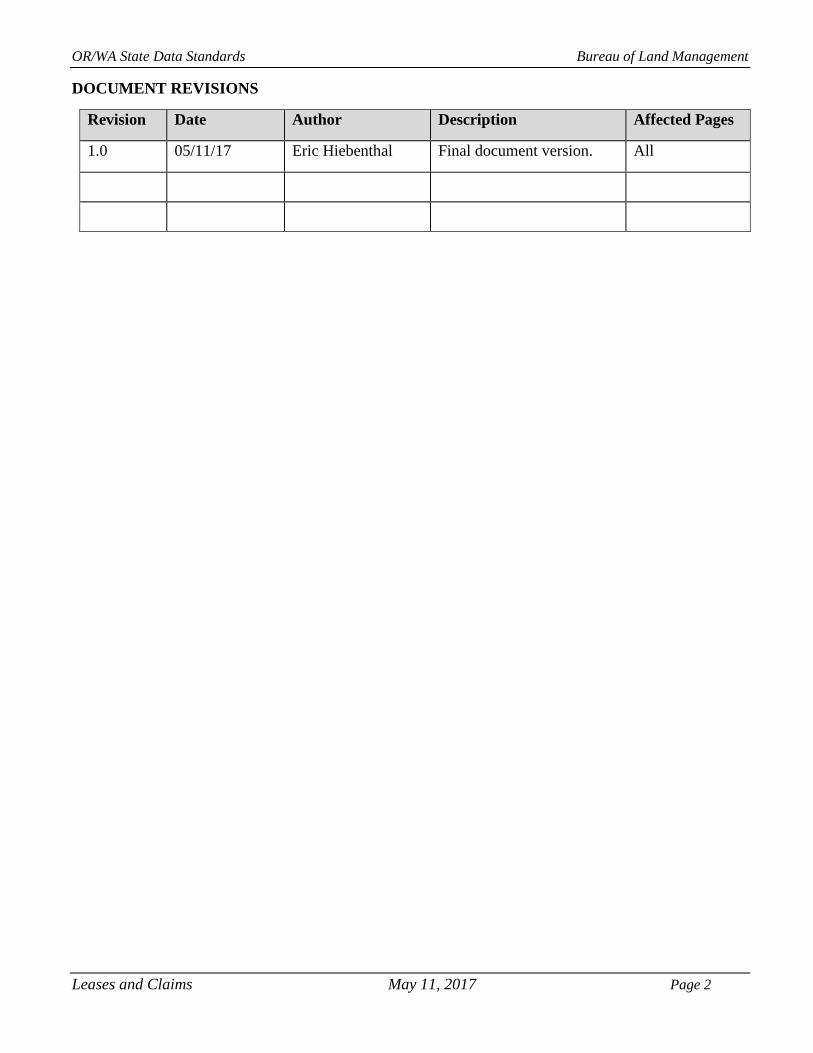
DOCUMENT REVISIONS
Revision Date Author Description Affected Pages
1.0 05/11/17 Eric Hiebenthal Final document version. All
Leases and Claims May 11, 2017 Page 2

OR/WA State Data Standards Bureau of Land Management
TABLE OF CONTENTS
1. GENERAL INFORMATION ................................................................................................................................................. 5
1.1 ROLES AND RESPONSIBILITIES ...................................................................................................................................5 1.2 FOIA CATEGORY .............................................................................................................................................................6 1.3 RECORDS RETENTION SCHEDULE(S) .........................................................................................................................6 1.4 SECURITY/ACCESS/SENSITIVITY ................................................................................................................................6 1.5 KEYWORDS ......................................................................................................................................................................6 1.6 SUBJECT FUCTION CODES ............................................................................................................................................7
2. DATASET OVERVIEW ......................................................................................................................................................... 7
2.1 DESCRIPTION ...................................................................................................................................................................7 2.2 USAGE ................................................................................................................................................................................7 2.3 SPONSOR/AFFECTED PARTIES .....................................................................................................................................8 2.4 RELATIONSHIP TO OTHER DATASETS .......................................................................................................................8 2.5 DATA CATEGORY/ARCHITECTURE LINK ..................................................................................................................9 2.6 RELATIONSHIP TO THE DEPARTMENT OF THE INTERIOR ENTERPRISE ARCHITECTURE − DATA RESOURCE MODEL ...............................................................................................................................................................9 2.7 LSE_CLM DATA ORGANIZATION / STRUCTURE ......................................................................................................9
3. DATA MANAGEMENT PROTOCOLS ............................................................................................................................. 12
3.1 ACCURACY REQUIREMENTS ..................................................................................................................................... 12 3.2 COLLECTION, INPUT AND MAINTENANCE PROTOCOLS ..................................................................................... 12 3.3 UPDATE FREQUENCY AND ARCHIVAL PROTOCOLS ............................................................................................ 13 3.4 STATEWIDE MONITORING .......................................................................................................................................... 13
4. LSE_CLM SCHEMA (SIMPLIFIED) ................................................................................................................................. 13
4.1 LSE_CLM_POLY (LEASE OR CLAIM POLYGONS) ............................................................................................................ 14 4.2 LSE_CLM_P_POLY (PROPOSED LEASE OR CLAIM POLYGONS) ...................................................................................... 14
5. PROJECTION AND SPATIAL EXTENT .......................................................................................................................... 15
6. SPATIAL ENTITY CHARACTERISTCS .......................................................................................................................... 15
7. ATTRIBUTE CHARACTERISTICS AND DEFINITIONS (IN ALPHABETICAL ORDER) .................................... 16
7.1 BLM_ORG_CD ................................................................................................................................................................ 16 7.2 CASEFILE ........................................................................................................................................................................ 16 7.3 CASETP ............................................................................................................................................................................ 16 7.7 LSE_CLM_P_NM ............................................................................................................................................................. 18 7.8 LSE_CLM_TP ................................................................................................................................................................... 18 7.10 RGT_ P_ HOLDER NM .................................................................................................................................................. 19 7.11 SRHA .............................................................................................................................................................................. 19 7.12 STATUS_P ...................................................................................................................................................................... 20 7.13 VERSION_NAME .......................................................................................................................................................... 20
8. LAYER FILES (PUBLICATION VIEWS) ......................................................................................................................... 21
8.1 GENERAL ........................................................................................................................................................................ 21
9. EDITING PROCEDURES.................................................................................................................................................... 22
9.1 MANAGING OVERLAP .................................................................................................................................................. 22 9.2 EDITING AND QUALITY CONTROL GUIDELINES ................................................................................................... 22 9.3 SNAPPING GUIDELINES ............................................................................................................................................... 22
10. OR/WA DATA FRAMEWORK OVERVIEW ................................................................................................................. 23
11. ABBREVIATIONS .............................................................................................................................................................. 24
Leases and Claims May 11, 2017 Page 3

OR/WA State Data Standards Bureau of Land Management
APPENDIX A. DOMAINS (VALID VALUES) ..................................................................................................................... 25
A.1 BLM_ORG_CD ................................................................................................................................................................ 25 A.2 COMMODITY ................................................................................................................................................................. 26 A.3 LSE_CLM_TP .................................................................................................................................................................. 28 A.4 STATUS_P ....................................................................................................................................................................... 28 A.5 YN .................................................................................................................................................................................... 28
Leases and Claims May 11, 2017 Page 4

OR/WA State Data Standards Bureau of Land Management
1. GENERAL INFORMATION
Dataset (Theme) Name: Leases and Claims
Dataset (Feature Class): LSE_CLM_POLY, LSE_CLM_P_POLY
1.1 ROLES AND RESPONSIBILITIES
Roles Responsibilities
State Data Stewards The State Data Steward for leasable minerals is Steve Storo, at 541-
416-6885. The Data Steward for locatable mineral claim is Timothy
Barnes, at 541-416-6858 . The State Data Stewards are responsible
for approving data standards and business rules, developing Quality
Assurance/Quality Control procedures, identifying potential privacy
issues and ensuring that data is managed as a corporate resource. The
State Data Stewards coordinate with field office Data Stewards, the
State Data Administrator, Geographic Information System (GIS)
coordinators, and with national Data Stewards. The State Data
Stewards review geospatial metadata for completeness and quality.
GIS Technical Lead The GIS Technical Lead, Frank Lahm, at 503-808-6425, works with
Data Stewards to convert business needs into GIS applications, derive
data requirements and participates in the development of data
standards. The GIS Technical Lead coordinates with system
administrators and GIS coordinators to manage the GIS databases.
State Data Administrator The State Data Administrator, Eric Hiebenthal, at 503-808-6565,
provides information management leadership, data modeling expertise,
and custodianship of the state data models. The State Data
Administrator ensures that defined processes for development of data
standards and metadata are followed and that they are consistent and
complete. The State Data Administrator is responsible for making data
standards and metadata accessible to all users. The State Data
Administrator coordinates with Data Stewards and GIS coordinators to
respond to national spatial data requests.
State Records Administrator The State Records Administrator, Tamara Yingling, at 503-808-6450,
assists the State Data Steward to identify any Privacy issues related to
spatial data. The State Records Administrator also provides direction
and guidance on data release and fees. The State Records
Administrator ensures that data has been classified under the proper
records retention schedule and determines appropriate Freedom of
Information Act category.
Table 1 - Roles and Responsibilities
Leases and Claims May 11, 2017 Page 5

OR/WA State Data Standards Bureau of Land Management
1.2 FOIA CATEGORY
The existing Leases and Claims features within this theme fall under the standard Records Access
Category 1A – Public Data. Proposed Leases and Claims features within this theme falls under Category
2 – Bureau of Land Management (BLM) Records Requiring a FOIA request.
1.3 RECORDS RETENTION SCHEDULE(S)
The DRS/GRS/BLM Combined Records Schedule under Schedule 20/52a3 (Electronic
Records/Geographic Information Systems) lists Wilderness Study Areas as one of the system-centric
themes that are significant for BLM’s mission that must be permanently retained.
"PERMANENT. Cutoff at the end of each Fiscal Year (FY), or, when significant changes and
additions have been made, before and after the change. Use BLM 20/52a. Transfer to the
National Archives every three years after cutoff. Under the instruction in 36 CFR 1235.44-50, or
whichever guidance is in place at the time of the transfer. Submissions are full datasets and are in
addition to, not replacements, of earlier submissions."
According to the DRS/GRS/BLM Records Schedules, Schedule 20 Item 52a3, the NOC is responsible for
transfer to NARA.
Oregon/Washington (OR/WA) BLM Guidebook for Management of Geospatial Data (v1) Section 15.2 -
Corporate Data Online Archives prescribes:
“Vector annual archives are retained online for 12 years. Each year, data that has reached 12
years old is copied off-line, to be retained until no longer needed (determined by data stewards
and program leads), with format and readability maintained in a five (5) year “tech refresh” update cycle.”
1.4 SECURITY/ACCESS/SENSITIVITY
The Leases and Claims (LSE_CLM) theme does not require any additional security other than that
provided by the General Support System (the hardware/software infrastructure of the OR/WA BLM.
This data is not sensitive and there are no restrictions on access to this data either from within the BLM
or external to the BLM.
There are no privacy issues or concerns associated with these data themes. A Privacy Impact Assessment
has been completed for Legacy Rehost 2000 (LR2000) and this dataset is considered a subsystem from
LR2000. This dataset falls under the Privacy Act System of Records Notice LLM-32, Land and Minerals
Authorization Tracking System.
1.5 KEYWORDS
Keywords that can be used to locate this dataset include: Leases, Claims, Minerals, LSE_CLM, and
encumbrance.
Leases and Claims May 11, 2017 Page 6

OR/WA State Data Standards Bureau of Land Management
1.6 SUBJECT FUCTION CODES
BLM Subject Function codes that can be used to describe this dataset include:
1283 - Data Administration
2900 – USE: Lease and Permits
3000 – Minerals Management
3800 – Mining Claims Under the General Mining Laws
2. DATASET OVERVIEW
2.1 DESCRIPTION
This dataset is a spatial representation of Leases and Claims (LSE_CLM). It is a portion of the total
encumbrance data category that includes information about entities, rights, and restrictions relating to
the use of Federal minerals.
There are three basic types of minerals on Federal lands:
1. Locatable (subject to the General Mining Law of 1872, as amended)
2. Leasable (subject to the various Mineral Leasing Acts)
3. Salable (subject to mineral materials disposed of under the Materials Act of 1947, as amended).
Locatable minerals include most metallic minerals (gold, silver, lead, copper, zinc, nickel, etc.), certain
nonmetallic (fluorspar, gypsum, mica, etc.) and industrial minerals. Prospecting and discovery can lead
to the filing of a “Claim”. There are two types of claims with different types of spatial representation:
“Lode Claims” are usually located as parallelograms with the side lines parallel to the vein or
lode; and
“Placer Claims” are located by legal subdivision.
Since 1920, the Federal Government has leased fuels and certain other minerals. Today, minerals that are
subject to lease include oil and gas, oil shale, geothermal resources, potash, sodium, native asphalt, solid
and semisolid bitumen, bituminous rock, phosphate, and coal. Solid leasables, other than coal and oil
shale, are leased in two ways:
Competitive issues in areas where we know there is a mineral deposit; and
Competitive leases through a bidding process.
Only Leases and Claims likely to occur on BLM property within the states of Oregon and Washington
are included in this dataset, but it can easily be expanded as necessary.
Salable minerals do not participate in this data standard. Salable minerals include common varieties of
sand, gravel, stone, pumice and cinders. Use of salable minerals requires either a sales contract or a free-
use permit. Disposals of salable minerals from BLM lands is an important part of Resource Management
Plans (RMP). Areas with salable minerals are also called Mineral Materials Sites or Community Pits and
participate in the Mineral Activities data standard.
2.2 USAGE
This dataset is used for depicting Leases and Claims on maps. All BLM planning and management
actions must identify any encumbrances on the land. The dataset includes both existing and proposed
Leases and Claims May 11, 2017 Page 7

OR/WA State Data Standards Bureau of Land Management
Leases and Claims. Leases and Claims are intersected with other resources to determine impact and/or
feasibility of the proposed action. The status of a claim or lease is captured in the STATUS_P attribute.
If the STATUS_P attribute is “Initial,” the proposed Lease or Claim should, for most purposes, not be included in analysis and display.
This dataset is intended to contain Leases and Claims issued by the BLM. RGT_HOLDER_NM contains
the name of the individual or company holding the lease or claim. Leases and Claims are issued for
specific commodities. The COMMODITY attribute provides this information.
2.3 SPONSOR/AFFECTED PARTIES
The sponsor for this dataset is the Deputy State Director, Resource Use, Planning and Protection. A
Lease or Claim is defined by, and specific to, the BLM. Matching interagency data across the landscape
is not necessary, but correcting discrepancies between BLM and non-BLM databases is important.
2.4 RELATIONSHIP TO OTHER DATASETS
The LSE_CLM entities are legal boundaries. They are often related to physical entities such as minerals
excavation or drilling sites. The Lease or Claim boundary is described in relation to the
construction/excavation (existing or proposed), but is usually not identical. The actual disturbance
(human construction) is found in the Mineral Activities (MIN_ACTY) database, described in the Mineral
Activities data standard. A GIS spatial overlay between LSE_CLM and mineral activities will show the
relationship.
In addition to the Acts of Congress described in Section 2.1, Leases and Claims are governed, to some
extent, by minerals stipulation zones, created as part of BLM’s landscape-level RMPs, which lay out the
long-term management actions for BLM administrative units. The dataset containing locatable, leasable
and salable stipulations areas (MINSTIP) is described in a different data standard.
The LSE_CLM dataset is related to other encumbrance entities, such as Easements and Rights-Of-Way,
which are found on the ESMTROW GIS theme group. A primary difference between the two types of
encumbrances is that the rights are granted under different authorities and that Leases and Claims involve
a commodity that will be removed from public lands, whereas, Easements and Rights-Of-Way (ROWs)
are often simply a right to cross or otherwise occupy public lands. In addition, the ESMTROW theme
includes both rights granted by the BLM and rights granted to the BLM (Easements), whereas, Leases
and Claims are only rights granted by the BLM.
The BLM national database Legacy Rehost System ( LR2000) is the official repository for records of
land and mineral use authorizations. The features in LSE_CLM represent just a portion of these records
and contain only a portion of the information for those records that are represented. The polygons on
LSE_CLM link to LR2000 via the CASEFILE attribute.
OR/WA BLM is currently working on creating GIS feature classes representing the information
portrayed on Master Title Plats (MTPs). The GIS datasets currently in use and proposed here are subsets
of the MTP GIS. They have simpler data structure and fewer attributes for easier use in a wide variety of
analysis. They also have proposed entities which are not portrayed on MTPs, nor in LR2000. OR/WA
BLM is also working on an automated method for extracting leases and other encumbrances directly
from LR2000 into GIS polygons. The resulting polygons can be compared to polygons captured via
manual processes in LSE_CLM and used to cross-check and correct errors in LR2000 and/or LSE_CLM.
Leases and Claims May 11, 2017 Page 8

OR/WA State Data Standards Bureau of Land Management
2.5 DATA CATEGORY/ARCHITECTURE LINK
These data themes are a portion of the Oregon Data Framework (ODF). The ODF utilizes the concept of
inheritance to define specific instances of data. The ODF divides all OR/WA resource-related data into
three general categories: Activities, Resources, and Boundaries. These general categories are broken
into sub-categories that inherit spatial characteristics and attributes from their parent categories. These
sub-categories may be further broken into more specific groups until a basic dataset is reached that
cannot be further subdivided. Those basic datasets inherit all characteristics of all groups/categories
above them. Physical data gets populated in the basic datasets (those groups/categories above them do
not contain actual data but set parameters that all data of that type must follow).
See ODF, Figure 2, for a simplified schematic of the entire Oregon Data Model showing the overall
organization and entity inheritance. For additional information about the ODF, contact:
Eric Hiebenthal OR/WA State Data Administrator Bureau of Land Management P.O. Box 2965 Portland, OR 97208 503-808-6009
2.6 RELATIONSHIP TO THE DEPARTMENT OF THE INTERIOR ENTERPRISE
ARCHITECTURE − DATA RESOURCE MODEL
The Department of the Interior’s (DOI) Enterprise Architecture contains a component called the Data
Resource Model. This model addresses the concepts of Data Sharing, Data Description, and Data
Context. This data standard provides information needed to address each of those areas. Data sharing is
addressed through complete documentation and simple data structures which make sharing easier. Data
description is addressed in the section on Attribute Descriptions. Data context is addressed in the data
organization and structure portions of this document. In addition, the DOI Data Resource Model
categorizes data by use of standardized Data Subject Areas and Information Classes. For this dataset, the
Data Subject Area and Information Class are:
Data Subject Area: Geospatial
Information Class: Location
For a complete list of all DOI Data Subject Areas and Information Classes, contact:
Eric Hiebenthal OR/WA State Data Administrator Bureau of Land Management P.O. Box 2965 Portland, OR 97208 503-808-6009
2.7 LSE_CLM DATA ORGANIZATION / STRUCTURE
For LSE_CLM, the categories/groups that the dataset is part of are:
Leases and Claims May 11, 2017 Page 9

OR/WA State Data Standards Bureau of Land Management
ODF
Boundaries
Land Status
Existing Land Status
Encumbrance Area
LSE_CLM_POLY
Proposed Land Status
Proposed Encumbrance Area
LSE_CLM_P_POLY
Leases and Claims May 11, 2017 Page 10

OR/WA State Data Standards Bureau of Land Management
Figure 1 Data Organization Structure
Leases and Claims May 11, 2017 Page 11

OR/WA State Data Standards Bureau of Land Management
3. DATA MANAGEMENT PROTOCOLS
3.1 ACCURACY REQUIREMENTS
This dataset is not complete for all Leases and Claims on BLM lands and, in addition, only basic
information about the lease or claim is provided. Details of the complete rights and restrictions history
are found in the following authoritative sources: case file records, Master Title Plats (MTPs), and the
Legacy Rehost 2000 (LR2000) database. The case file record is the primary source, with MTPs and
LR2000 as secondary sources. Moreover, this dataset will never be complete. Over time, more and more
approved LSE_CLM features will be added to the dataset, but it will never contain the complete record
(found in the case files).
This dataset requires the highest possible accuracy. Accuracy is determined by availability of survey data
and Cadastral National Spatial Data Infrastructure (CADNSDI) GIS features for the area. Where a
feature in LSECLM follows a road or other physical features, the coordinates are obtained from the most
accurate source available (see Collection, Input and Maintenance Protocols).
Proposed features, on LSE_CLM_P_POLY, are transitory and have varying degrees of accuracy.
Accuracy is reviewed and improved, if possible, if a proposed feature becomes authorized and is moved
to LSE_CLM_POLY.
Required attributes have an accuracy of at least ninety percent.
3.2 COLLECTION, INPUT AND MAINTENANCE PROTOCOLS
Existing Leases and Claims (LSE_CLM_POLY) are defined and described by the case file record and are
sometimes depicted on MTP. If a digital MTP with GIS features or a digital survey is available, the
appropriate spatial features are selected and copied from these. If there is no digital MTP or survey
source, the lines and polygons are created from the legal description and other information in the
authoritative sources (MTPs, LR2000, and the case file record). OR/WA BLM is working on an
automated method for creating GIS polygons directly from LR2000 descriptions. These could be used as
a starting point for LSE_CLM polygons. Where the feature is described by legal land line parcels or
surveyed lines, a vertex is placed at every CADNSDI point and snapped to it. It is rare that a Lease or
Claim will be described by anything except a legal subdivision (and coordinates obtained by anything
other than CADNSDI), but if so, the coordinates should be obtained from GPS or imagery with a total
locational accuracy of 100 feet or better. Existing linework is not replaced unless a more accurate spatial
representation of the legal description is provided.
Proposed Leases and Claims (LSE_CLM_P_POLY) are created from legal descriptions in the same way
as described above for LSE_CLM_POLY. If a proposed Lease or Claim becomes fact (is authorized), it
is copied to LSE_CLM_POLY and deleted from LSE_CLM_P_POLY. At the district Data Steward’s
discretion, when an authorized LSE_CLM becomes “closed”, for whatever reason (relinquished,
terminated, expired, abandoned), the feature can be moved back to the proposed feature class with the
appropriate value placed in the attribute STATUS_P. This might be done if the Data Steward feels the
feature has potential to become a proposal again or if it is important to retain the historic information in a
readily available spatial form.
Leases and Claims May 11, 2017 Page 12
OR/WA State Data Standards Bureau of Land Management
3.3 UPDATE FREQUENCY AND ARCHIVAL PROTOCOLS
The unit of processing for the LSE_CLM dataset is the individual Lease or Claim. If there is a
CADNSDI update which shifts the points of the LSE_CLM polylines, then the lines need to be re-
snapped to the updated CADNSDI points. Other updates to correct or improve locational accuracy are
done when discovered.
Changes to this dataset are potentially very frequent. At a minimum, this dataset is to be updated at least
annually by reporting due at the end of the fiscal year, September 30. Updates can be done at any time
and do not need to be done only on an annual basis. Claims change on a daily basis. Leases do not
change often.
3.4 STATEWIDE MONITORING
District Realty Specialists are required to check the themes for spatial and attribute accuracy within their
district, keep the themes consistent and current with LR2000 and the case files, and confirm that
proposed (LSE_CLM_P_POLY) were moved to existing (LSE_CLM_POLY) after approval. The State
Data Stewards are responsible for checking consistency across districts. At least once yearly,
LSE_CLM_POLY will be checked by comparing to LR2000. The number of cases in LR2000 and not in
LSE_CLM_POLY, and vice versa, will be used to determine completeness. Over time, the gap should
narrow.
4. LSE_CLM SCHEMA (Simplified)
General Information: Attributes are listed in the order they appear in the geodatabase feature class. The
order is an indication of the importance of the attribute for theme definition and use. There are no
aliases, unless specifically noted. The domains used in this data standard can be found in Appendix A.
These are the domains at the time the data standard was approved. Domains can be changed without a re-
issue of the data standard. For a complete list of domains, contact:
Eric Hiebenthal
OR/WA State Data Administrator
Bureau of Land Management
P.O. Box 2965 Portland, OR 97208 503-808-6565
Leases and Claims May 11, 2017 Page 13
OR/WA State Data Standards Bureau of Land Management
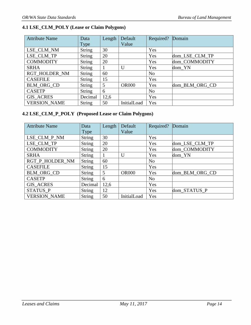
4.1 LSE_CLM_POLY (Lease or Claim Polygons)
Attribute Name Data
Type
Length Default
Value
Required? Domain
LSE_CLM_NM String 30 Yes
LSE_CLM_TP String 20 Yes dom_LSE_CLM_TP
COMMODITY String 20 Yes dom_COMMODITY
SRHA String 1 U Yes dom_YN
RGT_HOLDER_NM String 60 No
CASEFILE String 15 Yes
BLM_ORG_CD String 5 OR000 Yes dom_BLM_ORG_CD
CASETP String 6 No
GIS_ACRES Decimal 12,6 Yes
VERSION_NAME String 50 InitialLoad Yes
4.2 LSE_CLM_P_POLY (Proposed Lease or Claim Polygons)
Attribute Name Data
Type
Length Default
Value
Required? Domain
LSE_CLM_P_NM String 30 Yes
LSE_CLM_TP String 20 Yes dom_LSE_CLM_TP
COMMODITY String 20 Yes dom_COMMODITY
SRHA String 1 U Yes dom_YN
RGT_P_HOLDER_NM String 60 No
CASEFILE String 15 Yes
BLM_ORG_CD String 5 OR000 Yes dom_BLM_ORG_CD
CASETP String 6 No
GIS_ACRES Decimal 12,6 Yes
STATUS_P String 12 Yes dom_STATUS_P
VERSION_NAME String 50 InitialLoad Yes
Leases and Claims May 11, 2017 Page 14

OR/WA State Data Standards Bureau of Land Management
5. PROJECTION AND SPATIAL EXTENT
All feature classes and feature datasets are in Geographic, North American Datum 83. Units are decimal
degrees. Spatial extent (area of coverage) includes all lands managed by the BLM in OR/WA. See the
metadata for this dataset for more precise description of the extent.
6. SPATIAL ENTITY CHARACTERISTCS
LSE_CLM_POLY Description: Instance of Land Status Existing group. Geometry: Polygons may overlap entirely or in part. Topology: No topology enforced. Integration Requirements: If polylines are defined as parcels, they must have a vertex for every CADNSDI point, and be snapped to it.
LSE_CLM_P_POLY Description: Instance of Land Status Proposed group. Geometry: Polygons may overlap each other entirely or in part, and may overlap LSE_CLM_POLY features. Topology: No topology enforced. Integration Requirements: If polylines are defined as parcels, they must have a vertex for every CADNSDI point, and be snapped to it.
Leases and Claims May 11, 2017 Page 15

OR/WA State Data Standards Bureau of Land Management
7. ATTRIBUTE CHARACTERISTICS AND DEFINITIONS (In alphabetical order)
7.1 BLM_ORG_CD
Geodatabase Name BLM_ORG_CD
BLM Structured Name Administrative_Unit_Organization_Code
Inheritance Inherited from entity OREGON DATA FRAMEWORK
Feature Class Use LSE_CLM_POLY, LSE_CLM_P_POLY
Definition
A combination of the BLM administrative state and field offices which
have administrative responsibility for the spatial entity. This includes
which office covers the entity for planning purposes and which office is
the lead for GIS edits. Another agency or individual may have the
physical management responsibility for the on-the-ground entity. This
field applies particularly when a spatial entity crosses resource area or
district boundaries and the administrative responsibility is assigned to one
or the other, rather than splitting the spatial unit. Similarly, OR/WA BLM
may have administrative responsibility over some area that is physically
located in Nevada, Idaho, and California, and vice versa. When
appropriate, the office can be identified only to the district or even the
state level, rather than to the resource area level.
Required/Optional Required
Domain (Valid Values) dom_BLM_ORG_CD
Data Type Characters (5)
7.2 CASEFILE
Geodatabase Name CASEFILE
BLM Structured Name Realty_Casefile_Number
Inheritance Inherited from entity LAND STATUS
Feature Class Use LSE_CLM_POLY, LSE_CLM_P_POLY
Definition
Case number assigned by the LR2000 database (serial number full) when
an action is begun (either by BLM action or due to receipt of an
application). Include suffix (a unique identifier of cases resulting from
the division of an original case into multiple, separate, and unique cases).
For features with no BLM action, enter “PRIVATE”. The value in CASEFILE must match exactly with the serial numbers in LR2000,
including any spacing in the number (see the examples below).
Required/Optional Required for existing features, optional for proposed.
Domain (Valid Values) No domain. Examples: OROR 065814, OROR
061083FB, OROR 06173P1, ORORE 0014635
06818PT, OROR
Data Type Variable Characters (15)
7.3 CASETP
Geodatabase Name CASETP
BLM Structured Name Case_Type_Code
Inheritance Inherited from entity LAND STATUS
Leases and Claims May 11, 2017 Page 16

OR/WA State Data Standards Bureau of Land Management
Feature Class Use LSE_CLM_POLY, LSE_CLM_P_POLY
Definition
A coded number system (defined by LR2000) that identifies a case (e.g.,
authorization, conveyances, withdrawals, acquisitions, etc.). The six digit
code is constructed as follows:
First two digits “00” through “99” denotes major groups generally listed
in 43 CFR (e.g. 31 – Oil and Gas Leases and Agreements, 32 – Geothermal Leases and Agreements, 34 – Coal leases and Agreements, 35
– Other solid mineral leases, 36 – Mineral Material (sand & gravel,
community pits), 38 – Mining Claims)
322200, 311122, 384101
For a complete list of Case types go to: LR2000 Codes
Required/Optional Optional
Domain (Valid Values) No domain
Data Type Characters (6)
7.4 COMMODITY
Geodatabase Name COMMODITY
BLM Structured Name Mineral _Commodity_Code
Inheritance Inherited from EXISTING or PROPOSED ENCUMBRANCE
Feature Class Use LSE_CLM_POLY, LSE_CLM_P_POLY
Definition
The commodity code (defined by LR2000) for the type of mineral
commodity associated with the lease or claim. Only minerals found in
OR/WA are included in the domain. Locatable Mineral claims are not
required to report what commodity is being extracted. Therefore, this
value will likely be UNDETERMINED for these cases.
For a complete list of Commodity Codes go to: LR2000 Commodity
Codes
Required/Optional Required
Domain (Valid Values) dom_COMMODITY
Data Type Variable Characters (20)
7.5 GIS_ACRES
Geodatabase Name GIS_ACRES
BLM Structured Name GIS_Acres_Measure
Inheritance Inherited from entity OREGON DATA FRAMEWORK
Feature Class Use LSE_CLM_POLY, LSE_CLM_P_POLY
Definition
GIS_ACRES is calculated when the submitted polygon is approved for
incorporation into the dataset. The standard spatial reference of
Geographic (NAD 1983) cannot be used for calculating acres so the
features are projected to one of three projections as determined by the
BLM_ORG_CD of the record. These three projections all utilize linear
Leases and Claims May 11, 2017 Page 17

OR/WA State Data Standards Bureau of Land Management
units of meters, so the ESRI Geodatabase-controlled field SHAPE.AREA
can be used to convert to acres with the factor based on the U.S. Survey
Foot: GIS_ACRES = SHAPE.AREA * 0.0002471044
District indicated by BLM_ORG_CD: ESRI Projection used:
Prineville NAD 1983 USFS R6 Albers
Coos Bay, Lakeview, Medford, NW NAD 1983 UTM Zone 10N
Oregon, Roseburg
Burns, Spokane, Vale NAD 1983 UTM Zone 11N
Required/Optional Required (automatically generated)
Domain (Valid Values) No domain
Data Type Decimal (12,6)
7.6 LSE_CLM_NM
Geodatabase Name LSE_CLM_NM
BLM Structured Name Lease_Claim_Name
Inheritance Inherited from entity EXISTING ENCUMBRANCE
Feature Class Use LSE_CLM_POLY
Definition Identifying name for the Lease or Claim or the project it is part of.
Required/Optional Required
Domain (Valid Values) No domain. Examples: Fields M.S., EP Minerals Claims
Data Type Variable Characters (30)
7.7 LSE_CLM_P_NM
Geodatabase Name LSE_CLM_P_NM
BLM Structured Name Lease_Claim_Proposed_Name
Inheritance Inherited from entity PROPOSED ENCUMBRANCE
Feature Class Use LSE_CLM_P_POLY
Definition Identifying name for a Proposed Lease or Claim or the project it is part of.
Required/Optional Required
Domain (Valid Values) No domain. Examples: Cote Grade Quarry, Glass Buttes Geothermal
Data Type Variable Characters (30)
7.8 LSE_CLM_TP
Geodatabase Name LSE_CLM_TP
BLM Structured Name Lease_Claim_Type_Code
Inheritance Inherited from EXISTING or PROPOSED ENCUMBRANCE
Feature Class Use LSE_CLM_POLY, LSE_CLM_P_POLY
Definition The general type of mineral lease or mining claim.
Required/Optional Required
Domain (Valid Values) dom_LSE_CLM_TP
Data Type Variable Characters (10)
Leases and Claims May 11, 2017 Page 18

OR/WA State Data Standards Bureau of Land Management
7.9 RGT_HOLDER_NM
Geodatabase Name RGT_HOLDER_NM
BLM Structured Name Right_Holder_Name
Inheritance Inherited from entity EXISTING ENCUMBRANCE
Feature Class Use LSE_CLM_POLY
Definition
Name of the organization or person that holds the rights granted in the
Lease or Claim. Multiple names can be concatenated. In the case where
the names would exceed the 60 character limit, using the last name of the
first customer (or the customer with the highest percentage of interest)
and “, ET ALT” to indicate there is more than one customer. Required/Optional Optional
Domain (Valid Values) No domain. Examples: CELATOM MINE INC, DIAMOND RANCH
LLC.
Data Type Variable Characters (60)
7.10 RGT_ P_ HOLDER NM
Geodatabase Name RGT_ P_HOLDER _ NM
BLM Structured Name Right_Holder_Proposed_Name
Inheritance Inherited from entity PROPOSED ENCUMBRANCE
Feature Class Use LSE_CLM_P_POLY
Definition
Name of the person or entity applying for a Lease or Claim. Multiple
names can be concatenated. In the case where the names would exceed
the 60 character limit, using the last name of the first customer (or the
customer with the highest percentage of interest) and “, ET ALT” to
indicate there is more than one customer.
Required/Optional Optional
Domain (Valid Values) No domain. Examples:
LLC.
CELATOM MINE INC, DIAMOND RANCH
Data Type Variable Characters (60)
7.11 SRHA
Geodatabase Name SRHA
BLM Structured Name Stock_Raising_Homestead_Act_Indicator
Inheritance Not Inherited
Feature Class Use LSE_CLM_POLY, LSE_CLM_P_POLY
Definition Only relevant for mining claims; indicates whether the claim falls within
original SRHA lands and, therefore, has different filing requirements and
fees.
Required/Optional Required
Domain (Valid Values) dom_YN
Data Type Character (1)
Leases and Claims May 11, 2017 Page 19

OR/WA State Data Standards Bureau of Land Management
7.12 STATUS_P
Geodatabase Name STATUS_P
BLM Structured Name Facility_Proposed_Status_Code
Inheritance Inherited from entity PROPOSED ENCUMBRANCE
Feature Class Use LSE_CLM_P_POLY
Definition The status of a proposed facility, structure or application.
Required/Optional Required
Domain (Valid Values) dom_STATUS_P
Data Type Variable Characters (12)
7.13 VERSION_NAME
Geodatabase Name VERSION_NAME
BLM Structured Name Geodatabase_Version_Text
Inheritance Inherited from entity OREGON DATA FRAMEWORK
Feature Class Use All feature classes
Definition
Name of the corporate geodatabase version previously used to edit the
record.
InitialLoad = feature has not been edited in ArcSDE.
Format: username.XXX-mmddyy-hhmmss = version name of the last edit
(hours might be a single digit; leading zeros are trimmed for hours only).
XXX = theme abbreviation.
Only appears in the transactional (edit) version. Public version (which is
also the version used internally for mapping or analysis) does not contain
this attribute.
Required/Optional Required (automatically generated)
Domain (Valid Values) No domain. Example: sfrazier.GRA-121210-111034
Data Type Variable Characters (50)
Leases and Claims May 11, 2017 Page 20

OR/WA State Data Standards Bureau of Land Management
8. LAYER FILES (PUBLICATION VIEWS)
External publication layers will only contain features that can be linked to an LR2000 record (CASEFILE
IS NOT NULL). Additionally, external publication of the LSE_CLM theme will require the removal of
the RGT_HOLDER_NM and VERSION_NAME attributes. Only the current Leases and Claims
(LSE_CLM_POLY) feature class will be made available externally to the public. Proposed features
(LSE_CLM_P_POLY) will not be made available to the public. There will be no changes made to the
theme for internal BLM publication.
8.1 GENERAL
Master corporate feature classes/datasets maintained in the edit database (currently orsoedit) are
“published” to the user database (currently orsovctr) in several ways: Copied completely with no changes (replicated).
Copied with no changes except to omit one or more feature classes from a feature dataset.
Minor changes made (e.g., clip, dissolve, union with ownership) in order to make the data
easier to use.
These “Publication feature classes” are indicated by “PUB” in their name. They are created through scripts that can be automatically executed and are easily rebuilt from the master (orsoedit) data whenever
necessary.
Layer files are not new data requiring storage and maintenance, but point to existing data. They have
appropriate selection and symbolization for correct use and display of the data. They provide the
guidance for data published on the web. Layer files are created by simple, documented processes, and
can be deleted and recreated at any time.
8.2 SPECIFIC TO THIS DATASET
Proposed entities (LSE_CLM_P_POLY) are not published to the web.
Leases and Claims May 11, 2017 Page 21

OR/WA State Data Standards Bureau of Land Management
9. EDITING PROCEDURES
9.1 MANAGING OVERLAP
“Overlap” means there is potentially more than one feature in the same feature class that occupies the
same space (“stacked” polygons). Depending on the query, acres will be double-counted.
An individual Lease or Claim entity may consist of more than one polygon. Each polygon has a record
in the spatial table (with identical attributes). Multi-part features are not allowed. Multi-part features are
easily created inadvertently and not always easy to identify. If they are not consciously and consistently
avoided, feature classes will end up with a mixture of single and multi-part features. Multi-part features
can be more difficult to edit, query, and select, and may impact overall performance.
Overlap is only allowed in the ODF in limited and controlled scenarios. In each case, the cause of the
overlap (what attribute changes will “kick off” a new feature which may overlap an existing feature) is carefully defined and controlled. In the LSE_CLM feature classes, a new casefile will create a new, and
possibly overlapping, entity.
9.2 EDITING AND QUALITY CONTROL GUIDELINES
Checking for undesired duplicates is critical. Polygons that are 100 percent duplicate can be easily found
by searching for identical attributes along with identical Shape_Area and/or Shape_Length. Searching
for unintended partially overlapping polygons is harder, and each case must be inspected to determine if
the overlap is desired or not.
If polygons are copied in from other feature classes, multiparts should be checked for.
9.3 SNAPPING GUIDELINES
Where line segments with different coordinate sources meet, the most accurate or important, in terms of
legal boundary representation, are kept unaltered and other lines snapped to them. In general, the
hierarchy of importance is Legal Land Lines (CADNSDI points/lines) first. When snapping to
CADNSDI, be sure there are exactly the same number of vertices in the target, and source theme arcs.
Leases and Claims May 11, 2017 Page 22

OR/WA State Data Standards Bureau of Land Management
10. OR/WA DATA FRAMEWORK OVERVIEW
Figure 2 Oregon Data Framework Overview
Leases and Claims May 11, 2017 Page 23

OR/WA State Data Standards Bureau of Land Management
11. ABBREVIATIONS
(Does not include abbreviations/acronyms used as codes for particular data attributes.)
Abbreviations Descriptions
BLM Bureau of Land Management
CADNSDI Cadastral National Spatial Data Infrastructure
FOIA Freedom of Information Act
GIS Geographic Information System
GPS Global Positioning System
LR2000 Legacy Rehost 2000 Database
MTP Master Title Plat
NAD North American Datum
NARA National Archives and Records Administration
ODF Oregon Data Framework
OR/WA Oregon/Washington
SDE Spatial Data Engine
SRHA Stock-Raising Homestead Act
Table 2 Abbreviations/Acronyms Used
Leases and Claims May 11, 2017 Page 24
OR/WA State Data Standards Bureau of Land Management
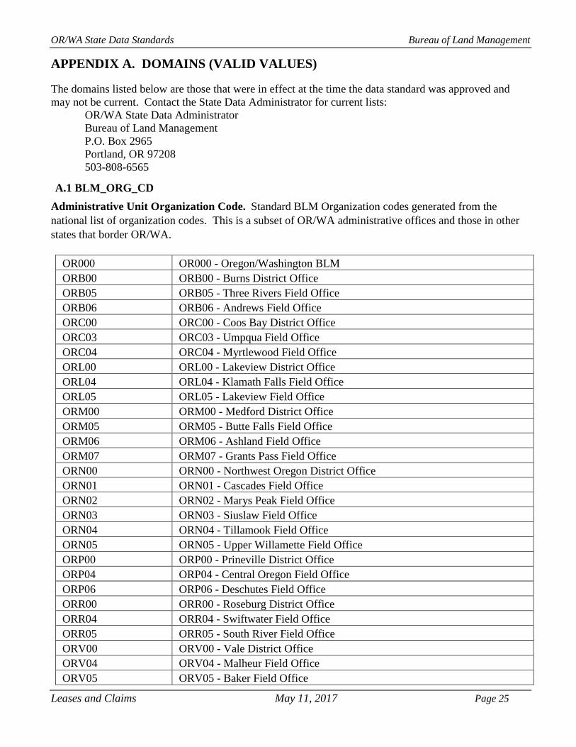
APPENDIX A. DOMAINS (VALID VALUES)
The domains listed below are those that were in effect at the time the data standard was approved and
may not be current. Contact the State Data Administrator for current lists:
OR/WA State Data Administrator
Bureau of Land Management
P.O. Box 2965 Portland, OR 97208 503-808-6565
A.1 BLM_ORG_CD
Administrative Unit Organization Code. Standard BLM Organization codes generated from the
national list of organization codes. This is a subset of OR/WA administrative offices and those in other
states that border OR/WA.
OR000 OR000 - Oregon/Washington BLM
ORB00 ORB00 - Burns District Office
ORB05 ORB05 - Three Rivers Field Office
ORB06 ORB06 - Andrews Field Office
ORC00 ORC00 - Coos Bay District Office
ORC03 ORC03 - Umpqua Field Office
ORC04 ORC04 - Myrtlewood Field Office
ORL00 ORL00 - Lakeview District Office
ORL04 ORL04 - Klamath Falls Field Office
ORL05 ORL05 - Lakeview Field Office
ORM00 ORM00 - Medford District Office
ORM05 ORM05 - Butte Falls Field Office
ORM06 ORM06 - Ashland Field Office
ORM07 ORM07 - Grants Pass Field Office
ORN00 ORN00 - Northwest Oregon District Office
ORN01 ORN01 - Cascades Field Office
ORN02 ORN02 - Marys Peak Field Office
ORN03 ORN03 - Siuslaw Field Office
ORN04 ORN04 - Tillamook Field Office
ORN05 ORN05 - Upper Willamette Field Office
ORP00 ORP00 - Prineville District Office
ORP04 ORP04 - Central Oregon Field Office
ORP06 ORP06 - Deschutes Field Office
ORR00 ORR00 - Roseburg District Office
ORR04 ORR04 - Swiftwater Field Office
ORR05 ORR05 - South River Field Office
ORV00 ORV00 - Vale District Office
ORV04 ORV04 - Malheur Field Office
ORV05 ORV05 - Baker Field Office
Leases and Claims May 11, 2017 Page 25

OR/WA State Data Standards Bureau of Land Management
ORV06 ORV06 - Jordan Field Office
ORW00 ORW00 - Spokane District Office
ORW02 ORW02 - Wenatchee Field Office
ORW03 ORW03 - Border Field Office
CA000 CA000 - California BLM
CAN01 CAN01 - Northern California Field Office
CAN02 CAN02 - Applegate Field Office
CAN03 CAN03 - Arcata Field Office
CAN06 CAN06 - Redding Field Office
ID000 ID000 - Idaho BLM
IDB00 IDB00 - Boise District Office
IDB01 IDB01 - Four Rivers Field Office
IDB03 IDB03 - Owyhee Field Office
IDC00 IDC00 - Coeur d'Alene District Office
IDC01 IDC01 - Coeur d'Alene Field Office
IDC02 IDC02 - Cottonwood Field Office
NV000 NV000 - Nevada BLM
NVE00 NVE00 - Elko District Office
NVE02 NVE02 - Tuscarora Field Office
NVW00 NVW00 - Winnemucca District Office
NVW01 NVW01 - Humboldt River Field Office
A.2 COMMODITY
Not all Commodity codes appear in the Leases and Claims database. Some commodities listed below are
saleable, meaning they will not have an associated lease or claim. All LR2000 commodities are listed in
the domain.
12 12 - ALUMINUM, CLAY
43 43 - ASPHALTIC MINERALS
50 50 - BARIUM
51 51 - BARIUM, BARITE
91 91 - CALCIUM, LIMESTONE
121 121 - CHROMITE
135 135 - CLAY, BENTONITE
137 137 - CLAY, COMMON
140 140 - COAL
170 170 - COPPER
171 171 - COPPER, SULFIDES
186 186 - ABRASIVE, FELDSPAR
255 255 - GEMSTONE, SEMIPREC SIL
256 256 - GEMSTONE, SEMIPREC OTH
257 257 - GEMSTONE, NON-PRECIOUS
260 260 - GOLD
261 261 - GOLD, LODE
Leases and Claims May 11, 2017 Page 26

OR/WA State Data Standards Bureau of Land Management
262 262 - GOLD, PLACER
271 271 - GRAPHITE, AMORP-CRYST
340 340 - LEAD
350 350 - LITHIUM
353 353 - LIMESTONE
380 380 - MERCURY
410 410 - NATURAL GAS
420 420 - NICKEL
440 440 - PERLITE
459 459 - OIL & GAS
470 470 - PLATINUM GROUP
471 471 - PLATINUM
483 483 - POTASH, POTASSIUM NIT
491 491 - PUMICE, PUMICITE
492 492 - PUMICE, VOLCANIC ASH
493 493 - PUMICE, VOLCANIC CINDER
495 495 - PUMICE, SCORIA
496 496 - OBSIDIAN
497 497 - RHYOLITE
500 500 - QUARTZ, CRYSTAL
521 521 - SAND AND GRAVEL, SAND
522 522 - SAND AND GRAVEL, SHALE
523 523 - SAND AND GRAVEL, GRAVEL
524 524 - SAND AND GRAVEL, CLINKER
525 525 - SAND AND GRAVEL, S&G
526 526 - SHALE
531 531 - SILICON, QUARTZ
532 532 - SILICON, QUARTZITE
540 540 - SILVER
550 550 - SODIUM
561 561 - STONE, DIMENSION
562 562 - STONE, CRUSHED & BROKEN
563 563 - STONE, RIPRAP
564 564 - STONE, WEATHERED GRANITE
565 565 - STONE, SPECIALTY
566 566 - STONE, TUFA
650 650 - URANIUM, (U308 CONTENT)
690 690 - ZEOLITES
693 693 - ZEOLITES, CLINOPTILOLITE
701 701 - ZINC, SULFIDES
770 770 - GEOTHERMAL
772 772 - GEOTHERMAL, WATER
800 800 - TWO OR MORE MINERALS
848 848 - GEMSTONE, SEMIPRECIOUS
878 878 - PUBLIC PURPOSES
879 879 - RECREATION PURPOSES
Leases and Claims May 11, 2017 Page 27

OR/WA State Data Standards Bureau of Land Management
885 885 - OTHER
891 891 - SOIL/OTHER, FILL
892 892 - SOIL/OTHER, TOPSOIL
894 894 - SOIL/OTHER, DIATOMITE
899 899 - ALL MATERIAL RESOURCE
UN UN-UNKNOWN
A.3 LSE_CLM_TP
LodeClaim LodeClaim – Lode Claim Mining
PlacerClaim PlacerClaim – Placer Claim Mining
MillSite MillSite – Mill Processing Site
TunnelSite TunnelSite-
Geothermal Geothermal – Geothermal Lease
Oil and Gas Oil and Gas – Oil and Gas Lease
Other Other – Other Mineral Site
A.4 STATUS_P
Initial Initial − Pre-application proposal
Pending Pending − Active proposal, application filed
Rejected Rejected − Proposal rejected by BLM
Closed Closed − Case closed
Relinquished Relinquished – Proposal released by the proponent
Suspended Suspended – Activity halted
A.5 YN
Y Y – Meets criteria set in data standard
N N – Does not meet criteria set in data standard
U U – Unknown whether criteria set in data standard is met
Leases and Claims May 11, 2017 Page 28