lec satellite communication
TRANSCRIPT
1
Satellite Communication

2
Satellite Orbits
Satellites are launched and orbited for a variety of purposes. The most common application is communication in which the satellite is used as a repeater.
An object which has been placed into orbit. Such objects are sometimes called artificial satellites to distinguish them from natural satellites such as the Moon.
An object launched to orbit Earth or another celestial body

3
Sputnik -was the first Earth-orbiting artificial satellite. It was launched into an elliptical low Earth orbit by the Soviet Union on 4 October 1957, with Sergei Korolev as chief designer
- it was about the size of a basketball, weighed only 183 pounds, and took about 98 minutes to orbit the Earth on its elliptical path
- Sputnik 1 helped to identify the density of high atmospheric layers through measurement of its orbital change and provided data on radio-signal distribution in the ionosphere

4
Sputnik 2 was launched on November 3, 1957 and carried the first living passenger into orbit, a dog named Laika.
Laika (, literally meaning "Barker") was a Soviet space dog (c. 1954–November 3, 1957) who became the first animal to orbit the Earth and the first orbital death

5
Laika, a stray, originally named Kudryavka (Little Curly), underwent training with two other dogs, and was eventually chosen as the occupant of the Soviet spacecraft Sputnik 2 that was launched into outer space on November 3, 1957.

6
Explorer 1 - was the first Earth satellite of the United States as part of the program for the International Geophysical Year and in response to the launch of the Soviet satellite Sputnik 1.
- was designed and built by the Jet Propulsion Laboratory (JPL), while the Jupiter-C rocket was modified by the Army Ballistic Missile Agency (ABMA) to accommodate a satellite payload
7
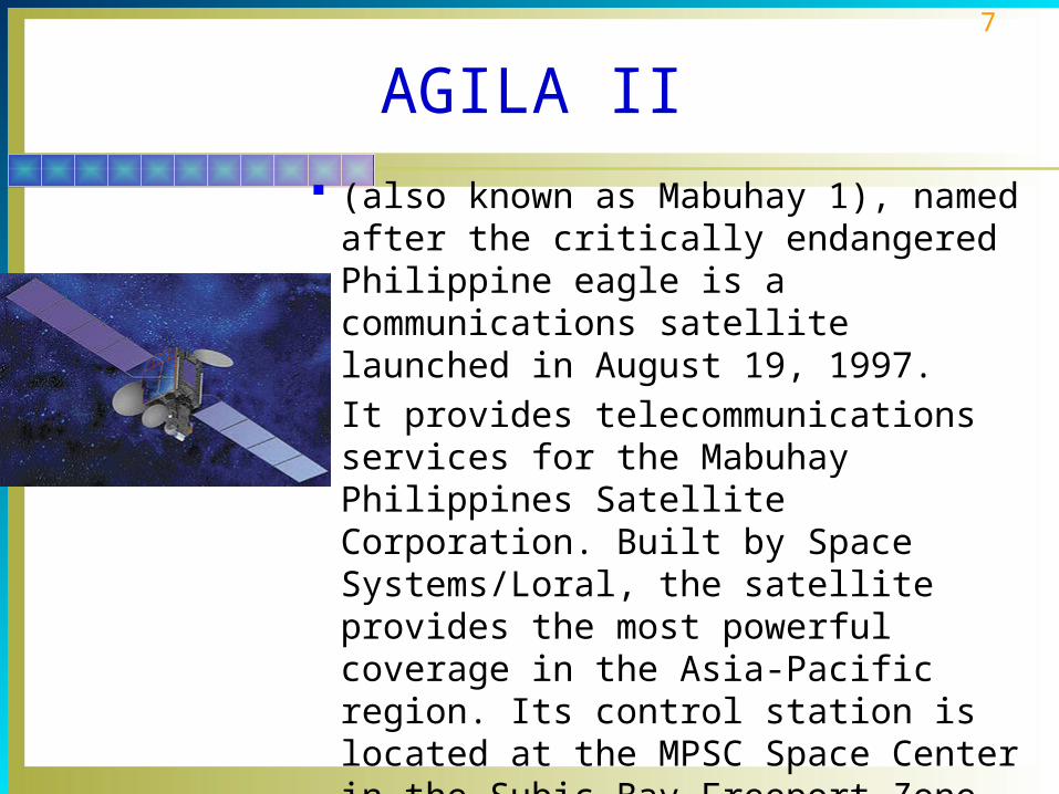
AGILA II (also known as Mabuhay 1), named after
the critically endangered Philippine eagle is a communications satellite launched in August 19, 1997.
It provides telecommunications services for the Mabuhay Philippines Satellite Corporation. Built by Space Systems/Loral, the satellite provides the most powerful coverage in the Asia-Pacific region. Its control station is located at the MPSC Space Center in the Subic Bay Freeport Zone

8
Satellite Orbits
Principles of Satellite Orbits and Positioning The ability to launch a satellite and keep it in orbit
depends upon following well-known physical and mathematical laws called orbital dynamics.
In order for a satellite to go into orbit around the earth, it must have some forward motion.
When a satellite is launched, it is given both vertical and forward motion.
9
Satellite Orbits
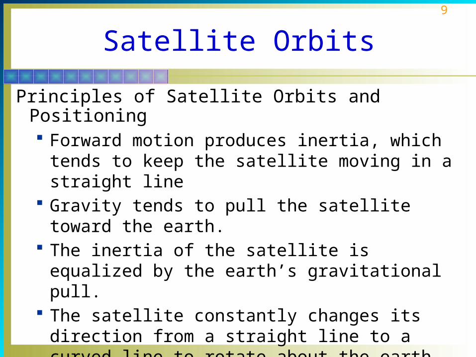
Principles of Satellite Orbits and Positioning Forward motion produces inertia, which tends to keep
the satellite moving in a straight line Gravity tends to pull the satellite toward the earth. The inertia of the satellite is equalized by the earth’s
gravitational pull. The satellite constantly changes its direction from a
straight line to a curved line to rotate about the earth.
10
Satellite Orbits
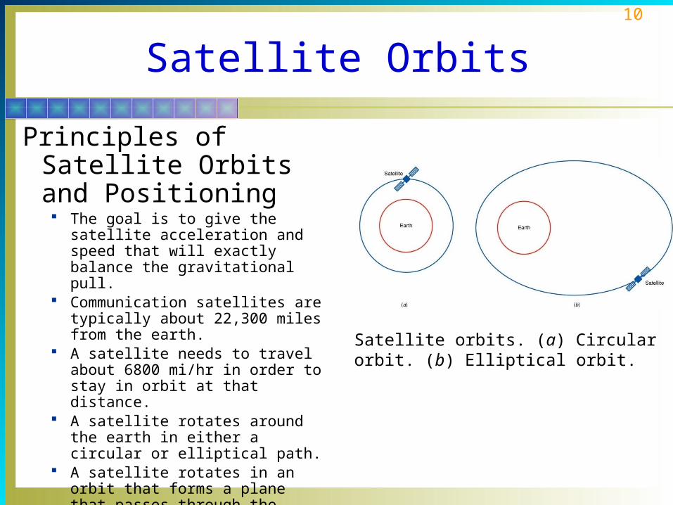
Principles of Satellite Orbits and Positioning The goal is to give the satellite
acceleration and speed that will exactly balance the gravitational pull.
Communication satellites are typically about 22,300 miles from the earth.
A satellite needs to travel about 6800 mi/hr in order to stay in orbit at that distance.
A satellite rotates around the earth in either a circular or elliptical path.
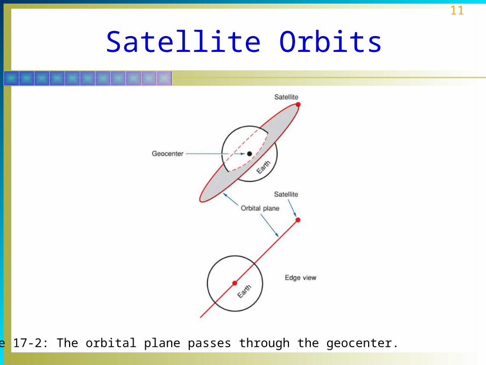
A satellite rotates in an orbit that forms a plane that passes through the center of gravity of the earth called geocenter.
Satellite orbits. (a) Circular orbit. (b) Elliptical orbit.
11
Satellite Orbits
Figure 17-2: The orbital plane passes through the geocenter.
12
Satellite Orbits
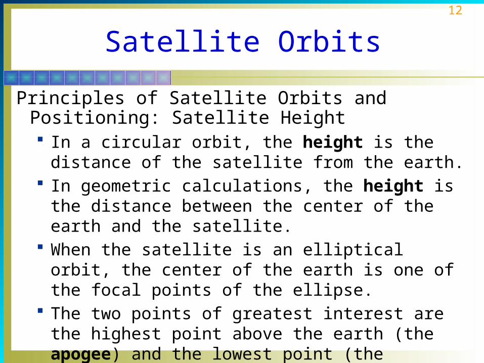
Principles of Satellite Orbits and Positioning: Satellite Height In a circular orbit, the height is the distance of the
satellite from the earth. In geometric calculations, the height is the distance
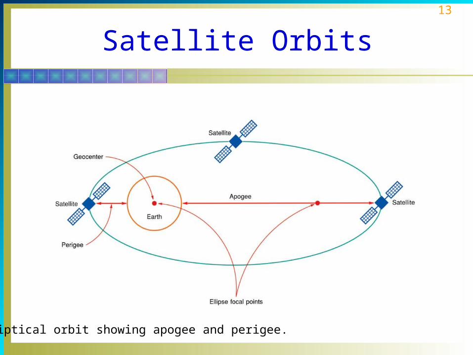
between the center of the earth and the satellite. When the satellite is an elliptical orbit, the center of the
earth is one of the focal points of the ellipse. The two points of greatest interest are the highest point
above the earth (the apogee) and the lowest point (the perigee).
13
Satellite Orbits
Elliptical orbit showing apogee and perigee.

14
Satellite Orbits
Principles of Satellite Orbits and Positioning: Satellite Speed Satellite speed varies depending upon the distance of
the satellite from the earth. For a circular orbit the speed is constant, but for an
elliptical orbit the speed varies depending upon the height.
Low earth satellites of about 100 mi in height have a speed of about 17,500 mi/hr.
Very high satellites such as communication satellites typically travel at speeds of about 6800 mi/hr.

15
Satellite Orbits
Principles of Satellite Orbits and Positioning: Satellite Period The period is the time it takes for a satellite to complete
one orbit. This time is also called the sidereal period. One revolution is the period of time that elapses
between the successive passes of the satellite over a given meridian of earth longitude.
Typical rotational periods range from about 1 ½ h for a 100-mi height to 24 h for a 22,300-mi height.

16
Satellite Orbits
Principles of Satellite Orbits and Positioning: Angle of Inclination The angle of inclination of a satellite orbit is the angle
formed between the line that passes through the center of the earth and the north pole, and a line that passes through the center of the earth but that is also perpendicular to the orbital plane.
It is also defined as the angle between the equatorial plane and the satellite orbital plane as the satellite enters the northern hemisphere.
When the satellite has an angle of inclination, the orbit is said to be ascending or descending.

17
Satellite Orbits
(a) Angle of inclination. (b) Ascending and descending orbits.

18
Satellite Orbits
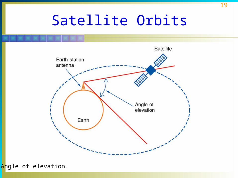
Principles of Satellite Orbits and Positioning: Angle of Elevation The angle of elevation of a satellite is the angle that
appears between the line from the earth station’s antenna to the satellite and the line between the earth station’s antenna and the earth’s horizon.
Noise in the atmosphere contributes to poor performance.
The minimum practical angle of elevation for good satellite performance is 5°.
The higher the angle of elevation, the better.
19
Satellite Orbits
Angle of elevation.
20
Satellite Orbits
Principles of Satellite Orbits and Positioning: Geosynchronous Orbits To use a satellite for communication relay or repeater
purposes, the ground station antenna must be able to follow or track the satellite as it passes overhead.
Depending upon the height and speed of the satellite, the earth station is able to use it only for communication purposes for that short period when it is visible.
The best solution to this problem is to launch a synchronous or geostationary satellite.
21
Satellite Orbits
Principles of Satellite Orbits and Positioning: Geosynchronous Orbits In a geosynchronous earth orbit (GEO), the satellite
rotates about the earth in exactly 24 h. It appears to be fixed or stationary. The antenna is
pointed at the satellite and remains in a fixed position, making continuous communication possible.
Most communication satellites in use today are of the geosynchronous variety.
22
Satellite Orbits
Principles of Satellite Orbits and Positioning: Position Coordinates in Latitude and Longitude The satellite location is specified by a point on the earth
directly below the satellite known as the subsatellite point (SSP).
Latitude is defined as the angle between the line drawn from a given point on the surface of the earth to the point at the center of the earth called the geocenter and the line between the geocenter and the equator.
The prime meridian is used as a reference point for measuring longitude.
23
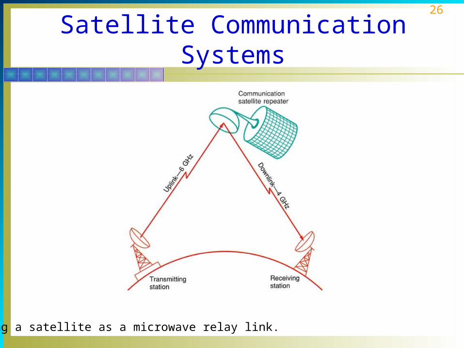
Satellite Communication Systems
Communication satellites are not originators of information to be transmitted.
Satellites are relay stations for earth sources. The transmitting station sends the information to the
satellite, which in turn retransmits it to the receiving station.
The satellite in this application is what is generally known as a repeater.

24
Satellite Communication Systems
Repeaters and Transponders An earth station transmits information to the satellite. The satellite contains a receiver that picks up the
transmitted signal, amplifies it, and translates it on another frequency.
The signal on the new frequency is then retransmitted to the receiving stations back on earth.

25
Satellite Communication Systems
Repeaters and Transponders The original signal being transmitted from the earth
station to the satellite is called the uplink. The retransmitted signal from the satellite to the
receiving stations is called the downlink. The transmitter-receiver combination in the satellite is
known as a transponder.
26
Satellite Communication Systems
Using a satellite as a microwave relay link.

27
Satellite Communication Systems
Repeaters and Transponders: Frequency Allocations Most communication satellites operate in the microwave
frequency spectrum. The microwave spectrum is divided up into frequency
bands that have been allocated to satellites as well as other communication services such as radar.
The most widely used satellite communication band is the C band.
The C band uplink frequencies are in the 5.925- to 6.425-GHz range and the downlink frequencies are in the 3.7- to 4.2-GHz range.

28
Satellite Communication Systems
Frequency bands used in satellite communication:
BAND FREQUENCY
P 225–390 MHz
J 350–530 MHz
L 1530–2700 MHz
S 2500–2700 MHz
C 3400–6425 MHz
X 7250–8400 MHz
Ku 10.95–14.5 GHz
Ka 17.7–31 GHz
Q 36–46 GHz
V 46–56 GHz
W 56–100 GHz

29
Satellite Subsystems
All satellite communication systems consist of two basic parts, the satellite or spacecraft and two or more earth stations.
The satellite performs the function of a radio repeater or relay station.
Two or more earth stations may communicate with one another through the satellite rather than directly point-to-point on the earth.

30
Satellite Subsystems
The heart of a communication satellite is the communication subsystem.
This subsystem is a set of transponders that receive the uplink signals and retransmit them to earth.
A transponder is a repeater that implements a wideband communication channel capable of carrying many simultaneous communication transmissions.

31
Satellite Subsystems
General block diagram of a communication satellite.

32
Satellite Subsystems
Communication Subsystems The main payload on a communication satellite is the
communication subsystem that performs the function of a repeater or relay station.
An earth station takes the signals to be transmitted, known as baseband signals, and modulates a microwave carrier.
The three most common baseband signals are voice, video, or computer data.
Most modern satellites contain at least 12 transponders.

33
Satellite Subsystems
Communication Subsystems: Multichannel Configurations Virtually all modern communication satellites contain
multiple transponders. This permits many more signals to be received and
transmitted. Each transponder operates on a separate frequency,
but its bandwidth is wide enough to carry multiple channels of voice, video, and digital information.
The two multichannel architectures used with communication satellites are broadband and fully channelized.

34
Satellite Subsystems
Power Subsystem Today virtually every satellite uses solar panels for its
basic power source. Solar panels are large arrays of photocells connected in
various series and parallel circuits to create a powerful source of direct current.
A key requirement is that the solar panels always be pointed toward the sun.
Solar panels generate a direct current that is used to operate the various components of the satellite and to charge secondary batteries that act as a buffer.

35
Satellite Subsystems
Telemetry, Command, and Control Subsystems All satellites have a telemetry, command, and control
(TC&C) subsystem that allows a ground station to monitor and control conditions in the satellite.
The telemetry system is used to report the status of the onboard subsystems to the ground station.
A command and control system permits the ground station to control the satellite.
Most satellites contain a small digital computer that acts as a central control unit for the entire satellite.

36
Satellite Subsystems
Applications Subsystems The applications subsystem is made up of the special
components that enable the satellite to fulfill its intended purpose.
For a communication satellite, this subsystem is made up of the transponders.
An observation satellite may use TV cameras or infrared sensors to pick up various conditions on earth and in the atmosphere. This information is then transmitted back to earth by a special transmitter designed for this purpose.
37
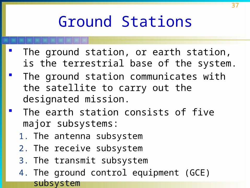
Ground Stations
The ground station, or earth station, is the terrestrial base of the system.
The ground station communicates with the satellite to carry out the designated mission.
The earth station consists of five major subsystems:1. The antenna subsystem
2. The receive subsystem
3. The transmit subsystem
4. The ground control equipment (GCE) subsystem
5. Power subsystem

38
Ground Stations
Receive Subsystems The downlink is the receive subsystem of the earth
station. It usually consists of very low noise preamplifiers that
take the small signal received from the satellite and amplify it to a level suitable for further processing.
The signal is then demodulated and sent on to other parts of the communication system.
39
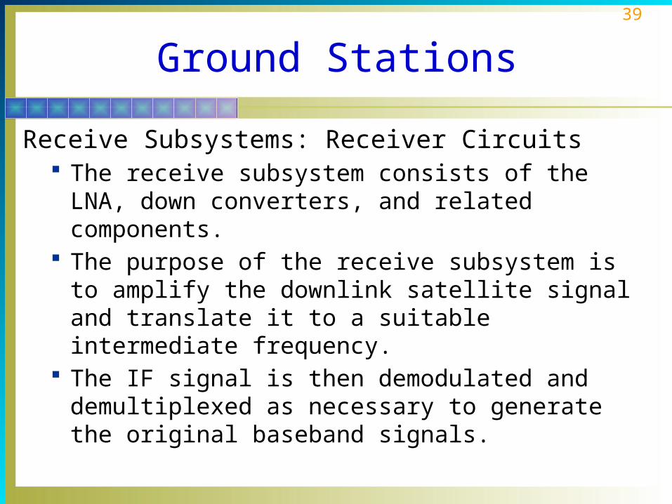
Ground Stations
Receive Subsystems: Receiver Circuits The receive subsystem consists of the LNA, down
converters, and related components. The purpose of the receive subsystem is to amplify the
downlink satellite signal and translate it to a suitable intermediate frequency.
The IF signal is then demodulated and demultiplexed as necessary to generate the original baseband signals.

40
Ground Stations
Receiver Ground Control Equipment The receiver ground control equipment (GCE)
consists of one or more racks of equipment used for demodulating and demultiplexing the received signals.
The down converters provide initial channelization by transponder, and the demodulators and demultiplexing equipment process the 70-MHz IF signal into the original baseband signals.
Other intermediate signals may be developed as required by the application.

41
Ground Stations
Transmitter Subsystems The uplink is the transmitting subsystem of the earth
station. It consists of all the electronic equipment that takes the
signal to be transmitted, amplifies it, and sends it to the antenna.
In a communication system, the signals to be sent to the satellite might be TV programs, multiple telephone calls, or digital data from a computer.
Signals modulate a carrier, are amplified, and sent to an antenna via waveguides, combiners, and diplexers.
42
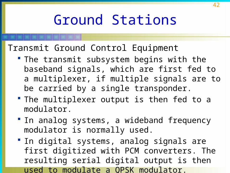
Ground Stations
Transmit Ground Control Equipment The transmit subsystem begins with the baseband
signals, which are first fed to a multiplexer, if multiple signals are to be carried by a single transponder.
The multiplexer output is then fed to a modulator. In analog systems, a wideband frequency modulator is
normally used. In digital systems, analog signals are first digitized with
PCM converters. The resulting serial digital output is then used to modulate a QPSK modulator.

43
Ground Stations
Power Subsystems Most earth stations receive their power from the normal
ac mains. Standard power supplies convert the ac power to the dc voltages required to operate all subsystems.
Most earth stations have backup power systems that take over if an ac power failure occurs.
The backup power system may consist of a diesel engine driving an ac generator, which automatically starts when ac power fails.
Smaller systems may use uninterruptible power supplies (UPS), which derive their main power from batteries.

44
Ground Stations
Telemetry and Control Subsystems The telemetry equipment consists of a receiver and the
recorders and indicators that display the telemetry signals.
The signal may be received by the main antenna or a separate telemetry antenna.
A separate receiver on a frequency different from that of the communication channels is used for telemetry purposes.

45
Ground Stations
Telemetry and Control Subsystems In some satellite systems where communication is not
the main function, some instrumentation may be a part of the ground station.
Instrumentation is a general term for all the electronic equipment used to deal with the information transmitted back to the earth station.

46
Ground Stations
Very Small-Aperture Terminal A very small-aperture terminal (VSAT) is a miniature
low-cost satellite ground station. These units are extremely small and mount on the top
or side of a building and in some versions even fit into a suitcase.
Costs range from a few thousand dollars to no more than about $6000 today.
They can be installed very quickly by plugging them in and pointing the antenna.

47
Ground Stations
Very Small-Aperture Terminal The most common application of VSATs today is in
connecting remote company or organization sites to a main computer system. Gas stations and retail stores use VSATs as point-of-sale
(PoS) terminals to transmit sales transaction information to the home office, check customer credit cards, and relay inventory data.
Tollbooths using SpeedPass and other radio-frequency identification (RFID) of vehicles for tolls use VSATs.
The settop box receiver used by consumers for Direct Broadcast Satellite (DBS) TV reception is a receive-only (RO) VSAT.

48
Satellite Applications
Communication: The main application for satellites today is in communication. Communication satellites act as relay stations in the sky and permit reliable long-distance communication worldwide.
Direct Broadcast Satellite (DBS) service: This is a TV signal distribution system designed to distribute signals directly to consumers.

49
Satellite Applications
Satellite Cell Phones. Satellite-based cellular telephone service is under development. The proposed new systems use low-earth-orbit satellites to perform the relay services to the main telephone system or to make connection directly between any two cellular telephones using the system.

50
Satellite Applications
Digital Satellite Radio: One of the newest satellite applications is in digital satellite radio or the digital audio radio service (DARS). This service provides hundreds of channels of music,
news, sports, and talk radio to car portable and home radios.
It provides full continuous coverage of the station you select wherever you are in the United States.
Its digital transmission techniques ensure high-quality stereo sound that is immune to noise.
The satellites transmit other information such as song title and artist, type of music, and other data, which are displayed on a LCD screen.
51
Satellite Applications
Surveillance satellites can look at the earth and transmit what they see back to ground stations for a wide variety of purposes, including military intelligence, meteorological applications, and mapping.
Satellite navigation systems can provide global coverage unavailable with land-based systems satellites.

52
Global Positioning System
The Global Positioning System (GPS), also known as Navstar, is a satellite-based navigation system that can be used by anyone with an appropriate receiver to pinpoint his or her location on earth.
GPS was developed by the US Air Force for the Department of Defense as a continuous global radio navigation system.
The GPS system consists of three major segments: the space segment, the control segment, and the user segment.

53
Global Positioning System
Space Segment The space segment is the constellation of satellites
orbiting above the earth that contain transmitters which send highly accurate timing information to GPS receivers on earth. The GPS consists of 24 main operational satellites and 3
active spare satellites arranged in six orbits of 3 or 4 satellites each.

54
Global Positioning System
Space Segment Each of the satellites contains four highly accurate atomic
clocks. These clocks are used to generate a unique
pseudorandom code identifying the specific satellite that is transmitted to earth.
The satellite also transmits a set of digitally coded ephemeris data that completely defines its precise orbit.

55
Global Positioning System
The GPS space segment.

56
Global Positioning System
Control Segment The control segment of the GPS system refers to the
various ground stations that monitor the satellites and provide control and update information. The master control station is operated by the U.S. Air
Force in Colorado Springs. Four additional monitoring and control stations
constantly monitor the satellites and collect range information from each.

57
Global Positioning System
Control Segment The information is sent back to the master control
station in Colorado, where all the information is collected and position data on each satellite calculated.
The master control station then transmits new ephemeris and clock data to each satellite on the S-band uplink once per day.

58
Global Positioning System
GPS Receivers A GPS receiver is a complex superheterodyne
microwave receiver designed to pick up the GPS signals, decode them, and then compute the location of the receiver.
The output is usually an LCD display giving latitude, longitude, and altitude information and/or a map of the area.
The most widely used GPS receiver is the popular handheld portable type, not much larger than an oversized handheld calculator.
59
Global Positioning System
GPS Receivers The receiver performs a time multiplexing operation on
the four satellites within view of the receiver. The data is extracted from each of the four satellites
and stored in the receiver’s memory. Data from three satellites is needed to fix the receiver’s
position. If data from a fourth satellite is available, altitude can be
calculated.

60
Global Positioning System
: A GPS receiver.

61
Global Positioning System
How triangulation works to locate a GPS receiver.

62
Global Positioning System
GPS Applications The primary application of the GPS is military and
related navigation. GPS is used by all services for ships, aircraft, and
ground troops. Most civilian applications also involve navigation, which
is usually marine or aviation-related.

63
Global Positioning System
GPS Applications Commercial applications include surveying,
mapmaking, and construction. Vehicle location is a growing application for trucking and
delivery companies, taxi, bus, and train transportation. Police, fire, ambulance, and forest services also use
GPS. A new hobby called geocaching uses GPS receivers.
In this sport, one team hides an item or “treasure” and then gives the other team coordinates to follow to find the treasure within a given time.