lecture notes in earth sciences 127 - springer978-3-642-01459-8/1.pdf · lecture notes in earth...
TRANSCRIPT

Lecture Notes in Earth Sciences 127Editors:
J. Reitner, GöttingenM. H. Trauth, PotsdamK. Stüwe, GrazD. Yuen, USA
Founding Editors:
G. M. Friedman, Brooklyn and TroyA. Seilacher, Tübingen and Yale

Ram S. Sharma
Cratons and Fold Beltsof India
123

Prof. Dr. Ram S. SharmaUniversity of RajasthanDept. [email protected]
ISSN 0930-0317ISBN 978-3-642-01458-1 e-ISBN 978-3-642-01459-8DOI 10.1007/978-3-642-01459-8Springer Heidelberg Dordrecht London New York
Library of Congress Control Number: 2009926971
© Springer-Verlag Berlin Heidelberg 2009This work is subject to copyright. All rights are reserved, whether the whole or part of the material isconcerned, specifically the rights of translation, reprinting, reuse of illustrations, recitation, broadcasting,reproduction on microfilm or in any other way, and storage in data banks. Duplication of this publicationor parts thereof is permitted only under the provisions of the German Copyright Law of September 9,1965, in its current version, and permission for use must always be obtained from Springer. Violationsare liable to prosecution under the German Copyright Law.The use of general descriptive names, registered names, trademarks, etc. in this publication does notimply, even in the absence of a specific statement, that such names are exempt from the relevant protectivelaws and regulations and therefore free for general use.
Cover design: Bauer, Thomas
Printed on acid-free paper
Springer is part of Springer Science+Business Media (www.springer.com)
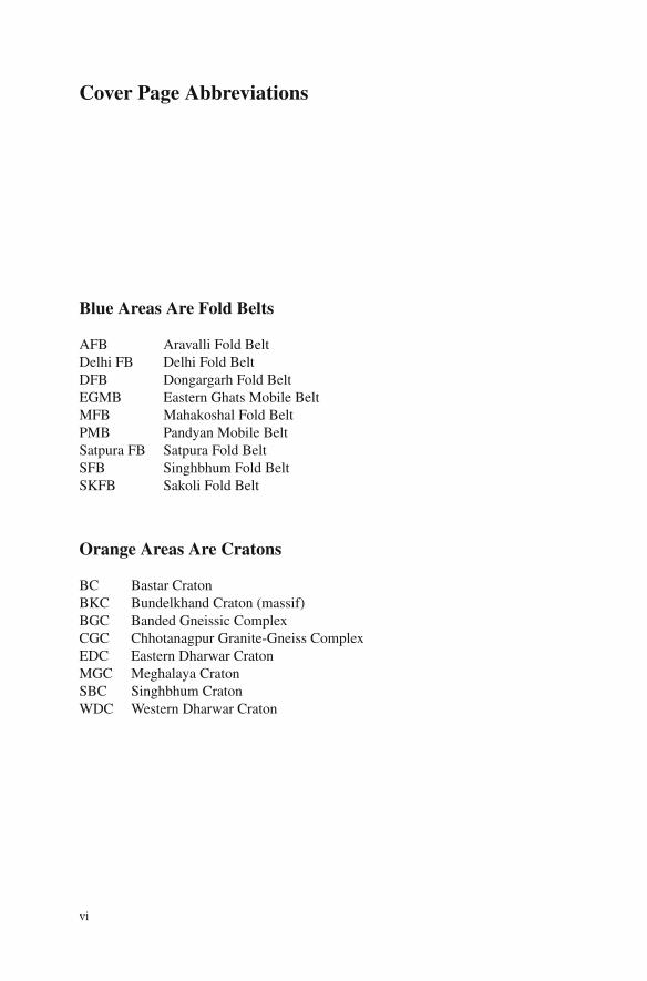
Cover Page Abbreviations
Blue Areas Are Fold Belts
AFB Aravalli Fold BeltDelhi FB Delhi Fold BeltDFB Dongargarh Fold BeltEGMB Eastern Ghats Mobile BeltMFB Mahakoshal Fold BeltPMB Pandyan Mobile BeltSatpura FB Satpura Fold BeltSFB Singhbhum Fold BeltSKFB Sakoli Fold Belt
Orange Areas Are Cratons
BC Bastar CratonBKC Bundelkhand Craton (massif)BGC Banded Gneissic ComplexCGC Chhotanagpur Granite-Gneiss ComplexEDC Eastern Dharwar CratonMGC Meghalaya CratonSBC Singhbhum CratonWDC Western Dharwar Craton
vi

A hundred times a day I remind myself that myinner and outer lives are based on the labors ofother people, living and dead, and that I mustexert myself in order to give in the same measureas I have received and am still receiving.
Albert Einstein

Dedicated to the memory of my sister Rajbai andher mother-in-law Bhoribai whose benevolenceand guardianship helped me attain what I could.

Foreword
Professor Ram Swaroop Sharma whom I affectionately address as Bhratashri hasasked me to write a foreword for his book on “Cratons and Fold Belts of India”.Bhratashri’s wish is always my command and this foreword is written with bothdelight and humility.
Formation of rocks to make up the continental crust and the assembly of suchrocks to form a contiguous and large physiographic feature called landmass is a firstorder geological problem. Several other geological problems such as the formationof various landforms (mountains, plateaus and plains), various mineral deposits,development/maintenance/evolution of hydrologic cycle, climate and life, and riversand their basins are integral parts of this first order problem. Just as the fundamen-tal thing called water is taken for granted, so also the existence of land on earth.Although land may not be a critical environmental resource, the existence of land iscritical to the physics and chemistry of the life system on earth. This basic truth, per-haps realized by Vedic men, is dawned on to the contemporary scientific communityonly towards the end of the twentieth century, thanks to the developing environmen-tal problems.
Our knowledge of the earth, its materials and processes, is very rapidly increasingdue to advancement in technical tools of investigations and in theoretical aspects ofphysics, chemistry and biology. The advent of plate tectonic theory after the SecondWorld War and the realization of environmental consequences of consumption ofearth materials and ecosystem services contributed very significantly to our under-standing of earth processes. Studies of the Precambrian Geology of India have madevery good use of all these development as well as International scientific coopera-tion. Although our knowledge of the formation of India as a landmass is better todaythan ever before, it is still far from what is required to sustain human “civilization.”
Prof. Sharma’s book on “Cratons and Fold Belts of India” is an excellent exposi-tion of the current status of our knowledge of the geology of Archaean cratonic partsof the Indian landmass and of the geology and processes of formation of Proterozoicfold belts on the cratonic basements (cratonic, of course, not during Proterozoic!).The book also provides, for an uninitiated but interested, in the first three chapters,concepts of terrain and terrain making processes, major cratonic terrains of Indiaand processes of formation of ensialic fold belts. For each of the Proterozoic foldbelts in India, possible models of evolution are discussed providing an excellent
xi

xii Foreword
account for anyone interested in further research. The book is also an exposition ofthe volume of research that has been done in India in the past five decades as well asthe volume of knowledge of Prof. Sharma on Indian Geology. Future generation ofstudents of Geosciences will sure appreciate the mind and service of Professor RamSharma.
New Delhi, India V. Rajamani
Preface
The fold belts, also known as mobile belts, whether the young Tertiary mountainof the Himalaya or the old Proterozoic fold belts, occur as linear belts of deformedand metamorphosed rocks within different continents of the Earth. To establish thecontinuity of these fold belts and to attempt correlations with other coeval fold beltselsewhere as well as to model their evolutionary mechanism is rather a difficulttask. This is because of the subsequent lithospheric plate movements, which broughtabout assembly/reassembly of the continents during various geological periods. Inthe plate tectonic evolution of the fold belts, the Himalaya is the best example tounderstand the events of plate collision and to recognize colliding plates, subduc-tion zones, arc, etc as the elements of the plate tectonics process. Undoubtedly, theevolution of the Himalaya would help us in organizing our observations and devel-oping our skills to apply plate tectonics theory for the evolution of the Proterozoicfold belts of India. By studying the geological characteristics of the fold belts wecan possibly decipher the tectonic history of the Earth preserved in these fold beltsand nowhere else. Proterozoic fold belts are the main repositories of informationabout early plate tectonic interactions. The Proterozoic fold belts of India are sig-nificant in this respect, as they would help in tracing the past history of the cratonicregions of the Indian shield and in attempting global correlations. This needs a thor-ough investigation of these fold belts in regard to their geological/geochronologicalcharacteristics and evolutionary processes. The available geological information onthese fold belts is, however, scattered and the different evolutionary models needa serious scrutiny towards a subjective overview, along with the role played in theprocess by the cratonic areas of the Indian shield. In the present book, we attemptto understand the nature, composition and antiquity of the cratonic regions of theIndian shield and their relationship with the fold belts in the neighbourhood, includ-ing the Himalaya, so as to arrive at a “definite point of view” concerning their origin.All published geodata, old and new, have been evaluated and interpreted in a logicalway. A mere accumulation of facts would make science dull unless the facts aregiven a meaningful interpretation, either to strengthen a theory or to propose a newmodel replacing the existing paradigms. The author has adopted this approach whilehandling the available geological database.
The basic plan of the book is as follows: The first chapter begins with thefundamental concepts about Precambrian terrains and Precambrian tectonics. It is
xiii
xiv Preface
followed by a historical development of the theme of mountain building processeswith a detailed account of plate tectonics and its features. In the second chapter,the cratonic areas of the Indian shield are described, because not only the evolutionof the fold belts involved the process of rifting and collision of the cratonic areas,but also because the fold belts are either located at the continental margins or aresandwiched between two cratonic regions. In Chap. 3, evolution of the Himalayais taken up as an illustrative example of the development of an orogenic belt in theplate tectonic setting. The tectono-thermal evolution of this Tertiary belt will helpprovide an understanding of the Proterozoic fold belts and their associated plate tec-tonic environments. In the subsequent chapters, each of the Proterozoic fold beltsis described, incorporating its geological characteristics, the agreed-on observationsand facts on the geological database pertaining to the deformation, metamorphism,and geochronology, with discussion of the evolutionary models proposed by dif-ferent workers. Each of the proposed models has been evaluated in terms of theseagreed observations and the geological database and a more plausible model is givenby the author at the close of each chapter. Geophysical data inputs are, however,often missing in this modeling exercise, primarily for lack of author’s own under-standing of geophysics and for not having appreciation of relating the present sub-surface features revealed by geophysics with the features of the geological past.The last chapter, Chap. 8, includes the Pandyan mobile belt of the southern Indiagranulite terrain. This chapter is presented in somewhat greater detail for its dif-ferent granulite blocks. Throughout this book, I have tried to keep the approachwell-motivated and to strive for simplicity of presentation. As an interpreter of geo-sciences, care has been taken to clarify the idea of the science of the fold belts, tocompare and contrast the different evolutionary models, some of which are only ofhistorical value and even fit for rejection. By such an approach the younger genera-tion will be benefited as well as encouraged.
The reader is advised to go back to the original literature whenever possible andsee what that original writer had in mind. I have tried to aid such students withlimited but essential references so that the reader should not miss the special pointsof the view that the authors put forward. When reporting words someone has used,I followed standard usage and used double quotation marks. This is to indicate thereader that the word or phrase is being used in some special way, with a specialmeaning or just to indicate that the discussion is calling the customary usage of theword in quotation.
Jaipur, India Ram S. Sharma
Acknowledgements
While writing this book, I received encouragements from several friends andcolleagues. Dr. K.R. Gupta of Department of Science and Technology (DST),New Delhi has been a constant reminder to this writer of the “academic respon-sibility” toward the younger generations of geoscientists of the country. It was not,however, until 2002 that the task was seriously begun. In this endeavor I got fullestsupport from my wife, Kanchan, and I took full liberty of her gentle nature, spend-ing long hours with the task of writing chapters and typing or retyping them untilthe manuscript took the “final” version. A part of the book was revised when theauthor was in the USA with his sons, Professor Anurag Sharma at RPI in Troyand Dr. Prashant Sharma in Chicago. During writing this book, the author reckonedearly formative days of his student career, which he spent under the guardianshipof his elder sister, Rajbai, in her temple at Jaipur. The author is highly indebted toher for inculcating in him the pleasure of doing things for others. While writingthis book, I received constant encouragements from friends and colleagues, whoseregular enquiries about the progress of the book kept my morale all-times high.I express my appreciation to them, especially Dr. K.K. Sharma, Dr. MallickarjunJoshi, Dr. Harel Thomas, Dr. Manoj Pandit and Professors A.K. Jain and V. Raja-mani, Professor B.S. Paliwal and Professor C. Leelanandam. Thanks are also dueto Dr. T.R.K. Chetty and Dr. Y.J. Bhaskar Rao of NGRI, Hyderabad for readingChapters 7 & 8 of the manuscript. Special thanks are due to Dr. Tej Bahadur, seniorresearch fellow in the department of geology of the University of Rajasthan atJaipur, who prepared computer-aided sketches for this book without which it wouldnot have been possible to bring the book in its present form. Dr. Rajiv Nigam isthanked for friendly suggestions pertaining to the figures accompanying the text.The editorial staff of Springer-earth sciences specially Drs. Chris Bendall, Petravan Steenbergen and Janet Sterritt, have done a marvellous job in bringing outthis publication in a short time of seven months. Finally, this book could not havebeen published without the project grants from Indian National Science Academy,New Delhi.
xv
Contents
1 Precambrian Terrains and Mountain Building Processes . . . . . . 11.1 Introduction . . . . . . . . . . . . . . . . . . . . . . . . . . . . 11.2 Archaean Terrains . . . . . . . . . . . . . . . . . . . . . . . . . 31.3 Proterozoic Terrains . . . . . . . . . . . . . . . . . . . . . . . . 71.4 Mountain Building Processes . . . . . . . . . . . . . . . . . . . 9
1.4.1 Geosynclinal Theory . . . . . . . . . . . . . . . . . . . . 91.4.2 Plate Tectonics Theory . . . . . . . . . . . . . . . . . . . 12
1.5 Continental Rifting and Sedimentary Basins . . . . . . . . . . . 221.5.1 Rifting and Triple Junctions . . . . . . . . . . . . . . . . 241.5.2 Pull-Apart Basin . . . . . . . . . . . . . . . . . . . . . . 281.5.3 Foreland Basin . . . . . . . . . . . . . . . . . . . . . . . 30
1.6 Orogeny and Plate Tectonics . . . . . . . . . . . . . . . . . . . . 301.7 The Wilson Cycle . . . . . . . . . . . . . . . . . . . . . . . . . 351.8 Suspect Terrains . . . . . . . . . . . . . . . . . . . . . . . . . . 38References . . . . . . . . . . . . . . . . . . . . . . . . . . . . . . . . . 39
2 Cratons of the Indian Shield . . . . . . . . . . . . . . . . . . . . . . 412.1 Introduction . . . . . . . . . . . . . . . . . . . . . . . . . . . . 412.2 Dharwar Craton . . . . . . . . . . . . . . . . . . . . . . . . . . 43
2.2.1 Introduction . . . . . . . . . . . . . . . . . . . . . . . . 432.2.2 Evolution of Dharwar Schist Belts . . . . . . . . . . . . . 502.2.3 Geodynamic Models for the Evolution
of Dharwar Craton . . . . . . . . . . . . . . . . . . . . . 522.3 Bastar Craton . . . . . . . . . . . . . . . . . . . . . . . . . . . 58
2.3.1 Introduction . . . . . . . . . . . . . . . . . . . . . . . . 582.4 Singhbhum Craton . . . . . . . . . . . . . . . . . . . . . . . . . 65
2.4.1 Geodynamic Evolution . . . . . . . . . . . . . . . . . . 722.5 Chhotanagpur Granite-Gneiss Complex . . . . . . . . . . . . . . 72
2.5.1 Archaean Status of CGGC Questioned . . . . . . . . . . 812.6 Rajasthan Craton . . . . . . . . . . . . . . . . . . . . . . . . . . 83
2.6.1 Banded Gneissic Complex and Berach Granite . . . . . . 842.6.2 BGC: Antiquity Challenged and Nomenclature Changed . 852.6.3 Geological Setting . . . . . . . . . . . . . . . . . . . . . 87
xvii
xviii Contents
2.6.4 Evolution of the Banded Gneissic Complex . . . . . . . . 922.6.5 Bundelkhand Granite Massif (BKC) . . . . . . . . . . . 94
2.7 Meghalaya Craton . . . . . . . . . . . . . . . . . . . . . . . . . 98References . . . . . . . . . . . . . . . . . . . . . . . . . . . . . . . . . 102
3 The Young and Old Fold Belts . . . . . . . . . . . . . . . . . . . . . 1173.1 Introduction . . . . . . . . . . . . . . . . . . . . . . . . . . . . 1173.2 Himalaya as an Example of the Young Fold Belt . . . . . . . . . 118
3.2.1 Geological Setting . . . . . . . . . . . . . . . . . . . . . 1183.2.2 Evolution of Himalaya . . . . . . . . . . . . . . . . . . . 122
3.3 Old Fold Belts . . . . . . . . . . . . . . . . . . . . . . . . . . . 1343.4 Proterozoic Fold Belts of India . . . . . . . . . . . . . . . . . . 1363.5 Ensialic Orogenesis Model . . . . . . . . . . . . . . . . . . . . 136References . . . . . . . . . . . . . . . . . . . . . . . . . . . . . . . . . 138
4 Aravalli Mountain Belt . . . . . . . . . . . . . . . . . . . . . . . . . 1434.1 Introduction: Geological Setting . . . . . . . . . . . . . . . . . . 1434.2 Aravalli Fold Belt . . . . . . . . . . . . . . . . . . . . . . . . . 143
4.2.1 Aravalli Stratigraphy: Controversies . . . . . . . . . . . . 1464.2.2 Geochronology: Time of Aravalli Orogeny . . . . . . . . 148
4.3 Delhi Fold Belt . . . . . . . . . . . . . . . . . . . . . . . . . . . 1494.3.1 Delhi Stratigraphy: Controversies . . . . . . . . . . . . . 1504.3.2 Geochronology: Time of Delhi Orogeny . . . . . . . . . 151
4.4 Deformation of the Proterozoic Fold Belts . . . . . . . . . . . . 1534.5 Geohistory of Granulites . . . . . . . . . . . . . . . . . . . . . . 1544.6 Agreed Observations and Facts . . . . . . . . . . . . . . . . . . 1574.7 Evolutionary Models and Discussion . . . . . . . . . . . . . . . 1594.8 Geophysical Database . . . . . . . . . . . . . . . . . . . . . . . 1704.9 Conclusions . . . . . . . . . . . . . . . . . . . . . . . . . . . . 171References . . . . . . . . . . . . . . . . . . . . . . . . . . . . . . . . . 172
5 Central Indian Fold Belts . . . . . . . . . . . . . . . . . . . . . . . . 1775.1 Introduction . . . . . . . . . . . . . . . . . . . . . . . . . . . . 1775.2 Mahakoshal Fold Belt . . . . . . . . . . . . . . . . . . . . . . . 179
5.2.1 Introduction: Geological Setting . . . . . . . . . . . . . . 1795.2.2 Agreed Observations and Facts . . . . . . . . . . . . . . 1805.2.3 Evolution of the Mahakoshal Fold Belt (MFB) . . . . . . 181
5.3 Satpura Fold Belt . . . . . . . . . . . . . . . . . . . . . . . . . 1825.3.1 Introduction: Geological Setting . . . . . . . . . . . . . . 182
5.4 Agreed Observations and Facts . . . . . . . . . . . . . . . . . . 1855.4.1 Evolution of the Satpura Fold Belt (SFB) . . . . . . . . . 186
5.5 Geological Significance of the Central Indian Tectonic Zone . . . 1895.6 Dongargarh Fold Belt . . . . . . . . . . . . . . . . . . . . . . . 191
5.6.1 Introduction: Geological Setting . . . . . . . . . . . . . . 1915.6.2 Agreed Observations and Facts . . . . . . . . . . . . . . 1945.6.3 Evolution of the Dongargarh Fold Belt (DFB) . . . . . . 194
Contents xix
5.7 Sakoli Fold Belt . . . . . . . . . . . . . . . . . . . . . . . . . . 1955.7.1 Introduction: Geological Setting . . . . . . . . . . . . . . 1955.7.2 Agreed Observations and Facts . . . . . . . . . . . . . . 1965.7.3 Evolution of the Sakoli Fold Belt (SKFB) . . . . . . . . . 197
5.8 Discussion of Evolutionary Models of the Central IndianFold Belts . . . . . . . . . . . . . . . . . . . . . . . . . . . . . 198
References . . . . . . . . . . . . . . . . . . . . . . . . . . . . . . . . . 204
6 Singhbhum Fold Belt . . . . . . . . . . . . . . . . . . . . . . . . . . 2096.1 Introduction: Geological Setting . . . . . . . . . . . . . . . . . . 2096.2 Deformation . . . . . . . . . . . . . . . . . . . . . . . . . . . . 2136.3 Metamorphism . . . . . . . . . . . . . . . . . . . . . . . . . . . 2146.4 Geochronolgy . . . . . . . . . . . . . . . . . . . . . . . . . . . 2156.5 Agreed Observations and Facts . . . . . . . . . . . . . . . . . . 2176.6 Evolution of the Singhbhum Fold Belt (SMB) . . . . . . . . . . 2186.7 Evolutionary Models and Discussion . . . . . . . . . . . . . . . 220References . . . . . . . . . . . . . . . . . . . . . . . . . . . . . . . . . 226
7 Eastern Ghats Mobile Belt . . . . . . . . . . . . . . . . . . . . . . . 2317.1 Introduction: Geological Setting . . . . . . . . . . . . . . . . . . 2317.2 Deformation . . . . . . . . . . . . . . . . . . . . . . . . . . . . 2347.3 Geochronology . . . . . . . . . . . . . . . . . . . . . . . . . . . 2357.4 Petrological Characteristics . . . . . . . . . . . . . . . . . . . . 2367.5 Tectono-Thermal Evolution . . . . . . . . . . . . . . . . . . . . 2367.6 Northern Segment . . . . . . . . . . . . . . . . . . . . . . . . . 237
7.6.1 Southern Segment . . . . . . . . . . . . . . . . . . . . . 2397.7 Is Godavari Graben a Major Terrain Boundary? . . . . . . . . . . 2417.8 Agreed Observations and Facts . . . . . . . . . . . . . . . . . . 2427.9 Evolutionary Models and Discussion . . . . . . . . . . . . . . . 2437.10 Newer Divisions of the Eastern Ghats Mobile Belt . . . . . . . . 248
7.10.1 Rengali Province . . . . . . . . . . . . . . . . . . . . . . 2537.10.2 Jeypore Province . . . . . . . . . . . . . . . . . . . . . . 2537.10.3 Krishna Province . . . . . . . . . . . . . . . . . . . . . . 2537.10.4 Eastern Ghats Province . . . . . . . . . . . . . . . . . . 254
References . . . . . . . . . . . . . . . . . . . . . . . . . . . . . . . . . 257
8 Pandyan Mobile Belt . . . . . . . . . . . . . . . . . . . . . . . . . . . 2638.1 Introduction: Geological Setting . . . . . . . . . . . . . . . . . . 2638.2 Geological Attributes of the Granulite Blocks . . . . . . . . . . . 2658.3 Pandyan Mobile Belt . . . . . . . . . . . . . . . . . . . . . . . . 2728.4 Agreed Observations and Facts . . . . . . . . . . . . . . . . . . 2768.5 Evolutionary Models and Discussion . . . . . . . . . . . . . . . 276References . . . . . . . . . . . . . . . . . . . . . . . . . . . . . . . . . 284
Postscript . . . . . . . . . . . . . . . . . . . . . . . . . . . . . . . . . . . 291
Appendix . . . . . . . . . . . . . . . . . . . . . . . . . . . . . . . . . . . 293
xx Contents
About the Book . . . . . . . . . . . . . . . . . . . . . . . . . . . . . . . . 295
About the Author . . . . . . . . . . . . . . . . . . . . . . . . . . . . . . 297
Index . . . . . . . . . . . . . . . . . . . . . . . . . . . . . . . . . . . . . 299

List of Figures
1.1 Tectonic units of the continents: the Shields and Orogenicbelts (after Umbgrove, 1947) . . . . . . . . . . . . . . . . . . . . . 3
1.2 Non-uniformitarian evolutionary model of Greenstone belt(after Windley, 1984). (a) Synformal structure; (b) crustalthickening; (c) uplift of deformed greenstones . . . . . . . . . . . . 5
1.3 Plate tectonic model for the formation of Greenstonebelt exemplified by Rocas Verdes Complex, South Chile(after Tarney et al., 1976). (a) Extensional phase and basinformation; (b) volcanic phase and emplacement of basalt;(c) continental sediments and arc lavas as supracrustals;(d) deformation due to basin closure and intrusion ofsynorogenic tonalite; (e) emplacement of late potassicGranite . . . . . . . . . . . . . . . . . . . . . . . . . . . . . . . . 6
1.4 Plate tectonic model for the evolution of greenstone-gneiss-granulite in the Archaean (redrawn from Windley,1984). (a) Several small continental plates with ensialicback-arc basins. The Andean-type margins are invadedby mantle-derived tonalitic batholiths and plutons;(b) aggregations of the continents to produce a largecontinental plate consisting of greenstone and granulite belts . . . . 7
1.5 Geosynclinal model for the development of an orogenic belt . . . . 101.6 Depth zones and distribution of deformed and
metamorphosed rocks in a crustal section . . . . . . . . . . . . . . 111.7 Block diagram showing the different plate margins. Mantle
material rises below the Constructive plate margins (oceanridges) and plate material descends into the mantle atConvergent (destructive) plate margins (ocean trenches). AtConservative plate margins (transform faults) plates slidepast each other, without getting created or destroyed . . . . . . . . 13
1.8 Representation of development of a ridge-to-ridge transform(adapted from Verhoogen et al., 1970, Fig. 3.75). (a) Oceanicridge (double line) along which new crustal material addedis displaced by a sinistral strike-slip fault (single line);
xxi
xxii List of Figures
(b) addition of magma between line A and A and slip onthe fault; (c) addition of material between lines B and B;scar of previously active sections of the fault extend laterallyinto the surrounding crust. Note that the sense of slip onthe transform fault is opposite of that inferred from thedisplacement of the ridge by strike-slip faulting . . . . . . . . . . . 15
1.9 Physiographic-cum-geologic units in a convergence of theOcean-Ocean plates (see text for details). e = eclogite facies;gl = glaucophane schist facies; pp = prehnite-pumpellyitefacies; z = zeolite facies . . . . . . . . . . . . . . . . . . . . . . . 17
1.10 Different mechanisms for the formation of Back-arc basin(after Moores and Twiss, 1995). (a) Forceful injection ofa diapir from the subducting slab and extension of theoverlying crust; (b) Convection currents driven by the dragof the downgoing slab resulting into extension of oceaniccrust behind the island arc; (c) Retreat of overriding plate byglobal plate motion changes compression to extension of theoceanic crust behind the arc; (d) Back-arc basin formed bychange of a Transform fault to a subduction zone . . . . . . . . . . 21
1.11 Marginal Basin (Back-arc basin) formed due to secondaryspreading (see text) . . . . . . . . . . . . . . . . . . . . . . . . . . 21
1.12 Ductile stretching as a possible mechanism for rift basinformation (see text) . . . . . . . . . . . . . . . . . . . . . . . . . . 23
1.13 Stages in the evolution of a Rift (see text for details) . . . . . . . . 231.14 Development of an Extensional basin in a continental
lithosphere. (a) Rising convection currents generate tensionalstresses, causing stretching of the crust; (b) deposition ofsediments and basaltic lava in the extensional basin . . . . . . . . . 24
1.15 Evolution of triple junction from one time to later time (afterKearey and Vine, 1996); see also text . . . . . . . . . . . . . . . . 25
1.16 RTF triple junction and velocity vectors as indicators ofstability/instability of Plate boundaries (after Kearey andVine, 1996); see text . . . . . . . . . . . . . . . . . . . . . . . . . 26
1.17 Development of an Aulacogen from a RRR triple junction;see text for details . . . . . . . . . . . . . . . . . . . . . . . . . . . 27
1.18 Pull-apart basins due to strike-slip motion and extension.(a) Basin at a fault curvature during transtensional regime,(b) sharp pull-apart basin by strike-slip motion, (c) basinsformed as a result of fault termination . . . . . . . . . . . . . . . . 29
1.19 Stages in the formation of Pull-apart Basins (see text fordetails) . . . . . . . . . . . . . . . . . . . . . . . . . . . . . . . . 29
1.20 Foreland basin formation as a flexural depression of thecontinental crust . . . . . . . . . . . . . . . . . . . . . . . . . . . 30
1.21 Different sedimentary deposits in shelf, slope and deep-seaconditions within a geosyncline . . . . . . . . . . . . . . . . . . . 31

List of Figures xxiii
1.22 Schematic cross section of converging ocean-continentplates, showing island arc and the distribution ofmetamorphic facies. High P/T facies series develops inthe subduction zone while low P/T facies series is formedin the arc. Dotted line is trace of an erosion plane alongwhich a progressive sequence of regional metamorphism isencountered in eroded fold belts . . . . . . . . . . . . . . . . . . . 32
1.23 Schematic map showing the development and location ofplate tectonic elements and the distribution of metamorphicfacies at a convergent continent-ocean plate boundary . . . . . . . . 34
1.24 Schematic illustration of the Wilson cycle (after Dewey andBird, 1970) . . . . . . . . . . . . . . . . . . . . . . . . . . . . . . 37
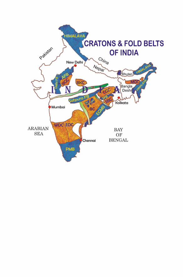
2.1 Outline map of the Indian shield showing the distribution ofcratons, including Chhotanagpur Granite Gneiss Complex,Rifts and Proterozoic fold belts. Megahalaya craton(formerly Shillong Plateau) is not outlined here but is shownin Fig. 2.10. The fold belts are: 1 = Aravalli Mt. belt, 2 =Mahakoshal fold belt, 3 = Satpura fold belt, 4 = Singhbhumfold belt, 5 = Sakoli fold belt, 6 = Dongargarh fold belt,7 = Eastern Ghats mobile belt, 8 = Pandyan mobile belt.Abbreviations: Opx-in = orthopyroxene-in isograd; AKS =Achankovil shear zone; PC-SZ = Palghat Cauvery ShearZone; SGT = Southern Granulite Terrain; SONA Zone =Son-Narmada lineament . . . . . . . . . . . . . . . . . . . . . . . 42
2.2 Simplified geological map of the southern Indian shield (afterGSI and ISRO, 1994) showing the Dharwar (-Karnataka)craton and its Schist belts, Southern Granulite Terrain (SGT)and shear zones. Metamorphic isograds between greenschistfacies and amphibolite facies and between amphibolite andgranulite facies (i.e. Opx-in isograd) are after Pichamuthu(1965). Greenstone (Schist) belts in the Dharwar craton(Eastern and Western blocks) are: 1 = Shimoga, 2 =Bababudan, 3 = Western Ghats, 4 = Chitradurga, 5 =Sandur, 6 = Kolar, 7 = Ramagiri, 8 = Hutti. Locality: BR =Biligiri Rangan Hills, Ch = Chitradurga, Cg = Coorg, Dh =Dharwar, Jh = Javanahalli, Kn = Kunigal, S = Shimoga.Shear zones: Bh = Bhavani; Ch-Sz = Chitradurga ShearZone, M =Moyar; M-Bh =Moyar-Bhavani . . . . . . . . . . . . 44
2.3 Geological sketch map of central part of the Kolar SchistBelt (after Hanson et al., 1988) . . . . . . . . . . . . . . . . . . . . 52
2.4 Block diagram showing the crustal evolution in the Kolararea (after Hanson et al., 1988). See text for details . . . . . . . . . 56
2.5 Central Indian fold belts and cratons. (a) Location of centralIndian fold belts. (b) Geological setting of Bastar Cratonin relation to adjacent cratons and Central Indian Tectonic
xxiv List of Figures
Zone (CITZ). Abbreviations: BC = Bastar craton, CGGC= Chhotangapur Granite Gneiss Complex, CIS = CentralIndian shear zone, DC=Dharwar craton, SBC= Singhbhumcraton, SONA ZONE = Son-Narmada Lineament zonebounded by Son-Narmada North Fault (SNNF) andSon-Narmada South Fault (SNSF). (c) Simplified geologicalmap (bottom sketch) shows the CITZ sandwiched betweenBastar craton in the south and Bundelkhand craton in thenorth. The four localities of granulites described in theSatpura fold belt are: BBG = Bhandara-Balaghat granulite,BRG = Bilaspur-Raipur granulite, MG = Makrohargranulite, and RKG = Ramakona-Katangi granulite . . . . . . . . . 61
2.6 Location and Geological map of Singhbhum (-Orissa) cratoncomprising Archaean rocks of Older Metamorphic Group(1) and Older Metamorphic Tonalite Gneiss (2), SinghbhumGranite Group (SBG) with three phases (I, II, & III) ofemplacement, and Iron-Ore Group (IOG) made up of: 1 –lavas and ultramafics, 2 – shale-tuff and phyllite, 3 – BHJ,BHQ, sandstone and conglomerate. Abbreviations: C =Chakradharpur, D = Daiteri, K = Koira, SSZ = Singhbhumshear zone. (1) = Singhbhum Granite, (2) = Bonai Granite,3 =Mayurbhanj Granite . . . . . . . . . . . . . . . . . . . . . . . 66
2.7 Location and distribution of Chhotanagpur Granite GneissComplex (CGGC). The five geological belts (I–V) outlinedby zigzag line in the CGGC terrain are drawn afterMahadevan (2002). Dotted lines are boundaries of the States . . . . 75
2.8 Simplified geological map of Rajasthan craton (afterHeron, 1953 and GSI, 1969), made up of Banded GneissicComplex (BGC), Berach Granite and other Archaeangranitoids. Granulite outcrops are in the BGC terrain andin the metasediments of the Delhi Supergroup (see text fordetails). Blank area occupied by Proterozoic fold belts andsand cover. Abbreviations: BL = Bhilwara, BW = Beawar,N = Nathdwara, M =Mangalwar. Inset shows the locationof BBC (Banded gneissic complex-Berach Granite) andBKC (Bundelkhand) cratonic blocks that together constitutewhat is here termed the Rajasthan (-Bundelkhand) Craton,abbreviated RC . . . . . . . . . . . . . . . . . . . . . . . . . . . . 83
2.9 Location and geological map of the Bundelkhandcraton/massif (after Basu, 1986). BB = Bijawar basin, GB =Gwalior basin, SB = Sonrai basin . . . . . . . . . . . . . . . . . . 95
2.10 Location of Meghalaya in the northeastern states of India(a and b) and Geological map (c) of the Shillong-MikirHills Plateau, herein called the Meghalaya craton, withlocation of Garo Hills (G), Khasi-Jantia Hills (K-J), Mikir
List of Figures xxv
Hills (renamed as Kabri Hills by some authors). Otherabbreviations: DF = Dauki Fault, DT = Disang thrust,MBT = Main Boundary thrust, MT = Mizu thrust, NT =Naga thrust, SPB = Schuppen Belt (Zone of imbrication) . . . . . . 99
3.1 Generalized geological map of the Himalaya showingthe principal geological divisions (litho-tectonic units),based on the compilation map of GSI (1962), Gansser(1964), and Valdiya (1977). Bottom figure is a crustalsection showing the relationship of different shear zones.Abbreviations: HHC = Higher Himalayan Crystallines,ITSZ = Indus-Tsangpo shear zone, MBT =Main BoundaryThrust, MCT =Main Central Thrust, MFT (MBF) =MainFrontal thrust (Main Boundary fault) . . . . . . . . . . . . . . . . . 119
3.2 Sequence of events in the evolution of the Himalaya(redrawn after Allegre et al., 1984). Abbreviatons: BNS =Bongong-Nujiang suture, ITSZ = Indus-Tsangpo suturezone, KS = Kokoxili suture, MCT = Main Central Thrust,MBT =Main Boundary Thrust . . . . . . . . . . . . . . . . . . . 123
3.3 A plausible model (after Sharma, 2005) for the invertedmetamorphism in the Himalayan metamorphic belt (HMB),shown in stages: (a) Indian-Asian plate collision, but Indianplate was too buoyant to be carried down further, (b) Plasticdeformation and recrystallization of the leading edge ofthe Indian plate, being at greater depth and hence at higherP & T, (c) Northward push of the subducted Indian plateresulted into southward thrusting of the plastically deformedand recrystallized rocks over the Precambrian rocks(Lesser Himalayan/basement) and overlying sediments.Emplacement of these rocks reduced drag load at the “tip” ofthe subducted continental crust, retreating and raising up theIndian plate, and this flip also caused southern convexity ofthe thrust belt all along the Himalayan length, (d) Continuednorthward push of the Indian plate resulted into renewedsouthward thrusting of still higher grade Higher HimalayanCrystalline (HHC) rocks during Oligocene-Miocene.Upthrusting of HHC caused decompression melting (latersolidified as the Leucogranite), occasional folding ofisograds and parallelism of “S” and “C” fabrics in theHHC rocks. Bottom figure shows thrusting in 3-dimension,differentiating MCT into I and II . . . . . . . . . . . . . . . . . . . 128
3.4 Northward drift of India with respect to Asia from 71 Mato the present, determined from magnetic lineations in theIndian and Atlantic oceans (redrawn from Molnar andTapponier, 1975) . . . . . . . . . . . . . . . . . . . . . . . . . . . 134

xxvi List of Figures
4.1 Generalized geological map of the Proterozoic fold belts(Aravalli and Delhi) and cratonic rocks (BGC) in Rajasthan(after GSI, 1969, 1993). Inset (a) is the location map and(b) shows the major Crustal Terranes in Rajasthan (afterSinha-Roy, 2000). Abbreviations: A = Alwar; AM = Ajmer;ANT = Antalia; B = Bhilwara; BN = Bhinder; BS =Banswara; BY = Bayana; CH = Chittaurgarh; DS = Dausa;GBF = Great Boundary Fault; J = Jahazpur; K = Kankroli;KHT = Khetri; N = Nathdwara; PHL = Phulad; S = Sirohi;SL = Salumbar; SM = Sandmata; SN = Sendra; SR = Sarara . . . 144
4.2 Diagrammatic representation of the sequence ofdeformational phases and fold styles in the Precambrianrocks of Rajasthan, NW India (based on Naha and others,1967, 1984; Mukhopadhyay and Dasgupta, 1978; Roy, 1988;Srivastava et al., 1995) . . . . . . . . . . . . . . . . . . . . . . . . 155
4.3 Evolutionary model of the Aravalli fold belt and relatedbelts shown by cartoons (redrawn after Sinha-Roy, 1988).Abbreviations: AG=Anjana Granite; DG=Derwal Granite;J = Jahazpur belt; PBDB = Pur-Banera-Dariba-Bhinderbelt; RU = Rakhabdev ultramafics. SDB = South DelhiOcean Basin. Toothed line is a major dislocation . . . . . . . . . . 159
4.4 Shows relation of the Aravalli subductionand opening of (a) North Delhi Rifts and(b) South Delhi Ocean Basin (SDB), illustratingdiachronous nature of the North and South Delhi fold belts(after Sinha-Roy, 1988). Abbreviations: AB = AravalliFold Belt; AFB = Alwar-Bayana Fold Belts; ICS =Intracontinental Subduction; RS = Rakhabdev Suture;SDF = South Delhi Ocean Opening (Basin); SJDT =Sambhar-Jaipur-Dausa Transcurrent Fault . . . . . . . . . . . . . . 160
4.5 Evolutionary model of Delhi fold belt (after Sinha-Roy,1988). Abbreviations: AFB = Aravalli Fold Belt; AS = ArcSequence; DMB = Delhi Marginal Basin; RS = RakhabdevSuture; SG = Sendra Granite; SD = South Delhi Rift; SJDT= Sambhar-Jaipur-Dausa Transcurrent/Tansform Fault;SDFB = South Delhi Fold Belt; VA = Volcanic Arc. Seetext for details . . . . . . . . . . . . . . . . . . . . . . . . . . . . . 161
4.6 Evolutionary model of Aravalli-Delhi fold belts (afterSugden et al., 1990). (a) Rifting of the Archaean lithosphereof Rajasthan, (b) generation of volcanic arc by eastwardsubduction of an oceanic crust, or (b’) volcanic arc generatedby westward subduction of continental lithosphere, (c)breaking of eastward subducting slab and development of adextral shear zone, (c’) breaking of westward subductingblock and upthrusting of crustal rocks on the Eastern block,
List of Figures xxvii
(d) crushing of the volcanic arc, upthrusting of the oceaniccrust as ophiolite and accretion of Aravalli-Delhi fold belts.VA = Volcanic Arc . . . . . . . . . . . . . . . . . . . . . . . . . . 164
4.7 Model for the origin of Aravalli basins along RRF (afterRoy, 1990) . . . . . . . . . . . . . . . . . . . . . . . . . . . . . . 165
4.8 Evolutionary stages for the Proterozoic Aravalli mountain(Aravalli and Delhi fold belts) in Rajasthan, NW India. (a)Plume-generated ductile stretching (rifting) of the Archaeancrust of Rajasthan in Palaeoproterozoic, (b) deposition ofAravalli supracrustals, including volcanics of Delwara, inthe rifted basin, (c) westward subduction and delaminationof mantle lithosphere whereby mantle magma underplatedthe crust, forming granulites at the base and rifting of thesoftened crust above the delaminated region for depositionof the Delhi supracrustals, (d) extension of the continentalcrust causing a series of rift basins in the northern part ofthe evolving Delhi basin; sedimentary fill of the extensionalbasin by Delhi Supergroup; and decompression meltingof the ascending asthenosphere and of the overlying crustwhereby basic magmas emplaced in the rifted basins,including the initiated south Delhi basin, while granitesintruded the crust below the rifted basins, (e) Enlargementof the extensional basins, including the basin initiated to thesouth of the rifted basins, (f) Convergence of the divergingblocks (due to depositional load, decay of plume responsiblefor lithosphere extension and change of stress direction withtime), resulting into deformation of both Delhi and alreadydeformed Aravalli fold belts, (g) Continued convergenceof the continental blocks resulted into welding of themantle lithosphere, accretion of the fold belts and tectonicexcavation of the granulites that now occur as fragments inthe BGC and Delhi metamorphic terrains. For details see text . . . . 167
5.1 Location map (a) and index map (b) showing the position ofthe different Proterozoic fold belts in central Indian region.1 = Mahakoshal folds belt, 2 = Satpura fold belt, 3 =Sakoli fold belt, 4 = Dongargarh fold belt. Abbreviations:CITZ = Central Indian Tectonic Zone, CIS = Central Indianshear zone, SONA ZONE = Son-Narmada Lineament zone,SNNF = Son-Narmada North Fault, SNSF = Son-NarmadaSouth Fault. (c) Geological map of central India (after Royet al., 2002) showing the different Proterozoic fold belts,granulite occurrences and shear zones. M = Malanjkhand,Ts = Tan shear zone, TF = Tapti Fault. Granulites ofRamakona-Katangi (RKG), Bhandara-Balaghat (BBG),Bilaspur-Raipur (BRG) and Makrohar (MG) are all located
xxviii List of Figures
in the basement rocks (Tirodi gneiss) of the Sausar Groupmaking up the Satpura fold belt . . . . . . . . . . . . . . . . . . . 178
5.2 Geological map of the Central Indian Tectonic Zone (CITZ)(after Roy et al., 2002) sandwiched between Bundelkhandcraton in the north and Bastar craton in the south (top figure).The location of the four fold belts and shear zones of centralIndia as well as the four granulite localities (Fig. 5.1) arealso shown in bottom figure. All abbreviations as in Fig. 5.1 . . . . 188
5.3 Geological map of Dongargarh fold belt, central India(after Sarkar, 1957; Deshpande et al., 1990). 1 = Amgaongneiss complex, 2 = Bijli rhyolite, 3 = Pitepani volcanics,4 = Dongargarh granitoid, 5 = Bortalao formation, 6 =Sitagota volcanics, 7 = Karutola formation, 8 =Manjikhutaformation, 9 = Ghogra formation, 10 = Katima volcanics(5–10 lithounits belong to Khairagarh Group) . . . . . . . . . . . . 193
5.4 A plausible model for the evolution of the fold belts ofthe central Indian region. (a) Existence of a large Indianprotocontinent (united cratons of Rajasthan-Bundelkhand-Bastar, RCBKCBC). (b) Plume-generated early Proterozoicigneous activity in the Indian protocontinent, initiatingrifting of the protocontinent in the western region(Bundelkhand-BGC cratonic region) and also resulting intoigneous activity of the Dongargarh bimodal volcanics (2.5Ga old) with minor ultramafics and granite intrusions ineastern part (Bastar cratonic region) of the protocontinent.(c) Development of the rift basin that became theSONA Zone bounded by north and south faults (calledSon-Narmada North Fault, SNNF, and Son-Narmada SouthFault, SNSF, respectively). The SONA Zone became thesite for deposition of the Mahakoshal supracrustal rocks,while sinking of the softened crust of the Bastar cratondeveloped a basin for the Khairagarh supracrustals. (d)Deformation of Dongargarh-Khairagarh Group rocks due tobasinal subsidence and also by compression due to tensionalforces associated with the development of SONA Zone. (e)Formation of shear, the Central Indian Shear Zone (CIS), dueto ductile stretching of the region of Bundelkhand-Bastarcratons, caused by sub-lithospheric mantle activity and alsoby deformation (F1) of the Mahakoshal supracrustals inthe SONA Zone. (f) Development of an ensialic basin asa result of thinning of continental crust due to shearing(CIS) and deposition of the Sausar Group supracrustalstherein. Magma underplating, due to crustal delamination, isbelieved to have developed granulites in the lower crust ofthe Bundelkhand-Bastar cratonic region. (g) Convergence of

List of Figures xxix
the once rifted Bundelkhand and Bastar cratons, resulting indeformation (F2) of the Mahakoshal rocks and the SausarGroup rocks along with their basement gneisses . . . . . . . . . . . 200
6.1 Location of Singhbhum fold belt between Singhbhum cratonand Chhotanagpur Granite Gneiss Complex (Chhotanagpurcraton) (after A.K. Saha, 1994). (A) = Dhanjori volcanics,(B) = Dalma volcanics, (C) = Jaganathpur volcanics, CB= Chaibasa formation, CH = Chakradharpur granite, DH= Dalma formation, GM = Gorumahisani formation, K =Kuilapal Granite, N = Nilgiri Granite, NM = NoamandiIron-Ore formation, M = Mayurbhanj Granite, OB =Ongerbira volcanics, SM= Simlipal basin, SZ= Singhbhumshear zone . . . . . . . . . . . . . . . . . . . . . . . . . . . . . . . 210
6.2 Diagram showing tectonic setting of Singhbhum marginalbasin and associated morphostructural unit (redrawn fromBose, 1994) . . . . . . . . . . . . . . . . . . . . . . . . . . . . . . 222
6.3 Slab break off evolutionary model for the Singhbhumfold belt, based on available geological-geochronologicaldata. (a) Ductile stretching and rifting of Archaeancraton (SC+CGGC) in Palaeoproterozoic (ca. 2.1 Ga) andsedimentation of Singhbhum Group. (b) Development ofensialic crust and deposition of more sediments with minortuffs (cf. Dunn and Dey, 1942). (c) Start of collision atabout 1.6 Ga ago and folding of supracrustal and basementrocks. (d) Convergence (perhaps oblique) and subductionof southern block (SC) followed by narrow rifting and slabweakening. (e) Slab rupture, underplating and extrusionof mafic magma (Dalma volcanics) amidst sediments ofSinghbhum Group. Additional volcano-sediment depositionand high level intrusion of mafic (gabbro-pyroxenitedykes at 1.6 Ga). (f) With underplating following slabrupture, mafic magma extruded and intruded. Heat fromthe underplated magma also induced partial melting withinthe crust to produce 1.6 Ga old granites (Kuilapal etc.)and granophyre (Arkasani). (g) Further slab break off andslab downgoing/sinking generated melt, giving rise tocalc-alkaline magma that appeared as volcanics (Chandil)and acid tuff (Ankro area of Chandil) at 1487 ± 34 Ma(Sengupta and Mukhopadhyay, 2000). (h) Slab sinks awayand melting at depth produced the last phases of granitoidliquid while dykes (Newer Dolerite; Saha, 1994) wereinjected from the underplate into the overlying crust.Abbreviations: CGGC = Chhotanagpur Granite GneissComplex, SC= Singhbhum Craton, SFB= Singhbhum FoldBelt, SSZ = Singhbhum Shear Zone, NSZ = Northern ShearZone . . . . . . . . . . . . . . . . . . . . . . . . . . . . . . . . . 225
xxx List of Figures
7.1 Simplified geological map of the Eastern Ghats MobileBelt (EGMB) (after Ramakrishnan et al., 1998) withmegalineaments after Chetty (1995). MSZ = MahanadiShear Zone; NSZ = Nagavalli Shear Zone; SSZ = SileruShear Zone; VSZ = Vamsadhara shear Zone. Inset showslocation of the mobile belt . . . . . . . . . . . . . . . . . . . . . . 232
7.2 Location map (a); the attempted correlation of EGMBwith Napier Complex (NPCx) and Rayner Complex(Rayner Cx) of the Enderbyland, Antarctica (b); (c) showsa synoptic history of P-T paths (see text) in differentdomains of the Eastern Ghats Mobile Belt. Note that theUHT metamorphism with high pressure IBC and IBCheating-cooling paths are attributed to an earlier eventof ∼1.6 Ga, whereas ITD path to a later, ∼1.0 Ga event(Dasgupta et al., 1994; Mezger and Cosca, 1999; Senguptaet al., 1999; Rickers et al., 2001; and others). The differencein metamorphic evolution in North and South EGMB maynot be real (see text) . . . . . . . . . . . . . . . . . . . . . . . . . . 238
7.3 Age domains in the Eastern Ghats Mobile Belt (after Rickerset al., 2001) (see text for details) . . . . . . . . . . . . . . . . . . . 251
7.4 Newer division of Eastern Ghats Mobile Belt into crustalprovinces (after Dobmeier and Raith, 2003). See text fordetails . . . . . . . . . . . . . . . . . . . . . . . . . . . . . . . . . 252
8.1 Simplified Geological map of the southern India (after GSIand ISRO, 1994), showing the major geological domains,the Western Dharwar Craton (WDC), Eastern DharwarCraton (EDC), and Southern Granulite Terrain (SGT) alongwith the Cauveri Shear Zone System (CSZ). Abbreviations:AKSZ = Achankovil Shear Zone; AH = Anamalai Hills;AT = Attur; BS = Bhavani Shear zone; BL = Bangalore;BR = Biligirirangan; CHS = Chitradurga Shear Zone; CG= Coorg; CM = Coimbatore; EDC = East Dharwar Craton;K = Kabbaldurga; KL = Kolar; KKB = Kerala KhondaliteBelt; MS = Moyar Shear zone; N = Nilgiri; OT= Ooty;PCSZ = Palgahat Shear Zone; PL = Pollachi; PMB =Pandyan Mobile Belt; SGT = Southern Granulite Terrain;SH = Shevaroy Hills; WDC = West Dharwar Craton;GR-Am = Isograd between Greenschist and AmphiboliteFacies; Am-Gt = Isograd between Amphibolite andGranulite Facies; TZ = Transition Zone of amphibolite andgranulite facies. Inset shows various identified crustal blocks . . . . 264
8.2 Simplified Geological map of part of the southern Indianshield (based on GSI and ISRO, 1994), showing the locationof the Southern Granulite Terrain (SGT) to the south ofthe Am/Gt (Amphibolite-granulite facies) isograd (drawn
List of Figures xxxi
after Pichamuthu, 1965). To the north of the isograd arethe Western and Eastern Dharwar Cratons (WDC andEDC). The Highland massifs are: Bilgirirangan (BR),Coorg (C), Cardamom (CH), Madras (MA), Kodaikanal(KK), Malai Mahadeswara (MM), Nilgiri (NG), Shevroy(SH), Varshunadu (VH). The prominent shear zones:The Cauvery Shear Zone System (CSZ), comprisingMoyar (MS), Bhavani (BS), Palghat-Cauvery (PCS),Salem-Attur (SA-At). Others are: Gangavalli (GA),Karur-Kambam-Painvu-Trichur (KKPT) and AchankovilShear Zones (AKSZ), Korur-Odanchitram Shear Zone(KOSZ). The different crustal blocks recognized in the SGTsensu lato are: the Northern Block (NBSGT) and SouthernBlock (SBSGT), Madurai Block (MB). The block betweenthe Palghat Shear Zone (PCS) and the Achankovil Shearzone (AKS) is designated Pandyan Mobile Belt (PMB).To the south of the AKS is the Kerala Khondalite Belt(KKB). Other abbreviations are: CM = Coimbatore; NC= Nagercoil; OT = Ooty; RM = Rajapalayam; TL =Tirunelveli. Inset shows the SGT, the KKB and the differentshear zones traversing the SGT. Other abbreviations as inFig. 8.1 . . . . . . . . . . . . . . . . . . . . . . . . . . . . . . . . 266
8.3 Litho-tectonic map of the Kerala Khondalite Belt (KKB)and a part of the Southern Granulite Terrain (i.e. MaduraiBlock), redrawn from T. Radhakrishna, 2004. Note that thegneiss/migmatite and granulite are cofolded by superposeddeformation F1 and F2 with axial traces (delineated by thewriter) which are cut across by the Achankovil shear zone,see text for details . . . . . . . . . . . . . . . . . . . . . . . . . . . 278