leg m50/1 cruise report - oceanrep - geomar
TRANSCRIPT

METEOR-Bericht
Circulation and Variability in the Tropical Atlantic
Cruise No. 68, Leg 2 from Recife, Brazil to Mindelo, Cape Verde
June 6 to July 9, 2006
Peter Brandt, Uwe Beckmann, Jürgen Fischer, Natalie Fischer, Tim Fischer, Andreas Funk, Susann Grobe, Niels Gülzow, Verena Hormann, Frank Malien, Uwe Koy, Mario Müller, Gerd Niehus, Wolf-Thilo Ochsenhirt, Uwe Papenburg, Benjamin Rabe, Jens Schafstall, Anke Schneider, Martina Schütt, Lothar Stramma, Toste Tanhua, Doris
Veleda, Peter Wiebe, Claudia Winkelmann, Rainer Zantopp
Editorial Assistance:
Frank Schmieder Fachbereich Geowissenschaften, Universität Bremen
Leitstelle METEOR
Institut für Meereskunde der Universität Hamburg

Table of Contents (M68/2) 2.1 Participants M68/2 2-32.2 Research Program 2-42.3 Narrative of the Cruise 2-42.4 Preliminary Results
2.4.1 CTD Measurements in the Tropical Atlantic 2.4.1.1 Calibration and Data Quality of CTD and Oxygen Measurements 2.4.1.2 Oxygen Minima Distribution in the Equatorial Atlantic 2.4.2 Current Observations
2.4.2.1 Ocean Surveyor: Technical Aspects 2.4.2.2 Current Sections 2.4.2.3 Lowered ADCPs
2.4.3 Mooring Operations 2.4.3.1 Recoveries 2.4.3.2 Deployments 2.4.3.3 Selected Results 2.4.4 ARGO Float Deployments 2.4.5 Microstructure Measurements 2.4.6 Chemical Measurements 2.4.7 DVS Meteorological and Surface Underway Data 2.4.7.1 Thermosalinograph Data 2.4.7.2 Meteorological Data
2-92-92-9
2-112-122-122-132-162-162-162-182-272-292-292-322-342-342-36
2.5 Ship’s Meteorological Station M68/2 2-372.6 Station List M68/2 2-372.7 Acknowledgements 2-442.8 References 2-44

METEOR-Bericht, Cruise 68, Leg 2, Recife-Mindelo
2-3
2.1. Participants M68/2
1 Brandt, Peter, PD Dr. Chief Scientist IFM-GEOMAR 2 Beckmann, Uwe CTD, technology IFM-GEOMAR 3 Fischer, Jürgen, Dr. LADCP, moorings IFM-GEOMAR 4 Fischer, Natalie Helium UBU 5 Fischer, Tim ADCP, shipboard sampling IFM-GEOMAR 6 Funk, Andreas, Dr. CTD, ADCP, radiosondes IFM-GEOMAR 7 Grobe, Susann CO2, alkalinity IFM-GEOMAR 8 Gülzow, Niels H2O2 IFM-GEOMAR 9 Hormann, Verena Salinometry, radiosondes IFM-GEOMAR 10 Koy, Uwe Microstructure IFM-GEOMAR 11 Malien, Frank O2, nutrients IFM-GEOMAR 12 Müller, Mario LADCP, computers IFM-GEOMAR 13 Niehus, Gerd Moorings, CTD IFM-GEOMAR 14 Ochsenhirt, Wolf-Thilo Meteorological technology DWD 15 Papenburg, Uwe Moorings, technology IFM-GEOMAR 16 Rabe, Benjamin, Dr. APEX, CTD, shipboard sampling IFM-GEOMAR 17 Schafstall, Jens Microstructure IFM-GEOMAR 18 Schneider, Anke CFC, SF6 IFM-GEOMAR 19 Schütt, Martina CFC, SF6 IFM-GEOMAR 20 Stramma, Lothar, Dr. Salinometry, CTD IFM-GEOMAR 21 Tanhua, Toste, Dr. CFC, SF6 IFM-GEOMAR 22 Veleda, Doris CTD UFPE 23 Wiebe, Peter CO2, alkalinity IFM-GEOMAR 24 Winkelmann, Claudia Helium UBU 25 Zantopp, Rainer Moorings, CTD IFM-GEOMAR 26 Marcelo Cavalcante Brazilian observer
2.1.1 Participating Institutions
IFM-GEOMAR Leibniz-Institut für Meereswissenschaften an der Universität Kiel,
Düsternbrooker Weg 20, 24105 Kiel - Germany, e-mail:pbrandt@ifm -geomar.de
DWD Deutscher Wetterdienst, Geschäftsfeld Seeschiffahrt, Bernhard-Nocht-Str. 76, 20359 Hamburg - Germany, e-mail: [email protected]
UBU Universität Bremen, Institut für Umweltphysik, Otto-Hahn-Allee, UW1, Postbox
330440, 28334 Bremen - Germany, e-mail: mrhein@ theo.physik.uni-bremen.de
UFPE Universidade Federal de Pernambuco, Av. Arquitetura, s/n 50740-550 - Cidade Universitária, Recife - PE, Brasil, e-mail: [email protected]

METEOR-Bericht, Cruise 68, Leg 2, Recife-Mindelo 2-4
2.2 Research Program
The measurement program of M68/2 consisted of station hydrographic observations with a CTD/O2 rosette including water sampling for tracer, oxygen and nutrient probing. Of particular importance were underway current measurements with both shipboard ADCPs (Ocean Surveyor, 38 kHz und 75 kHz). In addition to horizontal advection by different zonal current bands, diapycnal mixing plays an important role for the heat budget of the mixed layer. In the region between 23°W and 10°W specifically, diapycnal mixing processes were measured on station using a loosely tethered, free-falling microstructure probe and a high-frequency (1200 kHz) LADCP, lowered with the CTD/O2 rosette at the same station.
During M68/2 an intensive mooring program was carried out. This program particulary consisted of the recovery of two equatorial current meter moorings at 35°W and 23°W. To record changes in the equatorial currents on intraseasonal to interannual time scales, a mooring array was installed at 23°W. This array consists of four current meter moorings and is aimed at quantifying the variability of the thermocline water supply toward the equatorial cold tongue. Another equatorial current meter mooring was installed at 10°W in cooperation with the multi-national PIRATA program. In preparation of a planned new Sonderforschungsbereich [German Special Research Program], a profiling CTD/O2 was moored at 5°N, 23°W. The goal of this mooring is to observe the transport of oxygen-rich waters toward the oxygen minimum zone in the tropical North Atlantic. The final mooring of M68/2 was deployed near the Cape Verde Islands shortly before arrival at the port of Mindelo.
Helium probes were taken along the meridional sections (23°W and 10°W) and zonal sections (equator and 2°N) in the upper 500m of the water column. Biogeochemical water sampling, including O2, nutrients, CO2, CFC, and SF6 measurements, was carried out during regular CTD/O2 stations.
In support of the international AMMA program, twice daily radio soundings were taken during M68/2.
2.3 Narrative of the Cruise
R/V METEOR departed from Recife on June 6, 2006 at 10:00L. At that time, some of the instruments (two moored CTD profilers) shipped from Woods Hole, Massachusetts, to Recife should have been delivered to METEOR. Unfortunately, the customs strike in Brazil put a severe damper on these plans, and on-time delivery did not take place. It was decided to ask for permission to take delivery of the instruments upon the ship’s arrival at the island of Fernando de Noronha, where the Brazilian observer was scheduled to disembark from METEOR.
R/V METEOR headed north toward the Brazilian shelf along 35°W where scientific work started with the first CTD/O2 station early in the morning of June 7. The measurements along this section concentrated on the upper ocean so that the CTD/O2 profiles were taken to a depth of 1300m only, or near bottom in the shallower waters near the shelf. The CTD/O2 measurements were accompanied by current measurements with two Workhorse ADCPs attached to the CTD/O2 rosette, as well as by two shipboard ADCPs, so-called Ocean Surveyors of 38 kHz and 75 kHz, respectively. Both instruments obtain their heading input from the 3D-Ashtech GPS receiver as well as from METEOR’s Fiber Optic Compass (FOG).
METEOR-Bericht, Cruise 68, Leg 2, Recife-Mindelo
2-5
Water samples were taken using the water bottles of the CTD/O2 rosette as part of the intense biogeochemical program during M68/2. During most of the stations, water samples were analyzed with respect to their contents of chlorofluorocarbons (CFC), sulfur hexafluoride (SF6), helium, oxygen, nutrients (nitrate, nitrite, phosphate, silicate), dissolved inorganic carbon (DIC), total alkalinity (Alk), and hydrogen peroxide (H2O2).
Along the northward cruise track, CTD stations were spaced apart by about 20’ – 30’ of latitude, somewhat denser near the shelf and near the equator. On June 9, 09:00L, METEOR approached the position of our current meter mooring. The mooring had been deployed in August 2004 and contained four current meters, three CTD sensors, two ADCPs, and one RAFOS sound source. The releases were contacted using the hydrophone board unit, and the release command was sent at 09:10L, with the top element surfacing only a few minutes later. The mooring was then recovered without any problems. A first view of the obtained data showed that all instruments worked well, yielding an instrument and data recovery rate of 100%.
At the mooring position, a first test station with our microstructure profiler (MSS) was carried out with the profiler winch attached at the port side stern rail. The ship’s course and speed (max of 1 to 1.5 kn suggested) were adjusted in accordance with wind and surface current to ensure that the microstructure profiler would fall free and clear astern on the port side. After adjusting the profiler sink velocity by changing the weights of the MSS, the first data set was obtained. At this position, the strong eastward velocity of the Equatorial Undercurrent advected the profiler eastward, away from the ship steaming with 1 kn through the water while drifting southwestward. Thus there was no risk of losing the profiler by cutting the cable with the ship’s propeller.
After the MSS test station, the first APEX float was deployed successfully, and the CTD/O2 section along 35°W was continued. Water samples were taken at every other station for the full set of biogeochemical analyses. The stations in between were used instead for the calibration of Microcats to be deployed within the mooring array along 23°W.
On June 10, we received information from Mr. Marcos Fonseca (Windrose Serv. Mar.), the ship’s agent in Brazil, that the moored profilers were onboard the 53ft sail boat AUSSTEIGER, arriving at Fernando de Noronha in the morning of June 13. The same day, Mr. Fonseca and two customs officers would take an airplane to Fernando de Noronha to facilitate customs clearance and delivery of the moored profilers to METEOR on June 14 at 08:00L.
On June 11, the CTD/O2 section along 35°W was completed with the last station at 5°N. At this position a sound source mooring had been deployed during METEOR cruise M62/2, however, from the received RAFOS float data we knew that the sound source did not work from the very beginning. After approaching the mooring position at 09:20L, the release responded to the signal from the board unit via hydrophone, and about 10 min after sending the release command, the top element was observed at the sea surface. Recovery went smoothly and was completed at 10:00L. Following the mooring recovery another MSS test station was taken. Due to weak winds and currents, there was no problem in obtaining almost constant sink velocities of 0.6 or 0.7 m/s down to 350m depending on the number of ballasting rings attached to the profiler. The last activity at the 35°W section was a CTD/O2 test station. During the previous CTD/O2 casts we observed too strong a tilt of the ADCPs attached to the CTD rosette. We changed the ballast at the CTD rosette, which significantly improved the tilt with smaller pitch and roll angles throughout the CTD test cast. At 13:00L, METEOR began an ADCP section from 35°W, 5°N to
METEOR-Bericht, Cruise 68, Leg 2, Recife-Mindelo 2-6
32°30’W, 2°30’N and further to 32°30’W, 3°50’S, the location of the island of Fernando de Noronha. One ARGO float each was deployed at two degrees north and south of the equator, and two CTD stations were carried out to test the performance of our releases to be used for the mooring deployments later during the cruise.
On June 14 at 07:30L we arrived at the island of Fernado de Noronha. After disembarking the Brazilian observer, we contacted the sailboat AUSSTEIGER. They had already arrived one day earlier as did the two customs officer and the ship’s agent, Mr. Marcos Fonseca. There were no further complications with customs clearance at the island, and all-in-all we experienced only a minor time delay. All of the shipped equipment was found in good condition, and we felt fortunate to have the profiler available for our two moorings in the central tropical Atlantic. At 11:00L the ship headed toward the position of our next mooring recovery.
On June 15 at 10:00L we arrived at the mooring position. After lowering the hydrophone, we were not able to obtain a clear contact with the single release on the mooring. The release code was submitted nonetheless but without success. It appeared that some noise from the ship interfered with the signal of the hydrophone board unit, and after switching off the Kongsberg EM120 multi-beam echo sounder transmitting at 12kHz, we were able to receive clear signals from the release. The release code was submitted again and we received the message “Release executed”. However, the mooring did not come to the surface. Though repeatedly submitting the release code numerous times, nothing happened. As there was no additional time available because of the very tight mooring program, we decided to depart from the mooring position without recovering the sound source mooring. Another ARGO float was deployed at the mooring position, and METEOR headed toward the southern end of the 23°W section beginning at 4°S. Along the cruise track another two ARGO floats were deployed at 27°W and 25°W, respectively.
During the late evening of June 16, the hydrographic section along the 23°W section commenced with a first CTD/O2 cast at 4°S. Several CTD/O2 casts and the first set of regular microstructure stations were carried out during the following day. The depth reached by the microstructure profiler strongly depends on the strength of the vertical shear of the horizontal velocity. Near the equator in particular, only very shallow profiles could be obtained because of the very strong Equatorial Undercurrent (EUC) with core velocities above 1m/s at about 70m depth. During the night station on June 17, the acquisition computer of the microstructure profiler did not receive data from the profiler and it soon became evident that the cable was broken. We switched to a different cable, and microstructure measurements commenced after the mooring deployment on June 18.
The deployment of the first mooring of our equatorial array at 23°W began at 1015L with a drift test. The ship headed against the southeasterly winds with a velocity of about 1kn through water. A drift velocity of about 2.5kn to the south resulted due to prevailing wind and currents. After the drift test the bathymetry of the deployment area was surveyed with the multi-beam echo sounder which, during the last METEOR leg, has proven to be a highly accurate instrument. The obtained topographic data showed that the initially chosen mooring position was situated in an almost flat region of about 3680m water depth. The mooring deployment ran very smoothly, and after merely 2h 20min all instruments were in the water. We had to steam an additional hour to reach the anchor drop position. The final mooring position was determined to be at 0°44.95’S, 22°59.60’W. During the night following the mooring deployment, CTD/O2 and microstructure measurements were continued.

METEOR-Bericht, Cruise 68, Leg 2, Recife-Mindelo
2-7
Two mooring operations had been scheduled for the following day, June 19. Recovery of the French mooring located at 0°00.01’N, 23°07.51’W was started early in the morning. This mooring included a PIRATA Workhorse ADCP, an IFM-GEOMAR Longranger ADCP and several Aanderaa current meters (LOCEAN, C. Provost). The release responded accurately, and the first flotation elements surfaced after just a short while. The ship’s Zodiac was used to first recover the release and its flotation package, followed by all other instruments in short order. A first inspection of the ADCP records indicated complete data sets, although located shallower than originally planned, with the upward looking ADCP located right in the core of the EUC which resulted in strong mooring motion and vertical excursions of the top elements. The Aanderaa current meter tapes were not scheduled to be read during this cruise but to be sent to LOCEAN, Paris, to be read and analyzed there. Following the successful mooring recovery, we commenced with a multi-beam echo sounder survey and found the former mooring position was located amidst smooth topography. Water depths within half a mile around the chosen mooring position varied only between 3680m and 3690m. The drift test with 1.5kn through water against the southeasterly wind again yielded a southward drift because of the strong westward flowing SEC. The mooring deployment started very smoothly, all instruments including the moored profiler moved from the aftdeck into the water without any problems. At the end of the long 2.5km long wire segment for the moored profiler, the wire shifted from its straight position behind the ship and moved strongly to the port side of the ship. Severe tension was building on the mooring wire, and the captain decided to turn the ship to the port side to reduce tension on the mooring wire. However, the mooring wire shaved against the ships hull, resulting in some scuffs to its plastic jacket. As the mooring was at risk for being lost, the ship had to turn quickly to the starboard side, thereby leaving the drift track toward the planned anchor drop position.
After submerging the releases into the water and after attaching the mooring wire to the anchor still firmly attached to the ship’s aft deck, the ship made a wide turn for about 2.5h with about 2kn through water to reach the planned mooring position. The anchor was dropped at the proper and intended position. We believe that this very unusual mooring deployment resulted from the fact that the long mooring line segment of the moored profiler dropped into the depth range of the very strong EUC and was advected eastward. For future applications, one must consider alternative strategies to deploy similar moorings in the equatorial region. The submerging of the mooring top was concluded from the disappearance of the ARGO signal from the transmitter at the moorings top element. The mooring position was determined as 0°00.0S and 23°06.8’W.
During the following night, we completed two CTD casts, with the second one already at the next mooring position. After the topographic survey of the mooring area in the morning of June 20, we chose a mooring position at a water depth of 4310m, about 110m deeper than suggested by the 2’ Sandwell topography. The mooring deployment proceeded without any problems, and the anchor was dropped exactly at the planned position. The final mooring position was determined as 0°45.0’N, 22°59.5’W.
Two more CTD casts were taken during the following night. A drift test at the next mooring position showed rather weak surface currents, contrary to the previous deployments. The survey using the multi-beam echo sounder revealed a depth of about 4950m at the planned mooring position, with a variation of only a few meters nearby. The mooring deployments started right after lunch on June 21. The ship drifted along the planned track, and after about 3h, all
METEOR-Bericht, Cruise 68, Leg 2, Recife-Mindelo 2-8
instruments had been launched from the aftdeck into the water. METEOR had to steam another 45min to reach the anchor drop position, and the final mooring position was determined as 0°00.0’N, 21°29.6’W. This was the last mooring of our equatorial mooring array aimed at studying the role of the equatorial circulation for tropical Atlantic climate variability in the frame of the BMBF Verbundvorhaben “Nordatlantik”.
After the successful installation of the mooring array, the zonal section along the equator commenced with combined microstructure und CTD/O2 observations at 21°W. The distance between successive stations was chosen as 1° in longitude. We completed this section at 12°W during the night of June 24, and METEOR headed toward the southernmost point of the meridional section along 10°W.
Along the 10°W section, nine CTD casts were taken between 1°30’S and 1°30’N. In between, on June 26 at 11:00L, deployment of the French mooring as part of the PIRATA program was started. Following the drift test and topographic survey, the top element, including the PIRATA Workhorse ADCP, was launched smoothly into the water. At the second 2000m length of the parafil rope, the parafil slipped out of the fitting when leaving the capstan. The loose end was captured just before it went into the water (stopped by hand by the bosun and a crew member). We had to cut off about 30m of the parafil rope that were damaged during the rescue action. The 30m of parafil were replaced by 30m of 1/4'’ wire. At 16:00L the anchor was dropped, and the final mooring position was estimated as 0°01.28’N, 09°51.23’W. As we were not completely sure that the other fittings would withstand the launch tension, we steamed in the direction of likely drift of the top elements in case of any broken rope, but no sightings were obtained. Thus, we concluded that the mooring had been successfully deployed.
On June 27 at 17:30L the zonal section along 2°N commenced with the first CTD/O2 cast at 12°W. It was completed on June 30 at 19:30L with the last cast at 22°W. Along this westward cruise track, CTD stations were spaced apart by about 1° of longitude. METEOR headed toward 23°W, 1°N to continue the 23°W section that was interrupted for the eastern box limited by the section along the equator, 10°W, and 2°N. Near the equator, CTD stations were spaced apart by 20’ of latitude, and by 30’ of latitude starting at 3°N.
The mooring deployment at 5°N started early in the morning of July 1. This mooring contains one of the moored profilers that were delivered to Fernado de Noronha. Equipped with an oxygen sensor, it is aimed at studying the oxygen supply to the oxygen minimum zones in the eastern Tropical Atlantic. After a drift test and a survey with the multi-beam echo sounder, the top element including a Longranger ADCP was deployed at 06:30L. At about 09:30L the anchor was dropped exactly at the planned position, and submergence of the top element was observed about 20 min later. Following the mooring deployment, the section along 23°W was continued with CTD casts spaced apart by 30’ of latitude. On July 7, 13:30L the 23°W section was completed at 15°15’N, only a few miles west of the island of Maio, Cape Verde. At this location, a calibration cast for the fluorometer to be moored north of Cape Verde was taken down to 200m with water samples about every 10m.
Early in the morning of June 8, we arrived at the location of our last mooring. After performing microstructure measurements and a CTD cast down to near bottom, the area was surveyed with the multi-beam echo sounder revealing a flat topography at almost exactly the target depth. The mooring operations ran very smoothly, and the anchor was dropped at the planned location. As we had attached a POSIDONIA release at the top element of the mooring,

METEOR-Bericht, Cruise 68, Leg 2, Recife-Mindelo
2-9
we were able to exactly track the final position of the mooring. It is: 17°35.39N, 24°15.12W. After tracking the top element, the release was activated and it was recovered together with the two Benthos flotation elements. The scientific work of METEOR cruise M68/2 ended at 16:30L and the ship headed toward Mindelo where the cruise ended on July 9, 09:00L (Fig. 2.1).
Cruise Track METEOR 68/2
40oW 35oW 30oW 25oW 20oW 15oW 10oW 5oW 10oS
5oS
0o
5oN
10oN
15oN
20oN
CTD/LADCP stationFloat deploymentMicrostructure stationMooring deployment/recovery
Mindelo
Recife
Fig. 2.1: Cruise track of METEOR cruise 68/2.
2.4 Preliminary Results
2.4.1 CTD measurements in the tropical Atlantic
(L. Stramma, A. Funk, V. Hormann)
2.4.1.1 Calibration and Data Quality of CTD and Oxygen Measurements
In total 115 CTD profiles were sampled during cruise M68/2 (Table 2.8). The CTD-system used during the METEOR cruise 68/2 was a Seabird Electronics Inc. of Bellevue, Washington, USA (SBE) 9 plus. The IFM-GEOMAR Kiel SBE-2 with serial number 09p24785-0612 was used. Connected was a pressure sensor (s/n 80024). Two independent sets of temperature, conductivity and oxygen sensors were used. The sensors of the primary set were a temperature sensor (s/n 2826), a conductivity sensor (s/n 2512) and an oxygen sensor, a Seabird SBE-43 sensor (s/n

METEOR-Bericht, Cruise 68, Leg 2, Recife-Mindelo 2-10
0194) recording oxygen voltage but no oxygen temperature, as was the case in the former Beckman oxygen sensors. The secondary set of sensors was a temperature sensor (s/n 4547), a conductivity sensor (s/n 2859) and an oxygen sensor (s/n 0992). Starting from profile 51 also a fluorescence (Chlorophyll a) sensor was attached to the CTD but was not calibrated. A second Seabird CTD, IFM-GEOMAR SBE-4, was available as backup system, but was not used.
Routinely, CTD casts were made from surface to about 1300 m depth. Only stations located at a mooring position and two at the Brazilian shelf reached down to the bottom. Sound speed profiles derived from the deep casts were used as input for precise depth sounding at the mooring locations with the multi-beam echo sounder.
The monitor of the pinger used on earlier METEOR cruises to determine the bottom approach of the CTD was removed from the recording lab at the last stay at the shipyard. The only other monitor for the pinger had a broken power supply and was also not usable. The bottom alarm by a ground weight was not working reliably and on all three profiles of the 35°W section reaching to the bottom the CTD touched the bottom. Therefore, the missing monitor of the pinger is a strong limitation for the deep use of our CTD system. At the beginning the primary sensor system was used. At Profile 3 some unstable density layer appeared in the upper ocean. At Profile 16 the primary temperature and conductivity sensors showed large variability below about 2000 dbar while the secondary sensors stayed stable. Therefore, for processing the data only the sensors of the secondary sensor set were used. The pump of the primary sensor set was exchanged after Profile 16, and also the primary sensors worked well afterwards. Problems appeared at the beginning of the stations, as it took up to several minutes until the pump of the seabird system started. Flashing the sensors with salt water just before the start of the CTD solved this problem.
At Profile 24, the pump turned on but went off again during descent in the upper ocean and the upper 90 m of this profile can not be used. However, the upcast profile could be calibrated to replace the downcast CTD Profile 24. On Profile 45 a deep CTD profile was planned as this profile was close to a mooring which was recovered afterwards. Due to a problem with the winch cable the connection broke down at 1940 dbar, and the CTD cast was aborted.
The setup with two independent sensors was ideal to check the sensor behavior. While the older primary thermometer had a recent IFM-GEOMAR lab calibration, the new secondary thermometer had the original Seabird calibration. After applying the two independent calibrations to the sensors the temperature readings differed by less than 0.001°C. In addition recordings with electronic reversing pressure meters and reversing thermometers were made during the first part of the cruise to make sure that no jumps or drifts appeared.
The Seabird bottle release unit used with the rosette connected to the Seabird instrument worked properly and reliable except for 2 or 3 times, when one bottle did not close.
For calibration purposes several water samples were taken from the rosette bottles at most stations. Bottle salinities were determined with a Guildline Autosal salinometer (Guildline Instruments Inc, Smith Falls, Canada). A Guildline Autosal salinometer (Kiel AS7) was installed already at the beginning of leg M68/1. During M68/1 no reliable measurements could be made even after the installation of an additional stabilizer for the power supply. During M68/2 the same salinometer worked very well, although nothing was changed. Presently the only explanation is that during M68/1 electric equipment was used by one of the participating groups that disturbed the salinometer.

METEOR-Bericht, Cruise 68, Leg 2, Recife-Mindelo
2-11
The CTD values to be calibrated were chosen from the downcast profiles to avoid hysteresis problems. Calibration of the SBE-2 secondary CTD conductivity sensor was carried out for the 115 profiles using a total of 214 dual samples. First some obviously bad values were tagged and removed. In addition, bad or erroneous data were rejected when exceeding 2.8 times the standard deviation of the conductivity difference. This criterion still includes 98% of the calibration data. After correcting the conductivity with respect to temperature, pressure and conductivity itself as well as for a time trend, the rms difference between the bottle and CTD conductivity samples was 0.0022 mS/cm, corresponding to 0.0020 in salinity.
Oxygen from the bottle samples was determined using the Winkler titration method. The calibration of the secondary oxygen sensor was done with a stronger limitation than for conductivity with a 1.8 rms criterion to place more emphasis on the reliable values. The calibration of oxygen was carried out with 569 samples used which met the 1.8 rms criterion. After correcting with respect to pressure and temperature as well as with respect to a time trend and pressure dependence and a relation to the oxygen values themselves and the oxygen value itself, the rms difference was 0.03 ml/l. As only a few stations reached to depth deeper than 1300 m, the oxygen calibration for the deep profiles was slightly less accurate (but better than 0.04 ml/l). With regard to the investigation of the oxygen minimum zones the CTD oxygen data turned out to be a high quality data set.
2.4.1.2 Oxygen minima distribution in the equatorial Atlantic
In the eastern tropical Atlantic, oxygen minimum zones (OMZs) exist in the depth range 200 to 800 m. The OMZs are a consequence of a combination of ocean ventilation, which supplies oxygen, and respiration, which consumes oxygen (e.g. Karstensen et al. 2007). Although the extrema of the oxygen minimum appear in the Guinea and Angola Dome regions at about 10°N and 10°S, the oxygen minimum at intermediate depth is clearly present near the equator. As the equatorial currents transport either oxygen-rich water to the OMZ or export oxygen-poor water from the OMZs, the circulation of the equatorial Atlantic is of large interest for the observed differences in oxygen distribution.
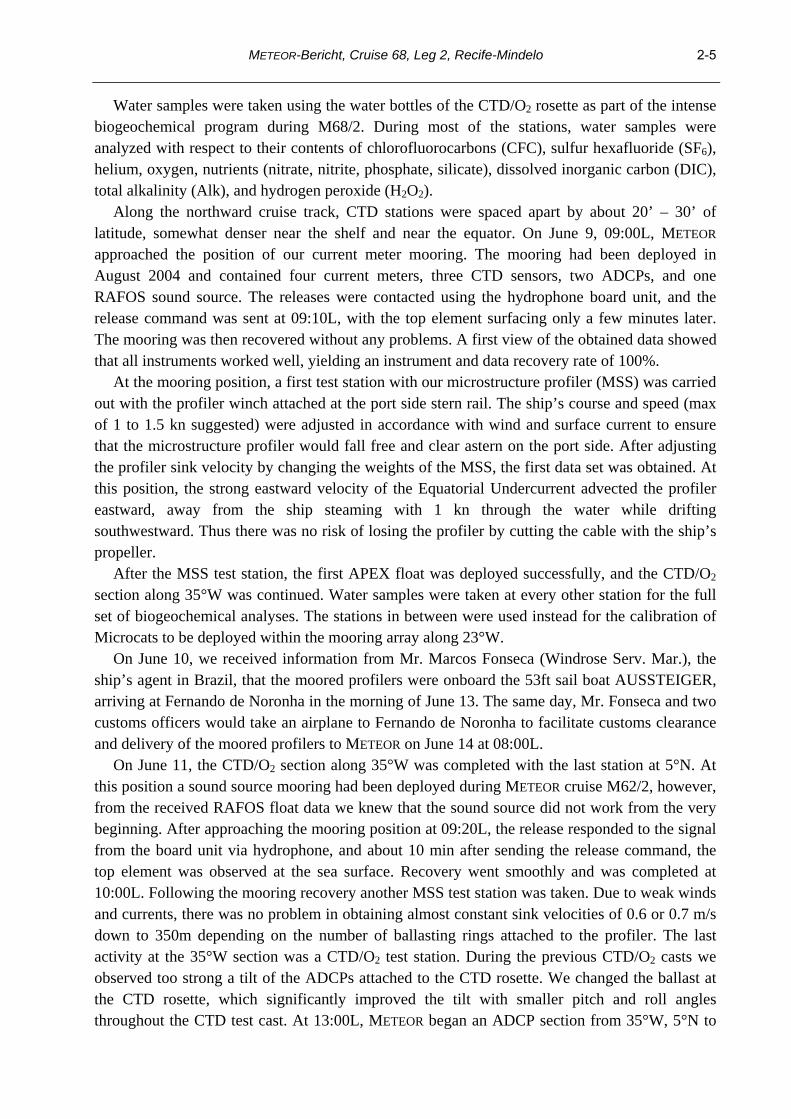
Cruise M68/2 covered a hydrographic box in the central equatorial Atlantic, with an eastward leg along the equator from 23°W to 10°W, and a westward leg at 2°N, closed by meridional sections at 23°W and 10°W. The meridional CTD-oxygen distributions clearly show a connection between equatorial oxygen minima and the off-equatorial OMZs. The oxygen distribution along the equator (Fig. 2.2) shows two well-separated cores of the oxygen minimum at about 260 m and 450 m depth. The cores stretch along the entire section of more than 1000 km, from 10°W to 23°W. The depth of these oxygen minimum cores corresponds well with the mean current field of the westward oriented Equatorial Intermediate Current (EIC) in Fig. 2.2. The current field derived from a mooring deployed at the equator at 23°W since 2004 shows a stable mean of the EIC, with two cores, however with a strong annual signal at these depths (Brandt et al., 2006). These observations highlight the role of the EIC in the oxygen budget of the OMZs arises from.
METEOR-Bericht, Cruise 68, Leg 2, Recife-Mindelo 2-12
Fig. 2.2: Dissolved oxygen [μmol/kg] along the equator in June 2006. The thick black isolines (left panel) mark potential density surfaces, showing decreasing depth towards the east. The zonal velocity profiles (right panel) at 0°N, 23°W (solid) and 35°W (dashed) with standard error (shaded) were derived from moored instruments for the period March 2004 to February 2005.
In detail there are of course deviations from this mean scenario, for example the velocity
distribution derived during June 2006 along the equator from the shipboard ADCP showed the EIC at depths of 450 to 600 m, while at 250 m depth eastward as well as westward currents were observed. The annual cycle calculated from 2 years of data shows a minimum strength of the EIC near June, explaining the difference between the velocity field and the oxygen distribution in June 2006. This further indicates that the water mass characteristics represent an integral part of the annual mean, even when the currents weaken or reverse for a short time period.
The EUC is known to shift from larger depth in the west to shallower depth in the eastern Atlantic. The signature of the upward movement is also visible in the oxygen distribution along the equator. The high oxygen water carried with the EUC eastward becomes slowly less oxygenated to the east as well as the vertical extent of the high oxygen water is reduced. A shallow isopycnal marked in Fig. 2.2 shows also well the upward shift toward east.
2.4.2 Current Observation
(T. Fischer, V. Hormann, A. Funk)
2.4.2.1 Ocean Surveyor: Technical aspects
The cruise saw two vessel-mounted RDI Ocean Surveyor ADCPs in use from June 7th to July 9th. One unit (75 kHz, OS75) is permanently fixed to the ship's hull, the second unit (38 kHz, OS38) was lowered into the well located in mid-ship and fixed hydraulically. Both units worked in narrowband mode, delivering current velocity to depths of up to 750m (OS75) and 1500m

METEOR-Bericht, Cruise 68, Leg 2, Recife-Mindelo
2-13
(OS38). There were no interferences with the various acoustic devices on board, except the Doppler-Log (78 kHz) drastically reducing the depth range of Ocean Surveyor 75 to about 200 meters. The Doppler-Log's use was confined to the absolutely necessary minimum during mooring activities.
Both ADCP units were controlled by computers using VMDAS software version 1.40 under MS Windows NT. Pinging was as fast as possible (2.4 seconds for OS75; 2.85 seconds for OS38), single pings recorded in partitions of 100 bins @ 8m (OS75) resp. 50 bins @ 32m (OS38). Navigation information available to ADCP units and control computers were:
Heading from FibreOpticGyro (FOG) via synchro interface, binarily recorded with pings; Position from ASHTECH GPS via synchro interface, binarily recorded with pings; Position from ASHTECH GPS and heading, pitch and roll from ASHTECH array, seperately recorded as NMEA textstrings via serial interface. For best results, ASHTECH heading and position were used to calculate current velocities
from ADCP output. As short gaps of 2 to 5 minutes occurred in ASHTECH navigation data about twice or thrice a day, the slightly less accurate FOG heading and TRIMBLE GPS position (recorded by the ship's DVS-system) were used to fill the gaps. Position data from both GPS-sources are sufficiently accurate to recognize the distance between the antennas as well as the swell-induced antenna movement. During post processing, misalignment angle and amplitude factor for both transducers were obtained from water track calibration when the ship accelerated/decelerated. Standard deviations for misalignment angle were 0.46° (OS75) and 0.37° (OS38), for amplitude factor 0.01 (OS75) and 0.006 (OS38). These values match the data quality of previous cruises.
Beginning about June 17th, current velocities calculated from OS38 data exhibited increasingly steplike deviations without any pattern and not related to navigation, reaching their highest level about June 30th during the 2°N-section. These deviations could not be observed with OS75, and were presumably caused by slight movements of the OS38-transducer by less than 1°. After fixing the transducer to the well once more, the problem seemed to be solved.
2.4.2.2 Current sections
The Ocean Surveyor data were mapped on a regular grid, using a Gaussian weighted interpolation scheme, and a best estimate of the currents at 35°W, 32.5°W, 23°W, 10°W, 0°N and 2°N was obtained. The flow across these meridional and zonal sections is described briefly. a) Meridional Sections The 35°W section runs from 5°S to 5°N and shows clearly the banded structure of the near-surface zonal flow (Fig. 2.3). The EUC is centered at the equator, with its core at about 80 m depth and a velocity of about 100 cm/s. Below the EUC, there is an indication for the westward EIC. The South Equatorial Undercurrent (SEUC) is found between about 4.5°S and 3°S, with its core at about 200 m depth, and the North Equatorial Undercurrent (NEUC) is present at the northern boundary of the section. In the intermediate depth range, both the Southern and Northern Intermediate Countercurrents (SICC and NICC) are observed between about 1.5° and

METEOR-Bericht, Cruise 68, Leg 2, Recife-Mindelo 2-14
3° S and N, respectively. The North Brazil Undercurrent (NBUC), here directed north-westward, shows up near the coast.
Due to time constraints, the first part of the 23°W section, running to 1°N, was limited to 4°S and the SEUC, which seems to have turned more southward compared to 35°W, was missed almost completely. After finishing the eastern equatorial box, the 23°W section was continued up to about 15°N 15’ (Fig. 2.4). Both equatorial currents, the EUC and EIC, are still well developed at 23°W and there are clear indications for the SICC and NICC as well. To the north of about 3°N, two bands of the North Equatorial Countercurrent (NECC) are observed. While the first band extends up to about 7°N, the core of the second one is located at about 8°N.
Fig. 2.3: Zonal velocity [cm/s] at 35°W from Ocean Surveyor; eastward currents in grey. Marked
are isopycnals σθ = 24.5, σθ = 26.8 and σ1 =32.15 [kg/m³] (thick solid lines). b) Zonal Sections The meridional sections at 23°W and 10°W show the EUC core shifted to the south of the equator, but nevertheless strong eastward velocities dominate the depth range of the EUC (upper 200 m; Fig. 2.5, upper panel). Underneath the EUC, a band of weak eastward velocities is observed down to about 400 m depth, but there are also indications for westward velocities at about 250 m depth. The prevailing westward velocities between about 400 and 700 m are attributable to the EIC. However, Brandt et al. (2006) showed the existence of two mean westward cores of the EIC below the EUC at 23°W, with a strong annual signal superimposed at these intermediate depths. Near June, the annual cycle reveals a minimum strength of the EIC, explaining the nearly missing upper core of this current at 0°N during June 2006. The alternating eastward and westward current bands below 400m are characterized by small vertical wavelengths typical for equatorial deep jets. These jets show a large zonal coherence along the equator.

METEOR-Bericht, Cruise 68, Leg 2, Recife-Mindelo
2-15
Fig. 2.4: Zonal velocity [cm/s] at 23°W from Ocean Surveyor; eastward currents in grey. Marked are
isopycnals σθ = 24.5, σθ = 26.8 and σ1 =32.15 [kg/m³] (thick solid lines).
Fig. 2.5: Zonal (upper panel) and meridional (lower panel) velocity [cm/s] at 0°N from Ocean
Surveyor; eastward and northward currents in grey. Marked are isopycnals σθ = 24.5, σθ = 26.8 and σ1 =32.15 [kg/m³] (thick solid lines).

METEOR-Bericht, Cruise 68, Leg 2, Recife-Mindelo 2-16
2.4.2.3. Lowered ADCPs
(J. Schafstall, J. Fischer)
Different from the usual LADCP work the focus during M68/2 was to evaluate whether high frequency ADCPs may be used for turbulent mixing studies. For this purpose a 1200 kHz Workhorse ADCP was attached to the CTD-Rosette working in a downward looking mode. The first trials were with different vertical resolution and with beam velocities.
The first result was that the velocity variances increased in relation to the vertical resolution; short 25cm bins with high variance, and long 100cm bins with significantly lower variance. This is due to longer pulses and higher accuracy of individual pings at large depth cells.
After this first test we decided to use 50cm cells and 0.5s intervals as a compromise between range (larger at large depth cells) and storage required. This setting was used throughout the rest of the cruise at every CTD station except 3, where we used the classic LADCP procedure (2 * 300kHz ADCPs) and instrument tracking with METEOR’S Posidonia. This should enable a comparison of the LADCP estimate of Rosette motion with its measured path.
Inspection of the profiles revealed large tilt angles and consequently we tried to reduce these by appropriate ballasting. However, we got the impression that beside symmetrical ballasting total weight is also important (could not be tested). Remaining tilts were still relatively large (up to 10°).
First data inspection was performed by comparing down- and up-casts with the expectation that the up-cast should show much higher variance, as the ADCP measures within the turbulence field generated by the CTD package. In fact this was observed.
Treating the 4 beams as individual measurements of the turbulent flow field, we performed a statistical analysis of the variance in depth coordinates for comparison with the microstructure measurements. Vertical resolution was 5m depth cells. We inspected many profiles and found no reliable variance enhancement where one would expect these (e.g. in the shear layers of the EUC). There should be some additional analysis with focus on the turbulent layers detected in the microstructure data.
On three stations we tried to track the underwater package by Posidonia. Although undisturbed tracking was not possible, we think it might be feasible to extract valuable data. Remember, the LADCP processing aims at separating ocean currents from package motion in an inverse routine. Inclusion of a first guess of the latter could help to improve the inversion. This might be a step forward in LADCP processing.
2.4.3. Mooring Operations
(R. Zantopp, J. Fischer)
2.4.3.1 Recoveries
Mooring work during M68/2 consisted of the recovery of 4 moorings, and the deployment of seven moorings (Table 2.1). The mooring work began in the morning of June 9 with the recovery of mooring KR4 located just north of the equator at 35°W.
This mooring contained a RAFOS sound source and several current meters, ADCPs and Microcats to study the variability of the equatorial current system (EUC and EIC). After arrival at the mooring position, KR4 was released after successful acoustic ranging. The new digital

METEOR-Bericht, Cruise 68, Leg 2, Recife-Mindelo
2-17
MORS deck unit worked well, but is extremely uncomfortable to use. All instruments came aboard in good shape, and all instruments contained full records.
During the morning of June 11 we recovered the sound source at 5°N, 35°W, which had not worked due to some unknown failure. Mooring work was rather routine and uncomplicated.
Several days later on June 15, we had scheduled the recovery of mooring KR2. At the mooring site the response from the Mors release unit was interfered with by another sound source (METEOR’s multi-beam echo sounder), but after this was switched off we received a clear response from the single release in that mooring. However, after many release commands with a “receipt and execute” from the release we found the release still locked at its depth. We concluded that the release might be tangled in a wire loop preventing its ascent to the surface. As time did not permit any dredging operation we stopped the procedure and headed to the next CTD station. Hopefully, there will be another opportunity to recover this mooring.
Table 2.1 Mooring and Instrument Recovery during METEOR Cruise 68/2 Mooring KR4 Notes Latitude 0 5.76 N Combined current meter and sound source Longitude 35 1.19 W mooring north of 35W PIRATA mooring. Water depth 4540 Mag. Var. -19.5 100% data recovery! Deployment 8/13/2004 15:10 Recovery 6/9/2006 13:10
Item Depth Instr. s/n KR4_01 146 Mini TD 41 good data
KR4_02 146 RDI-SC
150 267
good data KR4_03 149 MicroCat 2249 good data
KR4_04 151 RDI-SC
150 393
good data KR4_05 294 MicroCat 2251 good data KR4_06 499 Argonaut D294 good data KR4_07 650 Mini TD 42 good data KR4_08 652 Argonaut D299 good data
750 RAFOS 22 KR4_09 809 Argonaut D304 good data KR4_10 962 MicroCat 3144 good data KR4_11 1107 Argonaut D329 good data
Mooring KR3 Notes Latitude 5 0.00 N Sound source mooring Longitude 35 0.00 W Water depth 3753 Mag. Var. -19 Deployment 8/11/2004 16:58 Recovery 6/11/2006 13:20
Item Depth Instr. s/n 804 RAFOS 23 did not work
Mooring KR2 Notes Latitude 3 14.03 S Sound source mooring Longitude 28 31.42 W Water depth 5100

METEOR-Bericht, Cruise 68, Leg 2, Recife-Mindelo 2-18
Mag. Var. -19 Deployment 5/17/2003 19:02 Recovery 6/11/2006 13:20 Recovery failed
Item Depth Instr. s/n 795 RAFOS 13
French Mooring 23W Equ. Notes Latitude 0 0.01 S Longitude 23 7.51 W Water depth 3930 Mag. Var. -19.5 Deployment 5/29/2005 16:55 Recovery 6/19/2006 8:09
Item Depth Instr. s/n
F2_01 49 ADCP WH
300 509
F2_02 60 Mini TD 68 good data
F2_03 60 ADCP LR
75 2290
good data F2_04 605 RCM-4 5486 data not read F2_05 755 RCM-4 4445 data not read F2_06 905 RCM-4 4587 data not read F2_07 1055 RCM-4 5891 data not read F2_08 1205 RCM-4 4588 data not read F2_09 1355 RCM-4 5897 data not read F2_10 1505 RCM-4 5899 data not read
2.4.3.2 Deployments
All deployments had a deep CTD cast (for obtaining a precise estimate of the sound speed profile), followed by a bathymetric survey with METEOR’s multi-beam echo sounder and a mooring deployment simulation (drift test).
Deployments began with mooring AO_03 during the afternoon of June 18 after a deployment simulation (drift test) and a detailed survey of the topography. We found a well suited area of flat bottom and determined the target location. Mooring work was planned for 3 hours at a deployment speed of about 2.5 kn SOG while METEOR headed against south-easterly winds. Currents appeared to be mainly southwest, and the resulting deployment track was to the south. The actual deployment took a little less than three hours, and we had to tow the mooring to the anchor drop position.
Mooring AO_01, on June 19, was the second and most densely equipped mooring (2 ADCPs, McLane Profiler, current meters and Microcats). During the deployment, which began similar to the previous deployment, some unexpected difficulties arose from a combination of the mooring design and the current field. Apparently the 2500m long wire segment along which the profiler should move, hung down so deep that it was pulled sideways by the EUC. The wire on the stern of the ship moved sharply to the port side and was in danger of being cut by the microstructure winch. It took some time and extreme maneuvering to straighten out the wire behind the ship. However, after a rather long towing operation, we were able to drop the anchor almost as planned. Submergence was determined from the cessation of the ARGOS watchdog data stream.
AO_02 is the second (northern) off-equatorial mooring and was deployed at 0° 45.00’N, 22° 59.50’W on June 20. The deployment followed the usual drift test and a detailed bathymetric

METEOR-Bericht, Cruise 68, Leg 2, Recife-Mindelo
2-19
survey. The whole deployment procedure took 4.7 h, including an observation of the top element submerging. AO_04 was the second (eastern) equatorial mooring deployed on June 21 at 0° 00.00’N, 21° 29.60’W. The anchor drop position was as planned, and the top element was observed as it went under.
Mooring FR_10W was deployed for our French colleagues in the PIRATA framework. It contained only one WH-ADCP and a MORS rotor current meter. However, during deployment we experienced some accidental shortcomings. Firstly, the ARGOS beacon was apparently not transmitting (either defect, or batteries not connected). Secondly, one wire shot of 25m was put into wrong place (not affecting instrument depth). However, a dramatic event occurred at the last Kevlar termination when the wire separated from the termination, and the deck crew just managed to secure the end before it went into the sea. We had to cut 30m of Kevlar and made a new termination which was tension tested prior to deployment. To compensate for the 30m end we put in a 30m ¼’’ wire shot. However, there was some anxiety when the anchor was dropped. We were not able to observe the descent of the mooring top after the anchor drop, and we surveyed the area along the likely surface drift. Nothing was detected and we concluded that the mooring was deployed successfully. An attempt to talk to the release was also non-conclusive, as we received only two acoustic signals within the correct range.
Mooring AO_05 was deployed in the early morning of July 03, 2006. The deployment proceeded extremely well, and after three hours the anchor was dropped as planned (see Table 2.2). We were able to observe the descent of the top element from near by, with the radio signal ceasing at that moment.
Cape Verde Mooring V440 was deployed on the last day of the scientific work during M68/2. Topographic survey and deployment simulation were as during the other deployments. We began to deploy the mooring at 10:00L (11:00 UTC), and the duration was scheduled for 4.5 hours. Already after 3.5h of very smooth operation the anchor was on stand-by, but we had to tow quite a while before anchor drop 17° 35.66’N, 24° 14.98’W at 15:56 UTC. On top of the mooring we mounted a Mors Release with transponder mode for tracking the mooring with METEOR’s Posidonia system. Final depth of mooring top was 30 m (designed for 40 m), and its final position was 17° 35.39’N, 24° 15.12’W. After tracking the mooring we released the monitoring element and recovered it a few minutes later. At about 17:30 UTC mooring work was completed. Table 2.2 Deployment Tables Mooring Deployment Equatorial Atlantic AO_01 Notes: Vessel: METEOR Deployed: 19-Jun 2006 19:53 Vessel: Recovered: Latitude: 0 0.001 S Longitude: 23 6.800 W Water depth: 3931 Mag Var: -16.3
ID Depth Instr. type s/n Startup
log Argos WD 11278 126 ADCP WH up 508 x 126 Mini-TD 24 130 Microcat 52 x 234 Microcat 55 x

METEOR-Bericht, Cruise 68, Leg 2, Recife-Mindelo 2-20
399 Microcat 278 x 621 ADCP LR up 2395 x 687 RCM-8 9930 x 842 Argonaut D182 x 998 RCM-8 9964 x 2264 M-CTD MMP 120 x 3573 Release 174 Code: 9337 9339 A
3573 Release 110 Code: E972 E974 A Interrogate Release Mode Mooring Deployment Equatorial Atlantic AO_02 Notes: Vessel: METEOR Deployed: 20-Jun 2006 15:25 Vessel: Recovered: Latitude: 0 45.000 N Longitude: 22 59.500 W Water depth: 4310 Mag Var: -16.0
ID Depth Instr. type s/n Startup
log Argos WD 15172 51 Mini-TD 24 87 Microcat 381 x 138 Microcat 780 x 200 Microcat 921 x 301 ADCP 150 up 589 x 301 Mini-TD 11 397 RCM-8 9346 x 552 RCM-8 9932 x 697 RCM-8 5881 x 851 Argonaut D143 x 1007 RCM-8 8412 x 3632 Release 188 Code: 8181 8182 B
3632 Release 189 Code: 8183 8184 B Interrogate Release Mode Mooring Deployment Equatorial Atlantic AO_03 Notes: Vessel: METEOR Deployed: 18-Jun 2006 18:21 Vessel: Recovered: Latitude: 0 44.950 S Longitude: 22 59.710 W Water depth: 3700 Mag Var: -16.5
ID Depth Instr. type s/n Startup
log Argos WD 15173 47 Mini-TD 22 83 Microcat 922 x 144 Microcat 925 x 205 Microcat 936 x 307 ADCP 150 up 267 x 307 Mini-TD 27 403 RCM-8 9816 x 558 RCM-8 9349 x

METEOR-Bericht, Cruise 68, Leg 2, Recife-Mindelo
2-21
702 RCM-8 9819 x 857 Argonaut D145 x 1013 RCM-8 9820 x 3132 Release 190 Code: 8185 8186 B
3132 Release 220 Code: 9151 9152 B Interrogate Release Mode Mooring Deployment Equatorial Atlantic AO_04 Notes: Vessel: METEOR Deployed: 21-Jun 2006 18:00 Vessel: Recovered: Latitude: 0 0.000 S Longitude: 21 29.600 W Water depth: 4950 Mag Var: -15.8
ID Depth Instr. type s/n Startup
log Argos WD 2254 48 Mini-TD 73 81 Microcat 1281 x 142 Microcat 1282 x 204 Microcat 1583 x 455 ADCP LR up 2627 x 455 Mini-TD 61 459 Microcat 1599 x 553 RCM-8 10501 x 708 RCM-8 11621 x 852 RCM-8 9818 x 1007 Argonaut D184 x 4291 Release 428 Code: 2457 2459 B
4291 Release 635 Code: 3A95 3A96 A Interrogate Release Mode Mooring Deployment Equatorial Atlantic AO_05 Notes: Vessel: METEOR Deployed: 3-Jul 2006 11:36 Vessel: Recovered: Latitude: 5 0.900 N Longitude: 23 0.000 W Water depth: 4210 Mag Var: -14.5
ID Depth Instr. type s/n Startup
log Argos WD 5461 57 ADCP LR dn 3173 x 57 Mini-TD 62 103 Microcat 1682 x 616 M-CTD MMP 11617 x 1044 Microcat 2478 x 1045 RCM-8 10779 x 3513 Release 441 Code: 8A03 8A04 B
3513 Release 633 Code: 3A91 3A92 A Interrogate Release Mode

METEOR-Bericht, Cruise 68, Leg 2, Recife-Mindelo 2-22
Mooring Deployment Equatorial Atlantic FR_10W Notes: Vessel: METEOR Deployed: 26-Jun 2006 1:57 Vessel: Recovered: Latitude: 0 1.280 S Longitude: 9 51.230 W Water depth: 5205 Mag Var: -10.2
ID Depth Instr. type s/n Startup
log Argos WD 66366 140 ADCP WH up 509 x 200 Mors MC3X0 129/92 x 5150 Release 113
Mooring Deployment Cape Verde V440-01 Notes: Vessel: METEOR Deployed: 8-Jul 2006 15:56 Vessel: Recovered: Latitude: 17 35.390 N Longitude: 24 15.120 W Water depth: 3601 Mag Var: -11.2
ID Depth Instr. type s/n Startup
log Argos WD 5510 40 Microcat 3753 40 Fluorometer 269 62 Microcat 3752 81 Microcat 1162 103 ADCP WH up 1522 x 103 Microcat 3755 127 RCM-11 325 x 127 Optode 349 129 Microcat 2252 200 RCM-8 10810 x 202 Microcat 2255 302 Microcat 3754 400 Microcat 2256 500 Microcat 2254 602 RCM-8 11622 x 603 Microcat 3415 753 Microcat 2257 899 Watchdog 2265 899 Watchdog 11307 900 RCM-8 11265 x 902 Microcat 2279 999 Sediment Trap 97150 1002 Microcat 3757 1151 Microcat 1550 1299 RCM-8 11267 x 1301 Microcat 1269 1498 Microcat 2717 1749 Mini-TD 63 2001 RCM-8 10818 x

METEOR-Bericht, Cruise 68, Leg 2, Recife-Mindelo
2-23
2003 Microcat 1268 2249 Mini-TD 64 2500 Microcat 2933 2748 Mini-TD 65 3003 RCM-8 10776 x 3005 Microcat 2617 3250 Mini-TD 72 3511 Microcat 2618 3563 Microcat 2472 3565 Release 108 Code: E962 E964 A
3565 Release 821 Code: 4AA7 4AA8 A Interrogate Release Mode
Microcat / CTD calibration:
Six sets of calibrations were performed for Microcats in order to check their factory settings. The instruments were set to a faster sampling rate (10 sec vs. the normal 15 or 30 min) and mounted on the CTD rosette which was lowered to the ocean bottom during a regular CTD cast. Five to six stops of 4 minutes each (2 minutes during first two stations) were made during the upcast to allow for a stabilized equilibrium. A linear fit was performed for temperature, conductivity and pressure data (where available) from the Microcat and CTD instruments, and resulting rms differences are indicated (see Table 2.3). Some Microcats were equipped with pressure sensors. Three instruments (s/n 2249, 2251, 3144) were done post deployment, all others were done in preparation prior to deployment. Table 2.3 Results of linear fits
CTD S/N Temperature Conductivity Pressure No. Bias Slope RMS Bias Slope RMS Bias Slope RMS 24 52 -0.0004 0.9993 0.0083 0.0939 0.9972 0.0169 24 55 -0.0048 1.0001 0.0075 0.0838 0.9976 0.0142 24 925 -0.0044 0.9998 0.0086 0.1485 0.9946 0.0316 24 936 -0.0025 0.9996 0.0080 0.1789 0.9937 0.0265 24 1583 0.0004 0.9991 0.0113 0.0527 0.9980 0.0164 24 1599 -0.0023 0.9995 0.0102 0.0496 0.9985 0.0142 24 1682 0.0009 0.9988 0.0124 0.0723 0.9978 0.0193 24 2478 0.0016 0.9992 0.0118 0.0594 0.9982 0.0176 24 2614 0.0039 0.9988 0.0137 0.0828 0.9976 0.0215 26 278 -0.0053 0.9997 0.0062 0.0626 0.9972 0.0415 26 381 0.0046 0.9998 0.0054 0.0095 0.9981 0.0463 26 780 -0.0054 1.0004 0.0051 0.1164 0.9951 0.0388 26 921 -0.0031 0.9998 0.0042 0.0392 0.9979 0.0311 26 922 -0.0065 1.0003 0.0054 0.0494 0.9971 0.0393 26 1281 -0.0009 0.9994 0.0040 0.0775 0.9963 0.0361 26 1282 -0.0065 1.0004 0.0053 0.0142 0.9984 0.0368 26 2249 0.0015 0.9994 0.0034 0.0332 0.9981 0.0110 26 2251 -0.0039 1.0000 0.0048 -0.0199 1.0000 0.0175 26 3144 -0.0008 0.9996 0.0039 0.0426 0.9984 0.0128 53 3754 -0.0010 0.9998 0.0043 -0.0110 1.0000 0.0041 0.4081 0.9992 1.4083 53 3757 -0.0004 0.9997 0.0037 0.0018 0.9995 0.0039 -0.6978 1.0017 1.1569 73 2252 0.0030 0.9992 0.0080 -0.0596 1.0014 0.0197 73 2255 0.0019 0.9994 0.0076 -0.0639 1.0015 0.0237 73 3752 0.0029 0.9991 0.0086 -0.0801 1.0019 0.0255 1.5894 0.9999 0.4151

METEOR-Bericht, Cruise 68, Leg 2, Recife-Mindelo 2-24
73 3753 0.0042 0.9991 0.0099 -0.0750 1.0018 0.0237 1.7997 0.9996 0.3944 73 3755 0.0034 0.9993 0.0077 -0.0784 0.1002 0.0240 0.5217 0.9976 0.4270 74 1162 0.0091 0.9970 0.0143 0.0599 0.9977 0.0137 74 2254 0.0086 0.9971 0.0150 0.0804 0.9971 0.0141 74 2256 0.0089 0.9969 0.0158 0.1081 0.9963 0.0140 74 2257 0.0085 0.9969 0.0151 0.0943 0.9961 0.0140 74 2279 0.0060 0.9974 0.0151 0.0769 0.9975 0.0136 74 3415 0.0062 0.9974 0.0148 0.0456 0.9981 0.0134 0.4664 1.0015 0.7170 91 1268 -0.0015 0.9996 0.0021 0.0845 0.9973 0.0039 91 1269 -0.0006 0.9997 0.0022 0.0579 0.9982 0.0045 91 1550 0.0004 0.9995 0.0020 0.2055 0.9936 0.0025 91 2472 0.0033 0.9996 0.0025 0.2140 0.9933 0.0029 91 2617 0.0019 0.9997 0.0021 0.2176 0.9932 0.0029 91 2618 0.0038 0.9995 0.0022 0.2250 0.9930 0.0028 91 2933 0.0009 0.9993 0.0020 0.2242 0.9929 0.0026 91 2717 0.0008 1.0002 0.0020 -0.0260 1.0004 0.0020 3.7863 1.0006 0.2834
It is evident that some batches (casts 26 and 73 for conductivity in particular) are worse than
others. However, no reason was evident for this abnormal result. As no time was available to perform another set of calibrations prior to the instrument deployment during this cruise, we suggest that a careful post-deployment calibration be done after the instruments are retrieved.
Wetlabs Fluorometer
(N. Gülzow, J. Fischer)
A Wetlabs Fluorometer is installed in the top element of mooring V440. This had to be calibrated versus filtered water samples. These were taken during our approach to the Cape Verde Islands on a separate 200m CTD cast (Station 114). We took twelve water samples centered on the subsurface chlorophyll maximum that was determined during the downward cast – this covers the depth range at which the Fluorometer will be located in the mooring. The Fluorometer was attached to the CTD rosette with a clear downward view of its optics. By this procedure we also get a rough calibration of the SBE fluorescence sensor of the CTD.
By relative scaling (Fig. 2.6) a comparable profile structure is evident and it should be possible to get a good pre-deployment calibration. However, temperature is way off and needs calibration too.
ADCP data treatment
ADCP data from both instruments from the equatorial station at 23°W (continued by AO_01) have been combined to a continuous data set with all gaps eliminated by interpolation. This processing is described as follows:
Horizontal velocities from both ADCP’s are corrected for their compass deviation (location and time correction by mag_dev.m). Data ensembles with less than 20% good pings are eliminated prior to further processing routines. Then data are projected from bins (distance relative to transducer heads) to depth cells by using the pressure sensor information of the ADCPs and an attached Mini-TD-probe. Vertical resolution is 4m for both ADCPs; this corresponds to the original distribution of 4m for up-looking Workhorse ADCP and an oversampling of the 16m bins of the down-looking LongRanger ADCPs.

METEOR-Bericht, Cruise 68, Leg 2, Recife-Mindelo
2-25
Fig. 2.6: Calibration cast of Wetlabs Fluorometer compared to CTD Station 114. Left: temperature
[°C] (sensors close together); right: fluorometer outputs scaled for comparison. Units are relative and need to be calibrated versus filtered water samples. Depths of water samples are marked by plus signs
The data sets are interpolated to an equal time base (necessary due to incorrect times in the
Workhorse ADCP), and merged into a combined data set. The combined data set has variable limits due to mooring motion and a gap of some 20m (distance between transducers of 11m plus blanking distance). These gaps were closed by a an advanced Lagrangian interpolation algorithm called fillmiss.m available in the Matlab SAGA toolbox. An attempt was made to estimate the accuracy of this procedure by using the end product (interpolated data set as a reference) and introducing a similar gap but with different temporal distribution. This gap was then filled by fillmiss.m and the result was compared to the reference. Statistics showed a negligible mean difference (<1cm/s) and a standard deviation of about 3-5cm/s, which appears small relative to the mean speed of the EUC. Another comparison was done with the shipboard ADCP data at times of the mooring recovery. In the next step the gridded data (4m resolution, 1h Intervals) are detided, as there is evidence of substantial tidal flow. Data were low passed at 40h and sub sampled to 12h resolution. Combining the data from the 2004 and 2005 deployments we found the transition from one year to the other suspicious – especially in the meridional component – presumably due to non-perfect compass calibrations of the shallow ADCPs. Several tests were performed with the most stable result from a comparison of the VM-ADCP data and the mooring data. This comparison led to misalignment angles of -6° for the 2004-2005 WH-ADCP and of +6° for the 2005-2006 WH-ADCP. Data from the deeper LongRanger ADCPs seemed to be unaffected (may be masked by the much smaller zonal component), thus no correction was applied to these. – The effect of misalignment is large only when the current speed is large as in the EUC. The effect of this rotation to the mean zonal speed (EUC) is relatively small, of the order of 1cm/s compared to a mean of 70cm/s. WH-ADCP data were corrected accordingly and

METEOR-Bericht, Cruise 68, Leg 2, Recife-Mindelo 2-26
the whole procedure repeated, yielding the cleaned and sub-sampled final data set suitable for further processing. NB-ADCPs at 35°W also gave the impression of a misalignment angle of -8° compared to OS75 data. However, this appears to be only valid for the relatively short period of the comparison. This leads to unrealistic mean meridional flow structure, and we therefore decided not to rotate the moored ADCP data. MMP – McLane Moored Profiler
The MMP is a modern observing platform for physical and chemical in-situ measurements over long time intervals. Powered by lithium batteries an electric motor drives a friction wheel for climbing the mooring wire up and down at slow speeds. One million meters is the total range, e.g. 200 profile pairs of 5000m total length (2500m up and down, respectively) can be performed.
During M68/2 we had two of these instruments aboard – we finally got them at Fernando de Noronha – one of them from John Toole (WHOI) and the second one with an additional oxygen sensor (our own). The Toole instrument is used to study equatorial deep jets and is incorporated in our equatorial mooring AO_01 for profiling between 1000m and 3500m on a 4 day profile pair schedule. The position of this mooring is estimated at 0° 00.00’S, 23° 06.80’W. Our own profiler is the core element in mooring AO_05 at 05° 00.90’N, 23° 00.00’W (Fig. 2.7).
The schedule of this instrument calls for paired profiles every 1.6 d. This schedule obtains a full daily cycle every 5 profile pairs or 8 days, and an inertial period of 5.7 days is sampled by 3 to 4 profile pairs. Up- and down profiles follow each other with just a short break in between, and the instrument parks itself in between profile pairs at about 1000m, the lower stop of the profiling range. The LongRanger ADCP serves two purposes, first it will provide an excellent reference for the current measurements of the profiler including tides, and secondly it will give detailed measurements of the NEUC/NECC flow at that location. The Seabird Microcats above and below the profile range as well as the Aanderaa Rotor Current Meter will also be used as references for the CTD and current measurements of the moored profiler.
Fig. 2.7: Mooring AO_05 with full instrumentation, MMP, LongRanger ADCP, Aanderaa Rotor Current Meter, and two Seabird Microcats.
2.4.3.3 Selected Results
The Equatorial Mooring at 35°W had two ADCPs, one up-, and one downward-looking. Both had full, almost two year long data sets that were processed and merged as described under Section “ADCP data treatment”.
At both locations the flow in zonal direction is dominated by the intense EUC, reaching about 0.7m/s as a deployment long mean (Fig. 2.8). The most obvious time scale of the zonal variability is the annual cycle, which has maximum flow and is nearest to the surface in northern

METEOR-Bericht, Cruise 68, Leg 2, Recife-Mindelo
2-27
spring. Beside the intensity of the flow, the EUC core shows significant annual depth variability with its deepest expression around September/October. Below the EUC, the EIC has two stable mean cores at both longitudes – here we expect a clue on the existence of a mean EIC and its seasonal cycle.
Fig. 2.8: Zonal (a) and meridional (b) velocity at the equator, 35°W from two Narrow-Band 150kHz ADCPs, and zonal (c) and meridional (d) flow at the equator, 23°W from 300kHz WH-ADCP and 75kHz LongRanger ADCP. Data are detided, data gaps in between the instruments were interpolated. The mean flow is calculated by subtracting the annual and semiannual harmonics (solid red line, left panels) with standard error (shaded).
METEOR-Bericht, Cruise 68, Leg 2, Recife-Mindelo 2-28
J A S O N D J F M A M J J A S O N D J F M A M J J A
500 m
< u > −8.0 ± 12.7< v > 0.6 ± 8.4
(cm/s)Mean
652 m
< u > −2.2 ± 10.9< v > 0.7 ± 6.4
809 m
< u > −8.0 ± 12.3< v > 1.1 ± 7.1
1107 m
< u > −0.5 ± 7.8< v > 1.0 ± 5.8
35W Equator Mooring KR4 (2004−2006)− Argonaut CM
50 cm/s
2004 2005 2006| |
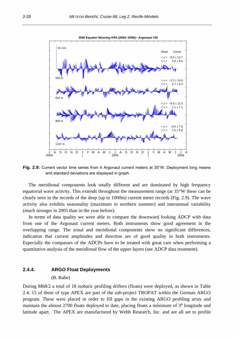
Fig. 2.9: Current vector time series from 4 Argonaut current meters at 35°W. Deployment long means
and standard deviations are displayed in graph.
The meridional components look totally different and are dominated by high frequency equatorial wave activity. This extends throughout the measurement range (at 35°W these can be clearly seen in the records of the deep (up to 1000m) current meter records (Fig. 2.9). The wave activity also exhibits seasonality (maximum in northern summer) and interannual variability (much stronger in 2005 than in the year before).
In terms of data quality we were able to compare the downward looking ADCP with data from one of the Argonaut current meters. Both instruments show good agreement in the overlapping range. The zonal and meridional components show no significant differences, indication that current amplitudes and direction are of good quality in both instruments. Especially the compasses of the ADCPs have to be treated with great care when performing a quantitative analysis of the meridional flow of the upper layers (see ADCP data treatment).
2.4.4. ARGO Float Deployments (B. Rabe)
During M68/2 a total of 18 isobaric profiling drifters (floats) were deployed, as shown in Table 2.4. 15 of these of type APEX are part of the sub-project TROPAT within the German ARGO program. These were placed in order to fill gaps in the existing ARGO profiling array and maintain the almost 2700 floats deployed to date, placing floats a minimum of 3º longitude and latitude apart. The APEX are manufactured by Webb Research, Inc. and are all set to profile

METEOR-Bericht, Cruise 68, Leg 2, Recife-Mindelo
2-29
2000m, while the drift depth is set to 1500m or 200m. The shallow floats are meant to give further insight into the shallow tropical-subtropical circulation. In addition to sensors for measuring in-situ temperature, salinity (conductivity) and pressure, using a SeaBird CTD sensor, some also carry an Aandera Optode to measure oxygen concentration in the water.
Further floats were deployed on behalf of other research groups: Two 1000m drifting SOLO floats for Woods Hole Oceanographic Institution and one PROVOR for the chemistry group at IFM-GEOMAR. The latter, equipped with a CTD and an oxygen sensor was deployed around 10ºN and 23ºW, close to a mooring location, and is meant to capture the supply of oxygen-rich water to the oxygen minimum zones closer to the African coast. Table 2.4 Profiling float deployment positions during M68/2
Float WMO ID (DEC) Date Time Longitude Latitude Sensors Depth S/N Park Profile
2472 1900653 60444 09.06.06 15:56 UTC 35 º 01.24 ' W 0 º 03.44 ' N T/S/P 200 2000 579 WHOI SOLO 10.06.06 20:30 UTC 34 º 59.38 ' W 3 º 01.19 ' N T/S/P 1000 1100 2484 1900650 56452 11.06.06 14:09 UTC 35 º 00.26 ' W 4 º 59.24 ' N T/S/P/O2 200 2000 2477 1900658 60449 12.06.06 17:24 UTC 32 º 30.03 ' W 1 º 59.99 ' N T/S/P 1500 2000 2478 1900659 60450 13.06.06 22:25 UTC 32 º 29.96 ' W 2 º 00.06 ' S T/S/P 1500 2000 2479 1900660 60451 15.06.06 13:22 UTC 28 º 30.88 ' W 3 º 14.73 ' S T/S/P 1500 2000 2473 1900654 60445 15.06.06 22:42 UTC 27 º 00.15 ' W 3 º 27.80 ' S T/S/P 200 2000 599 WHOI SOLO 16.06.06 09:07 UTC 24 º 59.52 ' W 3 º 44.53 ' S T/S/P 1000 1100 2480 1900661 60452 17.06.06 08:20 UTC 22 º 59.97 ' W 3 º 00.09 ' S T/S/P 1500 2000 2485 1900651 56453 19.06.06 11:15 UTC 23 º 10.94 ' W 0 º 01.42 ' S T/S/P/O2 200 2000 2483 1900664 60455 23.06.06 00:18 UTC 18 º 00.78 ' W 0 º 00.53 ' S T/S/P 1500 2000 2481 1900662 60453 24.06.06 11:34 UTC 14 º 00.52 ' W 0 º 00.21 ' N T/S/P 1500 2000 2475 1900656 60447 25.06.06 19:25 UTC 10 º 00.00 ' W 1 º 30.00 ' S T/S/P 200 2000 2482 1900663 60454 26.06.06 22:32 UTC 9 º 58.57 ' W 0 º 01.53 ' N T/S/P 1500 2000 2476 1900657 60448 02.07.06 05:45 UTC 22 º 59.55 ' W 2 º 59.38 ' N T/S/P 1500 2000 2486 1900652 60443 03.07.06 12:05 UTC 22 º 59.60 ' W 5 º 02.20 ' N T/S/P/O2 200 2000
PROVOR 1900120 52551 05.07.06 14:06 UTC 23 º 00.85 ' W 9 º 59.09 ' N T/S/P/O2 500 2000 2474 1900655 60446 06.07.06 16:00 UTC 23 º 00.49 ' W 13 º 00.07 ' N T/S/P 200 2000
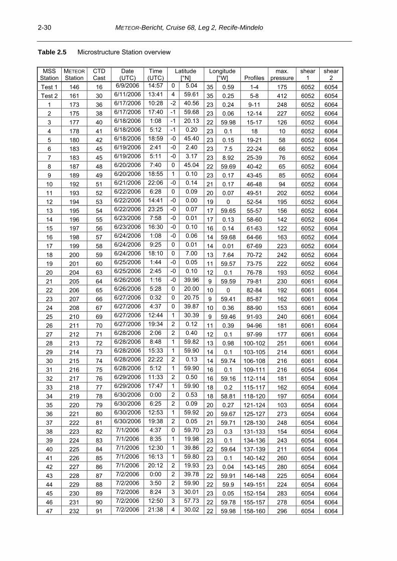
2.4.5. Microstructure mesurements
(U. Koy, J. Schafstall)
In total 202 MSS profiles were sampled during METEOR cruise 68/2 at 60 stations, normally 3 profiles per station (Table 2.5). The microstructure profiling system (MSS) used during the cruise was manufactured by ISW-Messtechnik in collaboration with SEA and Sun Technology (Trappenkamp, Germany) and consists of a profiler, a winch and a data interface. The profiler can operate 16 channels with a very high data transmission rate (1024 Hz) that is sufficient to resolve the small vertical scales of turbulent dissipation in the ocean. It is equipped with two shear sensors (airfoil, 4ms response time), a fast-responding temperature sensor (microthermistor FP07, 12 ms response time), an acceleration sensor, a fast conductivity sensor and typical conductivity, temperature, depths sensors that sample at a lower frequency (24 Hz), in addition we used an oxygen sensor (for details see Table 2.5).
METEOR-Bericht, Cruise 68, Leg 2, Recife-Mindelo 2-30
Table 2.5 Microstructure Station overview
MSS Station
METEOR Station
CTD Cast
Date (UTC)
Time (UTC)
Latitude [°N]
Longitude [°W] Profiles
max. pressure
shear 1
shear 2
Test 1 146 16 6/9/2006 14:57 0 5.04 35 0.59 1-4 175 6052 6054 Test 2 161 30 6/11/2006 13:41 4 59.61 35 0.25 5-8 412 6052 6054
1 173 36 6/17/2006 10:28 -2 40.56 23 0.24 9-11 248 6052 6064 2 175 38 6/17/2006 17:40 -1 59.68 23 0.06 12-14 227 6052 6064 3 177 40 6/18/2006 1:08 -1 20.13 22 59.98 15-17 126 6052 6064 4 178 41 6/18/2006 5:12 -1 0.20 23 0.1 18 10 6052 6064 5 180 42 6/18/2006 18:59 -0 45.40 23 0.15 19-21 58 6052 6064 6 183 45 6/19/2006 2:41 -0 2.40 23 7.5 22-24 66 6052 6064 7 183 45 6/19/2006 5:11 -0 3.17 23 8.92 25-39 76 6052 6064 8 187 48 6/20/2006 7:40 0 45.04 22 59.69 40-42 65 6052 6064 9 189 49 6/20/2006 18:55 1 0.10 23 0.17 43-45 85 6052 6064
10 192 51 6/21/2006 22:06 -0 0.14 21 0.17 46-48 94 6052 6064 11 193 52 6/22/2006 6:28 0 0.09 20 0.07 49-51 202 6052 6064 12 194 53 6/22/2006 14:41 -0 0.00 19 0 52-54 195 6052 6064 13 195 54 6/22/2006 23:25 -0 0.07 17 59.65 55-57 156 6052 6064 14 196 55 6/23/2006 7:58 -0 0.01 17 0.13 58-60 142 6052 6064 15 197 56 6/23/2006 16:30 -0 0.10 16 0.14 61-63 122 6052 6064 16 198 57 6/24/2006 1:08 -0 0.06 14 59.68 64-66 163 6052 6064 17 199 58 6/24/2006 9:25 0 0.01 14 0.01 67-69 223 6052 6064 18 200 59 6/24/2006 18:10 0 7.00 13 7.64 70-72 242 6052 6064 19 201 60 6/25/2006 1:44 -0 0.05 11 59.57 73-75 222 6052 6064 20 204 63 6/25/2006 2:45 -0 0.10 12 0.1 76-78 193 6052 6064 21 205 64 6/26/2006 1:16 -0 39.96 9 59.59 79-81 230 6061 6064 22 206 65 6/26/2006 5:28 0 20.00 10 0 82-84 192 6061 6064 23 207 66 6/27/2006 0:32 0 20.75 9 59.41 85-87 162 6061 6064 24 208 67 6/27/2006 4:37 0 39.87 10 0.36 88-90 153 6061 6064 25 210 69 6/27/2006 12:44 1 30.39 9 59.46 91-93 240 6061 6064 26 211 70 6/27/2006 19:34 2 0.12 11 0.39 94-96 181 6061 6064 27 212 71 6/28/2006 2:06 2 0.40 12 0.1 97-99 177 6061 6064 28 213 72 6/28/2006 8:48 1 59.82 13 0.98 100-102 251 6061 6064 29 214 73 6/28/2006 15:33 1 59.90 14 0.1 103-105 214 6061 6064 30 215 74 6/28/2006 22:22 2 0.13 14 59.74 106-108 216 6061 6064 31 216 75 6/28/2006 5:12 1 59.90 16 0.1 109-111 216 6054 6064 32 217 76 6/29/2006 11:33 2 0.50 16 59.16 112-114 181 6054 6064 33 218 77 6/29/2006 17:47 1 59.90 18 0.2 115-117 162 6054 6064 34 219 78 6/30/2006 0:00 2 0.53 18 58.81 118-120 197 6054 6064 35 220 79 6/30/2006 6:25 2 0.09 20 0.27 121-124 103 6054 6064 36 221 80 6/30/2006 12:53 1 59.92 20 59.67 125-127 273 6054 6064 37 222 81 6/30/2006 19:38 2 0.05 21 59.71 128-130 248 6054 6064 38 223 82 7/1/2006 4:37 0 59.70 23 0.3 131-133 154 6054 6064 39 224 83 7/1/2006 8:35 1 19.98 23 0.1 134-136 243 6054 6064 40 225 84 7/1/2006 12:30 1 39.86 22 59.64 137-139 211 6054 6064 41 226 85 7/1/2006 16:13 1 59.80 23 0.1 140-142 260 6054 6064 42 227 86 7/1/2006 20:12 2 19.93 23 0.04 143-145 280 6054 6064 43 228 87 7/2/2006 0:00 2 39.78 22 59.91 146-148 225 6054 6064 44 229 88 7/2/2006 3:50 2 59.90 22 59.9 149-151 224 6054 6064 45 230 89 7/2/2006 8:24 3 30.01 23 0.05 152-154 283 6054 6064 46 231 90 7/2/2006 12:50 3 57.73 22 59.78 155-157 278 6054 6064 47 232 91 7/2/2006 21:38 4 30.02 22 59.98 158-160 296 6054 6064

METEOR-Bericht, Cruise 68, Leg 2, Recife-Mindelo
2-31
48 233 92 7/3/2006 4:37 5 0.80 23 0.5 161-163 265 6054 6064 49 234 93 7/3/2006 16:00 5 29.90 22 59.7 164-166 277 6054 6064 50 235 94 7/3/2006 19:20 6 0.05 22 59.98 167-169 230 6054 6064 51 236 95 7/3/2006 23:53 6 29.88 22 59.86 170-172 249 6054 6064 52 237 96 7/4/2006 4:21 6 59.90 23 0 173-175 244 6052 6064 53 238 97 7/4/2006 8:56 7 29.98 22 5.98 176-178 274 6052 6064 54 239 98 7/4/2006 13:36 7 59.80 23 0.1 179-181 234 6052 6064 55 240 99 7/4/2006 18:30 8 29.92 23 0 182-184 205 6052 6064 56 242 101 6/5/2007 5:20 9 29.95 23 0.04 185-187 236 6052 6064 57 244 103 7/5/2006 16:50 10 29.90 22 59.8 188-190 214 6052 6064 58 246 105 7/6/2006 1:24 11 29.94 22 59.9 191-193 222 6052 6064 59 248 107 7/6/2006 9:54 12 29.83 23 0.04 194-196 273 6052 6064 60 250 109 7/6/2006 18:58 13 29.94 22 59.87 195-199 272 6052 6064 61 255 115 7/8/2006 4:54 17 35.86 24 14.92 200-202 243 6052 6064
The free-falling profiler is optimized to sink at a rate of about 0.6 m/s and is capable of measuring microstructure up to a depth of 500 m. Shear and temperature fluctuations recorded due to vibration of the profiler while sinking can be diagnosed from the spectra of the acceleration sensor time series.
In total, four shear probes (s/n 6052, 6054, 6061, 6064, marked in Table 2.6) were used. A second FP07 fast thermistor was available as backup, but was not used. Routinely, MSS casts were made from the surface to about a depth of 220-260 m. Only stations with excessive vertical velocity shear were stopped when the fall rate of the probe dropped below about 0.3 m/s (see shorter profile in Table 2.5). That was mainly the case at the equator, especially in the western part. First we tried to mount more ballast rings at the probe to increase the depth range, but by using more weight we enhanced mainly the fall rate in the top 30-40 m but did not sufficiently increase the depth. So we decided to use a combination of ballast and buoyancy rings which is optimized for a fall rate of 0.6 m/s above the EUC, or in low shear zones.
Just after putting the probe in the water at Station 234 we experienced a problem with data transmission and got excessive error messages. We decided to cut off the first 20 m of the sea cable, but after fixing the cable the problem was still there. So we switched to our backup cable, which was only 570 m long (instead of the original 800 m), but for most of our measurements the replacement cable was long enough. All other parts of our equipment worked well until the end of the cruise. Table 2.6 Sensors of MSS system used during METEOR cruise 68/2.
Sensor Type Response time Serial No.
Temperature PT100 40 ms Conductivity ADM 40 ms
Pressure PA-50 Progress 40 ms Oxygen Oxyguard ?? DO522M18
Acceleration ACC 4 ms 8023 Shear Airfoil 4 ms 6052 Shear Airfoil 4 ms 6054 Shear Airfoil 4 ms 6061 Shear Airfoil 4 ms 6064
Temperature NTC; FP07 12 ms 38 Conductivity Microstructure C-sensor 4 ms 13

METEOR-Bericht, Cruise 68, Leg 2, Recife-Mindelo 2-32
2.4.6. Chemical measurements
(T.Tanhua, M. Schütt, A. Schneider, F. Malien, S. Grobe, P. Wiebe, N. Gülzow)
SF6
Samples for SF6 measurements were taken on selected CTD stations during the cruise. Due to analytical difficulties, no samples could be analyzed onboard. However, during the cruise samples from a total of 8 profiles were flame-sealed in ampoules and brought back to the laboratory in Kiel for later analysis of CFC-12 and SF6. The samples were collected in 350 ml glass ampoules with a headspace of about 40 ml of pure nitrogen gas air.
CFC-11 and CFC-12 Samples for CFC measurements were drawn in syringes (first sample to be collected from the Niskin, followed by the SF6 sampling) and transferred in amounts of 20 ml to a purge and trap gas-chromatographic unit similar to the one described by Bullister and Weiss (1988). Separation of the dissolved gases was performed using a packed column, and detection was done with an Electron Capture Detector (ECD). The CFCs were calibrated against a standard gas, which was re-calibrated against a new gas standard provided by CMDL/NOAA in Boulder, CO. The temporal drift of the ECD was corrected for by applying calibration runs made before and after each station. In total, 1380 water samples (of which 190 were double samples) from 69 stations and 13 air samples were successfully analyzed. The reproducibility was determined by analyzing 190 samples twice and the standard deviation was found to be 1.4 % for CFC-12 and 1.0% for CFC-11. An analytical blank of 0.003 pmol/kg was removed from CFC-12; CFC-11 was free of analytical blank. Nutrients Nutrients (nitrate, nitrite, phosphate, silicate) were determined from 1320 water samples at 68 CTD-Stations. The nutrient analysis was made with a Continuous-Flow-Autoanalyzer-(CFA) System developed and built at IFM-GEOMAR according to Grashoff et al. (1999). For the determination of phosphate, the method by Bran and Luebbe (Method No. G-175-96 Rev 8) was used.
The precision for nutrient analysis as determined from 134 double samples from 67 stations was determined as (95 % confidence interval): Nitrite 0.008 μmol kg-1; Nitrate 0.18 μmol kg-1; phosphate 0.016 μmol kg-1, silicate 0.19 μmol kg-1, which was approximately 1 % of the nutrient standards. For precision estimates, two duplicate samples were taken and analyzed at 67 stations. Calibration curves were made with nutrients standards from Ocean Scientific International.
Oxygen Oxygen was analyzed from 1321 Niskin bottles at 68 CTD-Stations according to a standard titration after Winkler (Grashoff, 1999). Two duplicate samples were taken and analyzed at 67 of the stations, and the precision of the measurement was determined as 0.5 μmol kg-1 (95 % confidence interval).
Total Dissolved Inorganic Carbon (DIC) and Total Alkalinity Direct measurements of DIC were made using a coulometric method according to Johnson et al. (1993). The measurements were calibrated independently by regular injections of known

METEOR-Bericht, Cruise 68, Leg 2, Recife-Mindelo
2-33
amounts of pure CO2. The accuracy was assessed by regular measurement of Certified Reference Materials (CRM, supplied by Dr. Andrew Dickson, Scripps Institution of Oceanography (SIO), La Jolla, CA.
# Stations: 67 # Samples analyzed: 1189 # Duplicates analyzed: 88 Total alkalinity were determined with a potentiometric titration method according to Mintrop
et al. (2000). The accuracy was assessed by regular measurement of Certified Reference Materials (CRM, supplied by Dr. Andrew Dickson, Scripps Institution of Oceanography (SIO), La Jolla, CA). During the cruise we found a linear temporal trend in the measurements of CRMs, ranging from +1.93 to 1.42 μmol kg-1, and this was applied to the data set.
# Stations: 67 # Samples analyzed: 1189 # Duplicates analyzed: 88
Table 2.7 Table of analytical precision and information regarding certified reference materials used.
DIC AT
CRM:
analyzed bottles batches used Mean deviation from certified CRM-value standard deviation
87 68 & 74 -1.42 to 1.93 1.85 µmol/kg
79 68 & 74 - 0.65 µmol/kg ± 1.90 µmol/kg
Duplicates:
analyzed pairs mean deviation from duplicate value standard deviation
88 0.84 µmol/kg ± 0.94 µmol/kg
88 1.49 µmol/kg ± 1.29 µmol/kg
Filtration Samples for biological filtration were taken with the aim of sampling in, above and below the chlorophyll maximum. The depths, however, varied randomly throughout the cruise. Samples were taken with polycarbonate bottles and a volume of 2L was filtered with a low vacuum pressure onto a 0.22 micron 47 mm filter. After that the filters were removed with clean forceps from the filtration rack, packed in a screw cap cryo-vials and stored in the -80°C freezer.
The collection of filtered seawater samples is important for the detection of nifH genes and serves to get an impression which bacteria can be found in the different depths. To get some information about the size and abundances of bacteria in the seawater, some samples were also taken for Flow Cytometry in the lab in Kiel. A volume of 1.9ml seawater from the same bottles was taken and convicted into a screw cap cryo vials. After that a solution of 20% Glutaraldehyde stock was added to the screw cap cryo vials and stored in a -20°C freezer.
H2O2
Samples for H2O2 measurements were taken with brown polyethylene bottles at six different depths, typically 10, 20, 40, 60, 80 and 100m. Standard water was taken from the deepest Niskin closed, mostly 1300m. A known concentration of a secondary stock standard was added to the

METEOR-Bericht, Cruise 68, Leg 2, Recife-Mindelo 2-34
standard (deep) water sampler, after which the standard and samples were immediately measured. The samples were kept as cold as possible and direct sunshine was avoided. The samples were mixed with Luminol in a FIA analytical system were the H2O2 concentration could be detected photometrically.
Hydrogen peroxide is one of the strongest oxidants that occurs in natural waters and can be used as a tracer. H2O2 is principally produced in the water column by photochemical reactions involving dissolved organic matter O2. During M68/2, we found more H2O2 in the surface and declining concentrations with depth, consistent with the photochemical flux. 2.4.7. DVS meteorological and surface underway data
(B. Rabe)
The central data distributor (DVS) system continuously records a large set of oceanographic and atmospheric parameters from several sensors throughout the cruise. In order to complete the data set obtained from CTD/LADCP measurements and the two vessel-mounted ADCPs, several parameters were post-processed and calibrated. These variables were sea surface temperature (SST) and salinity (SSS) from the thermosalinograph, meteorological parameters including wind speed, wind direction, air temperature, air pressure and humidity as well as bathymetry. The post-processed dataset will be made available to the public by submitting the data to appropriate international data centers.
The METEOR just recently acquired a new database application by Werum Software & Systems. This provides both an “online” database for immediate display as well as web form to download data from an “archive” database by selecting variable names, units and precision. Although the old database was still running during the cruise, previous changes to the ship's hardware during shipyard time meant that some of the data streams were no longer available in the old database while the new one was still in the implementation stage. This concerns the thermosalinograph data and the bathymetric depth from the EM120 multi-beam echosounder. All thermosalinograph data gaps due to outages in the Werum database were filled as best as possible with direct recordings of data from the thermosalinograph.
2.4.7.1 Thermosalinograph data
a) Post-processing and sensor calibration Sea-surface temperature and salinity were measured by a thermosalinograph with an intake at the ship's hull at 4m depth. The device was a SeaCat SBE 120 manufactured by Sea-Bird Electronics, Inc. The thermosalinograph worked well throughout the cruise. However, there were problems with the data stream into the DVS and the recording via the SeaSave software on a PC directly connected to the thermosalinograph. These two data streams showed inconsistencies in the time offset of salinity and temperature values. Therefore, the DVS thermosalinograph temperature was compared to the ship's surface temperature sensors on both port and starboard. While the DVS data showed very good agreement, the directly recorded data did not. During times where the DVS database was operating, but did not have thermosalinograph data, the available separately recorded data was manually matched to the surface temperature by adjusting the time of the recorded data. The same time adjustment was used for the salinity data.

METEOR-Bericht, Cruise 68, Leg 2, Recife-Mindelo
2-35
Fig. 2.10: M68/2 thermosalinograph SSS (left) and SST (right), calibrated against CTD data.
In post-processing, the temperature and salinity records were calibrated against CTD temperature and salinity data from 4m depth collected during the cruise. A constant offset in thermosalinograph temperature and salinity was found to be most adequate for calibration, being -0.004 °C for thermosalinograph temperature and -0.075 psu for salinity. The standard deviation of the temperature differences between the CTD and thermosalinograph was 0.014 °C. This value can be viewed as the statistical measurement error of the thermosalinograph SST measurements due to the much higher accuracy of the temperature measurements by the CTD sensors. The standard deviation of the salinity differences was somewhat larger, being 0.023 psu, which again reflects the measurement error of the thermosalinograph salinity. For archiving, the constant offsets in temperature and salinity were removed and the data were averaged to five-minute ensembles. The dataset was submitted to the GOSUD/SISMER project, hosted at IFREMER in Brest, France (http://www.ifremer.fr/sismer/program/gosud/). b) Observations During the cruise, sea surface temperatures were higher west of about 24°W, where values are generally above 28°C (Fig. 2.10). East of this, down to 4°C lower temperatures are found along the equator, representing the seasonal cold tongue. Small temperature variations of the order of 1°C, visible for example in the 2°N section, are currently compared to the Vessel Mounted ADCP current velocity data and may be linked to Tropical Instability Waves. The SSS shows the expected large-scale pattern, with a salinity minimum near the African coast, north of the equator. Further south, close to the equator the seasonal cold tongue also brings high salinity water to the surface. In addition, small scale variability can be seen, as in the SST (Fig. 2.10). 2.4.7.2 Meteorological data a) Data acquisition and post-processing On R/V METEOR, meteorological parameters are recorded by a weather station from Theodor Friedrichs & Co. The sensors for air temperature, humidity, pressure, wind speed and wind direction are attached to the top platform of the main mast at 40.2 m above sea level. There are wind sensors on both the port and starboard side. The weather station automatically calculates true wind speed and direction from relative wind by using the ship's Doppler log. However, the

METEOR-Bericht, Cruise 68, Leg 2, Recife-Mindelo 2-36
latter had to be switched off during most of the cruise as it was found to interfere with the vessel mounted ADCPs. Instead, geographical positions from the differential GPS system were used to calculate true wind speed and direction. However, this still did not seem to yield satisfying results when the ship was moving at slow speed, e.g. on-station, so that any wind data collected when the ship had less than 5 kn speed over ground was discarded.
Thus, after removing outliers, the meteorological parameters true wind speed and direction, air temperature, humidity and pressure were averaged into 5-minute ensembles. The meteorological data set will be submitted to the Research Vessel Surface Meteorology Data Center at the Center for Ocean- Atmospheric Prediction Studies, Florida State University (http://www.coaps.fsu.edu/RVSMDC/html/data.shtml).
Radiosoundings were performed twice a day, with real-time data transmission via GTS for ingestion into various mid-range forecast models and to complement the improved African upper air network installed as part of AMMA. After the cruise 64 high-resolution profiles from radiosoundings were delivered to the AMMA database (http://amma-international.org/database/). b) Observations Strong northwestward winds were observed in the southeastern part of the cruise (Fig. 2.11). Between 5°N to 10°N, a band of weaker, mainly northward, winds denotes the region of the ITCZ during boreal summer. North of this, winds were dominated by strong southwestward trades. In the west, deviations from the generally expected westward wind are evident. This is likely due to mesoscale variability.
Fig. 2.11: True wind speed at 40m from the METEOR weather station. 2.5 Ship’s Meteorological Station
METEOR left the port of Recife on June 06 with south-easterly winds about 4 Bft and isolated showers. Along its northerly course, METEOR encountered the edge of the ITCZ (Intertropical Convergence Zone) near 2°S. At this point a period of heavy shower activity began, associated with squalls up to Bft 8. Outside of the shower area, the mean wind speed range was 3 to 5 Bft.

METEOR-Bericht, Cruise 68, Leg 2, Recife-Mindelo
2-37
From June 08 until June 10, a swell from SE reached the vessel, with additional smaller swell from S to SE.
METEOR remained in the ITCZ for the next days with different intensity of the convective clouds. After passing the most northern waypoint near 5°N 35°W on June 11, the cruise continued heading southeast and south en route to Fernando de Noronha. After a short stop an easterly track began until the 23rd degree of longitude. There for the first time the shower activity ceased, and the weather became fair in the region of the SE trades at about 4 Bft. Then METEOR sailed northerly until 1°N. The weather remained fair until METEOR approached the ITCZ on June 20. The clouds became lower and taller, and the wind increased to 4 and 5 Bft from east to southeast. Further along the equator, the ITCZ remained to the north and the weather was mostly sunny with south-easterly winds about 4Bft. The height of the sea (1.5-2m) resulted mainly from the swell from SE to S, sometimes from N.
During the track to the west near 02° N 23° W no significant weather was observed. Along its northerly course, METEOR encountered the ITCZ again near 4°N 23°W. The intensity of the ITCZ was weak at that time. The weather was characterized by southerly winds of Bft 4 and a broken to overcast cloud intensity. Both ITCZ and METEOR moved northward, and the first showers occurred not until July 04. One day later the ITCZ was already crossed, and the clouds became scattered. The light wind veered south-westerly, later northerly. On July 06, METEOR had left the ITCZ far behind and showers were rare. The northerly wind was in a range of 4 to 5 Bft. The voyage ended in the morning of July 09 in the harbour of Mindelo.
2.6 Station List M68/2
Table 2.8 M68/2 CTD/LADCP stations R/V METEOR cruise M68/2 CTD-stations
SHIP Station 3.1.1.1 DATE UTC POSITION Uncorr. MAX NO. OF
EXPOCODE No. No. Mmddyy TIME CODE LATITUDE LONGITUDE DEPTH PRESS BOTTLES PAR.
06ME68/2 130 1 060706 0722 BE 04 54,96 S 34 55,11 W 828 CTD 06ME68/2 130 1 060706 0745 BO 04 54,65 S 34 55,17 W 832 21 Bottle test, 806ME68/2 130 1 060706 0805 EN 04 54,11 S 34 55,30 W 06ME68/2 131 2 060706 0924 BE 04 48,47 S 34 52,84 W 983 06ME68/2 131 2 060706 0953 BO 04 47,85 S 34 53,01 W 1015 1011 21 1,4,5,6,7,8,1006ME68/2 131 2 060706 1023 EN 04 47,16 S 34 53,15 W 06ME68/2 132 3 060706 1120 BE 04 40,35 S 34 52,81 W 2426 06ME68/2 132 3 060706 1159 BO 04 39,69 S 34 52,92 W 1316 2 806ME68/2 132 3 060706 1231 EN 04 38,98 S 34 53,00 W 06ME68/2 133 4 060706 1415 BE 04 20,65 S 34 53,16 W 3520 06ME68/2 133 4 060706 1450 BO 04 19,95 S 34 53,32 W 1325 2 806ME68/2 133 4 060706 1527 EN 04 19,37 S 34 53,62 W 06ME68/2 134 5 060706 1722 BE 04 00,17 S 34 53,03 W 3460 06ME68/2 134 5 060706 1755 BO 03 59,78 S 34 53,13 W 1354 21 1,4,5,6,7,806ME68/2 134 5 060706 1830 EN 03 59,43 S 34 53,19 W 06ME68/2 135 6 060706 2104 BE 03 30,57 S 34 52,99 W 2360 06ME68/2 135 6 060706 2141 BO 03 30,38 S 34 53,08 W 1323 21 --06ME68/2 135 6 060706 2209 EN 03 30,34 S 34 53,08 W 06ME68/2 136 7 060806 0113 BE 03 00,35 S 34 53,12 W 3837 06ME68/2 136 7 060806 0152 BO 02 59,98 S 34 53,46 W 1311 21 1,4,5,6,7,8,1006ME68/2 136 7 060806 0229 EN 02 59,53 S 34 53,54 W

METEOR-Bericht, Cruise 68, Leg 2, Recife-Mindelo 2-38
06ME68/2 137 8 060806 0429 BE 02 40,00 S 34 56,93 W 3889 06ME68/2 137 8 060806 0501 BO 02 39,98 S 34 56,98 W 1302 -- --06ME68/2 137 8 060806 0527 EN 02 40,05 S 34 56,92 W 06ME68/2 138 9 060806 0735 BE 02 19,95 S 34 59,99 W 3947 06ME68/2 138 9 060806 0814 BO 02 19,94 S 35 00,02 W 1314 21 1,4,5,7,806ME68/2 138 9 060806 0847 EN 02 20,09 S 35 00,03 W 06ME68/2 139 10 060806 1049 BE 02 00,04 S 35 00,01 W 4053 06ME68/2 139 10 060806 1128 BO 02 00,39 S 35 00,02 W 1311 Test 2 bottles 06ME68/2 139 10 060806 1156 EN 02 00,31 S 35 00,03 W 06ME68/2 140 11 060806 1402 BE 01 40,05 S 34 59,88 W 4080 06ME68/2 140 11 060806 1439 BO 01 40,06 S 34 59,90 W 1319 21 1,4,5,6,7,8,1006ME68/2 140 11 060806 1516 EN 01 40,07 S 34 59,88 W 06ME68/2 141 12 060806 1903 BE 01 20,11 S 34 59,92 W 4345 06ME68/2 141 12 060806 1943 BO 01 20,25 S 35 00,00 W 1316 Test 3 bottles 06ME68/2 141 12 060806 2012 EN 01 20,35 S 34 59,98 W 06ME68/2 142 13 060806 2219 BE 00 59,97 S 34 59,95 W 4373 06ME68/2 142 13 060806 2251 BO 01 00,00 S 34 59,74 W 1315 21 1,4,5,6,7,8,906ME68/2 142 13 060806 2328 EN 01 00,00 S 34 59,72 W 06ME68/2 143 14 060906 0132 BE 00 39,98 S 34 59;99 W 4460 06ME68/2 143 14 060906 0204 BO 00 39;97 S 34 59;93 W 1315 -- --06ME68/2 143 14 060906 0230 EN 00 39;98 S 34 59,83 W 06ME68/2 144 15 060906 0435 BE 00 19;98 S 34 59;92 W 4515 06ME68/2 144 15 060906 0508 BO 00 19;96 S 34 59,74 W 1302 -- --06ME68/2 144 15 060906 0535 EN 00 19,90 S 34 59,45 W 06ME68/2 145 16 060906 0741 BE 00 00,06 S 34 59,95 W 4543 06ME68/2 145 16 060906 0919 BO 00 00,43 S 34 59,35 W 4608 20 1,3,4,5,6,7,8,9,1206ME68/2 145 16 060906 1106 EN 00 00,42 S 34 58,77 W 4543 06ME68/2 147 17 060906 1804 BE 00 19;95 N 35 00,00 W 4541 06ME68/2 147 17 060906 1842 BO 00 19,86 N 34 59,61 W 1302 20 1,4,5,6,7,8,9,1006ME68/2 147 17 060906 1917 EN 00 20,06 N 34 59,224 W 06ME68/2 148 18 060906 2120 BE 00 39,91 N 34 59,93 W 4544 06ME68/2 148 18 060906 2156 BO 00 40,00 N 34 59,73 W 1314 4 306ME68/2 148 18 060906 2224 EN 00 40,26 N 34 59,70 W 06ME68/2 149 19 061006 0013 BE 00 59,71 N 34 59,80 W 3620 06ME68/2 149 19 061006 0102 BO 00 59,70 N 34 59,65 W 1315 20 1,3,4,5,6,7,8,906ME68/2 149 19 061006 0138 EN 00 59,63 N 34 59,58 W 06ME68/2 150 20 061006 0346 BE 01 20,07 N 35 00,00 W 4062 06ME68/2 150 20 061006 0420 BO 01 20,29 N 34 59,62 W 1303 -- --06ME68/2 150 20 061006 0448 EN 01 20,44 N 34 59,45 W 06ME68/2 151 21 061006 0651 BE 01 40,11 N 34 59,97 W 4043 06ME68/2 151 21 061006 0722 BO 01 40,38 N 34 59,75 W 1320 20 1,4,7,806ME68/2 151 21 061006 0759 EN 01 40,61 N 34 59,42 W 06ME68/2 152 22 061006 0952 BE 02 00,02 N 34 59,99 W 4781 06ME68/2 152 22 061006 1027 BO 02 00,44 N 34 59,74 W 1314 8 806ME68/2 152 22 061006 1127 EN 02 00,63 N 34 59,49 W 06ME68/2 153 23 061006 1247 BE 02 19,94 N 34 59,91 W 06ME68/2 153 23 061006 1321 BO 02 20,11 N 34 59,91 W 4140 1337 21 1,4,5,6,7,8,9,1006ME68/2 153 23 061006 1358 EN 02 20,25 N 34 59,94 W 06ME68/2 154 24 061006 1600 BE 02 40,20 N 35 00,07 W 3391 06ME68/2 154 24 061006 1644 BO 02 40,71 N 34 59,91 W 1312 8 --06ME68/2 154 24 061006 1715 EN 02 40,99 N 34 59,77 W 06ME68/2 155 25 061006 1909 BE 03 00,11 N 34 59,93 W 3816 06ME68/2 155 25 061006 1949 BO 03 00,67 N 34 59,92 W 1314 21 1,4,5,6,7,8,906ME68/2 155 25 061006 2024 EN 03 00,99 N 34 59,87 W 06ME68/2 156 26 061006 2303 BE 03 29,99 N 35 00,07 W 3958 06ME68/2 156 26 061006 2348 BO 03 30,47 N 35 00,09 W 1313 2 calibration

METEOR-Bericht, Cruise 68, Leg 2, Recife-Mindelo
2-39
06ME68/2 156 26 061106 0015 EN 03 30,64 N 35 00,14 W 06ME68/2 157 27 061106 0254 BE 03 59,90 N 34 59,92 W 3487 06ME68/2 157 27 061106 0325 BO 04 00,08 N 34 59,85 W 1307 21 1,4,5,6,7,8,9,1006ME68/2 157 27 061106 0403 EN 04 00,29 N 34 59,62 W 06ME68/2 158 28 061106 0655 BE 04 29,99 N 35 00,07 W 3882 06ME68/2 158 28 061106 0729 BO 04 30,47 N 34 59,99 W 3896 1318 7 806ME68/2 158 28 061106 0758 EN 04 30,75 N 34 59,81 W 06ME68/2 159 29 061106 1028 BE 04 57,12 N 35 00,02 W 4054 06ME68/2 159 29 061106 1100 BO 04 57,32 N 34 59,99 W 3997 1315 21 1,4,5,6,7,8,906ME68/2 159 29 061106 1140 EN 04 57,68 N 35 00,06 W 3955 06ME68/2 160 30 061106 1458 BE 04 58,94 N 35 00,13 W 3774 06ME68/2 160 30 061106 1529 BO 04 59,07 N 35 00,15 W 1308 -- Test06ME68/2 160 30 061106 1557 EN 04 59,11 N 35 00,09 W 06ME68/2 163 31 061306 0914 BE 00 39,87 S 32 29,87 W 4559 06ME68/2 163 31 061306 0947 BO 00 39,48 S 32 29,71 W 4496 1316 21 1,3,4,5,6,7,806ME68/2 163 31 061306 1043 EN 00 39,38 S 32 29,26 W 06ME68/2 164 32 061306 1526 BE 01 19,98 S 32 30,00 W 4360 06ME68/2 164 32 061306 1555 BO 01 19,97 S 32 29,64 W 1303 21 Test, 906ME68/2 164 32 061306 1637 EN 01 15,80 S 32 29,22 W 06ME68/2 170 33 061606 2255 BE 04 00,01 S 23 00,23 W 5930 06ME68/2 170 33 061606 2327 BO 03 59,99 S 23 00,30 W 5945 1320 21 1,4,5,6,7,8,906ME68/2 170 33 061706 0004 EN 03 59,87 S 23 00,30 W 06ME68/2 171 34 061706 0256 BE 03 30,14 S 23 00,05 W 5493 06ME68/2 171 34 061706 0325 BO 03 30,20 S 23 00,06 W 1312 7 906ME68/2 171 34 061706 0359 EN 03 30,19 S 23 00,01 W 06ME68/2 172 35 061706 0706 BE 03 00,02 S 23 00,04 W 5491 06ME68/2 172 35 061706 0738 BO 03 00,02 S 23 00,07 W 1313 21 1,4,5,6,7,806ME68/2 172 35 061706 0815 EN 03 00,09 S 23 00,08 W 06ME68/2 173 36 061706 1109 BE 02 41,20 S 23 01,00 W 06ME68/2 173 36 061706 1138 BO 02 41,34 S 23 00,93 W 5577 1316 -- --06ME68/2 173 36 061706 1209 EN 02 41,31 S 23 00,91 W 5575 06ME68/2 174 37 061706 1425 BE 02 19,99 S 23 00,03 W 5138 06ME68/2 174 37 061706 1454 BO 02 00,97 S 23 00,02 W 1303 21 1,4,5,6,7,8,9,1006ME68/2 174 37 061706 1528 EN 02 19,87 S 22 59,92 W 06ME68/2 175 38 061706 1836 BE 02 00,64 S 23 01,64 W 5205 06ME68/2 175 38 061706 1905 BO 02 00,67 S 23 01,60 W 5219 1313 5 8,306ME68/2 175 38 061706 1935 EN 02 00,57 S 23 01,52 W 5228 06ME68/2 176 39 061706 2150 BE 01 40,08 S 23 00,52 W 4949 06ME68/2 176 39 061706 2219 BO 01 40,11 S 23 00,07 W 4936 1314 21 1,3,4,5,6,7,8,1006ME68/2 176 39 061706 2257 EN 01 40,07 S 23 00,11 W 4939 06ME68/2 177 40 061806 0149 BE 01 20,83 S 23 01,21 W 4963 06ME68/2 177 40 061806 0220 BO 01 20,92 S 23 01,16 W 4966 1312 5 306ME68/2 177 40 061806 0248 EN 01 20,80 S 23 01,03 W 4960 06ME68/2 178 41 061806 0529 BE 01 00,39 S 23 00,60 W 4179 06ME68/2 178 41 061806 0600 BO 01 00,47 S 23 00,62 W 4186 1315 21 1,3,4,5,6,7,806ME68/2 178 41 061806 0637 EN 01 00,57 S 23 00,34 W 4156 06ME68/2 179 42 061806 0822 BE 00 45,03 S 23 00,00 W 3669 06ME68/2 179 42 061806 0942 BO 00 44,98 S 22 59,70 W 3680 3654 21 1,3,4,5,6,7,806ME68/2 179 42 061806 1106 EN 00 44,99 S 22 59,56 W 3685 06ME68/2 181 43 061806 2119 BE 00 30,07 S 23 00,06 W 4624 06ME68/2 181 43 061806 2148 BO 00 30,19 S 22 59,95 W 4622 1313 21 1,3,4,5,6,7,8,906ME68/2 181 43 061806 2224 EN 00 30,13 S 22 59,72 W 4628 06ME68/2 182 44 061906 0004 BE 00 15,22 S 23 00,01 W 4153 06ME68/2 182 44 061906 0035 BO 00 15,32 S 23 00,00 W 4196 1313 5 306ME68/2 182 44 061906 0105 EN 00 15,14 S 22 59,95 W 4147 06ME68/2 183 45 061906 0330 BE 00 03,33 S 23 09,13 W 3735

METEOR-Bericht, Cruise 68, Leg 2, Recife-Mindelo 2-40
06ME68/2 183 45 061906 BO 1959 -- --06ME68/2 183 45 061906 0501 EN 00 03,08 S 23 08,72 W 3785 06ME68/2 185 46 061906 1348 BE 00 07,27 N 23 06,97 W 3792 06ME68/2 185 46 061906 1411 BO 00 07,30 N 23 06,93 W 3792 701 21 1,3,4,5,6,7,8,9,1006ME68/2 185 46 061906 1432 EN 00 07,43 N 23 06,75 W 3734 06ME68/2 186 47 062006 0101 BE 00 24,96 N 23 00,06 W 3868 06ME68/2 186 47 062006 0133 BO 00 25,06 N 23 00,11 W 3862 1314 21 1,3,4,5,6,7,8,9,1006ME68/2 186 47 062006 0210 EN 00 25,11 N 23 00,10 W 06ME68/2 187 48 062006 0418 BE 00 45,07 N 22 59,64 W 4309 06ME68/2 187 48 062006 0544 BO 00 45,03 N 22 59,50 W 4311 4266 21 1,3,4,5,6,7,8,906ME68/2 187 48 062006 0719 EN 00 45,04 N 22 59,49 W 4311 06ME68/2 189 49 062006 1742 BE 01 00,00 N 23 00,08 W 3239 06ME68/2 189 49 062006 1812 BO 01 00,06 N 23 00,09 W 3227 1314 21 1,2,3,4,5,6,7,8,906ME68/2 189 49 062006 1848 EN 01 00,09 N 23 00,08 W 3227 06ME68/2 190 50 062106 0756 BE 00 00,01 N 21 30,09 W 4950 06ME68/2 190 50 062106 0939 BO 00 00,11 N 21 29,44 W 4949 4931 21 1,3,4,5,6,7,806ME68/2 190 50 062106 1130 EN 00 00,24 N 21 29,11 W 4950 06ME68/2 192 51 062106 2239 BE 00 00,45 N 21 00,71 W 5124 06ME68/2 192 51 062106 2318 BO 00 00,51 N 21 00,62 W 5125 1313 21 1,3,4,5,6,7,8,9,1006ME68/2 192 51 062106 2356 EN 00 00,69 N 21 00,29 W 5128 06ME68/2 193 52 062206 0719 BE 00 00,00 N 19 59,98 W 2585 06ME68/2 193 52 062206 0751 BO 00 00,20 N 19 59,66 W 2543 1314 21 1,3,4,5,6,706ME68/2 193 52 062206 0832 EN 00 00,32 N 19 59,20 W 2594 06ME68/2 194 53 062206 1537 BE 00 00,64 S 19 00,62 W 4163 06ME68/2 194 53 062206 1608 BO 00 00,36 S 19 00,29 W 4163 1308 21 1,3,4,5,6,7,8,1006ME68/2 194 53 062206 1715 EN 00 00,18 N 18 59,55 W 4163 06ME68/2 195 54 062306 0023 BE 00 00,55 S 18 00,78 W 6475 06ME68/2 195 54 062306 0056 BO 00 00,55 S 18 00,69 W 6467 1312 21 1,3,4,5,6,7,8,1006ME68/2 195 54 062306 0131 EN 00 00,51 S 18 00,64 W 6468 06ME68/2 196 55 062306 0853 BE 00 00,21 S 17 01,30 W 4956 06ME68/2 196 55 062306 0924 BO 00 00,16 S 17 01,16 W 4972 1314 21 1,3,4,5,6,7,806ME68/2 196 55 062306 1001 EN 00 00,16 S 17 00,87 W 5041 06ME68/2 197 56 062306 1725 BE 00 00,11 S 16 01,84 W 3176 06ME68/2 197 56 062306 1757 BO 00 00,01 S 16 01,91 W 3170 1314 21 1,3,4,5,6,7,806ME68/2 197 56 062306 1835 EN 00 00,10 S 16 01,51 W 3217 06ME68/2 198 57 062406 0159 BE 00 00,03 S 15 01,16 W 3602 06ME68/2 198 57 062406 0230 BO 00 00,17 N 15 00,85 W 3752 1313 21 1,3,4,5,6,7,806ME68/2 198 57 062406 0307 EN 00 00,31 N 15 00,49 W 3775 06ME68/2 199 58 062406 1018 BE 00 00,03 N 14 00,77 W 3906 06ME68/2 199 58 062406 1051 BO 00 00,19 N 14 00,68 W 3971 1312 21 1,3,4,5,6,7,806ME68/2 199 58 062406 EN 06ME68/2 200 59 062406 1655 BE 00 00,06 S 13 08,20 W 4457 06ME68/2 200 59 062406 1726 BO 00 00,02 N 13 07,97 W 4457 1301 21 1,2,3,4,5,6,7,8,1006ME68/2 200 59 062406 1802 EN 00 00,07 N 13 07,69 W 4423 06ME68/2 201 60 062506 0240 BE 00 00,18 S 12 00,09 W 3828 06ME68/2 201 60 062506 0312 BO 00 00,01 N 11 59,72 W 4069 1304 21 1,3,4,5,6,7,8,1006ME68/2 201 60 062506 0351 EN 00 00,02 N 11 59,45 W 4371 06ME68/2 202 61 062506 1818 BE 01 29,93 S 10 00,08 W 4808 06ME68/2 202 61 062506 1848 BO 01 29,92 S 10 00,01 W 4799 1313 21 1,3,4,5,6,7,8,906ME68/2 202 61 062506 1923 EN 01 29,99 S 09 59,87 W 4800 06ME68/2 203 62 062506 2213 BE 01 00,01 S 10 00,00 W 4272 06ME68/2 203 62 062506 2244 BO 00 59,99 S 09 59,90 W 4275 1314 5 306ME68/2 203 62 062506 2315 EN 00 59,99 S 09 59,71 W 4268 06ME68/2 204 63 062606 0220 BE 00 40,33 S 10 00,44 W 4060 06ME68/2 204 63 062606 0254 BO 00 40,23 S 10 00,01 W 4031 1307 21 1,3,4,5,6,7,8,906ME68/2 204 63 062606 0331 EN 00 40,07 S 09 59,53 W 4042

METEOR-Bericht, Cruise 68, Leg 2, Recife-Mindelo
2-41
06ME68/2 205 64 062606 0630 BE 00 21,18 S 10 00,75 W 4337 06ME68/2 205 64 062606 0701 BO 00 21,27 S 10 00,64 W 4369 1314 5 3,806ME68/2 205 64 062606 0732 EN 00 21,40 S 10 00,38 W 4303 06ME68/2 206 65 062606 0958 BE 00 00,97 N 09 50,04 W 5203 06ME68/2 206 65 062606 1120 BO 00 00,89 N 09 49,84 W 5206 4026 21 1,2,3,4,5,6,7,8,9,1206ME68/2 206 65 062606 1248 EN 00 01,00 N 09 49,53 W 5202 06ME68/2 207 66 062706 0125 BE 00 20,08 N 10 00,90 W 4745 06ME68/2 207 66 062706 0157 BO 00 20,13 N 10 00,96 W 4749 1313 21 1,2,3,4,5,6,7,8,906ME68/2 207 66 062706 0233 EN 00 20,15 N 10 00,82 W 4750 06ME68/2 208 67 062706 0533 BE 00 38,76 N 10 02,36 W 4569 06ME68/2 208 67 062706 0605 BO 00 38,82 N 10 02,29 W 4570 1315 21 3,806ME68/2 208 67 062706 0643 EN 00 39,00 N 10 02,18 W 4552 06ME68/2 209 68 062706 0850 BE 01 00,03 N 10 00,13 W 4667 06ME68/2 209 68 062706 0922 BO 00 59,98 N 10 00,29 W 4665 1315 21 1,2,3,4,5,6,7,806ME68/2 209 68 062706 0958 EN 00 59,98 N 10 00,15 W 4664 06ME68/2 210 69 062706 1323 BE 01 30,04 N 10 00,22 W 5242 06ME68/2 210 69 062706 1357 BO 01 30,14 N 10 00,25 W 5241 1301 21 1,3,4,5,6,7,8,9,1106ME68/2 210 69 062706 1430 EN 01 30,16 N 10 00,33 W 5234 06ME68/2 211 70 062706 2019 BE 01 59,63 N 11 01,70 W 4420 06ME68/2 211 70 062706 2059 BO 01 59,61 N 11 02,03 W 4420 1314 21 1,3,4,5,6,7,8,906ME68/2 211 70 062706 2133 EN 01 59,51 N 11 02,00 W 4420 06ME68/2 212 71 062806 0253 BE 02 00,01 N 12 01,54 W 4838 06ME68/2 212 71 062806 0324 BO 02 00,25 N 12 01,49 W 4841 1307 21 1,3,4,7,8,9,1106ME68/2 212 71 062806 0404 EN 02 00,44 N 12 01,42 W 4840 06ME68/2 213 72 062806 0929 BE 01 59,78 N 13 01,04 W 4981 06ME68/2 213 72 062806 1006 BO 01 59,92 N 13 00,95 W 4984 1312 21 1,2,3,4,5,6,7,806ME68/2 213 72 062806 1041 EN 02 00,06 N 13 00,87 W 4991 06ME68/2 214 73 062806 1615 BE 01 59,26 N 14 01,26 W 5140 06ME68/2 214 73 062806 1648 BO 01 59,38 N 14 01,16 W 5149 1301 18 1,3,4,5,6,7,806ME68/2 214 73 062806 1741 EN 01 59,41 N 14 00,87 W 5149 06ME68/2 215 74 062806 2308 BE 01 58,92 N 15 00,82 W 5340 06ME68/2 215 74 062806 2340 BO 01 58,82 N 15 00,89 W 5347 1314 18 1,3,4,5,6,7,8,9,1106ME68/2 215 74 062906 0036 EN 01 58,82 N 15 00,90 W 5347 06ME68/2 216 75 062906 0600 BE 01 59,19 N 16 01,82 W 5137 06ME68/2 216 75 062906 0632 BO 01 59,14 N 16 02,10 W 5159 1313 21 1,3,4,5,6,7,806ME68/2 216 75 062906 0709 EN 01 59,14 N 16 02,14 W 5153 06ME68/2 217 76 062906 1214 BE 02 00,13 N 17 00,51 W 5276 06ME68/2 217 76 062906 1248 BO 02 00,18 N 17 00,63 W 5284 1314 21 2,3,5,6,8,9,1006ME68/2 217 76 062906 1325 EN 02 00,23 N 17 00,69 W 5294 06ME68/2 218 77 062906 1832 BE 01 59,83 N 18 02,04 W 5090 06ME68/2 218 77 062906 1902 BO 01 59,73 N 18 02,43 W 5162 1314 21 1,3,4,5,6,7,8,906ME68/2 218 77 062906 1939 EN 01 59,59 N 18 02,65 W 5179 06ME68/2 219 78 063006 0048 BE 01 59,91 N 19 00,31 W 5112 06ME68/2 219 78 063006 0118 BO 01 59,97 N 19 00,44 W 5112 1313 8 3,8,906ME68/2 219 78 063006 0152 EN 02 00,00 N 19 00,49 W 5117 06ME68/2 220 79 063006 0716 BE 01 59,59 N 20 02,43 W 4909 06ME68/2 220 79 063006 0749 BO 01 59,61 N 20 02,75 W 4947 1314 21 1,2,3,4,5,6,7,806ME68/2 220 79 063006 0825 EN 01 59,66 N 20 02,73 W 4934 06ME68/2 221 80 063006 1333 BE 01 59,94 N 21 00,31 W 4934 06ME68/2 221 80 063006 1412 BO 02 00,03 N 21 00,00 W 4934 1301 21 3,8,906ME68/2 221 80 063006 1441 EN 01 59,93 N 20 59,83 W 4934 06ME68/2 222 81 063006 2022 BE 01 59,23 N 22 00,82 W 4013 06ME68/2 222 81 063006 2052 BO 01 59,09 N 22 00,76 W 4024 1313 20 1,3,4,5,6,7,8,906ME68/2 222 81 063006 2119 EN 01 59,07 N 22 00,51 W 4055 06ME68/2 223 82 070106 0520 BE 00 59,02 N 23 01,38 W 3472 06ME68/2 223 82 070106 0552 BO 00 58,95 N 23 01,33 W 3493 1312 21 1,2,3,4,5,6,7,8

METEOR-Bericht, Cruise 68, Leg 2, Recife-Mindelo 2-42
06ME68/2 223 82 070106 0633 EN 00 58,87 N 23 01,05 W 3529 06ME68/2 224 83 070106 0920 BE 01 19,56 N 23 01,06 W 4571 06ME68/2 224 83 070106 0952 BO 01 19,46 N 23 01,06 W 4534 1313 21 3,8,1106ME68/2 224 83 070106 1033 EN 01 19,43 N 23 00,80 W 4600 06ME68/2 225 84 070106 1314 BE 01 38,80 N 23 00,50 W 4134 06ME68/2 225 84 070106 1346 BO 01 38,86 N 23 00,39 W 4132 1304 5 3,1106ME68/2 225 84 070106 1415 EN 01 39,00 N 23 00,25 W 4132 06ME68/2 226 85 070106 1707 BE 01 59,18 N 23 01,01 W 4324 06ME68/2 226 85 070106 1739 BO 01 59,29 N 23 00,80 W 4323 1301 21 1,3,4,5,6,7,806ME68/2 226 85 070106 1817 EN 01 59,53 N 23 00,66 W 4323 06ME68/2 227 86 070106 2059 BE 02 19,65 N 23 00,97 W 4270 06ME68/2 227 86 070106 2130 BO 02 19,52 N 23 01,00 W 4258 1315 8 3,1006ME68/2 227 86 070106 2204 EN 02 19,54 N 23 00,82 W 4237 06ME68/2 228 87 070206 0048 BE 02 38,92 N 23 00,75 W 4823 06ME68/2 228 87 070206 0120 BO 02 38,96 N 23 00,47 W 4819 1315 5 306ME68/2 228 87 070206 0152 EN 02 39,04 N 23 00,14 W 4798 06ME68/2 229 88 070206 0425 BE 02 59,61 N 23 00,06 W 4642 06ME68/2 229 88 070206 0500 BO 02 59,53 N 22 59,75 W 4642 1312 21 1,3,4,5,6,7,8,906ME68/2 229 88 070206 0540 EN 02 59,38 N 22 59,55 W 4647 06ME68/2 230 89 070206 0906 BE 03 29,85 N 23 00,26 W 4379 06ME68/2 230 89 070206 0938 BO 03 29,61 N 23 00,02 W 4371 1316 10 3,806ME68/2 230 89 070206 1012 EN 03 29,40 N 22 59,82 W 4369 06ME68/2 231 90 070206 1335 BE 03 57,49 N 22 59,93 W 4217 06ME68/2 231 90 070206 1404 BO 03 57,35 N 22 59,77 W 4217 1302 21 1,3,4,5,6,7,806ME68/2 231 90 070206 1438 EN 03 57,26 N 22 59,59 W 4219 06ME68/2 232 91 070206 2234 BE 04 30,38 N 22 59,97 W 4115 06ME68/2 232 91 070306 0000 BO 04 30,22 N 22 59,43 W 4105 4063 18 1,4,5,6,7,8,9,1006ME68/2 232 91 070306 0151 EN 04 29,60 N 22 59,60 W 4134 06ME68/2 233 92 070306 0517 BE 05 00,59 N 23 00,34 W 4214 06ME68/2 233 92 070306 0549 BO 05 00,79 N 22 59,95 W 4208 1313 21 3,8,906ME68/2 233 92 070306 0628 EN 05 01,26 N 22 59,34 W 4210 06ME68/2 234 93 070306 1455 BE 05 29,95 N 23 00,02 W 4231 06ME68/2 234 93 070306 1525 BO 05 29,94 N 22 59,70 W 4231 1303 7 9,1106ME68/2 234 93 070306 1556 EN 05 29,86 N 22 59,62 W 4231 06ME68/2 235 94 070306 2002 BE 06 00,06 N 23 00,01 W 4092 06ME68/2 235 94 070306 2033 BO 05 59,92 N 22 59,78 W 4099 1315 21 1,4,5,6,7,8,906ME68/2 235 94 070306 2110 EN 05 59,74 N 22 59,57 W 4101 06ME68/2 236 95 070406 0035 BE 06 30,07 N 23 00,12 W 2935 06ME68/2 236 95 070406 0106 BO 06 29,96 N 22 59,90 W 3119 1314 7 906ME68/2 236 95 070406 0138 EN 06 29,71 N 22 59,63 W 2940 06ME68/2 237 96 070406 0458 BE 06 59,77 N 23 00,08 W 1516 06ME68/2 237 96 070406 0530 BO 06 59,62 N 22 59,86 W 1452 1316 21 1,4,5,6,7,806ME68/2 237 96 070406 0609 EN 06 59,45 N 22 59,94 W 1497 06ME68/2 238 97 070406 0945 BE 07 29,60 N 23 00,11 W 4390 06ME68/2 238 97 070406 1017 BO 07 29,41 N 22 59,97 W 4385 1315 6 --06ME68/2 238 97 070406 1045 EN 07 29,33 N 22 59,68 W 4367 06ME68/2 239 98 070406 1420 BE 07 59,12 N 23 00,40 W 4422 06ME68/2 239 98 070406 1450 BO 07 58,91 N 23 00,15 W 4417 1303 21 1,4,5,6,7,8,9,1006ME68/2 239 98 070406 1527 EN 07 58,59 N 22 59,99 W 4407 06ME68/2 240 99 070406 2135 BE 08 30,91 N 22 58,98 W 4776 06ME68/2 240 99 070406 2208 BO 08 30,81 N 22 58,58 W 4777 1314 13 906ME68/2 240 99 070406 2238 EN 08 30,82 N 22 58,27 W 4778 06ME68/2 241 100 070506 0123 BE 09 00,07 N 22 59,74 W 4898 06ME68/2 241 100 070506 0154 BO 09 00,12 N 22 59,31 W 4894 1313 21 1,2,4,5,6,7,8,906ME68/2 241 100 070506 0234 EN 09 00,32 N 22 58,90 W 4898 06ME68/2 242 101 070506 0601 BE 09 29,65 N 23 00,51 W 4623

METEOR-Bericht, Cruise 68, Leg 2, Recife-Mindelo
2-43
06ME68/2 242 101 070506 0632 BO 09 29,51 N 23 00,07 W 4658 1314 4 806ME68/2 242 101 070506 0700 EN 09 29,50 N 22 59,83 W 4673 06ME68/2 243 102 070506 0958 BE 09 59,95 N 23 00,30 W 5069 06ME68/2 243 102 070506 1141 BO 09 59,28 N 22 59,73 W 5113 5007 21 1,4,5,6,7,8,9,1006ME68/2 243 102 070506 1355 EN 09 58,88 N 23 00,80 W 5145 06ME68/2 244 103 070506 1736 BE 10 29,78 N 22 58,92 W 5186 06ME68/2 244 103 070506 1807 BO 10 29,98 N 22 59,34 W 5187 1313 7 906ME68/2 244 103 070506 1837 EN 10 30,26 N 22 59,47 W 5187 06ME68/2 245 104 070506 2125 BE 10 59,88 N 22 59,89 W 5146 06ME68/2 245 104 070506 2157 BO 10 59,96 N 22 59,85 W 5149 1314 21 1,4,5,6,7,8,9,10,1106ME68/2 245 104 070506 2235 EN 11 00,14 N 23 00,38 W 5149 06ME68/2 246 105 070606 0205 BE 11 30,08 N 22 59,56 W 5114 06ME68/2 246 105 070606 0237 BO 11 29,87 N 23 00,02 W 5114 1313 7 906ME68/2 246 105 070606 0312 EN 11 29,47 N 23 00,18 W 5115 06ME68/2 247 106 070606 0603 BE 12 00,08 N 23 00,08 W 5046 06ME68/2 247 106 070606 0635 BO 12 00,34 N 23 00,23 W 5047 1314 21 1,4,5,6,7,806ME68/2 247 106 070606 0711 EN 12 00,56 N 23 00,19 W 5044 06ME68/2 248 107 070606 1040 BE 12 29,47 N 22 59,86 W 4920 06ME68/2 248 107 070606 1112 BO 12 29,71 N 23 00,04 W 4917 1312 8 --06ME68/2 248 107 070606 1145 EN 12 29,98 N 23 00,24 W 4916 06ME68/2 249 108 070606 1442 BE 12 59,96 N 23 00,05 W 4741 06ME68/2 249 108 070606 1515 BO 12 59,91 N 23 00,29 W 4739 1302 21 1,4,5,6,7,8,9,1106ME68/2 249 108 070606 1555 EN 13 00,00 N 23 00,50 W 4737 06ME68/2 250 109 070606 1941 BE 13 29,21 N 22 59,27 W 4541 06ME68/2 250 109 070606 2011 BO 13 29,10 N 22 59,27 W 4539 1316 7 9,1106ME68/2 250 109 070606 2041 EN 13 29,16 N 22 59,16 W 4539 06ME68/2 251 110 070706 0103 BE 14 00,02 N 22 59,88 W 4322 06ME68/2 251 110 070706 0135 BO 14 00,08 N 22 59,79 W 4322 1317 21 1,4,5,6,7,9,1106ME68/2 251 110 070706 0216 EN 14 00,04 N 22 59,75 W 4317 06ME68/2 252 111 070706 0513 BE 14 29,98 N 23 00,56 W 4088 06ME68/2 252 111 070706 0545 BO 14 30,09 N 23 00,19 W 4087 1315 -- --06ME68/2 252 111 070706 0611 EN 14 30,27 N 23 00,25 W 4085 06ME68/2 253 112 070706 0915 BE 14 59,88 N 23 00,03 W 2672 06ME68/2 253 112 070706 0948 BO 15 00,09 N 23 00,18 W 2709 1314 21 1,4,5,6,706ME68/2 253 112 070706 1027 EN 15 00,43 N 23 00,28 W 2759 06ME68/2 254 113 070706 1215 BE 15 14,95 N 22 59,59 W 1334 06ME68/2 254 113 070706 1241 BO 15 15,13 N 22 59,69 W 1315 1013 -- --06ME68/2 254 113 070706 1302 EN 15 15,20 N 22 59,92 W 1209 06ME68/2 254 114 070706 1308 BE 15 15,20 N 22 59,92 W 1172 06ME68/2 254 114 070706 1328 BO 15 15,19 N 23 00,12 W 202 12 Fluorometer06ME68/2 254 114 070706 1343 EN 15 15,22 N 23 00,19 W calibration06ME68/2 255 115 070806 0542 BE 17 35,45 N 24 14,63 W 3592 06ME68/2 255 115 070806 0655 BO 17 35,97 N 24 14,92 W 3597 3553 21 1,2,4,5,6,706ME68/2 255 115 070806 0818 EN 17 36,74 N 24 15,10 W Code: BE = begin, BO = bottom, EN = end Parameters (Par.): 1= CFC, 2=SF6, 3=He, 4=Oxy, 5=DIC, 6=Alk, 7=Nuts, 8=Sal, 9=H2O2, 10=Filtr, 11=Microbiology, 12=PFOS
2.7 Acknowledgements
We very much appreciated the professionalism and seamanship of crew, officers and Captain of F.S. METEOR which made this work a success. Financial support came from the German Bundesministerium für Bildung, Wissenschaft und Forschung (BMBF) as part of the Verbundvorhaben Nordatlantik (Der Nordatlantik als Teil des Erdsystems: Vom System-
METEOR-Bericht, Cruise 68, Leg 2, Recife-Mindelo 2-44
Verständnis zur Analyse regionaler Auswirkungen, 03F0443B) and the Verbundvorhaben ARGO (Untersuchungen zu Zirkulation und Wassermassen-Anomalien mit profilierenden Floats im Tropischen Atlantik, ARGO-TROPAT, 03F0367A), and from the German Science Foundation (DFG) as part of the TROPAT (RAFOS) project (Circulation of the shallow subtropical-tropical cell of the Atlantic, SCHO 168/30-1) and the EMMY NOETHER project (Diapycnal mixing processes in the upwelling regions of the tropical Atlantic, DE 13691-1).
2.8 References Brandt, P., F.A. Schott, C. Provost, A. Kartavtseff, V. Hormann, B. Bourles and J. Fischer,
(2006). Circulation in the central equatorial Atlantic: Mean and intraseasonal to seasonal variability. Geophysical Research Letters, 33, L07609, doi:10.1029/2005GL025498.
Bullister, J.L., and R.F. Weiss (1988), Determination of CCl3F and CCl2F2 in seawater and air,
Deep-Sea Res., Part I, 35(5), 839-853. Grasshoff (1999), Methods of Seawater Analysis, edited by K. Grasshoff, K. Kremling, and M.
Ehrhardt, pp. 501-519, Wiley-VCH. Johnson, K., K.D. Willis, D.B. Butler, W.K. Johnson, and C.S. Wong (1993), Coulometric
carbon dioxide analysis for marine studies: Maximizing the performance of an automated gas extraction system and coulometric detector, Mar. Chem., 44(2-4), 167-188.
Karstensen, J., L. Stramma, and M. Visbeck, (2007). Oxygen minimum zones in the eastern
tropical Atlantic and Pacific Oceans. Progress in Oceanography, (in press). Mintrop, L., F.F. Perez, M. Gonzalez-Davila, J.M. Santana-Casiano, and A. Körtzinger (2000),
Alkalintiy determination by potentiometri: intercalibration using three different methods, Scienc. Mar., 26, 1, 23-37.