leggette, brashears, & graham, consulting ground …
TRANSCRIPT

LEGGETTE, BRASHEARS, & GRAHAM,CONSULTING GROUND-WATER GEOLOGISTS
COWARD T. SIMMONS WILTON TAMPA WATCBa. SIDNEY Fox • 78 OANBUKX RDAO 1811 N. WCBTBHOKE BLVD. DCWATCKINFRANK H. CRUM WILTON. CT. O6B97 TAMPA. Fu 336O7 KCCHAMOINOR. G. 5LAYBACK C3Q3> 7*3-1207 (B13) 879-ai77 «ALT WATER PKOBUCMBB. I. STRAUSBERB CABLE AooREms - LEBRABRA CAB LI Aoonta* • AOUAFLA POLLUTION BTUOICI
PLCABC AOOMCB* REPLY ToWILTON. CONNECTICUT
March 3, 1981
Mr. Richard RieglerPhiladelphia Suburban Water Company762 Lancaster AvenueBryn Mawr, PA 19010
RE: UPPER MERION RESERVOIR TCE STUDY
Progress Report: Water-level monitoring program following theNovember 13, 1980 reduction in pumpage at theUpper Merion Reservoir and Henderson RoadSchool monitor well installation.
Dear Mr. Riegler:
Water levels in 12 monitor wells in the vicinity of theUpper Merion Reservoir are being measured to determine how theyrespond to the November 13, 1980 reduction in pumpage from thereservoir. Water-level measurements were made before thereduction and continue to be made on a weekly basis. Water-level recorders set up on four of the 12 wells provide con-tinuous records. Wells which show larger and quicker responsesto the pumpage reduction have more direct hydraulic connectionswith the reservoir, and therefore indicate those areas with thegreatest contamination potential to the reservoir.
Figure 1 shows approximate water-level elevations inmonitor wells and the reservoir and includes equipotential
.£•contours for February 5, 1981. Water-level elevations in generalare higher with increasing distance from the reservoir, reflectingthe dewatering effect of years of pumpage. The PSWCo* OldPumphouse dewatering well and the 251 Henderson Road Well have

Mr. Richard Riegler -2- March 3, 1981
anomalously high water levels, because these wells monitor"perched" water-table systems which are not in direct hydrauliccommunication with the regional deep aquifer. The BassettSteel Tube Company Well has partially collapsed since originallydrilled, and now water in the well reaches equilibrium withthe regional aquifer system only after a time delay. TheFalcone Well is an actively pumped household well in whichpumpage from the well is the most significant factor in controllingwater levels.
Water levels in the remaining wells continue to declinein response to the drought conditions that have existed throughoutthe period of measurement. Reducing the pumpage from the UpperMerion Reservoir, resulting in a rise of the water level, hasthe effect of lessening the rate of water-level decline inwells which are hydraulically connected to the reservoir.
As of February 5, 1981, 85 days after pumpage from thereservoir was reduced, only the Philadelphia Suburban WaterCompany's Crooked Lane Well has shown a marked response to theNovember 13 reduction. The remaining wells continue to showfairly continuous downward trends. Figures 2 through 7 showwater-level trends for all wells measured to date.
Water levels should continue to be measured in the 12wells monitored since the November 13, 1980 reduction. Inaddition, the Philadelphia Suburban Water Company's HendersonRoad School Well and the three wells installed by the EPAduring January 1981 should be monitored. Water-level recordersmay now be removed and all wells measured weekly.
Henderson Road School Monitor WellFrom December 15 to 19, 1980 the Thomas G. Keys Well
Drilling Company installed a monitor well for the PhiladelphiaSuburban Water Company on the Henderson Road School propertyin Upper Merion Township. This well was installed up'gradientfrom the O'Hara and Kessler properties, suspected sources of
1 00277

Mr. Richard Riegler -3- March 3, 1981
contamination to the Upper Merion Reservoir, to help establishthe location and extent of ground-water contamination. Analysisof water samples taken during the drilling of the well showednegligible levels (less than 1 ppb) for any of the organicstested. Pumped and/or bailed samples, more representative oftrue ground-water conditions, will be taken in the next fewmonths. Our letter of April 30, 1980 discusses constructiondetails of the monitor well and includes a map showing welllocation. Attached is a log for the 323-foot monitor well.
Very truly yours,
LEGGETTE, BRASHEARS & GRAHAM, INC.
Lee N. Grubman, Hydrogeologist
LNG:agEnclosure
48100278

FIGURE 2

55B Q.
d
_____________________ FIGURE 3K-tm r-
a_<
5 05Si <UI ^
§ DuZ -Q._ _ _ _ _ _ _ _ _ _ _ _ .--t;^--.__-____-_ _ _ _ - _ - - - - _ _ - _ - _ _ _ . _ _ _ _ _ _ _ _ _ _ _ ^ J
l-j
O00
CQ
5x2 H
C5WO
————, . . , . W
4.4-
--J-
-D-,ag£
0-
a
E
7*
3
IE
%fcl.l,
Efi-'i-
:t
::«j:
a
-UOi.
H I i I l Its
«UT
H44-
**
±%
-H-
11

FIGURE

FIGURE 5

FIGURE G
t clap

FIGURE 7
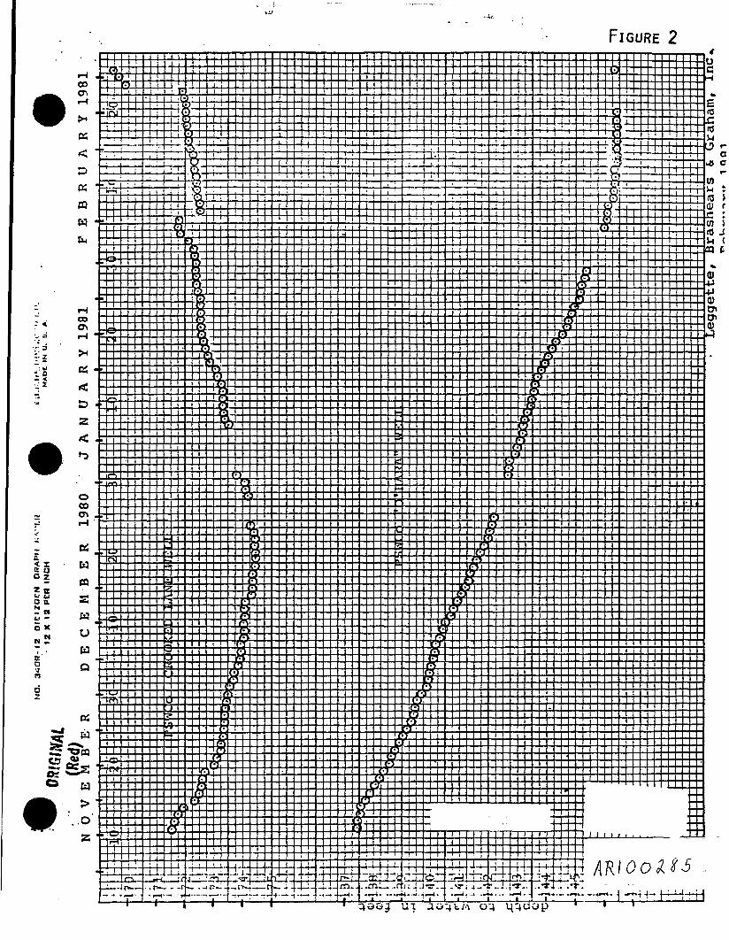
FIGURE 2 <00en
KCQWfc,
COCft
D2
oCOCTvr-t
Oi
W
OWQ
H>OZ

FlGURE 3 oCO .

FIGURE
< Iii §z a_l _iB 0.- Mu: -•5 x
&n
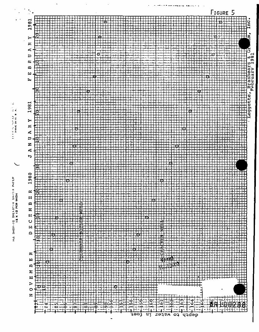
FIGURE 500o\
CQW
oo: = c^. < _i
cs<P.z
.Q-
G:
o00
WCQ
K
aw
o2
£X
3L
-Ca^ .........
WQ
T*--..«-IT.
.< O>Z+rL
i3-
•eo'--I-
•U
s
! >i±Kl:ji. 5_j_ tpT-H,
-; i-t- 4-!•••«:2 ~~&] ', I1-:' 1 ~ff f-- • *r»-i; — aj-ti. * -W l
TkV
qao^ UT ae^BM o^ q^dap

.-IGURE 0
•s. I
2 ttu uU 0."N
tO

FIGURE 7