lessons learned from german research for usarki/papers/hamp_et_al_ssrr11.pdf · lessons learned...
TRANSCRIPT
Lessons Learned from German Research for USARQuirin Hamp and Leonhard Reindl
University of Freiburg - IMTEKDepartment of Microsystems EngineeringLaboratory for Electrical Instrumentation
79110 Freiburg, GermanyTel: +49 761/2037158
Email: [email protected]
Alexander KleinerUniversity of Freiburg
Department of Computer Science79110 Freiburg, Germany
Abstract — We present lessons learned in USAR research withinthe framework of the German research project I-LOV. After threeyears of development first field tests have been carried out by profes-sionals such as the Rapid Deployment Unit for Salvage OperationsAbroad (SEEBA). We present results from evaluating search teams insimulated USAR scenarios equipped with newly developed technicalsearch means and digital data input terminals developed in the I-LOV project. In particular, the “bioradar”, a ground-penetrating radarsystem for the detection of humanoid movements, a semi-active videoprobe for rubble pile exploration of more than 10 m length, and thedecision support system FRIEDAA were evaluated and compared withconventional search methods. Results of this evaluation indicate thatthe developed technologies foster advantages in USAR, which arediscussed in this paper.
Keywords: USAR, information management, technicalsearch, radar, endoscope, emergency communications.
I. INTRODUCTION
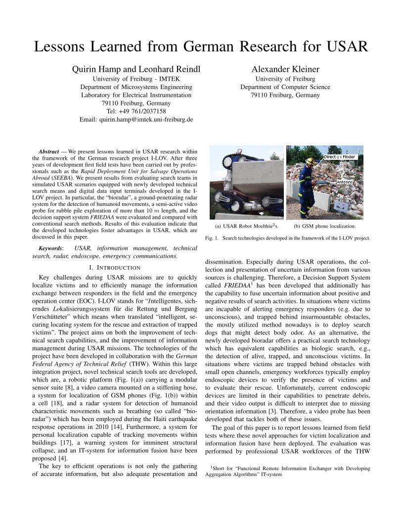
Key challenges during USAR missions are to quicklylocalize victims and to efficiently manage the informationexchange between responders in the field and the emergencyoperation center (EOC). I-LOV stands for “Intelligentes, sich-erndes Lokalisierungssystem fur die Rettung und BergungVerschutteter” which means when translated “intelligent, se-curing locating system for the rescue and extraction of trappedvictims”. The project aims on both the improvement of tech-nical search capabilities, and the improvement of informationmanagement during USAR missions. The technologies of theproject have been developed in collaboration with the GermanFederal Agency of Technical Relief (THW). Within this largeintegration project, novel technical search tools are developed,which are, a robotic platform (Fig. 1(a)) carrying a modularsensor suite [8], a video camera mounted on a stiffening hose,a system for localization of GSM phones (Fig. 1(b)) withina cell [18], and a radar system for detection of humanoidcharacteristic movements such as breathing (so called “bio-radar”) which has been employed during the Haiti earthquakeresponse operations in 2010 [14]. Furthermore, a system forpersonal localization capable of tracking movements withinbuildings [17], a warning system for imminent structuralcollapse, and an IT-system for information fusion have beenproposed [4].
The key to efficient operations is not only the gatheringof accurate information, but also adequate presentation and
(a) USAR Robot Moebhiu2s. (b) GSM phone localization.
Fig. 1. Search technologies developed in the framework of the I-LOV project.
dissemination. Especially during USAR operations, the col-lection and presentation of uncertain information from varioussources is challenging. Therefore, a Decision Support Systemcalled FRIEDAA1 has been developed that additionally hasthe capability to fuse uncertain information about positive andnegative results of search activities. In situations where victimsare incapable of alerting emergency responders (e.g. due tounconscious), and trapped behind insurmountable obstacles,the mostly utilized method nowadays is to deploy searchdogs that might detect body odor. As an alternative, thenewly developed bioradar offers a practical search technologywhich has equivalent capabilities as biologic search, e.g.,the detection of alive, trapped, and unconscious victims. Insituations where victims are trapped behind obstacles withsmall open channels, emergency workforces typically employendoscopic devices to verify the presence of victims andto evaluate their rescue. Unfortunately, current endoscopicdevices are limited in their capabilities to penetrate debris,and their video output is difficult to interpret due to missingorientation information [3]. Therefore, a video probe has beendeveloped that tackles both of these issues.
The goal of this paper is to report lessons learned from fieldtests where these novel approaches for victim localization andinformation fusion have been deployed. The evaluation wasperformed by professional USAR workforces of the THW
1Short for “Functional Remote Information Exchanger with DevelopingAggregation Algorithms” IT-system
and in particular of the Rapid Deployment Unit for SalvageOperations Abroad (SEEBA) which is trained for assistancein international disaster response. The assistive search tech-nologies all contributed to more effective search. The synergywith biologic search proved to give more accurate results withrespect to certainty, location accuracy, and situation awareness.The assistive IT-system enabling digital communication ofmessages proved to be a valuable tool and enhance the capa-bility of an EOC to handle messages from the field. However,the chosen communication infrastructure caused insufficientcoverage fostering delays in message transmission.
The reminder of this paper is structured as follows. InSection II state-of-the-art protocols of USAR operations arediscussed. In Section III the technical tools developed in I-LOV are introduced and experiments for testing their de-ployment by professional response personnel are presented inSection IV. Finally, achieved results and lessons learned arediscussed in Section V.
II. STATE OF THE ART OF USAR OPERATIONS
USAR research in Germany was firstly initiated by Maackduring WWII [9]–[11]. He suggested the five phase strategyprocedure for finding victims, which aims to ensure highefficiency while decreasing risks for rescuers and trappedsurvivors. This procedure is nowadays still used by Germanrescue organizations during USAR missions [16], but hasanother order than the prioritized one during the USAR opera-tions after the WTC collapse (see [3] p. 380). After first actions(phase I) and the rescue of “surfaced victims”, i.e., victims thatare easily accessible (phase II), the search for trapped victimsis initiated (phase III). If canine search is available, it is thefirst method of choice. Two to three dogs are conventionallyemployed. The second dog validates positive search resultsof the first one. The third dog is used if the other two dogsare exhausted or in order to check after the extrication of avictim whether another one has been forgotten. If the resultsof the canine search are uncertain, for example when bothdogs showed different reactions at the search site, technicalsearch means (if available) are used to verify the results of thedogs. Standard equipment of the THW are acoustic devices.During phase IV trapped victims are extricated. Only after theexhaustive search has been concluded, the area is cleared forsystematic removal of heavy debris (phase V).
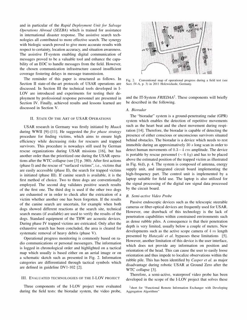
Operational progress monitoring is commonly based on ra-dio communications or personal messengers. The informationis logged in chronological order and highlighted on a tacticalmap which usually is based either on an aerial image or ona schematic sketch such as presented in Fig. 2. Informationcategories are differentiated through tactical symbols whichare defined in guideline DV1-102 [2].
III. EVALUATED TECHNOLOGIES OF THE I-LOV PROJECT
Three components of the I-LOV project were evaluatedduring the field tests: the bioradar system, the video probe,
Fig. 2. Conventional map of operational progress during a field test (seeSect. IV-A, p. 3) in 2011 Holzwickede, Germany.
and the IT-System FRIEDAA2. These components will brieflybe described in the following.
A. Bioradar
The “bioradar” system is a ground-penetrating radar (GPR)system which enables the detection of repetitive movementssuch as the heart beat and the chest movement during respi-ration [14]. Therefore, the bioradar is capable of detecting thepresence of either conscious or unconscious survivors situatedbehind obstacles. The bioradar is a device which needs to restimmobile during an approximatively 30 s long scan in order todetect human movements of 0.3−4 cm amplitude. The deviceis portable by rescue personnel (∼ 6 kg) and has to be placedabove the estimated position of the trapped victim as illustratedin Fig. 6(d), p. 4. The system is composed of antenna, energysupply unit, and integrated circuit board implementing thehigh-frequency part. The control unit is implemented by alaptop suitable for field use. The laptop is also utilized forthe signal processing of the digital raw signal data processedby the circuit board.
B. Semi-active Video Probe
Passive endoscopic devices such as the telescopic steerablecameras or fiber-optical devices are frequently used for USAR.However, one drawback of this technology is the lack ofpenetration capabilities within constrained environments suchas dense rubble piles. A consequence is that their penetrationdepth is very limited, usually below a couple of meters. Newdevelopments such as the active scope camera of 4 m lengthpresented by Hatazaki et al. bypasses these limitations [5].However, another limitation of this device is the user interface,which does not provide any information on position andorientation of the head. This can cause the user to easily looseorientation and thus impede to localize observations within therubble pile. This has been identified by Casper et al. as majordisadvantage during robotic USAR at Ground Zero after theWTC collapse [3].
Therefore, a semi-active, waterproof video probe has beendeveloped in the scope of the I-LOV project that solves these
2short for “Functional Remote Information Exchanger with DevelopingAggregation Algorithms”

issues. It consists of the following three main components:The first component is a hose of variable length (5− 30 m×∅65 mm, ∼ 1 kg/m) that can be controlled in its stiffnessthrough air pressure (max. 8 bar) (see Fig. 3). The video probecan be pushed using this hose up to 10 m into the rubble pileby a single human user from outside. The second component(600 mm × ∅65 mm, ∼ 3.4kg) allows the positioning ofthe head component carrying the video camera through pitchand yaw. The video camera and LED illumination in the headcomponent (300 mm × ∅80 mm, ∼ 2.5kg) can be orientedtrough two additional degrees of freedom (roll and yaw). Thesteering of the probe during insertion is performed throughthe three joints and the so-called “Lindauer Schere”, whichenables the probe to contrive in a bifurcating propagationchannel by ejecting and retracting a structure at the distalpart of the head. Sensors for artificial horizons are placedin the second component and in the head, respectively. Bythis, enhanced situational awareness is offered to the user,for example, when penetrating dense rubble piles, which alsoenables the localization of observations during the search.
Fig. 3. Semi-active video probe that can travel up to 10 m rubble.
C. Decision Support System FRIEDAA
The advantages of the use of so called geographic informa-tion systems (GIS) have already been recognized and used inprojects such as the Japanese DDT project [1]. The collectionof relevant information by collaborating operational units andthe centralized storage assures enhanced situational awareness.However, GIS typically are limited to store information fromreliable observation sources only, whereas in the context ofUSAR uncertain observations are likely to occur. FRIEDAA isan extension to state-of-the-art GIS that deals with observationuncertainty. FRIEDAA enables rescue workforces, for exam-ple, to collect and evaluate uncertain information about victimwhereabouts. Information from eye-witnesses and uncertainand imprecise results of search efforts can be collected andattached with geo-reference and timestamp similar to theKiwi+ format presented by Meguro et al. [12]. For on-siteemergency workforces, information collection is facilitatedthrough a PDA application called GeoRescue that allows userinputs by a pointing stick (Fig. 4(b)). The acquisition of a geo-reference is performed automatically through a GPS receiver.To circumvent the known lacking precision of GPS (see [6]),
relative input can be performed or corrected through dragand drop of tactical symbols in the desktop application ofFRIEDAA. Furthermore, it enables “2d+1” visualization ofhorizontal planes in order to track the operational progress insemi-collapsed, multi-storied edifices.
Three main functions assist the SAR team during decision-making. First, there is the handling of the victim list whichallows for a comparison of victims that were already found andvictims that are still expected to be found. Second, for likelyvictims several search methods can be employed that are allgenerating results. Multi-level information fusion3 allows toassociate reports, e.g., from eye-witnesses, that concern thesame victim. Furthermore, a victim detection algorithm assesall associated information and finally infers an estimated targetlocation. Third, the positions of rescue forces are assessedautomatically, e.g., whether they are within hazardous zones.In specific cases an alert is triggered.
(a) FRIEDAA on 46 inch tactile screen. (b) GeoRescue on a PDA.
Fig. 4. Decision Support System FRIEDAA for USAR operations duringa field test in 2011 at the German Federal School of the THW in Hoya,Germany.
IV. FIELD TEST RESULTS
Two field tests have been carried out by SAR professionalsto evaluate the proposed methods of the I-LOV project. Thefirst field test focused on the benefits of FRIEDAA during theresponse to large scale incidents. Especially, communicationperformance was assessed. The second field test allowed toevaluate the new search technologies. In order to facilitateobjective comparisons, both experiments were carried outwithin two runs, on the one hand with assistive tools of theI-LOV project, and on the other hand without.
A. Evaluation of FRIEDAA for large-scale disasters
The first field test was carried out in an intact environmentof approximatively 3.7 ha that was explored in parallel byfour Search and Rescue (SAR) teams (two persons, one teamassisted by search dogs) in Holwickede, Germany. In additionto the outside surface, there were six buildings that had as wellto be explored indoors (see Fig. 2 for a tactical map). Fourof the edifices had two floors. The aim was to find 23 cards(three with uncertain information), and three human victims
3refer to Nakamura et al. for the definition [13].

0 15 30 45 60 700
5
10
15
Max: 4 messagesmin
7 messagesmin
t [min]
#M
essa
ges
Conv. SAR FRIEDAA ass. SAR
Fig. 5. Comparison of the message volume treated by the EOC between thefirst and the second run with respect to the duration (t) of the search. Theamount of messages that can be managed assisted by FRIEDAA is higherthan for conventional SAR.
which were mainly hidden within the buildings. Half of thecards were concerning hazards, the other half victims.
In particular, the EOC was under observation. The first runemployed a conventional radio communication infrastructure,the second one was additionally assisted by the FRIEDAAcommunication infrastructure based on commercial WLAN.During the first run, two SAR operation leaders were in theEOC and managed the operational progress. One was loggingall incoming messages chronologically, the other person wasbusy with plotting information on the map presented in Fig. 2,and with updating a table for better presentation of theinformation.
The second run employed the same setting, but the teamswere assigned to regions they had not explored in the previousrun. All search teams carried a PDA with them that they usedpreferentially to collect and transmit information to the EOCusing the GeoRescue application.
During the first run 31 radio messages were transfered in 52minutes as presented in Fig. 5. The two persons in the EOChad difficulties to handle this amount of incoming messages,which resulted in delays of approximately 5 minutes. Themaximal information flow treatable by the EOC was aboutfour messages per minute. A comparison of the map in Fig. 2with the actual situation resulted in the fact that during thefirst run two victim observations and three hazard observationswere missed. Furthermore, the locations of the observationswere only approximative and did not correspond to the ac-tual positions since emergency workforces only indicated thegeographic direction and the floor.
The second run lasted in total 69 minutes during which57 messages were received in the EOC. Considering the factthat the GeoRescue application allows to transfer messagescontaining multiple data (e.g. a hazard combined with in-formation about a person), and that during the previous runevery single radio communication message was accountedfor, a total of 92 successfully transmitted messages has tobe considered. Furthermore, every time an information wascollected at the EOC, the region around the acquired geo-reference was automatically marked as cleared by FRIEDAA,which increased the amount of messages to 149 in total. InFig. 5 messages about cleared zones are not accounted for,
because they were automatically sent. The identification ofthe search team was as well transferred automatically to theFRIEDAA system.
Since the WLAN network did not cover the whole area,messages were sent delayed, e.g., once a position withincommunication range has been reached again after loosingconnection. Furthermore, the lacking GPS reception indoorsconstrained the SAR team members to locate themselves nearwindows to receive GPS signal. They had to indicate whetherthe message concerned the first or the second floor. The searchperformance was better in the second run than in the first run,only one hazard was missed. A comparison of the performanceof both runs is presented in Table I.
TABLE IPERFORMANCE OF THE TWO RUNS EVALUATING FRIEDAA FOR LARGE
SCALE DISASTERS.
RUN #INFOSMISSED
AVG.MESSAGES[min−1]
AVG.DELAY[min]
TOTALSEARCHTIME [min]
CONVENTIONAL 5 0.60 n.a. 52FRIEDAA 1 2.16 8 69
B. Evaluation of assistive search technologies integrated inconventional USAR procedure
The second field test took place in a completely destroyedarea of 0.58 ha with ten rubble piles at the school of the THWin Hoya, Germany. Three human victim actors were hidden intunnels under the rubble piles. Furthermore, a worn piece ofcloth was placed within one rubble pile, in order to checkwhether the dogs would neglect correctly this false target. Asin the first field test, two runs were performed, but FRIEDAAassisted in both of the cases.
(a) Biologic Search. (b) Semi-Active Video Probe.
(c) SearchCam. (d) Ground-penetrating Bioradar.
Fig. 6. Synergy between biologic and technical search methods.
During the first run only biologic search was performedafter a exploration phase. There were two exploration teamswho covered the whole area during 16 minutes. Two search
dog teams were employed to search the whole area. After 27minutes all victims were found. In one situation a direct accessto the victim could not be achieved. The search team suggestedthe application of technical search methods which, however,were not allowed during the first run. The total duration of thefirst run was 43 minutes with 93 distinct messages.
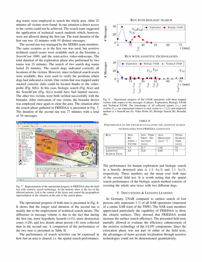
The second run was managed by the SEEBA team members.The same scenario as in the first run was used, but assistivetechnical search assets were available such as the bioradar, aSearchCam 3000, and the semi-active video-endoscope. Thetotal duration of the exploration phase also performed by twoteams was 25 minutes. The search of two search dog teamslasted 28 minutes. The search dogs indicated correctly alllocations of the victims. However, since technical search assetswere available, they were used to verify the positions wheredogs had indicated a victim. One victim that was trapped understacked concrete slabs could be located thanks to the video-probe (Fig. 6(b)). In this case, biologic search (Fig. 6(a)) andthe SearchCam (Fig. 6(c)) would have had limited success.The other two victims were both verified successfully with thebioradar. After extrication of one victim, the bioradar devicewas employed once again to clear the area. The situation afterthe search phase gathered in FRIEDAA is presented in Fig. 7.The duration of the second run was 77 minutes with a totalof 54 messages.
Fig. 7. Representation of the operational progress in FRIEDAA after the fieldtest with assistive search technology. At the bottom, there is the list of theaffected persons. Left is the control of the layers and central the geographicalrepresentation of the situation at the end of the search phase.
The operational progress of both runs is presented in Fig. 8.It shows that the longer total duration of the second run ismainly due to the employment of technical search means. Thedifference in message volume is due to the fact that duringthe first run, more hypothetic hazards (+15), more destructionzones (+29), and less details about person (-8) were collectedthan in the second run. A comparison of the performance ofthe two runs is presented in Table II.
The performance of search activities can be expressed inhow fast an area is cleared, i.e. the spatial search performance.
0 15 30 45 60 750
20
40
r 3B
V1B
V2BV3B
t [min]
#M
essa
ges
RUN WITH BIOLOGIC SEARCH
Exploration Biologic USAR
0 15 30 45 60 750
20
40
r 1B,r
1B
r 2B,r
1R
r 3B
r 3B
r 3R
r 3R
,r3S
V1SV2P V3S
t [min]
#M
essa
ges
RUN WITH ASSISTIVE TECHNOLOGIES
Exploration Biologic USAR Technical USAR
Fig. 8. Operational progress of the USAR operations with three trappedvictims with respect to the messages of phases: Exploration, Biologic USARand Technical USAR. The timestamps of all collected reports (rix) andvictims (Vix) are represented relative to each victim (i = 1,2,3) and employedmethod (x = SearchCam (S), Video Probe (P), Biologic Search (B), Bioradar(R)).
TABLE IIPERFORMANCE OF THE TWO RUNS EVALUATING THE ASSISTIVE SEARCH
TECHNOLOGIES WITH FRIEDAA ASSISTANCE.
RUN AVG.RE-PORTS /VICTIM
AVG. TIMEFIRST DE-TECTION[min]
AVG.MESSAGES[min−1]
TOTALSEARCHTIME[min]
CONVENTIONAL 1.3 21.7 2.16 43ASSISTIVESEARCH TECH.
4.0 24.0 0.69 77
The performance for human exploration and biologic searchin a heavily destroyed area is 1.4 ha/h and 1.1 ha/h,respectively. These numbers are the mean over both runsof the second field test. It is worth noting that the spatialsearch performance of the biologic search method consists ofcovering the whole area twice with two different dogs.
V. DISCUSSIONS & LESSONS LEARNED
In Germany, USAR compared to surface search of lostpersons only represents 5 % of all SAR operations (statementof a canine SAR team of the THW). The SAR team membersappreciated particularly the capability of FRIEDAA to showthe cleared surfaces. They stressed that FRIEDAA wouldincrease the surface search efficiency. The presented field testspartially allowed to evaluate the efficiency enhancement ofthe assistive technology of the I-LOV components. Since theextrication phase was not part of either of the field tests,the advantages of more accurate localization through assistivetechnologies could not be demonstrated quantitatively.
Despite the fact that commercially available GPS receiversare insufficiently precise for victim localization, and also notacquirable indoors, the capability to store information withtimestamps and geo-reference turned out to be very promis-ing. Ongoing developments about Pedestrian Dead Reckoning(PDR) [17] and SLAM [7] will allow robust localization in allcircumstances and enhance the capability to log operationalprogress in complex three dimensional terrain.
Conventional maps of operational progress such as pre-sented in Fig. 2 are poor in content and functionality comparedto GIS supported maps such as delivered by FRIEDAA (seeFig. 7). Long lasting operations in complex, multi-storiedterrain are certainly manageable on paper media. However,the capability to search and filter information with respect totemporal timestamps and categories are the clear advantages ofdigital assisted search. The data logging capability of digitallyassisted search fosters the consolidation of experiences in thefield, which is important for improving the efficiency of USARmissions in the future.
The benefits of non-verbal digital transmission of messagesbecame evident through the first field test. In the first run withconventional methods, the two persons in the EOC reachedtheir limit to handle the amount of incoming messages. Inthe second run, more information was transmitted whereas thetwo persons in the EOC had nearly no work and would havebeen able to focus on other important tasks such as warningendangered workforces, assessing uncertain information andmanaging the list of missing persons. The WLAN communica-tion infrastructure was lacking of coverage within and behindbuildings during the first field test. The lack of coverage causeddelays. However, this can be remedied with other digital radiocommunication technology such as GSM or TETRA [15]. Ifsuch an infrastructure is used to entirely cover a terrain suchas during the second field test, delays become negligible.
The comparison in Fig. 8 shows that the assistive technologyused during the second run increased the total duration of thesearch phase. However, it is worth noting that during USARmissions precise victim localization is of top most importance,which can be gained by assistive technologies as proved bythe performance comparison in Table II. If the position isonly known vaguely, extrication efforts and the total rescueduration are considerably increasing. The SEEBA stressedthe importance of portability of the assistive technologies.The bioradar was particularly promising in this regard. Theassistive search technologies have shown to be trustful toolsthat increase certitude about victim presence and location. Thesearch technologies in the given circumstances of the field testin Hoya always indicated correctly the presence of a trappedvictim.
ACKNOWLEDGMENT
We gratefully acknowledge financial support from the Ger-man Federal Ministry of Education and Research (supportcode: 13N9759). Furthermore, we are most grateful for thesupport of the German Federal Agency for Technical Relief(THW), of SEEBA, of the companies JT-electronic GmbH
and Berlin- Oberspree Sondermaschinenbau GmbH (BOS).FRIEDAA uses uDig source code of Refractions Research.
REFERENCES
[1] Hajime Asama, Yasushi Hada, Kuniaki Kawabata, Itsuki Noda, Os-amu Takizawa, Junichi Meguro, Kiichiro Ishikawa, Takumi Hashizume,Tomowo Ohga, Michinori Hatayama, Fumitoshi Matsuno, and SatoshiTodokoro. Rescue infrastructure for global information collection. In2006 SICE-ICASE International Joint Conference, Vols 1-13, pages1600–1605, 2006.
[2] Bundesanstalt Technisches Hilfswerk, Deutschherrenstraße 93-95, 53177Bonn. THW DV1-102 Taktische Zeichen, 2000.
[3] Jennifer Casper and Robin Murphy. Human-Robot Interactions Duringthe Robot-Assisted Urban Search and Rescue Response at the WorldTrade Center. IEEE Transactions on Systems, Man, and Cybernetics-Part B: Cybernetics, 33(3):367–385, 2003.
[4] Quirin Hamp, Michael Eitelberg, Bo-Sik Lee, Tobias Becker, DirkWiebeck, and Leonhard Reindl. Information Fusion based on graphanalysis during Urban Search and Rescue. In Information Fusion,Edinburgh, UK, 2010. IET.
[5] K. Hatazaki, M. Konyo, K. Isaki, S. Tadokoro, and F. Takemura. Activescope camera for urban search and rescue. In Intelligent Robots andSystems, 2007. IROS 2007. IEEE/RSJ International Conference on,pages 2596 –2602, 29 2007-nov. 2 2007.
[6] J. Hightower and G. Borriello. Location systems for ubiquitous com-puting. Computer, 34(8):57 –66, 2001.
[7] Alexander Kleiner, Christian Dornhege, and Sun Dali. Mapping disasterareas jointly: RFID-coordinated SLAM by humans and robots. InInternational Workshop on Safety, Security and Rescue Robotics, pages42–47, NEW YORK, USA, 2007. IEEE.
[8] Patrick Labenda, Tim Sadek, and Thomas Predki. Controlled maneu-verability of an articulated tracked mobile robot. ASME ConferenceProceedings, 2010(44106):1141–1147, 2010.
[9] P. Maack. Die Systematik der Schadenstellen, I. Teil. BaulicherLuftschutz, 6(5):97–118, 05 1942.
[10] P. Maack. Die Systematik der Schadenstellen, II. Teil. BaulicherLuftschutz, 6(6):129–133, 06 1942.
[11] P. Maack. Die Systematik der Schadenstellen, III. Teil. BaulicherLuftschutz, 7:2–16, 1943.
[12] Jun-Ichi Meguro, Kiitirou Ishikawa, Takumi Hasizume, Jun-IchiTakiguchi, Itsuki Noda, and Mitinori Hatayama. Disaster informationcollection into geographic information system using rescue robots. In2006 IEEE/RSJ International Conference on Intelligent Robots andSystems, volume 1-12, pages 3514–3520, 2006.
[13] Eduardo F. Nakamura, Antonio A. F. Loureiro, and Alejandro C. Frery.Information fusion for wireless sensor networks: Methods, models, andclassifications. ACM Computing Surveys, 39(3), 2007.
[14] O. Rogall, R. Schilling, M. Loschonsky, R. Schimko, and L. M. Reindl.Radargestutzte Personenortung. In Sensoren und Messsysteme, pages728–732, Nurnberg, 2010. VDE. (engl.: Radar based localization ofpersons).
[15] Peter Stavroulakis. Terrestrial trunked radio - TETRA: a global securitytool. Springer, 2007.
[16] Ulf Tabbert and Jorg Meike. Maßnahmen der Feuerwehr und andererHilfskrafte nach Gebaudeeinsturzen. Vereinigung zur Forderung desDeutschen Brandschutzes (vfdb), 2003.
[17] R. Zhang and L.M. Reindl. Pedestrian motion based inertial sensorfusion by a modified complementary separate bias Kalman filter. InSensors Applications Symposium (SAS), pages 209–213. IEEE, 2011.
[18] S. Zorn, M. Maser, A. Goetz, R. Rose, and R. Weigel. A power savingjamming system for E-GSM900 and DCS1800 cellular phone networksfor search and rescue applications. In IEEE Topical Conference onWireless Sensors and Sensor Networks (WiSNet), 2011.