lessons learned from selected case studiesfornistest.metla.fi/system/files/synthesis_all.pdfbased...
TRANSCRIPT

FORESTRY RESEARCH NETWORK FOR SUB-SAHARAN AFRICA (FORNESSA)
INTERNATIONAL UNION OF FOREST RESEARCH ORGANIZATIONS SPECIAL PROGRAMME FOR
DEVELOPING COUNTRIES (IUFRO-SPDC)
REHABILITATION OF DEGRADED LANDS
IN SUB-SAHARAN AFRICA:
Lessons Learned from Selected Case Studies
Authors: Dominic Blay, Edouard Bonkoungou, S.A.O. Chamshama and Ben Chikamai
Editors: Peter Wood and Atse M. Yapi
2004
EUROPEAN COMMISSION
2
EXECUTIVE SUMMARY
I. INTRODUCTION A. Definition and Extent of Land Degradation in SSA Land degradation is one of the biggest problems in Sub-Saharan Africa, threatening the lives of millions of people. The problem occurs in all the three zones of the region, the humid, sub-humid and dry lands, albeit at different levels. Key factors of degradation in the humid lands are:
• clearing trees for agricultural expansion,
• logging,
• firewood gathering and charcoal production,
• mining,
• human settlements, and
• infrastructural and industrial developments.
The same factors are also important in the sub-humid zones though overgrazing and uncontrolled fires become more important here. Within the drylands overgrazing combined with unsustainable agriculture and over-exploitation of natural resources are driving factors. Additionally, there are various underlying causes among which population growth, rural poverty and poor policies are key ones. Very large areas of Sub-Saharan Africa are already or becoming degraded as a result of these factors, the result of which is desertification in the dry sub-humid and dryland zones. The process of land degradation usually starts with deforestation and there is evidence to show that over 90% of the original moist forests have been lost or have become degraded remnants, whilst about 600,000 ha of indigenous forests in the sub-humid zones are cleared annually for other land uses. The annual rate of degradation (or desertification) in the drylands varies from 10% (in arid lands), 1% (in semi-arid lands) and 0.1% (in the dry sub-humid lands). However, these figures should be treated with caution since data are not always reliable and climates are highly variable, especially in the dry areas. There is clearly an urgent need for improved and harmonised methods for gathering data and monitoring changes. B. Impacts of Land Degradation The main consequences of land degradation which impact negatively on human livelihoods and on the environment are generally well-known. They include:

3
• shortages of firewood and other wood;
• shortages of non-timber forest products;
• increased sediment deposits, floods and land slides;
• drying up of springs and water bodies; siltation of dams;
• increased incidence of water-borne diseases;
• loss of biodiversity;
• climate change;
• desertification.
All these reduce land productivity and affect food security.
II. APPRAISAL OF LAND REHABILITATION TECHNIQUES In order to reverse or mitigate the effects of land degradation a number of techniques are available, depending on:
• the priorities and objectives of stakeholders,
• the costs and benefits associated with available rehabilitation techniques, and
• the economic, social, and environmental values of the land resources in their current and desired future states.
The major techniques that have been used in Sub- Saharan Africa include;
• Natural Regeneration,
• Assisted Natural Regeneration (ANR),
• Enrichment Planting,
• Plantations,
• Agroforestry, and
• Soil and Water Conservation.
Natural Regeneration involves deliberately managing the land to enhance and accelerate the natural processes of ecological succession in order to re-establish a healthy and resilient forest ecosystem. Assisted Natural Regeneration is used to accelerate regeneration by assisting the natural processes and it involves cutting or pressing down the weeds around existing naturally-

4
occurring seedlings, protecting the site from fire and inter-planting with desired species if necessary. Enrichment Planting is defined as the planting of valuable species in degraded forests without the elimination of valuable individuals already present. The technique is suitable for the restoration of over-exploited primary and secondary forests as it can increase total tree volume and the economic value of forests. Fire is a major ecological factor responsible for maintaining many African ecosystems, for example Miombo woodland. The technique for controlling fires usually involves carrying out early burning, that is, burning patches of grass and undergrowth early in the dry season before the vegetation becomes so dry that more intense and damaging fires occur, as is common later in the season. The Use of Plantations involves planting trees and/or shrubs as single or mixed species on degraded lands. Plantations are often used to catalyse forest succession in the understory, particularly where silvicultural management has been neglected or on sites where persistent ecological barriers to succession would otherwise preclude recolonisation by native forest species. The Use of Agroforestry involves two stages. In the first stage, tree and shrub species together with any necessary mycorrhizas or rhizobia are introduced to the site with the objective of checking further erosion and restoring soil organic matter and fertility status. In the second stage, the cover may be selectively removed and agricultural production introduced. Soil and Water Conservation Techniques entail creating structures to improve the conservation of water for plant growth. III. REVIEW OF SELECTED CASE STUDIES The urgency for rehabilitation has been widely recognized for many years and sub-Saharan Africa has been the focus of many initiatives in this area. There have been many successes as well as some failures but published details are mostly in the “grey” literature and are thus not easily accessible. A total of 14 such cases are included as annexes to the report, detailing the objectives and results and the reasons for success or failure. These case studies cover the three main ecological zones of Sub-Saharan Africa, the bulk of them being concerned with the dry land ecosystem (7 cases) , and come from field work in the woodlands of Burkina Faso, Ethiopia, Kenya, and Northern Cameroon. The remaining 7 cases are distributed almost equally between the sub-humid ecosystem (4 cases, from the Manyara, Shinyanga and Dodoma Regions of Tanzania, and the Upper East Region of Ghana) and the humid ecosystem (3 cases, from the Western and Brong Ahafo Regions of Ghana). This distribution is revealing, as it reflects the high priority given to the rehabilitation of degraded dry lands in view of the greater threat of desertification in that ecological zone. Eleven of the cases studied are regarded as generally successful, whilst the remaining 3 are more of a failure. Nevertheless, they all represent excellent learning points for charting the way forward for future rehabilitation of degraded lands.
5
IV. LESSONS LEARNT From this review a number of important lessons have been drawn that provide the basis for the recommendations made. Projects considered to be successful were found to have at least one of the following characteristics:
• The project is perceived by local communities to have a direct bearing on their livelihoods, i.e., to have a clear potential to deliver tangible and short term benefits such as wood and non-wood forest products for human and livestock direct use and for income generation.
• There is a favourable political and policy environment that provides a clear legal
framework for land ownership and/or usufruct rights. • Rehabilitation methods are simple and inexpensive, and relate as much as possible to
local knowledge and practice. The following were found to be particularly important features of the design and implement-tation of successful projects:
• Rehabilitation activities are preceded by stakeholder consultation to enhance
awareness of the causes and consequences of land degradation and of the available techniques for rehabilitation and their benefits.
• Baseline studies are fundamental tools for measuring success or failure (for
monitoring flora and fauna changes over time and the impact of rehabilitation on the livelihoods of people).
• Participation is given highest priority at all levels and involving all stakeholders in
planning, implementation and benefit-sharing of rehabilitation. • Land tenure problems are resolved for greater adoption and sustainability of
rehabilitation efforts.
• Local communities are empowered through
o Functional institutional frameworks at village level to oversee planning, implementation and monitoring;
o Capacity building to enable communities to implement the projects; and
o Equitable sharing of both costs and benefits within the communities and between
them and the government. V. THE WAY FORWARD Based mainly on the lessons learned from the case studies presented here, the following suggestions have been formulated and are strongly recommended as a guide to the way forward for land rehabilitation in Sub-Saharan Africa.

6
Policy Aspects Adopt appropriate policies that, among others, allow a paradigm shift in forest governance from centralised to decentralised management involving local communities (community based forest management or joint forest management) and other stakeholders. Pay particular attention to the role of range management for livestock in the dry zones especially, adopting a multi-sectoral approach as needed. Review and if necessary change land policies to ensure secure and clear tenure rights for different communities. The review should be based on national land use priorities taking into account biophysical as well as socio-economic conditions. Management Aspects In addition to ensuring the collection of baseline data, management also needs to take account of the following:
• Development of integrated and holistic approaches, including industrial and other off-
farm livelihood opportunities to reduce pressure on forest and range resources. Sustainable agroforestry production systems must be affordable by the resource-poor.
• The value to be gained from sharing information and experiences, both within and between countries. Linked with this is ensuring that relevant institutions have the capacity for disseminating appropriate knowledge.
• The value of traditional and local knowledge especially that held by the stakeholders. • The importance of developing the skills of individuals and communities in planning,
organisation, management and accounting. • The need for diversification of income generating activities and adding value through
developing markets and marketing; • Finally the necessity for planning to ensure sustainability of the benefits of
rehabilitation when project activity comes to an end. Research and Training Aspects
• Research is needed on: o The impacts of sectoral and macroeconomic policy and legislation on
deforestation and land degradation; o The socio-economic evaluation of successfully rehabilitated areas; o Nursery and field trials of single and mixed tree/shrub species for degraded land
planting;
• The harmonisation of demands on land resources, notably agriculture, animal husbandry and woodland production, especially where these are in conflict

7
• Training and dissemination of technologies in close partnership with existing governmental and non-governmental agricultural extension services of improved technologies are needed for rehabilitation of degraded.
Training needs include awareness enhancement, dissemination of improved technologies and small enterprise management.
• Training and dissemination of technologies in close partnership with existing governmental and non-governmental agricultural extension services of improved technologies are needed for rehabilitation of degraded lands. Training needs include awareness enhancement, dissemination of improved technologies and small enterprise management.

8
CONTENTS
Page Executive Summary 2 Foreword 10 Synthesis Main Text 12 Case Studies 23 References 96 LIST OF TABLES Page Forest Cover Change (1990-2000) in Humid Zone Countries in Sub-Saharan Africa 13 Forest Cover Changes in Selected Miombo Countries Since 1980. 14 Extent of Land Degradation due to Deforestation and De-vegetation in Dryland Africa (million ha) 14

9
LIST OF CASE STUDIES BY REGION Page The Humid Forest Zone HFZ-1 Joint Management as an Option for Rehabilitating Degraded Forests: The Case of the Gwira Banso Project in the Wassa West District of the Western Region of Ghana 23 HFZ-2 Rehabilitation of Degraded Forests through the Collaboration of Local Communities in the Dormaa district of the Brong Ahafo region of Ghana 30 HFZ 3 Agricultural Reclamation of Nueng North Forest Reserve in the Western Region of Ghana 38 The Sub-Humid Zones SHZ 1 Restoring the Vegetation and Improving the Livelihood of the Kamba and Maasai People in Kenya 42 SHZ 2 Ngitili: a Traditional Method of Land Rehabilitation in Shinyanga Region, Tanzania. 48 SHZ 3 Successful Community-based Management of Duru-Haitemba Miombo Forest, Babati District, Northern Tanzania 52 SHZ 4 Land Rehabilitation by the Hado Project in Kondoa District, Dodoma Region, Tanzania 55 SHZ 5 Community Efforts at Rehabilitating Degraded Lands in the Upper East Region of Ghana 59 The Dryland Zones DLZ 1 Community Resources Management by the Elangata Wuas Ecosystem Management Programme, Kajiado District, Kenya 64 DLZ 2 Rehabilitation of Degraded Lands in the Lake Chad basin, Cameroun 70 DLZ 3 Enclosures as a Tool for Rehabilitating Degraded Woodlands of Ethiopia 76 DLZ 4 Community-based Rehabilitation of the Nazinon Forest in Burkina Faso 82 DLZ 5 Participatory Extension Strategies for Promoting Agroforestry in the Drylands of West Pokot District, Kenya 87 DLZ 6 Land Rehabilitation Through Participatory Soil and Water Conservation in the Yatenga Region, Burkina Faso 92 Total: 14 case studies

10
FOREWORD This scientific synthesis document is the result of more than two years of thematic networking activities among forest scientists on the issue of rehabilitation of degraded lands in Sub-Saharan Africa. The initiative aims at demonstrating the added value of scientific output that can be achieved through enhanced collaboration and information sharing among scientists working in different countries and environments. Under the umbrella of the Forestry Research Network of Sub-Saharan Africa (FORNESSA) and with financial resources provided by the European Commission through the Global Forest Information Service - GFIS Africa Project, a group of African scientists compiled case studies of land rehabilitation from all major ecological regions in Western- Eastern and Southern Africa covering “dry”, “humid” and “sub-humid” forests and woodlands. The results of these case studies served to formulate general lessons learned for the rehabilitation of degraded forests lands. The authors concluded the synthesis work with recommendations for policy formulation, management practices, research and training to guide future rehabilitation efforts in Sub-Saharan Africa. The development process of the synthesis document went through a number of stages involving the identification of lead scientists, preparation of background papers, organisation of meetings and e-discussions and the final production of the synthesis document. In total, three meetings were held, two in Finland at the Field Station of the University of Helsinki and one in Ghana at the Forest Research Institute Ghana (FORIG). In view of the overlapping objectives of both the GFIS Africa synthesis and the initiative on Trees, Agroforestry and Climate Change in Dryland Africa (TACCDA) coordinated by the European Tropical Forest Research Network (ETFRN) and the Viiki Tropical Resources Institute (VITRI), efforts and resources were pooled to jointly organise the e-discussions and a final validation workshop. During the one-month e-discussions participants from all over the world involved in land management, extension, training and education had the opportunity to review the case studies and exchange ideas and experiences. In the final validation workshop the results of the case studies and lessons learned from both the GFIS Africa and TACCDA initiatives were discussed providing the input to the sections on lessons learned and recommendations. Overall, the synthesis work was guided by the Steering Committee of the GFIS Africa Project and coordinated through the FORNESSA Secretariat led by Dr. Atse M. Yapi; and the IUFRO-SPDC Coordinator, Dr. Michael Kleine, as the manager of the GFIS Africa Project. The present document contains the results of the scientific synthesis including all case studies and a CD ROM with the documents produced by the TACCDA initiative. On half of FORNESSA and IUFRO-SPDC we wish to express our great appreciation to:
• The European Commission (EC) for generous financial support, which made this synthesis work possible.
• The group of African Research Scientists including Dr. Dominic Blay (FORIG, Ghana), Dr. Ben Chikamai (KEFRI, Kenya), Dr. Edouard Bonkoungou, (formerly Coordinator of ICRAF SALWA Regional Programme), and Professor S.A.O. Chamshama (Sokoine University, Tanzania) for their dedicated and hard work in compiling this scientific synthesis.
• The European Tropical Forest Research Network (ETFRN) Coordinating Unit led by Willemine Brinkman for technical support during the e-discussions, and valuable comments and advice at all stages of the networking process.

11
• The colleagues at the Viikki Tropical Resources Institute (VITRI), University of Helsinki, Finland, headed by Professor Olavi Luukkanen, for the support in organising the various meetings in Finland, providing expertise, resource persons and moderators for the e-discussions and workshops.
• The many African forest scientists, who have contributed either to the electronic discussions or
case studies presented in the synthesis.
• The Forestry Research Institute of Ghana (FORIG) for hosting a wrap-up workshop in Kumasi, Ghana with the purpose to reviewing the information collected and integrating the individual contributions made to the development of the synthesis document.
• Mr Peter Wood for his excellent work in reviewing the draft synthesis text and providing
valuable input for preparing the text for publication.
• Dr. Robert Szaro and Dr. David Langor, Coordinator and Deputy Coordinator of IUFRO-SPDC for their efforts to conceptualise and manage this synthesis work in its early stages.
• The IUFRO-SPDC Coordinating Team in Vienna, Austria and Accra, Ghana, for their constant
encouragement and coordinating efforts during the entire process; and lay-out work of the final synthesis document.
Dr. Michael Kleine Dr. Paul K. Konuche Manager of the GFIS-Africa Project Chairman of FORNESSA and and IUFRO-SPDC Coordinator Director of KEFRI Vienna, Austria Narobi, Kenya Dr. Atse M. Yapi Dr. Joseph R. Cobbinah Secretary of FORNESSA and Chairman of the GFIS-Africa IUFRO SPDC Regional Coordinator Project Steering Committee; and Accra, Ghana Director of FORIG Kumasi, Ghana
12
I. INTRODUCTION Rehabilitation is seen as the most viable way of mitigating the effects of land degradation. Initiatives in this area have been going on for some time now in Africa, especially in Sub-Saharan Africa (SSA). There exist useful examples of success stories in rehabilitation but also of failures, both of which present opportunities as learning points. However, most of the cases exist in grey literature and are not readily available. The GFIS Africa Synthesis initiative on “Rehabilitation of Degraded Lands in Sub-Saharan Africa” was therefore initiated in an effort to bring together African scientists working on tropical forests, woodlands and allied natural resources through networking to review and appraise existing information (both published and grey) and chart the way forward on sustainable management of the resources as a further contribution to the GFIS Africa project. Specifically, the synthesis has an emphasis on case studies in Sub- Saharan Africa in order to demonstrate what has already been done in the area of rehabilitation of degraded lands and to identify what are the gaps with respect to policy, management and research. The final product will be a valuable complementary document to the report on the Trees, Agroforestry and Climate Change in Dryland Africa (TACCDA) initiative the vision of which is that “African countries develop and agree on clear national policies and strategies for addressing ecological degradation of Savannah and dryland forests taking account of management and climate change” This synthesis covers four sections. Section II highlights the problem of land degradation in SSA, the extent of the problem and its impact. Section III provides an appraisal of land rehabilitation techniques with respect to their adaptation to and utility in each of the three ecological zones, i.e., humid, sub-humid and dry lands. An analysis of selected case studies within each of the ecological zones is summarised in Section IV and fourteen case studies are presented as annexes to the report. Section V draws lessons from the case studies. Section VI provides the way forward based on lessons learnt and recommendations from the case studies. This section also provides a guide for further rehabilitation of degraded lands in SSA. The main beneficiaries of this synthesis are expected to be students, researchers and development actors (government, development partners and NGOs) involved in different aspects relevant to natural resources in SSA. II. DEFINING THE PROBLEM Sub-Saharan Africa covers an area of 13.9 million km2 or about 46 % of the continent (Encyclopaedia Britannica, 1967) and is home to some 600 million people (WRI, 1998) living in a variety of physical, cultural and economic environments. SSA can be broadly classified into three zones comprising humid lands, sub-humid lands and dry-lands based mainly on the aridity index (AI) of climate. The AI is derived from the ratio of mean annual precipitation (P) to mean annual potential evapotranspiration (PET) (UNDP/UNSO, 1997). Based on this criterion, humid lands have an aridity index value of AI>1.0; sub-humid lands fall into two categories of moist sub-humid (AI of 0.65-1.0) and dry sub-humid (AI of 0.5-0.65) while dry-lands have three categories of semi arid (AI of 0.2-0.5), arid (AI of 0.05 –0.2) and hyper arid (AI <0.05). AI values of <1.0 indicate an annual moisture deficit (Middleton and Thomas 1997),which for SSA, includes both the sub-humid and dry zones. One of the biggest problems threatening the lives of millions of inhabitants in SSA, especially those residing in the rural areas, is land degradation, which is defined in general terms as a temporary or permanent decline in the productive capacity of the land (Stocking and Murnaghan, 2001). Although a worldwide problem, land degradation is said to be most acute in SSA where it is characterized by decreasing production of forest products and food and worsening levels of poverty and malnutrition. Land degradation is occurring in all the three zones described above occasioned by the same driving factors, albeit at different levels. Within the humid forest ecosystem key driving factors of degradation

13
include clearing trees for agricultural expansion (subsistence or commercial farming), logging, firewood gathering and charcoal production, mining, human settlements, infrastructural and industrial developments (Evans, 1994; Raymond et al, 1994). The same factors are also responsible for land degradation in the sub-humid zone though overgrazing and uncontrolled fires become more important as one gets into the dry sub-humid areas (Kaoneka, 1999). Within the dry-lands (semi-arid and arid zones), overgrazing combined with unsustainable agriculture and over-exploitation of natural resources are important (Middleton and Thomas 1997). In general, land degradation in the dry sub-humid and dry-land zones leads to desertification. Meanwhile, there are various underlying causes of degradation which include poor policies, inequitable distribution of benefits, market and policy failures, population growth, rural poverty and the poor state of economy of the affected countries (Quinones et al, 1997; Raymond et al, 1994), among others. As a result of the above anthropogenic factors, which, however, operate in a complex interplay with natural causes, large areas of SSA have undergone or are experiencing different levels of degradation. The process usually starts with deforestation; for example, the rain forests of West Africa are said to be disappearing at the rate of 5% annually with nearly 90% of the original moist forests having gone or having become fragmented and/or degraded remnants (FAO, 2001). Deforestation rates over the ten-year period 1990 to 2000 in the humid zone countries are shown in Table 1. Table 1: Forest Cover Change (1990-2000) in Humid Zone Countries in SSA
Forest cover change (1990-2000) Country
Total forest, 1990 ('000 ha)
Total forest, 2000 ('000 ha) Annual change
('000 ha) Annual rate of
change (%) Benin 3,349 2,650 -70 -2.3 Cameroon 26,076 23,858 -222 -0.9 Central Africa Republic
23,207 22,907 -30 0.1
Comoros 12 8 n.s. -4.3 Congo 22,235 22,060 -17 -0.1 Cote d'Ivoire 9,766 7,117 -265 -3.1 Dem. Rep. of the Congo
140,531 135,207 -532 -0.4
Equatorial Guinea 1,858 1,752 -11 -3.3 Gabon 21,927 21,826 -10 n.s. Ghana 7,535 6,335 -120 -1.7 Guinea 7,276 6,929 -35 -0.5 Guinea-Bissau 2,403 2,187 -22 -0.9 Liberia 4,241 3,481 -76 -2.0 Madagascar 12,901 11,727 -117 -0.9 Nigeria 17,501 13,517 -398 -2.6 Sierra Leone 1,416 1,055 -36 -2.9 Togo 719 510 -21 -3.4 Uganda 5,103 4,190 -91 -2.0
Source: FAO, 2001 Studies within the Miombo woodlands of the sub-humid zone also reveal high rates of deforestation. In the SADC region for example, Shaba (1993) estimated that about 600,000 ha of indigenous forests are being cleared annually for other land uses. Table 2 illustrates the generally high deforestation rates ranging from 40,000 – 765,000 ha between1980 and 1990 and 50,000 – 740,000 ha between 1990 and 1995.

14
Table 2: Forest Cover Changes in Selected Miombo Countries Since 1980
Total forest cover (Thousand ha)
Annual deforestation rate
1980 1990 1995 1980 -1990 1990 -1995 Country
Area (000ha) % Area (000 ha) % Angola 24,812 23,385 22,200 -143 -0.6 -237 -1.0 Malawi 4,011 3,612 3,339 -40 -1.0 -55 -1.6 Mozambique 18,683 17,443 16,862 -124 -0.7 -116 -0.7 Tanzania 37,936 34,123 32,510 -381 -1.0 -323 -1.0 Zambia 35,931 32,720 31,398 -321 -0.9 -264 -0.8 Zimbabwe 9,506 8,960 8,710 -55 -0.6 -50 -0.6
Source: WRI (1994), FAO (1999) and Nduwamungu (2001).
A recent assessment by FAO has attempted to quantify the extent of deforestation in Africa by different land uses (FAO, 2001). Based on this study, 4% of forests were deforested through shifting cultivation, 8% through intensification of agriculture in already shifting agricultural areas, 60% as direct conversion of forest area to small-scale permanent agriculture, 12% as direct conversion of forest area to large-scale permanent agriculture and 17% for other purposes such as settlements. Nevertheless, there have been slight gains in forest cover in some countries mainly as a result of afforestation, e.g. in the Gambia and in Swaziland (FAO, 2001). Within the dry-lands zone, land degradation or desertification is reported to be occurring at various levels depending on land use. For example, it is moderate in irrigated croplands (1.9 million hectares or 18% of total irrigated cropland) while it is high in rain-fed croplands and rangelands (48.9 million ha or 61% of rain-fed croplands and 995.1 million ha or 74% of rangelands) (INFORSE, 1998). The annual rate of desertification is about 10% in arid lands, 1% in semi-arid lands and 0.1% in dry sub-humid lands, leading to an annual increase of lands affected of: 156.9 million ha in arid areas, 23.0 million ha in semi-arid areas and 1.3 million ha in dry sub-humid areas. These give an average rate of desertification of 3.5% per year. A further analysis of the extent of land degradation in the dry lands due to human activities on vegetation is summarized in Table 3
Table 3: Extent of Land Degradation Due to Deforestation and De-vegetation in Dryland Africa (million ha)
Aridity
Factor Arid Semi-arid Total Overgrazing Agricultural activity Over exploitation Deforestation
119.9 11.1 42.0 3.9
61.9 33.8 11.7 7.6
181.8 44.9 53.7 11.5
Total 176.9 115.0 291.9 Source: World Atlas of Desertification, 1997 However, a word of caution is needed when discussing the extent of land degradation. Whereas it is generally agreed that degradation is taking place in SSA, the actual magnitude of such degradation remains uncertain due to lack of reliable data on areas, stocks and yields (Misana et al, 1996). It is also widely known that owing to high variability in climatic conditions (especially rainfall amount and distribution) accompanied by drought and anthropogenic factors, dry land boundaries due to degradation are shifting over time (Tucker et al, 1991, Helden, 1991). This raises a number of questions, notably the choice of suitable and harmonized methods for generating data, the appropriate

15
frequency for monitoring changes, given the dynamism inherent in the climatic regions and the capacity within SSA to generate data and monitor trends. These are issues that need to be addressed. The consequences of land degradation are usually deleterious to human populations. The main consequences of such degradation and deforestation include: shortage of firewood, other wood products and non-wood forest products, increased sediment deposits, floods and land slides leading to loss of life, population displacement and reduced food production, sheet and gully erosion making land unproductive, reduced quantity and quality of water from catchments, drying up of springs, siltation of dams, increased incidences of water-borne diseases, loss of biodiversity, climate change and desertification. Since many areas in SSA are managed as range for domestic livestock a decline in the productivity of these systems is also of increasing importance. III. APPRAISAL OF TECHNIQUES FOR REHABILITATION OF DEGRADED
LANDS The choice of techniques for rehabilitating specific degraded areas depends first on the priorities and management objectives of stakeholders followed by the costs and benefits associated with available rehabilitation techniques and the economic, social, and environmental values of the land resources in their current and desired future states (Lamb, 1994). This section reviews rehabilitation techniques which are being used in SSA in the agricultural and forest sectors. As already noted, livestock is often a key element in land management although too often it is inadequately considered in rehabilitation planning. These techniques are:
• Natural Regeneration • Assisted Natural Regeneration
• Fire
• Enrichment Planting
• Plantations
• Agroforestry
• Soil and Water Conservation
Each of these techniques will be described, its advantages and disadvantages outlined and ecological zone, where it is more appropriate, indicated. Natural Regeneration Natural regeneration involves deliberately protecting degraded land to enhance and accelerate the natural processes of forest succession in order to re-establish a healthy and resilient productive – generally a forest – ecosystem. Where land is suited to direct human use and has not been stripped of topsoil, substantial recovery may be achieved in as few as 3 to 5 years but more typically may take 20 years. For example in Shinyanga, Tanzania, a sub-humid area, recovery of an Acacia nilotica ecosystem took less than 10 years whilst in the more diverse humid ecosystems of West Africa, it takes between 15 to 20 years depending on the intensity of degradation and the tree species used. This technique is simple and cheap, though it may be difficult to implement because of pressure from other land uses especially in highly populated areas. Uncontrolled grazing can have a major influence.

16
When land has been degraded for a long period, natural processes are often disturbed and barriers are formed which block the natural pathways of forest succession. These barriers include: low availability of native seeds and other propagules on-site, seed and seedling predation, seasonal drought, root competition, and poor soil conditions. These factors need to be ameliorated before successful restoration can be attempted. Natural regeneration can be used in all ecological zones. However, as earlier mentioned, the degree of success depends on the ecological characteristics of each specific site. Assisted Natural Regeneration An alternative approach to the restoration of degraded lands is to accelerate regeneration by assisting the natural processes of succession. Assisted natural regeneration (ANR) involves: cutting or pressing down the weeds around existing naturally established seedlings, protecting the area from fire and interplanting with desired species if necessary. ANR differs from 'natural regeneration', as it allows some human intervention but generally precludes tree planting. For example, in the Maradi region of central Niger, the Maradi Integrated Development Project has been encouraging farmers to deliberately protect regenerating bushes and shrubs in their millet fields (USAID/CILSS/IRG 2002) whilst in Aynalem Tabaia, Wukro Woreda in north eastern Ethiopia, enclosures have been used as a tool for rehabilitating degraded lands (Birhane et al. 2003). As with natural regeneration, ANR is also simple and cheap to implement. However, it is important to know what specific factors limit the rate of regeneration of trees in deforested areas, so that minimum input strategies may be devised to overcome them. This technique can be used in all the ecological zones of SSA. Enrichment Planting Enrichment planting is defined as the introduction of valuable species to degraded forests without the elimination of valuable individuals already present (Catinot, 1965 cited in Lamprecht, 1990; Weaver, 1987). The technique includes: line-, strip-, gap- and under- planting. Enrichment planting practice is intermediate in intensity between natural regeneration and plantations. This technique has been suggested for restoration of over-exploited primary and secondary forests as it can increase total tree volume and the economic value of forests (Weaver, 1987, Sips, 1993; Korpelainen et al. 1995). In addition, there are biological, environmental and economic arguments in favour of enrichment planting. When compared to other artificial regeneration systems, enrichment planting has the advantages of mimicking natural gap dynamics and protecting the soil by maintaining vegetative cover on site. Although enrichment planting is mainly used in the humid zone for production of timber, it has potential for application in other ecological zones. The main constraints for the application of this technique include: difficulty in selection of appropriate species and/or a lack of adherence to sound planting and tending practices. Others include: insufficient over storey opening prior to planting, insufficient follow-up tending, pest attacks, labour demand and high costs of establishment and maintenance of planting in the initial years. Fire
Fire is a major ecological factor, which is of fundamental importance in the maintenance of Miombo woodland (Lawton, 1978). It is for this reason that fire is deliberately used in the management of savannah woodlands in many places, especially in the Miombo. The technique involves carrying out early burning, that is, burning patches of undergrowth in the early dry season before the grass gets too dry in order to avoid more intense and more-damaging fires later in the season (Campbell, 1996). Early burning has been shown to improve regeneration and to reduce the fuel load as compared to

17
complete protection, which tends to increase fuel load and may lead to more damaging fires. Additional benefits include: inducement of new grass for livestock and control of pests. While early burning is simple and easy to implement, its main constraint relates to the timing and frequency of burning which if not practised appropriately can lead to increase in flammable biomass. Plantations
This technique involves planting trees and/or shrubs as single or mixed species on degraded lands. The main benefit of plantations is to catalyse forest succession in the understories, particularly where silvicultural management has been neglected, on sites where persistent ecological barriers to succession would otherwise preclude recolonisation by native forest species (Lubbe and Geldenhuys 1991, Geldenhuys 1993, 1996, and van Wyk et al. 1995, Fimbel and Fimbel 1996). The catalytic effect of plantations is due to changes in understory microclimatic conditions, increased vegetation structural complexity, and development of litter and humus layers that occur during the early years of plantation growth. These changes lead to increased seed inputs from neighbouring native forests (and sometimes also from nearby exotic or weedy species) by seed dispersing agents, suppression of grasses or other light-demanding species that normally prevent tree seed germination or seedling survival, and improved light, temperature and moisture conditions for seedling growth. There is increasing evidence that mixed-species plantations are more effective for rehabilitation than the use of single-species plantations due to their high potential for biomass production and attraction to animal seed dispersers as well as increased soil fertility and soil microbiological activity (Vanclay 1994, Parotta 1999). The inclusion of promising indigenous tree species along with exotic species would further improve the ecological stability and sustainability of forest plantations (Yirdaw 2002). Mixed forest plantations, therefore, should be given serious consideration in the planning and establishment of rehabilitation programmes. Major considerations in the use of plantations for rehabilitation include:
• Careful and accurate species/site matching.
• Choice of complementary species in case of mixed species plantations.
• Critical timing of forest management interventions.
• Provision of adequate protection against fire and grazing especially in the savannah and drylands.
Land Rehabilitation Using Agroforestry
Reclamation agroforestry involves two stages. In the first stage, tree and/or shrub species are introduced on to degraded forestland together with any necessary mycorrhizal or rhizobial symbionts, with the objective of checking erosion and restoring soil organic matter and fertility status. In the second stage, the cover may be selectively removed and agricultural production introduced (Young, 1989, 1995; Kieppe and Rao, 1994; Kessler and Wiersum, 1995). However, time is needed to build-up the enlarged plant-litter-soil nutrient cycle (Kellman, 1979 in Kessler and Wiersum, 1995), a period during which exploitation of the vegetative biomass should be kept low with necessary protection from grazing etc. The initial tree removal can be along contour aligned strips, with belts of trees remaining in between, leading by stages towards hedgerow intercropping (Young, 1989, 1995). Other options include fodder incorporation along strips or multi-storey systems (Young, 1989, 1995). Agroforestry can be practised in any of the ecological zones. It can be a way to reduce deforestation or land clearing and to increase crop yields (of food, fodder, fibres etc) and the diversity of products grown, but an additional benefit is the creation of a C sink that removes CO2 from the atmosphere, or the maintenance of C in existing vegetation and, therefore, has implications for climatic change

18
(Shroeder, 1994). Agroforestry, being one of several approaches for improving land use, is also frequently invoked as an answer to shortages of fuelwood, cash income, animal fodder and building materials in SSA (Rocheleau et al., 1988). Rehabilitation agroforestry being a new technique for land rehabilitation, constraints are now gradually emerging and they may be site specific. Soil and Water Conservation Soil and water conservation techniques entail creating structures which improve the retention of water for plant growth. The structures are generally micro-catchments of different types including: square, V-shape, W-shape, line barriers and tie-ridging. These techniques are more suitable for the dry sub-humid and dry land areas, which experience severe moisture deficits. The techniques are, however, generally labour-intensive. Further Research Needs The following are questions that need to be answered through further research:
• What characteristics of tree plantations lead to arrested successions and how can they be avoided?
• Can succession be accelerated in tree plantations designed specifically for the re-establishment
of species richness? • Are native tree species more efficient in accelerating succession than exotic species? • Can succession be accelerated, or is there a time tax (sensu Lugo, 1988b) that cannot be
short-circuited due to site degradation? • Are there key species or processes missing in successions that occur on degraded sites? • Can species be introduced at any time into a succession, or do they require a particular stand
history before they can survive? • Do plantations accelerate natural forest succession on degraded tropical sites? • If so, what site conditions, plantation designs (species selection, spacing, etc.), and silvicultural
management practices (site preparation, understory management, thinning regimes) favour the adoption of this technique for native forest rehabilitation or restoration over alternative methods?
• What is the role of wildlife in rehabilitation and how can plantations be designed to increase
their effectiveness as seed-dispersers? • To what extent does the regeneration of a diverse understory flora affect the productivity of the
planted crop in plantations established primarily for timber production, and how can the regeneration process be managed to optimise yields of a diverse product mix to meet economic, social and environmental conservation objectives?
• What are the potential uses of the ‘catalytic effect’ of plantations to harmonize forest
production goals and forest rehabilitation and/or restoration objectives? • What is the influence of overstory (planted) species architecture and phenology on understory
micro-climate heterogeneity (spatial and temporal patterns)

19
• What aspects of forest floor and soil development influence recruitment of native forest species under a variety of site and landscape conditions?
• What is the role of understory growth on ecosystem development and nutrient cycling? • What is the role of management practices (site preparation methods, use of fire, thinning
regimes etc) on the planted crops and understory? IV. REVIEW OF SELECTED CASE STUDIES IN THE DIFFERENT
ECOSYSTEMS Thirteen practical case studies are included as annexes to this report. They cover the main climatic zones and are as follows: The Humid Forest Zone
• Joint Management as an option for rehabilitating degraded forests: The Case of the Gwira
Banso Project in the Wassa West District of the Western Region of Ghana
• Rehabilitation of Degraded Forests through the Collaboration of Local Communities in the Dormaa District of the Brong Ahafo Region of Ghana
• Agricultural Reclamation of Nueng North Forest Reserve in the Western Region of Ghana
The Sub-Humid Zones
• Restoring the Vegetation and Improving the Livelihood of the Kamba and Maasai People in
Kenya • Ngitili: a Traditional Method of Land Rehabilitation in Shinyanga Region, Tanzania. • Successful Community-based Management of Duru-Haitemba Miombo Forest, Babati District,
Northern Tanzania • Community Efforts at Rehabilitating Degraded Lands in the Upper East Region of Ghana
The Dryland Zones
• Community Resources Management by the Elangata Wuas Ecosystem Management
Programme, Kajiado District, Kenya
• Rehabilitation of Degraded Lands in the Lake Chad Basin, Cameroun
• Enclosures as a Tool for Rehabilitating Degraded Woodlands of Ethiopia
• Community-based Rehabilitation of the Nazinon Forest in Burkina Faso
• Participatory Extension Strategies for Promoting Agroforestry in the Drylands of West Pokot District, Kenya

20
• Land Rehabilitation through Participatory Soil and Water Conservation in the Yatenga Region,
Burkina Faso
• Land Rehabilitation by the Hado Project in Kondoa District, Dodoma Region, Tanzania V. GENERAL LESSONS LEARNT From this review a number of important lessons have been drawn that provide the basis for recommendations to guide the way forward in land rehabilitation in Sub-Saharan Africa. Projects considered to be successful were found to have at least one of the following characteristics:
• They are perceived by local communities to have a direct bearing on their livelihoods, i.e., the project is believed to have a clear potential to deliver tangible and short term benefits such as wood and non-timber forest products for human and livestock direct use and for income generation. Thus, rehabilitation projects which use high-value trees or which improve animal fodder supply are likely to be more successful than projects which restrict their objectives to the repair of biophysical degradation of soils and vegetation.
• The existence of a favourable political and policy environment that provides a clear legal
framework for ownership and/or usufruct rights of local communities over their natural resources.
• Rehabilitation techniques and technologies are simple and inexpensive (both in terms of cash
and labour), and relate as much as possible to local knowledge and practice. The following were found to be particularly important learning points throughout the project design and implementation cycle:
• Rehabilitation activities should be preceded by creation or raising the awareness of the
stakeholders. Various approaches can be used but it is essential that the causes and consequences of land degradation, feasible rehabilitation techniques and benefits of rehabilitation are covered.
• Baseline studies are necessary to evaluate success or failure, to monitor flora and fauna
changes over time and to assess the impact of rehabilitation on the livelihoods of people.
• Participation in planning, implementation and benefits-sharing must involve all stakeholders. The process should take place at all levels, village, divisional, district, regional and national and should include local communities, natural resource management extension staff, and rural development experts.
• Land tenure problems often hold up rehabilitation efforts and affect adoption and sustainability.
Land tenure therefore needs to be addressed in the earliest stages of planning.
• Empowerment of local communities for effective participation in rehabilitation requires the fulfilment of several conditions, including:
o A functional institutional framework at village level to oversee planning, implementation
and monitoring; o Capacity building of communities to enable them implement projects; and

21
o Equitable sharing of costs and benefits within communities and between them and
government to give the communities a sense of ownership. VI. THE WAY FORWARD Based mainly on the lessons learned from the case studies presented here, the following recommendations are presented to guide future rehabilitation efforts to mitigate land degradation in Sub-Saharan Africa: Policy Aspects: Appropriate policies should be adopted that, among others, allow a paradigm shift in forest governance from centralised to decentralised management involving local communities (community based forest management or joint forest management) and other stakeholders and there should be equitable and transparent sharing of both benefits and costs. Land policies should be reviewed so as to enable families and communities to have secure and clear tenure rights. The review should be based on a well designed national land use plan taking into account soil and land characteristics as well as the socio-economic characteristics of the rural people and communities. Management Aspects: Rehabilitation efforts must be preceded by the collection of baseline data on biophysical and socio-economic conditions, followed by monitoring of these aspects during the rehabilitation process. Integrated and holistic approaches, including industrial and other off-farm livelihood opportunities must be implemented in order to reduce pressure on forest and range resources. Agroforestry, a sustainable production system affordable by resource poor farmers so as to ensure food security and wood availability is part of the solution as is tree planting to establish woodlots and regeneration and management of natural forests. There is a need to share information and experiences. Countries with similar problems need to share experiences and adapt approaches to local conditions. Within a country, relevant institutions should have the capacity to widely disseminate appropriate knowledge regarding natural resource management. Participatory approaches emphasising the needs of local people and other stakeholders and use of traditional knowledge are essential. Individuals and communities should be supported and trained in various aspects such as skills in organisation, management and accounting; capacity to prepare and implement simple management plans; diversification of income generating activities; techniques for value adding and increasing shelf life of non-wood forest products etc; and markets and marketing development for products. Projects must be planned to ensure sustainability of the benefits of rehabilitation when project activities come to an end, to prevent the restored land reverting to its pre-project condition. Research and Training Aspects:
• Research is needed on: (a) impacts of policies/legislations, sectoral policies, macroeconomic policies on
deforestation and land degradation

22
(b) valuation and socio-economic aspects of rehabilitated areas (c) nursery and field trials of single and mixed tree/shrub species for rehabilitation of
degraded lands.
• Training and dissemination of improved technologies for rehabilitation of degraded lands should be implemented in close partnership with existing governmental and non-governmental agricultural extension services.
23
HUMID FOREST ZONE CASE STUDY 1 Joint Management as an Option for Rehabilitating Degraded Forests: The Case of the Gwira Banso Project in the Wassa West District of the Western Region of Ghana1
BACKGROUND Gwira Banso is located in South-west Ghana (latitude 3° 30'-3° 45' and longitude 5° 25'-5° 30'). The population of about 5,000 is mostly made up of the indigenous Gwira people and migrants who are mostly Ashantis, Krobos, Fantes and Brongs. The average annual rainfall, which is the highest in Ghana, is between 1700 and 2000mm. The area is characterized by wet forest on highly acidic latosols generally unsuitable for the growing of cocoa. The vegetation is tropical high forest of the wet evergreen type. The major occupation of the people is farming using slash and burn with cocoa being the major cash crop planted. Because of the high acidity of the soils the yield of the cocoa is generally low. The damp conditions under the high forest canopy produces black pod diseases, which affect the productivity of the cocoa farms. Thus the farmers abandon their farms after a few years, and clear new forests for new farms. The abandoned lands are used subsequently for food crop farming after a short fallow period of 3 to 5 years. Logging has also been extensively practised for many years using indiscriminate felling practices. Therefore the activities of the farmers together with logging have led some areas to be degraded (Picture 1). In 1994, as a result of its growing business interest in Ghana and backed by its newly developed environmental policy of supporting worthwhile initiatives towards sustainable forestry, Dalhoff Larsen & Horneman (DLH) began discussions with one of its business partners in Ghana, Ghana Primewood Products Ltd., to set up a joint forest management project. Ghana Primewood Products Ltd. had at the time also embarked on a programme of good forest management practice in view of worldwide trends towards sustainable forest management as a tool for marketing timber and wood products. Later during the same year, the two partners, taking advantage of the newly set up office for the DANIDA Private Sector Development Programme (DANIDA/PSD-Programme) at the Royal Danish Embassy in Accra, approached it for funding support for the forest management project. In September 1995 agreement was reached with the DANIDA/PSD-Programme of the Danish Ministry of Foreign Affairs to provide a grant of DKK 2,150,000 (USD 335,937) for the first phase of the project which was estimated at a total cost of DKK 3,840,000 (USD600,000). The two commercial partners funded the balance between the estimated cost of the project and DANIDA support. These partners were to collaborate with the chiefs and people of Gwira Banso, the Forestry Service of Ghana, the Ministry of Food and Agriculture and the Nzema East District Assembly to undertake the pilot project of jointly managing the resources of a 16,000 ha off reserve area.
1 Compiled by J.Prah, Ghana Primewood Limited and Dominic Blay, FORIG

24
Picture 1: A degraded Area as a Result of Forest Clearing for Crop Farming
The first phase of the project, which primarily sought to introduce the “Joint Forest Management” concept and collect data for sustainable forest management, focusing on farmers as the main agents of change, ran for three years. After this period, the project partners generally agreed with DANIDA PSD-Programme that “the project had collected many important data and began developing methods for sustainable natural resource management in collaboration with the stakeholders. In addition, it had successfully introduced the concept of “Joint Forest Management” and due to its innovative nature, had attracted much attention. The authorities in Ghana supported it and saw it as a model for replication in other off-reserve forest areas. However, the project had not yet fully achieved sustainability with regard to ensuring the forest resources in the area. For these reasons, in 1999, a second phase of the project, this time oriented in a more commercial direction but still working within the framework of “Joint Forest Management”, was approved for support by the DANIDA PSD-Programme with a further grant of DKK 1,976,823. The second phase had as its main objective to ensure that the project produced timber including those species considered lesser-used, on a sustainable basis for processing by the Ghanaian partner and for marketing and sales involving DLH.
During the second phase, most of the direct supports to farmers undertaken in phase one, were implemented by CARE Denmark and CARE Ghana within the existing project structure. Thus a unique opportunity was created to implement a sustainable and commercially sound resource management system, with the involvement of local people, two business partners, DANIDA, an NGO, and the Ghanaian authorities in forest management and agriculture.

25
Picture 2: A Degraded Forest Area Due to Commercial Logging OBJECTIVES Developmental Objective The developmental objective was to develop jointly a sustainable natural resource management system for the rehabilitation of degraded lands in off-reserve forests and to enhance the livelihoods of forest dependent communities through increased benefits.
Specific objectives The specific objectives were:
• To promote sustainable forest management in a farming environment;
• To increase production of wood from the project area through identification, utilisation, and promotion of lesser-used timber species available in the area and elsewhere;
• To develop land use guidelines and promote sustainable agricultural practices in the project area leading to improved livelihoods for the individuals and communities in the area;
• To implement village level development activities with funds contributed to a community development fund by the timber companies.
26
APPROACH The approach used in the project involved mobilizing and fostering close partnership between forest sector stakeholders concerned in jointly creating the appropriate conditions and implementing appropriate activities in line with the stated objectives. Collaborating partners included Ghana Primewood Limited (GAP), Dalhoff Larsen & Horneman (DLH), the local people, CARE (an NGO) and the Forest Services Division (FSD). The implementation strategy included a division of responsibilities, in terms of which DHL was to provide technical assistance, training and technology transfer on the various activities of the project through its staff in both Ghana and Denmark. All training and technical assistance took place in Ghana except for a short period of about a month where some training in Low (Reduced) Impact Logging took place in Brazil. The various steps in the implementation are described below: Stakeholders' consultations At the beginning of the project, a series of consultations was held with various stakeholders, principally the local inhabitants of the area, (the landowners and farmers), the District Assembly (the political authority of the area), the Ministry of Food and Agriculture and the Forest Service of Ghana. The meetings were used to explain project aims and objectives, solicit views for improvement and seek the participation of the people. Field Activities Following the consultations, actual fieldwork began in 1996 with a two-week training of some forest operations staff of GAP in the techniques of taking inventory of timber stocks and survey of some non-timber forest products. After these initial surveys, further project activities were implemented focusing on the specific objectives as described below: Promoting Sustainable Forest Management in a Farming Environment Reforestation The choice of indigenous species was done by the farmers and was limited to those native to the area because of insufficient information on the silviculture of the non-native ones. They were planted in mixed stands just as they occur in nature, on farms, at a rate of 20 – 40 seedlings per ha depending on the wishes of the farmer and the crop being cultivated. The species included Khaya ivorensis, Heritiera utilis, Tieghemella heckellii, Entandrophragma angolense, Nauclea diderrichii, Entandrophragma utile and Ceiba pentandra. The main exotic species planted in the project is Cedrela odorata. Because this is a short-rotation timber tree, it was planted in pure stands on fallow lands with an initial population of about 1200 seedlings per ha. The farmers were provided with free seedlings by the project. In spite of the efforts made by the farmers to reforest the degraded areas, the project did not effectively build their capabilities on how to manage the areas after planting. Programmes to sustain continued efforts

27
on the part of the farmers were also lacking. Another issue that remained unresolved before the end of the current project period was that of land tenure between most settler farmers and the landowners and this had an impact on the reforestation programme. Development of Land Use Management Guidelines and Promoting Sustainable Agriculture for Improved Livelihoods of the Local People
Development of land use management guidelines began with the physical measurement of the sizes of farms. CARE continued the process when the project ended. Farmers, however, were trained in simple techniques of using a GPS to trace their farm boundaries and to take subsequent measurements. With respect to promoting sustainable agriculture, the project initially undertook an inventory of farmers, their land holdings and crops being grown. This was to establish a database for implementing and monitoring project activities. Furthermore, new cash crops more suitable than cocoa for the area, such as black pepper (Piper nigrum) and kola (Cola nitida) were introduced to farmers.
RESULTS
• A total area of 416 ha of farmlands was planted with indigenous (40%) and exotic (60%) timber tree species;
• Black pepper (Piper nigrum) and Cola (Cola nitida) were successfully introduced and adopted by
farmers in the project area;
• An extensive groundwork for sound social, economic and ecological management of natural resources has been firmly laid in the project area;
• Crop and tree growing as a form of agricultural diversification was promoted along with
collaborative natural resource management among farmers;
• The project created a forum for dialogue between farmers, landowners and other stakeholders to address land-tenure issues.
REASONS FOR SUCCESS
• The initial broad consultation with all partners;
• The decision by all partners to cooperate and respect each other’s interest;
• The choice of species for restoration by the farmers;

28
• The supply of free seedlings to the farmers;
• The diversification of agricultural crops on farmers' fields. SHORTCOMINGS
• The land tenurial arrangements for the mostly migrant farmers were unresolved;
• There was also no arrangement for marketing of the tree products as well as benefit sharing arrangements in such a complex project;
• Inability of the project to provide the farmers with the capacity to manage the established
plantations as well as ensuring sustainability of the programme had the potential of eroding most of the gains of the project;
• Although the taungya system had been practised in Ghana for a long time it had always been in
the moist and dry semi-deciduous zones and not in the wet evergreen zones. There is therefore the need to develop appropriate technologies for the wet evergreen zone.
LESSONS LEARNT
Many lessons have been learnt in the life of the JFM-Gwira Banso project. Among these are:
• Understanding the Psychology of the Rural Setting
Understanding the psychology of people who live in or on the fringes of the forests is important if one is to succeed in winning their cooperation in a project as complex as the JFM project.
• The Issue of Giving “Handouts” Many years of giving out incentives in rural areas has in general created a situation where people
who live in such areas, including those in Gwira Banso, expect to receive handouts particularly if a project which is donor supported is brought to their doorsteps. Thus when the JFM projects did not provide such incentives in the form of cash, cutlasses, wellington boots etc, many became suspicious of the real motives of the project. However, the provision of capital projects allayed their fears.
• Although the chiefs and people gave their overwhelming support to the project the issue of land
tenure and tree ownership could not be resolved because it was more complex than it was thought to be.
• The project has demonstrated that farmers can reforest degraded land in most off-reserve areas in
the forest regions of Ghana.

29
• The project provided a unique opportunity to demonstrate the possibility of sophisticated private commercial sector teaming up with simple, even unlettered rural people, the public sector and NGOs to undertake a complex, inherently interest-conflicting project like the JFM.
RECOMMENDATIONS Policy Rehabilitation of degraded lands is the responsibility of all stakeholders. There should therefore be a national forum at which the role, responsibilities, as well as associated inputs for rehabilitation by all stakeholders is discussed. Management
• Consultation workshops made at the beginning of a project should be holistic, and should touch
on all issues that will border on the project including incentives and should indicate the roles and responsibilities of all stakeholders.
• All arrangements made including roles and responsibilities should be clarified, defined, written and
signed. • Land and tree tenure issues as well as benefit sharing arrangements should also be clearly defined
at the beginning of a project to avoid conflicts and promote coordinated activities. • The local farmers should be provided with the capacity to manage the trees on their farmlands. • Programmes that will help sustain the project after donor funding ceases should be put in place.
Research
• The compatibility of different tree species with different agricultural needs to be determined. • Appropriate spacing for planting tree and agricultural crops as well as the impact of shading on
the different agricultural crops will also need to be determined.

30
HUMID FOREST ZONE CASE STUDY 2 Rehabilitation of Degraded Forests through the Collaboration of Local Communities in the Dormaa district of the Brong Ahafo region of Ghana1 BACKGROUND The project was undertaken in 9 rural communities covering 3 forest districts. These are: Woranteng and Ahenkora in the Begoro forest District, Nsugungua, Deworoworo No. 1, Deworoworo No. 2 and Bininita in the Offinso District and Kofiasua, Twum kurom, Abonsrakurom and Ntabene in the Dormaa District. The population of these communities is about 3000 and the major occupation of the people is farming of both cash and food crops. All these communities are in the moist and dry semi-deciduous forest ecological zones in Ghana. These zones lie between latitudes 4° 30’and 8° N in the southern part of Ghana. The mean annual rainfall range is between 1250-1500 mm. The mean daily temperature ranges from about 25° C in the wet season (March-October) and about 27° C during the dry season (November - February). The project area is underlain by Precambrian schists, phyllites, greenstones, greywackes, and other metamorphic rocks of Birimian and Tarkwian formations folded along axes running north - east to south- west and by associated granites. In the flat to moderately steep terrain, these rocks are frequently covered by a thick mantle of highly weathered material (Burnham, 1989). The soils are of ochrosol type and this belongs to the family group of the latosols. They are old weathered soils in which rock minerals have largely been altered to kaolin and sesquioxides of iron and aluminium. Humus content and cation exchange capacity are rather low (Hall and Swaine, 1983). All natural and secondary forests in this zone fall in the category of tropical semi-deciduous forest (UNESCO, 1973). Hall and Swaine (1976) described them as having more or less uneven tree canopy and with heights of between 10 – 40 m. However, some emergent trees reach 60m and woody climbers are always present. Vascular epiphytes are present, but not abundant. Gymnosperms and stem succulents are absent and palms are generally uncommon. The area is the most productive forest zone of Ghana with a soil structure and content ideal for most of the forest zone crops including cocoa. Cocoa and other crops are very much evidenced all over the moist semi-deciduous forest area where there is a great demand for more farmland. Other crops, apart from cocoa, usually planted by farmers in this zone are plantains, coco yam, maize and to a lesser extent vegetables. These farming activities are largely restricted to subsistence agriculture. Thus repeated clearing, burning and farming coupled with heavy exploitation of timber trees in the area have extensively degraded most of area (see Picture 1 below). Thus, although the yields of food and cash crops were not documented, farmers can now perceive that their current yields are drastically lower that they were some years back. The need to rehabilitate these degraded lands and make them productive again is a real concern for the local populations. For these reasons the Forestry Research Institute of Ghana and the Institute of Renewable Natural Resources of the Kwame Nkrumah University of Science and Technology undertook the project to rehabilitate the degraded areas, in partnership with the Forestry Services Division and the local communities, with financial support from the International Tropical Timber Organization (ITTO).
1 Compiled by Dominic Blay, FORIG
31
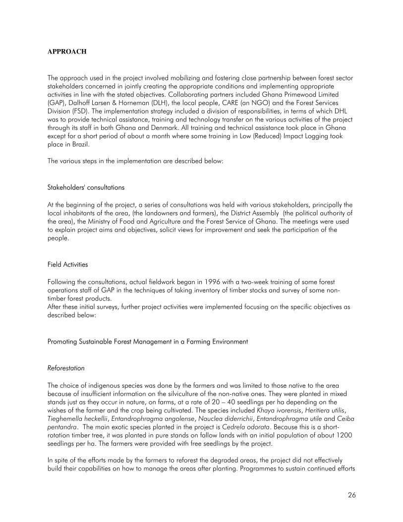
Picture 1: A View of the Degraded Area Before Rehabilitation OBJECTIVES The objectives of the project were:
• To determine underlying causes of degradation and the impact of degradation on the lives of the local communities;
• To establish, with the collaboration of local communities, demonstration plantations, which could serve as models in rehabilitating degraded forest lands;
• To determine the costs of establishment, maintenance and protection of plantations by the communities;
• To produce guidelines for use by other local communities. APPROACH Strategy The strategy used was to provide the local communities with the technical expertise and guidance to establish plantations in the degraded areas while at the same time eliciting from them their knowledge on degradation.

32
Plantation establishment was selected rather than natural regeneration because the degraded areas were characterised by nutrient-deficient soils, reduced primary productivity, and low biological diversity. Natural regeneration in such areas is therefore slow and cannot rapidly rehabilitate the areas within a timeframe compatible with short-term human needs. Artificial regeneration on the other hand is faster and can rehabilitate the degraded areas within a shorter period of time. Awareness Campaigns and Start-up Workshop Lack of communication between project planners, implementation agencies and communities ranks high as a major cause of failures in many projects. Policies and plans designed must always be clearly understood by community members and representatives so that they can be responsive to project needs and desires. Also, to ensure sustainability of rehabilitation efforts community management and community ownership must be the foundation upon which the project should be built. Consequently, the first major activity was the organisation of a start-up workshop organised in collaboration with the respective district assemblies to bring together all the stakeholders in the project within the communities. The workshop was designed to:
• Introduce the project to the communities;
• Ensure that all actors and stakeholders understood the project concept, the opportunities, limits and modalities, as well as the roles and responsibilities of the various actors;
• Enable the project team to capture preliminary data and information that would be useful for planning detailed field activities in connection with the project;
• Ensure agreement on subsequent activities and secure maximum co-operation from all stakeholders; and
• Determine how participation can be sustained throughout the project cycle. Activities The following two major activities were carried out in implementing the project: Activity 1
• Identify the major causes of land degradation and the most appropriate measures to address them, including species to be used for plantation establishment as well as appropriate methods of maintaining rehabilitated areas by local communities.

33
• Design and administer questionnaires and establish focus group discussions to elicit responses of the local communities on
o underlying causes of deforestation and degradation of forests near the communities,
o impact of degradation on the forests as well as on the livelihoods of the members of the
community,
o appropriate measures to be taken that would address the causes,
o indigenous species to be used for the rehabilitation of degraded areas by local communities,
o appropriate methods to be used to establish, protect and maintain plantations established in the degraded areas.
Activity 2
• Establish demonstration plantations in degraded forest areas with the active collaboration of local communities.
• Train local communities in:
o Production of planting materials (seedlings and vegetative propagation materials) of the
species they would use to rehabilitate the degraded areas,
o Site preparation for block planting, enrichment planting and taungya,
o Planting methods,
o Methods for assessment of survival and monitoring of growth and
o Methods for maintaining and protecting the planted areas.
They were then provided with logistics and technical advice to:
(i) propagate materials of the species that will be used to rehabilitate the degraded
areas,
(ii) prepare the sites for block planting, enrichment planting and taungya,
(iii) plant the prepared site with the propagated materials,
(iv) assess the planted materials for survival and monitor growth,
(v) protect the plantations from man, fire, animals, diseases and pests.

34
RESULTS Several perceptions of communities on the underlying causes of degradation and its impact on local communities were determined. Some of these included poverty, inequitable sharing of benefits from the timber royalties, non-involvement of local communities in forest resources policy formulation, as well as failure of the Forestry Commission to educate the local communities on current forest policies and legislation. Furthermore, the local communities were particularly aware of loss of non-timber forest products (NTFP), especially ''bushmeat", soil fertility loss leading to decreased crop yields, leading in turn to reduced income, reduced flow and sometimes complete drying up of streams and rivers. They also highlighted an increase in annual bush fires as result of increased growth of Chromolaena odorata and imperata grasses, which have more fuel load. Forest nurseries were established in all the local communities to produce seedlings for the plantation establishment and for sale to other agencies (Picture 2). Local communities have established about 100 ha of plantations interplanted with food crops. The plantation species were: Khaya ivorensis, Terminalia ivorensis, Terminalia superba, Entandrophragma utile, Khaya senegalensis as well as the exotic species Cedrela odorata. The food crops included plantain, yam, coco yam, cassava and vegetables (Picture 3)
Picture 2 - A Local Community Nursery, which Produces Seedlings for Plantation Establishment and for Sale.

35
Picture 3: A 2-year Old Plantation of Terminalia Superba Inter-cropped with Plantain that Has Been Established by a Local Community.
The local communities also indicated that their annual incomes have increased as a result of the sale of food crops from the plantations but that is yet to be confirmed by subsequent impact assessment studies. REASONS FOR SUCCESS/FAILURE AND LESSONS LEARNT
Success
The project succeeded mainly because:
• The project objectives were consistent with the needs and constraints of the local communities. Furthermore, these objectives, the project implementation processes and the expected benefits were clearly explained and understood by local communities.
• The local communities had a genuine interest in using their lands to produce both food crops and NTFPs. The project just provided a learning point into that dual need.
• The local communities benefited from the project, in terms of food, NTFPs and income generation.
• Appropriate incentives were provided to the local people within the project in the form of equipment (boots and cutlasses), which were needed to obtain their effective participation in the implementation activities.

36
Shortcomings Despite its significant success, the project registered a number of shortcomings which if addressed could have led to greater success. These include:
• The issue of who becomes responsible for the maintenance of the plantations after the farmer has left the areas where they are now operating to a new area. Likewise how the project can be sustained after ITTO funding has ceased has not yet been resolved.
• Lack of technical guidance when the communities need it as result of dependence on the services of part-time staff of the Forest Services Division to supervise community activities and provide technical advice. This demoralizes communities and retards efforts.
• Lack of documentation on the actual area planted by individual members of the communities and what their benefits from this will be.
• Lack of information on the optimum planting distances for trees and food crops to ensure maximum yield of food crops and optimum growth of trees.
• Lack of information on the socio-economic conditions of the participating communities and the impact the project is having on them.
Lessons Learnt
• Project start-up workshops are useful to ensure success of projects involving many partners, including local communities. Such workshops provide opportunities to discuss and clarify issues, which may compromise effective participation and commitment from all the actors, especially local people;
• The issues and arrangements to be discussed, clarified and agreed upon must include roles and responsibilities of each actor or partner, the concerns and needs of the local people who are the immediate beneficiaries, as well as benefit-sharing arrangements. Meeting some of these needs at the start of the project can stimulate effective participation from some actors (i.e., boots and cutlasses for the local people in this case study).
• Personnel supervising projects and providing technical advice should be full time so that they will be available when farmers and other local community members need them.
• Pre-project baseline data on local communities (socio-economic conditions) are important to fully assess project impacts later.
RECOMMENDATIONS Management Maintenance of project areas rehabilitated and how the project is to be sustained after donor funding ceases should be clearly be resolved at the beginning of the project.

37
A project should always have full time technical personnel who will always provide technical guidance at all times. Research Research should be initiated to determine:
• Appropriate planting distance for the taungya system to enhance productivity of both food and tree crop;
• How the taungya system could better contribute to poverty alleviation. Ex-post project impacts
assessment studies could be a starting point in investigating this.

38
HUMID FOREST ZONE CASE STUDY 3 Agricultural Reclamation of Nueng North Forest Reserve in the Western Region of Ghana1 BACKGROUND Neung North Forest Reserve lies at longitude 2º 30º 0’W and latitude 5º 20’ – 5º 30’ N located in the Wassa West District in the Western region of Ghana. The average annual rainfall is between 1700 – 2000 mm and the soils are of highly acidic latosols. These soils also contain deposits of gold and diamond, and the forest is of the wet evergreen type. Close to the forest reserve is the town of Agona Wassa, which has a population of about 3000 made up of two groups of people. The first group is the indigenous Wassa people, who constitute about a third of the population. This group is mostly subsistence farmers who farm in areas outside the forest reserves. The second group, the largest, is made up of migrants and consists mostly of young men and women of many other tribes (Ashantis, Fantes, Frafra’s Gas etc). These migrants came to the town to search for gold and diamonds in the Neung Forest Reserves. The modus operandi of the miners, all of whom were illegal, was to sneak out in the night into the reserve clear an area of all trees and shrubs and dig trenches some as deep as 10-12 metres and from these trenches collect the soil and pan for the minerals. As a result of the activities of these miners, the forest reserve has been significantly fragmented, with many deep trenches between patches. This type of mining activity was prevalent in many areas in Ghana. Consequently, the Ghana Mineral Commission, which has responsibility for all mining operations in Ghana, applied for a credit from the World Bank to pilot the reclamation of the degraded forest reserve with a view to transferring the technology and experience gained to other mining areas. The reclamation project was approved for two years and started in 2000 to close at the end of 2001. OBJECTIVES The objectives of the reclamation were:
• To return the degraded forest as closely as possible to its original status conforming to the landscape”.
• To increase the biodiversity as well as serve the economic and social benefit of the
community”. APPROACH The Mineral Commission designed the project and contracted its management out in two phases. The first phase was contracted to Messrs Nossoe Engineering Co. Ltd., an engineering firm with expertise in filling trenches outside forests. The contract involved trench filling by felling trees 1 Prepared by Dominic Blay (Forestry Research Institute of Ghana)

39
around the trenches, cutting them up into pieces and placing the pieces in the trenches until the trenches were filled up. The pieces of wood were then covered with sand. Thus, although the trenches were filled, they caused further degradation through the tree felling activities. The second phase was contracted to Arbor Nova, a Forestry consultancy firm, with the Forestry Research Institute of Ghana (FORIG) as a partner. This second contract consisted of planting trees in the trenched areas. It was only during this phase that the District Manager of the Forestry services Division at Tarkwa, who had oversight responsibility, was informed of the project. It was also during this phase that the chief of the town was fully briefed about the project. The activities conducted during the second phase consisted of:
• Digging holes of 500 x 500 x 600 mm in the filled trenches and filling these holes with organic matter at a rate of 5m³/ha;
• Planting of seedlings of the following indigenous species: Heriteria utilis, Nauclea
diderichii, Tieghemella heckelli, Entandrophagma utile, Khaya ivorensis and Terminalia ivorensis;
• Watering the seedlings until they were established;
• Spot weeding around the seedlings;
• Protecting the seedlings from fire by creating fire belts around the rehabilitated areas.
RESULTS The major achievement of this project was that 45 ha of degraded areas were rehabilitated with indigenous timber trees. The benefits from the trees to the local communities, however, will only be realized about 40 years later when the trees are harvested. The project saw very little involvement of local people since the contractor in the first phase brought most of its workers from outside the village and in the second phase only a few young men and women participated as hired labour. Furthermore, even when the project was going on in one part of the reserve, the illegal miners were operating at night in another section of the reserve. There has been a report that the miners went back to work in the rehabilitated areas after the project was over. The essence of the rehabilitation was to remedy forest fragmentation and achieve increased biodiversity as well as economic and social benefits to the local communities. This unfortunately has not been achieved, as illegal miners still operate in the reserve, including areas which have been rehabilitated.

40
REASONS FOR FAILURE This project has not been successful. Very little progress has been made in any of the two stated objectives. The following are some of the main reasons for the observed failure:
• The Mineral Commission designed the project without the involvement of other stakeholders especially the Forest Services Division, which had over-sight responsibility, and the chief and people of Agona Wassa who are the traditional owners of the Forest Reserve.
• There was no awareness creation among the citizenry of Agona Wassa on the impact of
the activities in the forest reserve. • The contractor hired to refill the trenches did not have the expertise to execute the job
correctly. • In the project design, there was no activity nor provision made for identifying the needs of
the local communities and for improving their socio-economic conditions through the project. Furthermore, no provisions were put in place to prevent illegal miners from returning to the forest reserve, thus to sustain the benefits from the project. No wonder illegal miners did not stop their activities during and after the project.
LESSONS LEARNT From this project, the following fundamental lessons are to be learnt for successful rehabilitation of degraded forest reserves:
• All stakeholders, including local communities, should be involved both in the planning and implementation of the project. The needs and aspirations of the forest fringe communities should be properly assessed and taken into account in project objectives.
• The project design should make provision for ensuring project sustainability through
preventive measures as well as through incentives to stop the people from repeating the activities responsible for the land degradation.
• Contractors or consultants employed to execute rehabilitation projects should be carefully
selected, matching their expertise with the tasks to be performed. RECOMMENDATIONS Policy
• The policy on mining in forested areas should make a provision for the development of sustainable livelihood programmes in fringe communities,

41
• Land-use policies that have been developed should be implemented in all forest communities,
Management
• Forest rehabilitation projects should be participatorily designed, with the involvement of all relevant stakeholders and experienced experts in degraded land rehabilitation.
• The Mineral Commission of Ghana should, in consultation with other land management
authorities, develop standardized methods of rehabilitating mining areas, as this type of degradation is now widespread in the country.
• There should be a start-up workshop involving all stakeholders before the rehabilitation
project begins, to discuss objectives, expected outputs, detailed activities to achieve the objectives, the role and responsibilities of every stakeholder, as well as requirements for effective enforcement of forest protection laws in the project area.
• The selection of contractors for projects should be done through competitive bidding,
which is open and transparent, so that the right contractor can be employed. Research
Research into the underlying factors for the degradation and ex-ante assessment of the impacts of the rehabilitation project should be carried out in order to identify socio-economic constraints, judiciously orient project objectives and activities and anticipate additional policy measures needed for the successful implementation and sustainability of the project.

42
SUB-HUMID ZONE CASE STUDY 1: Restoring the Vegetation and Improving the Livelihoods of the Kamba and Maasai People in Kenya1 BACKGROUND The Kamba people are found in south-eastern Kenya (latitude 37°47’E to 37°52’E and longitude 1°19’ S to 1°22’ S) whilst the Maasai are found mostly in southern Kenya (latitude 1o10’ to 3o10’S and longitude 36°5’ to 37°5’E). The region is characterized by low, unreliable and erratic rainfall. It has two rainfall seasons, which come from March to May (with a mean of 200 - 300 mm) and October to December (with a mean of 250 – 460 mm). Evapo-transpiration is high-ranging from 1550 to 2500 mm per year. Most of the land is between 500 and 1000 m in altitude with a number of hills, some reaching 1600 m above sea level. The mean temperatures range from 16 to 30OC. The soils are medium-textured ferrasols with the dominant type being moderately deep chromic luvisols. The vegetation is mainly dry woodlands and bushlands. The area has medium to low potential for plant growth. Over the last 100 years or so the region has continued to attract more people and especially during the last 50 years despite the fact that the region ranges from dry sub-humid to largely semi-arid in ecological conditions. The source of these migration inflows is the neighbouring high population density areas of Machakos District and Central Kenya. This pressure has led to continued degradation of vegetation, water and soils. Due to the evident degradation of the natural resources in the region, the Government of Kenya entered into a partnership with the Governments of Japan and Belgium to undertake a natural resource rehabilitation programme for the region. Two Ukambani Districts (Kitui and Makueni) and one division of neighbouring Kajiado District (predominantly Maasai) were identified as the focal areas of attention. Two formulation missions carried out in 1985 and 1995 found that the region experienced low farm income and inadequate food supply at household level because of various constraints. Rehabilitation of forest and tree resources was identified as a priority. But before a framework of development interventions was formulated, it was realized that the available technical tools and capacity for rehabilitation were inadequate. It was agreed that these shortcomings be addressed before a comprehensive rehabilitation action plan was adopted. The three governments, therefore, came up with a programme to perfect the tools of rehabilitation. OBJECTIVES The Overall Objective To improve the capacity of extension service and farmers in tree-based land restoration;
1 This case study has been compiled by Dr. B.N. Kigomo, Kenya Forestry Research Institute, P.O. Box 20412, 00200 City Square, Nairobi, Kenya.

43
Specific Objectives
• To train extension agents and farmers in dryland forest rehabilitation;
• To develop techniques for the restoration of degraded woodlands, soils and soil moisture regime; • To select, test and promote high value timber and food trees to fit into alternative-livelihood
commodity development options; and
• To develop Social Forestry Extension Model (SOFEM) for arid and semi-arid areas.
APPROACH A Social Forestry Training and Rehabilitation project for Semi Arid Areas (SOFEM) was thus initiated in 1985 in Kitui District and an Agroforestry project for Integrated Research and Development in Semi Arid Areas of Kenya (ARIDSAK) in Makueni and Kajiado Districts in 1997. Both projects adopted integrated and multi-disciplinary approaches involving all the stakeholders in the planning and implementation process. SOFEM is a bilateral project funded by the government of Kenya and Japan, implemented by the Kenya Forestry Research Institute (KEFRI) and the Forest Department (FD) on behalf of the Kenya Government and the Japanese International Co-operation Agency (JICA) on behalf of the Government of Japan. Staff from the above institutions work closely with selected core farmers, local groups and schools representing beneficiaries. ARIDSAK is also a bilateral project funded by the governments of Kenya and Belgium. The project involves KEFRI, the Kenya Agricultural Research Institute (KARI) and staff from the line Ministries of Environment and Natural Resources (Forest and Water Departments) and Agricultural and Rural Development providing subject matter specialists and selected farmers, local groups and schools representing beneficiaries. Phase I of SOFEM ended in November 2002, though various activities were still being undertaken by the government and communities beyond this date. Phase II of SOFEM was expected to start in the first quarter of 2004. Meanwhile, phase I of ARIDSAK is scheduled to end in 2005. The projects use a research and development approach on-station where technologies are developed and tested by subject matter specialists. Promising technologies are verified further under farmers’ conditions. Proven technologies are packaged in the form of extension materials for use by extension staff and farmers within the project areas. Through this approach, neighbouring farmers are expected to benefit through learning experiences of the core contact farmers. Other avenues for demonstration include greening and conservation of selected earth dams to reduce siltation. Meanwhile, capacity building through training is a major activity of the two projects. Results and experiences are extended to Eastern and Southern African countries through social forestry training.

44
RESULTS SOFEM Project Capacity Building in Dryland Forest Rehabilitation
• Courses on social forestry for dry areas focusing on farmers and extension frontline agents were conducted. Some 1400 national participants (farmers and extension frontline agents) had been trained on tree nursery techniques and management, tree establishment, protection and use by 1998.
• Regional courses on social forestry were conducted covering dryland tree technologies, extension
methodologies, policy formulation to promote social forestry in drylands and the role of forestry in enhancing conservation and mitigating desertification in the Eastern and Southern African region. One hundred and eighty participants from 18 countries (mostly extension staff from government and NGOs) in the region were trained in Social Forestry.
On-Farm Tree Planting and Extension Methodologies
Seedling propagation and management Ten commercial and 12 domestic small-scale nurseries were promoted in Kitui District, Ukambani. Women groups managed 70% of these nurseries while groups comprising both women and men managed the remaining 30%. The focus of promotion of tree nurseries included propagation and raising seedlings, tree planting in farms, and income generating opportunities. Nursery activities were promoted for ten years (1985-1995). In 2002, seven years after the formal intervention ceased, an evaluation was carried out, which revealed that although 25% of the contact groups had stopped nursery activities, some 18% of new groups had taken up nursery activities and there were more individuals, some who were part of the fall-out groups, had taken up small-scale tree nursery activities. But what is more interesting is the fact that the estimated total annual seedling production by small-scale nurseries had increased from 550,000 in 1993 to a total of 1,255,000 in 2002. In addition, among the seven income-generating activities of the women and combined groups, tree nursery activities moved from a general sixth position to third or fourth position in importance. Groups and individual nursery owners within the R & D farms in Kitui District obtained income from the sale of seedlings ranging from USD 900 to 2500 per year. The higher earners, especially individual nursery owners, got more income through sale of seedlings of grafted mangoes and in few cases citrus, which fetch two to three times the price of ungrafted seedlings.
Promotion of High Value Timber and Fruit Trees In addition to use of trees in rehabilitating degraded lands, a deliberate effort was made to select high value trees as an incentive to tree planting. Such trees included Melia volkensii (indigenous, fast growing and resistant to termites), Dalbergia melanoxylon (indigenous, slow growing but highly

45
valued for wood carving), Terminalia brownii (indigenous and favoured for its good form and resistance to termites), Senna siamea (exotic and popular for its fast growth and therefore quick provision of fuelwood), Mangifera indica (mango - a traditional domestic fruit tree), and Citrus sinensis (for its adaptability and fruits that generate good income). It has not been possible to get good estimates of the total area cover of these species in farmers’ land. It is however estimated roughly that during the last 7 or so years, M. volkensii has gained a collective area cover of about 65 ha, 6 ha for D. melanoxylon, 7 ha for S. siamea, 4 ha for T. brownii and over 65 ha for M. indica. The cover of the target timber and fruit tree species is likely to increase since awareness of the benefits of tree planting is high due to the promotional lobbying done by the projects.
Social Forestry Extension Model As a result of experience of social forestry and tree planting in the dry areas of Kitui District, a social forestry extension model was developed by the Kenya-Japan supported dryland initiative. In the model, results generated from research are verified under farmers’ conditions and, if proven, are packaged into extension material for use by frontline agents. The model also involves farmer-to-farmers extension where core farmers (i.e., those trained by the projects) are used as extension agents. It was expected that extension agents and farmers would benefit from the model. The SOFEM project proposed to develop appropriate guidelines for practical use of the various aspects of the extension model to be implemented in phase 2.
The ARIDSAK Project On-Farm Tree Planting and Extension Methodologies
Seedling propagation and management
• Twelve commercial and 20 domestic small-scale nurseries were promoted in Makueni District,
Ukambani and Kajiado District. Women groups managed 70% and 50% of these nurseries in Makueni and Kajiado while groups comprising both women and men managed 30% and 50% respectively. The focus of promotion of tree nurseries included propagation and raising of seedlings, tree planting in farms, and income generating opportunities.
• As in the SOFEM project the tree nurseries provided income to the groups and individuals owning them. Sales of planting stock often reached USD 2,500 annually and the highest priced items were, as before, fruit trees, especially grafted mangoes and occasionally citrus.
Tree Establishment and Management
The main constraint in dryland forestry practice is inadequacy of moisture to ensure establishment of seedlings. Four water conservation/harvesting methods were therefore widely tested and an evaluation of this effort indicated that the use of soil structures to concentrate water to the seedlings had been commonly adopted by over 40% of tree growing farmers. Use of terracottem (a water absorbing polymer), which had also been promoted, proved to be expensive for the small-scale farmers and generally beyond the means of subsistence farmers.
46
Natural Restoration of Degraded Woodlands
Due to over-exploitation of woodlands and especially overgrazing, charcoal production and firewood collection, recovery of vegetation becomes difficult and slow. Monitoring of recovery of woodlands was possible after an area had been excluded from grazing for a period of as short as one to two years. Seedlings of Commiphora, Terminalia and Acacia species regenerate immediately an area is excluded from animal grazing and since these are not browsed, the open areas are fast covered. The success of vegetation recovery after grazing exclusion is an initially quick re-establishment by a dense shrubby layer. The dominant species in the shrub layer are Hermannia oliveri, Aspilia mossambicensis, Solanum incanum, Chloris roxburghiana and Sporobolus fimbriatus. This layer creates a favourable condition for the quick establishment of drought woodland species dominated by Commiphora africana, Acacia senegal, A. tortilis, A. mellifera, A. brevispica and Terminalia brownii. Within two to four years some of the species grow to heights beyond the browsing level by goats. This was a successful approach that has been promoted in the Ukambani districts and is largely now being used by the animal range management farmers in the restoration of degraded woodlands and thus providing more foliage and tree raw materials for various and more sustainable uses by the land owners.
REASONS FOR SUCCESS/FAILURE AND LESSONS LEARNT
The main reasons that led to the success of the projects were:
• Collaborative planning including farmers, extension workers, experts in several areas and technical advisors;
• Continuous training, especially hands-on, in tree-based land use technologies;
• Low resource input by the government and the partners which motivated the farmers to keep adopting new ideas and technologies;
• Established parallel technology demonstrations located in the Dryland Technology Development Station of KEFRI in Kitui District. The demonstrations act as the learning points for farmers and school groups.
The reasons that contributed to lack of success included: • Inability of farmers to adopt introduced water absorbent material, e.g. terracottem due to cost,
therefore limiting good establishment of tree and fruit seedlings in the field where it was practised;
• Inadequate water, especially during the drier seasons, was a limiting factor in the adoption of recommended watering regimes for nursery seedlings by farmers.
47
RECOMMENDATIONS
Policy
The Social Forestry Extension Model recommended for scaling up will need to take into account farmers’ experiences from the non-project areas.
Management
Further training of farmers on grafting of high value fruit trees and nursery practices of problematic species like Melia volkensii and Terminalia brownii will be required to ensure successful orchards and woodlots.
Research • More work is still needed in the area of propagation (for some species) and silvicultural
management of all the identified tree species; and • Management of natural woodlands still requires further studies in the light of increasing human
populations in the drylands.
48
SUB-HUMID ZONE CASE STUDY 2 NGITILI: A Traditional Method of land Rehabilitation in Shinyanga Region, Tanzania. BACKGROUND Shinyanga region is situated in the north-western part of Tanzania, south of Lake Victoria at about latitude 2 - 5° S and longitude 31 - 35° E. The region has eight administrative districts and covers an area of 50,764 km2 of which 31,140 km2 is arable land, 12,079 km2 grazable land and 7,544 km2 forest reserves (HASHI 2002). The present population is about 2.6 million people and population density varies between 18 persons per km2 in Meatu District to 183 persons per km2 in Shinyanga Urban District with an average of 35 persons per km2 (HASHI 2002). Altitude varies between 1000 and 1500 m above sea level. Rainfall ranges between 650 - 1000 mm with a mean of 700 mm. Monthly temperatures vary between 27.6° C to 30.2° C maximum and 15° C and 18.3°0 C minimum. The region is characterised by small hills, separated by mbuga plains and gentle slopes. On hilltops, soils are moderately well drained greyish brown and sandy (ferric acrisols and oxisols). Moderately deep well drained, greyish brown sandy loams (ferric luvisols) occur on the slopes. On the low-lying bottom lands, are the poorly drained black clays –“mbugas” - (cambisols and vertisols). Vertic soils are very extensive covering 47% of all soil types in the region. Ecologically, Shinyanga region falls under the unimodal rainfall plateau. In this agro-ecological zone, a system of agro-pastoralism called ngitili is practised. Ngitili, which means leaving an area closed to allow grass regeneration for use during the dry season is an indigenous silvopastoral technology used to alleviate dry season fodder supply shortages, to conserve and protect soils and to reclaim degraded land (Kilahama 1994a, b, Maro 1995, Msangi 1995). Maize is the main food crop, followed by sorghum and rice, and cotton is the main cash crop. Livestock is an important component in the system; production is generally extensive, based on traditional communal grazing. Natural vegetation was originally woodland and bushland. However, due to severe deforestation, many areas turned treeless except for a few acacia and baobab trees. The vegetation has gradually reverted to an open bush savanna. In the past, the Shinyanga region had been extensively forested with woodland and bush land species such as Acacia, Brachystegia, Albizia, Commiphora and Dalbergia species. However, massive deforestation has taken place through shifting cultivation, tsetse fly and bird (principally Quelea quelea) eradication control campaigns in the early 1920s and 1930s. Most recently, extensive grazing has led to soil fertility decline and degradation with subsequent low crop yields, shortage of dry season fodder, scarcity of fuelwood and construction poles and severe wind and soil erosion (MNTE 1995). In 1986, because of the severe land degradation problems of the Shinyanga region, the Government of the United Republic of Tanzania started a land rehabilitation programme HASHI (In Kiswahili HASHI stands for: Hifadhi Ardhi Shinyanga i.e., Shinyanga Land Rehabilitation Programme) to rehabilitate the degraded areas. From 1991, HASHI started receiving financial support from the Government of the Royal Kingdom of Norway through the Norwegian Agency for Development Cooperation (NORAD). At the same time,

49
funding was also extended to agroforestry research in collaboration with the World Agroforestry Centre (ICRAF). HASHI worked in tandem and served as an extension arm of the HASHI/ICRAF research project by disseminating tested technologies such as management of woodlots and improved fallows. HASHI activities were phased out in 2002, and the respective Districts now handle all activities. OBJECTIVES The overall objective of the HASHI project was that “Communities in Shinyanga increasingly use sound practices and technologies to manage the natural resources on a sustainable basis”. This objective focused on the following key outputs:
• To secure increased awareness on natural resource management among actors;
• To articulate and implement improved land-use planning mechanisms and natural resource
management practices;
• To strengthen institutional capacity for extension, monitoring and evaluation. APPROACH HASHI collaborated with regional and district agricultural, natural resources and community development staff and the local communities, who are the main beneficiaries, to implement the project. The project gave emphasis to the re-establishment of Ngitili as well as other traditional natural resource management (NRM) techniques. Ngitili encompasses retaining of an area of standing hay until the rainy season ends, the area remains closed to livestock at the onset of the rainy season and is opened up at the peak of the dry season to allow the livestock get dry season fodder (Maro 1995, Mugasha et al. 1996). Grazing under ngitili normally starts from July/August after crop residues and forage in fallow areas have been depleted; and animals are removed from ngitili after all the fodder is exhausted or when fodder becomes available outside the ngitili (Kilahama 1994a, b, Otsyina and Asenga 1994). In order to achieve project objectives, various approaches and methods were employed aimed at greater participation of the community in every aspect of NRM. These approaches were: participatory rural appraisal (PRA), video and film shows, study visits, farmer to farmer visits, traditional dances (ngomas), theatre drama, publications (posters, newsletters, books), meetings, workshops, seminars, exhibitions, demonstration plots, youth camps and school excursions (HASHI 2002). The main activities included:
• Seedling production and tree planting, land reclamation and soil and water conservation. • Community participation and empowerment through training and awareness creation in adoption
of sound land use practises and capacity building.
• Promotion of indigenous natural resources management practices with emphasis on natural regeneration (in situ conservation - ngitili).

50
• Development of agroforestry systems (e.g. homestead, on-farm tree conservation and planting, boundary planting, fodder banks, improved fallows and rotational woodlots).
• Development of alternative forest uses and income generating activities through establishment of
“commercial” household tree nurseries, beekeeping and improved cook stoves. RESULTS Success Over the 15 years of the HASHI project in its different phases, significant progress has been recorded (Nshubemuki et al. 2003):
• Increasing environmental awareness among the Shinyanga communities, Government leadership, Non Governmental Organisations (NGOs), Community Based Organisations (CBOs), local institutions, schools and individual farmers.
• About 180 villages have been involved in management of fodder banks in terms of enclosures (ngitili) each with about 540 ha. About 70% of the households in the region have been able to re-establish their traditional ngitili system of land management covering over 350,000 ha with huge dividends both for the natural environment and the livelihood of the communities. This practice has begun to enhance land tenure and reduce the traditional conflict-prone free grazing. There has also been a spill-over into non-project areas as well as reactivation and strengthening of indigenous institutions as regards NRM and grazing (HASHI 2002).
• Homestead tree planting (mainly indigenous species) and management of scattered trees on farmland was also promoted where about 15 trees per ha were retained in 2002 as compared to 5 trees/ha in 1998.
• Promotion of community and private tree nursery establishment and eco-museum development. Eco-museum development involved documentation of indigenous technical knowledge.
• Training of over 3,000 people including community groups which included 30% women.
• Village Environmental Committees (VEC) were established and environmental conservation by-laws formulated both at village and district levels. The by-laws have facilitated control of overgrazing, encouraged fire protection, tree growing, tree harvesting and control of charcoal burning.
Shortcomings In the course of conceiving HASHI and implementation of planned interventions, some weaknesses were evident (Nshubemuki et. al. 2003):
• HASHI was traditionally planned as a central government project under the MNRT with very limited participation of the regional authorities and districts as well as other stakeholders in the region.
• The project lacked baseline studies.

51
• Limited extension staff has resulted in inadequate extension services in all parts of the region. REASONS FOR SUCCESS AND LESSONS LEARNT The success of the traditional ngitili system and other sound land use technologies in Shinyanga region can be attributed to awareness-raising, community participation and empowerment which resulted in re-establishment of this traditional land management and other land management systems. RECOMMENDATIONS Policy
Ngitili is a useful land use system, which needs to be scaled up to other districts of Shinyanga and other areas with similar ecological conditions. It is recommended that the policy makers put in place an enabling environment for wide scale adoption of the system.
Management
Communities should be trained in ngitili management to ensure adequate fodder availability.
Research
• The ngitili need to be improved to increase the availability of high quality dry season fodder and
wood based products. This can among others be achieved through: • Introduction of improved fodder grasses. • Planting of fast growing fodder trees and/or shrubs. • Determination of thinning regimes to encourage grass growth. • Impact of the ngitili system on the livelihood of local communities.
52
SUB-HUMID ZONE CASE STUDY 3 Successful Community-based Management of Duru-Haitemba Miombo Forest, Babati District, Northern Tanzania1
BACKGROUND
Duru-Haitemba forest is in Babati district (lat. 4°15’ S long. 35°45’ E, 1300 – 1800 m a. s. l.), Manyara region, northern Tanzania. The district has a total area of 6,069 km2. The Duru-Haitemba forest has a total area of about 6,968 ha and is surrounded by a total of 8 villages with a total population of about 20,000 people. Total district population is about 330,000 people with a growth rate of 3.8% per annum and a density of 54 people per km2.
Babati district is characterised by bi-modal and irregular rains ranging from 300 to 1200 mm per year with a mean of 790 mm per year. Mean annual temperature is about 23°C with a minimum of 18°C and a maximum of 28°C. Soils are vertisols or latosols.
The forest is dominated by Brachystegia microphylla, B. spiciformis, Julbernadia globiflora and some Albizia versicolor. The condition of the forest varies from more or less intact to severely degraded, with loss of canopy species and marked absence of young trees. Nonetheless, the forest remains important to the local community providing different items for household use, acting as a source of water and ensuring soil protection.
The main farming system is agro-silvo-pastoral. Livestock keeping is mainly extensive though there are some zero grazing and semi-intensive systems. Part of the grazing is done in the natural forest, which contributes to land degradation.
Before and during the colonial period, local leaders of the many hamlets scattered around and within the Duru-Haitemba forest exercised considerable control over the way the forest was used through traditional laws or rules. Some forests named Qaymanda for spiritual purposes were protected from any consumptive use. At least thirty such untouched forest patches remain operational in Duru-Haitemba forest today. With the establishment of village governments (1974), authority and control of the forest shifted into the hands of village government. Under village governments, new rules for forest resource utilization began to be made, and the need to get permission for certain uses was formalised.
In 1980, following establishment of District Councils, the forest was taken over by the Babati District Council. The withdrawal of authority from the local area appears to have much more dramatically weakened control and responsibility in regard to the forest than the case with the establishment of village government. The Babati District Council declared the forest a preserved area under the Local Government Act. During this period, there was increased degradation due human activities due . It was not until 1994 that a decision was reached to hand over the forest back to the villages. The Government with support from The Swedish International Development Agency (Sida), started a project to support the Duru-Haitemba communities to rehabilitate and sustainably manage the forest. 1 This case study has been compiled by S.A.O. Chamshama and J.B. Nduwayezu, based on work of Wily L., 1994.

53
OBJECTIVE Communities surrounding Duru-Haitemba forest rehabilitate and manage the natural resources on a sustainable basis.
APPROACH The main project strategy was to protect the forest from human and livestock impacts and allow natural regeneration. The following approaches were used:
• The District Forester with expert support held seminars and workshops with village and sub-village chairmen during which roles and responsibilities were assigned.
• The villagers were also assisted to draft by-laws and prepare management plans.
• The villagers formed village forest management resources committees to oversee implementation of the plans.
• Finally, forest guarding was actively instituted; involving selected young men in the community, thereafter exempted from providing other work inputs in the village, and “rewarded” with a share of the fine payments levied on offenders.
Partners in the project included the government (co-funding through provision of staff), Sida (financial support) and the local communities who were the main beneficiaries. RESULTS The five main results from the project are:
• Improvement in under-storey vegetation including useful trees and grasses,
• The return of bee swarms to the forest,
• Significant reduction in illegal activities,
• Increase in size of the forest, • Provision of incentive to the forest guards through share of income generated from
fines.
REASONS FOR SUCCESS AND LESSONS LEARNT The sense of ownership and control over the use and future of the resource by the communities has contributed to the sustainable management of the woodlands.

54
RECOMMENDATIONS Policy Based on the results of this case study, it is recommended that community-based management of forests be promoted in other areas. Management Communities should be provided with the capacity to prepare and implement management plans. Research
• Monitor flora and fauna changes over time following the management of the forests by communities.
• Study the impact of community forest management on the livelihoods of the people.

55
SUB-HUMID ZONE CASE STUDY 4 Land Rehabilitation by the Hado Project in Kondoa District, Dodoma Region, Tanzania1 BACKGROUND Dodoma region in central Tanzania extends between latitudes 4°49’ and 7°S and longitudes 35°55’ and 36°56’E. The region is approximately 43, 311 km2 in area and Kondoa district covers 14, 500 km2 of the region. Altitude ranges from 1650 - 2000 m above sea level with hills and escarpments separated by an expanse of flat or gently undulating land. The main soil types are ferric acrisols. The district is characterised by semi-arid to sub-humid conditions. The mean maximum and minimum temperatures are 29° C and 16° C respectively, and mean annual rainfall varies between 600 and 900 mm. Kondoa district has a population of about 400,000 inhabitants and a population density of 30 people per km2. The district has over ten ethnic groups with main activities ranging from crop production, livestock keeping, hunting and honey collection. Crop production and livestock keeping are the main economic activities. Various crops are grown both for subsistence and cash. The main crops are maize, finger millet, oil seeds, bulrush millet and sorghum. Other crops include beans, pigeon peas, groundnuts and sugar cane with sweet potatoes mainly grown on alluvial fans and close to drainage lines. Natural vegetation consists of miombo woodland, with Brachystegia being the most common woody genus. This vegetation has declined during the past century and often deteriorated into vegetation consisting mainly of thickets or widely spaced clumps of thorn bush with bare ground in between. The district is frequently cited as a classic example of severely degraded land due to deforestation caused by tsetse fly eradication programmes, shifting cultivation and overgrazing. The anti-tsetse campaign, which was initiated in 1927 and continued until 1949 to combat trypanosomiasis led to wholesale clearing of vegetation which resulted in long-term reduced vegetation cover. There were also other causes of deforestation, which included: shifting cultivation, overgrazing and uncontrolled fires. The British Colonial Government initiated some soil conservation measures from 1930 to the early 1950s. The measures proved unpopular because orders, regulations and restrictions pertaining to soil conservation seemed to be applied only to indigenous people (Mbegu, 1996). The political movements that came in the early 1950s made use of these discriminating policies to rally the support of the electorate against the colonial government. Consequently, all soil conservation measures were ignored, particularly after the attainment of independence in 1961 (Mbegu, 1996). Within the first decade after independence, the new government started to realise the damage caused by disregarding conservation measures. By-laws enacted by Kondoa District Council in 1968 to prohibit grazing, cultivation, digging water channels and cutting down trees without permission in the Kondoa Eroded Area (KEA) proved inadequate. As time passed the government realised that more concrete steps were needed to arrest the situation. Following recommendations of a study on soil erosion and degradation in Dodoma region carried out in 1972, the Government in 1973 started the land rehabilitation programme called HADO (HADO is a Swahili acronym for Hifadhi Ardhi Dodoma or Dodoma Land Rehabilitation Programme). 1 This case study has been compiled by S.A.O. Chamshama and J.B. Nduwayezu, based on works as referenced herein.

56
OBJECTIVES The objectives of the project were:
• To ensure that the people in Dodoma Region are self-sufficient in wood requirements.
• To encourage communal wood-growing schemes in the region.
• To promote communal bee keeping and other income generating activities.
• To encourage the establishment of shelter belts, windbreaks, shade trees, avenues and fruit tree
growing.
• To conserve soil and water and to reclaim depleted land. APPROACH The project partners were: Ministry of Natural Resources and Tourism (main implementing agency) and the Swedish International Development Agency for financial support. The approach was top-down with little real participation of the local people in planning and implementing project activities. The main rehabilitation technique used here was soil and water conservation, using physical structures and trees, shrubs and grass planting for soil stabilization. The main project activities included:
• Using heavy machinery and manual labour to construct contour bunds and tie-ridges to control movement of water over the soil surface;
• Stabilization of bunds using grasses, shrubs and trees;
• Construction of stabilization structures across medium-sized gullies using earth and stones;
• Construction of earth and stone check dams;
• Development of tree and horticultural nurseries for raising seedlings for planting in demonstration plots and for distribution to communities;
• De-stocking of livestock in severely eroded and overgrazed areas;
• Awareness creation and training on forestry and soil and water conservation measures.

57
RESULTS Success During the first ten years of the project (1973-1983), the following results were achieved (Mbegu and Mlenge, 1983):
• A total of 11,368 ha of degraded/eroded area were rehabilitated by bunding.
• About 126,600 ha were rehabilitated after closure to grazing.
• About 2,630 ha of woodlot demonstration plots were established.
• About 14,020,000 tree and fruit seedlings were raised and out of these 3,350,000 seedlings were distributed to villages, schools, institutions and individuals.
• Increased spring discharges to streams due to increased soil moisture recharge and increased wild animals within the rehabilitated area.
During the second phase (1984-1993), the following results were recorded (Mbegu 1996):
• About 14 million seedlings were raised by the project, 80% of which were distributed to villages and institutions.
• About 646,000 seedlings were raised by individuals, villages, schools and institutions.
• About 370 ha of woodlots demonstration plots were established.
• A total of 18 ha of agroforestry demonstration plots were established by the project.
• About 650,000 m of contour ridges were planted with elephant grass (Pennisetum purpureum).
• About 14,333 m of contour bunds were constructed on degraded lands.
• About 371,331 m of cut-off drains were constructed.
• About 40 ha of fodder multiplication plots were established.
• About 1,800 people (farmers, village, ward and divisional leaders, school teachers, councillors, district and regional leaders and land management technical staff) were trained in soil and water conservation measures.
• Village environmental committees were formed in 79 villages.

58
Shortcomings
• The programme used a top-down approach without community involvement in planning and implementation.
• A multi-disciplinary approach was not used so forestry technical staff did all rehabilitation work.
• No baseline study was carried out at the beginning of the project. Consequently there is no basis for comparison.
REASONS FOR SUCCESS/FAILURE AND LESSONS LEARNT Despite the indicated achievements, this project is considered a failure for two reasons:
• The top-down approach used; and
• The very limited participation by local communities and lack of awareness-raising, resulting in
communities continuing to use unsustainable practices after the project ended. RECOMMENDATIONS Policy
• Participatory mechanisms involving all relevant stakeholders, including local communities, should
be put in place.
• The project should be mainstreamed into the District Development Plans.
Management Awareness-raising on the causes and consequences of land degradation and training on sustainable land use practices should be continued.
Research
• Determination of appropriate agroforestry technologies for fodder production and soil fertility improvement.
• Impact assessment of the rehabilitation on vegetation and soil fertility.

59
SUB-HUMID ZONE CASE STUDY 5 Community Efforts at Rehabilitating Degraded Lands in the Upper East Region of Ghana1 BACKGROUND
The communities of Wulungu, Naabari, Namoranteng, and Degare lie at longitude. 1º 30’ -1º 45 W and latitude 10º 30’ – 10º 45' N and have a total population of about 2,000. These communities are very close to Bolgatanga, the capital of the Upper East savanna region of Ghana. The average annual rainfall is about 900 -1,200 mm. and the topography is generally flat, or with a few gentle slopes. The soils are of the ochrosol type belonging to the family of Latosols and are generally coarse-textured and of high to medium fertility, being derived predominantly from igneous rocks. The vegetation is Guinea Savanna woodland made up of widely-spaced deciduous trees, characteristically Shea (Vitellaria paradoxa), Dawadawa (Parkia biglobosa) and Baobab (Adansonia digitata) as the main natural economic species. Other dominant trees are Azadirachta indica, Combretum spp., Acacia spp., Afzelia Africana, Pterocarpus erinaceus, Detarium microcarpum and Terminalia avicennoides. Crop farming together with livestock production constitute the principal economically viable occupation of the majority of the adult population. The collection and selling of firewood, as well as the production of charcoal represent the second major economic activity in these communities. About 35% of the charcoal and firewood supplied to Bolgatanga come from these areas. The women are particularly dependent on these activities as sources of revenue. The remaining 65% of the charcoal and firewood supplied to the city of Bolgatanga come from the forest reserves and off reserve areas in the region. Consequently, these forests in the area are highly degraded due to a high incidence of annual bush fires, overexploitation of tree resources, unsustainable farming practices and overgrazing. The degradation therefore makes the supply of the wood-energy unsustainable and negatively affects the livelihoods of the local people. Thus the Ghana Government, with financial support from the Danish Development Agency (DANIDA), established the Traditional Energy Unit (TEU) under the Savanna Resources Management Project of the Ministry of Lands and Forestry in order to ensure an adequate supply of wood-energy through the sustainable management of the savanna woodlands. OBJECTIVES Developmental Objective The development objective of the project was to ensure the conservation and community-based integrated management of the savanna woodlands for the supply of fuelwood, through efficient marketing fair pricing, equitable distribution of revenues, and efficient utilization of fuelwood. 1 Prepared by Dominic Blay and Issacc Abebreseh (Forestry Research Institute of Ghana)
60
Specific Objectives The specific objectives of the project were:
• To develop the capacity of the traditional energy sub-sector in sustainable management techniques;
• To enhance the sustainable management of the resource base; and
• To improve wood fuel marketing, revenue generation and equitable sharing. APPROACH The partners of the project were the Danish Development Agency (DANIDA), which provided funding through the Ministries of Mines and Energy (MME) and Lands and Forestry (MLF); the Forest Services Division (FSD), which provided technical services and manpower; the local Communities, which implemented field activities, and the Bolgatanga District Assembly, which assisted with facilitation. The approach was entirely participatory. Members of the community were involved in problem identification, needs assessment and the designing of appropriate interventions. A working group from MME and the FSD held discussions with the whole community. This working group together with some youth and elders of the community undertook a walk through the farms, degraded farmlands, forest areas, and charcoal producing areas and water sources around the community. Proposed sites for the community reserve and woodlots were selected with the involvement of chiefs, Tendanas, elders, farmers, Magazias, women opinion leaders, traders, unit committee members, assemblymen, wood-fuel producers and youth leaders. An open forum was then held at which the objective and strategies of the traditional energy project was explained and clarification sought by community members. Several environmental, economic and social problems were identified, which helped refine project objectives. The community then agreed to release part of its relic forest for conservation and management. A committee was formed to assist in the implementation of the project. The TEU then identified eight woodland reserves to be piloted for harvesting of wood-fuels and prepared management plans to guide harvesting. The project started in 2000 and ended in 2003. RESULTS General Results Include the Following:
• A good number of people in the communities were trained and organized into 11 Natural Resources Management Committees (CONARs) to represent the communities in all matters related

61
to traditional energy planning, natural forest management (on and off-reserve) and wood-lot establishment and maintenance. The CONARs acted as the mouthpiece for the pilot community and a link between the TEU, FSD, District Assembly and the entire community. The CONARs mobilized the rest of the communities to plant trees, patrol the forest reserves, enact and enforce bye-laws and to guide natural resource management and utilization in the respective communities. However, the CONARs were often challenged by some community members who did not recognize the legality of the authority of these committees.
• Up to 11 fire prevention squads were formed, trained and equipped to educate the general
communities in simple fire management techniques and in understanding the negative effects of repeated bush fires.
• Specific results with regard to off-reserve management activities, woodlot establishment, and the
implementation of management plans, are presented below. Off-reserve Management About 3,600 ha of woodlands outside the reserves were surveyed, mapped, inventoried and reserved by the pilot communities for future production of wood-fuels. The communities formulated local rules and regulations based on traditional norms and values to manage the demarcated areas. The rules and regulations encompassed access to land, rights and responsibilities, bushfire management, harvesting of trees, species protection and unauthorized encroachment and as a result the vegetation in the forest has increased. (compare Pictures 1 and 2)
Picture 1 A Degraded Community Woodland Picture 2: Community Woodland Reserve –
Before the Project 2 Years After Reservation Establishment of Community Woodlots A total of 70 ha of woodlots was established under the project, using indigenous species to rehabilitate degraded woodlands and provide alternative sources of fuelwood and income for the communities. These community woodlots were planted on communal lands donated by the Tindana, the spiritual landowner, whose powers are being challenged in recent years; some of them leading to conflicts. Many in the communities were reluctant to work on the communal woodlots because the boots and cutlasses promised to them by the project were never delivered.
62
As a result of the above two difficulties, the concept of private woodlots emerged strongly during the second year of the project. Many privately owned woodlots were established by individuals and groups of individuals. Implementation of Management Plans The implementation of the harvesting schedules, detailed in the management plans, were fraught with difficulties, as the local communities did not understand them. REASONS FOR SUCCESS The project was however quite successful, as many of the objectives pursued were largely achieved. Reasons for the success include the following:
• A participatory planning process involving all stakeholders was followed;
• Enactment of community by-laws;
• Formation of implementation and surveillance committees by the local community. SHORTCOMINGS The success of the project was however less spectacular due to the following obstacles:
• The issue of land ownership was not explicitly addressed. This limited private initiatives in woodlot establishment and management;
• Multi-purpose use of the reserve was not fully explored during the participatory planning phase. This contributed in part to the difficulties in implementing the harvesting schedules drawn up within the management plans.
• The management plan was more on the technical aspects and ignored the economic and social perspectives. This also contributed to the difficulties in implementation.
• Unfulfilled promises on incentives (boots and cutlasses) coupled with a lack of clear policy and legal backing at the national level to community institutional initiatives also added to the difficulties and conflicts with local law enforcement committees.
63
LESSONS LEARNT A number of interesting lessons derive from this case study, including the following:
• A natural process of recovery can be an effective option for rehabilitation of degraded lands
• Land and tree ownership issues need to be resolved beforehand to avoid conflicts.
• Without policy and legal backing at either the district or national level, community-based initiatives are not easy to be implemented.
• Without delivering on promises to local communities, the motivation to work on community projects by local communities is reduced.
• Participatory planning is essential to successful project implementation. However such planning should consider all issues, technical, socio-economic and cultural, which have some bearing on the project and should involve all stakeholders.
RECOMMENDATIONS Policy
• A clear-cut policy on community forest reservation and management must be put in place to give
legal backing to community initiatives.
• The issue of land ownership should also be resolved through an open forum. Management
• Planning for rehabilitation of degraded lands should be holistic and should involve all stakeholders and address major issues which could limit successful implementation of project activities.
• A multi-purpose land use approach should be used in managing degraded forests.
Research
Studies should be conducted on natural processes of recovery to determine recruitment of species, composition and structure of the vegetation at different stages of recovery, the impacts of these on the soil and the phenology of the different plant species.

64
DRYLAND ZONE CASE STUDY 1 Community Resources Management by the Elangata Wuas Ecosystem Management Programme, Kajiado District, Kenya1. Note: KES denotes Kenya shillings/KSh BACKGROUND
This is a case study of the Kenyan Maasai people living in Kajiado District (Latitude 1o10’ to 3o10’S and Longitude 36o5’ to 37o5‘E) whose pastoral lifestyle has been curtailed since the coming of the colonial government to the present day. First, their movement was restricted south of the Uganda railway line in 1912 leading to a heavy loss of prime pasture land including dry season grazing areas, salt licks and watering points. Nomadic pastoralism was perceived then as a retrogressive land use system and a major cause of land degradation. In the early 1960s, the government of Kenya introduced a group ranch strategy as an alternative mode of land use in dryland areas, further restricting movement of the communities. In the programme area, three group ranches comprising 160,000 ha were created: Elangata Wuas, Kilonito and Torosei. Today, the area is home to about 10,000 persons and 27,500 head of cattle representing an overstocking rate of about 90%. Rainfall is typical of the semi-arid areas and ranges between 450-800 mm with an average of 600 mm. Low lying areas (under which most of the project falls) experiences lower average rainfall. Soils are generally variable with vertisols and luvisols being most common. Vegetation is mainly Acacia-commiphora bushland and grasslands. Main tree and shrub species are Adansonia digitata, Acacia and Commiphora spp. Common perennial grasses include Cenchrus ciliaris, Chloris roxburghiana and Eragrostis superba.
The main economic activity of the Maasai communities remains cattle raising but in a semi-nomadic and semi-sedentary system. However, with further sub-division of group ranches and allocation of parcels of land to individual holdings, the traditional livestock grazing patterns have been constrained and more so, in the absence of proven alternative land use technologies. This has led to heavy degradation of the natural resource base, particularly the pastures, soil and water. Besides these bio-physical forms of land degradation, lack of experience and know-how among the communities to engage in benign management practices and technologies, including coping mechanisms under the new land use systems has led to growing poverty, loss of livestock, rising unemployment and declining health. The women, old people and the youth are shouldering the bulk of the burden. The Elangata Wuas Ecosystem Management Programme (EWEMP) was formulated to address some of these problems.
1 This case study has been compiled by Dr J. A. Odera, Programme Coordinator, Elangata Wuas Management Programme, National Museums of Kenya, P.O Box 45547, Nairobi, Kenya.
65
OBJECTIVE EWEMP’s broad objective is to develop methodologies for sustainable management of natural resources, rehabilitation of degraded sites, diversification of income generation, and an acceleration of transition into the cash economy for improved community livelihood. APPROACH The Elangata Wuas Ecosystem Management Programme (EWEMP) is a partnership between the community in the Central Division of Kajiado District, the Centre for Biodiversity of the National Museums of Kenya (NMK) and the Kenya Wildlife Services (KWS). EWEMP was initiated in 1992 through discussions between the NMK and the KWS with the Elangata Wuas, Kilonito and Torosei communities in Kajiado District. Following a protracted planning and design process, EWEMP initiated pioneering field activities in 1998, and has subsequently strengthened promising ones from 2001. The Ford Foundation funds the programme with co-funding from the International Development Research Centre of Canada (IDRC). The project is on-going. The programme’s approach is based on building a participatory partnership that places people and their needs at the centre of natural resource management (NRM) for sustainable development. RESULTS During the last six years the programme has achieved the following results: Building a Community Based Organization and Governance Structures The programme has developed a Community-Based Organization (CBO) with a strong local foundation. It provides sensitisation, mobilization, recruitment, empowerment and capacity building to the CBO to enable it undertake all local development programmes and sustainable management of resources to generate income for members. Experiences gained so far show that the grounding of a credible CBO is contingent on establishment of a grass-root structure with legitimacy and recognition from stakeholders, and respect from the community. The members are concerned about transparency, accountability and equitable distribution of benefits. It is only through assuring resource ownership by the community and equitable access to benefits that the participation of the community can be assured. Woodland Management This is one of the promising and key micro-enterprises in the programme area. The programme has developed relevant databases on the woody resource that allows low impact off-take practice under a prescribed system of criteria and indicators for sustainable management. The members of the woodland micro-enterprise have developed a mini co-operative whose members practice a 15-year felling cycle for charcoal production. Each member produces 10 bags of charcoal monthly that she/he delivers to a sale

66
yard from where it is marketed to charcoal dealers at negotiated unit prices. The micro-enterprise is managed by rules and guidelines developed and enforced by its members. Currently members earn about KES 3000 (USD 40) per month from charcoal production. Consumptive and Non-consumptive Utilization of Wildlife The community is adamant that wildlife, which shares their land with livestock should justify its existence by providing some benefits to them. Further, the programme recognizes that wildlife management and conservation depends on information on its numbers, distribution dynamics and the state of the range and the co-operation of the land-owners. In this regard, factors influencing species abundance such as increases in human and livestock population and the peoples’ attitude have been discussed and noted. The programme has explored opportunities for generating income from wildlife and eco-tourism such as wildlife cropping, ostrich husbandry, beekeeping, filming, bird-shooting, home stays and cultural exchange. To date the community has established a wildlife utilization committee with representation from all stakeholders in the group ranch, and has been trained in animal scouting, population assessment and tour guiding. The committee is, however, still waiting for the government’s guidelines on cropping and the inauguration of the micro-enterprise. Eco-tourism The programme has established a base camp with satellite camping sites and a network of recreational activities as a nucleus for its eco-tourism micro-enterprise. Since the launching of the eco-tourism micro-enterprise over one year ago, over 500 visitors have visited the area as individuals and organized groups from institutions, as nature lovers, researchers, or on learning/training missions, using the programme’s facilities. The community earned over KES1 million (USD 13,333) from its eco-tourism micro-enterprise during 2000. Ostrich Husbandry by Pastoralists Experiences from ostrich husbandry show that the community is able to produce birds cheaply for meat and breeding at a cost of KES 4,000 (USD 53.3) per bird, over a period of 25 to 30 months. The birds are herded with sheep and goats at no extra cost and fetch between KES 10,000 (USD 133.3) and 20,000 (USD 266.7) each. By contrast, a mature bird fetches KES 75,000 (USD 1,000) in the export market. Prevailing poor market structure and lack of a clear government policy on ostrich production remain serious constraints to the development of this micro-enterprise. In the year 2000, the 12 participating community members earned KES 20,0000 (USD 2,666.7) from the sale of 23 month old ostriches. Beekeeping This activity has attracted 20 farmers all of whom have adopted Kenya top bar hives. The programme runs a nucleus production unit at the base camp and provides participating families with backup training and hive management, harvesting and honey processing. Each farmer harvests 10-15kg of honey, two to three times a year, with 1 kg of honey fetching KES 250.00 (USD 3.3).

67
Sustainable Use of the Sand Resources Sand harvesting along the River Toroka has become an important source of income. The area is readily accessible to lorries particularly during the wet season when roads to other sand producing areas are impassable. This has led to heavy and non-sustainable off-take of building sand. On realizing that heavy sand harvesting affects ground water levels and hence negatively impacts on the wells downstream, the community decided to carry out a study to:
• Determine the volume of sand resources in a specified area along the river; the characteristics of the sand beds, the seasonal variation in the water table and the effect of sand harvesting on the water levels on the wells along the river bed;
• Evaluate the general condition of groundwater along the Toroka River so as to identify sites for
drilling boreholes to supplement existing water supplies; carry out a monitoring of sand harvesting intensity and natural sand recharge rates, and fluctuations in the levels of aquifers in the area, and hence generate basic data for building a Geographical Information System (GIS) for further rigorous analysis, modelling and generating land-use information.
Available information shows that about 400,000 tons of sand can be harvested per year from the river segment under the study sustainably. This is valued at KES 20 million (USD 267,000) of which KES19 million (USD 253,000) should go to the community. Pasture Rehabilitation The results of assessment of the state of pasture had revealed that overgrazing pressure in the area over the last two decades or so have contributed to marked degradation of the vegetation and the ecosystem in general. Successive trampling and selective grazing has subsequently led to dominance of unpalatable species of forbs and grasses, and invasion of weeds and woody plants. This has concomitantly led to a reduction in the population of palatable woody plants, perennial forbs and grasses and an expansion of annual species. To reverse this trend the programme embarked on assessing the effectiveness of promising low cost technologies for mitigating the state of land degradation. The results of investigations carried out so far show that exclusion of grazing pressure, supported by erection of physical structures through construction of cascades of pits, a matrix of pegs drilled on the ground on the eroded surfaces across the contours, a series of stones and brush wood arranged across run-off channels, and broadcasting seeds of prime browse grasses such as Digitera macroblaphara, Pennisetum strameineum, Sporobolus pellicidus, and Dactyloctenium aegyptium seeds before the rain, have given promising intervention points. The physical structures trap excessive water run-off thereby enhancing infiltration and promoting healing of degraded sites. But it is critical to exclude the affected areas from grazing during treatment. A second major initiative began with exploring cost-effective techniques for rehabilitation and sustaining the pasture potentials in wooded areas. The opening up of the wood-encroached sites was taken together with low impact harvesting for biomass production. Managed removal of materials for fuelwood production makes possible a gradual opening up of the wooded areas and in time allows regeneration of prime browse perennial grasses.

68
Women in Development A total of 10 women groups, registered with the Ministry of Culture and Social Services are operating in the area. The women groups have excelled in managing income-generating activities. The programme supports and empowers them through training on product development and quality control in making artefacts and handicrafts. The women are currently earning an average of KES 800 monthly on an investment of about one hour per day working four to five days per week. Lately they have also been involved in vegetable production using drip irrigation. REASONS FOR SUCCESS AND LESSONS LEARNT The main reasons leading to the success of the project include:
• Project planning is based entirely on local resource base and needs;
• Project activities are tailored to fit, as much as possible, the traditional and cultural values of the Maasai community;
• Project implementation has adopted the traditional structure of the Maasai Community
governance, respecting also the gender roles;
• Consistent capacity building in CBO involved in the project;
• Need driven supportive research has redirected the development strategies and technical requirements for success;
• Financial inputs to the Project have been minimised to increase the capacity of Maasai
communities to contribute to their commitments;
• The Project has adopted a strategy of cost sharing, both financial and in-kind, where financial inputs by local communities will increase with time through the generated revenue and thus ensure sustainability of the activities in future.
RECOMMENDATIONS Policy This programme demonstrates a fully integrated natural resource management initiative in the drylands and useful learning points, especially with regard to wildlife. It is recommended that the government put in place enabling policy in support of community participation in wildlife management.

69
Management The CBO and governance structure being established is a useful organ for empowering the community in sustainable management of the natural resources. Its organization and strengthening need to be finalized during the current phase of the project. Research Further studies are still needed in sustainable woodland management, building on criteria and indicators already developed and community management of wildlife resources including marketing and benefit sharing.

70
DRYLAND ZONE CASE STUDY 2 Rehabilitation of Degraded Lands in the Lake Chad Basin1 BACKGROUND The location of the project is Maroua, Northern Cameroon, with a population of about 100,000 people, a mean annual rainfall of about 700 mm/year and an altitude of about 300 m above sea level. The soils of the area are mainly vertisols and the vegetation is of the sudano-sahelian savannah type with Acacia spp. as the predominant species. Crops (mainly the coarse grains - sorghum and millet) and livestock farming are the predominant activities. The pre-project survey estimated that some 13% of the total land area of the Maroua region was degraded due mainly to mechanized cotton mono-cropping by hundreds of local farmers with fertilizer inputs supplied by the cotton industry (SODECOTON). Other causes were shifting cultivation; overgrazing; over-harvesting of fuelwood; uncontrolled forest fires, and high population pressure (see figure 1). OBJECTIVES This pilot study pursued the following two objectives:
• To rehabilitate the degraded areas to make them productive;
• To demonstrate restoration techniques to the local communities. APPROACH The executing agency of the project was IRAD (Development-oriented Agricultural Research Institute). Project partners were of two types: active partners (administrative and local authorities) and passive partners (local farmers, who participated in the project only as hired labour). The approach, used to conduct the study, combined water-harvesting techniques with agroforestry. The following five water-harvesting techniques were used:
1) Small dams (4x4m, 15 cm high)
2) Half-moon (20 cm wide and 20 cm deep);
3) Zai method (1.5 cm long, 30 cm wide and 30 cm deep)
1 This case study has been compiled by Dr. Eyog-Matig, Coordinator, IPGRI/SAFORGEN, c/o IITA 08 BP 0932 Cotonou, Benin.

71
4) Ploughing with bulldozer (40 cm deep);
5) Planting holes (40x40 and 40 cm deep). (See Picture 1) Agroforestry techniques involved the following two groups of tree species planted at a spacing of 4x4 m:
(a) Exotic Species
• Azadirachta indica (for fuelwood, medicinal, pesticidal usage)
• Eucalyptus camadulensis (for poles, and fuelwood); and
• Dalbergia sissoo (for fodder)
Picture 1: Making Planting Holes in a Degraded Land Area in Need of Rehabilitation
(b) Indigenous Species
• Acacia nilotica (for tannins and fuelwood)

72
• Acacia senegal (for gum arabic, fuelwood and fodder); and
• Sclerocarya birrea (for wild fruits). PROJECT INPUTS Human and financial inputs were also used in the project.
• The human inputs included (a) a research team composed of soil scientists, foresters, hydrologists, and social scientists; (b) local farmers used mainly as hired labour.
• The financial inputs included the costs of preparation and establishment of the different
techniques: o Ploughing with bulldozer at USD 384 /ha;
o Small dams at USD 268/ha;
o Zai method at USD 317/ha;
o Half-moon at USD 217/ha;
o Planting holes at USD 134/ha.
RESULTS
After two years of rehabilitation work, the project site is now in a much better position of recovery as indicated by Picture 2. One could measure the improvement in the site by comparing the severely degraded site as seen in Picture 1 with Picture 2. Four years later, further improvement in the project site is observed as pictured on Picture 3.
Picture 2: A View of the Project Site after 2 Years of Rehabilitation Work

73
The survival of different tree species varied considerably. Indigenous species (Table 1) were more tolerant to drought (see percentage of survival of species established in planting holes) than exotic species. Exotic species showed faster growth, which seemed to stabilize 4-5 years after planting. Thinning exotic species after 4 or 5 years seemed best to boost their growth. Local species showed a slow but extended growth period. The evidence indicates that farmers can use both exotic and indigenous tree species in addressing their wood need strategies. Early-maturing exotic species could be harvested for poles and firewood, while local species are conserved and harvested later for fruit, timber and other purposes.
Table 1: Growth (in cm) and Survival (%) of Selected Tree Species after 4.5 Years of Planting Soil Preparation Regimes Species Ploughing with
bulldozer Small dams Ploughing with
hoe Planting hole
Azadirachta indica 358 cm; 80% 392 cm; 80% 434 cm; 80% 314 cm; 58% Acacia nilotica ssp. astringens
295 cm; 91% 328 cm; 94% 360 cm; 96% 207 cm; 77%
Dalbergia sissoo 426 cm; 65% 416 cm; 64% 455 cm; 45% 336 cm; 32% Sclerocarya birrea 233 cm; 91% 216 cm; 96% 207 cm; 87% 138 cm; 89%
Source: Jean M. Harmand. 1993. BFT Cah. Sc. N°11 Acacia senegal (see Table 2) confirms the tolerance of indigenous tree species to drought. The survival of the species is not significantly different from one treatment to the other. But the microcatchments put in place with various methods to reduce runoff and to increase water storage for the benefit of the trees, have significantly increased the growth of these trees.
Table 2: Performance of Acacia Senegal after 4.5 Years of Planting under the Different Treatments.
Treatments Survival rate (%) Growth (cm) Cost (USD)/ha Zai method 88 295a 317 Small dams 88 280b 268 Half-moon 88 280b 217 Planting holes 82 230c 134
Source: Harmand, BFT Cah.Sc. N°11, 1993. Note: Growth rates followed by the same alphabetic letter are not significantly different at the 95% level. Table 5 shows that an investment of 62 % above the cost of creating a planting hole only increases the growth rate of the species by 22 %. Whether this return (growth rate) warrants the additional investment is yet to be determined and whether the costs of the treatments under farmers’ conditions would be different from the ones indicated here is another issue to be resolved by future investigations.
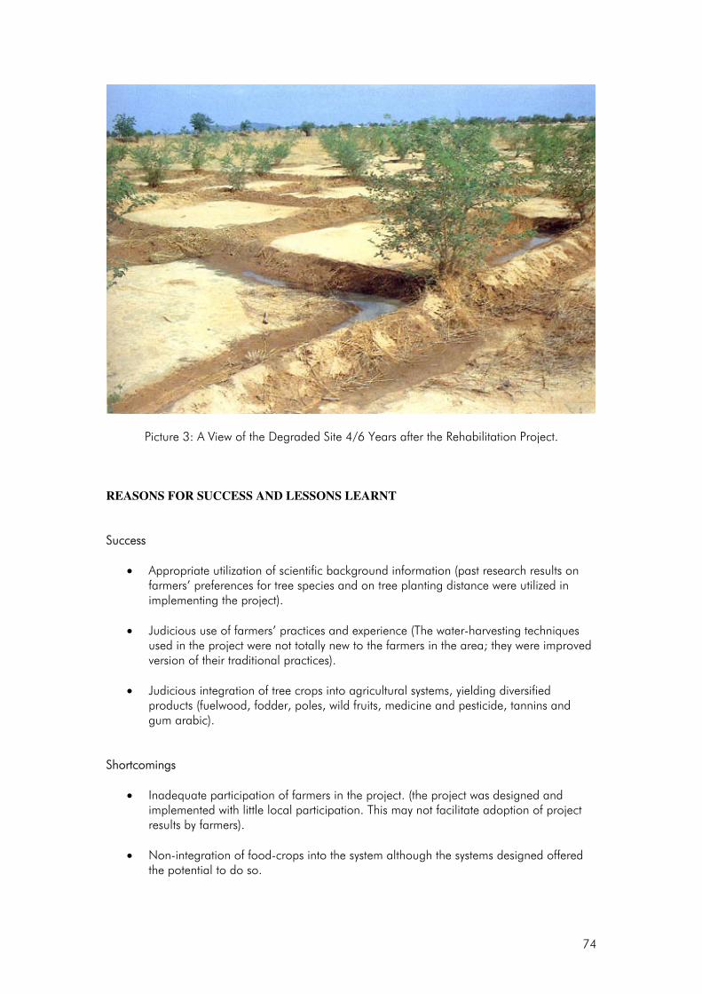
74
Picture 3: A View of the Degraded Site 4/6 Years after the Rehabilitation Project.
REASONS FOR SUCCESS AND LESSONS LEARNT Success
• Appropriate utilization of scientific background information (past research results on farmers’ preferences for tree species and on tree planting distance were utilized in implementing the project).
• Judicious use of farmers’ practices and experience (The water-harvesting techniques
used in the project were not totally new to the farmers in the area; they were improved version of their traditional practices).
• Judicious integration of tree crops into agricultural systems, yielding diversified products (fuelwood, fodder, poles, wild fruits, medicine and pesticide, tannins and gum arabic).
Shortcomings
• Inadequate participation of farmers in the project. (the project was designed and implemented with little local participation. This may not facilitate adoption of project results by farmers).
• Non-integration of food-crops into the system although the systems designed offered
the potential to do so.

75
• The trials covered a small land area (the associated costs might have been significantly reduced if a wider area had been covered, using machines such as bulldozers and agricultural tractors for land preparation).
RECOMMENDATIONS
Policy • Political support from public and local authorities is essential for smooth
implementation and success of the project;
• Land tenure should be clearly resolved for greater adoption and sustainability.
Management • Participatory processes should be adopted in project planning and implementation to
ensure increased local support and project sustainability;
• Extension services should be associated with the project to ensure timely dissemination of project results.
Research Topics
• Economic and technical feasibility of the system at farm level;
• Alternative and cheaper water-harvesting techniques;
• Identificaton and design of the best agrofroestry practices to improve the existing framing system (studies on alternative useful tree species, micro-catchment design, compatibility of food crops and tree species).

76
DRYLAND ZONE CASE STUDY 3 Enclosures as a Tool for Rehabilitating Degraded Woodlands of Ethiopia1 BACKGROUND Deforestation has been a major national problem in Ethiopia for many years. At the close of the twentieth century, the country found itself experiencing very rapid deforestation through forest clearance for crop cultivation, unsustainable wood exploitation for lumber and wood-fuel, overgrazing and also wars and civil unrest. The severely degraded lands are typically characterised by heavily eroded or nutrient deficient soils, hydrological instability, reduced primary productivity and low biological diversity (Verma et al., 1999) and these are common phenomena in the dry areas of Ethiopia. Most of these degraded areas have been under great pressure for a long time, to the extent that they have been changed into wastelands. Thus, at present, remnant forests, woodlands or shrub lands have become restricted to inaccessible areas such as hillsides, mountain tops and around churches, monasteries, mosques or graveyards, particularly in the northern parts of the country (EFAP, 1994). Past reforestation and afforestation programs in the degraded areas have often been unsuccessful with no or very low survival of the planted trees. Factors such as unavailability or low availability of propagules, low soil nutrient availability, absence of fungal and/or bacterial root symbionts or unsuitability of the microhabitats for plant establishment in general and seasonal drought have been identified as major reasons for program failures (Verma et al., 1999). As part of their fight against land degradation, communities have started establishing enclosures, with the hope of preventing further degradation and promoting their re-vegetation. The main objective of establishing such enclosures is to improve the overall ecological conditions of degraded areas so that they can provide better socio-economic benefits and environmental services to the local communities. In this regard, it has become a common phenomenon to observe increase of plant as well as animal biodiversity with time after the establishment of enclosures. In areas where they have been established, particularly in the northern parts of the country, enclosures are among the green spots with considerable species diversity (Tefera et al., 2003; Tesfaye, 2002; Emiru, 2002; Kidane, 2002). Establishing enclosures is considered advantageous since it is a quick, cheap and lenient method for the rehabilitation of degraded lands (Bendz, 1986). Despite the fact that enclosures have proved instrumental in the re-vegetation and rehabilitation of degraded lands, knowledge on the diversity, sources of propagules and status of regeneration of the developing flora as well as the actual and potential socio-economic benefits that can be derived from such enclosures is lacking. Hence before a nationwide action plan use of enclosures as a tool of rehabilitation of dry areas was adopted, investigation on their viabilities and potential was urged. This project was conducted in ‘Aynalem Tabia’ within Wukro Woreda situated 30 km north of Mekelle, in the Eastern Zone of the Tigray National Regional State (TNRS), north-eastern Ethiopia. Aynalem Tabia is a 1 This case study has been compiled by Emiru Birhanea, Demel Teketaya and Pia Barklundb
a Ethiopian Agricultural Research Organization, P. O. Box 2003, Addis Ababa, Ethiopia;
b ICRAF, Nairobi, Kenya

77
dry area with an average annual rainfall ranging from 390 to 410 mm, although variability of rainfall from year to year is very considerable. The rainy season is mainly between June and September. The average annual temperature at the study site ranges from 15 to 18° C. The area has an altitude that ranges from 1900 to 2200 m and slope that ranges between 05-20%. The study area has a very interesting history. Key informants of the area reported that the area was covered with a forest, mainly of big Acacia etbaica trees, until the invasion of Ethiopia by Italy in 1935. The area is known by the name ‘Ziban Serawat’, which refers to an area covered with A. etbaica trees. After the invasion, the Italian soldiers are reported to have cut the big trees and transported them on big lorries to Wukro town for fuel to process lime. According to the local people, most of the trees were uprooted, but those that were not uprooted coppiced vigorously. The coppice was devastated again after the First Tigray Peoples Liberation Front Movement failed in 1948. After the proclamation of land by the Socialist Government of Ethiopia in 1975, the area was converted into farmland. It was also reported that the area had been put under different land uses since 1993 when the 58 ha of land was enclosed for protection while the other 52 ha of land was left aside to serve as grazing land. The livelihood of the local people depends on subsistence farming, in which livestock husbandry and crop production play a major role. Almost all the population in Aynalem Tabia depends on agriculture and the dominant farming system is highland mixed farming. Land degradation combined with high population pressure and large livestock populations is a severe constraint to the farming system and livestock productivity is very low. OBJECTIVES The general objective of this study was “to investigate the role of enclosures in the rehabilitation of degraded drylands focusing on their potential socio-economic and environmental benefits to the society”. Specific objectives included:
• Studying the diversity, i.e., species richness and evenness, of woody plants; • Investigating the soil seed bank as a possible indicator of actual or potential source of propagules
for the developing flora; • Assessing the regeneration status of some selected woody species; • Investigating perceptions of the adjacent communities on the actual and potential socio-economic
and environmental benefits of degraded lands rehabilitation; • Formulating recommendations that would assist in the further development, management and
sustainable utilization of enclosures.

78
APPROACH The project was carried out by the government of Ethiopia (through the Ethiopian Agricultural Research Organization), the Swedish International Development Agency (for partial funding) and the local community. The site covered a total area of 7,133 ha. The study site had 1,800 households, of which 500 inhabited the actual study area known as ‘Hawza Kushet’. The total population in the study area was 3,000. In Hawza Kushet two sites of similar characteristics were selected for the study at a locality known as ‘Ziban Serawat’. One of the sites, covering a total area of 58 ha, had been enclosed for eight years while the other site, covering a total area of 52 ha, had been used for grazing. The following vegetation parameters were assessed:
• Species richness, abundance, density and diversity; • Regeneration status and ground cover; • Soil seed banks; • Socio-economic survey based on 50 households from a list of 500.
RESULTS Species Richness, Abundance, Density and Diversity The total number of woody plant species recorded in the study area, in both the enclosure and open grazing area, was 39, among which 31 were naturally growing species and eight were planted. In the enclosure 27 plant species representing 18 families were recorded. Out of the total woody species encountered in the study quadrants, 37% were trees and 52% shrubs. In the open grazing area, 14 species were recorded representing 12 families. Here, trees constituted 50% of the total woody species and shrubs 50%. In both land uses, more than half of the density, i.e. 64% in the enclosure and 60% in the open area, was contributed by only one species, namely A. etbaica, which had also the highest (100%) frequency. The species is four times more abundant in the enclosure than in the open area. The importance value index, basal area (BA) and density are also higher for this species in both land uses and is greater by all factors in the enclosure than the open area. The BA of all woody plants with their diameter greater than 2.5 cm was 21.96 m2/ha for the enclosure and 9.6 m2/ha for the open area. The BA in the enclosure exhibited a sort of normal distribution while in the open area most of the BA was concentrated around the higher diameter classes. Most of the woody species had a BA of less than 5 m2/ha both in the enclosure and open area. Acacia etbaica, Euclea schimperi, Aloe berhana, Lucas oligocephala, Carissa edulis and Oncoba spinosa were the first six most important dominant woody species in the enclosure reflected by their Importance Value Indices. Similarly, in the open area, Acacia etbaica, Euclea schimperi, and Lucas oligocephala were the most important dominant woody species. The difference between the enclosure and open area in terms of their number of species and ground cover could be attributed to the high level of interference both by humans and animals in the open area. The open area is used to collect wood and non-wood products for household consumption, to dig out stone for
79
construction and for grazing by domestic animals. There was a higher proportion of shrubs in the enclosure than in the open area, which was rather dominated by trees, suggesting that there is also an active succession taking place in the enclosure, i.e., high woody plant recruitment. Regeneration Status and Ground Cover When the diameter classes of all woody species were analysed together, the enclosure showed a more or less inverted J - shaped frequency distribution with abundant individuals at the lower diameter classes but declining numbers of individuals as the diameter classes increased, suggesting good regeneration status. The proportions of seedlings, saplings and trees were 59.8%, 20.7% and 19%, respectively. At the species level, the most abundant species, namely A. etbaica, exhibited an inverted J - shaped frequency distribution of its diameter classes with about 50% of its individuals less than 5 cm in diameter. Conversely, Euclea racemosa showed a relatively hampered regeneration. In the open area, although the diameter classes exhibited a more or less inverted J - shaped frequency distribution, Acacia etbaica, Euclea racemosa and Maytenus senegalensis showed hampered regeneration. The proportion of seedlings, saplings and trees were 27%, 58% and 15%, respectively indicating lower numbers of individuals both at the lower and higher diameter classes. The high proportion of seedlings in the enclosure, which is an indicator of recruitment of the plants through germination, implies the existence of a good potential for the restoration of woody communities. However, the same species exhibited lower proportions of seedlings in the open area than the enclosure indicating the impact from human and animal interference on their regeneration. Soil Seed Bank About 29 and 23 herbaceous species were recovered from the top nine centimetres of soil samples collected in the enclosure and open area, respectively. The total numbers of viable seeds recovered both from sieving and incubation of the soil samples were 1663 and 924, corresponding to densities of about 1479 and 1354 seeds/ m2 in the enclosure and the open area, respectively. Both the number of species and densities of seeds decreased with increasing depth in both land uses. Socio-economic Settings The male and female individuals accounted for 92 and 8%, respectively. The family size of the households in the study area ranged between 3-7 people. There is a high level of illiteracy, which is attributed to the prevalent subsistence farming. About 90% of the respondents had land ranging between 0.5 and 1 ha, and the remaining landless people, most of whom are married, live with and depend on their parents. Attitude, Perception and Awareness of the Local People Most of the informants in the study area had positive attitudes towards enclosures. All respondents in the village regarded the enclosure as a source of feed for their cattle and gave higher aesthetic value to the enclosure. About 71% of the residents near the enclosure supported further conservation of the enclosure while 29% of them preferred to use the enclosure for their immediate needs. The major reasons given for the need to use the enclosure were inability of the people to afford other forms of energy and shortage of grazing land since 78% of the respondents owned livestock for farming, draught, dung, milk and social

80
security. The majority of respondents did not have any other source of feed in bad seasons except the enclosure. All respondents agreed on the need for the bylaws and guarding, especially to protect the enclosures from damage by straying domestic animals. However, all the respondents expressed their strong desire for the amendment of the operational bylaws, which they felt should include provisions for carefully planned utilization of enclosures, e.g. through controlled livestock grazing in drought periods, as was done in 1996 and the collection of dead and live wood, etc. REASONS FOR SUCCESS AND LESSONS LEARNT Reasons for success and lessons learnt include:
• Integration of indigenous knowledge in the implementation of the project;
• Low funding requirement to carry out and complete the project;
• Involvement of local communities and extension service in determining the solutions on enclosures and the way forward;
• The highly scientific manner followed in carrying out the study has led to generation of valuable quantitative data on enclosures.
RECOMMENDATIONS Policy Full involvement of the local community during planning and initial support to community members is necessary for the success of enclosures as a rehabilitation strategy. Management Since participation of the local communities is the key to success in any community-based development and conservation effort, it is recommended that identification and delineation of areas for establishing enclosures together with their subsequent management, conservation and sustainable utilization; formulation, development and implementation of bylaws should be undertaken in close consultation and active participation of the communities concerned. It is particularly important that there should be equitable sharing mechanisms of both costs and benefits among members of the communities. Other factors to be taken into account include a balanced focus on protection and utilization of the enclosures as well as decisions on the level of punishment fines; and the identification, development and implementation of appropriate and viable management options for the actively developing or already rehabilitated enclosures.

81
Research and Training Exploration and introduction of affordable alternative sources of household energy and construction material are recommended to relieve the pressure from the local people on the enclosures. Formal and informal training for the local people is still needed on the ecological and socio-economic importance of enclosures. This has the ultimate aim of enhancing their awareness, which, in turn, is vital in ensuring the long term desired management, conservation and sustainable utilization of enclosures.

82
DRYLAND ZONE CASE STUDY 4 Community-based Rehabilitation of the Nazinon Forest in Burkina Faso1 BACKGROUND The Nazinon reserved forest (11°30’ - 11°51’ north latitude and 1°27 ’- 1°50’ west longitude) is a gazetted forest covering 32,000 ha in the tree savanna zone of southern Burkina Faso. The forest is located at an altitude of about 300 m on leached ferruginous soils with patches of indurate pans. Rainfall is unimodal with an annual average of 800 mm concentrated during a short period of four months from June to September. Average temperature is 33°C. Natural vegetation is tree savanna. Dominant tree species are Vitellaria paradoxa, Detarium microcarpum, and various species of Acacia, Lannea and Combretum. Dominant grass species are Loudetia togoensis, Pennisetum pedicellatum, and Andropogon spp. Surrounding communities, estimated to be in excess of 21,000 people, are increasingly encroaching on the forest through human settlements, crop fields and pastoral activities (year-round grazing by resident livestock and seasonal incursions by transhumant pastoralists during the dry season). In addition, the Nazinon forest has increasingly become the main source of fuelwood in the region after uncontrolled cutting depleted other sources of supply in the immediate vicinity of the capital city. In 1985, a project on fuelwood production identified the Nazinon forest in which to experiment a newly developed approach to natural forest management in Burkina Faso. OBJECTIVES The Nazinon Forest Rehabilitation Project was launched with the following objectives:
• To manage the forest for fuelwood production;
• To generate revenues from the sale of fuelwood;
• To empower local communities for effective participation in forest rehabilitation activities.
1 This case study has been compiled by Dr. Edouard G. Bonkoungou on the basis of the following two sources:
• Bellefontaine R, A. Gaston and Y .Petrucci. 2000. Management of Natural Forests of Dry Tropical Zones. FAO Conservation Guide N°32, Rome, 225 – 242;
• Kaboré, C. 2002. Aménagement des forêts du Sahel. Point sur vingt années de pratiques au Burkina Faso. Direction Générale des Eaux et Forêts, Ouagadougou.

83
APPROACH Key project partners are the communities of surrounding villages, the Forest Service, professional fuelwood traders, and transhumant pastoralists. Other partners are UNDP for financial support and FAO for technical assistance. Local communities are responsible for marketing fuelwood collected from the forest either as deadwood or logged wood. They also provide labour for field operations, direct seeding and other forest regeneration activities, opening up of firebreaks, logging, etc. The Forest Service provides technical expertise in forest regeneration, logging techniques and other silvicultural operations. The forest area deemed appropriate for silvopastoral management (23,700 ha) was partitioned into 8 management units 2,000 to 4,000 ha each, using aerial photographs at scale 1:20,000. Boundary strips of management units were 8m wide. Using a 20 year rotation plan, each management unit was subdivided into 20 logging compartments and assigned for field operations to one or several villages based on proximity, number of volunteers, and inter-village cooperation. In addition to land preparation for silvicultural operations (boundary lanes, skid roads and firebreaks), various surveys were conducted to collect socio-economic information on surrounding villages in connexion with the participatory approach adopted by the project. Main activities of the project are:
• Regeneration of forest cover using the following techniques:
o Enrichment by direct seeding. This option was adopted because of its low cost and also because it uses the same techniques and tools that are used locally by farmers for sowing cereals in crop fields;
o Protection of regenerants (seedlings, root suckers and stump sprouts) from bush fires and
livestock damage.
• Selective cutting to preserve species and individual stems for which the ecological and/or economic benefits are perceived to be higher than the market value of their firewood.
• Integration of pastoral activities in management plans to take into account other land use systems
that are important to local communities. The approach used is known as controlled grazing and consists of opening the forest to grazing during the rainy season in July and August with the following restrictions:
o Forest compartments which have been logged are excluded from grazing for at least 18
months;
o Grazed compartments are rotated to reduce risks of overgrazing;
o Lopping of fodder trees is not permitted.
The rationale for controlled grazing is that livestock, which is a major component of the rural economy in the Nazinon area, will benefit from pastures inside the forest. In turn, reduction of grass cover due to grazing will reduce the risks of severe bush fires.

84
• Marketing of fuelwood and sharing of revenues. Dead wood and logged wood from the forest is
sold to wood traders who buy it at forest gate. Sharing of revenues has been negotiated among stakeholders to cover remuneration of labour for field operations, and to establish a common fund to meet collective needs in the villages, as well as a forest fund to cover recurrent costs of the project.
• Institutional building and empowerment of local communities. The project assisted the
communities of surrounding villages to organize themselves into pre-cooperative groups known as forest management groups. These groups have full responsibility for wood marketing. Group members were given training in basic literacy as well as in field techniques in forestry and livestock production.
RESULTS Success Considerable forest seed collection and direct seeding operations to regenerate the forest have been achieved: some 3,500 kg of tree seed was collected annually by local populations (especially women) from trees indigenous to the region; The regeneration potential of the forest is now well documented. The density of juvenile plants in logged compartments is high (more than 2,500 stems/ha), although very variable (range=1,600 to 3,600 stems/ha). It is difficult in many cases to separate true seedlings from root suckers, but the contribution of the direct seeding operations to forest regeneration appears to be considerable and is being investigated. Species response to logging has been documented. Based on stump vigour (survival rate, number and size of stump sprouts), the following have been identified as the top 10 species with highest regeneration potential: Terminalia avicennoides, Detarium microcarpum, Piliostigma reticulatum, Entada africana, Burkea africana, Strychnos spinosa, Combretum glutinosum, Terminalia macroptera, Vitellaria paradoxa, and Gardenia erubescens. Fuelwood collection and marketing has generated substantial revenues. A volume of 500,000 steres has so far been collected and sold for 800 million CFA francs. A revenue sharing mechanism has been agreed among stakeholders to benefit local communities, the Government, and a forest management fund to cover project recurrent costs in anticipation of the end of external support. Participation of local communities: Village communities have been organised into pre-cooperative groups known as Forest Management Groups: 26 such groups are currently in existence, up from 9 groups in 1987. These groups now provide employment not only for casual labour, but also professional staff, including forest ingenieurs. Capacity building: 2,696 members of the Forest Management Groups have been trained in basic literacy and in silvopastoral field techniques, exceeding the project initial objective of 1,574 persons to be trained. In 1992, the project built a vocational training centre to sustain the capacity building effort.

85
Shortcomings
• The pastoral component failed to achieve any tangible result. Pastoralists did not comply with either the agreed levels of carrying capacity or the rules on controlled grazing.
• Control of bush fires has proved far more difficult than anticipated mainly because opening of
firebreaks and implementation of prescribed early burning activities coincide with intensive labour demand for crops.
• The training centre lacks resources and is momentarily closed.
REASONS FOR SUCCESS/FAILURES AND LESSONS LEARNT Reasons for Success
• Very favourable political and policy environment (the Government of Burkina Faso took a decision in 1985 to combat uncontrolled wood cutting and also adopted a forest policy to manage natural forests for fuelwood production);
• The Project’s emphasis on income generation and revenue sharing;
• Empowerment of local communities;
• A strong component of capacity building. Reasons for Failures
• Pastoral component very weak
• Resources generated from the sale of fuelwood are not sufficient for proper maintenance of skid roads and firebreaks
RECOMMENDATIONS Policy The forest management fund still awaits official recognition. Otherwise, the policy environment is good. Management
• The pastoral component needs to be re-diagnosed and re-designed;
86
• Revenue generation activities need to look beyond fuelwood; non-timber forest products should be given serious consideration;
• Re-opening the training centre should be supported; Research More research is needed on:
• The rotation period of 20 years: there are suggestions to shorten the period to 15 years but supporting data is missing.
• Information on the ecological dynamics after logging, grazing, or burning is currently limited and weak.

87
DRYLAND ZONE CASE STUDY 5 Participatory Extension Strategies for Promoting Agroforestry in the Drylands of West Pokot District, Kenya1 BACKGROUND The Pokot people are a community inhabiting the West Pokot District (latitude 10o7’ to 20o49’N and longitude 34o47’ to 35o49’E) and northern parts of Baringo District in North-Western Kenya. West Pokot District is largely a dryland area experiencing erratic climatic conditions and difficult terrain. Annual rainfall varies from less than 400 mm in the lower areas (1150-2000 m altitude) to slightly over 1500 mm in the high altitude areas (2439-3370 m altitude). Unreliability and variability are more considerable in the lower altitude drier areas. Soils in the low lying areas are generally poorly drained clays with occasional hard pans. The dominant vegetation is Acacia-commiphora woodland. Traditionally, the Pokot people are nomadic pastoralists whose lifestyle is rapidly changing to sedentary mixed farming, especially in areas where conditions are favourable. Like many other semi-arid parts of the country, the area has been experiencing a population increase both human and livestock. The climatic conditions, terrain and traditional lifestyle practised are not compatible with increasing population in terms of sustainable resource management and use. The area is prone to periodic droughts accompanied by famine and poverty and land degradation is evident over most places further threatening the livelihoods of the people. The Vi-Agroforestry project was established to address the issue of land degradation through agroforestry interventions. The project was started in 1983 and is on-going. OBJECTIVES The overall objective is to contribute towards better living standards of the small-scale farmers in the project areas (i.e., farmers who own at least 0.4 to 2.5 hectares of land and are fully dependent on their farms on a daily basis). The specific objectives of the Vi-Agroforestry project were:
• Increased food security,
• Improved nutritional security,
1 This case study has been compiled by the Project Manager, Vi-Agroforestry Project, P.O. Box 2006, Kitale, Kenya.

88
• Increased fuel wood availability, and
• Increased income generation. APPROACH Project partners include the Vi-planaterar Träd Foundation, an International NGO with headquarters in Stockholm, Sweden (which funds the Vi-Agroforestry programme), relevant government ministries (for further technical support) and local communities who are the main beneficiaries. The programme began by carrying out a survey of the Kainuk area, along the Wei-Wei River and in Chepareria Division, which revealed the loss of both soil and vegetation. The seasonal rivers were an unreliable water source and surface sealing, soil erosion, and loss of useful trees and shrubs, annual grasses and less productive species in the area as well as deep gullies were common. The situation constituted a threat to both human and livestock movement. Conservation and rehabilitation by planting trees on the large bare patches was considered as an immediate way of solving or arresting the problem. The project also involved socio-economic measures on how land can be utilized optimally. During the initial stages of implementation, the Project had some difficulties in gaining acceptance from the community, especially with regard to some of the technologies like enclosures given past experience where the government used such approaches to acquire land. To overcome this challenge, the project identified representative public institutions; schools and churches that had suffered degradation and established enclosures there. The project did all the work, paying all costs. After some time these sites recovered and were used as demonstrations for the local community. On observing the regeneration and rehabilitation of the land within the enclosures, some pastoralists volunteered a portion of their land for rehabilitation activities. On realizing the benefits, their fears were removed and more came to request the project for assistance while others spontaneously established their own pasture enclosures. The project applied the principal of participatory extension that involves the following stages: Participatory Rural Appraisal (PRA) The project assists the community to identify or diagnose their own problems and seek possible solutions to address them. PRAs are based on the real needs and within the capacity and skills of the community and their local institutions, assist the community in the implementation of the plan with either technical advice or other forms of support. PRA was used in a broader scope as the project’s entry point to make community members decide and analyse their own problems and identify their own resources for solving them. This promotes farmer participation in the development of agroforestry. The awareness created enables the communities to develop their own community action plans, addressing different sectors of development. Community Action Plan (CAP) The community’s needs and priorities were prepared in the form of a CAP for implementation. The implementation was at two levels - through groups or individuals. The group approach was more common

89
i.e., a group of farmers is identified on the basis of established groups. The extension workers enter into discussion with the groups over the agroforestry activities to be undertaken, get targets per agreed activities, discuss inputs and agree on the role the group will play in the provision of required input. They also monitor implementation. The same procedure is applied to individual farmers who for one reason or another cannot join a group. To ensure that a given area was properly covered, the project adopted an Area of Concentration Approach (AoCA). In this approach the project extension agent was stationed in an area of concentration where he/she progressively and intensively worked with 200-350 farmers for a period of 3-5 years depending on the community response. At this point the community would have been empowered to sustain various agroforestry activities on their own. The extension officer then moved to a new area, and constant follow-ups were frequently made in the old areas to establish their progress. Apart from establishment of enclosures and construction of water catchment structures for land rehabilitation, the project identified and tested other technologies for good land use management practices. These included:
• Soil fertility improvement based on the principle of organic farming (tree/crop residues, farm yard manure or promotion of short term fallows).
• Local seed collection and tree management.
• Woodland management,
• Apiculture (bee keeping) promoted alongside tree planting and woodland management. Field demonstrations, short courses and related activities were offered to improve the farmers’ capacities in sustainable management. Training activities included field days, farmers study tours, especially to the project’s Agroforestry Centre as a model and to other successful farmers and relevant institutions. Basic nursery and agriculture courses as well as advanced agroforestry training activities were also offered. The aim of the wide range of training activities offered was to enhance human resource development and ensure the project’s efficiency. Farmers were trained on agroforestry practices, direct sowing techniques, organic farming, farm planning, home tree nursery establishment and seed collection. RESULTS By 2001, the project had worked with 25,000 farmers (comprising around 6,500 households) who had acquired knowledge and skills in agroforestry. A total of 168 home nurseries produced 7,643 seedlings in W. Pokot while 5 group nurseries in Kongelai produced about 6,300 seedlings. A total of 127 farmers in Chepareria were involved in the collection and use of seeds. There were 45 soil and water conservation demonstration plots and 4,025 ditches in Kongelai and 1,000 metres of retention ditches constructed in Chepareria. Both indigenous and exotic tree species were used in the rehabilitated areas. Among the exotic species doing well in the area are: Senna siamea, Azadirachta indica (neem), Leucaena leucocephala and Parkinsonia aculeata. However, indigenous species predominate, the major ones being: Acacia nilotica, A. tortilis, Faidherbia albida, Balanites aegyptiaca, Terminalia brownii and Zizyphus macronata.

90
The enclosure system has had great impact on:
• Land tenure and value. Land tenure is slowly changing from communal to individual ownership and hence raising the value of the land. Some farmers are now selling grass to their neighbours for thatching which has led to better housing and rental of pasture (improved animal health) to earn income.
• Reduced migration in search of grazing and hence families are now staying together for a longer time; there has been improved enrolment in schools, improved pasture and animal health.
• Increased food production as more land is now under crops. Maize, beans, sorghum, millet and other new crops like cassava, pigeon peas, green gram, kales and an assortment of fruits e.g. paw paw, bananas, guavas and mangoes are cultivated.
• Changes in roles within families e.g. women assist in herding due to availability of fodder near homes, the presence of men in the homes provides extra labour, leading to diversification and expansion of the cropped area. Due to increased milk production and commercialisation, men are now involved in milking which was exclusively a woman’s job. House construction, previously a woman’s responsibility is now almost entirely taken over by men.
• Tree planting and management has greatly improved since the seedlings are now more protected in the enclosures, especially during the cropping period.
REASONS FOR SUCCESS AND LESSONS LEARNT The following are considered as reasons for the recorded success in the project:
• Participatory problem analysis through the PRA methodology;
• Integrated problem solving focusing on farmers and pastoralists’ priorities;
• Recognition of gender roles and agreeing on adoption of beneficial values to overcome changing social needs and challenges;
• Capacity improvement of local farmers and pastoralists in team building and simple resource management technologies and methodologies.
RECOMMENDATIONS Policy The project’s approach of improving land value and hence influencing tenure at local level is a useful learning point which policy makers should build upon.

91
Management The extension approach being used (AoCA) should be scaled up to other similar areas in the district. Research There exist other valuable dryland rehabilitation techniques, which could be tested in the area to complement the ones being used. The rate of rehabilitation using the enclosure system needs to be determined.

92
DRYLAND ZONE CASE STUDY 6 Land Rehabilitation through Participatory Soil and Water Conservation in the Yatenga Region, Burkina Faso1 BACKGROUND The Yatenga region of Burkina Faso is located at latitude 13°-14° 15’ N and longitude 1°45’–3° W in the Sudano–Sahelian area that borders the southern edge of the Sahara desert. Rainfall is low and highly variable: long term average for the regional capital Ouahigouya from 1950 to 1987 was 560 mm, but less than 400 mm of rain fell in both 1982 and 1983. Population density is as high as 75 – 100 per km², the highest in the country. Rural communities composed mostly of Mossi farmers and Fulani herdsmen, practise subsistence crops and livestock farming. Because of high population pressure, farmers have had to shorten and eventually to eliminate the fallow system, which used to be the main strategy for restoring land productivity. Continuous cultivation without proper replenishment of soil fertility has exhausted the land and led to dramatic soil erosion. As early as 1973, it was estimated that 11% of the land in central Yatenga had been degraded beyond use and that degradation was growing at a rate of 0.35% per year. The process has led to the formation of large patches of sterile unproductive zones devoid of any vegetation. To survive, many farm families have had to migrate or to rely on remittances from relatives. Earlier efforts by the Government and international organizations to improve the situation largely met with failure. In the early 1960s, a multimillion dollar project carried out by the Groupement Européen de Restauration des Sols (GERES) constructed soil and water conservation structures over 120,000 ha using bulldozers and other heavy machinery. Completed between 1962 and 1965, the project did not involve local populations, nor take their knowledge or needs into account. Thus, the population did not maintain the treated plots properly. Local communities made foot paths through the project area and by the end of the project in 1965 it was described as a failure. In an effort to arrest land degradation, local farmers attempted to remedy the situation using traditional techniques of soil and water conservation. This consisted of line barriers and zai, which consists of digging small holes and putting manure in them for sowing cereal crops such as sorghum. In 1979, the international NGO OXFAM launched an innovative land rehabilitation project with the goal of decreasing environmental degradation while improving production, building on the efforts started by the local farmers. 1 This case study has been compiled by Edouard G. Bonkoungou, based on the following sources:
Sawadogo,H.; Hien F.; Sohoro A. and F. Kambou. 2001. Pits for Trees: How Farmers in Semi-arid Burkina Faso Increase and Diversify Plant Biomass: 35 – 46 in: Chris Reij, Ch. and Waters, A. – Bayers (Ed): Farmer Innovation in Africa. A Source of Inspiration for Agricultural Development. Earthscan Publications Ltd, London. Wright, P. and Bonkoungou, E.G. 1986. Soil and Water Conservation as a Starting Point for Rural Forestry: the OXFAM Project in Ouahigouya, Burkina Faso. Rural Africana 23-44: 79-85.
Younger, S.D. and Bonkoungou, E. G. 1989. The Projet agro-forestier. A Case Study of Agricultural Research and Extension: 11-26 in: Successful Development in Africa : Case studies of Projects, Programs, and Policies. The World Bank, Washington, DC.
93
OBJECTIVES The project pursued the following objectives:
• Development of low cost water-harvesting technologies;
• Improvement of the tree cover using water harvesting techniques;
• Training farmers in soil and water conservation techniques;
• Fostering effective farmers participation. APPROACH The project used a microcatchment soil and water conservation technique, which consists of constructing low earth walls to enclose a one square metre run-off surface. At the lowest end of the microcatchment a single basin was dug to collect run-off water, with the objective of providing a planting site for trees and of reducing erosion. To try out the idea, the project first organized meetings between project personnel and eight village pre-cooperative groups chosen for their interest in the previous tree planting programme. At first the farmers were sceptical, so they volunteered their worst pieces of land for the trials. They became more interested when they observed that large amounts of water collected in the microcatchments. During discussion between project staff and participating farmers at the end of the first season, it became apparent that the farmers were more interested in planting cereal crops in the microcatchments rather than trees. Accordingly, the project agreed to shift its focus according to the farmers’ wishes. In the subsequent development of the project farmers made additional requests for changes which, again, were agreed to by the project. As farmers began to appreciate the potential benefit of water harvesting, they shifted their attention from group plots to their own private fields and then began to introduce various modifications to the initial design of the microcatchment by using line-barriers of rocks or branches placed perpendicular to the water flow. The modified design known as bunds or diguettes was basically a reintroduction of traditional techniques that farmers had abandoned. To improve on these, the project technicians found that it was necessary to lengthen the line barriers for maximum efficiency, which required following the contour lines of the terrain. The project therefore introduced a simple and inexpensive surveying device known as a water-tube level which is quite accurate even for slopes as low as 0.5% By the early 1980s various successive refinements over the course of two seasons resulted in the technique as it is still used today. This involves determining the contour line with the water-tube level, digging a small trench on the contour to anchor the rocks and building a barrier, which was 10 to 50 cm high and 10 to 100m long depending on the size of the field. The use of the water-tube level technique was easy to learn and the project quickly realised they could train an entire village in the use of the technique in two or three days.

94
RESULTS Success
• The project was very popular among farmers: By the end of the first year about 500 farmers from more than 100 villages volunteered to be trained in the use of the water-tube level technique; and many of them tried the technique on their private fields.
• Crop yield was found to be on average 67% higher on the treated plots compared to that on
non-treated fields.
• 90% of the farmers in the test reported substantial accumulation of soil and organic matter behind the bunds with soil depth increasing in some instances more than 20 mm in the first year.
• Cost benefit analysis studies found that the internal rate of return to the project ranged as high
as 37 % to 42 % depending on assumptions.
Shortcomings
• The technique works well only in areas where stones are available.
• The project did not keep adequate records for proper monitoring of the full range of its activities.
REASONS FOR SUCCESS AND LESSONS LEARNT The project has been very communicative with farmers. Not only has the project encouraged feedback from farmers; it has also taken their concerns seriously and has made major shifts in the project’s initial objectives to respond to farmers’ demands i.e.,
• growing cereal crops instead of planting trees; • building line barriers instead of microcatchments to harvest run-off water and • emphasis on private fields instead of group work on community land.
The technological package (water-tube level and line-barriers) was simple and inexpensive, resulting in wide adoption. RECOMMENATIONS Policy Local knowledge, perceptions and needs should be recognized and integrated in project planning and management.

95
Management
• Technology transfer should focus on technologies that are simple, inexpensive and relevant to the farmers.
• Effective participation of partners is key to successful land rehabilitation and management.
Research
• Conduct more cost-benefit analyses on a wider range of site conditions and farmer socio-economic circumstances.
• Assess the feasibility and potential benefits of incorporating multi-purpose trees into the farming
system to improve soil quality, crop productivity and rural livelihoods. • On sites devoid of stones, assess the potential of using planted vegetation as an alternative to
other contour barriers

96
REFERENCES Bendz, M. 1986. Hill Side Closures in Wollo. Ethiopian Red Cross Society Mission Report, Vaxjo, Sweden. Bhaskar and Dasappa 1986. Ground Flora in Eucalyptus Plantation of Different Ages IN: J.K. Sharma, C.T.S., Nair, S. Kedharnath and S. Kondas (Editors) Eucalyptus in India Post, Present and Future. Kerala Forest Research Institute, Peechi, Kerala. Pp. 213-224. Chai, D.N.P. 1975. Enrichment Planting in Sabah, Malay For. 38: 271-277. Cheah, L.C. 1978. Forest Regeneration and Development Options in Peninsular, Malaysia today. Malay For. 41: 171-175.. FAO, Rome, Italy. CHAPOSA 1998. Charcoal Potential in Southern Africa. Final Report. Sida. 304pp. Chidumayo, E.N. 1988. Early Post-felling Response of Marquesia Woodland to Burning in Zambia Copperbelt. Journal of Tropical Ecology 4, 361-372. Chidumayo, E.N. 1989b. Land Use, Deforestation and Reforestation in the Zambian Copperbelt. Land Degradation and Rehabilitation 1, 209-216. Dawkins, H.C. 1961. New Methods of Improving Stand Composition in Tropical Forests Carib. For. 22: 12-20. Delmacio, M.V. 1987. Assisted Natural Regeneration: a Strategy for Cheap, Fast and Effective Regeneration of Denuded Forest Lands. Unpublished manuscripts, Philippines Dept. of Env't and Natural Resources, Region 8, Tacloban City, Philippines, 6pp. Demel, T. & Granström, A. 1995. Soil Seed Banks in Dry Afromontane Forests of Ethiopia. Journal of Vegetation Science 6: 777-786. EFAP. 1994. Ethiopian Forestry Action Program (EFAP). EFAP, Addis Ababa. Emiru, B. 2002. Actual and Potential Contribution of Enclosures to Enhance Biodiversity in Drylands of Eastern Tigray, with Particular Emphasis on Woody Plants. Swedish University of Agricultural Sciences, Skinnskatteberg, Sweden. Encyclopaedia Britannica. 1967. Vol. 1, A-Anstuy. p246. Evans, J. 1994. Plantation Forestry in the Tropics. Second Edition. In Sten Norén (ed.) Compendium for the 20th Inter Nordic Course on Forests and Forestry in Developing Countries. Swedish University of Agricultural Sciences/International Rural Development Centre. Vol. 2. Evans, J. 1992. Plantation Forestry in the tropics. Clarendon Press, Oxford, UK. 403 pp. FAO 2001. Global Forest Resources Assessment 2000. FAO Forest Paper, No. 140. FAO, Rome.

97
FAO 1992. Mixed and Pure Forest Plantations in the Tropics and Sub-tropics. FAO Forestry Paper No. 103. Food and Agriculture Organization of the United Nations, Rome, Italy. 152 pp. Fimbel, R.A. and Fimbel, C.C. 1996. The Role of Exotic Conifer Plantation in Rehabilitating Degraded Tropical Forests Land: A Case Study from the Kibale Forest in Uganda For. Ecol. Management 81: 215-226. Geldenhuys, C.J. 1993. Management of Forestry Plantations to Become Effective Stepping Stones and Corridors for Forest Migration In: D.A. Everand (Editor). The Relevance of Island Biogeography Theory in Commercial Forestry, Environmental Forum Report FRD Pretoria pp. 102-118. Geldenhuys, C.J. 1996. The Blackwood Group System, its Relevance for Sustainable Forest Management in the Southern Cape S. Afr. For. J. 177: 1-21. George, S.J., Kumar, B.M. and Rajiv, G.R. 1993. Nature of secondary succession in the abandoned Eucalyptus plantations of Neyyar (Kerala) in Peninsular India J. Trop. For. Sci. 5: 372-386. Grance and Maiocco 1993. Comparacion de dos criterios de entresaca en el bosque subtropical Misionero En: VII Jornades Tecnices: Ecosistemas Forestales Natives: Uso, Manejoy Conservation Inst. Subtrop. Invest. For. Fac. Cs. For. Unam Eldorodo, Misiones pp. 284-299. Guariguata, M.R., Rheingans, R. and Montagnini, F. 1995. Early woody invasion under tree plantations in Costa Rica: Implication for forest restoration; Rest. Ecol. 3, 252-560. HASHI 2002. The Blooming Degraded land – HASHI Experience 1986/87 – 2002 (First Draft), Forestry and Beekeeping Division, Ministry of Natural Resources and Tourism, Tanzania 97 pp. Helden, U. 1991. Desertification – time for an Assessment? Ambio, 20, 372-83. Horstmann B. 2002. Desertification – a worldwide problem. In: Agriculture and Rural Development: Volume 9 No. 1/2002. Eschborner, Germany. INFORSE 1998. Sustainable Energy News. No. 23-Newsletter for International Network for Sustainable Energy-Desertification Theme. 16p. ITTO 2002: Management Strategies for Degraded and Secondary tropical Forests. Draft Guidelines: Draft Report prepared on behalf of ITTO by International Expert Panel. Berne, Switzerland Janzen, D.H. and Vazquez-Yanes, C. 1991. Aspects of tropical seed ecology of relevance to management of tropical forested wildlands, In: A. Gomez-Pompa, T.C. Whitmore and M. Hadley (Editors) Rain Forest Regeneration and Management. UNESCO Paris pp. 137-157. Kaoneka, A.R.S. and Solberg, B. 1994. Forestry related land use in the West Usambara mountains, Tanzania. Agriculture Ecosystem and Environment 49 (2) 207-215. Kidane, G. 2002. Woody biomass estimation in community managed closure areas in Tigray: Implications to sustainable management and utilization. MSc thesis, Swedish University of Agricultural Sciences, Skinnskatteberg, Sweden.

98
Knight, R.S., Geldenhuys, C.J., Masson, P.H., Jarman, M.L. and Cameron, M.J. (Editors) 1987. The Role of Aliens in Forest Edge Dynamics. A Workshop Report. Occasional Report No. 22, Ecosystem Programmes, FRD, CSIR, Pretoria 41pp. Kaoneka, A.R.S. 1999. A review of forest land management: Retrospects and Prospects. FORCONSULT, SUA. pp 74. Kilahama, F.B. 1994a. Trees and indigenous ecological knowledge about agroforestry practices in the rangelands of the Shinyanga region, Tanzania. PhD Thesis. University of Wales, Bangor. UK. 178 pp. Kilahama, F.B. 1994b Indigenous ecological knowledge. A vital tool for rural extension strategies. A case study of Shinyanga region, Tanzania. FTP Newsletter No. 24. Korpelainen, H. Adjers, G. Kuusipalo, J. Nuryanto, K. and Otasmo, A. 1995. Profitability of rehabilitation of overlogged dipterocarp forest: A case study from South Kalimantan, Indonesia For. Ecol. Manage. 79: 207-215. Kushalappa 1986. Nutrient status in Eucalyptus hybrid monoculture, In J.K. Sharma, CTS, Nair, S. Kedharnath and S. Kondas (Editors) Eucalyptus in India Past Present, Future. Kerala Forest Research Institute. Peechi, Kerala, India pp. 213-224. Kuusipalo, J., Adjers, G. Jafarsidik, Y. Antiio, Tuomela, K. and Vuokko, R. 1995. Restoration of natural vegetation in degraded Imperata cylindrica grassland: understory development in forest plantation. J. Veg. Sci. 6: 265-210. Lamb, D. 1994. Reforestation of degraded tropical forest lands in the Asia-Pacific. J. Trop. For. Sc. 7: 1-7. Lamb, D. and Tomilson, M. 1994. Forest Rehabilitation in the Asia-Pacific Region: Past lessons and present uncertainties. J. Tropical Forest Sci. 7: 157-170 Lamb, D. 1988. IUCN Guidelines for restoration of degraded ecosystems. Draft IUCN. Gland Lamprecht, H. 1990. Silvicultura en los Tropicos. Deutsche Gesellschaft für Technische Zusammenarbeit (GTZ) Eschborn. Lawton R.M. 1978. A study of the dynamic ecology of Zambian vegetation. Journal of Ecology 66, 175-198. Lubbe, W.A. and Geldenhuys, C.J. 1991. Regeneration patterns in planted and natural forest stands near Krysa, Southern Cape Afr. For. 159: 43-50. Lugo, A.E. 1988. The fortune of the forest-ecosystem rehabilitation in the tropics. Environment 30: 16-20-41-45. Lugo, A.E. 1992. Tree plantation for rehabilitating damaged lands in the tropics. In: M.K. Wali (Editor), Environmental Rehabilitation, Vol. 2 SPB Academic Publishing. The Hague pp. 247-255. Lugo, A.E. Parotta, J.A. Brown, S. 1993. Loss of species caused by tropical deforestation and their recovery through management Ambio, 22: 106-109. Maro, R.S. 1995. In situ conservation of natural vegetation for sustainable production in agro-pastoral system. A case study of Shinyanga, Tanzania. MSc. Dissertation. Management of Natural Resource and Sustainable Agriculture, AUN, As, Norway. 119 pp.

99
Mbegu, A.C. and Mlenge, W.C. 1983. Ten years of HADO (1973-1983). Ministry of Natural Resources and Tourism, Forestry Division, Dar es Salaam. 63 pp. Mbegu, A.C. 1996. The problems of soil conservation and rehabilitation: lessons from the HADO project. Pp.147-157. In: Christiansson, C. and Kikula, I.S. (Eds). Changing environments: research on man-land interrelations in semi-arid Tanzania. Sida’sRegional Soil conservation unit, Nairobi Kenya. 157 pp. Middleton N. J. and Thomas D. 1997. World Atlas of Desertification. UNEP, Arnold, London. UK. Misana, S., Mung’ong’o, C. and Mukamuri, B. 1996. Miombo woodlands in the wider context: macro-economic and inter-sectoral influences. In: The Miombo in transistion: Woodlands and Welfare in Africa (Edited by Bruce Campbell). CIFOR, Bogor Barat , Indonesia. pp73-99. MNTE 1995. HASHI Phase II Programme Report 1996/97. Ministry of Tourism, Natural Resources and Environment, Forest and Beekeeping Division, Dar es Salaam, Tanzania. 95 pp. Moyo, S., Okeefe, P. and Sill, M. 1993. The Southern African environment: profiles of the SADC countries: Earthscan, London. pp354. Msangi, H.B.A. 1995. The influence of social economic factors on the promotion and adoption of agroforestry technologies based on the traditional “ngitili” system. MSc. Dissertation. University of Wales, Bangor. UK. 90 pp. Mugasha, A.G., Isinika, C.A. and O’Kting’ati, A. 1996. Hifadhi Aridhi Shinyanga (HASHI/ICRAF). Agroforestry research evaluation report. Ministry of Natural Resources and Tourism. United Republic of Tanzania. 137 pp. Nduwamungu, J. 2001. Dynamics of deforestation in miombo woodlands: the case of Kilosa District, Tanzania. PhD Thesis. SUA. Morogoro, Tanzania. 274p. Williams, M.A.J. and Balling, R.C. 1996. Interactions between Desertification and climate. London: Edward Arnold. Nshubemuki, L., Chamshama, S.A.O., Mariki, S.W., Swai, R.E.A. and Nandrie, J.S. 2003 A proposal for establishment of a National resource and Competence Centre for Agroforestry Management and District Development. Forest and Beekeeping Division, Ministry of Natural Resources and Tourism. Dar es Salaam, Tanzania. 42 pp. Nepstad, D., Uhl, C. and Serrao, E.A. 1991. Recuperation of a degraded Amazonian landscape: forest recovery and agricultural restoration Ambio. 20: 248-225. Otsyina, R. and Asenga, D. 1994. Potentials of “ngitili” as a traditional agroforestry system among the Sukuma of Tanzania. ICRAF Agroforestry Research Project, Shinyanga (Unpublished). 20 pp. Parrotta, 1995. The influence of overstory composition on understory colonization by native species in plantation on a degraded tropical site J. Veg. Sc. 6: 627-636. Parrotta , J.A. 1999. Productivity, nutrient cycling, and succession in a single-and mixed-species plantations of Casuarina equisetifolia, Eucalyptus robusta, and Leucaena leucocephala in Puerto Rico. Forest Ecology and Management 124, 45-77.

100
Parrotta, 1992. The role of plantation forest in rehabilitating degraded ecosystems, Agric., Ecosys, Environ. 41: 115-133. Parrotta, 1993. Secondary forest regeneration on degraded tropical lands: the role of plantation as 'foster ecosystems' In H. Lieth and M. Lohmann (Editors), Restoration of Tropical Forest Ecosystems, Kluwer, Dordrecht pp. 63-73. Quinones, M.A., Borlaug, N.E. and Dowswell, C.R. 1997. A fertilizer-Based Green Revolution for Africa. pp 81-95. In R.J. Buresh et al. (ed.) Replenishing soil fertility in Africa. SSSA Special Publication No. 51. SSA, Madison, WI. Ramos, J.M. and del Amo, S. 1992. Enrichment planting in a tropical secondary forest in Veracruz, Mexico For. Ecol. Management 54: 289-304. Raymond, R., Sharma, N. and Browder, J. 1994. Deforestation: Problems, Causes and Concerns. In Sten Norén (ed.) Compendium for the 20th Inter Nordic Course on Forests and Forestry in Developing Countries. Swedish University of Agricultural Sciences/International Rural Development Centre. Vol. 2. Rocheleau, D., Webber, F. and Field, J.A 1988. Agroforestry in Dryland Africa. ICRAF. Nairobi. Kenya. 311p. Shroeder, P. 1994. Carbon storage benefits of agroforestry systems. Agroforestry Systems 27, 89-97. Silva Junior, M.C., Scarano, F.R. and Souza Cardel, F. 1995. Regeneration of an Atlantic forest formation in the understory of a Eucalyptus grandis plantation in Southeastern Brazil J. Trop. Ecol. II: 147-152. Sips 1993. Management of Tropical Secondary Rain Forests in Latin America. Today's Challenge, Tomorrow's Accomplished Fact? Working Document IKC-NBLF No. 27 Foundation Bos Wageningen. The Netherlands, 71pp. Soni, P., Vasistha, H.B. and Kumar, O. 1989. Biological diversity in surface mined areas after reclamation Ind. For. 115: 475-482. Sutherland, W. J. (ed.). 2000. Ecological Census: A Handbook. Cambridge University Press, U.K. Struhsaker, T. T. 1987. Forestry Issues and Conservation in Uganda. Biological Conservation 39, 209-234 Stocking, M. and Murnaghan, N. 2001. Handbook for the field Assessment of Land degradation. Earthscan publications Ltd, London, Stering VA. 169p. Tefera, M., Demel, T., Håkan, H. & Yonas, Y. 2003. The role of enclosures in the recovery of woody vegetation in degraded dryland hillsides of central and northern Ethiopia. Journal of Arid Environments (in press). Tesfaye Mebratu. 2002. Environmental rehabilitation efforts in IFSP-Shire supported Woredas (Districts), lessons learnt and recommendations: Enclosures. pp. 38-50. In: Demel Teketay & Yonas Yemshaw (eds.) Proceedings of the Fourth Annual Conference of Forestry Society of Ethiopia. Forestry Society of Ethiopia, Addis Abeba, Ethiopia.
101
Tucker, C.J., Dregne, H.E. and NewComb, W.W. 1991. Expansion and Contraction of the Sahara Desert from 1980 to 1990. Science 253, 299-301. Thang H.C. 1987. Forest Management Systems for tropical high forest with special ref. to Peninsular, Malaysia For. Ecol. Management 21: 3-20. Trapnell, C.G. 1959 Ecological results of woodland burning experiments in Northern Rhodesia (Zimbabwe). Journal of Ecology 47, 129-168. UNDP/UNSO 1997. Aridity zones and dryland populations: an assessment of population levels in the World’s drylands. UNSO/UNDP, New York. Van Wyk, G.F., Everard, D.A. and Geldenhuys, C.J. 1995. Forest Ecotone Development and Succession: Experimental Results and Guidelines for Forest Rehabilitation and Protection. Report For. DEA 867, CSIR Pretoria 34pp. Vanclay, J.K. 1994. Environmentally sound timber harvesting: Logging guidelines, conservation reserves and rehabilitation studies. p 185-192. In H. Lieth and M. Lohmann (Eds.), Restoration of tropical forest ecosystems. Kuwer academic publishers, the Netherlands Verma, S.R., Kunhikannanan, C. & Tottery, N.G. 1999. Impact of plantation in degraded land on diversity of ground flora, soil microflora and fauna and chemical properties of soil. Tropical Ecology 40: 191-197. Vieira, I.C.G., Uhl, C. & Nepstad, D. 1994. The role of the shrub Cordia multispicata Cham. as a 'Succession facilitator' in an abandoned pasture, Paragomimas, Amazonia, Vegetatio, 115. Weaver 1987. Enrichment planting in Tropical America In: J.C. Figueroa Colon, F.H. Wadsworth and S. Branhem (Editors), Management of Forests of Tropical America & Techn. Institute. Trop. For USDA Forest Services and Univ. Puerto Rico, Piedas, pp. 258-278. White, F. 1993. The Vegetation of Africa. UNESCO. 66pp WRI 1998. Africa’s Valuable Assets - A Reader in Natural Resource Management. 464p. Wily, L. 1994. The conservation of natural forests in villages: Finding the way forward. Report presented to the Regional Forest Officer, Arusha, Tanzania. 75 pp. Yirdaw, E. 2002. Restoration of native woody species diversity, using plantation species as foster trees, in the degraded highlands of Ethiopia. Tropical forestry reports 24, VIRTI, university of Helsinki. 60 pp + appendices Yu, Z.Y., Wang, Z.H. and He, S.Y. 1994. Rehabilitation of eroded tropical coastal lands in Guangdong, China J. Trop. For Sci. 7: 28-38.