line ka1 north launcher/receiver project
TRANSCRIPT

Fed
eral
Ener
gy
Reg
ulato
ry
Com
mis
sion
December 2018 Columbia Gas Transmission, LLC Docket No. CP18-508-000
Line KA1 North
Launcher/Receiver Project
Environmental Assessment
Washington, DC 20426
Office of
Energy Projects
A. PROPOSED ACTION
1
A. PROPOSED ACTION
1. Introduction
The staff of the Federal Energy Regulatory Commission (FERC or Commission)
prepared this environmental assessment (EA) to address the environmental impacts of the
construction and operation of the proposed Line KA1 North Launcher/Receiver Project
(Project). On June 20, 2018, Columbia Gas Transmission, LLC (Columbia) filed an
application with the Commission in Docket No. CP18-508-000 under Section 7(c) of the
Natural Gas Act (NGA) and Part 157 of the Commission’s regulations. Columbia seeks
to obtain a Certificate of Public Convenience and Necessity (Certificate) to modify seven
discrete points and install two bi-directional launcher/receivers on Columbia’s existing
Line KA1 North pipeline in Fayette and Madison Counties, Kentucky.
We1 prepared this EA in compliance with the requirements of the National
Environmental Policy Act (NEPA); the Council on Environmental Quality’s (CEQ)
regulations for implementing NEPA (Title 40 Code of Federal Regulations, Parts 1500-
1508 [40 CFR 1500-1508]); and the Commission’s regulations at 18 CFR 380. The EA
is an integral part of the Commission’s decision-making process whether to issue
Columbia a Certificate to construct and operate the proposed facilities. Our principal
purposes in preparing this EA are to:
identify and assess potential impacts on the natural and human environment that
could result from implementation of the proposed action;
identify and recommend reasonable alternatives and specific mitigation measures,
as necessary, to avoid or minimize Project-related environmental impacts; and
facilitate public involvement in the environmental review process.
Columbia has requested a Certificate in time to commence construction activities
no later than February 1, 2019 in order to meet a planned in-service date of October 2019.
2. Project Purpose and Need
Under Section 7(c) of the NGA, the Commission determines whether interstate
natural gas transportation facilities are in the public convenience and necessity and, if so,
grants a Certificate to construct and operate them. The Commission bases its decisions
on technical competence, financing, rates, market demand, gas supply, environmental
impact, long-term feasibility, and other issues concerning a proposed project.
According to Columbia, the Project is needed to allow the use of internal
inspection tools, known as “pigs,”2 within its Line KA1 North pipeline between its Bybee
1 “We,” “us,” and “our” refer to the environmental staff of the FERC’s Office of Energy Projects. 2 A “pig” is a tool that the pipeline company inserts into and pushes through the pipeline for cleaning the pipeline,
conducting internal inspections, or other purposes.

A. PROPOSED ACTION
2
and Muth measurement and regulation (M&R) Stations for integrity assessment purposes.
These modifications would enable the use of “smart” (inspection) pigs as well as cleaning
pigs within the pipeline, which would protect the pipeline from corrosion and provide
advanced monitoring capabilities.
Columbia has developed a multi-year, comprehensive modernization program to
address its aging infrastructure. Columbia’s modernization program, of which the
proposed Project is related, is designed to continue to enhance pipeline safety and
increase customer service reliability through a risk-based prioritization process. On
January 24, 2013, the Commission approved Columbia’s Modernization I Program
settlement in Docket No. RP12-1021-000, establishing the basis for its Modernization I
Program.3 On March 17, 2016, Columbia’s Modernization II Program, an extension of
the Modernization I Program, was approved by the Commission in Docket No. RP16-
314-000.4
3. Public Review and Comment
On August 3, 2018, we issued a Notice of Intent to Prepare an Environmental
Assessment for the Proposed Line KA1 North Launcher/Receiver Project and Request for
Comments on Environmental Issues (NOI). The NOI was published in the Federal
Register5 and was mailed to interested parties including federal, state, and local officials;
agency representatives; conservation organizations; potentially interested Native
American tribes; local libraries and newspapers; and affected landowners.
This EA addresses the potential environmental impacts of the Project as proposed
by Columbia and as identified by our own independent review of the environmental
issues. We received comments in response to our NOI from two Native American tribes;
these comments are addressed in section B.5 of this EA.
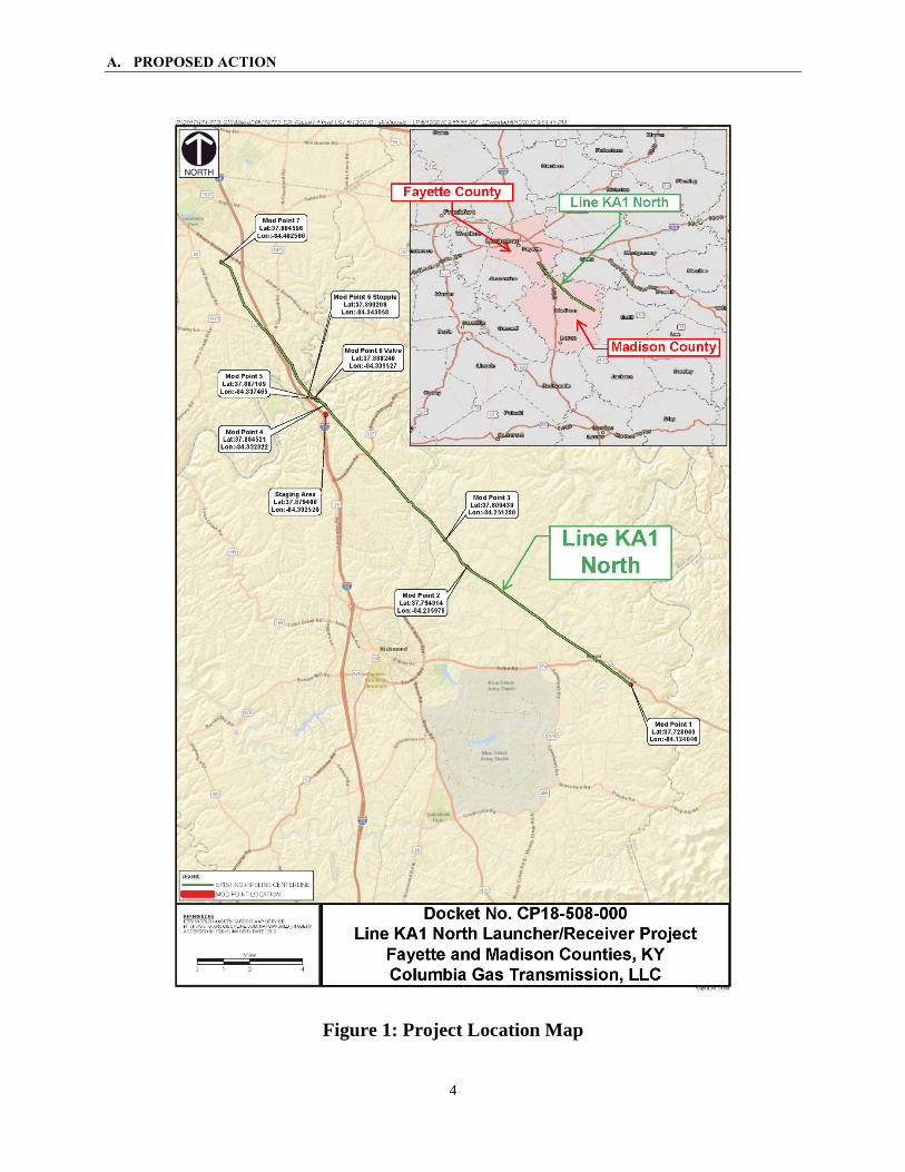
4. Proposed Facilities
Columbia’s proposed Line KA1 North Launcher/Receiver Project would install
two 16-inch by 12-inch bi-directional pig launcher/receivers on Columbia’s existing Line
KA1 North pipeline and perform other modifications at seven discrete modification
points (“Mod Points”) along the pipeline within Fayette and Madison Counties. The
activities that would be conducted at each of the Mod Points are summarized in table 1.
3 Columbia Gas Transmission, LLC, Order Approving Contested Settlement, 142 FERC ¶ 61,062 (2013). 4 Columbia Gas Transmission, LLC, Order Approving Settlement, 154 FERC ¶ 61,208 (2016). 5 The NOI was published in the Federal Register on August 9, 2018.

A. PROPOSED ACTION
3
A general location map for the Project is shown in figure 1.
Table 1 Project Facilities
Mod Point
Line KA1
North Station
No.
County Proposed Activities a/
1 6+00 Madison
install new 12-inch x 16-inch bidirectional launcher/receiver
install temporary 12-inch stopple fitting and temporary bypass piping
expand existing station lot, gravel, and fencing
construct new permanent access road
2 406+81 Madison
remove existing mainline valve and existing branch line to Line KA2
install new 12-inch mainline valve setting with a 6-inch bridle and new branch line to Line KA2
install two temporary 12-inch stopple fittings and temporary 2-inch bypass piping
expand existing station lot, gravel, and fencing
construct one new permanent access road and improve one existing permanent access road
3 479+27 Madison
remove existing 12-inch x 10-inch tee and existing 10-inch plug valve and replace with 12-inch-diameter straight pipe
install one temporary 12-inch stopple fitting
4 847+85 Madison replace existing 12-inch stopple with 12-inch-diameter pipe
5 867+43 Madison
replace existing 10-inch tee and elbow and 10-inch-diameter piping and replace with two new elbows
replace approximately 70 feet of 10-inch-diameter piping and associated pipe supports
6 877+60 Fayette remove existing valve and replace with 12-inch-diameter pipe
install one 12-inch stopple
7 1219+74 Fayette
install new 12-inch x 16-inch bidirectional launcher/receiver
remove existing 12-inch check valve and 4-inch bypass
install temporary 12-inch stopple fitting and 4-inch temporary bypass piping
expand existing station lot, gravel, and fencing
construct short segment of new permanent access road
a/ A comprehensive description of all Project Mod Points is included in Columbia’s August 30, 2018 response to FERC’s August 10, 2018 data request. See FERC Accession No. 20180830-5119.
A. PROPOSED ACTION
4
Figure 1: Project Location Map

A. PROPOSED ACTION
5
5. Non-Jurisdictional Facilities
Under Section 7 of the NGA, the Commission is required to consider, as part of its
decision to authorize jurisdictional facilities, all factors bearing on the public convenience
and necessity. Occasionally, proposed projects have associated facilities that do not
come under the jurisdiction of the Commission. However, no non-jurisdictional facilities
would be constructed in junction with or as a result of the Project.
6. Land Requirements
Table 2 summarizes the land acreage requirements for construction and operation
of the Project. Construction of the Project would disturb about 8.75 acres of land within
Columbia’s existing Line KA1 North right-of-way, within Columbia’s existing fenced
facilities, in areas to expand the existing facilities, and for existing and proposed new
access roads that Columbia would retain for operation of the Project facilities. See
section B.4 of this EA for details.
Table 2 Land Requirements for the Project
Facility Land Affected During
Construction (acres)
Land Affected During Operation (acres) a/
new permanent right-of-way or easement 0.20 0.20
new permanent gravel cover over existing Line KA1 North right-of-way
0.18 0.18
existing Line KA1 North right-of-way 0.97 0.87
existing gravel or paved facility 0.72 0.72
temporary workspace 2.03 0.00
staging area 3.42 0.00
access roads 1.24 1.22
Total 8.76 3.19
a/ The only permanent land impacts during operation, over and above the existing Line KA1 North facility footprint that would be utilized for operation of the Project’s new and replacement facilities, would result from the placement of gravel cover on select areas currently covered with vegetation and 0.2 acre of new permanent easement within adjacent grasslands and fields.
7. Permits Required
A number of federal, state, and local regulatory agencies have permit or approval
authority or consultation requirements for the proposed Project. These are described in
appendix A-1. Columbia would be responsible for obtaining all permits and approvals
required for construction and operation of the Project, regardless of whether or not they
appear in the table.
A. PROPOSED ACTION
6
8. Construction, Operation, and Maintenance Procedures
The Project would be designed, constructed, tested, operated, and maintained in
accordance with the U.S. Department of Transportation (DOT) Minimum Federal Safety
Standards in 49 CFR 192. The regulations are intended to ensure adequate protection for
the public and to prevent natural gas facility accidents and failures. Part 192 specifies
material selection and qualification; minimum design requirements; and protection from
internal, external, and atmospheric corrosion.
Throughout all phases of Project construction and restoration, Columbia would
adhere to its 2018 Environmental Construction Standards (ECS) and Erosion and
Sediment Control Plans (ESCP). Columbia’s ECS and ESCP fully incorporate all
requirements of the FERC’s Upland Erosion Control, Revegetation, and Maintenance
Plan (Plan) and Wetland and Waterbody Construction and Mitigation Procedures
(Procedures) as well as Columbia’s Spill Prevention, Control, and Countermeasures Plan
(SPCC Plan). In addition to its ECS and ESCP, Columbia would adhere to the
requirements in its Project-specific Environmental Management and Construction Plan
for all applicable permits and approvals.
The modifications to Columbia’s existing facilities would begin by delineating the
construction workspaces. Construction activities would then proceed in the order of
clearing, installing fencing around the workspaces, grading and placement of erosion
controls, and trenching for removal of old pipe components and the installation of
replacement components and new facilities. To the extent necessary for Columbia’s
limited scope of Project construction, pipe would be installed by stringing, bending,
welding, coating, lowering-in, backfilling, and hydrostatic testing. Disturbed areas would
then be final-graded and graveled, and otherwise cleaned up and restored in accordance
with Columbia’s ECS and ESCP.
Standard pipeline construction techniques would be required for the majority of
the Project. Columbia would implement site-specific construction practices at one
waterbody crossing, in areas of Project construction within 50 feet of residential areas,
within agricultural areas, at the intersection of the Project construction workspaces and
public paved roads, and at utility crossings. These are further discussed in section B.4.
Columbia states that the temporary workforce required for Project construction
would range from 30 to 40 individuals. Construction activities would typically take place
Monday through Saturday between 7:00 am and 5:30 pm. Only during unusual
circumstances, due to delays caused by weather or other unexpected events, would
Columbia elect to workoutside those timeframes in an effort to shorten the duration of
disturbance at any one location. No new permanent employees would be required for
operation and maintenance of the Project facilities.
In order to monitor environmental compliance during construction, Columbia
would employ at least one environmental inspector (EI). The EI would be responsible for

A. PROPOSED ACTION
7
ensuring that construction activities are in compliance with the environmental
requirements from construction through restoration. This includes the requirements of
the FERC Plan and Procedures; environmental conditions of any Certificate; mitigation
measures proposed by Columbia; and the requirements of any other environmental
permits and approvals. The EI would be responsible for identifying, documenting, and
overseeing any corrective actions to bring an activity back into compliance. The EI
would also have authority to stop activities that violate the environmental conditions of
any Certificate or other applicable permits. Columbia would also require its construction
contractor to employ at least one environmental compliance specialist to oversee the
successful installation and maintenance of erosion control devices across all proposed
Mod Points and construction work areas and for construction in environmentally
sensitive areas.
B. ENVIRONMENTAL ANALYSIS
8
B. ENVIRONMENTAL ANALYSIS
When considering the environmental consequences of constructing and operating
the proposed Project, we describe the duration and significance of any potential impacts
according to the following four levels: temporary, short-term, long-term, and permanent.
Temporary impacts generally occur during construction, with the resources returning to
pre-construction conditions almost immediately. Short-term impacts could continue for
approximately three years following construction. Long-term impacts would require
more than three years to recover, but eventually would recover to pre-construction
conditions. Permanent impacts could occur as a result of activities that modify resources
to the extent that they would not return to pre-construction conditions during the life of
the Project, such as with the construction of an aboveground facility. An impact would
be considered significant if it would result in a substantial adverse change in the physical
environment.
1. Geology and Soils
1.1 Geology
Geologic Setting
Mod Point 1 is within the Cumberland Plateau Region of the Appalachian Plateau
physiographic province. This area is uplifted nearly horizontal or gently folded strata
consisting primarily of Permian and Pennsylvanian sedimentary rocks including
sandstone, siltstone, shale, limestone, and coal. Mod Points 2 through 7 are within the
Lexington Plain Section of the Interior Low Plateau physiographic province. The
Lexington Plain Section (also known as the Bluegrass Region) consists of gently rolling
hills underlain by Ordovician age fossiliferous limestone, dolomite, and shale. The
topography in the Project area consists of elevations ranging between 580 and 1,030 feet
above sea level and is characterized by gently sloping to steep slopes. Blasting is not
anticipated based on the underlying geology and anticipated construction depths.
Mineral Resources
According to the Kentucky Geological Survey, no coal mining operations,
industrial sand and gravel pits, or gas/petroleum wells are present within 0.25 mile of the
Project area. Based on the proposed Project work areas and the mitigation measures
included in Columbia’s ESCP, Environmental Management and Construction Plan, and
SPCC Plan, we conclude there would not be a significant impact on mineral resources.
Geologic Hazards
Geologic hazards are naturally occurring physical conditions that are capable of
producing property damage and loss of life. Typically, these potential hazards include
seismic-related issues such as ground rupture due to faulting, strong ground shaking, soil
liquefaction, subsidence, slope stability and landslides, flash floods, and karst terrain.

B. ENVIRONMENTAL ANALYSIS
9
Seismicity
The U.S. Geological Survey (USGS) earthquake hazard program mapping shows
that seismicity in terms of peak ground acceleration within the Project area is between 8
to 10 percent gravity for the 2-percent probability of return period in 50 years. According
to the USGS, no significant seismic events (Magnitude 2.5 or greater) have been recorded
since 1850. However, the USGS Quaternary Faults and Folds database identified the
Kentucky River fault system underlying a part of the Project area from Mod Point 4 to
Mod Point 6. Faults in the Kentucky River fault system have shown slips that are
generally small and could be related to collapse from solution of the underlying bedrock.
Soil conditions necessary for liquefaction to occur are likely present in the Project
area. However, due to the low to moderate potential for a seismic event that would cause
strong and prolonged ground shaking, the potential for soil liquefaction to occur is very
low.
Modern steel pipelines with high quality electric arc welded joints have a history
of performing well during seismic events and ground displacements up to 60 centimeters
due to the restrained, welded joints and the flexibility of the pipeline to move with the
earth during ground shaking. Columbia’s upgrades and replacements would be designed
in accordance with all applicable federal and state safety codes.
Landslides and Slope Stability
Landslides involve the downslope movement of earth materials under a force of
gravity due to natural or man-made causes. The degree of slope, the composition of
surface materials, and the amount of rainfall exposure are all factors related to landslide
activity. The Project is in an area identified as susceptible to landslides. Based on the
limited ground disturbance and the mitigation measures included in Columbia’s ESCP,
we conclude there would not be a significant impact on mineral resources.
Flooding
Mod Points 2, 5, and 6 are within the vicinity of several creeks and rivers within
the 100-year floodplain. Aboveground facilities would be designed to the necessary
engineering standards and applicable federal, state, and local regulations. In addition,
Columbia would implement measures in its ESCP and ECS to mitigate against erosion
due to potential flooding. Such measures include the use of compost filter socks,
reinforced silt fence, temporary lined gravel construction entrances, and erosion control
blankets. We conclude that there would not be a significant impact from flooding on
Project construction or operation.
Karst Terrain
Karst terrain and the potential for karst features such as sinkholes and/or surface
collapse can occur within areas underlain by soluble carbonate bedrock and can be

B. ENVIRONMENTAL ANALYSIS
10
problematic during construction. Based on current mapping from the Kentucky
Geological Survey, Mod Points 4 and 5 are within 500-700 feet of mapped sinkholes; Mod
Points 6 and 7 are within 400-450 feet of mapped sinkholes; and the contractor staging area is
within 800 feet of a mapped sinkhole. However, operation of the existing facilities have
not been adversely affected by karst topography or subsidence to date. Based on the lack
of karst features at the existing facilities and the proposed construction depths, impacts on
the proposed Project facilities or adjacent land due to groundsoil land subsidence and/or
karst terrain are not anticipated.
Shallow Bedrock
Columbia anticipates that the restrictive material encountered during construction
would be moveable without the use of blasting. Should the need for blasting arise at a
later date, Columbia would provide a Project-specific blasting plan for review and written
approval by the Director of the Office of Energy Projects (OEP), prior to implementing
any blasting. Such a plan would also meet any local permit requirements.
Paleontological Resources
Paleontological resources are not known to exist within the Project area. The
majority of the Project areas to be excavated have been disturbed by previous
development. Based on this, we conclude there would be no impact on paleontological
resources.
1.2 Soils
Construction activities that create soil disturbance, such as clearing, grading, trench
excavation, backfilling, the movement of construction equipment within construction
workspaces, and the limited segments of pipeline right-of-way included in the Project
scope would result in temporary, minor impacts on soil resources. Soil characteristics
could affect construction performance or increase the potential for adverse construction-
related soil impacts. The activities that have the potential to impact soils and reduce soil
quality are the mixing topsoil of with subsoil, bringing excess rocks to the surface,
compacting soil by heavy equipment, and disrupting surface and subsurface drainage
patterns.
The U.S. Department of Agriculture defines prime farmland soils as those that have
the best combination of physical and chemical characteristics for producing food, feed,
forage, fiber, and oilseed crops, and that are available for these uses. Prime farmland
soils can include either actively cultivated land or land that is potentially available for
cultivation. Farmland that does not meet the criteria for prime farmland may still be
considered farmland of statewide importance for the production of food, feed, fiber,
forage, and oilseed crops. The criteria for defining and delineating farmland of statewide
importance are determined by the local conservation districts. Generally, this land
includes soils that nearly meet the requirements for prime farmland and that economically

B. ENVIRONMENTAL ANALYSIS
11
produce high yields of crops when treated and managed according to acceptable farming
methods. A total of about 0.15 acre of prime farmland soils and about 0.10 acre of
farmland of statewide importance would be permanently removed from use by the
Project.
During construction, topsoil would be stripped from over the excavation area and
the subsoil storage area. Columbia would remove the topsoil layer to the full topsoil
depth, up to 12 inches or as otherwise negotiated with the landowner, in cultivated or
rotated croplands and managed pastures, hayfields, residential areas, and other areas at
the landowner’s request. Segregated topsoil would be returned following backfilling of
the excavated area with subsoil, ensuring preservation of topsoil within the construction
area. With implementation of Columbia’s ESCP and ECS, long-term impacts on prime
farmland soils and farmland of statewide importance would be minimized. Further, a
landowner would not be precluded from using the pipeline easement for agricultural use
in the future.
Successful restoration and revegetation is important for maintaining soil
productivity and to protect the underlying soil from potential damage and erosion. In
accordance with its ECS, Columbia would apply soil amendments, as necessary, to create
a favorable environment for the re-establishment of vegetation. Columbia would also
obtain written recommendations from the local soil conservation authority, land
management agencies, or the landowner.
Topsoil removal, clearing, grading, and equipment movement could accelerate the
erosion process and, without adequate protection, result in discharge of sediment to
nearby waterbodies and wetlands. Soil loss due to erosion could also reduce soil fertility
and impair revegetation. Columbia would implement measures specified in its ESCP and
ECS to avoid and minimize potential impacts due to soil erosion and sedimentation.
During construction, erosion and sediment control measures would be installed and
maintained. At the end of construction, Columbia would reestablish vegetation as soon
as possible following final grading. Disturbed areas would be reseeded with seed
mixtures developed in consultation with the local soil conservation authority or
landowners. The Project’s compaction potential is generally low. In accordance with its
ESCP and ECS, Columbia would minimize compaction.
Contamination from spills or leaks of fuels, lubricants, and coolant from
construction equipment could adversely affect soils. However, the impacts of such
contamination are typically minor because of the low frequency and volumes of spills
and leaks. Measures outlined in Columbia’s ECS and SPCC Plan would be implemented
to reduce potential impacts on soils from any construction-related spills. These measures
include regularly inspecting equipment to ensure it is in good working order, properly
training employees regarding the handling of fuels and other hazardous materials,
implementing appropriate clean-up protocols, and promptly reporting any spills to the
appropriate agencies.

B. ENVIRONMENTAL ANALYSIS
12
Contaminated (Hazardous Waste) Sites
Columbia also performed an extensive file review of known contaminated sites.
Over 50 sites potentially containing hazardous materials or hazardous waste are within
0.5 mile of the Project Mod Points. Based on the lack of any reported leaks, spills, or
releases from many of the listed facilities and their distance from the Project, it is
unlikely that Project activities would occur within contaminated areas or above
contaminated groundwater plumes originating at or resulting from these facilities. In the
event that contaminated media is discovered during construction, Columbia would adhere
to its Plan for the Unanticipated Discovery of Contaminated Environmental Media
included as part of its ECS.
Given the limited construction footprint and the impact minimization and mitigation
measures described above, we conclude that soils would not be significantly affected by
Project construction and operation.
2. Water Resources
2.1 Groundwater
The Project is underlain by carbonate rocks of the Silurian-Devonian and
Ordovician principal aquifers of the Appalachian Interior Low Plateaus Province. These
aquifers provide the primary source of drinking water for all counties in the vicinity of the
Project. This groundwater is often utilized for agriculture and industrial purposes. No
sensitive groundwater resources such as sole-source aquifers; state-designated aquifers;
public and private water supply wells, springs, and wellheads; or aquifer protection areas
would be crossed or otherwise impacted by the Project. No private or public wells,
springs, or seeps are within 150 feet of the Project workspaces.
Contamination from spills or leaks of fuels, lubricants, and coolant from
construction equipment could adversely affect groundwater. However, the impacts of
such contamination are typically minor because of the low frequency and volumes of
spills and leaks. Measures outlined in Columbia’s SPCC Plan (described in section
B.1.2, above) would also serve to reduce potential impacts on groundwater from spills of
the hazardous materials used during construction.
Based on the results of Columbia’s file review of contaminated sites, it is unlikely
that construction activities would encounter contaminated groundwater. In the event that
contaminated groundwater is encountered, Columbia would implement measures in its
Plan for the Unanticipated Discovery of Contaminated Environmental Media, included
as part of its ECS.

B. ENVIRONMENTAL ANALYSIS
13
Potential impacts on groundwater resources would be minimized through
implementation of the ESCP, ECS, SPCC Plan, and other best management practices.
We do not anticipate any significant changes to groundwater quality, quantity, or
recharge to result from Project activities.
2.2 Surface Water
The Project area is within six 12-digit hydrologic unit code (HUC) watersheds, all
of which are within the greater Kentucky River watershed: Upper East Hickman Creek
(HUC 051002050601), Boone Creek (HUC 051002050301), Lower Howard Creek-
Kentucky River (HUC 051002050302), Upper Otter Creek (HUC 051002050105), Lower
Otter Creek (HUC 051002050106), and Drowning Creek (HUC 051002040506).
Waterbodies and wetlands were identified through desktop reviews of publicly
available data, including USGS and National Wetland Inventory maps, and field surveys
conducted on November 21, 2017. One minor ephemeral waterbody 6, an unnamed
tributary to East Fork Otter Creek, would be crossed at two distinct locations by
permanent gravel access roads for Mod Point 2. At one crossing location, an existing 25-
foot-long, 16-inch-diameter corrugated metal culvert would be replaced with a 60-foot-
long, 16-inch-diameter corrugated metal culvert to facilitate improvements of an existing
gravel access road. At the other crossing location, a new 40-foot-long, 16-inch-diameter
culvert would be installed to facilitate installation of a new permanent gravel access road.
In addition, at Mod Point 1, Columbia proposes to install a new culvert associated with a
new permanent access road that would cross a vegetated drainage ditch adjacent to a
road. This ditch does not have a defined bed, bank, or ordinary high water mark, and
does not appear to have a significant nexus to a traditionally navigable water of the
United States. As such, it likely does not fall under the permitting jurisdiction of the U.S.
Army Corps of Engineers.
Based on Kentucky Department of Environmental Protection (KDEP), Division of
Water data, the Project is located within portions of four source water protection areas:
Richmond Water/Gas/Sewer Works, Kentucky-American Water Company, Winchester
Municipal Utilities, and Nicholasville Water Department. The Project would not cross or
impact any surface water intakes. The closest public surface water intake is
approximately 2.9 miles downstream from Mod Point 5, on the northern bank of the
Kentucky River.
Potential impacts on the waterbody crossed by the Project include increased
sedimentation and the introduction of hazardous materials such as fuels, lubricants, and
coolants. Columbia would implement measures in its ECS and ESCP, including the use
of erosion control devices like silt fence and hay bales, to minimize impacts on the
6 FERC defines a waterbody as any natural or artificial stream, river, or drainage with perceptible flow at the time of
crossing, and other permanent waterbodies such as ponds and lakes. A minor waterbody is defined as water’s width
of 10 feet wide or less.

B. ENVIRONMENTAL ANALYSIS
14
waterbody from construction in adjacent uplands. Additionally, Columbia would apply
measures within its SPCC Plan to prevent spills of hazardous materials and employ
response procedures in the event of a spill. Further, on October 19, 2018, Columbia
received its Clean Water Act section 404 (Nationwide Permit 12) authorization from the
U.S. Army Corps of Engineers and Clean Water Act section 401 authorization from
KDEP. Columbia would adhere to the requirements identified in these permits.
Therefore, we conclude that the Project’s impacts on surface water would not be
significant.
Columbia delineated wetlands in the Project area in accordance with the U.S.
Army Corps of Engineers’ Wetlands Delineation Manual and the Eastern Mountain and
Piedmont Regional Supplement (Version 2.0). No wetlands were identified in the Project
area; therefore, the Project would not impact wetlands.
Hydrostatic Testing
Hydrostatic testing is a method by which water is introduced to segments of pipe
and then pressurized to verify the integrity of the pipeline. In accordance with the
requirements of DOT pipeline safety regulations (49 CFR 192), Columbia would
hydrostatically test all piping prior to placing them in service. A total of about 1,722
gallons of water would be required to hydrostatically test piping; the water would be
trucked in from municipal sources. Upon completion of testing, hydrostatic test water
would be placed in tanks and hauled offsite for disposal at an approved facility. Given
that hydrostatic test water would be obtained from a municipal source and that it would
be hauled offsite for disposal at an approved facility, we conclude that impacts from
hydrostatic testing would not be significant.
3. Vegetation and Wildlife
3.1 Vegetation
Three vegetation cover types are present along the Project areas: forest, open
land, and maintained right-of-way. Forest in the Project area consists of deciduous,
coniferous, and mixed forest types. Open land includes non-forested upland areas that
consist of grass and shrubs on previously disturbed areas, uncultivated pasture, and
hayfields. Maintained right-of-way includes utility corridors that are mowed and
maintained. Generally, maintained grasses and other herbaceous vegetation are the only
species common in maintained areas due to routine disturbance and clearing/mowing
activities. Construction of the Project would impact less than 1 acre of forest, about 2
acres of open land, and about 0.6 acre of maintained right-of-way (see table 3 below).
Little to no impacts on vegetation are expected at the staging area due to the existing
disturbed nature of the site.

B. ENVIRONMENTAL ANALYSIS
15
Table 3
Vegetation Impacts During Construction and Operation of the Project
Workspace
Forest Open Land a/ Maintained
Right-of-Way Total
Constr. Oper. Constr. Oper. Constr. Oper. Constr. Oper.
new permanent easement
0 0 0.20 0.20 0 0 0.20 0.20
existing right-of-way 0.30 0.30 0.13 0.13 0.61 0.61 1.04 1.04
existing facility 0 0 0.09 0.09 0 0 0.09 0.09
temporary workspace
0.58 0 1.32 0 0 0 1.90 0.00
access roads 0 0 0.08 0.07 0.03 0.02 0.11 0.09
staging area 0 0 0 0 0 0 0 0
Total 0.88 0.30 1.82 0.49 0.64 0.63 3.34 1.42
a/ Includes Agricultural – Hayfields land use category (see section B.4).
Invasive Species
Plant species that can invade natural areas and displace native species are called
invasive species. Noxious weeds are plants officially deemed destructive to agriculture,
wildlife, property, recreation, and public health. These plants tend to out-compete other
plant species and therefore could possibly cause environmental harm. Four invasive
plant species were identified within the Project area during surveys: multiflora rose, tree-
of-heaven, Japanese stiltgrass, and Japanese knotweed. Columbia would implement
measures in its ECS to minimize the spread of noxious weeds and invasive species.
Specific measures include limiting soil exposure by re-establishing vegetation in
temporary workspaces as soon as practicable following final grading and conducting
post‐construction monitoring to ensure that revegetation is successful. We find these
measures acceptable.
Vegetation Impacts and Mitigation
Impacts on vegetation range from short term to permanent. Construction of the
Project would affect approximately 3.3 acres (temporary and permanent) of which
approximately 1.4 acres would be permanently affected by facility operations. Gravel
would be placed within the newly expanded fence lines and new or improved permanent
access roads at the existing stations at Mod Points 1, 2, and 7. Less than 1 acre of trees
would be removed for construction, of which about 0.3 acre would be permanently
removed.
During operation, maintenance of the Project facilities primarily includes routine
vegetation mowing and clearing within the permanent right-of-way, which would
preclude the growth of trees. However, all areas disturbed by construction activities that
are not necessary to be maintained for operation would be restored to pre-construction
conditions. The impacted trees within temporary workspaces (about 0.6 acre) would be
considered long-term because the regrowth of trees could take decades to return to pre-
construction conditions. Revegetation in all other areas would be relatively short term (1-

B. ENVIRONMENTAL ANALYSIS
16
5 years). The majority of Project components and construction workspaces have been
situated in open land or maintained rights-of-way that are already frequently disturbed.
Some vegetation would be permanently lost for Project operation; however, all temporary
work areas would be restored and revegetated in accordance with Columbia’s ECS or
landowner agreements. For these reasons, we conclude that the Project would not
significantly impact vegetation.
3.2 Wildlife
Vegetation cover types discussed in the previous section describe the habitat types
for wildlife in the Project areas. Wildlife commonly found in the Project areas include
northern cardinal, American crow, red-tailed hawk, wild turkey, eastern cottontail rabbit,
red and gray foxes, white-tailed deer, Virginia opossum, striped skunk, and worm snake.
Fish were not observed during the site visit, as the waterbody crossed by the
Project (a drainage ditch) is unlikely to support fish populations due to discontinuous
flow.
Potential short-term impacts on wildlife include the temporary displacement of
individuals from construction areas and adjacent habitats and the direct mortality of
small, less-mobile mammals, reptiles, and amphibians that are unable to leave the
construction area. Construction of the Project could also impact nearby wildlife due to
the increase in noise due to construction equipment and increased human activity. The
majority of Project components and construction workspaces have been situated in areas
that already undergo ongoing disturbance. Following construction activities, Columbia
would implement the restoration measures within its ECS to ensure that all disturbed
areas are properly restored and revegetated. There is an abundance of similar habitat for
displaced wildlife to utilize during and after construction of the proposed facilities.
Vegetation removal and increased presence of humans and noise, during
construction would likely cause displacement and avoidance of the area by any birds in
the Project area, including migratory birds7, which are protected under the Migratory Bird
Treaty Act. Birds fleeing an area of disturbance could be injured or suffer mortality, or
abandon nests, affecting egg-laying and potentially causing the mortality of young.
However, this impact is expected to be intermittent and short term, occurring during work
hours and ceasing after construction activities have moved from a given area.
The proposed Project involves very little forest clearing, where most bird nesting
in the area occurs. Implementation of the construction and restoration measures in
Columbia’s ECS would reduce the extent and duration of impacts on migratory bird
habitat by restoring all areas not necessary to be maintained for operation to pre-
construction conditions. Further, Columbia plans on commencing construction in March
7 The Project falls within Bird Conservation Region 24: Central Hardwoods; however, no part of the Project is
within a designated Important Bird Area.

B. ENVIRONMENTAL ANALYSIS
17
2019 and would adhere to tree clearing timing restrictions for federally listed bats (April
1-October 15), which would also be protective of migratory birds (general breeding
season for migratory birds is April 1-August 15).
Columbia consulted with the U.S. Fish and Wildlife Service (FWS) regarding the
potential for bald eagle nests within the Project area. Correspondence from FWS, dated
August 20, 2018, stated that there are records of a bald eagle nest approximately 3 miles
from the northern terminus of the proposed Project area and that there are two more
recorded nests on the Kentucky River within 10 miles of the Project area. The Kentucky
Department of Fish and Wildlife Resources indicated that it does not have any nests
recorded within the Project area, but there is potential for unrecorded nests or
construction of new nests in the area, as nests are often located along rivers and lakes.
During Columbia’s field investigations, no bald eagle nests were observed in the
Project area or in the vicinity of Mod Points 5 and 6, which are near the Kentucky River.
Based on the presence of a major transportation structure (the Interstate 75 Bridge over
the Kentucky River) within 0.25 mile of the Project, we do not find it likely that bald
eagles would utilize this area for nesting activities. Or, if they do, they have been
acclimated to such human activity.
We conclude that the Project would not significantly impact wildlife, including
bald eagles or other migratory birds.
Special Status Species
Special status species are those species for which state or federal agencies provide
an additional level of protection by law, regulation, or policy. Included in this category
are federally listed species that are protected under the Endangered Species Act, species
considered as candidates for such listing by the FWS, and those species that are state-
listed as threatened or endangered.
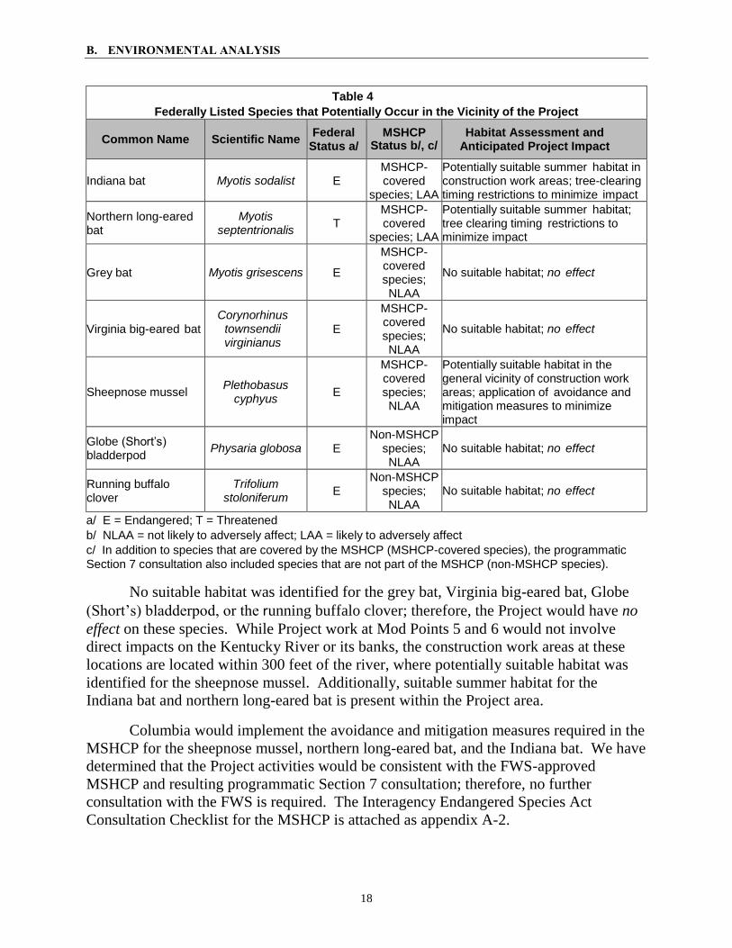
Federally Listed Species
Columbia, in coordination with the FWS, has developed a Multi-Species Habitat
Conservation Plan (MSHCP), which identifies common pipeline activities that may take
place within potential federally listed species habitat and outlines avoidance and
mitigation measures that would reduce impacts on federally listed species to less than
significant levels. An amendment to the MSHCP documents the analysis of impacts,
incidental take, and mitigation for the federally threatened northern long-eared bat. The
MSHCP identified seven federally threatened or endangered species with the potential to
occur in the Project area (table 4).
B. ENVIRONMENTAL ANALYSIS
18
Table 4
Federally Listed Species that Potentially Occur in the Vicinity of the Project
Common Name Scientific Name Federal
Status a/ MSHCP
Status b/, c/ Habitat Assessment and
Anticipated Project Impact
Indiana bat Myotis sodalist E
MSHCP- covered
species; LAA
Potentially suitable summer habitat in construction work areas; tree-clearing timing restrictions to minimize impact
Northern long-eared bat
Myotis septentrionalis
T
MSHCP- covered
species; LAA
Potentially suitable summer habitat; tree clearing timing restrictions to minimize impact
Grey bat Myotis grisescens E
MSHCP- covered species; NLAA
No suitable habitat; no effect
Virginia big-eared bat Corynorhinus
townsendii virginianus
E
MSHCP- covered species; NLAA
No suitable habitat; no effect
Sheepnose mussel Plethobasus
cyphyus E
MSHCP-covered species; NLAA
Potentially suitable habitat in the general vicinity of construction work areas; application of avoidance and mitigation measures to minimize impact
Globe (Short’s) bladderpod
Physaria globosa E
Non-MSHCP species; NLAA
No suitable habitat; no effect
Running buffalo clover
Trifolium stoloniferum
E
Non-MSHCP species; NLAA
No suitable habitat; no effect
a/ E = Endangered; T = Threatened
b/ NLAA = not likely to adversely affect; LAA = likely to adversely affect
c/ In addition to species that are covered by the MSHCP (MSHCP-covered species), the programmatic
Section 7 consultation also included species that are not part of the MSHCP (non‐MSHCP species).
No suitable habitat was identified for the grey bat, Virginia big-eared bat, Globe
(Short’s) bladderpod, or the running buffalo clover; therefore, the Project would have no
effect on these species. While Project work at Mod Points 5 and 6 would not involve
direct impacts on the Kentucky River or its banks, the construction work areas at these
locations are located within 300 feet of the river, where potentially suitable habitat was
identified for the sheepnose mussel. Additionally, suitable summer habitat for the
Indiana bat and northern long-eared bat is present within the Project area.
Columbia would implement the avoidance and mitigation measures required in the
MSHCP for the sheepnose mussel, northern long-eared bat, and the Indiana bat. We have
determined that the Project activities would be consistent with the FWS-approved
MSHCP and resulting programmatic Section 7 consultation; therefore, no further
consultation with the FWS is required. The Interagency Endangered Species Act
Consultation Checklist for the MSHCP is attached as appendix A-2.
B. ENVIRONMENTAL ANALYSIS
19
State-listed Species
Columbia consulted with the Kentucky Department of Fisheries and Wildlife
Resources and Kentucky State Nature Preserves Commission to determine the presence
of state-listed species within the Project areas. A total of nine species were identified as
potentially occurring within 1 mile of the Project, including the federally listed grey bat
and the running buffalo clover, which were previously discussed. However, a known
record of only one species, the stemless evening-primrose, was identified within 0.25
mile of Project areas. The known record of this plant is located approximately 1,000 feet
to the west of the mainline valve at Mod Point 6 in a wooded area that would remain
undisturbed during construction of the Project. In addition, given that this species is
typically found in dry woods, barrens, and prairies, and often in calcareous areas
including dry limestone soil and rock outcrops in fields, the Project is not likely to impact
the stemless evening-primrose due to the limited habitat availability and the limited
amount of temporary workspace at Mod Point 6. For these reasons, we conclude that the
Project would not adversely affect the stemless evening-primrose or any other state-listed
species.
4. Land Use, Recreation, and Visual Resources
Project construction would impact land use within the Project construction work
areas as described below. Land use descriptions in this section are based on land cover
types derived from observations made from aerial imagery, geographic information
system technology, and ground-truthing during biological and cultural resource surveys.
Land cover types affected by the Project include:
Forested: Tracts of upland forest or woodland that would be removed for the
construction right-of-way or staging areas;
Open Land: Non-forested lands consisting of open space including grasslands;
Agricultural/Hayfields: Land in pasture or row crops;
Maintained Right-of-Way: Utility corridors that are mowed and maintained;
Residential: Residential yards, residential subdivisions, and planned new
residential developments; and
Developed Land: Electric power or gas utility stations, manufacturing or
industrial plants, landfills, mines, quarries, commercial or retail facilities, and
gravel and dirt roads.
Temporary (construction) and permanent (operation) land use impacts from
Project construction and operation are summarized in table 5.

B. ENVIRONMENTAL ANALYSIS
20
Table 5 Land Use Impacts
Workspace
Forested Open Land Agricultural -
Hayfields
Maintained Right-of-
Way Residential Developed Total
Const Oper Const Oper Const Oper Const Oper Const Oper Const Oper Const Oper
new permanent easement
0 0 0.10 0.10 0.10 0.10 0 0 0 0 0 0 0.20 0.20
existing right-of-way
0.30 0.30 0 0 0.13 0.13 0.61 0.61 0.10 0 0.01 0.01 1.15 1.05
existing facility
0 0 0.09 0.09 0 0 0 0 0 0 0.63 0.63 0.72 0.72
temporary workspace
0.58 0 0.95 0 0.37 0 0 0 0.13 0 0 0 2.03 0.00
access roads
0 0 0.07 0.06 0.01 0.01 0.03 0.02 0 0 1.13 1.13 1.24 1.22
staging area 0 0 0 0 0 0 0 0 0 0 3.42 0 3.42 0
Total Project
0.88 0.30 1.21 0.25 0.61 0.24 0.64 0.63 0.23 0.0 5.19 1.77 8.76 3.19
Columbia would install two new launcher/receivers at Mod Points 1 and 7, replace
one existing mainline valve and Mod Point 2, and remove an existing mainline valve at
Mod Point 6 as part of the proposed Project. The launcher/receivers and replacement
mainline valve generally would be installed within existing, gravel-covered, fenced, and
permanent Columbia station lots. However, each location would require a minor
expansion of the existing gravel cover and fencing in order to accommodate the new and
replacement facilities, amounting to 0.4 acre of permanent impact to open or agricultural
land.
Project construction activities would affect 8.76 acres of land during construction,
of which 5.28 acres are developed land. Project construction would also affect 1.12 acres
of open land, 0.88 acre of forested land, and 0.61 acre of agricultural land. Following
completion of the Project, 3.19 acres would be maintained as operational right-of-way as
part of Columbia’s facilities. Areas disturbed during construction would be restored in
accordance with Columbia’s ECS. Following construction, the new fence and gravel
cover would be maintained as part of Columbia’s permanent easement. A total of 2.07
acres would be affected by operation of the launcher/receivers and mainline valves.
Columbia proposes to use existing roadways and to construct two new permanent
and two temporary access roads to access the Project construction work areas. These
roads would provide access to the Line KA1 North right-of-way and to each Mod Point.
Some of the existing roads would require improvements such as gravel and/or grading,
replacing or installing culverts, minor widening, and clearing of overhead vegetation to
safely accommodate construction equipment and vehicles.
B. ENVIRONMENTAL ANALYSIS
21
Project operation requires construction of new, permanent gravel access roads at
the Bybee and Muth M&R stations. These roads would permanently affect 1.22 acres of
land. Columbia is working with state and local agencies concerning the applicable
permits needed for the construction and use of access roads for the Project.
One contractor staging area off Carr Lane would be used to store pipe, materials,
and equipment; employee vehicle parking; vehicle maintenance and storage; and
temporary field offices. Columbia states that no improvements or expansion would be
made to this 3.42-acre, previously developed site. After construction has been
completed, the contractor staging area would be restored to pre-construction conditions in
accordance with Columbia’s ECS.
Forested Land
The forested land crossed by the Project consists of minor amounts of deciduous-
dominated forest, mixed evergreen/deciduous forest, and woodlands adjacent to
maintained rights-of-way. The Project would impact 0.88 acre of forested land
associated with the removal of trees and shrubs from the construction work areas (i.e.,
right-of-way and temporary workspace). Following construction, trees and shrubs in the
temporary workspace areas would be allowed to reestablish to pre-construction
conditions through natural succession. A total of 0.3 acre of forested land would be
permanently converted to permanent pipeline right-of-way and maintained in accordance
with Columbia’s ECS.
Open Land
About 1.12 acres of Open Land would be temporarily affected during Project
construction. The expansion of the aboveground facilities would permanently convert
0.1 acre of Open Land to Developed Land.
Residential Land
Construction the Project would affect 0.23 acre of residential land, which is
represented by the Mod Point 5 workspace, which partially overlaps the landowner’s
property for a recently constructed residence. No permanent impacts on residential land
would take place. As indicated in table 6, no residences are within 25 feet of the
Project’s construction work areas; however, the recently constructed residence referred to
above is approximately 30 feet south of the construction work area at Mod Point 5. In
addition, one residence is approximately 80 feet to the east of the construction work area
for Mod Point 6, and one residence is approximately 80 feet to the west of the access road
to Mod Point 7. The proposed workspaces for Mod Points 6 and 7 do not appear to be on
the actual residential property lots, however.

B. ENVIRONMENTAL ANALYSIS
22
Table 6 Structures Within 50 Feet of the Project Construction Work Areas
Mod
Point
Station Number County
Structure Type
Approximate Distance
from Work Area (feet)
Approximate Distance
from Pipeline Centerline
(feet)
Direction of Structure
from Centerline
Drawing Reference
(drawing number)
4 847+85 Madison Barn 22 80 Southwest TD-7231-111 a/, b/
5 867+43 Madison Abandoned
House 18 93 East TD-7231-113 a/,b/
5 867+43 Madison House 30 168 South TD-7231-113 a/, b/
TD-7231-RSD-1-P1 b/
Staging Yard 829+80 Madison
Abandoned Gas Station
Retail Building a/
0 1,100 West-
Southwest TD-7231-116 b/
Staging Yard 829+80 Madison
Abandoned Gas Station Maintenance Building a/
0 880 West-
Southwest TD-7231-116 b/
a/ These abandoned structures are along the periphery of an asphalt surface staging yard and would not be impacted by the Project. The staging yard would be used for parking, equipment staging and fabrication, contractor trailers, etc. b/ Drawings are included in Appendix 1B of Volume I of the application filed with the Commission on June 20, 2018. See Accession No. 20180620-5148.
Construction of the Project could result in short-term impacts on residential areas,
including clearing of existing vegetation and landscaping within the construction
workspace, increased construction-related traffic on local roads, noise, and dust from
construction equipment, and temporary visual effects from removal of vegetation and
presence of heavy equipment. Columbia would minimize impacts on the identified
residence within 50 feet of the Project area through implementation of the following
mitigation measures, in accordance with the FERC Plan:
install fencing around the edge of the construction area adjacent to each residence
for a distance of 100 feet on either side of the residence ensure that equipment,
materials, and spoil remain within the construction workspace;
refrain from removing mature trees and landscaping from within the edge of the
construction workspace unless necessary for safe operation of construction
equipment or as specified in landowner agreements;
restore lawns and landscaping to final restoration immediately after backfilling the
trench, or temporary restoration pending weather and soil conditions;
take all measures necessary to ensure that utilities are not disrupted during
construction. If the need to disrupt utilities arises, Columbia would provide as
much notice as possible to the landowner prior to the disruption;
utilize specialized construction techniques designed to minimize disturbances to
residences, such as the stovepipe or drag section techniques, may be used as
needed;
notify affected landowners and adjacent landowners no later than two weeks prior

B. ENVIRONMENTAL ANALYSIS
23
to the start of construction;
maintain traffic flow and emergency vehicle access on residential roadways and
traffic detail personnel and/or detour signs would be used where appropriate;
maintain a minimum of 25 feet between the residence and construction workspace
for a distance of 100 feet on either side of the residence. If a facility must be
within 25 feet of a residence, it would be installed such that the trench does not
remain open overnight;
leave trenches open for no more than 30 days unless otherwise authorized by the
EI and any section of the trench left open at the end of the workday would be
fenced off or covered with a steel plate; and
periodically inspect road surfaces near residences and, if necessary, clean road
surfaces of any soil and other debris; and
to minimize fugitive dust emissions during construction, use a procedure that
requires periodic watering of disturbed areas (via a mobile watering truck) when
needed, based on conditions encountered daily, further discussed in section B.6.
In addition, all construction-related litter and debris would be removed daily from
the construction work areas.
Developed Land
The Project would temporarily affect 5.28 acres of developed land, consisting of
electric power or gas utility stations, commercial or industrial sites, and gravel and dirt
roads, primarily for contractor staging and temporary workspace. After construction, the
sites would be restored to pre-construction conditions in accordance with Columbia’s
ECS. Most developed land uses would be able to continue in accordance with individual
right-of-way agreements for approved and/or restricted use of permanent rights-of-way;
however, buildings, other structures, wells, reservoirs, pools, obstructions, or
removal/addition of cover would not be permitted on the Project’s permanent pipeline
rights-of-way. Columbia would consider the construction of features such as roads or
driveways, utility lines, and properly gated fences to be generally permissible uses within
the permanent rights-of-way.
Natural, Recreational, or Scenic Areas
No designated Coastal Zone Management Areas, registered national natural
landmarks, designated Wilderness Areas, Wild and Scenic Rivers, or designated National
Trails are within 0.25 mile of any proposed Project activities. The Project would not
cross or pass within 0.25 mile of areas of land that are publicly owned or managed. The
Project area crosses no known public or private conservation easements. The closest
public/conservation land within the vicinity of the Project area is an approximately
178acre tract of land under the Farm and Ranch Lands Protection Program,
approximately 1,000 feet to the southeast of Mod Point 7. This property would not be
affected by the Project.

B. ENVIRONMENTAL ANALYSIS
24
Visual Resources
The Project involves minor modifications of aboveground facilities and work
within existing cleared right-of-way. Some additional clearing would be required for
temporary workspace to complete the proposed activities, but these areas are relatively
small in size and would be allowed to revert to their prior condition. As the Project does
not involve the expansion of the permanent right-of-way or installation of significant
aboveground facilities, visual impacts from construction and operation are expected to be
minimal.
5. Cultural Resources
Section 106 of the National Historic Preservation Act, as amended, requires the
FERC to take into account the effects of its undertakings on properties listed, or eligible
for listing, on the National Register of Historic Places (NRHP), and to afford the
Advisory Council on Historic Preservation an opportunity to comment. Columbia, as a
non-federal party, is assisting the FERC in meeting our obligations under Section 106 and
its implementing regulations at 36 CFR 800.
Columbia completed cultural resources surveys for the Project and provided a
Phase I Archaeological Survey report and an Historic Structures Report to the FERC and
Kentucky State Historic Preservation Office (SHPO). The archaeological survey covered
8.8 acres. No archaeological sites were identified as a result of the survey, and no further
work was recommended. In a letter dated February 9, 2018, the SHPO concurred, and
indicated the Project would result in no effect to archaeological historic properties. We
concur with the SHPO.
The historic structures survey identified four previously recorded resources and
eight newly recorded resources. The previously recorded resources included the Carr
House (MA590), Clays Ferry Bridge (FA595), Boone Creek Rural Historic District
(NR315), and a house with outbuildings (FA138). The Carr House was recommended as
not eligible for the NRHP. The Clays Ferry Bridge, identified at Mod Point 58, had
previously been determined eligible for the NRHP. Work at Mod Point 6 would take
place adjacent to the Boone Creek Rural Historic District, which is already listed on the
NRHP. The house with outbuildings, also identified near Mod Point 6, was
recommended as a contributing resource to the Boone Creek Rural Historic District. The
newly recorded resources consisted of residences with a date range of ca. 1870 to ca.
1957. None of the newly recorded resources were recommended as eligible for the
NRHP. Because nothing new would be attached to the Clays Ferry Bridge as part of the
work proposed at Mod Point 5, Columbia recommended no further work. Because no
above-ground pipework would be visible, the area would be restored, and no tree clearing
8 Mod Point 5 requires removal of a 90 degree elbow and 10-inch tee on the east side of the Clays Ferry Bridge and
replacement with two segmentable elbows. In addition, 70 feet of 10-inch-diameter pipeline would be replaced, and
pipe supports currently attached to the bridge would be modified to support reconfigured piping.

B. ENVIRONMENTAL ANALYSIS
25
would be conducted, Columbia recommended no further work at Mod Point 6. In a letter
dated March 6, 2018, the SHPO indicated that the Project would have no adverse effect.
We concur with the SHPO.
Columbia contacted the following Native American tribes regarding the Project:
Absentee-Shawnee Tribe of Oklahoma; Cherokee Nation; Chickasaw Nation; Choctaw
Nation of Oklahoma; Delaware Nation; Eastern Band of Cherokee Indians; Eastern
Shawnee Tribe of Oklahoma; Miami Tribe of Oklahoma; Muscogee (Creek) Nation;
Peoria Tribe of Indians of Oklahoma; Quapaw Tribe of Oklahoma; Shawnee Tribe of
Oklahoma; and United Keetoowah Band of Cherokee Indians in Oklahoma. The
Cherokee Nation indicated it was interested in acting as a consulting party and requested
surveys be conducted. Columbia provided the Cherokee Nation with the survey reports.
Upon review, the Cherokee Nation indicated it did not object to the Project, but requested
to be notified of any unanticipated discoveries during construction. The Choctaw Nation
of Oklahoma, Muscogee (Creek) Nation, and the Quapaw Tribe of Oklahoma indicated
the Project was outside their areas of interest. The Delaware Nation indicated it had no
comments. We sent our NOI to these same tribes. The Cherokee Nation indicated it was
interested in acting as a consulting party, and requested a copy of the survey reports. As
noted above, Columbia provided the Cherokee Nation with the reports. The Quapaw
Tribe of Oklahoma indicated the Project was outside its area of interest. No other
responses to our NOI have been received.
Columbia provided Plans for the Unanticipated Discovery of Archaeological
Resources or Human Remains During Construction. We requested minor revisions to the
plans. Columbia provided revised plans which we find acceptable.
6. Air Quality and Noise
Air Quality
Federal and state air quality standards are designed to protect human health. The
U.S. Environmental Protection Agency (EPA) has developed National Ambient Air
Quality Standards (NAAQS) for criteria air pollutants such as oxides of nitrogen (NOx)
and carbon monoxide (CO), sulfur dioxide (SO2), and inhalable particulate matter (PM2.5
and PM10). PM2.5 includes particles with an aerodynamic diameter less than or equal to
2.5 micrometers, and PM10 includes particles with an aerodynamic diameter less than or
equal to 10 micrometers. The NAAQS were set at levels the EPA believes are necessary
to protect human health and welfare. Volatile organic compounds (VOC) are regulated
by EPA mostly to prevent the formation of ozone, a constituent of photochemical smog.
Many VOCs form ground-level ozone by reacting with sources of oxygen molecules such
as NOx in the atmosphere in the presence of sunlight. NOx and VOCs are referred to as
ozone precursors. Hazardous air pollutants (HAP) are also emitted during fossil fuel
B. ENVIRONMENTAL ANALYSIS
26
combustion and are suspected or known to cause cancer or other serious health effects,
such as reproductive effects or birth defects, or adverse environmental effects.
Greenhouse Gases (GHG) produced by fossil-fuel combustion are carbon dioxide
(CO2), methane, and nitrous oxide (N2O). GHGs’ status as a pollutant is not related to
toxicity. GHGs are non-toxic and non-hazardous at normal ambient concentrations, and
there are no applicable ambient standards or emission limits for GHG under the Clean Air
Act. GHG emissions due to human activity are the primary cause of increased
atmospheric concentrations of GHGs since the industrial age. These elevated levels of
GHGs are the primary cause of warming of the climatic system. These existing and
future emissions of GHGs, unless significantly curtailed, will cause further warming and
changes to the local, regional, and global climate systems.
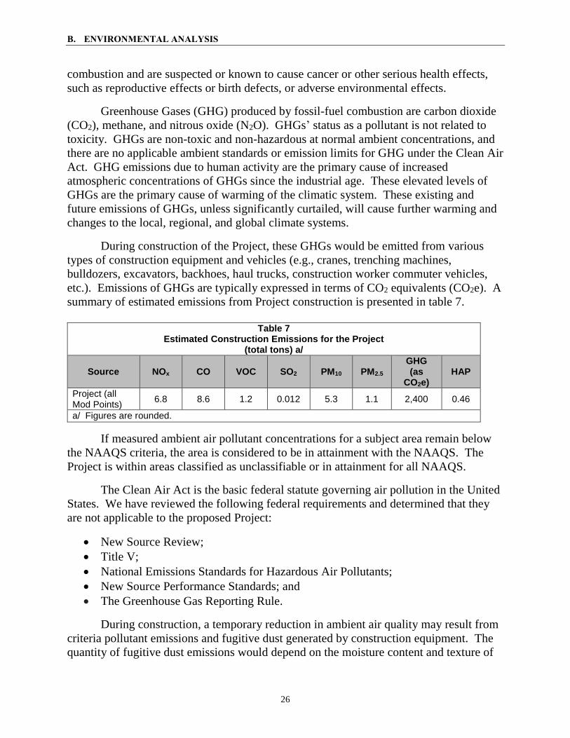
During construction of the Project, these GHGs would be emitted from various
types of construction equipment and vehicles (e.g., cranes, trenching machines,
bulldozers, excavators, backhoes, haul trucks, construction worker commuter vehicles,
etc.). Emissions of GHGs are typically expressed in terms of CO2 equivalents (CO2e). A
summary of estimated emissions from Project construction is presented in table 7.
Table 7
Estimated Construction Emissions for the Project (total tons) a/
Source NOx CO VOC SO2 PM10 PM2.5 GHG (as
CO2e) HAP
Project (all Mod Points)
6.8 8.6 1.2 0.012 5.3 1.1 2,400 0.46
a/ Figures are rounded.
If measured ambient air pollutant concentrations for a subject area remain below
the NAAQS criteria, the area is considered to be in attainment with the NAAQS. The
Project is within areas classified as unclassifiable or in attainment for all NAAQS.
The Clean Air Act is the basic federal statute governing air pollution in the United
States. We have reviewed the following federal requirements and determined that they
are not applicable to the proposed Project:
New Source Review;
Title V;
National Emissions Standards for Hazardous Air Pollutants;
New Source Performance Standards; and
The Greenhouse Gas Reporting Rule.
During construction, a temporary reduction in ambient air quality may result from
criteria pollutant emissions and fugitive dust generated by construction equipment. The
quantity of fugitive dust emissions would depend on the moisture content and texture of

B. ENVIRONMENTAL ANALYSIS
27
the soils that would be disturbed. Fugitive dust and other emissions due to construction
activities generally do not pose a significant increase in regional pollutant levels;
however, local pollutant levels could increase. As detailed within its Fugitive Dust
Control Plan, Columbia would use dust suppression techniques, such as watering access
roads and construction workspaces, and in areas near residences as described in section
B.4 above, as necessary to minimize the impacts of fugitive dust on sensitive
areas. Some residences in close proximity to construction workspaces may notice
elevated dust levels, but these impacts would be temporary and limited primarily to
periods when active construction is taking place.
Following construction, the Project facilities would emit very small quantities of
methane during normal operation through leaks from valves, fittings, and other Project
components, and as a result of periodic maintenance and inspection activities involving
use of the new pig launchers and receivers. Columbia estimates that the Project facilities,
including operation of the pig launchers and receivers, would result in approximately
33.887 tons per year and 2.153 tons per year of fugitive methane (as CO2e) releases from
Project equipment leaks and pig launcher/receiver operations, respectively. As a
replacement project, we do not expect the Project to appreciably alter the existing levels
of fugitive methane releases from the facilities that the Project is intended to replace. In
fact, the replacement of old gas transmission infrastructure with new components may
result in some reduction of fugitive releases from Columbia’s Line KA1 North during
normal operation.
Columbia participates in the EPA’s Methane Challenge Program, Natural Gas
STAR, and One Future programs, and reports annually the Line KA1 pump downs and
pipeline replacements. In addition, Columbia conducts regular inspections of its pipeline
facilities including leak detection surveys to minimize the occurrence of fugitive releases.
Based on the short duration of construction activities, and our review of the
estimated emissions from construction of the proposed Project, we conclude that the
Project would not result in regionally significant impacts on air quality.
Noise
The noise environment can be affected both during construction and operation of
pipeline projects. The magnitude and frequency of environmental noise may vary
considerably over the course of the day, throughout the week, and across seasons, in part
due to changing weather conditions and the effects of seasonal vegetation cover. Two
measures to relate the time-varying quality of environmental noise to its known effect on
people are the 24-hour equivalent sound level (Leq) and day-night sound level (Ldn). The
Leq is the level of steady sound with the same total (equivalent) energy as the time-
varying sound of interest, averaged over a 24-hour period. The Ldn is the Leq plus 10
decibels on the A-weighted scale (dBA) added to account for people’s greater sensitivity
to nighttime sound levels during late evening and early morning hours (between the hours
of 10:00 pm and 7:00 am). The A-weighted scale is used because human hearing is less

B. ENVIRONMENTAL ANALYSIS
28
sensitive to low and high frequencies than mid-range frequencies. The human ear’s
threshold of perception for noise change is considered to be 3 dBA; 6 dBA is clearly
noticeable to the human ear, and 10 dBA is perceived as a doubling of noise.
Construction noise is highly variable. Many construction machines operate
intermittently, and the types of machines in use at a construction site change with the
construction phase. The sound level impacts on residences at each of the Project Mod
Points due the construction activities would depend on the type of equipment used, the
duration of use for each piece of equipment, the number of construction vehicles and
machines used simultaneously, and the distance between the sound source and receptor.
Nighttime noise due to construction would be limited since construction would generally
occurs during daylight hours, Monday through Saturday, as described in section A of this
EA.
Construction could take place for several weeks to months at some of the Mod
Points over the course of Columbia’s planned March through October 2019 construction
timeframe. Noise from these construction operations would persist intermittently and
would be noticeable at nearby residences. To minimize noise impacts on the one
residence within 50 feet of a Project construction work area, Columbia would restrict its
construction activities at Mod Point 5 to the hours of 7:00 am and 5:30 pm, maintain
vehicles and equipment according to manufacturer’s recommendations, and ensure that
construction equipment is properly maintained and equipped with mufflers.9 In addition,
Columbia would install muffling equipment on valves during blowdown activities
necessary to prepare the Line KA1 pipeline for Project construction activities. Because
of the temporary nature of construction activities, we conclude that no significant noise
impacts are anticipated from construction of the proposed Project.
With the exception of the new pig launcher/receiver facilities, the Project facilities
would not produce noise during normal operation at levels that would be noticeable at
any nearby noise-sensitive areas, including residences, and would not change existing
noise levels. Minimal and very infrequent increases in operational noise would occur at
both of the Bybee and Muth M&R Stations at times when the pig launcher/receiver
facilities are operated, which Columbia expects would occur once every seven years. We
conclude that operation of the Project would result in minimal noise impacts.
7. Reliability and Safety
Methane, the primary component of natural gas, is colorless, odorless, and
tasteless. It is not toxic, but is classified as a simple asphyxiate, possessing a slight
inhalation hazard. If breathed in high concentration, oxygen deficiency can result in
serious injury or death.
9 The structure near Mod Point 4 is a barn, so special mitigation does not appear to be warranted.

B. ENVIRONMENTAL ANALYSIS
29
The transportation of natural gas by pipeline involves some risk to the public in
the event of an accident and subsequent release of gas. The greatest hazard is a fire or
explosion following a major pipeline rupture. The pressurization of natural gas at a
compressor station also involves some risk to the public in the event of an accident and
subsequent release of gas. The greatest hazard is a fire or explosion following a leak, or
rupture at the facility.
Columbia’s Project facilities must be designed, constructed, operated, and
maintained in accordance with the DOT Minimum Federal Safety Standards in 49 CFR
192, including provisions for written emergency plans and emergency shutdowns. The
regulations are intended to ensure adequate protection for the public and to prevent
natural gas facility accidents and failures. Columbia anticipates that no DOT
classifications (i.e., specifications that require certain design requirements be met) along
its Line KA1 North pipeline would change as a result of the Project.
The DOT pipeline standards are published in Parts 190-199 of 49 CFR. For
example, Part 192 specifically addresses natural gas pipeline safety issues and prescribes
the minimum standards for operating and maintaining pipeline facilities. Part 192 also
requires a pipeline operator to establish a written emergency plan that includes
procedures to minimize the hazards in a natural gas pipeline emergency.
Additionally, the operator must establish a continuing education program to enable
the public, government officials, and others to recognize an emergency at the pipeline
facilities and report it to appropriate public officials. Columbia would provide the
appropriate training to local emergency service personnel before the facilities are placed
in service.
The coating of removed pipe and fittings and any fluids found during removal
would be tested for asbestos and other hazardous contaminants (including
polychlorinated biphenyl compounds [PCBs]) and any materials found to be
contaminated will be disposed of at an approved facility. Based on Columbia’s review of
local gas producers and historic use of PCBs, and via its sampling of liquids in the Line
KA1 North pipeline, Columbia does not anticipate that PCBs would be encountered
during the Project activities.
As stated in section A.2, Columbia proposes the Project in order to protect Line
KA1 North from corrosion and provide advanced monitoring capabilities to ensure that
the pipeline continues to be operated and maintained in accordance with DOT standards.
Therefore, we are confident that the Project facilities and the modified Line KA1 North
would be constructed and operated safely.
8. Cumulative Impacts
In accordance with NEPA and with FERC policy, we identified other actions in the
vicinity of the Project facilities and evaluated the potential for a cumulative impact on the

B. ENVIRONMENTAL ANALYSIS
30
environment. As defined by the CEQ, a cumulative effect is the impact on the
environment that results from the incremental impact of the action when added to other
past, present, and reasonably foreseeable future actions regardless of the agency or party
undertaking such other actions. Cumulative impacts can result from individually minor,
but collectively significant actions, taking place over time. The CEQ guidance states that
an adequate cumulative effects analysis may be conducted by focusing on the current
aggregate effects of past actions without delving into the historical details of individual
past actions.10 In this analysis, we consider the impacts of past projects within defined
areas of influence (“scopes”) as part of the affected environment (environmental
baseline), which were described and evaluated in the preceding environmental analysis.
However, present effects of past actions (e.g., the presence of the existing Line KA1
North facilities) that are relevant and useful are also considered. Table 8 summarizes the
resource-specific geographic scopes that were considered in this analysis.
Our cumulative effects analysis focuses on potential impacts from the proposed
Project on resource areas or issues where the incremental contribution could result in
cumulative impacts when added to the potential impacts of other actions. To avoid
unnecessary discussions of insignificant impacts and projects and to adequately address
and accomplish the purposes of this analysis, an action must first meet the following
three criteria to be included in the cumulative analysis:
affects a resource also potentially affected by the Project11;
causes this impact within all, or part of, the Project areas defined by the resource-
specific geographic scope; and
causes this impact within all, or part of, the time span of the proposed Project’s
estimated impacts.
As described in our analysis above within section B of this EA, constructing and
operating the Project would affect the environment primarily on a short-term/temporary
basis, and its effect on a long-term/permanent basis would not be appreciably different
than the existing Line KA1 North facilities, except for 0.2 acre of new permanent
easement and 1.22 acres of permanent access roads summarized in tables 2 and 5. The
Project would affect geology, soils, some groundwater and surface water resources
(primarily related to potential fluid leaks or spills), vegetation, wildlife (including special
status species), some land uses, traffic, and construction-related air quality and noise.
We find that the Project’s potential to contribute to cumulative impacts to be
limited since the Project’s primary activities involve the installation of new and
replacement facilities largely within footprints currently occupied by existing and similar
facilities. As described in section B, impacts from the Project would be minor and
10 Considering Cumulative Effects under the National Environmental Policy Act. Website:
http://energy.gov/sites/prod/files/nepapub/nepa_documents/RedDont/G-CEQ-ConsidCumulEffects.pdf 11 For example, the Project would not affect wetlands; thus, we do not evaluate cumulative impacts on this particular
resource.

B. ENVIRONMENTAL ANALYSIS
31
primarily short-term. Therefore, our analysis of cumulative impacts is primarily confined
to the impacts that would occur during construction of the Project, and up to and
including the timeframe required to revegetate or otherwise restore the areas disturbed by
the Project.
Table 8 below summarizes the resource-specific geographic scopes that were
considered in this analysis, and the justification for each. Actions outside of these
boundaries are generally not evaluated because their potential to contribute to cumulative
impacts diminishes with increasing distance from the Projects.
Table 8 Cumulative Impact Resource-Specific Geographic Scopes
Resource Cumulative Impact Geographic Scope and
Justification
Geological Resources and Soils
For geological resources and soils, potential impacts include the area of disturbance of the Project (i.e., the construction workspaces) overlapping or immediately abutting the workspaces of other actions.
Surface Water Resources
Impacts on water resources are traditionally assessed on a watershed level, defined by the watershed boundary (HUC 12), to assess potential overlapping impacts from sedimentation, turbidity, and general water quality impacts.
Groundwater, Vegetation, Wildlife, and Special Status Species
The watershed level provides a natural boundary and a geographic proxy to accommodate general wildlife habitat and ecology characteristics in the Project area; therefore, impacts of other actions on vegetation, wildlife, and special status species are evaluated in combination with the Project within its HUC-12 watershed boundaries, as recommended by CEQ.
Land Use and Traffic Impacts of other actions in combination with the Project are evaluated within a 1-mile radius from the Project work areas to encompass large areas with specialized or recreational uses.
Air Quality Construction impacts include other actions within 0.25 mile from the Project workspaces.
Noise Construction impacts include other actions within 0.25 mile from the proposed Project earth-disturbing equipment work, based on our knowledge of typical construction equipment.
Other Actions identified within the Geographic Scope
Recently completed, present, and reasonably foreseeable projects are summarized
in table 9, and include the following types of actions falling within applicable geographic
scopes defined in table 8:
new and modified natural gas compressor stations and pipeline facilities;
multiple commercial lots for potential development;
recent commercial development;
one proposed residential development; and
two elementary schools.
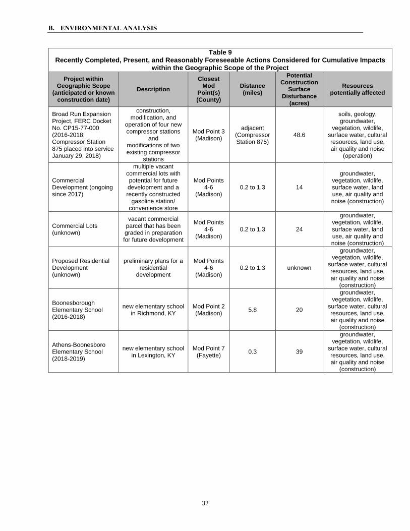
B. ENVIRONMENTAL ANALYSIS
32
Table 9 Recently Completed, Present, and Reasonably Foreseeable Actions Considered for Cumulative Impacts
within the Geographic Scope of the Project
Project within Geographic Scope
(anticipated or known construction date)
Description
Closest Mod
Point(s) (County)
Distance (miles)
Potential Construction
Surface Disturbance
(acres)
Resources potentially affected
Broad Run Expansion Project, FERC Docket No. CP15-77-000 (2016-2018; Compressor Station 875 placed into service January 29, 2018)
construction, modification, and
operation of four new compressor stations
and modifications of two existing compressor
stations
Mod Point 3 (Madison)
adjacent (Compressor Station 875)
48.6
soils, geology, groundwater,
vegetation, wildlife, surface water, cultural resources, land use, air quality and noise
(operation)
Commercial Development (ongoing since 2017)
multiple vacant commercial lots with potential for future development and a recently constructed
gasoline station/ convenience store
Mod Points 4-6
(Madison) 0.2 to 1.3 14
groundwater, vegetation, wildlife, surface water, land use, air quality and noise (construction)
Commercial Lots (unknown)
vacant commercial parcel that has been graded in preparation for future development
Mod Points 4-6
(Madison) 0.2 to 1.3 24
groundwater, vegetation, wildlife, surface water, land use, air quality and noise (construction)
Proposed Residential Development (unknown)
preliminary plans for a residential
development
Mod Points 4-6
(Madison) 0.2 to 1.3 unknown
groundwater, vegetation, wildlife,
surface water, cultural resources, land use, air quality and noise
(construction)
Boonesborough Elementary School (2016-2018)
new elementary school in Richmond, KY
Mod Point 2 (Madison)
5.8 20
groundwater, vegetation, wildlife,
surface water, cultural resources, land use, air quality and noise
(construction)
Athens-Boonesboro Elementary School (2018-2019)
new elementary school in Lexington, KY
Mod Point 7 (Fayette)
0.3 39
groundwater, vegetation, wildlife,
surface water, cultural resources, land use, air quality and noise
(construction)

B. ENVIRONMENTAL ANALYSIS
33
Geology and Soils
As Project impacts on geology and soils would be highly localized and limited
primarily to the Project footprint during the period of active construction, cumulative
impacts on geology and soils would only occur if other geographically overlapping
projects were constructed at the same time (and place) as the Project (and the exposure of
soils to erosion and sedimentation) occurs. The two projects identified in table 9 that
could apply are the two FERC-jurisdictional projects associated with adjacent
Compressor Station 875. However, in each case there is no ongoing work and likely no
work to be done during Columbia’s proposed Project activity. Thus, there would be no
cumulative impact on geology and soils.
Groundwater
Construction of the Project could result in minor, temporary impacts on
groundwater infiltration due to tree, herbaceous vegetation, or scrub-shrub vegetation
clearing; or from possible leaks/spills of equipment fluid. We are not aware of any major
impacts on groundwater from the other projects listed in table 9. As discussed in section
B, Columbia’s Project would have very minor impacts on groundwater, and Columbia
would implement its SPCC Plan regarding fluids. We would expect the other projects to
have comparable best management practices and likely only minor impacts on
groundwater. For these reasons, we conclude that any cumulative impact on groundwater
would be negligible.
Vegetation
The primary impacts on vegetation would result from the permanent conversion of
forested land to open land and herbaceous cover as a result of maintenance of the
permanent right-of-way. In addition, open land and agricultural fields would be
converted to impervious surfaces (i.e., gravel cover) for new permanent access roads and
extended gravel cover at existing facilities. Long-term impacts would occur where
forested areas are cleared for temporary workspaces because these areas could take
decades to return to pre-construction conditions.
While the construction timeline for some of these other projects in table 9 is
unknown, it is possible that cumulative impacts on vegetation in the geographic scope
could occur from construction and operation of the Project in combination with the
projects identified within the two HUC watersheds. All seven of these projects are
expected to create impervious surfaces as a result of construction activities or operations.
One of the identified projects (the Broad Run Expansion Project) includes work at
Compressor Station 875, which is adjacent to Mod Point 3. This project is FERC-
jurisdictional and is subject to the same requirements as the Project. The remaining
projects include the construction of two new elementary schools and new residential and
commercial developments.

B. ENVIRONMENTAL ANALYSIS
34
Local, regional, and federal permits and regulations applicable to these projects
require the use of industry-wide best management practices to reduce sedimentation and
erosion runoff which could be caused from vegetation removal. All of the projects could
temporarily and permanently affect forested areas, and although some of these projects
would be completed before or after the construction of the Project, forested areas may
take several years or decades to return to pre-construction conditions, and the effects of
tree clearing would continue beyond restoration. However, these impacts are not
expected to be significant on a local scale because the surrounding area is already highly
fragmented by agricultural and residential development. Further, it is expected that the
identified projects would use best management practices during construction to limit the
extent of impacts on forested areas (e.g., minimizing tree clearing) and would revegetate
all areas not necessary for operation. Further, the majority of Project components and
construction workspaces have been situated in open land or maintained rights-of-way that
are already frequently disturbed. For these reasons, we conclude that the Project would
not have a significant cumulative impact on vegetation when considered in combination
with the other projects identified in table 9.
Wildlife
As previously discussed in section B.3.2, the temporary and permanent loss of
wildlife habitat, primarily due to forest clearing and conversion of open/agricultural land
to impervious (gravel) surface, would introduce displacement and stress, and could result
in mortality of some individuals. However, following construction activities, all
disturbed areas would be properly restored and revegetated to pre-construction conditions
in accordance with Columbia’s ECS. Seven additional actions within the geographic
scope (see table 9) are expected to impact wildlife habitat and create impervious surfaces
as a result of construction activities or operations. However, based on the abundance of
suitable habitat in the vicinity of these action areas, it is expected that wildlife impacts
would be insignificant. Due to the limited extent of the Project impacts and because
much of the Project would occur within existing right-of-way and open lands, any
cumulative impacts attributed to the Project in combination with the other six identified
projects would be minor and would not result in a significant cumulative impact.
Surface Water
As discussed in section B.2 of this EA, the Project would only directly impact one
drainage ditch, at Mod Point 2. Any impacts on this waterbody would be short term and
minor. Based on the review of projects with the potential to contribute to cumulative
impacts, only one project, the construction of the new Boonesborough Elementary
School, was identified within the same HUC-12 watershed crossed by the Project’s Mod
Point 2. No information was attainable regarding the surface water impacts of the
proposed Boonesborough Elementary School. However, based on review of aerial
photographs, U.S. Geological Survey topographic mapping, national hydrography dataset
data, and National Wetland Inventory data, it appears that the proposed elementary

B. ENVIRONMENTAL ANALYSIS
35
school project avoided impacts on regulated waterbodies. Because there are no apparent
regulated waterbody impacts for the Boonesborough Elementary School, cumulative
impacts are not anticipated in combination with the Project.
Land Use
The Project would result in minor and temporary impacts on existing and future
land uses, and such impacts would be limited to 0.2 acre of new permanent easement and
1.22 acres of permanent access roads. Approximately 0.3 acre of forest would be
permanently converted to open land and herbaceous cover. Regarding the projects in
table 9, any type of new development, from single-lot buildings to subdivision or
commercial development, has the potential to convert existing land use (e.g., agriculture,
pasture, forest) to the desired end use. In comparison to the likely minor land use
conversion for the projects summarized in table 9, and considering that most of the
Project’s permanent impacts would occur within or adjacent to the existing Line KA1
North right-of-way, and not contributing in any significant manner to a regional impact
on land use conversion, we conclude that cumulative land use impacts would be minimal.
Traffic
Traffic would be temporarily impacted during construction of the Project. Several
commercial, industrial, or infrastructure projects listed in table 9 could also impact local
traffic if constructed during the same general timeframe as the Project. Cumulative
traffic impacts on local roads would be limited to the rural area within the vicinities of the
Mod Points, and would cease following completion of Project construction. Therefore,
any traffic impacts from the Project would not have a significant contribution to overall
cumulative impacts on local traffic.
Air Quality and Noise
If any ongoing commercial development construction in proximity to Mod Points
4, 5, and 6 were to occur within the 0.25-mile geographic scope, the construction at Mod
Points 4, 5, and 6 could result in some temporary, localized, and intermittent cumulative
air quality and noise impacts. Noise from construction at Mod Point 3 would also
temporarily add to the background air pollutant and noise levels attributable to the natural
gas-fired turbine at adjacent Compressor Station 875; however, we expect all such
impacts, if any, to be minor and temporary, ceasing after construction at these respective
Mod Points is complete. No other projects identified in table 9 would be within the
geographic scopes with a known construction timeframe that could result in cumulative
air quality or noise impacts with Project construction.

C. ALTERNATIVES
36
C. ALTERNATIVES
In accordance with NEPA and Commission policy, we considered alternatives to
the proposed action, which, due to the nature of the Project (pipe and equipment
replacements and upgrades at specific, discrete locations), are limited to the no-action
alternative and consideration of alternate construction methods. These alternatives were
evaluated to determine whether they would be reasonable and environmentally preferable
to the proposed action. The evaluation criteria for selecting alternatives are: technical
and economic feasibility and practicality; significant environmental advantages over the
proposed Project; and meeting the objectives of the proposed Project.
We note that the proposed new pig launcher/receiver facilities would be sited at
the existing Bybee and Muth M&R Stations within the existing Line KA1 North right-of-
way, and that the remaining Project activities involve the replacement of existing Line
KA1 North piping and components. Due to the site-specific nature of where the upgrades
and replacements would be installed, site alternatives are not applicable to this Project.
1. No-Action Alternative
As indicated in section A.2, Columbia states that the proposed Project is necessary
to enable the use of smart pigs as well as cleaning pigs within the Line KA1 North
pipeline, which would protect the pipeline from corrosion and provide advanced
monitoring capabilities, thereby facilitating Columbia’s continued safe operation of this
part of Columbia’s system. Under the no-action alternative, Columbia would not
implement the proposed action, thus avoiding the potential environmental impacts
associated with the Project as described in this EA; however, the Project’s objectives
would not be met.
The no-action alternative would allow continued transportation of natural gas
through Columbia’s Line KA1 North without the benefit of internal corrosion protection
and inspection capabilities that the Project would provide, and consequently would leave
the pipeline at greater risk for a failure due to a loss in integrity of the pipeline that
Columbia would not have the capability to detect and remedy at an early stage. As stated
in the Commission’s March 17, 2016 approval of Columbia’s Modernization II Program
(see section A.2), the Commission determined Columbia’s Modernization II Settlement
as uncontested, fair, and reasonable, and in the public interest. If the Project was not
constructed, Columbia would not be able to extend the core elements of the
Modernization I Settlement between its shippers that addressed previous modernization
issues. Columbia states that its modernization program was initiated in response to
shipper expectations for increased firm service reliability and to respond to new
regulatory and policy initiatives that address the need for pipeline safety and integrity
management programs. Without the Project, Columbia would not be able to meet these
expectations and regulatory requirements.
C. ALTERNATIVES
37
Further, cognizant of the benefits of facilities such as those the Project would
provide, the DOT requires that all new and replacement pipelines under its jurisdiction be
constructed to accommodate internal inspection and cleaning devices (see 49 CFR
192.917).
For the above reasons, we do not recommend the no-action alternative.
2. Construction Alternatives
We considered the use of portable pig launcher/receivers on its Line KA1 North to
monitor the pipeline’s integrity, instead of the permanent upgrades associated with the
proposed Project. Although such portable alternatives have advantages in certain
situations (e.g., where space at existing stations is limited, etc.), both temporary and
permanent pig launcher/receivers require earth disturbance to modify the pipeline, as well
as permanent access to each pig launcher and receiver. The portable pig
launcher/receiver also requires offsite storage and transport for scheduled inspections.
Since space at each of the Bybee and Muth M&R Stations is readily available for the
installation of permanent pig launcher/receiver facilities, we conclude that the permanent
facilities are preferable, and that they would not result in any additional environmental
impact than the portable construction alternative.
Our review of the proposed Project found no significant environmental impacts
that would drive an evaluation of additional alternatives. In addition, we received no
comments during scoping that suggested we consider alternatives to the proposed Project.
In conclusion, we have determined that the proposed Project is the preferred alternative
that can meet the Project objectives.

D. CONCLUSIONS AND RECOMMENDATIONS
38
D. CONCLUSIONS AND RECOMMENDATIONS
Based on the analysis contained in this EA, we have determined that if Columbia
constructs the proposed facilities in accordance with its application, filed supplements,
and our recommended mitigation measures listed below, approval of the Project would
not constitute a major federal action significantly affecting the quality of the human
environment.
We recommend that the Commission Order contain a finding of no significant
impact. If the Commission certificates the proposed Project, we recommend that the
Commission Order include the following specific conditions:
1. Columbia shall follow the construction procedures and mitigation measures
described in its application and supplements (including responses to staff data
requests) and as identified in the EA, unless modified by the Order. Columbia
must:
a. request any modification to these procedures, measures, or conditions in a
filing with the Secretary of the Commission (Secretary);
b. justify each modification relative to site-specific conditions;
c. explain how that modification provides an equal or greater level of
environmental protection than the original measure; and
d. receive approval in writing from the Director of the OEP before using that
modification.
2. The Director of OEP, or the Director’s designee, has delegated authority to
address any requests for approvals or authorizations necessary to carry out the
conditions of the Order, and take whatever steps are necessary to ensure the
protection of environmental resources during construction and operation of the
Project. This authority shall allow:
a. the modification of conditions of the Order;
b. stop-work authority; and
c. the imposition of any additional measures deemed necessary to ensure
continued compliance with the intent of the conditions of the Order as well
as the avoidance or mitigation of unforeseen adverse environmental impact
resulting from Project construction and operation.
3. Prior to any construction, Columbia shall file an affirmative statement with the
Secretary, certified by a senior company official, that all company personnel, EIs,
and contractor personnel will be informed of the EI’s authority and have been or
will be trained on the implementation of the environmental mitigation measures
appropriate to their jobs before becoming involved with construction and
restoration activities.

D. CONCLUSIONS AND RECOMMENDATIONS
39
4. The authorized facility locations shall be as shown in the EA, as supplemented by
filed alignment sheets. As soon as they are available, and before the start of
construction, Columbia shall file with the Secretary any revised detailed survey
alignment maps/sheets at a scale not smaller than 1:6,000 with station positions for
all facilities approved by the Order. All requests for modifications of
environmental conditions of the Order or site-specific clearances must be written
and must reference locations designated on these alignment maps/sheets.
Columbia’s exercise of eminent domain authority granted under NGA section 7(h)
in any condemnation proceedings related to the Order must be consistent with
these authorized facilities and locations. Columbia’s right of eminent domain
granted under NGA section 7(h) does not authorize it to increase the size of its
natural gas facilities to accommodate future needs or to acquire a right-of-way for
a pipeline to transport a commodity other than natural gas.
5. Columbia shall file with the Secretary detailed alignment maps/sheets and aerial
photographs at a scale not smaller than 1:6,000 identifying all route realignments
or facility relocations, and staging areas, pipe storage yards, new access roads, and
other areas that would be used or disturbed and have not been previously
identified in filings with the Secretary. Approval for each of these areas must be
explicitly requested in writing. For each area, the request must include a
description of the existing land use/cover type, documentation of landowner
approval, whether any cultural resources or federally listed threatened or
endangered species would be affected, and whether any other environmentally
sensitive areas are within or abutting the area. All areas shall be clearly identified
on the maps/sheets/aerial photographs. Each area must be approved in writing by
the Director of OEP before construction in or near that area.
This requirement does not apply to extra workspace allowed by the Commission’s
Upland Erosion Control, Revegetation, and Maintenance Plan and/or minor field
realignments per landowner needs and requirements which do not affect other
landowners or sensitive environmental areas such as wetlands.
Examples of alterations requiring approval include all route realignments and
facility location changes resulting from:
a. implementation of cultural resources mitigation measures;
b. implementation of endangered, threatened, or special concern species
mitigation measures;
c. recommendations by state regulatory authorities; and
d. agreements with individual landowners that affect other landowners or
could affect sensitive environmental areas.

D. CONCLUSIONS AND RECOMMENDATIONS
40
6. Within 60 days of the acceptance of the authorization and before construction begins, Columbia shall file an Implementation Plan with the Secretary for review
and written approval by the Director of OEP. Columbia must file revisions to the
plan as schedules change. The plan shall identify:
a. how Columbia will implement the construction procedures and mitigation
measures described in its application and supplements (including responses
to staff data requests), identified in the EA, and required by the Order;
b. how Columbia will incorporate these requirements into the contract bid
documents, construction contracts (especially penalty clauses and
specifications), and construction drawings so that the mitigation required at
each site is clear to onsite construction and inspection personnel;
c. the number of EIs assigned, and how the company will ensure that
sufficient personnel are available to implement the environmental
mitigation;
d. company personnel, including EIs and contractors, who will receive copies
of the appropriate material;
e. the location and dates of the environmental compliance training and
instructions Columbia will give to all personnel involved with construction
and restoration (initial and refresher training as the Project progresses and
personnel change);
f. the company personnel (if known) and specific portion of Columbia’s
organization having responsibility for compliance;
g. the procedures (including use of contract penalties) Columbia will follow if
noncompliance occurs; and
h. for each discrete facility, a Gantt or PERT chart (or similar Project
scheduling diagram), and dates for:
(1) the completion of all required surveys and reports;
(2) the environmental compliance training of onsite personnel;
(3) the start of construction; and
(4) the start and completion of restoration.
7. Columbia shall employ at least one EI. The EI shall be:
a. responsible for monitoring and ensuring compliance with all mitigation
measures required by the Order and other grants, permits, certificates, or
other authorizing documents;
b. responsible for evaluating the construction contractor’s implementation of
the environmental mitigation measures required in the contract (see
condition 6 above) and any other authorizing document;
D. CONCLUSIONS AND RECOMMENDATIONS
41
c. empowered to order correction of acts that violate the environmental
conditions of the Order, and any other authorizing document;
d. responsible for documenting compliance with the environmental conditions
of the Order, as well as any environmental conditions/permit requirements
imposed by other federal, state, or local agencies; and
e. responsible for maintaining status reports.
8. Beginning with the filing of its Implementation Plan, Columbia shall file updated
status reports with the Secretary on a monthly basis until all construction and
restoration activities are complete. On request, these status reports will also be
provided to other federal and state agencies with permitting responsibilities.
Status reports shall include:
a. an update on Columbia’s efforts to obtain the necessary federal
authorizations;
b. the construction status of the Project, work planned for the following
reporting period, and any schedule changes for stream crossings or work in
other environmentally-sensitive areas;
c. a listing of all problems encountered and each instance of noncompliance
observed by the EI(s) during the reporting period (both for the conditions
imposed by the Commission and any environmental conditions/permit
requirements imposed by other federal, state, or local agencies);
d. a description of the corrective actions implemented in response to all
instances of noncompliance;
e. the effectiveness of all corrective actions implemented;
f. a description of any landowner/resident complaints which may relate to
compliance with the requirements of the Order, and the measures taken to
satisfy their concerns; and
g. copies of any correspondence received by Columbia from other federal,
state, or local permitting agencies concerning instances of noncompliance,
and Columbia’s response.
9. Columbia must receive written authorization from the Director of OEP before
commencing construction of any Project facilities. To obtain such
authorization, Columbia must file with the Secretary documentation that it has
received all applicable authorizations required under federal law (or evidence of
waiver thereof).
10. Columbia must receive written authorization from the Director of OEP before
placing the Project into service. Such authorization will only be granted
following a determination that rehabilitation and restoration of the right-of-way
and other areas affected by the Project are proceeding satisfactorily.
D. CONCLUSIONS AND RECOMMENDATIONS
42
11. Within 30 days of placing the authorized facilities in service, Columbia shall
file an affirmative statement with the Secretary, certified by a senior company
official:
a. that the facilities have been constructed in compliance with all applicable
conditions, and that continuing activities will be consistent with all
applicable conditions; or
b. identifying which of the conditions in the Order Columbia has complied
with or will comply with. This statement shall also identify any areas
affected by the Project where compliance measures were not properly
implemented, if not previously identified in filed status reports, and the
reason for noncompliance.
43
E. LIST OF PREPARERS
Warn, Kenneth – Environmental Project Manager
M.P.P., Environmental Policy, 2005, The George Washington University
M.S., Chemical Engineering, 1995, Lehigh University
B.S., Chemical Engineering, 1992, Colorado School of Mines
Boros, Laurie – Cultural Resources
B.A., Anthropology/Archaeology, 1980. Queens College, City University of New
York
Cotton, Douglas – Land Use
M.S., University of Wisconsin-Madison, 1980, Urban & Regional Planning
B.A., University of Massachusetts-Amherst, 1977, Geography
Mallory, Christine – Surface Water Resources, Vegetation, and Wildlife
M.S., Environmental Management, 2013, Samford University
B.S., Biology, 2012, Stillman College
Rodgers, Keith – Geology, Soils, and Groundwater Resources Professional Geologist, 2008, North Carolina Board for the Licensing of
Geologists
M.E., Hydrogeochemistry, 2008, University of Arizona
B.S., Geological Sciences (Geochemistry option), 2004, Virginia Tech

Appendix A-1 Notifications, Permits, and Approvals for the Project
Permit/Approval Administering Agency Status
Federal
Certificate of Public Convenience and Necessity
Federal Energy Regulatory Commission
Application filed June 20, 2018. Certificate pending.
Clean Water Act, Section 404 —Nationwide Permit 12
U.S. Army Corps of Engineers - Louisville District
Permit applications filed May 18 and August 7, 2018. Permit received October 19, 2018.
Endangered Species Act, Section 7 Consultation a/
U.S. Fish and Wildlife Service - Kentucky Field Office
Consultation letter sent May 2, 2018. Kentucky Field Office concurrence received May 8, 2018.
Migratory Bird Consultation under Migratory Bird Treaty Act and Bald & Golden Eagle Protection Act
Consultation letter sent August 17, 2018. Kentucky Field Office concurrence received August 20, 2018.
Tribal
Tribal Consultation
Absentee-Shawnee Tribe of Indians of Oklahoma
Consultation letter sent May 8, 2018. No response to date.
Cherokee Nation of Oklahoma Consultation letter sent May 8, 2018. Response received June 4, 2018.
Choctaw Nation of Oklahoma Consultation letter sent May 8, 2018. Response received June 11, 2018.
The Chickasaw Nation Consultation letter sent May 8, 2018. No response to date.
Delaware Nation Consultation letter sent May 8, 2018. Response received June 12, 2018.
Eastern Band of Cherokee Indians
Consultation letter sent May 8, 2018. No response to date.
Eastern Shawnee Tribe of Oklahoma
Consultation letter sent May 8, 2018. No response to date.
Miami Tribe of Oklahoma Consultation letter sent May 8, 2018. No response to date.
Muscogee (Creek) Nation Consultation letter sent May 8, 2018. Responses received June 1 and 25, 2018.
Peoria Tribe of Indians of Oklahoma
Consultation letter sent May 8, 2018. No response to date.
Quapaw Tribe of Oklahoma Consultation letter sent May 8, 2018. Response received June 12, 2018.
Shawnee Tribe Consultation letter sent May 8, 2018. No response to date.
United Keetoowah Band of Cherokee Indians
Consultation letter sent May 8, 2018. No response to date.
State
Threatened and Endangered Species Natural Heritage Data Request
Letter sent on October 1, 2015. TDEC concurrence received October 6, 2015.
State Threatened and Endangered Species Consultation and Clearance
Kentucky State Nature Preserves Commission
Letter sent May 10, 2018. Response received June 14, 2018. Second letter sent August 20, 2018. Concurrence received August 20, 2018.
Clean Water Act, Section 401 Water Quality Certification
Kentucky Department of Environmental Protection
Permit application filed May 18 and August 7, 2018. Permit received October 19, 2018.
Kentucky Pollutant Discharge Elimination System Construction Stormwater General Permit – KYR10
Kentucky Department of Environmental Protection
Application filed February 2, 2018. Permit received February 18, 2018.

Appendix A-1 Notifications, Permits, and Approvals for the Project
Permit/Approval Administering Agency Status
Section 106 Cultural Resources Consultation
Kentucky State Historic Preservation Office (SHPO)
Survey reports sent December 12 and 21, 2017, and February 23, 2018. Concurrence received February 9 and March 6, 2018.
Local
Floodplain Construction Permit Fayette County Application filed January 23, 2018. Permit received February 14, 2018.
Floodplain Construction Permit Madison County
Application filed January 23, 2018. Permits received March 1, 2018 (Mod Point 2), March 13, 2018 (Mod Point 5), and April 19, 2018 (Mod Point 2 – Revised).
a/ To comply with the provisions of the Endangered Species Act, Columbia has evaluated and certified that the proposed Project activities are consistent with its U.S. Fish and Wildlife Service-approved Multi-Species Habitat Conservation Plan and the resulting programmatic Section 7 consultation. Refer to appendix A-2.
Appendix A-2 Multi-Species Habitat Conservation Plan

12
INTERAGENCY ENDANGERED SPECIES ACT CONSULTATION CHECKLIST FOR THE NISOURCE MULTI-SPECIES HABITAT CONSERVATION PLAN
APPLICANT SECTION
ACTION AGENCY (Recipient): ___________________________________________________________ OTHER INVOLVED FEDERAL AGENCIES: __________________________________________________ PROJECT NAME: _______________________________________________________________________ PROJECT I.D. NO. (if applicable): __________________________________________________________
NiSource and Columbia Pipeline Group (Columbia) has provided the attached documentation to involved federal agencies in accordance with “Project Review and Documentation Protocols” of the NiSource/Columbia Pipeline MSHCP Consultation Implementation Guidance 4. This documentation describes if and how the project is covered by the NiSource Multi-Species Habitat Conservation Plan (MSHCP), programmatic biological opinion (BO), and/or programmatic concurrence letters. In addition, the action agency could refer to the following sections and/or pages of the MSHCP, BO, and/or concurrence letters to verify that the activity is covered by the MSHCP and associated Section 7 consultation under the Endangered Species Act (ESA): Reference:
NiSource MSHCP Chapter 2.3 Covered Lands (pp 2-11)NiSource MSHCP Chapter 2.4 Covered Activities (pp 11- 25)NiSource/Columbia Pipeline MSHCP Consultation Implementation Guidance Quick Reference for Species Consultation Categories (pp 5-6) NiSource/Columbia Pipeline Group’s, “Habitat Conservation Program Best Management Practices Guidebook”, v.1.0, March 12, 2014 (specific pages for each species are referenced in the attached application material)
By signing below, Columbia certifies that its proposed activity, as outlined in the accompanying application or notification, is consistent with the MSHCP, BO, and/or concurrence letters. ________________________________ ___________________ Columbia Pipeline representative Date By checking the box, Columbia is notifying the involved federal agencies that the proposed activity will require additional ESA Section 7 consultation because part of the activity may include: (1) any of the 10 Likely to Adversely Affect (LAA) species that are not included in the MSHCP5, (2) species not addressed in the MSHCP, BO, or concurrence letters5, (3) non-covered activities, (4) activities outside of the covered lands, or (5) activities otherwise deviating from the MSHCP, BO, and/or concurrence letters. Additional biological information about the species, habitat, or effects of the action may be required. The federal agencies can contact the U.S. Fish and
4 See NiSource/Columbia Pipeline MSHCP Consultation Implementation Guidance. February 13, 2014. Pg 11. 5 See NiSource/Columbia Pipeline MSHCP Consultation Implementation Guidance. February 13, 2014. Pg. 5.
U.S. Army Corps of Engineers
Line KA1 North Launcher/Receiver Project
KY17BAA-003C
Federal Energy Regulatory Commission (FERC is the lead federal agency)
,
________________________________________________________________________________________________________________________ ___________ _____________olumbia Pipeline representat
2/6/2018

13
Wildlife Service’s NiSource/Columbia MSHCP Implementation Coordinator (Karen Herrington, 850.348.6495, [email protected]) for more information.
FEDERAL AGENCY SECTION This checklist serves as the official documentation that each action agency involved has completed its Section 7 responsibilities under the ESA for NiSource and Columbia Pipeline Group (Columbia) projects conducted as described in the MSHCP, BO, and/or concurrence letters. Every agency that receives a copy of this checklist should fill it out. The MSHCP, BO, and concurrence letters can be found on the U.S. Fish and Wildlife Service (FWS) NiSource website: http://www.fws.gov/midwest/endangered/permits/hcp/nisource/index.html Quick access to the required Avoidance and Minimization Measures (AMMs) and Best Management Practices (BMP) can be found in the Columbia BMP Guidebook, which is also posted on the above website.
1. Does the federal action occur entirely within the covered lands as described in the MSHCP? _____ Yes. Go to #2. _____ No. Additional consultation is required because the action is not consistent with the MSHCP, BO,
and/or concurrence letters. If the project may affect listed species, contact your local FWS Field Office.
2. Is the proposed action as described in the MSHCP, programmatic BO, and/or concurrence letter?
_____ Yes. Go to #3. _____ No. Additional consultation is required because the action is not consistent with the MSHCP, BO,
and/or concurrence letters. If the project may affect listed species, contact your local FWS Field Office.
3. Does the proposed action pose any effects on species not included in the MSHCP, BO or concurrence
letters55? _____ Yes. Additional consultation is required because the species was not included in the MSHCP, BO,
and/or concurrence letters. If the project may affect listed species not included in the consultation, contact your local FWS Field Office.
_____ No. Go to #4.
4. Does the proposed action include MSHCP species65 only? _____ Yes. Go to #6. _____ No. Go to #5.
5. Does the proposed action include any of the 10 Likely to Adversely Affect (LAA) species that are not included in the MSHCP (i.e., LAA non-MSHCP species) as addressed in the BO? _____ Yes. Additional consultation is required. Enter into tiered consultation with your local FWS office
for any LAA non-MSHCP species. _____ No. Go to #6.
6 See NiSource/Columbia Pipeline MSHCP Consultation Implementation Guidance. February 13, 2014. Pg. 5
X
X
X
X
X Running buffalo clover and Globe (Short's) bladderpod are listed but not affected. Review of the MSCHP database indicatedthat no modeled potentially suitable habitat for these species was present in the Project area. Furthermore, no newright-of-way (ROW) alignments are proposed. Therefore, there are no applicable avoidance and minimization measures(AMMs) for these species and no further coordination with USFWS is required relative to these species.
