listing of contents - jogss.orgjogss.org/conference/abstracts booklet of 3rd national...
TRANSCRIPT
1
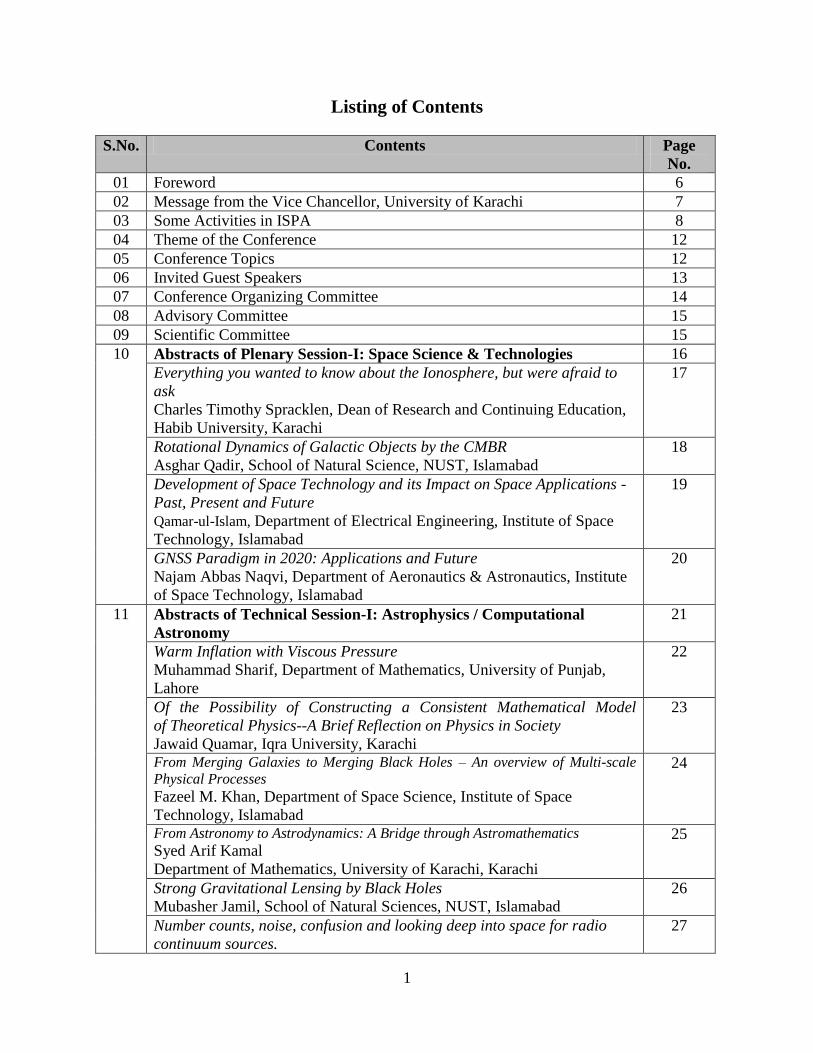
Listing of Contents
S.No. Contents Page
No.
01 Foreword 6
02 Message from the Vice Chancellor, University of Karachi 7
03 Some Activities in ISPA 8
04 Theme of the Conference 12
05 Conference Topics 12
06 Invited Guest Speakers 13
07 Conference Organizing Committee 14
08 Advisory Committee 15
09 Scientific Committee 15
10 Abstracts of Plenary Session-I: Space Science & Technologies 16
Everything you wanted to know about the Ionosphere, but were afraid to
ask
Charles Timothy Spracklen, Dean of Research and Continuing Education,
Habib University, Karachi
17
Rotational Dynamics of Galactic Objects by the CMBR
Asghar Qadir, School of Natural Science, NUST, Islamabad
18
Development of Space Technology and its Impact on Space Applications -
Past, Present and Future
Qamar-ul-Islam, Department of Electrical Engineering, Institute of Space
Technology, Islamabad
19
GNSS Paradigm in 2020: Applications and Future
Najam Abbas Naqvi, Department of Aeronautics & Astronautics, Institute
of Space Technology, Islamabad
20
11 Abstracts of Technical Session-I: Astrophysics / Computational
Astronomy
21
Warm Inflation with Viscous Pressure
Muhammad Sharif, Department of Mathematics, University of Punjab,
Lahore
22
Of the Possibility of Constructing a Consistent Mathematical Model
of Theoretical Physics--A Brief Reflection on Physics in Society
Jawaid Quamar, Iqra University, Karachi
23
From Merging Galaxies to Merging Black Holes – An overview of Multi-scale
Physical Processes
Fazeel M. Khan, Department of Space Science, Institute of Space
Technology, Islamabad
24
From Astronomy to Astrodynamics: A Bridge through Astromathematics
Syed Arif Kamal
Department of Mathematics, University of Karachi, Karachi
25
Strong Gravitational Lensing by Black Holes
Mubasher Jamil, School of Natural Sciences, NUST, Islamabad
26
Number counts, noise, confusion and looking deep into space for radio
continuum sources.
27
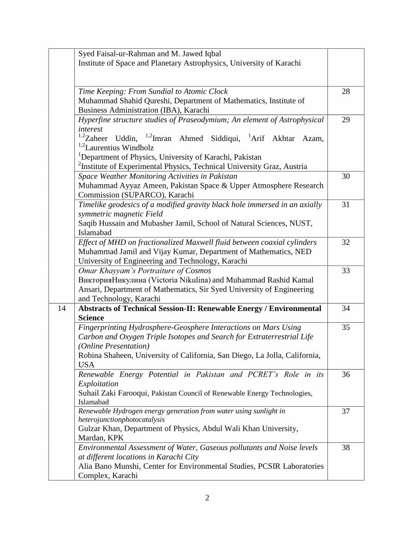
2
Syed Faisal-ur-Rahman and M. Jawed Iqbal
Institute of Space and Planetary Astrophysics, University of Karachi
Time Keeping: From Sundial to Atomic Clock
Muhammad Shahid Qureshi, Department of Mathematics, Institute of
Business Administration (IBA), Karachi
28
Hyperfine structure studies of Praseodymium; An element of Astrophysical
interest 1.2
Zaheer Uddin, 1,2
Imran Ahmed Siddiqui, 1Arif Akhtar Azam,
1,2Laurentius Windholz
1Department of Physics, University of Karachi, Pakistan
2Institute of Experimental Physics, Technical University Graz, Austria
29
Space Weather Monitoring Activities in Pakistan
Muhammad Ayyaz Ameen, Pakistan Space & Upper Atmosphere Research
Commission (SUPARCO), Karachi
30
Timelike geodesics of a modified gravity black hole immersed in an axially
symmetric magnetic Field
Saqib Hussain and Mubasher Jamil, School of Natural Sciences, NUST,
Islamabad
31
Effect of MHD on fractionalized Maxwell fluid between coaxial cylinders
Muhammad Jamil and Vijay Kumar, Department of Mathematics, NED
University of Engineering and Technology, Karachi
32
Omar Khayyam’s Portraiture of Cosmos
ВикторияНикулина (Victoria Nikulina) and Muhammad Rashid Kamal
Ansari, Department of Mathematics, Sir Syed University of Engineering
and Technology, Karachi
33
14 Abstracts of Technical Session-II: Renewable Energy / Environmental
Science
34
Fingerprinting Hydrosphere-Geosphere Interactions on Mars Using
Carbon and Oxygen Triple Isotopes and Search for Extraterrestrial Life
(Online Presentation)
Robina Shaheen, University of California, San Diego, La Jolla, California,
USA
35
Renewable Energy Potential in Pakistan and PCRET’s Role in its
Exploitation
Suhail Zaki Farooqui, Pakistan Council of Renewable Energy Technologies,
Islamabad
36
Renewable Hydrogen energy generation from water using sunlight in
heterojunctionphotocatalysis
Gulzar Khan, Department of Physics, Abdul Wali Khan University,
Mardan, KPK
37
Environmental Assessment of Water, Gaseous pollutants and Noise levels
at different locations in Karachi City
Alia Bano Munshi, Center for Environmental Studies, PCSIR Laboratories
Complex, Karachi
38
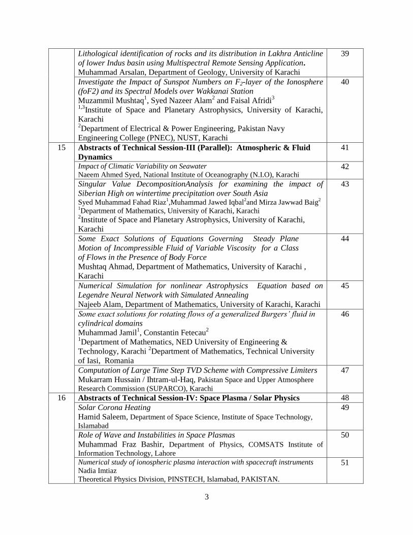
3
Lithological identification of rocks and its distribution in Lakhra Anticline
of lower Indus basin using Multispectral Remote Sensing Application.
Muhammad Arsalan, Department of Geology, University of Karachi
39
Investigate the Impact of Sunspot Numbers on F2-layer of the Ionosphere
(foF2) and its Spectral Models over Wakkanai Station
Muzammil Mushtaq1, Syed Nazeer Alam
2 and Faisal Afridi
3
1,3Institute of Space and Planetary Astrophysics, University of Karachi,
Karachi 2Department of Electrical & Power Engineering, Pakistan Navy
Engineering College (PNEC), NUST, Karachi
40
15 Abstracts of Technical Session-III (Parallel): Atmospheric & Fluid
Dynamics
41
Impact of Climatic Variability on Seawater
Naeem Ahmed Syed, National Institute of Oceanography (N.I.O), Karachi 42
Singular Value DecompositionAnalysis for examining the impact of
Siberian High on wintertime precipitation over South Asia Syed Muhammad Fahad Riaz
1,Muhammad Jawed Iqbal
2and Mirza Jawwad Baig
2
1Department of Mathematics, University of Karachi, Karachi
2Institute of Space and Planetary Astrophysics, University of Karachi,
Karachi
43
Some Exact Solutions of Equations Governing Steady Plane
Motion of Incompressible Fluid of Variable Viscosity for a Class
of Flows in the Presence of Body Force
Mushtaq Ahmad, Department of Mathematics, University of Karachi ,
Karachi
44
Numerical Simulation for nonlinear Astrophysics Equation based on
Legendre Neural Network with Simulated Annealing
Najeeb Alam, Department of Mathematics, University of Karachi, Karachi
45
Some exact solutions for rotating flows of a generalized Burgers’ fluid in
cylindrical domains
Muhammad Jamil1, Constantin Fetecau
2
1Department of Mathematics, NED University of Engineering &
Technology, Karachi 2Department of Mathematics, Technical University
of Iasi, Romania
46
Computation of Large Time Step TVD Scheme with Compressive Limiters
Mukarram Hussain / Ihtram-ul-Haq, Pakistan Space and Upper Atmosphere
Research Commission (SUPARCO), Karachi
47
16 Abstracts of Technical Session-IV: Space Plasma / Solar Physics 48
Solar Corona Heating
Hamid Saleem, Department of Space Science, Institute of Space Technology,
Islamabad
49
Role of Wave and Instabilities in Space Plasmas
Muhammad Fraz Bashir, Department of Physics, COMSATS Institute of
Information Technology, Lahore
50
Numerical study of ionospheric plasma interaction with spacecraft instruments
Nadia Imtiaz
Theoretical Physics Division, PINSTECH, Islamabad, PAKISTAN.
51
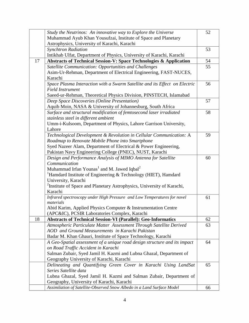
4
Study the Neutrinos: An innovative way to Explore the Universe
Muhammad Ayub Khan Yousufzai, Institute of Space and Planetary
Astrophysics, University of Karachi, Karachi
52
Synchtron Radiation
Intikhab Ulfat, Department of Physics, University of Karachi, Karachi
53
17 Abstracts of Technical Session-V: Space Technologies & Application 54
Satellite Communication: Opportunities and Challenges
Asim-Ur-Rehman, Department of Electrical Engineering, FAST-NUCES,
Karachi
55
Space Plasma Interaction with a Swarm Satellite and its Effect on Electric
Field Instrument
Saeed-ur-Rehman, Theoretical Physics Division, PINSTECH, Islamabad
56
Deep Space Discoveries (Online Presentation)
Aquib Moin, NASA & University of Johannesburg, South Africa
57
Surface and structural modification of femtosecond laser irradiated
stainless steel in different ambient
Umm-i-Kulsoom, Department of Physics, Lahore Garrison University,
Lahore
58
Technological Development & Revolution in Cellular Communication: A
Roadmap to Renovate Mobile Phone into Smartphone
Syed Nazeer Alam, Department of Electrical & Power Engineering,
Pakistan Navy Engineering College (PNEC), NUST, Karachi
59
Design and Performance Analysis of MIMO Antenna for Satellite
Communication
Muhammad Irfan Younas1 and M. Jawed Iqbal
2
1Hamdard Institute of Engineering & Technology (HIET), Hamdard
University, Karachi 2Institute of Space and Planetary Astrophysics, University of Karachi,
Karachi
60
Infrared spectroscopy under High Pressure and Low Temperatures for novel
materials
Abid Karim, Applied Physics Computer & Instrumentation Centre
(APC&IC), PCSIR Laboratories Complex, Karachi
61
18 Abstracts of Technical Session-VI (Parallel): Geo-Informatics 62
Atmospheric Particulate Matter Assessment Through Satellite Derived
AOD and Ground Measurements in Karachi Pakistan
Badar M. Khan Ghauri, Institute of Space Technology, Karachi
63
A Geo-Spatial assessment of a unique road design structure and its impact
on Road Traffic Accident in Karachi
Salman Zubair, Syed Jamil H. Kazmi and Lubna Ghazal, Department of
Geography University of Karachi, Karachi
64
Delineating and Quantifying Green Cover in Karachi Using LandSat
Series Satellite data
Lubna Ghazal, Syed Jamil H. Kazmi and Salman Zubair, Department of
Geography, University of Karachi, Karachi
65
Assimilation of Satellite-Observed Snow Albedo in a Land Surface Model 66
5
Dr. M. Jahanzeb Malik
Pakistan Space and Upper Atmosphere Research Commission SUPARCO,
Karachi 75270
Turning the Tide: From energy crises to its sustainable solution using GIS
Hira Fatima, Institute of Space and Planetary Astrophysics, University of
Karachi, Karachi
67
Estimation of municipal water demand for a planned city and feasible
methods for water conservation Rabia Tabassum,
1,2,, Mudassar Hassan Arsalan2,3
Arif Inam Osmani3
Institute of Space and Planetary Astrophysics, University of Karachi, Karachi
68
Geospatial Analysis Brown Rust Disease On Wheat Crop In Upper Potohar
Region
Sheikh Saeed Ahmad, Shazia Iftikhar and Maria Neelum
Department of Environmental Sciences, Fatima Jinnah Women University,
Rawalpindi
69
Spatial Decision Support System for Installation of Waste Water Treatment Plant
in Karachi, A GIS Perspectives
Syed Kanwal Waseem1, Tariq Masood Ali Khan
2, Jowaid Ahmed
3, Atif Shahzad
4
1, 2, 4 Institute of Environmental Studies, University of Karachi
3 Department
of Geography, University of Karachi
70
Understanding Tropical Cyclone Genesis In The Arabian Sea; A Gis
Perspective
Anam Khalid, Mudassar Hassan Arsalan and Hira Fatima
Research Lab of Geo-Informatics and Sustainable Development Institute of Space and Planetary Astrophysics, University of Karachi
71
Drought Assessment Based on NDVI & Land Surface Temperatures: A case
study of Mithi taluka, Tharparkar, Sindh
Zahid Rao , Muhammad Arslan, Badar Ghauri
Department of Remote Sensing & Geo-information Sciences
Institute of Space Technology, P.O. Box 8456, Karachi-75270 Pakistan
72
19 Abstracts of Poster Presentation 73
6
Foreword
We are now in an era where humanity is reaching to the end points of our solar system through
probes like Voyager 1, sent decades ago by NASA with messages from our civilization.
Humanity is also endeavoring to colonize other planets through multi-national projects. We are
also looking deepest into the space for new stars, galaxies and even to some of the earliest times
after the creation of our universe through cosmic microwave background probes like Planck.
Advancements in space science and technology will not only help in discovering new things
about our universe but through scientific capacity building, technical human resource
development and spin-off technologies, we can see some real economic and social development.
In this regard, Institute of Space and Planetary Astrophysics (ISPA) is playing a significant role to
promote education and research in the fields of Space Science and Technology.ISPA has collaboration
with Pakistan Space Agency SUPARCO, Centre for Astrophysics and Supercomputing,
Swinburne University of Technology, Australia and School of Marine and Atmospheric
Sciences, Stony Brook University, NY, USA.ISPA has recently published first issue of Journal
of GeoSpace Science.The journal covers a wide range of topics related to Geospace sciences.
The Institute of Space and Planetary Astrophysics (ISPA), University of Karachi is organizing
the 3rd
national conference on Space Science and Technology on October 5-6, 2015 for
celebrating World Space Week 2015. The theme of the conference is Deep Space Discoveries. A
number of technical research papers will be presented in the conference in the areas of
Computational Astronomy, Astrophysics, Aeronautical, Space Technologies and Its
Applications, Space Plasma Physics, Renewable Energy, Environmental Science, Atmospheric
Sciences, Remote Sensing and GIS, Computational Physics and other related disciplines which
will benefit individuals and on the large, to the audience.
I would like to extend my thanks to all the speakers for taking part in the activities and last but
not least the organizing committee.Finally, I would like to thank the Vice Chancellor, University
of Karachi; Chairman, SUPARCO, and Higher Education Commission for providing financial
supports to arrange this conference. I also thank members of advisory and organizing committees
and ISPA faculty members. I appreciate the efforts of Office Staff of ISPA in managing this
conference.
Prof. Dr. Muhammad Jawed Iqbal
Director, ISPA
Convener, Conference Organizing Committee
7
Message from Vice Chancellor
University of Karachi
Honorable guests from academia and industry, on behalf of University of Karachi, I welcome
you to the third National Conference on Space Sciences 2015, organized by ISPA. It is a great
privilege for me to see so many students and researchers from various institutes of Pakistan who
have come here to contribute to the spirit of knowledge sharing. Throughout history, astronomy
and space sciences have helped many related fields like physics, chemistry, biology, engineering,
computing and climate studies by providing space and upper atmosphere as means to observe
different scientific phenomena.
Apart from satisfying humanity‘s thirst to explore our universe, space sciences play a vital role in
developing research and industrial capacity building of a country. We, as a developing nation
need to focus on indigenous space technology development, astronomy research and
development of state of the art computing facilities to meet the international standards in the area
of space science and technology.
Astronomy and space sciences, through the global nature of many projects, also provide common
grounds for humanity to employ their skills for peaceful scientific endeavors. It is a great honor
for me to tell you that, ISPA is now collaborating with various international groups and institutes
in the areas of climate studies, radio astronomy and cosmology. I also encourage inter-
disciplinary research collaboration between different departments and institutes of University of
Karachi and other universities so that we can help in developing a solid science and technology
base for this country.
In the end, I would like to congratulate the conference organizing committee for their efforts and
success of this conference.
Prof. Dr. Muhammad Qaiser
Vice-Chancellor
University of Karachi
8
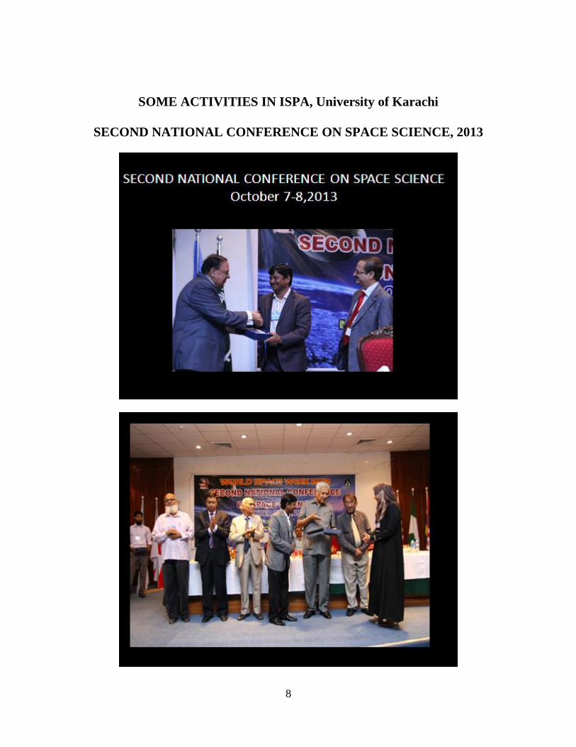
SOME ACTIVITIES IN ISPA, University of Karachi
SECOND NATIONAL CONFERENCE ON SPACE SCIENCE, 2013
9
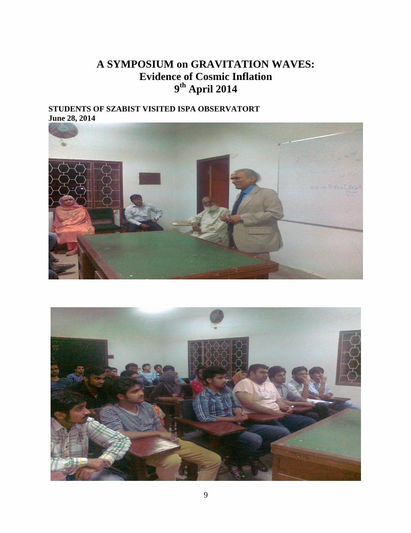
A SYMPOSIUM on GRAVITATION WAVES:
Evidence of Cosmic Inflation
9th
April 2014
STUDENTS OF SZABIST VISITED ISPA OBSERVATORT
June 28, 2014
10
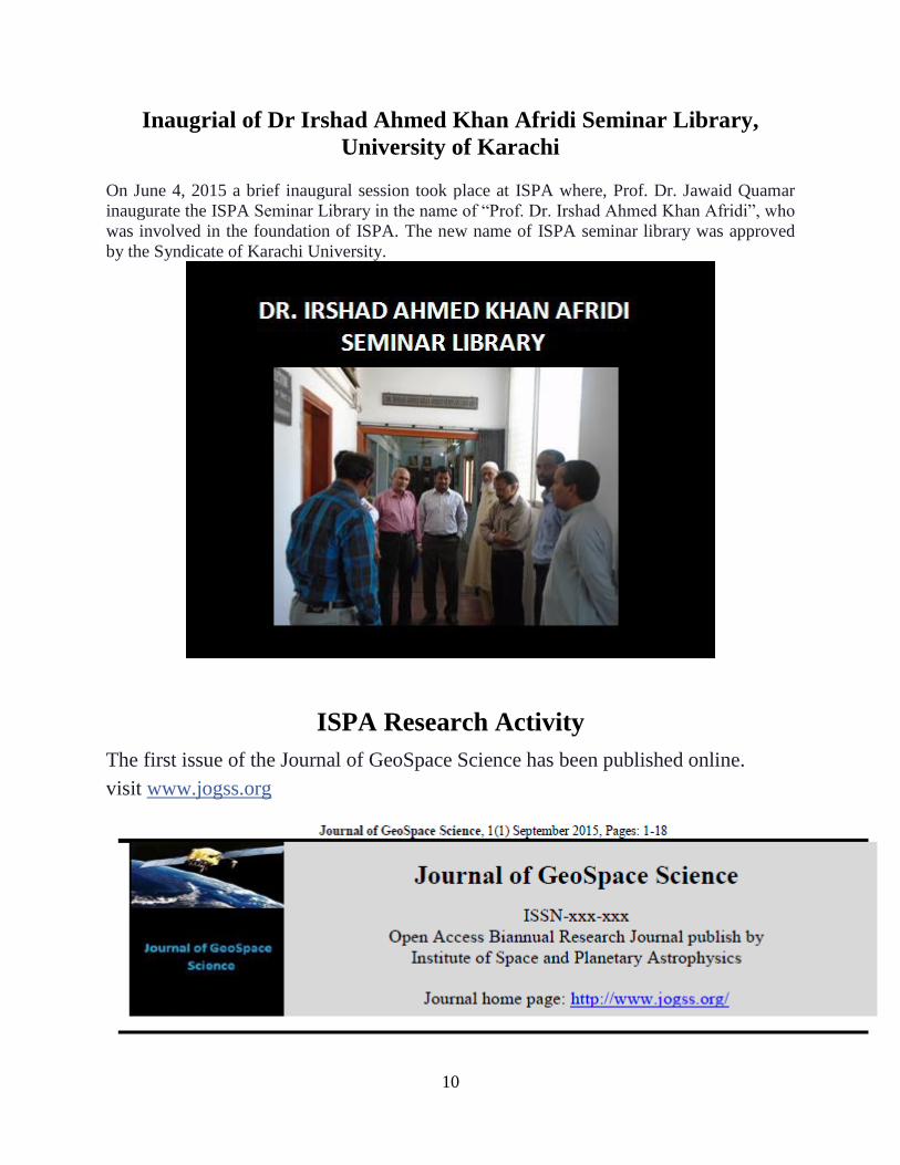
Inaugrial of Dr Irshad Ahmed Khan Afridi Seminar Library,
University of Karachi
On June 4, 2015 a brief inaugural session took place at ISPA where, Prof. Dr. Jawaid Quamar
inaugurate the ISPA Seminar Library in the name of ―Prof. Dr. Irshad Ahmed Khan Afridi‖, who
was involved in the foundation of ISPA. The new name of ISPA seminar library was approved
by the Syndicate of Karachi University.
ISPA Research Activity
The first issue of the Journal of GeoSpace Science has been published online.
visit www.jogss.org
11
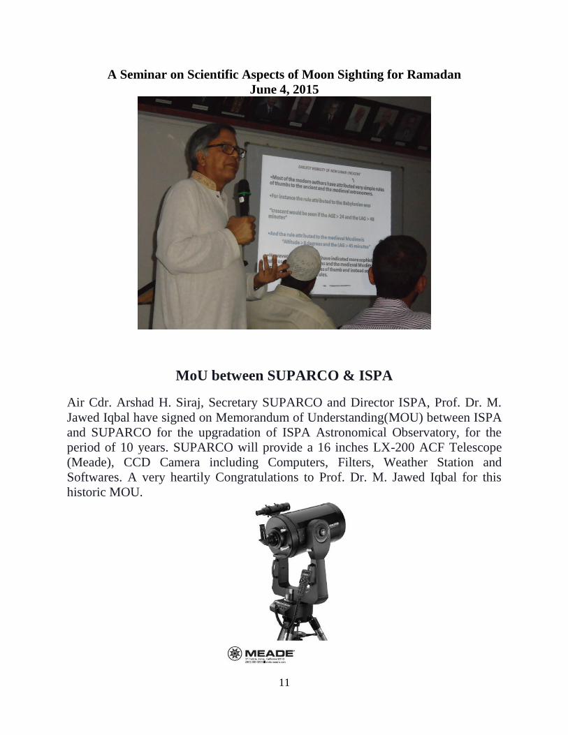
A Seminar on Scientific Aspects of Moon Sighting for Ramadan
June 4, 2015
MoU between SUPARCO & ISPA
Air Cdr. Arshad H. Siraj, Secretary SUPARCO and Director ISPA, Prof. Dr. M.
Jawed Iqbal have signed on Memorandum of Understanding(MOU) between ISPA
and SUPARCO for the upgradation of ISPA Astronomical Observatory, for the
period of 10 years. SUPARCO will provide a 16 inches LX-200 ACF Telescope
(Meade), CCD Camera including Computers, Filters, Weather Station and
Softwares. A very heartily Congratulations to Prof. Dr. M. Jawed Iqbal for this
historic MOU.
12
THEME OF THE CONFERENCE
The Institute of Space and Planetary Astrophysics, University of Karachi is organizing the Third
National Conference on Space Science & Technology on October 5-6, 2015. This conference is
being organized in collaboration with SUPARCO and Higher Education Commission.
The main theme of the conference is ―Exploring the Deep Space Discoveries‖. The objective of
the ―National Conference on Space Science & Technology‖ is to provide a forum for discussion
and implementation of the Space Science and Technology in Pakistan. This conference will also
be a contribution towards the World Space Week 2015.
CONFERENCE TOPICS
The conference is not restricted to any particular area of Space Sciences. To achieve our goal and
theme of the conference, our intention is to cover all active research areas in pure, applied and
interdisciplinary Space Sciences in Pakistan.
Astronomy / Radio Astronomy
Astrophysics
Computational Astrophysics
Cosmology
Satellite Communication / GNSS
Space Antennas
Space Technology and Industry
Flight Dynamics
Aerodynamics
Space Plasma
Remote Sensing and GIS
Solar System and Extrasolar Planets
Astro-Chemistry
Space-Biology
Planetary Atmospheric Sciences
Renewable Energy
Environmental Sciences / Natural Hazards
Physical Oceanography
13
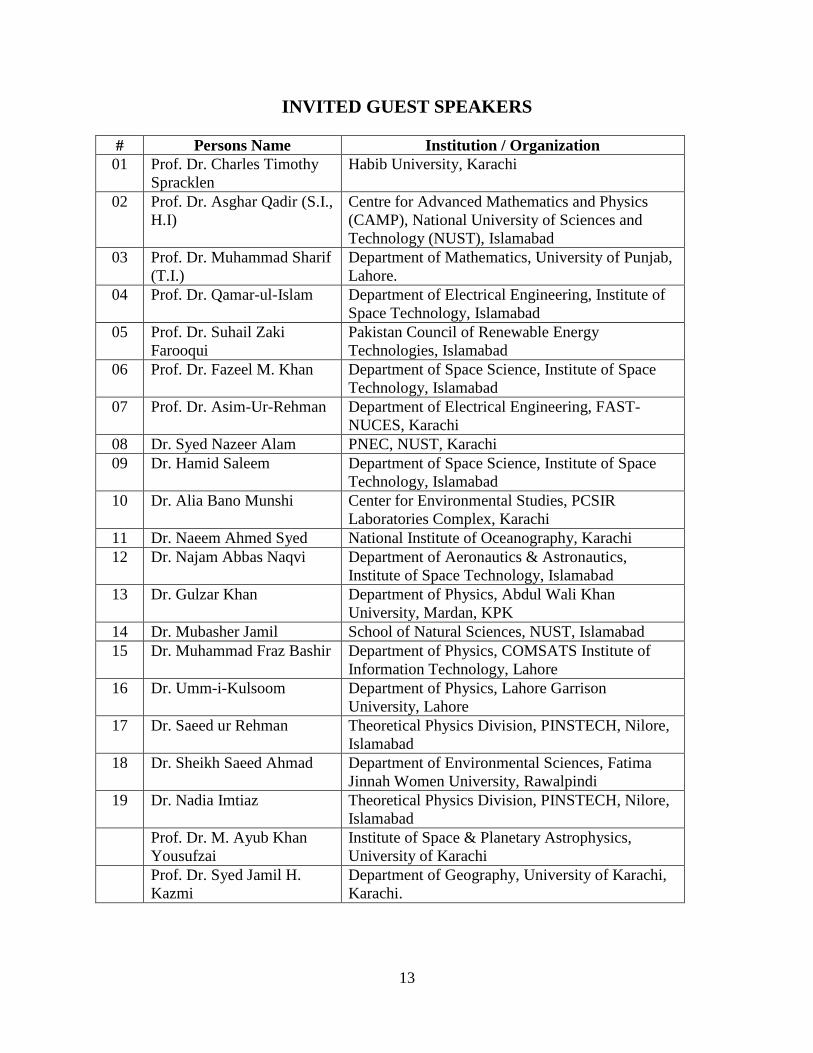
INVITED GUEST SPEAKERS
# Persons Name Institution / Organization
01 Prof. Dr. Charles Timothy
Spracklen
Habib University, Karachi
02 Prof. Dr. Asghar Qadir (S.I.,
H.I)
Centre for Advanced Mathematics and Physics
(CAMP), National University of Sciences and
Technology (NUST), Islamabad
03 Prof. Dr. Muhammad Sharif
(T.I.)
Department of Mathematics, University of Punjab,
Lahore.
04 Prof. Dr. Qamar-ul-Islam Department of Electrical Engineering, Institute of
Space Technology, Islamabad
05 Prof. Dr. Suhail Zaki
Farooqui
Pakistan Council of Renewable Energy
Technologies, Islamabad
06 Prof. Dr. Fazeel M. Khan Department of Space Science, Institute of Space
Technology, Islamabad
07 Prof. Dr. Asim-Ur-Rehman Department of Electrical Engineering, FAST-
NUCES, Karachi
08 Dr. Syed Nazeer Alam PNEC, NUST, Karachi
09 Dr. Hamid Saleem Department of Space Science, Institute of Space
Technology, Islamabad
10 Dr. Alia Bano Munshi Center for Environmental Studies, PCSIR
Laboratories Complex, Karachi
11 Dr. Naeem Ahmed Syed National Institute of Oceanography, Karachi
12 Dr. Najam Abbas Naqvi Department of Aeronautics & Astronautics,
Institute of Space Technology, Islamabad
13 Dr. Gulzar Khan Department of Physics, Abdul Wali Khan
University, Mardan, KPK
14 Dr. Mubasher Jamil School of Natural Sciences, NUST, Islamabad
15 Dr. Muhammad Fraz Bashir Department of Physics, COMSATS Institute of
Information Technology, Lahore
16 Dr. Umm-i-Kulsoom Department of Physics, Lahore Garrison
University, Lahore
17 Dr. Saeed ur Rehman Theoretical Physics Division, PINSTECH, Nilore,
Islamabad
18 Dr. Sheikh Saeed Ahmad
Department of Environmental Sciences, Fatima
Jinnah Women University, Rawalpindi
19 Dr. Nadia Imtiaz Theoretical Physics Division, PINSTECH, Nilore,
Islamabad
Prof. Dr. M. Ayub Khan
Yousufzai
Institute of Space & Planetary Astrophysics,
University of Karachi
Prof. Dr. Syed Jamil H.
Kazmi
Department of Geography, University of Karachi,
Karachi.
14
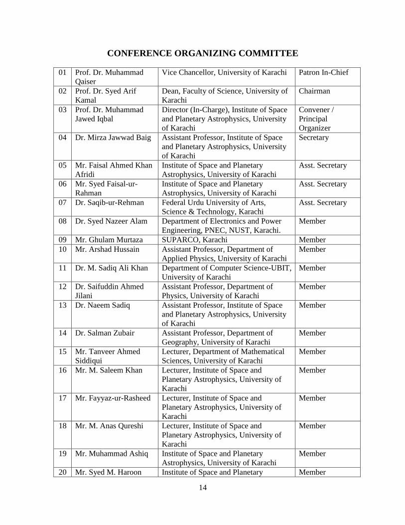
CONFERENCE ORGANIZING COMMITTEE
01 Prof. Dr. Muhammad
Qaiser
Vice Chancellor, University of Karachi Patron In-Chief
02 Prof. Dr. Syed Arif
Kamal
Dean, Faculty of Science, University of
Karachi
Chairman
03 Prof. Dr. Muhammad
Jawed Iqbal
Director (In-Charge), Institute of Space
and Planetary Astrophysics, University
of Karachi
Convener /
Principal
Organizer
04 Dr. Mirza Jawwad Baig Assistant Professor, Institute of Space
and Planetary Astrophysics, University
of Karachi
Secretary
05 Mr. Faisal Ahmed Khan
Afridi
Institute of Space and Planetary
Astrophysics, University of Karachi
Asst. Secretary
06 Mr. Syed Faisal-ur-
Rahman
Institute of Space and Planetary
Astrophysics, University of Karachi
Asst. Secretary
07 Dr. Saqib-ur-Rehman Federal Urdu University of Arts,
Science & Technology, Karachi
Asst. Secretary
08 Dr. Syed Nazeer Alam Department of Electronics and Power
Engineering, PNEC, NUST, Karachi.
Member
09 Mr. Ghulam Murtaza SUPARCO, Karachi Member
10 Mr. Arshad Hussain Assistant Professor, Department of
Applied Physics, University of Karachi
Member
11 Dr. M. Sadiq Ali Khan Department of Computer Science-UBIT,
University of Karachi
Member
12 Dr. Saifuddin Ahmed
Jilani
Assistant Professor, Department of
Physics, University of Karachi
Member
13 Dr. Naeem Sadiq Assistant Professor, Institute of Space
and Planetary Astrophysics, University
of Karachi
Member
14 Dr. Salman Zubair Assistant Professor, Department of
Geography, University of Karachi
Member
15 Mr. Tanveer Ahmed
Siddiqui
Lecturer, Department of Mathematical
Sciences, University of Karachi
Member
16 Mr. M. Saleem Khan Lecturer, Institute of Space and
Planetary Astrophysics, University of
Karachi
Member
17 Mr. Fayyaz-ur-Rasheed Lecturer, Institute of Space and
Planetary Astrophysics, University of
Karachi
Member
18 Mr. M. Anas Qureshi Lecturer, Institute of Space and
Planetary Astrophysics, University of
Karachi
Member
19 Mr. Muhammad Ashiq Institute of Space and Planetary
Astrophysics, University of Karachi
Member
20 Mr. Syed M. Haroon Institute of Space and Planetary Member
15
Rashid Astrophysics, University of Karachi
21 Mr. Muhammad Sohail Karachi Grammar School, Karachi Member
22 Mr. Syed M. Fahad
Riaz
FAST-NUCES University, Karachi Member
23 Dr. Muhammad Ali Pakistan Meteorological Department,
Karachi
Member
24 Mr. Asif Ali Abbasi Institute of Space and Planetary
Astrophysics, University of Karachi
Member
25 Mr. Farooque Ahmed
Abro
Institute of Space and Planetary
Astrophysics, University of Karachi
Member
26 Dr. Salman Zubair Department of Geography, University of
Karachi, Karachi
Member
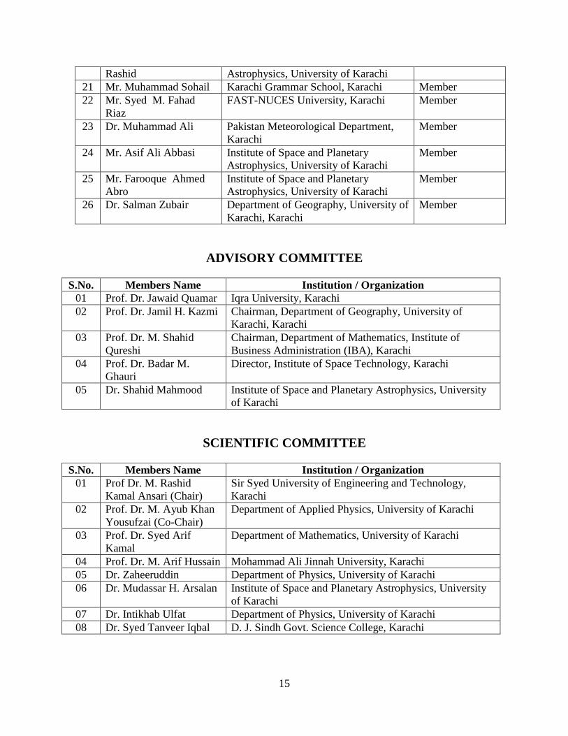
ADVISORY COMMITTEE
S.No. Members Name Institution / Organization
01 Prof. Dr. Jawaid Quamar Iqra University, Karachi
02 Prof. Dr. Jamil H. Kazmi Chairman, Department of Geography, University of
Karachi, Karachi
03 Prof. Dr. M. Shahid
Qureshi
Chairman, Department of Mathematics, Institute of
Business Administration (IBA), Karachi
04 Prof. Dr. Badar M.
Ghauri
Director, Institute of Space Technology, Karachi
05 Dr. Shahid Mahmood Institute of Space and Planetary Astrophysics, University
of Karachi
SCIENTIFIC COMMITTEE
S.No. Members Name Institution / Organization
01 Prof Dr. M. Rashid
Kamal Ansari (Chair)
Sir Syed University of Engineering and Technology,
Karachi
02 Prof. Dr. M. Ayub Khan
Yousufzai (Co-Chair)
Department of Applied Physics, University of Karachi
03 Prof. Dr. Syed Arif
Kamal
Department of Mathematics, University of Karachi
04 Prof. Dr. M. Arif Hussain Mohammad Ali Jinnah University, Karachi
05 Dr. Zaheeruddin Department of Physics, University of Karachi
06 Dr. Mudassar H. Arsalan Institute of Space and Planetary Astrophysics, University
of Karachi
07 Dr. Intikhab Ulfat Department of Physics, University of Karachi
08 Dr. Syed Tanveer Iqbal D. J. Sindh Govt. Science College, Karachi
16
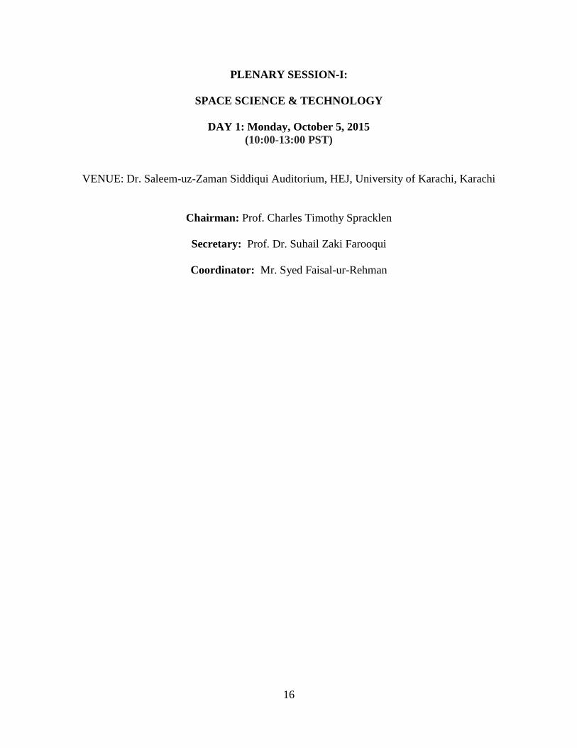
PLENARY SESSION-I:
SPACE SCIENCE & TECHNOLOGY
DAY 1: Monday, October 5, 2015
(10:00-13:00 PST)
VENUE: Dr. Saleem-uz-Zaman Siddiqui Auditorium, HEJ, University of Karachi, Karachi
Chairman: Prof. Charles Timothy Spracklen
Secretary: Prof. Dr. Suhail Zaki Farooqui
Coordinator: Mr. Syed Faisal-ur-Rehman
17
Everything you wanted to know about the Ionosphere, but were afraid to ask
Charles Timothy Spracklen
Habib University, Karachi
ABSTRACT:
The ionosphere is a region of Earth‘s upper atmosphere, from about 85 km to 600 km altitude,
and includes the thermosphere and parts of the mesosphere and exosphere. It is distinguished
because it is ionized by solar radiation. It plays an important part in atmospheric electrical
activity and forms the inner edge of the magnetosphere. It has practical importance too because it
greatly influences radio communication and can severely affect GPS (sat nav) accuracy during
magnetic storms and periods of intense solar activity. The ionosphere is like a 500 km deep
electron-ion ‗ocean‘ in the upper atmosphere; it has waves, storms and tides, it varies from day to
night, summer to winter and is profoundly influenced by solar flares and sun-spots. It also plays
a part in the spectacular Northern Lights (‗Aurora Borealis‘) that many would claim is nature‘s
most remarkable light show. In this lecture we will explore the ionosphere, learn about some of
the extraordinary and eccentric people who were responsible for its discovery and uncover its
role in ‗kick starting‘ radio broadcasting in the early 20th century. Even today it plays a pivotal
role in commercial aviation, enabling pilots on longhaul trans-Atlantic and trans-Pacific routes to
keep in touch with Air Traffic Control. Maybe, too, they‘ll even be enough time for me to tell
you a little about my small part in Ionospheric research.
18
Rotational Dynamics of Galactic Objects by the CMBR
Asghar Qadir
Department of Mathematics,
National University of Sciences and Technology (NUST), Islamabad, Pakistan
Abstract: Some 20 years ago some of us had proposed that there would be diffuse hydrogen
clouds in galaxies and suggested a way to see them by looking at the cosmic microwave
background in the direction of the galaxies with sufficiently accurate satellite instruments. The
predicted signal was first picked up by WMAP but was not clearly enough resolved. With Planck
the signal comes out clearly, not only in the originally proposed galaxy but in some others as
well. It turns out that it can be a tool for studying the dynamics of galaxies comparable with or
better than the Sunyaev-Zeldovich effect. In this talk I will first review some facts about
Cosmology and the problem of dark matter and then go on to talk about the earlier and more
recent developments with the molecular hydrogen clouds.

19
Development of Space Technology and its Impact on Space Applications
- Past, Present and Future
Qamar-ul-Islam
Department of Electrical Engineering, Institute of Space Technology, Islamabad
20
GNSS Paradigm in 2020: Applications and Future
Najam Abbas Naqvi
Department of Aeronautics and Astronautics, Institute of Space Technology, Islamabad
Abstract: This research contribution presents the paradigm of Global Navigation Satellite
System (GNSS) for the year 20120 along with its basic principle while highlighting the
application areas of GNSS and forecasting its future. The year 2020 is envisaged as the time to
experience the system of systems of satellite-based navigation systems, specifically the veteran
and modified GPS by US, upgraded GLONASS by Russia, Galileo by European Union and
Beidou/Compass by China. In addition to that some regional navigation systems like GAGAN by
India and QZSS by Japan will also be in space to contribute in the availability of nearly 100
navigation satellites to the users all over the globe providing (PNT) Position, Navigation and
Timing information, round the clock. The gurus of the GNSS field predict cosmic application
areas of this PNT information after resolving the issues of inter-operability, reliability, accuracy
and integrity. This research contribution delves into the application areas and future of GNSS
paradigm in year 2020 and provides a frame work to utilize this emerging field of GNSS.
Keywords: Global Navigation Satellite System (GNSS); Academia; Industry; GPS
21
PLENARY SESSION-II:
ASTROPHYSICS / COMPUTATIONAL ASTRONOMY
DAY 1: Monday, October 5, 2015
(14:30-17:30 PST)
VENUE: Dr. Saleem-uz-Zaman Siddiqui Auditorium, HEJ, University of Karachi, Karachi
Chairman: Prof. Dr. Asghar Qadir
Secretary: Prof. Dr. Altaf Hussain
Coordinator: Dr. Syed Nazeer Alam
22
Warm Inflation with Viscous Pressure
Muhammad Sharif
Department of Mathematics, University of Punjab, Lahore, Pakistan
Abstract: We study the effects of bulk viscous pressure on warm inflationary model using FRW
universe composed of inflaton and imperfect fluid. We evaluate the solutions of inflaton fields,
potentials and entropy density for variable (constant) dissipation and bulk viscous coefficients in
weak as well as strong dissipative regimes during intermediate era. Finally, we check the
compatibility of this model with recent data by constraining the model and perturbed parameters.
23
Of the Possibility of Constructing a Consistent Mathematical Model
of Theoretical Physics - A Brief Reflection on Physics in Society
Jawaid Quamar
Iqra University, Karachi
Abstract: This communication examines how far it is possible to construct a consistent model of
theoretical physics. Albeit physicists seem to have landed on what they will likely christen the
ultimate theory, the ambiguity in the matter is apparently inescapable for both experts as also
non-experts alike. This presentation attempts an elementary analysis of the current scenario for
the non-experts. This is followed by a presentation of the sociological dimension of research.

24
From Merging Galaxies to Merging Black Holes – An overview of Multi-scale
Physical Processes
Fazeel Mahmmod Khan
Department of Space Science, Institute of Space Technology, Islamabad
Abstract: Galaxies grow in mass and sizes by merging with each other in hierarchical fashion
and so do the central supermassive black holes (SMBHs) that lurk in the hearts of almost all
galaxies. There is growing observational evidence that dual SMBHs as well as true binaries
exists in the centers of nearby galaxies as well as in distant quasars. I shall review some of the
most promising cases reported for binary black holes. Main focus of my talk shall be to introduce
the scales and rich physics involved to study the dynamics and evolution of SMBH binaries in
merging galaxies. In last part of my talk I shall present recent results of our study, where we have
investigated evolution of SMBH binary in high resolution simulations of galaxy mergers
obtained from cosmological initial conditions.
25
From Astronomy to Astrodynamics: A Bridge through Astromathematics
Syed Arif Kamal
Department of Mathematics, University of Karachi, Karachi 75270, Pakistan;
Abstract: ―Astromathematics‟ was introduced by the speaker on Monday, October 8, 2012,
during the First National Conference on Space Sciences, as a branch of mathematics focused on
geometrical aspects to study orbits from a kinematical perspective, in which the force
expressions did not, explicitly, appear. Force interactions were expressed as space-time-
curvature equivalents. This formulation could deal with accelerated frames, governed by
„geometrodynamics‟, based on general theory of relativity. ―Astronomy‟ is considered as a
branch of natural science, which studies celestial objects. Astronomical models are based on
geometric ideas, physical concepts, aesthetic notions and basic assumptions. Babylonians,
Greeks, Chinese and Muslims all contributed to astronomy, given sophistication by the
monumental contributions of Galileo, Kepler, Newton and others. ―Astrodynamics‟ is a branch
of mathematics, which deals with designing orbits to reach a target planet. The term is attributed
to Samuel Herrick (1911-1974). In the preface to his book, An Introduction to the Mathematics
and (the) Methods of Astrodynamics (Revised Edition), Richard H. Battin remarks, ―In the three
centuries following Kepler and Newton, the world‟s greatest mathematicians brought, celestial
mechanics to such an elegant state of maturity that, for several decades preceding the USSR‟s
Sputnik in 1957, it all but disappeared from the university curriculum.‖ The author studied
thoroughly First Edition (1987) of this book. On July 19, 1993, he sent a review to the author,
who replied on October 25, 1993, ―Thank you very much for your letter and your interest in my
book. I appreciate your list of corrections and suggestions.‖ Plane-polar coördinates are not the
natural choice for setting up two-body problem. According to Strong Noether‟s Theorem, if one
sets up problem close to natural symmetries of the system, one discovers additional constants-of-
motion. Planetary orbits were modeled using elliptic-astrodynamical-coördinate mesh, which
yielded 3 constants of motion. Two-body problem was, also, set up in hyperbolic-
astrodynamical-coördinate mesh. New control laws were devised — extended-cross-product
steering, normal-component-cross-product steering, dot-product steering, normal-component-
dot-product steering and ellipse-orientation steering. Cross-range error was incorporated in the
Lambert scheme as well as inverse- and multi-stage-Lambert schemes proposed for course-
plotting a satellite-launch vehicle. In addition, multi-stage and inverse-Q systems were devised
for steering a satellite-launch vehicle. The problems, which are under investigation by my PhD
students are setting up of two-body problem in parabolic-astrodynamical-coördinate mesh and
complete formulation of extended-Q system. In extended-Q system, both position and velocity
vectors are managed, simultaneously, through extended-cross-product steering to put a satellite
in the desired location with the recommended velocity.
26
Strong Gravitational Lensing by Black Holes
Mubasher Jamil
Department of Mathematics, School of Natural Sciences, NUST, Islamabad
Abstract: We investigate the gravitational lensing scenario due to Schwarzschild-like black hole
surrounded by quintessence (Kiselev black hole). We discuss here three special cases of Kiselev
black hole: non-extreme, extreme and naked singularity. We present the detailed derivation for
the bending angles of light as it traverses in the equatorial plane of the black hole. We also
calculate the approximate bending angle and compare it with exact bending angle expressions. In
the weak field approximation, we calculate the position and total magnification of relativistic
images.
Keywords: Astrophysics; Black hole; Gravitational fields; Lensing.
27
Number Counts, Noise, Confusion and Looking Deep into Space for Radio
Continuum Sources
Syed Faisal urRahma and M. Jawed Iqbal
ISPA, Karachi University
Abstract: Looking deep into the space in search for truth has been a long time goal of humanity.
With development of new technologies and observational techniques, we are now well equipped
to see objects billions of light years away from us. In this presentation we are going to discuss
some of the challenges radio astronomers face while observing radio continuum sources. We will
discuss issues related to rms noise, confusion, position accuracy, shot noise and how these issues
can affect observation stage, data analysis and the science goals we are trying to achieve. We
will use Evolutionary Map of the Universe (EMU-ASKAP) sky survey as a main focus of our
talk.
28
Time Keeping: From Sundial To Atomic Clocks
M Shahid Qureshi
IBA, Karachi
Abstract: For keeping account of time various kinds of 'clocks' and 'calendars' have been used
since antiquity. Different devices and schemes based on some kind of cyclic motions have
evolved from 'hour glass' to 'atomic clocks'; from mechanics to quantum mechanics. In this work
the history of this evolution and current issues related to time keeping are reviewed and
analyzed.
29
Hyperfine Structure Studies of Praseodymium;
an element of Astrophysical Interest
1.2
Zaheer Uddin, 1,2
Imran Ahmed Siddiqui, 1Arif Akhtar Azam,
1,2Laurentius Windholz
1Department of Physics, University of Karachi, Pakistan
2Institute of Experimental Physics, Technical University Graz, Austria
Abstract: Astrophysicists‘ are always interested in knowing the composition of stars and other
heavenly objects. The abundance of an element can be verified by a number of ways and
techniques. The spectroscopic techniques are the most widely used techniques for the
verification of elements abundance. Praseodymium is an element that belongs to Lanthanides
series. It is very rich in atomic fine levels. This is the reason of very large number of spectral
lines (more than 15000) of Praseodymium.
The Fourier Transform Spectrum was investigated for unclassified lines. These lines were
investigated to find the unknown levels of Praseodymium. The spectral line 9855.392Å is Pr I
line in FT spectrum. The line has a structure in which all diagonal components are visible though
the intensity of the line is not much. The simulation of the line leads to the discovery of new Pr I
odd levels with angular momentum 4.5 and energy 18464.188 cm-1
. The level was confirmed
through two further lines 9565.747Å and 8508.298Å of the same level.
30
Space Weather Monitoring Activities in Pakistan
Muhammad Ayyaz Ameen
Pakistan Space & Upper Atmosphere Research Commission (SUPARCO)
Abstract: Space weather (SWx) refers to the conditions on Sun and in the Earth‘s upper
atmosphere that can influence the performance and reliability of space-borne and ground-based
technological systems. During adverse SWx conditions, the Sun emits high energy particles as
well as excessive radiation that can cause disruption of satellite operations, communications,
navigation, aviation, electric grid etc leading to economic losses. Due to the emerging
importance of SWx a number of instruments have been deployed all over the world to monitor
SWx 24/7. A number of countries (including Pakistan) are engaged in acquiring real-time
ionospheric conditions, geomagnetic field variations and monitoring of the solar terrestrial
environment (that makes the SWx). The SWx monitoring activities carried out by SUPARCO
would be presented in the talk, which would cover the purpose, history, infrastructure and
services being offered. The future plans, collaborations and contribution in the discipline of SWx
would also be highlighted.
31
Timelike geodesics of a Modified Gravity Black Hole Immersed in an Axially
Symmetric Magnetic Field
Saqib Hussain
1, and Mubasher Jamil
2,
1Department of Physics, School of Natural Sciences (SNS),
National University of Sciences and Technology (NUST), H-12, Islamabad, Pakistan 2Department of Mathematics, School of Natural Sciences (SNS),
National University of Sciences and Technology (NUST), H-12, Islamabad, Pakistan
Abstract: We investigate the dynamics of a neutral and a charged particle around a black hole in
modified gravity immersed in magnetic field. Our focus is on the scalar-tensor-vector theory as
modified gravity. We are interested to explore the conditions on the energy of the particle under
which it can escape to infinity after collision with another neutral particle in the vicinity of the
black hole. We calculate escape velocity of particle orbiting in the innermost stable circular orbit
(ISCO) after the collision. We study the effects of modified gravity on the dynamics of particles.
Further we discuss how the presence of magnetic field
in the vicinity of black hole, effects the motion of the orbiting particle. We show that the stability
of ISCO increases due to presence of magnetic field. It is observed that a particle can go arbitrary
close to the black hole due to presence of magnetic field. Furthermore ISCO for black hole is
more stable as compared with Schwarzschild black hole. We also discuss the Lyapunov exponent
and the effective force acting on the particle in the presence of magnetic field.
32
Effect of MHD on Fractionalized Maxwell Fluid between Coaxial Cylinders
Muhammad Jamil and Vijay Kumar
Department of Mathematics, NED University of Engineering and Technology, Karachi-75270,
Abstract: This Paper deals with the unsteady flows of an incompressible MHD fractionalized
Maxwell fluid between two infinite porous coaxial circular cylinders. Which has a very
significant role in pipeline industry. At time 𝑡=0+, the inner cylinder is subject to torsional and
longitudinal time dependent shear stresses and the outer cylinder is also rotate around its axis and
to slide along the same axis with acceleration. Exact solutions obtained with the application of
Laplace and finite Hankel transform, presented in series form in terms of newly introduced
generalized functions 𝑴, satisfy all imposed initial and boundary conditions. The corresponding
solutions for Maxwell and Newtonian fluids are also obtained as special cases with and without
Magnetic effects. Finally, the influence of pertinent parameters on the velocity components and
shear stresses, as well as a comparison among fractionalized Maxwell, Maxwell and Newtonian
fluids with and without Magnetic effects, is also analyzed by graphical illustrations.
Keywords: Fractional derivative, Maxwell fluid, helical flows, velocity field, shear stresses,
Laplace and finite Hankel transform.
33
Omar Khayyam’s Portraiture of Cosmos
ВикторияНикулина (Victoria Nikulina)* and Muhammad Rashid Kamal Ansari
*
*Department of Mathematics, Sir Syed University of Engineering and
Technology, Karachi-75300
[email protected], [email protected]
Abstract: Omar Khayyam the most prominent mathematician, astronomer and philosopher of
11th
century was a poet too. Along with his marvelous contributions in mathematics he
contributed much as an astronomer too. He founded an observatory, prepared almanacs and
astronomical tables. He also developed a calendar of his own. This calendar called the Jalali
Calendar was more accurate than the Gregorian calendar which is now in use. Jalali calendar is
accurate for 5000 years whereas, Gregorian calendar was accurate for only 2000 years. This was
the reasons that many controversies appeared when the second millennium was approaching to
its end. Omar Khayyam is considered responsible for initiating Algebraic geometry and
heliocentric theory.
Cosmology is an area of astronomy which unifies astronomy and philosophy in some aspects and
that is the topic of cosmogony. It is an interest common to philosophers, Sufis, religious scholars,
followers of esotericism and scientists. However, scientists prefer to discuss the topic under the
broader banner of cosmology.
The issue of the time of creation of the earth and the issue of the time of its annihilation are
prime issues to be discussed under cosmogony. Mythologists, philosophers and theologists try to
explain the mystery of universe, life and human destiny. Modern cosmological theories and
models explain the origin, present structure, evolution, and the future of the universe considering
the universe and the cosmos in terms of physical phenomena skipping any supernatural
explanations for the physical phenomena.
Omar Khayyam‘s books regarding his cosmological physics and his philosophy of cosmogony
are not available now. This study attempts to explore his views about the cosmos and the
universe out of his poetry which comprises mainly of his famous quatrains that got popularity
through the English translations of Edward Fitzgerald at the end of 19th century. These quatrains
got translated in many other languages too.
*Victoria Nikulina is an independent researcher and batik artist associated with the group
working on Mathematics and Islamic Art at Sir Syed University of Engineering and Technology,
Karachi
34
TECHNICAL SESSION-III:
RENEWABLE ENERGY / ENVIRONMENTAL SCIENCE
DAY 2: Tuesday, October 6, 2015
(09:30-11:30 PST)
VENUE: Video Conference Room, LEJ, University of Karachi, Karachi
Chairman: Prof. Dr. Syed Jamil H. Kazmi
Secretary: Prof. Dr. m. Khalid Anis
Coordinator: Dr. Syed Tanveer Iqbal
35
Fingerprinting Hydrosphere-Geosphere Interactions on Mars Using Carbon
and Oxygen Triple Isotopes and Search for Extraterrestrial Life
R. Shaheen, Department of Chemistry and Biochemistry,
University of California San Diego, La Jolla, California. USA.
Abstract: The presence of liquid water is essential to all forms of life as we know from the life
that exists on the earth. Therefore, search for life in the solar system and beyond is basically
summarized by NASA as ―Follow the Water‖. After Earth, the planet that seems to be more
conducive for life in our solar system is Mars. However, current Martian conditions with low
temperature (~ 210K), thin atmosphere (~7mb) and intense UV radiations are harsh to allow the
presence of liquid water) as indicated by landers, rovers, and orbiters on Mars. Secondary
minerals (such as carbonates, sulfates, haematitie and jarosite) can provide a unique window to
the paleo hydrosphere-atmosphere-biosphere-lithosphere interaction and the processes by which
these minerals were formed. Meteorites from Mars (4.2- 1.2 billion years) found on the Earth
provide a unique opportunity to understand paleo history of the planet. The micrometer sized
globular and lacy carbonates in the Martian meteorite ALH84001 were considered to be possible
biological relics. A range of temperature (100-800oC) and formation environments were inferred
from 18
O and mineral composition (Ca-Mg-Fe rich carbonates). A combination of carbon and
oxygen triple isotopes (17
O, 18
O) and oxygen isotope anomaly (∆17
O) provided a powerful tool
to distinguish between biotic and abiotic processes. The ozone molecule serves as an important
natural tracer of atmospheric chemistry due to the highest enrichment in heavy isotopes 17
O=
67-117‰ and 18
O= 73-135‰) and presence of oxygen isotope anomaly (17
O) ranging from 25
to 40‰. The oxygen isotope anomaly of the ozone is transferred to other oxygen carrying
molecules in the atmosphere and hence can be used to uniquely identify atmospheric chemical
reactions. In this regard, I will discuss the origin of carbonate minerals in two famous meteorites
ALH84001 and NWA7034 (Black beauty) and serendipitous discovery of atmospheric
carbonates from the aerosol samples collected at the Scripps Pier, La Jolla California. These
direct observations represent the first measurements of heterogeneous reactions on ambient
particles and provided unique insight on the role of surface adsorbed water on particles. The O-
triple isotope analysis has revealed that reactions on nano-surfaces involve a new type of
quantum level interactions (physi-sorption, adsorption/desorption, changes in surface OH groups
and hence pH) and were previously unknown. The discovery was recognized by the National
Academy of Sciences of the United States Cozzarelli prize (2011).
36
Renewable Energy Potential in Pakistan and PCRET’s Role in its
Exploitation
Suhail Zaki Farooqui
Pakistan Council of Renewable Energy Technologies, No. 25, Sector H-9, Islamabad.
Abstract: Pakistan is the sixth most populous country of the world comprising 2.56% of the total
global population. However, it ranks 37th
in the energy consumption, at 0.37% of the world total.
The per capita energy availability is only 51 watts, which is 1/ 7th
of the world average. On the
other hand, the country is rich in renewable energy sources and has vast potential for their
exploitation. The total hydel power potential exceeds 100 GW, Solar power 2900 GW, wind
power 120 GW and biomass 2.3 GW.
Pakistan Council of Renewable Energy Technologies (PCRET) is the premier organization of
Pakistan, dedicated to the promotion and dissemination of these technologies for the socio-
economic uplift of the country and climate change mitigation strategies. The organization, in its
current form is active since 2001. It introduced a number of new technologies in the country to
promote the energy related clean and alternate solutions for the general public. PCRET, with its
very limited funds, installed 4600 biogas plants, 560 micro-hydro power plants, 155 wind
turbines, 520 solar power systems, 25 solar dehydrators, 500 solar water purifiers and 5000 solar
cookers, under the various PSDP projects, to trigger the penetration of these technologies in the
entire country. However, there is much more to be done, as the potential for the dissemination of
these and other related technologies is much higher than achieved so far, in Pakistan. For
example, 15 million biogas plants, 30,000 megawatt capacity micro-hydro power plants, 10
million solar water purifiers and 20 million solar cookers can be installed/ distributed throughout
Pakistan. Materialization of these installations can revolutionize the way energy is utilized in
Pakistan and can have an annual impact of hundreds of billions of rupees on the national
economy, besides creating job opportunities for hundreds of thousands of Pakistanis.
37
Renewable Hydrogen Energy Generation From Water Using
Sunlightin Heterojunctionphotocatalysis
Gulzar Khan
Department of Physics, Abdul Wali Khan University, Mardan, KPK
Abstract: Multi-walled carbon nanotubes (CNTs) effectively catalyzes
photocatalytichydrogen production in heterojunction suspensions under solar visible light
(AM 1.5G; > 420 nm). Dueto the high catalytic activity of CNTs, use of Pt can be
significantly reduced. For this, quaternary composites(CdS/TiO2/Pt/CNTs) are prepared by
the creation of CdS on platinized TiO2 (TiO2/Pt) subsequently towhich chemically
oxidized CNTs are loaded. A binary (CdS/TiO2) and two ternaries (CdS/TiO2/Pt
andCdS/TiO2/CNTs) are also prepared for comparison. A TEM analysis for the
quaternary sample shows thatTiO2is a central component that holds Pt nanoparticles,
CNTs, and CdS clusters, while the last is spatiallyaway from the catalysts.
Photoluminescence (PL) emission bands of the binary are reduced by loading either Pt or
CNTs, and further by co-loading of both catalysts. This suggeststhat the recombination of
photogenerated charges under UV or visible light is inhibited due to cascaded
charge transfer between TiO2and CdS, which is further decreased by Pt and/or CNTs.
Photolysis confirmsthat either Pt or CNTs catalyzes effectively photocatalytic
H2production in aqueous CdS/TiO2suspensionswith sulfide/sulfite electron donor under
visible light. Such activity is significantly enhanced by over 50%by co-loading of Pt and
CNTs. It is found that the Pt amount can be reduced to approximately five- orone-tenth
by additional loading of CNTs under an optimal condition.
38
Environmental Assessment of Water, Gaseous Pollutants and Noise Levels at
Different Locations In Karachi City
Alia Bano Munshi*, DurdanaRaisHashmi, HinaAhsan and AkhtarShareef
Centre for Environmental Studies, PCSIR Laboratories Complex, Karachi-75280, Pakistan
*Centre of Excellence in Marine Biology, University of Karachi, Karachi
[email protected] and [email protected]
Abstract: Air, Noise and Water pollution has become a serious environmental issue in Karachi,
mainly due to the presence of toxic trace organic and inorganic chemicals in the atmosphere and
water as a consequence of rapid industrialization and increased transportation during recent
years. Huge number unfit vehicles on roads not only discharging carbon monoxide in air but also
making big noise in surroundings. Karachi is facing an enormous problem of exceedingly high
levels of traffic noise, which is significantly higher than all the available international data. Thus
noise is a ubiquitous environmental hazard of the Karachi, originating from a wide variety of
sources including traffic, which plays a dominant role in noise pollution. A study was carried out
to assess the variation trend in air pollutant concentrations and noise pollution in the atmosphere
of Karachi city. Measurement of the concentration of major ambient air pollutants such as CO,
SO2, NOx and PM10 along with the meteorological parameters were carried out at the selected
areas in Karachi by using air analyzers and Noise level meter. At each location the data of Air
pollutants were collected for eight days. The results also suggest that all the pollutants were
mainly due to the emissions from industries, refineries, power generation plants and also from
motor vehicles. Level of pollution was found gradually lowered from sites of high activity to a
place of low activity as control site < Residential areas < Commercial areas < Industrial areas
respectively. Results have also been discussed with reference to the ambient air quality limits
recommended by the World Health Organization. The main focus of this study was to describe
the present position of ambient air pollutants, noise level and their health hazards. Another study
was done for contamination of drinking water being a major source of health hazards for Karachi
residents as no proper monitoring of supply water. A water assessment survey was conducted
during 2013 - 2014 based on water samples referred to PCSIR Labs. Complex Karachi. In total
80 water samples were included ground, surface water sources and bottled water. Among these
sample 40% were contaminated with heavy metals, pesticides hydrocarbons. Industrial effluents
is dumping as untreated to sea destroying marine life causing lost of sea food along with big
economical lost. The resulting situation is a harbinger of many ills. It is disrupting fishing
activities, paralyzing economic activities and eventually impacting the local fishing
communities. The sea water of the metropolitan is considered to be the worst affected part of the
country because of the discharge of industrial waste from Korangi, Landhi, and Karachi Export
Processing Zone. The health impacts of air, water and pollution productivity losses due to
deforestation and soil erosion have been attributed to air and water pollution, in terms of health
care costs.
Keywords: Air, Noise, Water, Pollution, Contamination and Karachi
39
Lithological Identification of Rocks and its Distribution in Lakhra Anticline
of Lower Indus Basin using Multispectral Remote Sensing Application.
Muhammad Arsalan
Department of Geology, University of Karachi.
Abstract: The Lakhra anticline is a north-trending asymmetrical structure situated northwest of
Hyderabad in Lower Indus Basin, Sindh, Pakistan. The anticline is about 30 kilometers wide and
100 km structure and its highest points about 200 meters above mean sea level. About 340 meter
of Paleocene to Holocene strata has been eroded from the core of the anticline. In study area
Paleocene to Recent rocks upper Ranikot group (Bara Formation and Lakhra Formations) Laki,
Nari, Gaj, and Manchar Formations and Sub resent to Recent Alluvium are expose.
Stratigraphy and rock type in study area is sandstone of Bara Formation and fossiliferrous
limestone with minor sandstone and shale of Lakhra Formation and shale with significance
amount of iron oxide of Shnahri member and white creamy limestone of Laki limestone member
of Laki Formation of Eocene age in the study area. These rocks are identified during detail
geological field work and proceed to detail work using multispectral remote sensing application.
Landsat 8 is processed used to create output image by mathematically combining the DN values
of different bands. In result give the clay mineral index and iron oxide indices these are match
with ground realities.
The mineral indices combine three band ratios that highlight specific mineral types Ratio of
bands used to highlight clay in Landsat 8 image Band 6 / and Band 7 Band 5/Band 7 highlights
clays (Georgia is famous for its ―Georgia clay‖) similar as Ratio of bands for Iron Oxide is Band
6 / Band5 or Band 5/Band 4 highlights ferrous oxides similar as Band 3/Band 1 highlights iron
oxide.
40
Investigate the Impact of Sunspot Numbers on F2-layer of the Ionosphere
(foF2) and its Spectral Models over Wakkanai Station
Muzammil Mushtaq1, Syed Nazeer Alam
2, Faisal Ahmed Khan Afridi
3 and Kamran Mukhtar
4
1Institute of Space and Planetary Astrophysics (ISPA), University of Karachi, Karachi-75270,
Pakistan;
[email protected] 2Department of Electronics and Power Engineering, PNEC, NUST, Karachi, Pakistan;
[email protected] 3Institute of Space and Planetary Astrophysics (ISPA), University of Karachi, Karachi-75270,
Pakistan;
[email protected] 4Space Weather Monitoring Division, SUPARCO Headquarters, SUPARCO Road, Karachi-
75270, Pakistan
Abstract: The influence of the sunspot cycle on F2 layer of the ionosphere at daytime and night
time over the mid-latitude region has been investigated for Wakkanai (45.39ºN, 141.68ºE) Japan
during 21st solar cycle (1976-1986) and 23
rd solar cycle (1996-2008). The trends of critical
frequency of F2 layer (foF2) for a different local time, months and solar cycles have been
analyzed, which represent the behavior of F2 layer of ionosphere in which seasonal and semi-
annual anomalies are observed. The quantitative dependency of the sunspot cycle on foF2 has
been examined by performing a regression analysis between the monthly median hourly foF2
and the monthly mean relative sunspot number (SSN). The results show that the magnitude of
the solar cycle, seasons and diurnal cycle has considerable effects on foF2. There is a significant
nonlinear relationship exists between SSN and foF2 for all months. Saturation effect is seen in
the month of December in noontime and midnight. By introducing the geomagnetic index Ap
and the prior month SSN improve the accuracy of our regression models. We have constructed
single station diurnal models of foF2 using Fourier series and compared Fourier models with
International Reference Ionosphere (IRI) 2012 model which clearly shows that our models are
better than the IRI model over Wakkanai (45.39º N). The research carried out has enhanced the
knowledge, work experience of individuals and the results obtained are useful for researchers,
organizations working in the field of sunspot performance relating to the dynamics of the
ionosphere.
Keywords: sunspot number, foF2, time series trends, spectral models, Wakkanai
41
TECHNICAL SESSION-IV (PARALLEL):
ATMOSPHERIC & FLUID DYNAMICS
DAY 2: Tuesday, October 6, 2015
(10:00-11:35 PST)
VENUE: Dr. Saleem-uz-Zaman Siddiqui Auditorium, University of Karachi, Karachi
Chairman: Dr. Muhammed Shafique
Secretary: Dr. Fazeel M Khan
Coordinator: Mr. M. Saleem Khan
42
Impact of Climatic Variability on Seawater
Naeem Ahmed Syed
National Institute of Oceanography, Karachi
Abstract: The atmosphere and the ocean are closely linked and hence influence each other by
the transfer of heat, gases and energy from one to the other. Ocean surface absorbs most of the
heat from the sun and the surface currents move this warm water around the world and warm the
atmosphere from below. Sea surface waves and currents are produced by the wind that blow
over the surface of the ocean. The transfer of energy between the atmosphere and the ocean is a
fundamental process within the global climate system. The transfer of energy between the
atmosphere and the ocean is controlled by the difference of temperature between the air and the
sea.
The water properties, such as temperature and salinity, are formed by the heat exchange through
the relative contribution of heat and freshwater fluxes only when the water is at the surface or in
the mixed layer. The basic parameters that govern the formation and transportation of water
masses are the heating, cooling, rain, sublimation or evaporation through the surface buoyancy
fluxes (density fluxes) that in turn is controlled by the air sea coupling. Sea Surface Temperature
(SST) is the key parameter of air-sea interaction process that controls the variation in sea surface
salinity (SSS) and formation of water masses with particular salinity signatures. The monthly
variability of SST and SSS provide vital information about air-sea interaction process (heat and
water fluxes) and climate of Ocean environment.
The Arabian Sea has a unique environment having very special dynamics and thermodynamics
due to its small size and geographical location being without a connection with the more
northern seas. The near-surface circulation of the Arabian Sea is driven by the seasonally
reversing winds associated with the monsoons. The North Indian Ocean (NIO) which
encompasses Arabian Sea in turn provides the moisture and energy to drive the monsoon system
in the Arabian Sea. The ocean and the atmosphere are coupled together to create the monsoon
system. The sub-surface circulation in the Arabian Sea is influenced by the wind force. The
strong winds of the Arabian Sea force a vigorous oceanic circulation and the heat received at the
surface is transported southward and into the deeper ocean. Variability of SST is important as
the duration and intensity of SST provide the basis for convection from cooling sub-surface layer
sinks to the sub-surface of the ocean.
43
Singular Value DecompositionAnalysis for Examining the Impact of Siberian
High on Wintertime Precipitation over South Asia
Syed Muhammad Fahad Riaz1,Muhammad Jawed Iqbal
2and MirzaJawwad Baig
2
1Department of Mathematics, University of Karachi, Karachi-75270, Pakistan
2Institute of Space and Planetary Astrophysics, University of Karachi, Karachi-75270, Pakistan
Abstract: The relationship and linkage of Siberian High (SH) with wintertime climate over
central Asia, East Asia and Eurasia has been focused in the available literature. The effect of
Siberian High over the South Asian region has received little amount of concentration. Thus, this
article examines the possible teleconnection of SH pressure on wintertime precipitation
variability over the region of South Asia. Moreover, the recent research studies focused on large-
scale circulation phenomena: El-Nino Southern Oscillation (ENSO) and North Atlantic
Oscillation (NAO), and regarded them as responsible for variability of wintertime rainfall. This
paper gives the evidence that the wintertime rainfall variability is strongly influenced by Siberian
High pressure. The effect of Siberian High pressure on wintertime precipitation over the South
Asian region (30-90o E, 10-50
oN) has been investigated using Singular Value Decomposition
analysis (SVDA) that is performed on gridded datasets of NCEP-NCAR Reanalysis and Climate
Research Unit (CRU) of University of East Anglia, United Kingdom. SVDA isolates the leading
pairs of the coupled signals that mainly explains the relationship between the coupled fields. By
employing SVDA, it is found that the Siberian High has dominant impact on precipitation
variability during winter season over Northern areas of South Asia.
44
Some Exact Solutions of Equations Governing Steady Plane Motion of
Incompressible Fluid of Variable Viscosity for a Class of Flows in the
Presence of Body Force
Mushtaq Ahmed and R. K. Naeem
Department of Mathematics, University of Karachi
Karachi-75270, Pakistan
Email: [email protected]
Abstract: Geophysical fluid dynamics (GFD) is concerned with large-scale fluid flow in the
ocean and atmosphere. The earth‘s rotation has a substantial effect on the dynamics of
geophysical flows. The body forces like centrifugal force, coriolis force, viscous force and
constant gravity force must be added to right-hand side of Navier-Stokes equations.
The objective of this paper is to indicate exact solutions of equations governing the steady plane
motion of incompressible fluid of variable viscosity in the presence of body force for a class of
flows for which the stream lines are characterized by equation )()()( rgrf . Exact
solutions are determined for .)( constrg and .)( constrg When )(rf is arbitrary we can
construct an infinite set of streamlines, the velocity components, viscosity function, generalized
energy function L and temperature distributionT in the presence of body force. Therefore, there
are an infinite set of solutions to flow equations with body force.
Key words: A class of exact solutions in the presence of body force, Exact solutions to the
flow equations of incompressible, variable viscosity, Navier-Stokes equations,
Exact solutions variable viscosity.
45
Numerical Simulation for Nonlinear Astrophysics
Equation based on Legendre Neural Network with Simulated Annealing
Najeeb Alam Khan, Amber Shaikh
Department of Mathematical Sciences, University of Karachi, Karachi 75270, Pakistan
Abstract: The actual motivation of this work is to study the Nonlinear Lane-Emden-Fowler
singular initial value problem that governs the polytrophic and isothermal gas spheres, by
Legendre Simulated Annealing Neural Network (LSANN) in which the minimization of error is
performed by Simulated Annealing method while Legendre polynomials are used in hidden layer
to control the singularity problem. Many illustrative examples of Lane-Emden-Fowler type are
discussed and results are compared to show the superiority and effectiveness of the LSANN over
the formerly used algorithms.
46
Some Exact Solutions for Rotating Flows of a Generalized Burgers’ Fluid
in Cylindrical Domains
Muhammad Jamil1 , Constantin Fetecau
2
1Department of Mathematics, NED University of Engineering & Technology, Karachi-75270,
Pakistan 2Department of Mathematics, Technical University of Iasi, Iasi-700050, Romania
Abstract. The velocity field and the adequate shear stress corresponding to the flow of a
generalized Burgers‘ fluid model, between two infinite co-axial cylinders, are determined by
means of Laplace and finite Hankel transforms. The motion is due to the inner cylinder that
applies a time dependent torsional shear to the fluid. The solutions that have been obtained,
presented in series form in terms of usual Bessel functions J1(•), J2(•), Y1(•) and Y2(•), satisfy
all imposed initial and boundary conditions. Moreover, the corresponding solutions for Burgers‘,
Oldroyd-B, Maxwell, second grade, Newtonian fluids and large-time solutions for all kind of
fluids and transient solutions for generalized Burgers‘ fluid are also obtained as special cases of
the present general solutions. The effect of various parameters on large-time and transient
solutions of generalized Burgers‘ fluid are also discussed. Furthermore, for small values of the
material parameters, λ2 and λ4 or λ1, λ2, λ3 and λ4, the general solutions corresponding to
generalized Burgers‘ fluids are going to those for Oldroyd-B and Newtonian fluids, respectively.
Finally, the influence of the pertinent parameters on the fluid motion, as well as a comparison
between models, is shown by graphical illustrations. Mathematics Subject Classification (2010).
76A05, 76A10. Keywords: Generalized Burgers‘ fluid, coaxial cylinders, velocity field, time-
dependent shear stress, Laplace and Hankel transforms.
47
Computation of Large Time Step TVD Scheme with Compressive Limiters
Ihtram Ul Haq1, Mukkarum Hussain
2, Muhammad Jawed Iqbal
3
1,3Institute of Space and Planetary Astrophysics (ISPA), University of Karachi, Pakistan
2Institute of Space Technology (IST), Karachi, Pakistan
Abstract — Advancement of low dissipative high resolution large time step scheme has been a
great interest of researchers in the field of computational fluid dynamics (CFD). Total variation
diminshining (TVD) schemes are low dissipative and high resolution schemes, but for explicit
formulation they are bounded by stability criterion CFL<1. Stability criteria for explicit
formulation limits time stepping and thus increase computational cost. In 1986, Harten has
improved TVD scheme and presented large time step (LTS) TVD scheme. This scheme is
(2K+3) point explicit second order accurate for scalar and one dimensional Euler equation which
are TVD under CFL restriction K. Harten scheme is stable for scalar equation but produce
spurious oscillations for system of equation. This problem is investigated and resolved by Qian.
Modified large time step (MLTS) TVD scheme presented by Qian has been tested with minmod
limiter which is very dissipative. In present work Qian MLTS TVD scheme is tested with more
compressive limiters, namely, centralized MC and superbee.
In present study MLTS TVD scheme performance with compressive limiters has been
investigated and results are analyzed for their merits and shortcomings. Shock tube problem for
LAX boundary condition is solved for validation purpose. Reasons of attraction in this test case
are availability of analytical solution and at the same time presence of complex flow feature
namely, expansion, shock wave, and contact discontinuities.
48
PLENARY SESSION-V:
SPACE PLASMA / SOLAR PHYSICS
DAY 2: Tuesday, October 6, 2015
(12:30-13:30 PST)
VENUE: Dr. Saleem-uz-Zaman Siddiqui Auditorium, HEJ, University of Karachi, Karachi
Chairman: Prof. Dr. Jawaid Quanar
Secretary: Prof. Dr. M. Ayub Khan Yousufzai
Coordinator: Mr. Fayyaz-ur-Rasheed

49
Solar Corona Heating
Hamid Saleem Khan
Department of Space Science, Institute of Space Technology, Islamabad
Abstract: It is suggested that the solar corona is heated due to low frequency electrostatic
instabilities which take energy from the inhomogeneous plasma flows. The plasma enters into
corona from lower regions with short scale non-uniform flows. The purely growing shear flow
instability as well as the drift wave instability in the presence of inhomogeneous flows creates
electric fields randomly throughout the corona causing acceleration of plasma particles. It is also
proposed that the electron-ion collisions which are generally ignored in the study of coronal
plasma can play an important role in creating electrostatic fields through drift-dissipative
instability. The theoretical model is applied to solar corona to explain self-heating of corona by
shear flows.
50
Role of Wave and Instabilities in Space Plasmas
Muhammad Fraz Bashir
Department of Physics, COMSATS Institute of Information Technology, Lahore
Abstract: The basics of space plasmas and current trends to study the role of waves and
instabilities related to the explanation and mechanism of solar wind will be analyzed by using the
kinetic theory. It is also highlighted how we can model the solar wind data using the exact
numerical analysis and/or PIC simulation.
51
Numerical Study of Ionospheric Plasma Interaction
with Spacecraft Instruments
Nadia Imtiaz
Theoretical Physics Division, PINSTECH, Islamabad, PAKISTAN.
Abstract: This work presents numerical studies of the interaction between ionospheric plasma and
spacecraft instruments under different plasma conditions. This is achieved by simulating space plasma
interaction with two different particle sensors; namely, DEMETER‘s Seg-mented Langmuir probe (SLP)
and PROBA2‘s Dual Segmented Langmuir probe. First, we model the current characteristics of the
DEMETER Segmented Langmuir probe (SLP).
The probe is used to measure electron density and temperature in the ionosphere at an altitude of
approximately 700 km. It is also used to measure the plasma flow velocity in the satellite frame of
reference. The probe is partitioned into seven collectors: six electrically insulated spherical segments and
a guard electrode (the rest of the sphere and the small post). Comparisons are made between the
predictions of the model and DEMETER measurements for actual ionospheric plasma conditions
encountered along the satellite orbit.
Segment characteristics are computed numerically with PTetra, a three dimensional particle in cell
simulation code. In PTetra, space is discretized with an unstructured tetrahedral mesh, thus enabling a
good representation of the probe geometry. The model also accounts for several physical effects of
importance in the interaction of spacecraft with the space environment. These include satellite charging,
photoelectron and secondary electron emissions.
The model is electrostatic, but it accounts for the presence of a uniform background magnetic field.
PTetra simulation results show different characteristics for the different probe segments. The current
collected by each segment depends on its orientation with respect to the ram direction, the plasma
composition, the magnitude and the orientation of the magnetic field. It is observed that the presence of
light H+ ions leads to a significant increase in the ion current branch of the I-V curves of the negatively
polarized SLP. The effect of the magnetic field is demonstrated by varying its magnitude and direction
with respect to the reference magnetic field. It is found that the magnetic field appreciably affects the
electron current branch of the I-V curves of certain segments on the SLP, whereas the ion current branch
remains almost unaffected. PTetra simulations are validated by comparing the computed characteristics
with the DEMETER measurements, as simulation results are found to be in good agreement with the
measurements. Finally, we model the current characteristics of the Dual Segmented Langmuir probe
(DSLP), which is a part of the scientific payload of the ESA satellite PROBA2. The DSLP consists of two
independent segmented Langmuirprobes. The current characteristics of the DSLP are also computed by
using the 3D particle-in-cell code PTetra. The floating potential and ion current branch of the I-V curves
of each segment illustrate the directional sensitivity of the DSLP. The computed I-V curves are then
used to estimate the electron temperature in the direction parallel and perpendicular to the magnetic field.
This study will be helpful to understand the floating potential and electron temperature anisotropies
measured by the DSLP.
52
Study the Neutrinos: An Innovative Way to Explore the Universe
Muhammad Ayub Khan Yousufzai
Institute of Space & Planetary Astrophysics, Department of Applied Physics, University of
Karachi
Abstract: This Communication presents an assessment of recent developments in neutrino
physics including astrophysical and cosmological applications with a spotlight on the issues that
must be resolved if we intend to look up our comprehension of the inherent characteristics of
neutrinos. A treatment of important issues will also be illustrated for selected theoretical models
and current experimental results. Viewpoint right through integrates physics and astrophysical
data with predictions for particles and astrophysical aspects.
This presentation also describes the elements of neutrino interaction with other particles, then the
model‘s predictions on neutrino-electron interactions and experimental limits on neutrino mass
with leptonic mixing angles. Wave packet treatment along with the pictorial description of
neutrino oscillations will also be manifested. The salient features of the standard solar model are
distinguished for solar neutrino that is most exciting subject in the world of physics with
implications of chlorine, water and gallium detectors result for neutrino properties. Some
forthcoming detectors such as Sudbury Neutrino Observatory (SNO) will also be offered. This
information will provide an inclusive perceptive for budding and seasoned researchers to carry
on investigation in neutrino dynamics.

53
Synchtron Radiation
Intikhab Ulfat,
Department of Physics, University of Karachi, Karachi
Abstract:
54
TECHNICAL SESSION-VI:
SPACE TECHNOLOGIES & APPLICATION
DAY 2: Tuesday, October 6, 2015
(2:20-4:30 PST)
Video Conference Room, LEJ, University of Karachi, Karachi
Chairman: Prof. Dr. Syed Arif Kamal
Secretary: Mr. Zahid Jamal
Coordinator: Mr. Zain Ahmed
55
Satellite Communication: Opportunities and Challenges
Asim ur Rehman Khan,
NU-FAST, Karachi Campus
Abstract: Satellite Communication brings in opportunities as well as new challenges. A global
coverage beyond the geographical boundaries and cultures is certainly an unparalleled
advantage. There is a need to think innovative ways to tap various benefits from our resources as
well as improve the well being of our people. This requires long term planning in two strategic
directions.
The first area is an effective utilization of available geographical information from
satellite. Significant work on Geographical Information System (GIS) has been done in
SUPARCO during the past 30 years. Several other organizations are also effectively using
satellite data for their specific needs. Still there are other areas that are either neglected, or did
not receive attention of the authorities. The top most concern is the environmental issue. The
cities are expanding beyond their designed capacity. As a result the civic life is deteriorating with
every passing day.
The second area is the technology side. The present state of technology allows
developing prototypes for a satellite system that includes both the satellite and the ground
station. Satellite technology will remain expensive due to stringent requirements. However, the
best plan is to start with simpler LEO satellites, and then enhance them to sophisticated GEO
satellites.
The primary objective should be an affordable solution to our national issues. The best
approach in both the above areas is to have closer interaction with the universities. Dedicated
GIS degree programs can be introduced at the BS and MS levels. Universities are the hub of
knowledge, and they have young bright minds that bring a lot of innovative ideas, and energy.
The most important point is to encourage and acknowledge the achievements of all participants.
56
Space Plasma Interaction with a Swarm Satellite and its Effect
on Electric Field Instrument
Saeed-ur-Rehman
Theoretical Physics Division, PINSTECH, Islamabad
Abstract: The interaction of Swarm Electric Field Instrument (EFI) with plasma conditions that
are representative of what is expected along Swarm orbits is investigated using particle in cell
(PIC) and test particle modeling. Swarm is a European Space Agency Earth explorer mission and
a constellation of three identical satellites, launched in November 2013. On each of the three
Swarm satellites, EFI consists of a pair of thermal ion imagers (TIIs) mounted on the ram face,
and two small Langmuir probes extending in the nadir direction. The TIIs are capable of
measuring ion distributions in three-dimensional velocity space which will be used to infer the
ambient electric field from the relation E~ = −~v × B~ where ~v is the plasma flow velocity
measured with the EFI and B~ is the local magnetic field. The motional electric field in the
satellite frame leads to asymmetries and shifts in the O+ distribution function at the entrance
aperture of TIIs. The estimates indicate that the shifts in the O+ flux centroids could lead to
aberrations in the inferred lateral velocity by as much as ≃ ±200 m/s. These aberrations would be
systematic and periodic, as the magnitude and orientation of the magnetic field would vary along
the Swarm orbits. Therefore, it is concluded that an optimal interpretation of TII measurements
will require that shifts induced by magnetic fields and associated ~v × B~ electric fields be
modeled and accounted for in the calibration of the instruments.
Keywords: Plasma-satellite interaction, Swarm satellites, Kinetic simulation

57
Deep Space Discoveries
Aquib Moin,
NASA & University of Johannesburg, South Africa
(Online Presentation)
58
Surface and Structural Modification of Femtosecond Laser Irradiated
Stainless Steel in Different Ambient
Umm-i-Kalsoom1,2,3
, Shazia Bashir2 , Nisar Ali
1,2,M.Shahid Rafique
4 , Wolfgang Husinsky
1 ,
Chandra S. R. Nathala1 , Sergey V. Makarov
5 .
Institute for Applied Physics, Vienna University of Technology, Vienna, Austria
2. Centre for Advanced Studies in Physics, GC University Lahore, Pakistan
3. Department of Physics, Lahore Garrison University, Lahore, Pakistan
4. Department of Physics, University of Engineering and Technology Lahore, Pakistan
5. P.N. Lebedev Physics Institute RAS, Moscow, Russia
Abstract:
The formation of self-organized subwavelength Laser Induced Periodic Surface Structures
(LIPSS), conical microstructures and cavities on the surface of stainless steel (SS-304) induced
by 100 fs laser pulses for various laser fluences in different ambient environments (Vacuum &
O2) has been observed. Nano/Micro structures on the surface of irradiated SS-304 were explored
by using Scanning Electron Microscope (SEM). Single and multiple (100) shot ablation
threshold and incubation coefficient were also calculated by using SEM images under, both
ambient conditions i. e., vacuum and O2 environments. The phase analysis and chemical
composition of irradiated targets were explored by X-ray Diffraction (XRD) and Energy
Dispersive X-ray Spectroscopy (EDS) techniques, respectively. For comprehensive study of
variation in periodicity of ripples with fluence and ambient conditions, Fast Fourier transform
(FFT) was employed. The calculated values illustrate the dependence of periodicity on variation
in fluence and ambient environments. The periodicity of nano scale LIPSS is higher under
vacuum condition as compared to O2 environment. It is observed from the SEM micrographs
that the value of ablation threshold fluence for SS-304 is higher under vacuum condition as
compared to O2 environment. XRD data reveals that no new phases are formed in case of fs laser
irradiation of SS-304 under Vacuum condition. However, a slight variation in the peak intensities
of the XRD patterns is observed. Whereas in case of O2 environment new phases in the form of
oxides are revealed. EDS analysis shows the variation in chemical composition of almost all
phases under both ambient condition for various fluences from minimum to maximum. While in
case of irradiation in O2 environment along with the variation in chemical composition a slight
(5%) diffusion of Oxygen is also observed. Key words: ablation threshold, incubation
coefficient, structural modification.
59
Technological Development & Revolution in Cellular Communication: A
Roadmap to Renovate Mobile Phone into Smartphone
Syed Nazeer Alam, Department of Electrical & Power Engineering, Pakistan Navy Engineering
College (PNEC), NUST, Karachi
Abstract: It has been learnt that the transmission of speech by electromagnetic waves has a long
and varied history. This communication encompasses the technological breakthrough in cellular
communication networks and service provisioning during the last four & half decades. With the
advancements in hi-tech we have experienced great merger of computing in a compact cell
phone and its renovation into smart phones which made life straightforward. This presentation
describes the cutting edge cellular technology, 1st Generation (1G) emerged in 1970s allowing
frequency reuse technique, full duplex voice implemented with call handoff over digital link
control. An improved mobile phone generation has appeared every 10 years since the 1G. The
commercially developed 2G (Global System for Mobile) was introduced in 1992. This
generation provided higher capacity, more flexibility in mobility with a faster switching and
lesser call drop. With the implementation of packet switched data services, wireless application
protocol (WAP), multimedia message service (MMS), and for internet communication services
such as e-mail and world wide access were available in 2.5G. The 3G networks revolutionized
under CDMA, TDMA and FDMA ensuring greater security permitting validation measures when
communicating with other users. Mobile TV, video on demand, video conferencing, location-
based services and global positing systems (GPS) are key features of 3G technology. A 4G
system provides mobile ultra-broadband internet access to laptops with USB wireless modem, to
Smartphone, and to other mobile devices. The applications include a mended mobile web access,
internet protocol telephony, gaming services, high-definition mobile TV, video conferencing, 3D
television and cloud computing. The future generation 5G transparent wearable Smartphone will
be commercially available by 2020 with connectivity speed of 25Mbps, capable of uploading and
downloading speed up to 1Gbps, higher system spectral efficiency, higher number of
simultaneously supported devices, and lower battery consumption with the higher reliability at
lower cost in newer carrier frequency bands. This technical talk presents paradigm shift to use
compact cellular technology with excellence of services using finger tip on a touch screen.
60
Design and Performance Analysis of MIMO Antenna
for Satellite Communication
Halar Mustafa1 Muhammad Irfan Younas
2, M Jawed Iqbal
3
1Hamdard University (HIET), Karachi, Pakistan
2HamdardUniversity (HIET), Karachi, Pakistan
3Institute of Space and Planetary Astrophysics, Karachi, Pakistan
Abstract: In this paper, a wideband low profile 2*2 MIMO antenna design is proposed for
satellite communication in S-band (2–4 GHz). Each antenna element used in this MIMO is
Planar Inverted F antenna (PIFA) and total antenna dimensions 100mm*48mm. The introduction
of PIFA (Planner Inverted F Antenna) is also given in this paper. Simulation results shows the
proposed MIMO antenna design has operating frequency range of1.6Ghz to 4Ghz with good
isolation in between two radiating antenna. Due to the wideband of the antenna, it can operate in
different frequency band simultaneously The Simulation is done in CST Microwave Studio. The
other characteristics like s-parameter, correlation, radiation pattern are also analyzed which
shows that the designed antenna has a very good results. The feeding method used in this
designed antenna is coaxial feeding. The advantages and strengths of the designed PIFA
antennas for MIMO application is also discussed and analyzed briefly in this paper.
IndexTerms—MIMO,PIFA,correlation coefficient, isolation, s-parameter
61
Infrared spectroscopy under High Pressure and Low Temperatures
for novel materials
Abid Karim,
Applied Physics Computer & Instrumentation Centre (APC&IC),
PCSIR Laboratories Complex, Karachi
Abstract: Infrared spectroscopy is a powerful technique to study various exotic phenomena in
natural and life sciences as well as in sophisticated engineering applications. Additionally, the
effects of temperature and pressure broaden the scope of the technique which helps to reveals in
depth information about the phenomena (or phase transitions) occurred beyond ambient
conditions. Therefore, performing infrared spectroscopy at low`temperature and high-pressure
gives wide range of information which play a key role in the design and development of novel
materials and optoelectronics devices, such as solar and light-weight aerospace systems, Lighting
(LED) and radiation devices, superconductors and magnetic materials.
Unfortunately, most of commercial infrared spectrometers are designed to work at ambient
temperature and pressure; however the temperature parameter is recently incorporated in some
advanced and expensive spectrometers. Moreover, application of high pressure on the sample in
low temperatures regimes (300 to 4 K) is indeed a difficult task due to the inherit complications
involve in optical systems which are being amplified due to the inclusion of high-pressure and
low-temperature physics.
The infrared spectroscopy was carried out under high-pressure (0 to 8 GPa) at various low-
temperatures from 300 down to 4 K, for the layered superconducting Pnictides (single crystals),
SrFe2As2 and SrCo0.1Fe1.9As2. The experiments were carried out with the home-built
experimental setup which was interfaced with the commercial FTIR spectrometer. The setup was
also interfaced with the Synchrotron Radiation Source at ANKA Karlsruhe, Germany, in order to
perform the experiments in far infrared range. The Infrared response of SDW (spin density
wave) transition was observed below 200 K as a small suppression in reflectivity which becomes
well pronounce at 10 K. The transition shows successive suppression in reflectivity with
increasing pressure and completely suppressed at 4 GPa.
62
TECHNICAL SESSION-VII (PARALLEL):
GEO-INFORMATICS
DAY 2: Tuesday, October 6, 2015
(2:20-4:30 PST)
VENUE: Dr. Saleem-uz-Zaman Siddiqui Auditorium, HEJ, University of Karachi, Karachi
Chairman: Prof. Dr. Badar M. Ghauri
Secretary: Dr Mohammed Jahanzeb Malik
Coordinator: Dr. Salman Zubair
63
Atmospheric Particulate Matter Assessment Through Satellite Derived AOD
and Ground Measurements in Karachi Pakistan
Badar Ghauri
Institute of Space Technology (IST)
Department of Remote Sensing and Geoinformation Science, Karachi, Pakistan
Abstract: Remote sensing has enabled the study of fine aerosol particles in a region without
going through time consuming ground measurements . Satellite and ground based
measurements provide a comprehensive spatial and temporal information on regional as well
as global aerosol concentrations variability and in turn quality of air in that area. Use of
Hysplit Back trajectory model can further assists in studying transport of various pollutants
from source to receptor. Aerosol optical depth (AOD) as obtained from MODIS/ Terra satellites
has been demonstrated as a substitute to ground based particulate matter measurements to
assess air quality. This is so , especially where ground measurements are very few. This paper
describes investigation of seasonal and spatial variations using satellite derived AODs over
south of Pakistan. The ground based data were obtained from NASA AERONET Sun
Photometer installed at Karachi Pakistan. Some measurements of Particulate Matter (PM 1.0
and PM2.5) at Karachi ((24.87◦ N, 67.03◦ E), were taken from previous studies. Regression
relationship between ground based measurements and satellite derived AOD suggested
thatsatellite aerosol optical depth (AOD) can be used with reasonable confidence as substitute
to ground measurements without going through time consuming ground measurements.
Keywords: Ground based Aerosols AOD ,MODIS/ Terra AOD , air quality
64
A Geo-Spatial Assessment of a Unique Road Design Structure and Its Impact
on Road Traffic Accident In Karachi
Salman Zubair1, Jamil H. Kazmi
2 and Lubna Ghazal
3
1,2,3Department of Geography University of Karachi
Abstract: Road Traffic Accidents (RTAs) has been a growing problem of urban areas of the
world costing thousands of lives and leaving millions of people injured every year. Karachi ranks
fourth in the world for highest fatal RTAs in the world. The aim of this paper is to assess the
influence of Signal Free Corridors (SFCs) in terms of number and intensity of RTAs in Karachi.
Satellite Remote Sensing along with GIS technologies is incorporated to identify particular spots
causing higher numbers of RTAs with possible geometrical errors. Moreover, buffer technique
was used in ARC GIS environment for calculating the number and types of RTAs over these
newly built SFCs. These SFCs passing through the density populated towns of the city that
connect city centers with peripheral areas, subsequently, bear more traffic volume thus,
responsible for increasing number of severe injury to fatal RTAs in Karachi. Surprisingly,
numbers of minor injury road accidents have shown the declining trend. SFCs contribute only
1% length of the total road network of the city on the contrary this design is responsible of nearly
20% of all the RTAs of Karachi, with increasing trend of severe injury and fatal RTAs. In
Karachi more than 34% of the RTAs take place due to flaw in road design geometry and SFCs
are major contributors in this domain. It is therefore, suggested to modify the present road side
accessories on these SFCs to reduce the incidents of RTAs. Traffic law enforcement is highly
recommended to control such events and loss of precious lives.
Keywords: Signal Free Corridors, Buffer technique, RS & GIS, Road Geometry
65
Delineating and Quantifying Green Cover in Karachi
Using LandSat series Satellite data
Lubna Ghazal, S. Jamil. Hassan Kazmi and Salman Zubair
Department of Geography, University of Karachi, Karachi 75270, Pakistan
Abstract: Vegetation cover depicts the availability of soil misture in any region which does
varry due to rainfall dynamics. Karachi experiences semi-arid climate thus presence of
vegetation cover is dependent upon availability of water or rainfall which is quite variable in
time amount and distribution.
This Study assesses the role of satellite data for monitoring, quantifying and mapping of
spatio-periodic dynamics of surface vegetation in Union councils of Karachi. For this
purpose LandSat -7 TM and ETM satellite imagries of different months and years (1992,
2003, 2007, and 2011) were processed to attain the desired results. Initially Indecies like
Normalised Vegetative Index (NDVI), Total Difference Vegetation Index (TDVI) were
computed. Finally NDVI was chosen to observe the spatio-Temporal and seasonal
distribution of vegetation dynamics in the study area. Unsupervised Classification of images
was performed before tabulating the area and percent share of vegetation in each Union
council of Karachi. Erdas imagine 9.2 and ArcMap 10.1 were used to perform these steps.
Resultant choropleth maps were developed for the quick and comparative understanding.
Resultant maps proved positive correlation between water and vegetation.Moveover rural
Ucs were seen more green due to the presence of farmlands. Application of LandSat 30 m
resolution data is found ideal for quantifying and mapping of substantial spatio-temporal
variations of land resources such as vegetation cover.Therefore, this study would be
beneficial for environmentalist and planners.
Keywords: Vegetation Dynamics, Quantifying and mapping, TDVI, NDV, Spatio-Periodic,
Satellite imageries, LandSat-7 TM and ETM
66
Assimilation of Satellite-Observed Snow Albedo in a Land Surface Model
Dr. M. Jahanzeb Malik
Pakistan Space and Upper Atmosphere Research Commission (SUPARCO, Karachi 75270
Abstract: This study aims to improve energy and water fluxes simulations over the snow-
covered land-surface that affect the weather and streamflow forecasts, which in turn impacts the
available water resources and management practices within a basin. The performance of existing
approaches for the retrieval from satellite-based observations and simulation by land surface
models (LSM) of snow properties (snow albedo) is evaluated. The existing approaches for snow
albedo are found to be in good agreement with in situ measurements collected in Colorado U.S.
However, uncertainties in terms of bias and variance exist, adversely affecting the simulation –
with or without assimilation of satellite-observed snow albedo – of snow properties (depth,
albedo, coverage, and duration), and energy and water balance components (runoff, melt rate,
evapotranspiration, upward shortwave radiations).
Alternative (semi-) empirical approaches are introduced for retrieving snow albedo from satellite
observations and for assimilating the retrieved snow albedo in LSMs. These approaches
explicitly account for the characteristics of snow albedo – e.g., anisotropic reflectance behavior
for albedo retrieval from satellite observations, and evolution of snow albedo for simulations in
LSMs – and thus improve the retrieval and simulation of snow albedo. These improvements in
simulation – demonstrated with or without assimilation of the retrieved snow albedo at limited
spatial and temporal scales – positively affect the simulation of snow properties as well as the
energy and water balance. This study thus demonstrates that assimilation of satellite-observed
snow albedo can improve LSM simulations, which may positively affect the representation of
hydrological and surface energy budget processes in runoff and numerical weather prediction
models.
Keywords
Satellite Remote Sensing, Land Surface Modeling, Snow, Energy and Water Budgets
67
Turning the Tide: From Energy Crises to its Sustainable Solution using GIS
Hira Fatima1
,Mudassar H. Arsalan1, Anam Khalid
1, Ibrahim Zia
2
1Institute of Space and Planetary Astrophysics, University of Karachi
2National Institute of Oceanography, Karachi, Pakistan
Corresponding Author: [email protected]
Abstract: Technology advancement and its association with life has increased energy demands
manifold. Further, the environmental concerns have made renewable energy sources a more
favorable option than conventional energy production. In the current era, renewable energy
utilization is considered as an essential part in energy policies and sustainable development
strategies.
Pakistan is facing a serious energy crisis, whichis a major constraint to its efficient economy
growth. Currently the energy demand is primarily fulfilled by natural gas and imported oil.
However, Pakistan is blessed with natural resources such as Wind, Solar, Hydel, Biomass and
tidal energy that can be exploited to deal with this energy crisis as well as reduce dependence on
oil imports. In comparison to other renewable energy technologies, Tidal energy is still not being
capitalized on Pakistan.
Tidal current technology is very similar to wind energy technology, however the high density of
water makes it more efficient than wind energy. High predictability of tidal current energy makes
it more favorable than other energy resources.
A GIS based approach was used to analyze the available tidal current power potential along
Indus delta, Pakistan and its sustainable use. Further, the tidal current power potential sites were
analyzed in the context of the physical, environmental and social constraints, using Geo-
informatics.
It was estimated that about 900 MW power can be generated from tidal currents in the Indus
Delta Creeks. Among all creeks Chan Waddo creek (280 MW), Korangi Creek (174 MW),
Paitiani creek (157 MW), Kajhar creek (127 MW) and Khai creek (58 MW) have the highest
tidal current power potentials.
As the tidal current potential of the Indus delta creek system is encouraging, this green energy
resource should be considered in future energy policies and sustainable development strategies to
reduce energy crises and greenhouse gas emissions. It is highly recommended that further
research and pilot projects should be carried out in this regard on a priority basis
Keywords: Tidal energy, energy crises, sustainable development, GIS
68
Estimation of Municipal Water Demand for a Planned City and Feasible
Methods for Water Conservation
Rabia Tabassum,1,2,
, Mudassar Hassan Arsalan2,3
Arif Inam Osmani3
1National University of Computer and Emerging Sciences (FAST), Karachi, Pakistan.
2Geoinformaticsand Sustainable Development Research Lab
Institute of Space and Planetary Astrophysics, University of Karachi, Pakistan 3Osmani & Company (Pvt.) Ltd., Karachi, Pakistan
Abstract: Water, an essential element of the world‘s ecological system, is one of the vital needs of life.
Only 3% of world‘s total water is fresh; and this fresh water is 2.5% in frozen form, and only 0.5 % is
available for human use. Nowadays Pakistan is one of the water deficit countries due to insufficient
rainfall to meet the growing requirement of water. It is predicted that due to the constant increase in water
demand based on the persistent increment in demographics will lead to the severe scarcity of water.
Efficient use of water is related to use improved technologies and practices which provide equal and
better service with less water. Reducing water consumption in the home, market and at public places is a
simple and easy way to decrease water and energy bills and reduce household‘s impact on the
environment. Water demand comprises water provided to the system to fulfill the consumers‘
requirements, water supply for system flushing, firefighting, and water needed to properly operate the
treatment facilities. Spatial and temporal estimations of water demand are required for sustainable water
resource management and future forecasting.
DHA city Karachi (DCK) is considered as a first sustainable city of Pakistan and for maintaining its high
standard of life style comparatively high water demand is essential. Karachi Water and Sewerage Board
(KW&SB) is the main source of water supply for Karachi city which is already in stress, therefore for
DCK efficient use and conservation of water can reduce the needs of consumers.
In this study spatial and temporal water demand estimation is done using software Arc GIS 10.2 for the
DCK land use; Residential, commercial, Mixed use, Amenities, Recreation, Utilities, Transportation
corridors, Agriculture farming and Reserved spaces. Residential water demand was initiated with the
KW&SB‘s standard viz. 52 gpcd. However, based on the size of the plot, especially for 500 and above,
grey water use has been considered as an alternate for indoor and outdoor gardening water requirements.
Similarly, water required for soft landscaping in the streets and transportation corridors; agriculture and
farming will be fulfilled by reclaimed water.
On a time scale DCK water demand is calculated as per its development and inhabitation strategy, which
is going to develop in three phases; Short Term, Mid Term and Long Term. Spatial estimation shows that
residential land use has maximum water demand about 41% of total municipal water demand, whereas the
recreation and agriculture areas are required comparatively the lowest water demand with only 1%. By
considering development plans of DCK it is estimated that for Short- term and Long- term development
approximately 11 mgd and for midterm about 20 mgd water will be required.
For the efficient use of water at usage point is more effective to save water and reduce overall municipal
water demand. There are many methods and strategy for water reduction, but most feasible and easy to
deploy are; Use of Water efficient plumbing devices or fixtures and Recycling or re-use of grey water.
The implementation of the strategy may produce a significant reduction in water demand, which is up to
40% reduction.
69
Geospatial Analysis of Brown Rust Disease on Wheat Crop
in Upper Potohar Region
Sheikh Saeed Ahmad, ShaziaIftikhar and Maria Neelum
Department of Environmental Sciences
Fatima Jinnah Women University
Rawalpindi, Pakistan
Abstract: Wheat crop is main cereal crop of Pakistan which is produced on large scale. In
recent years, wheat crop is substantially affected by fungal rust diseases. Mostly rust diseases
are air-borne and soil-borne. Foliar rust diseases; yellow/stripe rust, brown/leaf rust, powdery
mildew and tan spot infect different parts of plants thus taking high toll of crop yield. Brown
rust is spreading more rapidly due to availability of favourable conditions. High rate of
precipitation and humidity cause germination of spores thus, yearly climatic data was
analyzed to assess the variations along with the disease. Geospatial tools helps in visual
interpretation of brown rust disease spread across different regions of upper Potohar region.
70
Spatial Decision Support System for Installation of Waste Water Treatment
Plant in Karachi, A GIS Perspectives
Syed Kanwal Waseem1, Tariq Masood Ali Khan
2, Jowaid Ahmed
3, Atif Shahzad
4
1, 2, 4 Institute of Environmental Studies, University of Karachi
3 Department of Geography, University of Karachi
ABSTRACT
Karachi is the largest metropolitan city with estimated population of 14 million according to
census report of the year 2005 with the growth rate of about 3 %, this growing population need
to the attention of water supply and consequent drainage requirement for the treatment of waste
water that need to install waste water treatment plants (WWTP) because Karachi sewage is going
into the sea through drains and these sewage system influence environmental conditions that
have impact on health and hygienic conditions of residents who are exposed to their surrounding
environment. Moreover, Karachi is also the biggest industrial estate of Pakistan with more than
2000 industrial units in SITE in addition industrial area Landhi, Korangi, North Karachi, Federal
B areas are also have significance. Industries are diversified in nature handling textile, chemical,
tanneries etc. most of these industries discharge their waste into nearest channel/river instead of
discharging pre-treated waste into the network as a result Lyari and Malir rivers are now perineal
rivers which carry domestic / industrial waste water and serving as an open sewer through the
heart of Karachi city. The basic aim of the installation of WWTP is to protect the environment,
maintain the ecological balance and save the citizens from health hazards. The issue for
installation of WWTP is now become a major challenge for administrators / decision maker to
maintain the ecological and economical balance of the city. The installation of WWTP is one of
the potential sources to manage the waste water that release from domestic / industrial discharge
points. Suitable site selection for WWTP is a key factor and selection of unsuitable site has been
the cause of failure of many work plan / projects. The proposed study aimed to devise a scientific
method to identify and select a suitable site for WWTP easy that help for installation. Remote
sensing and GIS are powerful scientific tools which analyzed and resolved issues in spatial
framework. A Spatial Decision Support System (SDSS) developed to find the suitable site for
WWTP by using Remote Sensing and Geographical Information System (GIS) based Multi
Criteria Evaluation (MCE) and taking thematic base layers with the help of satellite images as
input to the model. The study will be conducted to identify appropriate site for WWTP using
GIS-based multi-criteria evaluation. This base line study may be expanded in future and applied
for modeling suitable sites for WWTP for any particular region / country.
Keywords: Waste Water Treatment Plants, Spatial Decision Support System, Multi-criteria
Evaluation, GIS, Site Selection
Corresponding Author Syed Kanwal Waseem ([email protected] )
71
Understanding Tropical Cyclone Genesis in the Arabian Sea; A Climate
Change Perspective
Anam Khalid, Mudassar Hassan Arsalan and Hira Fatima Research Lab of Geo-Informatics and
Sustainable Development Institute of Space and Planetary Astrophysics, University of Karachi,
Pakistan Karachi – 75270, Pakistan Abstract Tropical
Abstract: Cyclone formation is the most significant and least understood processes. In general,
it is widely believed that a Tropical Cyclone (TC) does not arise spontaneously even if the
necessary conditions are satisfied. Due to the small age of reliable satellite-based data a very
little information is available on the climatology of TCs and the consequence of global warming
on TC genesis over the Northern Indian Ocean (NIO). The genesis of tropical cyclone is likely to
affect from weather and climatic factors. During the last few decades, some scientific articles
have revealed a large increase in the energy, wind-speeds and numbers of tropical cyclones in
some regions in link with warmer sea surface temperatures. Some studies also reported that these
increases are also due to changes in observational techniques and instrumentation. Howbeit, the
future projections based on the outcomes of high resolution dynamical models indicate that the
average intensity of TCs may increase with 2-11% by 2100 globally due to greenhouse warming.
Whereas the enduring studies shows a decrease in the average frequency of TCS by 6-34%
globally. Some recent studies also suggested that a rise in ocean surface temperatures due to
global warming can act to increase the activity of tropical cyclones. However, besides ocean
surface temperature, a number of environmental factors can also govern the development and
intensification of tropical cyclones, such as upper atmospheric temperature, relative humidity,
and wind shear. Tropical cyclone activity is analyzed from the Coupled Model Intercomparison
Project phase 5 (CMIP5). The historical runs of global TC activity is compared with
observations. Maps of surface air temperature change in different seasons are presented. Three
20 year average changes for 2016- 2035, 2046-2065 and 2081-2100 are given, corresponding to
a reference period of 1986-2005 and known as near term, mid-term and long term respectively.
Keywords: Tropical cyclone genesis, NIO, Climate change, GIS, CMIP5, IPCC
72
Drought Assessment Based on NDVI & Land Surface Temperatures :
A case study of Mithi taluka, Tharparkar, Sindh
Zahid Rao 1
, Muhammad Arslan1*
, Badar Ghauri 1
Department of Remote Sensing & Geo-information Sciences 1Institute of Space Technology, P.O. Box 8456, Karachi-75270 Pakistan
*Corresponding author contact: [email protected]
Cell: +92-347-2042693
Abstract: Drought is a natural phenomenon that occurs throughout the history. Mithi Taluka of
Tharparkar, Pakistan has often undergone short and long term droughts. In this paper, drought
occurred in 2014 was analyzed and compared with previous years at Mithi Taluka, Tharparkar,
Sindh. For this study 16 days composite of NDVI from MODIS MOD13Q1 product and eight
days composite of LST product MOD11A2 were acquired from NASA for the whole year from
2010 to 2014 to monitor drought conditions at Mithi Taluka along with field based data. From
May to October, NDVI and LST maximum values correlated in order to identify the drought
condition. In parrellel, a field survey was also carried out in February, 2015 to obtain views of
local people on the 2014 drought and its effects. From May to October it was analyzed that a
strong negative correlation (R2
= 0.8255) existed between NDVI and LST in 2010 and this
negative correlation got weakened gradually from 2010 to 2014. A very weak negative
correlation (R2
= 0.2753) occurred in 2014 which also pointed out presence of a weak drought in
the year 2014. Local people also reported drought like condition in 2014. In this paper spatial
drought monitoring and assessment was demonstrated using satellite remote sensing
technology.
Keywords: Drought, LST, Mithi Taluka, MODIS, NDVI

73
POSTER PRESENTATION

74
Timelike geodesics of a modified gravity black hole immersed in an axially
symmetric magnetic Field
Saqib Hussain1, and Mubasher Jamil
2,
1Department of Physics, School of Natural Sciences (SNS),
National University of Sciences and Technology (NUST), H-12, Islamabad, Pakistan 2Department of Mathematics, School of Natural Sciences (SNS),
National University of Sciences and Technology (NUST), H-12, Islamabad, Pakistan
Abstract:
We investigate the dynamics of a neutral and a charged particle around a black
hole in modified gravity immersed in magnetic field. Our focus is on the scalar-tensor-vector
theory as modified gravity. We are interested to explore the conditions on the energy of the
particle under which it can escape to infinity after collision with another neutral particle
in the vicinity of the black hole. We calculate escape velocity of particle orbiting in the
innermost stable circular orbit (ISCO) after the collision. We study the effects of modified
gravity on the dynamics of particles. Further we discuss how the presence of magnetic field
in the vicinity of black hole, effects the motion of the orbiting particle. We show that the
stability of ISCO increases due to presence of magnetic field. It is observed that a particle
can go arbitrary close to the black hole due to presence of magnetic field. Furthermore ISCO
for black hole is more stable as compared with Schwarzschild black hole. We also discuss the
Lyapunov exponent and the effective force acting on the particle in the presence of magnetic
field.
75
Strong Gravitational Lensing by a Black Hole in Scalar-Tensor-Vector
Modified Gravity (MOG)
Saqib Hussain,1Azka Younas,1 and Mubasher Jamil1, _
1School of Natural Sciences (SNS), National University of
Sciences and Technology (NUST), H-12, Islamabad, Pakistan
Abstract: We investigate the gravitational lensing scenario due to a black hole in modified
gravity. We discuss here three special cases of modified gravity black hole: non-extreme,
extreme and naked singularity. We present the detailed derivation for the bending angles of light
by using the null geodesics as its traverses in the equatorial plane of the MOG black hole. We
explore the energy conditions for the photons that when it will capture or escape from the black
hole vicinity. we also investigate the characteristic of unstable circular orbit with reference to
di_erent parameters. Analysis of geodesics motion for photon is also discuss in this paper.
Keywords: Black hole; gravitational lensing; null-geodesics.
76
Analysis of Wind Speed by Maximum Entropy Principle
for Karachi from 2009-2014
Karim Ahmed Narejo
PCSIR Laboratory, Karachi
Abstract
The electrical energy plays a vital role in our daily life. The conventional means of producing
electrical energy have been discouraging people all around the world to continue producing
electrical energy by these methods; because the cost of electrical energy has been increasing
rapidly and sources of fuel also depleting rapidly. The whole country including Karachi has been
facing energy crisis. The crisis becomes very serious in summer. The short fall of electricity is
compensated by load shedding. The load shedding causes a number of problem to individuals as
well companies, institutes etc. In many cities duration of load shedding in summer becomes up to
twelve to fourteen hours. People have been looking for alternate sources of energy. The best
choices are solar and wind energy. The potential of these renewable energies in Pakistan is
excellent. Karachi is the capital of Sindh province. It is located at the coastal belt of Arabian Sea.
We have analyzed wind data of Karachi city from 2009-2014. The data has been recorded at a
frequency of per minutes at Meteorological Center Karachi. The fitting of wind seed was done
by the method of Maximum Entropy Principle. The fitted distribution is compared with the
recorded wind speed. Also the mean wind speed are be predicted.
77
Geospatial engineering for paper based cadastral maps in Pakistan
Muhammad SherazAhsan
National University of Science and Technology (NUST), Islamabad, Pakistan
Abstract: Pakistan owns hundred years old cadastral mapping system inherited form the
British rule (1858-1947) in sub-continent. Cadastral maps in Pakistan are created on the
paper or cloth often lacking cartographic standards, geographic coordinates, datum and
angular information. Land parcel attributes are recorded on the separate paper based land
registers. Land measurement in Pakistan employ traditional and local measurement unit
called ―karam‖. There are about 14000 patwaris to manage the 190 million land records
in the country. Cadastral maps in Pakistan are prepared on basis of kishtwar survey
system (irregular shape of parcel boundary) and rectangular survey system (regular shape
of parcel boundary). The study area mauzaChak No. 154-ML consist of rectangular
survey system, having 1823 parcels. The study evaluates the potential of geospatial
engineering for the manual cadastral mapping in Pakistan. Participatory Geographic
Information System (PGIS) is applied in the study to take on board the local community
for digital cadastral maps to ensure transparency, openness and tenure security.
Geographic Information System (GIS), High Resolution Satellite Imagery (HSRI) and
Global Positioning System (GPS) has made the mapping convenient, accurate and
efficient as compared manual and conventional survey and mapping techniques. The
automated parcel geometry construction for the parcels having rectangular survey system
was compiled using location of boundary marks and existing parcel measurements. About
62% of the parcels in the study area were created automatically and rest of the 38%
adjusted manually. The manual adjustment happened due to the canal, road, settlement
and land distribution. The integration of parcel geometry construction and field book
computerized data found many discrepancies in manual data. Around 8 acres discrepancy
was found in officially notified total mauza area and geospatially calculated area. PGIS
and sub meter HSRI along with ownership record was utilized for the verification of
discrepancies. Around 12 acres of the land found extra in the field book whose ownership
record and physical presence on ground did not exist. The total mauza area calculated on
manual cadastral maps and geospatial calculation had a minor discrepancy. The
discrepancies mainly arise due to the field book which is duplicate copy in official record
prepared without field survey, as original field book misplaced. The geospatial
engineering found time efficient, precise and validated input to digital cadastral mapping.
Keywords: Parcel, PGIS, GPS, Mauza, Patwari
78
Climate Change Vulnerability Mapping and Assessment for the Gilgit-
Baltistan by Using GIS and RS Techniques
Dr. Omair Bin Zamir
Department of Geography
University of Karachi
Abstract:
This study reports the climate change vulnerability mapping for Gilgit Baltistan and provides
information about the most vulnerable areas to climate change impacts in Tibetan Eco-region of
Pakistan. To monitor and map the radical entities like climate change and analysis of ecological
resources GIS and Remote sensing techniques are used which provides integrating methods that,
is useful for the better understanding and decision making with greater efficiency. This climate
change vulnerability mapping and assessment is carried out by overlaying different factorial
maps like Hazards map, Biological resource maps etc. This study uses GIS to help visualize
geographical locations in Gilgit Baltistan that belongs to different vulnerable groups with
multiple stressors.
Climate Change Vulnerability Mapping and Assessment of Gilgit Baltistan is based on the
identification of hazards and sensitivity, determining of adaptive capacity and integrated
mapping which leads to the development of the management plan. This study also provides a
summary of climate change induced threats and provides model for the identification of hot
spots, temporal changes and zoning of biological resources etc.
This study covers the following objectives: Whereas, the primary objective of this study is to
develop Vulnerability maps with a state-of-the-art design architecture that will allow think tanks
and Govt of Gilgit Baltistan to rapidly implement and manage its Geo-technical research work
and related operations in an efficient manner, which will be consistent with national and
international standards.
79
Spatio-temporal distribution of aerosol and cloud properties over Sindh using
MODIS satellite data and a HYSPLIT model
Fozia Sharif a, Khan Alam
* b,c,d
, Sheeba Afsar a,
a Department of Geography, University of Karachi, Karachi 75270, Pakistan
b Institute of Space and Planetary Astrophysics, University of Karachi, Karachi, Pakistan
c Department of Geography and Geology, University of Salzburg, Hellbrunnerstrasse 34,
Salzburg 5020, Austria d
Department of Physics, University of Peshawar, Peshawar 25120, Pakistan
Abstract: This study relates to the spatio-temporal distributions and seasonal variations of
aerosols over Sindh province of Pakistan that leads to change the microphysics of clouds as well.
For this purpose various cloud parameters have been analyzed by using Moderate Resolution
Imaging Spectroradiometer (MODIS) data for 12 years from 2001 to 2013. The monitoring of air
masses was also included in the study to examine the source and movements of aerosol particles
in the region. The Hybrid Single Particle Lagrangian Integrated Trajectory (HYSPLIT) model
was used to make trajectories of these air masses from their origins. AOD high values were
observed in summer during the monsoon period (June-August). The highest AOD values in July
were recorded ranges from 0.41 to 1.46. In addition, low AOD values were found in winter
season (December-February) particularly in December 0.16 to 0.69. We then analyzed the
relationship between AOD and Ångström exponent that is a good indicator of size of an aerosol
particle. We further described the relationships of AOD and four cloud parameters, namely water
vapour (WV), cloud fraction (CF), cloud top temperature (CTT) and cloud top pressure (CTP) by
producing regional correlation maps of their data values. The analyses showed negative
correlation between AOD and Ångström exponent especially in central and western Sindh. The
correlation between AOD and WV was throughout positive with high correlation values > 0.74
in whole Sindh except eastern most arid strip of Thar Desert of the region. The correlation
between AOD and CF was positive in southern Sindh and negative in northern Sindh. AOD
showed a positive correlation with CTP and CTT in northern Sindh and a negative correlation in
southern Sindh. All these correlations were observed to be depended on the meteorological
conditions for all of the ten sites investigated.