living near paradise main library local history reading room . 5 figure 4 circa 1779 map of the...
TRANSCRIPT
Living Near Paradise
The Development of Land Uses in Cradock, Virginia along Paradise Creek
Laura Purvis January 9, 2008

List of Figures
Figure 1 Location of United States Housing Corporation Projects in Hampton Roads
United States Housing Corporation. War emergency construction (housing war workers) : report of the United States Housing Corporation. Washington : Govt. Prtg. Off., 1919. 271
Figure 2 The Powhatan Empire
Axtell, James. After Columbus : essays in the ethnohistory of Colonial North America. New York: Oxford University Press, 1988. 185
Figure 3 Carl Weston’s Mill at Deep Creek and Old Mill Roads.
Barker, Stuart. Grist Mills of Norfolk County. Great Bridge, Va.: June 1994. Filed in the Chesapeake Main Library Local History Reading Room. 5
Figure 4 Circa 1779 Map of the Elizabeth River, labeling the roads and mills.
The Rebel Fort Near Portsmouth. Circa 1779. Found in the Norfolk Public Library Local History Reading Room map collection.
Figure 5 Map of Suffolk with detail of Paradise Creek and the Barkley family farms.
Soederquist Leiut., Oscar. Military Map of Suffolk and Vicinity for Brig. Gen. E.L. Viele. 1862. Figure 6 Plan showing the location of Afton Farm, Prospect Farm, and the Portsmouth Company
land in 1918. The two farms became the namesakes for the main roads in Cradock. Norfolk County Map Book 16, page 2 Figure 7 Original 1918 Plan of Cradock. Color coding indicates: Orange- vacant lots Blue – planned parks Red – land along Paradise Creek Green – potential development area that becomes an extension of Prospect Field
United States Housing Corporation. War emergency construction (housing war workers) : report of the United States Housing Corporation. Washington : Govt. Prtg. Off., 1919.
Figure 8 “Cradock – The Garden Spot of Tidewater” Located in Norfolk County 1920
This newspaper article shows the trolley going through Afton Square before the stores and homes were built.
“Cradock – The Garden Spot of Tidewater” Located in Norfolk County 1920. Clipping located in the Cradock Files at the Portsmouth Public Library Local History Reading Room.
Figure 9 1920s Sanborn Map. Color coding indicates: Orange- vacant lots Blue – planned parks Red – land along Paradise Creek Sanborn Maps. Cradock, Va. 1920, 1920-1950 <http://sanborn.umi.com/>

Figure 10 Williams Seed Company Store Window
“Williams Seed Company” 1912. Sargent Memorial Reading Room Historical Photographs: Norfolk Public Libraries. [photograph database] <http://www.npl.lib.va.us/absoluteig/gallery.asp?action=viewimage&imageid=258&text=&categoryid=93&box=&shownew=>
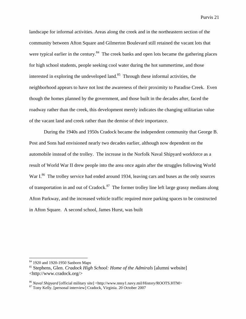
Figure 11 1920s-1950s Sanborn Map. Color coding indicates:
Orange- vacant lots Blue – planned parks Red – land along Paradise Creek Sanborn Maps. Cradock, Va. 1920, 1920-1950 < http://sanborn.umi.com/> Figure 12 Afton Square in 1954
Stephens, Glen. Cradock High School: Home of the Admirals [alumni website] <http://www.cradock.org/>
Figure 13 Intersections of half-mile service areas for two new shopping centers and Afton Square. Although the new shopping centers do not intersect, both cover large portions of Cradock.
Office of Dan E. Griffin, Architects, AIA, Ltd. Afton Square Study. Portsmouth, Va: Office of City Planning, May 1978. 12
Figure 14 Green Spaces of 1918 plan as interpreted by 1978 study.
Office of Dan E. Griffin, Architects, AIA, Ltd. Afton Square Study. Portsmouth, Va: Office of City Planning, May 1978. Figure 2
Purvis 1
Living Near Paradise
The development of land uses in Cradock, Virginia along Paradise Creek
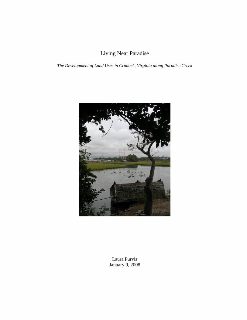
Looking across Paradise Creek, smokestacks rise in the distance. Ducks have gathered
just beyond the water’s edge where the surface is unobstructed by marsh grasses and trees. The
ripples break the dark surface of the water and reflect the hazy grey sky above. Dark shadows
beneath the trees accent the vivid green vegetation. Yet, the orange smokestacks still puncture
the horizon line through the dense trees on the far side of the creek. At low tide, the creek
recedes to leave only a thick mud.
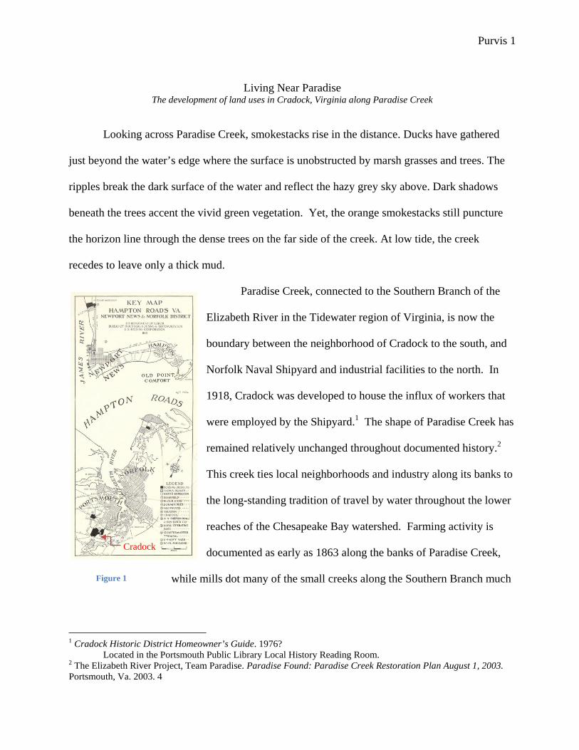
Paradise Creek, connected to the Southern Branch of the
Elizabeth River in the Tidewater region of Virginia, is now the
boundary between the neighborhood of Cradock to the south, and
Norfolk Naval Shipyard and industrial facilities to the north. In
1918, Cradock was developed to house the influx of workers that
were employed by the Shipyard.1 The shape of Paradise Creek has
remained relatively unchanged throughout documented history.2
This creek ties local neighborhoods and industry along its banks to
the long-standing tradition of travel by water throughout the lower
reaches of the Chesapeake Bay watershed. Farming activity is
documented as early as 1863 along the banks of Paradise Creek,
while mills dot many of the small creeks along the Southern Branch much
1 Cradock Historic District Homeowner’s Guide. 1976? Located in the Portsmouth Public Library Local History Reading Room. 2 The Elizabeth River Project, Team Paradise. Paradise Found: Paradise Creek Restoration Plan August 1, 2003. Portsmouth, Va. 2003. 4
Figure 1
Cradock
Purvis 2
earlier in the mid eighteenth century.3 The gradual introduction and expansion of industry in the
area absorbed farmland for both housing and production facilities. The land was once heavily
wooded, but farming and ship building have removed all of the original growth along these
waterways.4 Only in the Great Dismal Swamp – just to the south – can one experience the dense
and varied vegetation that grew in the southeastern part of Virginia. Although drastically altering
the built environment, the construction of Cradock did not cause a definitive break with the
historic uses of the land and creek. The activity along Paradise Creek is only one example of a
trend that exists throughout the area known as Hampton Roads. The natural features of the land
have continued to be a resource in the daily lives of inhabitants along Paradise Creek as a
connective element to both the traditions of the past and the initiatives of the future, even in the
wake of pivotal changes in the built environment.
Connected by Water
Although the built environment in Hampton Roads developed in the wake of European
contact during the 17th century, Native Americans had been exploiting rivers and streams for
transportation throughout the Tidewater region long before the passage across the Atlantic.5 The
intricate system of rivers and creeks along the Bay was first created over 8,000 years ago from
flooding caused by melting glaciers.6 During this flooding, the shoreline became irregular
creating a web of rivers and creeks that reached far inland. The four main rivers in Virginia
poured into the Chesapeake after its formation. The Potomac, the Rappahannock, the York, and
the James connect to innumerable small creeks and rivers which make transportation on these
3 Stuart Barker. Grist Mills of Norfolk County. Great Bridge, Va: June 1994. 4 Filed in the Chesapeake Main Library Local History Reading Room in Great Bridge, Virginia. 4 The Elizabeth River Project. “History: Our Royal Past.” The Elizabeth River Project: Restoring the Elizabeth River through government, business, and community partnerships. [online] < http://www.elizabethriver.org/> 5 William Tazwell and Guy Friddell. Norfolk’s Waters: An Illustrated History of Hampton Roads. Sun Valley, CA: American Historical Press, 2000. 17 6 Ibid

Purvis 3
systems possible. The Elizabeth River intersects the James River and the Bay at their most
southern point before merging with the Atlantic Ocean. The three other tributaries lie to the
north. The proximity of water throughout this entire region gave early inhabitants a means for
transportation and survival, and the area along the Elizabeth River was inhabited by the
Chesapian (Chesapeake) Indians well before the first Spanish explorers sailed into the Bay in
1561.7 By 1607, the entire region was part of the Powhatan Empire, and the Chesapeake paid
tributes to Chief Powhatan.8 The political organization of these tribes extended from the
Potomac River to the Great Dismal Swamp and as far inland as the fall lines of the four major
tributary rivers.9 Settlements were mostly along rivers, and tribes were able to cultivate surplus
crops to support the community.10 Chief Powhatan’s seat of government was along the northern
bank of the York River, and travel was crucial in order to rule over his large empire and ensure
loyalty. The site, called Werowocomoco, also provided ample space along the bank of the river
for canoes to bring tributes from subordinate tribes like the Chesapeake. 11
7 Ibid 8 Axtell, James. After Columbus : essays in the ethnohistory of Colonial North America. New York: Oxford University Press, 1988. 184-185 9 Axtell 185 10 William E. McNulty et al. A World Transformed. National Geographic Map Insert. Washington DC: National Geographic Society, May 2007. 11 William E. McNulty et al. 1607: When Cultures Collided. National Geographic Map Insert. Washington DC: National Geographic Society, May 2007.
Purvis 4
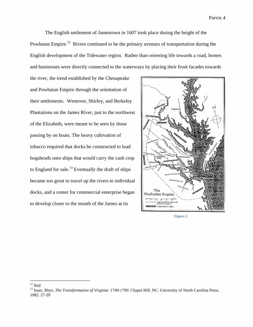
The English settlement of Jamestown in 1607 took place during the height of the
Powhatan Empire.12 Rivers continued to be the primary avenues of transportation during the
English development of the Tidewater region. Rather than orienting life towards a road, homes
and businesses were directly connected to the waterways by placing their front facades towards
the river, the trend established by the Chesapeake
and Powhatan Empire through the orientation of
their settlements. Westover, Shirley, and Berkeley
Plantations on the James River, just to the northwest
of the Elizabeth, were meant to be seen by those
passing by on boats. The heavy cultivation of
tobacco required that docks be constructed to load
hogsheads onto ships that would carry the cash crop
to England for sale.13 Eventually the draft of ships
became too great to travel up the rivers to individual
docks, and a center for commercial enterprise began
to develop closer to the mouth of the James at its
12 Ibid 13 Isaac, Rhys. The Transformation of Virginia: 1740-1790. Chapel Hill, NC: University of North Carolina Press, 1982. 27-29
Figure 2

Purvis 5
intersection with the Elizabeth River.14 The cities of Norfolk and Portsmouth formed on
opposite sides of the Elizabeth, taking advantage of proximity to the sheltered harbor. The rural
land surrounding these two cities became Norfolk County, and was a mixture of agriculture and
industry.15 Gosport, an area just below the colonial boundaries of Portsmouth, was developed by
Andrew Sprowle in 1767 for ship building and maintenance.16 Tobacco cultivation did not last
long in the region as the natural harbor was adapted for industrial purposes and the surrounding
land was cultivated in food crops.17 Grist and wood mills
developed along the Elizabeth while the Gosport shipyard
grew.18 Grist mills were built first to keep up with the
demand for corn and grain by the increasing population in
the area.19 As the area grew, wood mills developed. The
Great Dismal Swamp just to the southwest had been
discovered by William Drummond in 1665, and the Southern Branch of the river was the most
direct connection to the resources of the swamp, such as juniper and cedar. 20 Mills at each
creek could take advantage of the proximity of raw materials.21 Along the Southern Branch, the
Gosport Shipyard and the mills continued to be dependent on the water for both their daily
operation and transportation of goods.
14 Robert W. Lamb. Our twin cities of the nineteenth century: (Norfolk and Portsmouth) : their past, present and future. Norfolk, Va.: Barcroft, 1887-88.87 15 Col. William H Stewart. History of Norfolk County, Virginia and representative Citizens. Chicago: Biographical Publishing Company, 1902. 156 16 Norfolk Naval Shipyard History. [official military website] <http://www.nnsy1.navy.mil> 17 Stewart. 157 18 Barker 1 19 Ibid 20 Amy Yarsinske. The Elizabeth River. Charleston, SC: The History Press, 2007. 228 21 Raymond Harper. Norfolk County. Charleston, SC: Arcadia, 2000.
Figure 3
Purvis 6
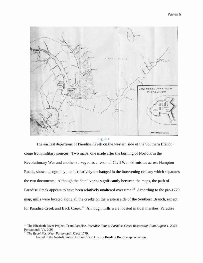
The earliest depictions of Paradise Creek on the western side of the Southern Branch
come from military sources. Two maps, one made after the burning of Norfolk in the
Revolutionary War and another surveyed as a result of Civil War skirmishes across Hampton
Roads, show a geography that is relatively unchanged in the intervening century which separates
the two documents. Although the detail varies significantly between the maps, the path of
Paradise Creek appears to have been relatively unaltered over time.22 According to the pre-1779
map, mills were located along all the creeks on the western side of the Southern Branch, except
for Paradise Creek and Back Creek.23 Although mills were located in tidal marshes, Paradise
22 The Elizabeth River Project, Team Paradise. Paradise Found: Paradise Creek Restoration Plan August 1, 2003. Portsmouth, Va. 2003. 23 The Rebel Fort Near Portsmouth. Circa 1779. Found in the Norfolk Public Library Local History Reading Room map collection.
Figure 4

Purvis 7
Creek may not have been able to support a mill because of its low water level even during high
tide.24 The same map indicates a roadway that linked all of the creeks together near the location
of the mills. This road runs beyond the most inland point of Paradise Creek, leaving water as the
only efficient means of transportation. During colonial period, Paradise Creek appears to have
been relatively remote and possibly forested.
By the Civil War era, the details of the geography and land ownership are depicted in
greater detail. 25 The Roanoke and Seaboard Railroad now cuts through the Dismal Swamp
towards Portsmouth, and clusters of farm sites along waterfronts and roads pattern the landscape.
Paradise Creek is still unlabeled, but the surveyor recorded farms belonging to the Barkley,
Owens, Edwards, and Petam families. There are two Barkley lots located in the proximity of the
future site of Cradock along Paradise Creek, and both indicate homes that are within a short
walking distance of the creek. The road depicted in the Revolution era map still connects all the
mills, and driveways link the Barkley properties to the only depicted land route. Drawing from
the changes between the Revolution era map and that from the Civil War, the Barkleys may be
the first family to have improved the land along that section of Paradise Creek. During the late
1800s, local produce from farms like the Barkley’s accounted for a significant portion of the
exports from Norfolk County through Portsmouth and Norfolk.26 The practice, known as
trucking, began in Hampton Roads around 1844 and continued well into the twentieth century.27
There were enough families farming near the Barclay property to organize a school, located in
the 1862 Civil War map. However, the location of a “Poor House” near the school demonstrates
that this area still had a level of economic problems that necessitated the organization of such a
24 Barker 2 25 Leiut. Oscar Soederquist. Military Map of Suffolk and Vicinity for Brig. Gen. E.L. Viele. 1862. 26 Stewart 156 27 Ibid

Purvis 8
Figure 5

Purvis 9
facility. Even with the development of institutions along the main road, an author of Norfolk
County history in 1902 states that:
The county is penetrated by several arms of the sea, - Tanner’s Creek, Broad Creek, Mason’s Creek and Deep Creek, - which with the three branches of the Elizabeth River, - the “Eastern Branch,” “Western Branch” and “Southern Branch,” – and the North West River constitute a very fine water system, and places each farm in Norfolk County within a few miles of water transportation, insuring to the Norfolk County farmer the cheapest transportation in the world.28
Although increasing development had brought a land route for transportation of goods, water still
provided a vital link among farmers to the rest of Hampton Roads.
The first map to label Paradise Creek is a plat within a deed dated to 1883, although oral
histories suggest that a farm named Paradise Plantation existed on the site during the colonial
period and gave the creek its name.29 The plat depicts the land exchange between a Mr. Starke to
William and James Maupin for sixty-six acres. The acreage is surrounded by S.Barclay, the
same family that was indicated in the Civil War map, while the northern boundary is the labeled
Paradise Creek. 30 Other sections of the Barclay farm were sold off during the intervening years
leading to the federal purchase of the land to create Cradock. William and James Maupin
continued to acquire land along Paradise Creek after the initial 1882 purchase. The Barclay
property was divided, most likely among siblings, before 1888 when the final section of the
original Barclay farm was sold to the Maupins.31 The consolidated land was renamed Afton
Farm and appears in several surveys done before the purchase of land to build Cradock in
1918.32 Similar transactions had taken place just below Afton Farm on the land known as the
28 Ibid 22 29 Norfolk County Deed Book 117 page 82 and, The Elizabeth River Project, Team Paradise. Paradise Found: Paradise Creek Restoration Plan August 1, 2003. Portsmouth, Va. 2003. 3 30 The spelling of the Barkley family name changes over time. Other spellings include Barklay and Barclay. 31 Norfolk County Deed Book 112 pages 92-95 32 Norfolk County Map Book 16 page 2, Map Book 13 page 73, and Deed Book 452 pages 591, 594

Purvis 10
“Bain Tract” that was renamed Prospect Farm under the ownership of John T. Griffin.33
Figure 6 During the era of farm reorganization in the late 19th century, the Portsmouth Company, a
land speculation and development firm, began gradually purchasing land along the western bank
of the Elizabeth River.34 The Portsmouth Company was part of a much larger firm based in
Philadelphia which had other local branches across the Elizabeth River in Norfolk and the upper
class Ghent neighborhood, located just beyond the commercial center of the city of Norfolk.35
Upon the purchase of land along Paradise Creek, the company’s ownership extended into
33 Norfolk County Deed Book 225 pages 364-370 34 Ibid. 35 Yarsinske, Amy Waters. Ghent: John Graham’s Dream, Norfolk, Virginia’s Treasure. Charleston: The History Press, 2006. 21, 56-58 and Norfolk County Deed Book 255 page 364

Purvis 11
portions of the creek itself.36 The Portsmouth Company gave significant right of way to the
Riverfront Railroad Company and, later, the Virginian Railway Company.37 The railroad had
divided the land between St. Julians’ and Paradise creeks to the east and west, and much of the
eastern portion along the shoreline of the Southern Branch was owned by William Schmoele.38
The land purchased included rights into sections of the creek as well.39
At the beginning of World War I, the three prominent land holders remained William and
James Maupin, John Griffin, and the Portsmouth Company.40 The fluctuations in population as a
result of the war-time demands on the shipping industry and the United States Navy, who now
operated the Gosport Shipyard, gradually brought more people into Hampton Roads and
increased the demand for housing.41 The federal government began planning communities to
support the extra personnel. The land around Paradise Creek was in close proximity to Norfolk
Naval Shipyard and within a few months of the initial bill authorizing the expansion of
government housing across the country, the land was surveyed for an ‘Industrial Housing
Development’ that would later become Cradock.42
The Federal Intervention
As people came in the area during World War I to work at Norfolk Naval Shipyard, just a
few miles north of the neighborhood, the federal government began to respond with new housing
projects. Two sites were chosen along Paradise Creek. One, Truxton, became African-
American government housing, while Cradock was the Caucasian counterpart.43 Cradock, which
36 Norfolk County Map Book 2 page 68 37 Norfolk County Map Book 4 page 47 38 Ibid 364-5 39 Norfolk County Map Book 7 page 69, and Map Book 2 page 68 40 Norfolk County Map Book 16 page 2 41 Cradock Historic District Homeowner’s Guide. 1976? 42 Ibid 43 United States Housing Corporation. War emergency construction (housing war workers) : report of the United States Housing Corporation. Washington : Govt. Prtg. Off., 1919. 270

Purvis 12
was planned on the southern bank of Paradise Creek, was organized with the homes facing away
from the creek, although a significant portion of the land along the creek was a planned park.44
However, once on site, the builders felt the creek was “…a serious problem, because though the
creek is very attractive at high tide it is largely a mud flat at low tide.”45 In an area known for its
waterways and shipping industry by the late nineteenth and early twentieth centuries, the builders
of the Cradock neighborhood chose to ignore the muddy little creek and its connection to the
larger network of waterways throughout the Hampton Roads area. For the first time, land routes
dominated the transportation system along Paradise Creek.
In 1918, when construction was beginning for Cradock, industry had just begun to creep
down to the northern bank of Paradise Creek.46 The Norfolk Naval Shipyard also purchased land
from William Schmoele who had owned several tracts of land along the western portion of the
Elizabeth River’s Southern Branch, including a section just to the north of Cradock.47 The land
on the northern side of Paradise Creek allowed for facilities expansion during the early 20th
century.48 Initial plans for the Cradock community incorporated a park and curved roads along
the northern boundary of the community. Cradock was planned instead around a central
commercial lot, called Afton Square, which also featured a small park for the residents. 49 Three
main roads serve as arteries through the grid layout. Afton Parkway is the main entrance
44 United States Housing Corporation. 273 45 United States Housing Corporation. 272 46 Norfolk County Map Book 16, page 2 47 Norfolk Naval Shipyard [official military site] <http://www.nnsy1.navy.mil/History/ROOTS.HTM> 48 Ibid 49 United States Housing Corporation. 272

Purvis 13
Figure 7

Purvis 14
into the neighborhood as well as the primary east west artery. Deep Creek Oval Park is just
north of the entrance to Afton Parkway from Shell Road, the existing highway to the west.
Afton Parkway then travels through the neighborhood by Afton Square, and intersects with
Gilmerton (now Victory) Boulevard. Gilmerton connected across Paradise Creek to Norfolk
Naval Shipyard. The two north-south principle roads, Prospect Parkway and Gilliss Road,
terminate at other critical features of the neighborhood plan. Gilliss Road connects Shell Road to
the pedestrian bridge over Paradise Creek towards the Naval Yard property. Prospect Parkway
terminates at both the northern and southern end in parks. To the south, Afton Park is the largest
in the community and divides the impermanent worker and family housing from the planned
permanent buildings.50 Prospect Field forms the open space behind the community school on the
southern edge of the property. Although original housing corporation plan calls for two
semicircular roads between the creek and Prospect field to accommodate four more blocks of
housing (indicated by the green highlighting in Figure 7), the road which was to define the
boundary of Prospect Field and the three radial streets dividing the land into blocks was among
the few omitted during the initial building period in 1918. As a result, Prospect Field increased in
size and is now bounded by Aylwin Crescent, the street that travels along much of Paradise
Creek. The use of Prospect and Afton in several street and park names commemorates the Afton
and Prospect farms that existed on the property in the decades before the government began the
development of the neighborhood. The creek bank remained largely undeveloped according to
the original plan, while just to the south the United States Housing Corporation and the architects
in charge of the project, George B. Post and Sons, built the majority of the permanent housing.51
Homes were first built between the new central commercial center, the highway forming the
50 United States Housing Corporation. 273 51 Ibid 272
Purvis 15
western boundary, and the school at the northern end of the neighborhood.52 These locations
were all convenient to the new trolley line that took workers to and from the shipyard.53 In order
to quickly house the expanding population before the planned structures could be built, “ready-
cut” houses were installed in several blocks on the southeast boundary of the property between
Virginia Road and Afton Park. These manufactured homes were placed on fifty foot lots that
became typical throughout the entire neighborhood.54 The permanent houses had varied plans to
create a pleasing affect in the neighborhood, which included apartment buildings along with
single family houses. The planned community had a density higher than that of the surrounding
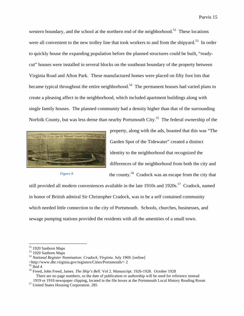
Norfolk County, but was less dense than nearby Portsmouth City.55 The federal ownership of the
property, along with the ads, boasted that this was “The
Garden Spot of the Tidewater” created a distinct
identity to the neighborhood that recognized the
differences of the neighborhood from both the city and
the county.56 Cradock was an escape from the city that
still provided all modern conveniences available in the late 1910s and 1920s.57 Cradock, named
in honor of British admiral Sir Christopher Cradock, was to be a self contained community
which needed little connection to the city of Portsmouth. Schools, churches, businesses, and
sewage pumping stations provided the residents with all the amenities of a small town.
52 1920 Sanborn Maps 53 1920 Sanborn Maps 54 National Register Nomination: Cradock, Virginia. July 1969. [online] <http://www.dhr.virginia.gov/registers/Cities/Portsmouth/> 2 55 Ibid 4 56 Freed, John Freed, James. The Ship’s Bell. Vol 2. Manuscript. 1926-1928. October 1928 There are no page numbers, so the date of publication or authorship will be used for reference instead 1919 or 1918 newspaper clipping, located in the file boxes at the Portsmouth Local History Reading Room 57 United States Housing Corporation. 285
Figure 8
Purvis 16
This independent spirit intensified during the federal freeze on construction in the
neighborhood. Over a thousand homes were planned for Cradock during World War I, but when
the project ended abruptly with the Treaty of Versailles only seven-hundred and fifty nine homes
had been constructed.58 The presence of so much open space within the community created a
tradition of appropriating vacant lots for both public and private uses within Cradock,
independent of the planned intentions for the land.59 Although some sections of the
neighborhood grid had been left open in plans to allow for later construction, the relative density
of homes within the built sections of Cradock contrasted sharply with the large open spaces left
by the post-war freeze on building.60 Jobs at the Norfolk Naval Shipyard were cut from 11,234
in 1919 to 2,538 in 1923, just above the pre-war employment level and the surplus population
dependent on those jobs moved elsewhere.61 As a result, the United States Housing Corporation
began the process in 1920 of privatizing Cradock as the community was too expensive to
operate.62 The small town model became even more important during the transfer of ownership
to residents living in the neighborhood. With several failed appeals to join both the city of
Portsmouth and Norfolk County in the years after World War I due to the medium-level density
of the area, Cradock was left to operate itself for two years, earning the name “Orphan Town”
among local newspapers.63 The community attempted to become an independent town during
58 Freed references gardening throughout the 1926-1928 newspapers and recollections in The Ship’s Bell 59 Author’s observation from The Ship’s Bell collection, and personal interviews with current residents. 60 1920 Sanborn Map 61 Naval Shipyard [official military site] <http://www.nnsy1.navy.mil/History/ROOTS.HTM> 62 Horner, Guy T. Statement of Facts Relating to Cradock, Va (US Housing Corporation – Project 150a) Submitted by the Citizens’ Council of Cradock & The Cradock Utilities Co. Inc. through Guy T. Horner, Counsel. 20 63 Newspaper articles found in the collection at the Portsmouth Public Library Local History Reading Room, Cradock Information Boxes. And Cradock Historic District Homeowner’s Guide. 1976?
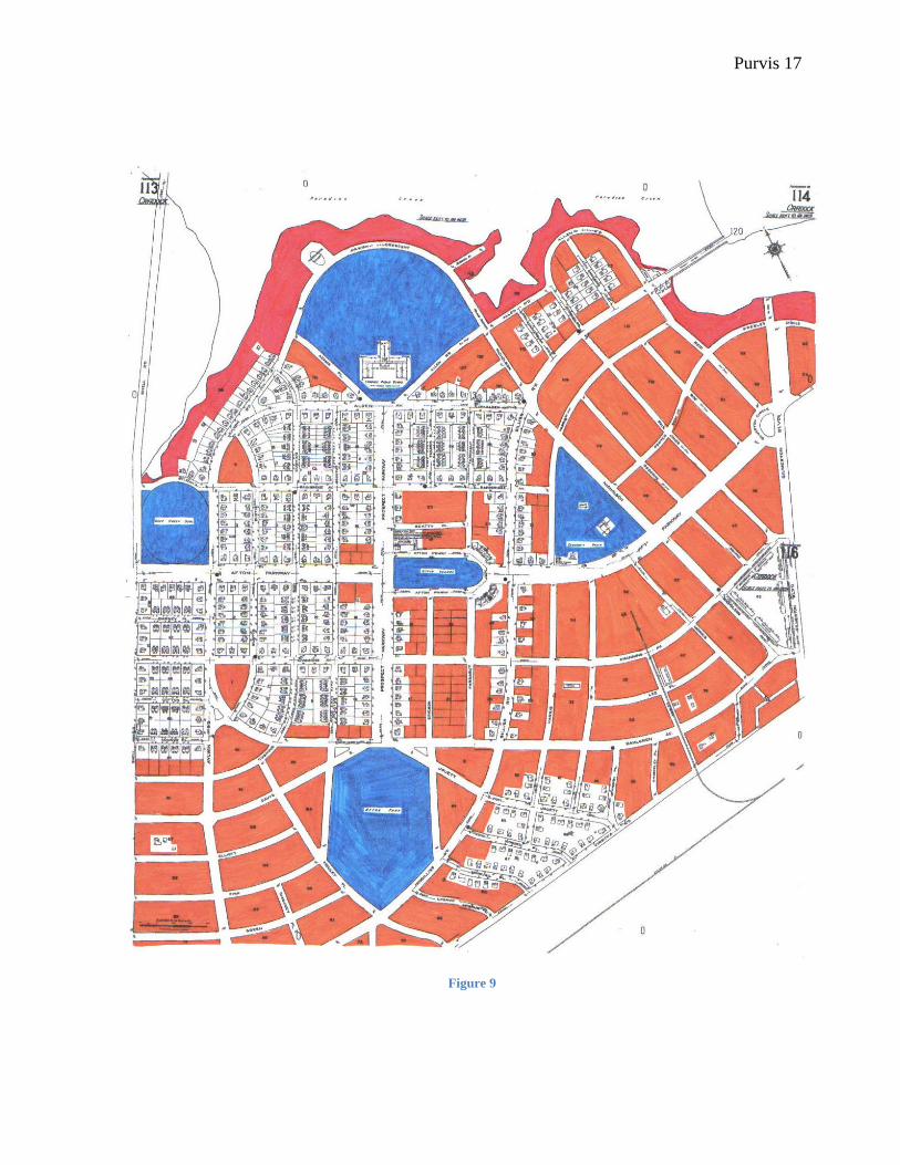
Purvis 17
Figure 9

Purvis 18
the privatization phase, but was unable to do so.64 Both the city of Portsmouth and Norfolk
County turned down their requests to be annexed.65 For the city, Cradock approximated rural
density and the county believed that the community was too urban to fall under their
jurisdiction.66 Until 1922, when Norfolk County finally accepted the annexation request,
Cradock was forced to run itself without formal organizational support.67
The events spanning 1920-1922 left a legacy for the neighborhood. Although Cradock
became part of Norfolk County, residents still perceived their location as isolated from the local
governments.68 By 1928, the business district, then called The Crescent and bordered Afton
Square, was a viable center that included a grocery store, doctor’s office, post office, and drug
store.69 The trolley line, which began operation during 1918, continued to provide direct
connection from the neighborhood to the Navy Yard and other industry. The pedestrian bridge
across Paradise Creek was still standing.70 All of these functioning elements preserved the
independent town aura that surrounded Cradock even after annexation. Given that the area was
also less dense that Portsmouth, unimproved property provided opportunities for locals to extend
their land use to other lots. Some like the Freed family, who lived on 59 Bainbridge Avenue and
wrote the Ship’s Bell, a community newspaper distributed in the late 1920s, planned to “…rent a
bit of land and have a real garden….”71 In a better documented cases of appropriating land for
agricultural use, a man decided to test the viability of a second growing season in the Portsmouth
area by planting a late crop of corn on a lot near Afton Square.72 Mr. Freed reports testing
64 Homer. 10-12 65 Ibid 66 Ibid 67 Ibid 68 Ibid. 12 69 Freed, John. The Ship’s Bell. Vol 2. Manuscript. 1926-1928. 11 February 1928 70 1920 Sanborn Map 71 Freed. July 26th 72 Ibid. November Gossip 15th and 23rd of the month

Purvis 19
several ears of corn to verify that the experiment was working and noted that “This ‘noble
experiment’ will furnish the planter with a couple of dozen ears of corn and some shocks of
fodder, and experience. It has been a very interesting study.”73 Young people also used the land
for Boy Scout adventures and gathering places.74 The woods used by the Boy Scouts were those
between Harris and Irwin Streets, three blocks to the southeast of Afton Square.75 The
neighborhood was surrounded by portions of woods in undeveloped lots which provided a sense
of protection against possible explosions at the St. Julian’s Ammunition Depot and the Navy
Yard.76 The woods were a barrier that could catch any ‘missiles’ coming from those bases.77
Those who lived in Cradock may not have viewed the creek with as much scorn as the architects
of George B. Post and Sons during the early construction of the neighborhood. In fact, the creek
was mentioned as an asset. John Freed wrote that “A trip to “town” on the trolley is an
inspiration to the nature lover. Afton Woods, the sand flats, the winding Paradise Creek…”78
Like the woods, the creek was a protective barrier from the industrial activity around the
neighborhood.
During this period, even though the large scale farms had been eliminated by the creation
of Cradock, an interest in an agrarian past persisted. Both of the main roads in Cradock, Afton
and Prospect Parkways, had been named after the Maupin and Griffin Farms.79 Maps denote the
Barclay family cemetery even in plans created by the United States Housing Corporation.80
Although many of the people who lived in Cradock were not originally from the immediate area,
73 Ibid. November Gossip 23rd of the month 74 Ibid. November Gossip 10th of the month 75 Freed, John. The Ship’s Bell. Vol 1. 11 Nov 1928 76 “Ammunition Depot Rocked by Blast; Cradock Terrified” The Portsmouth Star. Portsmouth, Va: 27 July 1928 77 Ibid. and Freed, July 1928 78 Freed, The Ship’s Bell. Vol 2. 10th November Gossip 79 Tradition in the neighborhood is that the main roads were named after the previous farms, and deed research revealed that Afton and Prospect farms existed on the site before Cradock. 80 United States Housing Corporation. 273

Purvis 20
these indications of an earlier era persisted in creating an awareness of the local past. Farming
continued, although on a smaller scale. The land was a resource rather than simply a foundation
for the built environment that the federal government had planned. Trucking gardens were
popular, and those who used their backyards or extra lots for trucking gardens were participating
in the same commercial enterprise as the earlier farms.81 The gardens were named, quite
literally, from the process of selling goods to the local vendors who drove their trucks all over
the area to gather fresh fruits and vegetables for sale elsewhere. The earlier era of trucking that
began in 1844 was similar, but depended on water routes
for transportation.82 Seeds were most likely bought in the
cities; Mr. Freed kept a catalogue from the Williams Seed
Company in Norfolk.83 A photograph of the Williams
Seed Company storefront in Norfolk demonstrates the
target market for the store. Although there were still
considerable farms within Norfolk County, the display
shows a well dressed woman sowing seeds mock patch of
earth. The display apparently focuses on the domestic
practicality and potential profit of cultivation, and given that trucking gardens were a
development of backyard scale gardening, the store recognized a viable market of which
Cradock was part.
By the second wave of development in Cradock during World War II, backyard
cultivation and recreational activities had transformed the formalized agricultural and
transportation uses of Paradise Creek and the surrounding land. Residents now used the natural
81 Freed. Vol 1. 11 February 1928 82 Stewart. 156 83 Freed. Vol 1, Spring 1928
Figure 10
Purvis 21
landscape for informal activities. Areas along the creek and in the northeastern section of the
community between Afton Square and Gilmerton Boulevard still retained the vacant lots that
were typical earlier in the century.84 The creek banks and open lots became the gathering places
for high school students, people seeking cool water during the hot summertime, and those
interested in exploring the undeveloped land.85 Through these informal activities, the
neighborhood appears to have not lost the awareness of their proximity to Paradise Creek. Even
though the homes planned by the government, and those built in the decades after, faced the
roadway rather than the creek, this development merely indicates the changing utilitarian value
of the vacant land and creek rather than the demise of their importance.
During the 1940s and 1950s Cradock became the independent community that George B.
Post and Sons had envisioned nearly two decades earlier, although now dependent on the
automobile instead of the trolley. The increase in the Norfolk Naval Shipyard workforce as a
result of World War II drew people into the area once again after the struggles following World
War I.86 The trolley service had ended around 1934, leaving cars and buses as the only sources
of transportation in and out of Cradock.87 The former trolley line left large grassy medians along
Afton Parkway, and the increased vehicle traffic required more parking spaces to be constructed
in Afton Square. A second school, James Hurst, was built
84 1920 and 1920-1950 Sanborn Maps 85 Stephens, Glen. Cradock High School: Home of the Admirals [alumni website] <http://www.cradock.org/> 86 Naval Shipyard [official military site] <http://www.nnsy1.navy.mil/History/ROOTS.HTM> 87 Tony Kelly. [personal interview] Cradock, Virginia. 20 October 2007
Purvis 22
Figure 11
Purvis 23
in 1942 to accommodate the increasing population of children in the area.88 The school was
built on Afton Park. At that time, what remained of Afton Park was “heavily wooded.”89 By
1954, a new high school across George Washington Highway (formerly Shell Road which
connected all the mills during the early history of the area) was built.90 This became the new
Cradock High School while the former high school building housed lower grades.91 The large
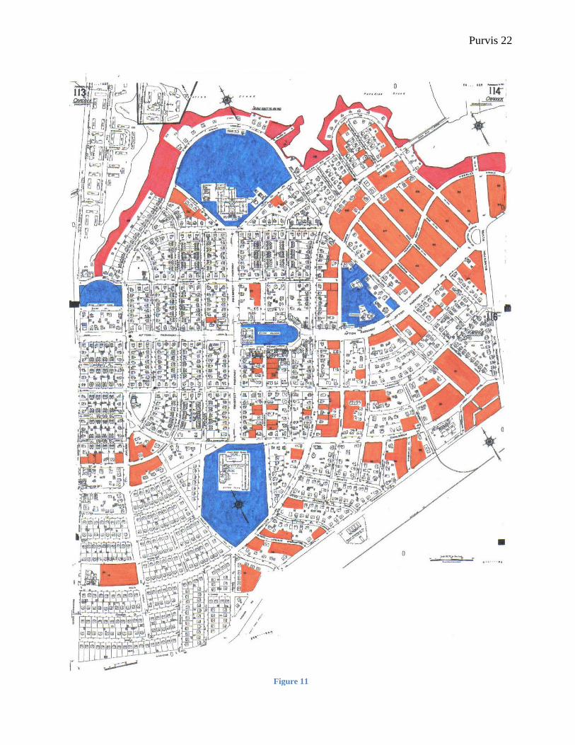
numbers of children in the neighborhood gave rise to a youth culture that centered on the local
business in Afton Square and the gathering places
along the creek. Summers were spent wading in the
water, catching crabs and muskrats along the banks,
and enjoying movies in the Afton Theater, in the
commercial center.92 The Shipyard had extended its
facilities to the northern bank near the Elizabeth River,
while homes were being built along the southern
bank.93 While some parts of the creek were gathering places, sections along Aylwin Crescent
now included homes that had the creek as part of the backyard. This play between public and
private space also took place just behind a store facing George Washington Highway between
Gilliss and Woodland streets.94 The lot, one of the few vacant on in the western portion of the
neighborhood, was used for community gardening space while the road frontage gave access to
the privately owned store.95 Even though Cradock was finally functioning much as the planners
88 Portsmouth Public Schools: James Hurst Elementary. [official website for Portsmouth city schools] <http://pps.k12.va.us/schools/elementary_schools/james_hurst/default.aspx?id=1550> 89 Ibid 90 Stephens. <http://www.cradock.org/> 91 Ibid 92 Kelly and Wyatt 93 1920-1950 Sanborn, and Norfolk Naval Shipyard History < http://www.nnsy1.navy.mil> 94 Kelly 95 Ibid
Figure 12

Purvis 24
had intended, the appropriation of property continued to define among residents interaction with
the local landscape.
The Creek Reclaimed
In 1960 Cradock was annexed to the city of Portsmouth.96 In the latter part of that
decade, the neighborhood began a decline that has centered on the business in Afton Square. By
1978, two competing neighborhood shopping centers were either drawing businesses out of the
Cradock commercial area or creating duplicate stores that offered a more diverse assortment of
goods.97 During this time, the story of the creek and vacant land seem to continue as they did
during and after World War II, but these issues were overshadowed by the decline of Afton
Square. As the planned heart of the community,
most of the revitalization efforts have focused on
that section. The earliest concentrated effort
took place in 1978 when the Portsmouth City
Planning Office recognized the hardship caused
by the new shopping centers.98 Efforts
immediately turned to restoring the
neighborhood to the original plan created by George B. Post and Sons, the plan that only came
into fruition in modified form by World War II.99 Few changes described in the plans were used
in Afton Square. However, the emphasis on “green space” in the plan was the first indication of
a shifting aesthetic of planning for the neighborhood. Rather than landscape interaction being an
96 Cradock Historic District Homeowner’s Guide. 1976? Located in the Portsmouth Public Library Local History Reading Room. 97 Office of Dan E. Griffin, Architects, AIA, Ltd. Afton Square Study. Portsmouth, Va: Office of City Planning, May 1978. 12 98 Ibid 99 Ibid. Figure 2
Figure 13
Purvis 25
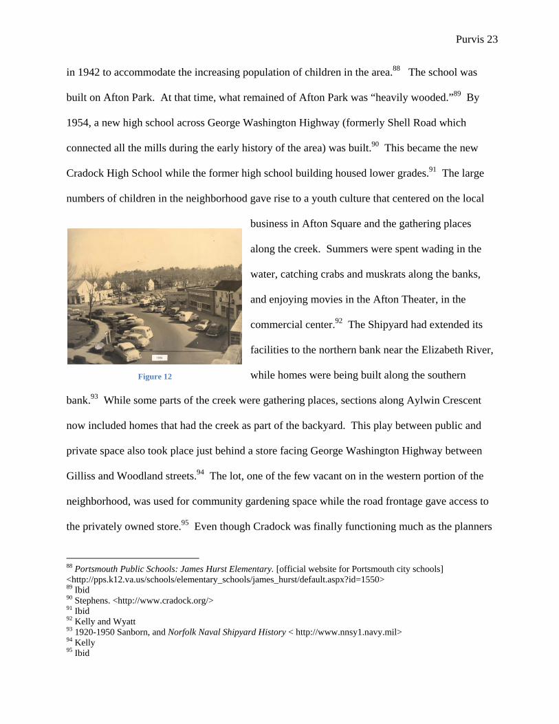
entirely informal activity within the community, the plans from the 1978 study incorporate
landscaping and trees into the concerns of altering the buildings on the Square.100 A map of the
1918 plan, drawn by Dan E. Griffin Architects for Portsmouth City Planning, includes swaths of
green that connect the main thoroughfares, Afton Parkway and Prospect Parkway, with the
Square, parks, and the bank of Paradise Creek. Part of Prospect Field, behind the site of the 1918
Cradock High School, returned to proposed space for development, even though the land use
since the construction of the community had lent itself to recreation for the school.101 The plan
ignores the uses of land by residents that
had developed since 1918. By the 1970s,
those leading revitalization efforts had
chosen the original construction intentions
and appearances as the historically
important aspects of Cradock, rather than
the economically viable and more
populous decades of the 1940s and 1950s.
Afton Parkway, while having large areas
of open grass, is important within the
community because it has historically connected the residents to jobs and resources in
Portsmouth. Likewise, Prospect Parkway provides the north-south connections within the
community. Although originally planned as a park, the land along Paradise Creek has a
developmental history that is aligned with the growth of the neighborhood and the use of vacant
100 Ibid. Afton Square Site Plan 101 Ibid. Figure 2
Figure 14
Purvis 26
or backyard lots for truck gardens. The urge to restore the area to mimic the 1918 proposal
ignores the growth and change of Cradock.
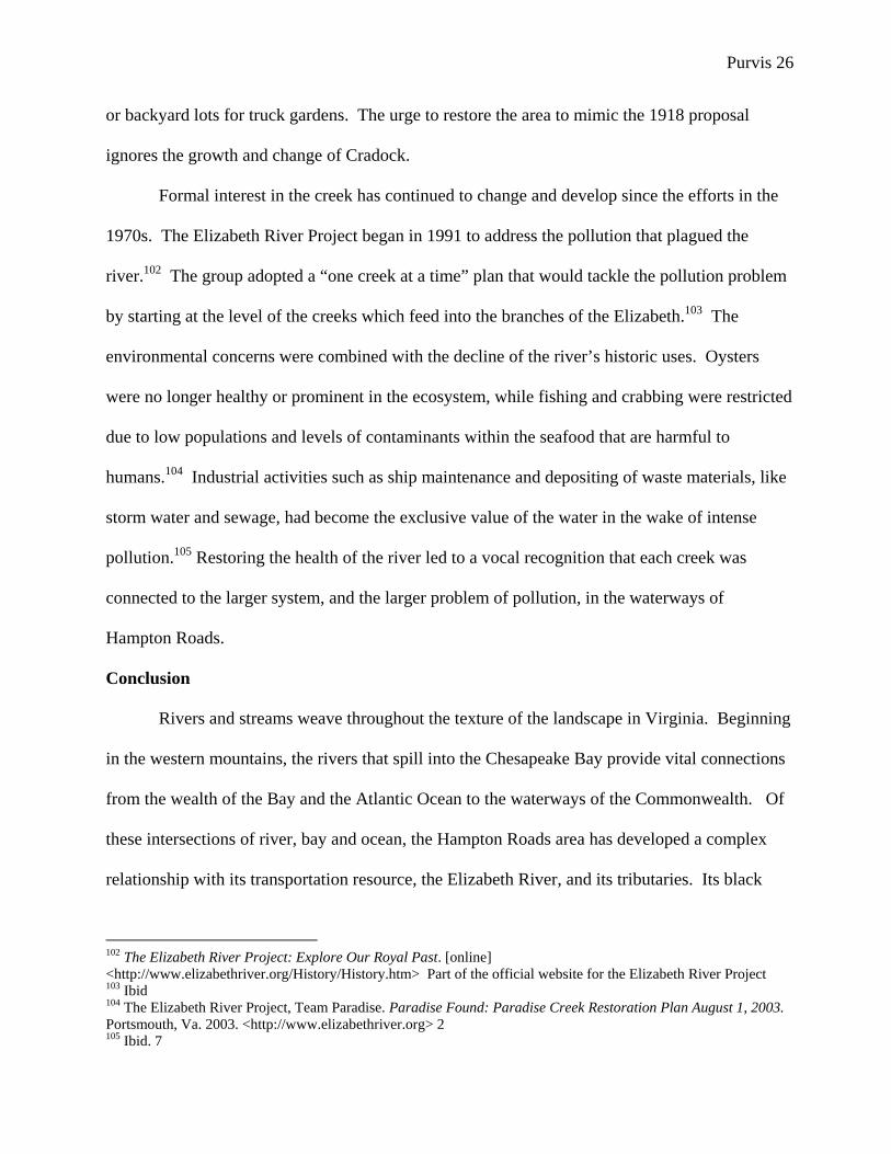
Formal interest in the creek has continued to change and develop since the efforts in the
1970s. The Elizabeth River Project began in 1991 to address the pollution that plagued the
river.102 The group adopted a “one creek at a time” plan that would tackle the pollution problem
by starting at the level of the creeks which feed into the branches of the Elizabeth.103 The
environmental concerns were combined with the decline of the river’s historic uses. Oysters
were no longer healthy or prominent in the ecosystem, while fishing and crabbing were restricted
due to low populations and levels of contaminants within the seafood that are harmful to
humans.104 Industrial activities such as ship maintenance and depositing of waste materials, like
storm water and sewage, had become the exclusive value of the water in the wake of intense
pollution.105 Restoring the health of the river led to a vocal recognition that each creek was
connected to the larger system, and the larger problem of pollution, in the waterways of
Hampton Roads.
Conclusion
Rivers and streams weave throughout the texture of the landscape in Virginia. Beginning
in the western mountains, the rivers that spill into the Chesapeake Bay provide vital connections
from the wealth of the Bay and the Atlantic Ocean to the waterways of the Commonwealth. Of
these intersections of river, bay and ocean, the Hampton Roads area has developed a complex
relationship with its transportation resource, the Elizabeth River, and its tributaries. Its black
102 The Elizabeth River Project: Explore Our Royal Past. [online] <http://www.elizabethriver.org/History/History.htm> Part of the official website for the Elizabeth River Project 103 Ibid 104 The Elizabeth River Project, Team Paradise. Paradise Found: Paradise Creek Restoration Plan August 1, 2003. Portsmouth, Va. 2003. <http://www.elizabethriver.org> 2 105 Ibid. 7
Purvis 27
waters are a sign of the pollution problems that continued industry have wrought on the natural
landscape. Yet, the river continues to efficiently serve its transportation role for countless ships
involved in commercial transport, naval operations, and ship maintenance. Paradise Creek is part
of the legacy of the Elizabeth, and connects the Cradock neighborhood along its banks to the
historical trends of the region. The independent spirit that has characterized Cradock began with
the early phases of farm development in the area. Water transportation provided a means for
people to link their farms to the larger communities at the mouth of the Elizabeth, and these
transportation links continued to connect the neighborhood to the rest of Hampton Roads. As the
water became a secondary resource, the creek and vacant land became a place of informal
recreation and agriculture. The neighborhood began to become active in reversing the decline of
the 1960s and 70s, and an interest in the creek was revived.106 The neighborhood formed a Civic
League, an alumni group for the Cradock High School (which was closed in 1992), and
numerous groups advocating for the neighborhood against proposed trash dumps and ethanol
plants.107
This neighborhood is not defined by the conditions of the shops in Afton Square. Two
schools are still in full operation, and the streets are filled with children once the bell rings at the
end of the day. The recreational value of the creek had gradually declined due to the pollution of
the river, and the involvement on the part of the neighborhood to help clean the creek not only
speaks to concerns of health and ecology, but also to the traditional place of the creek within the
community.108 The creek has suddenly become symbol of the push to revive the center of
Cradock and make the neighborhood a safe, desirable place to live for newcomers to
106 The Elizabeth River Project, Team Paradise. Paradise Found: Paradise Creek Restoration Plan August 1, 2003. Portsmouth, Va. 2003. <http://www.elizabethriver.org> 14-17 107 Cradock Civic League. Historic Cradock [online]<www.historiccradock.org> 108 The Elizabeth River Project, Team Paradise. 17

Purvis 28
Portsmouth.109 The local pre-school, Cradock Christian Academy, is involved with sampling
and monitoring the creek water for pollutants for the Elizabeth River Project, a non-profit group
advocating and organizing the cleaning of the river.110 Members of the Civic League are
involved as well, and Paradise Creek is the first creek to undergo restoration as the Project hopes
to clean the river “one creek at a time.”111 The involvement and activity of the community is not
apparent in the business district, but takes place in the homes and surrounding landscape.
Although the business district was the emblem of vitality within the memory of many of the long
time residents, the creek has returned as an emblem of the connectedness of the community to
the Elizabeth River and the Hampton Roads region.112 Paradise Creek and the land near its
banks, which were once crucial to the development of farms on the site, have again become
formally important within the existing Cradock neighborhood.
109 Ibid. 18 110 Somers, Laura. [personal interview] Cradock, Virginia. 20 October 2007 111 The Elizabeth River Project, Team Paradise. 25 112 Author’s observations from Somers, Wyatt, and Kelly interviews 20 October 2007
Bibliography
1919 Cradock Map Book. Copy donated to the Portsmouth Library History Reading Room.
“Ammunition Depot Rocked by Blast; Cradock Terrified” The Portsmouth Star. Portsmouth, Va: 27 July 1928
Axtell, James. After Columbus : essays in the ethnohistory of Colonial North America. New York: Oxford University Press, 1988. Barker, Stuart. Grist Mills of Norfolk County. Great Bridge, Va.: June 1994. Filed in the Chesapeake Main Library Local History Reading Room Cradock Civic League. Historic Cradock [online]<www.historiccradock.org>
Cradock Historic District Homeowner’s Guide. 1976? Located in the Portsmouth Public Library Local History Reading Room. The Elizabeth River Project. The Elizabeth River Project: Restoring the Elizabeth River through government, business, and community partnerships. [online] < http://www.elizabethriver.org/>
The Elizabeth River Project, Team Paradise. Paradise Found: Paradise Creek Restoration Plan August 1, 2003. Portsmouth, Va. 2003.
“Cradock – The Garden Spot of Tidewater” Located in Norfolk County 1920. Clipping located in the Cradock Files at the Portsmouth Public Library Local History Reading Room.
Harper, Raymond. Norfolk County. Charleston, SC: Arcadia, 2000.
Holladay, Mildred and Dean Burgess. History of Portsmouth, Virginia. Portsmouth Historical Commission, 2007.
Horner, Guy T. Statement of Facts Relating to Cradock, Va (US Housing Corporation – Project 150a) Submitted by the Citizens’ Council of Cradock & The Cradock Utilities Co. Inc. through Guy T. Horner, Counsel.
Isaac, Rhys. The Transformation of Virginia: 1740-1790. Chapel Hill, NC: University of North Carolina Press, 1982.
Freed, John. The Ship’s Bell. Vols 1 & 2. Manuscript. 1926-1928.
Kelly, Tony. [personal interview] Cradock, Virginia. 20 October 2007
Lamb, Robert W. Our twin cities of the nineteenth century: (Norfolk and Portsmouth) : their past, present and future. Norfolk, Va. : Barcroft, 1887-88.
Office of Dan E. Griffin, Architects, AIA, Ltd. Afton Square Study. Portsmouth, Va: Office of City Planning, May 1978.
McNulty, William E. et al. A World Transformed. National Geographic Map Insert. Washington DC: National Geographic Society, May 2007. McNulty, William E. et al. 1607: When Cultures Collided. National Geographic Map Insert. Washington DC: National Geographic Society, May 2007
National Register Nomination: Cradock, Virginia. July 1969. [online] <http://www.dhr.virginia.gov/registers/Cities/Portsmouth/>
Norfolk County Deed and Map Books. Located in the Chesapeake City Circuit Court in Deep Creek, Virginia. Deed Book 112, pages 85-86 Deed Book 112, pages 91-95 Deed Book 112, pages 326-328 Deed Book 117, pages 82-84 Deed Book 255, pages 364-370 Deed Book 451, pages 591-598 Deed Book 533, pages 143-153 Map Book 2, page 68 Map Book 4, pages 46-47 Map Book 7, page 69 Map Book 13, page 73 Map Book 16, page 2 Map Book 17, pages 93-100 Norfolk Naval Shipyard History. [official military website] <http://www.nnsy1.navy.mil>
Portsmouth Public Schools: James Hurst Elementary. [official website for Portsmouth city schools] <http://pps.k12.va.us/schools/elementary_schools/james_hurst/default.aspx?id=1550>
The Rebel Fort Near Portsmouth. Circa 1779. Found in the Norfolk Public Library Local History Reading Room map collection. Sanborn Maps. Cradock, Va. 1920, 1920-1950. < http://sanborn.umi.com/>
Somers, Laura. [personal interview] Cradock, Virginia. 20 October 2007
Soederquist Leiut., Oscar. Military Map of Suffolk and Vicinity for Brig. Gen. E.L. Viele. 1862.
Stephens, Glen. Cradock High School: Home of the Admirals [alumni website] <http://www.cradock.org/>
Stewart, Col. William H. History of Norfolk County, Virginia and representative Citizens. Chicago: Biographical Publishing Company, 1902.

United States Housing Corporation. War emergency construction (housing war workers) : report of the United States Housing Corporation. Washington : Govt. Prtg. Off., 1919.
Upton, Dell. “Another City: The Urban Cultural Landscape in the Early Republic” Everyday Life in the Early Republic. Winterthur, 1989.
“Williams Seed Company” 1912. Sargent Memorial Reading Room Historical Photographs: Norfolk Public Libraries. [photograph database] <http://www.npl.lib.va.us/absoluteig/gallery.asp?action=viewimage&imageid=258&text=&categoryid=93&box=&shownew=>
Wyatt, Dolores V. [personal interview] Cradock, Virginia. 20 October 2007
Yarsinske, Amy Waters. Ghent: John Graham’s Dream, Norfolk, Virginia’s Treasure. Charleston: The History Press, 2006.