local flood guide safe - mount alexander shire council · the impacts on the loddon house holiday...
TRANSCRIPT
SafeLocal Flood Guide
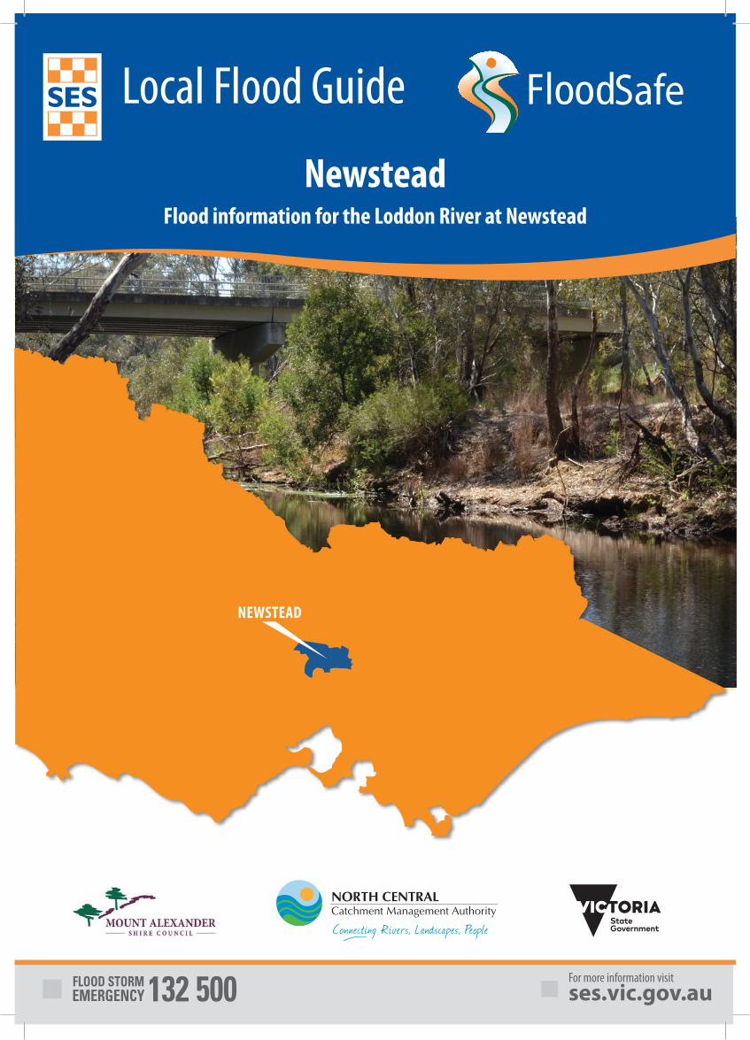
NEWSTEAD
NewsteadFlood information for the Loddon River at Newstead
Local Flood Guide2
New
stea
d Fl
ood
Info
rmat
ion
The township of Newstead is located in central Victoria about 15 kilometres west of Castlemaine and is part of the vibrant Mount Alexander Shire. Newstead is situated on the banks of the Loddon River, the second longest river in Victoria. Newstead is to the south east of the Cairn Curran Reservoir and Muckleford Creek branches off the Loddon River to the south east of the town.
There is a long history of flooding in Newstead. A levee bank was built in the early 1900’s which has stopped the town from flooding several times, but the floods of 2010-2011 saw a number of homes in the town inundated. The January 2011 flood event is believed to be the highest, or close to the highest, flood on record. Flooding caused damage to businesses, homes and sporting facilities, and caused significant distress and hardship to members of the community.
In September and October 2016, many areas of the Mount Alexander Shire were affected by wide spread riverine and flash flooding.
Roads were cut or impassable due to flooding in areas of Baringhup West, Elphinstone, Walmer, Guildford, Harcourt, Castlemaine, Taradale, Metcalfe and parts of the Pyrenees and Midland Highways. Extensive interruptions to school bus routes and cancellation of bus services affected many students and residents in the shire.
The impacts on the Loddon House Holiday Park in Baringhup, just downstream of the Cairn Curran Reservoir, resulted in eight caravans sustaining water damage and the evacuation of residents on 3 October 2016, as spills from Cairn Curran weir were increased due to continuing inflows.
It is important for residents to be aware of the potential for future flash flooding and plan for it.
Newstead can experience flash flooding from heavy rainfall occurring over a short period of time and riverine flooding from prolonged rainfall on the Loddon catchment.
A warning for flash flood is often limited by the available time for adequate and accurate predictions of the flood impact. It is always best to be prepared and understand your risk.
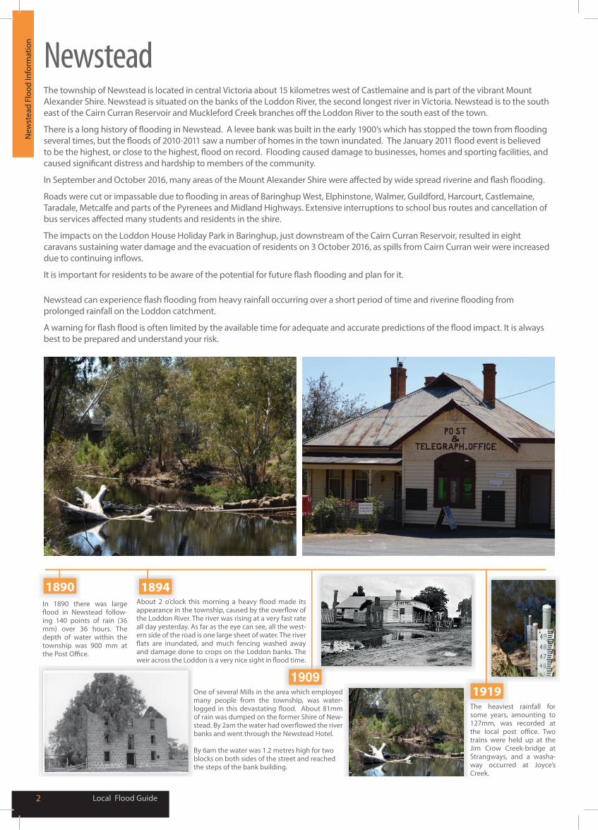
In 1890 there was large -
ing 140 points of rain (36 mm) over 36 hours. The depth of water within the township was 900 mm at
the Loddon River. The river was rising at a very fast rate all day yesterday. As far as the eye can see, all the west-ern side of the road is one large sheet of water. The river
and damage done to crops on the Loddon banks. The
One of several Mills in the area which employed many people from the township, was water-
of rain was dumped on the former Shire of New-
banks and went through the Newstead Hotel.
By 6am the water was 1.2 metres high for two blocks on both sides of the street and reached the steps of the bank building.
The heaviest rainfall for some years, amounting to 127mm, was recorded at
trains were held up at the Jim Crow Creek-bridge at Strangways, and a washa-way occurred at Joyce’s Creek.
1909
18941890
1919
Newstead
Local Flood Guide 3
Loca
l Flo
od In
form
atio
nYour Local Flood Information Know your risk
Are you at risk of flooding?
The Loddon River rises in the mountains between Daylesford and Kyneton and flows northwest passing through the townships of Guildford and Newstead before entering Cairn Curran Reservoir. It then flows in a northerly direction through Laanecoorie Reservoir, where the Tullaroop and Bet Bet creeks join the river above the dam.
A number of creek systems join the Loddon River upstream of Newstead. These include Campbells Creek, Jim Crow Creek, and the Muckleford Creek.
A Flood Watch or Warning for Newstead is predicted from a series of gauges located in the Loddon River catchment; Vaughan, Newstead, Yandoit on the Jim Crow Creek, and Muckleford on the Muckleford Creek. The warning times from rainfall to flooding will be affected by the volume of water, saturation levels within the soil and rivers, and the amount of time rain takes to fall.
Due to the locality of Newstead, the information provided in a Flood Watch or Warning may be very general in nature. Monitoring the catchment conditions and weather is very important to your plan in an emergency. The latest River Height Data can be accessed through bom.gov.au
Newstead can become isolated and subject to transport disruption at a time of flood, with the Midland Highway at Newstead likely to be cut by even a minor flood, depending on the flow of the river. Having an emergency plan in place is key to staying safe if you become isolated during a flood due to flood water or road damage.
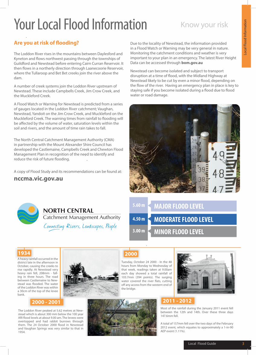
A heavy rainfall occurred in the district late in the afternoon in October, causing the creeks to rise rapidly. At Newstead very heavy rain fell, 208mm - fall-ing in three hours. The road between Castlemaine to New-
of the Loddon River was within a 30cm of the top of the levee bank.
The Loddon River peaked at 5.62 metres at New-stead which is about 300 mm below the 100 year
overtopped and had rabbit burrows through
and Vaughan Springs was very similar to that in 1954.
Tuesday, October 24 2000 - In the 48 hours from Monday to Wednesday of that week, readings taken at 9.00am each day showed a total rainfall of 103.7mm (394 points). The surging
the bridge.
Most of the rainfall during the January 2011 event fell between the 12th and 14th. Over these three days 147.6mm fell.
A total of 157mm fell over the two days of the February 2012 event, which equates to approximately a 1-in-90 AEP event (1.11%).
1934
2000 - 2001
2000
2011 - 2012
5.60 m
4.50 m
3.00 m
MAJOR FLOOD LEVEL
MODERATE FLOOD LEVEL
MINOR FLOOD LEVEL
The North Central Catchment Management Authority (CMA) in partnership with the Mount Alexander Shire Council has developed the Castlemaine, Campbells Creek and Chewton Flood Management Plan in recognition of the need to identify and reduce the risk of future flooding.
A copy of Flood Study and its recommendations can be found at:
nccma.vic.gov.au
Local Flood Guide4
Und
erst
andi
ng L
evee
s Understanding LeveesLeveesA flood levee is an embankment usually along-side a river or creek designed to reduce the risk of flooding.
Flood levees are built to reduce the risk of flooding to properties. They are not designed to protect people. If a levee is in danger of failing, people within areas at risk of being impacted by flooding may be advised to evacuate. It is important that you follow this advice.
Key facts about levees:
Levee FailuresNo levee is guaranteed flood proof and levees can and do fail. When a levee fails, floodwater will enter the previously protected area. It may be so fast that there is no time to evacuate. Levees can fail due to:
Overtopping - A levee is in danger of overtopping when the height of the floodwater is higher than the height the levee is designed for. Overtopping is one of the most common reasons for floodwater entering properties behind a levee. In April 1990 the town of Nyngan in NSW was inundated by floodwater when the levee was overtopped.
Breaching - A levee breaches when part of the levee fails, creating an opening that floodwater can get through. Breaches can be caused by a number of factors and can happen over a long period of time or very suddenly. In September 2010, properties in Wangaratta were evacuated when the town’s main levee was in danger of breaching.
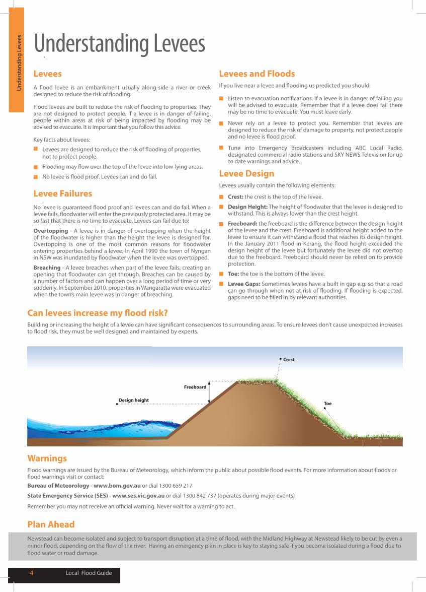
Levee DesignLevees usually contain the following elements:
Plan Ahead
Freeboard
Design height
Crest
Toe
Listen to evacuation notifications. If a levee is in danger of failing you will be advised to evacuate. Remember that if a levee does fail there may be no time to evacuate. You must leave early.
Never rely on a levee to protect you. Remember that levees are designed to reduce the risk of damage to property, not protect people and no levee is flood proof.
Tune into Emergency Broadcasters including ABC Local Radio, designated commercial radio stations and SKY NEWS Television for up to date warnings and advice.
Levees and FloodsIf you live near a levee and flooding us predicted you should:
WarningsFlood warnings are issued by the Bureau of Meteorology, which inform the public about possible flood events. For more information about floods or flood warnings visit or contact:
Can levees increase my flood risk?Building or increasing the height of a levee can have significant consequences to surrounding areas. To ensure levees don’t cause unexpected increases to flood risk, they must be well designed and maintained by experts.
Bureau of Meteorology - www.bom.gov.au or dial 1300 659 217
State Emergency Service (SES) - www.ses.vic.gov.au or dial 1300 842 737 (operates during major events)
Remember you may not receive an official warning. Never wait for a warning to act.
Levees are designed to reduce the risk of flooding of properties, not to protect people.
Flooding may flow over the top of the levee into low-lying areas.
No levee is flood proof. Levees can and do fail.
Crest: the crest is the top of the levee.
Design Height: The height of floodwater that the levee is designed to withstand. This is always lower than the crest height.
Freeboard: the freeboard is the difference between the design height of the levee and the crest. Freeboard is additional height added to the levee to ensure it can withstand a flood that reaches its design height. In the January 2011 flood in Kerang, the flood height exceeded the design height of the levee but fortunately the levee did not overtop due to the freeboard. Freeboard should never be relied on to provide protection.
Toe: the toe is the bottom of the levee.
Levee Gaps: Sometimes levees have a built in gap e.g. so that a road can go through when not at risk of flooding. If flooding is expected, gaps need to be filled in by relevant authorities.
Newstead can become isolated and subject to transport disruption at a time of flood, with the Midland Highway at Newstead likely to be cut by even a minor flood, depending on the flow of the river. Having an emergency plan in place is key to staying safe if you become isolated during a flood due to flood water or road damage.
Local Flood Guide 5
Abo
ut F
lood
War
ning
s
What warnings meanWarnings are issued by the Bureau of Meteorology (BoM) to tell people about possible flooding.
A Flood Watch means there is a developing weather pattern that might cause floods in one or two days.
A Flood Warning means flooding is about to happen or is already happening. There are minor, moderate and major flood warnings.
A Minor Flood Warning means floodwater can:
■ Reach the top of the river banks. ■ Come up through drains in nearby streets. ■ Cover low-lying areas including riverside camping areas. ■ Affect some low-lying caravan parks. ■ Cover minor roads, tracks and low level bridges. ■ Spread across land or go into buildings on some properties
and farms.
A Moderate Flood Warning means floodwater can:
■ Spill over river banks and spread across low-lying areas. ■ Start to threaten buildings, roads, rail, power and other
developments. ■ Require evacuation in some areas. ■ Cover main roads.
A Major Flood Warning means floodwater can:
■ Cause widespread flooding. ■ Threaten more houses and businesses. ■ Cause properties and whole areas to be isolated by water. ■ Disrupt major roads and transport routes. ■ Require many evacuations.
Victoria State Emergency Service (SES) will give information about how the floodwater might affect people and properties. This includes safety messages to remind you what to do during a flood.
Severe Thunderstorm Warnings Thunderstorms are classified as severe due to their potential to cause significant localised damage through wind gusts, large hail, tornadoes or flash flooding. Severe Thunderstorm Warnings are issued to the community by BoM.
Severe Weather Warnings These warnings are issued to the community by BoM when severe weather is expected that is not directly related to severe thunderstorms or bushfires. Examples of severe weather include damaging winds and flash flooding.
Flash flooding happens quickly. Newstead residents should listen out for warnings with flash flooding and remember that flash flooding:
■ Occurs so fast that it is difficult to provide a detailed warning. Often it arrives without warning.
■ Results from heavy rainfall during short severe storms.
About Flood Warnings
During flash flooding
When flash flooding is likely, if you decide to leave, do so well before flooding occurs. Leaving early before flooding occurs is always the safest option. You may decide to shelter with neighbours, family or friends in a safer area.
Evacuating through floodwater is very dangerous and you may be swept away. Never drive, ride or walk through floodwater.
If you do not leave early enough and become trapped by rising floodwater inside your home or business, stay inside your building and seek the highest part such as a second storey.
Stay there and call Triple Zero (000) if your emergency is life-threatening.
Remember, you may not receive any official warning.
Emergency assistance may not be immediately available. Be aware of what is happening around you to stay safe.
Never wait for a warning to act.
Emergency AlertSES may provide alerts to the Newstead community through the Emergency Alert telephone warning system. All emergency service providers can use Emergency Alert to warn communities about dangerous situations by voice message to landline telephones or text message to mobile phones.
If you receive a warning, make sure that all family members, people at work and your neighbours are aware of the situation.
If you receive an Emergency Alert you should pay attention and act. It could mean life or death.
If you need help to understand a warning, ask a friend, neighbour or family member.
Warnings for NewsteadThe Loddon River Flood Warnings are issued by the Bureau of Meteorology. Flood Warnings provide predictions of flood size (minor, moderate or major), time and possible peaks of the:
■ Loddon River BOM issues warnings for the Loddon River based on readings for gauge stations situated at the following locations:
■ Vaughan ■ Yandoit (Jim Crow Creek) ■ Muckleford (Muckleford Creek) ■ Newstead Township
It is important to know how the predicted flood levels are likely to impact you as you may be affected before the peak.
See page 3: Flood Levels for the Loddon River at Newstead.
Use this table to figure out when you need to start following your flood emergency plan.
Local Flood Guide6
Preparing for FloodsNow – before a flood
■ Check if your home or business is subject to flooding. For more information, contact Mount Alexander Shire.
■ Develop an emergency plan.
■ Check if you could be cut off by floodwater.
■ Know the safest way to go if you decide to leave your property and plan an alternative route.
■ Check your insurance policies to ensure your equipment, property and business are covered for flood damage.
■ Keep a list of emergency numbers near the telephone. ■ Put together an emergency kit.
■ Stay alert for weather warnings and heavy rainfall.
When a flood is likely ■ Take action. Follow your emergency plan.
■ Listen to your radio for information and advice.
■ Check your neighbours are safe and know about the flood.
■ Stack possessions on benches and tables with electrical goods in the highest places.
■ Anchor objects that are likely to float and cause damage.
■ Move rubbish bins, chemicals and poisons to the highest place.
■ Put important papers, valuables, photos and other special personal items into your emergency kit.
■ Business owners should raise stock, business records and equipment onto benches and tables.
■ Rural property owners should move livestock, pumps and machinery to higher ground.
■ If you are likely to be isolated, have enough food, drinking water, medicine, fuel and other needs to last at least three days.
■ Do not forget pet food and stock feed.
Your emergency planEmergencies can happen at any time, with little warning. People who have planned and prepared for emergencies have reduced the impact and recovered faster.
Taking the time to think about emergencies and make your own plan helps you think clearly and have more control to make better decisions when an emergency occurs.
Your emergency plan should identify:
■ The types of emergencies that might affect you.
■ How those emergencies might affect you.
■ What you will do before, during and after an emergency.
■ Where to get more information.
■ Where you will go if you evacuate and the best way to go in different circumstances.
■ A list of phone numbers you will need, including emergency services, your insurance company, friends and family.
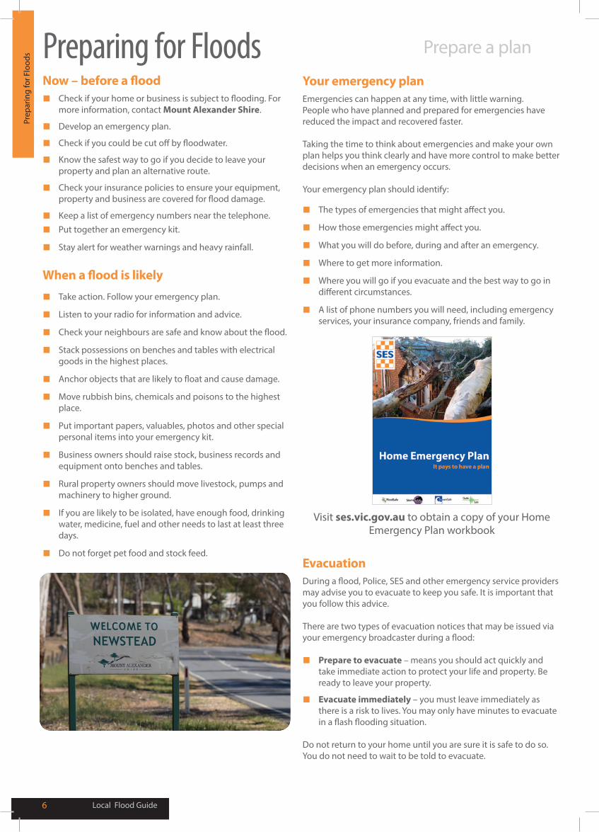
Visit ses.vic.gov.au to obtain a copy of your Home Emergency Plan workbook
EvacuationDuring a flood, Police, SES and other emergency service providers may advise you to evacuate to keep you safe. It is important that you follow this advice.
There are two types of evacuation notices that may be issued via your emergency broadcaster during a flood:
■ Prepare to evacuate – means you should act quickly and take immediate action to protect your life and property. Be ready to leave your property.
■ Evacuate immediately – you must leave immediately as there is a risk to lives. You may only have minutes to evacuate in a flash flooding situation.
Do not return to your home until you are sure it is safe to do so. You do not need to wait to be told to evacuate.
Prep
arin
g fo
r Flo
ods Prepare a plan
Local Flood Guide 7
Hom
e Em
erge
ncy
KitEmergency Kit
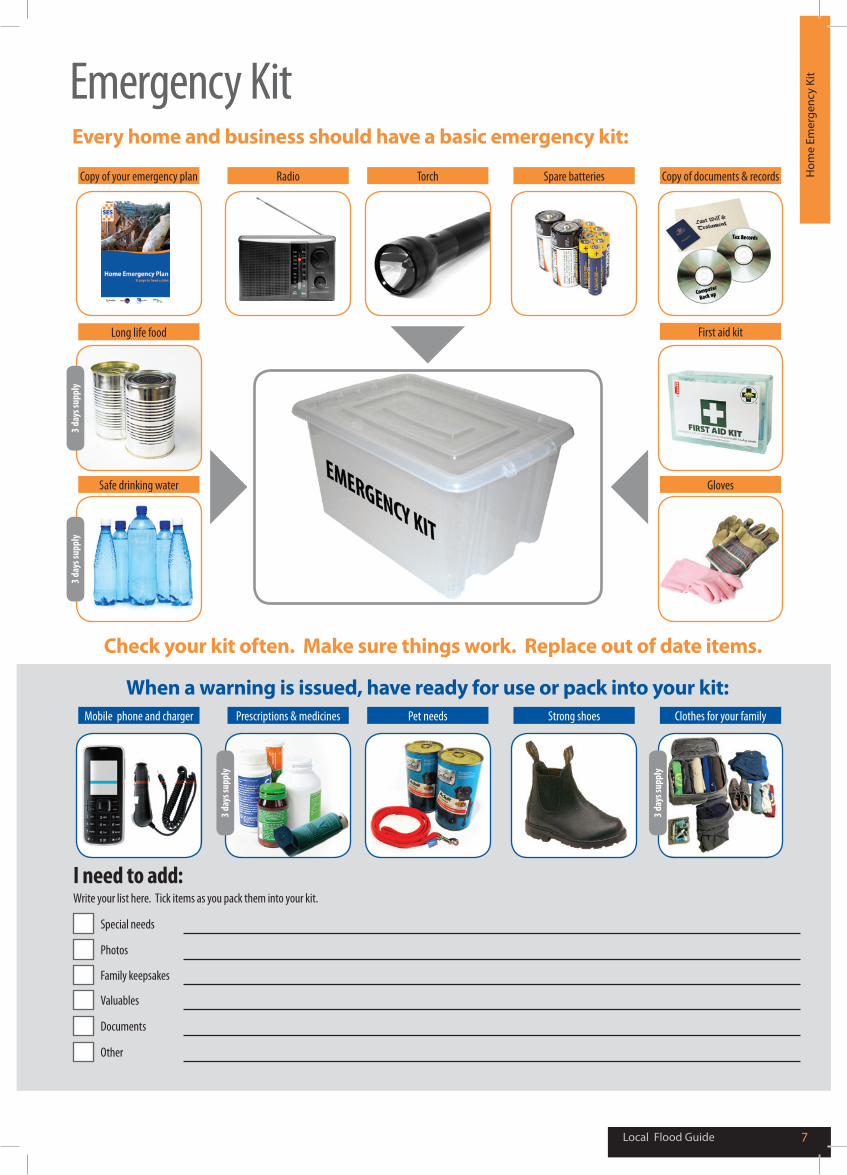
Every home and business should have a basic emergency kit:
Copy of your emergency plan
Long life food
Safe drinking water
Mobile phone and charger Prescriptions & medicines Pet needs Strong shoes Clothes for your family
Radio Torch Spare batteries Copy of documents & records
First aid kit
Gloves
When a warning is issued, have ready for use or pack into your kit:
Check your kit often. Make sure things work. Replace out of date items.
3 day
s sup
ply
3 day
s sup
ply
3 day
s sup
ply
3 day
s sup
ply
I need to add: Write your list here. Tick items as you pack them into your kit.
Special needs
Photos
Family keepsakes
Valuables
Documents
Other
Emergency ContactsEmergency ChecklistCh
eckl
ist a
nd C
onta
cts
Now: Flood preparation
Check if your insurance policies cover flooding.
Keep this list of emergency numbers near the telephone.
Put together an emergency kit and prepare a home or business emergency plan, see ses.vic.gov.au.
When you hear a Flood Watch or weather warning
Listen to Severe Weather Warnings for flash flood.
Listen to radio and check the SES website for more information and advice.
Go over your emergency plan. Pack clothing and other extra items into your emergency kit and take this with you if you evacuate.
Leave early if you intend to evacuate.
When flooding may happen soon (heavy rainfall)
Make sure your family members and neighbours are aware of what is happening.
Conditions change rapidly, roads and escape routes can be covered or blocked. Don’t forget to take pets and your medicine with you.
Put household valuables and electrical items as high as possible.
Turn off water, gas and electricity at the mains.
Secure objects likely to float and cause damage.
If you are staying in a caravan or temporary dwelling, move to higher ground BEFORE flooding begins.
During the flood
For SES emergency assistance, call 132 500.
DO NOT drive, ride, swim or walk through floodwater. This is the main cause of death during floods.
NEVER allow children to play in floodwater. This is the main cause of death during floods for children and young people.
Stay away from drains, culverts and waterways as water can flow quickly and have strong currents.
Stay well clear of fallen trees, powerlines and damaged buildings. If you are trapped inside a building, stay inside and shelter in the highest place. Call Triple Zero (000) in a life-threatening emergency.
After the flood: recovery
If your property has been flooded, check with Mount Alexander Shire for information and advice.
Have all electrical and gas equipment professionally tested before use.
Your electricity supplier:
Your gas supplier:
Doctor:
Complete the following and keep this information handy close to the phone:
Vet:
Insurance
Policy Number:
Phone Number:
For
the
late
st v
ersi
on o
f thi
s pu
blic
atio
n vi
sit s
es.v
ic.g
ov.a
u
Vers
ion
: EM
PC-L
FG-X
X.0
July
201
6
Emergency BroadcastersEmergency broadcasters include ABC Local Radio, designated commercial radio stations across Victoria and SKY NEWS Television.
This publication is supported by the National Disaster Resilience Grants Scheme.
ses.vic.gov.aufacebook.com/vicsestwitter.com/vicseswarningsmountalexander.vic.gov.au/Emergency_Management
For more information visit:
Mount Alexander Shire Contact Details
Phone: 03 5471 1700Email: [email protected]: mountalexander.vic.gov.au
Weather District: North Central
Catchment: North Central Catchment Management Authority
■ ABC Local 91.1 FM
■ TripleM Bendigo 93.5 FM
■ KLFM 96.5 FM
■ SKY NEWS Television
■ Gold 1071 AM
■ Gold 98.3 FM
■ Hit 91.9 FM
■ Phoenix 106.7 FM
Life-threatening emergency Police Fire Ambulance
Triple Zero TTY106
Victoria State Emergency Service (SES) For SES emergency assistance 132 500
VicEmergency Hotline 1800 226 226
VicRoads Road closures and hazard reporting service
13 11 70vicroads.vic.gov.au
Bureau of Meteorology (BoM)Weather information, forecasts, warnings
1300 659 217 bom.gov.au
Internet Relay users log into iprelay.com.au/call/ then enter: 132 500 or 000
National Relay Service (NRS) relayservice.gov.au
The deaf, hearing or speech impaired can call SES or Triple Zero (000) using NRS:
■ Speak and Listen (SSR) users phone
■ TTY / Voice users phone
1300 555 727
13 36 77
DIAL THEN ASK FOR
132 500
132 500
000
VicEmergency Victorian emergency warnings
emergency.vic.gov.au