location: phase 2, dollis valley estate, barnet, herts,...
TRANSCRIPT

LOCATION:
Phase 2, Dollis Valley Estate, Barnet, Herts, EN5
REFERENCE: B/02349/14 Received: 02 May 2014 Accepted: 16 May 2014 WARD(S): Underhill
Expiry: 15 August 2014
Final Revisions: APPLICANT:
Countryside Properties (UK) Limited
PROPOSAL: Reserved matters application seeking approval of landscaping, appearance, scale, access and layout for Phase 2 of the Dollis Valley Estate Redevelopment pursuant to Condition 7 of the Hybrid planning permission reference B/00354/13 dated 01/10/2013 involving the erection of 163 residential dwellings (Use Class C3) comprising 84 houses and 79 apartments including associated infrastructure, new site access off Mays Lane at the existing Dollis Valley Drive/ Way junction, new public open space, car parking and landscaping, together with details to discharge the requirements of the following conditions: 6 (Phasing and Implementation); 16 (Car Parking) 23 (Refuse and Recycling) 35 (Stopping Up of Highways); 37 (Levels); 39 (Children’s Play Space); 40 (Tree Protective Fencing); 48 (Archaeology); 49 (Contaminated Land Method Statement); 51 (Ventilation and Extraction Details); 53 (Sound Insulation); 89 (Daylight, Sunlight, Overshadowing Assessment)

RECOMMENDATION: APPROVE SUBJECT TO CONDITIONS
1. Approved Plans
The development hereby permitted shall be carried out in accordance with the following plans:
Drawing Title Drawing Number
Location Plan 2376_A_101
Reserved Matters Application Boundary 2376_A_102
Topography 2376_A_103
Demolition 2376_A_104
Masterplan 2376_A_121 Rev D
Levels Plan 2376_A_122 Rev E
Master Plan – Parking 2376_A_123 Rev A
Master Plan – Tenure Mix 2376_A_124 Rev A
Ground Floor Plan 2376_A_125 Rev A
Roof Plan 2376_A_126 Rev A
Site Sections A-A1 & B-B1 2376_A_130 Rev B
Site Sections A-A2 & B-B2 2376_A_131 Rev B
Site Sections C-C1, C-C2, D-D1& E-E1 2376_A_132 Rev B
Site Sections E-E2 & F-F1 2376_A_133
Site Sections G-G1 & G-G2 2376_A_134 Rev B
Site Sections H-H1, J-J1, O-O1 & U-U1 2376_A_135 Rev B
Site Sections K-K1, L-L1, M-M1 & N-N1 2376_A_136
Site Sections P-P1, Q-Q1, R-R1, S-S1, T-T1 & V-V1
2376_A_137 Rev B
Phase 2 Tree Protection Plan 2376_A_153 Rev B
Tree Protection Plan – Demolition TPP-01 Rev 2
Tree Protection Plan – Construction Works TPP-02 Rev 2
Arboricultural Report and Method Statement for works adjacent to Oak T77 only
Ruskins ref: 0412-1489 Rev 2
Clarification of Proposals for Works Around Retained Oak Tree T77
DOL-102-AR-9880 03.07.2014
DV1b Terraced House 2376_A_200
DV1c Terraced House 2376_A_201
DV1d Terraced House 2376_A_202
DV7 Townhouse Plans 2376_A_203
DV7 Townhouse Elevations & Sections 2376_A_204
DV11a Townhouse 2376_A_205
DV11b Townhouse 2376_A_206
DV13b Townhouse 2376_A_207
DV14 Townhouse 2376_A_208 Rev A
DV15 Townhouse Plans 2376_A_209
DV15 Townhouse Elevations & Sections 2376_A_210 Rev A
Block 2 Site Plan 2376_A_220 Rev B

Block 2 Ground Floor Plan 2376_A_221 Rev A
Block 2 First Floor Plan 2376_A_222 Rev B
Block 2 Second Floor Plan 2376_A_223
Block 2 Third Floor Plan 2376_A_224
Block 2 Roof Plan 2376_A_225
Block 2 East and South Elevations 2376_A_226 Rev A
Block 2 West Elevation and Section 2376_A_227 Rev B
Block 2 North Elevation 2376_A_228 Rev A
Block 3 & 5 Site Plan 2376_A_230 Rev A
Block 3 & 5 East and West Elevations 2376_A_231 Rev B
Block 3 Ground Floor Plan 2376_A_232 Rev A
Block 3 First and Second Floor Plan 2376_A_233 Rev A
Block 3 Third Floor and Roof Plans 2376_A_234 Rev A
Block 3 Sections 2376_A_235 Rev A
Block 3 North and South Elevations 2376_A_236 Rev A
Block 3 East and West Elevations 2376_A_237 Rev A
Block 5 Ground Floor Plan 2376_A_250 Rev B
Block 5 First and Second Floor Plans 2376_A_251 Rev A
Block 5 Third Floor and Roof Plans 2376_A_252 Rev A
Block 5 Sections 2376_A_253 Rev B
Block 5 North and South Elevations 2376_A_254 Rev B
Block 5 East and West Elevations 2376_A_255 Rev B
Block 5 North and South Short Elevations 2376_A_256 Rev B
Design and Access Statement Section 3.4 – Phasing and Implementation Strategy (Condition 6)
Areas of Existing Public Highway Subject to Stopping Up (Condition 35)
11274/SK/03 P2
West Square Landscape Proposals (Children’s Playspace Condition 39)
2376_A_154 Rev B
East Square Proposals (Children’s Playspace Condition 39)
2376_A_155 Rev A
Block 2 Courtyard Garden 2376_A_156
Heritage Statement Planning Statement Appendix 2
Contaminated Land Method Statement Ground Conditions Report, Planning Statement Appendix 3
Extraction and Ventilation Equipment – Residential extracting fan Fusion HRV95 details
Planning Statement Appendix 4
External Façade Sound Insulation Report WSP dated 15/04/2014
Daylight and Sunlight assessment and overshadowing assessment
PRP ref: AE 3433C(V2)
Addendum Letter to Daylight and Sunlight Report dated 17 July 2014 (PRP)

Unit Type Landscape Proposals 1 of 3 2376_A_157
Unit Type Landscape Proposals 2 of 3 2376_A_158
Unit Type Landscape Proposals 3 of 3 2376_A_159
Reason: For the avoidance of doubt and in the interests of proper planning and so as to ensure that the development is carried out fully in accordance with the plans as assessed in accordance with policies CS1, CS4, CS5, DM01 and DM02 of the Barnet Local Plan and policy 1.1 of the London Plan.
2. Commencement
The development hereby approved shall be begun within 3 years of the date of this permission. Reason: To comply with Section 91 of the Town and Country Planning Act 1990 as amended by Section 51 of the Planning and Compulsory Purchase Act, 2004.
3. Block 2 Windows
Before apartments 248 and 250 in block 2 are occupied, windows in the north end elevation of the block serving these units and facing plots 253 and 254, shall be glazed with obscure glass only and shall be permanently retained as such thereafter and shall be permanently fixed shut with only a fanlight opening. Reason: To safeguard the privacy and amenities of occupiers of adjoining residential properties in accordance with policy DM01 of the Adopted Barnet Development Management Policies DPD (2012).
4. Block 2 Balcony Openings
Before the relevant units within block 2 are occupied, the north facing balcony openings serving units 248 and 250 facing plots 253 and 254 shall be screened in accordance with the details as shown on plan 2376_A_228 rev. A and shall be permanently retained as such thereafter. Reason: To safeguard the privacy and amenities of occupiers of adjoining residential properties in accordance with policy DM01 of the Adopted Barnet Development Management Policies DPD (2012).
5. Block 2 Windows
Before apartment 234 (Block 2) is occupied, windows in the north elevation serving this unit facing towards the rear garden of 83 Mays Lane shall be glazed with obscure glass only and shall be permanently retained as such thereafter and shall be permanently fixed shut with only a fanlight opening.

Reason: To safeguard the privacy and amenities of occupiers of adjoining residential properties in accordance with policy DM01 of the Adopted Barnet Development Management Policies DPD (2012).
6. Windows to Bin Stores
Before apartment blocks 2, 3 and 5 are occupied, windows serving internal bin stores shall be fitted with obscure glass and shall be permanently fixed shut and retained as such thereafter. Reason: To safeguard the appearance of the blocks in accordance with policies DM01 of the Adopted Barnet Development Management Policies DPD (2012) and CS5 of the Adopted Barnet Core Strategy DPD (2012).
7. DV7 Privacy Measures
Before the DV7 dwellings hereby approved at plots 203-209 are occupied privacy screens to the first floor rear facing balconies should be erected comprising a solid screen of a minimum height of 1.5m. These shall be permanently maintained thereafter. Reason: To safeguard the privacy and amenities of occupiers of adjoining residential properties in accordance with policy DM01 of the Adopted Barnet Development Management Policies DPD (2012).
8. Restriction of Permitted Development Rights – Extensions
Notwithstanding the provisions of any development order made under Section 59 of the Town and Country Planning Act 1980 (or any Order revoking and re-enacting that Order) the building(s) hereby permitted shall not be extended in any manner whatsoever. Reason: To ensure that the development does not prejudice the character of the locality and the enjoyment by existing and/or neighbouring occupiers of their properties in accordance with policy DM01 of the Adopted Barnet Development Management Policies DPD (2012) and CS5 and CS7 of the Adopted Barnet Core Strategy DPD (2012).
9. Restriction of Additional Windows and Doors
Notwithstanding the provisions of any development order made under Section 59 of the Town and Country Planning Act 1990 (or any Order revoking and re-enacting that Order) no additional windows or doors shall be inserted into any of the residential dwellings hereby approved, other than those expressly authorised by this permission. Reason: To safeguard the privacy and amenities of occupiers of adjoining residential properties and to safeguard the character of the locality in accordance with

policy DM01 of the Adopted Barnet Development Management Policies DPD (2012) and CS5 and CS7 of the Adopted Barnet Core Strategy DPD (2012).
10. Restrictions of Permitted Development – Telecommunication
Notwithstanding the provisions of any development order made under Section 59 of the Town and Country Planning Act 1990 (or any Order revoking and re-enacting that Order) no installation of any structures or apparatus for purposes relating to telecommunications shall be installed on any part the roof of the building(s) hereby approved, including any structures or development otherwise permitted under Part 24 and Part 25 of Schedule 2 of the Town and Country Planning (General Permitted Development) Order 1995 (as amended) or any equivalent Order revoking and re-enacting that Order. Reason: To ensure that the development does not impact adversely on the townscape and character of the area and to ensure the Local Planning Authority can control the development in the area so that it accords with policy DM01 and DM18 of the Adopted Barnet Development Management Policies DPD (2012).
11. Telecommunications Equipment
Prior to commencement of the development hereby permitted, a scheme for the provision of communal/centralised satellite and television reception equipment to be installed on the roof of all apartment blocks hereby permitted shall be submitted to, and approved in writing by, the Local Planning Authority. The development shall be implemented in accordance with the details approved and the equipment shall thereafter be retained and made available for use by all occupiers of the development.
Reason: To ensure that the development makes appropriate provision for such equipment, so as to not impact adversely on the townscape and character of the area, so that it accords with policies CS5 and DM01 Barnet Local Plan.
12. Architectural Details
Prior to the commencement of the development hereby approved, details of architectural features within this phase shall be submitted at the appropriate scale (1:10/ 1:20) to the Local Planning Authority and agreed in writing. These details shall be in general accordance with the principles outlined at page 48 of the Reserved Matters Design and Access Statement section 9.2 Materials and Details – Apartment Blocks (as amended and received 17/07/2014). These details should include (but are not limited to): - Balconies and balustrades (including soffit details) - Roof parapets - Entrances to apartment blocks - Apartment block building splays - Porches - Window reveals - Shadow gap along DV1 typology party walls - Dormer Windows

- Location and design of rainwater goods - Brick detailing on the east elevation of block 2 to car park The development shall be carried out in accordance with the approved details. Reason: To safeguard the character and visual amenities of the site and wider area and to ensure that the building is constructed in accordance with policies CS5 and DM01 of the Barnet Local Plan and policies 1.1, 7.4, 7.5 and 7.6 of the London Plan.
13. Provision of kerb build outs and street planting The 2no. kerb build outs and associated tree planting on the south side of the east west street as shown on plan 2807/SK/037C shall be installed in accordance with plan 2376_A_121 Rev D (Master Plan) hereby approved within 3 months of the completion of this east west street within Phase 3 of the Dollis Valley regeneration as identified on phasing plan 2346_A_111 dated 25.01.2013 (as approved under the Hybrid Planning Consent reference B/00354/13) and shown within Section 3.4 of the Phase 2 Design and Access Statement. The kerb build outs and landscaping shall be maintained thereafter. Reason: In order to allow clear passage for refuse collection vehicles along the east west street which will only partially be delivered in Phase 2, the kerb build outs and associated tree planting shall not be implemented for a temporary period. This condition is to ensure that the kerb build outs shall be installed and trees planted in full accordance with the approved details at such time as the east west street is completed in Phase 3 of the development at which point refuse vehicles will be able to traverse the full length of the street without needing to turn around.
14. Children’s Play Space
The play space and associated equipment shall be carried out in accordance with the details shown on plans 2376_A_154 Rev B, 2376_A_155 Rev A and 2376_A_156 and permanently maintained thereafter. Reason: To ensure a satisfactory appearance to the development and ensure suitable facilities for play are provided in accordance with policies DM01 and DM02 of the Barnet Local Plan and policy 3.6 of the London Plan.
15. Landscaping
The details required to be submitted under condition 38 (Hard and Soft Landscaping) of the Hybrid Planning Permission B/00354/13 in relation to this phase shall be in general accordance with the principles outlined in Section 12.7 Streetscape Character (page 102 amended 21/07/2014) of the Phase 2 Design and Access Statement and the indicative planting strategy illustrated on drawing SK-140716-01 dated 16.07.2014.

Reason: To ensure a satisfactory appearance to the development and protect the amenities of the area in accordance with policies DM01 and DM02 of the Barnet Local Plan and policies 3.6 and 7.21 of the London Plan.
INFORMATIVE(S):
1. In accordance with paragraphs 186 and 187 of the NPPF, the Council takes a positive and proactive approach to development proposals, focused on solutions. The Local Planning Authority has produced planning policies and written guidance to guide applicants when submitting applications. These are all available on the Council’s website. A pre-application advice service is also offered. The Local Planning Authority has negotiated with the applicant / agent where necessary during the application process to ensure that the proposed development is in accordance with the Council’s relevant policies and guidance. In this case, formal pre-application advice was sought prior to submission of the application.
2. Refuse collection point should be located at a ground floor level and within 10m of the refuse vehicle parking bay. Levelled access should be provided for the refuse collection personnel to collect the bins. The refuse collection personnel are not expected to push the bins on an inclined surface to safeguard their Health and Safety requirements. Alternatively, the dustbins will need to be brought to the edge of the refuse vehicle parking bay on day of collection.
3. The applicant is advised that Mays Lane Barnet is Traffic Sensitive Road;
deliveries during the construction period should not take place between 7.30am-10am & 4pm-7pm Mon-Fri. Careful consideration must also be given to the optimum route(s) for construction traffic and the Development and Regulatory Services should be consulted in this respect.
4. The costs of any associated works on the public highway, including reinstatement works, will be borne by the applicants and will require the Applicant to enter into a rechargeable agreement or a 278 Agreement under the Highways Act 1980.
SUMMARY OF PROPOSAL The Dollis Valley Estate is designated as one of the Council’s Priority Housing Estates for Regeneration in its Local Plan (Core Strategy) Development Plan Document (2012). It forms part of the Barnet’s Place Shaping Strategy, the Three Strands Approach ‘Protection, Enhancement and Growth’ which seeks to guide regeneration in the Borough. There is a recognised need for physical improvements to the Estate in order to tackle the poor quality built environment and the current isolation of the estate from the

surrounding area as well as its ability to deliver new housing and create a new revived neighbourhood. The redevelopment of the Estate (along with other similar housing estates within the Borough) has been a longstanding priority for the Council for many years. In 2011, following a competitive dialogue process, Countryside Properties (CP) and London and Quadrant Housing Trust (L&Q) were selected as Barnet Council’s preferred development partner for the regeneration of the Dollis Valley Estate. A hybrid planning application was granted in October 2013 under planning application B/00354/13 for the redevelopment of the Dollis Valley Estate to accommodate up to 631 residential units, replacement community space, new open space and infrastructure. The application was submitted in a part outline/ part detailed form (referred to as a ‘hybrid’ application), with detailed consent being sought for Phase 1 of the development comprising of 108 residential units the new community space and associated café and nursery and associated public open space, road network and parking and outline consent for phases 2-5 comprising the balance of 523 units and associated road network, open space provision and parking. The outline element of the hybrid planning permission approved a masterplan for the development which established the siting of the new buildings and the points of access and road layout. The scale of the buildings, external appearance and landscaping were ‘reserved’ for future consideration (the Reserved Matters). Phase 1 of the regeneration is now under construction with the first units expected to be handed over in March 2015. In order to maintain momentum of the regeneration, Countryside Properties and London and Quadrant Housing Trust have submitted a reserved matters application for Phase 2 of the regeneration which seeks approval for the scale and external appearance of buildings and landscaping for the phase. Phase 2 is the largest of the five construction phases planned for the site with the development providing 163 dwellings comprising of 84 houses and 79 apartments. Of the 163 units, 95 will be for private sale, 63 for affordable rent and 5 intermediate, representing an affordable housing provision of 42%. In addition to the proposed housing, two out of the three public squares proposed under the outline consent will be located with Phase 2, along with associated children’s play equipment and landscaping. Reserved matters applications for the remaining phases of the development (3-5) will come forward at a later date. The reserved matters of detailed design, appearance and landscaping have been assessed and it is considered that the proposals will deliver high quality, sustainable, residential accommodation. The vision of the development to create a contemporary Arts and Crafts garden suburb is carried forward in the detailed design of the houses and flats whilst the scale and form of the buildings respect the surrounding residential context. The use of high quality brick throughout these zones will provide a robust material as well as continuity across the overall masterplan. The overall

layout and design of the buildings and landscape is considered to create a high quality residential environment and enhanced public realm. The detailed design proposed for Phase 2 includes a number of adjustments in relation to the approved parameters of the masterplan. This primarily consists of minor alterations to the scale, layout and dimensions of the proposed houses and apartment blocks contained within the scheme. The main points of access and street layout remain unchanged. The proposed changes and adjustments to the detailed design of Phase 2 are not considered to be a significant departure from the approved parameters established by the hybrid consent under reference B/00354/13 and result in a high quality design. The proposals provide appropriate level of car parking and landscaping in accordance with the requirements of the hybrid consent. This application is the first reserved matters application submitted pursuant to the hybrid approval and is found to be acceptable when assessed against the parameters of the hybrid consent and relevant development plan policies. This reserved matters application will allow the next phase of the regeneration of the Dollis Valley Estate to be delivered and will contribute to the objective of creating a new, mixed and balanced community comprising new private sale homes as well as affordable housing that will bring social, economic and environmental benefits to the surrounding area.

1. MATERIAL CONSIDERATIONS 1.1 Key Relevant Planning Policy National Planning Policy Guidance / Statements: The National Planning Policy Framework (NPPF) National planning policies are set out in the National Planning Policy Framework (NPPF). This 65 page document was published in March 2012 and it replaces 44 documents, including Planning Policy Guidance Notes, Planning Policy Statements and a range of other national planning guidance. The NPPF is a key part of reforms to make the planning system less complex and more accessible. The NPPF states that the purpose of the planning system is to contribute to the achievement of sustainable development. The document includes a ‘presumption in favour of sustainable development’. This is taken to mean approving applications, such as this proposal, which are considered to accord with the development plan. The Mayor's London Plan: July 2011 The replacement London Plan was adopted on 22nd July 2011 and provides the strategic planning guidance and policies for the capital. It promotes sustainable growth and environmentally responsive development. Relevant London Plan Policies: 2.13 (Opportunity Areas and Intensification Areas), 3.3 (Increasing Housing Supply), 3.4 (Optimising housing potential), 3.5 (Quality and design of housing developments), 3.6 (Children and Young People’s Play and Informal Recreation Facilities), 3.7 (Large Residential Development), 3.8 (Housing Choice), 3.9 (Mixed and balanced communities), 3.12 (Negotiating affordable housing on individual private residential and mixed use schemes), 5.2 (Minimising carbon dioxide emissions), 5.3 (Sustainable design and construction), 5.7 (Renewable energy), 5.11 (Green roofs and development site environs), 5.12 (Flood risk management), 5.13 (Sustainable drainage), 5.14 (Water quality and wastewater infrastructure), 5.21 (Contaminated land), 6.3 (Assessing effects of development on transport capacity), 6.9 (Cycling), 6.10 (Walking), 6.13 (Parking), 7.1 (Building London’s neighbourhoods and communities), 7.2 (An inclusive environment), 7.3 (Designing out crime), 7.4 (Local character), 7.5 (Public Realm), 7.6 (Architecture), 7.8 (Heritage Assets and Archaeology), 7.15 (Reducing noise and enhancing soundscapes), 7.19 (Biodiversity and Access to Nature), 7.21 (Trees and Woodlands). Barnet Core Strategy (Adopted 2012) The Planning & Compulsory Purchase Act 2004 reformed the development plan system replacing the Unitary Development Plan (UDP) with the Local Development Framework (LDF). The LDF will be made up of a suite of documents including the Core Strategy and Development Management Policies DPD.

The Core Strategy will contribute to achieving the vision and objectives of Barnet’s Sustainable Community Strategy and will help our partners and other organisations to deliver relevant parts of their programmes. It will cover the physical aspects of location and land use traditionally covered by planning. It also addresses other factors that make places attractive and distinctive as well as sustainable and successful. Relevant Core Strategy Policies: CS NPPF (National Planning Policy Framework – Presumption in Favour of Sustainable Development), CS4 (Providing Quality Homes and Housing Choice in Barnet), CS5 (Protecting and Enhancing Barnet’s Character to Create High Quality Places), CS7 (Enhancing and Protecting Barnet’s Open Spaces), CS9 (Providing safe, effective and efficient travel), CS12 (Making Barnet a Safer Place), CS13 (Ensuring the Efficient Use of Natural Resources), CS14 (Dealing with Waste). Development Management Plan (Adopted 2012) The Development Management Policies document provides the borough wide planning policies that implement the Core Strategy. These policies will be used for day-to-day decision making. Relevant Development Management DPD Policies: DM01 (Protecting Barnet’s Character and Amenity), DM02 (Development Standards), DM03 (Accessibility and Inclusive Design), DM04 (Environmental Considerations), DM06 (Barnet’s Heritage and Conservation), DM08 (Ensuring a variety of sizes of new homes to meet housing Need), DM16 (Biodiversity), DM17 (Travel Impact and Parking Standards). 1.2 Relevant Planning History
Application Reference:
B/00354/13
Case Officer: Josleen Chug
Proposal: Hybrid planning application for the redevelopment of Dollis Valley Estate to accommodate up to 631 residential units, replacement community space, new open space and infrastructure comprising: Outline permission for the demolition of existing buildings and the construction of up to 523 new residential units, together with new public open spaces, junction improvements to existing access onto Mays Lane, enhanced pedestrian, cycle and public transport facilities, car parking, infrastructure and other ancillary works. Detailed element (Phase 1) for the demolition of existing buildings (including the former Barnet Hill School, 131-135 Mays Lane and Barnet South Community Association Hall) and construction of 108 new residential units and 417sqm of non-residential (class D1 use) floorspace (new community centre and

nursery space), together with new public open space, creation of new vehicular access from Mays Lane and new car parking, bike storage, infrastructure and other ancillary works. Submission of Environmental Statement
Stat Start Date 08/02/2013
Application Type Hybrid Application
Decision Granted
Decision Date 01/10/2013
1.3 Pre-Application Public Consultation The applicant has submitted a Statement of Community Involvement (SCI) with the application. The submitted document outlines the community and stakeholder consultation activities that have taken place between February 2013 and March 2014. The following activities have been undertaken in relation to the Phase 2 development:
• Newsletters, in the period February 2013 to April 2014 3 newsletters have been delivered, to residents on the estate and the surrounding area;
• A website has been set up and maintained to enable the sharing of information;
• Exhibitions and open days held for all stakeholders;
• Onsite surgeries held;
• Consultation and engagement team set up;
• Communication channels set up;
• Art project for young people held to design site hoardings;
• Two Public Exhibitions were held on Saturday 8th February and Wednesday 12th February 2014;
Public Exhibition Two Public Exhibitions were held on Saturday 8th February between 10:00 and 13:30 (attendance 80 people) and Wednesday 12th February 2014 between 14:00 and 20:00 (attendance 75 people). The exhibitions were advertised one month prior to the event with letters being delivered to all properties within the Estate. The exhibitions were held at the Valley Centre, Dollis Valley Drive. The exhibitions provided a series of displays illustrating the details of the proposed development and representatives from Countryside Properties were present to take any questions and to take feedback. A signing in book and feedback forms were also provided.

Feedback was generally positive and supportive of the design of the scheme, however detailed comments were raised concerning detailed design aspects of the scheme in relation to their individual circumstances, relationship of proposal to existing properties on Mays Lane, management of open spaces traffic issues and construction disturbance. Changes as a Result of Feedback As a result of pre-application feedback Countryside made a number of minor changes to the scheme, reducing the height and repositioning a property facing Mays Lane, retaining an access path to the rear garden of 63 Mays Lane and amended the design of some of the houses by introducing a new house type and reduction in balconies. 1.4 Consultations and Views Expressed Public Consultation Neighbours Consulted: 1110 Replies: 3 Neighbours Wishing To Speak 1 The following is a summary of the comments received grouped by topic:
• Increase in traffic using Mays Lane, parking restrictions should be put into place at the bottom of Hillside Gardens and at the top of Mays Lane where it joins Barnet Hill.
Officer Comment The traffic impact of the development was assessed during the consideration of the hybrid application (B/00354/13). The S106 Schedule D paragraph 3, contains a parking review mechanism, allowing for the impact of the development on parking demand on surrounding roads to be assessed. The review will include Mays Lane and Hillside Gardens.
• Increase in through traffic passing through Hardy and Hammond Close which were previously cul de sacs and are now through roads.
Officer Comment The internal site layout including the road network was established under the hybrid consent. The principle of connecting Hammond Close and Hardy Close into the wider development has therefore been established and considered acceptable. The road layout will not be altered by the current reserved matters application.
• Level of Parking Provision for the development is inadequate and will result in spill over parking on surrounding roads.

Officer Comment The level of car parking provision is considered acceptable by Council Highway Officers and accords with the parameters of the outline consent and TFL guidelines.
• Concerns expressed by a future resident regarding flooding, the build quality of the proposed development, levels of soundproofing and sunlight, condensation and proximity to families with children.
Officer Comment Issues regarding the build quality of the development, condensation and sound proofing between floors are matters which are covered by building regulation legislation. The application is accompanied by a daylight and sunlight assessment which concludes that all habitable rooms will receive adequate levels of daylight, the site has been assessed as at low risk of flooding. The Environment Agency were consulted on the Hybrid Application and found the scheme to be acceptable. Drainage details are dealt with under Condition 47. The housing of tenants and whether tenants without children are placed next to tenants with children is a matter for is a matter for London and Quadrant Housing Trust.
Dollis Valley Partnership Board A letter of support has been submitted by the Dollis Valley Partnership Board that represents residents and leaseholders on the estate. The letter is addressed to the Chairman of the Planning Committee and states the following:
I am writing in my capacity as Chair of the Dollis Valley Partnership
Board to express the Board’s support for the Dollis Valley Phase 2
Reserved Matters Planning Application submitted by Countryside.
As set out in its Constitution the Dollis Valley Partnership Board
“is the formal resident involvement structure between the residents
of Dollis Valley Estate, the Regeneration Partnership of L&Q and
Countryside, Barnet Homes and the London Borough of Barnet in
relation to the Regeneration of the Dollis Valley Estate”.
On 17th June 2013 your Committee approved the Masterplan and Phase 1
proposals for the regeneration of Dollis Valley including the
provision new homes for existing secure tenants and leaseholders and
new community facilities. The masterplan and the latest application
have been subject to extensive consultation with the residents of
Dollis Valley and its neighbours and enjoy overwhelming support.
The work on the Phase 1 is now well underway, providing the first of
the much needed new homes, a new nursery and a new community centre.

The application before you this evening continues and builds on this
and we would urge you to approve it.
Internal /external and Other Consultations:
Environmental Health Details submitted regarding sound insulation and extraction/ ventilation are considered acceptable. The content of the contaminated land survey is considered satisfactory, however the use of a geotextile membrane on private residential gardens may be required in addition to the proposed topsoil and subsoil recommendations depending on validation results. Highways No Objection in principle raised to the proposal subject to appropriate conditions. Detailed comments are incorporated in the Highway Section of the report below. Trees and Landscape No objection in principle to proposal subject to confirmation of levels. Transport for London Concerns expressed regarding swept path analysis and ability of buses to navigate the corners. Concerns also expressed regarding the limited width of the road and the private nature of the east west road which will form the future temporary bus route which could affect the enforcement of parking restrictions. Concern also expressed regarding layout of parking including tandem parking provision necessitating reversing movements into the highway to the detriment of highway safety. Officer Comment The applicant has withdrawn conditions 33 (Bus Swept Paths) and 34 (Temporary Bus Route) from consideration under this reserved matters application to allow discussions with TFL to continue. Revised information will be submitted for the discharge of conditions 33 and 34 and TFL will be consulted at that time. Highways Agency No Objection to Proposals. National Grid Advise that gas pipes and associated equipment are located in proximity to the proposed development and any development will need to not infringe National Grid’s legal rights a (i.e. easements or wayleaves) and follow HSE guidance on safe working. Officer Comment The developer is aware of gas easements running through the site and the layout of the development has been designed with this in mind and buildings have been located to avoid them.

Thames Water No Objections in relation to waste water. Insufficient information submitted in relation to surface water run off. Officer Comment The applicant has withdrawn the drainage information relating to condition 47. Revised information will be submitted for discharge of condition 47 and Thames Water will be consulted at that time. Metropolitan Police No Objections to the proposal as submitted. London Fire Brigade No Objections raised. English Heritage (Archaeology) Recommend Condition 48 (Archaeology) is discharged. Natural England No Objections raised.

2. DESCRIPTION OF THE SITE, SURROUNDINGS AND PROPOSAL 2.1 Background to Application The Dollis Valley Estate is designated as one of the Council’s Priority Housing Estates for Regeneration in its Local Plan (Core Strategy) Development Plan Document (2012). It forms part of the Barnet’s Place Shaping Strategy, the Three Strands Approach ‘Protection, Enhancement and Growth’ which seeks to guide regeneration in the Borough. There is a recognised need for physical improvements to the Estate in order to tackle the poor quality built environment and the current isolation of the estate from the surrounding area as well as its ability to deliver new housing and create a new revived neighbourhood. The redevelopment of the Estate (along with other similar housing estates within the Borough) has been a longstanding priority for the Council for many years. A development partner (Warden Housing Association) was selected in 2003 to deliver the regeneration of the site involving redevelopment to provide new homes (affordable rented, shared ownership and private sale) together with new community facilities and the rebuild and expansion of the Barnet Hill primary school. The Council published a Vision Statement in 2005 which outlined the key issues that the Estate faced determined through consultation with relevant stakeholders and residents and set out guiding principles for the redevelopment of the area. The proposals developed by Warden Housing involved the demolition of the existing flats on the estate and the replacement with 1000 units comprising the provision of 450 affordable dwellings targeted at existing residents of the estate with the remaining units being flats for private sale. The scheme was dependent on a high density development that relied on grant from the Housing Corporation in order to re-provide all existing affordable homes. The scheme failed to secure grant and ultimately the proposals were deemed to be unviable and as such a planning application for the redevelopment of the site was never submitted and the objectives of the much needed regeneration were not realised. The application site incorporated the site of the former Barnet Hill Junior Mixed Infant and Nursery School (Barnet Hill School) and associated grounds consisting of a playing field. The school is currently in temporary use following agreement for its closure by the Council in 2005 as part of the Primary School Capital Investment Programme (PSCIP) which sought to close identified school sites in order to invest in the provision of 10 new schools in the borough. The Barnet Hill School, a single form entry school, was identified for closure with the capacity absorbed into the facility at Whitings Hill School which as a part of PSCIP was rebuilt to provide an additional form of entry. The Whitings Hill School site is approximately 1.5km from Barnet Hill and as such school catchment boundaries were varied accordingly.

Delays to the regeneration of the estate have meant that the school site is currently being used temporarily for education purposes by an independent school despite formal agreement to dispose of the land from the Secretary of State. In 2009 LBB sought to secure a new development partner to deliver the long awaited regeneration of the Estate. In 2011, following a competitive dialogue process, Countryside Properties (CP) and London and Quadrant Housing Trust (L&Q) were selected as Barnet Council’s preferred development partner for the regeneration of the Dollis Valley Estate. The proposals developed by CP aimed to ensure that there was no reliance on public subsidy or affordable housing grant in order to deliver the scheme and were focused around the concept of a low density ‘garden suburb’ layout dominated by houses with private gardens with a traditional pattern of streets and spaces. The Hybrid Consent A hybrid planning application was submitted in February 2013 for: the redevelopment of the Dollis Valley Estate and comprising of the demolition of all existing buildings (440 residential units, retail and community buildings) within the defined planning application boundary and the:
• Construction of up to 631 new residential units to be provided as a mix of houses and flats with 230 for social rent, 20 intermediate units and 381 units for private sale;
• Provision of 417sqm of community space (Use Class D1) including the provision of a nursery;
• Provision of 3 new areas of open space totalling 3,485sqm;
• New access road from Mays Lane;
• Alterations to the Dollis Valley Drive junction with Mays Lane, the existing means of access to the site;
• New internal road network;
• Provision of a maximum of 788 parking spaces
• Pedestrian and cycle routes across the site linking into the pedestrian and cycle network in the surrounding area and the Dollis Valley Green Walk;
• Enhanced public transport facilities and provision of 3 new bus stops;
• New street planting and landscaping. The application was submitted in a part outline/ part detailed form (referred to as a ‘hybrid’ application), with detailed consent being sought for phase 1 of the development comprising of 108 residential units the new community space and associated café and nursery and associated public open space, road network and parking and outline consent for phases 2-5 comprising the balance of 523 units and associated road network, open space provision and parking. The Planning and Environment Committee resolved to Grant Planning Permission subject to the completion of an associated S106 and Direction from the Mayor of London. The S106 was signed and the planning decision issued on the 1 October

2013 following confirmation from the Mayor of London that they did not wish to direct refusal. 2.2 Site Description and Surroundings Dollis Valley Estate and the Outline Consent The application site is located in the north part of Barnet in the Underhill Ward. It lies within the valley south of Chipping/ High Barnet and north of the Totteridge and the Dollis Valley Brook. It extends to an area of approximately 10.8 hectares, to the south of Mays Lane and comprises of the majority of the Dollis Valley Estate, built in 1967 on a historic sewage disposal site. It also includes Hammond Close and land to the west of the estate which is occupied by the former Barnet Hill School and nursery buildings, the Barnet South Community Association building which fronts Mays Lane and 3 residential dwellings north of the site also fronting Mays Lane. The site is bounded by residential properties on all sides and the locality is predominantly characterised by two-storey dwellings of a modest scale. In the immediate surroundings streets are generally lined with terraced and semi-detached dwellings of a modest scale. Further north, towards the historic town centre of Chipping Barnet, larger detached and semi-detached dwellings of a diversity of sizes and ages are found. The land referred to above as the Dollis Valley Estate consists of several blocks of flats and maisonettes providing 436 units. The buildings range from 2-5 storeys and are mostly of pre-fabricated concrete construction with shallow pitched roofs. The estate’s main access and egress is from Dollis Valley Drive/ Dollis Valley Way, off Mays Lane, which forms a continuous loop around the main estate and connects to the smaller residential streets of Bryant Close, Crocus Field, Meadow Close and Rossiter Fields which are excluded from the site. In addition to the residential units on the estate there are 2 independent community centres The Valley Centre and the Rainbow Centre, and 3 retail units (A1 class use) although only 1 remains in use. Given the location of these facilities within the estate, they are not readily accessible to the wider community. The levels fall from north to south. The slope is steepest in the northern part of the site and becomes gentler towards Dollis Brook. Despite the relatively wide gap in the Mays Lane street scene at the Dollis Valley Drive/ Way junction, the presence of mature trees and steepness of the slope mean there is little visual connection with the Estate from the north and pedestrian movement is secondary to the dominance of the road network. Site in Relation to Phase 2 Phase 2 is the largest of the five construction phases, planned for the Dollis Valley development, extending from the south western corner with Rossiter Fields to the north eastern corner with Mays Lane. The site adjoins Phase 1 of the development which is currently under construction to the east. Numbers 63 – 129 Mays Lane

adjoin the northern boundary and the future phase 3 and 4a to the east and south. Access will be provided via Dollis Valley Way and the new central access road from Mays Lane which is currently under construction in Phase 1. 2.3 Description of Proposal The application seeks approval of matters reserved under the outline element of the hybrid planning consent ref B/00354/13 (access, appearance, landscaping, layout and scale) in relation to Phase 2 of the Dollis Valley Estate regeneration to redevelop the site for residential purposes. Housing: Phase 2 is the largest of the five construction phases planned for the site with the development providing 163 dwellings comprising of 84 houses and 79 apartments. Of the 163 units, 95 will be for private sale, 63 for affordable rent and 5 intermediate, representing an affordable housing provision of 42%. The proposed housing mix is as follows: 28 x one bed two person flats; 28 x two bed three person flats; 17 x two bed four person flats; 6 x three bed five person flats; 4 x two bed four person houses; 39 x three bed five person houses; 23 x three bed six person houses; 5 x four bed six person houses; and 13 x four bed seven person houses. Landscaping, Open Space and Play Space In addition to the proposed housing, two out of the three public squares proposed under the outline consent will be located with Phase 2, along with associated children’s play equipment and landscaping. Discharging of conditions: This application also involves the partial discharging of a number of planning conditions attached to the outline consent that require information to be submitted for each phase of the development. Those conditions that are to be discharged insofar as the details submitted relate to Phase 2 are as follows:
• Condition 6 (Phasing and Implementation);
Requires details of the proposed phasing of Phases 2-5 prior to the commencement of development within each phase.
• Condition 16 (Car Parking);

Requires details of the number, location and layout of car parking spaces prior to the commencement of development within each phase.
• Condition 23 (Refuse and Recycling); Requires details of the screened storage or refuse and recycling along with details of collection points and arrangements prior to the commencement of development within each phase.
• Condition 35 (Stopping Up of Highways); Requires details of any highways to be stopped up prior to the commencement of development within each phase.
• Condition 37 (Levels); Requires details of the levels of proposed buildings, roads, footpaths and landscaped areas prior to the commencement of development within each phase.
• Condition 39 (Children’s Play Space); Requires details of appropriate facilities for children and toddler play prior to the commencement of development within each phase.
• Condition 40 (Tree Protective Fencing); Requires details of protective fencing to retained trees prior to the commencement of development within each phase.
• Condition 48 (Archaeology); Requires the submission of a written scheme of investigation prior to the commencement of development within each phase.
• Condition 49 (Contaminated Land Method Statement); Requires the submission of a contaminated land desktop study prior to the commencement of development within each phase.
• Condition 51 (Ventilation and Extraction Details); Requires details of all proposed extraction and ventilation equipment prior to the commencement of development within each phase.
• Condition 53 (Sound Insulation); Required details of proposed sound insulation measures prior to the commencement of development within each phase.
• Condition 89 (Daylight, Sunlight, Overshadowing Assessment). Requires a daylight and sunlight and overshadowing assessment to be submitted with each reserved matters application.
The application originally submitted details for the discharge of condition 47 in relation to drainage however this information has subsequently been withdrawn to enable further discussion with Thames Water.

The application also originally submitted details for the discharge of condition 33 in relation to bus route swept paths and condition 34 in relation to the proposed temporary bus route however this information has subsequently been withdrawn to enable further discussion with Transport for London (TfL). 3. PLANNING CONSIDERATIONS 3.1 The Principle of Development The principle of constructing 163 residential dwellings and provision of public open space is established by the outline planning consent. Condition 6 (Phasing and Implementation) seeks details (layout, scale, landscaping and appearance) to be submitted to and approved by the Local Planning Authority (LPA) prior to the commencement of development of each phase of the Regeneration. The reserved matters currently under consideration are: Scale – the height, width and length of each building proposed in relation to its surroundings.
Layout – the way in which buildings, routes and open spaces are provided within the development and their relationship to buildings and spaces outside the development.
Appearance – the aspects of a building or place which determine the visual impression it makes, excluding the external built form of the development. Landscaping – this is the treatment of private and public space to enhance or protect the site’s amenity through hard and soft measures, for example, through planting of trees or hedges or screening by fences or walls. Access – The internal road layout was established at outline stage. This current application shows roads in the same location in compliance with the outline parameters for access. The outline element of the hybrid planning permission provided for a series of parameter plans which establish a series of parameters and principles to create a clear framework of planning control and fix the quantum of development, land uses, levels and access arrangements. The key parameter plans of relevance to the consideration of this application are:
• Parameter Plan 2346_A_110: Development Zones This plan defines the extent of private space occupied by the buildings and their associated front and rear gardens and prescribes the maximum developable area per zone (the maximum Gross Internal Area). Outside of these defined zones is space belonging to the public realm comprising of roads, footpaths and public open spaces.

• Parameter Plan 2346_A_111: Phasing This plan defines the phasing strategy for the redevelopment. As the redevelopment of the estate involves re-housing existing tenants the phase boundaries are defined by land availability, maintaining access and the decant requirements of each phase. These phases may in future be varied with the prior approval of the Council on the application of the developers, provided the variations are unlikely to cause significant unanticipated adverse environmental effects and/or to undermine comprehensive development in accordance with planning policy.
• Parameter Plan 2346_A_112: Storey Numbers, Building Heights, Site Levels This establishes per development zone the maximum number of storeys above ground level, maximum height of buildings from ground level and sets parameters for future ground levels within the site.
• Parameter Plan 2346_A_113: Access and Circulation Establishes the movement strategy for the site and the locations of primary and secondary access points to the site for vehicles, cycles and pedestrians including connections to the surrounding network as well as identifying street hierarchy, bus routes and locations for bus stops.
• Parameter Plan 2346_A_114: Land Uses Establishes the parameters for the distribution of land uses across the site.
• Parameter Plan 2346_A_115: Strategic Landscape Establishes the location and extent of public open spaces and associated shared surfaces together with the tree planting strategy.
These plans are read in conjunction with the Design Guidelines and Scale Threshold Tables (contained within chapters 1, 5, 6, 7 and 8 of the Design and Access Statement) which support and expand upon the details in the Parameter Plans. Collectively these 3 tools establish a series of development principles that will be used to guide the detail of future phases and the preparation of Reserved Matters applications to ensure the resultant development is in accordance with the outline elements of the hybrid consent. The Design Guidelines comprise of: • Chapter 5 of the D&AS: Urban Design Guidelines • Chapter 6 of the D&AS: Landscape Design Guidelines • Chapter 7 of the D&AS: Building Design Guidelines • Chapter 8 of the D&AS: Character Areas
Comparison against Parameters The application broadly accords with the agreed parameters of the outline consent with the exception of several minor deviations. These deviations and an assessment thereof are discussed in detail in the relevant sub sections below.
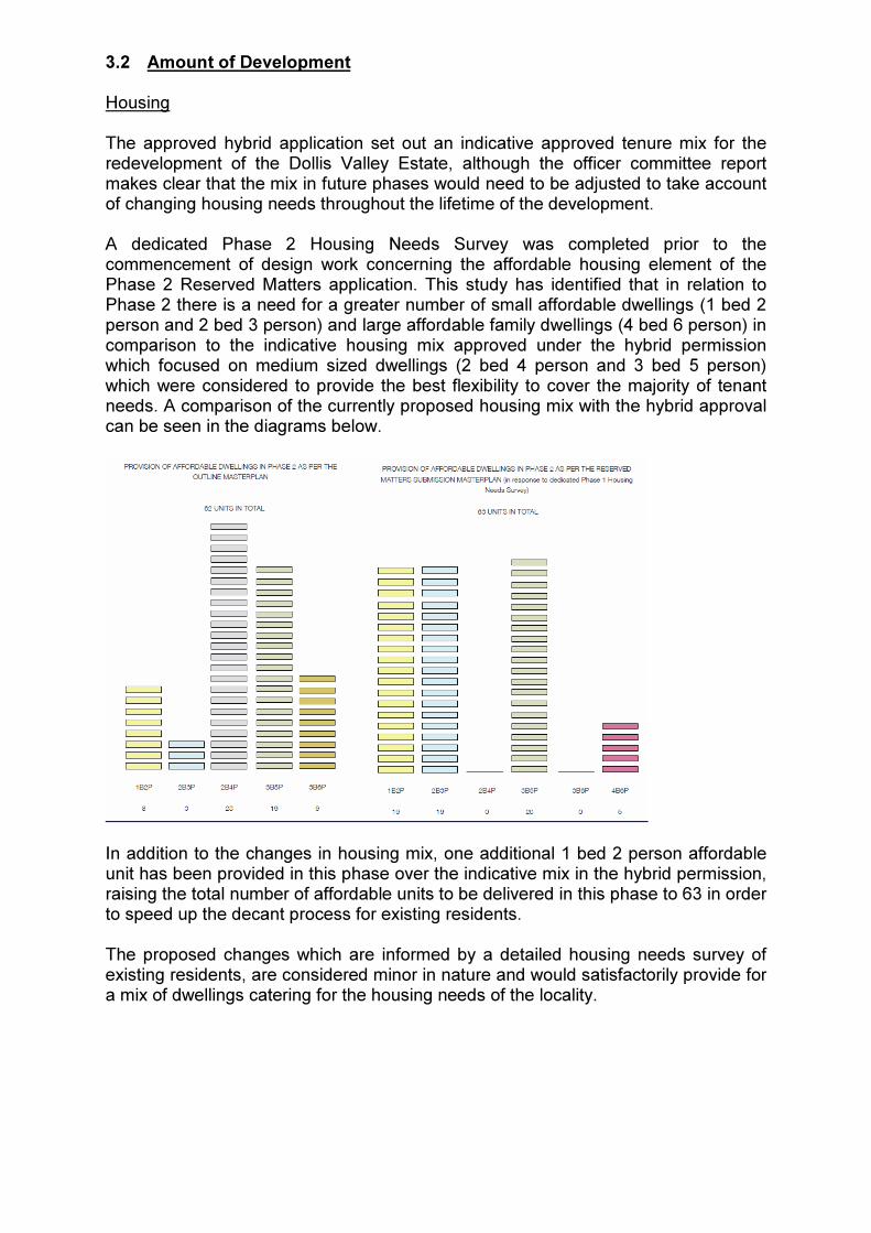
3.2 Amount of Development Housing The approved hybrid application set out an indicative approved tenure mix for the redevelopment of the Dollis Valley Estate, although the officer committee report makes clear that the mix in future phases would need to be adjusted to take account of changing housing needs throughout the lifetime of the development. A dedicated Phase 2 Housing Needs Survey was completed prior to the commencement of design work concerning the affordable housing element of the Phase 2 Reserved Matters application. This study has identified that in relation to Phase 2 there is a need for a greater number of small affordable dwellings (1 bed 2 person and 2 bed 3 person) and large affordable family dwellings (4 bed 6 person) in comparison to the indicative housing mix approved under the hybrid permission which focused on medium sized dwellings (2 bed 4 person and 3 bed 5 person) which were considered to provide the best flexibility to cover the majority of tenant needs. A comparison of the currently proposed housing mix with the hybrid approval can be seen in the diagrams below.
In addition to the changes in housing mix, one additional 1 bed 2 person affordable unit has been provided in this phase over the indicative mix in the hybrid permission, raising the total number of affordable units to be delivered in this phase to 63 in order to speed up the decant process for existing residents. The proposed changes which are informed by a detailed housing needs survey of existing residents, are considered minor in nature and would satisfactorily provide for a mix of dwellings catering for the housing needs of the locality.

Public Open Space In addition to housing, two out of the three new public spaces within the Dollis Valley Estate redevelopment will be delivered within Phase 2, namely the Eastern and Western Entrance Squares. The Planning Statement submitted in support of the application advises that the design of the areas of open space as illustrated in the Design and Access Statement are illustrative only as discussions concerning the position of street trees are still on going and as such conditions 38 (Hard and Soft Landscaping) and 88 (Open Space Strategy) attached to the hybrid permission cannot be discharged at this stage. Details of Playspace provision (Condition 39) has been provided with the aim of discharging these conditions. The planning merits of which are discussed in Section 4.6 of this report.

3.3 Scale Height Parameter Plan 2346_A_112 (Scale) sets out the approved site levels and the maximum permissible dimensional height and maximum level of storeys throughout the wider Dollis Valley Development. In relation to Phase 2 the development predominately accords with the approved parameter plans with the exception of a short line of terrace houses located on Brent Place on the north eastern corner of the phase, which provide three storeys accommodation, although the building heights remain within the permitted maximum height levels for 2 storey dwellings. Overall the proposed deviation is considered minor in nature and would not result in any additional massing when viewed from the surrounding area. Given the overall height of these houses has not changed there are no overshadowing or outlook impacts on neighbouring properties. Footprint Chapter 5.7 of the Design and Access Statement approved under the Hybrid Consent which sets Design Guidelines and Scale Threshold Tables for future outline phases, sets maximum Gross Internal Development Areas for future plots. On the whole the development accords with these dimensions, with the exception of Apartment Block 3, where the development footprint exceeds the maximum dimensions by 114sq.m. The reason for this change is due to the necessity of locating cycle and bin store structures to positions outside a designated gas easement which runs through the site, which have resulted in these structures being integrated into the building rather than being standalone structures. It is considered that in the context of the scale of the development, this alteration is a relatively minor change which would not result in any significant increase in massing, or reductions in public realm. Chapter 5.13.5 of the Design and Access Statement also sets out detailed design dimensions for the proposed development within the Phase 2, setting minimum and maximum dimensions, lengths of active frontage and back to back and back to side distances. The development accords with the maximum height dimensions and minimum back to back distances, however the proposed development differs in various elements from the specifications contained within the Design and Access Statement. The main points of deviation are as follows:
• The length of active frontages is less than the approved parameters in relation to zone D2 measuring between 23 and 36m in comparison to the guideline dimensions of between 28 and 32. In contrast the development within zone E2 marginally exceeds the stated guidelines measuring between 18 and 37m compared to the figure of between 17 and 35m outlined in the approved

parameters. The justification for this is due to site constraints in particular the gas easement which passes through the site;
• The minimum back to side distances between adjoining plots has been reduced by 0.7m and 1.3m from those outlined in chapter 5.13.5, with resultant distance separations ranging from between 12.5m to 26.7m. The stated justification for this is due to wider urban design principles seeking to extend active frontages and reducing gaps between dwellings in order to achieve a traditional urban block layout;
• The minimum and maximum depths of the footprint of the apartment blocks is less than the figures specified in chapter 5.13.5, with Block 2 now measuring between 9.6m (min) and 15.8m (max) in depth. Block 3 between 8.8m (min) and 15m (max) in depth and Block 5 between 9.4 (min) and 14.4m (max in depth). In comparison the guideline figures are between 9.6m and 15.8m, between 8.8m and 15m for block 3 and between 9.4m and 14.4m for block 5. The stated justification for the proposed change is due to detailed assessment of the design of the proposed dwellings to provide similar design layouts, adequate daylight to habitable rooms, optimal façade lengths and rational internal circulation solutions.
The proposed changes above relatively minor departures, which have been adequately justified by the applicant. The proposed changes do not raise any significant urban design or amenity issues. Levels Site Levels drop fairly significantly from north to south throughout the site, in particular in the north east corner. The levels information which has been submitted in support of the application accord with the levels set out in the parameter plans, however the stated levels for roads and footpaths will need to be agreed at detailed highway design stage. Amended Plans have been submitted by the applicant providing a step in the rear gardens of plots 251-260 along Mays Lane to be lowered enabling the retaining garden boundary walls to be lowered minimising the impact on the amenities of the immediately adjoining properties at 83 and 63 Mays Lane. In each instance there is a gap separating the garden wall from the fences of the adjacent Mays Lane properties. Taking into consideration this separation combined with the lowered garden levels, the proposals are not considered to result in significant detrimental impacts on the amenities of the neighbouring residential occupiers. Density The amount of development and minimum/maximum building dimensions have already been approved at the outline stage and therefore the target residential density is also established, with the development providing 163 dwellings at 255 habitable rooms per hectare (dph).

Phase 2 has a Public Transport Accessibility Level (PTAL) of 2 and is considered suburban in character. The London Plan recommends a density range of 150-250 Habitable rooms per hectare for Suburban sites with a PTAL between 2-3. The proposed development is marginally above the top end of the maximum density levels however the scheme can be considered to broadly accord with the density levels established by London Plan Policy. 3.4 Layout Policies CS5 and DM01 require development to be of a high quality design and should ensure attractive, safe and vibrant streets which provide visual interest. Proposals should also create safe and secure environments, reduce opportunities for crime and minimise fear of crime. The proposed layout for Phase 2 is shown in Appendix 1. The proposals demonstrate a building layout in broad accordance with the Illustrative Masterplan and is considered to achieve the requirements of Policies CS5 and DM01. The detailed design of the development is discussed in greater detail later in the report under Design Considerations. Access The main access point into the development is via the revised access to Mays Lane in the North East corner of the site which will replace Dollis Valley Way. An East West distributor road will then run through Phase 2 and connect to the central access to Mays Lane which is being constructed in Phase 1 of the development. New Entrance Squares are proposed at either end to provide an appropriate demarcation point and entrance feature to the development. To the south the proposed roads will connect to the future internal route system for the Dollis Valley Estate redevelopment. New temporary bus stops are proposed on the eastern and western end of this phase, with a through route being provided at a later stage following the completion of building works. Parking The application proposes the provision of 188 car parking spaces of which 181 are allocated and 7 non allocated. Spaces will be allocated at the ratio of 1 space per 1-3 bed units and 2 spaces for 4 bed and above dwellings. The majority of the spaces are provided within plots for the houses and in the form of communal surface parking courts for the proposed apartments. An undercroft car park is provided for Block 2. Cycle Parking is also provided in the form of dedicated outbuildings providing space for 2 cycles in the rear curtilages of the proposed houses. In relation to the apartment blocks, internal communal cycle storage is provided for apartment blocks 3 and 5. In relation to apartment block 2, secure cycle parking is provided in the form a standalone structure which is covered but not enclosed.

The level of parking is discussed in the highways section of this report. Crime The proposed layout follows a perimeter block approach, which ensures that all street and pubic open spaces benefit from being overlooked by active frontages. The submitted Design and Access Statement advises that the proposals have been discussed with the Secured by Design Officer of the Metropolitan Police and that the scheme will be built out to meet Secured by Design Standards. 3.5 Appearance The National Planning Policy Framework 2012 makes it clear that good design is indivisible from good planning and a key element in achieving sustainable development. This document states that permission should be refused for development which is of poor design that fails to take the opportunities available for improving the character and quality of an area and the way it functions. The development within Phase 2 consists of residential properties in the form of 84 houses measuring 2-3 storeys in height of ten differing house types along with 79 apartments located in three 3- 4 storey apartment blocks. The application proposal can be split into three main character areas, the eastern and western site entrances from Mays Lane and the residential streets running from east to west with houses along them. Eastern Mays Lane Site Entrance The application proposal aims to provide a public face and entrance point into the development while also integrating with the wider streetscape along Mays Lane. The application proposes the use of a 2 storey DV1c house type along the Mays Lane frontage involving a short terrace of four houses adjacent to number 83 Mays Lane and another short terrace of six houses on the opposite side of the Dollis Valley Way entrance. The houses are two storey 3 bed five person units with steep pitch mansard roofs with central flat roof elements containing PV Panels and projecting shallow pitched 2 storey projections and inset first floor balconies. The existing houses on Mays Lane are predominately two-storey terraced and semi-detached houses constructed between the 1920’s and 50’s. The new houses proposed on this frontage, while two storeys in height are taller than the existing houses at both eaves and ridge level, predominately due to the step up in ground levels and the higher roof pitch on the proposed houses to incorporate the solar PV panels. However the new houses remain sympathetic in scale incorporating hipped roofs to match the adjoining properties and allowing for the height to step up gradually. Overall it is considered that overall the proposed dwellings would accord with the scale of the surrounding streetscene while presenting a distinctive and contemporary appearance and important gateway into the development and are considered acceptable.

Turning into the Dollis Valley Way a staggered line of 7 terraced houses, Type DV14 4 bed 6 person are proposed on the eastern side of the road alongside the eastern entrance square with the flank wall of the Block 2 Apartment Block on the western side of the road. The proposed houses are two storeys in height with projecting first floor element with Juliet balconies and recessed ground floor providing covered refuse and recycling storage, a side single storey link extension with first floor balcony above helps break up the massing of the terrace allowing the terrace to gradually step down taken account of the steep drop of levels along Dollis Valley Way. Car parking and soft landscaping is proposed to the front of the proposed houses. Additional sketch drawing DOL-102-SK-140716-01 was submitted on the 17th July in response to officers concerns about the height of the flank retaining wall in relation to Dollis Valley Drive streetscene. The sketch information illustrates the potential soft landscape treatment which would be proposed to soften the visual appearance of the wall within the streetscene. The final landscape planting details will be secured via the landscaping condition. Combined with a reduction in the height of the wall due to changes in levels of the gardens of the adjacent houses, the proposed sketch planting detail is considered sufficient to ensure an attractive appearance to the streetscene. In relation to the proposed apartment block, the eastern elevation is formed of three separate linked elements allowing the development to take account of the changing levels of the site with the portion closest to Mays Lane providing 3 storeys of accommodation rising to 4 storeys of accommodation on the lower portion of the development adjoining the east west road. The block provides a varied staggered building line along each of the 3 sections and incorporates architectural measures such as utilising both recessed and projecting balconies and a varied fenestration pattern in order to provide contrast and to break up the façade. The Design of both the houses and the apartments are considered to relate satisfactorily to the challenging levels on this portion of the site, providing a gradual step down from Mays Lane to the lower levels of the East West Road, while maintaining a scale sympathetic to surrounding development. Brent Place A line of four terraced houses is proposed behind the houses located on Dollis Valley Drive. These properties are physically isolated from the rest of the development, forming a cul de sac accessed from Brent Place to the East, with no access to the rest of the Dollis Valley Development. The proposed houses are of a DV15 house type containing habitable roof accommodation and a small balcony area to the front. The design of these houses is considered acceptable, relating satisfactorily in scale and form to the surrounding pattern of development. Western Mays Lane Site Entrance and Entrance Square At its western boundary Phase 2 joins the central access road in Phase 1 which connects to Mays Lane. The properties fronting the western square on the eastern

side are of the DV11a Type which are the same as the consented houses in Phase 1 fronting Mays Lane. The houses are three storeys in height with pitched faux mansard roof to the front and flat roof beyond containing PV panels. The properties incorporate projecting bronze metallic GRP dormers in roof slopes and projecting aluminium bronze metallic porches to the front. The second floor rear of the building is timber clad with second floor roof terraces. Beyond the entrance square on the western side of the road are located two apartment blocks 3 and 5. These apartment blocks are 4 storeys in height while slightly dropping down in height with the change in levels from north to south. Similarly to Block 2 the blocks are built in several sections allowing for a varied building line and incorporates the use of recessed and projecting balconies and a varied fenestration pattern in order to maintain architectural variety and interest in the elevation. Overall the design of the properties in this portion of the development is considered to represent an appropriate standard of design in keeping with the design and scale of the adjoining development being built out in Phase 1. East West Streets Phase 2 of the development contains one complete east west road running along the northern edge of this phase and another partial east west road which will be completed under subsequent reserved matters applications for latter phases. The layout of these roads follows a traditional layout with houses located on both sides of the road. The street frontage will be composed out of several groups of houses of a range of house types forming a series of terraces. Each group will have no less than three and no more than 8 houses of the same type in succession. Due to the design of these different house types, with various degrees of setbacks and gaps at first floor level, the terrace would provide adequate articulation and variety breaking up the appearance of the terrace into smaller distinctive elements. The height of the properties proposed are predominately 2 storeys with several 3 storey properties with mansard roofs. Overall the design of these houses is considered acceptable, providing a variety of house types to maintain architectural interest. Materials The Development proposes the use of two different buff bricks with the properties located in the north eastern corner facing the Mays Lane Entrance and the western part of the development being built in Mystique Brick and the remainder of the dwellings in the centre of the development and in Brent Place to the north east being built out of Ivanhoe Cream Brick. Roofs throughout the development will be built out of dark grey fibre synthetic slate. Other materials include dark grey RAL 7016 upvc windows and doors, GRP dormer surrounds, aluminium composite porches and bronze coloured steel balcony railings to the apartment blocks to match the proposed brickwork. Timber cladding is proposed for the inside of entrances, porches and balconies.

The proposed material palette reflects the materials approved in Phase 1 of the development. Final materials will need to be agreed and approved through the conditions attached to the hybrid consent. Architectural Details The detailed design of a number of key architectural features of the houses and apartment buildings are critical to the success of the overall design approach for Phase 2 and the quality of the development. The Design and Access Statement submitted with the application includes some illustrations and images of some of these architectural details. Notwithstanding the information submitted, these details require further discussion with officers before they can be agreed and a condition is recommended to require the submission of plans and sections at appropriate scale in order that officers can be satisfied that a high quality scheme will be delivered. Conclusion for External Appearance Overall, the proposal successfully incorporates various architectural styles within a coherent design and is considered acceptable in principle resulting in a high quality development in accordance with the requirements of Policies CS5 and DM01 and compliant with the parameter plans and design guidelines approved under the outline element of the hybrid consent for Dollis Valley. 3.6 Landscaping The Hybrid Planning Approval for the regeneration of the Dollis Valley estate proposed a total of 26,366 m² of amenity space of which 3,485 m² would be public open space in the form of public squares and greens, 1,200 m² shared semi private amenity space i.e. for apartment blocks and 21,680m² private amenity space in the form of residential gardens. Public Open Space The Dollis Valley Hybrid consent proposed three areas of public open space, including a proposed green on the southern portion of the site to be built out in future phases and the eastern and western entrance squares both of which are located with the Phase 2 Reserved Matters Application site boundary. West Square Landscape Proposals The proposed Western Square is located on the western portion of the Phase 2 development directly to the north of apartment Block 3. The landscape proposals for this space include the provision of a single axial path along the western side of the space containing bench seating and stepped gravel terraces leading into open grassed areas which are also designated Local Areas of Play. Grids of Birch trees will be built alongside these raised terraces providing shade in summer months. The perimeter to the area will be planted with mixed shrub and herbaceous planting designed to encourage biodiversity with a formal hedge to the west and railings to the back of the footpath to the east.

East Square Landscape Proposals The Eastern Square is located on the eastern side of the development facing the Block 2 apartment block on the eastern side of Dollis Valley Drive. The proposed materials will be similar to the West Square incorporating sleeper steps to create grassed terraces containing local areas of play and formal and informal seating. The boundary to Dollis Valley Drive will be hedge backed railings set on top of a small retaining wall in order to improve the ambience of the space. Planting throughout the square will incorporate bio diverse species mixes in the hedge base and will also contain a large specimen tree in the centre of the square. Street Landscaping The application proposes street tree planting along all roads within the Phase 2 development, however the planting proposals including the species are only indicative as discussions with the highway authority regarding position and species are still progressing and are subject to sightlines, visibility splays, car parking and vehicle swept path analysis The indicative planting proposals differ depending on road type with paired semi mature hornbeam trees proposed on the future adopted roads on the eastern and western avenues to create a traditional London street typology and strong green corridor. On other quieter residential streets the application proposes the planting of single rows of medium sized trees along with seasonal specimen trees. Suggested species include Field Maple, Juneberry and Cherry. Front and Rear Residential Gardens The application proposals for Phase 2 propose the widespread use of hedges to house frontages mixed with climber planting to flanking walls to soften the appearance of the development. Where planting space is limited the application proposes the use of pre grown ivy screens as boundaries between properties to reduce the visual impact of parked cars and to soften long views of the streets. Set back areas and planting around parking bays will contain mixes of shrubs and herbaceous planting, the choice of which will depend on shade tolerance and the solar orientation of the development. Rear gardens will be fenced with 1.8m close boarded fences, and will in some cases contain planted trees. Play space London Plan policy 3.6 states that new residential developments should include provision for play and informal recreation, based on the expected child population generated by the scheme and an assessment of future needs. The Hybrid permission provided for the provision of 100sq.m of formal and equipped doorstep play space within both the east and west entrance squares contained within Phase 2, with an additional 300 sq.m of local and formally equipped play space to be

provided on the Green adjoining Dollis Brook at the southern end of the Dollis Valley redevelopment outside the current reserved matters application. The applicant has provided details of proposed play equipment which is proposed in the eastern and western entrance squares. These consist of 3 x timber wobbly sheep, 1 set of timber stepping stones and 4 x artificial stones finished in brushed steel set in the grass, 3 x timber snails along with informal and formal seating. The quantum of play space is in accordance with the hybrid consent. The play equipment proposed is sufficient for doorstep play for under 5’s. A greater range of equipment is expected to be provided in the Green in later phases. Trees London Plan policy 7.21 Trees and woodlands seeks to ensure protection, maintenance and enhancement of trees and woodlands. The policy states that existing trees of value should be retained and any loss should be replaced. Where appropriate, planting of additional trees should be secured. Local Plan policy DM01 seeks to ensure trees are safeguarded, and when protected trees are to be felled, replanting with a suitable size and species will be required. The approved Masterplan Tree Strategy approved under the hybrid planning approval proposed the removal of 193 trees out of 208 trees within the Wider Dollis Valley Development. In relation to Phase 2 the application proposed the retention of two mature category B mature trees (T31 Lime and T77 English Oak) and 2 groups of mature or early mature C trees containing the following tree specimens, (TG9 Apple, Cherry and Ash) and (TG10 (Elder, Damson and Hawthorn). All trees which are to be removed are to be replaced on a 2 for 1 basis. Deviation from approved tree removal strategy The submitted reserved matters application proposes the additional removal of the TG10 group of trees located in the north eastern corner of the site. The stated reason for the refusal is that following detailed design work and due to the challenging levels within the area, the need to provide retaining walls and in order to create usable amenity area. Advice from the Council’s Arboriculturalist is that these trees are of limited amenity value and no objection is raised subject to adequate replacement in line with the Masterplan Tree Strategy i.e. 2 for 1 provision. Replacement Planting The proposal as a result of the removal of TG10 will in total result in the loss of 49 trees. The indicative tree strategy submitted in mitigation in support of the application proposes the planting of 59 on street trees (with 8 deferred to future phases due to issues with Bus Radii), 10 trees on site parks and 25 trees within on site gardens, resulting in a total of 94 trees in comparison with the 88 trees proposed under the

hybrid approval. The planting strategy is indicative only as the position of trees still needs to be agreed by the Highway Authority. Protection of existing trees The applicant has submitted an Arboricultural Method Statement and accompanying plans to indicate the protection measures for the retained trees. The method statement demonstrates that the two retained trees in particular the T77 English Oak which is located in close proximity to an adjoining terrace can be retained and safeguarded through the use of a raised timber decking allowing the retention of existing site levels in the proximity of the tree along with a 25% crown reduction to provide a 2m clearance to neighbouring dwellings. The Council’s Tree Officer has no objections to the proposed details. Maintenance The applicant has submitted a landscape maintenance schedule specifying site specific management requirements for the establishment period (years 1-5) including regular inspections, use of fertilizer, mulching, grass cutting pruning of shrubs and replacement of damaged plants. Hard areas Proposed hard surface materials for Phase 2 are as per the agreed specifications for Phase 1 concrete block paving along footpaths, silver grey granite kerbs and block paving to crossovers. The non-adopted east west streets are shown to be predominantly tarmac. Plans have been submitted to indicate where areas of block paving bands can be added at entrances and at locations along the streets to help break up the visual appearance of the tarmac. This principle is supported and final details for these block paved/alternative material areas will be discussed further with the applicant and final details approved under the landscaping condition. Concrete blocks will be used for shared surfaces on non adopted road and buff coloured resin bonded gravel of footpaths within the entrance squares, seating and bins will be of a contemporary design to be agreed with the Local Planning Authority. The final materials for the streets will be secured through the landscaping details condition. Conclusion for Landscaping The landscaping approach is considered to be in accordance with design principles set in the parameter plans and will frame and complement the architectural approach whilst increasing the overall biodiversity of the site’s environment. It complies with Policies CS5 and DM16. 3.7 Amenities of Future Occupants Dwelling outlook and daylighting Development plan policy requires that new dwellings are provided with adequate outlook. The layout proposed for Phase 2 maximizes the outlook of occupiers of the

new dwellings, with all houses being located on a north south or east west axis. A Daylight/ Sunlight and Overshadowing Assessment has been submitted in support of the application. The Assessment assess the level of daylight and sunlight which will be achieved by all habitable rooms within the development as well as an assessment of overshadowing of open spaces within the Phase 2 development. The results of the assessment show that all habitable rooms will receive levels of daylight which accord with the Building Research Establishment (BRE) guidelines and as such will receive adequate levels of daylight. In relation to sunlight the assessment indicated that 140 out of 163 living rooms have at least one window located within 90º of due south and will accord with the BRE requirement to achieve at least 25% of Annual Probable Sunlight Hours (APSH). In relation to Winter Probable Sunlight Hours (WPSH) 139 out of 163 living rooms will achieve the 5% BRE requirement. Overall the percentage of units achieving the BRE sunlight criteria is considered acceptable given the layout of the scheme following the approved internal estate layout, which means that not all living rooms can be designed to be located within 90º of due south without compromising other urban design standards such as the need for active perimeter block layouts with back facing backs and fronts facing fronts. In relation to open space including private rear gardens, the assessment shows that 60 out of the 90 open spaces comply with the BRE requirement that at least 50% of the site receives more than 2 hours of sun on the 21st March. In relation to the spaces which do not pass, this is predominately due to their orientation facing north. These gardens will still receive a level of sunlight and a number of these properties have secondary amenity space in the form of roof terraces. The proposals are considered acceptable in the context of the development and the wider objectives of the regeneration. Noise The application is accompanied by a noise report assessing levels of background noise in relation to properties fronting Mays Lane. The findings of the report indicate that enhanced sound proofed glazing and the provision of alternative mechanical ventilation should be provided to all dwellings fronting Mays Lane. In relation to other dwellings standard double glazing is considered to provide acceptable internal noise levels. The Council’s Environmental Health Officer has confirmed that the submitted details are considered satisfactory in accordance with Conditions 51 and 53 of the Outline element of the Hybrid Approval. Privacy The Council’s Supplementary Planning Document Residential Design Guide recommends minimum distances between habitable room windows and to neighbouring gardens to protect privacy.

It was accepted during the consideration of the hybrid planning application that not all back to back (across gardens) or front to front distance (across streets) would accord with the Council’s 21m recommended separation distance. This has been established and approved in the parameter plans for Dollis Valley which establish the minimum distances which would be permitted in the development. In relation to the current application, the position of the proposed houses is broadly in accordance with the illustrated Masterplan approved as part of the Hybrid consent. Distance separations between dwellings are a minimum of 17.5m back to back and between 12- 14m front to front. While it acceptable that this level is below SPD guidelines, the Council’s SPD acknowledges that shorter distances between facing habitable room windows and to neighbouring gardens may be acceptable within regeneration areas where there are material justifications. It is considered in this case that the high quality urban environment proposed and the wider regeneration benefits of the proposals justify the relaxation of these standards. The proposals comply with the minimum distances specified in the parameter plans approved under the hybrid planning consent for Dollis Valley Estate. The distances across streets contribute to the character and feel of the streets within the development. The back to back distances still enable a good level of privacy to be achieved. Drawing 2376_A_228 rev A has been submitted to confirm that obscure glass screens will be installed to the north facing balconies on the north elevation of Block 2 to ensure that there will be no overlooking into the gardens of plots 252, 253 and 254. The proposals are considered to result in an acceptable level of privacy for future occupiers of the development. Dwelling size Table 3.3 in the London Plan provides a minimum gross internal floor area for different types of dwelling. The Mayor’s Housing SPG November 2012 includes a wider ranging Minimum Floorspace Table based upon the same standards. All of the units proposed including both the houses and apartments would have gross internal floor areas which exceed the requirements of the London Plan. The proposal complies with policy and is therefore considered to be acceptable in this regard. Amenity space The Council’s adopted Supplementary Planning Document entitled Residential Design Guidance requires the provision of 5 sq.m of amenity space per habitable room for flats, and between 40 and 85 sq.m for houses depending on the number of habitable rooms. Every dwelling has access to some form of private amenity space. The houses all have individual front and rear gardens and several of the houses also have front, side or rear facing balconies or terraces. The applicant has submitted a schedule of the amenity space provided for each plot. Rooms exceeding 20 sq.m are counted as

two habitable rooms and driveways, front gardens and areas occupied by bike shed are excluded from the calculation in accordance with Barnet’s SPD (April 2013). Of the 84 houses proposed in this phase, 8 would fall short of the amenity space standard with the shortfall ranging between 1.7 sq.m and 11.2 sq.m. In all of the other plots the standards are exceeded and in most cases by over 10 sq.m. The instances where plots fall short of the standard are considered to be acceptable given specific site constraints and the overall regeneration objectives to achieve a robust urban design layout. Several of the properties, particularly in the southern portion of the site along the southern east west road have changes in levels in their rear garden. These gardens therefore have a split level to ensure flat usable areas are provided. The change in levels is more significant for some of the gardens of the proposed houses backing onto the gardens of the Mays Lane properties. For some of these properties the change in levels would necessitate the use of low retaining walls to create stepped terraces. An area of paved patio space is provided immediately to the rear of the houses with upper terraces which could either be turfed or paved to provide usable space. In relation to plots 216 through to 224, there is an existing hedge along the Mays Lane boundary. In order to retain this hedge the gardens are split into three levels. The top most level being given over entirely to the retained hedge. This reduces the amount of usable garden area. For plots 216 to 219 which comprise type DV13b the garden area returns beneath a raised terrace between the houses. This additional area plus the upper terrace are sufficient to ensure that these properties have sufficient amenity space. Plots 220 to 224 do not have this additional space. For these properties a sketch alternative garden layout has been submitted which illustrates how additional usable garden space could be provided if the existing hedge was removed. Replacement planting would be provided in this instance to mitigate the loss of the hedge and provide a degree of screening for the Mays Lane properties to the north. The final landscape details will be agreed under the discharge of condition 38 of the hybrid planning consent. In relation to the apartments these are all provided with individual amenity space in the form of balconies, gardens or roof terraces along with access to shared amenity space in the form of podium courtyards and roof terraces. Blocks 2 and 3 exceed the minimum amenity space requirements providing between 5.2 sq.m and 7 sq.m respectively per habitable room. The amenity space provision for Block 5 is slightly below standard with 4.3sq.m of amenity space being provided for each habitable room. It is noted however that this Block will still provide a total of 492.5 sq.m of either private or shared amenity space and on balance, given the limited nature of the shortfall and taking into account the wider public open space provision both within and outside the Dollis Valley boundary is considered acceptable in this instance.
3.8 Impacts on amenities of neighbouring and surrounding occupiers and users
The periphery of the site to the north adjoins the rear gardens of numbers 83 – 129 Mays Lane to the north.

The proposed dwellings along the east west road are located over 40m from the rear building line of buildings on Mays Lane. Due to this distance separation, the drop in levels from north to south and the 2-3 storey nature of the dwellings to be constructed on the east west road, the proposal will not result in any demonstrable loss of daylight, sunlight or privacy between habitable room windows. In relation to overlooking of amenity areas, the rear gardens of the proposed units are shorter than the policy requirement of 10.5m as set out in Barnet’s adopted Residential Design Guidance SPD with rear gardens measuring between 7.5m and 9.5m in depth. However the position of the houses has already been established by the original hybrid consent, and any overlooking will be limited to rearmost portion of substantial gardens to the properties in Mays Lane. Taking into account the change in levels, substantial size of the Mays Lane gardens and privacy screen measures to be secured by condition, it is not considered that the proposal would be significantly harmful to the amenities of these properties. Plots 267 – 270 along Dollis Valley Drive back onto the side garden of number 39 Brent Place. The proposed properties are located between 6-7m from the side curtilage and 26m (at the closest point) from the actual house. The boundary is currently screened by a Leyland hedge along with a Mature English Oak which are proposed to be retained and it is not considered that the proposal would be significantly harmful to the amenities of this property. The flank wall of plot 264 adjoins the rear gardens of no’s 39-43 Brent Place. The proposed building is located over 31m from the rear wall of these properties is considered minimal and the proposal would not result in any significant loss of daylight or sunlight. No side facing windows are proposed and as such the proposal will not result in any loss of privacy to the rear gardens of these properties. In relation to the proposed dwellings fronting Mays Lane, the property located closest to number 83 Mays Lane (Plot 250) roughly aligns front and rear with number 83. There is a 3m gap between the properties and therefore it is not considered that the amenities of number 83 Mays Lane would be unduly impacted upon by the proposal. In relation to plot 259 on the western side of number 63 Mays Lane. The proposed building extends 3m beyond the rear building line of number 63 at a distance of 1m to the boundary and 2m to the adjoining flank wall. Number 63 has been extended at the rear in the form of a rear conservatory and the applicant has made changes t the layout of the rear gardens introducing a step allowing the height of the gardens and hence the height of the retaining boundary retaining walls to be lowered. Due to these factors and taking into consideration the south facing aspect of the garden to 63 Mays Lane, it is considered that the amenities of number 63 Mays Lane would not be unduly impacted upon by the proposals. The hybrid Planning Application was accompanied by a Daylight and Sunlight assessment in relation to the impact of both the detailed Phase 1 portion of the development and the outline portion of the development comprising phases 2-5. The report concluded that the proposal would not result in daylight or sunlight levels being reduced below acceptable levels as defined in the Building Research Establishment (BRE) guidelines. The applicant has assessed the impact of changes

to the Phase 2 development in comparison to the masterplan approved under the hybrid consent and concluded that the proposed changes would not result in any significant impact over and above the approved plans and as such a revised Daylight and Sunlight Assessment is not required. In relation to future phases located to the south and east of the development, no detailed reserved matters application have been submitted, however the distance separation between the development and these future plots will be similar to the relationship of plots to the north and west as well as the current internal relationship within this phase and it is not considered that the proposal would significantly affect the amenities of dwellings contained within future phases or be unduly impacted upon by future development. 3.9 Transport, parking and highways matters: Access As part of the Phase Two development the existing Dollis Valley Way access off May Lane is proposed to be redesigned increasing the junction radii and visibility splays. The submitted plans have been examined by the Council’s Highway Team who advise that in principle the proposal is acceptable. However, detailed drawings will need to be submitted to the Planning Authority for approval before the proposed junction works can commence.
Temporary Routing of Bus Route 326:
Currently the 326 bus route passes through part of the Dollis Valley Estate. As a result of the proposed building work, the through bus route will be temporarily affected while works take place. In order to address this, the applicant has proposed two temporary bus routes and turning circles and temporary bus stops which will be provided when the western and eastern portions of phase 2 are built out. Following completion of phase 2 it is intended that buses will transverse the northern estate road (westbound only). This route is intended to be retained until the completion of phase 5 when the adopted loop road will be complete and the permanent bus route available.
The submitted proposals have been examined by Transport for London and the Council’s Highway Officers. Transport for London have expressed concerns regarding swept path analysis and ability of buses to navigate the corners, the private nature of the road limiting the ability to enforce illegal parking and the layout of parking spaces including tandem parking arrangements which would require parked vehicles to either reverse into the spaces or out into the road, potentially to the detriment of highway safety. As a response to the comments, the applicant has agreed to withdraw conditions 33 (Bus Swept Paths) and 34 (Temporary Bus Route) from consideration under this reserved matters application to allow discussions with TFL to continue and these matters will be addressed in a future discharge of condition application.

Travel Plan: Travel Plan requirements for the entire Dollis Valley Development have been identified and included in the hybrid planning application B/00354/13 approved by planning and as such are not required to be submitted with this reserved matters application. Pedestrian Facilities The hybrid planning permission sought, as one of its core objectives, to improve the pedestrian environment within the Dollis Valley Estate. The application proposal incorporates 1.8m wide pedestrian footpaths along all proposed roads linking in with the temporary bus facilities and areas of open space. All footpaths will be lit and overlooked and is considered to represent a satisfactory pedestrian environment. On a wider basis, future pedestrian connections from the Dollis Valley Estate to the wider neighbourhood will include a footpath to Barnet Lane and an enhanced link to Dollis Brook and King George V Playing Fields to the south and east of the site. Parking Parking Standards set out in the Local Plan Policy DM17 are as follows: Maximum Standards will be:
(i) 2 to 1.5 spaces per unit for detached and semi detached houses and flats (4 or more bedrooms)
(ii) 1.5 to 1 spaces per unit for terraced houses and flats (2 to 3 bedrooms) and
(iii) 1 to less than 1 space per unit for development consisting mainly of flats (1 bedroom)
Overall 788 parking spaces are to be provided for the completed development. A total of 188 car parking spaces are being proposed for phase 2 development which forms part of the overall provision. This falls mid-way within the range set out in the Local Plan. The table below shows the total number of units and the parking requirement for the Phase 2 development:
Type of Units LP maximum Parking Range
LP Parking spaces (low end of range)
LP Parking spaces (high end of range)
1 Bed (0.0-1.0) = 0 28
2 Bed (1.0-1.5) = 49 73.5
3 Bed (1.0-1.5) = 68 102
4+ Bed (1.5-2.0) = 27 36
Total 144 239.5

It is proposed that 181 parking spaces will be allocated parking spaces and 7 non-allocated. The level of parking proposed is in accordance with the Barnet Local Plan Development Management Policies approved in September 2012 and the levels of parking established by the hybrid planning consent for Dollis Valley, therefore the level of car parking provision is considered acceptable A Car Parking Management Strategy has yet to be submitted and must be submitted prior to the commencement of phase 2 in order to accord with the conditions of the hybrid consent. This will demonstrate how vehicles will be prevented from parking on the non designated areas. Accessibility and Inclusivity Thirteen houses within Phase 2 are designed to be wheelchair adaptable, which equates to 10% and in compliance with Condition 14 ( Wheelchair Standards) of the outline element of the hybrid consent. None of the existing tenants within the Dollis Valley Estate which are due to be rehoused within these units are currently registered disabled and therefore the units have been designed to accord with the Wheelchair Accessible Housing Best Practice Guidance rather than being specifically designed for any end user. All of the proposed dwellings are designed to comply with the internal design criteria necessary to meet Lifetime Homes standards in accordance with Condition 11 (Lifetime Homes) of the outline element of the hybrid consent. Sustainable travel Secure cycle storage is provided in the form of dedicated outbuildings providing space for 2 cycles in the rear curtilages of the proposed houses. In relation to the apartment blocks, internal communal cycle storage is provided for apartment blocks 3 and 5. In relation to apartment block 2, secure cycle parking is provided in the form a standalone structure which is covered but not enclosed. The Design and Access Statement advises that this will meet Secured by Design Standards and is considered acceptable. No details of proposed electric charging has been provided with the application however Condition 17 of the outline element of the hybrid consent requires that a minimum of 20% active and 20% passive are provided in accordance with current GLA Policy Waste Management The refuse strategy for the development provides for refuse storage facilities in the rear curtilages of the proposed houses with collection points being located to the front. Refuse collection for the apartment blocks will take the form of an integrated communal refuse stores for blocks 3 and 5 and a split integrated and freestanding store for block 2. Amendments to the street layout have been made following representations from the Council’s Highway Officer removing several car parking

spaces in order to ensure satisfactory access for refuse and emergency vehicles and the proposed refuse and recycling details are considered acceptable. Street lighting The provision of adequate and well designed lighting will influence potential criminal behaviour and should help to reduce the risk of crime and fear of crime for those people living, visiting and working within this latest phase of the Dollis Valley development. The submission of details of street lighting is required before the commencement of each phase in accordance with Condition 29 of the Hybrid Consent. Conclusion for Transport, Parking and Highways In summary, the application provides for adequate parking without harming the local highway network and promotes sustainable modes of travel and complies with Policies CS9 and DM17. 3.10 Environmental issues Construction management No details have been provided with this reserved matters application, however condition 26 of the outline element of the hybrid consent requires the submission of a demolition, construction and traffic management plan prior to the commencement of each phase and as such appropriate safeguards exist in order to safeguard the amenity of neighbouring residential properties and highway and pedestrian safety. The construction management plan for Phase 2 will be based on the principles approved for Phase 1. Contamination Condition 49 of the outline element of the outline consent requires the submission of a contaminated land desktop study prior to the commencement of each phase identifying where appropriate a risk assessment and method statement detailing any necessary remediation measures. A preliminary risk assessment has been submitted with the current reserved matters application. The assessment notes that samples which have been taken indicated that there are localised hotspots of TPH (Total Petroleum Hydrocarbons (TPHs) which will need to be remediated. The remediation strategy will involve the removal of contaminated soils and backfilling with clean imported top soil. Advice from the Council’s Environmental Health Officer is that this approach is predominately satisfactory however the use of a geotextile membrane may also be required depending on validation results. However it is considered that the pre commencement element of Condition 49 can be discharged.

3.11 Energy, climate change, biodiversity and sustainable construction matters:
Sustainable design and construction
The Mayor’s Energy Hierarchy as specified in policies 5.2 and 5.3 of the London Plan sets out three methods for achieving a minimum (Post October 2013) a 40% reduction in carbon emissions: 1 Be lean: use less energy (fabric efficiency standards) 2 Be clean: supply energy efficiently 3 Be green: use renewable energy Condition 54 of the hybrid planning permission also requires the submission of an energy strategy prior to the commencement of any phase ‘incorporating full details of the photovoltaic panels, including quantum, to be installed in the relevant phase and measures to achieve carbon dioxide reductions in accordance with the previously submitted site-wide Energy Statement dated January 2013’. The application is accompanied by an energy statement, which illustrates how the development can achieve the required policy requirement. However the application documents advise that this strategy is for information only as the specification of the proposed PV Panels is not known at this stage and these matters will be considered under a future discharge of condition application Water resources and Drainage Condition 47 of the Hybrid consent requires a detailed surface water drainage scheme to be submitted prior to the development of any phase based on the agreed Flood Risk Assessment. The applicant has submitted a drainage strategy with the application which makes the following comments and recommendations. In relation to flooding the site is located on slopping ground located over 140m from the Dollis Brook which is the closest watercourse to the development. The development falls within Flood Zone 1 and is therefore considered to be limited risk of flooding with a 1 in 1000 risk of flooding from a river source. In relation to surface water drainage, at present surface water on the Estate drains into a network of Thames Water maintained sewers and the application does not propose any significant alterations to this system. Where existing sewers need to be replaced or diverted a design strategy will be adopted to ensure that drainage to all properties upstream of the diversion will not be affected. In relation to foul water drainage Phase 2 will discharge to existing Thames Water foul sewers. Flow rates are considered likely to be similar or only slightly higher than existing flow rates and as such no major adaptations will be required. Similarly to the surface water sewers where existing sewers need to be replaced or diverted a design strategy will be adopted to ensure that drainage to all properties upstream of the diversion will not be affected.

Thames Water have been consulted on the application and have raised no objection to the proposed waste water plans, however additional information is required in relation to surface water. In order to allow sufficient time to prepare the additional information the applicant has withdrawn condition 47 from the current application. Once the revised details are ready they will be submitted under a discharge of condition application and Thames Water will be consulted. Biodiversity and Ecology Condition 46 of the outline element of the hybrid approval requires details of measures to enhance biodiversity to be submitted prior to the commencement of any phase. The application is not seeking permission for the discharge of this condition however an indicative biodiversity appraisal is included with the application. The appraisal notes that the habitat survey submitted with the original hybrid application did not find any evidence of badgers, great crested newts, bats or reptiles within the phase 2 site area. Ecological enhancement measures proposed include additional tree, hedgerow and shrub planting, the setting up of deadwood habitats in appropriate locations and the provision of bat and bird boxes on identified trees. Natural England have been consulted on this application and have advised that they do not wish to raise any objections to the scheme. 3.12 Archaeology Condition 48 of the hybrid planning permission requires the implementation of a programme of archaeological mitigation with each phase. The applicant has submitted a statement in support of their application advising that no archaeological sites or deposits have been found in the Phase 1 part of the development and that due to the level of ground works which were carried out when Dollis Valley Estate was constructed in the 1960’s it is unlikely that Phase 2 has any sites of archaeological interest and therefore no further investigation is required. English Heritage have been consulted on this application and have advised that they have no objection to the discharge of this condition. 4. COMMENTS ON GROUNDS OF OBJECTIONS The traffic impact of the development was assessed during the consideration of the hybrid application (B/00354/13). The S106 Schedule D paragraph 3, contains a parking review mechanism, allowing for the impact of the development on parking demand on surrounding roads to be assessed. The review will include Mays Lane and Hillside Gardens. The internal site layout including the road network was established under the hybrid consent. The principle of connecting Hammond Close and Hardy Close into the wider development has therefore been established and considered acceptable. The road layout will not be altered by the current reserved matters application.

The level of car parking provision is considered acceptable by Council Highway Officers and accords with the parameters of the outline consent and TFL guidelines. Issues regarding the build quality of the development, condensation and sound proofing between floors are matters which are covered by building regulation legislation. The application is accompanied by a daylight and sunlight assessment which concludes that all habitable rooms will receive adequate levels of daylight, the site has been assessed as at low risk of flooding. The Environment Agency were consulted on the Hybrid Application and found the scheme to be acceptable. Drainage details are dealt with under Condition 47. The housing of tenants and whether tenants without children are placed next to tenants with children is not a material planning consideration. London and Quadrant Housing Trust will be responsible for liaising with secure tenants in relation to their housing options. 5. EQUALITIES AND DIVERSITY ISSUES
Section 149 of the Equality Act 2010, which came into force on 5th April 2011, imposes important duties on public authorities in the exercise of their functions, including a duty to have regard to the need to: “(a) eliminate discrimination, harassment, victimisation and any other conduct that
is prohibited by or under this Act;
(b) advance equality of opportunity between persons who share a relevant protected characteristic and persons who do not share it;
(c) foster good relations between persons who share a relevant protected characteristic and persons who do not share it.”
For the purposes of this obligation the term “protected characteristic” includes:
• age;
• disability;
• gender reassignment;
• pregnancy and maternity;
• race;
• religion or belief;
• sex;
• sexual orientation. Officers have in considering this application and preparing this report had regard to the requirements of this section and have concluded that a decision to grant planning permission for this proposed development will comply with the Council’s statutory duty under the above legislation. The Phase 2 development will offer inclusive design for safe and easy use for all. All of the proposed dwellings are designed to meet the internal Lifetime Homes Criteria and 13 units (10% of proposed) are designed to be wheelchair adaptable.

The use as residential has been established at outline stage and it would not prejudice existing or future users/residents in the surrounding area. The areas of open spaces are publicly accessible and have level access. This reserved matters application will enable the Council and Barratt Homes to continue to deliver the regeneration of the Dollis Valley Estate which will provide greatly improved standards of housing for residents. The regeneration scheme will provide a new area of mixed tenure housing and will make this part of the Borough a better place to live, leading to improved community cohesion in an area with a highly diverse population. It is considered by officers that the submission adequately demonstrates that the design of the development and the approach of the applicant are acceptable with regard to equalities and diversity matters. The proposals do not conflict with either Barnet Council’s Equalities Policy or the commitments set in our Equality Scheme and support the council in meeting its statutory equality responsibilities.
6. CONCLUSION As conditioned the proposal would not compromise the outline planning permission (B/00354/13) for the redevelopment of the wider site. It accords with the relevant development plan policies, conforms to the design principles and the parameters established in the approved outline application for the Dollis Valley Estate. The proposal is acceptable on visual amenity, access, highways, biodiversity, and drainage grounds. The proposal would not significantly affect the amenities of neighbouring residential properties. It would provide for much needed quality family housing, including 63 affordable units that would have a good standard of accommodation including outlook, privacy and access to daylight. The design of the development is considered appropriate for its location, which also provides for variety and legibility in Built Form. The materials and form relates well to the surrounding development. The layout of the development provides permeability around the site as well as to the wider development. It is recommended that the application be Approved subject to the attached conditions. It is also recommended that Conditions 6, 16, 23, 35, 37, 39, 40, 48, 49, 51, 53 and 89 are discharged insofar as the details relate to Phase 2 of the development only.

APPENDIX 1 – Masterplan Layout for Phase 2

APPENDIX 2 – Dollis Valley Estate Phasing Plan
Phase 2 Phase 1
Phases 3-5

SITE LOCATION PLAN: Phase 2, Dollis Valley Estate, Barnet, Herts, EN5 REFERENCE: B/02349/14
Reproduced by permission of Ordnance Survey on behalf of HMSO. © Crown copyright and database right 2013. All rights reserved. Ordnance Survey Licence number LA100017674.