london borough of enfield · london borough of enfield planning committee ... rl roof level rad...
TRANSCRIPT

LONDON BOROUGH OF ENFIELD
PLANNING COMMITTEE
Date : 12 September 2017
Report of Assistant Director, Regeneration & Planning
Contact Officer: Andy Higham Liz Sullivan Adam Squires Tel No: 020 8379 4018
Ward: Cockfosters Chase
Ref: 17/03298/PAAG
Category: Application for prior notification of agricultural or forestry development- proposed building.
LOCATION: Beech Barn Farm, The Ridgeway, Enfield, EN2 8AF PROPOSAL: Erection of a replacement agricultural building Applicant Name & Address: Mr Don Perry 225 Village Way
Agent Name & Address: Mr Keith Milne Enfield Council Corporate Maintenance & Construction Team
RECOMMENDATION: That prior approval is Not required Note for Members: A proposal of this nature would normally be considered under delegated authority because assessment is conducted against the Permitted Development Act 2015 (as amended), save for an assessment on the siting of the building. A council department is acting as the agent for this application, meaning that in the interests of transparency, the application has been referred to Committee for decision.

Ref: 17/03298/PAAG LOCATION: Beech Barn Farm , The Ridgeway, Enfield, EN2 8AF
Reproduced by permission of Ordnance Survey on behalf of HMSO. ©Crown Copyright and database right 2013. All Rights Reserved. Ordnance Survey License number 100019820
Scale 1:1000 North

1. Site and Surroundings 1.1 The subject site is located on the southern side of the Ridgeway and is
occupied by a large agricultural holding.
1.2 The site is located within the Green Belt. 1.3 The replacement building will be a portal steel framed storage barn for the
storage of machinery and plant 2. Proposal 2.1 By virtue of Condition A.2 (2) (a) (i) of Schedule 2, Part 6, Class A of the
Permitted Development Act 2015 (as amended), the developer must, before beginning the development, apply to the Local Planning Authority for a determination as to whether the prior approval of the authority will be required for the siting, design and external appearance of the proposed new agricultural building.
2.2 The proposal is for the replacement of a previously demolished agricultural shed which has been removed within the last 2 years. The replacement shed would have a depth of 30m and a breadth of 12m, with 6.8m wall height to match the dimensions of the original structure that existed on the site.
2.3 Before establishing whether the siting, design and external appearance of the buildings require prior approval, a determination as to whether the building falls within the criteria of the General Permitted Development Order is required.
3. Relevant Planning Decisions
3.1 The following planning history is considered to be relevant:
Reference Proposal Decision Date 16/04258/PRM Change of use of
agricultural building to storage (B8)
Prior Approval not required
10/11/216
4. Relevant Policies

4.1 The Town and Country Planning (General Permitted Development) (England) Order 2015, Schedule 2, Part 6, Class A is relevant to determine the application.
5. Analysis
5.1 General Permitted Development Order 5.2 The Town and Country Planning (General Permitted Development)
(England) Order 2015, Schedule 2, Part 6 ‘Agricultural and forestry’, Class A dictates if an application would be considered as Permitted Development
5.3 Per Part A the following development is considered as permitted development; The carrying out on agricultural land comprised in an agricultural unit of 5 hectares or more in area of- a) works for the erection, extension or alternation of a building; or
b) any excavation or engineering operations,
which area reasonably necessary for the purposes of agriculture within that unit
5.4 as such, development must be able to demonstrate it is reasonably necessary for the agricultural purposes within the site. It is considered that, given the structure would replace a previously existing building which was removed due to structural conditions, there is a reasonable expectation of demand for such a form of building. such form of shed preforms a necessary function in agricultural operations for the storage of machinery, plant and produce. On this basis, the proposed works would be seen as meeting this requirement.
5.5 Part A further identifies conditions against which an application must
comply to be considered Permitted Development. an assessment against these conditions is detailed below:
a) The development would be carried out on a separate parcel of land
forming part of the unit which is less than 1 hectare in area; No- per the application information supplied, the property is comfortably in excess of 1ha.
b) It would consist of the erection or extension of any agricultural building on an established agricultural unit (as defined in paragraph X
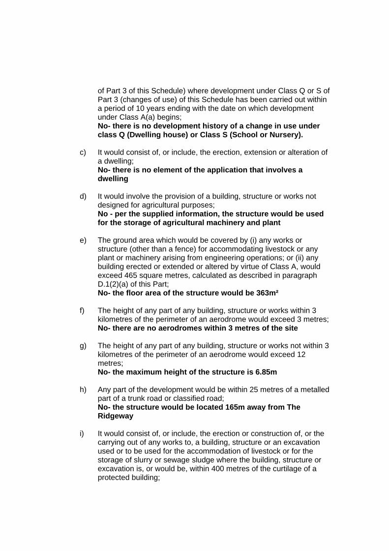
of Part 3 of this Schedule) where development under Class Q or S of Part 3 (changes of use) of this Schedule has been carried out within a period of 10 years ending with the date on which development under Class A(a) begins; No- there is no development history of a change in use under class Q (Dwelling house) or Class S (School or Nursery).
c) It would consist of, or include, the erection, extension or alteration of a dwelling; No- there is no element of the application that involves a dwelling
d) It would involve the provision of a building, structure or works not
designed for agricultural purposes; No - per the supplied information, the structure would be used for the storage of agricultural machinery and plant
e) The ground area which would be covered by (i) any works or
structure (other than a fence) for accommodating livestock or any plant or machinery arising from engineering operations; or (ii) any building erected or extended or altered by virtue of Class A, would exceed 465 square metres, calculated as described in paragraph D.1(2)(a) of this Part; No- the floor area of the structure would be 363m²
f) The height of any part of any building, structure or works within 3
kilometres of the perimeter of an aerodrome would exceed 3 metres; No- there are no aerodromes within 3 metres of the site
g) The height of any part of any building, structure or works not within 3
kilometres of the perimeter of an aerodrome would exceed 12 metres; No- the maximum height of the structure is 6.85m
h) Any part of the development would be within 25 metres of a metalled
part of a trunk road or classified road; No- the structure would be located 165m away from The Ridgeway
i) It would consist of, or include, the erection or construction of, or the
carrying out of any works to, a building, structure or an excavation used or to be used for the accommodation of livestock or for the storage of slurry or sewage sludge where the building, structure or excavation is, or would be, within 400 metres of the curtilage of a protected building;

No- the development would not occur within 400m of a protected building, nor would the above uses occur within the structure
j) It would involve excavations or engineering operations on or over
article 2(4) land which are connected with fish farming; or No- the operations are not connected with fish farming
k) Any building for storing fuel for or waste from a biomass boiler or an
anaerobic digestion system— (i) would be used for storing waste not produced by that boiler or system or for storing fuel not produced on land within the unit; or (ii) is or would be within 400 metres of the curtilage of a protected building. No- site will not be used for the storage of waste, nor within 400 metres of a protected building.
5.6 Having regard to the above, the proposed development would constitute
permitted development under the Town and Country Planning (General Permitted Development) (England) Order 2015, Schedule 2, Part 6, Class A.
5.7 It has been established that the works would be permitted development, an assessment of the siting, design and external appearance of the proposed barn is now required.
6. Siting, design and external appearance
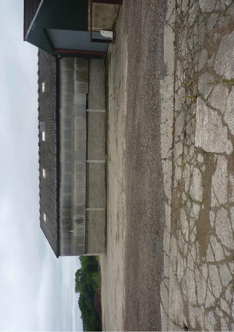
6.1 The proposal is to erect a replacement shed on the site at Beech Barn Farm. Per information and plans supplied, the shed would replace an existing dilapidated structure that was removed from the site within the last 2 years. The shed would have a length of 30m and a depth of 12m with 6.8m wall height, located to match the footprint of the previous building.
6.2 Per council’s aerial imaging records, the site is currently vacant however, aerial mapping from 2015 shows the presence of a shed in the location of, and the dimensions detailed by the supplied plans. In this regard, the description of the application as a replacement structure is seen as being appropriate.
6.3 The subject site is located within the Green Belt and as such, the impact of
any development within the setting of this area must be given due consideration. The proposed structure will be located 160m from The Ridgeway and will be within a complex of 4 larger farm buildings. The shed would be located within an area of existing hardstanding and as such would not result in any further erosion of Green Belt areas. The shed is

also screened from The Ridgeway by a band of trees directly in front of the proposed structure and another band of vegetation along The Ridgeway.
6.4 Farm buildings such as herein proposed are an expected form of development within the wider area by nature of the use of land and the established industry of this area. Within the immediate locale, the development is relatively modest in comparison to the larger surrounding farm buildings and would not be considered dominant or likely to detract from the visual amenity of the area. Given this context and the previous shed that was located on the site and the setback from the road, it is considered that the structure would not be inappropriate within the setting of the site. Overall, no objection is raised with regards to the siting or appearance of the proposed replacement shed.
Recommendation
The proposed replacement shed would constitute permitted development under The Town and Country Planning (General Permitted Development) (England) Order 2015, Schedule 2, Part 6, Class A (as amended). Having due regard to the submitted details, prior approval is not required for the siting, design and external appearance of the proposed agricultural shed

Aerial imaging- 2015

Google aerial photo Beechbarn Farm, The Ridgeway, Enfield, EN2 8AF Stace LLP

Current site aerial imaging


Existing Barn footprint Plan Beechbarn Farm, The Ridgeway, Enfield, EN2 8AF Stace LLP

Roundhedge Hill
Drain
Path (um)
Salmon's Brook
Roundhedge Hill
Issues
Silos
THE RIDGEWAY
Vault Hill
Little Beechhill Wood
Vault Hill Wood
Beechbarn House
101.2m
FB
Pond
A 1005
Pat
h (u
m)
Drain
Track
Track
Dra
in
Boro C
onst and Ward B
dy
1.22m R
H
Def
Boro C
onst and Ward B
dy
1.22m R
H
1.22m F
F
1.22m R
H
Farmhouse
Silo
Warehouse/Store
Store
Store
Crop Drying Shed
Silo
Demolished Barn
Sub-Station
N
Buildings
Sheet No.
DateByDescriptionRev
DateAppr'dDateChkdDateDrawn
Client.
Title.
Dwg No.
Rev.Scale
Surv
BuildingsAH Access HatchAH Arch HeightAL Arch LevelBE BeamBH Beam HeightBHL Beam Head LevelBSL Beam Soffit LevelC-H Cill to HeadCH Ceiling HeightCL Ceiling LevelC-S Cill to SpringDH Door HeightF-C Floor to CillFCH False Ceiling HeightFCL False Ceiling LevelFL Floor LevelGIA Gross Internal AreaHT HeightHR Hose ReelNIA Net Internal AreaRL Roof LevelRad RadiatorRSC Rolled Steel ColumnRSJ Rolled Steel JoistSL SkylightSPH Springer HeightSPL Springer LevelSVP Soil and Vent PipeTHL Threshold LevelWCL Window Cill LevelWHL Window Head LevelWT Wall Top
TopographicB BollardBT British Telecom CoverBM Bench MarkDK Drop KerbEL Electricity CoverEP Electricity Pole
FH Fire HydrantFFP Flagged FootpathG GullyGM Gas MeterGV Gas ValveIC Inspection CoverIL Invert LevelLP Lamp PostMH Man HoleNB Notice BoardP PostPB Post BoxRE Rodding EyeRS Road SignRWP Rain Water PipeSC Stop CockSP Sign PostSS Street Name SignSTP Stand PipeSV Stop ValveTFP Tarmac FootpathTL Traffic Light TP Telegraph PoleUTL Unable To LiftVP Vent PipeWM Water MeterWP Waste Pipe
Fence and WallsRet Retaining WallB/W Barbed WireC/B Close BoardedC/I Corrugated IronC/L Chain LinkC/P Chestnut PalingHR Hand RailI/R Iron RailingLat LatticeP/C Post & ChainP/R Post & RailP/W Post & Wire
Abbreviation & Symbol Key.
NotesDetail shown on plan is from Ordnance Survey data and boundaryinformation supplied to Gleeds by Enfield Council.
95 New Cavendish StreetLondonW1W 6XF
Tel: 020 7631 7000Fax: 020 7631 7001www.gleeds.com
gleedsBuilding Surveying LtdLand, Engineering, Hydrographic and Building Surveying
Enfield CouncilCivic CentreSilver StreetEnfieldEN1 3XA
Ordnance Survey Site PlanBeechbarn FarmThe RidgewayEnfieldEN2 8AF
LNBS0526_BF_OS01
1 of 1
1:2000@A1 0
CC CC 18/04/17 SMc 18/04/17 SMc 18/04/17
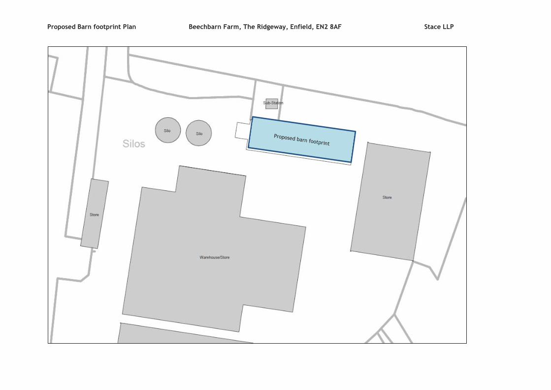
Proposed Barn footprint Plan Beechbarn Farm, The Ridgeway, Enfield, EN2 8AF Stace LLP