london borough of richmond upon thames strategic flood ... · strategic flood risk assessment...
TRANSCRIPT

London Borough of Richmond upon Thames Strategic Flood Risk Assessment (SFRA)
Level 1 Update
August 2010 (Final Report)
London Borough of Richmond upon Thames Civic Centre
44 York Street Twickenham
TW1 3BZ

London Borough of Richmond upon Thames STRATEGIC FLOOD RISK ASSESSMENT (SFRA) Level 1
August 2010 (FINAL) i
Document title London Borough of Richmond upon Thames Strategic Flood Risk Assessment Level 1 SFRA (update to June 2008 version)
Document short title Level 1 SFRA (Update) Status Final Report Date August 2010 Issue and Revision Record
Revision: 0 1 2 Final Version Date: March 2010 June 2010 July 2010 August 2010 Originator:
Andrea Kitzberger, Principal Planning Policy Officer, LBRuT
Approved by:
Justine Glynn, Development Control Technical Specialist (Environment Agency)
LBRuT does not accept any responsibility or liability for the consequence of this document being used for a purpose other than the purposes for which it is intended. This report is based on information supplied by other parties, therefore LBRuT accepts no liability for any loss or damage suffered by clients, planning applicants and developers stemming from any conclusions based on data contained within this report.

London Borough of Richmond upon Thames STRATEGIC FLOOD RISK ASSESSMENT (SFRA) Level 1
August 2010 (FINAL) ii
UPDATE OF THE LONDON BOROUGH OF RICHMOND UPON THAMES LEVEL 1 SFRA SUMMARY OF MAIN CHANGES In June 2008, Jacobs completed the London Borough of Richmond upon Thames Level 1 Strategic Flood Risk Assessment (SFRA), referred to hereafter as the 2008 SFRA. The 2008 SFRA provided a robust assessment of flood risk across the Borough. The main outputs from the study were a set of maps and GIS data delineating fluvial and tidal flood zones to meet the requirements of Planning Policy Statement 25: Development and Flood Risk. In August 2010, the London Borough of Richmond upon Thames updated the SFRA and this SFRA Update supersedes the 2008 SFRA. The update was necessary for the following reasons:
- a revised PPS25 was published in March 2010, replacing the earlier version of PPS25 published in 2006
- the PPS25 Practice Guide Companion was published in June 2008 and has since been replaced by a December 2009 version
- the Environment Agency has commissioned a number of new modelling studies that supersede those used for the original SFRA
- the Environment Agency has published in 2009 Areas Susceptible to Surface Water Flooding
- the Environment Agency has published the Thames Catchment Flood Management Plan in July 2008 and the Thames Estuary 2100 Plan in 2010
- the Council has adopted it’s LDF Core Strategy in April 2009, and the Development Management DPD will be submitted to Government in autumn 2010
- the Mayor of London has published the London Plan (Consolidated with Alterations since 2004) in February 2008; the draft replacement London Plan (2009) has also been published
- the Regional Flood Risk Appraisal has been published (October 2009) - the Flood Risk Regulations 2009 have been enacted - the Flood and Water Management Act 2010 has been enacted
The update reflects the intention announced in the original version of the SFRA (June 2008) to review and update the SFRA on a regular basis as it is a Living Document. Therefore, this updated version reflects new existing knowledge of flood risk within the Borough and amendments to national, regional and local guidance and policy. The approach to this update is explained in the paragraphs A to F below. Many of the amendments made are of relatively minor nature and it would not be appropriate or helpful to list every single change. However attention is drawn to the following more substantial changes from the June 2008 version: A. Chapter 2 – Introduction: updated in line with published Thames Catchment Flood
Management Plan, draft Lower Thames Strategy, draft Thames Estuary 2100 and adopted Core Strategy.
B. Chapter 4 – Policy Framework:
- Update to PPS25 - Update to PPS25 Practice Guide - Update to Supplement to PPS1: Planning and Climate Change - Update in line with adopted London Plan (2008) - Insert section on the consultation of the draft replacement plan of the London Plan
(2009) - Update in line with adopted Regional Flood Risk Appraisal (2009) - Update on Local Planning Policy in line with adopted Core Strategy and draft version
of Development Management DPD (January 2010) - Chapter 5 – Data Collection

London Borough of Richmond upon Thames STRATEGIC FLOOD RISK ASSESSMENT (SFRA) Level 1
August 2010 (FINAL) iii
C. Chapter 5 – Data Collection: insert information about areas in the Borough that are further than 20 metres away from the main River Thames
D. Chapter 6 – Flood Risk in Richmond:
- Clarification on redevelopment in zone 3b Functional Floodplain (requirement to
reduce risk) - Sub-chapter on surface water flooding (including SWMP information and Areas
Susceptible to Surface Water Flooding) - Sub-chapter on sewer flooding - Update on Climate Change section with regard to UK Climate Projections (2009) - Update on Life of Development, in line with published PPS25 Practice Guide
E. Chapter 7 – Sustainable Management of Flood Risk:
- Update on Lead Local Flood Authority - Update to Thames Catchment Flood Management Plan - Updated information regarding Lower Thames Strategy - Update to Thames Estuary 2100 Strategy - Update to Planning & Development Control, in particular regarding Sequential Test,
requirements for Flood Risk Assessment in Flood Zone 1, and Spatial Planning & Development Control Recommendations (table)
- Update to Character Areas, particularly regarding Eel Pie Island and Teddington area, in line with updated flood maps, including update on localised drainage issues
- Update on requirements for detailed Flood Risk Assessments - Update to Basements - Update of Sustainable Drainage Systems section, particularly with regard to drainage
hierarchy - Update of Local Community Actions to Reduce Flood Damage, particularly with
regard to designing for flood risk, including flood resistance and resilience and Flood Warning and Evacuation Plans
- Update to Emergency Planning section - Update on Insurance
F. Appendix C – inclusion of an assessment of flood hazard for the Beverley Brook G. Appendix F – removal of Delineation of Function Floodplain Zone 3b for Beverley Brook
Catchment, insert UK Climate Projections 2009 H. Appendix G – insert town centre boundaries and sequential test maps
The next stage is the Level 2 SFRA, which is a more detailed assessment of flood risk. This detailed assessment will be done in places that are at risk of flooding (as shown in the SFRA Level 1) and where there are pressures for new development (see Section Conclusion & Recommendations for further information on the Level 2 SFRA).

London Borough of Richmond upon Thames STRATEGIC FLOOD RISK ASSESSMENT (SFRA) Level 1
August 2010 (FINAL) iv
EXECUTIVE SUMMARY
Introduction
1. A large proportion of the borough is situated in proximity to the River Thames and its tributaries, and not surprisingly therefore a relatively large number of properties within the borough are potentially at risk of flooding from rivers.
2. The River Thames within this Borough extends from Barnes to Hampton Court (upstream
of Teddington Weir). Teddington Weir represents (formally) the tidal extent of the River Thames, and therefore the Borough is at risk from both fluvial (river) and tidal flooding.
3. Downstream of Teddington Weir, the Borough is protected against flooding from the River
Thames by the Thames Tidal Defence (TTD) system. The TTD provides protection against flooding through a combination of raised flood defences, flood proofing to riverside properties, and the Thames Barrier. Currently the TTD provides the following standard of protection within the Borough of Richmond:
A 1 in 1000 year standard of protection (SoP) against a combined tidal and
fluvial flooding event from Richmond downstream (i.e. towards the City of London) (with the exception of Eel Pie Island).
A progressively decreasing SoP against a combined tidal and fluvial flooding event event from Richmond upstream (i.e. towards Teddington). The new tidal modelling carried out by the Environment Agency suggests the SoP currently decreases to somewhat less than 1 in 100 years at Teddington, and that this will decrease with time to between 1 in 20 and 50 years by the end of the century.
A 1 in 1000 year SoP against tidal flooding only between Richmond and Teddington.
It is noted that a ‘combined’ event will be observed when an unusually high tide happens to coincide with particularly high river levels due to prolonged rainfall in the upper catchment.
4. It is important to recognise however that the probability of fluvial flooding (alone) from the
River Thames within the Borough upstream of Teddington is somewhat higher than from tidal flooding. In simple terms, this means that river levels as a result of prolonged heavy rainfall within the upper catchment (including Oxfordshire and Gloucestershire as seen during the summer 2007 event) will be higher, and occur more frequently, than the combined tidal and fluvial event described above. For this reason, the standard of protection provided to property upstream of Teddington is closer to 1 in 100 years.
5. The River Crane, the Duke of Northumberland River and the Beverley Brook, tributaries
of the River Thames, also pose a risk of flooding to properties within the Borough. The River Crane and Duke of Northumberland River are situated on the west bank of the River Thames, and whilst they flow through a relatively well defined waterway corridor, the rivers have been heavily constrained and modified by urban development over the centuries. Properties situated adjacent to the River Crane and Duke of Northumberland River are potentially at risk of fluvial flooding. Areas adjacent to the River Crane and Duke of Northumberland may also be at risk of flooding when tide-locked (“normal” fluvial flows can build up behind the tidal gates when tides are higher than normal).
6. The Beverley Brook is situated on the east bank of the River Thames. Its waterway
corridor is less well defined, however once again urban development has encroached into the natural floodplain over the years. Consequently, properties situated within the vicinity of the river channel may be at risk of flooding from the Brook during periods of extreme rainfall.

London Borough of Richmond upon Thames STRATEGIC FLOOD RISK ASSESSMENT (SFRA) Level 1
August 2010 (FINAL) v
7. It should be remembered that the risk of river and tidal flooding can be expected to increase as a result of climate change. Within the Borough of Richmond, the current understanding of the flooding regime appears to indicate that the increase in the number of properties potentially at risk of flooding in 2010 as a result of climate change is relatively small. Rather, those properties that are currently at risk can expect to be affected by flooding more frequently, and to a greater severity. It is therefore important that the Council has a clear policy in place to deal with the potential impacts of climate change, both for those properties that are currently affected by flooding, and for those that may be at risk in future years. Clear recommendations have been provided accordingly, highlighting the importance of sustainable design techniques to mitigate the potential risk of flooding not only within Zone 3a High Probability, but also within Zone 2 Medium Probability (i.e. encompassing those areas that are likely to be a ‘high’ risk in future generations).
8. It is important to highlight that river and tidal flooding are not the only sources of flood risk
within the Borough. Richmond Borough is very susceptible to surface water flooding, as recent events showed, such as the summer 2007 flooding, A series of localised flooding issues have been identified through consultation with the Council and the Environment Agency. The information source of these localised issues is generally unknown, and most stem from phone calls received by the public in response to a local problem that they have observed. It is envisaged that the localised flooding incidents that have been reported will typically be as a result of blocked gullies and/or culverts, sewer flooding or surface water flooding. The latter is known to be a concern within the Borough, particularly within areas situated at the base of steep escarpments (e.g. at the foot of Richmond Park) where runoff drains downhill very quickly during heavy rains, and the local drainage system is unable to cope.
9. PPS25 advocates a sequential approach to the allocation of land for future development,
steering development towards areas of lowest risk. This is based heavily upon the PPS25 flood zones however, and these are defined largely on the basis of tidal and fluvial (river) flood risk. It is essential that the Council do not disregard the potential risk of flooding from other sources, and that their local policy advocates the importance of sustainable design techniques to minimise the potential impact that these may have upon future development. Conversely, future development may exacerbate localised problems of this nature. Careful design through, for example, the incorporation of sustainable drainage systems (SUDS), can ensure that this does not happen, and may provide other benefits (e.g. a reduction in on site water demand).
10. Approximately 21,300 of the Borough’s 100,665 properties are located within flood zone
2, approximately 15,200 properties within flood zone 3 and around 1,000 properties in the functional floodplain1. Flooding represents a risk to both property and life. It is essential therefore that planning decisions are informed, and take due consideration of the risk posed to (and by) future development by flooding. It is worth noting that 95% of the damages sustained by a residential property as a result of flooding occurs within the first 9 inches of water. Furthermore, whilst the average burglary results in a financial loss of £900, the average financial loss to a family as a result of flooding is £28,000.
Why carry out a Strategic Flood Risk Assessment (SFRA)?
11. Flooding can result not only in costly damage to property, but can also pose a risk to life
and livelihood. It is essential that future development is planned carefully, steering it away from areas that are most at risk from flooding, and ensuring that it does not exacerbate existing known flooding problems.
1 Analysis by overlaying Borough’s LLPG records with EA flood maps (February 2010)

London Borough of Richmond upon Thames STRATEGIC FLOOD RISK ASSESSMENT (SFRA) Level 1
August 2010 (FINAL) vi
12. Planning Policy Statement (PPS) 25: Development and Flood Risk has been developed to underpin decisions relating to future development (including urban regeneration) within areas that are subject to flood risk. In simple terms, PPS25 requires local planning authorities to review the variation in flood risk across their district, and to steer vulnerable development (e.g. housing) towards areas of lowest risk. Where this cannot be achieved and development is to be permitted in areas that may be subject to some degree of flood risk, PPS25 requires the Council to demonstrate that there are sustainable mitigation solutions available that will ensure that the risk to property and life is minimised (throughout the lifetime of the development) should flooding occur.
13. The Strategic Flood Risk Assessment (SFRA) is the first step in this process, and it
provides the building blocks upon which the Council’s planning and development control decisions will be made.
What is a Strategic Flood Risk Assessment (SFRA)? 14. The London Borough of Richmond upon Thames Strategic Flood Risk Assessment
(SFRA) has been carried out to meet the following key objectives:
To collate all known sources of flooding, including river, surface water (local drainage), sewers and groundwater, that may affect existing and/or future development within the Borough;
To delineate areas that have a ‘low’, ‘medium’ and ‘high’ probability of flooding within the Borough, in accordance with Planning Policy Statement 25 (PPS25), and to map these:
- Areas of ‘high’ probability of flooding are assessed as having a 1 in 100
(1%) or greater chance of fluvial flooding, or 1 in 200 (0.5%) or greater chance of tidal flooding, in any year, and are referred to as Zone 3a High Probability;
- Areas of ‘medium’ probability of flooding are assessed as having between a 1 in 100 fluvial, or 1 in 200 tidal, and 1 in 1000 chance of flooding (1% to 0.1%) in any year, and are referred to as Zone 2 Medium Probability;
- Areas of ‘low’ probability of flooding are assessed as having a less than 1 in 1000 chance of flooding (<0.1%) in any year, and are referred to as Zone 1 Low Probability.
Within flood affected areas, to recommend appropriate land uses (in accordance with the PPS25 Sequential Test) that will not unduly place people or property at risk of flooding
Where flood risk has been identified as a potential constraint to future development, recommend possible flood mitigation solutions that may be integrated into the design (by the developer) to minimise the risk to property and life should a flood occur (in accordance with the PPS25 Exception Test).
The Sequential Test
15. The primary objective of PPS25 is to steer vulnerable development towards areas of
lowest flood risk. PPS25 advocates a sequential approach that will guide the planning decision making process (i.e. the allocation of sites). In simple terms, this requires planners to seek to allocate sites for future development within areas of lowest flood risk in the initial instance. Only if it can be demonstrated that there are no suitable sites within these areas should alternative sites (i.e. within areas that may potentially be at risk of flooding) be contemplated. This is referred to as the Sequential Test.
16. As an integral part of the sequential approach, PPS25 stipulates permissible development
types. This considers both the degree of flood risk posed to the site, and the likely vulnerability of the proposed development to damage (and indeed the risk to the lives of the site tenants) should a flood occur.

London Borough of Richmond upon Thames STRATEGIC FLOOD RISK ASSESSMENT (SFRA) Level 1
August 2010 (FINAL) vii
17. The PPS25 Sequential Test is summarised in Figure 4.1 of the PPS25 Practice Guide 2009). The London Borough of Richmond upon Thames has recently adopted its own Sequential Test approach for properties in and around town centres. See the section on Sequential Test within chapter 7.4.1 on Planning Solutions to Flood Risk Management.
The Exception Test
18. Many towns within England are situated adjacent to rivers and are at risk of flooding. The
future sustainability of these communities relies heavily upon their ability to grow and prosper. PPS25 recognises that in some Boroughs, including the London Borough of Richmond, restricting residential development from areas designated as Zone 3a High Probability may compromise the viability of existing communities within the Borough.
19. For this reason, PPS25 provides an Exception Test. Where a local planning authority has
identified that there is a strong planning based argument for a development to proceed that does not meet the requirements of the Sequential Test, it will be necessary for the Council to demonstrate that the Exception Test can be satisfied.
20. For the Exception Test to be passed it must be demonstrated that:
“…the development provides wider sustainability benefits to the community that
outweigh flood risk, informed by a SFRA where one has been prepared. If the DPD has reached the ‘submission’ stage – see Figure 4 of PPS12: Local Development Frameworks – the benefits of the development should contribute to the Core Strategy’s Sustainability Appraisal;
the development should be on developable2, previously-developed land or, if it is not on previously developed land3, that there are no reasonable alternative sites on previously-developed land; and
a FRA must demonstrate that the development will be safe, without increasing flood risk elsewhere, and, where possible, will reduce flood risk overall.”
Outcomes of the Richmond Borough SFRA
21. The Borough of Richmond upon Thames has been delineated into zones of low, medium
and high probability of flooding, based upon existing available information provided by the Environment Agency. Detailed flood risk mapping has been made available for the River Thames, the River Crane, the Duke of Northumberland River, the Beverley Brook and the Environment Agency Flood Zone Maps (January 2010) have been adopted as the basis for the SFRA for other watercourses.
Zone 3b (Functional Floodplain)
22. Areas subject to flooding up to (and including) the 5% (1 in 20 year) event have been
delineated. In accordance with the principles set out in the PPS25 Practice Guide (2009) these areas have been sub-delineated on the basis of current land use, i.e. open space as ‘Zone 3b Functional Floodplain’ versus areas that are currently developed.
23. The latter areas are subject to relatively frequent flooding and maybe to fast flowing
and/or deep water. Notwithstanding this however, PPS25 recognises the importance of pragmatic planning solutions that will not unnecessarily ‘blight’ areas of existing urban development. To this end, whilst it may be impractical to refuse all future development within existing urban areas falling within Zone 3b, careful consideration must be given to future sustainability. A suite of dedicated planning policies has been developed accordingly. These areas have been designated as Zone 3b (Developed Land).
2 Developable sites are defined in Planning Policy Statement 3 (PPS3) Housing as those sites which should be in a suitable location for housing development and there should be a reasonable prospect that the site is available for, and could be developed at the point envisaged. 3 Previously-developed land definition (commonly known as Brownfield Land). See Annex B of Planning Policy Statement 3 Housing.

London Borough of Richmond upon Thames STRATEGIC FLOOD RISK ASSESSMENT (SFRA) Level 1
August 2010 (FINAL) viii
Zone 3a High Probability
24. Areas subject to flooding up to (and including) the 1% (1 in 100 year) fluvial, or 0.5% (1 in 200 year) tidal, event (i.e. Zone 3a High Probability) have been identified. ’More vulnerable’ development (including, for example, residential) should be avoided in these areas.
25. It is important to recognise that the delineation of Zone 3a encompasses those areas that
are protected against flooding through the presence of flood defences (including the Thames Tidal Defences). The ‘actual’ risk of flooding to property is clearly reduced within these defended areas, however where the defences are engineering structures that are raised above ground level, there remains a residual risk of sudden collapse. Spatial planning and development control decisions should be taken accordingly, and to this end Zone 3a High Probability has been sub-delineated into zones of ’hazard’ (reviewing the potential risk to life), considering the impact of a failure of the River Thames defences. This is discussed further in Section 6.3 below.
26. To meet the requirements of the Exception Test, it will be necessary for the Council to
demonstrate that the development provides wider sustainability benefits to the community that outweigh flood risk. The Council must also demonstrate that the development is on developable, previously developed land or if it is not on previously developed land, that there are no reasonable alternative sites on previously developed land.
27. The SFRA has outlined specific development control recommendations that should be
placed upon development within Zone 3a High Probability to minimise both the damage to property, and the risk to life in case of flooding. It is essential that the developer carries out a detailed Flood Risk Assessment to consider the site-based constraints that flooding may place upon the proposed development.
Zone 2 Medium Probability
28. Areas subject to flooding in events exceeding the 100 year fluvial (or 200 year tidal)
event, and up to (and including) once in every 1000 years on average (i.e. Zone 2 Medium Probability) have been identified. ’Highly vulnerable’ development (including, for example, emergency services and basement dwellings) should be avoided in these areas. There are generally no other restrictions placed upon land use within these areas, however it is important to ensure that the developer takes account of possible climate change impacts to avoid a possible increase in the risk of flooding in future years (achieved through completion of a simple Flood Risk Assessment). Zone 1 Low Probability
29. There are no restrictions placed on land use within Zone 1 Low Probability (i.e. all
remaining areas of the Borough) by PPS25. It is important to recognise however that those areas affected by flooding within the Greater London area in recent years have often fallen within Zone 1. It is essential therefore that the Council establish robust local planning policy that addresses those issues not captured by PPS25 through the delineation of fluvial flood zones. Consideration must be given to the potential risk of flooding from other sources (outlined in ‘Localised Flooding Issues’ below), ensuring that future development is not inadvertently placed at risk. It is also essential to ensure that future development does not exacerbate the current risk posed to existing homes and businesses.

London Borough of Richmond upon Thames STRATEGIC FLOOD RISK ASSESSMENT (SFRA) Level 1
August 2010 (FINAL) ix
Localised Flooding Issues
30. In addition to fluvial (river) flooding, properties and infrastructure within the Borough of Richmond are also at risk of flooding from other, more localised, sources. Some parts of this Borough are susceptible to surface water flooding and the Environment Agency’s map showing areas susceptible to surface water flooding is presented in Figure G. Localised flooding issues also include groundwater flooding, the surcharging of the underground sewer system and the blockage of culverts and gullies (which results in overland flow). Evidence of historical flooding of this nature has been captured through discussions with the Environment Agency and the Council, and these are presented in Figures 1 to 11. It is important to recognise that these are not a measure of ‘risk’, but rather problems that have occurred due to a particular set of local circumstances in the past (for example, the blockage of a local gully inlet). These may or may not reoccur in future years.
31. PPS25 does not address localised drainage issues within its delineation of flood zones
and what development is acceptable within them. It is difficult to predict the likelihood and anticipated severity of localised flooding. Local drainage related problems are generally very localised, and relate to historical incidents, the source of which is often somewhat uncertain. Incidents of this nature will often be as a result of ‘on the ground’ conditions on any particular day (e.g. litter or leaves on the road may exacerbate a problem). Observed flooding can certainly be captured, however not surprisingly these are generally within areas of existing development. Within other areas of the Borough, topography and geology can be interrogated in an effort to highlight areas that may be most susceptible to groundwater flooding and/or flash flooding following periods of particularly intense rainfall. Topographic and geological maps of the Borough are provided as Figures A and B.
32. From a spatial planning perspective therefore, local drainage issues should not affect
decision making with respect to the allocation (or otherwise) of sites within Richmond Borough and it is considered unreasonable to restrict future development within areas that may have suffered a localised flooding incident in years past. It is essential however not to overlook the potential risk of localised flooding during the design process. Whilst the incidents that have been identified will typically not result in widespread damage or disruption, a proactive approach to risk reduction through design can mitigate the potential for damage, both to the development itself and elsewhere. Specific development control recommendations have been provided accordingly.
33. The implementation of sustainable drainage systems (SUDS) must be ensured and
careful consideration to overland flow routes (and avoidance of their obstruction), as part of the site design, should be encouraged.
34. Thames Water was approached for information regarding flooding arising from the
surcharging and blockage of surface and foul water sewers. This data, known as DG5 flooding data, is subject to confidentially issues and specific incidences where individual properties were affected cannot be divulged. However, Thames Water is allowed to detail how many properties have been subject to DG5 flooding per postcode area (the first four digits of the postcode are provided only). These are reflected indirectly within Figure 1 to 10.

London Borough of Richmond upon Thames STRATEGIC FLOOD RISK ASSESSMENT (SFRA) Level 1
August 2010 (FINAL) x
A Proactive Approach – Reduction in Flood Risk
35. It is crucial to recognise that PPS25 considers not only the risk of flooding posed to new development. It also seeks to positively reduce the risk of flooding posed to existing properties within the Borough. It is strongly recommended that this principle be adopted as the underlying ‘goal’ for developers and Council development control teams within Richmond Borough.
36. Developers should be encouraged to demonstrate that their proposal will deliver a
positive reduction in flood risk to the Borough, whether that be by reducing the frequency or severity of flooding (for example, through the introduction of SUDS), or by reducing the impact that flooding may have on the community (for example, through a reduction in the number of people within the site that may be at risk). This should be reflected through the inclusion of a positive statement within the detailed FRA that clearly and concisely summarised how this reduction in flood risk will be delivered.
The Way Forward
37. A considerable proportion of the Borough of Richmond is at risk of flooding. The risk of flooding posed to properties within the Borough arises from a number of sources including river flooding, localised runoff, sewer and groundwater flooding.
38. A planning solution to flood risk management should be sought wherever possible,
steering vulnerable development away from areas affected by flooding in accordance with the PPS25 Sequential Test. Specific planning recommendations have been provided for all urban centres within the Borough.
39. Following application of the Sequential Test, and the decision to proceed with
development in areas at risk of flooding due to other planning constraints (that outweigh flood risk), it will be necessary for the Exception Test to be applied. Specific recommendations have been provided to assist the Council and the developer to meet the Exception Test. These could be applied as development control recommendations for all future development.
40. Council policy is essential to ensure that the recommended development control
recommendations can be imposed consistently at the planning application stage. This is essential to achieve future sustainability within the Borough with respect to flood risk management. Current policy has been reviewed in light of the findings and recommendations of the 2008 Richmond Borough SFRA.
41. Emergency planning is imperative to minimise the risk to life posed by flooding within the
Borough. It is recommended that the Council advises the Local Resilience Forum of the risks raised in light of the Richmond Borough SFRA, ensuring that the planning for future emergency response can be reviewed accordingly.
A Living Document
42. The Richmond Borough SFRA has been developed in accordance with PPS25. The
SFRA has been developed building heavily upon existing knowledge with respect to flood risk within the Borough. The Environment Agency regularly review and update their Flood Zone Maps (on a quarterly basis) and has a rolling programme of detailed flood risk mapping. This will improve the current knowledge of flood risk within the Borough, and may marginally alter predicted flood extents. This may therefore influence future development control decisions within these areas.
43. It is recommended that the Richmond Borough SFRA is reviewed on a regular basis. A
series of key questions to be challenged as part of the SFRA review process are set out in Section 8 of this document, providing the basis by which the need for a detailed review of the document should be triggered.

London Borough of Richmond upon Thames STRATEGIC FLOOD RISK ASSESSMENT (SFRA) Level 1
August 2010 (FINAL) xi
Table of Contents 1 Why and how this update was prepared........................................................................... 1 2 Introduction ....................................................................................................................... 2
2.1 Overview .................................................................................................................. 2 2.2 Future Development in Richmond............................................................................ 3
3 SFRA Approach ................................................................................................................ 4 4 Policy Framework ............................................................................................................. 6
4.1 Introduction............................................................................................................... 6 4.2 National Policy.......................................................................................................... 6
4.2.1 Planning Policy Statement 25: Development and Flood Risk ......................... 6 4.2.2 Supplement to Planning Policy Statement 1: Planning and Climate Change . 7
4.3 Regional Planning Policy ......................................................................................... 7 4.3.1 The London Plan ............................................................................................. 7 4.3.2 Consultation draft replacement plan of the London Plan ................................ 8 4.3.3 Regional Flood Risk Appraisal ........................................................................ 9 4.3.4 Supplementary Planning Guidance – Sustainable Design & Construction... 10
4.4 Local Planning Policy ............................................................................................. 10 4.4.1 London Borough of Richmond upon Thames LDF Core Strategy (Adopted April 2009)....................................................................................................................... 10 4.4.2 London Borough of Richmond upon Thames UPD (Adopted March 2005).. 10 4.4.3 London Borough of Richmond upon Thames Pre-submission Development Management DPD (January 2010) ................................................................................. 11
5 Data Collection................................................................................................................ 14 5.1 Overview ................................................................................................................ 14 5.2 Environment Agency Flood Zone Maps................................................................. 14 5.3 Historical Flooding.................................................................................................. 14 5.4 Detailed Hydraulic Modelling.................................................................................. 15 5.5 Flood Defences ...................................................................................................... 15 5.6 Consultation ........................................................................................................... 16 5.7 Topography & Geology .......................................................................................... 17
6 Flood Risk in Richmond.................................................................................................. 19 6.1 Overview ................................................................................................................ 19 6.2 Fluvial and Tidal Flooding - Delineation of the PPS25 Flood Zones ..................... 20
6.2.1 Delineation of Zone 3b Functional Floodplain............................................... 21 6.2.2 Delineation of Zone 3a High Probability ........................................................ 22 6.2.3 Delineation of Zone 2 Medium Probability..................................................... 22 6.2.4 Delineation of Zone 1 Low Probability........................................................... 22
6.3 Assessment of Risk to Life (Flood Hazard)............................................................ 22 6.4 Surface water flooding ........................................................................................... 24
6.4.1 Areas Susceptible to Surface Water Flooding............................................... 24 6.5 Local Drainage Issues............................................................................................ 25 6.6 Groundwater Issues ............................................................................................... 26 6.7 Sewer flooding........................................................................................................ 26 6.8 Climate Change...................................................................................................... 27 6.9 Residual Risk of Flooding ...................................................................................... 29
7 Sustainable Management of Flood Risk ......................................................................... 30 7.1 Overview ................................................................................................................ 30 7.2 Responsibility for Flood Risk Management............................................................ 30 7.3 Strategic Flood Risk Management - The Environment Agency ............................. 31
7.3.1 Overview........................................................................................................ 31 7.3.2 Thames Catchment Flood Management Plan (CFMP) ................................. 31 7.3.3 Lower Thames Strategy ................................................................................ 32 7.3.4 Thames 2100 Plan (TE2100) ........................................................................ 33 7.3.5 Beverley Brook Flood Risk Management Strategy ....................................... 34
7.4 Planning & Development Control – Richmond upon Thames ............................... 35 7.4.1 Planning Solutions to Flood Risk Management ............................................ 35 7.4.2 A Proactive Approach – Positive Reduction of Flood Risk through Development................................................................................................................... 37 7.4.3 Localised Flood Risk within the Planning Process........................................ 38 7.4.4 Spatial Planning and Development Control Recommendations ................... 39

London Borough of Richmond upon Thames STRATEGIC FLOOD RISK ASSESSMENT (SFRA) Level 1
August 2010 (FINAL) xii
7.5 SFRA Interpretation................................................................................................ 40 7.5.1 Character Area R1 – Barnes (Figure 1) ........................................................ 40 7.5.2 Character Area R2 – East Sheen and Mortlake (Figure 2) ........................... 41 7.5.3 Character Area R3 – Kew & North Sheen (Figure 3) .................................... 42 7.5.4 Character Area R4 – Richmond Town (Figure 4).......................................... 42 7.5.5 Character Area R5 – Twickenham, Eel Pie Island & St Margarets (Figure 5) 42 7.5.6 Character Area R6 – Strawberry Hill & Teddington Lock (Figure 6) ............. 43 7.5.7 Character Area R7 – Teddington South, Trowlock Island & Hampton Wick (Figure 7) 44 7.5.8 Character Area R8 – Hampton Court Park (Figure 8)................................... 45 7.5.9 Character Area R9 – Hampton, Taggs Island & Platt’s Eyot (Figure 9)........ 45 7.5.10 Character Area R10 – Twickenham & Whitton (Figure 10)........................... 45 7.5.11 Character Area R11 – Richmond Park (Figure 11) ....................................... 45
7.6 Detailed Flood Risk Assessment (FRA) – The Developer..................................... 46 7.6.1 Scope of the Detailed Flood Risk Assessment ............................................. 46 7.6.2 Raised Floor Levels (Freeboard)................................................................... 48 7.6.3 Basements..................................................................................................... 48 7.6.4 Sustainable Drainage Systems (SUDS)........................................................ 49
7.7 Local Community Actions to Reduce Flood Damage ............................................ 51 7.7.1 Designing for Flood Risk ............................................................................... 51 7.7.2 Flood Warning and Evacuation Plans ........................................................... 52
7.8 Emergency Planning .............................................................................................. 53 7.9 Insurance................................................................................................................ 55
8 Conclusion & Recommendations.................................................................................... 56 8.1 Level 2 SFRA ......................................................................................................... 56 8.2 A Living Document ................................................................................................. 57
Appendices A Assessment of Risk to Life B Breach Modelling Methodology C Assessment of Flood Hazard (Raised River Thames Defences – Kew to Barnes) D SFRA User Guide E Safe Access & Egress Design Requirements F UK Climate Projections (Precipitation) 2009 G Sequential Test and town centre boundaries Figures 1 Character Area R1 – Barnes 2 Character Area R2 – East Sheen & Mortlake 3 Character Area R3 – Kew & North Sheen 4 Character Area R4 – Richmond Town 5 Character Area R5 – Twickenham, Eel Pie Island & St Margarets 6 Character Area R6 – Strawberry Hill & Teddington Lock 7 Character Area R7 – Teddington South, Trowlock Island & Hampton Wick 8 Character Area R8 – Hampton Court Park 9 Character Area R9 – Hampton, Taggs Island & Platt’s Eyot 10 Character Area R10 – Twickenham & Whitton 11 Character Area R11 – Richmond Park A Topography B Geology C-1 Flood Hazard – River Thames (Kew to Barnes) C-2 Flood Hazard – Beverley Brook D Areas Benefitting from Defences and Groundwater flooding incidents E Impacts of Climate Change F Depths of Flooding along Key Routes G Areas susceptible to surface water flooding

London Borough of Richmond upon Thames STRATEGIC FLOOD RISK ASSESSMENT (SFRA) Level 1
August 2010 (FINAL) 1
Glossary and Abbreviations/Acronyms
AEP Annual Exceedance Probability e.g. 1% AEP is equivalent to 1% probability of occurring in any one year (or, on average, once in every 100 years)
Core Strategy
The Development Plan Document within the Council’s Local Development Framework, which sets the long-term vision and objectives for the area. It contains a set of strategic policies that are required to deliver the vision including the broad approach to development.
DCLG Department of Community and Local Government
Defra Department of Environment, Food and Rural Affairs
Development The carrying out of building, engineering, mining or other operations, in, on, over or under land, or the making of any material change in the use of a building or other land.
Development Plan Document (DPD)
A spatial planning document within the Council’s Local Development Framework, which set out policies for development and the use of land. Together with the Regional Spatial Strategy (in this instance The London Plan), they form the development plan for the area. They are subject to independent examination.
EA Environment Agency
Flood Zone Map Nationally consistent delineation of ‘high’ and ‘medium’ flood risk, published on a quarterly basis by the Environment Agency
Fluvial Flooding caused by rivers
Formal Flood Defence A structure built and maintained specifically for flood defence purposes
Freeboard The difference between the flood defence level and the design flood level; it is also an allowance for uncertainty in estimating flood levels, and for potential wave action as a result of for example vehicles driving through flood water
Greenfield land Land that has not been previously developed (also see Previously Developed land definition)
Habitable Room
A room used as living accommodation within a dwelling but excludes bathrooms, toilets, halls, landings or rooms that are only capable of being used for storage. All other rooms, such as kitchens, living rooms, bedrooms, utility rooms and studies are counted.
Informal Flood Defence
A structure that provides a flood defence function, however has not been built and/or maintained for this purpose (e.g. boundary wall)
Local Development Framework (LDF)
Consists of a number of documents which together form the spatial strategy for development and the use of land for a local authority
Major development
A major development is: a) where the number of dwellings to be provided is ten or more, or the site areas is 0.5ha or more, ore b) non-residential development, where the floorspace to be provided is 1000m2 or more, or the site area is 1ha or more

London Borough of Richmond upon Thames STRATEGIC FLOOD RISK ASSESSMENT (SFRA) Level 1
August 2010 (FINAL) 2
Planning Policy Guidance (PPG)
A series of notes issued by the Government, setting out policy guidance on different aspects of planning. They will be replaced by Planning Policy Statements.
Planning Policy Statement (PPS)
A series of statements issues by central Government, setting out policy guidance on different aspects of planning. They replace Planning Policy Guidance Notes
Pluvial Flooding caused by rain
PPG25 Planning Policy Guidance 25: Development and Flood Risk Office of the Deputy Prime Minister (ODPM), 2001
PPS25 Planning Policy Statement 25: Development and Flood Risk Department of Community & Local Government, 2006
Previously Developed (Brownfield) Land
Land which is or was occupied by a building (excluding those used for agriculture and forestry). It also includes land within the curtilage of the building, for example, a house and its garden would be considered to be previously developed land (also see Greenfield Land definition)
Residual Risk The risk which remains after all risk avoidance, reduction and mitigation measures have been implemented
Resilience Constructing the building in such a way that although flood water may enter the building, its impact is minimised, structural integrity is maintained and repair, drying and cleaning are facilitated
Resistance Construction the building in such a way as to prevent flood water entering the building or damaging its fabric. This has the same meaning as flood proof.
Run-off The flow of water from an area caused by rainfall
SEA Strategic Environmental Assessment: European Community Directive on the assessment of the effects of certain plans and programmes on the environment
Standard of Protection (SOP)
The design event or standard to which a building, asset or area is protected against flooding, generally expressed as an annual exceedence probability.
SUDS Sustainable Drainage System: A sequence of management practices and control structures, often referred to as SUDS, designed to drain water in a more sustainable manner than some conventional techniques.
Supplementary Planning Document (SPD)
Provides supplementary guidance to policies and proposals contained within Development Plan Documents. They are not subject to independent examination but to rigorous procedures of community involvement and Sustainability Appraisal. SPDs form part of the LDF and the planning framework.
Sustainability Appraisal (SA)
An integral part of the plan-making process which seeks to appraise the economic, social and environmental effects of a plan in order to inform decision-making that aligns with sustainable development principles
Sustainable Development
Development that meets the needs of the present without compromising the ability of future generations to meet their own needs” (The World Commission on Environment and Development, 1987)

London Borough of Richmond upon Thames STRATEGIC FLOOD RISK ASSESSMENT (SFRA) Level 1
August 2010 (FINAL) 3
Tidal Flooding caused by the sea
Vulnerability classes
PPS25 provides a vulnerability classification to assess which uses of land maybe appropriate in each flood risk zone
Windfall sites Sites which become available for development unexpectedly and are therefore not included as allocated land in a planning authority’s development plan
Zone 1 Low Probability
PPS25 Flood Zone, defined as areas with a less than 1 in 1000 (>0.1%) annual probability of river or sea flooding in any year
Zone 2 Medium Probability
PPS25 Flood Zone, defined as areas at risk of flooding between a 1 in 100 (1%) and 1 in 1000 (0.1%) annual probability of fluvial flooding and between a 1 in 200 (0.5%) and 1 in 1000 (0.1%) annual probability of tidal flooding in any year
Zone 3a High Probability
PPS25 Flood Zone, defined as areas at risk of flooding with a 1 in 100 (1%) or greater annual probability of fluvial flooding or a 1 in 200 (0.5%) or greater annual probability of tidal flooding in any year
Zone 3b Functional Floodplain
PPS25 Flood Zone, to be identified in the SFRA with EA agreement, taking account of local circumstances rather than on rigid probability parameters. Land which would flood with an annual probability of 1 in 20 (5%) or greater in any year, or is designed to flood in an extreme (0.1%) flood, is a starting point for consideration.

London Borough of Richmond upon Thames STRATEGIC FLOOD RISK ASSESSMENT (SFRA) Level 1
August 2010 (FINAL) 1
1 Why and how this update was prepared
44. This update (2010) of the SFRA replaces the SFRA version that was published in June 2008. The update reflects the intention announced in the original version of the SFRA (June 2008) to review and update the SFRA on a regular basis as it is a Living Document. Therefore, this updated version reflects new existing knowledge of flood risk within the Borough and amendments to national, regional and local guidance and policy.
45. Chapter 7 of the June 2008 SFRA states that a periodic review of the Richmond SFRA is
imperative as the SFRA has been developed building heavily upon existing flood risk knowledge and a rolling programme of detailed flood risk mapping within the Thames region was underway, such as further modelling of the Beverley Brook and River Crane (including Duke of Northumberland’s River). This has significantly improved the current knowledge of flood risk within the Borough and has altered predicted flood extents within the Borough. In addition, DCLG have provided further detailed advice with respect to the application of PPS25 and amendments to the PPS25 Practice Guide have now been incorporated into this revised version of the SFRA.
46. As part of the SFRA review process, the Questions outlined in Chapter 7 of the original
version have been addressed. A summary of the answers to the questions is provided below:
- Question 1: No - Question 2: Yes (PPS25, PPS25 Practice Guide) - Question 3: Yes (new EA modelling and mapping for the Borough; Areas
Susceptible to Surface Water Flooding; new EA Flood Risk Standing Advice) - Question 4: Yes (application of DC recommendations; practicability of applying
the Sequential Test)
47. This update of the SFRA reflects current, and as far as it is possible to do so, emerging national, regional and local policy. It also takes into account any relevant legislation enacted since the original version was published in June 2008. Any further legislations which may have a bearing on the matters covered in the SFRA will be reflected in future updates.
48. The update of this SFRA also draws on feedback from the Council’s Development Control
Section 7.4 on the application of the SFRA and its DC recommendations when determining planning applications and in identifying whether further clarification of any of the wording in the SFRA would be of benefit. The update also draws on feedback and input from staff at the Environment Agency.
49. Many of the amendments made are of relatively minor nature and it would not be
appropriate or helpful to list every single change. However, the substantial changes from the June 2008 version are listed on page ii and iii.

London Borough of Richmond upon Thames STRATEGIC FLOOD RISK ASSESSMENT (SFRA) Level 1
August 2010 (FINAL) 2
2 Introduction 2.1 Overview
50. A large proportion of the London Borough of Richmond is situated in close proximity to
the River Thames and its tributaries. The River Thames, River Crane and Beverley Brook are all key features of the Borough, and all pose a potential risk of flooding (to some degree) to local homes and businesses. It is highlighted that the upstream extent of tidal influence within the River Thames is Teddington Weir, and therefore properties within the Borough are subject to not only fluvial flooding, but also tidal flooding. Groundwater flooding and surface water (flash) flooding are also known to pose a risk to property and livelihood within the Borough, and the Council takes the potential risk of flooding very seriously.
51. Approximately 21,300 of the Borough’s 100,665 properties are located within flood zone
2, approximately 15,200 properties within flood zone 3 and around 1,000 properties in the functional floodplain4. Flooding represents a risk to both property and life, and it is essential therefore that planning decisions are informed, and take due consideration of the risk posed to (and by) future development by flooding.
52. The Environment Agency has developed strategic studies relating more widely to the
River Thames, in particular the Thames Catchment Flood Management Plan and the Thames Estuary 2100 Strategy. The EA has published in July 2008 the Thames Catchment Flood Management Plan (CFMP), which sets out the Environment Agency’s preferred plan for sustainable flood risk management over the next 50 to 100 years and covers the fluvial and non-tidal part of the Thames region. See section 7.3.2 for further details.
53. The Lower Thames Strategy is a draft flood risk management strategy for the Lower
Thames. It sets out the Environment Agency’s preferred options for managing the risk of flooding for the area. Recommendations of the draft strategy include large scale flood diversion channels, improvements to weir structures, widening of the Desborough Cut and implementation of floodplain management options. See section 7.3.3 for further details.
54. Whilst the Thames CFMP focuses on the fluvial and non-tidal part of the Thames, the
Thames Estuary 2100 (TE2100) Plan covers the long-term flood management policies for the tidal part of the River Thames. The TE2100 Plan demonstrates how flood risk can be managed in the Thames Estuary over this century. See section 7.3.4 for further details.
55. An ever increasing ‘squeeze’ is evident through competing needs for government funding
for flood defence, and an increasing potential risk of flooding due to pressure for future development and climate change. For this reason, a key focus of the Environment Agency’s strategies is the need to proactively deliver a reduction in flood risk through the planning process – in simple terms, guiding vulnerable development away from areas that are most at risk, and adopting sustainable design techniques. The Council embraces these core principles of sustainability and the key messages of the Thames CFMP and the TE2100 Plan have underpinned the development of the Richmond Borough SFRA and are also reflected within the Richmond Borough Local Development Framework, particularly in the adopted Core Strategy and the emerging Development Management DPD.
56. Planning Policy Statement (PPS) 25: Development and Flood Risk requires that local
planning authorities prepare a SFRA in consultation with the Environment Agency. The primary purpose of the SFRA is to determine the variations in flood risk across the Borough. Robust information on flood risk is essential to inform and support the Council’s revised flooding policies in its emerging Local Development Framework (LDF). Jacobs
4 Analysis by overlaying Borough’s LLPG records with EA flood maps (February 2010)

London Borough of Richmond upon Thames STRATEGIC FLOOD RISK ASSESSMENT (SFRA) Level 1
August 2010 (FINAL) 3
was commissioned by the London Borough of Richmond upon Thames in July 2006 to develop a Strategic Flood Risk Assessment (SFRA). The SFRA was subsequently reviewed following the release of the PPS25 Practice Companion Guide in February 2007 and the first version of the SFRA was published in June 2008.
57. This SFRA forms part of the Council’s evidence base for its emerging Local Development
Framework (LDF). It is a technical document that will be submitted to the Secretary of State with the submission Local Development Framework (LDF). This SFRA will be developed and refined over time and will feed into the Council’s preferred policies and site allocations within the Borough.
2.2 Future Development in Richmond
58. The London Borough of Richmond upon Thames Core Strategy was adopted in April 2009. It sets out the LDF vision, which has 3 inter-related themes of ‘A Sustainable Future’, ‘Protecting Local Character’ and ‘Meeting People’s Needs’.
59. The London Borough of Richmond is characterised by a large number of parks, open land
and greenspace areas, providing an important asset to not only the local community, but also the wider Greater London region. The protection of these areas is considered a paramount objective of the Core Strategy. Other key policy drivers are the Borough’s responsibility towards global sustainability by constructing new buildings in a sustainable way, minimising energy use and maximising renewable energy, the need to protect the local environment, particularly the outstanding natural and historic environment and range of biodiversity as well as the requirement to accommodate housing needs.
60. Due to the close proximity to London and the historical character retained by many of the
key community centres within the Borough, Richmond upon Thames is a sought after location for housing. Challenging housing targets have been placed upon Richmond upon Thames, contributing to the anticipated population growth within the wider greater London region. The Borough adopts a policy approach that focuses on the concept of ‘sustainability’, seeking the local provision of supporting infrastructure (e.g. employment and shops) to sustain local residents, thereby reducing the need for movement into neighbouring Boroughs to meet these demands.
61. The protection of the core greenspace areas within the Borough means that future
housing targets can only be satisfied through the allocation of sites within brownfield (i.e. previously developed) areas. It is recognised that many brownfield areas within the Borough are situated adjacent to river corridors, and therefore may potentially be at risk of flooding. Redevelopment in areas at risk of flooding will therefore be unavoidable as some already developed areas and town centres are in areas at risk of flooding. Redevelopment and/or intensification within flood affected areas may increase the number of residents at risk, and therefore careful consideration is required as an integral part of the planning process. However, redevelopment in flood risk areas also provides opportunities to achieve a net reduction in flood risk and to manage the flood risk and its consequences in a better way. A Level 2 SFRA will be required to inform the production of Flood Risk Assessments and decision making on development proposals in areas at risk of flooding.

London Borough of Richmond upon Thames STRATEGIC FLOOD RISK ASSESSMENT (SFRA) Level 1
August 2010 (FINAL) 4
3 SFRA Approach
62. The primary objective of the Richmond Borough SFRA is to inform the revision of flooding policies, including the allocation of land for future development, within the Local Development Framework (LDF). More specifically, the SFRA seeks to inform the identification of sustainability objectives, test policy options, allocate land for housing and employment, ‘shape’ flood risk related policies within the emerging Development Management DPD and inform planning application decisions. The SFRA has a broader purpose however, and in providing a robust depiction of flood risk across the Borough, it can:
Assist the development control process by providing a more informed response to
development proposals affected by flooding, influencing the design of future development within the Borough5;
Help to identify and implement strategic solutions to flood risk, providing the basis for possible future flood attenuation works;
Support and inform the Council’s emergency planning response to flooding.
63. The Government provides no specific methodology for the SFRA process, however, guidance for preparing SFRAs can be found in the PPS25 Practice Guide. Therefore, to meet these broader objectives, the SFRA has been developed in a pragmatic manner in close consultation with both the Council and the Environment Agency.
64. A considerable amount of knowledge exists with respect to flood risk within the Borough,
including information relating both to historical flooding, and the predicted extent of flooding under extreme weather conditions (i.e. as an outcome of detailed flood risk modelling carried out by the Environment Agency). The London Borough of Richmond upon Thames SFRA has built heavily upon this existing knowledge, underpinning the delineation of the Borough into ‘high’, ‘medium’ and ‘low’ risk zones, in accordance with PPS25. These zones have then been used to provide a robust and transparent evidence base for the development of flooding related policy, and the allocation of sites.
65. A summary of the adopted SFRA process is provided in the figure below, outlining the
specific tasks undertaken and the corresponding structure of the SFRA report.
5 The SFRA should be used by developers and development control officers (EA and Council) as background for detailed site specific FRAs

London Borough of Richmond upon Thames STRATEGIC FLOOD RISK ASSESSMENT (SFRA) Level 1
August 2010 (FINAL) 5
66. It is important to recognise that all of the rivers that affect the Borough flow into, or from, adjoining authorities within the Thames Valley. Future development within the Borough, if not carefully managed, can influence the risk of flooding posed to residents within neighbouring areas. Conversely, careless planning decisions within adjacent districts can also impact adversely upon flooding within the Borough.
67. Consistency in adopted approach and decision making with respect to the effective
management of flood risk throughout the Thames system is therefore imperative. Regular discussions with the Environment Agency have been carried out throughout the SFRA process to this end, seeking clarity and consistency where needed.

London Borough of Richmond upon Thames STRATEGIC FLOOD RISK ASSESSMENT (SFRA) Level 1
August 2010 (FINAL) 6
4 Policy Framework 4.1 Introduction
68. This section provides a brief overview of the strategy and policy context relevant to flood
risk in the London Borough of Richmond upon Thames.
69. The success of the SFRA is heavily dependent upon the Council’s ability to implement the recommendations put forward for future sustainable flood risk management, both with respect to planning decisions and development control recommendations (see Section 7.4). A framework of national and regional policy directive is in place, providing guidance and direction to local planning authorities. Ultimately however, it is the responsibility of the Council to establish robust policies that will ensure future sustainability with respect to flood risk.
4.2 National Policy
4.2.1 Planning Policy Statement 25: Development and Flood Risk6
70. Planning Policy Statement 25 (PPS25) was first published in December 2006; a revised version of this PPS was published in March 2010. PPS25 sets out the planning objectives for flood risk management. It states that all forms of flooding and their impacts are material planning considerations, which gives much weight to the issue of flooding. The aim of PPS25 is to ensure that flood risk is taken into account at all stages of the planning process in order to prevent inappropriate development in ‘at risk’ areas.
71. The key objectives for planning are appraising, managing and reducing flood risk. To
appraise the risk it is stated that flood risk areas need to be identified, and that the level of risk needs to be defined. To facilitate this, PPS25 indicates that Regional Flood Risk Appraisals and Strategic Flood Risk Assessments should be prepared.
72. To manage the risk, Local Planning Authorities (LPAs) need to develop policies which
“avoid flood risk to people and property where possible, and manage any residual risk, taking account of the impacts of climate change”. LPAs should also only permit development in flood risk areas if there are no reasonably available alternative sites located in areas of lower flood risk
73. To reduce the risk, PPS25 indicates that land needed for current or future flood
management should be safeguarded; new development should have an appropriate location, layout and design and incorporate sustainable drainage systems (SUDS); and that new development should be seen as an opportunity to reduce the causes and impacts of flooding by measures such as provision of flood storage, use of SUDS, and re-creating the functional flood plain.
74. A partnership approach is stressed in PPS25 to ensure that LPAs work with partners
such as the Environment Agency. The Environment Agency can provide both information and advice relating to flood risk, and should always be consulted when preparing policy or making decisions which will have an impact on flood risk.
75. The future impacts of climate change are highlighted, as climate change will lead to
increased flood risk in many places in the years ahead. When developing planning policy, LPAs need to consider if it is necessary to encourage the relocation of existing development to locations at less of a risk from flooding in order to prevent future impacts of flooding.
6 Communities and Local Government (2010) Planning Policy Statement 25: Development and Flood Risk

London Borough of Richmond upon Thames STRATEGIC FLOOD RISK ASSESSMENT (SFRA) Level 1
August 2010 (FINAL) 7
76. PPS25 also gives specific advice for determining planning applications, which needs to be considered when developing policy. LPAs should ensure that flood risk assessments (FRAs) are submitted with planning applications where this is appropriate; they should apply the sequential approach (defined in the PPS), which ensures that lower risk areas are considered preferable to higher risk areas; priority should be given to the use of SUDS; and new development should be designed to be resilient to flooding as appropriate.
77. The Practice Guide Companion to PPS25 was first published in June 2008 and has been
revised in December 2009. It provides additional guidance on the principles set out in PPS25. The hierarchy of assess, avoid, substitute, control and mitigate used in the Practice Guide further develops the appraise, manage and reduce flood risk approach in PPS25 and shows how this can be done in practice.
4.2.2 Supplement to Planning Policy Statement 1: Planning and Climate Change7
78. The document highlights the issue of climate change, and sets out ways planning should prepare for its effects, which includes managing flood risk. It specifically states that LPAs should take particular account of the climate the development is likely to experience over its expected lifetime. In particular,LPAs should expect new development to provide public and private open space as appropriate so that it offers accessible choice of shade and shelter, recognising the opportunities for flood storage, wildlife and people provided by multifunctional greenspaces; and give priority to the use of sustainable drainage systems, paying attention to the potential contribution to be gained to water harvesting from impermeable surfaces and encourage layouts that accommodate waste water recycling.
4.3 Regional Planning Policy
4.3.1 The London Plan8
79. The London Plan is the adopted regional spatial strategy relevant to Richmond upon
Thames. This document includes a number of policies relevant to flood risk in the London area within which Richmond upon Thames is situated. One of the objectives of this Plan is to make London an exemplary world city in mitigating and adapting to climate change, which includes as key policy direction the management of flood risk and water resource issues at an early stage. The Plan seeks to ensure that all future development minimises the risk of flooding within the Capital. The following key policies are of particular relevance within the context of the Richmond SFRA.
80. Policy 4A.9 ‘Adaptation to Climate Change’ promotes and supports the most effective
adaptation to climate change, including contributing to reducing flood risk including applying principles of sustainable urban drainage.
81. Policy 4A.12 ‘Flooding’ is particularly relevant stating that in reviewing their DPDs,
boroughs should carry out strategic flood risk assessments to identify locations suitable for development and those required for flood risk management. Within areas at risk from flooding (flood zones) the assessment of flood risk for development proposals should be carried out in line with PPS25. This SFRA document identifies the areas at risk from flooding within this borough and follows the principles set out in PPS25.
82. Policy 4A.13 ‘Flood risk management’ ensures that where development in areas at risk
from flooding is permitted (taking into account the provisions of PPS25), boroughs should manage the existing risk of flooding, and the future increased risk and consequences of flooding as a result of climate change, by protecting the integrity of existing flood defences, setting permanent built development back from existing flood defences, incorporating flood resilient design and establishing flood warning and emergency
7 Communities and Local Government (2007) Planning Policy Statement: Planning and Climate Change - Supplement to Planning Policy Statement 1 8 Mayor of London (2008) The London Plan: Spatial Development Strategy for Greater London (Consolidated with Alterations since 2004)

London Borough of Richmond upon Thames STRATEGIC FLOOD RISK ASSESSMENT (SFRA) Level 1
August 2010 (FINAL) 8
procedures. In addition, opportunities should also be taken to identify and utilise areas for flood risk management, including the creation of new floodplain or the restoration of all or part of the natural floodplain to its original function, as well as using open space in the flood plain for the attenuation of flood water. As a significant proportion of the Borough of Richmond is protected by flood defences, the Council will need to ensure that any new development near defences is set back from them and that it does not undermine them.
83. Policy 4A.14 ‘Sustainable drainage’ seeks to ensure that surface water run-off is
managed as close to its source as possible in line with the drainage hierarchy set out in the policy. It further states that the use of SUDS should be promoted for development unless there are practical reasons for not doing so. Developers should also aim to achieve greenfield run off from their site, and boroughs should encourage the retention of soft landscaping in front gardens and other means of reducing, or at least not increasing, the amount of hard standing associated with existing homes.
84. Policy 4A.15 ‘Rising groundwater’ highlights that when considering major planning
applications in areas where rising groundwater is an existing or potential problem, reasonable steps should be undertaken to abstract and use that groundwater. London has a history of rising groundwater as the major industrial abstractions have stopped. The EA advises however that the rise in groundwater levels in response to reduced abstraction is no longer a significant issue. The EA’s recent annual reports on groundwater levels in the chalk aquifer under London no longer refers to rising groundwater in the title: “Management of the London Basin Chalk Aquifer”. Whilst not directly relevant within Richmond, the issue of groundwater flooding is a consideration for the Borough, particularly in areas within the Thames corridor that overlay Thames Gravels (discussed further in Section 6.6 below). The EA advises that any groundwater flooding within Richmond borough will be in response to seasonal rainfall recharge rather than any long-term abstraction influences.
85. The Region’s housing targets over the plan period are given in policy 3A.1 ’Increasing
London’s Supply of Housing’, which states that the minimum target for housing provision is 30,500 additional homes per year. The Borough’s housing targets are set out in policy 3A.2 ‘Borough housing target’ and in subsequent table 3A.1. Within the Borough of Richmond a ten year target of 2,700, which equals an annual monitoring target of 270 additional housing per year, is sought. Note that the new national government has abolished regional housing targets; these will now be agreed locally.
86. The policies mentioned above will need to be considered when the Borough is
considering how to allocate land, in particular, in order to meet development pressures such as the need for additional housing.
4.3.2 Consultation draft replacement plan of the London Plan9
87. The draft consultation document for the replacement plan of the London Plan was
published in October 2009; anticipated Examination in Public (EiP) will take place in the summer/autumn of 2010, with anticipated adoption in late 2011. It is thus gaining in status as emerging policy and is worth consideration.
88. The draft Plan recognises that there will be an increased probability of flooding and a
need to cope with the greater consequences when it does happen, including the potential for more surface water flooding. Policy 5.3 ‘Sustainable design and construction’ sets out sustainable design principles, which includes avoiding impacts from natural hazards such as flooding. Policy 5.12 ‘Flood risk management’ reflects the principles of existing London Plan policy 4A.13, with more emphasis on flood resilient design and emergency planning. Policy 5.13 ‘Sustainable drainage’ is similar to existing policy 4A.14, and also contains the London Plan drainage hierarchy. No policy is proposed regarding groundwater as it is thought that groundwater levels will not be particularly affected by climate change.
9 Mayor of London (2009) The London Plan: Spatial Development Strategy for Greater London – Consultation draft replacement plan

London Borough of Richmond upon Thames STRATEGIC FLOOD RISK ASSESSMENT (SFRA) Level 1
August 2010 (FINAL) 9
4.3.3 Regional Flood Risk Appraisal
89. The Regional Flood Risk Appraisal (RFRA) (October 2009) was produced alongside the
replacement plan of the London Plan, and it investigates flood risk in more detail and identifies that London is at risk from tidal, fluvial, surface water, sewer and groundwater as sources of flooding. It identifies flood risk as a major issue for London, and examines the nature and implication of flood risk in London and how the risk should be managed. The RFRA, combined with the policies in the draft replacement London Plan and a range of actions being undertaken by various organisations aims to ensure that overall flood risk does not increase and that by addressing existing problems, overall risk is reduced. Furthermore, it is a is a specific aim of this RFRA to bring spatial planners and emergency planners into closer communication.
90. The RFRA is a strategic overview of flood risk across London and does not represent a
detailed analysis of flood risk in relation to any particular areas or sites. It contains a series of recommendations which are either region wide, applicable to boroughs in undertaking their SFRAs or apply to utility/service providers. The recommendations of specific relevance to the Borough of Richmond are outlined below:
Recommendation 1: All Thames-side planning authorities should consider in their
SFRAs and put in place DPD policies to promote the setting back of development from the edge of the Thames and tidal tributaries to enable sustainable and cost effective upgrade of river walls/embankments, in line with draft Policy 5.12, CFMPs and TE2100.
Recommendation 2: The London Boroughs of Richmond, … should put in place
policies to avoid development that would prejudice the implementation of increased channel capacity between Teddington Lock and Hammersmith Bridge in line with TE2100 findings
Recommendation 4: Boroughs at confluences of tributary rivers with the River
Thames should pay particular attention to the interaction of fluvial and tidal flood risks.
Recommendation 5: Developments all across London should reduce surface water
discharge in line with the Sustainable Drainage Hierarchy set out in draft Policy 5.13.
Recommendation 6: Regeneration and redevelopment of London’s fluvial river corridors offer a crucial opportunity to reduce flood risk. SFRAs and policies should focus on making the most of this opportunity through appropriate location, layout and design of development as set out in PPS25 and the Thames CFMP. In particular opportunities should be sought to: - Set back of development from the river edge to enable sustainable and cost
effective flood risk management options - Ensure that the buildings with residual flood risk are designed to be flood
compatible or flood resilient - Use open spaces within developments which have a residual flood risk to act as
flood storage areas;
Recommendation 8: Organisations responsible for development with large roof areas should investigate providing additional surface water runoff storage.
Further recommendations are provided to help to focus attention on the strategic
issues relating to flood risk in London and it has also highlighted the range and scale of infrastructure which is at risk of floding. This will be useful to emergency planners in considering the wider context of their activities and in focusing the minds of spatial planners in relation to the location of new facilities.

London Borough of Richmond upon Thames STRATEGIC FLOOD RISK ASSESSMENT (SFRA) Level 1
August 2010 (FINAL) 10
4.3.4 Supplementary Planning Guidance – Sustainable Design & Construction10
91. Clause 2.4.4 of the SPG (Water Pollution and Flooding) sets out a series of standards that are to be sought through local planning policy. These form the framework within which the development control recommendations established within the Richmond Borough SFRA have been developed (in consultation with the Council and the Environment Agency). The ‘Essential Standards’ sought through the SPG are:
use of SUDS measures wherever practical; and achieve a 50% attenuation of the undeveloped site’s surface water runoff at peak
times Furthermore, the ‘Mayor’s Preferred Standard’ is to achieve a 100% attenuation of the undeveloped site’s surface water runoff at peak times.
4.4 Local Planning Policy
4.4.1 London Borough of Richmond upon Thames LDF Core Strategy (Adopted April 2009)
92. The London Borough of Richmond upon Thames adopted its LDF Core Strategy in April 2009. One strategic, high level policy sets out that development will need to be designed to take account of the impacts of climate change over its lifetime, including flood risk.
93. Policy CP3 Climate Change – Adapting to the Effects states:
“3.A Development will need to be designed to take account of the impacts of climate change over its lifetime, including:
● Water conservation and drainage ● The need for Summer cooling ● Risk of subsidence ● Flood risk from the River Thames and its tributaries
3.B Development in areas of high flood risk will be restricted, in accordance with PPS25, and using the Environment Agency's Catchment Flood Management Plan, Borough’s Strategic Flood Risk Assessment and site level assessments to determine risk.”
4.4.2 London Borough of Richmond upon Thames UPD (Adopted March 2005)
94. The London Borough of Richmond upon Thames UDP was adopted in March 2005. A number of specific policies are set out in the adopted plan, guiding future development within the Borough that may be affected by flooding. These policies will be replaced by the Development Management DPD policies, once this document has been adopted.
95. Policy ENV34 (Protection of the Floodplain and Urban Washlands) states:
“5.123 Within the area liable to flood, as shown on the proposals map, development, including land raising, will not be permitted unless it can be demonstrated to the satisfaction of the Council that the proposal would not of itself, or cumulatively in conjunction with other development:
i. increase impedance to the flow of floodwater; ii. reduce the site's contribution to the capacity of the floodplain to store water (ideally
a scheme should enhance its capacity); iii. increase the number of people or properties at risk from significant adverse effects
of flooding; iv. obstruct land adjacent to water courses required for access and or maintenance
purposes; v. adversely affect flood defence structures or other features with the same role.”
10 Mayor of London (May 2006) Sustainable Design and Construction – The London Plan Supplementary Guidance

London Borough of Richmond upon Thames STRATEGIC FLOOD RISK ASSESSMENT (SFRA) Level 1
August 2010 (FINAL) 11
96. Policy ENV35 (Surface Water Runoff) states:
“5.127 Planning permission will not normally be granted for new development or redevelopment if such development would result in an increased flood risk in areas downstream due to additional surface water run-off. Where development is permitted which is likely to increase the risk of flooding, it must include appropriate attenuation measures for the disposal of surface water, defined by the Council in consultation with the Environment Agency.”
97. Policy ENV36 (Tidal Defences) states:
“5.129 There will be a general presumption against development which would adversely affect the integrity of the tidal defences and flood defences above Teddington Lock. Where development relating to the tidal defences and flood defences is permitted, the Council will, in consultation with appropriate bodies including the Environment Agency, require appropriate measures to be incorporated to protect the integrity of the defences.”
98. The adopted policies of the Core Strategy and UDP broadly encapsulate the key
underlying principles set out in PPS25, and are considered robust in its approach. It is recommended that future revisions to the policy are developed with due consideration to the specific recommendations for future development within flood affected areas as set out in Section 7.4 of this document. These recommendations have been identified and agreed in close consultation with the Environment Agency and the Council. They represent the minimum conditions that will be expected by the Environment Agency should development be permitted to proceed.
4.4.3 London Borough of Richmond upon Thames Pre-submission Development
Management DPD (January 2010)
99. The London Borough of Richmond upon Thames is currently preparing the Development Management DPD. This will build on the Core Strategy and will include more detailed policies on the management of development. Once this DPD is adopted, it will supersede the policies of the UDP. A number of specific policies are proposed in the pre-submission document, guiding future development within the Borough that may be affected by flooding.
100. Policy DM SD 6 Flood
“Development will be guided to areas of lower risk by applying the Sequential Test. Unacceptable developments and land uses will be restricted in line with PPS25 and as outlined below. Developments and Flood Risk Assessments must consider all sources of flooding and the likely impacts of climate change. Where a Flood Risk Assessment is required and in addition to the Environment Agency's normal floodplain compensation requirement, attenuation areas to alleviate fluvial and/or surface water flooding must be considered where there is an opportunity. The onus is on the applicant/developer for proposals on sites of 10 dwellings or 1000sqm of non-residential development or more to provide evidence and justification if attenuation areas cannot be used. In areas at risk of flooding, all proposals on sites of 10 dwellings or 1000sqm of non-residential development or more are required to submit a Flood Warning and Evacuation Plan.

London Borough of Richmond upon Thames STRATEGIC FLOOD RISK ASSESSMENT (SFRA) Level 1
August 2010 (FINAL) 12
Land uses (refer to PPS25) and developments – restrictions
Sequential Test Exception Test Flood Risk Assessment
Zone 3b
The functional floodplain as identified in the Borough’s Strategic Flood Risk Assessment will be protected by not permitting any form of development on undeveloped sites unless it: - is for water-compatible development; - is for essential utility infrastructure which has to be
located in a flood risk area and no alternative locations are available and it can be demonstrated that the development would be safe, without increasing flood risk elsewhere and where possible would reduce flood risk overall
Redevelopment of existing developed sites will only be supported if there is no land use intensification and a net flood risk reduction; the restoration of the functional floodplain to its original function will be supported Proposals for the change of use or conversion to a use with a higher vulnerability classification will not be permitted Basements, basement extensions, conversions of basements to a higher vulnerability classification or self-contained units will not be permitted
Required for essential utility infrastructure
Required for essential utility infrastructure
Required for all development proposals
Zone 3a
Land uses are restricted to water compatible, less and more vulnerable development. Highly vulnerable developments will not be permitted Self-contained residential basements and bedrooms at basement level will not be permitted. All basements, basement extensions and basement conversions must have internal access to a higher floor and flood resistant and resilient design techniques must be adopted.
Required for all developments unless exceptions outlined in the justification apply
Required for more vulnerable development
Required for all development proposals
Zone 2
No land use restrictions Self-contained residential basements and bedrooms at basement level will not be permitted. All basements, basement extensions and basement conversions must have internal access to a higher floor and flood resistant and resilient design techniques must be adopted.
Required for all developments unless exceptions outlined in the justification apply
Required for highly vulnerable development
Required for all development proposals unless for change of use from water compatible to less vulnerable
Zone 1
No land use restrictions
Not applicable Not applicable Required for sites greater than 1 ha Required for all other development proposals where there is evidence of a risk from other sources of flooding, including surface water, ground water and sewer flooding.
101. Policy DM SD 7 Sustainable Drainage
“All development proposals are required to follow the drainage hierarchy when disposing of surface water and must utilise Sustainable Drainage Systems wherever practical. Any discharge should be reduced to greenfield run-off rates wherever feasible. When discharging surface water to a public sewer, developers will be required to provide evidence that capacity exists in the public sewerage network to serve their development.”

London Borough of Richmond upon Thames STRATEGIC FLOOD RISK ASSESSMENT (SFRA) Level 1
August 2010 (FINAL) 13
102. Policy DM SD 8 Flood Defences
“The effectiveness, stability and integrity of the flood defences, river banks and other formal and informal flood defence infrastructure within the Borough will be retained and provision for maintenance and upgrading will be ensured. Setting back developments from river banks and existing flood defence infrastructure, where there are opportunities, will be encouraged. The removal of formal or informal flood defences is only acceptable if this is part of an agreed flood risk management strategy by the Environment Agency. The Environment Agency must be consulted for any development that could affect a flood defence infrastructure.”

London Borough of Richmond upon Thames STRATEGIC FLOOD RISK ASSESSMENT (SFRA) Level 1
August 2010 (FINAL) 14
5 Data Collection 5.1 Overview
103. A considerable amount of knowledge exists with respect to flood risk within the London
Borough of Richmond upon Thames, including (but not limited to):
Historical river flooding information; Information relating to localised flooding issues (surface water, groundwater
and/or sewer related), collated in consultation with the Council and the Environment Agency;
Detailed flood risk mapping; Environment Agency Flood Zone Maps (December 2009); Topography (LiDAR).
104. All of this data has been sourced from the Council and the Environment Agency, forming
the core dataset that has informed the SFRA process. The application of this data in the delineation of the ‘high’, ‘medium’ and ‘low’ risk flood zones, and the formulation of planning and development control recommendations, is explained in Section 7.4 below. An overview of the core datasets, including their source and their applicability to the SFRA process, is outlined below.
5.2 Environment Agency Flood Zone Maps
105. The Environment Agency’s Flood Map shows the natural floodplain, ignoring the presence of defences, and therefore areas potentially at risk of flooding from rivers or the sea. The Flood Map shows Flood Zone 3 (high risk), which is the area that is susceptible to a 1 in 100 (1% annual exceedance probability or AEP) chance of flooding from rivers, and/or a 1 in 200 (0.5%) chance of flooding from the sea, in any one year. It also shows Flood Zone 2 (medium risk), which indicates the area that has a 1 in 1000 (0.1% AEP) chance of flooding from rivers and/or the sea in any given year. This is also known as the Extreme Flood Outline.
106. The Flood Map outlines have been produced from a combination of a national
generalised computer model, more detailed local modelling (if available), and some historic flood event outlines (historic outlines are only included in Flood Zone 2). The availability of detailed modelling for the Richmond area is further discussed in Section 4.4.
107. The Environment Agency’s knowledge of the floodplain is continuously being improved by
a variety of studies, detailed models, data from river flow and level monitoring stations, and actual flooding information. They have an ongoing programme of improvement, and updates are made on a quarterly basis where improved information is made available.
108. The Flood Map in the London Borough of Richmond is provided in Figures 1 to 11,
showing a considerable proportion of the area being at risk from river flooding. This is not surprising given the relatively low lying topography of much of the Borough, particularly adjoining the River Thames and its tributaries.
5.3 Historical Flooding
109. The River Thames has a considerable history of flooding with significant events (resulting in property flooding) occurring no less than nine times within the past 100 years. The most recent River Thames flood occurred in 2003 in which a number of areas to the west of London were severely affected, resulting in damage to homes and businesses within low lying Boroughs (including Spelthorne and Windsor & Maidenhead) along the Thames corridor.

London Borough of Richmond upon Thames STRATEGIC FLOOD RISK ASSESSMENT (SFRA) Level 1
August 2010 (FINAL) 15
110. The flood extents for previous river and tidal flooding events within the Borough were provided by the Environment Agency and the Council, and are presented in Figures 1 to 11. These outlines provide a good depiction of known flood risk areas within the Borough, and have been used to review the delineation of the adopted flood risk zones. Incidents of localised flooding within the Borough have also been collated in Figures 1 to 11. Collectively, this information will also be useful when considering the susceptibility to flooding of specific sites when carrying out a detailed site based Flood Risk Assessment (FRA).
5.4 Detailed Hydraulic Modelling
111. A number of detailed flooding investigations have been carried out by the Environment Agency throughout the borough of Richmond, including the lower reaches of the River Thames (upstream of Teddington Weir) and new modelling for the tidal Thames. Detailed hydraulic models downstream of Teddington Weir have also been carried out. There are separate models for combined tidal/fluvial flooding (from Teddington to Purfleet) and fluvial only flooding (from Teddington to Hammersmith Bridge). Flood extents from these models were supplied by the Environment Agency for the SFRA update 2010, and they are shown in the SFRA Figures 1 to 11. A detailed study and modelling of the River Crane (incorporating the Duke of Northumberland River) to predict flood extents has been carried out. The Environment Agency has also carried out a full review of the Beverley Brook model. The above studies incorporate the development of a detailed hydraulic model, providing a robust understanding of the localised flooding regime in line with Section 105 (2) of the Water Resources Act for the delineation of the PPS25 flood zones.
112. It should be noted that the detailed hydraulic models developed on behalf of the
Environment Agency assume ‘typical’ conditions within the respective river systems that are being analysed. The predicted water levels may change if the operating regimes of the rivers involved are altered (e.g. engineering works which may be implemented in the future), or the condition of the river channel is allowed to deteriorate.
5.5 Flood Defences
113. Flood defences are typically raised structures that alter natural flow patterns and prevent floodwater from entering property in times of flooding. They are generally categorised as either ‘formal’ or ‘informal’ (or de-facto) defences. A ‘formal’ flood defence is a structure constructed specifically to redirect the flow of floodwater, and that is maintained for this purpose by its respective owner, regardless of ownership. An ‘informal’ (or de-facto) flood defence is a structure that has not been specifically built to redirect floodwater, and is not maintained for this specific purpose. It may however afford some protection against flooding. These may include boundary walls, industrial buildings, railway embankments and road embankments situated adjacent to rivers.
114. Formal raised flood defences within the Borough have been identified in consultation with
the Environment Agency, providing protection against tidal and fluvial flooding from the River Thames. These are indicated in Figures 1 to 11. The construction of these raised flood defences commenced in the late 1970s (completed in the early 1980s) and no defence raising has occurred since this time. With completion of the Thames Barrier, the walls at their original heights provide the following standard of protection within the Borough of Richmond:
A 1 in 1000 year standard of protection (SoP) against a combined tidal and
fluvial flooding event from Richmond downstream (i.e. towards the City of London) (with the exception of Eel Pie Island).
A progressively decreasing SoP against a combined tidal and fluvial flooding event event from Richmond upstream (i.e. towards Teddington). The new tidal modelling carried out by the Environment Agency suggests the SoP currently decreases to somewhat less than 1 in 100 years at Teddington, and that this will decrease with time to between 1 in 20 and 50 years by the end of the century.

London Borough of Richmond upon Thames STRATEGIC FLOOD RISK ASSESSMENT (SFRA) Level 1
August 2010 (FINAL) 16
A 1 in 1000 year SoP against tidal flooding only between Richmond and Teddington.
It is noted that a ‘combined’ event will be observed when an unusually high tide happens to coincide with particularly high river levels due to prolonged rainfall in the upper catchment.
115. It is important to recognise however that the probability of fluvial flooding (alone) from the River Thames within the Borough upstream of Teddington is somewhat higher than from tidal flooding. In simple terms, this means that river levels as a result of prolonged heavy rainfall within the upper catchment (including Oxfordshire and Gloucestershire as seen during the summer 2007 event) will be higher, and occur more frequently, than the combined tidal and fluvial event described above. For this reason, the standard of protection provided to property upstream of Teddington is closer to 1 in 100 years.
116. A small number of informal defences have been identified that may alter the path of
floodwaters, including the embankment adjoining Beverley Brook at the Palewell Playing Fields, and the railway embankments near Barnes Common. It is important to recognise that local roads and/or rail lines that have been constructed on raised embankments may alter overland flow routes at any location throughout the Borough, and as such may have a localised effect upon the risk of flooding. This should be carefully reviewed in a local context as part of the detailed site based Flood Risk Assessment.
117. Sites close to flood defences are important because even minor development can affect
their structural integrity and/or the Environment Agency’s ability to access them for inspection and maintenance purposes. Therefore, the Environment Agency will be consulted on all proposals, including minor developments, that fall within 20 metres of the landward side of the flood defence, if present, or the bank of the river, if not. Refer to Figures 1-11 and Figure D for the location of the tidal flood defences.
118. It is important to reiterate that the risk of flooding can never be fully addressed. There will
always be a residual risk of flooding, due to (for example) a more extreme event, changing climatic conditions, and/or a structural failure of the constructed flood defence system. It is incumbent on both Council and developers to ensure that the level and integrity of defence provided within developing areas can be assured for the lifetime of the development.
5.6 Consultation
119. Consultation has formed a key part of the data collation phase for the 2008 London Borough of Richmond upon Thames SFRA. The following key stakeholders have been comprehensively consulted to inform its investigation: London Borough of Richmond upon Thames
Planning Consulted to identify areas under pressure from development and/or regeneration. The update of the SFRA also draws on feedback from the Development Control section on the application of the SFRA and its DC recommendations. Drainage Consulted to identify areas potentially at risk from river flooding and/or urban drainage Emergency Planning Consulted to discuss issues of specific relevance to the Borough’s emergency response to flooding. Emergency Planning was also consulted on the update of the SFRA, particularly with regard to the local community actions, the section on emergency planning as well as insurance.

London Borough of Richmond upon Thames STRATEGIC FLOOD RISK ASSESSMENT (SFRA) Level 1
August 2010 (FINAL) 17
Environment Agency The Environment Agency has been consulted to source specific flood risk information to inform the development of the SFRA. In addition, the Environment Agency is a statutory consultee under PPS25 and therefore must be satisfied with the findings and recommendations for sustainable flood risk management into the future. For this reason, the Environment Agency has been consulted during the development of the 2008 and 2010 SFRA to discuss potential flood risk mitigation measures and planning recommendations.
Thames Water Thames Water is responsible for the management of urban drainage (surface water) and sewerage within the Borough. The underground drainage systems in many towns and cities of England are being progressively upgraded from the Victorian sewers. However, they often remain under capacity and subject to relatively frequent ‘overload’ (i.e. resulting in flooding on the surface). Thames Water was consulted for the 2008 SFRA to discuss the risk of localised flooding associated with the existing drainage/sewer system. The feedback provided was very general in nature, providing simply a summary of the number of recorded incidents per post code. It is therefore not possible to pinpoint known capacity problems and/or infrastructure at risk of structural failure. Thames Water has also been consulted during the update of the 2010 SFRA. They advised that Thames Water cannot provide more specific information on sewer flooding as it is covered by the Data Protection Act. They have however provided comments on sewer flooding, amongst other issues, and are happy to work with the local authority to understand impacts of developments on their network and identify infrastructure needs.
Communities and Local Government (CLG) PPS25 was first released in December 2006, mid way through the development of the 2008 Richmond SFRA. Similarly, the Practice Guide Companion to PPS25 was released in draft form in February 2007. Some subtle modifications were made to the 2008 document, resulting in a need to seek clarity from CLG (authors of PPS25) by both the Council and the Environment Agency. CLG were consulted on a number of specific issues throughout the 2008 SFRA process, including (but not limited to) the definition of Zone 3b Functional Floodplain, and the incorporation (or otherwise) of climate change impacts within the delineation of the PPS25 flood zones. The revised PPS25 was published in March 2010 and now also incorporates a revised definition of the functional floodplain. As no clarification on specific issues was required, CLG were not consulted as part of the 2010 SFRA process.
5.7 Topography & Geology
Topography 120. Detailed topographic information has been provided by the Environment Agency (2007)
for the Borough in the form of LiDAR. LiDAR enables a detailed Digital Elevation Model (DEM) to be developed that, in simple terms, provides a three dimensional representation of the Borough. This is presented in Figure A.
121. The topography of the London Borough of Richmond is relatively undulating throughout
much of the Borough, falling gradually from the upper reaches of the River Crane and Beverley Brook catchments towards the River Thames. The north bank of the River Thames generally features well defined river valleys, demonstrated by the relatively limited extent of floodplain along the river corridors. To the south of the Thames however, the Borough topography varies much more considerably. Steep slopes are evident to the south and east of Richmond, and runoff from these slopes drains rapidly towards the low lying floodplains of the River Thames and Beverley Brook.

London Borough of Richmond upon Thames STRATEGIC FLOOD RISK ASSESSMENT (SFRA) Level 1
August 2010 (FINAL) 18
Geology
122. Geological information has been retrieved from the British Geological Society (BGS), providing an overview of soils and substrate, as presented in Figure B. The geology of the Borough of Richmond is characterised to a very large degree by London Clay. The impermeable nature of the soils can increase the susceptibility of the area to surface water (or flash) flooding following periods of heavy rainfall. Immediately adjoining the River Thames, deposits of gravel overlay the London Clay, and this can lead to localised incidents of groundwater flooding. The geology of the Borough will heavily influence the functionality of Sustainable Drainage (SUDS) techniques, and should be carefully considered as part of the design process.

London Borough of Richmond upon Thames STRATEGIC FLOOD RISK ASSESSMENT (SFRA) Level 1
August 2010 (FINAL) 19
6 Flood Risk in Richmond 6.1 Overview
123. The River Thames, Beverley Brook and the River Crane are major topographical features
of the London Borough of Richmond upon Thames. A considerable proportion of the urban area of the Borough is situated on relatively low lying ground adjacent to the river systems, and not surprisingly a considerable proportion of the district is potentially affected by flooding. Indeed, spatial analyses11 show that approximately 1,000 properties are within the functional floodplain zone 3b (greater than a 5% or 1 in 20 chance of flooding in any year). A further 15,200 properties are at “high” risk of flooding (greater than a 1% or 1 in 100 chance of flooding in any year. Around 21,400 properties are at “medium” risk of flooding (between a 1% or 1 in 100 and 1 in 1000 chance of fluvial flooding in any year or between a 0.5% or 1 in 200 and 1 in 1000 chance of tidal flooding in any year).
River Thames
124. River Thames flooding has affected the Borough numerous times in the past, however
these flood events do not always affect residential property. It is important to recognise that flooding may also affect transportation links, preventing access to food and medicine during extended periods of flooding, and resulting in severe disruption to communities and business. The London Borough of Richmond upon Thames is currently protected to some degree against flooding from the River Thames by the Thames Tidal Defences (TTD). The recent Thames fluvial/tidal modeling carried out around Teddington shows fluvial flooding behind the Thames Tidal Defences (see Figure 6). Whilst the government today is committing funds for flood defences within London, the planning process must make decisions that will influence generations well into the future. Investment some 100 years from today can clearly not be predicted with certainty, and there is always a residual risk that an engineered structure may fail (as occurred so catastrophically in New Orleans during 2005). The findings of the TE2100 Plan also show that over the next 25 years, the use of the Thames Barrier for fluvial flood risk management will be reduced. Therefore, it is imperative that the decisions of today are, at the very least, sensibly informed by the potential risk, taking into account climate change, and should the current defence systems deteriorate over time.
River Crane & Beverley Brook
125. The River Crane and Beverley Brook are key features of the London Borough of
Richmond, situated to the north and the south of the River Thames respectively. Both systems pose a potential risk of fluvial flooding to property within the Borough, as is evident in Figures 1 to 11.
126. The River Crane and Beverley Brook catchment areas are much smaller than the
Thames catchment, and they are subsequently ‘flashier’ systems that will respond to a rainfall event faster than the River Thames. Flood warnings are more difficult to issue accurately and/or with long lead times. This means that often the community may be caught by surprise, resulting in damages being sustained on a more frequent basis.
Other (Localised) Sources of Flooding
127. It is essential to recognise that flood risk within the Borough is not limited solely to
flooding of main rivers. There is a risk to properties as a result of groundwater flooding, exacerbated by high river levels. Localised flooding as a result of local catchment runoff and/or sewer system failure following heavy rainfall is also a known risk to properties.
11 Spatial analyses: overlaying Local Land and Property Gazetteer with the flood zones (February 2010)

London Borough of Richmond upon Thames STRATEGIC FLOOD RISK ASSESSMENT (SFRA) Level 1
August 2010 (FINAL) 20
128. It is vitally important that planning decisions recognise the potential risk that these additional sources of flooding may pose to property, and that development is planned accordingly so that future sustainability can be assured. In addition to property damage however, flooding can affect lives and livelihoods. It is absolutely essential that future development (particularly residential development) is not placed within areas of the Borough within which the safety of residents cannot be assured in times of flood.
A Sustainable Approach
129. As highlighted throughout the SFRA, the potential risk of flooding is increasing due to
pressure for future development and climate change. Future investment in flood defence cannot be assured, and for this reason, it is imperative that local government works to proactively deliver a reduction in flood risk through the planning process. PPS25, regional planning policy, and the Environment Agency require planners to guide vulnerable development away from areas that are most at risk. Sustainable design techniques are also very important to ensure that, where a degree of flood risk is inevitable, the risk to property and life is minimised. The core recommendations of the Richmond Borough SFRA have been developed accordingly.
6.2 Fluvial and Tidal Flooding - Delineation of the PPS25 Flood Zones
130. It is emphasised that the risk of an event (in this instance a flood event) is a function of both the probability that the flood will occur, and the consequence to the community as a direct result of the flood. PPS25 endeavours to assess the likelihood (or probability) of flooding, categorising the Borough into zones of low, medium and high probability. It then provides recommendations to assist the Council to manage the consequence of flooding in a sustainable manner, for example through the restriction of vulnerable development in areas of highest flood risk.
131. To this end, a key outcome of the SFRA process is the establishment of the Sequential
Test in accordance with Appendix D (Table D1) of PPS25. To inform the planning process, it is necessary to review flood risk across the area, categorising the area in terms of the likelihood (or probability) that flooding will occur.
132. The Borough has been delineated into the flood zones summarised below.
Zone 3b The Functional Floodplain
Areas of the region susceptible to flooding within which “water has to flow or be stored in times of flood” (PPS25), or land which would flood with an annual probability of a 1 in 20 (5%) or greater in any year or is designed to flood in an extreme (0.1%) flood
Zone 3a High Probability
Land assessed as having a 1 in 100 or greater annual probability (i.e. 1%) of fluvial flooding, or a 1 in 200 or greater annual probability (i.e. 0.5%) of tidal flooding, in any year.
Zone 2 Medium Probability
Land assessed as having between a 1 in 100 (i.e. 1% AEP) (fluvial), or 1 in 200 (0.5% AEP) (tidal), and 1 in 1000 (i.e. 0.1% AEP) annual probability of flooding in any year.
Zone 1 Low Probability
Land assessed as having a less than 1 in 1000 annual probability of flooding in any year (i.e. 0.1% AEP).
133. The delineation of the PPS25 flood zones is presented in the adjoining Flood Risk Maps.

London Borough of Richmond upon Thames STRATEGIC FLOOD RISK ASSESSMENT (SFRA) Level 1
August 2010 (FINAL) 21
6.2.1 Delineation of Zone 3b Functional Floodplain
134. Zone 3b Functional Floodplain is defined as those areas in which “water has to flow or be stored in times of flood”. The definition of functional floodplain remains somewhat open to subjective interpretation. PPS25 states that “SFRAs should identify this Flood Zone (land which would flood with an annual probability of 1 in 20 (5%) or greater in any year or is designed to flood in an extreme (0.1%) flood, or at another probability to be agreed between the LPA and the Environment Agency, including water conveyance routes).” For the purposes of the London Borough of Richmond upon Thames SFRA, Zone 3b has been defined in the following manner:
land where the flow of flood water is not prevented by flood defences or by
permanent buildings or other solid barriers from inundation during times of flood; land which provides a function of flood conveyance (i.e. free flow) or flood
storage, either through natural processes, or by design (e.g. washlands and flood storage areas);
land subject to flooding in the 5% AEP (20 year) flood event (i.e. relatively frequent inundation expected, on average once every 20 years).
135. Within the London Borough of Richmond upon Thames, detailed modelled flood
outlines12 have been provided by the Environment Agency for the River Thames (fluvial and tidal), the River Crane and the Beverley Brook, providing the basis for the delineation of Zone 3b Functional Floodplain. The functional floodplain is shown in the adjoining
eating areas that are to be treated as ‘functional floodplain’ for
maps.
136. In summary, Zone 3b Functional Floodplain encompasses primarily those low lying areas immediately adjoining the main river corridors. Any development within these areas is likely to measurably impact upon the existing flooding regime, increasing the severity and frequency of flooding elsewhere. It is noted that existing urban areas adjoining the main river corridors within the Borough are affected by flooding in the 5% AEP (20 year) flooding event. PPS25 Practice Guide highlights the importance of considering existing land use when delinplanning purposes.
137. Discussions with the Environment Agency have confirmed that, due to the obstructions to overland flow paths posed by existing development within flood affected areas, existing buildings (that are impermeable to floodwater) fall within the zone 3b ‘Developed Land’. The land surrounding existing buildings form important flow paths and flood storage areas however. These must be protected, and planning decisions should be taken accordingly. For this reason, a sub-delineation within Zone 3b has been provided, making reference to ‘developed’ and ‘undeveloped’ areas as further described in Section 7.4 below. The London Borough of Richmond upon Thames may consider removing Permitted Development rights for certain types of developments (such as extensions) in the functional floodplain to protect the important flow paths and flood storage areas surrounding existing buildings.
138. In zone 3b, developers and local authorities should seek opportunities to reduce the overall level of flood risk in the area through the layout and form of the development and the appropriate application of sustainable drainage techniques; and relocate existing development to land with a lower probability of flooding. The redevelopment of existing developed sites should result in a net flood risk reduction. The restoration of the functional floodplain to its original function should be sought.
e earliest stage possible in the planning process. This is reflected in Section 7.4 below.
139. It is important to recognise that all areas within Zone 3b are subject to relatively frequent
flooding – on average, flooding once in every 20 years. There are clear safety, sustainability and insurance implications associated with future development within these areas, and informed planning decisions must be taken with care. PPS25 Practice Guide states (para. 6.49) that developers and planners should consider the future insurability of new developments at th
12 Detailed modelled flood outline for the 1 in 20 year (5%) design event (January 2010)

London Borough of Richmond upon Thames STRATEGIC FLOOD RISK ASSESSMENT (SFRA) Level 1
August 2010 (FINAL) 22
6.2.2 Delineation of Zone 3a High Probability
140. Zone 3a High Probability is defined as those areas of the Borough that have a 1% or greater AEP (100 year) of fluvial flooding, and/or a 0.5% (200 year) or greater tidal flooding, whichever is greater. It is emphasised that the delineation of Zone 3a High Probability does NOT consider the presence of raised defences. This is because defences do not remove the risk of flooding completely. There remains a risk that the constructed defences may fail, resulting in the rapid inundation of areas behind the defences (refer Section 5.3 below).
141. The detailed modelling outputs13 developed by the Environment Agency have been
adopted for the delineation of Zone 3a High Probability.
142. It is important to recognise that the delineation of Zone 3a encompasses those areas that are protected against flooding through the presence of flood defences (including the Thames Tidal Defences). These are presented clearly by the Environment Agency’s “Areas Benefitting from Defence” layer, provided in Figure D. The ‘actual’ risk of flooding to property is clearly reduced within these defended areas, however where the defences are engineering structures that are raised above ground level, there remains a residual risk of sudden collapse or overtopping of the defences. Spatial planning and development control decisions should be taken accordingly, and to this end Zone 3a High Probability has been sub-delineated into zones of ’hazard’ (reviewing the potential risk to life), considering the impact of a failure of the River Thames defences. This is discussed further in Section 6.3 below.
6.2.3 Delineation of Zone 2 Medium Probability
143. Zone 2 Medium Probability is defined as those areas of the Borough that are situated between the 0.1% AEP (1 in 1000 year) and the 1% AEP (1 in 100 year) fluvial and/or 0.5% AEP (200 year) tidal flood extents (whichever is greater). In this instance, Zone 2 Medium Probability is defined in accordance with PPS25 and the Environment Agency’s Flood Zone Map.
144. It is noted that, given the relatively rapid rise in topography at the periphery of the
floodplain, the increase in the predicted flood level (and hence flood extent) between Zone 3a High Probability and Zone 2 Medium Probability is marginal.
6.2.4 Delineation of Zone 1 Low Probability
145. Zone 1 Low Probability is defined as those areas of the Borough that are situated above (or outside of) the 0.1% AEP (1000 year) flood extent. For SFRA purposes, this incorporates all land that is outside of the shaded Zone 2 and Zone 3 flood risk areas (as defined above).
6.3 Assessment of Risk to Life (Flood Hazard)
146. The SFRA must consider not only the potential damage sustained by property in the case of flooding, but also (if not more importantly) the risk to life should a flood event be experienced within the Borough. A considerable amount of research is ongoing worldwide to assess the risk that flooding may pose to life. In simple terms, it can be said that the risk to life is largely a function of the depth and velocity of the floodwater as it crosses the floodplain.
147. The risk to life (as a result of flooding) within the London Borough of Richmond has been
assessed and delineated in accordance with Defra guidance provided in the form of ‘Flood Risks to People’ (FD2321/TR2), as described in Appendix A. A brief summary of the findings is presented below:
13 Detailed modelled flood outline for the 1 in 100 year (1%) and/or 1 in 200 year (0.5%) or greater design event (January 2010)

London Borough of Richmond upon Thames STRATEGIC FLOOD RISK ASSESSMENT (SFRA) Level 1
August 2010 (FINAL) 23
Flood Hazard due to River Thames Flooding
The likelihood of a rapid river level rise within the River Thames, resulting in the rapid inundation of urban areas within the Borough posing a risk to life, is considered to be negligible. This is primarily due to the large River Thames system and its substantial upper contributing catchment area which allows the Environment Agency, with its current flood warning system, to provide long lead times in advance of a pending flood event.
Flood Hazard due to Flooding from Tributaries of the River Thames
The likelihood of a rapid river level rise within the tributaries of the River Thames, including (for example) the River Crane and Beverley Brook, has been considered. Whilst these catchment areas are substantially smaller than that of the River Thames, they remain relatively large and unlikely to be subject to ‘flashy’ response following a rainfall event. Once again therefore the rapid inundation of urban areas within the Borough posing a risk to life is considered very low.
Flood Hazard due to a Breach of the Flood Defences
The flood affected areas of Richmond upon Thames are relatively low lying, and in many areas floodwaters can disperse quickly following a breach failure. The Borough is protected against river and tidal flooding through the Thames Tidal Defence (TTD) system. The TTD provides protection through a combination of raised defences, flood proofing, and the Thames Barrier. Consequently, only a relatively small proportion of the Borough is situated behind raised flood defences that may be at risk of catastrophic structural failure (resulting in a flood wave), extending from Kew to Barnes on the southern bank of the Thames. As part of the SFRA, hydraulic modelling was carried out for the Kew to Barnes area to consider the velocity, depth and path of flood water should a failure of the defences occur (at any point along its length). The time within which flood waters inundate the Borough following a breach failure is also a key consideration of the breach modelling. The methodology used in the modelling is described in Appendices B and C. The use of this information in planning terms is outlined below. Sub-delineation of Zone 3a High Probability for Planning Purposes (River Thames)
The reach of the Borough of Richmond extending from Kew to Barnes (on the south bank of the River Thames) is situated within Zone 3a High Probability, however is defended against flooding by a series of raised defences. There remains a residual risk of failure of these defences, and therefore it is essential that planning decisions are taken with due consideration to the scale (and variability) of this risk. Two particular ‘measures’ of flood risk have been adopted to underpin the development of spatial planning and development control recommendations for the Borough. The first is the rapid inundation zone. This is the zone within which a sudden breach of the raised River Thames defences may pose an immediate risk to life, calculated as a measure of the flood depth and flow velocity. It is important that development within this zone is restricted (in accordance with Section 7.4). The rapid inundation zone (RIZ) is indicated in Figures 1 to 11. The second is flood hazard, considering the potential risk to life should a failure of the flood defences occur. This is a measure of the flood depth and flow velocity, assessed as described in Appendix C. The adopted Flood Hazard zones are presented in Figure C-1 (River Thames: Kew to Barnes) and Figure C-2 (Beverley Brook).

London Borough of Richmond upon Thames STRATEGIC FLOOD RISK ASSESSMENT (SFRA) Level 1
August 2010 (FINAL) 24
Specific forward planning and development control recommendations have been developed for these areas, and these are set out in Section 7.4 below.
Flood Hazard due to the Overtopping of the Flood Defences
It is important to recognise that the River Thames flood defences have been constructed to a finite height. Inevitably therefore there will always remain a residual risk that these will be overtopped in a flood that exceeds the event for which they were designed. As highlighted above, the flood affected areas of the London Borough of Richmond upon Thames are relatively low lying, and in many areas floodwaters are expected to disperse quickly. Widespread shallow sheetflow can be expected in these extreme circumstances, and local ‘sags’ in the topography will be subject to ponding for an extended period until floodwaters can be disposed of. The risk to life in these circumstances is not expected to be particularly high, however it is important to recognise that evacuation of the area is likely be required and many key access routes within the Borough will be inundated. This may prevent more vulnerable members of the local community from leaving their homes without assistance, placing a high degree of reliance upon the emergency services.
6.4 Surface water flooding 148. The Pitt Review recommendations (recommendation 18) concluded that Surface Water
Management Plans (SWMPs) should provide the basis for managing local flood risk. Richmond and Kingston Council have developed a joint first edition Surface Water Management Plan (SWMP). The main aim of this study was to pilot Defra’s draft Surface Water Management Plan Guidance. Defra’s finalised SWMP Guidance will be available by the time this document is published and available on the Defra website.
149. Drain London is proposing to deliver a surface water management strategy for Greater
London and establish an organisational framework that will support the implementation of the strategy at the local level. The aim of this is to implement the second edition of SWMPs across London in a more efficient, cost-effective and holistic manner than could be achieved if all London authorities were to act independently. The Greater London Authority is currently in the process of using a hierarchical assessment to identify and prioritise surface water flood risk in London.
150. Until the London Borough of Richmond upon Thames has a full and adopted Surface
Water Management Plan for its borough, the Council’s planning policy and development control team is advised to use the Environment Agency’s “Areas Susceptible to Surface Water Flooding” information.
6.4.1 Areas Susceptible to Surface Water Flooding The Environment Agency provides indicative a map on areas susceptible to surface water flooding. The map shows areas that are susceptible to surface water flooding. It has been produced using a simplified method that uses a single rainfall event and it excludes buildings, underground sewerage and drainage systems, and smaller over ground drainage systems.. Therefore, it only provides a general indication of areas which may be more likely to suffer from surface water flooding. The map provides three bandings from ‘less’ and ‘intermediate’ to ‘more’ susceptible to surface water flooding. This is demonstrated by the following key:

London Borough of Richmond upon Thames STRATEGIC FLOOD RISK ASSESSMENT (SFRA) Level 1
August 2010 (FINAL) 25
The ‘more’ band will be useful to help identify areas which have a natural vulnerability to:
flood first; flood deepest; and/or flood for relatively frequent, less extreme events (when compared to the
other bands). Because of the way these maps have been produced and the fact that they are indicative, the maps are not appropriate to act as the sole evidence for any specific planning decision at any scale without further supporting studies or evidence, for example, historical data, other models/organisations data. Therefore, the map is not suitable for identifying individual properties susceptible to surface water flooding. A map of the areas susceptible to surface water flooding is provided in Figure G. Due to the uncertainties in the data, a more detailed base map scale than 1:50,000 can not be provided.
6.5 Local Drainage Issues 151. A number of observed incidents of flooding throughout the Borough of Richmond have
been collated through discussions with the EA and the Council as part of this investigation, and these are captured (and described) in the adjoining flood maps. Not surprisingly, many of these incidents are within relatively densely urbanised parts of the Borough. The date and cause of flooding has been listed on the maps wherever possible, however it is important to recognise that this can often be somewhat subjective.
152. The capturing of historical incidents of flooding within the Borough as part of the SFRA is
an important trigger to prospective developers to consider what has happened in the past, developing a design that will seek to ensure that similar problems do not reoccur in the future. It is essential to recognise however that historical flooding is not a measure of the potential risk of flooding in the future. Indeed, localised flooding (including surface water (flash) flooding, groundwater flooding, and/or surcharging of the sewer system) may occur anywhere within the Borough.
153. It is important to highlight that, throughout much of England, the drainage (sewer) network
is typically designed to cater for no greater than a 1 in 30 year design storm. For this reason, any event that exceeds this probability can be expected to result in overland flow that may pose a risk of flooding to local properties. It is recognised that the risk of flooding from surface water and/or the sewer network is difficult to predict accurately, and is heavily dependant upon local conditions during the passing of a storm. For example, leaves and/or a parked car may be blocking a gully, water levels within the receiving watercourse may be elevated preventing free drainage from (or backing up of) the sewers. It is not possible therefore to sensibly develop a map that fully captures all potential localised flood risks for planning purposes
154. It is important therefore to ensure that the potential risk of localised flooding to a property
is considered within a local context. This is most appropriate at the development application stage (i.e. as part of the detailed site level Flood Risk Assessment). The topographic and geological maps provided as Figures A and B respectively have been provided to assist in this respect, offering an indication of both localised ‘sags’ that may be susceptible to ponding, and overland flow routes that will convey water when the capacity of the underground system is exceeded.

London Borough of Richmond upon Thames STRATEGIC FLOOD RISK ASSESSMENT (SFRA) Level 1
August 2010 (FINAL) 26
6.6 Groundwater Issues
155. A large proportion of the Borough of Richmond overlays London Clay and consequently the risk of groundwater flooding will typically be low. Areas adjoining the River Thames corridor however are often characterised by deposits of gravel above the clay layer. These are referred to as ‘Thames Gravels’ and there is evidence within adjoining Boroughs of groundwater flooding occurring some distance from the river as a result of water finding a pathway through the gravels during high river levels.
156. Evidence of historical groundwater flooding within the Borough of Richmond is relatively
limited, however a number of incidents have been reported (some resulting in relatively deep flooding for extended periods), and these are reflected in Figure D.
157. It is important to recognise that the risk of groundwater flooding is highly variable and
heavily dependent upon local conditions at any particular time. It is not possible to sensibly develop a strategic map of ‘groundwater risk’ as part of the SFRA process, and it is important to recognise however that historical flooding is not a robust measure of the risk of flooding in future years.
158. Due to the high degree of variability when considering groundwater flooding, it is
important to ensure that the potential risk of groundwater flooding to a property is considered within a local context. This is most appropriate at the development application stage (i.e. as part of the detailed Flood Risk Assessment). Once again, the topographic and geological maps provided as Figures A and B respectively have been provided to assist in this respect, offering an indication of both areas of Thames Gravels, and localised ‘sags’ that may be susceptible to ponding.
159. In addition, the EA advises that the rise in groundwater levels in response to reduced
abstraction is no longer a significant issue. Therefore, any groundwater flooding within Richmond borough will be in response to seasonal rainfall recharge rather than any long-term abstraction influences.
6.7 Sewer flooding
160. Due to the complexities of the sewage and surface water networks and the uncertainty of development options at this point of the planning process, it is not possible to accurately assess areas which will be affected by sewer flooding as a result of future development. Areas where sewer flooding is known to occur should not necessarily be seen as areas to avoid development as new sewerage capacity may be able to be provided to alleviate the problem. The reverse is also true in that areas which currently do not encounter sewer flooding should not always be viewed as areas best placed to accommodate new development.
161. It is essential to ensure that infrastructure is in place ahead of development to avoid
unacceptable impacts such as sewage flooding of residential and commercial properties. Consequently, development should only take place where the new demand upon existing infrastructure is taken into account. Therefore, developers should provide evidence in the form of written confirmation from the sewerage undertaker (in this instance Thames Water) that adequate capacity exists in the public sewerage network to serve their development
162. To avoid sewer flooding, detailed computer modelling of development may be required in
relation to the sewerage network. To do this the exact location and scale of development needs to be known. The Local Planning Authority will work closely with the water company to ensure that development will not be allowed to precede the delivery of essential sewerage infrastructure by refusing unsustainable developments or attaching 'Grampian' style planning conditions on sites where essential infrastructure is required.

London Borough of Richmond upon Thames STRATEGIC FLOOD RISK ASSESSMENT (SFRA) Level 1
August 2010 (FINAL) 27
6.8 Climate Change
163. A considerable amount of research is being carried out worldwide in an endeavour to quantify the impacts that climate change is likely to have on flooding in future years. Climate change is perceived to represent an increasing risk to low lying areas of England, and it is anticipated that the frequency and severity of flooding will change measurably within our lifetime.
164. PPS25 (Appendix B) states that a 10% increase in the 1% AEP (100 year) river flow can
be expected within the next 20 years, increasing to 20% within the next 100 years. In tidally affected areas within the east of England (including London), an increasing rate of change in predicted sea levels is to be assumed with time, as summarised in the table below.
Recommended Contingency Allowances for Net Sea Level Rise (mm/yr) London (relative to 1990 base sea level) PPS25 (Annex B) Table B1
1990 to 2025 2025 to 2055 2055 to 2085 2085 to 2115
4.0mm/yr 8.5mm/yr 12.0mm/yr 15.0mm/yr
165. The potential impact that climate change may have upon the likelihood of flooding over the life time of a development should be taken into account and this should be addressed in site level Flood Risk Assessments. The UK Climate Projections (UKCP09) have been published in 2009 and these can be found at http://ukclimateprojections.defra.gov.uk. UKCP09 provides details on projected increases in sea level rise and precipitation (rainfall), for a range of seasonal and emission scenarios. See Appendix F for the changes in summer and winter mean precipitation under the high emissions scenario for the London region.
River Thames downstream of Teddington Weir (tidal flooding)
166. Within the areas adjoining the River Thames downstream of Teddington Lock (i.e. at risk of tidal flooding from the River Thames), the potential impact that climate change may have upon peak design river levels within the Thames is complicated to a large degree by the operation of the Thames Tidal Defences (TTD).
167. As part of the TE2100 Plan, a detailed review of the TTD design and operation into future years is underway by the Environment Agency. Currently it is envisaged that the impacts of climate change can be mitigated by effective operation of the Thames Barrier although this cannot be guaranteed in the future. Clearly future investment in the TTD over the coming century cannot be assured today; however, and therefore it is essential that planning policy takes a proactive stance when considering the potential impact of climate change. For this reason, developers working within this area should consult with the EA as part of the design process to seek advice on the appropriate climate change related design level to use for design purposes. Note that the recent Thames fluvial/tidal modeling carried out around Teddington shows fluvial flooding behind the Thames Tidal Defences (see Figure 6), which is likely to increase as a result of climate change.
168. Detailed modelled outlines for the 1 in 100 plus 20% allowance for climate change were available for the tidal reaches of the River Thames. These are shown in the adjoining maps.

London Borough of Richmond upon Thames STRATEGIC FLOOD RISK ASSESSMENT (SFRA) Level 1
August 2010 (FINAL) 28
River Thames upstream of Teddington Weir (fluvial flooding)
169. The detailed modelling of the River Thames (upstream of Teddington Weir) has considered the potential impact of climate change upon river flooding over the next 100 years, assuming a 20% increase in the peak design flow. This has been reflected in the adjoining flood maps. Note that the Thames Barrier’s legal purpose is to protect against tidal flooding and therefore it is likely that the availability of the Thames Barrier to alleviate fluvial flooding will get less over the next 25 years, as the sea level continues to rise.
River Crane & Beverley Brook
170. Detailed modelled outlines for the 1 in 100 plus 20% allowance for climate change have been made available for the River Crane or Beverley Brook by the Environment Agency.
Impact of Climate Change upon Flood Risk within Richmond Borough
171. It is clear that climate change will not markedly increase the extent of river flooding within most areas of the Borough. Consequently, few areas that are currently situated outside of Zone 3 High Probability will be at substantial risk of flooding in the forseeable future. This is an important conclusion from a spatial planning perspective.
172. It is important to recognise that those properties (and areas) that are currently at risk of flooding may be susceptible to more frequent, more severe flooding in future years. It is essential therefore that the development control process (influencing the design of future development within the Borough) carefully mitigates against the potential impact that climate change may have upon the risk of flooding to the property.
173. For this reason, all of the development control recommendations set out below require all floor levels, access routes, drainage systems and flood mitigation measures to be designed with an allowance for climate change. This provides a robust and sustainable approach to the potential impacts that climate change may have upon the Borough over the next 100 years, ensuring that future development is considered in light of the possible increases in flood risk over time.
Lifetime of development
174. It is essential that developers consider the possible change in flood risk over the lifetime of the development as a result of climate change. The likely increase in flow and/or tide level over the lifetime of the development should be assessed proportionally to government guidance as outlined above. PPS25 Practice Guide states that “for practical reasons it is difficult to define the lifetime of development as each development will have different characteristics. For guidance, residential development should be considered for a minimum of 100 years, unless there is specific justification for considering a shorter period. For development other than residential, its lifetime will depend on the characteristics of that development. Planners should use their experience within their locality to assess how long they anticipate the development being present for. Developers should justify why they have adopted a given lifetime for the development when they are formulating their FRA.” For design purposes, the Environment Agency suggests that the ‘lifetime of development’ is adopted as 60 years and 100 years for commercial and residential development respectively.
175. It is important to remember however that the potential impacts of climate change will affect not only the risk of flooding posed to property as a result of river and/or tidal flooding, but it will also potentially increase the frequency and intensity of localised storms over the Borough. This may exacerbate localised drainage problems, and it is essential therefore that the detailed FRA considers the potential impacts of climate change upon localised flood risks, as well as the risks of river related flooding.

London Borough of Richmond upon Thames STRATEGIC FLOOD RISK ASSESSMENT (SFRA) Level 1
August 2010 (FINAL) 29
6.9 Residual Risk of Flooding
176. It is essential that the risk of flooding is minimised over the lifetime of the development in all instances. It is important to recognise however that flood risk can never be fully mitigated, and there will always be a residual risk of flooding.
177. This residual risk is associated with a number of potential risk factors including (but not
limited to):
a flooding event that exceeds that for which the local drainage system has been designed;
the residual danger posed to property and life as a result of flood defence failure;
general uncertainties inherent in the prediction of flooding.
178. The modelling of flood flows and flood levels is not an exact science, therefore there are inherent uncertainties in the prediction of flood levels used in the assessment of flood risk. Whilst the PPS25 flood zones provide a relatively robust depiction of flood risk for specific conditions, all modelling requires the making of core assumptions and the use of empirical estimations relating to (for example) rainfall distribution and catchment response.
179. Taking a conservative approach for planning purposes, the Environment Agency advises
that finished floor levels are raised to 300mm above the peak design flood level (including 20% allowance for climate change) when advising developers.

London Borough of Richmond upon Thames STRATEGIC FLOOD RISK ASSESSMENT (SFRA) Level 1
August 2010 (FINAL) 30
7 Sustainable Management of Flood Risk 7.1 Overview
180. An ability to demonstrate ‘sustainability’ is a primary government objective for future
development within the UK. The definition of ‘sustainability’ encompasses a number of important issues ranging broadly from the environment (i.e. minimising the impact upon the natural environment) to energy consumption (i.e. seeking alternative sources of energy to avoid the depletion of natural resources). Of particular importance however is sustainable development within flood affected areas.
181. Recent history has shown the devastating impacts that flooding can have on lives, homes
and businesses. A considerable number of people live and work within areas that are susceptible to flooding, and ideally development should be moved away from these areas over time. It is recognised however that this is often not a practicable solution. For this reason, careful consideration must be taken of the measures that can be put into place to minimise the risk to property and life posed by flooding. These should address the flood risk not only in the short term, but throughout the lifetime of the proposed development. This is a requirement of PPS25.
182. The primary purpose of the SFRA is to inform decision making as part of the planning and
development control process, taking due consideration of the scale and nature of flood risk affecting the Borough. Responsibility for flood risk management resides with all tiers of government, and indeed individual landowners, as outlined below.
7.2 Responsibility for Flood Risk Management
183. There is no statutory requirement for the Government to protect property against the risk of flooding. Notwithstanding this however, the Government recognise the importance of safeguarding the wider community, and in doing so the economic and social well being of the nation. An overview of key responsibilities14 with respect to flood risk management is provided below.
184. The Regional Assembly, in this instance the Mayor of London, should consider flood risk
when reviewing strategic planning decisions including (for example) the provision of future housing and transport infrastructure.
185. The Environment Agency has a statutory responsibility for flood management and
defence in England. It assists the planning and development control process through the provision of information and advice regarding flood risk and flooding related issues.
186. Lead Local Flood Authorities15, such as the London Borough of Richmond upon Thames,
have a duty to prepare flood risk assessment reports, maps and plans in relation to flooding in its area, considering surface water and ground water flooding, as well as flooding associated with ordinary watercourses (non main river).
187. The Local Planning Authority is responsible for carrying out a Strategic Flood Risk
Assessment. The SFRA should consider the risk of flooding throughout the borough and should inform the allocation of land for future development, development control policies and sustainability appraisals. Local Planning Authorities have a responsibility to consult with the Environment Agency when making planning decisions.
188. Landowners & Developers16 have the primary responsibility for protecting their land and
property against the risk of flooding. They are also responsible for managing the drainage of their land so that they do not adversely impact upon adjoining properties.
14 Roles and responsibilities are likely to change in due course due to the Flood and Water Management Bill (February 2010) 15 Lead Local Flood Authority as defined in “The Flood Risk Regulations 2009, No. 3042” 16 Referred to also as ‘landowners’ within PPS25

London Borough of Richmond upon Thames STRATEGIC FLOOD RISK ASSESSMENT (SFRA) Level 1
August 2010 (FINAL) 31
189. The Environment Agency has developed a guide entitled “Living on the Edge” that provides specific advice regarding the rights and responsibilities of property owners, the Environment Agency and other bodies. The guide is targeted at owners of land situated alongside rivers or other watercourses, and is a useful reference point outlining who is responsible for flood defence, and what this means in practical terms. It also discusses how stakeholders can work collaboratively to protect and enhance the natural environment of our rivers and streams. This guide can be found on the Environment Agency’s website at www.environment-agency.gov.uk.
7.3 Strategic Flood Risk Management - The Environment Agency
7.3.1 Overview
190. The Environment Agency (EA) has a strategic approach to flood risk management. The assessment and management of flood risk is carried out on a ‘whole of catchment’ basis. This enables the Environment Agency to review the impact that proposed defence works at a particular location may have upon flooding at other locations throughout the catchment.
191. A number of flood risk management strategies have either been adopted or are underway
within the region, encompassing many of the large river systems that influence flood risk within the London Borough of Richmond. A brief overview of these investigations is provided below.
7.3.2 Thames Catchment Flood Management Plan (CFMP)
192. The flood risk regime within the London Borough of Richmond upon Thames is heavily influenced by the River Thames. The Thames system is under careful consideration by the Environment Agency, and resources are currently being targeted at a strategic level to ensuring that the nature and severity of flood risk throughout the wider greater London area is broadly understood. This will enable the Environment Agency, responsible for the future management of flood risk within the area, to target future activities in a cost effective and sustainable manner.
193. The Thames Catchment Flood Management Plan (CFMP) gives an overview of the flood
risk across the river catchment. It recommends ways of managing those risks now and over the next 50-100 years. The CFMP considers all types of inland flooding, from rivers, ground water and surface water. It also takes into account the likely impacts of climate change, the effects of how land is used and managed, and how areas could be developed to meet the present day needs without compromising the ability of future generations to meet their own needs. A CFMP is used to help the Environment Agency and its partners plan and agree the most effective way to manage flood risk in the future.
194. The Environment Agency has published in July 2008 the Thames Catchment Flood
Management Plan (CFMP), which sets out the Environment Agency’s preferred plan for sustainable flood risk management over the next 50 to 100 years and covers the fluvial and non-tidal part of the Thames region.
195. The main regional level findings are that catchment wide storage is not the answer, there
are some opportunities for local storage giving local benefit but limited opportunities for the implementation of new defences and development and planning are going to be key in the future. The Thames region is divided into 43 geographical areas called policy units, of which the Lower Thames, Crane and Beverley Brook policy units are of relevance to the London Borough of Richmond.
196. The Lower Thames unit is characterised as generally urban areas with no major river
flood defences and the main policy for this unit is to reduce the risk - lower the probability of exposure to flooding and/or the magnitude of the consequences of a flood.
London Borough of Richmond upon Thames STRATEGIC FLOOD RISK ASSESSMENT (SFRA) Level 1
August 2010 (FINAL) 32
197. The River Crane is characterised as a developed floodplain with little open space and often with concrete channels, where the policy is to accept the risk, but in the longer term take action to ensure that risk does not increase from the current level.
198. The Beverley Brook unit’s key characteristic is a highly developed floodplain with little
open space and modified river channels, for which the policy is to take further action to sustain the current level of flood risk into the future (responding to the potential increases in risk from urban development, land use change and climate change).
199. In summary, the Thames CFMP seeks a sustainable ‘planning’ led solution to flood risk
management within the Greater London area. The CFMP encourages local authorities (and indeed developers) to strive for a positive reduction in flood risk through future development and regeneration. This is striving to ensure that collectively decisions taken not only avoid the creation of a future legacy of new development at risk of flooding, but also progressively reduces the risk of flooding to existing development. This is a key objective of PPS25. The Council has endorsed the Thames CFMP in its Core Strategy and the principles and key messages are also reflected in this SFRA.
7.3.3 Lower Thames Strategy
200. The Lower Thames Strategy is a draft flood risk management strategy for the Lower Thames. It sets out the Environment Agency’s preferred options for managing the risk of flooding for the area. Recommendations of the draft strategy include large scale flood diversion channels, improvements to weir structures, widening of the Desborough Cut and implementation of floodplain management options. The recommendations in the strategy could substantially reduce the risk of flooding from the river for about 5,100 properties within the study area. It would result in 7,200 properties being taken out of the 1 in 100 year flood risk area. To manage the flood risk most effectively, the study area for the strategy has been divided in two sections: from Datchet to Walton Bridge (Reach 3) and from Walton Bridge to Teddington (Reach 4).
201. The Strategy’s recommended approach is:
Large-scale flood diversion channel works in the Reach 3 area to alleviate flooding
Improvements to weirs at Sunbury, Molesey and Teddington Floodplain management measures in Reach 3 and Reach 4 Widening of the Desborough Cut to accept higher flood flows
202. Floodplain management in Reach 3 and 4 includes the following:
Increasing public awareness of flooding, including encouraging the uptake of Floodline Warnings Direct
Continue to work in partnership with local authorities and other public bodies to improve flood mapping, develop emergency plans, local flood action plans
Working through policy and planning and encouraging increased flood storage in upstream tributaries
Community based measures, which may include providing financial support for individual and community based flood prevention initiatives. These would include the use of demountable and temporary defences, and flood resistance schemes for individual and groups of properties. Protection of small groups of properties, particularly between Walton Bridge and Teddington. Protecting individual properties is most suitable in Reach 4
Floodplain management tools, which consist of interactive flood mapping tools, working with local planning authorities, new procedures to guide and promote sustainable development, and effective community evacuation plans
Working with local authorities to safeguard flood flow routes. Other approaches would include continuing to control development in areas that are prone to flooding

London Borough of Richmond upon Thames STRATEGIC FLOOD RISK ASSESSMENT (SFRA) Level 1
August 2010 (FINAL) 33
The Thames Barrier can be operated to mitigate flood impacts in the downstream parts of Reach 4. The Environment Agency would look to promote its operation to provide benefits whenever this proves to be possible. However, because the Thames Barrier’s legal purpose is to protect against tidal flooding, it is likely that the availability of the Thames Barrier to alleviate for fluvial flooding will get less over the next 25 years, as the sea level continues to rise.
203. Engineering works in Reach 4, which also contains Richmond borough:
The study shows that the Environment Agency would need to do some works to the river through Reach 4 to maintain the flows at their current level to prevent any increase in flooding, and the proposals would also reduce flood risk for most people in Reach 4
Modifying weirs: this would involve increasing the capacity of Sunbury, Molesey and Teddington weirs to convey water during a flood
Widening of Desborough Cut Local defences: this would protect localised areas such as those around Teddington
Studios but this approach is ruled out in visually sensitive locations such as around Hampton Court Palace
204. It is important to emphasise that the intention of the study is not to reduce flood risk in
order to make way for future development. It is also unlikely that the physical management measures identified will be in operation within foreseeable planning timeframes.
205. For this reason, the SFRA has not taken the potential flood risk reduction measures in
account in this instance. Within future planning horizons however, the revision of the SFRA should review the status of schemes recommended as an outcome of the Lower Thames Strategy, and consider the potential impact that these may have had upon flood risk within the Borough.
7.3.4 Thames 2100 Plan (TE2100)
206. The Environment Agency’s Thames Estuary 2100 (TE2100) project has developed a
strategic plan for managing flood risk in the River Thames estuary to the year 2100. It covers the areas bordering the River Thames from the estuary upstream to Teddington Lock (Richmond upon Thames) where the tidal influence ends.
207. The Thames Estuary 2100 (TE2100) Plan covers the long-term flood management
policies for the tidal part of the River Thames. The TE2100 Plan is a multi-agency action plan that demonstrates how flood risk can be managed in the Thames Estuary over this century in response to a changing climate, a changing Estuary and ageing flood defences.
208. The Plan identified proposals and actions for 8 action zones. Action zone 1 (West
London) is divided into 4 policy units, of which 3 are within Richmond Borough: (1) Richmond, (2) Twickenham and (3) Barnes & Kew.
209. The recommended flood risk management policy (P3) for (1) Richmond and (2)
Twickenham is to continue with existing or alternative actions to manage and maintain flood risk at the current level, accepting that flood risk will increase over time. The key issue in these areas is the risk of fluvial flooding, which is currently mitigated by closing the Thames Barrier. However, the use of the Barrier for this purpose will be significantly reduced in the future to conserve the barrier for tidal flood risk management. This means vulnerable areas such as undefended islands will have to rely upon floodplain management measures such as flood proofing of properties, increased reliance on flood warning and community flood management strategies, special design arrangements for single story and basement properties, safe access and egress routes, with localised defences to protect specific properties where this can be justified. The Thames Landscape Strategy proposal for making space for water through the restoration of the Ham Lands would also play a part in the Plan.

London Borough of Richmond upon Thames STRATEGIC FLOOD RISK ASSESSMENT (SFRA) Level 1
August 2010 (FINAL) 34
210. For the (3) Barnes & Kew policy unit, the recommended flood risk management policy
(P5) is to take further action to reduce flood risk beyond that required to keep pace with climate change. The local issue is that defence raising may not be acceptable in all areas and an alternative approach would be a combination of local secondary defences and floodplain management to reduce the impact of flooding to existing properties and other assets.
211. In summary, TE2100 means for Richmond borough the following:
areas of unprotected floodplain in Richmond will flood more frequently as water levels rise
the Thames Barrier will continue to provide tidal flood protection to the same high standard as the rest of London, but over the next 25 years there needs to be new ways of managing fluvial flooding other than operating the Thames Barrier
space for water and the shape and space for maintenance and renewal of flood management assets will need to be identified
and spatial and emergency planning will have an increasing role in managing and reducing flood risk.
7.3.5 Beverley Brook Flood Risk Management Strategy
212. The Beverley Brook Flood Risk Management (FRM) Strategy was carried out by the Environment Agency. The Strategy focuses on reducing damages to property situated within the Beverley Brook catchment. Detailed flood mapping has been carried out in 2008 and is incorporated into this SFRA.

London Borough of Richmond upon Thames STRATEGIC FLOOD RISK ASSESSMENT (SFRA) Level 1
August 2010 (FINAL) 35
7.4 Planning & Development Control – Richmond upon Thames
7.4.1 Planning Solutions to Flood Risk Management
213. The risk of flooding is most effectively addressed through avoidance, which in very simple terms equates to guiding future development (and regeneration) away from areas at risk. Development that is sustainable for future generations is imperative, and it is widely recognised that the risk of flooding cannot be considered in isolation. There are many tests and measures of ‘sustainability’ that must be weighed in the balance when locating and designing future development.
214. PPS25 endeavours to guide Local Planning Authorities in this decision making process, and the Sequential and Exception tests underpin the method by which flood risk should be taken into consideration as part of the planning process. The application of these tests within the London Borough of Richmond (by the Council) is outlined below. The Sequential Test
215. Historically urbanisation has evolved along river corridors, the rivers providing a critical
source of water, food and energy. This leaves many areas of England with a legacy of key urban centres that, due largely to their close proximity to rivers, are at risk of flooding.
Applying the Sequential Test at the local planning level
216. The ideal solution to effective and sustainable flood risk management is a planning led
one, i.e. steer urban development away from areas that are susceptible to flooding. PPS25 advocates a sequential approach that will guide the planning decision making process (i.e. the allocation of sites). In simple terms, this requires planners to seek to allocate sites for future development within areas of lowest flood risk in the initial instance. Only if it can be demonstrated that there are no suitable sites within these areas should alternative sites (i.e. within areas that may potentially be at risk of flooding) be contemplated. This sequential approach is referred to as The Sequential Test, and the application of the Sequential Test at the local level for LDF preparation (i.e. the Site Allocations DPD) is summarised in Figure 4.1 of the PPS25 Practice Guide (2009).
It is absolutely imperative to highlight that the SFRA does not attempt, and indeed
cannot, fully address the requirements of the PPS25 Sequential Test. As highlighted in Section 7.4.1 and Figure 4.1 of the Practice Guide, it is necessary for the Council to demonstrate that sites for future development have been sought within the lowest flood risk zone (i.e. Zone 1 Low Probability). Only if it can be shown that suitable sites are not available within this zone can alternative sites be considered within the areas that are at greater risk of possible flooding (i.e. Zone 2, and finally Zone 3).
Applying the Sequential Test for individual planning applications 217. The Council must restrict development to the permissible land uses summarised in
PPS25 Appendix D (Table D2). This may involve seeking opportunities to ‘swap’ more vulnerable allocations at risk of flooding with areas of lesser vulnerability that are situated on higher ground.
218. Many properties of the Borough are located in and around town centres. Relocating
development from and around these centres (400m is considered to be walking distance from the town centres) is not a realistic option and in order to sustain the continuing role of these centres, development can be used as a way to help manage and reduce flood risk in these areas. Therefore, for the London Borough of Richmond upon Thames, the following local sequential test approach, which has been agreed with the Environment Agency, is applied:

London Borough of Richmond upon Thames STRATEGIC FLOOD RISK ASSESSMENT (SFRA) Level 1
August 2010 (FINAL) 36
219. Future development in Zone 3a and Zone 2 will only be considered if there has been a Sequential Test applied in accordance with PPS 25 and guidance contained within any subsequent SPD, however there will be some exceptions to this. The Sequential Test will be not required if is not a major development17 and at least one of the following applies:
- It is a LDF proposal site that has already been sequentially tested, unless the use of the site being proposed is not in accordance with the allocations in the LDF
- It is within a town centre boundary18 as identified within the LDF (Richmond, Twickenham, Teddington, Whitton and East Sheen) (see Annex G for town centre boundaries)
- It is for residential development or a mixed use scheme and within the 400m buffer area identified within the LDF surrounding the town centres referred to above (see Annex G for town centre boundaries including the 400m buffer area)
- It is for the redevelopment of an existing single residential property - It is for a conversion or change of use
The Sequential Test will be required in all other cases. See Appendix G for a map of the draft town centre boundaries and their 400m buffer area.
220. It is important to recognise that the principles of the sequential approach are applicable
throughout the planning cycle, and refer equally to the forward planning process (delivered by the Local Planning Authority as part of the LDF), to the determination of applications for development, to the assessment of windfall sites and to locating development within a site. Where windfall sites come forward for consideration, and the above local Sequential Test approach does not apply, it is essential for the developer to consider the planning ‘need’ for the proposed site (adopting a sequential approach in accordance with PPS25). The Council will assist where possible with supporting information. The detailed FRA will be required to demonstrate the careful and measured consideration of whether indeed there is an alternative site available within an area of lesser flood risk, in accordance with the PPS25 Sequential Test. The Exception Test
221. It is recognised that a relatively large area of the London Borough of Richmond upon
Thames is situated within Zone 3a High Probability and Zone 2 Medium Probability. Prohibiting future residential development in these areas is likely to have a detrimental impact upon the economic and social welfare of the existing community. Within these areas (i.e. areas in which the Sequential Test cannot be met due to other pressing planning considerations), the Council and potential future developers are required to work through the Exception Test (PPS25 Appendix D) where applicable. PPS25 (Table D.3 Flood Risk Vulnerability and Flood Zone ‘Compatibility’) sets out which types of developments requires the Exception Test.
222. For the Exception Test to be passed:
a) “It must be demonstrated that the development provides wider sustainability
benefits to the community that outweigh flood risk, informed by a SFRA where one has been prepared19.;
17 Major development as defined in PPS 25:
“Major development is defined in The Town and Country Planning (Flooding) (England) Direction 2007 as: (a) in respect of residential development, a development where the number of dwellings to be provided is 10 or more, or the site area
is 0.5 hectares or more; or (b) in respect of non-residential development, a development where the new floorspace to be provided is 1,000 square metres or
more, or the site area is 1 hectare or more” 18 Town centre boundaries as identified within the LDF (DM DPD) 19 If the DPD has reached the ‘submission’ stage, the benefits of the development should contribute to the Core Strategy’s Sustainability Appraisal

London Borough of Richmond upon Thames STRATEGIC FLOOD RISK ASSESSMENT (SFRA) Level 1
August 2010 (FINAL) 37
b) the development should be on developable20, previously developed land or if it is not on previously developed land21, that there are no reasonable alternative sites on previously-developed land; and
c) a FRA must demonstrate that the development will be safe, without increasing flood risk elsewhere, and, where possible, will reduce flood risk overall.”
223. The first two points set out in the Exception Test are planning considerations that must be
adequately addressed. A planning solution to removing flood risk must be sought at each specific location in the initial instance, seeking to relocate the proposed allocation to an area of lower flood risk (i.e. Zone 1 Low Probability or Zone 2 Medium Probability) wherever feasible.
224. The Richmond Borough SFRA has been developed to inform the Sequential Test. It will
be the responsibility of the Council to carry out the Sequential Test on the basis of this information, allocating potential sites for future development accordingly (i.e. in the Site Allocations DPD). Furthermore, the developer will be required to demonstrate within the detailed Flood Risk Assessment that the Sequential Test has been applied, and ,where applicable, that the risk of flooding has been adequately addressed in accordance with PPS25.
225. The management of flood risk throughout the Borough must be assured should
development be permitted to proceed, addressing the third critical element of the Exception Test. The SFRA has provided specific recommendations that ultimately should be adopted as design features, with evidence provided of how they will be fulfilled prior to permission being granted for all future development. It is the responsibility of the prospective developer to build upon these recommendations as part of a detailed Flood Risk Assessment to ensure that the specific requirements of PPS25 can be met.
226. An overview of flood risk throughout the Borough has been provided in Section 6 and the
adjoining flood risk maps. Future planning decisions should consider the spatial variation in flood risk across the borough, as defined by the delineated flood zone that applies at the specified site location, and apply the recommendations provided below in 7.4.4 accordingly. It is reiterated that PPS25 applies equally to both allocated sites identified within the LDF and its emerging Site Allocations DPD and future windfall sites.
7.4.2 A Proactive Approach – Positive Reduction of Flood Risk through Development
227. It is crucial to reiterate that PPS25 considers not only the risk of flooding posed to new development. It also seeks to positively reduce the risk of flooding posed to existing properties within the Borough. It is strongly recommended that this principle be adopted as the underlying ‘goal’ for developers and the Council’s development control team within Richmond Borough.
228. Developers should be encouraged to demonstrate that their proposal will deliver a
positive reduction in flood risk to the Borough, whether that be by reducing the frequency or severity of flooding (for example, through the introduction of SUDS), or by reducing the impact that flooding may have on the community (for example, through a reduction in the number of people within the site that may be at risk). This should not be seen as an onerous requirement, and indeed if integrated into the design at the conceptual stage, will place no added demands upon the development and/or planning application process.
229. Possible risk reduction measures for consideration may include the following:
The integration of SUDS to reduce the runoff rate from the site; A change in land use to reduce the vulnerability of the proposed development; A reduction in the building footprint;
20 Developable sites as deinfed in PPS3 (Housing) 21 Previously-developed land definition (commonly known as Brownfield Land). See Annex B of PPS3 (Housing)

London Borough of Richmond upon Thames STRATEGIC FLOOD RISK ASSESSMENT (SFRA) Level 1
August 2010 (FINAL) 38
The raising of internal floor levels and flood proofing (within existing buildings) to reduce potential flood damage;
The rearrangement of buildings within the site to remove obstructions to overland flow paths;
The placement of buildings to higher areas within the site to limit the risk of flood damage.
23
23
232.
0. It is recommended that a clear statement is requested within each and every detailed FRA that concisely summarises how a reduction in flood risk has been achieved within the proposed (re)development. This may be specified as (for example) a reduction in flow from the site, a reduction in water levels within (or adjacent to) the site, or a reduction in the consequences of flooding (i.e. reducing vulnerability and number of people at risk).
7.4.3 Localised Flood Risk within the Planning Process 1. PPS25 advocates the application of a sequential approach when allocating land, taking
into consideration all sources of flooding. The local drainage related problems identified within the Richmond Borough SFRA are generally localised and relate to historical incidents, the source of which is often somewhat uncertain. It is important to recognise therefore that these are not a measure of ‘risk’, but rather problems that have occurred due to a particular set of local circumstances in the past. These may or may not reoccur in future years.
From a spatial planning perspective therefore, it is considered unreasonable to
completely restrict future development within areas that may have suffered a localised flooding incident in years past. Whilst the incidents that have been identified will typically not result in widespread damage or disruption, a proactive approach to risk reduction through design can mitigate the potential for damage, both to the development itself and elsewhere. Therefore, all developments, including extensions, conversions and change of use, should also consider localised flood risk, such as surface water or groundwater flooding. A Flood Risk Assessment is required for smaller development proposals in flood zone 1, where there is evidence of a risk from other sources of flooding identified in this SFRA. Specific development control recommendations 7.4.4 have been provided accordingly.

Richmond upon Thames
2010 (FINAL) 39
London Borough ofSTRATEGIC FLOOD RISK ASSESSMENT (SFRA) Level 1
August
7.4.4 Spatial Planning and Development Control Recommendations
Developed Undeveloped Undefended Defended (refer Figure D) Extreme & Significant Hazard Medium Hazard Low Hazard
It is important to recognise that, within Zone 3b Functional Floodplain, ‘developed land’ relates
solely to existing buildings that are impermeable to flood water. The undeveloped land
surrounding these buildings are important flow paths and/or flood sto
Future development within Zone 2 Medium Probability can only be considered following
application of the Sequential Test
It is important to recognise that sites within Zone 1 may be susceptible to flooding from
other sources. Development may contribute to an increase in flood risk elsewhere if not
carefully mitigated
It should be recognised that property situated within Zone 3b Functional Floodplain will be
subject to frequent flooding, on average, no less than once in every 20 years. There are clear
sustainability implications to be considered in this regard, and it
Redevelopment should only be supported if there is a net flood risk reduction. Change of use or conversion to a use with a higher vulnerability
should not be permitted.
Water Compatible Development and Essential Infrastructure
Land use should be restricted to Water Compatible, Less Vulnerable or More Vulnerable development.
Highly Vulnerable development may only be considered if Exception Test can be passed
No restrictions
Required Required Required Required Required Required Required RequiredRequired for all sites greater than 1ha.
Required for all developments if there is evidence of a localised flood risk source.
Site Runoff
Other
Buffer Zone
DEVELOPMENT CONTROL RECOMMENDATIONS
Flood resiliant design techniques should be adopted to mitigate the potential damage to property in case of flooding, guided by Figure 6.2 of PPS25 Practice
Guide (2009)
Floor levels are to be situated a minimum of 300mm above the Q100 fluvial or Q200 tidal (whichever is greater) flood level, including
climate change.
Floor levels are to be situated a minimum of 300mm above the Q100 fluvial or Q200
tidal (whichever is greater) flood level, including climate change.
Floor levels are to be situated a minimum of 300mm above the Q100 fluvial or Q200
tidal (whichever is greater) flood level, including climate change, assuming a
breach of the river defences.
No minimum level stipulated by PPS25
No restrictions
No minimum level stipulated by PPS25
Access and egress routes must be designed to meet Environment Agency defined criteria, as set out in
Appendix E. It is essential to ensure that the nominated evacuation route does not divert
evacuees onto a ‘dry island’ upon which essential supplies (i.e
Self-contained residential basements and bedrooms at basement level should not be permitted.
Basements should have internal access to higher floors (situated above the Q100 fluvial or Q200 tidal flood level, whichever is greater, including climate
change)
Refer SFRA Appendix E. For residential property, dry access is to be provided above the Q100 fluvial or Q200 tidal
(whichever is greater) flood level, including climate change. For commercial
property, access must be 'safe' in accordance with Defra "Flood
Refer SFRA Appendix E. For residential property, dry access is to be provided above the Q100 fluvial or Q200 tidal
(whichever is greater) flood level, including climate change, assuming a breach of the
defences. For commercial property, access must be '
Basements
Zone 3b Functional Floodplain
PPS25 Flood Zone
The undeveloped Functional Floodplain should be protected
by not permitted any form of development unless it is for
water-compatible development or essential utility infrastructure. Future development within Zone
3b Functional Floodplain can only be cons
Areas of Zone 2 and Zone 1 that may be surrounded by flooding in case of a breach must ensure site specific emergency evacuation procedures are in place to ensure that the risk to life is minimised
should a flood occur. Coordination with the emergency se
SPATIAL PLANNING RECOMMENDATIONS
Policy Response
Important Considerations
Zone 2 Medium Probability Zone 1 Low ProbabilitySOUTH BANK OF THE RIVER THAMES - KEW to BARNES (protected by raised defences) - Refer Figure C
BOROUGH OF RICHMOND excluding south bank of the River Thames between Kew & Barnes
Zone 3a High Probability
Future development within Zone 3a High Probability can only be considered following application of the Sequential Test
Land use should be restricted to Water Compatible or Less Vulnerable development. More Vulnerable development may only be considered if Exception Test can be passed
Future development within Zone 3a High Probability can only be considered following application of the Sequential Test
Basements must be restricted solely to non-residential uses within the
'extreme' hazard zone, with an internal access to 300mm above the Q100 fluvial or Q200 tidal (whichever is greater) plus climate change flood
level, assuming a breach of the River Tham
Self-contained residential basements and bedrooms at basement level
should not be permitted. Basements must have an internal access to
300mm above the Q100 fluvial or Q200 tidal (whichever is greater) plus climate change flood level, assuming
a breach of
Ground floor levels should be situated 300mm above the Q100 fluvial or Q200 tidal (whichever is greater) plus Climate Change flood level, assuming a
breach of the River Thames defences
Flood resiliant design techniques should be adopted to mitigate the
potential damage to property in case of flooding. Further guidance is provided in Figure 6.2 of PPS25
Practice Guide (2009)
Access and egress routes must be designed to meet Environment Agency defined criteria, as set out in Appendix
E. It is essential to ensure that the nominated evacuation route does not
divert evacuees onto a ‘dry island’ upon which essential supplies (i.e.
A dedicated 'safe haven' should be provided above the Q200 plus Climate Change flood level (assuming breach failure) to enable rapid escape should a failure of the defences occur. This may be provided in the form of a sheltered
communal space within the
Ensure that the proposed development does not result in an increase in the risk of flooding (from all sources) within adjoining properties. This may be achieved by ensuring (for example) that the existing building footprint is not increased, that overlan
No basements are permitted within Zone 3b Functional Floodplain
Self-contained residential basements and bedrooms at basement level should not be
permitted. All basements, basement extensions and basement conversions should have internal access to higher
floors (situated 300mm above the Q100 fluvial or Q200 tidal floo
Self-contained residential basements and bedrooms at basement level should not be permitted. All basements, basement extensions and basement conversions should have internal access to higher
floors (situated 300mm above the Q100 fluvial or Q200 tidal floo
Implement SuDS to ensure that runoff from the site (post redevelopment), as a minimum, is not increased. A reduction in site runoff should be sought, aiming to achieve greenfield run-off rates, or reduce run-off rates by at least 50% over current levels.
Self-contained residential basements and bedrooms at basement level
should not be permitted. Basements must have an internal access to
300mm above the Q100 fluvial or Q200 tidal (whichever is greater) plus
climate change flood level, assuming a breach of
A minimum buffer zone must be provided to ‘top of bank’ within sites immediately adjoining the River Thames. A 16m buffer will be sought along the River Thames. Advice must be sought from the Environment Agency at an early stage.
N/A
Floor Level
Site Access & Egress N/A
Land use should be restricted to Water Compatible or Less Vulnerable development. More Vulnerable development may only be considered if Exception Test can be
passed.
Land Use (refer PPS25 Table D2)
Detailed Flood Risk Assessment
(FRA)
N/A
Refer SFRA Appendix E. For residential property, dry access is to be provided above the Q100
fluvial or Q200 tidal (whichever is greater) flood level, including climate change. For commercial property, access must be 'safe' in accordance
with Defra "Flood

London Borough of Richmond upon Thames STRATEGIC FLOOD RISK ASSESSMENT (SFRA) Level 1
August 2010 (FINAL) 40
7.5 SFRA Interpretation
233. The spatial variation in flood risk across the Borough is depicted in the adjoining maps, and described below. The Richmond Borough SFRA should be used by both the Council and prospective developers to meet their obligations under PPS25 throughout the planning cycle. Instructions for use are provided below:
London Borough of Richmond upon Thames (Forward Planning)
Figures 1 to 11 provide an overview of the spatial variation in flood risk throughout the Borough. It is necessary to adopt a sequential approach when considering where land should be allocated for future development, and this is described in Section 7.4. This figure should be used to inform this sequential approach. Furthermore, PPS25 provides clear guidance on appropriate land uses within areas potentially at risk from flooding, and this too is discussed in Section 7.4.
Whilst there is no particular constraint placed upon land use within areas of Zone 1 Low Probability within the Borough, it is strongly recommended that the Council takes due consideration of flooding from other sources (i.e. surface water). Areas that have previously flooded from localised sources are depicted in Figures 1 to 11. Many of these localised sources of flooding within Richmond Borough can be effectively managed through the design process, however it is recommended that advice is taken from the Environment Agency to ensure that the severity of the local issue that may affect (or be exacerbated by) the proposed allocation is fully appreciated.
London Borough of Richmond upon Thames (Development Management) & Developers
It is important that the potential risk of flooding is considered as an integral part of all proposed development within the Borough. Figures 1 to 11 provide a measure of the severity of flooding within the proposed development site. These should be used to trigger a more detailed assessment of flood risk related issues within the site, as described in Section 7.4 and Section 7.6.
The assessment of localised flooding related issues is imperative for all proposed development, irrespective of its location and/or scale within the Borough, and the SFRA provides some helpful tools to assist in this regard:
Figures 1 to 11 provide an indication of areas that have been susceptible to localised flooding historically. This is not a comprehensive record of flooding, and relies upon community reports of flooding made to the Council(s). It is a good indication of areas that may be susceptible however, and reiterates the importance of considering flood risk related issues in areas that are outside of the designated PPS25 flood zones.
Figures A and B provide an overview of the topography and geology of the Borough. The detailed FRA should use this information to assess (in a site based context) the potential risk of localised ponding, flash flooding and/or inundation from groundwater.
234. Finally, to provide meaningful recommendations, and for ease of reference, the flood risk
within the Borough has been considered on the basis of ‘Character Areas’. These character areas have been delineated largely on the basis of geographical location, and within the SFRA incorporate only those areas in which there is a risk of flooding.
7.5.1 Character Area R1 – Barnes (Figure 1) A large proportion of the character area of Barnes is within zone 3a high probability. The area is subject to both tidal and fluvial flooding from the River Thames. Flood warnings are provided within the Borough, relating to both fluvial and tidal flooding. The Environment Agency strives to provide as much forewarning as possible of a pending flood event. This provides the Council, emergency services, residents & businesses with an opportunity to prepare to minimise property damage and risk to life.

London Borough of Richmond upon Thames STRATEGIC FLOOD RISK ASSESSMENT (SFRA) Level 1
August 2010 (FINAL) 41
The southern portion of Character Area R1 is also affected by flooding from the Beverley Brook. The Beverley Brook catchment is relatively steep and underlain by impermeable soils. As a result, the brook is susceptible to flooding of a ‘flashy’ nature and in addition to placing properties at risk during prolonged widespread rainfall, Beverley Brook may also affect properties during localised high intensity rain storms. In addition to the known fluvial/tidal flooding from the River Thames and Beverley Brook, there are sites where local drainage has been identified by the Council as a known source of flood risk, namely:
Lonsdale Road The area adjacent to Rocks Lane The Terrace22
These localised problem areas have been highlighted by the Council following observed flooding at these locations. The precise cause of the flooding problem is generally uncertain. Notwithstanding this however, it is important to ensure that any future development does not exacerbate these issues. It is essential to make certain that future development does not increase the rate runoff that drains towards these areas.
7.5.2 Character Area R2 – East Sheen and Mortlake (Figure 2)
The area of Mortlake adjoining the River Thames corridor is within zone 3a high probability and zone 2 medium probability, subject to both tidal and fluvial flooding from the River Thames. Flood warnings are provided within the Borough, relating to both fluvial and tidal flooding. The EA strives to provide as much forewarning as possible of a pending flood event. This provides the Council, emergency services, residents & businesses with an opportunity to prepare to minimise property damage and risk to life. Whilst the majority of East Sheen is within zone 1 low probability, a small proportion of East Sheen is affected by flooding from Beverley Brook (zone 2 medium probability). The Beverley Brook catchment is relatively steep and underlain by impermeable soils. As a result, the Brook is susceptible to flooding of a ‘flashy’ nature and in addition to placing properties at risk during prolonged widespread rainfall, Beverley Brook may also affect properties during localised high intensity rain storms. In addition to the known fluvial/tidal flooding from the River Thames and Beverley Brook, there are sites where local drainage has been identified by the Council as a known source of flood risk, namely:
Shrewsbury Avenue Percival Road The Terrace23 Sheen Cemetery Observatory Road Groundwater flooding at East Sheen
These localised problem areas have been highlighted by the Council following observed flooding at these locations. The precise cause of the flooding problem is generally uncertain. Notwithstanding this however, it is important to ensure that any future development does not exacerbate these issues. It is essential to make certain that future development does not increase the rate runoff that drains towards these areas.
22 Note that the Environment Agency has identified an observed groundwater flooding event at this location 23 Note that the Environment Agency has identified an observed groundwater flooding event at this location

London Borough of Richmond upon Thames STRATEGIC FLOOD RISK ASSESSMENT (SFRA) Level 1
August 2010 (FINAL) 42
7.5.3 Character Area R3 – Kew & North Sheen (Figure 3) The areas adjoining the River Thames corridor in Character Area R3 are situated within zone 3a high probability and zone 2 medium probability. This area is subject to tidal and fluvial flooding from the River Thames. Flood warnings are provided within the Borough, relating to both fluvial and tidal flooding. The Environment Agency strives to provide as much forewarning as possible of a pending flood event. This provides the Council, emergency services, residents & businesses with an opportunity to prepare to minimise property damage and risk to life. There are no known localised flood risk issues within this area, however it is understood through discussion with the Council that a perceived flood risk exists within riverfront areas of Kew (within the vicinity of the National Archives). This is due to the erection of raised flood defences to provide protection against River Thames flooding. These defences prevent local runoff from draining into the river, resulting in localised ponding and potential flooding. It is noted that the affected area falls largely within Zone 3a High Probability and therefore these localised flooding problems would be addressed in a Flood Risk Assessment.
7.5.4 Character Area R4 – Richmond Town (Figure 4)
The areas of Character Area R4 that adjoin the River Thames corridor are within zone 3b functional floodplain and zone 3a high probability, subject to both tidal and fluvial flooding from the River Thames. Relatively few properties are affected, however the EA are able to provide forewarning of a pending River Thames flood event, enabling the Council, emergency services, residents & businesses to prepare to minimise property damage and risk to life. The remainder of Character Area R4 is situated within zone 1 low probability. There are a number of localised issues that are known or perceived by the Council to pose a potential flood risk to surrounding property. These include:
Haliburton Road Ranelagh Drive A316 (Twickenham Bridge) Petersham Road
7.5.5 Character Area R5 – Twickenham, Eel Pie Island & St Margarets (Figure 5) A proportion of St Margarets is situated within zone 3a high probability and zone 2 medium probability. The area is subject to both tidal and fluvial flooding from the River Thames and the River Crane. The areas of Twickenham, including Eel Pie Island, which adjoin the River Thames are affected by fluvial and tidal flooding from the Thames, and are within the zone 3 high probability. A large proportion of Twickenham north of the railway line is within zone 2 medium probability, affected by fluvial flooding from the River Crane and Duke of Northumberland’s River. Large areas of Twickenham (south of the railway line) are situated within zone 1 low probability. The River Thames drains a considerable catchment area and flooding is typically a result of long duration, regional rainfall events. Flood warnings are provided within the Borough, relating to both fluvial (river) and tidal flooding. The Environment Agency strives to provide as much forewarning as possible of a pending flood event. This provides the Council, emergency services, residents & businesses with an opportunity to prepare to minimise property damage and risk to life. In addition to the fluvial/tidal flooding from the River Thames, River Crane and Duke of Northumberland’s River, there are a number of localised issues that are known or perceived by the Council to pose a potential flood risk to surrounding property. These include:

London Borough of Richmond upon Thames STRATEGIC FLOOD RISK ASSESSMENT (SFRA) Level 1
August 2010 (FINAL) 43
Petersham Road Twickenham Dip Cross Deep A316 (Twickenham Bridge) Flooding of back gardens adjacent to the River Crane downstream of Chertsey
Road Concerns have been raised over the capacity of storm drains in the Mogden Lane area, servicing the large wastewater treatment facility. It is perceived that subsequent storms in close succession may rapidly overload the system resulting in localised flooding. The Duke of Northumberland River is conveyed in an aqueduct. The future structural integrity of this system has been identified as a possible area for concern. Eel Pie Island The flood risk designation for Eel Pie Island has changed from functional floodplain (zone 3b) to a high probability flood risk area (zone 3a). This is due to the latest flood modelling carried out by the Environment Agency. Whilst PPS25 (Table D.1) would allow Local Planning Authorities in such circumstances to designate the entire Island as functional floodplain, the Council took a pragmatic approach and designated the Island as zone 3a. The Local Planning Authority therefore represents accurately the level of flood risk on Eel Pie Island. It also took into consideration the implications for existing developments on the Island for obtaining property insurance if the Island were entirely designated as functional floodplain. However, access and egress to or from Eel Pie Island is only via a pedestrian bridge, which has its foot on the north side, which together with Twickenham Embankment, is in the functional floodplain (zone 3b). “FD 2320/TR2: Flood Risk Assessment Guidance for New Development”, provides advice on the assessment of safe access and exit. See Appendix E for further information on Safe Access and Egress Design Requirements.
In approximate terms the foot of the bridge floods to depths of 0.6m in a 1 in 2 year flood event, 1m in a 1 in 20 year flood event and 1.3m in a 1 in 100 year flood event. FD 2320/TR2, provides a methodology whereby hazards due to flooding can be estimated by combining the depth and velocity of flood water with a debris factor. Even by ignoring the velocity associated with floodwater the foot of the bridge would be located in water presenting ‘Danger for most’, a category which includes the general public. For the purposes of new development therefore, Eel Pie Island will be considered and treated as functional floodplain (zone 3b) due to the access/egress being located in the functional floodplain.
7.5.6 Character Area R6 – Strawberry Hill & Teddington Lock (Figure 6)
Areas adjoining the River Thames corridor are situated within zone 3b functional floodplain and zone 3a high probability. The area is subject to both tidal and fluvial flooding from the River Thames. Council, emergency services, residents & businesses are issued flood warnings that enable them to prepare for an emergency situation, minimising property damage and risk to life. Flood modelling carried out in the Teddington area shows areas of flooding behind the Thames Tidal Defences (see Figure 6) that are not shown as ‘Areas benefiting from flood defences’ (see Figure D). The reason for this is that in very high fluvial flood events flood water will come out of bank some way upstream of Teddington Weir and flow behind the defences that start at that point. Flood Risk Assessments in this area should consider both fluvially dominated events and tidally dominated events (for which a residual risk of breach remains).

London Borough of Richmond upon Thames STRATEGIC FLOOD RISK ASSESSMENT (SFRA) Level 1
August 2010 (FINAL) 44
Existing housing and sports facilities sandwiched between the A310 (Manor Road) and the River Thames are affected by flooding, on average, once in every 20 years. This is referred to as zone 3b functional floodplain, however giving due consideration to the existing development, a pragmatic approach to future redevelopment is permitted in accordance with Section 7.4 above. Careful consideration is warranted however, taking due care and attention to the susceptibility of this area to relatively frequent flooding. Large areas of Ham Lands are located within zone 2 medium probability and zone 3a high probability. Finally, the remaining proportion of Character Area R6 is situated within zone 1 low probability. In addition to the fluvial/tidal flooding from the River Thames, there are a number of localised issues that are known by the Council to pose a potential flood risk to surrounding property. These include:
Twickenham Dip Cross Deep Strawberry Hill Road Strawberry Vale24 Manor Road Ferry Road York Road Ham Gate Avenue
These localised problem areas have been highlighted by the Council following observed flooding at these locations. The precise cause of the flooding problem is generally uncertain. Notwithstanding this however, it is important to ensure that any future development does not exacerbate these issues. It is essential to make certain that future development does not increase the rate runoff that drains towards these areas.
7.5.7 Character Area R7 – Teddington South, Trowlock Island & Hampton Wick (Figure 7) Riverfront areas of Character Area R7 are affected by flood risk, situated largely within zone 3a high probability and also within zone 3b functional floodplain. The severity of flooding is heavily dependant upon the proximity to the river, and detailed modelling of this reach indicates that the land rises quite steeply away from the river. The area of (and adjoining) Trowlock Island is particularly vulnerable, subject to flooding in a 5% (1 in 20 year) event (i.e. zone 3b functional floodplain) and it is recommended that these open space areas are preserved for flood storage purposes. The character area is subject to fluvial flooding from the River Thames. Flood warnings are provided within the Borough, relating to both fluvial (river) and tidal flooding. The Environment Agency strives to provide as much forewarning as possible of a pending flood event. This provides the Council, emergency services, residents & businesses with an opportunity to prepare to minimise property damage and risk to life. The remaining areas of Character Area R7 are situated within zone 1 low probability. In addition to the fluvial flooding from the River Thames, there is a known localised drainage issue at:
Hampton Court Road
24 Note that the Environment Agency has identified an observed groundwater flooding event at this location

London Borough of Richmond upon Thames STRATEGIC FLOOD RISK ASSESSMENT (SFRA) Level 1
August 2010 (FINAL) 45
7.5.8 Character Area R8 – Hampton Court Park (Figure 8)
A proportion of this area is subject to fluvial flooding from the River Thames. Notwithstanding this, the area is dominated by the presence of Hampton Court Palace and its grounds, including the golf course, and therefore it is envisaged that there will be no future development to the north of the River Thames within foreseeable planning horizons. The remaining areas of Character Area R8 are situated within zone 1 low probability. In addition to the fluvial flooding from the River Thames, there is a known localised drainage issue at:
Hampton Court Road
7.5.9 Character Area R9 – Hampton, Taggs Island & Platt’s Eyot (Figure 9) Riverfront areas of Character Area R11 are situated within zone 3a high probability and zone 3b functional floodplain, subject to fluvial flooding from the River Thames. Riverfront properties adjoining Thames Street and Hampton Court Road, and residents of Taggs Island and Ash Island, are also at risk of fluvial flooding from the River Thames, falling within the 5% (20 year) predicted flood extents (i.e. zone 3b functional floodplain). Careful consideration should be given to the sustainability of future redevelopment within these areas, as outlined in Section 7.4 above. The Hampton Water Works are also within flood affected areas and it is recognised that this is an essential piece of infrastructure providing water to a substantial proportion of the Greater London region. Failure of this system due to flooding may have a considerable impact. The remaining areas of Character Area R9, including the main areas of Hampton, are situated within zone 1 low probability. There are no known localised drainage issues within Character Area R11.
7.5.10 Character Area R10 – Twickenham & Whitton (Figure 10) Character Area R10 is dissected by the River Crane. Development along the river corridor has been largely constrained, and a series of park areas and playing fields provide a floodplain function. Notwithstanding this however, small pockets of existing development are situated within zone 2 medium probability (surrounding the A306). The majority of Character Area R10 is situated within zone 1 low probability (including the Whitton Brook corridor). There is a known localised drainage issue at:
Mill Road Burton’s Road Ditch
7.5.11 Character Area R11 – Richmond Park (Figure 11)
Character Area R11 encompasses Richmond Park, which is dissected by Beverley Brook. Areas adjoining Beverley Brook are within zone 2 medium probability, however, there are no properties located in this area and there will also be no future development in this part. The remaining areas of Richmond Park are situated within zone 1 low probability. There are no known localised flood risk issues within Character Area R11.

London Borough of Richmond upon Thames STRATEGIC FLOOD RISK ASSESSMENT (SFRA) Level 1
August 2010 (FINAL) 46
7.6 Detailed Flood Risk Assessment (FRA) – The Developer 7.6.1 Scope of the Detailed Flood Risk Assessment
235. As highlighted above, the SFRA is a strategic document that provides an overview of
flood risk throughout the area. Once the Sequential Test has been applied in accordance with Section 7.4 above to determine the allocation of sites for future development, it is imperative that a site-based Flood Risk Assessment (FRA) is carried out by the developer for all proposed developments. This should be submitted as an integral part of the planning application. All development proposals, including extensions, conversion and change of use, should consider the likely impacts of climate change and all sources of flooding.
236. The FRA should be commensurate with the risk of flooding to the proposed development.
For example, where the risk of flooding to the site is negligible (e.g. Zone 1 Low Probability), there is little benefit to be gained in assessing the potential risk to life and/or property as a result of flooding. Rather, emphasis should be placed on ensuring that runoff from the site does not exacerbate flooding lower in the catchment. The particular requirements for FRAs within each delineated flood zone are outlined below.
It is highlighted that the description of flood risk provided in the Character Area discussions above place emphasis upon the primary source of flood risk (i.e. river flooding). In all areas, a localised risk of flooding may also occur, typically associated with local catchment runoff following intense rainfall passing directly over the Borough. This localised risk of flooding must also be considered as an integral part of the detailed Flood Risk Assessment.
237. Proposed Development within Zone 3a High Probability & Zone 3b Functional Floodplain
All FRAs supporting proposed development within Zone 3b Functional Floodplain and Zone 3a High Probability should include an assessment of the following:
The vulnerability of the development to flooding from other sources (e.g. surface water, groundwater, foul water) as well as from river flooding. This will involve discussion with the Council and the Environment Agency to confirm whether a localised risk of flooding exists at the proposed site.
The vulnerability of the development to flooding over the lifetime of the development (including the potential impacts of climate change), i.e. maximum water levels, flow paths and flood extents within the property and surrounding area. The Environment Agency may have carried out detailed flood risk mapping within localised areas that could be used to underpin this assessment. Where available, this will be provided at a cost to the developer. Where detailed modelling is not available, hydraulic modelling by suitably qualified engineers will be required to determine the risk of flooding to the site.
The potential of the development to increase flood risk elsewhere through the addition of hard surfaces, the effect of the new development on surface water runoff, and the effect of the new development on depth and speed of flooding to adjacent and surrounding property. This will require a detailed assessment, to be carried out by a suitably qualified engineer.
A demonstration that residual risks of flooding (after existing and proposed flood management and mitigation measures are taken into account) are acceptable. Measures may include flood defences, flood resistant and resilient design, escape/evacuation, effective flood warning and emergency planning.
Details of existing site levels, proposed site levels and proposed finished ground floor levels. All levels should be stated relevant to Ordnance Datum.
Details of proposed sustainable drainage systems (SUDS) that will be implemented to ensure that runoff from the site (post redevelopment) does not exceed greenfield runoff rates. Any SUDS design must take due account of groundwater and geological conditions.

London Borough of Richmond upon Thames STRATEGIC FLOOD RISK ASSESSMENT (SFRA) Level 1
August 2010 (FINAL) 47
The developer must provide a clear and concise statement summarising how the proposed (re)development has contributed to a positive reduction in flood risk within the Borough.
It is reiterated that a proportion of the London Borough of Richmond is delineated as Zone 3a High Probability, however the presence of raised defences provides a degree of protection against flooding. It is broadly accepted that these defences reduce the actual risk to properties within lower lying areas of the district, however recent history has demonstrated the potentially catastrophic consequence of overtopping or a breach failure, often resulting in widespread flooding.
Developers should consult the Environment Agency, via the pre-application process, to find out whether they need to complete a breach analysis flood model as part of their Flood Risk Assessment.
It is essential that developers situated within close proximity of a raised flood defence25 thoroughly review the existing and future structural integrity of the defences (i.e. over the lifetime of the development), and ensure that emergency planning measures are in place to minimise risk to life in the unlikely event of a defence failure.
For redevelopment proposals in Zone 3b Functional Floodplain, a net reduction in flood risk is required, and proposals for the change of use or conversion to a use with a higher vulnerability classification are not allowed. Net flood risk reduction includes both on- and off-site measures, including reducing the land use vulnerability, raising of floor levels, reducing site run-off, increasing flood storage capacity, reducing impedance to flood water flow, incorporation of flood resilient and/or resistant measures and others.
238. Proposed Development within Zone 2 Medium Probability
For all sites within Zone 2 Medium Probability, a high level FRA should be prepared based upon readily available existing flooding information, sourced from the EA. It will be necessary to demonstrate that the residual risk of flooding to the property is effectively managed through, for example, the provision of raised floor levels (refer Section 7.6.2) and the provision of a planned evacuation route and/or safe haven.
The risk of alternative sources of flooding (e.g. urban drainage and/or groundwater) must be considered, and sustainable urban drainage techniques must be employed to ensure no worsening to existing flooding problems elsewhere within the area.
As part of the high level FRA, the developer must provide a clear and concise statement summarising how the proposed (re)development has contributed to a positive reduction in flood risk within the Borough.
Details of proposed sustainable drainage systems (SUDS) that will be implemented to ensure that runoff from the site (post redevelopment) does not exceed greenfield runoff rates. Any SUDS design must take due account of groundwater and geological conditions;
239. Proposed Development within Zone 1 Low Probability
For all sites greater than 1ha in area, a Flood Risk Assessment / Drainage Strategy must be prepared. The potential impacts of the development to increase flood risk elsewhere through the addition of hard surfaces and the effect of the new development on surface water runoff must be considered.
Details of proposed sustainable drainage systems (SUDS) that will be implemented to ensure that runoff from the site (post redevelopment) does not exceed greenfield runoff rates. Any SUDS design must take due account of groundwater and geological conditions.
The risk of alternative sources of flooding (e.g. urban drainage and/or groundwater) must be considered.
25 The specific requirement for a detailed analysis of defence failure to be carried out should be determined in conjunction with the Council and the Environment Agency at the FRA scoping stage. It is recommended that all proposed developments situated within 1000m of the defence line confirm the need (or otherwise) to carry out this assessment prior to commencement.

London Borough of Richmond upon Thames STRATEGIC FLOOD RISK ASSESSMENT (SFRA) Level 1
August 2010 (FINAL) 48
A Flood Risk Assessment is also required for smaller development proposals where there is evidence of a risk from other sources of flooding identified in this SFRA.
240. Liaison with the Environment Agency To assist local planning authorities, the Environment Agency has produced standing advice to inform on their requirements regarding the consultation process for planning applications on flood risk matters. Full details of their Flood Risk Standing Advice for applicants / agents and for Local Planning Authorities can be found on the Environment Agency’s website: http://www.environment-agency.gov.uk/research/planning/82584.aspx The Environment Agency is an excellent source of information to inform the development of the detailed FRA. The external relations team should be contacted as early as possible to source information relating to (for example) historical flooding, hydraulic modelling and topography (LiDAR). The Environment Agency has modelled flood levels for various return periods, including climate change, for most parts of the Borough; modelled flood levels will be required for Flood Risk Assessments and the levels can be obtained from the Environment Agency’s external relations team. It is emphasised that the information provided within the SFRA is the best available at the time of writing. More up to date information may be available, and contact should always be made with the EA at an early stage to ensure that the detailed site based FRA is using the most current datasets, avoiding unnecessary re-work. Early pre-application discussions with the Council and the Environment Agency are encouraged. The Council provides pre-application advice for developers as well as householders on its website: http://www.richmond.gov.uk/pre-application_advice_for_developers http://www.richmond.gov.uk/pre-application_advice_for_householders It is strongly recommended that a draft of the detailed FRA is provided to the EA for review and comment before submitted with the Planning Application, thereby reducing potentially costly delays to the planning process. Developers and applicants can get advice from the Environment Agency free of charge relating to a specific plot of land before submitting a planning application to a Local Planning Authority. The form is available on: http://www.environment-agency.gov.uk/research/planning/33580.aspx
7.6.2 Raised Floor Levels (Freeboard)
241. The raising of floor levels within the highest risk areas of the Borough will ensure that the risk to life, and damage to property, is minimised. Where stipulated within Section 7.4 above, finished floor levels should be situated a minimum of 300mm above the 1% AEP (100 year) fluvial or 0.5% (200 year) tidal (whichever is greater) plus climate change flood level, determined as an outcome of the site based FRA. A minimum of 600mm above the 1% AEP (100 year) flood level should be adopted if no climate change data is available. The height that the finished floor level is raised above flood level is referred to as the ‘freeboard’, and is determined as a measure of the residual risks.
7.6.3 Basements 242. Basements represent a particularly high risk to life within flood affected areas of the
Borough, and it is essential that careful consideration is given to their design and use. Basements will be subject to very rapid inundation as floodwaters encroach across the floodplain, and it is essential that the minimum design requirements set out in Section 7.4.4 are rigorously adhered to.
243. Self-contained residential basements and bedrooms at basement level should not be
permitted in zone 3b Functional Floodplain and zone 3 high probability as they are classified as “highly vulnerable” development. Internal access to a higher floor (300mm above the Q100 or Q200, whichever is greater, including climate change, flood level) and flood resistant and resilient design techniques must be adopted for all basements, basement extensions and conversions. Self-contained residential basements and bedrooms at basement level should also not be permitted in zone 2 medium probability.

London Borough of Richmond upon Thames STRATEGIC FLOOD RISK ASSESSMENT (SFRA) Level 1
August 2010 (FINAL) 49
It is also important to not locate any essential services, storage space for key provisions and equipment at basement level; they should be designed to be located above predicted flood level so that they remain operational during a flood event. All basement development should be installed with a pumped sewerage system to prevent flooding from back flow in public sewerage system as recognised in Part H of the Building Regulations. Issues of groundwater should be addressed by home owners.
7.6.4 Sustainable Drainage Systems (SUDS)
244. SUDS is a term used to describe the various approaches that can be used to manage surface water drainage in a way that mimics the natural environment. The management of rainfall (surface water) is considered an essential element of reducing future flood risk to both the site and its surroundings. Indeed reducing the rate of discharge from urban sites to greenfield runoff rates is one of the most effective ways of reducing and managing flood risk within the Borough. Greenfield run-off is the surface water drainage regime from a site prior to development.
245. SUDS may improve the sustainable management of water for a site by26:
reducing peak flows to watercourses or sewers and potentially reducing the risk of flooding downstream;
reducing volumes and the frequency of water flowing directly to watercourses or sewers from developed sites;
improving water quality over conventional surface water sewers by removing pollutants from diffuse pollutant sources;
reducing potable water demand through rainwater harvesting; improving amenity through the provision of public open space and wildlife habitat; replicating natural drainage patterns, including the recharge of groundwater so
that base flows are maintained.
246. In catchment terms, any reduction in the amount of water that originates from any given site is likely to be small. But if applied across the catchment in a consistent way, the cumulative affect of a number sites could be significant.
247. The London Borough of Richmond upon Thames supports the London Plan drainage
hierarchy when disposing of surface water from a development site. Therefore, development should comply with the hierarchy, which is as follows:
store rainwater for later use use infiltration techniques, such as porous surfaces in non-clay areas attenuate rainwater in ponds or open water features for gradual release to a
watercourse attenuate rainwater by storing in tanks or sealed water features for gradual
release to a watercourse discharge rainwater direct to a watercourse discharge rainwater to a surface water sewer/drain discharge rainwater to the combined sewer.
It is recommended that developers are required to demonstrate that this hierarchy has been considered in the design of their surface water management system.
248. There are numerous different ways that SUDS can be incorporated into a development
and the most commonly found components of a SUDS system are described in the following table27. More than one technique can be used on a development site. The appropriate application of a SUDS scheme to a specific development is heavily dependent upon the layout, topography and geology of the site (and its surrounds).
26 Interim Code of Practice for Sustainable Drainage Systems National SUDS Working Group, 2004 27 Interim Code of Practice for Sustainable Drainage Systems National SUDS Working Group, 2004

London Borough of Richmond upon Thames STRATEGIC FLOOD RISK ASSESSMENT (SFRA) Level 1
August 2010 (FINAL) 50
Detailed advice on the selection, design and maintenance of SUDS is given in the CIRCIA SUDS Manual28. Careful consideration of the site characteristics must be assured to ensure the future sustainability of the adopted drainage system.
Pervious surfaces Surfaces that allow inflow of rainwater into the underlying construction or soil.
Green roofs Vegetated roofs that reduce the volume and rate of runoff and remove pollution.
Filter drain Linear drains consisting of trenches filled with a permeable material, often with a
perforated pipe in the base of the trench to assist drainage, to store and conduct water; they may also permit infiltration.
Filter strips Vegetated areas of gently sloping ground designed to drain water evenly off impermeable areas and to filter out silt and other particulates.
Swales Shallow vegetated channels that conduct and retain water, and may also permit infiltration; the vegetation filters particulate matter.
Basins, Ponds and Wetlands Areas that may be utilised for surface runoff storage.
Infiltration Devices Sub-surface structures to promote the infiltration of surface water to ground. They can be trenches, basins or soakaways.
Bioretention areas Vegetated areas designed to collect and treat water before discharge via a piped system or infiltration to the ground
249. For more guidance on SUDS, the following documents and websites are recommended
as a starting point: Interim Code of Practice for Sustainable Drainage Systems, National SUDS
Working Group, 2004 Draft Planning Policy Statement 25, Annex F, Office of the Deputy Prime Minister,
2005 The use of SUDS in high density development – Guidance Manual (SR666), HR
Wallingford, 2005 The SUDS Manual (C697), CIRICA, February 2007 www.ciria.org.uk/suds/
250. Furthermore, the Environment Agency (Thames Region) has issued best practice guidance for Sustainable Drainage Systems (October 2006), available from the Environment Agency development control teams. This provides a clear hierarchy for SUDS, reflecting the degree of sustainability offered by the SUDS application as captured in the table below.
Most
Sustainable SUDS technique Flood Reduction
Water Quality Improvement
Landscape & Wildlife Benefit
Living roofs a a a
Basins and ponds - Constructed wetlands - Balancing ponds - Detention basins - Retention ponds
a a a
Filter strips and swales a a a
Infiltration devices - soakaways - infiltration trenches and basins
a a a
Permeable surfaces and filter drains - gravelled areas - solid paving blocks - porous paving
a a
Least Sustainable
Tanked systems - over-sized pipes/tanks - storms cells
a
28 The SUDS Manual (C697), CIRICA, February 2007

London Borough of Richmond upon Thames STRATEGIC FLOOD RISK ASSESSMENT (SFRA) Level 1
August 2010 (FINAL) 51
7.7 Local Community Actions to Reduce Flood Damage
251. Approximately 21,300 of the Borough’s 100,665 properties are located within flood zone 2 medium probability, approximately 15,200 properties within flood zone 3 high probability and around 1,000 properties in zone 3b functional floodplain29. It is essential therefore to ensure a broad awareness with respect to flood risk, providing the community with the knowledge (and tools) that will enable them to help themselves should a flood event occur.
252. The following ‘community based measures’ are cost effective solutions that local
communities may introduce to minimise the damage sustained to their own homes in the case of flooding. Further guidance is provided by the EA, Defra and CLG30 (refer to the National Flood Forum at www.floodforum.org.uk). The document ‘Improving the Flood Performance of New Buildings: Flood Resilient Construction’ provides specific advice about how to design new buildings to be more resilient to floods.
253. It is recommended that the Local Authority seek to proactively raise awareness within the
community with respect to flooding (and indeed ‘self help’ flood risk reduction opportunities) through, for example, the circulation of a targeted newsletter to affected residents to coincide with the release of the Richmond Borough SFRA.
7.7.1 Designing for Flood Risk
There are four main approaches to designing for flood risk:
Flood Avoidance: Constructing a building and its surroundings (at site level) in such a way to avoid being flooded.
Flood Resistance: Constructing a building in such a way to prevent flood water entering the building and damaging its fabric.
Flood Resilience: Constructing a building in such a way that although flood water may enter the building its impact is reduced.
Flood Repairable: Constructing a building in such a way that although flood water enters a building, elements that are damaged by flood water can be easily repaired or replaced. This is also a form of flood resilience.
254. Flood Avoidance:
Applying the sequential approach at the site level by locating more vulnerable development in lower flood risk areas, whilst using areas at higher risk of flooding for amenity area and other water-compatible or less vulnerable uses.
Raising of floor levels above the anticipated maximum flood level including climate change ensures that the interior of the property is not directly affected by flooding, avoiding damage to furnishings, wiring and interior walls. It is highlighted that plumbing may still be impacted as a result of mains sewer failure.
Raising land to create higher ground, without increasing the risk of flooding elsewhere.
255. Flood Resistance:
Flood resistance comprises of measures designed for stopping water entering a property. Such measures must be installed as a complete package, and advice should be sought from a specialist. Every entry point for flood water must be stopped i.e. doors, air-bricks, gaps round pipes, sinks and toilets. There are two types of resistance measures, permanent and temporary measures. Permanent measures include the use of low permeability materials such as plastics and water resistant sealants. Temporary measures include for example the installation of flood resistant door guards, skirts, fences and gates.
29 Analysis by overlaying Borough’s LLPG records with EA flood maps (February 2010) 30 Improving the Flood Performance of New Buildings – Flood Resilient Construction (May 2007)

London Borough of Richmond upon Thames STRATEGIC FLOOD RISK ASSESSMENT (SFRA) Level 1
August 2010 (FINAL) 52
When constructing new properties, permanent flood resistance measures are always preferable to temporary measures as they do not require intervention by the property occupants (e.g. a flood gate needs to be securely shut and remain so, flood skirts need to be slid across the door etc.). For existing homes, the use of flood boards/gates can be a successful measure as well as the placement of a temporary watertight seal across doors, windows and air bricks to avoid inundation of the building interior. This may be suitable for relatively short periods of flooding, however the porosity of brickwork may result in damage being sustained should water levels remain elevated for an extended period of time. This may lessen the effectiveness of flood proofing to existing properties affected by flooding from larger river systems such as the Thames. Flood resistance is not recommended for floods deeper than 600mm because they obstruct the natural flow of water. This has the potential to place hydrostatic and/or hydrodynamic pressure on the structure of the building, placing occupants at risk. It also has the potential to cause sudden inundation of the building if the level of resistance to flood waters is breached by the water depth or velocity. Therefore, flood resistance measures are generally less desirable than flood resilience measures (see below) when flood waters are deeper.
256. Flood Resilience and Repairable:
Flood resilience measures comprise of measures designed to reduce flood damage costs and recovery time. Resilient design is favoured where the flood water levels are likely to be greater than 0.6m in height, Unlike resistance measures, improvements can be made separately and can yield individual benefits. Many of the measures can be done while redecorating, for little or no extra cost. Developers are strongly recommended to have regard to "Improving the Flood Performance of New Buildings31" when identifying the materials to be used in any new development proposal located in an area at risk of flooding. Flood resilience also encompasses many other practical and design based initiatives, such as raising of electrical wiring and sockets within flood affected buildings and chasing electricity through ceilings rather than beneath the floor, as this reduces the risks to health and safety, and also reduces the time required after a flood to rectify the damages sustained. Flood resilience can also include locating electrical appliances and heating systems above the predicted height of flood water, fitting one-way valves on water pipes to prevent drainage systems from backing up, choosing interior fittings such as kitchen units and floor coverings with flood risk in mind and ensure they are more flood resilient. Flood repairable in many ways is the same as flood resilience, however this considers measures that result in the least harm in the event of damage occurring.
7.7.2 Flood Warning and Evacuation Plans
257. In line with PPS25, Flood Warning and Evacuation Plans should be in place for those areas at an identified risk of flooding. Developers should ensure that appropriate evacuation and flood response procedures are in place to manage the residual risk associated with an extreme flood event, and include how such plans will be implemented. This will also need to be considered in locations where there is a residual risk of flooding due to the presence of defences. Therefore, it is recommended that all major development proposals (10 dwellings or 1000sqm of non-residential or more) submit a Flood Warning and Evacuation Plan. Minor developments at risk of flooding are also encouraged to produce a Flood Warning and Evacuation Plan.
31 Improving the Flood Performance of New Buildings – Flood Resilient Construction (May 2007)

London Borough of Richmond upon Thames STRATEGIC FLOOD RISK ASSESSMENT (SFRA) Level 1
August 2010 (FINAL) 53
7.8 Emergency Planning 258. The Council is designated as a Category 1 Responder under the Civil Contingencies Act
2004. As such, the Council has defined responsibilities to assess risk, and respond appropriately in case of an emergency, including (for example) a major flooding event. The Council’s primary responsibilities are32:
a. from time to time assess the risk of an emergency occurring; b. from time to time assess the risk of an emergency making it necessary or
expedient for the person or body to perform any of his or its functions; c. maintain plans for the purpose of ensuring, so far as is reasonably practicable,
that if an emergency occurs the person or body is able to continue to perform his or its functions;
d. maintain plans for the purpose of ensuring that if an emergency occurs or is likely to occur the person or body is able to perform his or its functions so far as necessary or desirable for the purpose of:
i. preventing the emergency, ii. reducing, controlling or mitigating its effects, or iii. taking other action in connection with it
259. Recommendations for the Emergency Planning Team
260. The SFRA provides a summary of the possible sources of flooding within the borough
and may be used to inform the assessment of flood risk in response to the requirements of the above Act. The data within the SFRA allows emergency planning processes to be tailored to the needs of the area and be specific to the risks faced. The Emergency Planning Team should use the SFRA findings when reviewing and/or updating the Richmond Multi-Agency Flood Plan. The Emergency Planning Team should advise the appropriate agency / Council service areas of the need to have in place arrangements for:
Updating the Multi-Agency Flood Plan in the light of the SFRA findings to determine the suitability of refuge centres and evacuation routes.
Considering the likelihood of all sources of flooding as shown on the maps of this
report, and responding accordingly.
Ensuring that where necessary and appropriate, specific evacuation plans are in place for existing vulnerable institutions in the floodplain and other areas at high flood risk, as shown in the attached maps.
Ensuring that safe evacuation routes and access routes (see Figure F) for emergency
services are planned from any existing area of flood risk to rest centres.
Acknowledging the role of the Environment Agency in a flood event in the Multi-Agency Flood Plan, and liaise with the Environment Agency on flood warning and response to flooding.
Using the SFRA to educate local people to improve flood awareness, in cooperation
with the Environment Agency. This should include measures that people can take to make their homes more resilient or resistant to flooding from all sources, and encourage all those at fluvial and tidal flood risk to sign up to the Environment Agency’s Floodline Warnings Direct service.
32 Civil Contingencies Act 2004

London Borough of Richmond upon Thames STRATEGIC FLOOD RISK ASSESSMENT (SFRA) Level 1
August 2010 (FINAL) 54
261. Recommendations for the LPA with respect to Emergency Planning
The LPA should formally consult the Council’s Emergency Planning team on the
submitted Flood Warning and Evacuation Plans for major developments in Flood Zone 2 or 3.
The advice of Emergency Planners on the submitted Flood Warning and Evacuation
Plans should be followed.
262. The Environment Agency monitors river levels within the River Thames catchment. Based upon weather predictions provided by The Met Office, the Agency makes an assessment of the anticipated maximum water level that is likely to be reached within the proceeding hours (and/or days). Where these predicted water levels are expected to result in the inundation of populated areas33, the Environment Agency will issue a series of flood warnings within defined flood warning areas, encouraging residents to take action to avoid damage to property in the first instance.
263. As water levels rise and begin to pose a risk to life and/or livelihood, it is the responsibility
of the emergency services to coordinate the evacuation of residents, working in cooperation with the Local Planning Authority to ensure safe shelter can be provided. Figure F provides anticipated flood depths upon primary access routes during the 1% (100 year) design flood. It is essential that a robust plan is in place that clearly sets out (as a minimum):
roles and responsibilities; paths of communication; evacuation routes; community centres to house evacuated residents; contingency plans in case of loss of power and/or communication.
264. Coordination with the emergency services and the Environment Agency is imperative to
ensure the safety of residents in time of flood. Areas within the Borough that are adjoining the River Thames, and are at risk of river and/or tidal flooding (as indicated by the shaded PPS25 flood risk zones in the adjoining maps), are often susceptible to widespread weather phenomenon, and considerable forewarning will generally be provided to encourage preparation in an effort to minimise property damage and risk to life. It is important to recognise however that often relatively few households at risk of flooding within England have registered with the Environment Agency to receive flood warnings, and therefore the current effectiveness of the system can at times be heavily compromised. This highlights the importance of awareness raising with respect to the potential risk (and impacts) of flooding within the Borough.
265. In contrast, areas suffering from localised flooding issues (including flooding from the
River Crane and Beverley Brook) will tend to be susceptible to ‘flash’ flooding, associated with storm cells that pass over the Borough. Storms of this nature result in high intensity, often relatively localised, rainfall. It is anticipated that events of this nature will occur more often as a result of possible climate change over the coming decades. Events of this nature are difficult to predict accurately, and the rapid runoff that follows will often result in flooding that cannot be sensibly forewarned.
266. It is very important to recognise that the river (and tidal) flooding depicted within the
adjoining flood risk maps is unlikely to occur in isolation. Flooding of this nature will typically occur during heavy, prolonged rainfall across the Borough, and is likely to coincide with other emergency incidents, for example localised flooding due to sewer failure. Whilst it is essential that a safe route of escape (above the maximum river flood level) is provided as part of the design process, it should be emphasised that the safety this escape route may be hindered at the time of evacuation. For this reason, it is imperative that full control is provided to the emergency services during a flooding situation to determine the timing and route of any evacuation.
33 Restricted to those urban areas situated within Environment Agency flood warning zones

London Borough of Richmond upon Thames STRATEGIC FLOOD RISK ASSESSMENT (SFRA) Level 1
August 2010 (FINAL) 55
267. Finally, all urbanised areas are potentially at some degree risk of localised flooding due to heavy rainfall. The blockage of gullies and culverts as a result of litter and/or leaves is commonplace, and this will inevitably lead to localised problems that can only realistically be addressed by reactive maintenance. It is also important to recognise that future planning decisions may alter the risk of flooding to people and property within the Borough, introducing (and/or removing) properties from areas that are potentially at risk of flooding. These decisions may therefore impact upon the emergency response required during periods of flooding in future years.
268. It is recommended that the Council advises the Local Resilience Forum of the risks raised
in light of the Richmond Borough SFRA, ensuring that the planning for future emergency response can be reviewed accordingly.
7.9 Insurance
269. Many residents and business owners perceive insurance to be a final safeguard should damages be sustained as a result of a natural disaster such as flooding. Considerable media interest followed the widespread flooding of 2000 when it became clear that the insurance industry were rigorously reviewing their approach to providing insurance protection to homes and businesses situated within flood affected areas. Not surprisingly, the recent widespread flooding of July 2007 has further exacerbated the discussion surrounding the future of insurance for householders and business owners situated within flood affected areas.
270. The Government has negotiated an agreement with the insurance industry, and until 30
June 2013, ABI members commit to:
Continue to make flood insurance for domestic properties and small businesses available as a feature of standard household and small business policies if the flood risk is not significant (this is generally defined as no worse than a 1.3% or 1 in 75 annual probability of flooding).
Continue to offer flood cover to existing domestic property and small business
customers at significant flood risk providing the Environment Agency has announced plans and notified the ABI of its intention to reduce the risk for those customers below significant within five years. The commitment to offer cover will extend to the new owner of any applicable property subject to satisfactory information about the new owner.”
The statement (July 2008) from the Association of British Insurers (http://www.abi.org.uk/) of principles on the provision of flood insurance is available to download via this link: http://www.abi.org.uk/Publications/Revised_Statement_of_Principles_on_the_Provision_of_Flood_Insurance1.aspx The commitment does not apply to any new property built after 1 January 2009: the ABI encourages developers and customers purchasing a property in a new development to ensure that it is insurable for flooding, and this commitment is subject to annual review.
271. In summary, the future availability of flood insurance within the UK will be heavily
dependant upon commitment from the government to reduce the risk of flooding over time, particularly given the anticipated impacts of climate change. Investment is required in flood defence and improving the capacity of sewage and drainage infrastructure.
272. As flood insurance for development at a greater than 1 in 75 risk of flooding is unlikely, it
is essential to ensure that spatial planning decisions do not place property within areas at risk of flooding.

London Borough of Richmond upon Thames STRATEGIC FLOOD RISK ASSESSMENT (SFRA) Level 1
August 2010 (FINAL) 56
8 Conclusion & Recommendations
273. A considerable proportion of the London Borough of Richmond upon Thames is at risk of flooding. The risk of flooding posed to properties within the Borough arises from a number of sources including river flooding, localised runoff, sewer and groundwater flooding.
274. The Borough is characterised by a number of major river systems including the River
Thames, the River Crane (and tributaries), and Beverley Brook. Collectively, these represent a major source of flood risk to properties within the Borough. A collation of potential sources of flood risk has been carried out in accordance with PPS25, developed in close consultation with both the Council and the Environment Agency. The Borough has been broken down into zones of ‘high’, ‘medium’ and ‘low’ risk in accordance with PPS25, providing the basis for the application of the PPS25 Sequential Test.
275. Investment in flood defence has been delivered within the Borough, providing a degree of
protection to existing property in the form of raised embankments, flood control structures and diversion channels. A residual risk of flooding remains however, associated both with an event that may exceed the design capacity of the defences, and/or a structural failure.
276. A planning solution to flood risk management should be sought wherever possible,
steering vulnerable development away from areas affected by flooding in accordance with the PPS25 Sequential Test. Specific planning recommendations have been provided for all urban centres at flood risk within the Borough.
277. Where other planning considerations must guide the allocation of sites following the
application of the Sequential Test, specific recommendations have been provided to assist the Council and the developer to meet the Exception Test. These should be applied as development control recommendations for all future development (refer Section 7.4).
278. Council policy is essential to ensure that the recommended development control
recommendations can be imposed consistently at the planning application stage. This is essential to achieve future sustainability within the Borough with respect to flood risk management. Current Core Strategy Policy CP3 and UDP policy ENV34 are considered generally robust. Draft policies on local flood risk, sustainable drainage and the protection of flood defences are proposed as part of the Development Management DPD, and they have been developed in light of the suggested development control recommendations presented by the Richmond upon Thames SFRA (refer Section 7.4).
279. Emergency planning is imperative to minimise the risk to life posed by flooding within the
Borough. It is recommended that the Council advises the Local Resilience Forum of the risks raised in light of the Richmond SFRA, ensuring that the planning for future emergency response can be reviewed accordingly.
8.1 Level 2 SFRA
280. A Level 2 SFRA corresponds to the ‘increased scope’ SFRA referred to in PPS 25. The principal purposes of a level 2 SFRA is to facilitate application of the Sequential and Exception Tests. This more detailed study should consider the detailed nature of the flood hazard, taking account of the presence of flood risk management measures such as flood defences.
281. A Level 2 SFRA should build on the source information that would be comprised within a
Level 1 SFRA and contain:
maps showing the distribution of flood risk across all flood zones from all sources of flooding, taking climate change into account;
an appraisal of the current condition of flood defence infrastructure and of likely future flood management policy with regard to its maintenance and upgrade;

London Borough of Richmond upon Thames STRATEGIC FLOOD RISK ASSESSMENT (SFRA) Level 1
August 2010 (FINAL) 57
an appraisal of the probability and consequences of overtopping or failure of flood risk management infrastructure, including an appropriate allowance for climate change;
guidance on appropriate policies for sites which could satisfy parts a) and b) of the Exception Test, and on the requirements that would be necessary for a flood risk assessment supporting a planning application for a particular application to pass part c) of the Exception Test;
guidance on the preparation of flood risk assessments for sites of varying risk across the flood zones, including information about the use of sustainable drainage techniques;
identification of the location of critical drainage areas and identification of the need for Surface Water Management Plans; and
meaningful recommendations to inform policy, development control and technical issues.
282. A Level 2 SFRA will be required if development is allocated in flood risk areas. It will need
to specifically inform the town centre development (if the town centre is at risk of flooding) and allocations that require the Exception Test. Richmond and Twickenham have been identified for planned development in the Core Strategy, and if the Exception Test is required for anticipated development in these areas, further detail from a Level 2 SFRA is needed. It is anticipated that a Level 2 SFRA will be produced along with the Council’s Site Allocations DPD to consider whether the sites referred to fall within areas of flood risk shown in the SFRA maps.
283. In addition, a Level 2 SFRA will be required to inform the production of FRAs and
decision making on windfall proposals in areas at risk of flooding.
8.2 A Living Document
284. The SFRA has been developed building heavily upon existing knowledge with respect to flood risk within the district and upon detailed flood risk mapping within the Thames region carried out by the Environment Agency, who will continue their rolling programme of flood risk mapping. This, in addition to observed flooding that may occur throughout a year, will improve the current knowledge of flood risk within the district and may marginally alter predicted flood extents within the Borough. Furthermore, Communities and Local Government (CLG) have recently reviewed PPS25, and the amendments to the PPS25 have been incorporated. Given that policy documents and flood risk information is continually being improved and updated, a periodic review of the Richmond SFRA is imperative.
285. It is recommended that the Richmond SFRA is reviewed on a regular basis. The following
key questions should be addressed as part of the SFRA review process:
Question 1 Has any flooding been observed within the Borough since the previous review? If so, the following information should be captured as an addendum to the SFRA:
What was the mapped extent of the flooding? On what date did the flooding occur? What was the perceived cause of the flooding? If possible, what was the indicative statistical probability of the observed flooding
event? (i.e. how often, on average, would an event of that magnitude be observed within the Borough?)
If the flooding was caused by overtopping of the riverbanks, are the observed flood extents situated outside of the current Zone 3a? If it is estimated that the frequency of flooding does not exceed, on average, once in every 100 years then the flooded areas (from the river) should be incorporated into Zone 3a to inform future planning decision making.

London Borough of Richmond upon Thames STRATEGIC FLOOD RISK ASSESSMENT (SFRA) Level 1
August 2010 (FINAL) 58
Question 2 Have any amendments to PPS25 or the Practice Guide been released since the previous review? If so, the following key questions should be tested:
Does the revision to the policy guidance alter the definition of the PPS25 Flood Zones presented within the SFRA?
Does the revision to the policy guidance alter the decision making process required to satisfy the Sequential Test?
Does the revision to the policy guidance alter the application of the Exception Test?
Does the revision to the policy guidance alter the categorisation of land use vulnerability, presented within Table D2 of PPS25 (December 2006)?
If the answer to any of these core questions is ‘yes’ then a review of the SFRA recommendations in light of the identified policy change should be carried out.
Question 3 Has the Environment Agency issued any amendments to their flood risk mapping and/or standing guidance since the previous policy review? If so:
Has any further detailed flood risk mapping been completed within the Borough, resulting in a change to the 20 year, 100 year or 1000 year flood outline? If yes, then the Zone 3b and Zone 3a flood outlines should be updated accordingly.
Has the assessment of the impacts that climate change may have upon rainfall and/or river flows over time altered? If yes, then a review of the impacts that climate change may have upon the Borough is required.
Do the development control recommendations provided in Section 7.4 of the SFRA in any way contradict emerging EA advice with respect to (for example) the provision of emergency access, the setting of floor levels and the integration of sustainable drainage techniques? If yes, then a discussion with the EA is required to ensure an agreed suite of development control requirements are in place.
Have any new/updated surface water or other sources of flooding maps been produced and published?
It is highlighted that the Environment Agency reviews the Flood Zone Map on a quarterly basis. If this has been revised within the Borough, the updated Flood Zones will be automatically forwarded to the Council for their reference. It is recommended that only those areas that have been amended by the Environment Agency since the previous SFRA review are reflected in Zone 3 and Zone 2 of the SFRA flood maps. This ensures that the more rigorous analyses carried out as part of the SFRA process are not inadvertently lost by a simple global replacement of the SFRA flood maps with the Flood Zone Maps. Question 4 Has the implementation of the SFRA within the spatial planning and/or development control functions of the Council raised any particular issues or concerns that need to be reviewed as part of the SFRA process?

London Borough of Richmond upon Thames STRATEGIC FLOOD RISK ASSESSMENT (SFRA) Level 1
August 2010 (FINAL) i
Appendix A Assessment of Risk to Life
London Borough of Richmond upon Thames

London Borough of Richmond upon Thames STRATEGIC FLOOD RISK ASSESSMENT (SFRA) Level 1
August 2010 (FINAL) ii
Definition of Flood Hazard The assessment of flood risk has thus far considered the maximum extent to which flooding will occur during a particular flood event. This provides the basis for assessing broadly the areas potentially impacted by flooding. Of equal importance however is the speed with which flooding occurs as river levels rise. The inundation of floodwaters into low lying areas can pose a considerable risk to life. Substantial research has been carried out internationally into the risk posed to pedestrians during flash flooding. This research has concluded that the likelihood of a person being knocked over by floodwaters is related directly to the depth of flow, and the speed with which the water is flowing. This is referred to as ‘Flood Hazard’. For example, if a flood flow is relatively deep but is low energy (i.e. slow moving), then an average adult will be able to remain standing. Similarly, if the flow of water is moving rapidly but is very shallow, then once again an average adult should not be put off balance. If however the flow is both relatively deep and fast flowing, then a person will be washed off their feet, placing them at considerable risk. The risk to health and safety as a result of submerged hazards during flooding conditions (given the often murky nature of floodwaters) is also a consideration. Defra and the Environment Agency have developed a suite of documents entitled ‘Flood Risk to People’ (FD2320 and FD2321). This provides guidance to assess and delineate flood hazard in a consistent manner within the UK, and has been used to underpin the definition of the ‘rapid inundation zone’ within which there may be a direct risk to life within the Borough. Future detailed site based Flood Risk Assessments should also make reference to this document when assessing the potential risk to life posed by flooding (and flood defence failure) as outlined below. Flood Hazard due to River Flooding The speed and depth with which the River Thames floods the Borough of Richmond upon Thames is an important consideration. Deep, fast flowing water may potentially pose risk to life. This must be considered when planning future development. The results of the existing detailed two dimensional hydraulic analysis of the fluvial reaches of the Lower Thames system (i.e. upstream of Teddington Lock) have been examined to identify areas where floodwaters could pose a risk to life. These results have been used as the basis for delineating the approximate ‘high flood hazard zone’ for planning purposes. It has been assumed that the ‘high flood hazard zone’ is defined as the product of depth x velocity of the flow, in accordance with ‘Flood Risk to People’ (FD2320), and it is broadly suggested that development is steered away from these areas wherever possible. Typically, the ‘high flood hazard zone’ areas are particularly evident where floodwaters bypass natural meanders in the river channel, resulting in either deep water and/or high velocities. There are no such reaches within the modelled reaches of the borough of Richmond upon Thames. In summary, the likelihood of a rapid river level rise within the River Thames and possible rapid inundation of urban areas within the borough of Richmond posing a risk to life is considered to be negligible. This is primarily due to the large River Thames system and its substantial upper contributing catchment area which allows the Environment Agency, with its current flood warning system, to provide forewarning of two (2) days of a pending flood event. It should be noted that the Environment Agency endeavours to meet its flood warning targets but this cannot be guaranteed.

London Borough of Richmond upon Thames STRATEGIC FLOOD RISK ASSESSMENT (SFRA) Level 1
August 2010 (FINAL) iii
Flood Hazard due to Flood Defence Failure Structural (breach) Failure
There are a small number of raised defences within the Borough of Richmond upon Thames, providing protection against fluvial and tidal flooding from the River Thames. Flood defences are typically raised structures that alter natural flow patterns and prevent floodwater from entering property in times of flooding.
There is always a residual risk that these defences may fail, resulting from either overtopping and/or breach failure. The latter could result in rapid inundation into overbank areas behind the defence, posing a potential risk to residents, pedestrians and property that may be in the path of the floodwaters.
It is recognised that a breach failure of the River Thames defences will, over a period of time, result in the inundation of a relatively large area. The extent of inundation will be entirely dependant on the height of the defence, the height of the river level, and the location of the breach failure. Within Richmond, it is important to recognise that the topography of the Borough is such that the dispersal of floodwater following a breach may equally affect any area within Zone 3a High Probability. There is no sensible sub-delineation that can be provided within Zone 3a for planning purposes.
It is important to highlight however that, following the initial ‘burst’ of water through the defences the flood wave will be relatively shallow and unlikely to pose a risk to life. The greatest Flood Hazard is the rapid, deep and fast flowing water immediately behind the breach.
To assess the potential risk to life as a result of breach failure, a two dimensional model34 was developed. The breach modelling, and assessment of flood hazard following a breach, is outlined in Appendices B and C respectively.
Structural Condition
Spatial planning decisions are taken to allocate land for future development that will provide homes and business premises for decades, if not centuries. It is argued that the structural condition of the defences at the time of the decision is somewhat irrelevant. It is not possible for the planning process for ‘foretell’ decisions with respect to future investment in flood defence. Rather a ‘worst case’ situation must be considered, such that the planning decision can be made with the assurance that the residual risk of defence failure does not affect the future sustainability of the proposed development.
Notwithstanding this however, it is essential that the structural condition of the defences is reviewed at the time of construction (planning application). The commitment to long term maintenance must also be considered to ensure the future integrity of the defence over the lifetime of the development. To this end, it is important to recognise that the structural integrity of the existing flood defences is integral to the sustainability of both existing and future development in Richmond. Without the raised defences, the severity and frequency of flooding in these areas will increase. It is essential that the detailed site based Flood Risk Assessment for all potential future development in defended areas of the Borough considers both the likelihood and consequence of defence failure near the proposed site.
34 TuFlow, adopting a 5m topographic grid based upon LiDAR (as provided by the Environment Agency, 2006).
London Borough of Richmond upon Thames STRATEGIC FLOOD RISK ASSESSMENT (SFRA) Level 1
August 2010 (FINAL) iv
Appendix B Breach Modelling Methodology

London Borough of Richmond upon Thames STRATEGIC FLOOD RISK ASSESSMENT (SFRA) Level 1
August 2010 (FINAL) v
Breach Modelling The method used in the breach analysis was chosen to ensure a high level of accuracy when simulating a theoretical breach in raised defences. It was decided to dynamically link a simplistic 1D representation of the River Thames with a two dimensional representation of the floodplain developed using the TUFLOW 2D modelling package. The principal benefit of using a 2D model in this low-lying floodplain area is that the model determines the flow routes throughout the catchment. 1D Hydrologic model The 1D Hydrologic model Estry was used and physical dimensions of the river were estimated using map data and online sources. A conservative scenario was chosen to evaluate rapid inundation by using the hydraulic inflow into the model designed to replicate a water level lapping at the top of the defences (6m AOD). 2D TUFLOW The methodology adopted for the 1D/2D modelling was based on the approaches described by the TUFLOW modelling manual35, whereby the user sets up a model as a combination of 1D Estry, network domains linked to 2D TUFLOW domains using the hydrodynamic programme to form one model. The 1D model and the 2D TUFLOW were linked by “carving” through the 2D TUFLOW. The 1D domain lateral banks were defined as a weir allowing flood water to spill into the 2D TUFLOW model and vice versa. 2D Domain A low level LiDAR survey was commissioned by the Environment Agency in February 2003 along the study reach to provide the 2D model with acceptably accurate ground elevation data. The filtered LiDAR levels are distributed on a 1m grid for most of the study area; these have been used to inform the 4m grid TUFLOW model DTM as well as breaklines and bank crest elevation lines representing the boundaries between the 2D and 1D network domains. The 2D domain contains the appropriate defence height in the form of “zln” breaklines as TUFLOW fixed grid discretisation does not guarantee that the crest height for structures is picked up from the LiDAR DTM. The domain also includes a range of different roughness zones which alter the velocity and flow path depending on the land use. The buildings have been mapped and their roughness is assigned a value of 0.7n (Mannings roughness value). As the 2D DTM is based on filtered LiDAR data it can contain unnecessary obstructions to flow paths that do not occur in reality. These obstructions have been removed to ensure the accuracy of the flow paths, e.g.; through roads intersecting an embankment railway track. Model Runs Once the 1D/2D model was linked and the necessary water levels were achieved the model was run with all defences in place with a crest height of 6m AOD. The results from this model run were used as “hot start” conditions for breach simulations. The breach locations have been selected based upon a visual assessment and consultation with Environment Agency personnel. These locations were selected on the basis of the height of the defence (>1m) and the accessibility to the public immediately behind the defence. Those locations in which an immediate risk to public safety was considered likely (as a result of a breach) were identified for breach analysis. These results were then ‘interpolated’ along the remainder of the defence line on the basis of local topography.
35 TUFLOW User Manual, GIS based 2D/1D Hydrodynamic Modelling, WBM Oceanics 2006

London Borough of Richmond upon Thames STRATEGIC FLOOD RISK ASSESSMENT (SFRA) Level 1
August 2010 (FINAL) vi
Three discrete breach sites36 were chosen along the length of the River Thames between Kew and Barnes. To ensure a worst case scenario, each model had their defences altered at those specific locations to instantaneously remove a 24m long section of defence. All of the breach models were run for a 4 hour simulation, and a further simulation of 15 hours was carried out to better understand the flow paths with a prolonged breach. TUFLOW provides multiple outputs and allows a Risk grid to be produced, defined as a function of velocity and depth. The ‘rapid inundation zone’ was defined on the basis of the TuFlow modelling (in accordance with FD2320) to delineate the area within which an immediate risk to life is evident following a breach. The hazard posed to life as water ingresses into the Borough was also assessed, and this is outlined in Appendix C below.
36 It is highlighted that, whilst three (3) distinct breach locations have been analysed, the findings from this detailed modelling has been transposed along the length of the defence line (based upon detailed topography) to depict the potential risk to life due to a breach failure at any point between Kew and Barnes

London Borough of Richmond upon Thames STRATEGIC FLOOD RISK ASSESSMENT (SFRA) Level 1
Appendix C Assessment of Flood Hazard
August 2010 (FINAL) vii

London Borough of Richmond upon Thames STRATEGIC FLOOD RISK ASSESSMENT (SFRA) Level 1
1. Assessment of Flood Hazard on the River Thames (Kew to Barnes) An assessment of Flood Hazard has been established for the June 2008 SFRA for the reach from Kew to Barnes, building upon the findings of the breach modelling carried out above. The flood hazard has been calculated as a product of depth and velocity in accordance with Table E1 below (Defra FD2320). Table E1 Hazard to People as a Function of Velocity and Depth37
Depth Velocity Factor
D* (V+0.5) Flood Hazard Description
< 0.75 Low Caution
0.75 – 1.25 Moderate Dangerous for some (children)
1.25 – 2.5 Significant Dangerous for most people
> 2.5 Extreme Dangerous for all
To provide a consistent measure of hazard across the affected reach for planning purposes, it was necessary to ‘merge’ the results of the breach modelling along the length of the River Thames frontage, and to establish a sensible and robust assessment of potential flood depth and flow velocity. The breach modelling that underpins this analysis is explained in Appendix B. To develop a robust assessment of risk to life, the ‘Rapid Inundation Zone’ has been defined on the basis of detailed breach modelling, as outlined in Appendix B. As water ingresses into the Borough, a ‘design’ water level of 5mAOD and flow velocity of 0.5m/s has been assumed. This is a conservative yet pragmatic assumption, and is based upon the following key arguments:
The breach modelling carried out to date indicates that flow will move relatively slowly into the Borough with velocities generally not exceeding 0.2 to 0.5m/s;
The breach modelling indicates that the maximum flood levels throughout the inundated area
some 4 hours after a breach failure of the defences are approximately 5mAOD. After 15 hours, the maximum flood level remains at or near this level;
It is highlighted that, whilst three (3) distinct breach locations have been analysed, the findings from this detailed modelling has been transposed along the length of the defence line (based upon detailed topography) to depict the potential risk to life due to a breach failure at any point between Kew and Barnes. The adopted Flood Hazard Map for the River Thames (Kew to Barnes) is provided as Figure C-1. Note that the flood hazard from the Beverley Brook as shown in Figure C-1 is no longer up to date; the flood hazard from the Beverley Brook has recently been remodelled. See the section on “Assessment of Flood Hazard on the Beverley Brook” below and contact the Environment Agency for the most up to date information.
37 Defra/EA - Flood Risks to People, FD 2321/TR1, March 2006.
August 2010 (FINAL) viii
London Borough of Richmond upon Thames STRATEGIC FLOOD RISK ASSESSMENT (SFRA) Level 1
2. Assessment of Flood Hazard on the Beverley Brook The Beverley Brook Hazard Mapping was provided by the Environment Agency in July 2010 as an addendum to the Beverley Brook Flood Mapping Study Report (March 2009). The Beverley Brook tuflow model runs have output data in the standard UK hazard rating. Flood Hazard Mapping Definition: The flood hazard on the Beverley Brook has been calculated in line with the supplementary node to Flood Risk to People Methodology, supplementary note to FR23214. To calculate hazard with debris factor the following calculation is used:
• HR = d x (v+0.5) + DF Where: HR = flood hazard rating d = depth of flooding (m) v = velocity of floodwaters (m/sec) DF = debris factor calculated (0, 0.5, 1 depending on probability that debris will lead to a hazard) Depths below or equal to 0.25m are given a debris factor of 0.5. Depths in excess of 2.5m are given a debris factor of 1. The hazard rating is then classified into four hazard categories for mapping.
Flood Hazard Rating Hazard to People Classification
Less than 0.75 Very low hazard – Caution 0.75 to 1.25 Danger for some – includes children, the elderly and the infirm 1.25 to 2.0 Danger for most – includes the general public
More than 2.0 Danger for all – includes the emergency services The adopted Flood Hazard Map (1 in 100 including climate change) for the Beverley Brook is provided as Figure C-2.
August 2010 (FINAL) ix

London Borough ofSTRATEGIC FLOOD RISK ASSESSMENT (SFRA) Level 1
August
Richmond upon Thames
2010 (FINAL) x
Appendix D London Borough of Richmond upon Thames SFRA
User Guide

London Borough of Richmond upon Thames STRATEGIC FLOOD RISK ASSESSMENT (SFRA) Level 1
August 2010 (FINAL) xi

Richmond upon Thames
2010 (FINAL) xii
London Borough of Richmond upon Thames STRATEGIC FLOOD RISK ASSESSMENT (SFRA) Level 1
August 2010 (FINAL) xii
London Borough ofSTRATEGIC FLOOD RISK ASSESSMENT (SFRA) Level 1
August

London Borough of Richmond upon Thames STRATEGIC FLOOD RISK ASSESSMENT (SFRA) Level 1
Appendix E Safe Access & Egress Design Requirements
(Environment Agency, June 2007)
August 2010 (FINAL) xiii

London Borough of Richmond upon Thames STRATEGIC FLOOD RISK ASSESSMENT (SFRA) Level 1 ‘Safe’ access and egress is to be designed to meet the following strict criteria:
“FD 2320/TR2: Flood Risk Assessment Guidance for New Development”, provides advice on the assessment of safe access and exit:
“New developments are required to provide safe access and exit during a flood and the measures by which this will be achieved should be clear in the Flood Risk Assessment (FRA). Safe access and exit is required to enable the evacuation of people from the development, provide the emergency services with access to the development during a flood and enable flood defence authorities to carry out any necessary duties during the period of flood. A safe access or exit route is a route that is safe for use by occupiers without the intervention of the emergency services or others. Safe routes should be identified both inside and beyond the boundary of the new development. Even where a new development is above the floodplain and considered acceptable with regard to its impact on flood flows and flood storage, it should be demonstrated that the routes to and from the development are also safe to use.
The requirements for safe access and exit from new developments in flood risk areas are as follows, in decreasing order of preference:
Safe dry route for people and vehicles Safe dry route for people If a dry route for people is not possible, a route for people where the flood hazard (in terms
of depth and velocity of flooding) is low and should not cause a risk to people. If a dry route for vehicles is not possible, a route for vehicles where the flood hazard (in
terms of depth and velocity of flooding) is low to permit access for emergency vehicles. However the public should not drive vehicles in floodwater.
Where a dry route is not possible and a route with low flood hazard is identified, the route should not have any service covers that could be removed, or other underwater hazards. It is often difficult to see underwater hazards even in shallow water, particularly at night or if the water is silty. In addition, the route should be clearly marked, for example using painted posts.”
Developments within Zone 3b Functional Floodplain, Zone 3a High Probability and Zone 2 Medium Probability, and are NOT offered protection from flood defences:
Dry escape, above the 100 year flood level taking into account climate change, should be provided for all ‘more vulnerable’ (including residential) and ‘highly vulnerable’ development;
'Safe' should preferably be dry38 for all other uses such as educational establishments, hotels and 'less vulnerable' land use classifications.
Developments within Zone 3a High Probability and Zone 2 Medium Probability, and ARE offered protection from flood defences:
'Safe' access should preferably be dry39 for ‘highly vulnerable’ uses; 'Safe' access should incorporate the ability to escape to levels above the breach
water level40. In all instances, it will be necessary to ensure that the Richmond Borough Council Emergency Planning Team, and the emergency services (consulted via the Emergency Planning Team), accept the proposals.
38 Above the 1 in 100 year, plus climate change, flood level 39 Above the 1 in 100 year, plus climate change, flood level 40 Defined assuming the full hydrostatic loading of the flood defence upon collapse (as a worst case scenario)
August 2010 (FINAL) xiv

London Borough of Richmond upon Thames STRATEGIC FLOOD RISK ASSESSMENT (SFRA) Level 1
For major ‘highly vulnerable’ development, ‘safety’ will also need to be ensured through the development of a robust evacuation plan. This should clearly define routes to dry (i.e. ‘unflooded’) land. This may include routes through flood waters, providing the depth and speed of flow across the evacuation route are below the risk defined by the “some” threshold in 'Flood Risk to People' (Defra, FD2320)41. For infrastructure development, ‘safety’ will also need to be ensured through the development of a robust evacuation plan. This should clearly define dry escape routes (above the 100 year plus climate change flood level) to dry (i.e. ‘unflooded’) land.
In exceptional circumstances, dry access (above the 100 year plus climate change flood level) for ‘more vulnerable’ and/or ‘highly vulnerable’ development may not be achievable. In these exceptional circumstances, liaison must be sought with the Environment Agency and the Richmond Borough Council Emergency Planning Team to ensure that the safety of site tenants can be satisfactorily resolved.
41 Refer Defra Research Paper FD2320 ‘Flood Risk to People’
August 2010 (FINAL) xv

London Borough of Richmond upon Thames STRATEGIC FLOOD RISK ASSESSMENT (SFRA) Level 1
Appendix F UK Climate Projections 2009
Precipitation
August 2010 (FINAL) xvi

London Borough of Richmond upon Thames STRATEGIC FLOOD RISK ASSESSMENT (SFRA) Level 1 UK Climate Projections 2009 - Precipitation
Progression from the 2020s to the 2080s of changes in summer mean precipitation under the high emissions scenario for the London (administrative) region: Changes at probability levels of 10, 33, 50, 67 and 90% are indicated by different colours and the middle line shows the central estimate.
Figure 2: Changes in summer mean precipitation for London (Source: UKCP09)
Progression from the 2020s to the 2080s of changes in winter mean precipitation under the high emissions scenario for the London (administrative) region: Changes at probability levels of 10, 33, 50, 67 and 90% are indicated by different colours and the middle line shows the central estimate.
Figure 3: Changes in winter mean precipitation for London (Source: UKCP09)
August 2010 (FINAL) xvii

London Borough of Richmond upon Thames STRATEGIC FLOOD RISK ASSESSMENT (SFRA) Level 1
Appendix G Sequential Test
Town Centre Boundaries, including 400m buffer area
August 2010 (FINAL) xviii

© Crown copyright. All rights reserved 100019441 [2010]London Borough of Richmond upon Thames
London Borough of Richmond upon Thames SFRA (2010)
Appendix G - RichmondTown Centre
1:7,500±
LegendTown centre boundary400m buffer area surrounding town centre boundariesZone 3b Functional FloodplainZone 3a High ProbabilityZone 2 Medium Probability

© Crown copyright. All rights reserved 100019441 [2010]London Borough of Richmond upon Thames
London Borough of Richmond upon Thames SFRA (2010)
Appendix G - Twickenham Town Centre
1:7,500±
LegendTown centre boundary400m buffer area surrounding town centre boundariesZone 3b Functional FloodplainZone 3a High ProbabilityZone 2 Medium Probability

© Crown copyright. All rights reserved 100019441 [2010]London Borough of Richmond upon Thames
London Borough of Richmond upon Thames SFRA (2010)
Appendix G - East SheenTown Centre
1:7,500±
LegendTown centre boundary400m buffer area surrounding town centre boundariesZone 3b Functional FloodplainZone 3a High ProbabilityZone 2 Medium Probability

© Crown copyright. All rights reserved 100019441 [2010]London Borough of Richmond upon Thames
London Borough of Richmond upon Thames SFRA (2010)
Appendix G - TeddingtonTown Centre
1:7,500±
LegendTown centre boundary400m buffer area surrounding town centre boundariesZone 3b Functional FloodplainZone 3a High ProbabilityZone 2 Medium Probability
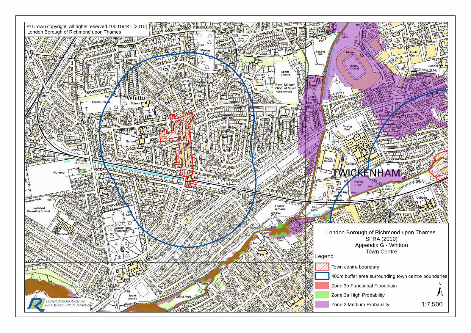
© Crown copyright. All rights reserved 100019441 [2010]London Borough of Richmond upon Thames
London Borough of Richmond upon Thames SFRA (2010)
Appendix G - WhittonTown Centre
1:7,500±
LegendTown centre boundary400m buffer area surrounding town centre boundariesZone 3b Functional FloodplainZone 3a High ProbabilityZone 2 Medium Probability