london to wales route strategy evidence report technical annex · pdf filelondon to wales...
TRANSCRIPT
Safe roads, reliable journeys, informed travellers
An executive agency of the Department for Transport
London to Wales Route Strategy
Evidence Report Technical Annex
April 2014
Technical annex to London to Wales route-based strategy evidence report
Document History
Technical annex to London to Wales route-based strategy evidence report
Highways Agency
This document has been issued and amended as follows:
Version Date Description Author Approved by
1 12/12/13 First draft issue to Highways Agency Ian Parsons Andrew Page-Dove
2 13/12/13 Second draft Ian Parsons Andrew Page-Dove
3 16/01/14 Final draft for Publication Agency SW RBS Team
Andrew Page-Dove
4 30/01/14 Final draft for stakeholders Agency SW RBS Team
Ian Parsons
5 03/04/14 Final for publication Agency SW RBS Team
Colin Gimblett
i

Technical annex to London to Wales route-based strategy evidence report
Table of Contents
Document History ......................................................................................................... i
Technical annex to London to Wales route-based strategy evidence report................. i
Tables ........................................................................................................................iii
Figures.......................................................................................................................iv
Part A Supporting evidence .................................................................................5
A1 Introduction .....................................................................................................6
A1.1 Route description...........................................................................................6
A2 Route capability, condition and constraints...............................................12
A2.1 Route performance ......................................................................................12
A2.2 Road Safety .................................................................................................19
A2.3 Asset Condition............................................................................................19
A2.4 Route Operation ..........................................................................................19
A2.5 Technology ..................................................................................................19
A2.6 Vulnerable Road Users................................................................................20
A2.7 Environment.................................................................................................21
A3 Future considerations ..................................................................................27
A3.1 Economic development and surrounding environment ................................27
A3.2 Network improvements and operational changes ........................................31
A3.3 Wider transport networks.............................................................................35
A4 Key challenges and opportunities...............................................................38
A4.1 Timescales...................................................................................................38
A4.2 Stakeholder priorities ...................................................................................38
A4.3 Operational challenges and opportunities....................................................38
A4.4 Asset condition challenges and opportunities..............................................38
A4.5 Capacity challenges and opportunities ........................................................38
A4.6 Safety challenges and opportunities ............................................................38
A4.7 Social and environmental challenges and opportunities ..............................38
Part B Stakeholder engagement........................................................................39
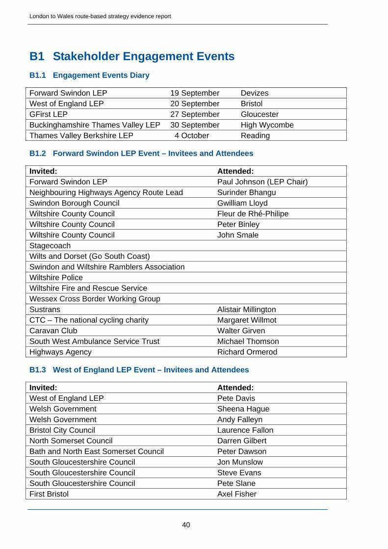
B1 Stakeholder Engagement Events .................................................................40
B1.1 Engagement Events Diary ............................................................................40
B1.2 Forward Swindon LEP Event – Invitees and Attendees................................40
B1.3 West of England LEP Event – Invitees and Attendees .................................40
ii
Technical annex to London to Wales route-based strategy evidence report
B1.4 GFirst LEP Event – Invitees and Attendees..................................................41
B1.5 Buckinghamshire Thames Valley LEP Event – Invitees and Attendees .......42
B1.6 Thames Valley Berkshire LEP Event – Invitees and Attendees....................42
B1.7 Forward Swindon LEP Event – Notes...........................................................44
B1.8 West of England LEP Event – Notes ............................................................54
B1.9 GFirst LEP Event – Notes.............................................................................67
B1.10 Buckinghamshire Thames Valley LEP Event – Notes ..................................81
B1.11 Thames Valley Berkshire LEP Event – Notes...............................................90
Tables
Table A2.1 Sections of the route falling within the national top 250 (top 10%) busiest in England ..............................................................................................12
Table A2.2 Sections of the route in the national top 250 (top 10%) least reliable journey-time 2012/13 ..........................................................................................12
Table A2.3 Links with freight proportions over 20% ........................................13
Table A2.4 M4 – Derivation of Flow range (vehicles per day, in both directions) 14
Table A2.5 A404 – Derivation of Flow range (vehicles per day, in both directions) 14
Table A2.6 M32 – Derivation of Flow range (vehicles per day, in both directions) 15
Table A2.7 M48 – Derivation of Flow range (vehicles per day, in both directions) 15
Table A2.8 M49 – Derivation of Flow range (vehicles per day, in both directions) 15
Table A2.9 A308(M) – Derivation of Flow range (vehicles per day, in both directions) 15
Table A2.10 M4 – Derivation of Average Freight Proportion ...........................16
Table A2.11 A404 – Derivation of Average Freight Proportion........................17
Table A2.12 M32 – Derivation of Average Freight Proportion .........................17
Table A2.13 M48 – Derivation of Average Freight Proportion .........................18
Table A2.14 M49 – Derivation of Average Freight Proportion .........................18
Table A2.15 A308(M) – Derivation of Average Freight Proportion ..................18
Table A2.16 Collisions / Casualties – Temporal Analysis................................19
Table A2.17 Technology Provision along the Strategic Road Network Section 20
iii
Technical annex to London to Wales route-based strategy evidence report
iv
Table A2.17 Technology Provision along the Strategic Road Network section20
Figures
Figure A1.1 Scheme Publication Extract – Scheme Overview 8
Figure A1.2 Scheme Publication Extract – Scheme Coverage 9
Figure A1.3 Scheme Publication Extract – Scheme Detail 10
Figure A2.1 Bristol AQMA coverage 21
Figure A2.2 Reading AQMA coverage 22
Figure A2.3 Wokingham AQMA coverage 23
Figure A2.4 Royal Borough of Windsor and Maidenhead – Bray/M4 AQMA coverage 24
Figure A2.5 South Bucks District Council AQMA coverage 25
Figure A2.6 Slough Borough Council – Slough AQMA No.1 coverage 26
Figure A2.7 Bristol City Region City Deal – Executive Summary Extract 28
Figure A2.8 Bristol City Region City Deal – Vision and Strategy for Growth Extract 29
Figure A2.9 Bristol City Region City Deal – Diagram Extract 30
London to Wales route-based strategy evidence report
Part A Supporting evidence
5

London to Wales route-based strategy evidence report
A1 Introduction
A1.1 Route description
M4 Junction 19-20 and M5 Junction 15-17 Smart Motorway
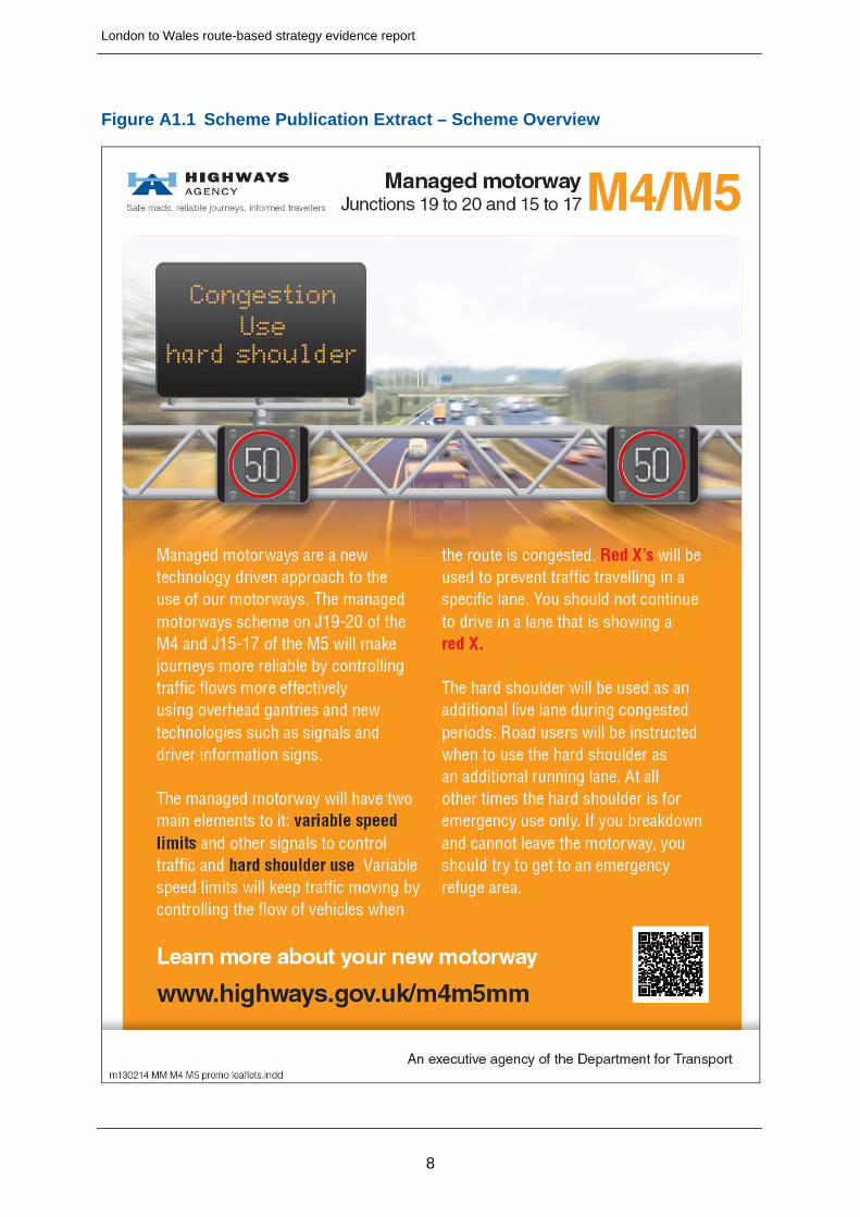
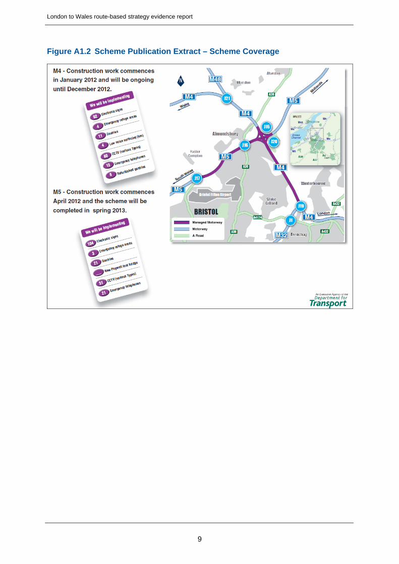
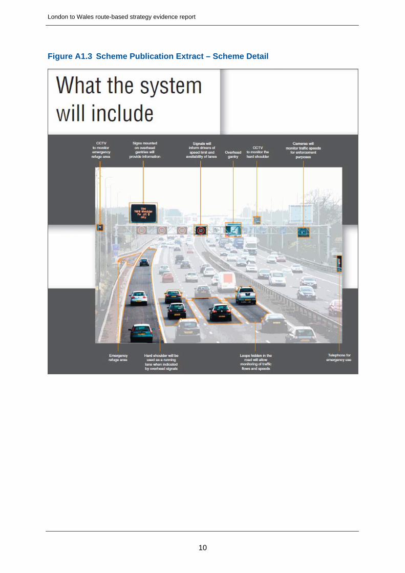
Section 1.3 of the main report provides a description of the route and within that description; reference is made to the upgrade of the route to smart motorway between M4 junctions 19 and 20. Further information is provided here in relation to this scheme.
The Agency is working to improve the M4 between junctions 19 and 20, and the M5 between junctions 15 and 17, by making it a smart motorway (previously known as managed motorways). Smart motorways help relieve congestion by using technology to vary speed limits. They also allow the hard shoulder to be used as a running lane at peak times to create additional capacity. They deliver these benefits at a significantly lower cost than conventional motorway widening and with less impact on the environment during construction. See pages 8 and 9 for more about smart motorways.
Following the October 2010 Spending Review, it was announced in April 2011 that this scheme would be prepared to start construction in early 2012. Works were then officially started on 25 January 2012 by Roads Minister Mike Penning. It was planned to open the scheme to traffic in the fourth quarter (between January and March) of financial year 2013/14.
The M4/M5 smart motorway scheme is taking place on the link between the main motorways between London, the West and the Midlands and South-West. It serves the City of Bristol. This work is needed as the route suffers from heavy congestion and unpredictable journey times.
The estimated outturn cost of £89 million was approved by the Secretary of State in October 2011 prior to the start of construction. The current forecasted cost for this scheme is £86 million as at the end of August 2013.
This project brings together motorway technologies, infrastructure and procedures, from the UK and around the world, to maximise a number of benefits:
Additional capacity for vehicles
Improving the detection of incidents
Improving the response to incidents
Helping to alleviate congestion
Reducing delays caused by incidents or congestion
Piloting new and innovative concepts
Targeted solutions to specific problems
Building on best practice and experience of the M42, smart motorways combines existing technology with new and innovative ideas. Together,
6

London to Wales route-based strategy evidence report
these make the best use of the existing road space to provide additional capacity for vehicles, reducing congestion and improving safety.
Publication extracts associated with the scheme are provided below In Figures A1.1 through to A1.3, which afford further information.
7
London to Wales route-based strategy evidence report
Figure A1.1 Scheme Publication Extract – Scheme Overview
8
London to Wales route-based strategy evidence report
Figure A1.2 Scheme Publication Extract – Scheme Coverage
9
London to Wales route-based strategy evidence report
Figure A1.3 Scheme Publication Extract – Scheme Detail
10
London to Wales route-based strategy evidence report
UNECE European Route E30
Within the main report, in section 1.3, it is identified that the M4 forms part of the United Nations Economic Commission for Europe (UNECE) European Route E30. Further information in relation to this designation is provided here.
The international E-road network numbering system seeks to support UNECEs aim to encourage economic cooperation among its member states. While E-road numbers are signposted in some countries, this is not the case in the UK.
European Route E30 forms an east-west route between Ireland and Russia, therefore representing one of the longest European routes. In the UK, in addition to the M4 corridor between Llanelli in Wales and the M25, the route also covers the A40 (Fishguard to Carmarthen), the A48 (Carmarthen to Llanelli), the M25 (Slough to Brentwood), the A12 (Brentwood to Ipswich) and the A14 (Ipswich to Felixstowe).
11
London to Wales route-based strategy evidence report
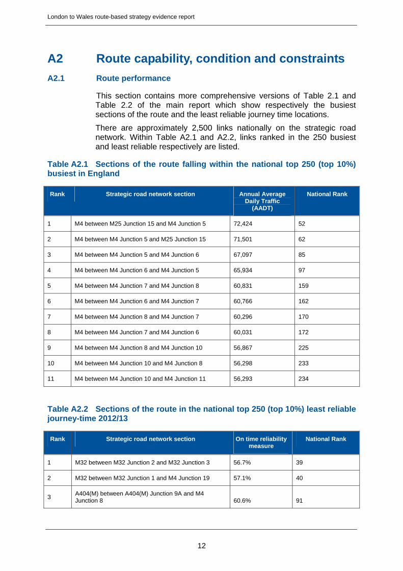
A2 Route capability, condition and constraints
A2.1 Route performance
This section contains more comprehensive versions of Table 2.1 and Table 2.2 of the main report which show respectively the busiest sections of the route and the least reliable journey time locations.
There are approximately 2,500 links nationally on the strategic road network. Within Table A2.1 and A2.2, links ranked in the 250 busiest and least reliable respectively are listed.
Table A2.1 Sections of the route falling within the national top 250 (top 10%) busiest in England
Rank Strategic road network section Annual Average Daily Traffic
(AADT)
National Rank
1 M4 between M25 Junction 15 and M4 Junction 5 72,424 52
2 M4 between M4 Junction 5 and M25 Junction 15 71,501 62
3 M4 between M4 Junction 5 and M4 Junction 6 67,097 85
4 M4 between M4 Junction 6 and M4 Junction 5 65,934 97
5 M4 between M4 Junction 7 and M4 Junction 8 60,831 159
6 M4 between M4 Junction 6 and M4 Junction 7 60,766 162
7 M4 between M4 Junction 8 and M4 Junction 7 60,296 170
8 M4 between M4 Junction 7 and M4 Junction 6 60,031 172
9 M4 between M4 Junction 8 and M4 Junction 10 56,867 225
10 M4 between M4 Junction 10 and M4 Junction 8 56,298 233
11 M4 between M4 Junction 10 and M4 Junction 11 56,293 234
Table A2.2 Sections of the route in the national top 250 (top 10%) least reliable journey-time 2012/13
Rank Strategic road network section On time reliability measure
National Rank
1 M32 between M32 Junction 2 and M32 Junction 3 56.7% 39
2 M32 between M32 Junction 1 and M4 Junction 19 57.1% 40
3 A404(M) between A404(M) Junction 9A and M4 Junction 8 60.6% 91
12
London to Wales route-based strategy evidence report
13
Rank Strategic road network section On time reliability measure
National Rank
4 M32 between M32 Junction 3 and M32 Junction 2 61.7% 123
5 M4 between M4 Junction 19 62.6% 145
6 M32 between M32 Junction 1 and M32 Junction 2 64.4% 231
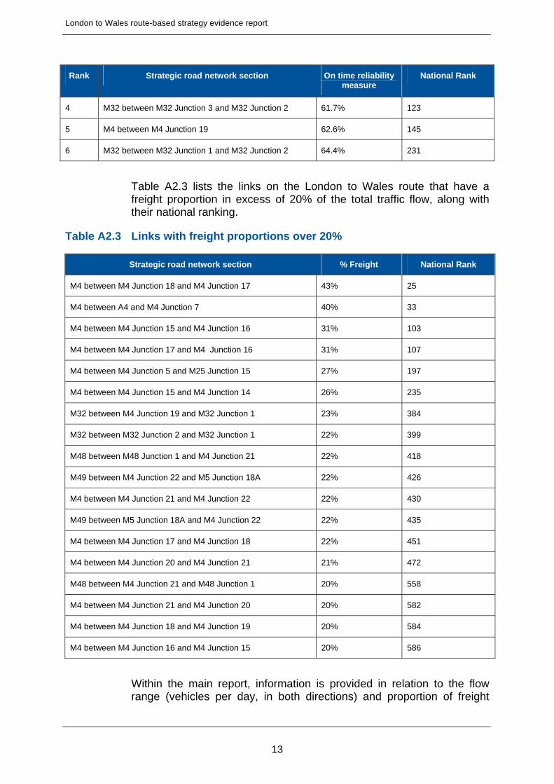
Table A2.3 lists the links on the London to Wales route that have a freight proportion in excess of 20% of the total traffic flow, along with their national ranking.
Table A2.3 Links with freight proportions over 20%
Strategic road network section % Freight National Rank
M4 between M4 Junction 18 and M4 Junction 17 43% 25
M4 between A4 and M4 Junction 7 40% 33
M4 between M4 Junction 15 and M4 Junction 16 31% 103
M4 between M4 Junction 17 and M4 Junction 16 31% 107
M4 between M4 Junction 5 and M25 Junction 15 27% 197
M4 between M4 Junction 15 and M4 Junction 14 26% 235
M32 between M4 Junction 19 and M32 Junction 1 23% 384
M32 between M32 Junction 2 and M32 Junction 1 22% 399
M48 between M48 Junction 1 and M4 Junction 21 22% 418
M49 between M4 Junction 22 and M5 Junction 18A 22% 426
M4 between M4 Junction 21 and M4 Junction 22 22% 430
M49 between M5 Junction 18A and M4 Junction 22 22% 435
M4 between M4 Junction 17 and M4 Junction 18 22% 451
M4 between M4 Junction 20 and M4 Junction 21 21% 472
M48 between M4 Junction 21 and M48 Junction 1 20% 558
M4 between M4 Junction 21 and M4 Junction 20 20% 582
M4 between M4 Junction 18 and M4 Junction 19 20% 584
M4 between M4 Junction 16 and M4 Junction 15 20% 586
Within the main report, information is provided in relation to the flow range (vehicles per day, in both directions) and proportion of freight
London to Wales route-based strategy evidence report
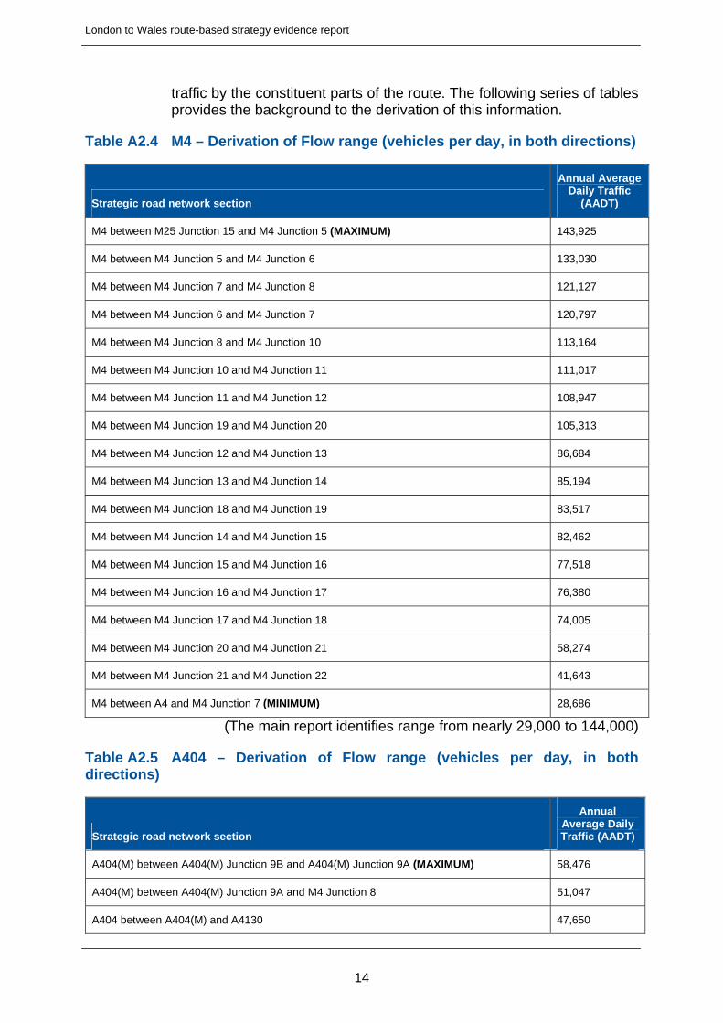
traffic by the constituent parts of the route. The following series of tables provides the background to the derivation of this information.
Table A2.4 M4 – Derivation of Flow range (vehicles per day, in both directions)
Strategic road network section
Annual Average Daily Traffic
(AADT)
M4 between M25 Junction 15 and M4 Junction 5 (MAXIMUM) 143,925
M4 between M4 Junction 5 and M4 Junction 6 133,030
M4 between M4 Junction 7 and M4 Junction 8 121,127
M4 between M4 Junction 6 and M4 Junction 7 120,797
M4 between M4 Junction 8 and M4 Junction 10 113,164
M4 between M4 Junction 10 and M4 Junction 11 111,017
M4 between M4 Junction 11 and M4 Junction 12 108,947
M4 between M4 Junction 19 and M4 Junction 20 105,313
M4 between M4 Junction 12 and M4 Junction 13 86,684
M4 between M4 Junction 13 and M4 Junction 14 85,194
M4 between M4 Junction 18 and M4 Junction 19 83,517
M4 between M4 Junction 14 and M4 Junction 15 82,462
M4 between M4 Junction 15 and M4 Junction 16 77,518
M4 between M4 Junction 16 and M4 Junction 17 76,380
M4 between M4 Junction 17 and M4 Junction 18 74,005
M4 between M4 Junction 20 and M4 Junction 21 58,274
M4 between M4 Junction 21 and M4 Junction 22 41,643
M4 between A4 and M4 Junction 7 (MINIMUM) 28,686
(The main report identifies range from nearly 29,000 to 144,000)
Table A2.5 A404 – Derivation of Flow range (vehicles per day, in both directions)
Strategic road network section
Annual Average Daily Traffic (AADT)
A404(M) between A404(M) Junction 9B and A404(M) Junction 9A (MAXIMUM) 58,476
A404(M) between A404(M) Junction 9A and M4 Junction 8 51,047
A404 between A404(M) and A4130 47,650
14
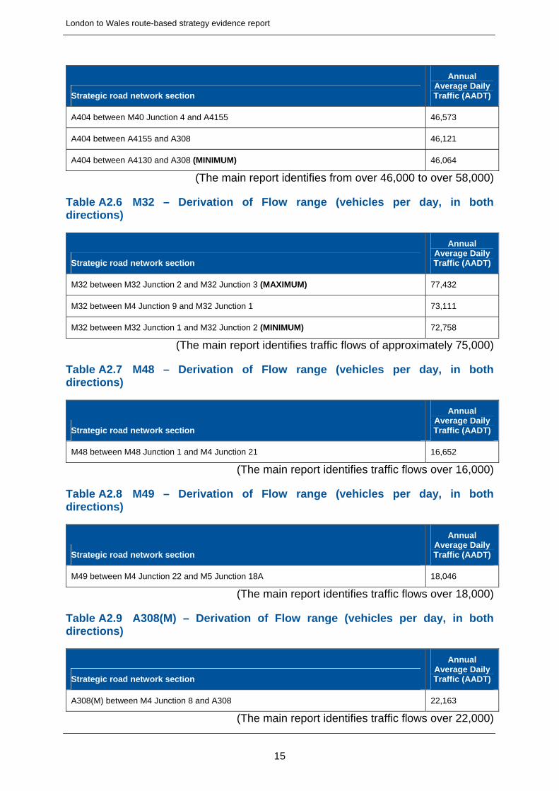
London to Wales route-based strategy evidence report
15
Strategic road network section
Annual Average Daily Traffic (AADT)
A404 between M40 Junction 4 and A4155 46,573
A404 between A4155 and A308 46,121
A404 between A4130 and A308 (MINIMUM) 46,064
(The main report identifies from over 46,000 to over 58,000)
Table A2.6 M32 – Derivation of Flow range (vehicles per day, in both directions)
Strategic road network section
Annual Average Daily Traffic (AADT)
M32 between M32 Junction 2 and M32 Junction 3 (MAXIMUM) 77,432
M32 between M4 Junction 9 and M32 Junction 1 73,111
M32 between M32 Junction 1 and M32 Junction 2 (MINIMUM) 72,758
(The main report identifies traffic flows of approximately 75,000)
Table A2.7 M48 – Derivation of Flow range (vehicles per day, in both directions)
Strategic road network section
Annual Average Daily Traffic (AADT)
M48 between M48 Junction 1 and M4 Junction 21 16,652
(The main report identifies traffic flows over 16,000)
Table A2.8 M49 – Derivation of Flow range (vehicles per day, in both directions)
Strategic road network section
Annual Average Daily Traffic (AADT)
M49 between M4 Junction 22 and M5 Junction 18A 18,046
(The main report identifies traffic flows over 18,000)
Table A2.9 A308(M) – Derivation of Flow range (vehicles per day, in both directions)
Strategic road network section
Annual Average Daily Traffic (AADT)
A308(M) between M4 Junction 8 and A308 22,163
(The main report identifies traffic flows over 22,000)
London to Wales route-based strategy evidence report
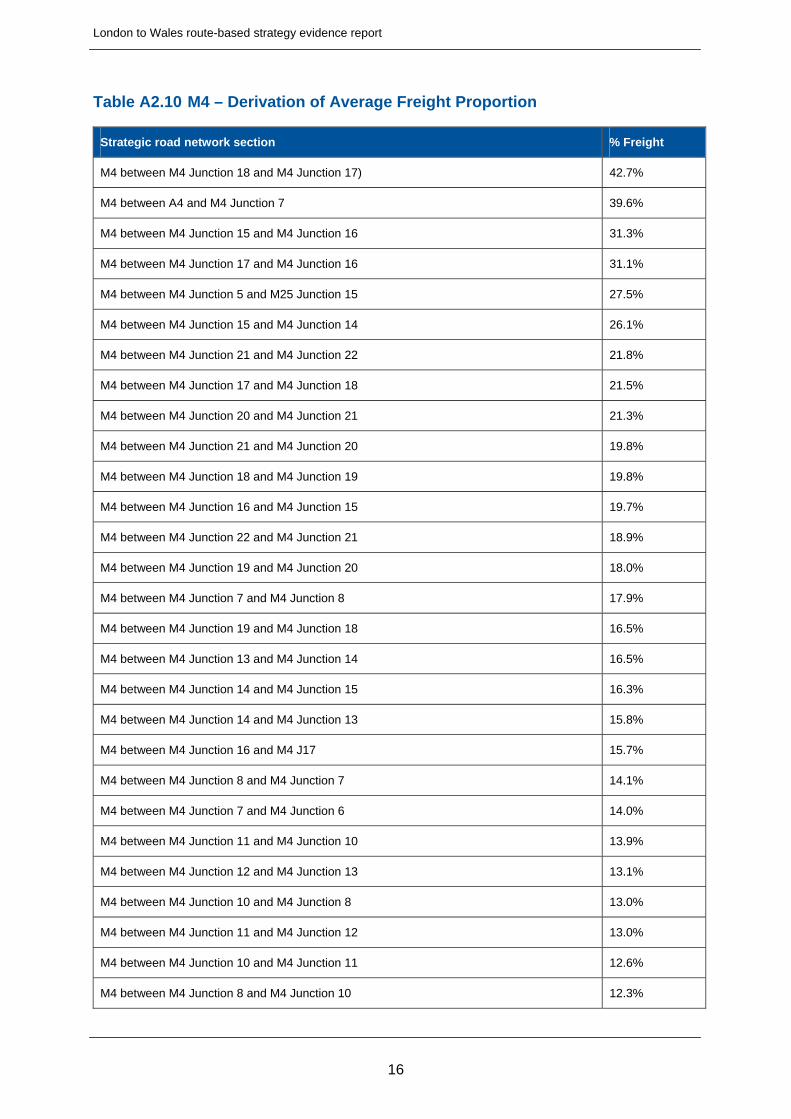
Table A2.10 M4 – Derivation of Average Freight Proportion
Strategic road network section % Freight
M4 between M4 Junction 18 and M4 Junction 17) 42.7%
M4 between A4 and M4 Junction 7 39.6%
M4 between M4 Junction 15 and M4 Junction 16 31.3%
M4 between M4 Junction 17 and M4 Junction 16 31.1%
M4 between M4 Junction 5 and M25 Junction 15 27.5%
M4 between M4 Junction 15 and M4 Junction 14 26.1%
M4 between M4 Junction 21 and M4 Junction 22 21.8%
M4 between M4 Junction 17 and M4 Junction 18 21.5%
M4 between M4 Junction 20 and M4 Junction 21 21.3%
M4 between M4 Junction 21 and M4 Junction 20 19.8%
M4 between M4 Junction 18 and M4 Junction 19 19.8%
M4 between M4 Junction 16 and M4 Junction 15 19.7%
M4 between M4 Junction 22 and M4 Junction 21 18.9%
M4 between M4 Junction 19 and M4 Junction 20 18.0%
M4 between M4 Junction 7 and M4 Junction 8 17.9%
M4 between M4 Junction 19 and M4 Junction 18 16.5%
M4 between M4 Junction 13 and M4 Junction 14 16.5%
M4 between M4 Junction 14 and M4 Junction 15 16.3%
M4 between M4 Junction 14 and M4 Junction 13 15.8%
M4 between M4 Junction 16 and M4 J17 15.7%
M4 between M4 Junction 8 and M4 Junction 7 14.1%
M4 between M4 Junction 7 and M4 Junction 6 14.0%
M4 between M4 Junction 11 and M4 Junction 10 13.9%
M4 between M4 Junction 12 and M4 Junction 13 13.1%
M4 between M4 Junction 10 and M4 Junction 8 13.0%
M4 between M4 Junction 11 and M4 Junction 12 13.0%
M4 between M4 Junction 10 and M4 Junction 11 12.6%
M4 between M4 Junction 8 and M4 Junction 10 12.3%
16
London to Wales route-based strategy evidence report
17
Strategic road network section % Freight
M4 between M4 Junction 6 and M4 Junction 5 12.0%
M4 between M4 Junction 5 and M4 Junction 6 11.9%
M4 between M4 Junction 13 and M4 Junction 12 11.8%
M4 between M4 Junction 6 and M4 Junction 7 11.6%
M4 between M25 Junction 15 and M4 Junction 5 11.6%
M4 between M4 Junction 7 and A4 8.7%
Average (as quoted in paragraph 1.3.5 of the main report 19%
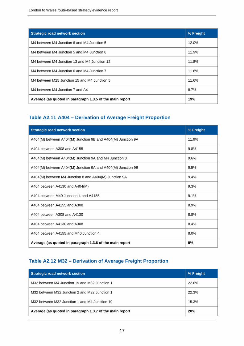
Table A2.11 A404 – Derivation of Average Freight Proportion
Strategic road network section % Freight
A404(M) between A404(M) Junction 9B and A404(M) Junction 9A 11.9%
A404 between A308 and A4155 9.8%
A404(M) between A404(M) Junction 9A and M4 Junction 8 9.6%
A404(M) between A404(M) Junction 9A and A404(M) Junction 9B 9.5%
A404(M) between M4 Junction 8 and A404(M) Junction 9A 9.4%
A404 between A4130 and A404(M) 9.3%
A404 between M40 Junction 4 and A4155 9.1%
A404 between A4155 and A308 8.9%
A404 between A308 and A4130 8.8%
A404 between A4130 and A308 8.4%
A404 between A4155 and M40 Junction 4 8.0%
Average (as quoted in paragraph 1.3.6 of the main report 9%
Table A2.12 M32 – Derivation of Average Freight Proportion
Strategic road network section % Freight
M32 between M4 Junction 19 and M32 Junction 1 22.6%
M32 between M32 Junction 2 and M32 Junction 1 22.3%
M32 between M32 Junction 1 and M4 Junction 19 15.3%
Average (as quoted in paragraph 1.3.7 of the main report 20%
London to Wales route-based strategy evidence report
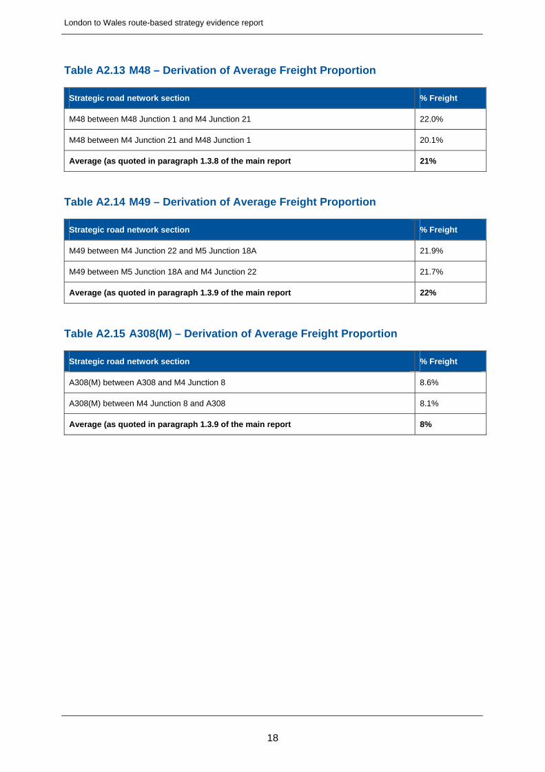
Table A2.13 M48 – Derivation of Average Freight Proportion
Strategic road network section % Freight
M48 between M48 Junction 1 and M4 Junction 21 22.0%
M48 between M4 Junction 21 and M48 Junction 1 20.1%
Average (as quoted in paragraph 1.3.8 of the main report 21%
Table A2.14 M49 – Derivation of Average Freight Proportion
Strategic road network section % Freight
M49 between M4 Junction 22 and M5 Junction 18A 21.9%
M49 between M5 Junction 18A and M4 Junction 22 21.7%
Average (as quoted in paragraph 1.3.9 of the main report 22%
Table A2.15 A308(M) – Derivation of Average Freight Proportion
Strategic road network section % Freight
A308(M) between A308 and M4 Junction 8 8.6%
A308(M) between M4 Junction 8 and A308 8.1%
Average (as quoted in paragraph 1.3.9 of the main report 8%
18
London to Wales route-based strategy evidence report
A2.2 Road Safety
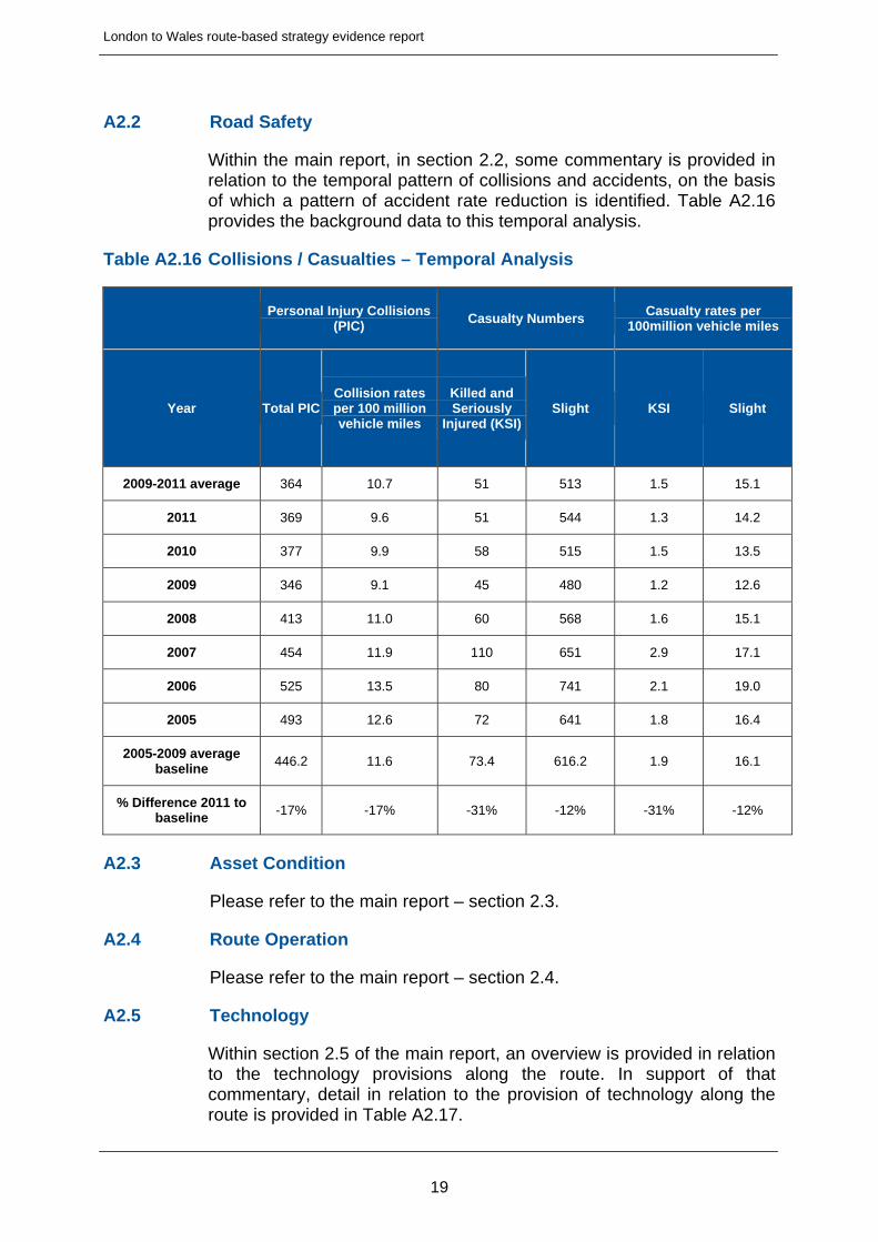
Within the main report, in section 2.2, some commentary is provided in relation to the temporal pattern of collisions and accidents, on the basis of which a pattern of accident rate reduction is identified. Table A2.16 provides the background data to this temporal analysis.
Table A2.16 Collisions / Casualties – Temporal Analysis
Personal Injury Collisions
(PIC) Casualty Numbers
Casualty rates per 100million vehicle miles
Year Total PIC Collision rates per 100 million vehicle miles
Killed and Seriously
Injured (KSI)Slight KSI Slight
2009-2011 average 364 10.7 51 513 1.5 15.1
2011 369 9.6 51 544 1.3 14.2
2010 377 9.9 58 515 1.5 13.5
2009 346 9.1 45 480 1.2 12.6
2008 413 11.0 60 568 1.6 15.1
2007 454 11.9 110 651 2.9 17.1
2006 525 13.5 80 741 2.1 19.0
2005 493 12.6 72 641 1.8 16.4
2005-2009 average baseline
446.2 11.6 73.4 616.2 1.9 16.1
% Difference 2011 to baseline
-17% -17% -31% -12% -31% -12%
A2.3 Asset Condition
Please refer to the main report – section 2.3.
A2.4 Route Operation
Please refer to the main report – section 2.4.
A2.5 Technology
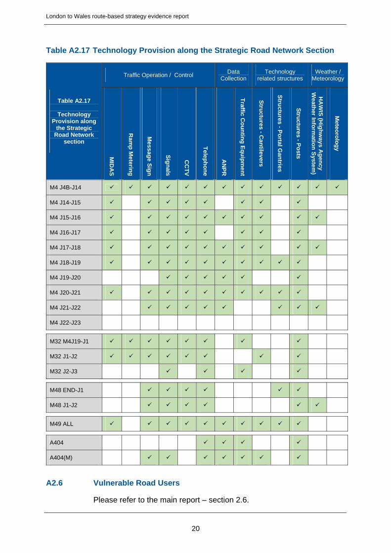
Within section 2.5 of the main report, an overview is provided in relation to the technology provisions along the route. In support of that commentary, detail in relation to the provision of technology along the route is provided in Table A2.17.
19
London to Wales route-based strategy evidence report
Table A2.17 Technology Provision along the Strategic Road Network Section
Traffic Operation / Control Data
Collection Technology
related structures Weather /
Meteorology
Table A2.17
Technology Provision along
the Strategic Road Network
section
MID
AS
Ram
p M
etering
Mess
age S
ign
Sig
nals
CC
TV
Telep
ho
ne
AN
PR
Traffic C
ou
ntin
g E
qu
ipm
ent
Stru
ctures - C
antilevers
Stru
ctures - P
ortal G
antries
Stru
ctures - P
osts
HA
WIS
(Hig
hw
ays Ag
ency
Weath
er Info
rmatio
n S
ystem
)
Meteo
rolo
gy
M4 J4B-J14
M4 J14-J15
M4 J15-J16
M4 J16-J17
M4 J17-J18
M4 J18-J19
M4 J19-J20
M4 J20-J21
M4 J21-J22
M4 J22-J23
M32 M4J19-J1
M32 J1-J2
M32 J2-J3
M48 END-J1
M48 J1-J2
M49 ALL
A404
A404(M)
A2.6 Vulnerable Road Users
Please refer to the main report – section 2.6.
20
London to Wales route-based strategy evidence report
A2.7 Environment
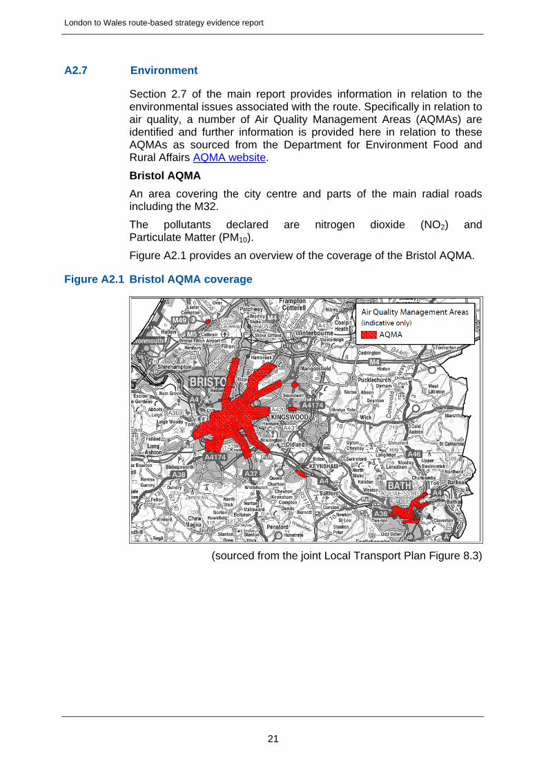
Section 2.7 of the main report provides information in relation to the environmental issues associated with the route. Specifically in relation to air quality, a number of Air Quality Management Areas (AQMAs) are identified and further information is provided here in relation to these AQMAs as sourced from the Department for Environment Food and Rural Affairs AQMA website.
Bristol AQMA
An area covering the city centre and parts of the main radial roads including the M32.
The pollutants declared are nitrogen dioxide (NO2) and Particulate Matter (PM10).
Figure A2.1 provides an overview of the coverage of the Bristol AQMA.
Figure A2.1 Bristol AQMA coverage
(sourced from the joint Local Transport Plan Figure 8.3)
21

London to Wales route-based strategy evidence report
Reading AQMA
An area covering Reading Town Centre, areas along the major radial road routes into Reading (including Junction 11 of the M4) and along the railway lines where they pass through built-up areas.
The pollutants declared are nitrogen dioxide (NO2).
Figure A2.2 provides an overview of the coverage of the Reading AQMA.
Figure A2.2 Reading AQMA coverage
22
London to Wales route-based strategy evidence report
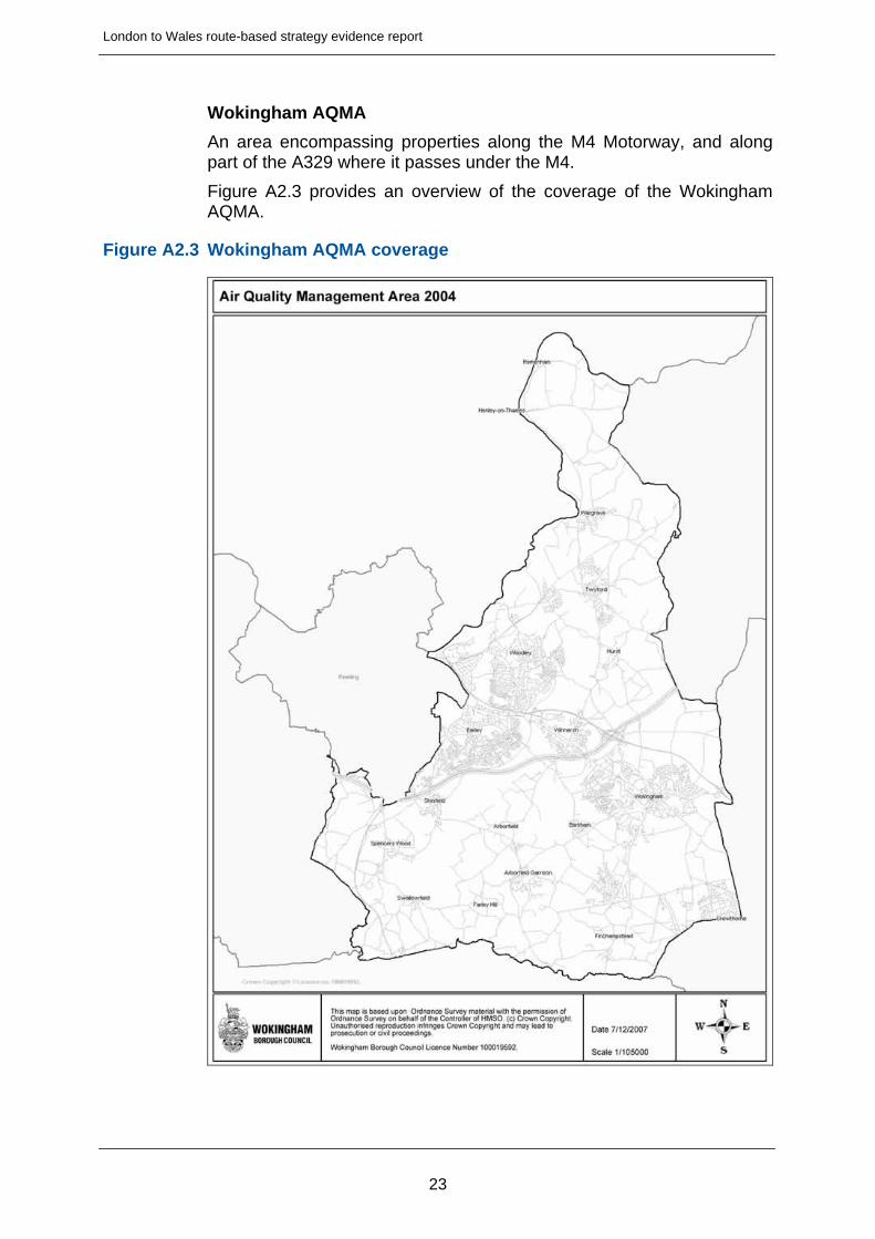
Wokingham AQMA
An area encompassing properties along the M4 Motorway, and along part of the A329 where it passes under the M4.
Figure A2.3 provides an overview of the coverage of the Wokingham AQMA.
Figure A2.3 Wokingham AQMA coverage
23
London to Wales route-based strategy evidence report
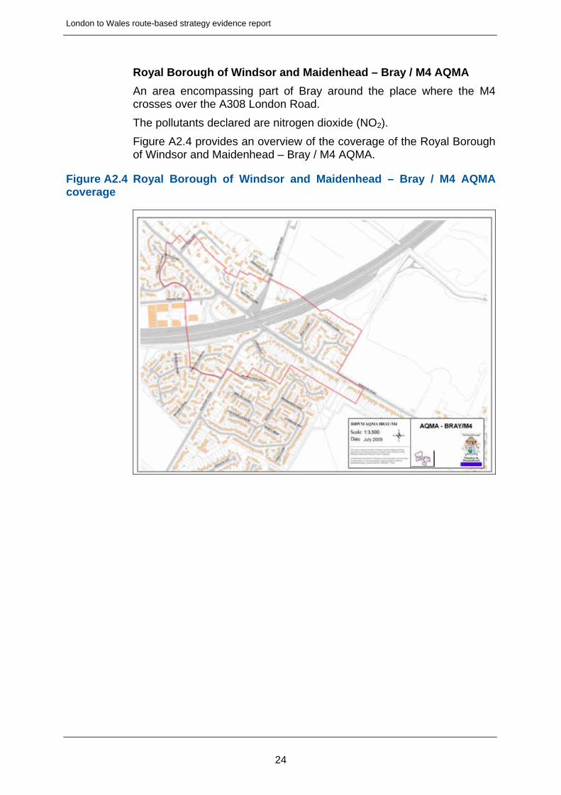
Royal Borough of Windsor and Maidenhead – Bray / M4 AQMA
An area encompassing part of Bray around the place where the M4 crosses over the A308 London Road.
The pollutants declared are nitrogen dioxide (NO2).
Figure A2.4 provides an overview of the coverage of the Royal Borough of Windsor and Maidenhead – Bray / M4 AQMA.
Figure A2.4 Royal Borough of Windsor and Maidenhead – Bray / M4 AQMA coverage
24
London to Wales route-based strategy evidence report
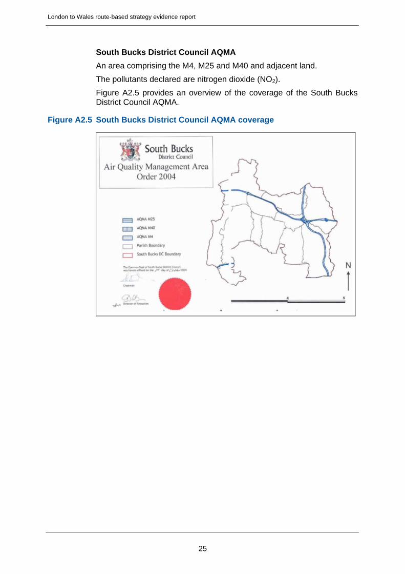
South Bucks District Council AQMA
An area comprising the M4, M25 and M40 and adjacent land.
The pollutants declared are nitrogen dioxide (NO2).
Figure A2.5 provides an overview of the coverage of the South Bucks District Council AQMA.
Figure A2.5 South Bucks District Council AQMA coverage
25
London to Wales route-based strategy evidence report
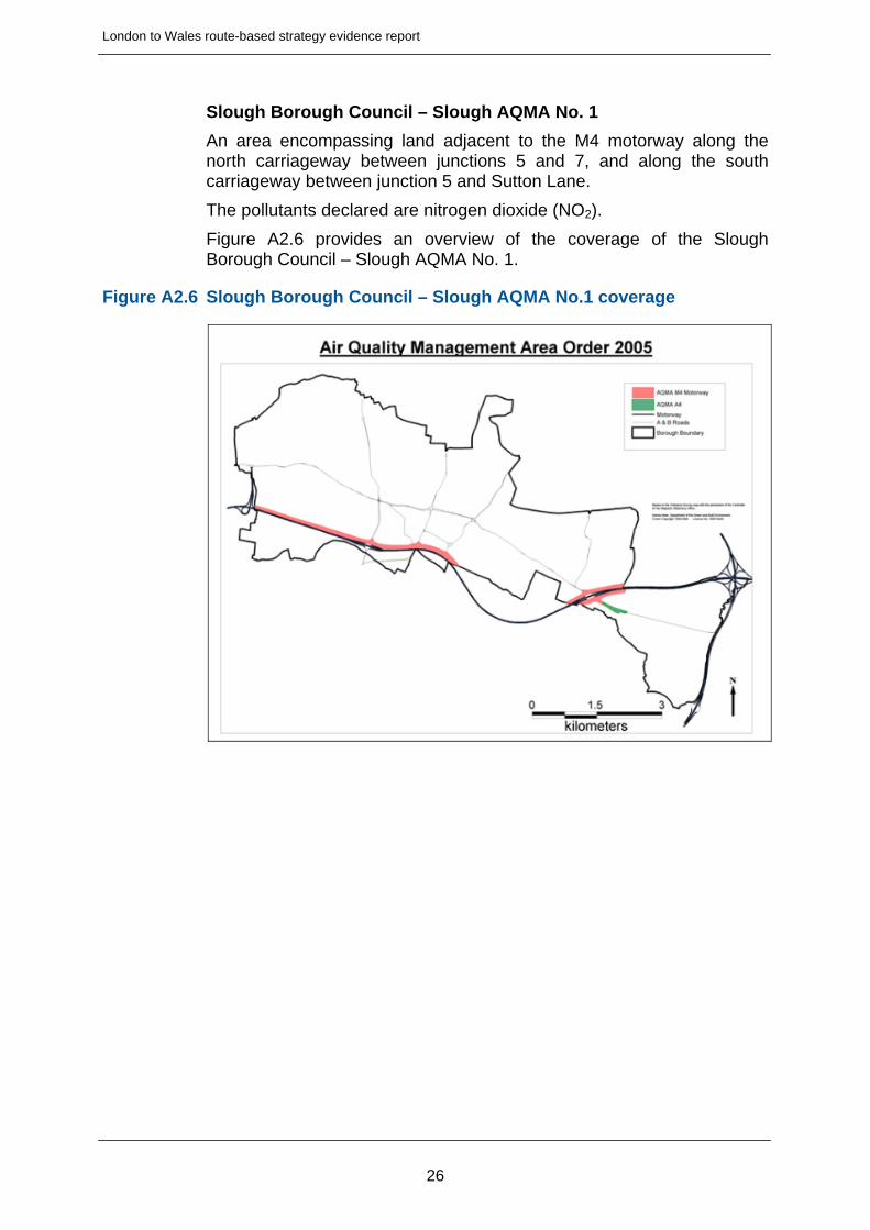
Slough Borough Council – Slough AQMA No. 1
An area encompassing land adjacent to the M4 motorway along the north carriageway between junctions 5 and 7, and along the south carriageway between junction 5 and Sutton Lane.
The pollutants declared are nitrogen dioxide (NO2).
Figure A2.6 provides an overview of the coverage of the Slough Borough Council – Slough AQMA No. 1.
Figure A2.6 Slough Borough Council – Slough AQMA No.1 coverage
26
London to Wales route-based strategy evidence report
A3 Future considerations
A3.1 Economic development and surrounding environment
Temple Quarter Enterprise Zone
Section 3.2 of the main report outlines the aspirations for growth at the Temple Quarter Enterprise Zone. Further information is provided here as available on the Enterprise Zone website.
Bristol Temple Quarter is one of the largest urban regeneration projects in the UK. The 70 hectare area in the heart of Bristol with Temple Meads railway station at its centre was officially declared open for business by Chancellor George Osborne in April 2012. Its targets are to create 4,000 jobs in the first five years and around 17,000 in the 25 year lifespan of the project.
350 businesses are already in the Zone, including prestigious Top 50 law firm Burges Salmon, who chose Temple Quarter for their new headquarters because of its great location and whose building has achieved a BREEAM ‘Excellent’ rating for its sustainability initiatives. Other well-known names include BT, IBM, Osborne Clarke, Canada Life and HSBC. New occupiers in the Zone include EMO, the Real Adventure Company and LICenergy UK, a Danish windfarm developer. There are also rapidly growing clusters of small and start-up businesses, particularly in the creative and digital sectors, moving into a number of locations in the Zone.
Enterprise zones have been set up by the government to drive local growth and create jobs. They offer a range of incentives to businesses including business rate relief, low rent incubator units and simplified planning procedures. They have been developed with businesses in mind, which means investors can look forward to superfast broadband, good transport links – to the major road networks, rail, air and so on -and the government is allocating funding for infrastructure improvements in and around the Zones.
Many of the zones are targeting specific industry sectors too, encouraging clusters of similar businesses for mutual benefit.
The project is being delivered by four key partners:
the West of England Local Enterprise Partnership, which is tasked with creating 95,000 jobs in the region by 2030
Bristol City Council, the local authority with planning responsibility for the Zone
the Homes and Communities Agency, which owns six sites totaling around 5.36 hectares (13 acres) within the site
Network Rail, responsible for Temple Meads railway station, which is a crucial part of the development
27
London to Wales route-based strategy evidence report
Bristol City Region City Deal
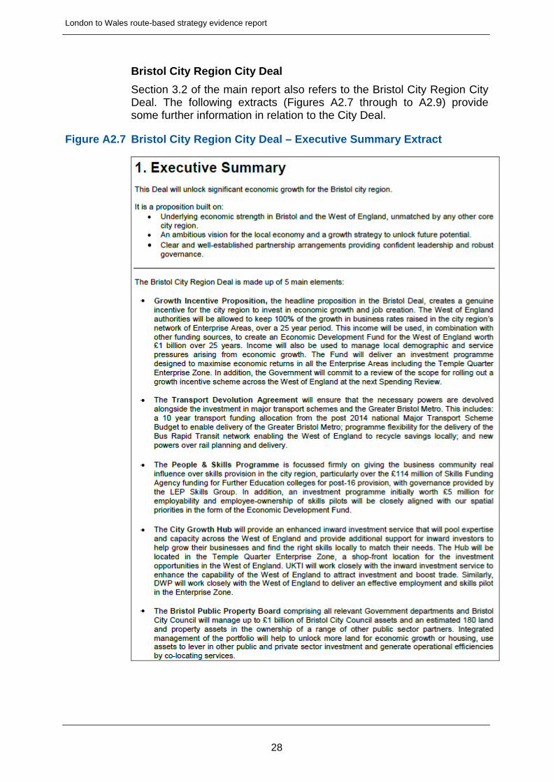
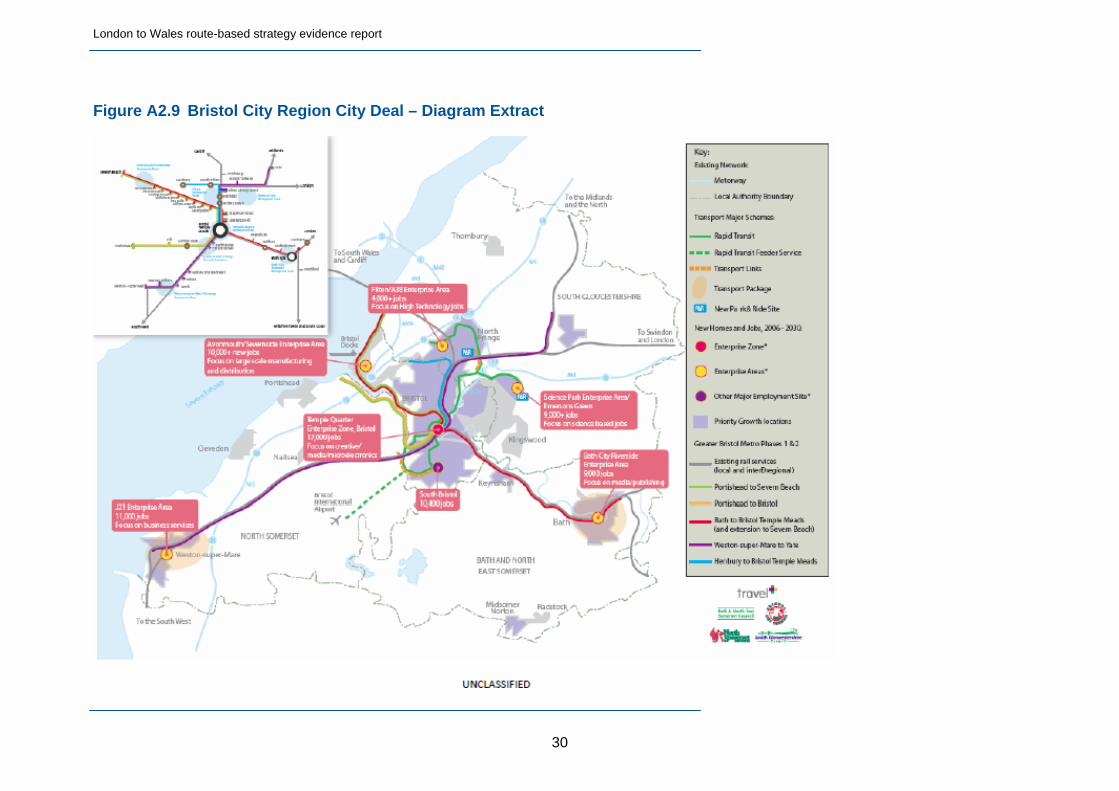
Section 3.2 of the main report also refers to the Bristol City Region City Deal. The following extracts (Figures A2.7 through to A2.9) provide some further information in relation to the City Deal.
Figure A2.7 Bristol City Region City Deal – Executive Summary Extract
28

London to Wales route-based strategy evidence report
29
Figure A2.8 Bristol City Region City Deal – Vision and Strategy for Growth Extract
London to Wales route-based strategy evidence report
Figure A2.9 Bristol City Region City Deal – Diagram Extract
30
London to Wales route-based strategy evidence report
A3.2 Network improvements and operational changes
Tables 3.2 and 3.3 of the main report highlight the committed strategic road network enhancement schemes and pipeline schemes respectively. Further information in relation to each of these schemes is provided below.
M4 Junctions 19-20 Smart Motorway Scheme
Refer to section A1.3 of this Technical Annex in relation to this scheme.
M4 Junction 10 Pinch Point Scheme
This scheme will improve the links between the M4 and A329(M), to provide increased capacity at the junction and improve traffic flows. M4 junction 10 is the exit for the A329(M) leading to Wokingham, Bracknell and Reading (west) in Berkshire.
These works are part of the national pinch point programme which forms part of the UK Government’s growth initiative, outlined during the Chancellor’s Spring Statement in April 2013.
This scheme is currently scheduled to start in autumn 2014 and is expected to take approximately five months to complete.
Junction 10 is a major interchange connecting the M4 with the A329(M). The junction is affected by peak time congestion, particularly at the merges from the M4 onto the A329(M), leading to traffic queues on the link roads back towards the M4.
Improvements to the link roads between the M4 and the A329(M) will improve journey times and reduce accidents through the junction.
The scheme will cost approximately £2.5 million.
Improvements at the junction will include:
Widening the A329(M) north and southbound entry slip roads to two lanes
Reducing sections of the main A329(M) north and southbound carriageways through the junction to one lane using road markings
Realignment of the road markings on the link road carriageways
As part of the pinch point programme, this scheme aims to:
Improve capacity and movement through this junction
Promote growth within key developments in Wokingham and Reading
Help facilitate the delivery of approximately 6,000 additional jobs and 10,000 homes by 2020, which are key aspirations within the Wokingham core strategy
More information is available here:
http://www.highways.gov.uk/roads/road-projects/m4-junction-10-congestion-relief-improvement/
31
London to Wales route-based strategy evidence report
M4 Junction 2-3 Bus Lane Suspension Scheme
The bus lane that operated between junctions 3 and 2 of the eastbound M4 has been suspended. This opens the lane to all motorists travelling towards the capital - not just licensed black taxis, motorcycles and buses. The M4 bus lane runs eastbound towards London for 3.5 miles between junctions 3 and 2 of the three lane section of motorway.
The removal of the bus lane will create an additional running lane for all traffic travelling into London. Analysis suggests that traffic flows have slowly changed over the last ten years, that more traffic now exits the M4 at Junction 3, and that the benefits of the dedicated bus lane have decreased.
We expect there to be time savings for all current non-bus lane users during the morning peak period, with slightly more savings during the evening peak. There is expected to be no significant change in journey times for existing bus lane users.
More information is available here:
http://www.highways.gov.uk/roads/road-projects/m4-junctions-3-2-bus-lane-suspension-scheme/
A404 Bisham Roundabout Improvement Pinch Point Scheme
The pinch point programme forms part of the UK Government's growth initiative, outlined during the Chancellor’s Autumn Statement in November 2011. pinch point programme schemes are designed to deliver focused improvements to the strategic road network that will help to stimulate growth in the local economy and relieve congestion and/or improve safety.
As part of its junction improvements studies, the Agency considered a number of options at Bisham. The considered options and the proposed solution of a signalised junction have been extensively discussed with both the Royal Borough of Windsor and Maidenhead and local Parish Councils. As a result we are aware of certain local concerns over the proposed signalisation of the junction and, following discussions with the Borough, we are in the process of assessing an alternative improvement option, which would involve retaining the existing roundabout.
This alternative proposal is currently under review and once more detailed information is available we will be undertaking further discussions with local authority representatives.
The project is located at the Bisham roundabout, where the A308 Marlow Road meets the A404 (near Marlow, Buckinghamshire). The A404 is a key route for road users travelling between the M4 and M40.
The main construction work is scheduled to start in August 2014 and is expected to take approximately three months to complete. The scheme will be carefully programmed but may be altered or delayed due to poor weather conditions, emergency works or other circumstances beyond our control.
32

London to Wales route-based strategy evidence report
The A404 Bisham roundabout suffers from high levels of congestion on a daily basis and the roundabout is already operating at or above capacity on a regular basis. The cost of the alternative proposal will be confirmed at a later date.
As part of the pinch point programme, this scheme aims to:
Reduce journey times for road users
Boost the economy
Improve safety
More information is available here:
http://www.highways.gov.uk/roads/road-projects/a404-bisham-roundabout-improvement/
A404 Handy Cross Roundabout Pinch Point Scheme
This scheme will be taking place to improve the traffic signals at the M40 Junction 4/A404 Handy Cross roundabout.
These works are part of the national pinch point programme which forms part of the UK Government's growth initiative, outlined during the Chancellor's Spring Statement in April 2013.
Handy Cross roundabout is located near High Wycombe in Buckinghamshire. It is a major interchange between the M40 motorway from Oxford to London, and the A404 which links the M40 and the M4 in Berkshire.
This scheme is currently scheduled to take place in early 2014 and should take approximately two weeks to complete.
Previous studies have shown that the existing operation of the Handy Cross roundabout is not being maximised and is operating under capacity due to poor signal coordination around the junction.
The existing signals will be optimised by installing SCOOT (Split Cycle Offset Optimisation Technique), which is an adaptive computerised operating system and responds automatically to traffic fluctuations. SCOOT has proved to be an effective and efficient tool for managing traffic on signalised road networks. The scheme will cost approximately £160,000.
As part of the pinch point programme, this scheme aims to reduce congestion and maximise efficiency, which will be beneficial to the local environment and economy.
More information is available here:
http://www.highways.gov.uk/roads/road-projects/m40-junction-4a404-handy-cross-roundabout-scoot-installation/
M4 Junction 3-12 London to Reading Smart Motorway Scheme
The Agency proposes to improve the M4 by making it a smart motorway (previously known as managed motorways) between junctions 3 and 12. Smart motorways help relieve congestion by using technology to vary speed limits. They also allow the hard shoulder to be used as a running
33
London to Wales route-based strategy evidence report
lane at peak times to create additional capacity. They deliver these benefits at a significantly lower cost than conventional motorway widening and with less impact on the environment during construction.
On 8th May 2012, the Roads Minister Mike Penning, announced that funding would be provided to develop the M4 J3-12 smart Motorway scheme, to ensure a "pipeline" of future Highways Agency major infrastructure improvements will be maintained, contributing to future economic growth, and supporting the Government's National Infrastructure Plan. By developing the scheme now, it will be in a good position to be considered for delivery in the early years of the next spending review period (post 2015).
It is important to note that by advancing this scheme through its development phase, this does not guarantee its construction; this decision will be taken at the next spending review.
This project is located on 31 miles of the M4 Motorway between the A312 at Heathrow Airport to Theale in Berkshire.
The strategic case for providing additional capacity on the M4 within Thames Valley was examined in the Thames Valley Multi-Modal Study, which recommended against widening the motorway prior to 2016 in favour of demand management measures. The Secretary of State endorsed these recommendations in 2003.
However the March 2008 Advanced motorway signalling and traffic management feasibility study identified this motorway link as a priority for the provision of additional capacity and Ministers agreed that hard shoulder running should be investigated as an alternative to widening.
The estimated cost of this scheme is in the range of £525 million and £720 million.
The feasibility study identified a single Option which will allow vehicles to occupy the Hard Shoulder on M4 J3-12 with Through Junction Running at junctions 5, 6 & 7. Whilst this option is being considered, variants of this option are also being addressed to ensure the best Value for Money can be achieved.
The scheme will comprise the following elements:
MIDAS Queue protection technology
CCTV coverage
MS4 information signs
Lane specific speed signals at certain locations
Variable speed limits
Speed enforcement
Hard Shoulder usage as a running lane
Emergency refuge areas with emergency telephones
The benefits of the scheme are:
34
London to Wales route-based strategy evidence report
The improvements will contribute to all three Eddington Priorities, ie Gateway ( Improved reliability to Heathrow), Inter-urban (more reliable journeys from London to Reading, Bristol & West Country) and Urban (Supports agglomeration in Thames Valley)
To reduce congestion and improve resilience of the strategic road network
To improve journey time reliability on the strategic road network
To improve road safety on the strategic road network (including road workers)
To minimise environmental impact, enhancing the environment where appropriate
To provide better information for drivers using the strategic road network
Promote innovation to obtain better value for money
Optimise the use of technology and minimise whole life costs
More information is available here:
http://www.highways.gov.uk/roads/road-projects/m4-junctions-3-12/
A3.3 Wider transport networks
Section 3.4 of the main report provides information in relation to the wider transport networks that could influence patterns of travel along the route. Further information is provided here.
Bath Transportation Package
With reference to the Bath and North East Somerset Council website, it can be noted that the package seeks to provide a significant upgrade to the transport network in Bath aimed at tackling congestion, improving air quality and supporting growth and represents £27 million investment.
The focus of the package is on:
Increasing the capacity of the park and ride facilities
Improvements to bus routes
Traffic flow improvements
Creating a safer pedestrian experience
Bristol Bus Rapid Transit
The Bristol City Council website provides further information in relation to the scheme which identifies the network will be of high quality with modern vehicles, will be reliable and easy to use and will have its own right of way in places. The scheme is formed of three rapid transit routes:
Ashton Vale to Temple Meads and Bristol City Centre
North Fringe to Hengrove
35

London to Wales route-based strategy evidence report
South Bristol Link
MetroWest Phase 1
The Travel West website offers further information in relation to the project that seeks to provide new rail lines and services in the West of England area. The key aims of the project are to:
Reopen the Portishead line
Open a new service from Bath Spa to Severn Beach
Improvements to the Severn Beach Line and Bedminster / Parson Street
West of England Better Bus Area
The Travel West website also offers information in relation to the Better Bus Area. In summary, the aim of the better bus area fund is to increase bus patronage in busy urban areas, create growth and to cut carbon. The councils in the West of England, in conjunction with local bus operators have agreed a suitable scheme focussed on improvements to eight corridors.
Western Rail Access to Heathrow
The Western Access to Heathrow (WRATH) scheme is detailed on the Thames Valley Berkshire LEP website and is identified as a simple, low cost, technically and financially deliverable scheme offering significant economic benefits.
The scheme would deliver direct rail services to Heathrow from Reading, via Maidenhead / Twyford and Slough, reducing journey times by 45 minutes and offering reduced journey time further afield to Cardiff, Bristol, Plymouth, Exeter, Bournemouth and Shrewsbury.
Crossrail
Crossrail represents one of the most significant infrastructure projects ever undertaken in the UK and will improve journey times across London, most notably linking Maidenhead and Heathrow at the western elements of the route to London and beyond.
Reading Station Area redevelopment
This Network Rail scheme deals with one of the busiest parts of the rail network in the country and aims to remove congestion and improve journeys with the following benefits:
A better station (new platforms and passenger access)
A better railway
Fewer delays
More freight capacity
New bridges
36

London to Wales route-based strategy evidence report
M5 Junction 15 and 16 Improvements
These schemes have been prioritised by the Swindon and Wiltshire Local Transport Body has submitted schemes to the DfT for approval, with a focus on tackling congestion issues and supporting future economic growth.
37
London to Wales route-based strategy evidence report
38
A4 Key challenges and opportunities
A4.1 Timescales
Please refer to the main report – section 4.
A4.2 Stakeholder priorities
Please refer to the main report – table 4.1.
A4.3 Operational challenges and opportunities
Please refer to the main report – section 4.2.
A4.4 Asset condition challenges and opportunities
Please refer to the main report – section 4.3.
A4.5 Capacity challenges and opportunities
Please refer to the main report – section 4.4.
A4.6 Safety challenges and opportunities
Please refer to the main report – section 4.5.
A4.7 Social and environmental challenges and opportunities
Please refer to the main report – section 4.6
London to Wales route-based strategy evidence report
Part B Stakeholder engagement
39
London to Wales route-based strategy evidence report
B1 Stakeholder Engagement Events
B1.1 Engagement Events Diary
Forward Swindon LEP 19 September Devizes West of England LEP 20 September Bristol GFirst LEP 27 September Gloucester Buckinghamshire Thames Valley LEP 30 September High Wycombe Thames Valley Berkshire LEP 4 October Reading
B1.2 Forward Swindon LEP Event – Invitees and Attendees
Invited: Attended: Forward Swindon LEP Paul Johnson (LEP Chair) Neighbouring Highways Agency Route Lead Surinder Bhangu Swindon Borough Council Gwilliam Lloyd Wiltshire County Council Fleur de Rhé-Philipe Wiltshire County Council Peter Binley Wiltshire County Council John Smale Stagecoach Wilts and Dorset (Go South Coast) Swindon and Wiltshire Ramblers Association Wiltshire Police Wiltshire Fire and Rescue Service Wessex Cross Border Working Group Sustrans Alistair Millington CTC – The national cycling charity Margaret Willmot Caravan Club Walter Girven South West Ambulance Service Trust Michael Thomson Highways Agency Richard Ormerod
B1.3 West of England LEP Event – Invitees and Attendees
Invited: Attended: West of England LEP Pete Davis Welsh Government Sheena Hague Welsh Government Andy Falleyn Bristol City Council Laurence Fallon North Somerset Council Darren Gilbert Bath and North East Somerset Council Peter Dawson South Gloucestershire Council Jon Munslow South Gloucestershire Council Steve Evans South Gloucestershire Council Pete Slane First Bristol Axel Fisher
40
London to Wales route-based strategy evidence report
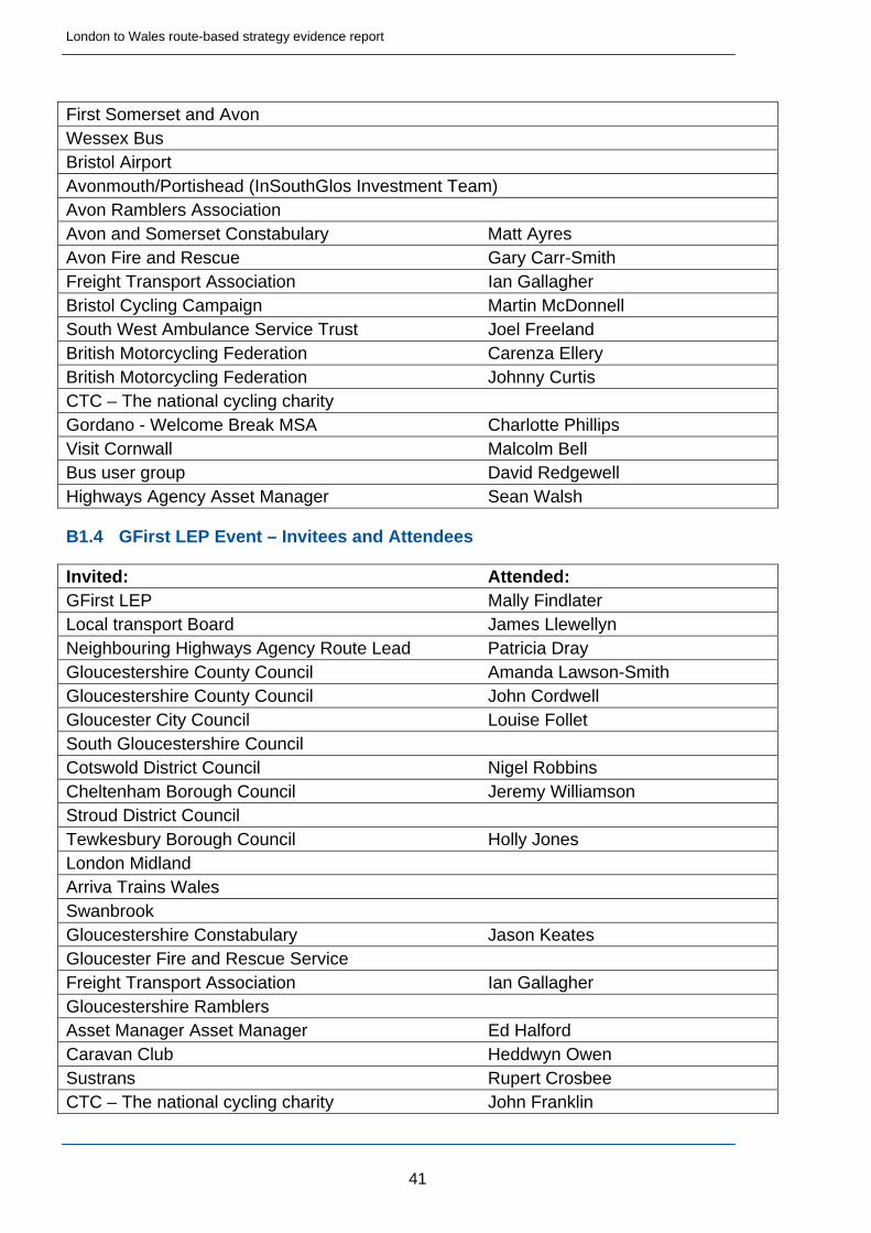
First Somerset and Avon Wessex Bus Bristol Airport Avonmouth/Portishead (InSouthGlos Investment Team) Avon Ramblers Association Avon and Somerset Constabulary Matt Ayres Avon Fire and Rescue Gary Carr-Smith Freight Transport Association Ian Gallagher Bristol Cycling Campaign Martin McDonnell South West Ambulance Service Trust Joel Freeland British Motorcycling Federation Carenza Ellery British Motorcycling Federation Johnny Curtis CTC – The national cycling charity Gordano - Welcome Break MSA Charlotte Phillips Visit Cornwall Malcolm Bell Bus user group David Redgewell Highways Agency Asset Manager Sean Walsh
B1.4 GFirst LEP Event – Invitees and Attendees
Invited: Attended: GFirst LEP Mally Findlater Local transport Board James Llewellyn Neighbouring Highways Agency Route Lead Patricia Dray Gloucestershire County Council Amanda Lawson-Smith Gloucestershire County Council John Cordwell Gloucester City Council Louise Follet South Gloucestershire Council Cotswold District Council Nigel Robbins Cheltenham Borough Council Jeremy Williamson Stroud District Council Tewkesbury Borough Council Holly Jones London Midland Arriva Trains Wales Swanbrook Gloucestershire Constabulary Jason Keates Gloucester Fire and Rescue Service Freight Transport Association Ian Gallagher Gloucestershire Ramblers Asset Manager Asset Manager Ed Halford Caravan Club Heddwyn Owen Sustrans Rupert Crosbee CTC – The national cycling charity John Franklin
41
London to Wales route-based strategy evidence report
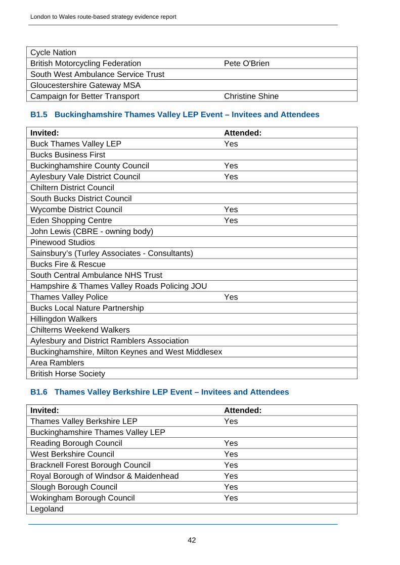
Cycle Nation British Motorcycling Federation Pete O'Brien South West Ambulance Service Trust Gloucestershire Gateway MSA Campaign for Better Transport Christine Shine
B1.5 Buckinghamshire Thames Valley LEP Event – Invitees and Attendees
Invited: Attended: Buck Thames Valley LEP Yes Bucks Business First Buckinghamshire County Council Yes Aylesbury Vale District Council Yes Chiltern District Council South Bucks District Council Wycombe District Council Yes Eden Shopping Centre Yes John Lewis (CBRE - owning body) Pinewood Studios Sainsbury’s (Turley Associates - Consultants) Bucks Fire & Rescue South Central Ambulance NHS Trust Hampshire & Thames Valley Roads Policing JOU Thames Valley Police Yes Bucks Local Nature Partnership Hillingdon Walkers Chilterns Weekend Walkers Aylesbury and District Ramblers Association Buckinghamshire, Milton Keynes and West Middlesex Area Ramblers British Horse Society
B1.6 Thames Valley Berkshire LEP Event – Invitees and Attendees
Invited: Attended: Thames Valley Berkshire LEP Yes Buckinghamshire Thames Valley LEP Reading Borough Council Yes West Berkshire Council Yes Bracknell Forest Borough Council Yes Royal Borough of Windsor & Maidenhead Yes Slough Borough Council Yes Wokingham Borough Council Yes Legoland
42
London to Wales route-based strategy evidence report
43
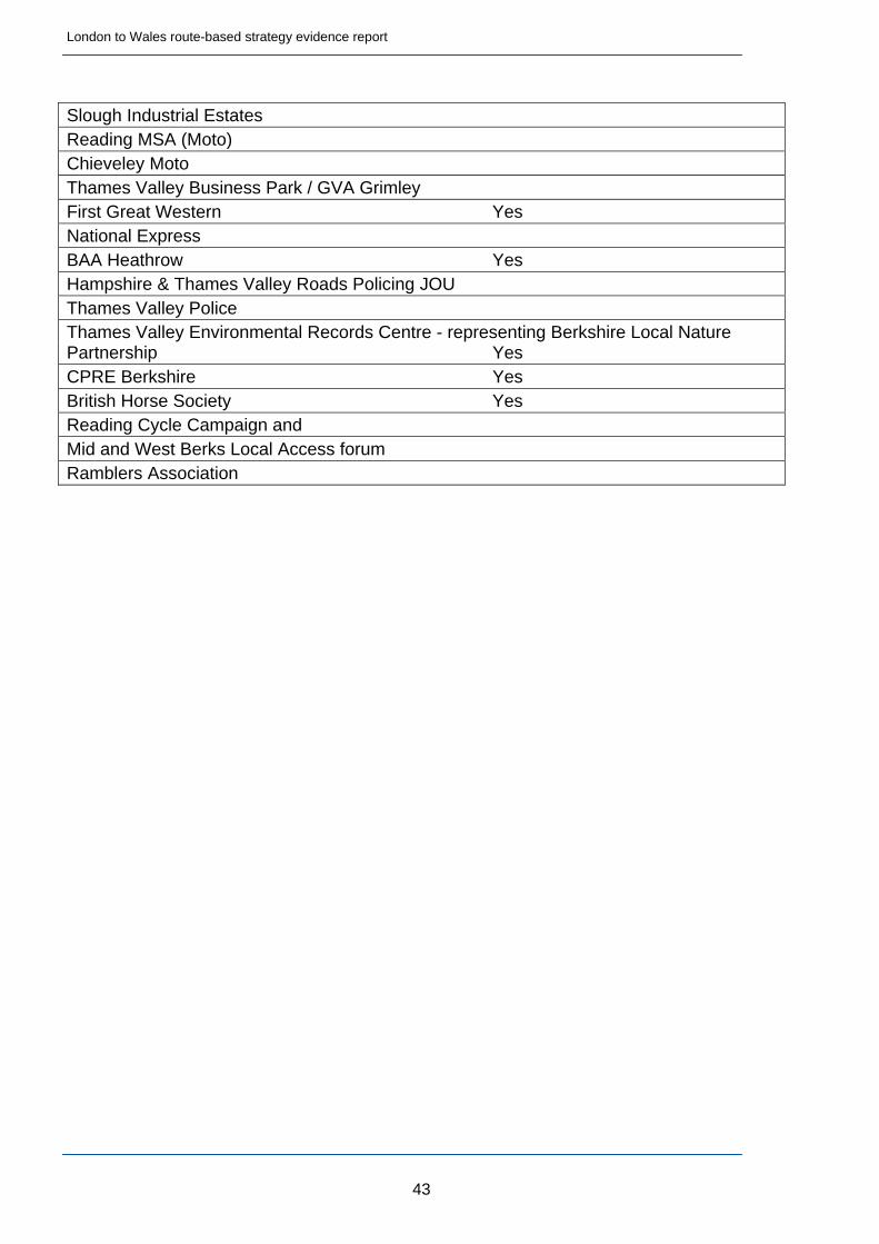
Slough Industrial Estates Reading MSA (Moto) Chieveley Moto Thames Valley Business Park / GVA Grimley First Great Western Yes National Express BAA Heathrow Yes Hampshire & Thames Valley Roads Policing JOU Thames Valley Police Thames Valley Environmental Records Centre - representing Berkshire Local Nature Partnership Yes CPRE Berkshire Yes British Horse Society Yes Reading Cycle Campaign and Mid and West Berks Local Access forum Ramblers Association
London to Wales route-based strategy evidence report
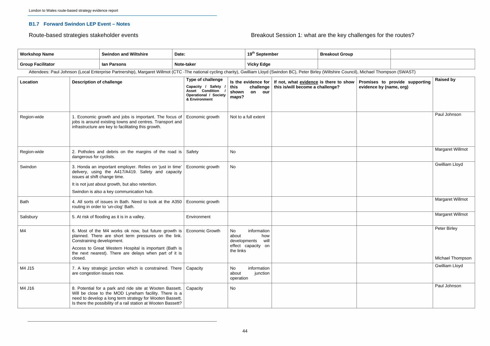
B1.7 Forward Swindon LEP Event – Notes
Route-based strategies stakeholder events Breakout Session 1: what are the key challenges for the routes?
Workshop Name Swindon and Wiltshire Date: 19th September Breakout Group
Group Facilitator Ian Parsons Note-taker Vicky Edge
Attendees: Paul Johnson (Local Enterprise Partnership), Margaret Willmot (CTC -The national cycling charity), Gwilliam Lloyd (Swindon BC), Peter Birley (Wiltshire Council), Michael Thompson (SWAST)
Location Description of challenge Type of challenge
Capacity / Safety / Asset Condition / Operational / Society & Environment
Is the evidence for this challenge shown on our maps?
If not, what evidence is there to show this is/will become a challenge?
Promises to provide supporting evidence by (name, org)
Raised by
Region-wide 1. Economic growth and jobs is important. The focus of jobs is around existing towns and centres. Transport and infrastructure are key to facilitating this growth.
Economic growth Not to a full extent Paul Johnson
Region-wide 2. Potholes and debris on the margins of the road is dangerous for cyclists.
Safety No Margaret Willmot
Swindon 3. Honda an important employer. Relies on ‘just in time’ delivery, using the A417/A419. Safety and capacity issues at shift change time.
It is not just about growth, but also retention.
Swindon is also a key communication hub.
Economic growth No Gwilliam Lloyd
Bath 4. All sorts of issues in Bath. Need to look at the A350 routing in order to ‘un-clog’ Bath.
Economic growth Margaret Willmot
Salisbury 5. At risk of flooding as it is in a valley. Environment Margaret Willmot
M4 6. Most of the M4 works ok now, but future growth is planned. There are short term pressures on the link. Constraining development.
Access to Great Western Hospital is important (Bath is the next nearest). There are delays when part of it is closed.
Economic Growth No information about how developments will effect capacity on the links
Peter Birley
Michael Thompson
M4 J15 7. A key strategic junction which is constrained. There are congestion issues now.
Capacity No information about junction operation
Gwilliam Lloyd
M4 J16 8. Potential for a park and ride site at Wooten Bassett. Will be close to the MOD Lyneham facility. There is a need to develop a long term strategy for Wooten Bassett. Is there the possibility of a rail station at Wooten Bassett?
Capacity No Paul Johnson
44
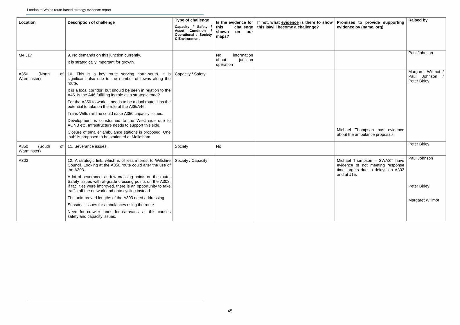
London to Wales route-based strategy evidence report
45
Location Description of challenge Type of challenge
Capacity / Safety / Asset Condition / Operational / Society & Environment
Is the evidence for this challenge shown on our maps?
If not, what evidence is there to show this is/will become a challenge?
Promises to provide supporting evidence by (name, org)
Raised by
M4 J17 9. No demands on this junction currently.
It is strategically important for growth.
No information about junction operation
Paul Johnson
A350 (North of Warminster)
10. This is a key route serving north-south. It is significant also due to the number of towns along the route.
It is a local corridor, but should be seen in relation to the A46. Is the A46 fulfilling its role as a strategic road?
For the A350 to work, it needs to be a dual route. Has the potential to take on the role of the A36/A46.
Trans-Wilts rail line could ease A350 capacity issues.
Development is constrained to the West side due to AONB etc. Infrastructure needs to support this side.
Closure of smaller ambulance stations is proposed. One ‘hub’ is proposed to be stationed at Melksham.
Capacity / Safety
Michael Thompson has evidence about the ambulance proposals.
Margaret Willmot / Paul Johnson / Peter Birley
A350 (South of Warminster)
11. Severance issues. Society No Peter Birley
A303 12. A strategic link, which is of less interest to Wiltshire Council. Looking at the A350 route could alter the use of the A303.
A lot of severance, as few crossing points on the route. Safety issues with at-grade crossing points on the A303. If facilities were improved, there is an opportunity to take traffic off the network and onto cycling instead.
The unimproved lengths of the A303 need addressing.
Seasonal issues for ambulances using the route.
Need for crawler lanes for caravans, as this causes safety and capacity issues.
Society / Capacity Michael Thompson – SWAST have evidence of not meeting response time targets due to delays on A303 and at J15.
Paul Johnson
Peter Birley
Margaret Willmot
London to Wales route-based strategy evidence report
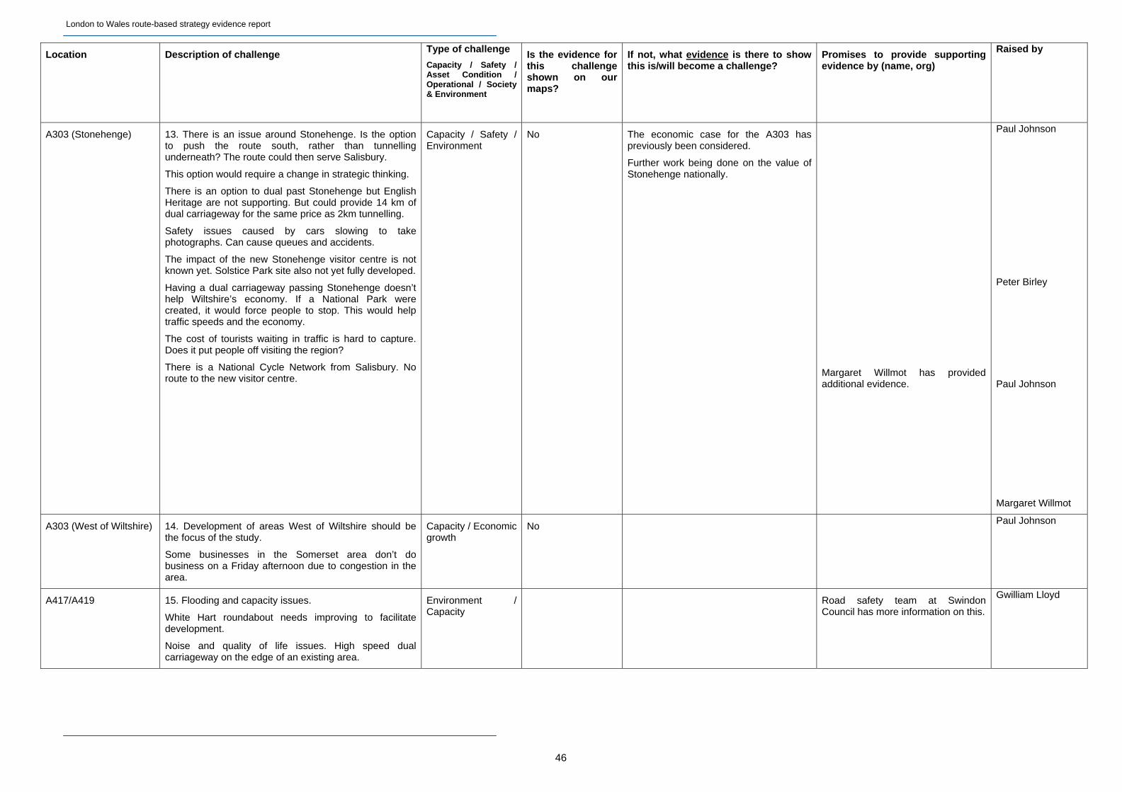
46
Location Description of challenge Type of challenge
Capacity / Safety / Asset Condition / Operational / Society & Environment
Is the evidence for this challenge shown on our maps?
If not, what evidence is there to show this is/will become a challenge?
Promises to provide supporting evidence by (name, org)
Raised by
A303 (Stonehenge) 13. There is an issue around Stonehenge. Is the option to push the route south, rather than tunnelling underneath? The route could then serve Salisbury.
This option would require a change in strategic thinking.
There is an option to dual past Stonehenge but English Heritage are not supporting. But could provide 14 km of dual carriageway for the same price as 2km tunnelling.
Safety issues caused by cars slowing to take photographs. Can cause queues and accidents.
The impact of the new Stonehenge visitor centre is not known yet. Solstice Park site also not yet fully developed.
Having a dual carriageway passing Stonehenge doesn’t help Wiltshire’s economy. If a National Park were created, it would force people to stop. This would help traffic speeds and the economy.
The cost of tourists waiting in traffic is hard to capture. Does it put people off visiting the region?
There is a National Cycle Network from Salisbury. No route to the new visitor centre.
Capacity / Safety / Environment
No The economic case for the A303 has previously been considered.
Further work being done on the value of Stonehenge nationally.
Margaret Willmot has provided additional evidence.
Paul Johnson
Peter Birley
Paul Johnson
Margaret Willmot
A303 (West of Wiltshire) 14. Development of areas West of Wiltshire should be the focus of the study.
Some businesses in the Somerset area don’t do business on a Friday afternoon due to congestion in the area.
Capacity / Economic growth
No Paul Johnson
A417/A419 15. Flooding and capacity issues.
White Hart roundabout needs improving to facilitate development.
Noise and quality of life issues. High speed dual carriageway on the edge of an existing area.
Environment / Capacity
Road safety team at Swindon Council has more information on this.
Gwilliam Lloyd
London to Wales route-based strategy evidence report
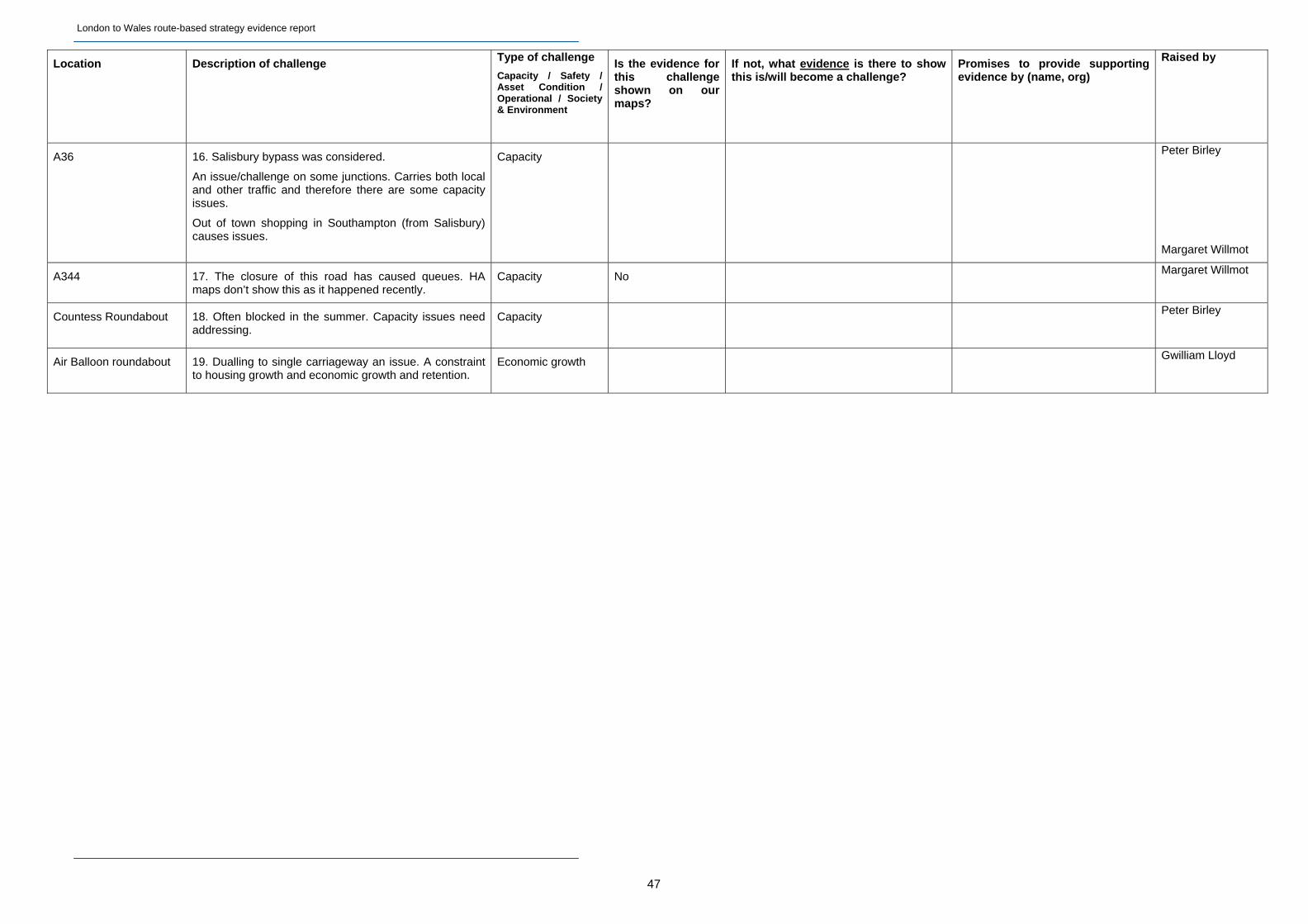
47
Location Description of challenge Type of challenge
Capacity / Safety / Asset Condition / Operational / Society & Environment
Is the evidence for this challenge shown on our maps?
If not, what evidence is there to show this is/will become a challenge?
Promises to provide supporting evidence by (name, org)
Raised by
A36 16. Salisbury bypass was considered.
An issue/challenge on some junctions. Carries both local and other traffic and therefore there are some capacity issues.
Out of town shopping in Southampton (from Salisbury) causes issues.
Capacity Peter Birley
Margaret Willmot
A344 17. The closure of this road has caused queues. HA maps don’t show this as it happened recently.
Capacity No Margaret Willmot
Countess Roundabout 18. Often blocked in the summer. Capacity issues need addressing.
Capacity Peter Birley
Air Balloon roundabout 19. Dualling to single carriageway an issue. A constraint to housing growth and economic growth and retention.
Economic growth Gwilliam Lloyd
London to Wales route-based strategy evidence report
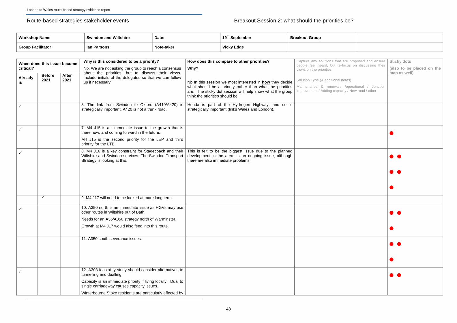
Route-based strategies stakeholder events Breakout Session 2: what should the priorities be?
Workshop Name Swindon and Wiltshire Date: 19th September Breakout Group
Group Facilitator Ian Parsons Note-taker Vicky Edge
When does this issue become critical?
Already is
Before 2021
After 2021
Why is this considered to be a priority?
Nb. We are not asking the group to reach a consensus about the priorities, but to discuss their views. Include initials of the delegates so that we can follow up if necessary
How does this compare to other priorities?
Why?
Nb In this session we most interested in how they decide what should be a priority rather than what the priorities are. The sticky dot session will help show what the group think the priorities should be.
Capture any solutions that are proposed and ensure people feel heard, but re-focus on discussing their views on the priorities.
Solution Type (& additional notes)
Maintenance & renewals /operational / Junction improvement / Adding capacity / New road / other
Sticky dots
(also to be placed on the map as well)
3. The link from Swindon to Oxford (A419/A420) is strategically important. A420 is not a trunk road.
Honda is part of the Hydrogen Highway, and so is strategically important (links Wales and London).
7. M4 J15 is an immediate issue to the growth that is there now, and coming forward in the future.
M4 J15 is the second priority for the LEP and third priority for the LTB.
8. M4 J16 is a key constraint for Stagecoach and their Wiltshire and Swindon services. The Swindon Transport Strategy is looking at this.
This is felt to be the biggest issue due to the planned development in the area. Is an ongoing issue, although there are also immediate problems.
9. M4 J17 will need to be looked at more long term.
10. A350 north is an immediate issue as HGVs may use other routes in Wiltshire out of Bath.
Needs for an A36/A350 strategy north of Warminster.
Growth at M4 J17 would also feed into this route.
11. A350 south severance issues.
12. A303 feasibility study should consider alternatives to tunnelling and dualling.
Capacity is an immediate priority if living locally. Dual to single carriageway causes capacity issues.
Winterbourne Stoke residents are particularly effected by
48
London to Wales route-based strategy evidence report
49
When does this issue become critical?
Already is
Before 2021
After 2021
Why is this considered to be a priority?
Nb. We are not asking the group to reach a consensus about the priorities, but to discuss their views. Include initials of the delegates so that we can follow up if necessary
How does this compare to other priorities?
Why?
Nb In this session we most interested in how they decide what should be a priority rather than what the priorities are. The sticky dot session will help show what the group think the priorities should be.
Capture any solutions that are proposed and ensure people feel heard, but re-focus on discussing their views on the priorities.
Solution Type (& additional notes)
Maintenance & renewals /operational / Junction improvement / Adding capacity / New road / other
Sticky dots
(also to be placed on the map as well)
severance.
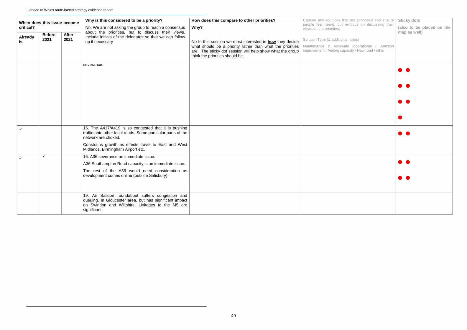
15. The A417/A419 is so congested that it is pushing traffic onto other local roads. Some particular parts of the network are choked.
Constrains growth as effects travel to East and West Midlands, Birmingham Airport etc.
16. A36 severance an immediate issue.
A36 Southampton Road capacity is an immediate issue.
The rest of the A36 would need consideration as development comes online (outside Salisbury).
19. Air Balloon roundabout suffers congestion and
queuing. In Gloucester area, but has significant impact on Swindon and Wiltshire. Linkages to the M5 are significant.
London to Wales route-based strategy evidence report
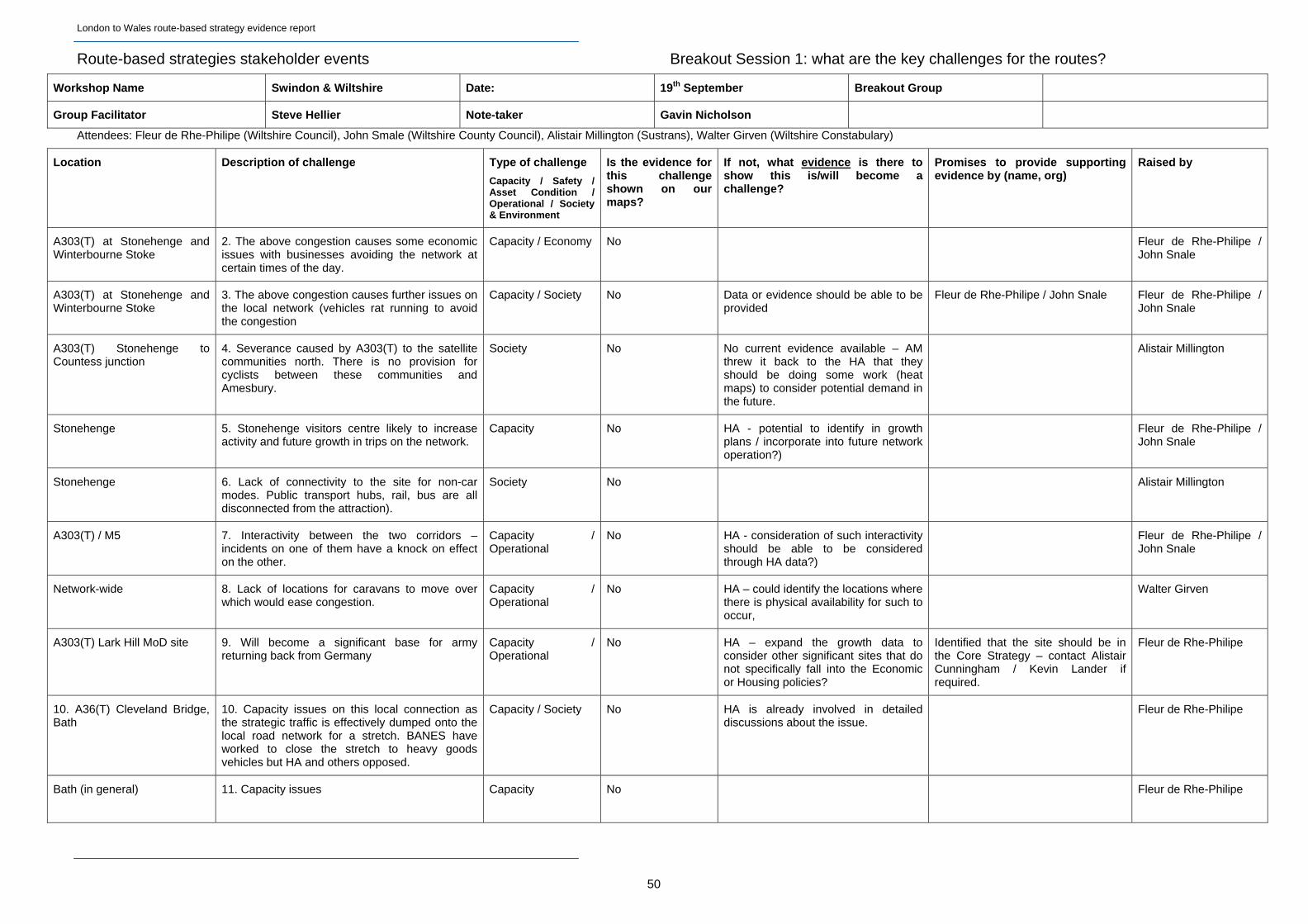
Route-based strategies stakeholder events Breakout Session 1: what are the key challenges for the routes?
Workshop Name Swindon & Wiltshire Date: 19th September Breakout Group
Group Facilitator Steve Hellier Note-taker Gavin Nicholson
Attendees: Fleur de Rhe-Philipe (Wiltshire Council), John Smale (Wiltshire County Council), Alistair Millington (Sustrans), Walter Girven (Wiltshire Constabulary)
Location Description of challenge Type of challenge
Capacity / Safety / Asset Condition / Operational / Society & Environment
Is the evidence for this challenge shown on our maps?
If not, what evidence is there to show this is/will become a challenge?
Promises to provide supporting evidence by (name, org)
Raised by
A303(T) at Stonehenge and Winterbourne Stoke
2. The above congestion causes some economic issues with businesses avoiding the network at certain times of the day.
Capacity / Economy No Fleur de Rhe-Philipe / John Snale
A303(T) at Stonehenge and Winterbourne Stoke
3. The above congestion causes further issues on the local network (vehicles rat running to avoid the congestion
Capacity / Society No Data or evidence should be able to be provided
Fleur de Rhe-Philipe / John Snale Fleur de Rhe-Philipe / John Snale
A303(T) Stonehenge to Countess junction
4. Severance caused by A303(T) to the satellite communities north. There is no provision for cyclists between these communities and Amesbury.
Society No No current evidence available – AM threw it back to the HA that they should be doing some work (heat maps) to consider potential demand in the future.
Alistair Millington
Stonehenge 5. Stonehenge visitors centre likely to increase activity and future growth in trips on the network.
Capacity No HA - potential to identify in growth plans / incorporate into future network operation?)
Fleur de Rhe-Philipe / John Snale
Stonehenge 6. Lack of connectivity to the site for non-car modes. Public transport hubs, rail, bus are all disconnected from the attraction).
Society No Alistair Millington
A303(T) / M5 7. Interactivity between the two corridors – incidents on one of them have a knock on effect on the other.
Capacity / Operational
No HA - consideration of such interactivity should be able to be considered through HA data?)
Fleur de Rhe-Philipe / John Snale
Network-wide 8. Lack of locations for caravans to move over which would ease congestion.
Capacity / Operational
No HA – could identify the locations where there is physical availability for such to occur,
Walter Girven
A303(T) Lark Hill MoD site 9. Will become a significant base for army returning back from Germany
Capacity / Operational
No HA – expand the growth data to consider other significant sites that do not specifically fall into the Economic or Housing policies?
Identified that the site should be in the Core Strategy – contact Alistair Cunningham / Kevin Lander if required.
Fleur de Rhe-Philipe
10. A36(T) Cleveland Bridge, Bath
10. Capacity issues on this local connection as the strategic traffic is effectively dumped onto the local road network for a stretch. BANES have worked to close the stretch to heavy goods vehicles but HA and others opposed.
Capacity / Society No HA is already involved in detailed discussions about the issue.
Fleur de Rhe-Philipe
Bath (in general) 11. Capacity issues Capacity No Fleur de Rhe-Philipe
50
London to Wales route-based strategy evidence report
51
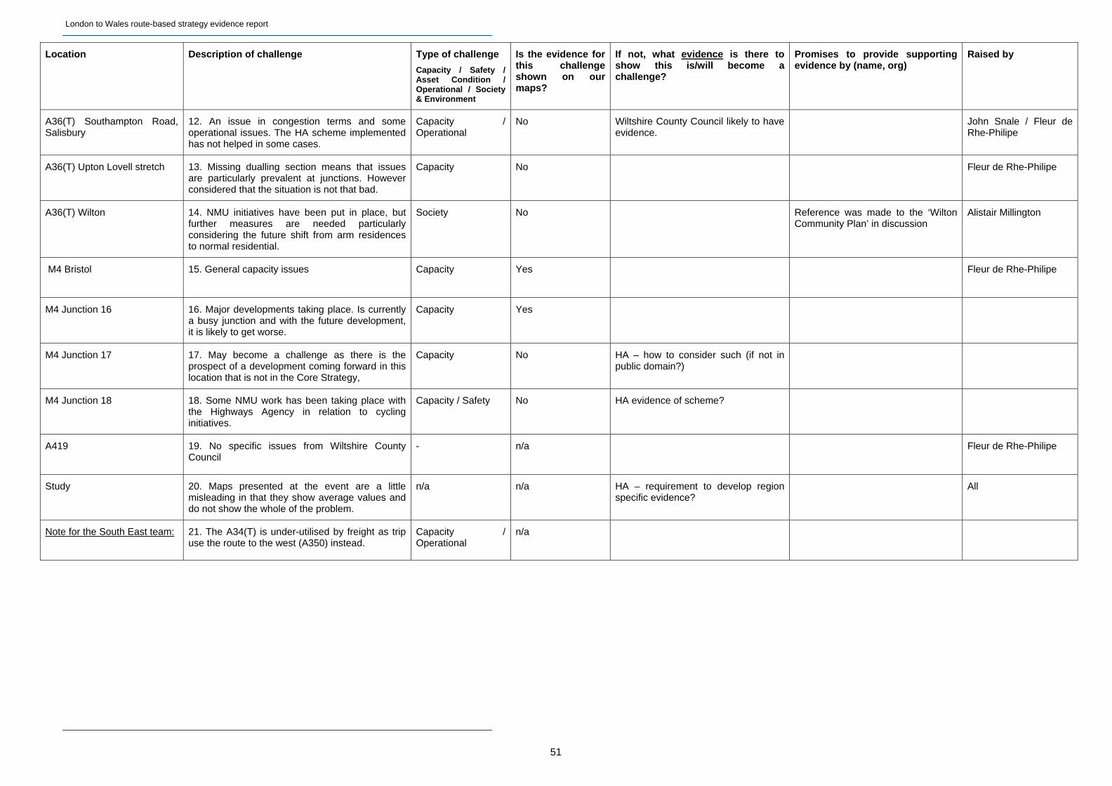
Location Description of challenge Type of challenge
Capacity / Safety / Asset Condition / Operational / Society & Environment
Is the evidence for this challenge shown on our maps?
If not, what evidence is there to show this is/will become a challenge?
Promises to provide supporting evidence by (name, org)
Raised by
A36(T) Southampton Road, Salisbury
12. An issue in congestion terms and some operational issues. The HA scheme implemented has not helped in some cases.
Capacity / Operational
No Wiltshire County Council likely to have evidence.
John Snale / Fleur de Rhe-Philipe
A36(T) Upton Lovell stretch 13. Missing dualling section means that issues are particularly prevalent at junctions. However considered that the situation is not that bad.
Capacity No Fleur de Rhe-Philipe
A36(T) Wilton 14. NMU initiatives have been put in place, but further measures are needed particularly considering the future shift from arm residences to normal residential.
Society No Reference was made to the ‘Wilton Community Plan’ in discussion
Alistair Millington
M4 Bristol 15. General capacity issues Capacity Yes Fleur de Rhe-Philipe
M4 Junction 16 16. Major developments taking place. Is currently a busy junction and with the future development, it is likely to get worse.
Capacity Yes
M4 Junction 17 17. May become a challenge as there is the prospect of a development coming forward in this location that is not in the Core Strategy,
Capacity No HA – how to consider such (if not in public domain?)
M4 Junction 18 18. Some NMU work has been taking place with the Highways Agency in relation to cycling initiatives.
Capacity / Safety No HA evidence of scheme?
A419 19. No specific issues from Wiltshire County Council
- n/a Fleur de Rhe-Philipe
Study 20. Maps presented at the event are a little misleading in that they show average values and do not show the whole of the problem.
n/a n/a HA – requirement to develop region specific evidence?
All
Note for the South East team: 21. The A34(T) is under-utilised by freight as trip use the route to the west (A350) instead.
Capacity / Operational
n/a
London to Wales route-based strategy evidence report
Route-based strategies stakeholder events Breakout Session 2: what should the priorities be?
Workshop Name Swindon & Wiltshire Date: 19th September Breakout Group
Group Facilitator Steve Hellier Note-taker Gavin Nicholson
When does this issue become critical?
Already is
Before 2021
After 2021
Why is this considered to be a priority?
Nb. We are not asking the group to reach a consensus about the priorities, but to discuss their views. Include initials of the delegates so that we can follow up if necessary
How does this compare to other priorities?
Why?
Nb In this session we most interested in how they decide what should be a priority rather than what the priorities are. The sticky dot session will help show what the group think the priorities should be.
Capture any solutions that are proposed and ensure people feel heard, but re-focus on discussing their views on the priorities.
Solution Type (& additional notes)
Maintenance & renewals /operational / Junction improvement / Adding capacity / New road / other
Sticky dots
(also to be placed on the map as well)
Note, sticky dots exercise was undertaken on a separate summary sheet
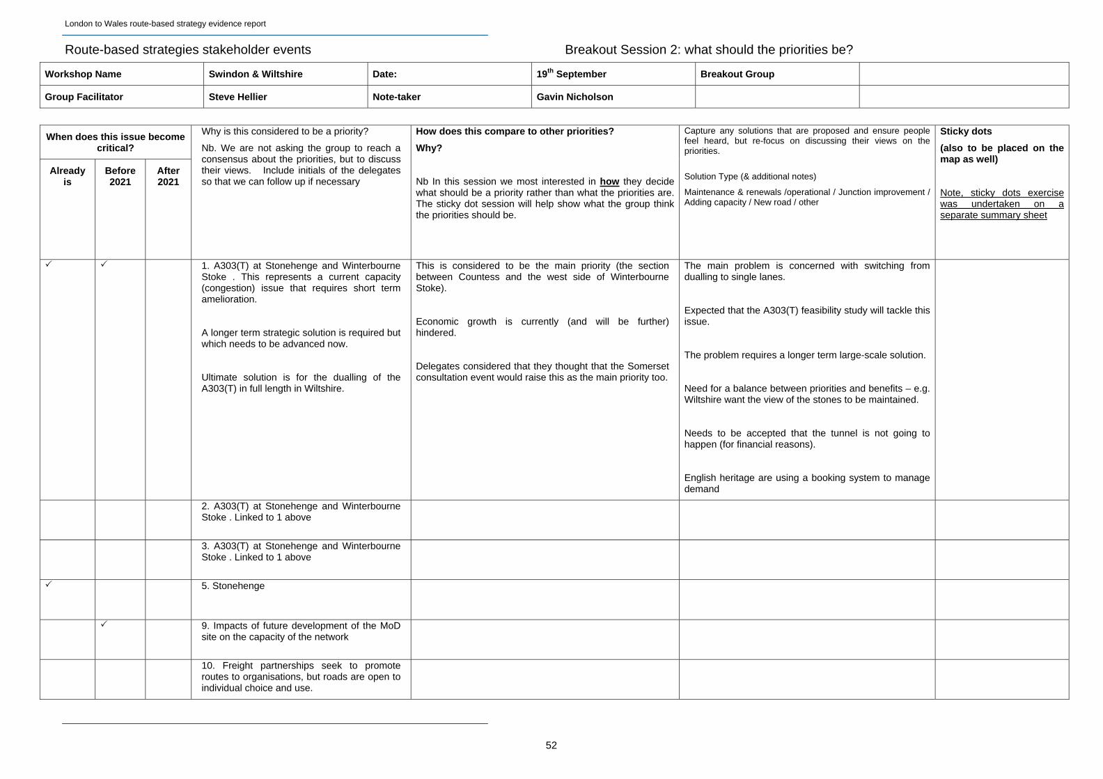
1. A303(T) at Stonehenge and Winterbourne Stoke . This represents a current capacity (congestion) issue that requires short term amelioration.
A longer term strategic solution is required but which needs to be advanced now.
Ultimate solution is for the dualling of the A303(T) in full length in Wiltshire.
This is considered to be the main priority (the section between Countess and the west side of Winterbourne Stoke).
Economic growth is currently (and will be further) hindered.
Delegates considered that they thought that the Somerset consultation event would raise this as the main priority too.
The main problem is concerned with switching from dualling to single lanes.
Expected that the A303(T) feasibility study will tackle this issue.
The problem requires a longer term large-scale solution.
Need for a balance between priorities and benefits – e.g. Wiltshire want the view of the stones to be maintained.
Needs to be accepted that the tunnel is not going to happen (for financial reasons).
English heritage are using a booking system to manage demand
2. A303(T) at Stonehenge and Winterbourne Stoke . Linked to 1 above
3. A303(T) at Stonehenge and Winterbourne Stoke . Linked to 1 above
5. Stonehenge
9. Impacts of future development of the MoD site on the capacity of the network
10. Freight partnerships seek to promote routes to organisations, but roads are open to individual choice and use.
52
London to Wales route-based strategy evidence report
53
When does this issue become critical?
Already is
Before 2021
After 2021
Why is this considered to be a priority?
Nb. We are not asking the group to reach a consensus about the priorities, but to discuss their views. Include initials of the delegates so that we can follow up if necessary
How does this compare to other priorities?
Why?
Nb In this session we most interested in how they decide what should be a priority rather than what the priorities are. The sticky dot session will help show what the group think the priorities should be.
Capture any solutions that are proposed and ensure people feel heard, but re-focus on discussing their views on the priorities.
Solution Type (& additional notes)
Maintenance & renewals /operational / Junction improvement / Adding capacity / New road / other
Sticky dots
(also to be placed on the map as well)
Note, sticky dots exercise was undertaken on a separate summary sheet
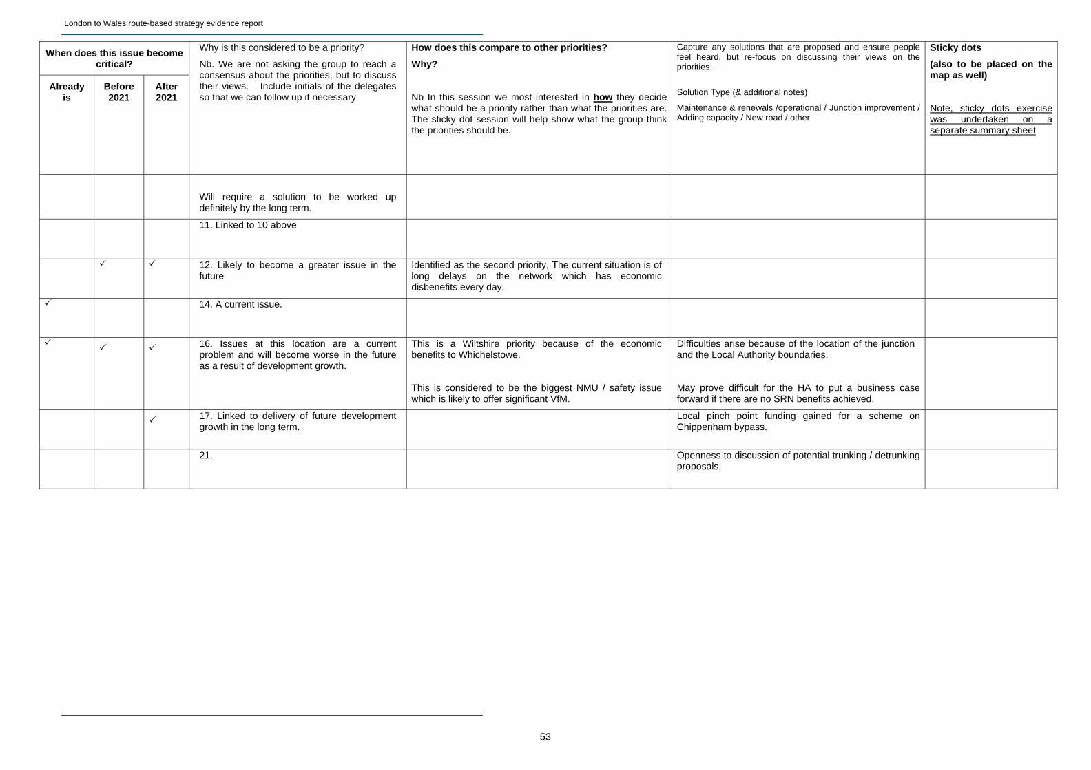
Will require a solution to be worked up definitely by the long term.
11. Linked to 10 above
12. Likely to become a greater issue in the future
Identified as the second priority, The current situation is of long delays on the network which has economic disbenefits every day.
14. A current issue.
16. Issues at this location are a current
problem and will become worse in the future as a result of development growth.
This is a Wiltshire priority because of the economic benefits to Whichelstowe.
This is considered to be the biggest NMU / safety issue which is likely to offer significant VfM.
Difficulties arise because of the location of the junction and the Local Authority boundaries.
May prove difficult for the HA to put a business case forward if there are no SRN benefits achieved.
17. Linked to delivery of future development growth in the long term.
Local pinch point funding gained for a scheme on Chippenham bypass.
21. Openness to discussion of potential trunking / detrunking
proposals.
London to Wales route-based strategy evidence report
B1.8 West of England LEP Event – Notes
Route-based strategies stakeholder events Breakout Session 1: what are the key challenges for the routes?
Workshop Name West of England Date: 20th September Breakout Group One
Group Facilitator Ian Parsons Note-taker Vicky Edge
Attendees: Sheena Hague (Welsh Assembly Government), Laurence Fallon (Bristol City Council), Malcolm Bell (South West Tourism), Steve Evans (South Gloucestershire Council), Pete Davis (Local Enterprise Partnership)
Location Description of challenge Type of challenge
Capacity / Safety / Asset Condition / Operational / Society & Environment
Is the evidence for this challenge shown on our maps?
If not, what evidence is there to show this is/will become a challenge?
Promises to provide supporting evidence by (name, org)
Raised by
Study 1. What is the difference between this and Route Management Strategies?
No
Sheena Hague
Study 2. How will prioritisation work? How can local/strategic/stakeholder views and needs be balanced?
No Sheena Hague
Study 3. Housing and growth plans need to sit alongside RBS. North Fringe and South Bristol are the housing priorities within Bristol.
Travel planning can be used to remove local traffic from the network.
Capacity / Economic growth
Partly Laurence Fallon
Study 4. Effect on traffic of the school holiday policies. Can’t take children out of school in term time, so a big increase in traffic at the start of holidays.
Traffic management during holidays is important. If the weather is bad, people react and leave their holiday, which floods the network.
Capacity / Operational
No Malcolm Bell
Study 5. The Highways Agency are reactive rather than proactive. They need to engage and integrate when planning.
Need to engage with local authorities at the local plan core strategy stage.
Economic growth No Steve Evans
Pete Davis
Region-wide 6. Missing evidence from maps, e.g. Temple Quarter is an Enterprise Zone. There are also Enterprise Areas which are relevant. These will feature heavily in economic priorities and create 60,000 jobs.
Economic growth No Pete Davis
Region-wide 7. Environment Agency flood relief document recently published.
Environment Steve Evans
54
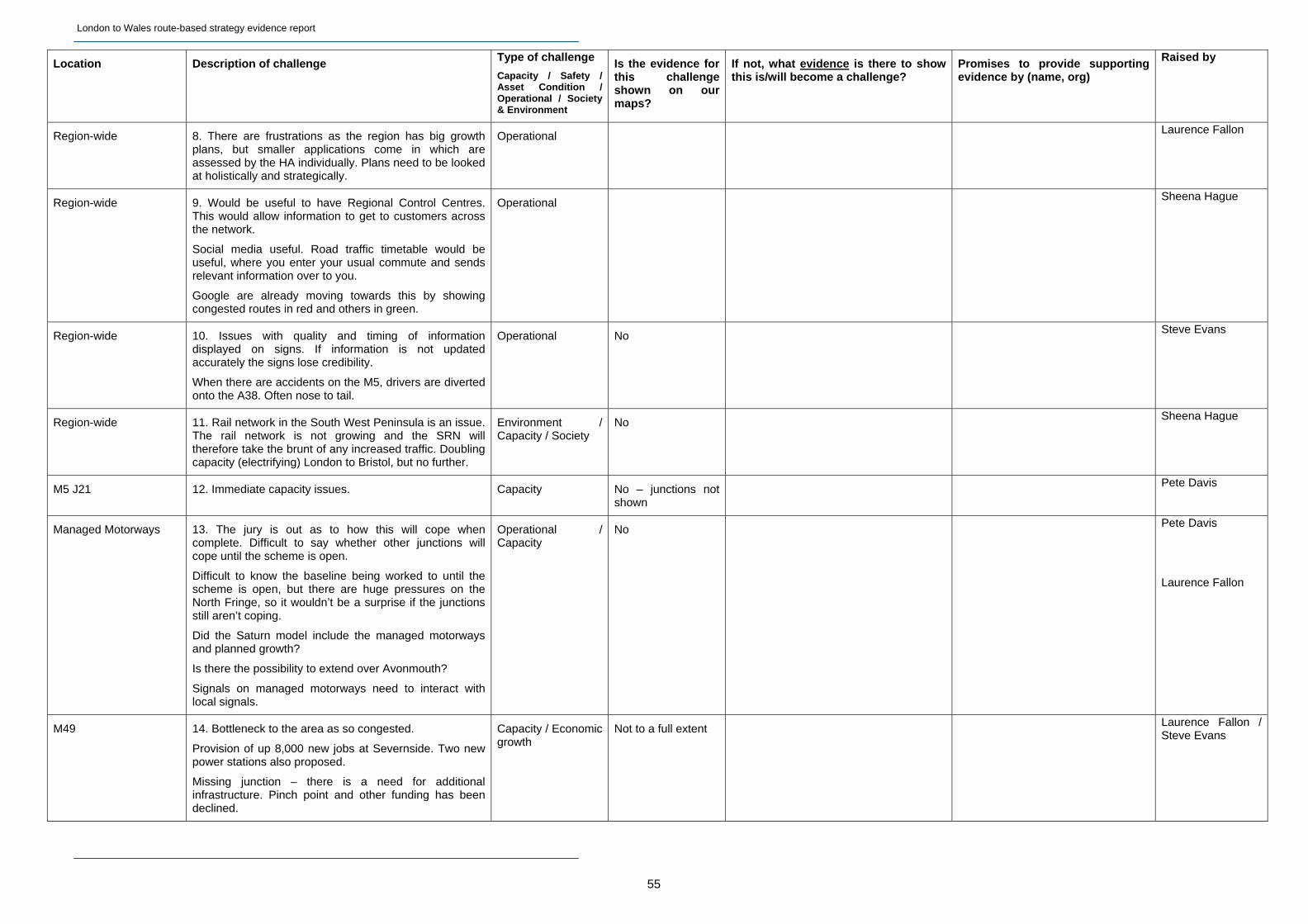
London to Wales route-based strategy evidence report
55
Location Description of challenge Type of challenge
Capacity / Safety / Asset Condition / Operational / Society & Environment
Is the evidence for this challenge shown on our maps?
If not, what evidence is there to show this is/will become a challenge?
Promises to provide supporting evidence by (name, org)
Raised by
Region-wide 8. There are frustrations as the region has big growth plans, but smaller applications come in which are assessed by the HA individually. Plans need to be looked at holistically and strategically.
Operational Laurence Fallon
Region-wide 9. Would be useful to have Regional Control Centres. This would allow information to get to customers across the network.
Social media useful. Road traffic timetable would be useful, where you enter your usual commute and sends relevant information over to you.
Google are already moving towards this by showing congested routes in red and others in green.
Operational Sheena Hague
Region-wide 10. Issues with quality and timing of information displayed on signs. If information is not updated accurately the signs lose credibility.
When there are accidents on the M5, drivers are diverted onto the A38. Often nose to tail.
Operational No Steve Evans
Region-wide 11. Rail network in the South West Peninsula is an issue. The rail network is not growing and the SRN will therefore take the brunt of any increased traffic. Doubling capacity (electrifying) London to Bristol, but no further.
Environment / Capacity / Society
No Sheena Hague
M5 J21 12. Immediate capacity issues. Capacity No – junctions not shown
Pete Davis
Managed Motorways 13. The jury is out as to how this will cope when complete. Difficult to say whether other junctions will cope until the scheme is open.
Difficult to know the baseline being worked to until the scheme is open, but there are huge pressures on the North Fringe, so it wouldn’t be a surprise if the junctions still aren’t coping.
Did the Saturn model include the managed motorways and planned growth?
Is there the possibility to extend over Avonmouth?
Signals on managed motorways need to interact with local signals.
Operational / Capacity
No Pete Davis
Laurence Fallon
M49 14. Bottleneck to the area as so congested.
Provision of up 8,000 new jobs at Severnside. Two new power stations also proposed.
Missing junction – there is a need for additional infrastructure. Pinch point and other funding has been declined.
Capacity / Economic growth
Not to a full extent Laurence Fallon / Steve Evans
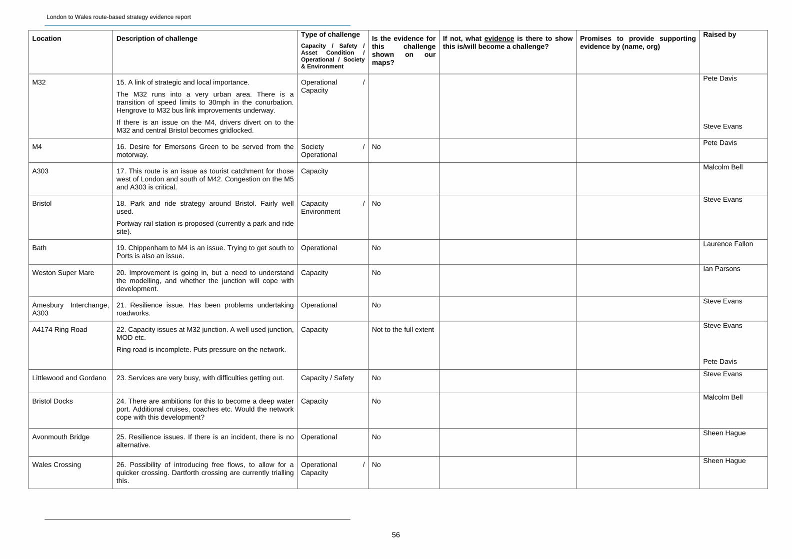
London to Wales route-based strategy evidence report
Location Description of challenge Type of challenge
Capacity / Safety / Asset Condition / Operational / Society & Environment
Is the evidence for this challenge shown on our maps?
If not, what evidence is there to show this is/will become a challenge?
Promises to provide supporting evidence by (name, org)
Raised by
M32 15. A link of strategic and local importance.
The M32 runs into a very urban area. There is a transition of speed limits to 30mph in the conurbation. Hengrove to M32 bus link improvements underway.
If there is an issue on the M4, drivers divert on to the M32 and central Bristol becomes gridlocked.
Operational / Capacity
Pete Davis
Steve Evans
M4 16. Desire for Emersons Green to be served from the motorway.
Society / Operational
No Pete Davis
A303 17. This route is an issue as tourist catchment for those west of London and south of M42. Congestion on the M5 and A303 is critical.
Capacity Malcolm Bell
Bristol 18. Park and ride strategy around Bristol. Fairly well used.
Portway rail station is proposed (currently a park and ride site).
Capacity / Environment
No Steve Evans
Bath 19. Chippenham to M4 is an issue. Trying to get south to Ports is also an issue.
Operational No Laurence Fallon
Weston Super Mare 20. Improvement is going in, but a need to understand the modelling, and whether the junction will cope with development.
Capacity No Ian Parsons
Amesbury Interchange, A303
21. Resilience issue. Has been problems undertaking roadworks.
Operational No Steve Evans
A4174 Ring Road 22. Capacity issues at M32 junction. A well used junction, MOD etc.
Ring road is incomplete. Puts pressure on the network.
Capacity Not to the full extent Steve Evans
Pete Davis
Littlewood and Gordano 23. Services are very busy, with difficulties getting out. Capacity / Safety No Steve Evans
Bristol Docks 24. There are ambitions for this to become a deep water port. Additional cruises, coaches etc. Would the network cope with this development?
Capacity No Malcolm Bell
Avonmouth Bridge 25. Resilience issues. If there is an incident, there is no alternative.
Operational No Sheen Hague
Wales Crossing 26. Possibility of introducing free flows, to allow for a quicker crossing. Dartforth crossing are currently trialling this.
Operational / Capacity
No Sheen Hague
56
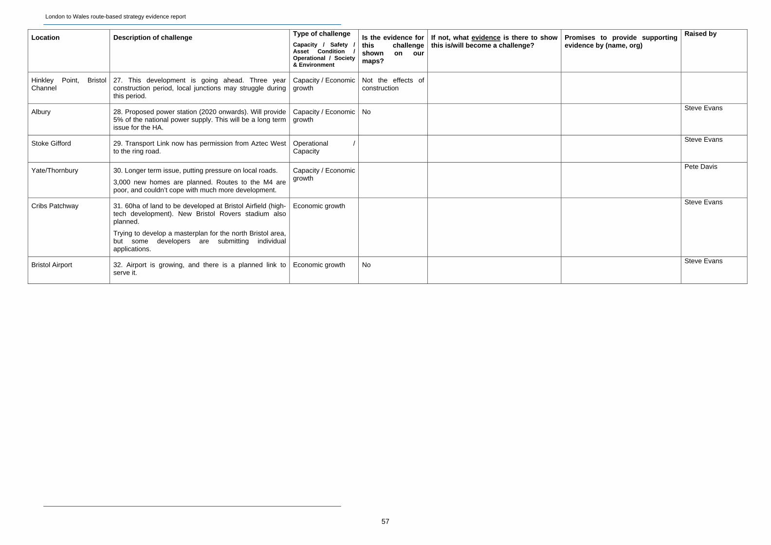
London to Wales route-based strategy evidence report
Location Description of challenge Type of challenge
Capacity / Safety / Asset Condition / Operational / Society & Environment
Is the evidence for this challenge shown on our maps?
If not, what evidence is there to show this is/will become a challenge?
Promises to provide supporting evidence by (name, org)
Raised by
Hinkley Point, Bristol Channel
27. This development is going ahead. Three year construction period, local junctions may struggle during this period.
Capacity / Economic growth
Not the effects of construction
Albury 28. Proposed power station (2020 onwards). Will provide 5% of the national power supply. This will be a long term issue for the HA.
Capacity / Economic growth
No Steve Evans
Stoke Gifford 29. Transport Link now has permission from Aztec West to the ring road.
Operational / Capacity
Steve Evans
Yate/Thornbury 30. Longer term issue, putting pressure on local roads.
3,000 new homes are planned. Routes to the M4 are poor, and couldn’t cope with much more development.
Capacity / Economic growth
Pete Davis
Cribs Patchway 31. 60ha of land to be developed at Bristol Airfield (high-tech development). New Bristol Rovers stadium also planned.
Trying to develop a masterplan for the north Bristol area, but some developers are submitting individual applications.
Economic growth Steve Evans
Bristol Airport 32. Airport is growing, and there is a planned link to serve it.
Economic growth No Steve Evans
57
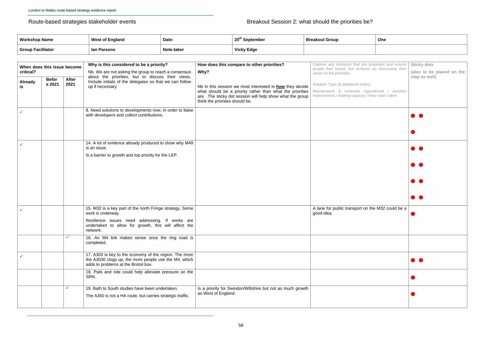
London to Wales route-based strategy evidence report
Route-based strategies stakeholder events Breakout Session 2: what should the priorities be?
Workshop Name West of England Date: 20th September Breakout Group One
Group Facilitator Ian Parsons Note-taker Vicky Edge
When does this issue become critical?
Already is
Before 2021
After 2021
Why is this considered to be a priority?
Nb. We are not asking the group to reach a consensus about the priorities, but to discuss their views. Include initials of the delegates so that we can follow up if necessary
How does this compare to other priorities?
Why?
Nb In this session we most interested in how they decide what should be a priority rather than what the priorities are. The sticky dot session will help show what the group think the priorities should be.
Capture any solutions that are proposed and ensure people feel heard, but re-focus on discussing their views on the priorities.
Solution Type (& additional notes)
Maintenance & renewals /operational / Junction improvement / Adding capacity / New road / other
Sticky dots
(also to be placed on the map as well)
8. Need solutions to developments now, in order to liaise with developers and collect contributions.
14. A lot of evidence already produced to show why M49
is an issue.
Is a barrier to growth and top priority for the LEP.
15. M32 is a key part of the north Fringe strategy. Some work is underway.
Resilience issues need addressing. If works are undertaken to allow for growth, this will affect the network.
A lane for public transport on the M32 could be a good idea.
16. An M4 link makes sense once the ring road is
completed.
17. A303 is key to the economy of the region. The more the A3030 clogs up, the more people use the M4, which adds to problems at the Bristol box.
18. Park and ride could help alleviate pressure on the
SRN.
19. Bath to South studies have been undertaken.
The A350 is not a HA route, but carries strategic traffic.
Is a priority for Swindon/Wiltshire but not as much growth as West of England.
58
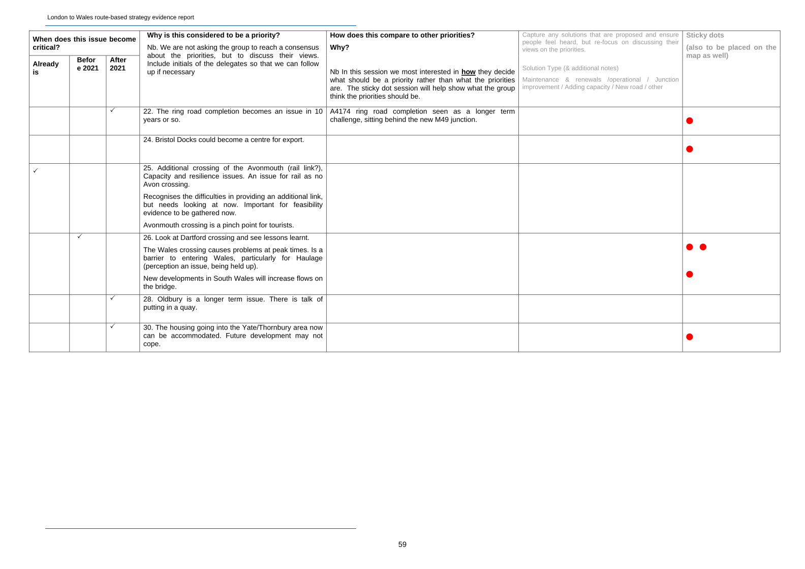
London to Wales route-based strategy evidence report
59
When does this issue become critical?
Already is
Before 2021
After 2021
Why is this considered to be a priority?
Nb. We are not asking the group to reach a consensus about the priorities, but to discuss their views. Include initials of the delegates so that we can follow up if necessary
How does this compare to other priorities?
Why?
Nb In this session we most interested in how they decide what should be a priority rather than what the priorities are. The sticky dot session will help show what the group think the priorities should be.
Capture any solutions that are proposed and ensure people feel heard, but re-focus on discussing their views on the priorities.
Solution Type (& additional notes)
Maintenance & renewals /operational / Junction improvement / Adding capacity / New road / other
Sticky dots
(also to be placed on the map as well)
22. The ring road completion becomes an issue in 10
years or so. A4174 ring road completion seen as a longer term challenge, sitting behind the new M49 junction.
24. Bristol Docks could become a centre for export.
25. Additional crossing of the Avonmouth (rail link?),
Capacity and resilience issues. An issue for rail as no Avon crossing.
Recognises the difficulties in providing an additional link, but needs looking at now. Important for feasibility evidence to be gathered now.
Avonmouth crossing is a pinch point for tourists.
26. Look at Dartford crossing and see lessons learnt.
The Wales crossing causes problems at peak times. Is a barrier to entering Wales, particularly for Haulage (perception an issue, being held up).
New developments in South Wales will increase flows on the bridge.
28. Oldbury is a longer term issue. There is talk of putting in a quay.
30. The housing going into the Yate/Thornbury area now
can be accommodated. Future development may not cope.
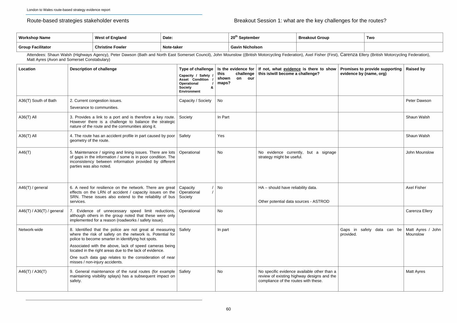
London to Wales route-based strategy evidence report
Route-based strategies stakeholder events Breakout Session 1: what are the key challenges for the routes?
Workshop Name West of England Date: 20th September Breakout Group Two
Group Facilitator Christine Fowler Note-taker Gavin Nicholson
Attendees: Shaun Walsh (Highways Agency), Peter Dawson (Bath and North East Somerset Council), John Mounslow ((British Motorcycling Federation), Axel Fisher (First), Carenza Ellery (British Motorcycling Federation), Matt Ayres (Avon and Somerset Constabulary)
Location Description of challenge Type of challenge
Capacity / Safety / Asset Condition / Operational / Society & Environment
Is the evidence for this challenge shown on our maps?
If not, what evidence is there to show this is/will become a challenge?
Promises to provide supporting evidence by (name, org)
Raised by
A36(T) South of Bath 2. Current congestion issues.
Severance to communities.
Capacity / Society No Peter Dawson
A36(T) All 3. Provides a link to a port and is therefore a key route. However there is a challenge to balance the strategic nature of the route and the communities along it.
Society In Part Shaun Walsh
A36(T) All 4. The route has an accident profile in part caused by poor geometry of the route.
Safety Yes Shaun Walsh
A46(T) 5. Maintenance / signing and lining issues. There are lots of gaps in the information / some is in poor condition. The inconsistency between information provided by different parties was also noted.
Operational No No evidence currently, but a signage strategy might be useful.
John Mounslow
A46(T) / general
6. A need for resilience on the network. There are great effects on the LRN of accident / capacity issues on the SRN. These issues also extend to the reliability of bus services.
Capacity / Operational / Society
No HA – should have reliability data.
Other potential data sources - ASTROD
Axel Fisher
A46(T) / A36(T) / general 7. Evidence of unnecessary speed limit reductions, although others in the group noted that these were only implemented for a reason (roadworks / safety issue).
Operational No Carenza Ellery
Network-wide 8. Identified that the police are not great at measuring where the risk of safety on the network is. Potential for police to become smarter in identifying hot spots.
Associated with the above, lack of speed cameras being located in the right areas due to the lack of evidence.
One such data gap relates to the consideration of near misses / non-injury accidents.
Safety In part Gaps in safety data can be provided.
Matt Ayres / John Mounslow
A46(T) / A36(T) 9. General maintenance of the rural routes (for example maintaining visibility splays) has a subsequent impact on safety.
Safety No No specific evidence available other than a review of existing highway designs and the compliance of the routes with these.
Matt Ayres
60
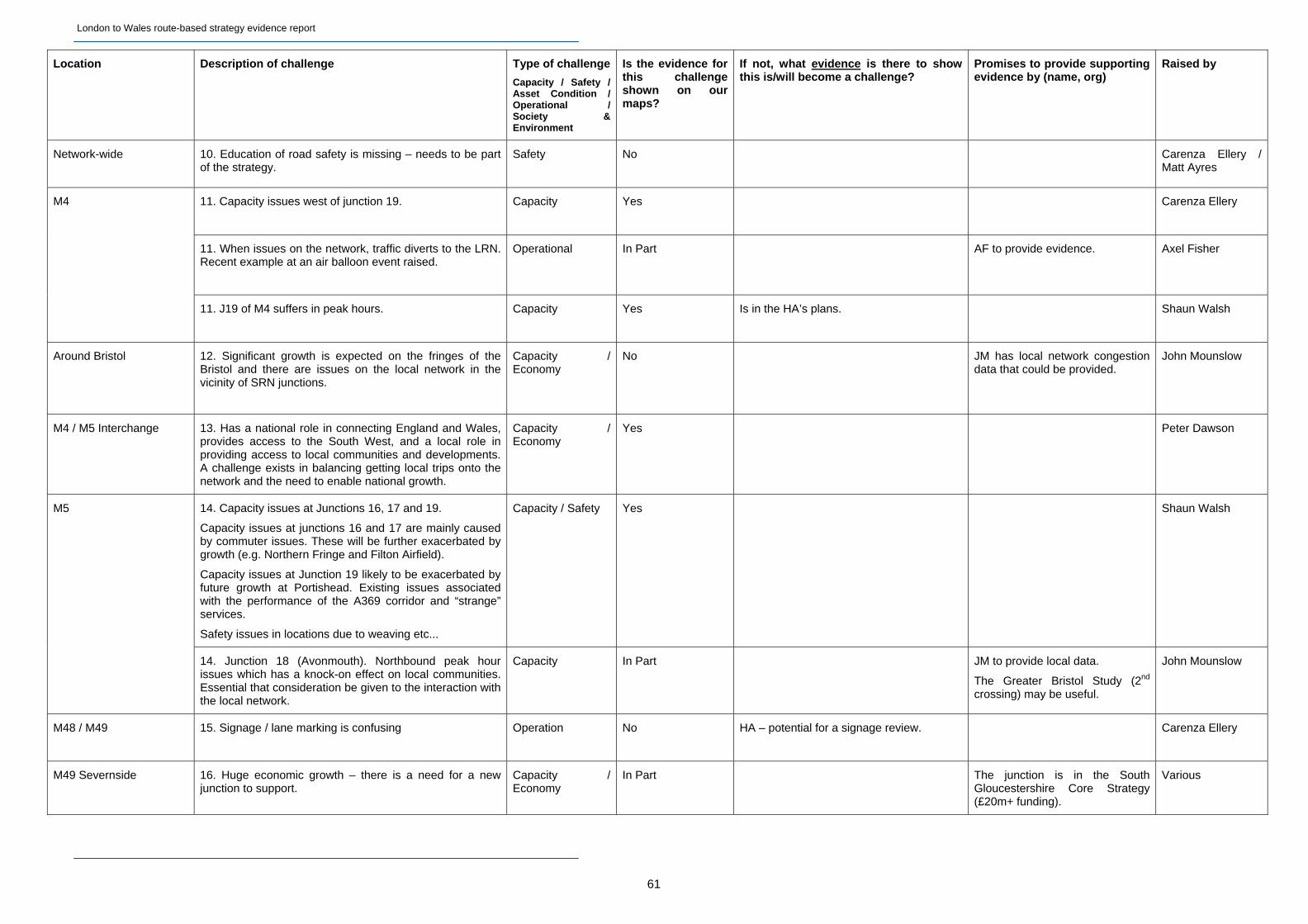
London to Wales route-based strategy evidence report
61
Location Description of challenge Type of challenge
Capacity / Safety / Asset Condition / Operational / Society & Environment
Is the evidence for this challenge shown on our maps?
If not, what evidence is there to show this is/will become a challenge?
Promises to provide supporting evidence by (name, org)
Raised by
Network-wide
10. Education of road safety is missing – needs to be part of the strategy.
Safety No Carenza Ellery / Matt Ayres
11. Capacity issues west of junction 19.
Capacity Yes Carenza Ellery
11. When issues on the network, traffic diverts to the LRN. Recent example at an air balloon event raised.
Operational In Part AF to provide evidence. Axel Fisher
M4
11. J19 of M4 suffers in peak hours. Capacity Yes Is in the HA’s plans. Shaun Walsh
Around Bristol 12. Significant growth is expected on the fringes of the Bristol and there are issues on the local network in the vicinity of SRN junctions.
Capacity / Economy
No JM has local network congestion data that could be provided.
John Mounslow
M4 / M5 Interchange
13. Has a national role in connecting England and Wales, provides access to the South West, and a local role in providing access to local communities and developments. A challenge exists in balancing getting local trips onto the network and the need to enable national growth.
Capacity / Economy
Yes Peter Dawson
14. Capacity issues at Junctions 16, 17 and 19.
Capacity issues at junctions 16 and 17 are mainly caused by commuter issues. These will be further exacerbated by growth (e.g. Northern Fringe and Filton Airfield).
Capacity issues at Junction 19 likely to be exacerbated by future growth at Portishead. Existing issues associated with the performance of the A369 corridor and “strange” services.
Safety issues in locations due to weaving etc...
Capacity / Safety Yes Shaun Walsh M5
14. Junction 18 (Avonmouth). Northbound peak hour issues which has a knock-on effect on local communities. Essential that consideration be given to the interaction with the local network.
Capacity In Part JM to provide local data.
The Greater Bristol Study (2nd crossing) may be useful.
John Mounslow
M48 / M49 15. Signage / lane marking is confusing
Operation No HA – potential for a signage review. Carenza Ellery
M49 Severnside 16. Huge economic growth – there is a need for a new junction to support.
Capacity / Economy
In Part The junction is in the South Gloucestershire Core Strategy (£20m+ funding).
Various
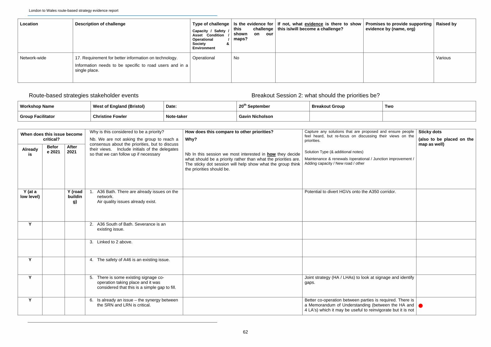
London to Wales route-based strategy evidence report
62
Location Description of challenge Type of challenge
Capacity / Safety / Asset Condition / Operational / Society & Environment
Is the evidence for this challenge shown on our maps?
If not, what evidence is there to show this is/will become a challenge?
Promises to provide supporting evidence by (name, org)
Raised by
Network-wide 17. Requirement for better information on technology.
Information needs to be specific to road users and in a single place.
Operational No Various
Route-based strategies stakeholder events Breakout Session 2: what should the priorities be?
Workshop Name West of England (Bristol) Date: 20th September Breakout Group Two
Group Facilitator Christine Fowler Note-taker Gavin Nicholson
When does this issue become critical?
Already is
Before 2021
After 2021
Why is this considered to be a priority?
Nb. We are not asking the group to reach a consensus about the priorities, but to discuss their views. Include initials of the delegates so that we can follow up if necessary
How does this compare to other priorities?
Why?
Nb In this session we most interested in how they decide what should be a priority rather than what the priorities are. The sticky dot session will help show what the group think the priorities should be.
Capture any solutions that are proposed and ensure people feel heard, but re-focus on discussing their views on the priorities.
Solution Type (& additional notes)
Maintenance & renewals /operational / Junction improvement / Adding capacity / New road / other
Sticky dots
(also to be placed on the map as well)
Y (at a low level)
Y (road buildin
g)
1. A36 Bath. There are already issues on the network. Air quality issues already exist.
Potential to divert HGVs onto the A350 corridor.
Y 2. A36 South of Bath. Severance is an existing issue.
3. Linked to 2 above.
Y 4. The safety of A46 is an existing issue.
Y 5. There is some existing signage co-operation taking place and it was considered that this is a simple gap to fill.
Joint strategy (HA / LHAs) to look at signage and identify gaps.
Y 6. Is already an issue – the synergy between the SRN and LRN is critical.
Better co-operation between parties is required. There is a Memorandum of Understanding (between the HA and 4 LA’s) which it may be useful to reinvigorate but it is not
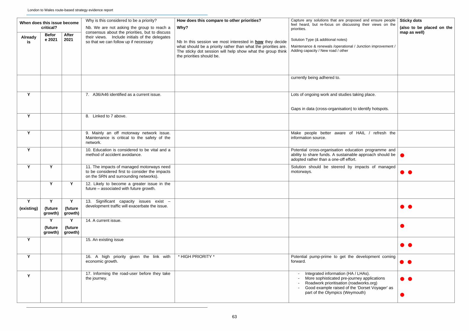
London to Wales route-based strategy evidence report
63
When does this issue become critical?
Already is
Before 2021
After 2021
Why is this considered to be a priority?
Nb. We are not asking the group to reach a consensus about the priorities, but to discuss their views. Include initials of the delegates so that we can follow up if necessary
How does this compare to other priorities?
Why?
Nb In this session we most interested in how they decide what should be a priority rather than what the priorities are. The sticky dot session will help show what the group think the priorities should be.
Capture any solutions that are proposed and ensure people feel heard, but re-focus on discussing their views on the priorities.
Solution Type (& additional notes)
Maintenance & renewals /operational / Junction improvement / Adding capacity / New road / other
Sticky dots
(also to be placed on the map as well)
currently being adhered to.
Y 7. A36/A46 identified as a current issue.
Lots of ongoing work and studies taking place.
Gaps in data (cross-organisation) to identify hotspots.
Y 8. Linked to 7 above.
Y 9. Mainly an off motorway network issue. Maintenance is critical to the safety of the network.
Make people better aware of HAIL / refresh the information source.
Y 10. Education is considered to be vital and a method of accident avoidance.
Potential cross-organisation education programme and ability to share funds. A sustainable approach should be adopted rather than a one-off effort.
Y Y 11. The impacts of managed motorways need to be considered first to consider the impacts on the SRN and surrounding networks).
Solution should be steered by impacts of managed motorways.
Y Y 12. Likely to become a greater issue in the future – associated with future growth.
Y
(existing)
Y
(future growth)
Y
(future growth)
13. Significant capacity issues exist – development traffic will exacerbate the issue.
Y
(future growth)
Y
(future growth)
14. A current issue.
Y 15. An existing issue
Y
16. A high priority given the link with economic growth.
* HIGH PRIORITY * Potential pump-prime to get the development coming forward.
Y 17. Informing the road-user before they take the journey.
- Integrated information (HA / LHAs). - More sophisticated pre-journey applications - Roadwork prioritisation (roadworks.org) - Good example raised of the ‘Dorset Voyager’ as
part of the Olympics (Weymouth)

London to Wales route-based strategy evidence report
Route-based strategies stakeholder events Breakout Session 1: what are the key challenges for the routes?
Workshop Name Bristol Date: 20th September Breakout Group Three
Group Facilitator Steve Helier Note-taker Peter Triplow
Attendees: Martin Mc Donnell (Bristol Cycle Campaign), David Redgewell (Campaign for Better Transport), Peter Slane (South Gloucestershire Council), Ian Gallagher (Freight Transport Association)
Location Description of challenge Type of challenge
Capacity / Safety / Asset Condition / Operational / Society & Environment
Is the evidence for this challenge shown on our maps?
If not, what evidence is there to show this is/will become a challenge?
Promises to provide supporting evidence by (name, org)
Raised by
M5 junctions around Bristol 3. Crossing the M5 is not easy for non-motorway users, especially walkers and cyclists. The problem is particularly bad at Almondsbury. [NB there is a Pinchpoint scheme proposed for Junction 16.]
Safety
Society & Environment
No Need evidence of how many drivers are using roads across junctions - South Gloucestershire Council have an MMM available.
Martin Mc Donnell
supported by
David Redgewell
M32 4. Need some form of priority for freight and public transport as these presently get held up on their way in and out of Bristol.
Capacity Yes David Redgewell
M4 north of Bath 5. Heavy traffic on the M4 leads to many Bristol-bound drivers leaving the M4 at Junction 18 near Bath and using local roads to complete their journey. Particular problem through Pucklechurch and Mangotsfield.
Capacity
Society & Environment
No Only anecdotal evidence at present but South Gloucestershire Council are trying to quantify things.
Peter Slane
A36 and A46 east of Bath 6. A link road is needed between the A36 and A46 east of Bath. At present, drivers have to go right into Bath in order to pass from one road to the other, and this creates massive congestion. The solution is not likely to be cheap, and the idea of a new road is unlikely to go down well with either Bath residents or BANES Council.
Capacity Not as well as it could be
Link is known unofficially as the Beckford Spur.
Ian Gallagher
Bristol / Bath (evening economies)
7. Motorway closures tend to happen overnight, so the impact of these falls disproportionately on the evening economy. Both cities are keen to promote themselves as evening destinations, and these closures are leading to lost trade.
Capacity
Society & Environment
No David Redgewell
M49 near Avonmouth 8. The port of Avonmouth and the enterprise zone west of Bristol currently have no direct access to the M49, despite it passing through both. If Bristol is to compete with other ports, such as Southampton, a junction on the M49 is essential.
Society & Environment No Peter Slane
Countywide journey times 9. A lot of the congestion around Bristol could be avoided if people had better information on when and when not to travel. This information is available but has not been publicised very well.
Operational
Society & Environment
No Martin McDonnell
64
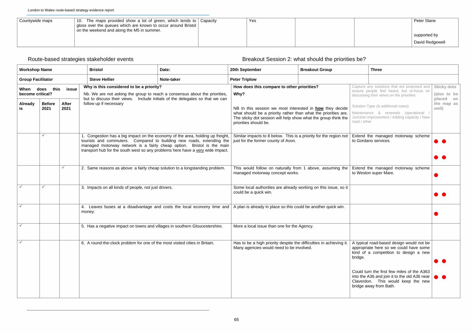
London to Wales route-based strategy evidence report
Countywide maps 10. The maps provided show a lot of green, which tends to gloss over the queues which are known to occur around Bristol on the weekend and along the M5 in summer.
Capacity Yes Peter Slane
supported by
David Redgewell
Route-based strategies stakeholder events Breakout Session 2: what should the priorities be?
Workshop Name Bristol Date: 20th September Breakout Group Three
Group Facilitator Steve Hellier Note-taker Peter Triplow
When does this issue become critical?
Already is
Before 2021
After 2021
Why is this considered to be a priority?
Nb. We are not asking the group to reach a consensus about the priorities, but to discuss their views. Include initials of the delegates so that we can follow up if necessary
How does this compare to other priorities?
Why?
NB In this session we most interested in how they decide what should be a priority rather than what the priorities are. The sticky dot session will help show what the group think the priorities should be.
Capture any solutions that are proposed and ensure people feel heard, but re-focus on discussing their views on the priorities.
Solution Type (& additional notes)
Maintenance & renewals /operational / Junction improvement / Adding capacity / New road / other
Sticky dots
(also to be placed on the map as well)
1. Congestion has a big impact on the economy of the area, holding up freight, tourists and commuters. Compared to building new roads, extending the managed motorway network is a fairly cheap option. Bristol is the main transport hub for the south west so any problems here have a very wide impact.
Similar impacts to 8 below. This is a priority for the region not just for the former county of Avon.
Extend the managed motorway scheme to Gordano services.
2. Same reasons as above: a fairly cheap solution to a longstanding problem. This would follow on naturally from 1 above, assuming the
managed motorway concept works.
Extend the managed motorway scheme to Weston super Mare.
3. Impacts on all kinds of people, not just drivers. Some local authorities are already working on this issue, so it could be a quick win.
4. Leaves buses at a disadvantage and costs the local economy time and
money.
A plan is already in place so this could be another quick win.
5. Has a negative impact on towns and villages in southern Gloucestershire. More a local issue than one for the Agency.
6. A round-the-clock problem for one of the most visited cities in Britain. Has to be a high priority despite the difficulties in achieving it.
Many agencies would need to be involved. A typical road-based design would not be appropriate here so we could have some kind of a competition to design a new bridge.
Could turn the first few miles of the A363 into the A36 and join it to the old A36 near Claverdon. This would keep the new bridge away from Bath.
65
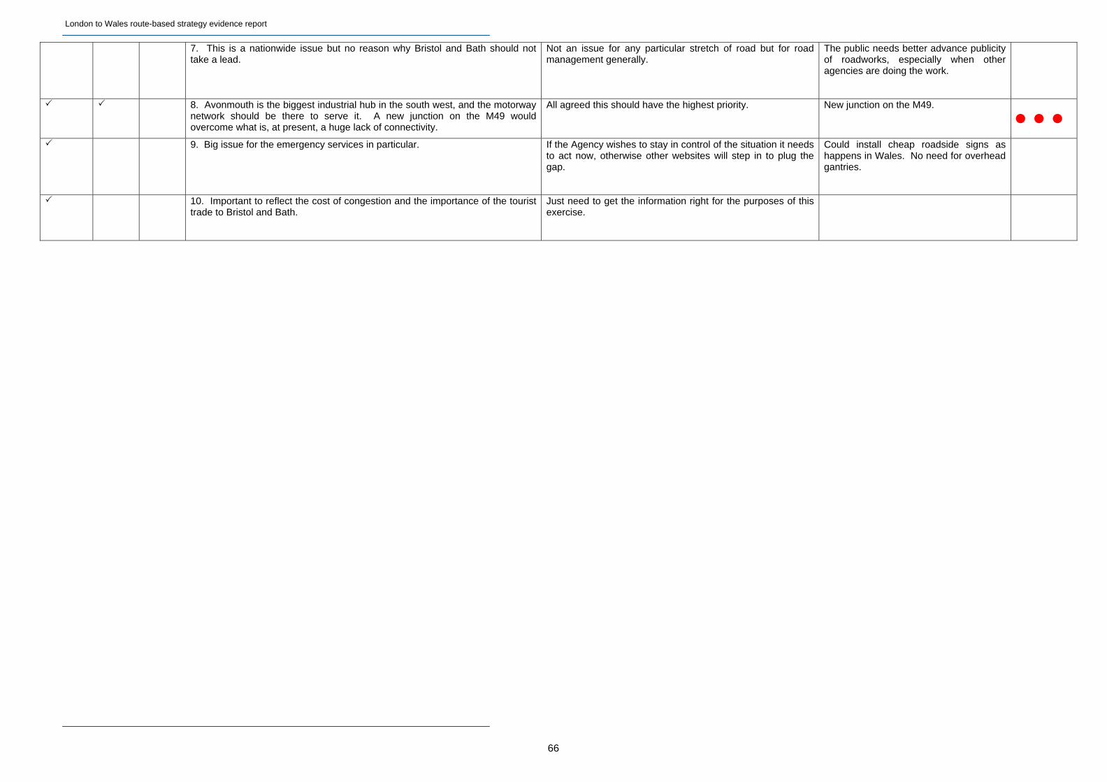
London to Wales route-based strategy evidence report
7. This is a nationwide issue but no reason why Bristol and Bath should not take a lead.
Not an issue for any particular stretch of road but for road management generally.
The public needs better advance publicity of roadworks, especially when other agencies are doing the work.
8. Avonmouth is the biggest industrial hub in the south west, and the motorway network should be there to serve it. A new junction on the M49 would overcome what is, at present, a huge lack of connectivity.
All agreed this should have the highest priority. New junction on the M49.
9. Big issue for the emergency services in particular. If the Agency wishes to stay in control of the situation it needs to act now, otherwise other websites will step in to plug the gap.
Could install cheap roadside signs as happens in Wales. No need for overhead gantries.
10. Important to reflect the cost of congestion and the importance of the tourist trade to Bristol and Bath.
Just need to get the information right for the purposes of this exercise.
66
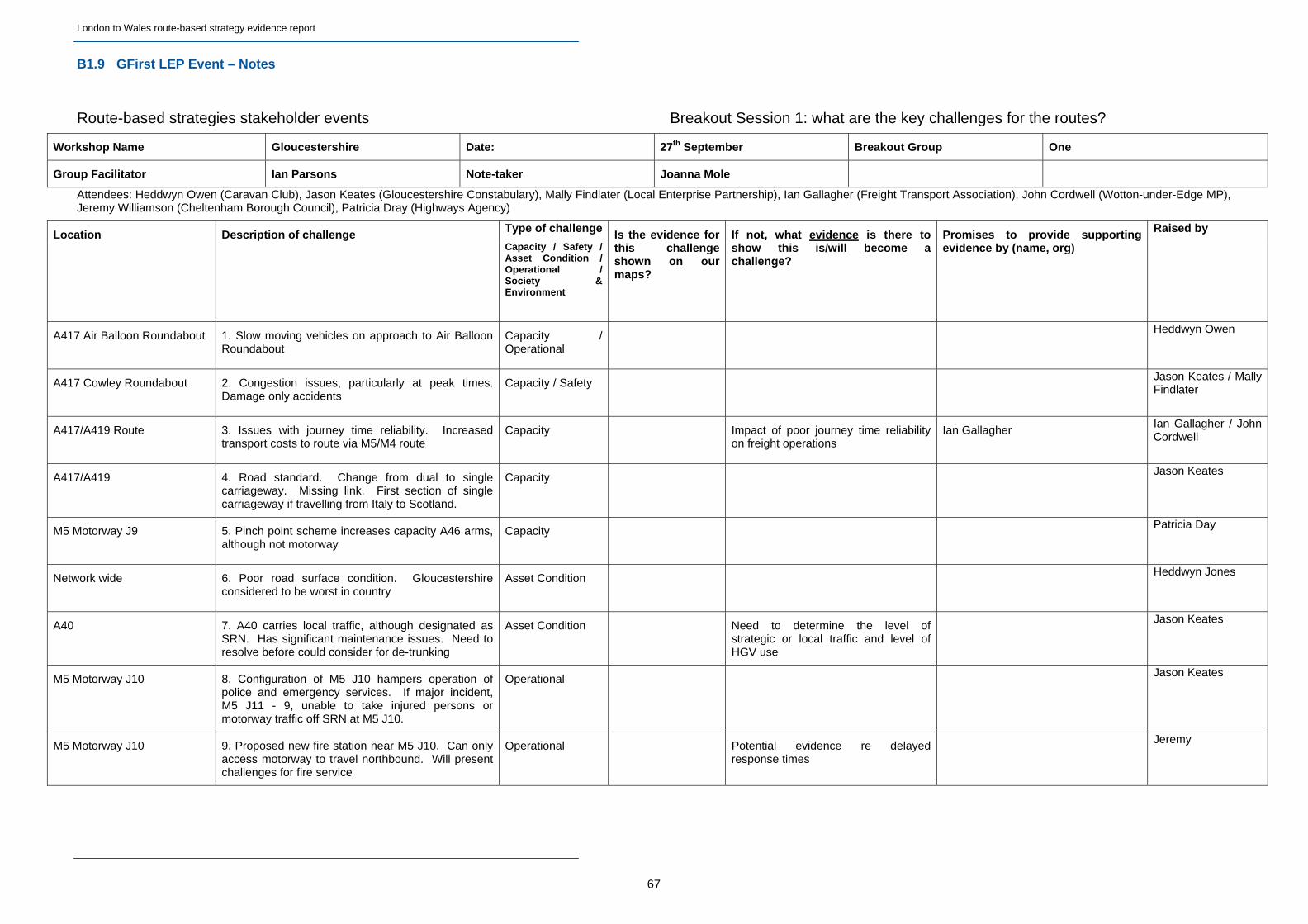
London to Wales route-based strategy evidence report
B1.9 GFirst LEP Event – Notes
Route-based strategies stakeholder events Breakout Session 1: what are the key challenges for the routes?
Workshop Name Gloucestershire Date: 27th September Breakout Group One
Group Facilitator Ian Parsons Note-taker Joanna Mole
Attendees: Heddwyn Owen (Caravan Club), Jason Keates (Gloucestershire Constabulary), Mally Findlater (Local Enterprise Partnership), Ian Gallagher (Freight Transport Association), John Cordwell (Wotton-under-Edge MP), Jeremy Williamson (Cheltenham Borough Council), Patricia Dray (Highways Agency)
Location Description of challenge Type of challenge
Capacity / Safety / Asset Condition / Operational / Society & Environment
Is the evidence for this challenge shown on our maps?
If not, what evidence is there to show this is/will become a challenge?
Promises to provide supporting evidence by (name, org)
Raised by
A417 Air Balloon Roundabout 1. Slow moving vehicles on approach to Air Balloon Roundabout
Capacity / Operational
Heddwyn Owen
A417 Cowley Roundabout 2. Congestion issues, particularly at peak times. Damage only accidents
Capacity / Safety Jason Keates / Mally Findlater
A417/A419 Route 3. Issues with journey time reliability. Increased transport costs to route via M5/M4 route
Capacity Impact of poor journey time reliability on freight operations
Ian Gallagher Ian Gallagher / John Cordwell
A417/A419 4. Road standard. Change from dual to single carriageway. Missing link. First section of single carriageway if travelling from Italy to Scotland.
Capacity Jason Keates
M5 Motorway J9 5. Pinch point scheme increases capacity A46 arms, although not motorway
Capacity Patricia Day
Network wide 6. Poor road surface condition. Gloucestershire considered to be worst in country
Asset Condition Heddwyn Jones
A40 7. A40 carries local traffic, although designated as SRN. Has significant maintenance issues. Need to resolve before could consider for de-trunking
Asset Condition Need to determine the level of strategic or local traffic and level of HGV use
Jason Keates
M5 Motorway J10 8. Configuration of M5 J10 hampers operation of police and emergency services. If major incident, M5 J11 - 9, unable to take injured persons or motorway traffic off SRN at M5 J10.
Operational Jason Keates
M5 Motorway J10 9. Proposed new fire station near M5 J10. Can only access motorway to travel northbound. Will present challenges for fire service
Operational Potential evidence re delayed response times
Jeremy
67

London to Wales route-based strategy evidence report
M5 Motorway 10. Poor driving conditions during snowfall. Managing agents cleared snow far better in Worcestershire than agent in Gloucestershire. Inconsistencies are evident
Operational Jason Keates
Motorway Service Areas 11. Parking for caravans is only available in areas designated for heavy goods vehicles. Potential safety issues.
Operational / Safety
Heddwyn Jones
Network wide 12. Difficulties in finding locations to pull in and let other vehicles overtake
Operational / Safety
Heddwyn Jones
M5 Motorway J9 13. Use of full time signalisation at M5 J9. Delays in off-peak periods when not required.
Operational Jeremy
M5 Motorway J14 14. Signalisation at roundabout. Do timings reflect traffic conditions?
Operational Jeremy
M5 Motorway J14 17. Car-share parking in lay-by Operational / Safety
John Cordwell
M50 Motorway 15. Some resilience issues. Pressure on A417 through Gloucester when used as a diversionary route
Operational Jason Keates
Network wide 16. Signage for Motorway Service Areas does not include fuel information, although the operator is named
Operational Ian Gallagher / Jeremy
A417 Air Balloon Roundabout 18. Issues for traffic leaving roundabout down Crickley Hill
Safety Jason Keates
A417 Air Balloon Roundabout 19. Air quality issues at Air Balloon Roundabout Environment John Cordwell / Ian Gallagher
Severn Bridge 20. Capacity on Severn Bridge can be reduced by collection of tolls. Need improved toll collection. Traffic reassigns to other roads to avoid toll in one direction
Technology Directional traffic volumes on bridge and alternative parallel routes
Ian Gallagher / John Cordwell
A417/A419 21. Economic growth in Gloucestershire is hampered by ‘missing link’. The challenge is finding evidence to support this. Road users avoid this road.
Economic Growth Evidence to support economic case is unknown
Mally Findlater
M5 Motorway J9 22. Development pressures at Ashchurch e.g. MOD site, Cotswolds Retail Centre. Need road network to support future growth
Economic Growth John Cordwell / Patricia Day / Mallly Findlater
68
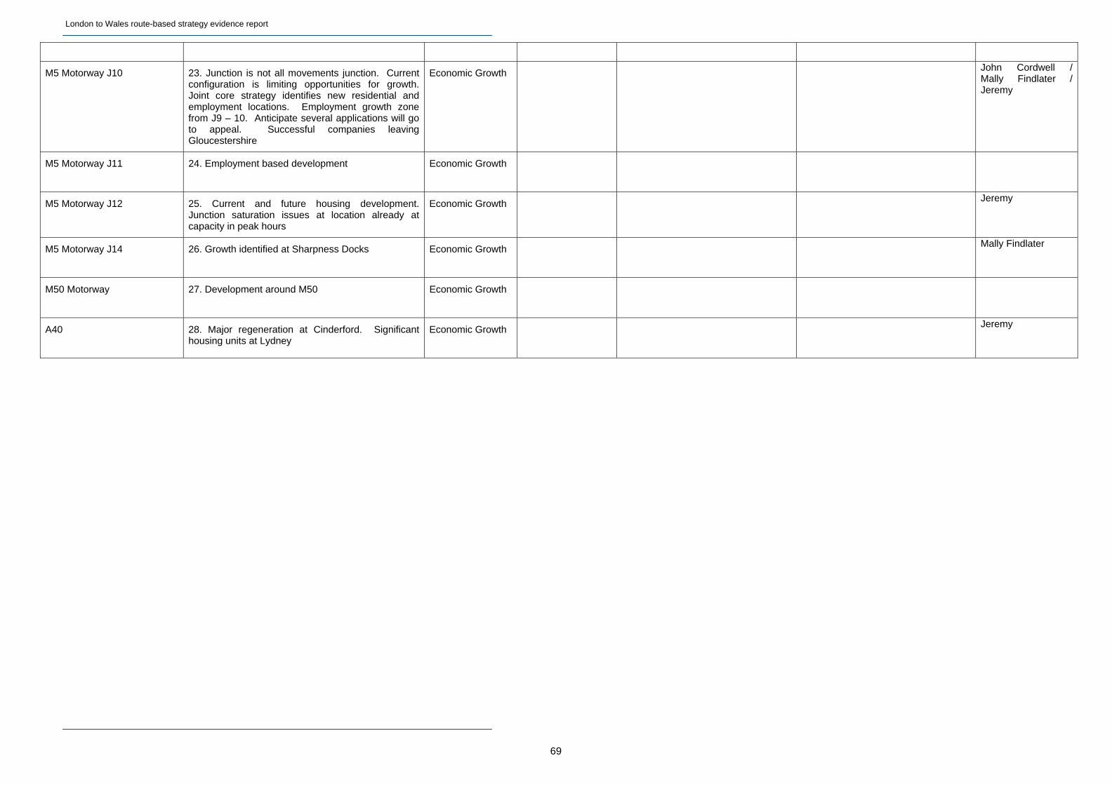
London to Wales route-based strategy evidence report
M5 Motorway J10 23. Junction is not all movements junction. Current configuration is limiting opportunities for growth. Joint core strategy identifies new residential and employment locations. Employment growth zone from J9 – 10. Anticipate several applications will go to appeal. Successful companies leaving Gloucestershire
Economic Growth John Cordwell / Mally Findlater / Jeremy
M5 Motorway J11 24. Employment based development Economic Growth
M5 Motorway J12 25. Current and future housing development. Junction saturation issues at location already at capacity in peak hours
Economic Growth Jeremy
M5 Motorway J14 26. Growth identified at Sharpness Docks Economic Growth Mally Findlater
M50 Motorway 27. Development around M50 Economic Growth
A40 28. Major regeneration at Cinderford. Significant housing units at Lydney
Economic Growth Jeremy
69
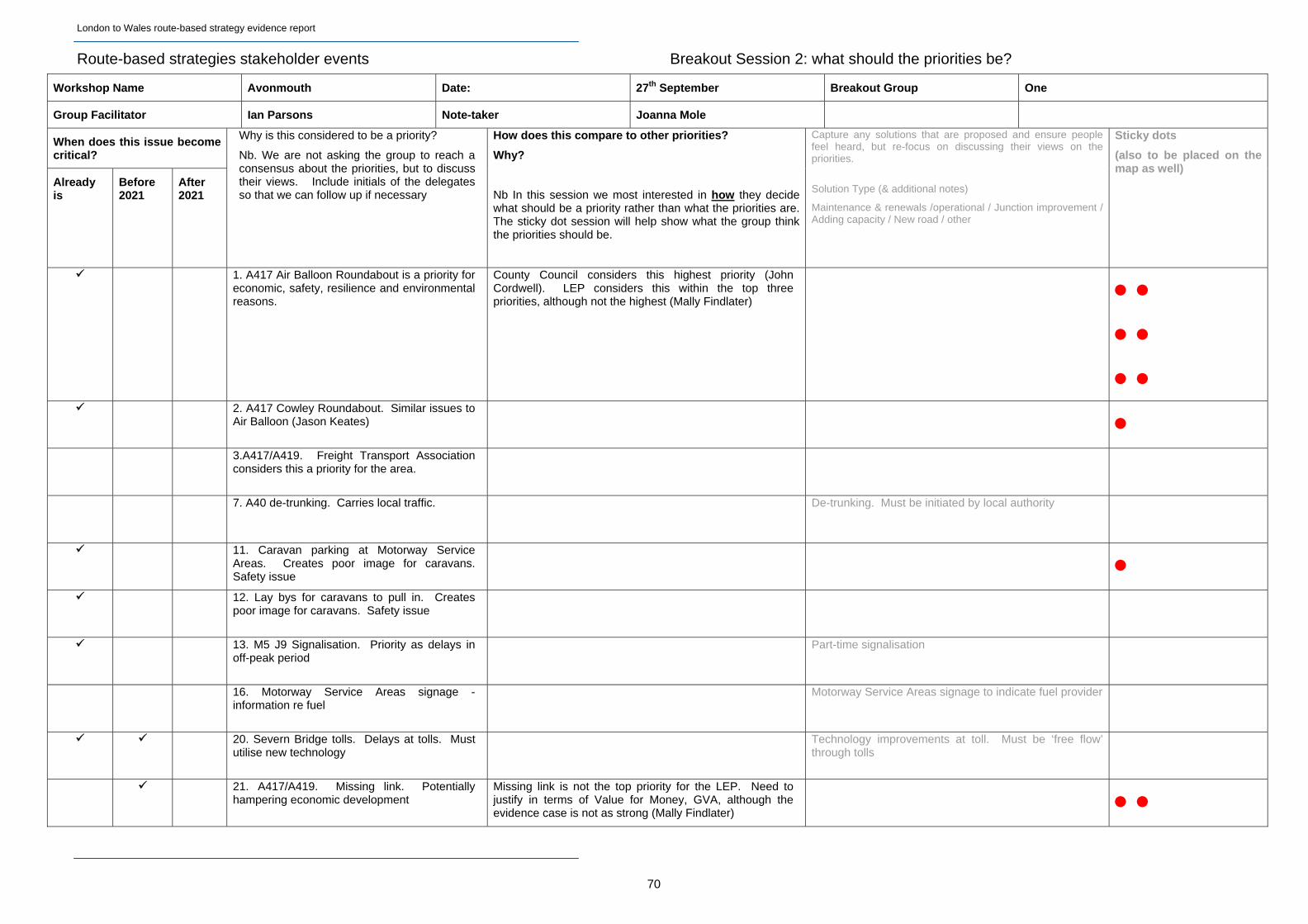
London to Wales route-based strategy evidence report
Route-based strategies stakeholder events Breakout Session 2: what should the priorities be?
Workshop Name Avonmouth Date: 27th September Breakout Group One
Group Facilitator Ian Parsons Note-taker Joanna Mole
When does this issue become critical?
Already is
Before 2021
After 2021
Why is this considered to be a priority?
Nb. We are not asking the group to reach a consensus about the priorities, but to discuss their views. Include initials of the delegates so that we can follow up if necessary
How does this compare to other priorities?
Why?
Nb In this session we most interested in how they decide what should be a priority rather than what the priorities are. The sticky dot session will help show what the group think the priorities should be.
Capture any solutions that are proposed and ensure people feel heard, but re-focus on discussing their views on the priorities.
Solution Type (& additional notes)
Maintenance & renewals /operational / Junction improvement / Adding capacity / New road / other
Sticky dots
(also to be placed on the map as well)
1. A417 Air Balloon Roundabout is a priority for economic, safety, resilience and environmental reasons.
County Council considers this highest priority (John Cordwell). LEP considers this within the top three priorities, although not the highest (Mally Findlater)
2. A417 Cowley Roundabout. Similar issues to Air Balloon (Jason Keates)
3.A417/A419. Freight Transport Association considers this a priority for the area.
7. A40 de-trunking. Carries local traffic. De-trunking. Must be initiated by local authority
11. Caravan parking at Motorway Service Areas. Creates poor image for caravans. Safety issue
12. Lay bys for caravans to pull in. Creates poor image for caravans. Safety issue
13. M5 J9 Signalisation. Priority as delays in off-peak period
Part-time signalisation
16. Motorway Service Areas signage -information re fuel
Motorway Service Areas signage to indicate fuel provider
20. Severn Bridge tolls. Delays at tolls. Must utilise new technology
Technology improvements at toll. Must be ‘free flow’ through tolls
21. A417/A419. Missing link. Potentially hampering economic development
Missing link is not the top priority for the LEP. Need to justify in terms of Value for Money, GVA, although the evidence case is not as strong (Mally Findlater)
70
London to Wales route-based strategy evidence report
22. M5 J9. Development pressures now and future
Development pressures at J9 and J10, therefore higher priority than Air Balloon (Jason Keates)
23. M5 J10. This is a priority as a result of
configuration, development pressures, impact on operations of policy and emergency services and proposed location of fire station.
M5 J10 considered to be a higher priority than J9 (general consensus)
24. M5 J11. Not considered to be same priority as J9 and J10
25. M5 J12. Current and future development pressures.
Review signage at M5 J12. Counter-intuitive to destination
Route-based strategies stakeholder events Breakout Session 1: what are the key challenges for the routes?
Workshop Name Gloucestershire Date: 27th September Breakout Group Two
Group Facilitator Christine Fowler Note-taker Peter Triplow
Attendees: Pete O’Brien (British Motorcycling Federation), John Franklin (Gloucestershire Council), Ed Halford (Highways Agency), Christine Shine (Campaign for Better Transport), James Llewellyn (Gloucestershire Local Transport Board), Rupert Crosbee (Sustrans)
Location Description of challenge Type of challenge
Capacity / Safety / Asset Condition / Operational / Society & Environment
Is the evidence for this challenge shown on our maps?
If not, what evidence is there to show this is/will become a challenge?
Promises to provide supporting evidence by (name, org)
Raised by
Study 1. Important to get all information in place before making decisions as this challenge underpins all others. If we rely only on the information as shown the South West may lose out.
M5 Bristol 2. This stretch of the M5 always seems to have roadworks, plus some of the junctions are confusing. This creates a negative impression of Gloucestershire to visitors from the south.
Capacity Yes Pete O'Brien
M5 junction 10 3. Question of how well this junction relates to the local road network. If the junction is made accessible to traffic from the south this would encourage more local traffic onto the motorway. This then raises the question of whether the Agency should try and direct local drivers away from the motorway.
Capacity
Operational
No John Franklin
71

London to Wales route-based strategy evidence report
M5 junction 12 4. Too many traffic lights at this junction which cause congestion locally.
Operational No Pete O'Brien
M50 5. This road never seems to be open. Question raised as to where it serves and why it was built. Junction 1 is confusing, even to locals.
Asset condition Yes Pete O'Brien
A40 north and west of Gloucester
6. Congestion is caused as the road goes from dual to single carriageway. This road is the only access to Gloucester and Cheltenham from west of the river so any problems here impact hard on residents and businesses. Question raised as to whether this road should still be a strategic road.
Capacity
Society & Environment
No Ed Halford
supported by
Pete O'Brien
A417 south of Cheltenham 7. There is bad congestion on the single carriageway section from Birdlip to Nettleton Bottom. Slopes and landscape designations are likely to make solutions difficult. The hilltop has its own microclimate which can surprise drivers. Together with the volume of traffic, this makes it an accident black spot. Drivers who do not know the road tend to drive down the hill with their brakes on, which can create confusion at night. The turning into Birdlip at the top of the hill can be tricky for cyclists.
Capacity
Safety
Society & Environment
Yes No evidence offered but agreed that we need evidence on journey time, accidents and air quality. We also need businesses and haulage firms to say how much this stretch of road is costing them.
LEP is trying to get evidence together.
Christine Shine
supported by
Pete O'Brien
Ed Halford
John Franklin
A417 (lighting and signage) 8. Signs seem overly large for the size of road. Could they be smaller and do all stretches of the road need lighting? Suggestion that it may be possible to turn off more lights than at present.
Operational
Society & Environment
No Christine Shine
A417 / A419 (heading north west)
9. Some drivers heading from the south east to Wales use this road as an alternative to the M4 on the grounds that the M4 might be congested. With better advance signage on the M4 this could be avoided.
Operational No Ed Halford
A417 / A419 (heading south east)
10. Some drivers heading from the Midlands to Chippenham and the west side of Swindon use this road as an alternative to the M5 on the grounds that the M5 might be congested. With better advance signage on the M5 this could be avoided.
Operational No Pete O'Brien
Countywide (journey information)
11. There is a lack of information on the origins and destinations of traffic so it is hard to distinguish between long distance and local travellers. For known pinchpoints such as the Air Balloon this information would be useful.
Capacity No Christine Shine has information on traffic through Nettleton Bottom.
Ed Halford has a traffic model for the central Severn Vale.
Travel to work data is available from the census.
James Llewellyn
supported by
Christine Shine
72
London to Wales route-based strategy evidence report
Countywide (accidents) 12. How useful are the present statistics we have on accidents? Is safety becoming a greater or lesser problem? We need to understand the whole picture rather than relying on injury data.
Safety Yes James Llewellyn
Countywide (diversions) 13. Need to think more carefully about where traffic is diverted when strategic roads are shut or congested. Traffic figures plateau once a road become blocked so it can be hard to tell whether traffic is diverting and, if so, how much and where to.
Capacity No Christine Shine Christine Shine
Countywide (crossings) 14. It can be very hard to cross strategic roads at flat junctions, particularly for those on bikes. Examples given of the A419 at Cricklade, the A46 south of Evesham and the M5 at Tewkesbury. Although cycle lanes and crossings have been provided, many cyclists choose not to use them. To date it has been assumed that one solution will fit all cyclists, whereas in fact there are different kinds of cyclists with different needs. The narrowness of unimproved sections also makes things tricky. The growth planned east of Tewkesbury will make the M5 junction even harder to cross.
Safety
Society & Environment
No John Franklin
supported by
Rupert Crosbee
Countywide (service areas) 15. There is nowhere to park motorbikes at service stations. Also need a lorry park for the M5.
Asset condition No Pete O'Brien
Countywide (satnavs) 16. Need to tackle the problem of satnavs sending drivers down roads which are ill-suited to their needs (particular problem with lorries being sent down country lanes. Could the satnav makers be persuaded to provide different settings for cars, bikes, lorries, caravans etc.?
Operational No Pete O'Brien
supported by
Christine Shine
73
London to Wales route-based strategy evidence report
Route-based strategies stakeholder events Breakout Session 2: what should the priorities be?
Workshop Name Gloucestershire Date: 27th September Breakout Group Two
Group Facilitator Christine Fowler Note-taker Peter Triplow
When does this issue become critical?
Already is
Before 2021
After 2021
Why is this considered to be a priority?
Nb. We are not asking the group to reach a consensus about the priorities, but to discuss their views. Include initials of the delegates so that we can follow up if necessary
How does this compare to other priorities?
Why?
Nb In this session we most interested in how they decide what should be a priority rather than what the priorities are. The sticky dot session will help show what the group think the priorities should be.
Capture any solutions that are proposed and ensure people feel heard, but re-focus on discussing their views on the priorities.
Solution Type (& additional notes)
Maintenance & renewals /operational / Junction improvement / Adding capacity / New road / other
Sticky dots
(also to be placed on the map as well)
1. Important to get all information in place before making decisions. Needs to happen before other challenges are tackled.
2. The M5 is the main gateway into Gloucestershire from the south so
problems around Bristol affect the whole county.
Work is already underway on this stretch of the M5 so it could be a quick win.
Rebuild the Almondsbury interchange to make it less confusing.
3. Could make an already congested part of the M5 even busier. Would only become a problem if the junction were to be made accessible to drivers from the south as well as from the north.
4. More a local issue than a strategic one. Not as high a priority as other challenges.
5. This road has little impact on Gloucestershire so this is more of an observation than a challenge.
Agreed by all to be a low priority.
6. A40 north and west of Gloucester. Affects economic activity and connectivity for those living and / or working west of the Severn.
One scheme is already going ahead which may help. Could be a quick win but other priorities are higher.
Redesign of Over Island.
7. A417 south of Cheltenham. Big issue for business, freight and tourism, as well as for local residents. Affects the whole economic attractiveness of Gloucestershire. Causes hold ups in getting fresh fruit and vegetables out of the county.
All agreed this should be the top priority.
8. Has a big visual impact in sensitive areas like the Cotswold AONB. Something to consider when other changes and improvements are made.
9. Hard to quantify but could be putting unnecessary strain on the A417 through Nettleton Bottom.
Cannot do much until we know the start and end points of journeys. Could be a quick win as it is only a signage issue.
10. A417 / A419 (heading south east) used if M5 congested. Hard to quantify
but could be putting unnecessary strain on the A417 through Nettleton Bottom. Cannot do much until we know the start and end points of journeys. Could be a quick win as it is only a signage issue.
11. A lack of information on the origins and destinations of traffic. Other
challenges, such as 9 and 10, rely on us having this information. Needs to happen before certain other challenges can be tackled.
74

London to Wales route-based strategy evidence report
12. Important to understand this issue before making decisions on other challenges.
Needs to happen before other challenges are tackled.
13. Important to understand this issue before making decisions on other
challenges. Needs to happen before other challenges are tackled.
14. It can be very hard to cross strategic roads at flat junctions. Planned growth will only make this problem worse so we need to act now.
A big priority for cyclists. Investment should be directed towards growth areas.
15. Not a huge priority but something to be borne in mind when new services are proposed.
Less of a priority than solving congestion problems.
16. Some lorries and caravans are using unsuitable roads as their satnavs only have one setting.
A high priority but not within the Agency's control.
75
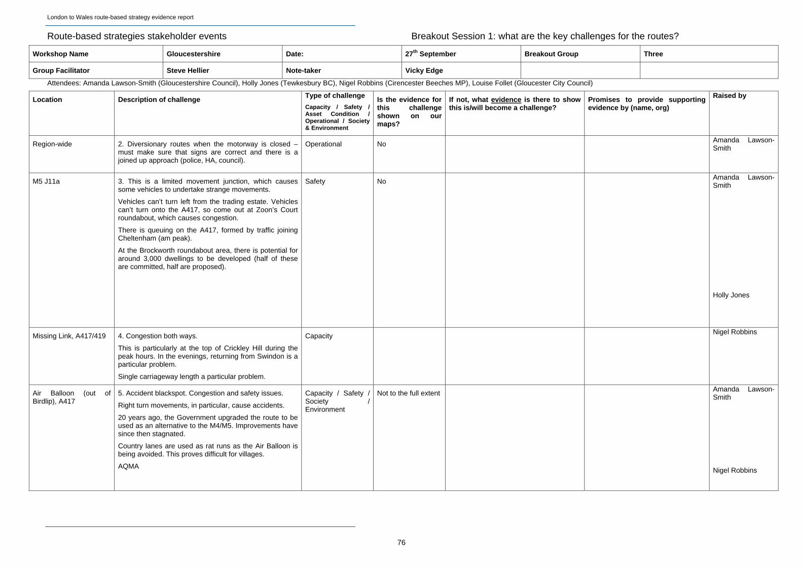
London to Wales route-based strategy evidence report
Route-based strategies stakeholder events Breakout Session 1: what are the key challenges for the routes?
Workshop Name Gloucestershire Date: 27th September Breakout Group Three
Group Facilitator Steve Hellier Note-taker Vicky Edge
Attendees: Amanda Lawson-Smith (Gloucestershire Council), Holly Jones (Tewkesbury BC), Nigel Robbins (Cirencester Beeches MP), Louise Follet (Gloucester City Council)
Location Description of challenge Type of challenge
Capacity / Safety / Asset Condition / Operational / Society & Environment
Is the evidence for this challenge shown on our maps?
If not, what evidence is there to show this is/will become a challenge?
Promises to provide supporting evidence by (name, org)
Raised by
Region-wide 2. Diversionary routes when the motorway is closed – must make sure that signs are correct and there is a joined up approach (police, HA, council).
Operational No Amanda Lawson-Smith
M5 J11a 3. This is a limited movement junction, which causes some vehicles to undertake strange movements.
Vehicles can’t turn left from the trading estate. Vehicles can’t turn onto the A417, so come out at Zoon’s Court roundabout, which causes congestion.
There is queuing on the A417, formed by traffic joining Cheltenham (am peak).
At the Brockworth roundabout area, there is potential for around 3,000 dwellings to be developed (half of these are committed, half are proposed).
Safety No Amanda Lawson-Smith
Holly Jones
Missing Link, A417/419 4. Congestion both ways.
This is particularly at the top of Crickley Hill during the peak hours. In the evenings, returning from Swindon is a particular problem.
Single carriageway length a particular problem.
Capacity Nigel Robbins
Air Balloon (out of Birdlip), A417
5. Accident blackspot. Congestion and safety issues.
Right turn movements, in particular, cause accidents.
20 years ago, the Government upgraded the route to be used as an alternative to the M4/M5. Improvements have since then stagnated.
Country lanes are used as rat runs as the Air Balloon is being avoided. This proves difficult for villages.
AQMA
Capacity / Safety / Society / Environment
Not to the full extent Amanda Lawson-Smith
Nigel Robbins
76

London to Wales route-based strategy evidence report
77
Location Description of challenge Type of challenge
Capacity / Safety / Asset Condition / Operational / Society & Environment
Is the evidence for this challenge shown on our maps?
If not, what evidence is there to show this is/will become a challenge?
Promises to provide supporting evidence by (name, org)
Raised by
A419 6. Noise is a problem, and an action group has now been set up because of this. There is a concrete section from Cirencester to Cricklade which causes particular problems.
It was noted that this is a problem which may get worse if traffic levels increase (AL).
Accidents are caused by people slowing down and speeding up along this route. The variable speed limits are felt to pose a problem.
Links to Swindon/Reading etc are important as this is a key aerospace/technological area.
The A419 is a DBFO with a 30 year contract (phantom toll), managed by RBS. RBS could argue against reducing traffic as their revenue would be reduced as a consequence.
The local authority has heard that RMS are happy with the current situation. If their income is capped, there may be no incentive for solutions to be developed (an increase in traffic would not see their income increase if there is a cap imposed).
Safety / Environment
No The LEP has recently surveyed businesses in the area about what the effect would be of improvements to J9, J10 and Air Balloon.
The results of the survey should be published soon (LF).
Nigel Robbins
Louise Follet
Nigel Robbins
Amanda Lawson-Smith
M5 J9 (with A46) 7. Congestion at this junction is significant.
Right on the junction, there is an area allocated for housing development. A short way to the east, there is a proposal for 2,200 homes, plus employment (currently an MOD site).
Worcestershire are requesting dualling of the A46 to Stratford, and a pinch point scheme is currently underway at this junction.
Capacity / Economic growth
Information on junctions not shown
Holly Jones
Amanda Lawson-Smith
M5 J10 8. Currently a limited movement junction. Desire for it to become an all-movement junction (LEP priority).
4,800 dwellings are proposed very close to the junction.
If coming south, have to travel through Cheltenham residential areas to access the motorway.
Heading east to Cheltenham, queuing back onto motorway, which is a safety issue.
Capacity / Safety No Holly Jones
Amanda Lawson-Smith
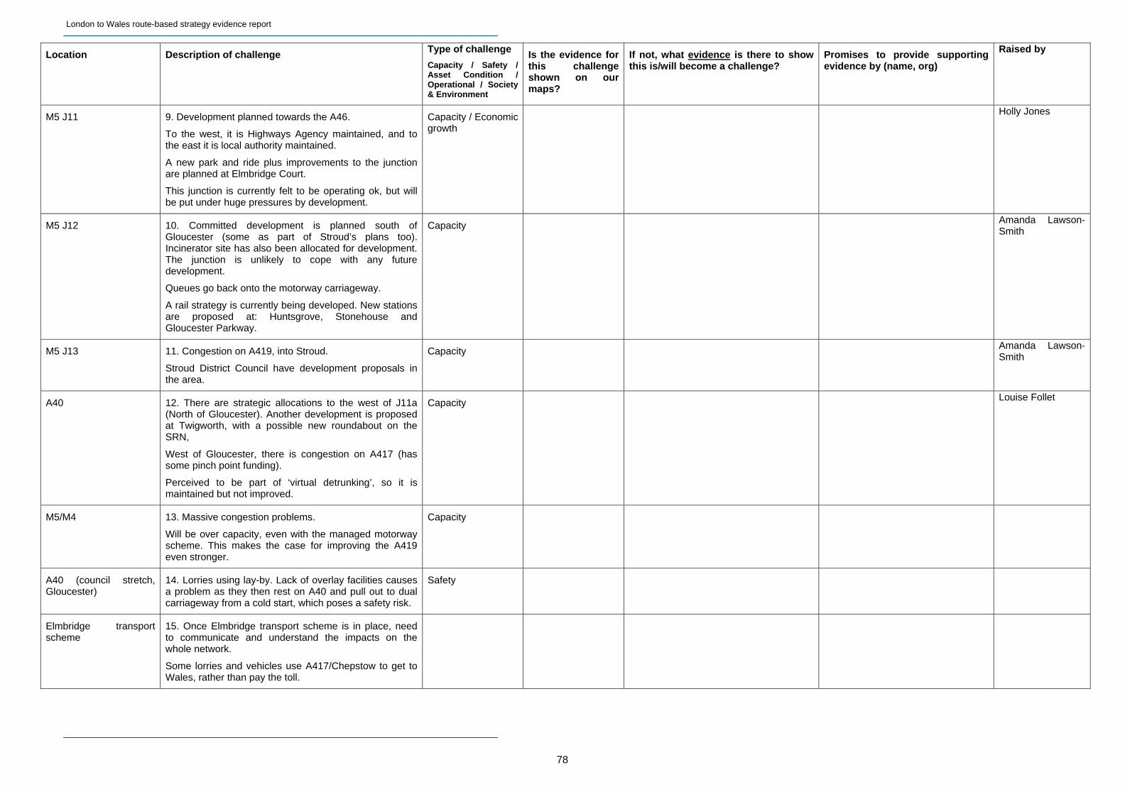
London to Wales route-based strategy evidence report
78
Location Description of challenge Type of challenge
Capacity / Safety / Asset Condition / Operational / Society & Environment
Is the evidence for this challenge shown on our maps?
If not, what evidence is there to show this is/will become a challenge?
Promises to provide supporting evidence by (name, org)
Raised by
M5 J11 9. Development planned towards the A46.
To the west, it is Highways Agency maintained, and to the east it is local authority maintained.
A new park and ride plus improvements to the junction are planned at Elmbridge Court.
This junction is currently felt to be operating ok, but will be put under huge pressures by development.
Capacity / Economic growth
Holly Jones
M5 J12 10. Committed development is planned south of Gloucester (some as part of Stroud’s plans too). Incinerator site has also been allocated for development. The junction is unlikely to cope with any future development.
Queues go back onto the motorway carriageway.
A rail strategy is currently being developed. New stations are proposed at: Huntsgrove, Stonehouse and Gloucester Parkway.
Capacity Amanda Lawson-Smith
M5 J13 11. Congestion on A419, into Stroud.
Stroud District Council have development proposals in the area.
Capacity Amanda Lawson-Smith
A40 12. There are strategic allocations to the west of J11a (North of Gloucester). Another development is proposed at Twigworth, with a possible new roundabout on the SRN,
West of Gloucester, there is congestion on A417 (has some pinch point funding).
Perceived to be part of ‘virtual detrunking’, so it is maintained but not improved.
Capacity Louise Follet
M5/M4 13. Massive congestion problems.
Will be over capacity, even with the managed motorway scheme. This makes the case for improving the A419 even stronger.
Capacity
A40 (council stretch, Gloucester)
14. Lorries using lay-by. Lack of overlay facilities causes a problem as they then rest on A40 and pull out to dual carriageway from a cold start, which poses a safety risk.
Safety
Elmbridge transport scheme
15. Once Elmbridge transport scheme is in place, need to communicate and understand the impacts on the whole network.
Some lorries and vehicles use A417/Chepstow to get to Wales, rather than pay the toll.
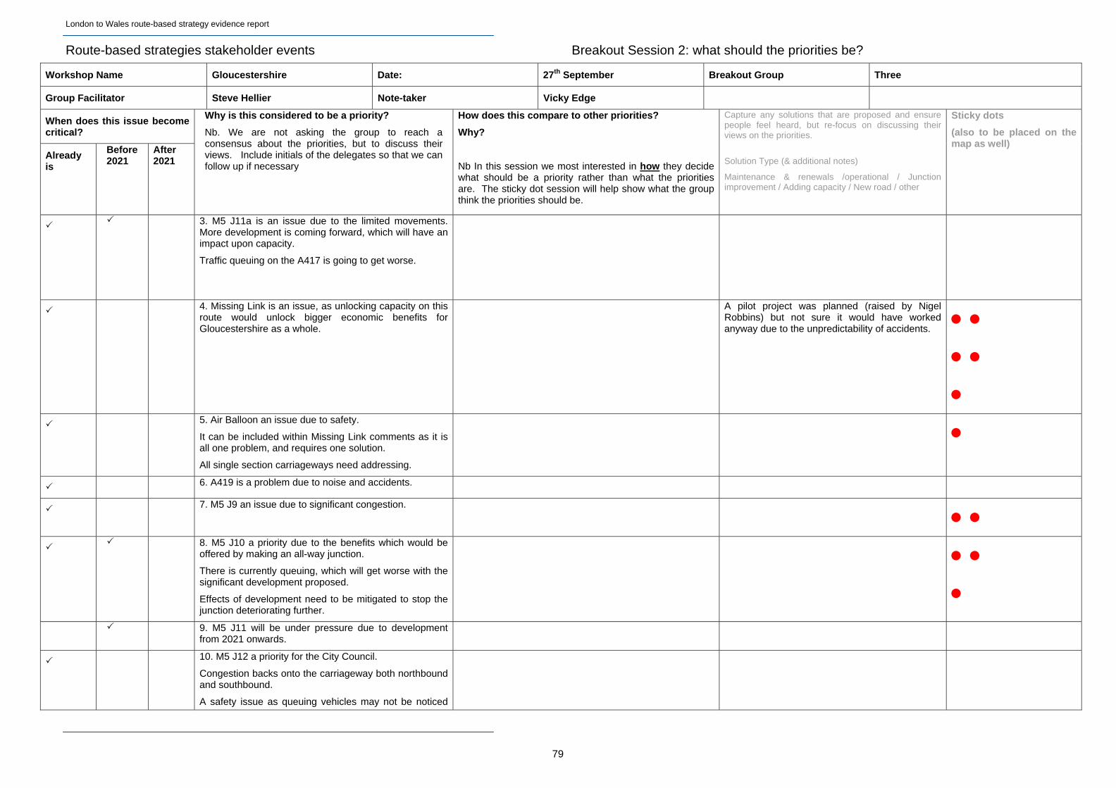
London to Wales route-based strategy evidence report
Route-based strategies stakeholder events Breakout Session 2: what should the priorities be?
Workshop Name Gloucestershire Date: 27th September Breakout Group Three
Group Facilitator Steve Hellier Note-taker Vicky Edge
When does this issue become critical?
Already is
Before 2021
After 2021
Why is this considered to be a priority?
Nb. We are not asking the group to reach a consensus about the priorities, but to discuss their views. Include initials of the delegates so that we can follow up if necessary
How does this compare to other priorities?
Why?
Nb In this session we most interested in how they decide what should be a priority rather than what the priorities are. The sticky dot session will help show what the group think the priorities should be.
Capture any solutions that are proposed and ensure people feel heard, but re-focus on discussing their views on the priorities.
Solution Type (& additional notes)
Maintenance & renewals /operational / Junction improvement / Adding capacity / New road / other
Sticky dots
(also to be placed on the map as well)
3. M5 J11a is an issue due to the limited movements. More development is coming forward, which will have an impact upon capacity.
Traffic queuing on the A417 is going to get worse.
4. Missing Link is an issue, as unlocking capacity on this route would unlock bigger economic benefits for Gloucestershire as a whole.
A pilot project was planned (raised by Nigel Robbins) but not sure it would have worked anyway due to the unpredictability of accidents.
5. Air Balloon an issue due to safety.
It can be included within Missing Link comments as it is all one problem, and requires one solution.
All single section carriageways need addressing.
6. A419 is a problem due to noise and accidents.
7. M5 J9 an issue due to significant congestion.
8. M5 J10 a priority due to the benefits which would be
offered by making an all-way junction.
There is currently queuing, which will get worse with the significant development proposed.
Effects of development need to be mitigated to stop the junction deteriorating further.
9. M5 J11 will be under pressure due to development
from 2021 onwards.
10. M5 J12 a priority for the City Council.
Congestion backs onto the carriageway both northbound and southbound.
A safety issue as queuing vehicles may not be noticed
79

London to Wales route-based strategy evidence report
by oncoming vehicles.
11. M5 J13 a lower priority for the area.
Unsure of Stroud’s proposals, so not sure when it would become a priority.
Lower priority
12. A40 west of Gloucester an issue.
Approach to the region from the Forest/Hereford.
There is a P&R, but no bus lane so doesn’t really help vehicles.
The scheme at Elbridge roundabout doesn’t take account of the huge developments going on in the area.
There are proposals to detrunk, but the current position of the county is that they don’t want to take it on (financial liability).
80

London to Wales route-based strategy evidence report
81
B1.10 Buckinghamshire Thames Valley LEP Event – Notes
Type of challenge Type of challenge
When does this issue become critical?
Is the evidence for this challenge shown on our maps?
If not, what evidence is there to show this is/will become a challenge?
Rai
sed
by
Relevant RBS Table Location Description of challenge
Cap
acit
y
Saf
ety
Ass
et C
on
dit
ion
Op
erat
ion
al
So
ciet
y &
En
viro
nm
ent
Capacity / Safety / Asset Condition / Operational / Society & Environment
Alr
ead
y is
2018
-21
Aft
er 2
021
Promises to provide supporting evidence by (name, org)
ALL ONE
General Lack of HA liaison w.r.t. emergency and police services x
Operational
x n/a n/a Cro
xt on
LONDON TO WALES
ONE
A404 Junction with A4155
Severe congestion pinchpoint during peaks ‐ this constrains business. Also affected by Bisham rbt x
Capacity
x NO
REQUEST: business survey information from Charles Brocklehurst and queue information from BCC. Proposed upgrades from Warren Ralls
War
ren
Ral
ls /
Ian
Man
ktel
ow
7
ALL ONE
A404 / general
Restricted access for emergency and police services on dual carriageways x
Operational
x n/a n/a
John
Cro
xton
LONDON TO SCOTLAND WEST
ONE
North‐South Linkage between M40 and Aylesbury Vale
The topography of High Wycombe results in restricted access from the north to the M40 and the Thames Valley. The planned development in Aylesbury Vale is for housing, but all the employment is south in the Thames Valley. This affects in particular the A4010. The role of Junction 6 in providing access to the north should be better defined, as should the A413 to Junction 2. The greenbelt review will have an impact on this too. x
Capacity
x NO
REQUEST: development planning data from county and district councils and infrastructure planning from BCC (to include Milton Keynes)
Cha
rles
Bro
ckle
hurs
t/Ian
Man
ktel
ow
3
LONDON TO SCOTLAND WEST
ONE
General
A lack of alternatives: the A40 is not a politically attractive alternative route to the M40, which results in issues with incident management and getting signage agreed for alternative/diversion routes x
Operational
x NO
REQUEST: policy statement from Wycombe DC with regards to the A40 as an alternative route
John
Cro
xton
4
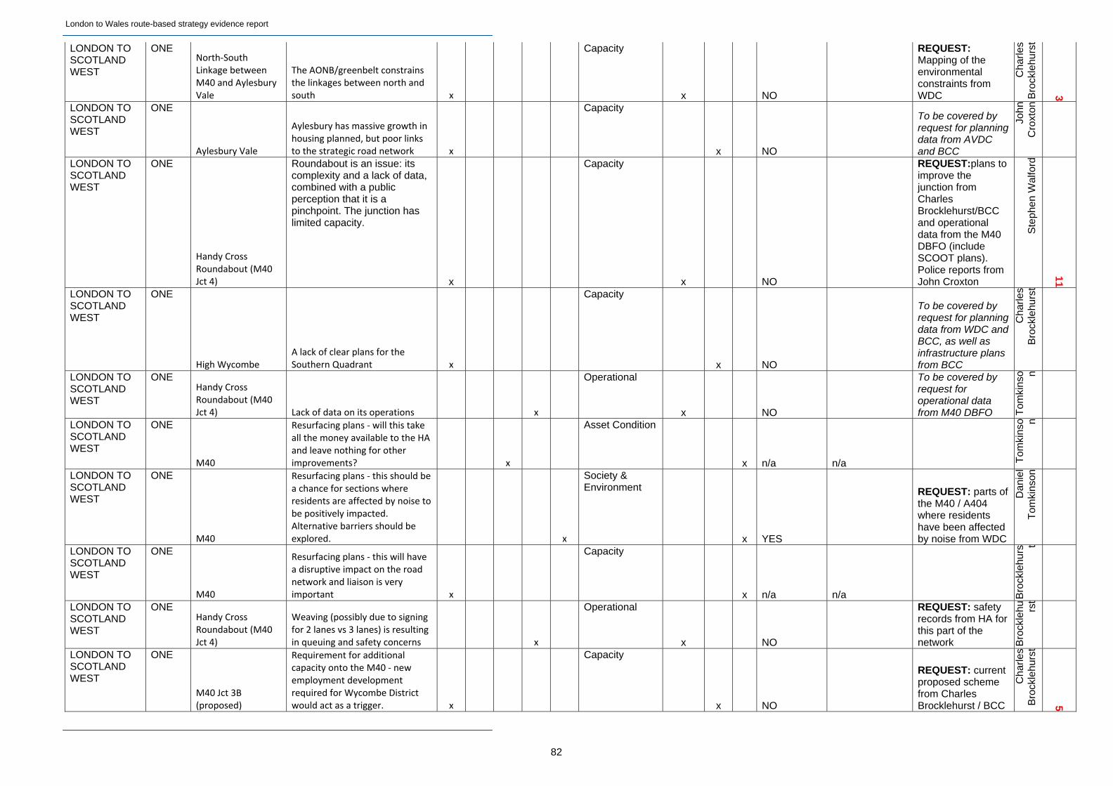
London to Wales route-based strategy evidence report
82
LONDON TO SCOTLAND WEST
ONE North‐South Linkage between M40 and Aylesbury Vale
The AONB/greenbelt constrains the linkages between north and south x
Capacity
x NO
REQUEST: Mapping of the environmental constraints from WDC
Cha
rles
Bro
ckle
hurs
t
3
LONDON TO SCOTLAND WEST
ONE
Aylesbury Vale
Aylesbury has massive growth in housing planned, but poor links to the strategic road network x
Capacity
x NO
To be covered by request for planning data from AVDC and BCC
John
Cro
xton
LONDON TO SCOTLAND WEST
ONE
Handy Cross Roundabout (M40 Jct 4)
Roundabout is an issue: its complexity and a lack of data, combined with a public perception that it is a pinchpoint. The junction has limited capacity.
x
Capacity
x NO
REQUEST:plans to improve the junction from Charles Brocklehurst/BCC and operational data from the M40 DBFO (include SCOOT plans). Police reports from John Croxton
Ste
phen
Wal
ford
11
LONDON TO SCOTLAND WEST
ONE
High Wycombe A lack of clear plans for the Southern Quadrant x
Capacity
x NO
To be covered by request for planning data from WDC and BCC, as well as infrastructure plans from BCC
Cha
rles
Bro
ckle
hurs
t
LONDON TO SCOTLAND WEST
ONE Handy Cross Roundabout (M40 Jct 4) Lack of data on its operations x
Operational
x NO
To be covered by request for operational data from M40 DBFO T
omki
nso n
LONDON TO SCOTLAND WEST
ONE
M40
Resurfacing plans ‐ will this take all the money available to the HA and leave nothing for other improvements? x
Asset Condition
x n/a n/a Tom
kins
o n
LONDON TO SCOTLAND WEST
ONE
M40
Resurfacing plans ‐ this should be a chance for sections where residents are affected by noise to be positively impacted. Alternative barriers should be explored. x
Society & Environment
x YES
REQUEST: parts of the M40 / A404 where residents have been affected by noise from WDC
Dan
iel
Tom
kins
on
LONDON TO SCOTLAND WEST
ONE
M40
Resurfacing plans ‐ this will have a disruptive impact on the road network and liaison is very important x
Capacity
x n/a n/a Bro
ckle
hurs t
LONDON TO SCOTLAND WEST
ONE Handy Cross Roundabout (M40 Jct 4)
Weaving (possibly due to signing for 2 lanes vs 3 lanes) is resulting in queuing and safety concerns x
Operational
x NO
REQUEST: safety records from HA for this part of the network B
rock
lehu rs
t
LONDON TO SCOTLAND WEST
ONE
M40 Jct 3B (proposed)
Requirement for additional capacity onto the M40 ‐ new employment development required for Wycombe District would act as a trigger. x
Capacity
x NO
REQUEST: current proposed scheme from Charles Brocklehurst / BCC
Cha
rles
Bro
ckle
hurs
t
5
London to Wales route-based strategy evidence report
83
LONDON TO SCOTLAND WEST
ONE
Wycombe District
Growth plans for High Wycombe are focussed near the motorway and could have an impact on the motorway and Jct 4 x
Capacity
x NO
To be covered by request for planning data from WDC and BCC, as well as infrastructure plans from BCC
Cha
rles
Bro
ckle
hurs
t
LONDON TO SCOTLAND WEST
ONE
M40 Junction 5 (Stokenchurch) Nobody uses it currently x
Capacity
x NO n/a
Cha
rles
Bro
ckle
hurs
t
LONDON TO SCOTLAND WEST
ONE
A40
Not a practical alternative route to the M40, in particular as the Abbey Way flyover may be closed. Contingency planning is required to meet requirements on the WDC Local Plan. x
Capacity
x NO
REQUEST: evidence of impact of A40 closures etc on SRN
John
Cro
xton
LONDON TO SCOTLAND WEST
ONE
M40 Junction 1
The Pinewood development proposal is with the Secretary of State for consideration but this will have an impact on the SRN x
Capacity
x NO
Pinewood development to be included in planned development data from BCC/districts
War
ren
Ral
ls
LONDON TO SCOTLAND WEST
ONE
M40 Junction 2
Wilton Park development and associated infrastructure improvements will have an impact on the SRN x
Capacity
x NO
Pinewood development to be included in planned development data from BCC/districts
War
ren
Ral
ls
ALL ONE
General
Communication between the HA/DBFOs/service providers/emergency services/police/etc is poor and better liaison is needed. The DBFO contractor is separate to the HA and LA's. Maintenance info should be used to inform safety management. x
Operational
x NO n/a
John
Cro
xton
3
ALL ONE
General
There is clear information from the HA regarding their future and the bigger planning picture x
Capacity
x NO n/a
John
Cro
xton
LONDON TO SCOTLAND WEST
ONE
Handy Cross Roundabout (M40 Jct 4)
Sunrise/sunset could cause traffic accidents, as well as speed along certain sections (e.g. downhill between M40 jct 4 and 5) x
Safety
x NO
REQUEST: more detailed accident data from the HA
Dan
iel
Tom
kins
on
LONDON TO SCOTLAND WEST
ONE
M40 The DBFO does not produce safety plans x
Safety
x NO n/a Cro
xto n
London to Wales route-based strategy evidence report
84
LONDON TO WALES
ONE
A404
Contingency planning required as currently being used as an alternative route to the A34 and M25. More VMS signing and access for emergency vehicles is required) x
Operational
x NO n/a
John
Cro
xton
ALL ONE
General
VMS signing not on local authority network, which results in motorists continuing to attempt to access the SRN even if the motorway is closed. x
Operational
x NO n/a
John
Cro
xton
2
ALL ONE General Improved VMS signing on the SRN (more detail in messages, etc) would reduce driver confusion and improve incident management x
Operational
x NO n/a John
Cro
xton
LONDON TO SCOTLAND WEST
ONE Handy Cross Roundabout (M40 Jct 4) Poor quality infrastructure x
Capacity
x NO n/a
John
Cro
xton
1
LONDON TO SCOTLAND WEST
ONE
M40
Safety management through technology applications required, e.g. Speed enforcement (SPECS) and managed motorway functionality. x
Safety
x NO
Evidence on the effectiveness of similar schemes elsewhere in the UK/Europe. Jo
hn C
roxt
on
2
LONDON TO SCOTLAND WEST
ONE
Handy Cross Roundabout (M40 Jct 4)
Too little information on the capacity of the junction is provided to the public ‐ this will assist with the perception that it is congested. x
Operational
x NO n/a
Ian
Man
ktel
ow
LONDON TO SCOTLAND WEST
ONE
Wycombe District
New job creation is required ‐ around Junction 4, Junction 3b and Westhorpe roundabout x
Capacity
x YES n/a
REQUEST: Wycombe Local Plan - latest growth plans M
ankt
elo w
LONDON TO SCOTLAND WEST
ONE M40 eastbound between Jct 5 and Jct 4
Regular congestion in eastbound direction ‐ approach to Jct 4 needs to be widened. x
Capacity
x NO n/a Tom
kin
son
LONDON TO SCOTLAND WEST
ONE
Handy Cross Roundabout (M40 Jct 4)
Slip lane from A404 to M40 northbound should be lengthened to avoid vehicles being caught in back of queue from roundabout. x
Capacity
x NO n/a
Dan
iel
Tom
kins
on
LONDON TO SCOTLAND WEST
ONE Handy Cross Roundabout (M40 Jct 4)
Performance monitoring of the junction to improve understanding of operations and issues. x
Operational
x NO n/a Tom
kins
o n
LONDON TO SCOTLAND WEST
ONE
M40
Does the fact that the M40 is managed by a DBFO constrain/limit what can be done? x
Capacity
x NO n/a
Ste
phen
Wal
ford
LONDON TO SCOTLAND WEST
ONE
General
It is important to maintain the operational viability of existing junctions and accommodate growth x
Capacity
x NO n/a
Ste
phen
Wal
ford
1
London to Wales route-based strategy evidence report
85
LONDON TO SCOTLAND WEST
ONE
Wycombe District
Longer term growth at Pinewood/Wilton Park and a potential Junction 3b x
Capacity
x NO n/a Ste
phen
Wal
ford
LONDON TO SCOTLAND WEST
ONE
Wycombe District
If HGVs from High Heavens (waste facility) in Wycombe could access the SRN south of Jct 4 this would relieve pressure on Jct 4 x
Capacity
x NO n/a
Ste
phen
Wal
ford
LONDON TO WALES
ONE
A404 Bisham Roundabout junction works ‐ Mar 2014 ‐ Mar 2015 x
Capacity
x YES
REQUEST: Bisham rbt plans under pinch point programme
War
ren
Ral
ls
LONDON TO SCOTLAND WEST
ONE
Wycombe District
Development sites: 1) Wycombe Airport site may become development site ‐ 200 acres 2) Cressex Business Park 3) Handy Cross Hub 4) Junction 3a business parks 5) Wilton Park (Junction 2) 6) Globe business park x
Capacity
x NO
REQUEST: plans/ideas from Warren Ralls and development details from BCC/WDC
War
ren
Ral
ls
5
LONDON TO WALES / LONDON ORBITAL AND M23 TO GATWICK
TWO
M4/M25 into London (particular focus on Heathrow Junction ‐ M4 J4)
Tidal flow in and out of London on the M4 starting at M4 J8/9. Capacity constraints now not only restricted to peak periods, rather capacity issues throughout the day. Issue will become exacerbate if Heathrow airport expands. x
Capacity x London Heathrow Economic Impact Study - Sept 2013. Executive Summary provided.
Ric
hard
Har
ringt
on -
LEP
's
LONDON TO WALES / LONDON ORBITAL AND M23 TO GATWICK
TWO
M4/M25 into / out off London Impact of incidents high x
Operational x
Ton
yB
lack
mor
e -
LONDON TO WALES / LONDON ORBITAL AND M23 TO GATWICK
TWO
M4/M25 into / out off London
AQMA area ‐ related to emissions from Transport x
Society & Environment
x Designated AQMA area T
ony
Bla
ckm
ore
-
LONDON TO WALES
TWO
M4 Junction 8/9
General congestion at the moment. Concern that congestion could also be shifted from Bisham r/b to M4 junction 8/9 if improvements through pinch point Programme occur. x
Capacity x (prior to 2015 inline with PPP)
No evidence to support this
Ton
y B
lack
mor
e -
BC
C
2
LONDON TO WALES
TWO
A404 (north of Bisham r/b)
Potential for business retention and expansion reduced if the A404 congestion is not improved. x
Capacity x Experian report - where Bucks sits in national league R
icha
rdH
arrin
gton
London to Wales route-based strategy evidence report
86
LONDON TO WALES / LONDON TO SCOTLAND WEST
TWO
General issue for A404, M4 and M40
Traffic diverting onto local roads due to capacity of road closure on SRN. x
Operational x BCC looking into this but no data currently available.
Ton
yB
lack
mor
e -
LONDON TO SCOTLAND WEST
TWO
M40 Junction 4 (Handy Cross)
Large amount of development (inc re‐development of sport centre, Cressex Island and former RAF site). All this will exacerbate the capacity at Handy Cross. x
Capacity x x BCC - Transport Strategy plus impact assessments
Ton
y B
lack
mor
e -
BC
C a
nd R
yan
1
LONDON TO SCOTLAND WEST
TWO
LEP area
Lack of choice / alternative options for information on travel limited
x
Capacity Buckinghamshire Case Conference - Background information
Ric
hard
Har
ringt
on -
LONDON TO WALES / LONDON TO SCOTLAND WEST
TWO
A34 / A404 Bisham r/b and M40 J4
Any incidents on the A34 have major impact on already busy Bisham r/b and Handy Cross. x
Capacity BCC is currently gathering evidence on impact on rd closures elsewhere.
Ton
y B
lack
mor
e -
BC
C a
nd C
laire
LONDON TO SCOTLAND WEST
TWO
Throughout LEP area
Development inside the M40 / M1 will result in capacity issues on M40 and A34. Proposed / planned development includes: 1. Growth at Silverstone ‐ impact on A43 / M40 / A34 2. Development at Buckingham ‐ duelling connecting A43 and Milton Keynes 3. Aylesbury to Leighton Buzzard Extension of Dualling 4. Luton 5. Aylesbury ‐ new link road east of Aylesbury ‐ may impact A41 East 6. Possible J3A on M40 7. Development of Pinewood Studios ‐ impact on M40 junction 1 8. Princes Risborough ‐ new access n/s onto M40 9. Development at Aylesbury Vale 10. Aylesbury ‐ strategic Employment site at Westcott 11. Development at Bicester 11. Development at Bicester ‐ impact on A34 / M40 / A43 x
Capacity x x
Ric
hard
Har
ringt
on -
LE
P's
6
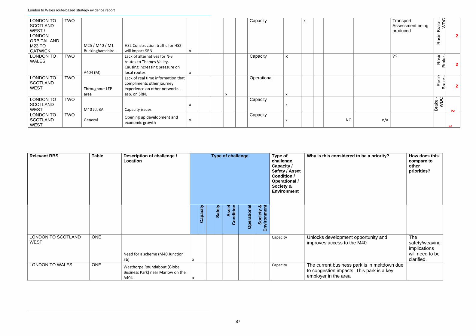
London to Wales route-based strategy evidence report
87
LONDON TO SCOTLAND WEST / LONDON ORBITAL AND M23 TO GATWICK
TWO
M25 / M40 / M1 Buckinghamshire ‐
HS2 Construction traffic for HS2 will impact SRN x
Capacity x Transport Assessment being produced
Ros
ie B
rake
-W
DC
2
LONDON TO WALES
TWO
A404 (M)
Lack of alternatives for N‐S routes to Thames Valley. Causing increasing pressure on local routes. x
Capacity x ??
Ros
ieB
rake
-
2
LONDON TO SCOTLAND WEST
TWO
Throughout LEP area
Lack of real time information that compliments other journey experience on other networks ‐ esp. on SRN. x
Operational
x
Ros
ieB
rake
-
2
LONDON TO SCOTLAND WEST
TWO
M40 Jct 3A Capacity issues x
Capacity x
Bra
ke -
W
DC
2
LONDON TO SCOTLAND WEST
TWO General
Opening up development and economic growth
x Capacity
x NO n/a
1
Relevant RBS Table Description of challenge / Location
Type of challenge Type of challenge Capacity / Safety / Asset Condition / Operational / Society & Environment
Why is this considered to be a priority? How does this compare to other priorities?
C
apac
ity
Saf
ety
Ass
et
Co
nd
itio
n
Op
erat
ion
al
So
ciet
y &
E
nvi
ron
men
t
LONDON TO SCOTLAND WEST
ONE
Need for a scheme (M40 Junction 3b) x
Capacity Unlocks development opportunity and improves access to the M40
The safety/weaving implications will need to be clarified.
LONDON TO WALES ONE Westhorpe Roundabout (Globe Business Park) near Marlow on the A404 x
Capacity The current business park is in meltdown due to congestion impacts. This park is a key employer in the area
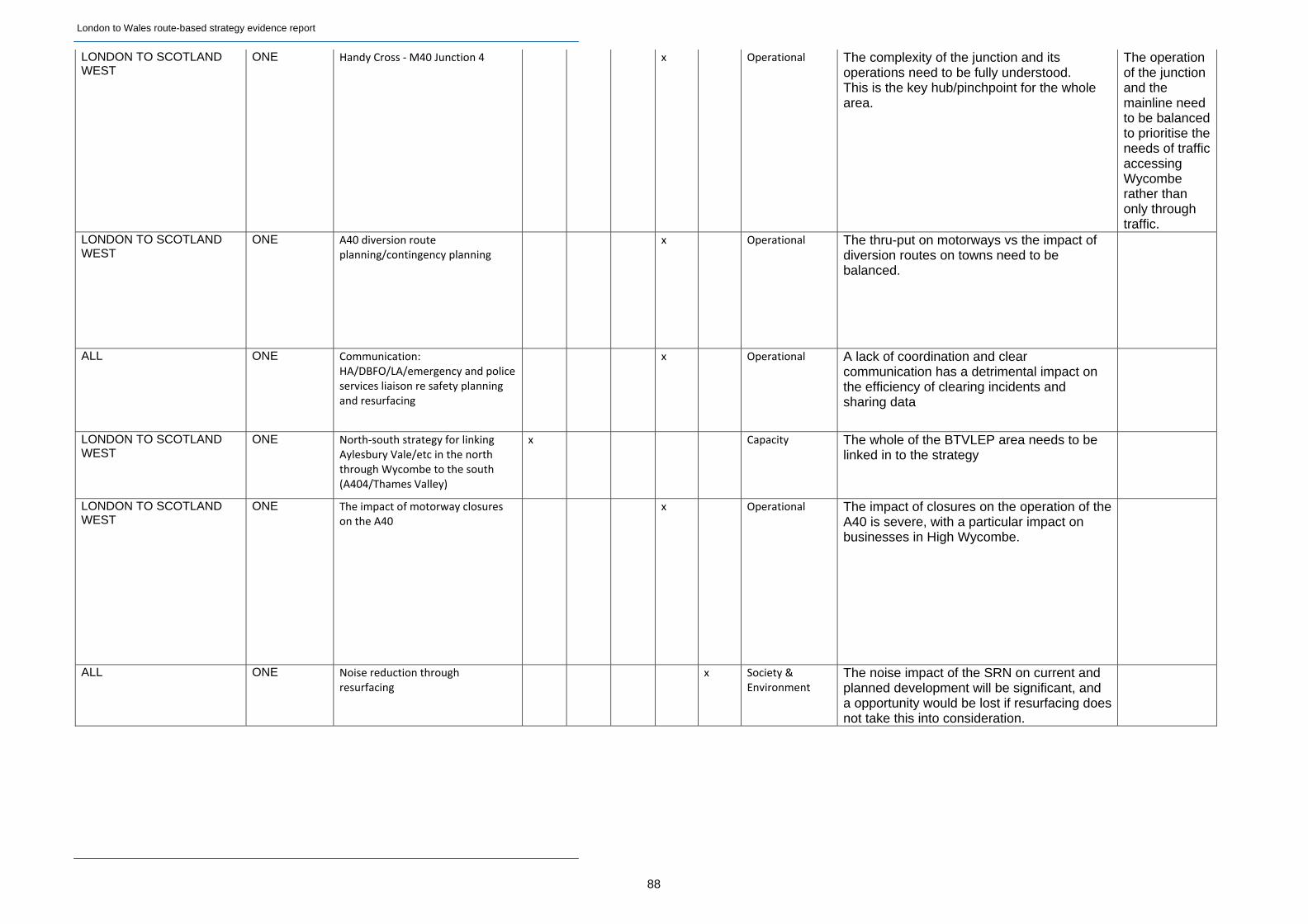
London to Wales route-based strategy evidence report
88
LONDON TO SCOTLAND WEST
ONE Handy Cross ‐ M40 Junction 4 x Operational The complexity of the junction and its operations need to be fully understood. This is the key hub/pinchpoint for the whole area.
The operation of the junction and the mainline need to be balanced to prioritise the needs of traffic accessing Wycombe rather than only through traffic.
LONDON TO SCOTLAND WEST
ONE A40 diversion route planning/contingency planning
x Operational The thru-put on motorways vs the impact of diversion routes on towns need to be balanced.
ALL ONE Communication: HA/DBFO/LA/emergency and police services liaison re safety planning and resurfacing
x Operational A lack of coordination and clear communication has a detrimental impact on the efficiency of clearing incidents and sharing data
LONDON TO SCOTLAND WEST
ONE North‐south strategy for linking Aylesbury Vale/etc in the north through Wycombe to the south (A404/Thames Valley)
x Capacity The whole of the BTVLEP area needs to be linked in to the strategy
LONDON TO SCOTLAND WEST
ONE The impact of motorway closures on the A40
x Operational The impact of closures on the operation of the A40 is severe, with a particular impact on businesses in High Wycombe.
ALL ONE Noise reduction through resurfacing
x Society & Environment
The noise impact of the SRN on current and planned development will be significant, and a opportunity would be lost if resurfacing does not take this into consideration.
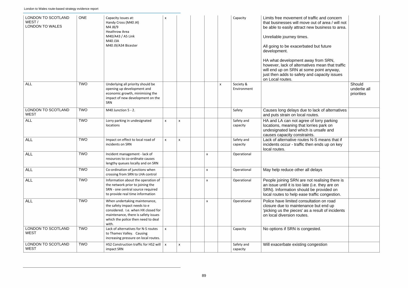
London to Wales route-based strategy evidence report
89
LONDON TO SCOTLAND WEST / LONDON TO WALES
ONE Capacity issues at: Handy Cross (M40 J4) M4 J8/9 Heathrow Area M40/A43 / A5 Link M40 J3A M40 J9/A34 Bicester
x Capacity Limits free movement of traffic and concern that businesses will move out of area / will not be able to easily attract new business to area. Unreliable journey times. All going to be exacerbated but future development. HA what development away from SRN, however, lack of alternatives mean that traffic will end up on SRN at some point anyway, just then adds to safety and capacity issues on Local routes.
ALL TWO Underlying all priority should be opening up development and economic growth, minimising the impact of new development on the SRN
x Society & Environment
Should underlie all priorities
LONDON TO SCOTLAND WEST
TWO M40 Junction 5 ‐ 2. Safety Causes long delays due to lack of alternatives and puts strain on local routes.
ALL TWO Lorry parking in undesignated locations
x x Safety and capacity
HA and LA can not agree of lorry parking locations, meaning that lorries park on undesignated land which is unsafe and causes capacity constraints.
ALL TWO Impact on effect to local road of incidents on SRN
x x Safety and capacity
Lack of alternative routes N-S means that if incidents occur - traffic then ends up on key local routes.
ALL TWO Incident management ‐ lack of resources to co‐ordinate causes lengthy queues locally and on SRN
x Operational
ALL TWO Co‐ordination of junctions when crossing from SRN to LHA control
x Operational May help reduce other all delays
ALL TWO Information about the operation of the network prior to joining the SRN ‐ one central source required to provide real time information
x Operational People joining SRN are not realising there is an issue until it is too late (i.e. they are on SRN). Information should be provided on local routes to help ease traffic congestion.
ALL TWO When undertaking maintenance, the safety impact needs to e considered. I.e. when HX closed for maintenance, there is safety issues which the police then need to deal with.
x Operational Police have limited consultation on road closure due to maintenance but end up 'picking us the pieces' as a result of incidents on local diversion routes.
LONDON TO SCOTLAND WEST
TWO Lack of alternatives for N‐S routes to Thames Valley. Causing increasing pressure on local routes.
x Capacity No options if SRN is congested.
LONDON TO SCOTLAND WEST
TWO HS2 Construction traffic for HS2 will impact SRN
x x Safety and capacity
Will exacerbate existing congestion
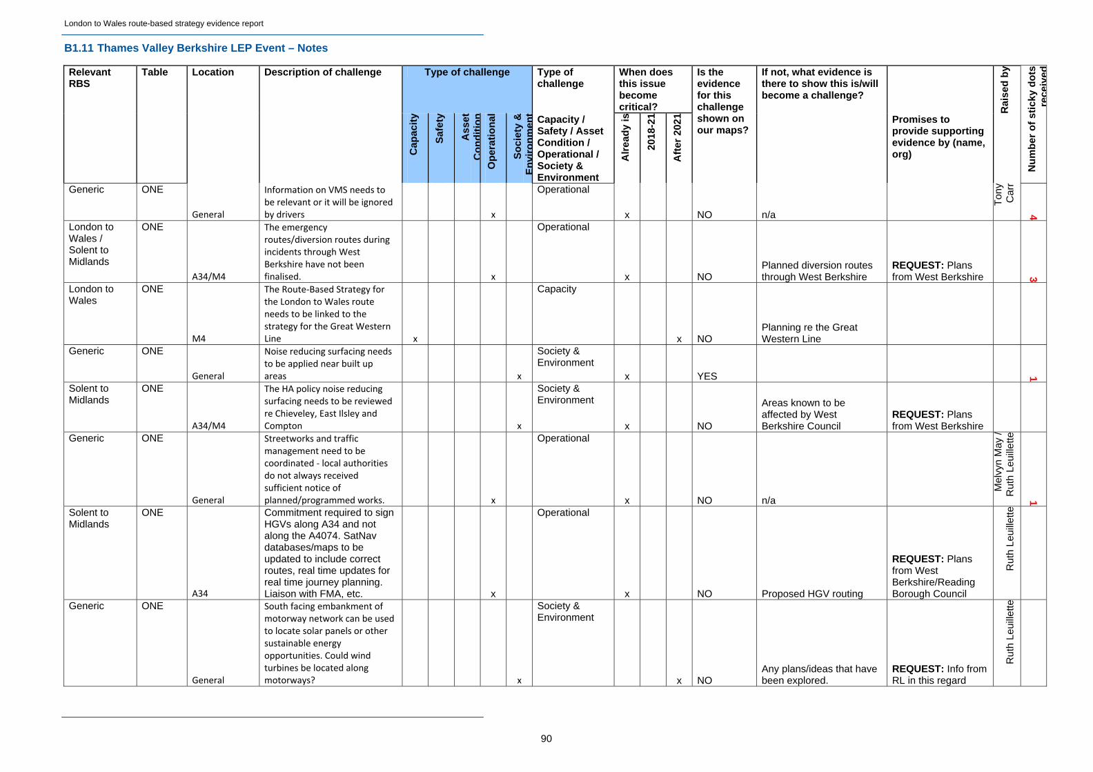
London to Wales route-based strategy evidence report
90
B1.11 Thames Valley Berkshire LEP Event – Notes
Type of challenge Type of challenge
When does this issue become critical?
Relevant RBS
Table Location Description of challenge
Cap
acit
y
Saf
ety
Ass
etC
on
dit
ion
Op
erat
ion
al
So
ciet
y &
En
viro
nm
ent
Capacity / Safety / Asset Condition / Operational / Society & Environment
Alr
ead
y is
2018
-21
Aft
er 2
021
Is the evidence for this challenge shown on our maps?
If not, what evidence is there to show this is/will become a challenge?
Promises to provide supporting evidence by (name, org)
Rai
sed
by
Nu
mb
er o
f st
icky
do
tsre
ceiv
ed
Generic ONE
General
Information on VMS needs to be relevant or it will be ignored by drivers x
Operational
x NO n/a
Ton
yC
arr
4
London to Wales / Solent to Midlands
ONE
A34/M4
The emergency routes/diversion routes during incidents through West Berkshire have not been finalised. x
Operational
x NO Planned diversion routes through West Berkshire
REQUEST: Plans from West Berkshire 3
London to Wales
ONE
M4
The Route‐Based Strategy for the London to Wales route needs to be linked to the strategy for the Great Western Line x
Capacity
x NO Planning re the Great Western Line
Generic ONE
General
Noise reducing surfacing needs to be applied near built up areas x
Society & Environment
x YES 1
Solent to Midlands
ONE
A34/M4
The HA policy noise reducing surfacing needs to be reviewed re Chieveley, East Ilsley and Compton x
Society & Environment
x NO
Areas known to be affected by West Berkshire Council
REQUEST: Plans from West Berkshire
Generic ONE
General
Streetworks and traffic management need to be coordinated ‐ local authorities do not always received sufficient notice of planned/programmed works. x
Operational
x NO n/a
Mel
vyn
May
/R
uth
Leui
llette
1
Solent to Midlands
ONE
A34
Commitment required to sign HGVs along A34 and not along the A4074. SatNav databases/maps to be updated to include correct routes, real time updates for real time journey planning. Liaison with FMA, etc. x
Operational
x NO Proposed HGV routing
REQUEST: Plans from West Berkshire/Reading Borough Council
Rut
h Le
uille
tte
Generic ONE
General
South facing embankment of motorway network can be used to locate solar panels or other sustainable energy opportunities. Could wind turbines be located along motorways? x
Society & Environment
x NO Any plans/ideas that have been explored.
REQUEST: Info from RL in this regard
Rut
h Le
uille
tte
London to Wales route-based strategy evidence report
91
Generic ONE
General
The HA needs to show commitment to an aim to develop an electric vehicle charging network across the SRN x
Society & Environment
x NO OLEV's plans for network REQUEST: Info from RL in this regard
Rut
hLe
uille
tte
Generic ONE
General
Access to the rail network (which is being substantially upgraded) needs to be a priority x
Society & Environment
x NO n/a Leui
llett e
1
Generic ONE
General
Variable speed limits and improvements on journey time reliability x
Operational
x NO n/a Leui
llett e
3
Generic ONE
General
Lack of communication is an issue. VMS is not joined up between HAs and LAs. Especially an issue around event management and for diversionary routes x
Operational
x NO n/a
Rut
h Le
uille
tte
1
Generic ONE
General
HGV rest areas/lorry parking ‐ this has an impact on residential areas. There is a need for formal rest areas x
Society & Environment
x NO
Proposals for HGV rest areas along SRN and local network T
ony
Car
r
Generic ONE
General
HGVs are generated onto the SRN from developments: planning conditions should restrict the times at which HGVs can access the SRN x
Operational
x NO n/a
Ton
y C
arr
London to Wales
ONE HS2
What are the highway implications of HS2? x
Operational x NO n/a
London to Wales
ONE
Wokingham Noise issues from the M4 x
Society & Environment
x NO Noise complaints from residents
REQUEST: Info from Wokingham BC in this regard
Mat
tG
ould
1
Generic ONE
General
HOV lanes ‐ reduce the number of single occupancy vehicles, in particular during peak times x
Capacity
x NO n/a
Mat
tG
ould
1
Generic ONE
General
Demand management ‐ scope for bringing back programme post 2015 to tie into local LSTF projects x
Capacity
x NO LSTF programme info
REQUEST: Info from local authorities in this regard M
ike
Fin
ch
1
London to Wales
ONE
Thames Valley
Thames Valley is a key business catchment area for Heathrow Airport - journeys are important to the UK economy x
Capacity
x NO Data on catchment for Heathrow
REQUEST: Info from Heathrow C
hris
Joy
ce
1
London to Wales
ONE
M4
HGV activity and overtaking can effectively reduce capacity. Need education campaign or tighter rules to better manage HGV activity x
Operational
x NO n/a
Chr
is J
oyce
London to Wales
ONE
Wokingham
AQMA's along the M4 lie within the boundaries of Wokingham BC x
Society & Environment
x NO Maps of AQMAs REQUEST: Info from WBC
Mat
tG
ould
London to Wales route-based strategy evidence report
92
London to Wales
ONE
M4
Better liaison between the HA and Network Rail with regards to strategic planning for capacity. Great Western rail route effectively follows M4 . Need to consider and co-ordinate modes better in planning terms! x
Capacity
x x x NO n/a
Rut
h Le
uille
tte
London to Wales
ONE
Heathrow
M4 Journey times J‐7‐10 seen as overambitious and unreliable. Creates problems for Heathrow travellers. Why is this? x
Operational
x NO Data from airport passenger surveys?
REQUEST: Info from Heathrow C
hris
Joy
ce /
Mel
vyn
May
3
London to Wales
ONE
M4
Air quality impacts - largest contributor is the M4 and the local authorities have no influence on the root causes x
Society & Environment
x NO Air quality data
REQUEST: Info from local authorities in this regard T
ony
Car
r
London to Wales
ONE
Slough
AQMA with action plan along the M4 past Slough (M4 Jct 5 - Jct 7) x
Society & Environment
x NO Action Plan
Mik
eF
inch
London to Wales
ONE M4 Bus lanes and other sustainable transport options to be promoted along the M4 corridor (and the SRN as a whole) x
Capacity
x NO n/a
Ton
y C
arr
London to Wales
ONE
Heathrow
The outcome of the Airports Commission will have an impact on the demand for travel to Heathrow (currently unknown) x
Capacity
x NO n/a Chr
is J
oyce
London to Wales
ONE
M4
Poor co‐ordination and consultation around M4 corridor demand management initiatives and recent revocation of bus lane orders. Has the HA consulted on the revocation of the M4 bus lane? Would prefer to see an extension of public transport priority. x
Operational
x NO
Rut
h Le
uille
tte
London Orbital and M23 to Gatwick
ONE
M25/M23
Strategic capacity of the Heathrow to London Gatwick link x
Capacity
x NO Evidence of journey time reliability and demand
REQUEST: Info from Heathrow/LGW
Rut
hLe
uille
tte
Generic ONE
General Reliability of the journey times? x
Operational
x NO Evidence of journey time reliability Le
uille
tt e
1
Generic ONE
General
Verges are maintained too intensively and hence do not act as wildlife corridors. Need to maintain Diversity. Would some KPIs aid things? x
Society & Environment
x NO Appropriate guidance
REQUEST: Info from Local Nature Partnership on appropriate practice
Cam
illa
Bur
row
1
Generic ONE
General
Fragmentation of habitats for wildlife ‐ biodiversity opportunity areas x
Society & Environment
x NO
Data from the Thames Valley Environmental Records Centre
REQUEST: Info from Camilla Burrow C
amill
aB
urro
w
2
London to Wales route-based strategy evidence report
93
Generic ONE
General
Local operational managers don't have a responsibility / target to conserve the natural environment and don't have practical local guidance x
Society & Environment
x NO Appropriate guidance
REQUEST: Info from Local Nature Partnership on appropriate practice
Cam
illa
Bur
row
1
Generic ONE
General
Keen to see wider application of Demand management initiatives network wide
X Capacity
x x x
Rut
hLe
uille
tte
London to Wales
ONE
M4
Incident management is poorly managed. Lack of consistent approach and diversion routes are not being agreed with LA's particularly on demand management and Ramp Metering. Lack of continuity in HA engagement is an issue
x
Operational
x
Mel
vyn
May
/ R
uth
Leui
llett
e
London to Wales
ONE
M4
Ramp metering and demand management approaches are not adequately co‐ordinated between LAs and HA.
x
Operational
x
May
/ R
uth
Leui
llett
e
Generic ONE
General
Not always easy to differentiate KSI data so HA data skews reporting for some LA's. Same true of AQ information x
Operational
x NO Action Plan Mik
e F
inch
Generic ONE
General
Also not always easy to differentiate Air Quality data so HA data skews reporting for some LA's. x
Society & Environment
x NO Action Plan Mik
e F
inch
London to Wales
ONE
Slough
Overnight parking is an issue for lorries and Air Freight Hauliers. Try to avoid parking charges x
Society & Environment
x NO Action Plan REQUEST: Info from Slough BC
/ M
elvy
nM
ay
London to Wales
ONE M4 / A34 Chieveley
Noise from old Roads is a problem
x
Society & Environment
x
Mel
vyn
May
Generic TWO
General
Organisation should make use of tools such as www.elgin.org.uk and/or roadworks.org. How are the HA linking to these? x
Operational
x NO n/a Ste
ve C
apil-
Dav
ies
Generic TWO
General Local Authority Active Travel Plans are not to be forgotten x
Society & Environment
x NO n/a Jan
ice
Brid
ger
Generic TWO
General Community severance must be avoided x
Society & Environment
x NO Areas with severance issues
REQUEST: Info from Janice Bridger Ja
nic
eB
ridge
r
Solent to Midlands
TWO A34
Delays along A34 around Oxford (towards the M40) x
Capacity x NO n/a
London to Wales / Solent to Midlands
TWO
A34
Some bad junction slips off the A34 in West Berkshire between the M4 and northern district boundary x
Safety
x NO List of bad slips REQUEST: Info from West Berkshire DC
Nav
tej
Tun
g
London to Wales route-based strategy evidence report
94
Generic TWO
General
Must contact ALL relevant Local Access Forums (statutory bodies) to advise on NMU travel. Consult LTPs, Rights of Way Improvement Plans, Active Travel Plans, etc. The HA and local authorities are working separately at the moment. x
Society & Environment
x NO
LTPs Rights of Way Improvement Plans Active Travel Plans
REQUEST: Info from local authorities in this regard
Jani
ce B
ridge
r
Solent to Midlands
TWO
A34
Currently consists of two lanes only, with no hard shoulder. Any incidents result in congestion. x
Operational
x NO n/a
Jani
ceB
ridge
r
Solent to Midlands
TWO
A34
Currently consists of two lanes only, with no hard shoulder. This is a safety concern as there is nowhere to go in the event of a breakdown. Slip roads are too sharp. x
Safety
x NO List of bad slips REQUEST: Info from Janice Bridger
Jani
ce B
ridge
r
Generic TWO
General
NMUs: lack of crossings across the M4 in the area of Hermitage ‐ Yaltend Rd: this is a major right of way which is now severed, and is a problem which should have been resolved at the time of construction. x
Society & Environment
x NO n/a REQUEST: Info from Janice Bridger
Jani
ce B
ridge
r
London to Wales
TWO
M4
Light and noise pollution: major issues have been highlighted by parish plans within West Berkshire. Complaints have been received with regards to resurfacing, but whether action has been taken is an unknown. x
Society & Environment
x NO
West Berkshire parish plans re noise/air pollution
REQUEST: Info from West Berkshire DC
Nav
tej T
ung
1
Solent to Midlands
TWO
A34 (Chieveley)
NMU issues: e.g. Chieveley junction (A34) ‐ an east‐west bridleway bridge had to be fought for (and obtained) by volunteers. The north‐south cycle/walk way along the A34 was provided by the HA but is not attractive and is not used. x
Society & Environment
x NO n/a
Jani
ce B
ridge
r
2
London to Wales / Solent to Midlands
TWO
M4 Jct 13 (A34)
Did the predicted traffic demand projected for the junction following the improvements in 2000 materialise? Was the traffic demand under‐estimated? x
Capacity
x NO Current and projected traffic demand
REQUEST: Info from HA/West Berkshire DC Ja
nice
Brid
ger
1
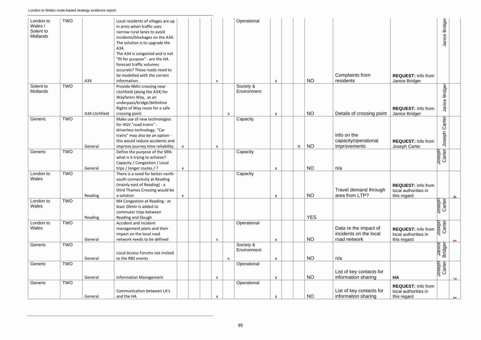
London to Wales route-based strategy evidence report
95
London to Wales / Solent to Midlands
TWO
A34
Local residents of villages are up in arms when traffic uses narrow rural lanes to avoid incidents/blockages on the A34. The solution is to upgrade the A34. The A34 is congested and is not "fit for purpose" ‐ are the HA forecast traffic volumes accurate? These roads need to be modelled with the correct information. x
Operational
x NO Complaints from residents
REQUEST: Info from Janice Bridger
Jani
ce B
ridge
r
Solent to Midlands
TWO
A34 Litchfield
Provide NMU crossing near Litchfield (along the A34) for Wayfarers Way, as an underpass/bridge/definitive Rights of Way route for a safe crossing point x
Society & Environment
x NO Details of crossing point REQUEST: Info from Janice Bridger
Jani
ce B
ridge
r
Generic TWO
General
Make use of new technologies for HGV "road trains" ‐ driverless technology. "Car trains" may also be an option ‐ this would reduce accidents and improve journey time reliability. x x
Capacity
x NO
Info on the capacity/operational improvements
REQUEST: Info from Joseph Carter Jo
seph
Car
ter
Generic TWO
General
Define the purpose of the SRN: what is it trying to achieve? Capacity / Congestion / Local trips / longer routes / ? x
Capacity
x NO n/a
Jose
phC
arte
r
London to Wales
TWO
Reading
There is a need for better north‐south connectivity at Reading (mainly east of Reading) ‐ a third Thames Crossing would be a solution x
Capacity
x NO Travel demand through area from LTP?
REQUEST: Info from local authorities in this regard 4
London to Wales
TWO
Reading
M4 Congestion at Reading ‐ at least 20min is added to commuter trips between Reading and Slough
YES
Jose
phC
arte
r
London to Wales
TWO
General
Accident and incident management plans and their impact on the local road network needs to be defined x
Operational
x NO
Data re the impact of incidents on the local road network
REQUEST: Info from local authorities in this regard
Jose
phC
arte
r
1
Generic TWO
General Local Access Forums not invited to the RBS events x
Society & Environment
x NO n/a
Jani
ceB
ridge
r
Generic TWO
General Information Management x
Operational
x NO List of key contacts for information sharing HA Jo
seph
Car
ter
7
Generic TWO
General Communication between LA's and the HA x
Operational
x NO List of key contacts for information sharing
REQUEST: Info from local authorities in this regard 1
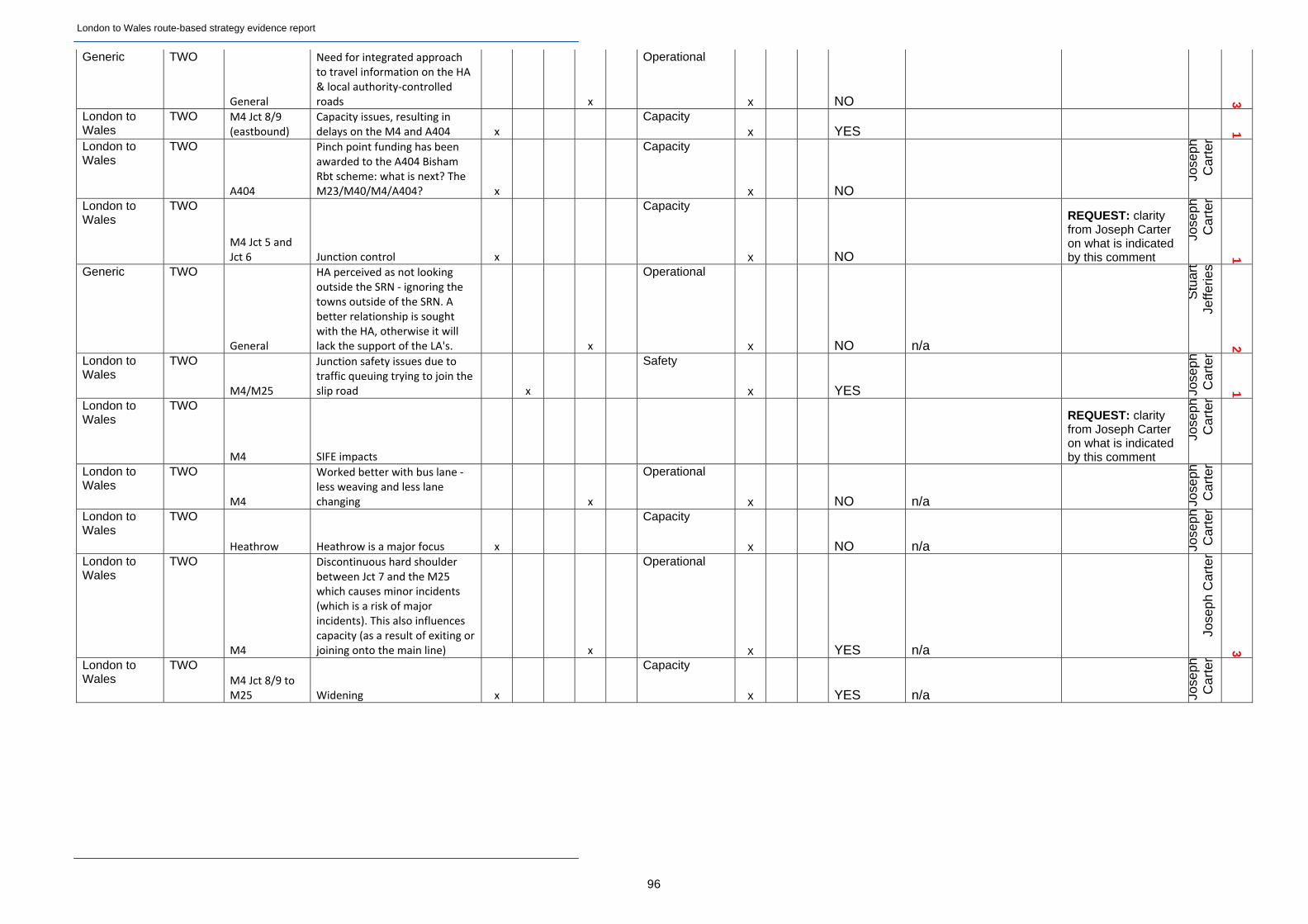
London to Wales route-based strategy evidence report
96
Generic TWO
General
Need for integrated approach to travel information on the HA & local authority‐controlled roads x
Operational
x NO 3
London to Wales
TWO M4 Jct 8/9 (eastbound)
Capacity issues, resulting in delays on the M4 and A404 x
Capacity x YES 1
London to Wales
TWO
A404
Pinch point funding has been awarded to the A404 Bisham Rbt scheme: what is next? The M23/M40/M4/A404? x
Capacity
x NO
Jose
phC
arte
r
London to Wales
TWO
M4 Jct 5 and Jct 6 Junction control x
Capacity
x NO
REQUEST: clarity from Joseph Carter on what is indicated by this comment
Jose
phC
arte
r
1
Generic TWO
General
HA perceived as not looking outside the SRN ‐ ignoring the towns outside of the SRN. A better relationship is sought with the HA, otherwise it will lack the support of the LA's. x
Operational
x NO n/a
Stu
art
Jeffe
ries
2
London to Wales
TWO
M4/M25
Junction safety issues due to traffic queuing trying to join the slip road x
Safety
x YES Jose
phC
arte
r
1
London to Wales
TWO
M4 SIFE impacts
REQUEST: clarity from Joseph Carter on what is indicated by this comment
Jose
phC
arte
r
London to Wales
TWO
M4
Worked better with bus lane ‐ less weaving and less lane changing x
Operational
x NO n/a Jose
phC
arte
r
London to Wales
TWO
Heathrow Heathrow is a major focus x
Capacity
x NO n/a Jose
phC
arte
r
London to Wales
TWO
M4
Discontinuous hard shoulder between Jct 7 and the M25 which causes minor incidents (which is a risk of major incidents). This also influences capacity (as a result of exiting or joining onto the main line) x
Operational
x YES n/a
Jose
ph C
arte
r
3
London to Wales
TWO M4 Jct 8/9 to M25 Widening x
Capacity
x YES n/a Jose
phC
arte
r
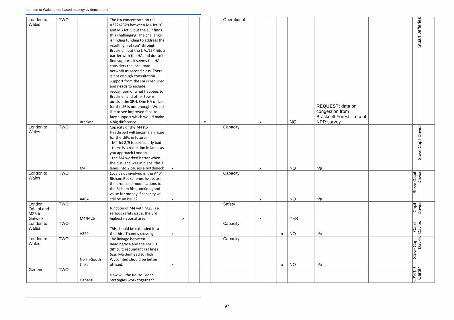
London to Wales route-based strategy evidence report
97
London to Wales
TWO
Bracknell
The HA concentrate on the A322/A329 between M4 Jct 10 and M3 Jct 3, but the LEP finds this challenging. The challenge is finding funding to address the resulting "rat run" through Bracknell, but the L.A./LEP hits a barrier with the HA and doesn't find support. It seems the HA considers the local road network as second class. There is not enough consultation . Support from the HA is required and needs to include recognition of what happens to Bracknell and other towns outside the SRN. One HA officer for the SE is not enough. Would like to see improved face‐to‐face support which would make a big difference. x
Operational
x NO
REQUEST: data on congestion from Bracknell Forest - recent NPR survey
Stu
art
Jeffe
ries
London to Wales
TWO
M4
Capacity of the M4 (to Heathrow) will become an issue for the LEPs in future: ‐ M4 Jct 8/9 is particularly bad ‐ there is a reduction in lanes as you approach London ‐ the M4 worked better when the bus lane was in place: the 3 lanes into 2 causes a bottleneck x
Capacity
x NO n/a
Ste
ve C
apil-
Dav
ies
London to Wales
TWO
A404
Locals not involved in the A404 Bisham Rbt scheme. Issue: are the proposed modifications to the Bisham Rbt junction good value for money if capacity will still be an issue? x
Capacity
x NO n/a
Ste
ve C
apil-
Dav
ies
London Orbital and M23 to Gatwick
TWO
M4/M25
Junction of M4 with M25 is a serious safety issue: the 3rd highest national area x
Safety
x YES
Cap
il-D
avie
s
London to Wales
TWO
A329 This should be extended into the third Thames crossing x
Capacity
x NO n/a
Cap
il-D
avie
s
London to Wales
TWO
North‐South Links
The linkage between Reading/M4 and the M40 is difficult: redundant rail lines (e.g. Maidenhead to High Wycombe) should be better utilised. x
Capacity
x NO n/a
Ste
ve C
apil-
Dav
ies
Generic TWO
General How will the Route‐Based Strategies work together?
Jose
phC
arte
r
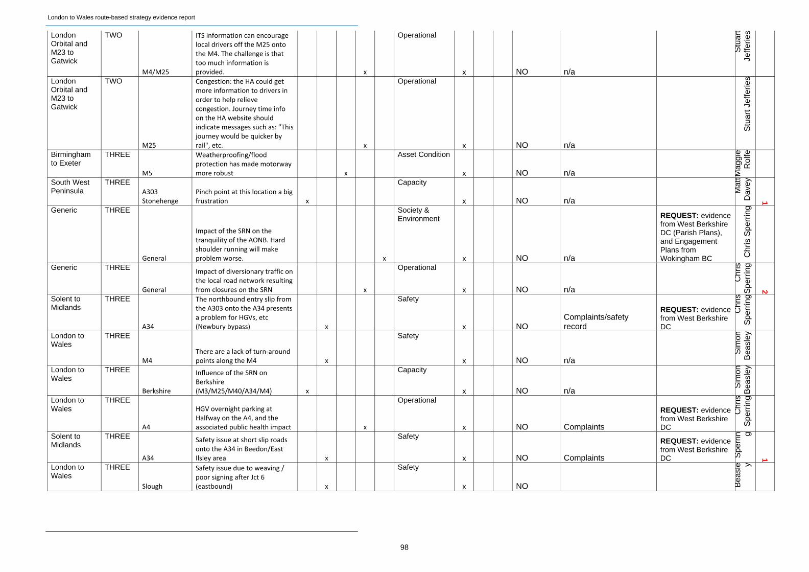
London to Wales route-based strategy evidence report
98
London Orbital and M23 to Gatwick
TWO
M4/M25
ITS information can encourage local drivers off the M25 onto the M4. The challenge is that too much information is provided. x
Operational
x NO n/a
Stu
art
Jeffe
ries
London Orbital and M23 to Gatwick
TWO
M25
Congestion: the HA could get more information to drivers in order to help relieve congestion. Journey time info on the HA website should indicate messages such as: "This journey would be quicker by rail", etc. x
Operational
x NO n/a
Stu
art
Jeffe
ries
Birmingham to Exeter
THREE
M5
Weatherproofing/flood protection has made motorway more robust x
Asset Condition
x NO n/a Mag
gie
Rol
fe
South West Peninsula
THREE A303 Stonehenge
Pinch point at this location a big frustration x
Capacity
x NO n/a
Mat
tD
avey
1
Generic THREE
General
Impact of the SRN on the tranquility of the AONB. Hard shoulder running will make problem worse. x
Society & Environment
x NO n/a
REQUEST: evidence from West Berkshire DC (Parish Plans), and Engagement Plans from Wokingham BC C
hris
Spe
rrin
g
Generic THREE
General
Impact of diversionary traffic on the local road network resulting from closures on the SRN x
Operational
x NO n/a
Chr
isS
perr
ing
2
Solent to Midlands
THREE
A34
The northbound entry slip from the A303 onto the A34 presents a problem for HGVs, etc (Newbury bypass) x
Safety
x NO Complaints/safety record
REQUEST: evidence from West Berkshire DC
Chr
isS
perr
ing
London to Wales
THREE
M4 There are a lack of turn‐around points along the M4 x
Safety
x NO n/a
Sim
onB
easl
ey
London to Wales
THREE
Berkshire
Influence of the SRN on Berkshire (M3/M25/M40/A34/M4) x
Capacity
x NO n/a
Sim
onB
easl
ey
London to Wales
THREE
A4
HGV overnight parking at Halfway on the A4, and the associated public health impact x
Operational
x NO Complaints
REQUEST: evidence from West Berkshire DC
Chr
isS
perr
ing
Solent to Midlands
THREE
A34
Safety issue at short slip roads onto the A34 in Beedon/East Ilsley area x
Safety
x NO Complaints
REQUEST: evidence from West Berkshire DC S
perr
in g
1
London to Wales
THREE
Slough
Safety issue due to weaving / poor signing after Jct 6 (eastbound) x
Safety
x NO Bea
sle y
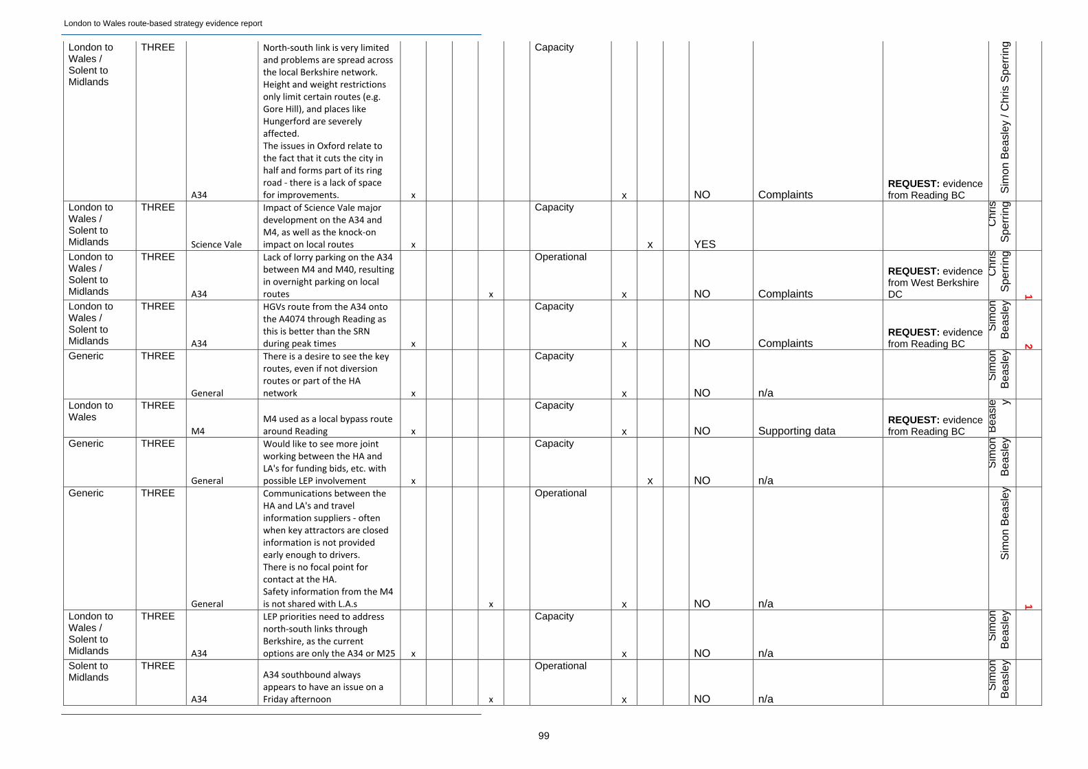
London to Wales route-based strategy evidence report
99
London to Wales / Solent to Midlands
THREE
A34
North‐south link is very limited and problems are spread across the local Berkshire network. Height and weight restrictions only limit certain routes (e.g. Gore Hill), and places like Hungerford are severely affected. The issues in Oxford relate to the fact that it cuts the city in half and forms part of its ring road ‐ there is a lack of space for improvements. x
Capacity
x NO Complaints REQUEST: evidence from Reading BC S
imon
Bea
sley
/ C
hris
Spe
rrin
g
London to Wales / Solent to Midlands
THREE
Science Vale
Impact of Science Vale major development on the A34 and M4, as well as the knock‐on impact on local routes x
Capacity
x YES
Chr
isS
perr
ing
London to Wales / Solent to Midlands
THREE
A34
Lack of lorry parking on the A34 between M4 and M40, resulting in overnight parking on local routes x
Operational
x NO Complaints
REQUEST: evidence from West Berkshire DC
Chr
isS
perr
ing
1
London to Wales / Solent to Midlands
THREE
A34
HGVs route from the A34 onto the A4074 through Reading as this is better than the SRN during peak times x
Capacity
x NO Complaints REQUEST: evidence from Reading BC
Sim
onB
easl
ey
2
Generic THREE
General
There is a desire to see the key routes, even if not diversion routes or part of the HA network x
Capacity
x NO n/a
Sim
onB
easl
ey
London to Wales
THREE
M4 M4 used as a local bypass route around Reading x
Capacity
x NO Supporting data REQUEST: evidence from Reading BC B
easl
e y
Generic THREE
General
Would like to see more joint working between the HA and LA's for funding bids, etc. with possible LEP involvement x
Capacity
x NO n/a
Sim
onB
easl
ey
Generic THREE
General
Communications between the HA and LA's and travel information suppliers ‐ often when key attractors are closed information is not provided early enough to drivers. There is no focal point for contact at the HA. Safety information from the M4 is not shared with L.A.s x
Operational
x NO n/a
Sim
on B
easl
ey
1
London to Wales / Solent to Midlands
THREE
A34
LEP priorities need to address north‐south links through Berkshire, as the current options are only the A34 or M25 x
Capacity
x NO n/a
Sim
onB
easl
ey
Solent to Midlands
THREE
A34
A34 southbound always appears to have an issue on a Friday afternoon x
Operational
x NO n/a
Sim
onB
easl
ey

London to Wales route-based strategy evidence report
100
Solent to Midlands
THREE
A34
A34 near Oxford is very sensitive to roadworks, resulting in diversion through Reading x
Operational
x NO n/a Sim
on B
easl
ey/ C
hris
Spe
rrin
g
London to Wales
THREE
Reading
Effects of redevelopment on both sides of Reading Station, as well as a significant projected increase in passengers using Reading station. x
Capacity
x NO Data from FGW/Network Rail
REQUEST: evidence from Reading BC/Network Rail
Mag
gie
Rol
fe
London to Wales
THREE
Reading
Coordination between HA and the police on works and incident management ‐ there is a lack of information on the impact of issues on the SRN on Reading town centre x
Operational
x NO Plans between Network Rail and the Police
REQUEST: evidence from Maggie Rolfe
Mag
gie
Rol
fe
London to Wales
THREE
M4 Congestion on M4 Jct 12 eastwards x
Capacity
x YES Sim
on B
easl
ey/ C
hris
Spe
rrin
g
London to Wales
THREE
M4 Jct 11
HGV strategy required for access to Reading/M4 Jct 11 (for A33) x
Capacity
x NO Info on key origins/destinations
REQUEST: evidence from Reading BC B
easl
e y
London to Wales
THREE
Reading Thames crossing needed ‐ there are too few river crossings. x
Capacity
x NO
Mat
tD
avey
London to Wales
THREE
M4
Condition of M4 impacts directly on the local road network during busy times. However, at M4 Jct 12 the L.A. Changes the signal settings during an incident to limit vehicles from leaving the M4. x
Operational
x NO
Sim
on B
easl
ey
London to Wales
THREE
M4
Diversion routing following an incident on the M4 ‐ smartphones are often used for navigation. x
Operational
x NO
Mat
tD
avey
1
London to Wales
THREE
M4
Capacity/congestion on M4 between Reading and M25 during busy times. The L.A.s would like confirmation of whether proposals for hard shoulder running will be implemented. x
Capacity
x YES
Sim
on B
easl
ey
London to Wales
THREE
M4 Noise/air pollution x
Society & Environment
NO Data REQUEST: evidence from Wokingham BC
Mat
tD
avey
4
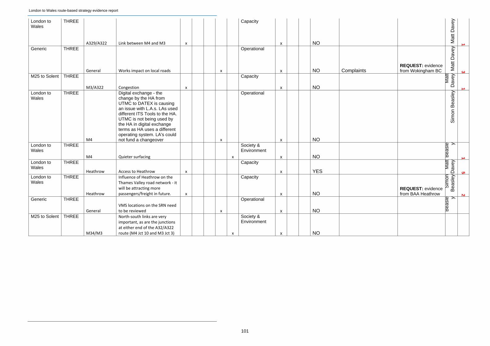
London to Wales route-based strategy evidence report
101
London to Wales
THREE
A329/A322 Link between M4 and M3 x
Capacity
x NO Mat
t D
avey
1
Generic THREE
General Works impact on local roads x
Operational
x NO Complaints REQUEST: evidence from Wokingham BC M
att
Dav
ey
3
M25 to Solent THREE
M3/A322 Congestion x
Capacity
x NO
Mat
tD
avey
1
London to Wales
THREE
M4
Digital exchange - the change by the HA from UTMC to DATEX is causing an issue with L.A.s. LAs used different ITS Tools to the HA. UTMC is not being used by the HA in digital exchange terms as HA uses a different operating system. LA's could not fund a changeover x
Operational
x NO
Sim
on B
easl
ey
London to Wales
THREE
M4 Quieter surfacing x
Society & Environment
x NO Bea
sle y
1
London to Wales
THREE
Heathrow Access to Heathrow x
Capacity
x YES
Mat
tD
avey
5
London to Wales
THREE
Heathrow
Influence of Heathrow on the Thames Valley road network ‐ it will be attracting more passengers/freight in future. x
Capacity
x NO REQUEST: evidence from BAA Heathrow
Sim
onB
easl
ey
2
Generic THREE
General VMS locations on the SRN need to be reviewed x
Operational
x NO Bea
sle y
M25 to Solent THREE
M34/M3
North‐south links are very important, as are the junctions at either end of the A32/A322 route (M4 Jct 10 and M3 Jct 3) x
Society & Environment
x NO

London to Wales route-based strategy evidence report
102
Generic THREE
Berkshire
20,000 new homes are planned in the area. The impact of development in Surrey and Buckinghamshire also needs to be considered as Berkshire has a wide influence. Berkshire is very attractive to Heathrow. Crossrail will have an impact. Tesco development at Green Park. The West Reading industrial parks are being linked to the town centre, which will affect signing from M4 Jct 11 as a freight route. x
Capacity
x YES
REQUEST: evidence from L.A.s to confirm numbers, in particular the West Berkshire freight strategy and Reading BC's freight access plans.
Mat
t D
avey
London to Wales
THREE
M4 Jct 12
Drivers can see the operational state of the M4 when they cross the bridge at Jct 12 and then choose the A4 if it appears congested. x
Operational
x NO Mat
t D
avey
Generic THREE
General
There is a disconnect between the projected traffic growth figures from the DfT and the evidence from other European studies. x
Capacity
x NO
Sim
onB
easl
ey
London to Wales
THREE
M4/M329 Risk of run‐off flooding at Winnersh x
Capacity
x NO Dav
e y
Relevant RBS Table Description of challenge / Location
Type of challenge Type of challenge Capacity / Safety / Asset Condition / Operational / Society & Environment
Why is this considered to be a priority?
How does this compare to other priorities?
Cap
acit
y
Saf
ety
Ass
et
Co
nd
itio
n
Op
erat
ion
al
So
ciet
y &
E
nvi
ron
men
t
London to Wales ONE Journey Time Reliability and Co‐ordination strategies need to be linked and Real Time systems used.
x
Operational
Particularly effects Heathrow & empl0yment opportunities
Generic ONE Information / real‐time information strategy across the SRN and non‐SRN
x
Operational
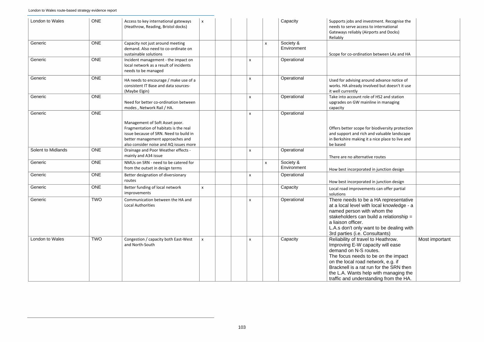
London to Wales route-based strategy evidence report
103
London to Wales ONE Access to key international gateways (Heathrow, Reading, Bristol docks)
x Capacity Supports jobs and investment. Recognise the needs to serve access to international Gateways reliably (Airports and Docks) Reliably
Generic ONE Capacity not just around meeting demand. Also need to co‐ordinate on sustainable solutions
x Society & Environment
Scope for co‐ordination between LAs and HA
Generic ONE Incident management ‐ the impact on local network as a result of incidents needs to be managed
x Operational
Generic ONE HA needs to encourage / make use of a consistent IT Base and data sources‐ (Maybe Elgin)
x Operational Used for advising around advance notice of works. HA already involved but doesn't it use it well currently
Generic ONE Need for better co‐ordination between modes , Network Rail / HA.
x Operational Take into account role of HS2 and station upgrades on GW mainline in managing capacity
Generic ONE
Management of Soft Asset poor. Fragmentation of habitats is the real issue because of SRN. Need to build in better management approaches and also consider noise and AQ issues more
x Operational
Offers better scope for biodiversity protection and support and rich and valuable landscape in Berkshire making it a nice place to live and be based
Solent to Midlands ONE Drainage and Poor Weather effects ‐ mainly and A34 issue
x Operational
There are no alternative routes
Generic ONE NMUs on SRN ‐ need to be catered for from the outset in design terms
x Society & Environment How best incorporated in junction design
Generic ONE Better designation of diversionary routes
x Operational
How best incorporated in junction design
Generic ONE Better funding of local network improvements
x Capacity Local road improvements can offer partial solutions
Generic TWO Communication between the HA and Local Authorities
x Operational There needs to be a HA representative at a local level with local knowledge - a named person with whom the stakeholders can build a relationship = a liaison officer. L.A.s don't only want to be dealing with 3rd parties (i.e. Consultants)
London to Wales TWO Congestion / capacity both East‐West and North‐South
x x Capacity Reliability of travel to Heathrow. Improving E-W capacity will ease demand on N-S routes. The focus needs to be on the impact on the local road network, e.g. if Bracknell is a rat run for the SRN then the L.A. Wants help with managing the traffic and understanding from the HA.
Most important
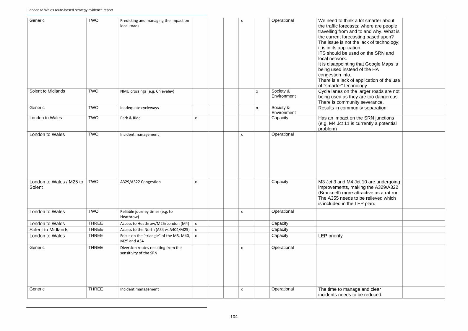
London to Wales route-based strategy evidence report
104
Generic TWO Predicting and managing the impact on local roads
x Operational We need to think a lot smarter about the traffic forecasts: where are people travelling from and to and why. What is the current forecasting based upon? The issue is not the lack of technology; it is in its application. ITS should be used on the SRN and local network. It is disappointing that Google Maps is being used instead of the HA congestion info. There is a lack of application of the use of "smarter" technology.
Solent to Midlands TWO NMU crossings (e.g. Chieveley) x Society & Environment
Cycle lanes on the larger roads are not being used as they are too dangerous. There is community severance.
Generic TWO Inadequate cycleways x Society & Environment
Results in community separation
London to Wales TWO Park & Ride x Capacity Has an impact on the SRN junctions (e.g. M4 Jct 11 is currently a potential problem)
London to Wales TWO Incident management x Operational
London to Wales / M25 to Solent
TWO A329/A322 Congestion x Capacity M3 Jct 3 and M4 Jct 10 are undergoing improvements, making the A329/A322 (Bracknell) more attractive as a rat run.The A355 needs to be relieved which is included in the LEP plan.
London to Wales TWO Reliable journey times (e.g. to Heathrow)
x Operational
London to Wales THREE Access to Heathrow/M25/London (M4) x Capacity Solent to Midlands THREE Access to the North (A34 vs A404/M25) x Capacity London to Wales THREE Focus on the "triangle" of the M3, M40,
M25 and A34 x Capacity LEP priority
Generic THREE Diversion routes resulting from the sensitivity of the SRN
x Operational
Generic THREE Incident management x Operational The time to manage and clear incidents needs to be reduced.
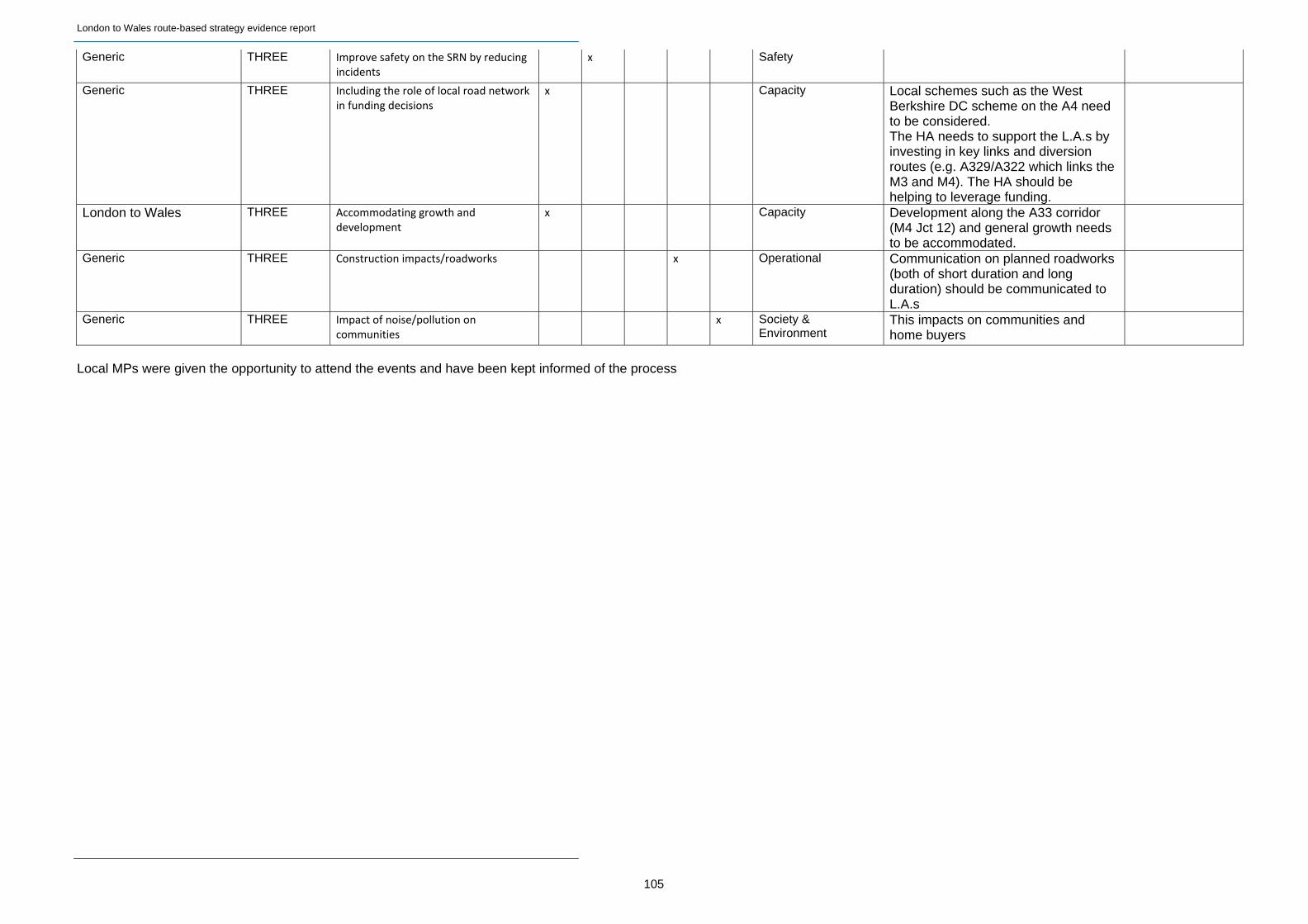
London to Wales route-based strategy evidence report
105
Generic THREE Improve safety on the SRN by reducing incidents
x Safety
Generic THREE Including the role of local road network in funding decisions
x Capacity Local schemes such as the West Berkshire DC scheme on the A4 need to be considered. The HA needs to support the L.A.s by investing in key links and diversion routes (e.g. A329/A322 which links the M3 and M4). The HA should be helping to leverage funding.
London to Wales THREE Accommodating growth and development
x Capacity Development along the A33 corridor (M4 Jct 12) and general growth needs to be accommodated.
Generic THREE Construction impacts/roadworks x Operational Communication on planned roadworks (both of short duration and long duration) should be communicated to L.A.s
Generic THREE Impact of noise/pollution on communities
x Society & Environment
This impacts on communities and home buyers
Local MPs were given the opportunity to attend the events and have been kept informed of the process

© Crown copyright 2014. You may re-use this information (not including logos) free of charge in any format ormedium, under the terms of the Open Government Licence. To view this licence:visit http://www.nationalarchives.gov.uk/doc/open-government-licence/write to the Information Policy Team, The National Archives, Kew, London TW9 4DU,or email [email protected].
This document is also available on our website at www.highways.gov.uk
If you have any enquiries about this document [email protected] or call 0300 123 5000*.Please quote the Highways Agency publications code PR192/13
* Calls to 03 num bers cost no more than a national rate call to an 01 or 02 num ber and must count towards any inclu sive min utes in the same way as 01 and 02 calls. These rules apply to calls from any type of line includ ing mobile, BT, other fixed line or payphone. Calls may be recorded or monitored.
Highways Agency media services Bristol Job number M130525
If you need help using this or any other Highways Agency information, please call 0300 123 5000* and we will assist you.