long bay wetland nature reserve management plan
TRANSCRIPT

Long Bay Wetland Nature Reserve Management Plan Gambier Island, BC
PREPARED FOR:
Brigade Bay Bluffs and Long Bay Wetland Nature Reserves joint management plan prepared: November 30, 2005
REVISED February 2019 by: Carrina Maslovat, R. P. Bio. #1407
and Laura Matthias, Consultant Biologist, Salt Spring Island, BC
APPROVED BY: Islands Trust Conservancy, October 1, 2019: ITC-2019-038
Gambier Island Conservancy, November 13, 2019 Sunshine Coast Conservation Association, October 24, 2019
Photo 1. Carrina Maslovat in small wetland habitat along roadside of Mt. Artaban Road
Long Bay Wetland Nature Reserve Management Plan
2
i. Executive Summary
Islands Trust Conservancy acknowledges and respects that Gambier Island is within the traditional territory of multiple Coast Salish peoples, whose historical relationship to the land, culture, and spirit of this place continues to this day. Islands Trust Conservancy is committed to honoring the rich history of Indigenous stewardship in the lands and waters of the Islands Trust Area and to building mutually respectful relationships between Indigenous and non-Indigenous partners in conservation. Therefore, this Management Plan for Long Bay Wetland Nature Reserve is a living document that will evolve as opportunities for knowledge sharing arise and understanding grows.
In January 2005, the Islands Trust Conservancy protected two parcels of land west of Brigade Bay on eastern Gambier Island: Brigade Bay Bluffs Nature Reserve (5.14 hectares/12.7 acres) and Long Bay Wetland Nature Reserve (38 hectares/94 acres). These lands were transferred by Coastland Wood Industries Ltd. and Mike Jenks as part of the Brigade Bay subdivision development. Cascade Environmental Resource Group Ltd. prepared the initial joint management plan for the Brigade Bay Bluffs and Long Bay Wetland Nature Reserves. In 2018, the Management Plans were updated as separate documents for each reserve.
The Long Bay Wetland Nature Reserve (LBWNR) consists of upland areas surrounding a large wetland area. The Nature Reserve includes a wetland and three tributaries that were significantly damaged by logging in 2000 and 2001. Riparian restoration efforts completed in 2002 and 2003 included removal of excessive slash and channel blockages, de-compaction of affected soils and re-vegetation of riparian areas (Cascade 2005). The wetland and tributaries are part of the headwaters of the Long Bay watershed and Long Bay Creek, a fish bearing stream. The upland portions of the reserve were selectively logged prior to reserve establishment, resulting in a young forest with large numbers of mature deciduous species and pole/sapling sized conifers. Although the forests are young, they will mature into blue- and red-listed ecological communities. The adjacent Brigade Bay subdivision used the north end of the reserve area as a quarry borrow pit for sand and gravel. Some reforestation and protection of seedlings from deer browsing has been initiated (2015, 2017) within the reserve. LBWNR is an important part of a large contiguous natural area within the Coastal Western Hemlock Very Dry Maritime (CWHxm) subzone on Gambier Island.
The management objectives for management of the LBWNR are:
Preserve and protect the ecosystems, biological diversity and other natural values of the site;
Restore plant and animal communities and ecological processes where necessary;
Allow low-impact pedestrian access on existing trails while ensuring ecological values are not compromised (further development of the trail system is not recommended);
Support ongoing inventory, mapping and monitoring to guide management;
Protect the water quality and flow regimes of all streams and wetlands within

Long Bay Wetland Nature Reserve Management Plan
3
the reserve;
Remove invasive plant species throughout the reserve and hazard trees around the trail system; and
Allow natural forest succession and natural ecological processes and functions to proceed unimpeded without human intervention, except in the case of wildfire or other exceptional situations where remediation is considered imperative. Only the removal of hazard trees around the trail system and invasive plant species is permitted.
Key management recommendations are to maintain trails and signage, remove invasive species, continue restoration of highly degraded sites and to develop a wildfire management plan. Further inventories for Species at Risk would provide a clearer picture of the ecology of the reserve and guide future management.

Long Bay Wetland Nature Reserve Management Plan
4
ii. Tables and Lists
Table of Contents
i. Executive Summary ............................................................................................................ 2
ii. Tables and Lists .................................................................................................................. 4
iii. Acknowledgements .......................................................................................................... 8
1.0 Introduction .................................................................................................................... 9
1.1 Islands Trust Conservancy .........................................................................................................9
1.2 Purpose of Islands Trust Conservancy Management Plans ....................................................... 10
1.3 Scope of Islands Trust Conservancy Management Plans ............................................................... 10
1.4 Protected Area Purpose .......................................................................................................... 11
1.5 Protected Area Objectives ...................................................................................................... 11
2.0 Property Information ..................................................................................................... 11
2.1 Location ................................................................................................................................. 11
2.2 Legal description .................................................................................................................... 12
2.3 Legal Access ........................................................................................................................... 13
2.4 Landscape Context ................................................................................................................. 15
2.5 Site History ............................................................................................................................ 17
2.6 Anthropogenic Features ......................................................................................................... 17
2.7 Undersurface Rights ............................................................................................................... 19
2.8 Notations, Charges, Liens and Interests ................................................................................... 19
2.9 Local Planning Designations .................................................................................................... 19
2.10 Existing Public, First Nations, and Other Use .......................................................................... 22
3.0 Inventory by Ecological Community ............................................................................... 23
3.1 Ecological Significance ............................................................................................................ 23
3.2 Climate .................................................................................................................................. 24
3.3 Geology and Physiology .......................................................................................................... 25
3.4 Hydrology .............................................................................................................................. 26
3.5 Soils ....................................................................................................................................... 27
3.6 Ecological Classifications ......................................................................................................... 27
3.7 Ecological Communities and Site Series ................................................................................... 27
3.8 Wildlife Species ...................................................................................................................... 42
Long Bay Wetland Nature Reserve Management Plan
5
3.9 Expected Change Over Time ................................................................................................... 43
4.0 Threats .......................................................................................................................... 44
4.1 Expected Change to Threats Over Time ................................................................................... 45
5.0 Community Engagement ................................................................................................ 45
5.1 Adjacent Landholders ............................................................................................................. 45
5.2 First Nations ........................................................................................................................... 46
5.3 Conservation Partners and Community Members.................................................................... 46
5.4 Engagement Results ............................................................................................................... 46
6.0 Management Recommendations ................................................................................... 46
6.1 Management Roles ................................................................................................................ 46
6.2 Permitted and Prohibited Uses ............................................................................................... 47
6.3 Proposed Monitoring Program ................................................................................................ 47
6.4 Public Access .......................................................................................................................... 48
6.5 Signage .................................................................................................................................. 48
6.6 Trail Use, Maintenance and Development ............................................................................... 48
6.7 Protection Initiatives for Sensitive Ecosystems and Species and Ecosystems at Risk.................. 49
6.8 Ecological Restoration Options ............................................................................................... 49
6.9 Scientific Research/Education Opportunities ........................................................................... 50
6.10 Exotic and Invasive Species Management .............................................................................. 50
6.11 Wildfire Risk Management.................................................................................................... 51
6.12 Climate Change Impacts and Management ............................................................................ 51
7.0 Action Items .................................................................................................................. 52
7.1 Immediate Actions (1-2 years): ............................................................................................... 52
7.2 Short term Actions (3-5 years): ............................................................................................... 52
7.3 Long term Actions (5+ years) ................................................................................................... 52
7.4 Ongoing or Annual Action Items ............................................................................................. 52
8.0 Conclusion ..................................................................................................................... 53
9.0 References ..................................................................................................................... 53
10.0 Appendices .................................................................................................................. 56
Appendix A. Survey Plan for LBWNR ............................................................................................. 56
Appendix B. Vegetation Found in LBWNR ..................................................................................... 57
Appendix C. Photographic Documentation ................................................................................... 60
Appendix D. Letter to Neighbours................................................................................................. 62
Long Bay Wetland Nature Reserve Management Plan
6
Appendix E. Questionnaire sent to Neighbours and Available Online ............................................. 64
List of Figures
Figure 1. Map of trail access to LBWNR, including photopoint stations (photograph locations). 14
Figure 2. Location of Gambier Island (inset) and protected areas context surrounding LBWNR (reserve boundary outlined in orange). A complimentary map of marine protected area zones is provided in Schedule B of Gambier Island Land Use Bylaw #86 (Islands Trust 2004). ................. 16
Figure 3. Map of ALR zoned area within the LBWNR (yellow shading) ........................................ 21
Figure 4. Average temperature and precipitation at Bowen Island weather station from 1985-2018 (Meteoblue 2018) ................................................................................................................ 25
Figure 5. Map showing ecological communities and locations of vegetation plots within LBWNR....................................................................................................................................................... 28
List of Tables
Table 1. Acknowledgement of thanks ............................................................................................ 8
Table 2. Anthropogenic features in LBWNR ................................................................................. 18
Table 3. Ecological communities and their status ........................................................................ 24
Table 4. Description of ecological community 1 ........................................................................... 30
Table 5. Vegetation in ecological community 1. ........................................................................... 30
Table 6. Description of ecological community 2 ........................................................................... 31
Table 7. Vegetation in ecological community 2. ........................................................................... 32
Table 8. Description of ecological community 3 ........................................................................... 34
Table 9. Vegetation in ecological community 3. ........................................................................... 34
Table 10. Description of ecological community 4. ........................................................................ 37
Table 11. Vegetation in ecological community 4. ......................................................................... 38
Table 12. Description of ecological community 5. ........................................................................ 40
Table 13. Vegetation in ecological community 5. ......................................................................... 40
Table 14. Wildlife species observed in LBWNR ............................................................................. 42
Table 15. Summary of threats....................................................................................................... 44
Table 16. Partners involved in management of LBWNR. .............................................................. 47
List of Photos and Credits
Photo 1. Carrina Maslovat in small wetland habitat along roadside of Mt. Artaban Road ........... 1
Long Bay Wetland Nature Reserve Management Plan
7
Photo 2. Trailhead signs off Mt. Artaban Road in LBNR with connector trail to Mt. Artaban Nature Reserve. ............................................................................................................................ 13
Photo 3. Reserve boundary signage roadside on Mt. Artaban Rd. .............................................. 19
Photo 4. Trail leading west to privately-managed, Sea Ranch Strata, west of LBWNR. .............. 22
Photo 5. Wetland vegetation in ecological community 5 (disturbed from logging) shifting towards Horsetail dominated understory. ................................................................................... 26
Photo 6. Creekbed that flows north from Mount Artaban Nature Reserve into LBWNR. ........... 27
Photo 7. Ecological community 1 with rocky bluffs. ..................................................................... 29
Photo 8. Maturing Douglas-fir trees surrounded by dense Sword Fern understory. Red Alder wildlife trees and woody debris provide diverse wildlife habitat. ............................................... 33
Photo 9. Young regenerating forest with Western Redcedar and Bracken Fern. ........................ 36
Photo 10. Larger Bigleaf Maple veteran trees with dense Sword Fern understory. .................... 39
Photo 11. Wildlife trees provide important habitat for a variety of wildlife. .............................. 43
Photo 12. Private property sign at trailhead off Mt. Artaban Road leading into Brigade Bay subdivision at north end of LBWNR. ............................................................................................. 48
Photo 13. Trailhead sign leading into north end of LBWNR from Brigade Bay subdivision on Mt. Artaban Rd. ................................................................................................................................... 48
Photo 14. Caged Western Redcedar and Douglas-fir trees in central portion of reserve along decommissioned trail. ................................................................................................................... 50
Photo 15. Invasive Tansy Ragwort in centre foreground at disturbed quarry site, with young regeneration of Red Alders along edges of quarry. ...................................................................... 51
List of Appendixes
Appendix A. Survey Plan for LBWNR ............................................................................................ 56
Appendix B. Vegetation Found in LBWNR .................................................................................... 57
Appendix C. Photographic Documentation .................................................................................. 60
Appendix D. Letter to Neighbours ................................................................................................ 62
Appendix E. Questionnaire sent to Neighbours and Available Online ......................................... 64

Long Bay Wetland Nature Reserve Management Plan
8
iii. Acknowledgements
Table 1. Acknowledgement of thanks
Name Position/Affiliation Professional Accreditation or subject expertise
Contribution
Carrina Maslovat Botanist/Consultant R.P. Bio. Primary Author, field data collection
Laura Matthias Independent Biologist/ Subcontractor
Species at Risk Biologist
Secondary Author, field data collection
Cascade Environmental Resource Group
Consultant Preparation of previous management plan
Nuala Murphy Property Management Specialist/Islands Trust Conservancy
Background information and mapping, local contacts
Jemma Green Property Management Specialist/Islands Trust Conservancy
Review of document
Doug Hopwood Biologist/Consultant R.P. Forester Providing background information, writing baseline report, assisting with access logistics
Peter Scholefield Volunteer/Gambier Island Conservancy
Background data, assistance with field logistics, document review
Jason Herz Conservation Committee Chair/Sunshine Coast Conservation Association
Review of document
Ruth Simons Volunteer/Gambier Island Conservancy
Background data and assistance with field logistics; allowing access via Brigade Bay Marina.

Long Bay Wetland Nature Reserve Management Plan
9
1.0 Introduction
Gambier Island is situated within the traditional territory of the Coast Salish peoples, who share a rich history of stewardship in the lands and waters of the Islands Trust Area that inspires the work of Islands Trust Conservancy and its partners. The Long Bay Wetland Nature Reserve (LBWNR) on Gambier Island was protected by the Islands Trust Fund (now the Islands Trust Conservancy – ITC) in 2005, along with Brigade Bay Bluffs Nature Reserve. The properties were part of a transfer by Coastland Wood Industries Ltd. and Mike Jenks as part of the Brigade Bay subdivision development (survey in Appendix A).
Cascade Environmental Resource Group Ltd. developed the initial Management Plan for both the Brigade Bay Bluffs and LBWNR (Cascade 2005). In 2018, the Management Plans for both properties were scheduled to be updated and written as separate independent documents for each property.
The Gambier Island Conservancy and the South Coast Conservation Association co-hold a conservation covenant on the land.
1.1 Islands Trust Conservancy
Since time immemorial, the lands and waters between Vancouver Island and mainland British Columbia have been home to the Coast Salish people, whose ecological, cultural, and spiritual connections to this place continue to this day. In 1974, the Province of British Columbia recognized this region as a special place within the province where the unique beauty, rural character and diverse ecosystems should be protected for future generations. Through the Islands Trust Act, the province established the Islands Trust, a local government, with the following mandate (known as the Object of the Islands Trust):
To preserve and protect the trust area and its unique amenities and environment for the benefit of the residents of the trust area and of British Columbia generally, in cooperation with municipalities, regional districts, improvement districts, other persons and organizations and the government of British Columbia. (Islands Trust 2018)
In 1990, through the enactment of a section of Islands Trust Act, the Islands Trust Conservancy (originally called the Islands Trust Fund) was established as a conservation land trust to assist in carrying out the “preserve and protect” mandate. Part 6 of the Islands Trust Act establishes the corporate status, responsibilities, and governance structure of the Islands Trust Conservancy. The Islands Trust Conservancy is one of fifteen corporate entities charged to uphold the Object of the Islands Trust and since 1990 has protected over 1,267 hectares (3,130 acres) of land as nature reserves, nature sanctuaries and conservation covenants.
The vision of the Islands Trust Conservancy is that the islands and waters of the Strait of Georgia and Howe Sound will be a vibrant tapestry of culture and ecology where humans live and work in harmony with the natural world. This special place will have a network of protected areas that preserve in perpetuity the native species and natural systems of the islands. Engaged residents and conservation partners will work together to protect large natural areas and key wildlife habitat. Viable ecosystems will flourish alongside healthy island communities.
Long Bay Wetland Nature Reserve Management Plan
10
The mission of the Islands Trust Conservancy is to protect special places by encouraging, undertaking and assisting in voluntary conservation initiatives within the Islands Trust Area. Islands Trust Conservancy nature reserves are managed to maintain, preserve and protect the natural features and values of ecosystems. This level of protection is similar to the International Union for Conservation of Nature (IUCN) protected area Category 1B: Wilderness area: a “large area of unmodified or slightly modified land and/or sea; retaining its natural character and influence, without permanent or significant habitation, which is protected and managed in order to preserve its natural condition” (Lockwood 2006).
1.2 Purpose of Islands Trust Conservancy Management Plans
ITC management plans provide background information and set out the direction of property management as follows:
Provide general and descriptive information on the property, including location, history, and land use;
Set out the conservation goals and objectives for the property;
Identify the property's ecological and/or cultural values and features;
Describe the management issues associated with the property; and,
Provide short, medium and long-term management recommendations (action items or tasks) on issues such as: species at risk protection; ecological restoration; public access; educational and research opportunities; invasive species management; and signage needs.
Preserve and protect cultural, spiritual, and sacred locations.
Once the management plan process is complete, the ITC will work to carry out the management actions or strategies identified in the plan, as resources allow. Following general practice and as outlined in the conservation covenant and statutory right of way, the ITC will revise the Management Plan every ten years.
1.3 Scope of Islands Trust Conservancy Management Plans
Consistent with the Islands Trust Reconciliation Declaration (Islands Trust 2019), ITC recognizes that its nature reserves may be places of great cultural and spiritual significance to First Nations. Cooperative management of these protected places will provide opportunities to establish and maintain mutually respectful relationships between the Islands Trust Conservancy and First Nations. Relationship-building, knowledge-sharing, healing, and establishment of trust are long-term processes that do not necessarily conform to the timeline required for many management activities (e.g. protecting species at risk, maintaining trails and signage, controlling invasive species, etc.); therefore, Islands Trust Conservancy is committed to developing a parallel Management Plan for Areas of Cultural Heritage and Sacred Significance with a flexible timeline. This parallel Management Plan sets out guiding principles for cooperative collaboration between ITC and those First Nations with historical and cultural interests in the area defined by one or more nature reserves. Moreover, the Management Plan defines the
Long Bay Wetland Nature Reserve Management Plan
11
common vision, objectives, policies, and best management practices for the nature reserve(s) to ensure that its natural values and cultural and sacred heritage are maintained for future generations. As with this plan, the Management Plan for Areas of Cultural Heritage and Sacred Significance must be in accordance with the conservation covenant registered on the land.
1.4 Protected Area Purpose
The purpose of the LBWNR is to preserve and protect the natural ecosystems and natural values of the site (including any rare and endangered plant and animal species), and to maintain the biodiversity of the site for the benefit of the flora and fauna of the reserve, the residents of the island and the province generally. The site is to be protected in accordance with the objectives of the Islands Trust Conservancy and the Islands Trust.
1.5 Protected Area Objectives
The objectives for the LBWNR are as follows:
1. Preserve and protect the natural ecosystems, biological diversity and natural values.
2. Restore plant and animal communities and ecological process.
3. Allow low-impact pedestrian access on existing trails (further development of the trail system is not recommended), while ensuring that significant ecological values are not compromised by recreation use.
4. Support and enhance continued use of areas of sacred and cultural significance by First Nations where such uses are compatible with protection of ecological values and in compliance with the conservation covenant held by Gambier Island Conservancy and the Sunshine Coast Conservation Association.
5. Support ongoing inventory, mapping and monitoring to guide management.
6. Protect the water quality and flow regimes of all streams and wetlands within the reserve.
7. Remove invasive plant species throughout the reserve and hazard trees around the trail system.
8. Allow natural forest succession and natural ecological processes and functions to proceed unimpeded without human intervention, except in the case of wildfire or other exceptional situations where remediation is considered imperative.
2.0 Property Information
The LBWNR is 38 hectares (91 acres) in size with a degraded low-lying wetland (impacted from logging operations in 2000-2001) measuring 10.7 ha (26.5 acres). The remaining area consists primarily of forested slopes spanning an elevation range from 27 m (90 feet) to 151 m (500 feet) above sea level.
2.1 Location
Gambier Island is approximately 10 km from Horseshoe Bay.

Long Bay Wetland Nature Reserve Management Plan
12
Gambier Island can be accessed by passenger ferry from the BC Ferries Langdale Terminal, which docks at New Brighton Dock on the west side of Gambier Island. There is no road access to LBWNR from the dock at New Brighton. There is a Gambier Island trail network but the route to the LBWNR from New Brighton is lengthy, not direct, and the trail is not well marked or signed in places.
LBWNR can be accessed from two public dock locations on Gambier Island. From the public dock at Camp Artaban, at the head of Long Bay, there is a short public trail through the camp property that continues along the Brigade Bay Road easement, through the Gambier Island Sea Ranch property, and onto Mt. Artaban Road in the Brigade Bay subdivision. This hike takes approximately 30 minutes. Alternatively, the trailhead to the Mount Artaban trail, which starts off in the LBWNR, can be reached from the public dock in the Halkett Bay Provincial Marine Park by hiking north on a trail through the park, then walking north along Mt. Artaban Road. This route takes about one hour.
To travel to these two public docks, there are regularly scheduled water taxi runs from Horseshoe Bay on weekends and on Wednesday evenings in the summer. There are two nearby private marinas, one at the Sea Ranch and the other at Brigade Bay. For those who are not property owners at either location, permission is required to access the marinas.
2.2 Legal description
The LBWNR is legally described as PID: 015-921-034, District Lot 1259, Group 1, New Westminster District, Except Part Subdivided by Plan BCP15304.

Long Bay Wetland Nature Reserve Management Plan
13
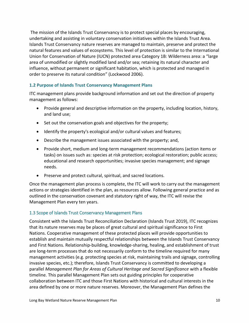
2.3 Legal Access
Legal access to the LBWNR is off of Mt. Artaban Road, which goes through the Brigade Bay subdivision (see Figure 1 for trailhead locations). The reserve is west of the road along much of its length.
Photo 2. Trailhead signs off of Mt. Artaban Road in LBWNR on connector trail to Mt. Artaban Nature Reserve.
Long Bay Wetland Nature Reserve Management Plan
14
Figure 1. Map of trail access to LBWNR, including photopoint stations (photograph locations).

Long Bay Wetland Nature Reserve Management Plan
15
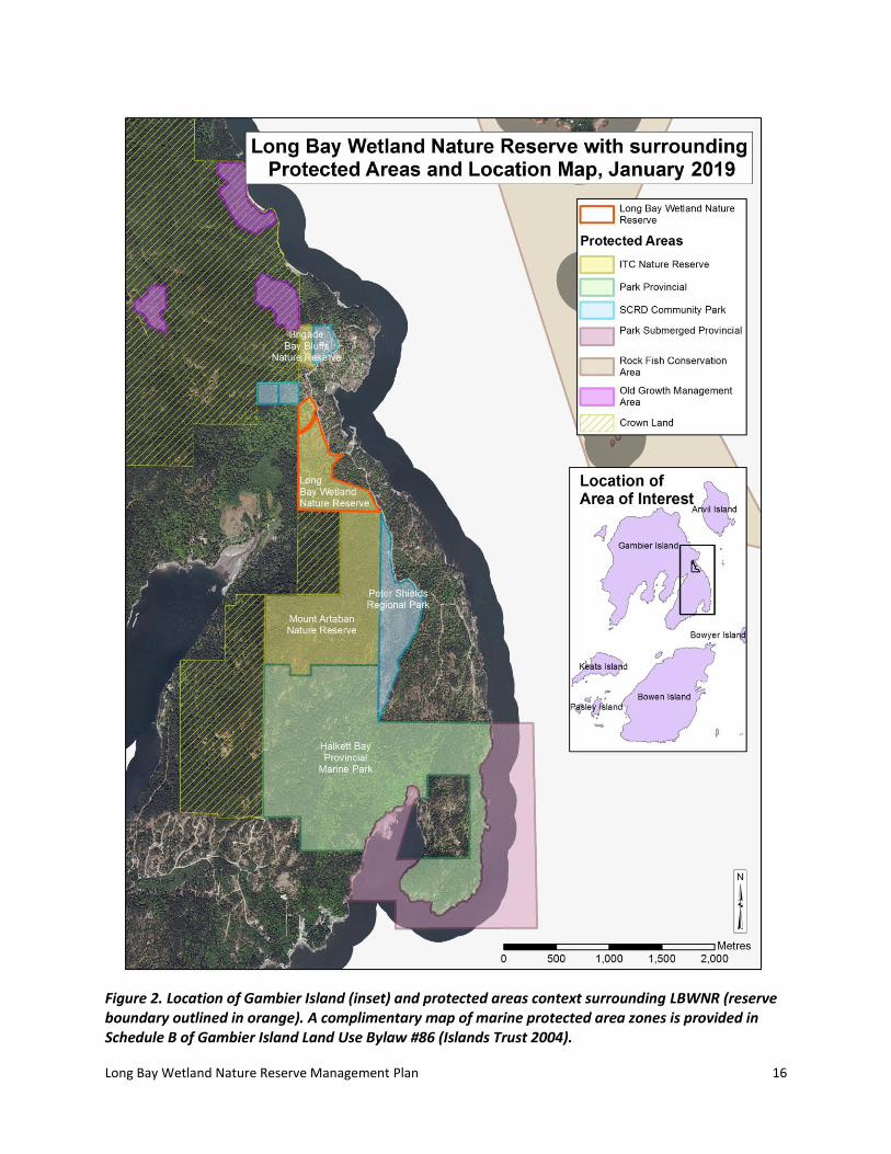
2.4 Landscape Context
Gambier Island is located in Howe Sound and is one of the many islands governed by the Islands Trust (see Figure 2 for location and protected area context). LBWNR is located on the east side of Gambier Island, west of Brigade Bay. Directly to the north and east are a number of privately-managed lots in the Brigade Bay subdivision. Directly south is the Mount Artaban Nature Reserve, managed by the Islands Trust Conservancy, and a provincially-managed parcel. To the west is Sea Ranch strata common property.
LBWNR faces threats from the six adjacent, privately-managed properties that are part of a 68-lot, privately-managed Brigade Bay subdivision (map in Appendix A). The reserve also abuts one strata property. All of the privately-managed properties may impact management of the reserve.
LBWNR is the most northern part of a contiguous protected area of parks and nature reserves (469.12 ha) including Mount Artaban Nature Reserve (ITC), Halkett Bay Provincial Marine Park (BC Parks), Pete Shields Regional Park (Sunshine Coast Regional District), and provincially-managed lands (171.35 ha) for a total 640.47 ha of contiguous protected lands. There is an additional marine portion of the Halkett Bay Provincial Marine Park (149.99 ha).
To the north (275 m) is a matrix of protected areas (30.97 ha) including Brigade Bay Bluffs Nature Reserve (ITC), two small community parks (Sunshine Coast Regional District), and a large network of undeveloped provincially-managed parcels and old-growth management areas (3345.83 ha), totaling 3376.81 ha of contiguous protected areas. Although a moderately-sized parcel on its own, the LBWNR plays an important role in enhancing the habitat values of the area through connectivity and proximity to other undeveloped and protected lands on the island. The wetland and streams provide ecological diversity.
Long Bay Wetland Nature Reserve Management Plan
16
Figure 2. Location of Gambier Island (inset) and protected areas context surrounding LBWNR (reserve boundary outlined in orange). A complimentary map of marine protected area zones is provided in Schedule B of Gambier Island Land Use Bylaw #86 (Islands Trust 2004).

Long Bay Wetland Nature Reserve Management Plan
17
2.5 Site History1
Gambier Island is within the traditional territory of multiple Coast Salish First Nations who have called this place home since time immemorial. The Coast Salish peoples maintained a vital, dynamic, and sustainable connection to their territory and developed rich cultural, spiritual, and traditional ecological knowledge. However, cultural heritage and sacred sites of Gambier Island and the greater Islands Trust Area were negatively impacted by European settlement. Past archeological activities, vandalism, and land use have disturbed sites of cultural and spiritual importance. Nevertheless, the land and the greater territory remains an embodiment of the stories, oral history, and culture of these First Nations.
There are two archaeological sites on Brigade Bay, which are protected under the Heritage Conservation Act (Cascade 2005). The adjacent properties in Brigade Bay subdivision have covenants that allow “the right of passage by members of the Squamish Nation for the purposes related to continuation of current use of lands or resources for traditional purposes” (FOC 2004 in Cascade 2005). Consultation between Squamish Nation and Fisheries and Oceans Canada during the Brigade Bay subdivision development determined that the Brigade Bay Site, Ho-mahmk, and surrounding environs are well known for deer hunting, plant collection, and as a camp site and safe haven for members of the Squamish Nation traveling in Howe Sound (FOC, December 2, 2003).
The Brigade Bay area had a settler homestead, probably during the 1920s, and the buildings remained until the 1980s (Hopwood 2013). The reserve area was burned by a human-caused fire that ignited on July 9, 1922 (Parminter pers. comm. in Hopwood 2009). The reserve was logged, probably in the 1920s (shortly before or after the fire), and regrowth was from natural regeneration (Hopwood 2013). A recent selective harvest in most of the reserve occurred in 2000-2001 (Cascade 2005). In 2001, an Environmental Assessment was completed for the Brigade Bluffs subdivision (CERG 2001 in Cascade 2005). Planning for the Brigade Bluffs subdivision began in 2000 and residential lots were put on the market in 2004. Islands Trust Conservancy acquired the reserve in 2005.
2.6 Anthropogenic Features
There are no structures or buildings within the reserve. At this time, no archaeological sites have been identified within LBWNR. The following is a table of other anthropogenic features in the reserve.
1 The Islands Trust Conservancy recognizes that the language commonly used to refer to land may be disrespectful to First Nations. For example, notions of ‘private’ and ‘Crown’ land do not appropriately recognize aboriginal title. The words “provincially-managed land” or “federally managed land” will be used in place of “Crown”. “Privately managed” will be used in place of “private” and “land holder” instead of “land owner”.

Long Bay Wetland Nature Reserve Management Plan
18
Table 2. Anthropogenic features in LBWNR
Anthropogenic Feature
Description Condition Photopoint Location (including UTMs)
Trail There is a trail in the northern portion of the reserve along the Brigade Bay Road easement from Mt. Artaban Road to Sea Ranch strata and another trail in the southeast of the reserve from Mt. Artaban Road to Mount Artaban Nature Reserve
Good P4 (photo is of end of trail)
475380; 5481633
Boundary sign Nature Reserve Boundary Sign on Mt. Artaban Road
Good P3
475679; 5481419
Boundary sign Nature Reserve Boundary Sign on Mt. Artaban Road
Good P13
475543; 5481832
Boundary sign and Private Property sign
Private Property and No Hunting signs at Mt. Artaban Road at northern trailhead at eastern end
Good P12
475547; 5481839
Caging around replanted trees
Caged western redcedar and Douglas-fir trees in restoration area at old quarry at the north end of the reserve and along the Brigade Bay Road easement.
Caging good, some trees in poor condition
P14
475611; 5481311
Boundary sign, Private Property sign
Trailhead Boundary Sign and Private Property sign for adjacent strata (No Motorized Vehicles); at end of northern trail at western boundary of Nature Reserve
Good P4
475380; 5481633
Boundary sign Nature Reserve Boundary sign on Mt. Artaban Road
Good 475621; 5481556
Boundary and trailhead signs
Boundary sign and trailhead sign to Mount Artaban Nature Reserve trail connector
Good P2
476130; 5480906
Boundary sign On corner of eastern boundary of reserve Good No photo
475689; 5481309
Boundary sign On corner of eastern boundary of reserve Good No photo
475680; 5481185
Boundary sign Covenant boundary sign in southwest corner of reserve
Good No photo
475357; 5480877

Long Bay Wetland Nature Reserve Management Plan
19
2.7 Undersurface Rights
The title shows no undersurface rights designated for LBWNR.
2.8 Notations, Charges, Liens and Interests
A Section 219 Conservation Covenant (Registration Number: CA3219709) and Section 218 Statutory Right of Way (Registration Number: CA3219710) were registered on the lands in 2013 in favour of Gambier Island Conservancy and Sunshine Coast Conservation Association. The general intent of the agreement is:
a) to protect, preserve, conserve, maintain, enhance and, if applicable from time to time restore, the natural state of the Land and the Amenities as described in the Report (baseline documentation); and
b) to prevent any occupation or use of the Land that will impair or interfere with the natural state of the Land and the Amenities as described in the Report.
The Statutory Right of Way outlines permitted access and activities for the Covenant Holders.
2.9 Local Planning Designations
LBWNR is within Development Permit Area #3 which protects all mapped and unmapped streams on Gambier Island under the Riparian Areas Regulation (Islands Trust 2017).
The southeast corner of the reserve is zoned G2 (Nature Reserve). The purpose of this zone is to maintain and enhance the ecological values, ecosystems and unique areas of nature reserves and sanctuaries. Permitted uses within the zone include ecosystem preservation use, water
Photo 3. Reserve boundary signage roadside on Mt. Artaban Rd.

Long Bay Wetland Nature Reserve Management Plan
20
recharge use, trail use, fish and wildlife habitat protection use, and accessory use including but not limited to fire protection (Islands Trust 2004).
The remainder of the reserve is within the Agricultural Land Reserve (ALR), zoned Agriculture (A) (see Figure 3 for ALR zone). The purpose of the zone is to provide regulations to support the retention of small-scale farming on Gambier Island in areas with agricultural potential and on land in the Provincial Agricultural Land Reserve. According to the Gambier Island Land Use Bylaw No. 86, permitted uses within the Agriculture zone include agriculture use, single family residential use, associated secondary dwelling use, and accessory uses including but not limited to home occupations (Islands Trust 2004).

Long Bay Wetland Nature Reserve Management Plan
21
Figure 3. Map of ALR zoned area within the LBWNR (yellow shading)

Long Bay Wetland Nature Reserve Management Plan
22
2.10 Existing Public, First Nations, and Other Use
Long Bay Wetland Nature Reserve falls within the territory of multiple First Nations, and as such has been a site of cultural activity for thousands of years. There is knowledge and oral history relating to this site that may or may not be shared outside of the membership of a First Nation. As a first step toward strengthening cultural connections to the land that were negatively impacted by European settlement, ITC is exploring the potential of a Management Plan for Areas of Cultural Heritage and Sacred Significance that will support and enhance the continued use of the site by First Nations.
There is light recreational activity on existing public trails in the reserve. A signed trail follows the Brigade Bay Road dedication that divides the reserve into two portions in the northern portion of the reserve (Figure 1). The trail follows an old logging road, from Mt. Artaban Road to the Sea Ranch strata common property and on to Camp Artaban in Long Bay. A second signed trail is found in the southeast corner of the reserve and provides a connector link into the adjacent Mount Artaban Nature Reserve to the south. The trail leads over the summit of Mount Artaban and through Halkett Bay Provincial Marine Park (Figure 2).
A trail that bisected the reserve in the middle of the reserve, west of Brigade Bay Marina, has been decommissioned and is becoming overgrown. Trees have been caged where the decommissioned trail meets the old roadway (Figure 1) (information on restoration provided in
Photo 4. Trail leading west to privately-managed, Sea Ranch Strata, west of LBWNR. Note overgrown ITC trailhead sign in sword ferns, and private property sign below bigleaf maple.

Long Bay Wetland Nature Reserve Management Plan
23
Section 6.8 Ecological Restoration Options).
3.0 Inventory by Ecological Community
Islands Trust Conservancy acknowledges that there is a wealth of traditional ecological knowledge and a long history of ecosystem stewardship among the First Nations whose territory encompasses LBWNR. ITC will strive to work with First Nations knowledge holders to deepen its understanding, improve its stewardship practices, and, ultimately, support the transfer of traditional ecological knowledge to younger generations within First Nations communities to ensure that it is not lost. At this time, the ecological information presented in this management plan was formed using systems that are based in foundations of Western science.
3.1 Ecological Significance
The LBWNR includes lowland forests with steep rocky outcrops and mossy bluffs. The upland portions of the reserve were selectively logged prior to reserve establishment, leaving behind large, mature deciduous trees and pole/sapling sized conifers. Although the forests are young, they will mature into blue- and red-listed ecological communities (Table 3). The hydrology of the wetland site, its three small tributaries, and two streams was significantly altered by logging in 2000-2001.
The adjacent Brigade Bay Subdivision utilized the northern portion of the reserve as a borrow pit for sand and gravel. Some reforestation and protection of seedlings from deer browsing has been initiated (2015, 2017) within the reserve.
A search of BC Conservation Data Centre (CDC) data revealed no species at risk occurrences in the reserve and only one blue-listed species on Gambier Island: the northern red-legged frog (Rana aurora) (BC CDC 2018). During site visits in August 2018, no rare species were noted within the reserve, though it is likely that some rare species would be detected if surveys were completed at appropriate times of the year. The wetland likely supports frog and salamander breeding habitats and important foraging habitat for bats and other wildlife. Butterflies and dragonflies were noted around the wetland habitat areas. Fish, likely juvenile coho (Oncorhynchus kisutch), use at least one of the three small tributaries within the reserve (Hopwood 2013).

Long Bay Wetland Nature Reserve Management Plan
24
Table 3. Ecological communities and their status
Ecological Community Name Status
English Scientific Provincial BC List Global
Douglas-fir–Lodgepole Pine/Grey Rock-moss Very Dry Maritime
Pseudotsuga menziesii–Pinus contorta/Racometrium canescens
S2 (2004) Red GNR
Douglas-fir–Western Hemlock/Salal Very Dry Maritime
Pseudotsuga menziesii–Tsuga heterophylla/Gaultheria shallon
S2S3 (2013) Blue G3G4
Western Redcedar/Three-leaved Foamflower Very Dry Maritime
Thuja plicata/Tiarella trifoliata S2S3 (2013) Blue G3
Western Redcedar–Sitka Spruce/Skunk Cabbage Very Dry Maritime
Thuja plicata–Picea sitchensis/ Lysichiton americanus
S3S4 (2001) Yellow GNR
3.2 Climate
The southern Gulf Islands, which include the islands in Howe Sound, have a climate pattern of warm, dry summers and mild, wet winters. The maritime influence moderates the effect of elevation, latitude, and aspect on local temperature and precipitation.
The weather statistics for the adjacent Bowen Island station show that annual precipitation is approximately 1507 mm and most of it comes in the form of rain rather than snow (The Weather Network 2018). On Bowen Island, average daily temperatures peak in the summer months at 23°C (July and August) and are lowest in the winter at 0°C (December and January) (Figure 4). Precipitation is highest in the winter months, from November to January (averaging 506-420 mm), and July and August are the driest months (58-78 mm) (Meteoblue 2018).

Long Bay Wetland Nature Reserve Management Plan
25
Figure 4. Average temperature and precipitation at Bowen Island weather station from 1985-2018 (Meteoblue 2018)
The future impacts from climate change are unknown, although a summer drying trend and an increase in storm events are predicted (Mauger et.al. 2015). More powerful storms may cause increasing erosion, especially in areas with exposed soil such as trails and in riparian areas due to increased flows. Drier summers may impact the wetlands and riparian hydrology causing premature drying. Over time, there may be shits to the vegetation community away from western redcedar (Thuja plicata), allowing the spread of Douglas-fir (Pseudotsuga menziesii). Higher temperatures and less precipitation may lead to localized stress on trees and plants. Maintaining habitat connectivity, biodiversity and ecosystem resilience may assist the flora and fauna adapting to climate change stresses.
3.3 Geology and Physiology
Granitic rocks of the Jurassic to Cretaceous Coast Plutonic Complex (approximately 160 million years old) underlie the southern part of the island (BC Ministry of Energy, Mines and Petroleum Resources 2009 in Hopwood 2009). These stratified rock formations are composed of andesitic to dacitic tuff, breccia agglomerate, andesite, argillite, conglomerate, lesser marble, greenstone, and phyllite (BC Ministry of Energy and Mines, 2005 in Cascade 2005). Intrusive rock of the Coast Plutonic complex, such as quartz diorite and diorite, occur in the vicinity (Cascade 2005).
The Howe Sound region was covered by glaciers from approximately 29,000 to 12,000 years ago. During glaciation, the weight of the ice depressed the land surface so that some lower elevation portions of Gambier Island were below sea level. As the glaciers retreated and the land rebounded, marine and coastal processes eroded loose materials from the higher and

Long Bay Wetland Nature Reserve Management Plan
26
steeper parts of the island and laid down finer-textured soil parent materials on many of the lower-lying and more gently sloping areas of the island (Hopwood 2009).
Within the reserve, the topography is dominated by rocky outcrops and bluffs that are roughly southwest to northeast in direction. In the center of the reserve is a large gently sloping wet area with a smaller more intact wetland as mapped. Bedrock is overlain by a veneer of colluvium and glacial till, except where glacial processes removed these materials and only a thin organic layer has since accumulated (Cascade 2005).
3.4 Hydrology
The reserve includes three stream tributaries of Long Bay Creek, which flow southwest from the wetland into Long Bay. There is also un-channelized flow through the wetland in a southwesterly direction across the western boundary of the covenant area (Hopwood 2013). The runoff from the upland areas and the streams feeds the wetland depression in the center of the reserve (Photo 5), with the wettest portion mapped in Figure 1 and Figure 5.
Two streams flow north from Mount Artaban Nature Reserve into the southeast corner of the reserve and into the ocean just south of Brigade Bay Marina (Photo 6).
All the streams and the wetland were significantly damaged by streamside logging in 2000 and 2001, to the point that in 2001 pre-existing channels could not be identified (Cascade 2005). Restoration efforts prior to 2004 included removal of excessive slash and channel blockages, de-compaction of affected soils, and revegetation of riparian areas (Cascade 2005).
Photo 5. Wetland vegetation in ecological community 5 (disturbed from logging) shifting towards Horsetail dominated understory.

Long Bay Wetland Nature Reserve Management Plan
27
3.5 Soils
Humo-Ferric Podzols are the most widely distributed soils in the upland areas, with glacial till overlying bedrock that results in well drained soils. Primary mineral deposits are colluvial and glacial derived. Soil processes that are characteristic of this submaritime forest include Mor humus formation (associated with the accumulation of acid organic matter), leaching, eluviation, and illuviation (Meidinger and Pojar 1991 in Cascade 2005).
Deep, organic Folisols are prominent in the wetland and permanent seepage areas. Soil profiles feature an LFH (organic litter) horizon, underlain by a light gray eluviated (Ae and Aej) horizon, followed by a light reddish-brown (becoming yellowish with depth) B horizon containing large, coarse fragments in a silty matrix (Cascade 2005).
3.6 Ecological Classifications
The LBWNR is within the Very Dry Maritime subzone (xm) of the Coastal Western Hemlock biogeoclimatic zone (CWH) (Green and Klinka 1994). Climatic factors, in conjunction with existing soil conditions, result in a productive coastal forest with a long growing season although water deficits may occur on zonal sites. The Reserve is within the Pacific Maritime Ecozone and the Georgia Puget Basin Ecoregion (Lands Directorate 1986).
3.7 Ecological Communities and Site Series
The previous Management Plan for the LBWNR (Cascade 2005) delineated three vegetation types based on Terrestrial Ecosystem Mapping (TEM) units. The baseline inventory for the Reserve (Hopwood 2013) delineated six units. An ecological inventory of biological features was conducted in the reserve on August 7th and 8th, 2018. Site series were identified using A Field Guide for Site Identification and Interpretation for the Vancouver Forest Region (Green and Klinka 1994) (Figure 5). This updated management plan has followed the latter delineation of six vegetation types, with the removal of one vegetation type (6) from the baseline inventory which separated the quarry borrow pit into a separate classification. In this plan, the former quarry has been amalgamated into Vegetation Type 4.
A list of all plant species is included in Appendix B. Locations of photopoints and other photograph locations are given in Appendix C.
Photo 6. Creek bed that flows north from Mount Artaban Nature Reserve into LBWNR.

Long Bay Wetland Nature Reserve Management Plan
28
Figure 5. Map showing ecological communities and locations of vegetation plots within LBWNR
Long Bay Wetland Nature Reserve Management Plan
29
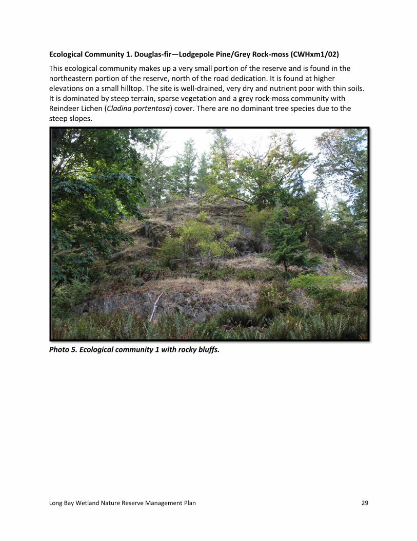
Ecological Community 1. Douglas-fir—Lodgepole Pine/Grey Rock-moss (CWHxm1/02)
This ecological community makes up a very small portion of the reserve and is found in the northeastern portion of the reserve, north of the road dedication. It is found at higher elevations on a small hilltop. The site is well-drained, very dry and nutrient poor with thin soils. It is dominated by steep terrain, sparse vegetation and a grey rock-moss community with Reindeer Lichen (Cladina portentosa) cover. There are no dominant tree species due to the steep slopes.
Photo 5. Ecological community 1 with rocky bluffs.

Long Bay Wetland Nature Reserve Management Plan
30
Table 4. Description of Ecological Community 1
Polygon ID: Ecological Community 1
Ecological Community:
Douglas-fir – Lodgepole Pine/Grey Rock-moss
Classification: CWHxm1/02
Structural Stage: 1-Sparse/bryoid
Status (BC List): Red-listed
Photopoint(s): P7
Ecological Community Description:
Hilltop, steep rocky terrain with predominantly moss and Reindeer Lichen cover; dry site with no trees present; lower foot of slope below rocky outcrop has sparse bigleaf maple, western hemlock, western redcedar and Douglas-fir, as well as sparse oceanspray, foxglove, sword fern and sweet vernalgrass in lower crevices.
Disturbance Notes: Some natural turnover in plant community due to drought years, ground fire.
Anticipated Change/Succession:
No significant changes anticipated.
Wildlife observations:
Observed during site visit: none
Habitat: Perching sites for raptors, seeds for birds and small mammals, thermoregulation sites for reptiles.
Table 5. Vegetation in Ecological Community 1.
VEGETATION SPECIES
PERCENT COVER (%)
NOTES
Mai
n C
ano
py
Seco
nd
ary
Can
op
y
Shru
b L
ayer
Her
b L
aye
r
Mo
ss, L
ich
en
La
yer
No
n-n
ativ
es
Amelanchier alnifolia (Saskatoon) 1
Holodiscus discolor (oceanspray) 1
Anthoxanthum odoratum (sweet vernalgrass)
20
Polystichum munitum (sword fern) 2
Polypodium glycyrrhiza (licorice fern) T
Digitalis purpurea (foxglove) T
Moss Layer 2 3 20 Total Moss Layer: 75%
Cladina portentosa
Long Bay Wetland Nature Reserve Management Plan
31
Dicranum species
Polytrichum juniperinum
Racomitrium canescens
Selaginella wallacei
Cover by Layer (%) 2 3 75 20 Total Canopy Cover: 0%
T stands for Trace or less than 1%
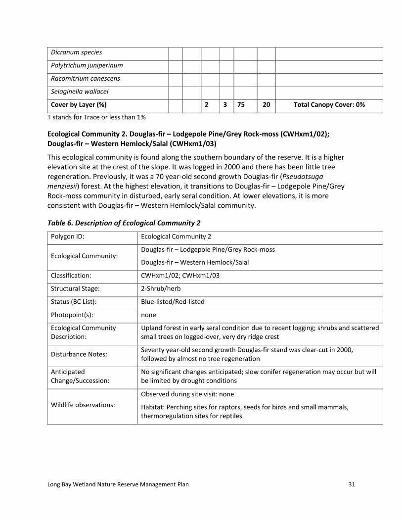
Ecological Community 2. Douglas-fir – Lodgepole Pine/Grey Rock-moss (CWHxm1/02); Douglas-fir – Western Hemlock/Salal (CWHxm1/03)
This ecological community is found along the southern boundary of the reserve. It is a higher elevation site at the crest of the slope. It was logged in 2000 and there has been little tree regeneration. Previously, it was a 70 year-old second growth Douglas-fir (Pseudotsuga menziesii) forest. At the highest elevation, it transitions to Douglas-fir – Lodgepole Pine/Grey Rock-moss community in disturbed, early seral condition. At lower elevations, it is more consistent with Douglas-fir – Western Hemlock/Salal community.
Table 6. Description of Ecological Community 2
Polygon ID: Ecological Community 2
Ecological Community: Douglas-fir – Lodgepole Pine/Grey Rock-moss
Douglas-fir – Western Hemlock/Salal
Classification: CWHxm1/02; CWHxm1/03
Structural Stage: 2-Shrub/herb
Status (BC List): Blue-listed/Red-listed
Photopoint(s): none
Ecological Community Description:
Upland forest in early seral condition due to recent logging; shrubs and scattered small trees on logged-over, very dry ridge crest
Disturbance Notes: Seventy year-old second growth Douglas-fir stand was clear-cut in 2000, followed by almost no tree regeneration
Anticipated Change/Succession:
No significant changes anticipated; slow conifer regeneration may occur but will be limited by drought conditions
Wildlife observations:
Observed during site visit: none
Habitat: Perching sites for raptors, seeds for birds and small mammals, thermoregulation sites for reptiles

Long Bay Wetland Nature Reserve Management Plan
32
Table 7. Vegetation in Ecological Community 2.
VEGETATION SPECIES
PERCENT COVER (%) NOTES
Mai
n C
ano
py
Seco
nd
ary
Can
op
y
Shru
b L
ayer
Her
b L
ayer
Mo
ss, L
ich
en
Laye
r
No
n-n
ativ
es
Pinus contorta (lodgepole pine) 2
Pseudotsuga menziesii (Douglas-fir) 2
Amelanchier alnifolia (saskatoon) 1
Berberis nervosa (dull Oregon-grape) 6
Gaultheria shalon (salal) 10
Holodiscus discolor (oceanspray) 3
Rubus ursinus (trailing blackberry) T
Polystichum munitum (sword fern) 20
Pteridium aquilinum (bracken fern) 5
Grasses 20
Digitalis purpurea (foxglove) T
Moss Layer 4 20 45 Total Moss Layer: 50%
Dicranum species
Hylocomium splendens (step moss)
Polytrichum juniperinum (juniper haircap moss)
Racomitrium canescens (grey rock-moss)
Cover by Layer (%) 4 20 45 50 <1 Total Canopy Cover:
4%

Long Bay Wetland Nature Reserve Management Plan
33
Ecological Community 3. Western Redcedar/Three-leaved Foamflower (CWHxm1/07) with small pockets (<5%) of Douglas-fir/Sword Fern (CWHxm1/04) and Western Redcedar/Sword Fern (CWHxm1/05)
This ecological community is found predominantly in the southeast portion of the reserve, with a small patch also occurring in the northeast portion of the reserve, east of Ecological Community 1. In the reserve, it is found on level to moderate slopes with rich mineral soils that are moderate-well to imperfectly drained. The humus forms are thin because of rapid decomposition. The forests are highly productive, although logging in the reserve in 2000 and 2001 removed all merchantable timber. Large bigleaf maple (Acer macrophyllum) remain and red alder (Alnus rubra) snags are present as wildlife trees in many areas. There are patches of young regenerating western redcedar (Thuja plicata), Douglas-fir, western hemlock (Tsuga heterophylla), and Sitka spruce (Picea sitchensis) in the secondary canopy. There is dense understory of sword fern (Polystichum munitum) and grasses in areas where trees could be planted to help restore the site. Invasive English holly (Ilex aquifolium) has established in some areas.
Photo 6. Maturing Douglas-fir trees surrounded by dense sword fern understory. Red alder wildlife trees and woody debris provide diverse wildlife habitat.

Long Bay Wetland Nature Reserve Management Plan
34
Table 8. Description of Ecological Community 3
Polygon ID: Ecological Community 3
Ecological Community: Western Redcedar/Three-leaved Foamflower with small pockets (<5%) of Douglas-fir/Sword fern (CWHsm1/04) and Western Redcedar/Sword Fern (CWHxm1/05)
Classification: CWHxm1/07
Structural Stage: 5-Young Forest
Status (BC List): Blue-listed
Photopoint(s): P8
Ecological Community Description:
Open mixed residual forest on rocky mid slopes. Several small red alder snags and woody debris. Gently sloping, NE facing. Riparian area (creek) along edge of plot.
Disturbance Notes: Larger trees within clearcut with much younger trees.
Anticipated Change/Succession:
Conifer regeneration may be limited due to browsing pressure and dense understory. With tree-planting efforts and protection with caging, reforestation would be greatly enhanced. Bigleaf maples will eventually die off or may re-sprout from base. Remaining conifers will mature although understory will likely remain fairly open.
Wildlife observations: Audio: Spotted Towhee (Pipilo maculatus)
Table 9. Vegetation in Ecological Community 3.

Long Bay Wetland Nature Reserve Management Plan
35
VEGETATION SPECIES
PERCENT COVER (%)
NOTES
Mai
n C
ano
py
Seco
nd
ary
Can
op
y
Shru
b L
ayer
Her
b L
ayer
Mo
ss, L
ich
en
Laye
r
No
n-n
ativ
es
Pseudotsuga menziesii (Douglas-fir) 32 T
MC: 20-40yrs, ht: 20m, DBH: 25-40cm
SC: 10-15yrs, ht: 10m, DBH: 5-10cm
Tsuga heterophylla (western hemlock) 10 T
MC: 20-30yrs, ht: 15m, DBH: 25-30cm
SC: 10-15yrs, ht: 1-2m, DBH: 2-10cm
Thuja plicata (western redcedar) 2 T
MC: 60-80yrs, ht: 20m, DBH: 70cm
SC: 10-15yrs, ht: 5m, DBH: 10cm
Alnus rubra (red alder) 1 MC: 30yrs, ht: 15m, DBH:
30cm
Picea sitchensis (Sitka spruce) T SC: 5-10yrs, ht: 1-2m, DBH:
<5cm
Polystichum munitum (sword fern) 60
Vaccinium parvifolium (red huckleberry)
1
Berberis nervosa (dull Oregon-grape) T
Dryopteris expansa (spiny wood fern) T
Gaultheria shallon (salal) T
Ilex aquifolium (English holly) T
Moss Layer Total Moss Layer: 5%
Eurynchium oreganum (Oregon-beaked moss)
2
Hylocomium splendens (step moss) 1
Plagiothecium undulatum (flat moss) 1
Long Bay Wetland Nature Reserve Management Plan
36
Rhytidiadelphus loreus (lanky moss) 1
Cover by Layer (%) 45 61 5 <1 Total Canopy Cover: 45%
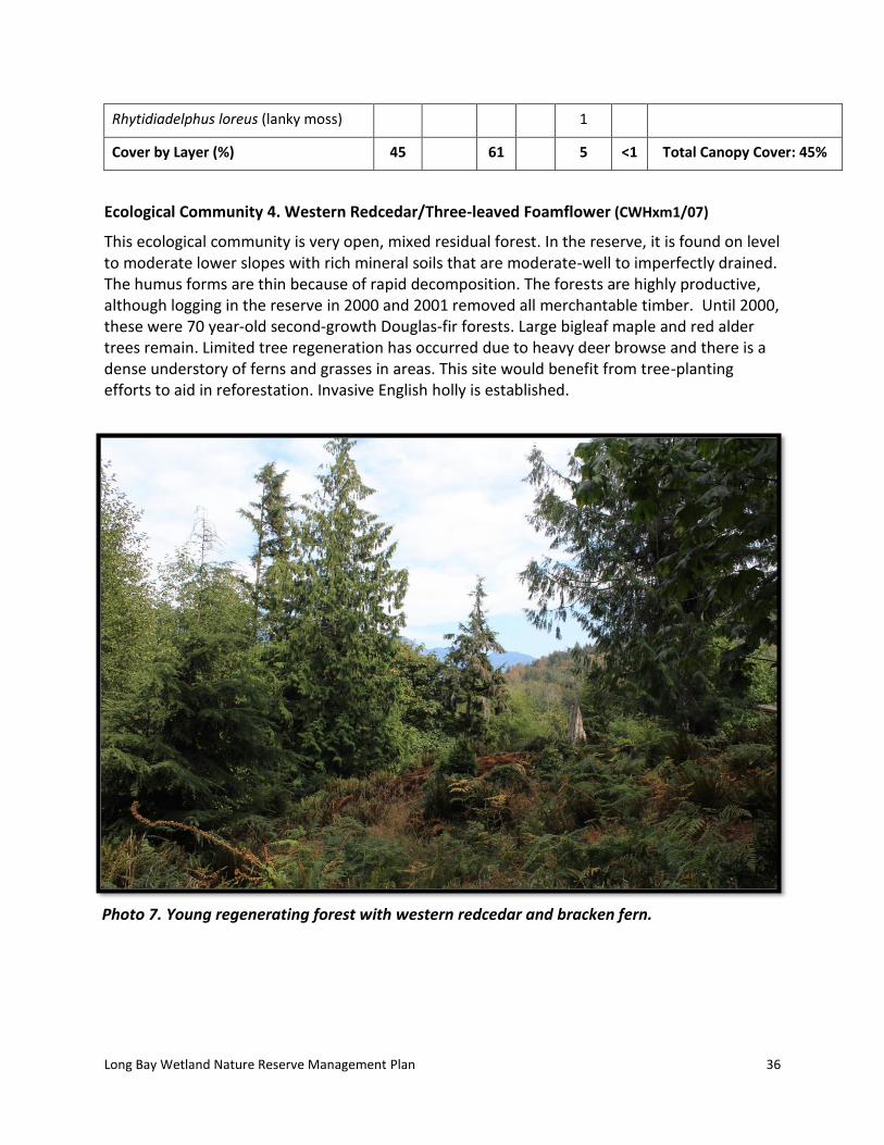
Ecological Community 4. Western Redcedar/Three-leaved Foamflower (CWHxm1/07)
This ecological community is very open, mixed residual forest. In the reserve, it is found on level to moderate lower slopes with rich mineral soils that are moderate-well to imperfectly drained. The humus forms are thin because of rapid decomposition. The forests are highly productive, although logging in the reserve in 2000 and 2001 removed all merchantable timber. Until 2000, these were 70 year-old second-growth Douglas-fir forests. Large bigleaf maple and red alder trees remain. Limited tree regeneration has occurred due to heavy deer browse and there is a dense understory of ferns and grasses in areas. This site would benefit from tree-planting efforts to aid in reforestation. Invasive English holly is established.
Photo 7. Young regenerating forest with western redcedar and bracken fern.

Long Bay Wetland Nature Reserve Management Plan
37
Table 10. Description of Ecological Community 4.
Polygon ID: Ecological Community 4
Ecological Community: Western Redcedar/Three-leaved Foamflower
Classification: CWHxm1/07
Structural Stage: 5-Young Forest
Status (BC List): Blue-listed
Photopoint(s): P9
Ecological Community Description:
Open mixed residual and regenerating forest on moist, rich lower slopes with dominant forest cover of large deciduous species and smaller sapling/pole size conifers. Gentle east-facing slope.
Disturbance Notes:
Selectively logged in 2000, resulting in disturbed ground cover and low regeneration. In the northeast corner of the reserve, a ‘quarry borrow pit’ was used during the subdivision and some replanting of trees has occurred for restoration efforts (see Section 5.8).
Anticipated Change/Succession:
Larger deciduous trees (bigleaf maple, red alder) will likely die off and scattered conifers will replace them. However, the low success rate of regeneration due to dense understory competition (e.g. graminoids, ferns) and black-tailed deer herbivory will likely maintain the relatively open forest structure unless reforestation efforts with protection from herbivory occur.
Wildlife observations:
Visual: Red-breasted Sapsucker holes in bigleaf maple trees, black-tailed deer scat.
Audio: Northern Flicker
Long Bay Wetland Nature Reserve Management Plan
38
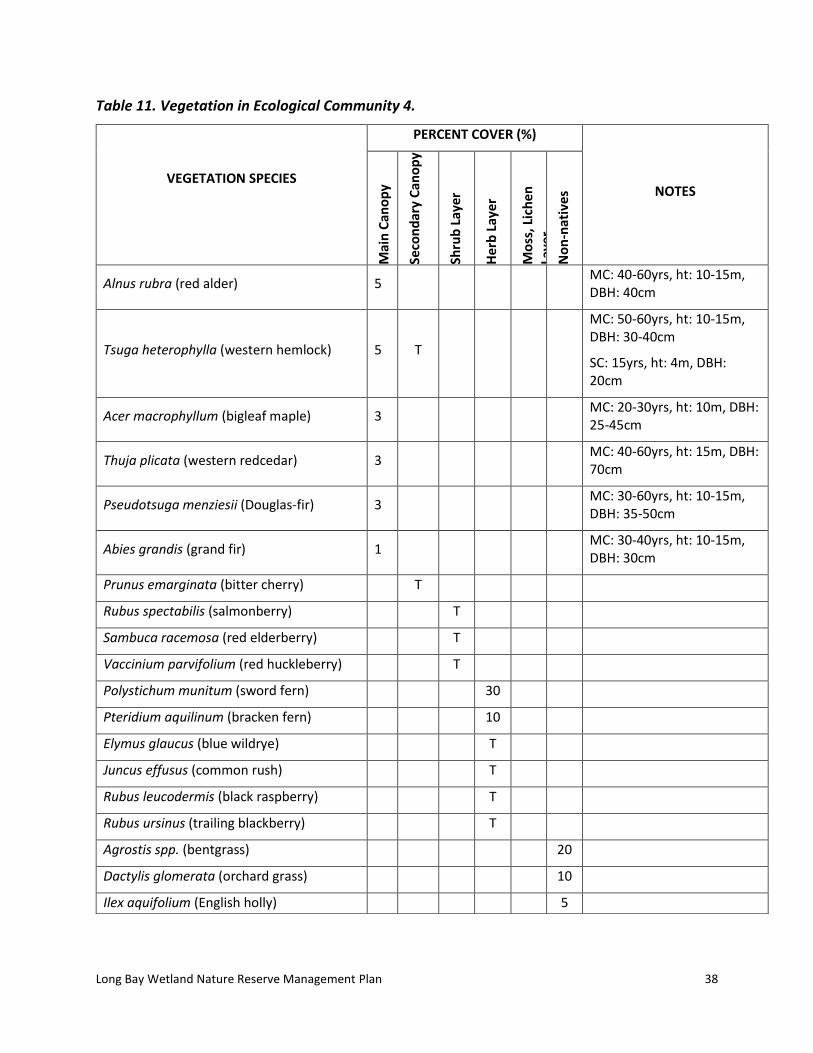
Table 11. Vegetation in Ecological Community 4.
VEGETATION SPECIES
PERCENT COVER (%)
NOTES
Mai
n C
ano
py
Seco
nd
ary
Can
op
y
Shru
b L
ayer
Her
b L
ayer
Mo
ss, L
ich
en
Laye
r N
on
-nat
ives
Alnus rubra (red alder) 5 MC: 40-60yrs, ht: 10-15m,
DBH: 40cm
Tsuga heterophylla (western hemlock) 5 T
MC: 50-60yrs, ht: 10-15m, DBH: 30-40cm
SC: 15yrs, ht: 4m, DBH: 20cm
Acer macrophyllum (bigleaf maple) 3 MC: 20-30yrs, ht: 10m, DBH:
25-45cm
Thuja plicata (western redcedar) 3 MC: 40-60yrs, ht: 15m, DBH:
70cm
Pseudotsuga menziesii (Douglas-fir) 3 MC: 30-60yrs, ht: 10-15m,
DBH: 35-50cm
Abies grandis (grand fir) 1 MC: 30-40yrs, ht: 10-15m,
DBH: 30cm
Prunus emarginata (bitter cherry) T
Rubus spectabilis (salmonberry) T
Sambuca racemosa (red elderberry) T
Vaccinium parvifolium (red huckleberry) T
Polystichum munitum (sword fern) 30
Pteridium aquilinum (bracken fern) 10
Elymus glaucus (blue wildrye) T
Juncus effusus (common rush) T
Rubus leucodermis (black raspberry) T
Rubus ursinus (trailing blackberry) T
Agrostis spp. (bentgrass) 20
Dactylis glomerata (orchard grass) 10
Ilex aquifolium (English holly) 5

Long Bay Wetland Nature Reserve Management Plan
39
Ecological Community 5. Western Redcedar – Sitka Spruce/Skunk Cabbage (CWHxm1/12)
This ecological community is found on lower, wet, rich soils. The site is moisture receiving and the topography is predominantly level. Three tributaries of Long Bay Creek start in this area and
Anthoxanthum odoratum (sweet vernalgrass)
T
Circium arvense (Canada thistle) T
Digitalis purpurea (foxglove) T
Moss Layer Total Moss Layer: 0 %
Eurynchium oreganum (Oregon-beaked moss)
Hylocomium splendens (step moss)
Plagiothecium undulatum (flat moss)
Rhytidiadelphus loreus (lanky moss)
Cover by Layer (%) 20 <1 <1 40 35 Total Canopy Cover: 20 %
Photo 8. Large bigleaf maple veteran trees with dense sword fern understory.

Long Bay Wetland Nature Reserve Management Plan
40
flow to the southwest. The site had very large western redcedar trees (logged in the 1920s) and the remaining 70 year-old second-growth Douglas-fir were logged in 2000. There is little natural regeneration at this site, and the area would benefit from additional planting of native trees using caging to protect the trees from browse. There is a small wetland (as mapped) with standing water and wetland vegetation. Much of the rest of the vegetation type has wetland-characteristic species, including small-flowered bulrush (Scirpus microcarpus), which has been overgrown by non-native grasses and horsetail (Equisetum sp.), possibly due to hydrology changes associated with logging.
Table 12. Description of Ecological Community 5.
Polygon ID: Ecological Community 5
Ecological Community: Western Redcedar – Sitka Spruce/Skunk Cabbage
Classification: CWHxm1/12
Structural Stage: 4-Pole/sapling
Status (BC List): Red-listed Western Redcedar/Three-leaved Foamflower Very Dry Maritime community in disturbed mid seral condition
Photopoint(s): P10
Ecological Community Description:
Shrubs, herbs and patchy young mixed forest on wet, rich site;
forested wetlands occurring in a slight depression with poor drainage that collects water from runoff, groundwater and precipitation; deep organic soils and level slopes. Vegetation within the polygon is typical of both stand initiating and young forest stages.
Disturbance Notes:
The forest cover has recently been selectively harvested, and piles of slash have been left. Seventy year-old second growth mixed forest was heavily logged in 2000, leaving bigleaf maple “veterans” and scattered alders and smaller conifers, followed by limited tree regeneration. Indication of infrequent stand-replacing fires and windthrow.
Anticipated Change/Succession:
Older bigleaf maples will die off over next 50 years or so, possibly re-sprouting from the base. Scattered conifers will grow larger, but stand will remain very open with lush understory due to the moisture regime. Minor conifer regeneration may occur but is likely to be impeded by competition from ferns, grasses and shrubs.
Wildlife observations: No wildlife observed
Table 13. Vegetation in Ecological Community 5.

Long Bay Wetland Nature Reserve Management Plan
41
VEGETATION SPECIES
PERCENT COVER (%)
NOTES
Mai
n C
ano
py
Seco
nd
ary
Can
op
y
Shru
b L
ayer
Her
b L
ayer
Mo
ss, L
ich
en L
ayer
No
n-n
ativ
es
Picea sitchensis (Sitka spruce) 5 MC: 40-60yrs, ht: 20-
25m, DBH: 55cm
Acer macrophyllum (bigleaf maple) 15 MC: 100-150yrs, ht: 15-
20m, DBH: 150cm
Thuja plicata (western redcedar) 3 MC: 30-40yrs, ht: 15-
20m, DBH: 30cm
Alnus rubra (red alder) 1 MC: 30-40yrs, ht: 15m,
DBH: 30cm
Tsuga heterophylla (western hemlock) 1 T
MC: 60-80yrs, ht: 25m, DBH: 70cm
SC: 15-20yrs, ht: 3-4m, DBH: 17cm
Abies amabilis (amabilis fir) T SC: 10-15yrs, ht: 3m,
DBH: 7-10cm
Pseudotsuga menziesii (Douglas-fir) T SC: 10yrs, ht: 2m, DBH:
5cm
Rubus spectabilis (salmonberry) T
Rubus ursinus (trailing blackberry) T
Sambuca racemosa (red elderberry) T
Vaccinium parvifolium (red huckleberry) T
Polystichum munitum (sword fern) 60
Festuca campestris (rough fescue) T
Dactylis glomerata (orchard grass) 10
Arctium minus (common burdock) T
Ilex aquifolium (English holly) T
Mycelis muralis (wall lettuce) T
Poa pratensis (Kentucky bluegrass) T
Rubus laciniatus (cutleaf evergreen blackberry)
T

Long Bay Wetland Nature Reserve Management Plan
42
Moss Layer Total Moss Layer: 0 %
Cover by Layer (%) 25 <1 <1 60 10 Total Canopy Cover: 25%
3.8 Wildlife Species
The wetland habitat likely provides important foraging habitat for a variety of local native bat species, breeding habitat for amphibians, and important sources of drinking water for other wildlife. Black-tailed deer (Odocoileus hemionus) scat and Douglas’s squirrel (Tamiasciurus douglasii) caches were noted in the reserve. The reserve likely provides habitat for a wide range of birds, but the late-summer field season was not ideal timing for assessing bird life. A few butterfly and dragonfly species were noted in the open upland and wetland habitats. Juvenile coho salmon (Oncorhynchus kisutch) are known to inhabit small streams and wetlands in the reserve (Hopwood 2013).
Table 14. Wildlife species observed in LBWNR in 2018
Common Name Latin Name
Mammals
Black-tailed deer Odocoileus hemionus
Douglas’s squirrel Tamiasciurus douglasii
River otter (scat) Lontra canadensis
Invertebrates
Lorquin’s admiral Limenitis lorquini
Pine white Neophasia menapia
Woodland skipper Ochlodes sylvanoides
Reptiles
Common gartersnake Thamnophis sirtalis
Gartersnake (dead on road) Thamnophis sp.
Northern alligator lizard Elgaria coerulea
Birds
American Goldfinch Spinus tristis
American Robin Turdus migratorius
Cedar Waxwing Bombycilla cedrorum
Chestnut-backed Chickadee Poecile rufescens
Common Raven Corvus corax

Long Bay Wetland Nature Reserve Management Plan
43
Downy Woodpecker Dryobates pubescens
Hairy Woodpecker Dryobates villosus
Northern Flicker Colaptes auratus
Pileated Woodpecker Dryocopus pileatus
Red-breasted Sapsucker Sphyrapicus ruber
Red Crossbill Loxia curvirostra
Spotted Towhee Pipilo maculatus
Turkey Vulture Cathartes aura
Western Tanager Piranga ludoviciana
White-crowned Sparrow Zonotrichia leucophrys
Willow Flycatcher Empidonax traillii
Fish
Coho salmon Oncorhynchus kisutch
3.9 Expected Change Over Time
There may be ongoing regeneration of forests overtime in areas previously logged, although regeneration has been minimal to date due to dense understory vegetation, compaction, and high herbivory pressure. Additional reforestation efforts and protection of tree seedlings from browse would assist in regeneration. Remnant forested areas and new conifer growth will continue to mature and diversify over time. In areas with older bigleaf maple and red alder, the older trees may die opening up the understory for coniferous species.
The wetland areas are unlikely to experience significant changes. Dense grasses and forbs will limit tree establishment and without further restoration, hydrology patters are unlikely to change.
Photo 9. Wildlife trees provide important habitat for a variety of wildlife.
Long Bay Wetland Nature Reserve Management Plan
44
4.0 Threats
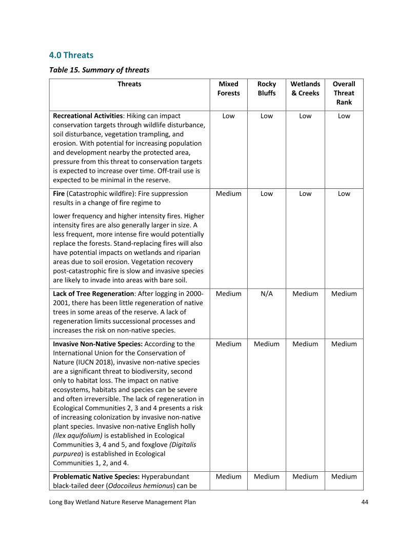
Table 15. Summary of threats
Threats Mixed Forests
Rocky Bluffs
Wetlands & Creeks
Overall Threat Rank
Recreational Activities: Hiking can impact conservation targets through wildlife disturbance, soil disturbance, vegetation trampling, and erosion. With potential for increasing population and development nearby the protected area, pressure from this threat to conservation targets is expected to increase over time. Off-trail use is expected to be minimal in the reserve.
Low Low Low Low
Fire (Catastrophic wildfire): Fire suppression results in a change of fire regime to
lower frequency and higher intensity fires. Higher intensity fires are also generally larger in size. A less frequent, more intense fire would potentially replace the forests. Stand-replacing fires will also have potential impacts on wetlands and riparian areas due to soil erosion. Vegetation recovery post-catastrophic fire is slow and invasive species are likely to invade into areas with bare soil.
Medium Low Low Low
Lack of Tree Regeneration: After logging in 2000-2001, there has been little regeneration of native trees in some areas of the reserve. A lack of regeneration limits successional processes and increases the risk on non-native species.
Medium N/A Medium Medium
Invasive Non-Native Species: According to the International Union for the Conservation of Nature (IUCN 2018), invasive non-native species are a significant threat to biodiversity, second only to habitat loss. The impact on native ecosystems, habitats and species can be severe and often irreversible. The lack of regeneration in Ecological Communities 2, 3 and 4 presents a risk of increasing colonization by invasive non-native plant species. Invasive non-native English holly (Ilex aquifolium) is established in Ecological Communities 3, 4 and 5, and foxglove (Digitalis purpurea) is established in Ecological Communities 1, 2, and 4.
Medium Medium Medium Medium
Problematic Native Species: Hyperabundant black-tailed deer (Odocoileus hemionus) can be
Medium Medium Medium Medium

Long Bay Wetland Nature Reserve Management Plan
45
problematic, limiting natural regeneration, dramatically altering understory vegetation structure and composition, and adversely affecting songbird populations (Martin et al. 2010).
Human Disturbance: Increased human activity in adjacent privately-managed lots (e.g. Brigade Bay subdivision) may increase the potential risk of unauthorized human activities such as firewood removal, land clearing, trail building, construction, camping or other incursions into the Nature Reserve boundaries (Carey et. al. 2000).
Low Low Low Low
Climate Changes: The trend towards longer, drier summers and droughts in the region may have effects on the vegetation and hydrology of the site in the long term (Erwin 2009).
Unknown Unknown Unknown Unknown
Overall Threat Status for Protected Area Low-Medium
Low Low Low
4.1 Expected Change to Threats Over Time
Recreational activities and unauthorized human disturbance and infractions in the reserve are likely to increase over time given the increased development pressure on Gambier Island from the Greater Vancouver region and surrounding areas.
The threat of catastrophic, high-intensity wildfire remains high in the region as the climate appears to be shifting to increasingly drier summers and fire suppression remains active.
Lack of native tree regeneration will likely remain constant given the ongoing herbivory, dense understory, and disturbance associated with former logging. Additional replanting of native trees will help restore logged areas and control invasive species through shading.
Invasive species spread will likely increase without a concerted effort at control. Ongoing removal and control efforts will be required because these invasive species form large, persistent seed banks.
5.0 Community Engagement
5.1 Adjacent Landholders
In preparation for the development of the Management Plan, letters were sent to all landholders and neighbours within a 100 m radius of the reserve. A total of 113 letters were sent by email on November 23rd, 2018 (Appendix D). The letters contained information about Brigade Bay Bluffs, Long Bay Wetland and Mount Artaban Nature Reserves, an invitation to a web conference and a link to an online questionnaire (see Appendix E).

Long Bay Wetland Nature Reserve Management Plan
46
5.2 First Nations
ITC is currently in discussion with three First Nations who have asserted traditional rights on Gambier Island to discuss management planning. Meetings are being held with the Musqueam Nation, Tsleil-Waututh Nation and the Squamish Nation and this communication will continue.
5.3 Conservation Partners and Community Members
The Islands Trust Conservancy held a public web conference on December 14th, 2018. People attending the online conference were asked to provide input on the draft Management Plan and management planning for the reserve. Maps and photographs were presented during a brief powerpoint presentation and residents were asked for their input at that time. There were six members of the public who attended online. Notice of the online questionnaire was provided to the public by ITC and partners through social media.
5.4 Engagement Results
The questionnaire was completed by nine people (four online and five mail-in responses). The nine respondents were primarily non-residents, with 78% living in Vancouver and 3 respondents had a second residence on Gambier Island. Most respondents (44%) have visited the reserve a few times and all who have visited the reserve engage in hiking/walking; many visitors brought their dogs (88%). The most important values for respondents were protection of habitat for at-risk species (89%), conservation for the sake of the intrinsic value of nature (78%), ecosystem services (67%), and low-impact recreational opportunities (67%).
6.0 Management Recommendations
The general management direction of the LBWNR is to allow natural successional processes to continue while allowing low-impact recreational use. With the exception of fire, natural disturbance factors due to wind (windthrow), pest infestation, disease and wildlife use should proceed without intervention. Only the removal of invasive plant species throughout the reserve and of hazard trees around the trail system are permitted. No further trail development is recommended; this is to limit fragmentation and reduce potential future impacts to the reserve associated with additional access points. Restoration is recommended to help re-establish trees in areas with low recruitment.
6.1 Management Roles
The Islands Trust Conservancy is the sole owner of the LBWNR but will rely on its partnership with the Gambier Island Conservancy and the Sunshine Coast Conservation Association to assist with on-the-ground management (Table 16). Since 2009, Islands Trust Conservancy has held a management agreement with the Gambier Island Conservancy (Islands Trust Fund 2009). It specifies that the Reserve should be managed by Gambier Island Conservancy in a manner consistent with the Reserve Purposes, the Management Plan, and the policies of the Board. The Islands Trust Conservancy will monitor the property annually to detect any management issues. Any issues will be reported to the covenant co-holders, Gambier Island Conservancy and Sunshine Coast Conservation Association.

Long Bay Wetland Nature Reserve Management Plan
47
Table 16. Partners involved in management of LBWNR.
Partner Role
Island Trust Conservancy Landholder
Gambier Island Conservancy Covenant Holder and Management Group
Sunshine Coast Conservation Association Covenant Holder
6.2 Permitted and Prohibited Uses
The reserve is open to the public for recreational hiking and nature appreciation on existing trails. Visitors are requested to keep dogs on a leash.
The following activities by the public are prohibited:
Hunting
Use of motorized vehicles
Bicycling
Horseback riding
Camping
Fires
Forestry
Livestock grazing
Trail development (outside of established trails)
Tree cutting
Collection of plants or animals
6.3 Proposed Monitoring Program
Annual monitoring by the covenant holders and by managers of the Reserve is important to ensure that there are no covenant breaches or management issues occurring within the protected area. The main focus of monitoring should be on the existing trail system and the boundary along Mt. Artaban Road since these are the primary access routes into the reserve (Figure 1). Monitoring should assess usage intensity of authorized trails and evaluate trail condition (e.g., levels of erosion and root exposure/damage), and determine if any prohibited uses are occurring, such as tree cutting, unauthorized trails development, use of motorized vehicles, etc.
Species at Risk surveys and monitoring are encouraged during appropriate times of year to assess which species are present. Acoustic bat monitoring and amphibian surveys at wetland sites would provide insightful data. Monitoring of invasive species spread is advisable over time so that control measures can be taken as required.
Monitor regrowth of trees replanted in the borrow pit and other areas of the reserve and remove protective cones as needed.

Long Bay Wetland Nature Reserve Management Plan
48
6.4 Public Access
There are two existing public access trails located off Mt. Artaban Road: one in the northern part of the reserve in the road right of way and a second in the southeast corner of the reserve that provides a linkage to Mount Artaban Nature Reserve (see Section 2.1 for additional details). No additional access sites or trails will be developed in order to minimize habitat fragmentation and degradation.
Alternative access opportunities for First Nations may be established through a separate Management Plan for Areas of Cultural Heritage and Sacred Significance, which must be in compliance with the conservation covenant on the land.
6.5 Signage
There are six boundary signs, six “Covenant Boundary” signs, one trailhead sign (on the trail that leads to Mount Artaban Nature Reserve) and two other private property signs at access points to the reserve (Figure 1 and Table 2). When signs are updated, it is recommended that general contact information for the Islands Trust Conservancy be included on signs. Installing interpretive signage explaining why dogs must be on leash is recommended. Additional signage should be considered if further development occurs on adjacent properties, as this will increase public use of the reserve.
6.6 Trail Use, Maintenance and Development
There is limited recreational use of two trails within the Nature Reserve (see Section 2.10 and Figure 1). The trails are in good condition and have been regularly maintained. There is a decommissioned trail through the center of the reserve that runs approximately east to west and it is largely overgrown. The location of the decommissioned trail should not be shown on maps or other public documents.
No additional trails should be installed; this is to prevent fragmentation within the reserve and limit any potential additional hydrological impacts.
Photo 10. Private property sign at trailhead off Mt. Artaban Road leading into Brigade Bay subdivision at north end of LBWNR.
Photo 11. Trailhead sign leading into north end of LBWNR from Brigade Bay subdivision on Mt. Artaban Rd.

Long Bay Wetland Nature Reserve Management Plan
49
6.7 Protection Initiatives for Sensitive Ecosystems and Species and Ecosystems at Risk
Given the paucity of wetlands throughout the Islands Trust area (ITC 2018), the riparian and wetland habitats within the reserve deserve the highest protection. Wetlands and riparian areas provide important habitat for numerous wildlife and care should be taken to avoid impact on these sensitive ecosystems. Limiting further trail development and maintaining the existing trail to limit erosion will help protect these sensitive areas.
6.8 Ecological Restoration Options
In 2013, a restoration plan was developed for the quarry borrow pit which included roughening and loosening the substrate to address compaction, tree planting, caging of trees and potential hydroseeding. Due to challenges associated with access for heavy equipment, trees were planted and caged but the site was not loosened or hydroseeded. Instead, blown on or ‘terraseeded’ growth medium and native tree species seeds were added. In 2015, 28 western redcedar trees were caged to protect from deer browse (Scholefield 2015). In 2017, eight 1-gallon nursery Douglas-fir seedlings were planted and caged, and 10 naturally established Douglas-fir seedlings were caged in situ (Hopwood 2017). An additional 30 trees were caged in more southern portions of the reserve along the trails (Scholefield 2015), and dense young red alder trees were removed from the trailhead areas. Only a portion of the caged trees in the southern portion of the reserve were mapped (Figure 1).
Monitoring the survivorship of trees is important for gauging restoration success and to determine when the cages should be removed once the trees have grown to a suitable size to withstand some browsing by deer.
Future ecological restoration could include planting of native trees and shrubs with protective caging in areas with poor regeneration to create more diversity in the canopy and understory vegetation. Encouraging more woody vegetation may eventually help shade out invasive species, such as tansy ragwort, that are invading the disturbed site. Species chosen for restoration should be those currently found within the reserve (Appendix B). A biologist should be consulted for site-specific species recommendations because differences in microsite will support different vegetation.
Although some wetland restoration was done to remove excessive slash and channel blockages and address soil compaction prior to 2004, the hydrology has been altered from its original state. A long-term priority, if the budget allows, is to restore the impacted wetland to a more natural state, and to develop a more comprehensive restoration plan for the impacted wetland habitat.

Long Bay Wetland Nature Reserve Management Plan
50
Photo 12. Caged western redcedar and Douglas-fir trees in central portion of reserve along decommissioned trail.
6.9 Scientific Research/Education Opportunities
To date, no research has been conducted on the property. Future research could include species at risk surveys and monitoring during peak season for a variety of species including rare plants, mosses and lichens, bats, birds, gastropods and amphibians.
6.10 Exotic and Invasive Species Management
Invasive English holly (Ilex aquifolium) is found in Vegetation Types 3, 4, and 5 and foxglove (Digitalis purpurea) is found in Vegetation Types 1, 2, and 4. Efforts should be made to remove these species since they can produce large, long-lasting seedbanks and will continue to spread into adjacent habitats. There is some tansy ragwort present in the former quarry, which should also be controlled.

Long Bay Wetland Nature Reserve Management Plan
51
Photo 13. Invasive tansy ragwort (center foreground) at disturbed quarry site, with young regeneration of red alders along edges of the quarry.
6.11 Wildfire Risk Management
Wildfire and wildfire suppression can be extremely damaging to sensitive ecosystems. Developing a fire management plan in consultation with the Gambier Fire Equipment Group and the BC Wildfire Service to identify optimum fire suppression techniques is recommended. This information should be provided to the province for inclusion in their annual Fire Plan. The use of salt water or fire retardants is not recommended for fire suppression since both can damage sensitive ecosystems. There are two freshwater lakes on Gambier that should be used for bucketing in the event of a wildfire (Gambier Island Community 2018).
6.12 Climate Change Impacts and Management
Climate change may impact the distribution of ecosystems across the landscape, affecting vegetation patterns, hydrology, and outbreaks of pests. Hotter, drier summers may lead to premature drying of wetlands and altered flow rates in seasonal streams. Trends that may prevail in this region include up-slope migration of the tree line and ecosystem boundaries, and increased fire frequency. Douglas-fir-dominated stands will expand at the cost of Coastal Western Hemlock (CWH) forests, which are expected to shift upslope (Hebda 1997). Ensuring ongoing protection and connectivity between large protected areas will aid the dispersal of species into new habitats and across elevations as vegetation patterns shift with climate

Long Bay Wetland Nature Reserve Management Plan
52
change. These protected area matrices will provide potential reservoirs for dispersal into suitable habitats in adjacent areas as climate change shifts the distribution of these ecosystem types (McCloskey et.al. 2009).
7.0 Action Items
7.1 Immediate Actions (1-2 years):
1. Continue to work with the Gambier Island Conservancy and Sunshine Coast Conservation Association to complete management activities as funds allow.
2. Monitor planted trees for survival and remove cages as necessary.
3. Identify opportunities for cooperative management with First Nations.
7.2 Short term Actions (3-5 years):
1. Prepare a wildfire management plan that considers both forest ecology and prevention of damage to surrounding neighbourhoods in consultation with the local fire authorities.
2. Plant and cage native shrubs and trees in areas with poor natural regeneration.
3. Initiate development of parallel Management Plan for Areas of Cultural Heritage and Sacred Significance documents with First Nations.
7.3 Long term Actions (5+ years)
1. Conduct surveys for species at risk and other wildlife (e.g. amphibians, bats) to provide a better understanding of the natural values of the reserve.
2. Develop a wetland restoration plan, if the budget allows.
7.4 Ongoing or Annual Action Items
1. Conduct annual monitoring to identify management concerns, including public use (e.g. trail monitoring) and invasive species.
2. Communicate annually with the Gambier Island Conservancy and Sunshine Coast Conservation Association to provide updates on the reserve, seek approvals for stewardship activities as necessary, and maintain compliance with the conservation covenant.
3. Conduct ongoing maintenance of trails and signs.
4. Continue to inform the general public of the natural values of the site and the permitted and prohibited uses through information placed in local publications.
5. Work with First Nations towards cooperative management of the reserve using a Management Plan for Areas of Cultural Heritage and Sacred Significance as a guide.

Long Bay Wetland Nature Reserve Management Plan
53
8.0 Conclusion
Long Bay Wetland Nature Reserve is an important protected area that is surrounded by a combination of privately- and provincially-managed land and other protected areas. Although impacted by past logging, over time the land will develop into a young forest and reforestation efforts can help enhance degraded habitats. The Reserve provides important connectivity and wildlife habitat across a large, significant network of protected areas on Gambier Island.
Islands Trust Conservancy will act on the management action items identified in this plan to achieve the vision, objectives and purpose of the Nature Reserve. Future management issues may lead to further action items that will be identified in work plans and in future revisions of this plan.
9.0 References
BC CDC 2018. British Columbia Conservation Data Centre iMap. http://maps.gov.bc.ca/ess/hm/cdc/ [Accessed November 2018].
BC Ministry of Energy and Mines. 2005. Surficial Geology Map Index of BC (GSB Open File 1992-13). http://webmap.em.gov.bc.ca/mapplace/minpot/OF_13map.cfm [Accessed October 2018]
Cascade Environmental Resource Group Ltd. 2005. Brigade Bay Bluffs Nature Reserve and Long Bay Wetlands Nature Reserve Management Plan, Gambier Island, BC. November 30, 2005. Unpublished report prepared for The Islands Trust Fund.
Carey, C., N. Dudley, and S. Stolton. 2000. Squandering Paradise? The importance and vulnerability of the world’s protected areas. WWW-World Wildlife Fund for Nature International, Gland, Switzerland. Pp. 227.
CERG. 2001. Environmental Assessment: Gambier Island, DL’s 1257, 1259 and part DL 1780; except part in Ref. Plan 2829, Group 1, NWD, Gambier Island BC. Prepared for 586329 BC Ltd. September 17, 2001.
Erwin, K.L. 2009. Wetlands and global climate change: the role of wetland restoration in a changing world. Wetlands Ecological Management 17:71-84.
Fisheries and Oceans Canada (FOC). 2004. Authorization for Works or undertakings Affecting Fish Habitat. Authorization No. 02-HPAC-PA2-000-000006 Brigade Bay Developments. February 25, 2004.
Fisheries and Oceans Canada (FOC). 2003. Proposed Brigade Bay Development Project;586329 BC Ltd. Ho-mahmk, Cha7elknech (Brigade Bay, Gambier Island, Howe Sound). First Nations Interests. December 2, 2003.
Gambier Island Community. 2018. Gambier Island Fire District Map. Web site: http://www.gambierisland.org/Documents/Gambier%20Fire%20District%202016.pdf

Long Bay Wetland Nature Reserve Management Plan
54
Green, R.N. and K. Klinka. 1994. A Field Guide to Site Identification and Interpretation for the Vancouver Forest Region. Land Management Handbook No. 28. Ministry of Forests. Victoria, B.C.
Hebda, R.J. 1997. Chapter 13: Impacts of Climate Change on Biogeoclimatic Zones of British Columbia and Yukon In Responding to Global Climate Change in British Columbia and Yukon, Volume 1 of the Canada Country Study: Climate Impacts and Adaptations. Eds E.Taylor and B. Taylor. Pp. 13-1 - 13-15.
Hopwood, D. 2009. Management Plan for Mount Artaban Nature Reserve. Unpublished Report prepared for the Islands Trust Fund.
Hopwood, D. 2013. Baseline Report: Long Bay Wetland Nature Reserve. Prepared for Islands Trust Conservancy, Schedule A of Conservation Covenant (CA3219709).
Hopwood, D. 2017. Notes on Gambier Conservancy Restoration Work Party, February 25, 2017. Unpublished report prepared for the Islands Trust Conservancy.
International Union for Conservation of Nature (IUCN). 2018. Invasive Species.
https://www.iucn.org/theme/species/our-work/invasive-species [Accessed October 8, 2018].
Islands Trust. 2004. Gambier Island Land Use Bylaw No. 86, 2004. Adopted September 15, 2005.
Islands Trust. 2017. Gambier Island Official Community Plan. Bylaw No. 783, 2001. Schedule 1 Development Permit Areas. http://www.islandstrust.bc.ca/islands/local-trust-areas/gambier/bylaws/ [Accessed November 9, 2018].
Islands Trust. 2018. Islands Trust Object. http://www.islandstrust.bc.ca/trust-council/islands-trust-act/ [Accessed October 8, 2018].
Islands Trust. 2019. Reconciliation Declaration. Web site: http://www.islandstrust.bc.ca/media/347494/reconciliation-declaration.pdf Accessed March 2019.
Islands Trust Conservancy (ITC). 2018. Regional Conservation Plan 2018-2027. January 30, 2018. Pp. 146.
Islands Trust Fund. 2009. Brigade Bay Bluffs Nature Reserve Management Agreement. Unpublished agreement between the Trust Fund Board and Gambier Island Conservancy.
Lands Directorate, Terrestrial Ecozones Of Canada, Ecological Land Classification No. 19, 1986, p. 107-113.
Long Bay Wetland Nature Reserve Management Plan
55
Lockwood, M. 2006. Global protected area framework. In M. Lockwood, M. Lockwood, G. L. Worboys, and A. Kothari (Eds.). Managing Protected Areas: A Global Guide (p. 84). London: Earthscan.
Martin, T.G., P. Arcese, and N. Scheerder. 2011. Browsing down out natural heritage: Deer impacts on vegetation structure and songbird populations across an island archipelago. Biological Conservation 144(2011):459-469.
Mauger, G.S., J.H. Casola, H.A. Morgan, R.L. Strauch, B. Jones, B. Curry, T.M. Busch Isaken, L. Whitely Binder, M.B. Krosby, and A.K. Snover. 2015. State of Knowledge: Climate Change in Puget Sound. Report prepared for the Puget Sound Partnership and the National Oceanic and Atmospheric Administration. Climate Impacts Group, University of Washington, Seattle. doi:10.7915/CIG93777D
McCloskey, S.P.J., L.D. Daniels, and J.A. McLean. 2009. Potential impacts of climate change on Western Hemlock Looper outbreaks. Northwest Science. 83(3):225-238.
Meidinger, D. and J. Pojar. 1991. Ecosystems of British Columbia. BC Ministry of Forests. Victoria, B.C.
Meteoblue. 2018. Climate Gambier Island: Average Temperature and Precipitation. https://www.meteoblue.com/en/weather/forecast/modelclimate/gambier-island_canada_5959241 [Accessed October 8, 2018].
Parminter, J. 2009. Personal Communication to D. Hopwood (unreferenced in Hopwood 2009).
Scholefield, P. 2015. Gambier Nature Reserve Restoration – Island Trust Fund Project No 2104-0061 Work Party Report. Unpublished Report for Islands Trust Conservancy. Gambier Island Conservancy, February 16, 2015.
The Weather Network. 2018. Bowen Island Average Annual Precipitation. https://www.theweathernetwork.com/ca/api/sitewrapper/index?b=%2Fstatistics%2F&p=%2Fforecasts%2Fstatistics%2Findex&url=%2Fstatistics%2Fcabc0037%2Fbowen-island%2F%2F%2F%3F [Accessed October 8, 2018].

Long Bay Wetland Nature Reserve Management Plan
56
10.0 Appendices
Appendix A. Survey Plan for LBWNR
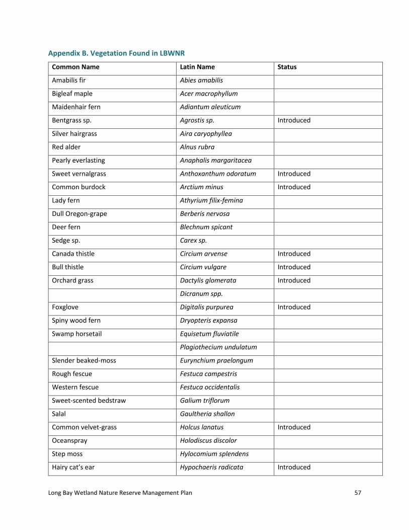
Long Bay Wetland Nature Reserve Management Plan
57
Appendix B. Vegetation Found in LBWNR
Common Name Latin Name Status
Amabilis fir Abies amabilis
Bigleaf maple Acer macrophyllum
Maidenhair fern Adiantum aleuticum
Bentgrass sp. Agrostis sp. Introduced
Silver hairgrass Aira caryophyllea
Red alder Alnus rubra
Pearly everlasting Anaphalis margaritacea
Sweet vernalgrass Anthoxanthum odoratum Introduced
Common burdock Arctium minus Introduced
Lady fern Athyrium filix-femina
Dull Oregon-grape Berberis nervosa
Deer fern Blechnum spicant
Sedge sp. Carex sp.
Canada thistle Circium arvense Introduced
Bull thistle Circium vulgare Introduced
Orchard grass Dactylis glomerata Introduced
Dicranum spp.
Foxglove Digitalis purpurea Introduced
Spiny wood fern Dryopteris expansa
Swamp horsetail Equisetum fluviatile
Plagiothecium undulatum
Slender beaked-moss Eurynchium praelongum
Rough fescue Festuca campestris
Western fescue Festuca occidentalis
Sweet-scented bedstraw Galium triflorum
Salal Gaultheria shallon
Common velvet-grass Holcus lanatus Introduced
Oceanspray Holodiscus discolor
Step moss Hylocomium splendens
Hairy cat’s ear Hypochaeris radicata Introduced

Long Bay Wetland Nature Reserve Management Plan
58
English holly Ilex aquifolium Introduced
Common rush Juncus effusus
Rush sp. Juncus sp.
Common nipplewort Lapsana communis Introduced
Hairy honeysuckle Lonicera hispidula
Skunk cabbage Lysichiton americanus
Wall lettuce Mycelis muralis Introduced
Timothy Phleum pratense Introduced
Sitka spruce Picea sitchensis
Spruce sp. Picea sp.
Flat moss Plagiothecium undulatum
Kentucky bluegrass Poa pratensis Introduced
sword fern Polystichum munitum
Bitter cherry Prunus emarginata
Douglas-fir Pseudotsuga menziesii
Bracken fern Pteridium aquilinum
Creeping buttercup Ranunculus repens Introduced
Lanky moss Rhytidiadelphus loreus
Black gooseberry Ribes lacustre
Cutleaf evergreen blackberry Rubus laciniatus Introduced
Black raspberry Rubus leucodermis
Thimbleberry Rubus parviflorus
Salmonberry Rubus spectabilis
Trailing blackberry Rubus ursinus
Red elderberry Sambucus racemosa
Wool-grass Scirpus atrocinctus
Small-flowered bulrush Scirpus microcarpus
Tansy ragwort Senecio jacobaea Introduced
Long-leaved starwort Stellaria longifolia
Western redcedar Thuja plicata
Broad-leaved starflower Trientalis borealis
Western hemlock Tsuga heterophylla
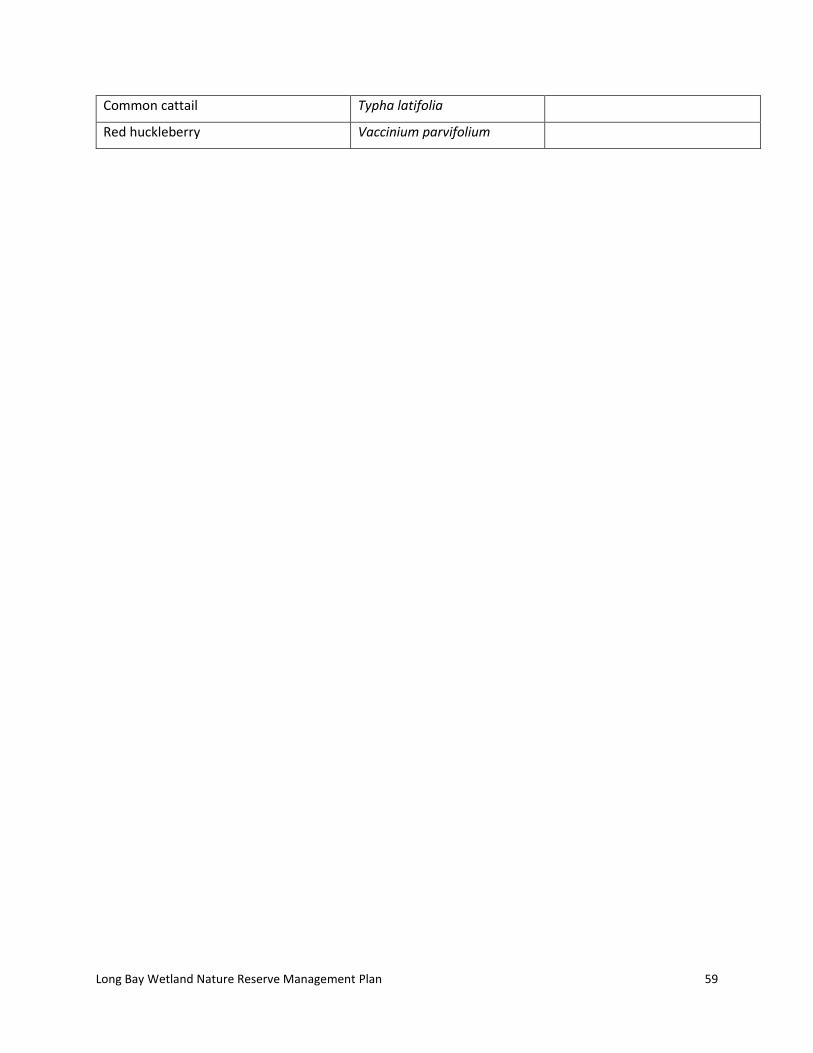
Long Bay Wetland Nature Reserve Management Plan
59
Common cattail Typha latifolia
Red huckleberry Vaccinium parvifolium

Long Bay Wetland Nature Reserve Management Plan
60
Appendix C. Photographic Documentation
All photo locations are shown in the map in Figure 1.
PHOTO STATION
LOCATION
(UTM Coordinates)
DIRECTION PHOTO-GRAPHER
DATE
YYYY-MM-DD
DESCRIPTION
P2 476130; 5480906
270o LM 2018-08-07 Trailhead and boundary signs.
P3 475679; 5481419
225o LM* 2018-08-07 Nature Reserve Boundary Sign on Mt. Artaban Road.
P4 475380; 5481633
270o LM 2018-08-08 Trailhead Boundary Sign and Private Property Sign for adjacent strata (No Motorized Vehicles). At end of northern trail at western boundary of Nature Reserve.
P12 475547; 5481839
270o LM 2018-08-07 Private Property and No Hunting signs at Mt. Artaban Road northern trailhead at eastern boundary.
P13 475543; 5481832
270o LM 2018-08-07 Nature Reserve Boundary Sign on Mt. Artaban Road.
P14 475611; 5481311
208o LM 2018-08-07 Caged western redcedar and Douglas-fir trees on decommissioned trail.
Natural Features as noted in Figure 5
P1 475653; 5481475
270o LM 2018-08-08 Small wetland (20 m x 5 m) beside road with skunk cabbage, small-flowered bulrush, cattail, wool-grass, common rush, horsetail and lady fern by road. Carrina Maslovat in centre of wetland. No standing water.

Long Bay Wetland Nature Reserve Management Plan
61
P5 475615; 5481551
280o LM 2018-08-09 Roadside wetland near boundary sign, seems to have shifted to mostly sword fern, horsetail, orchard grass and timothy.
P6 475966; 5480978
270o LM 2018-08-07 Creekbed with rocks, some water still flowing.
P7 475511; 5481738
285o
LM
2018-08-08 Looking upslope to steep, rocky bluff with reindeer lichen and mosses. There is some oceanspray, foxglove, sweet vernal-grass, present with sword fern below and sparse bigleaf maple, western hemlock and Douglas-fir. Large western redcedar at bottom of steep outcrop.
P8 475937; 5480977
200o LM 2018-08-08 Centre Plot of Vegetation Type 3. Sword fern understory.
P9 475424; 5481610
128o LM 2018-08-08 Centre of Vegetation Type 4 showing cleared area with browsed English holly, sword fern understory.
P10 475586; 5481309
324o
LM
2018-08-07 Centre plot of Vegetation Type 5, large older bigleaf maple trees and dense sword fern cover.
P11 475647; 5481489
LM 2018-08-07
Red alder wildlife tree.
P15 475472; 5481954
225o LM 2018-08-09 Quarry borrow pit showing tansy ragwort and replanted trees.
* LM=Laura Matthias

Long Bay Wetland Nature Reserve Management Plan
62
Appendix D. Letter to Neighbours
Long Bay Wetland Nature Reserve Management Plan
63

Long Bay Wetland Nature Reserve Management Plan
64
Appendix E. Questionnaire sent to Neighbours and Available Online

Long Bay Wetland Nature Reserve Management Plan
65

Long Bay Wetland Nature Reserve Management Plan
66