longwall 32 resident information pack - simec.com · tahmoor coking coal operations | longwall 32...
TRANSCRIPT
TAHMOOR COKING COAL OPERATIONS | LONGWALL 32 RESIDENT INFORMATION PACK – JUNE 2018
1
380STAFF
Our people
Our HistoryIn 1979 additional consent was given to establish a Coal Handling & Preparation Plant (CHPP) and Reject Emplacement Area (REA) onsite.
Tahmoor Coking Coal is an underground operation which began mining by Clutha Development Ltd.
In 1986 amended consent allowed for the construction of a gas extraction plant and implementation of a gas drainage system in preparation for longwall mining to be undertaken.
1979
1985
- 86
1982
1986
2018The CHPP allows the coal to be processed onsite before rail transport to Port Kembla Coal Terminal, where it is shipped to overseas markets. Production of coal began.
In 1986 longwall mining was introduced.
The mine has changed ownership over several times during its 39 year history. In 2018 SIMEC Mining purchased Tahmoor Coking Coal.
On-site methane gas power plant commissioned in 200020
00
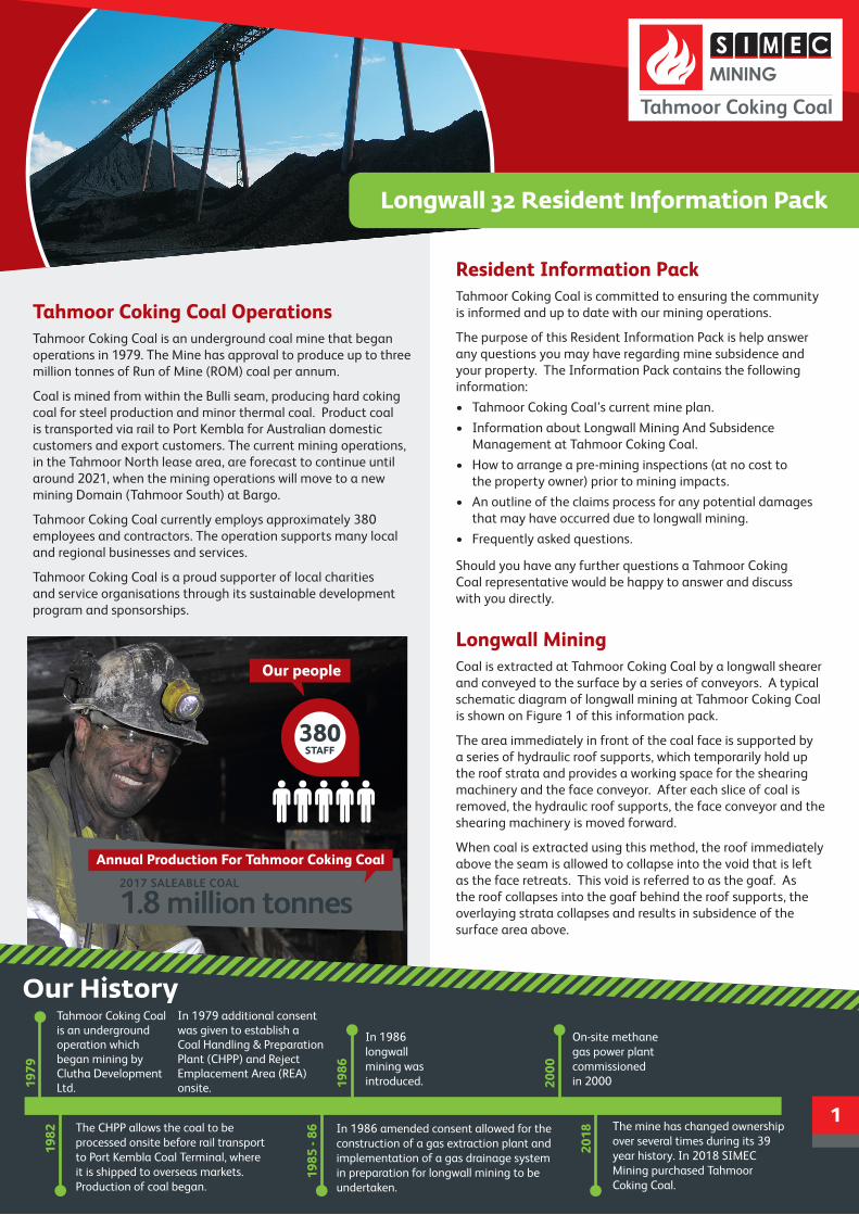
Tahmoor Coking Coal OperationsTahmoor Coking Coal is an underground coal mine that began operations in 1979. The Mine has approval to produce up to three million tonnes of Run of Mine (ROM) coal per annum.
Coal is mined from within the Bulli seam, producing hard coking coal for steel production and minor thermal coal. Product coal is transported via rail to Port Kembla for Australian domestic customers and export customers. The current mining operations, in the Tahmoor North lease area, are forecast to continue until around 2021, when the mining operations will move to a new mining Domain (Tahmoor South) at Bargo.
Tahmoor Coking Coal currently employs approximately 380 employees and contractors. The operation supports many local and regional businesses and services.
Tahmoor Coking Coal is a proud supporter of local charities and service organisations through its sustainable development program and sponsorships.
Resident Information PackTahmoor Coking Coal is committed to ensuring the community is informed and up to date with our mining operations.
The purpose of this Resident Information Pack is help answer any questions you may have regarding mine subsidence and your property. The Information Pack contains the following information:
• Tahmoor Coking Coal’s current mine plan.
• Information about Longwall Mining And Subsidence Management at Tahmoor Coking Coal.
• How to arrange a pre-mining inspections (at no cost to the property owner) prior to mining impacts.
• An outline of the claims process for any potential damages that may have occurred due to longwall mining.
• Frequently asked questions.
Should you have any further questions a Tahmoor Coking Coal representative would be happy to answer and discuss with you directly.
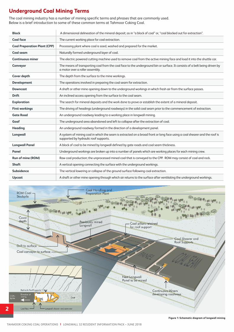
Longwall Mining Coal is extracted at Tahmoor Coking Coal by a longwall shearer and conveyed to the surface by a series of conveyors. A typical schematic diagram of longwall mining at Tahmoor Coking Coal is shown on Figure 1 of this information pack.
The area immediately in front of the coal face is supported by a series of hydraulic roof supports, which temporarily hold up the roof strata and provides a working space for the shearing machinery and the face conveyor. After each slice of coal is removed, the hydraulic roof supports, the face conveyor and the shearing machinery is moved forward.
When coal is extracted using this method, the roof immediately above the seam is allowed to collapse into the void that is left as the face retreats. This void is referred to as the goaf. As the roof collapses into the goaf behind the roof supports, the overlaying strata collapses and results in subsidence of the surface area above.
2017 SALEABLE COAL
1.8 million tonnes
Annual Production For Tahmoor Coking Coal
Longwall 32 Resident Information Pack
1
TAHMOOR COKING COAL OPERATIONS | LONGWALL 32 RESIDENT INFORMATION PACK – JUNE 2018
Figure 1: Schematic diagram of longwall mining
Block A dimensional delineation of the mineral deposit; as in “a block of coal” or, “coal blocked out for extraction”.
Coal face The current working place for coal extraction.
Coal Preparation Plant (CPP) Processing plant where coal is sized, washed and prepared for the market.
Coal seam Naturally formed underground layer of coal.
Continuous miner The electric powered cutting machine used to remove coal from the active mining face and load it into the shuttle car.
Conveyor The means of transporting coal from the coal face to the underground bin or surface. It consists of a belt being driven by a motor over a roller assembly.
Cover depth The depth from the surface to the mine workings.
Development The operations involved in preparing the coal seam for extraction.
Downcast A shaft or other mine opening down to the underground workings in which fresh air from the surface passes.
Drift An inclined access opening from the surface to the coal seam.
Exploration The search for mineral deposits and the work done to prove or establish the extent of a mineral deposit.
First workings The driving of headings (underground roadways) in the solid coal seam prior to the commencement of extraction.
Gate Road An underground roadway leading to a working place in longwall mining.
Goaf The underground area abandoned and left to collapse after the extraction of coal.
Heading An underground roadway formed in the direction of a development panel.
Longwall A system of mining coal in which the seam is extracted on a broad front or long face using a coal shearer and the roof is supported by hydraulic roof supports.
Longwall Panel A block of coal to be mined by longwall defined by gate roads and coal seam thickness.
Panel Underground workings are broken up into a number of panels which are working places for each mining crew.
Run of mine (ROM) Raw coal production; the unprocessed mined coal that is conveyed to the CPP. ROM may consist of coal and rock.
Shaft A vertical opening connecting the surface with the underground workings.
Subsidence The vertical lowering or collapse of the ground surface following coal extraction.
Upcast A shaft or other mine opening through which air returns to the surface after ventilating the underground workings.
2
Underground Coal Mining TermsThe coal mining industry has a number of mining specific terms and phrases that are commonly used. Below is a brief introduction to some of these common terms at Tahmoor Coking Coal.
TAHMOOR COKING COAL OPERATIONS | LONGWALL 32 RESIDENT INFORMATION PACK – JUNE 2018
3
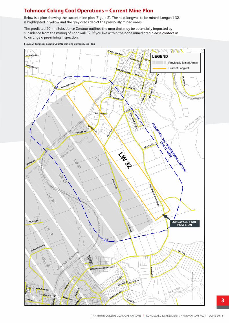
Tahmoor Coking Coal Operations – Current Mine PlanBelow is a plan showing the current mine plan (Figure 2). The next longwall to be mined, Longwall 32, is highlighted in yellow and the grey areas depict the previously mined areas.
The predicted 20mm Subsidence Contour outlines the area that may be potentially impacted by subsidence from the mining of Longwall 32. If you live within the none mined area please contact us to arrange a pre-mining inspection.
Figure 2: Tahmoor Coking Coal Operations Current Mine Plan
LONGWALL START POSITION
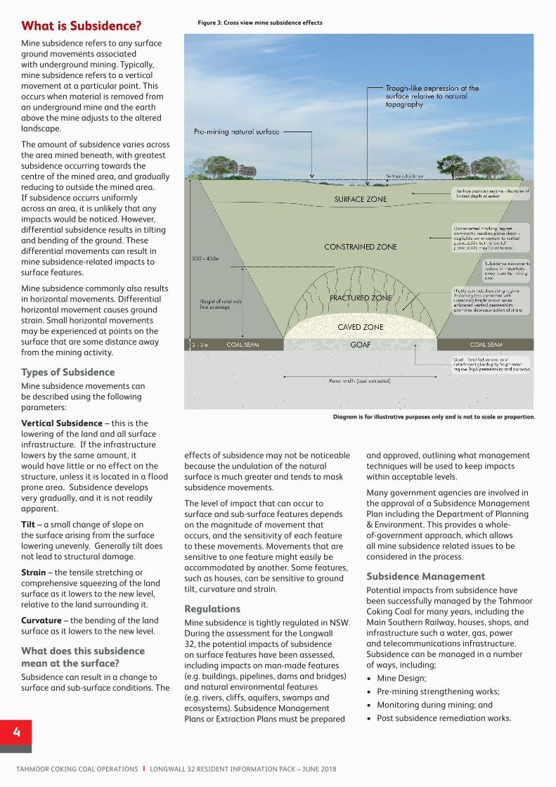
Diagram is for illustrative purposes only and is not to scale or proportion.
What is Subsidence?Mine subsidence refers to any surface ground movements associated with underground mining. Typically, mine subsidence refers to a vertical movement at a particular point. This occurs when material is removed from an underground mine and the earth above the mine adjusts to the altered landscape.
The amount of subsidence varies across the area mined beneath, with greatest subsidence occurring towards the centre of the mined area, and gradually reducing to outside the mined area. If subsidence occurrs uniformly across an area, it is unlikely that any impacts would be noticed. However, differential subsidence results in tilting and bending of the ground. These differential movements can result in mine subsidence-related impacts to surface features.
Mine subsidence commonly also results in horizontal movements. Differential horizontal movement causes ground strain. Small horizontal movements may be experienced at points on the surface that are some distance away from the mining activity.
Types of Subsidence Mine subsidence movements can be described using the following parameters:
Vertical Subsidence – this is the lowering of the land and all surface infrastructure. If the infrastructure lowers by the same amount, it would have little or no effect on the structure, unless it is located in a flood prone area. Subsidence develops very gradually, and it is not readily apparent.
Tilt – a small change of slope on the surface arising from the surface lowering unevenly. Generally tilt does not lead to structural damage.
Strain – the tensile stretching or comprehensive squeezing of the land surface as it lowers to the new level, relative to the land surrounding it.
Curvature – the bending of the land surface as it lowers to the new level.
What does this subsidence mean at the surface?Subsidence can result in a change to surface and sub-surface conditions. The
Figure 3: Cross view mine subsidence effects
and approved, outlining what management techniques will be used to keep impacts within acceptable levels.
Many government agencies are involved in the approval of a Subsidence Management Plan including the Department of Planning & Environment. This provides a whole-of-government approach, which allows all mine subsidence related issues to be considered in the process.
Subsidence ManagementPotential impacts from subsidence have been successfully managed by the Tahmoor Coking Coal for many years, including the Main Southern Railway, houses, shops, and infrastructure such a water, gas, power and telecommunications infrastructure. Subsidence can be managed in a number of ways, including;
• Mine Design;
• Pre-mining strengthening works;
• Monitoring during mining; and
• Post subsidence remediation works.
effects of subsidence may not be noticeable because the undulation of the natural surface is much greater and tends to mask subsidence movements.
The level of impact that can occur to surface and sub-surface features depends on the magnitude of movement that occurs, and the sensitivity of each feature to these movements. Movements that are sensitive to one feature might easily be accommodated by another. Some features, such as houses, can be sensitive to ground tilt, curvature and strain.
Regulations Mine subsidence is tightly regulated in NSW. During the assessment for the Longwall 32, the potential impacts of subsidence on surface features have been assessed, including impacts on man-made features (e.g. buildings, pipelines, dams and bridges) and natural environmental features (e.g. rivers, cliffs, aquifers, swamps and ecosystems). Subsidence Management Plans or Extraction Plans must be prepared
4
TAHMOOR COKING COAL OPERATIONS | LONGWALL 32 RESIDENT INFORMATION PACK – JUNE 2018
TAHMOOR COKING COAL OPERATIONS | LONGWALL 32 RESIDENT INFORMATION PACK – JUNE 2018
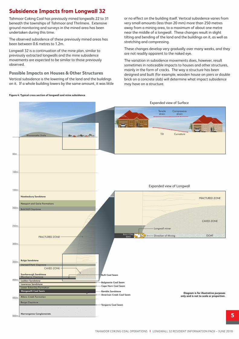
Subsidence Impacts from Longwall 32Tahmoor Coking Coal has previously mined longwalls 22 to 31 beneath the townships of Tahmoor and Thirlmere. Extensive ground monitoring and surveys in the mined area has been undertaken during this time.
The observed subsidence of these previously mined areas has been between 0.6 metres to 1.2m.
Longwall 32 is a continuation of the mine plan, similar to previously extracted longwalls and the mine subsidence movements are expected to be similar to those previously observed.
Possible Impacts on Houses & Other StructuresVertical subsidence is the lowering of the land and the buildings on it. If a whole building lowers by the same amount, it was little
or no effect on the building itself. Vertical subsidence varies from very small amounts (less than 20 mm) more than 250 metres away from a mining area, to a maximum of about one metre near the middle of a longwall. These changes result in slight tilting and bending of the land and the buildings on it, as well as stretching and compressing.
These changes develop very gradually over many weeks, and they are not readily apparent to the naked eye.
The variation in subsidence movements does, however, result sometimes in noticeable impacts to houses and other structures, mainly in the form of cracks. The way a structure has been designed and built (for example, wooden house on piers or double brick on a concrete slab) will determine what impact subsidence may have on a structure.
Figure 4: Typical cross section of longwall and mine subsidence
EDH 1WNS EDH 1WNS
EDH 1NSW
EDH 1NSW
50m
100m
150m
200m
250m
300m
350m
400m
450m
500m
Hawkesbury Sandstone
Newport and Garie Formations
Bald Hill Claystone
Bulga Sandstone
Stanwell Park Claystone
Scarborough SandstoneWombarra Claystone
Loddon Sandstone
Lawrence Sandstone
Lower Eckersley Formation
Wongawilli Coal Seam
Allens Creek Formation
Bargo Claystone
Marrangaroo Conglomerate
Tongarra Coal Seam
American Creek Coal Seam
Kembla Sandstone
Cape Horn Coal Seam
Balgownie Coal Seam
Bulli Coal Seam
CAVED ZONE
FRACTURED ZONE
Compressivestrain
Tensilestrain
CurvatureTiltWianamatta Shale
CAVED ZONE
FRACTURED ZONE
GOAFBULLI COAL
SEAM
Longwall miner
Direction of Mining
Typical Cross Section of Longwall and Mine Subsidence
Expanded view of Surface
Expanded view of Longwall
5
Expanded view of Surface
Expanded view of Longwall
Diagram is for illustrative purposes only and is not to scale or proportion.
Subsidence Advisory NSWSubsidence Advisory NSW (SA NSW) is the NSW Government agency responsible for administering the Coal Mine Subsidence Compensation Act 2017. SA NSW has two core functions:
1. To provide compensation or manage the provision of compensation where surface developments are damaged by mine subsidence following extraction of coal or shale in NSW; and
2. To regulate surface development within mine subsidence districts to reduce the risk of mine subsidence damage.
SA NSW provides expert advice to property owners, government departments, councils, community organisations and industries within coal mining areas of NSW. This advice aims to provide compatibility between surface development and underground mining.
Changes to the Mine Subsidence Compensation Act 1961Changes to the mine subsidence system in NSW took effect from 1 January 2018 following a review of the former Mine Subsidence Compensation Act 1961. The
changes make the mine subsidence compensation processes easier for property owners and provide a more equitable model for mining.
Pre-mining inspection Tahmoor Coking Coal encourages property owners in areas where underground mining is planned in the near future to have a pre-mining inspection (PMI) carried out on their property.
PMIs are free of charge and facilitate a straight forward claims process if a property is impacted by subsidence.
The purpose of a PMI is to determine the condition of a property prior to mining. PMIs are an added protection for property owners to ensure they receive adequate compensation to return their property to its pre-mining condition should it be impacted by subsidence.
The inspector undertaking the PMI will document the condition of the property using photographs and survey levels. Once completed property owners can request a copy of the PMI detailed report. This report can be used as a reference to identify potential damage once mining has occurred.
How to request a pre-mining inspection To request a PMI simply contact Tahmoor Coking Coal or Subsidence Advisory NSW. An inspection time will then be arranged.
Subsidence DamageThe signs of mine subsidence damage to buildings and other structures can range from cracking to walls and jammed doors to more significant structural issues. Generally, buildings damaged by mine subsidence remain safe and serviceable until they are repaired.
The extent of damage will vary depending on the location of the building in proximity to the mine workings and other subsidence related factors.
Duty to Disclose Impacts to property improvements are covered by the Coal Mine Subsidence Compensation Act 2017, however, please consult with your insurance agency and mortgagee to determine if you have an obligation to disclose to them that mining will occur beneath your property.
Subsidence Monitoring and Management
To book your free Pre-mining Inspection simply contact: Tahmoor Coking Coal 1800 154 415.
6
TAHMOOR COKING COAL OPERATIONS | LONGWALL 32 RESIDENT INFORMATION PACK – JUNE 2018
Tahmoor Coking Coal has previously directly mined beneath or adjacent to more than 1,900 houses and civil structures, commercial and retail properties, the Main Southern Railway and local roads and bridges. Tahmoor Coking Coal has implemented extensive measures prior to, during and after mining to ensure that the health and safety of people have not been put at risk due to mine subsidence. Management strategies for the successful mining beneath structures include:
• Regular consultation with the community before, during and after mining;
• Site-specific investigations for identified properties;
• Implementation of mitigation measures as suggested by specialist engineers;
• Ground surveys along streets; and
• Detailed visual inspections.
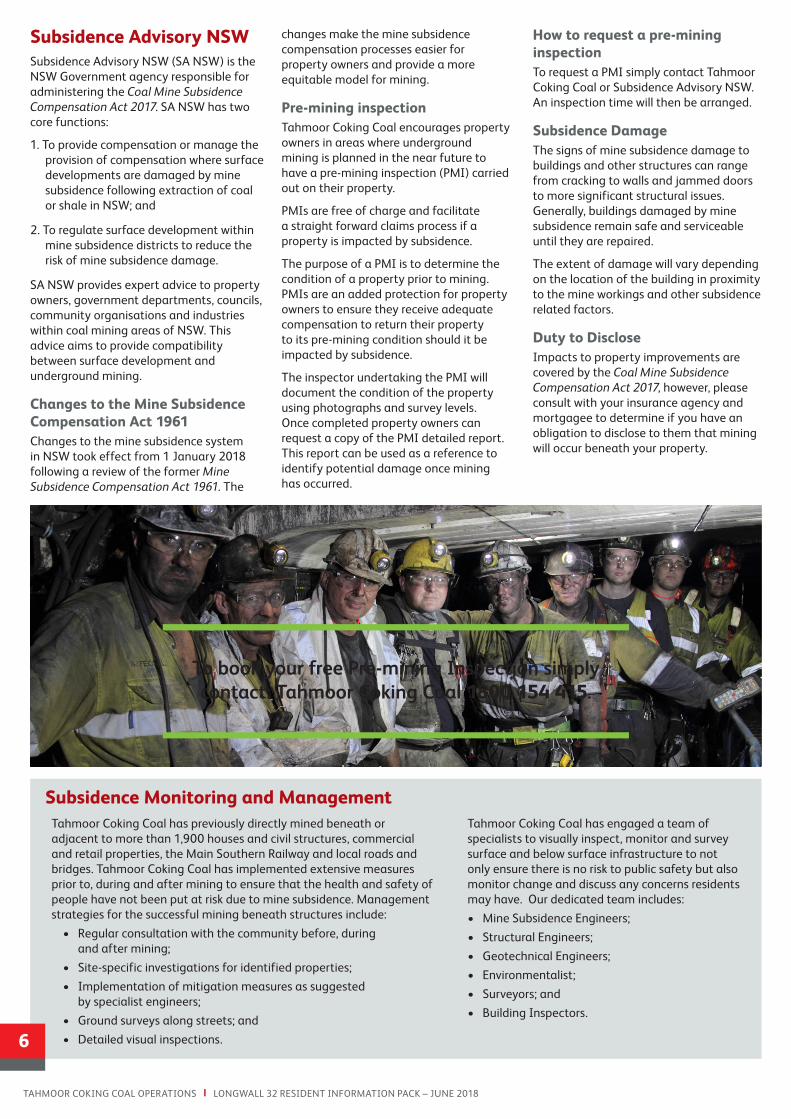
Tahmoor Coking Coal has engaged a team of specialists to visually inspect, monitor and survey surface and below surface infrastructure to not only ensure there is no risk to public safety but also monitor change and discuss any concerns residents may have. Our dedicated team includes:
• Mine Subsidence Engineers;
• Structural Engineers;
• Geotechnical Engineers;
• Environmentalist;
• Surveyors; and
• Building Inspectors.
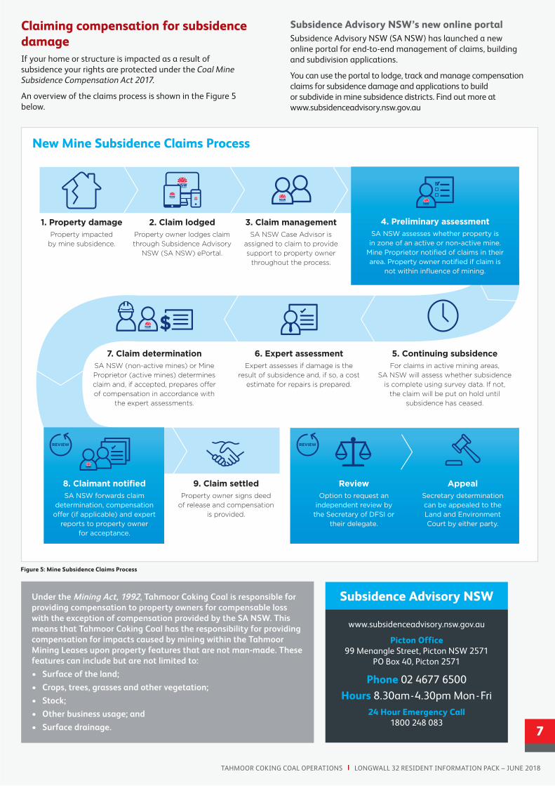
Claiming compensation for subsidence damageIf your home or structure is impacted as a result of subsidence your rights are protected under the Coal Mine Subsidence Compensation Act 2017.
An overview of the claims process is shown in the Figure 5 below.
Subsidence Advisory NSW’s new online portalSubsidence Advisory NSW (SA NSW) has launched a new online portal for end-to-end management of claims, building and subdivision applications.
You can use the portal to lodge, track and manage compensation claims for subsidence damage and applications to build or subdivide in mine subsidence districts. Find out more at www.subsidenceadvisory.nsw.gov.au
Under the Mining Act, 1992, Tahmoor Coking Coal is responsible for providing compensation to property owners for compensable loss with the exception of compensation provided by the SA NSW. This means that Tahmoor Coking Coal has the responsibility for providing compensation for impacts caused by mining within the Tahmoor Mining Leases upon property features that are not man-made. These features can include but are not limited to:
• Surface of the land;
• Crops, trees, grasses and other vegetation;
• Stock;
• Other business usage; and
• Surface drainage.
TAHMOOR COKING COAL OPERATIONS | LONGWALL 32 RESIDENT INFORMATION PACK – JUNE 2018
7
Key benefits
• A simplified, streamlined process for all claims for compensation for damage caused by mine subsidence
• All claims are managed by a SA NSW Case Advisor who will provide property owners with focused support and a dedicated point of contact throughout the process
• Property owners can track their claim and access all claim documents in a central location using a new ePortal
• Mine Proprietors have greater incentive to reduce subsidence damage
• Property owners have access to new dispute resolution options to help avoid costly litigation
www.subsidenceadvisory.nsw.gov.au
1. Property damageProperty impacted
by mine subsidence.
New Mine Subsidence Claims Process
8. Claimant notifiedSA NSW forwards claim
determination, compensation offer (if applicable) and expert
reports to property owner for acceptance.
9. Claim settled Property owner signs deed
of release and compensation is provided.
2. Claim lodgedProperty owner lodges claim through Subsidence Advisory
NSW (SA NSW) ePortal.
7. Claim determinationSA NSW (non-active mines) or Mine Proprietor (active mines) determines claim and, if accepted, prepares offer of compensation in accordance with
the expert assessments.
3. Claim managementSA NSW Case Advisor is
assigned to claim to provide support to property owner
throughout the process.
6. Expert assessmentExpert assesses if damage is the
result of subsidence and, if so, a cost estimate for repairs is prepared.
ReviewOption to request an
independent review by the Secretary of DFSI or
their delegate.
5. Continuing subsidenceFor claims in active mining areas,
SA NSW will assess whether subsidence is complete using survey data. If not,
the claim will be put on hold until subsidence has ceased.
AppealSecretary determination can be appealed to the Land and Environment Court by either party.
$
$ $ $$
$$ $
$$ $
REVIEWREVIEW
4. Preliminary assessment SA NSW assesses whether property is
in zone of an active or non-active mine. Mine Proprietor notified of claims in their area. Property owner notified if claim is
not within influence of mining.
New Mine Subsidence Claims Process
www.subsidenceadvisory.nsw.gov.au
Picton Office 99 Menangle Street, Picton NSW 2571
PO Box 40, Picton 2571
Phone 02 4677 6500
Hours 8.30am - 4.30pm Mon - Fri 24 Hour Emergency Call
1800 248 083
Subsidence Advisory NSW
Figure 5: Mine Subsidence Claims Process
8T: (02) 4640 0100 E: [email protected] W: www.tahmoorcoal.com.au
A free confidential counselling service is available for residents impacted by mining.
For further details please contact Tahmoor Coking Coal 1800 154 415.
Frequently Asked Questions
How do I find out when mining is occurring near my property?To received regular mining updates please contact the Tahmoor Coking Coal to be placed on our contact database.
What if I am a tenant?If you are a tenant, please make sure you keep your landlord or managing agent informed if you notice any changes to your property that may be from mine subsidence.
Alternatively, if you receive information regarding your property from either Tahmoor Coking Coal or the SA NSW and you are a tenant please forward the information onto your landlord or managing agent.
It is important that not only the tenant receives information, but the owner and / or Managing Agent is also kept informed about mining operations.
What are the advantages of a pre-mining inspection? The purpose of a PMI is to determine the condition of a property prior to mining. PMIs are an added protection for property owners to ensure they receive adequate compensation to return their property to its pre-mining condition should it be impacted by subsidence.
How do I arrange a pre-mining inspection?To request a PMI simply contact Tahmoor Coking Coal. An inspection time will then be arranged with you.
What if I don’t have access to the internet or a computer to lodge a claim online? SA NSW will continue to accept claims for compensation and development applications in hardcopy. You can lodge hardcopy applications with SA NSW over the counter at its Picton office or via post.
Who managers my claim?All claims are managed by a SA NSW Case Advisor who will provide property owners with focused support and a dedicated point of contact throughout the process.
How to stay in touch & update to date with the latest informationContact Us: 1800 154 415
Email: [email protected]
Web: www.tahmoorcoal.com.au
Tahmoor Coking Coal Operations Environment and Community team:
• Ron Bush Environment & Community Manager
• Belinda Clayton Community Coordinator
• Fiona Robinson Environmental Coordinator
• Sam Beresford Environment & Community Officer
• Dave Talbert Project Manager
Emergency Numbers
Fire 000
Ambulance 000
Police 000
Gas 131 909
Electricity 131 002
Sydney Water 131 090
Telstra 132 203