low c-swapwell clear trade study preliminary results · •investigate trade space for detect and...
TRANSCRIPT

LowC-SWaP WellClearTradeStudyPreliminaryResults
UAS INTEGRATION IN THE NAS5 December,2017
GilbertWuSeungman LeeDevinJack
https://ntrs.nasa.gov/search.jsp?R=20170011691 2018-07-17T11:57:37+00:00Z
• Investigate trade space for Detect and Avoid (DAA) Well Clear definition for UAS with low cost, size, weight, and power (Low C-SWaP) sensors that detect and track non-cooperative aircraft• Recommend candidate DAA Well Clear (DWC) definition(s)
for the SC-228 to consider
Objectives
2

• Between non-cooperative aircraft and UAS with low C-SWaPsensors that are– Below 10,000 ft and above 500 ft AGL– During extended operations in classes D, E (non-terminal), or G (non-
terminal), or– During transit operations in classes B and C – For UAS within a certain speed range
ScopeofDWCApplicability
3

• Preliminary Results: December 5, 2017 at SC-228 F2F• Final results: February 20, 2018
Schedule
4

PerformanceMetrics
5
• Unmitigated collision risk– The probability of a near mid-air collision (NMAC) given a loss of DWC
– Denoted as P(NMAC|LoWC)
• Maneuver initiation point– Latest point for ownship to maneuver to maintain DWC
• Bearing, elevation, range, and closure rate distribution of intruders at the Loss of Well Clear (LoWC)
• CPA miss distance/time given LoWC
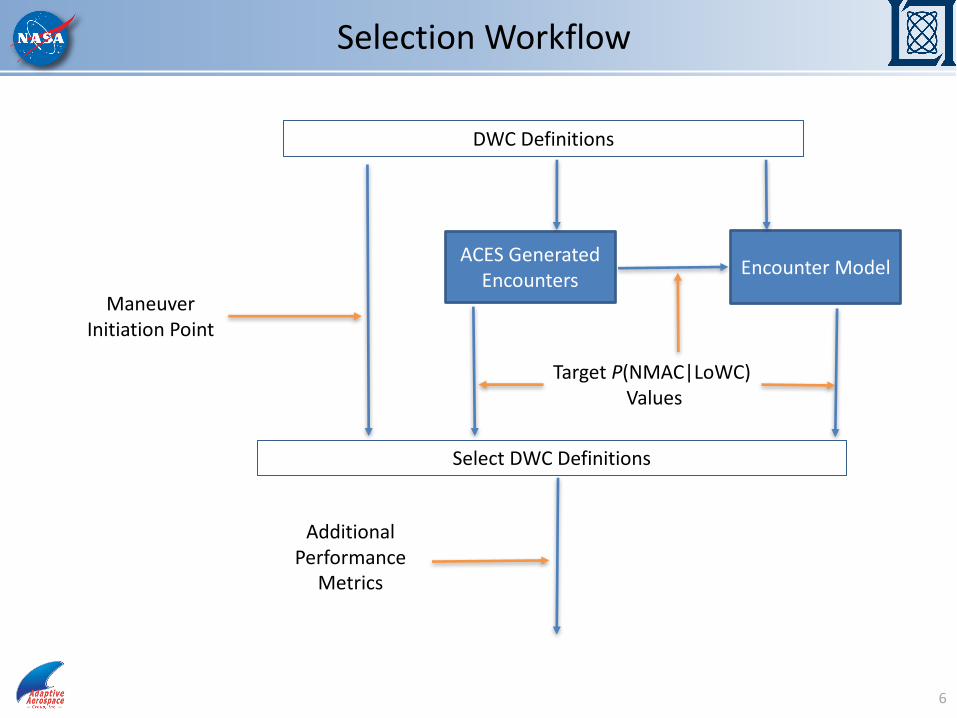
SelectionWorkflow
6
ACESGeneratedEncounters EncounterModel
DWCDefinitions
TargetP(NMAC|LoWC)Values
SelectDWCDefinitions
ManeuverInitiationPoint
AdditionalPerformance
Metrics

• DWC types and threshold values (* for threshold)– DWC1: h*, HMD*, modTau*– DWC2: h*, HMD*, tpz*– DWC3: Static hockey puck: h*, R*– DWC4: Dynamic hockey puck: h*, R*(rdot) = a* + rdot x b*
DWCDefinitions
7
Type h*(ft) HMD*(ft) modTau*(sec)DWC1 450 [1000,9000] [0,35]
Type h*(ft) HMD*(ft) Tpz*(sec)DWC2 450 [1000,9000] [0,35]
Type h*(ft) R*(ft)DWC3 450 [1000,9000]
Type h*(ft) a*(ft) b*(sec)DWC4 450 [1000,6000] [0,20]

ACESGeneratedEncounters
8

• 3.3millionencounters– betweenprojectedUAStrajectoriesandrecordedVFRtrafficfrom21daysinyear2012– Cooperativeaircraftregardedassurrogatesofnon-cooperative
• About60%oftheencountersareconsidered“lowC-SWaP”• 708NMACs(forlowC-SWaP)• NumberofLoWCs varies
ACESEncountersConsidered
9
UAS VFR

Prob
abilit
y
0.05
0.10
0.15
0.20
0.25
0.30
0.35
0.40
0.45
20 30 40 50 60 70 80 90 100 120 140 160 180 200 220 240Ownship Airspeed (knots)
SpeedDistributionofOwnship
10

Prob
abilit
y
0.02
0.04
0.06
0.08
0.10
0 20 40 60 80 100 140 180 220 260 300 340 380 420 460Intruder Airspeed (knots)
SpeedDistributionofIntruder
11

Prob
abilit
y
0.03
0.05
0.08
0.10
0.13
0.15
0 1000 3000 5000 7000 9000 11000 13000 15000 17000 19000Ownship Alittude (MSL)
AltitudeDistributionofOwnship
12

Prob
abilit
y
0.03
0.05
0.08
0.10
0.13
0.15
0 1000 3000 5000 7000 9000 11000 13000 15000 17000Intruder Altitude (MSL)
AltitudeDistributionofIntruderVFRAircraft
13

ExperimentalMatrix
• Modified Tau DWC– Total 45 settings– ModTau threshold (5 levels): 0, 8, 15, 25, 35 (sec)– HMD threshold (9 levels): 1000, 1500, 2000, 2500, 3000, 3500, 4000,
6500, 9000 (ft.)– Altitude threshold (1 level): 450 (ft)
• Time to Protected Zone (TPZ) DWC• Static Cylinder DWC• Dynamic Cylinder DWC
14

• P(NMAC|LoWC) is between 2% and 5%– Phase 1 P ~ 2.2%– Previous Lincoln Lab work recommended 5%
• Maneuver initiation point range as small as possible
TargetMetricValues
15

0.010.01
0.020.02
0.020.02
0.020.020.02
0.030.03
0.030.03
0.030.030.03
0.040.04
0.040.04
0.040.040.04
0.050.05
0.050.05
0.050.050.05
0.060.06
0.060.060.060.060.06
0.070.070.070.07
0.070.070.07
0.080.08
0.080.080.080.080.08
0.090.090.090.090.09
0.10.10.10.10.110.110.11
0.12
0 5 10 15 20 25 30 35
Modified Tau Threshold (sec)
1000
2000
3000
4000
5000
6000
7000
8000
9000
HM
D T
hres
hold
(ft)
Unmitigated Conditional Collision Risk
UnmitigatedCollisionRiskP(NMAC|LoWC)
16
P=2%
P=5%
ManeuverInitiationPoint
17

ManeuverInitiationPoint
18
IntruderOwnship
TurnRate(deg/sec)
τ234
• 2PAIRS• Head-on, co-altitude encounter• Only horizontal maneuver is considered• Constant roll rate, steady-state turn rate, ownship speed, and intruder speed• 𝑟𝑎𝑛𝑔𝑒 = 𝑓 𝐷𝑊𝐶, 𝑜𝑤𝑛𝑠ℎ𝑖𝑝𝑠𝑝𝑒𝑒𝑑, 𝑖𝑛𝑡𝑟𝑢𝑑𝑒𝑟𝑠𝑝𝑒𝑒𝑑• UAS (Ownship) speed 40 to 100 kts• Turn rate 6 deg/s (3 and 12 deg/s results also looked at)

“SweetSpot”
19
P=5%
Blow-up
P=5%

• “Sweetspot”HMD*2000to2500ft,modTau 0to15sec– P(NMAC|LoWC)~ 5%– Maneuverinitiationrange~2nmi (given6deg/sturnrate)– ComparedtolowC-SWaP radarrangethatmaybebelow3nmi
• Tofurtherreducerangerequirements,wemay– Goabove5%forP(NMAC|LoWC)– Requireahigherturnrateat40kts (e.g.,12deg/s)– Increaseminimumownship speedfrom40kts– Mandateaminimumturnspeed>40kts forownship
• Otherconsiderations– Rangeandbearingdistributiontrade-off
Summary
20

• ACESencounteranalysis– Applyadditionalfilters– Analyzeadditionalperformancemetrics– AnalyzeresultsfromotherDWCtypes– AnalyzeresultsfromPhase1UAS(speedandaltitude)
• Encountermodel– ParallelworktoACESanalysis– ComparisontoACESresultsforvalidation
• CandidateDWCdefinitionsforfurtherevaluations– Mayproposemorethanone(possiblytwo)definitionsvaryingbyP
values• Fasttimesimulation2foralertingandsensor(May2018)• HITLforlowC-SWaP (Nov.2018)
NextSteps
21

BackupSlides
22
EncounterModel
23

• Assumptions– Phase 1 VFR traffic
– Same encounter set used to define SARP WCV definition• Enables comparison with previous results
– Encounters are between two aircraft, where one or both aircraft do not have transponders, or both are VFR (1200 code)
– Looking at full encounter set (<300 kts) and subset of encounters with speeds < 100 kts
UncorrelatedEncounterModel
24
Resultsarepreliminary.Noconclusionsshouldbedrawnfromtheresultsuntiltheycanbefurtheranalyzedandunderstood.

• DWC3– P(NMAC|LoWC) vs. R* using ACES– P(NMAC|LoWC) vs. R* using the encounter models
PreliminaryComparisonResults
25
Thresholdfortauis5secforencountermodel
results
CollisionRisk:0.02~0.05
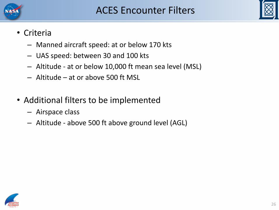
• Criteria– Mannedaircraftspeed:atorbelow170kts– UASspeed:between30and100kts– Altitude- atorbelow10,000ft meansealevel(MSL)– Altitude– atorabove500ft MSL
• Additionalfilterstobeimplemented– Airspaceclass– Altitude- above500ft abovegroundlevel(AGL)
ACESEncounterFilters
26

27

28

29

30

• Can Phase 1 UAS have an alternative DWC for non-cooperative aircraft? Can a single DWC be defined for both Phase 1 UAS and low C-SWaP UAS (for non-cooperative aircraft)?
AdditionalConsiderations
31

• Well clear trade study (Fast Time 1)– Preliminary Results briefing: December 5, 2017 at SC-228 F2F– Final results briefing: February 20, 2017
• Alerting and surveillance uncertainty (Fast Time 2) – Planning starts in December 2017– Data collection May 2018– Final results September 2018
• HITL – Planning starts in April 2018– Data collection October 2018– Final results February 2019
• Closed loop (Fast Time 3)– Planning January 2019– Data collection June 2019– Final results November 2019
SelectSimulationSchedule
32

VFRTraffic• 21daysacross4seasonsin2012(24hourseachday)
• MannedIFRdata:ASDI(AirspaceSituationDisplaytoIndustry)• MannedVFRdata:84th RadarEvaluationSquadron(RADES)AirDefenseRadarData– Bothcooperativeandnon-cooperativeVFRtrafficthatsatisfyspeedrange
(<170kts)andtargetairspace(<10,000ft andnon-terminaloperations)willbeused
33
January 2012 Su M Tu W Th F Sa 1 2 3 4 5 6 7 8 9 10 11 12 13 14
15 16 17 18 19 20 21 22 23 24 25 26 27 28 29 30 31
April 2012 Su M Tu W Th F Sa 1 2 3 4 5 6 7 8 9 10 11 12 13 14
15 16 17 18 19 20 21 22 23 24 25 26 27 28 29 30
July 2012 Su M Tu W Th F Sa 1 2 3 4 5 6 7 8 9 10 11 12 13 14
15 16 17 18 19 20 21 22 23 24 25 26 27 28 29 30 31
October 2012 Su M Tu W Th F Sa
1 2 3 4 5 6 7 8 9 10 11 12 13
14 15 16 17 18 19 20 21 22 23 24 25 26 27 28 29 30 31

UASMissions
34
Number MissionTypes Airspace UASGroup CruiseAltitude CruiseSpeed(KTAS) FlightPattern
1 AerialImagingandMapping
Flightsdepartfromandreturntoaregional
airportlocatedwithin40nmi.ofOEP35
airports;ClassD,E,andG(includingModeC
Veil)withClassBorCtransition
AerosondeMk4.7 3000ft.AGL 44to51Radiator-gridpatternor
circularpattern
2 AirQualtiyMonitoring
Flightsdepartfromandreturntoaregional
airportlocatedwithin40nmi.ofOEP35
airports;ClassD,E,andG(includingModeC
Veil)withClassBorCtransition
Shadow-B
(RQ7B)/NASASierra
4k,5k,and6kft
AGL74to89 Radiator-gridpattern
3 AirbornePathogenTracking
Flightsdepartfromandreturntoaregional
airportlocatedwithin40nmi.ofOEP35
airports;ClassD,E,andG(includingModeC
Veil)withClassBorCtransition
Shadow-B
(RQ7B)/NASASierra
3,000ft.,5,000ft.
and10,000ft.AGL72to97 Radiator-gridpattern
4 FloodInund.Mapping
Flightsdepartfromandreturntoaregional
airportlocatedwithin40nmi.ofOEP35
airports;ClassD,ModeCVeil,E,andG
AerosondeMk4.7 4,000ft.AGL 46to51 Gridpattern
5 FloodStreamFlow
Flightsdepartfromandreturntoaregional
airportlocatedwithin40nmi.ofOEP35
airports;ClassD,ModeCVeil,E,andG
AerosondeMk4.7 4,000ft.AGL 46to51Gridpatternand/or
alongstreamdirection
6 LawEnforcement
Flightsdepartfromandreturntoaregional
airportlocatedwithin40nmi.ofOEP35
airports;ClassD,E,andG(includingModeC
Veil)withClassBorCtransition
AerosondeMk4.7 3,000ft.AGL 44to51
Threetypesofpattern:
1)gridpattern,2)
random,3)outward
spirial
7 PointSourceEmission
Flightsdepartfromandreturntoaregional
airportlocatedwithin40nmi.ofOEP35
airports;ClassD,ModeCVeil,E,andG
Shadow-B 3,000ft.AGL 72to80Gridpatternand/or
alongstreamdirection
8 SpillMonitoring
Flightsdepartfromandreturntoaregional
airportlocatedwithin40nmi.ofOEP35
airports;ClassD,ModeCVeil,E,andG
Shadow-B/Sierra3,000ft.to13,000
ft.AGL72to93
Upanddown-wind
flightsinaradiator-grid
pattern,Round-the-
clock
9 TacticalFireMonitoring
Flightsdepartfromandreturntoaregional
airportlocatedwithin40nmi.ofOEP35
airports;ClassD,E,andG(includingModeC
Veil)withClassBorCtransition
ScanEagle/Shadow-B 3,000ft.AGL 72to75
Circularflightpath
followingtheperimeter
ofawildfire
10 TrafficMonitoring
Flightsdepartfromandreturntoaregional
airportlocatedwithin40nmi.ofOEP35
airports;ClassD,E,andG(includingModeC
Veil)withClassBorCtransition
Shadow-B 1,500ft.AGL 58to84Geo-spatialmonitoring
flightpath
11 WildlifeMonitoring
Flightsdepartfromandreturntoaregional
airportlocatedwithin40nmi.ofOEP35
airports;ClassD,ModeCVeil,E,andG
AerosondeMk4.7 3,000ft.AGL 44to51 Radiator-gridpattern
12 NewsGathering
Flightsdepartfromandreturntoaregional
airportlocatedwithin40nmi.ofOEP35
airports;ClassD,E,andG(includingModeC
Veil)withClassBorCtransition
AerosondeMk4.71,500ft.to3,000
ft.AGL44to51
Random-path:e.g.,
police-chase;Circular
orbit:

VFRIntruderTraffic
• Itisassumedthatunmannedaircraftwillbeequippedwithonboardradar,activesurveillancetransponder(ModeC/S),andADS-Bsurveillancesystemtodetectcooperativeandnon-cooperativeintruderaircraft.
• Typesofintruderswithdifferentequipage– IntrudersoperatingunderIFR(Coopeative)– IntrudersoperatingunderVFR(CooperativeandNon-cooperative)
35
IntruderAircraft Transponder Equipage Percentage
Cooperative AC 1 ADS-B Out(1090orUAT) 71%*CooperativeAC2 Mode C transponderOnly 14%*Non-CoopAC NoTransponder(orModeA
transponder)15%*
*BasedonOSEDdocument:TableA-1.IntruderEquipageAssumptionsPost-2020

SimulationPlatform
• VariousrealisticencountersbetweenUASandIFR/VFRmannedtrafficincivilairspace– MannedIFRtraffic:ASDI(AirspaceSituationDisplaytoIndustry)data– Historicalcooperativeandnon-cooperativeVFRtraffic
• The84thRaderEvaluationSquadron(RADES)data– ProposedUASFlights
• 12differenttypesofUASmissionsgeneratedbyIntelligentAutomationInc.
• UASDAAAlertingandGuidanceSystem[JADEM]– Higherfidelitysurveillancemodel:Honeywellsensormodels– DAIDALUSDAAalertingandguidancealgorithm
36
• Airspace Concept Evaluation System (ACES) and JADEM Fast-time Simulation Framework– Simulate NAS-wide air
traffic operations of UAS, IFR, and VFR traffic

CooperativeTraffic
37