lower north thompson community forest society
TRANSCRIPT

1
Lower North Thompson Community Forest Society
FOREST STEWARDSHIP PLAN
Community Forest Agreement K1Z
FSP Term: 5 Years (commencing 2020)
FSP ID# TBD

2
Table of Contents
1.0 ADMINISTRATION AND INTERPRETATION ......................................................................... 4
1.1 Definitions .................................................................................................................................... 4
1.2 Relevant Date for Legislation and Objective References ................................................................. 6
1.3 Definition from Legislation .............................................................................................................. 6
1.4 Changes to Legislation ...................................................................................................................... 7
1.5 Expressions Inclusive........................................................................................................................ 7
1.6 Organization ...................................................................................................................................... 7
1.7 Headings and Preamble..................................................................................................................... 7
1.8 Appendices Part of FSP .................................................................................................................... 7
1.9 Application of Results and Strategies ............................................................................................... 7
1.10 Conditional Exemptions under FPPR section 12 ............................................................................ 8
2.0 TERM ............................................................................................................................................. 8
2.1 Date of Submission ........................................................................................................................... 8
2.2 Term .................................................................................................................................................. 8
2.3 Commencement of Term .................................................................................................................. 8
3.0 APPLICATION .............................................................................................................................. 9
3.1 Application to Agreements and Holders of Agreements .................................................................. 9
3.2 Dis-application of FSP ...................................................................................................................... 9
3.3 Cutblocks or Roads Approved under a Previous FSP ...................................................................... 9
4.0 FOREST DEVELOPMENT UNITS .............................................................................................. 9
4.1 Forest Development Units ................................................................................................................ 9
4.2 Identifying Required Values within Forest Development Units..................................................... 10
5.0 RESULTS AND STRATEGIES................................................................................................... 10
5.1 Timber ............................................................................................................................................. 10
5.2 Soils................................................................................................................................................. 10
5.3 Wildlife - FPPR section 7(1) Species at Risk and KHLPO Wildlife Objectives............................ 11
5.4 Water, Fish, Wildlife and Biodiversity within Riparian Areas ....................................................... 15
5.5 Retention of Trees in a Riparian Management Zone ...................................................................... 16
5.6 KHLPO Riparian Management Areas and Inland Fisheries ........................................................... 17
5.7 KHLPO Water Management ........................................................................................................... 18
5.8 Fisheries Sensitive Watersheds ....................................................................................................... 19
5.9 Wildlife and Biodiversity – Landscape Level ................................................................................ 21

3
5.10 Wildlife and Biodiversity – Stand Level ...................................................................................... 22
5.11 Old Growth Management ............................................................................................................. 24
5.12 Visual Quality ............................................................................................................................... 25
5.13 Cultural Heritage Resources ......................................................................................................... 26
5.14 KHLPO Archaeological Assessments .......................................................................................... 28
5.15 Interpretive Forest Sites, Recreation Sites or Recreation Trails ................................................... 29
5.16 KHLPO Range .............................................................................................................................. 29
6.0 MEASURES ................................................................................................................................. 30
6.1 Invasive Plants ................................................................................................................................ 30
6.2 Natural Range Barriers ................................................................................................................... 33
7.0 STOCKING STANDARDS ......................................................................................................... 34
7.1 Establishment of Free Growing Stands........................................................................................... 34
7.2 Definitions....................................................................................................................................... 34
7.3 Stocking Standards FDU #1-K1Z ................................................................................................... 35
8.0 Signatures ...................................................................................................................................... 40
8.1 Signature of Preparing Forester ...................................................................................................... 40
8.2 Signature of Person Required to Prepare the Plan .......................................................................... 40
APPENDICES .......................................................................................................................................... 41
Appendix A – Stocking Standards ........................................................................................................ 41
Appendix B – Forest Stewardship Plan Map by FDU .......................................................................... 45
Appendix C – Notice, Review and Comment ....................................................................................... 46

4
1.0 ADMINISTRATION AND INTERPRETATION
1.1 Definitions
Definitions appearing in the body of this FSP are presented in italics for ease of recognition.
In this FSP, unless this FSP specifies, or the context requires otherwise:
1. “Act” means the Forest and Range Practices Act RSBC 2002, c.69;
2. “adjacent” as defined in FPPR 65(1) means “an area that is sufficiently close to a cutblock that, due to its
location, could directly impact on, or be impacted by, a forest practice carried out within the cutblock”;
3. “agreement” means an agreement listed in Paragraph 3.1, unless this FSP no longer applies to that
agreement;
4. “agreement holder” is defined in FPPR section 1 and “means a holder of an agreement under the Forest
Act, other than a woodlot licence” and for the purpose of this FSP, applies to the agreement holders listed
in Paragraph 3.1, or any successor or assignee of that agreement, unless this FSP no longer applies to that
agreement holder;
5. “applicable SAR notice” means
i. The undated document entitled “BACKGROUND INFORMATION FOR WILDLIFE HABITAT
FOR SPECIES AT RISK OBJECTIVES UNDER THE KAMLOOPS LAND AND RESOURCE
MANAGEMENT PLAN, IN THE KAMLOOPS FOREST DISTRICT”.
6. “BEC” means Biogeoclimatic Ecosystem Classification;
7. “CP” means a Cutting Permit;
8. “current” means, in the context of a FSP, timber sale licence, CP or RP, an approved document that has
not expired or been replaced;
9. “cutblock” means an area:
i. in which a holder of a Licence has harvested timber under a CP or timber sale licence; or
ii. in which a holder of a Licence is authorized to harvest timber but where harvesting has not
occurred;
10. “dbh” means diameter breast height, a standard method of expressing the diameter of the bole of a tree,
generally measured at a height 1.3 metres above the point of germination.
11. “established cutblock” means a cutblock that has been:
i. harvested under a licence to which this FSP applies;
ii. declared under this FSP;
iii. included within a current CP issued under a licence to which this FSP applies, whether the CP is
or is not subject to this FSP; or
iv. identified spatially in the BC Geographic Warehouse as a cutblock:
a) harvested under a timber sale licence or major licence to which this FSP does not apply;
or
b) included in a timber sale licence or current CP issued under a major licence to
which this FSP does not apply.
12. “established road” means a road that has been:
i. constructed under a CP or RP issued under or associated with a licence to which this FSP applies;
ii. declared under this FSP;
iii. included within a current CP or RP issued under or associated with a licence to which this FSP
applies, whether the CP or RP is or is not subject to this FSP;
iv. identified spatially in the BC Geographic Warehouse as a road:
a) constructed by a person other than a holder of this FSP; or
b) included within a CP or RP issued in respect of a Licence to which this FSP does
not apply.
13. “FDU” means a Forest Development Unit;

5
14. “Forest Act” means the Forest Act R.S.B.C. 1996, c.157;
15. “forested area” means an area of crown forest identified in the VRI as contributing to the forest
management land base, as indicated by the Forest Management Land base Indicator attribute. This
attribute indicates whether a polygon is forested or has been forested and is capable of producing a stand
of trees. Polygons classified as lakes, rock, alpine, shrub and wetland are not considered forested area.
16. “FPC” means the Forest Practices Code of British Columbia Act R.S.B.C. 1996, c. 159 and all
regulations there under;
17. “FPPR” means the Forest Planning and Practices Regulation B.C. Reg. 14/2004;
18. “FRPA” means the “Act” and the regulations there under;
19. “FSP” means a Forest Stewardship Plan;
20. “FSP holder” or “holder” means the agreement holders listed in Paragraph 3.1, or any successor or
assignee of that agreement, unless this FSP no longer applies to that agreement holder;
21. “GAR” means the Government Actions Regulation B.C. Reg. 582/2004;
22. “government” means the government of British Columbia;
23. “height” means the average height of a specified forested area, as confirmed by VRI data or a survey that
is available to or completed by the FSP holder.
24. “initial silviculture activities” means, for the following activities on a cutblock, the activity that is
completed last:
i. site preparation;
ii. debris pile burning; or
iii. initial reforestation, including tree planting or direct seeding.
25. “KHLPO” means the Kamloops Higher Level Plan Order, established pursuant to section 93.4 of the
Land Act, and dated Jan 8, 2009;
26. “KLRMP” means the Kamloops Land and Resource Management Plan;
27. “legislated planning date” means:
i. subject to Clause (ii), the date 4 months before the December 15, 2019 date of submission; or
ii. if an enactment or an objective set by government requires that a date different than the date
referred to in Clause (i) be applied under this FSP, then that different date;
28. “licence” means an agreement under the Forest Act;
29. “major licence” has the meaning given to it under the Forest Act;
30. “minister” means the minister responsible for the Forest Act;
31. “net area to reforest” or “NAR” has the meaning given to it in FPPR section 1 (2);
32. “OGMA” means an Old Growth Management Area as defined in Paragraphs 5.11.1.1, 5.11.3.1, and
5.11.4.1;
33. “practicable” means that which is feasible or performable in the circumstances, when the balance of all
relevant factors (such as environment, social, economic, safety, usefulness) is considered;
34. “primary forest activity” has the meaning given to it in FPPR section 1, and “means one or more of the
following:
i. timber harvesting;
ii. silviculture treatments; or
iii. road construction, maintenance and deactivation”;
35. “proposed wildlife habitat area” means an area that is:
i. located outside of an established cutblock or established road; and
ii. identified by the ministry responsible for environment in a review and comment referral package
provided to the FSP holder not less than 12 months prior to a cutting authority application or
amendment over that area, as being under consideration for establishment as a wildlife habitat
area;
36. “qualified professional” means a registered member in good standing with a professional association
whose training, ability and experience makes the member professionally competent in the relevant area of
practice;

6
37. “range agreement” means a grazing tenure held by a range agreement holder and issued under the Range
Act or Land Act. Spatial and attribute data for range agreements are housed in the BC Geographic
Warehouse.
38. “road” has the meaning given to it in FPPR section1;
39. “RP” means a road permit;
40. “safety hazard” means a situation or circumstance the holder determines to be a potential source of harm
to workers based on WorkSafe BC regulations and policies, or the general public. Safety hazards include
but are not limited to danger trees (snags), inadequate visibility, falling objects, steep slopes, or unstable
terrain;
41. “scenic area” has the meaning given to it under FPPR section 1;
42. “timeline” means, in regards to a FSP result or strategy referral provided by the FSP holder to a First
Nation or stakeholder, the length of time specified in the referral that provides a reasonable opportunity
for review and response. A referral response must be received by the FSP holder within the timeline
specified in the referral in order to be considered as part of the result or strategy. The timeline will be:
i. 60 days for First Nations;
ii. 30 days for stakeholders; or
iii. another length of time where agreed to with a First Nation or stakeholder, or as indicated in a
notice published in a newspaper.
43. “TSA” means a timber supply area;
44. “VRI” means Vegetation Resource Inventory, the photo-based inventory data of the BC provincial forest
which is housed in the BC Geographic Warehouse. The VRI data that is relevant to specific FSP results or
strategies is the version of VRI that is available not less than 18 months prior to cutting authority
application or amendment;
45. “wildlife habitat area” or “WHA” as defined in FPPR section1 “means a wildlife habitat area
i. continued under section 180 (b) [grandparenting specified designations] of the Act, or
ii. established under the Government Actions Regulation”.
1.2 Relevant Date for Legislation and Objective References
In this FSP, unless this FSP specifies otherwise, reference to:
a) legislation;
b) an established objective;
c) a notice under FPPR section 7(2):
d) the designation of a species to which such a notice or established objective applies;
e) the establishment of an area referred to in FPPR section 14(3)(a) to (i); or
f) an order made by government
means that legislation, established objective, notice, designation, area or order as it existed on the legislated
planning date, unless it is repealed or cancelled, in which case the reference to that legislation, notice, designation,
objective or order does not apply.
1.3 Definition from Legislation
In this FSP, unless this FSP specifies, or the context requires otherwise, words and phrases defined in FRPA or
the Forest Act and the regulations under them have the same meaning as those definitions, as they were on the
Legislative Planning Date.
7
1.4 Changes to Legislation
Subject to Paragraph 1.2, if legislation referred to in this FSP is renamed or a provision of legislation referred to
in this FSP is renumbered, the reference in this FSP is to be construed as a reference to the provision as renamed
or renumbered, as the case may be.
1.5 Expressions Inclusive
In this FSP, unless this FSP specifies, or the context requires otherwise:
a) the singular includes the plural and the plural includes the singular; and
b) the masculine, the feminine and the neuter are interchangeable and each includes the body corporate.
1.6 Organization
This FSP is divided into parts, paragraphs, subparagraphs, clauses, sub-clauses and sections, illustrated as follows:
1. Part;
1.1 Paragraph;
(a) Subparagraph;
(i) Clause;
(A) Sub-clause;
(I) Section,
and a reference to a subparagraph, clause, sub-clause or section is to be construed as a reference to a
subparagraph, clause, sub-clause or section of the paragraph, subparagraph, clause or sub-clause, as the case may
be, in which the reference occurs.
1.7 Headings and Preamble
The headings and Preamble in this FSP are for ease of reference only and are not to be construed as part of this
FSP.
1.8 Appendices Part of FSP
The Appendices to this FSP are a part of this FSP and any reference in this FSP to this FSP includes a reference to
the Appendices.
1.9 Application of Results and Strategies
Each result and strategy in this FSP applies to an area that is subject to a CP or RP held by an agreement holder.
Notwithstanding the foregoing, in a proceeding in respect of an alleged failure to achieve a result or carry out a
strategy, the result or strategy applies only to the agreement holder whose CP or RP is located in the area subject
to the proceeding.

8
1.10 Conditional Exemptions under FPPR section 12
The FSP holder is exempt from the FPPR practice requirement sections specified in Table 1.10 by including an
applicable result or strategy in this approved FSP:
Table 1.10 Conditional Exemptions
Paragraph in this
FSP
FPPR section providing
Exemption
FPPR Practice Requirement section to which the Exemption
Applies
5.2.1 12.2(1) 35 (adopted in strategy)
5.2.1 12.2(2) 36 (adopted in strategy)
5.4.1 12.3(1) 47(4) to (6) (adopted in strategy)
5.4.1 12.3(2) 48(30 to (5) (adopted in strategy)
5.4.1 12.3(3) 49(2) (replaced by strategy)
5.4.1 12.3(3) 49(3) (adopted in strategy)
5.4.1 12.3(4) 50(1) (adopted in strategy)
5.4.1 12.3(5) 51(1) and (3) (adopted in strategy)
5.4.1 12.3(6) 52(2) (adopted in strategy)
5.4.1 12.3(7) 53 (adopted in strategy)
5.9.2 12.4(1) 64(1) (adopted in strategy)
5.9.2 12.4(2) 65(2) (replaced by strategy)
5.10.2 12.5(1) 66 (replaced by strategy)
5.10.3 12.5(2) 67 (replaced by strategy)
2.0 TERM
2.1 Date of Submission
The date of submission of this FSP for approval is December 15, 2019.
2.2 Term
For the purposes of section 6(1) (a) of the Act, the term of this FSP is 5 years, commencing on the date specified
in Paragraph 2.3 unless:
a) the holders of this FSP elect to replace it with another approved FSP; or
b) it is extended pursuant to FRPA.
2.3 Commencement of Term
For the purposes of section 6(1) (b) of the Act, the term of this FSP commences on the date of approval by the
Delegated Decision Maker (DDM), or another date as specified by the DDM.

9
3.0 APPLICATION
3.1 Application to Agreements and Holders of Agreements
For the purposes of FRPA section 3(4), this FSP applies to each cutting permit issued and each road permit
granted:
a) on or after the date the term of this FSP commences, as specified in Paragraph 2.3;
b) within an FDU; and
c) in respect of the agreements under the Forest Act and the agreement holders specified in Table 3.1.
Table 3.1 FSP Agreement Holders and Agreements
FDU Number FDU Name Agreement Holder Forest Act Agreement
1 K1Z Lower North Thompson Community
Forest Society
Community Forest Agreement
K1Z
3.2 Dis-application of FSP
At any time during the term of this FSP, an agreement holder may elect to dis-apply this FSP from an agreement
it holds, as specified in Paragraph 3.1.
3.3 Cutblocks or Roads Approved under a Previous FSP
Consistent with FRPA section 21(2), cutblocks or roads approved under a previous FSP or FDP will be subject to
this FSP for a result or strategy under Part 5, a measure under Part 6 or a stocking standard under Part 7 if an
amendment to the cutblock or road site plan states that the application of the current FSP provision applies.
4.0 FOREST DEVELOPMENT UNITS
4.1 Forest Development Units
For the purposes of the FRPA section 5(1)(a)(ii) and FPPR section 14(1)(a), the FDUs that apply to agreement
holder and agreement specified in Paragraph 3.1 are indicated in Table 4.1 and shown on the Forest Stewardship
Plan Map in Appendix B to this FSP.
Table 4.1 Forest Development Units
FDU Number FDU Name Description
1 K1Z Community Forest Agreement K1Z Area, including
several buffer areas along the boundary to facilitate
future access requirements and the potential need for
salvage.

10
4.2 Identifying Required Values within Forest Development Units
For the purposes of FPPR sections 14(2) and (3), Table 4.2.1 and the Forest Stewardship Plan Map in Appendix B
to this FSP identify the things referred to in those sections that are in the FDU and in effect as of the legislated
planning date. These items include: ungulate winter range, fisheries sensitive watershed, scenic area, old growth
management area, and cutting permits and road permits that are held by the agreement holder if that is the person
required to prepare the plan.
Table 4.2.1 Cutting Permits and Road Permits held by the agreement holder that is the person required to
prepare the plan, and are in effect as of the legislated planning date
FDU # Licence Cutting Permit/Road Permit
1 K1Z CP 9
RP R16473
5.0 RESULTS AND STRATEGIES
5.1 Timber
Source of Objective: FPPR section 6 Timber
The objectives set by government for timber are to
a) Maintain or enhance an economically valuable supply of commercial timber from British Columbia’s forests,
b) Ensure that delivered wood costs, generally, after taking into account the effect on them of the relevant
provisions of this regulation and of the Act, are competitive in relation to equivalent costs in relation to regulated
primary forest activities in other jurisdictions, and
c) Ensure that the provisions of this regulation and of the Act that pertain to primary forest activities do not
unduly constrain the ability of a holder of an agreement under the Forest Act to exercise the holder’s right under
the agreement.
Applicable FDUs: #1-K1Z
Consistent with FPPR section 12(8), the FSP holder is exempt from the requirement to prepare a result or strategy
for the objectives set by government for timber.
5.2 Soils
Source of Objective: FPPR section 5 Soils
The objective set by government for soils is, without unduly reducing the supply of timber from British
Columbia's forests, to conserve the productivity and the hydrologic function of soils.
Applicable FDUs: #1-K1Z
5.2.1 Result or Strategy for Soils
Applicable FDUs: #1-K1Z

11
In relation to the objective set by government for soils that is set out in section 5 of the FPPR, the FSP holder
adopts as a strategy, FPPR section 35 (Soil disturbance limits) and FPPR section 36 (Permanent access structure
limits) as those sections were on the legislated planning date
of this FSP.
5.3 Wildlife - FPPR section 7(1) Species at Risk and KHLPO Wildlife Objectives
5.3.1 KHLPO Moose
Source of Objective: KHLPO section 2.1.12.2
[a] Maintain thermal and visual cover for moose, and enhance browse production.
[b] Maintain suitable forest cover attributes with respect to thermal cover and forage production.
Applicable FDUs: #1-K1Z
5.3.1.1 Definitions
For the purposes of this result or strategy:
“critical moose winter range” means, within FDU #1, the area identified as Critical Moose Winter Range on Map
1: Critical Deer & Moose Winter Range for Kamloops Higher Level Plan of the Kamloops Higher Level Plan
Order, dated January 8, 2009.
“moose habitat key element” means a W1, W2, W3 or W5 wetland, or a L1-A, L1-B, L2, L3 or L4 classified
lake.
“moose management unit” means an area consisting of a moose habitat key element and a 200 metre (slope
distance) zone applied to the outside edge of a moose habitat key element, inclusive of the riparian management
area associated with the moose habitat key element.
“visual screen” means vegetation and/or topography that partially or completely obstructs the view from a road
surface into an adjacent area.
“moose forage” means palatable species of plants that are a food source for moose, including willow (Salix spp.),
birch (Betula spp.) and Red-osier dogwood (Cornus stolonifera).
5.3.1.2 Result or Strategy for KHLPO Moose
Applicable FDU: #1-K1Z
In relation to the objectives set by government for moose in the KLRMP area, where the FSP holder harvests a
cutblock, constructs a road or conducts silviculture treatments within critical moose winter range, the FSP holder
will:
1. at the conclusion of harvesting that cutblock:
a. when the harvest area of the cutblock is added to the area of established cutblocks, not cause:
i. more than 50% of the forested area in a moose management unit to be less than 5.0
metres in height;
b. if less than 40% of the pre-harvest basal area is retained on that cutblock, ensure that no point
within that cutblock is greater than 400 metres from an area that is at least 100 meters in width
and has conifer leading forest cover > 5 meters in height;
2. not construct a new permanent road within a moose management unit, unless no practicable alternative
road location exists;

12
3. where new permanent road is constructed within a moose management unit, at the conclusion of the road
construction and where practicable, retain a visual screen along and/or between the new permanent road
and moose habitat, unless the safe use of the road warrants removal of the visual screen; and
4. retain moose forage at the conclusion of harvesting and silviculture treatments (including brushing,
weeding and stand tending) where present and practicable, unless retaining moose forage impedes the
ability of a stand to reach free growing status.
5.3.2 Flammulated Owl
Source of Objective: KHLPO section 2.1.3.1
To conserve the diversity and abundance of native species and their habitats throughout the Kamloops LRMP.
Source of Objective: KHLPO section 2.1.12
Ensure habitat needs of all naturally occurring wildlife species are provided for. Special attention will be paid to
those red- and blue-listed species, as defined by Ministry of Environment, and species designated as regionally
important (e.g. Mule Deer).
Applicable FDUs: #1-K1Z
5.3.2.1 Result or Strategy for Flammulated Owl
Applicable FDUs: #1-Kamloops
In relation to the objectives set by government for Flammulated Owl, the strategies specified in the following
Paragraphs are the strategies for Flammulated Owl:
1. Paragraph 5.11.1.2 [Result or Strategy for KLRMP Area Old Growth Management Areas] in FDU #1;
5.3.3 Spotted Bat
Source of Objective: KHLPO section 2.1.3.1
To conserve the diversity and abundance of native species and their habitats throughout the Kamloops LRMP.
Source of Objective: KHLPO section 2.1.12
Ensure habitat needs of all naturally occurring wildlife species are provided for. Special attention will be paid to
those red- and blue-listed species, as defined by Ministry of Environment, and species designated as regionally
important (e.g. Mule Deer).
Applicable FDUs: #1-K1Z
5.3.3.1 Definitions
For the purposes of this result or strategy:
“occurrence site” means the mapped location of an occurrence of Spotted Bat that where cliff features or talus
slope is also present, and is identified spatially:
a) in information provided as background to the applicable SAR notice;
b) by the BC Conservation Data Centre not less than 12 months prior to cutting authority application or
amendment; or
c) as a proposed wildlife habitat area for Spotted Bat.
“core area” means an area not less than 5 hectares, incorporating an occurrence site.
“management area” is an area located 100 metres (slope distance) beyond the edge of a core area.
5.3.3.2 Result or Strategy for Spotted Bat

13
Applicable FDUs: #1-K1Z
In relation to the objectives set by government for Spotted Bat, the FSP holder will:
1. within a core area:
a. not construct a new road unless no practicable alternative road location exists;
b. not harvest a cutblock;
2. within a management area:
a. not construct a new road unless no practicable alternative road location exists;
b. not cause there to be less than 50% of the pre-harvest basal area retained at the conclusion of
harvesting;
c. retain single or grouped tree reserves at the conclusion of harvesting or silviculture treatments,
consistent with Paragraph 5.10.2 [Result or Strategy for Wildlife and Biodiversity – Stand Level];
d. not employ the use of pesticides;
3. if the FSP holder constructs a new road within a core area or management area:
a. not construct a road between March 1 and October 31 of any given year;
b. not remove rock or talus;
c. restrict access to that road to the extent that it is non-passable to a standard four-wheel drive
pickup truck within one year of the conclusion of initial silviculture activities on the cutblock
accessed by that road, where use of that road beyond the cutblock accessed by that road is not
required by the FSP holder within two years following the conclusion of initial silviculture
activities on the cutblock; and
4. if the FSP holder harvests a cutblock within a management area, establish the wildlife tree retention area
that pertains to that cutblock in the core area or management area prior to harvesting that cutblock, where
practicable and consistent with Paragraph 5.10.2 [Result or Strategy for Wildlife and Biodiversity – Stand
Level].
5.3.4 Lewis’s Woodpecker
Source of Objective: KHLPO section 2.1.3.1
To conserve the diversity and abundance of native species and their habitats throughout the Kamloops LRMP.
Source of Objective: KHLPO section 2.1.12
Ensure habitat needs of all naturally occurring wildlife species are provided for. Special attention will be paid to
those red- and blue-listed species, as defined by Ministry of Environment, and species designated as regionally
important (e.g. Mule Deer).
Applicable FDUs: #1-K1Z
5.3.4.1 Definitions
For the purposes of this result or strategy:
“occurrence site” means the location of an occurrence of Lewis’s Woodpecker, identified spatially:
a) in information provided as background to the applicable SAR notice;
b) by the BC Conservation Data Centre not less than 12 months prior to cutting authority application or
amendment; or
c) as a proposed wildlife habitat area for Lewis’s Woodpecker.
“core area” means an area located within 100 metres (slope distance) of an occurrence site.
“management area” is an area located 100 metres (slope distance) beyond the edge of an occurrence site.
“mature tree” means a lodgepole pine tree at least 12.5 cm dbh, or another tree species at least 17.5 cm dbh.
“stub” means a mature tree that is either mechanically felled or broken off at least 3m above the ground.

14
5.3.4.2 Result or Strategy for Lewis’s Woodpecker
Applicable FDUs: #1-K1Z
In relation to the objectives set by government for Lewis’s Woodpecker the FSP holder will:
1. within a core area:
a. not construct a new road unless no practicable alternative road location exists;
b. not harvest a cutblock;
2. within a management area:
a. not construct a new road unless no practicable alternative road location exists;
b. not employ the use of pesticides;
c. at the conclusion of harvesting a cutblock and where practicable:
i. not cause there to be less than six (6) dead standing mature trees or stubs per hectare of
the largest diameter stems;
ii. retain live ponderosa pine and black cottonwood trees great than 30 cm dbh;
3. if the FSP holder constructs a new road within a core area or management area, restrict access to that road
to the extent that it is non-passable to a standard four-wheel drive pickup truck within one year of the
conclusion of initial silviculture activities on the cutblock accessed by that road, where use of that road
beyond the cutblock accessed by that road is not required by the FSP holder within two years following
the conclusion of initial silviculture activities on the cutblock; and
4. if the FSP holder harvests a cutblock within a management area, establish the wildlife tree retention area
that pertains to the cutblock in the core area or management area prior to harvesting the cutblock, where
practicable and consistent with Paragraph 5.10.2 [Result or Strategy for Wildlife and Biodiversity – Stand
Level].
5.3.5 Wildlife – KHLPO General Wildlife Objectives
Source of Objective: KHLPO section 2.1.3.1
To conserve the diversity and abundance of native species and their habitats throughout the Kamloops LRMP.
Source of Objective: KHLPO section 2.1.12
Ensure habitat needs of all naturally occurring wildlife species are provided for. Special attention will be paid to
those red- and blue-listed species, as defined by Ministry of Environment, and species designated as regionally
important (e.g. Mule Deer).
Applicable FDUs: #1-K1Z
5.3.5.1 Result or Strategy for KHLPO General Wildlife Objectives
Applicable FDUs: #1-K1Z
In relation to the general wildlife objectives set by government, the FSP holder will be consistent with the results
or strategies applicable to FDU #1 specified in:
1. Paragraph 5.3 [Wildlife - FPPR section 7(1) Species at Risk and KHLPO Wildlife];
2. Paragraph 5.4 [Water, Fish, Wildlife and Biodiversity within Riparian Areas ];
3. Paragraph 5.5 [Retention of Trees in a Riparian Management Zone];
4. Paragraph 5.9 [Wildlife and Biodiversity – Landscape Level];
5. Paragraph 5.10 [Wildlife and Biodiversity – Stand Level]; and
6. Paragraph 5.11 [Old Growth Management].

15
5.4 Water, Fish, Wildlife and Biodiversity within Riparian Areas
Source of Objective: FPPR section 8
The objective set by government for water, fish, wildlife and biodiversity within riparian areas is, without unduly
reducing the supply of timber from British Columbia's forests, to conserve, at the landscape level, the water
quality, fish habitat, wildlife habitat and biodiversity associated with those riparian areas.
Applicable FDUs: #1-K1Z
5.4.1 Result or Strategy for Water, Fish, Wildlife and Biodiversity Within Riparian Areas
Applicable FDUs: #1-K1Z
In relation to the objectives set by government for water, fish, wildlife and biodiversity within riparian areas set
out in section 8 of the FPPR, the FSP holder:
1. adopts the following FPPR sections, as those sections were on the legislated planning date of this FSP,
consistent with FPPR section 12.3, which provides for a conditional exemption from one or more of
FPPR sections 47 to 53:
a. 47 (4) to (6) [Stream Riparian Classes];
b. 48 (3) to (5) [Wetland Riparian Classes];
c. 49 (3) [Lake Riparian Classes];
d. 50 (1) [Restrictions in a Riparian Management Area];
e. 51 (1) and (3) [Restrictions in a Riparian Reserve Zone];
f. 52 (2) [Restrictions in a Riparian Management Zone];
g. 53 [Temperature Sensitive Streams];
2. is conditionally exempt from FPPR section 49(2), consistent with FPPR section 12.3(3);
3. establishes for each riparian class of lake, the minimum riparian management area width, riparian reserve
zone width and riparian management zone width as indicated in Table 5.4.1;
4. will, when harvesting or carrying out a silviculture treatment on a cutblock to which this FSP applies:
a. not permit the tracks or wheels of ground based machinery within 5 metres (slope distance) of a
non-fish S4, S5, S6 or S6L stream bank unless:
i. required to construct a stream crossing;
ii. operating the machinery more than 5 metres from the stream bank would create a higher
risk of sediment delivery to the stream; or
iii. the harvesting or silviculture treatment is conducted in a manner that does not cause a
material adverse effect to the stream bank and understory vegetation that is within 5
metres (slope distance) of the stream bank, and
b. fall and yard or skid trees away from the stream channel of non-fish S4, S5, or S6 streams where
it is practicable to do so; and
5. will, within 12 months of the conclusion of harvesting within a riparian management zone that is within a
cutblock to which this FSP applies, remove logging related debris that has been introduced to the stream
channel of a non-fish S4, S5, S6 or S6L stream where that debris will have a material adverse effect on
stream channel stability.
Table 5.4.1 Lake Class Riparian Zones
Riparian Class RMA width (m) RRZ width (m) RMZ width (m)
L1-A lake 0 0 0
L1-B lake 30 10 20
L2 lake 30 10 20
L3 lake 30 0 30

16
L4 lake 30 0 30
5.5 Retention of Trees in a Riparian Management Zone
Source of Regulation: FPPR section 12(3)
Despite section 12.1(2) and (6), a person who prepares a forest stewardship plan must specify in it, for the
objective set out in section 8, a result or strategy that addresses retention of trees in a riparian management zone.
Applicable FDUs: #1-K1Z
5.5.1 Definitions
For the purposes of this result or strategy:
“RMZ affected area” means the area of riparian management zone contained within a cutblock to which this FSP
applies.
“RMZ retained basal area equivalency” or “RMZ RBAE” means, for an RMZ that has been partial cut, the
proportion of RMZ tree basal area retained that is equivalent to RMZ area, determined from the following
equation:
RMZ RBAE = basal area/ha of trees retained trees in the RMZ x RMZ harvest area
basal area/ha of RMZ
“RMZ retention” means the treed proportion of the RMZ affected area retained at the conclusion of harvesting
based on a combination of RMZ area reserved from harvest and RMZ RBAE, determined from the following
equation:
% = (RMZ area reserved from harvest) + (RMZ RBAE) X 100
RMZ affected area
“S6L” means a stream as defined in FPPR section 47(3b) [Stream riparian classes], where the year-round wetted
stream width is greater than 1.5m.
5.5.2 Result or Strategy for Retention of Trees in a Riparian Management Zone
Applicable FDUs: #1-K1Z
In relation to the objectives set by government for retention of trees in a riparian management zone, the FSP
holder will, at the conclusion of harvesting within a riparian management zone that is within a cutblock to which
this FSP applies, not cause RMZ retention to be less than specified in Table 5.5.2, unless the harvesting is
conducted:
1. to recover a tree that has been windthrown or has been damaged by fire, insects, disease or other causes, if
the recovery of the tree will not have a material adverse impact on the riparian management zone; or
2. with a harvest system that is other than ground-based, and the use of a ground-based harvest system is not
practicable due to terrain constraints; and
3. the FSP holder ensures that the RMZ retention specified in Table 5.5.2 is reduced only to the extent
necessary to recover the windthrown or damaged tree, or conduct the non-ground based harvesting.
Table 5.5.2 Riparian Management Zone Tree Retention

17
Riparian Class RMA width (m)
RRZ width (m)
RMZ width (m)
RMZ
Retention (%)
S1-A Stream 100 0 100 50
S1-B Stream 70 50 20 50
S2 stream 50 30 20 20
S3 stream 40 20 20 20
S4 stream (fish
bearing)
30 0 30 30
S4 stream (non-fish
bearing)
30 0 30 30
S5 stream 30 0 30 30
S6L 20 0 20 20
S6 stream 20 0 20 >0
L1-A lake 0 0 0 N/A
L1-B lake 30 10 20 100
L2 lake 30 10 20 20
L3 lake 30 0 30 20
L4 lake 30 0 30 20
W1 wetland 50 10 40 20
W2 wetland 30 10 20 20
W3 wetland 30 0 30 20
W4 wetland 30 0 30 20
W5 wetland 50 10 40 20
5.6 KHLPO Riparian Management Areas and Inland Fisheries
Source of Objective: KHLPO section 2.1.2.1 Riparian Management Areas
Manage riparian areas, including streams, wetlands and lakes in accordance with the Forest Planning and
Practices Regulation and the Kamloops and Clearwater District Lakeshore Management Guidelines or other
applicable management tools or agency agreements
Source of Objective: KHLPO section 2.1.5 Inland Fisheries
Maintain a mosaic of angling opportunities within the recreational spectrum (i.e. walk-in lakes, drive-to lakes,
trophy lakes).
Applicable FDUs: #1-K1Z
5.6.1 Result or Strategy for KHLPO Riparian Management Areas and Inland Fisheries
Applicable FDUs: #1-K1Z
In relation to the objective set by government for Riparian Management Areas and Inland Fisheries, the FSP
holder will:
1. not construct new road within 200 metres (slope distance) of a L1, L2 or L3 lake, unless no practicable
alternative road location exists;
2. if the FSP holder constructs a new road within 200 metres (slope distance) of a L1, L2 or L3 lake restrict
access to that road to the extent that it is non-passable to a standard four-wheel drive pickup truck within
one year of the conclusion of initial silviculture activities on the cutblock accessed by that road, where use

18
of that road beyond the cutblock accessed by that road is not required by the FSP holder within two years
following the conclusion of initial silviculture activities on that cutblock; and
3. ensure harvesting and road construction is consistent with results or strategies specified in:
a. Paragraph 5.5.2 [Result or Strategy for Retention of Trees in a Riparian Management Zone];
b. Paragraph 5.12 [Visual Quality]; and
c. Paragraph 5.10.2 [Result or Strategy for Wildlife and Biodiversity – Stand Level].
5.7 KHLPO Water Management
Source of Objective: KHLPO 2.1.2
The objective set by government for water management is to ensure implementation of a referral process to notify
all potentially impacted water licencees when development is proposed.
Applicable FDUs: #1-K1Z
5.7.1 Definitions
For the purposes of this result or strategy:
“water licence” means a licence issued under the Water Sustainability Act or a former water licence related Act
not less than 4 months prior to cutting authority application or amendment. Water licence spatial and attribute
data is housed in the BC Geographic Warehouse.
“point of diversion” means the location where water is legally diverted for the purpose specified in a water
licence.
“water management mitigation strategy” means a plan developed by a qualified professional in order to mitigate
potential impacts to a water licence that are related to harvesting and road construction and identified by a water
licence holder. The strategy specifies:
a) what actions are to be undertaken;
b) who is responsible for undertaking the actions;
c) where the actions will occur; and
d) when the actions will be completed.
5.7.2 Result or Strategy for KHLPO Water Management
Applicable FDUs: #1-K1Z
In relation to the objective set by government for water management, where the FSP holder proposes cutblock
harvesting or road construction that is within the catchment area of an S3, S4, S5 or S6 stream upon which a point
of diversion is established, and that proposed cutblock harvesting or road construction is located less than two
kilometres (horizontal distance) upstream of that point of diversion, the FSP holder will:
1. prior to harvesting the cutblock or constructing the road:
a. refer the proposed cutblock harvesting or road construction activities to the holder of the water
licence associated with the point of diversion, requesting that the water licence holder identify
concerns about their water licence that may be related to the activities;
b. where the water licence holder responds within the timeline specified in the referral and identifies
concerns, ensure that a water management mitigation strategy is developed that addresses the
concerns of the water licence holder to the extent that it is practicable to do so;
c. communicate the water management mitigation strategy to the water licence holder; and
2. conduct harvesting or road construction consistent with the water management mitigation strategy.

19
5.8 Fisheries Sensitive Watersheds
Source of Objectives:
Order given under Government Actions Regulation sections 14(1) and 14(2):
Order – Fisheries Sensitive Watersheds – Thompson Rivers Natural Resource District, dated March 27, 2018
1. For the Fisheries Sensitive Watersheds identified by this Order, the objectives are:
a) Maintain channel stability and riparian function by retaining and protecting all mature timber and/or other
natural vegetation on all active fluvial units on:
i. fish streams; and
ii. streams that are a direct tributary to fish streams.
b) Minimize adverse sediment related effects to fish and fish streams by maintaining a very low likelihood
of harmful sediment delivery from unnatural sediment sources to:
i. fish streams; and
ii. streams that are a direct tributary to fish streams.
c) To protect the quantity and timing of annual and seasonal flows establish and maintain a sustainable rate
of cut for the fisheries sensitive watershed and/or specified basins, that does not exceed 25% Equivalent
Clearcut Area (ECA) above the snowline; with forest harvesting distributed by aspect, sub-basin, and
elevation where possible.
Applicable FDUs: #1-K1Z
5.8.1 Definitions
For the purposes of this result or strategy:
“active fluvial unit” or “AFU” means that portion of a floodplain over which water can be expected to flow
during a runoff event of magnitude 1 in 100 years, and that portion of an AFU on which there is evidence of
hydrogeomorphic processes, active within at least one full rotation (100 years on average). The ‘active’ portion is
defined by the size and power of the stream and the dominant hydrogeomorphic processes.
“direct tributary” (to fish streams) means a channel that has the ability to transport harmful levels of fine and
coarse sediment to downstream fish-bearing waters as a result of stream power and physical connection. This
definition differs from the Fish Stream Identification Guidebook which is based primarily on stream order,
however using stream order may be inadequate to identify important upstream reaches that are capable of
affecting downstream fish habitat.
“fish stream” means a stream in which fish presence and/or fish habitat is confirmed or inferred by a qualified
professional.
“fisheries sensitive watershed” means an area identified under GAR Order–Fisheries Sensitive Watersheds–
Thompson Rivers Natural Resource District dated March 27, 2018 (effective April 13, 2018)
“sediment hazard assessment” – means an assessment carried out by a qualified professional that:
1. Identifies the potential for primary forest activities to result in sediment related hazards, including areas
where activities are most likely to generate and deliver sediment to fish streams;
2. Develops recommendations to manage sediment generation and delivery, including:
i. Mitigation options to manage sediment related hazards including road location, construction,
upgrades, deactivation, monitoring and maintenance;
ii. The potential for sediment generation and delivery from primary forest activities;
iii. Identifies shut-down protocols that may be needed in response to road conditions and weather in
order to manage sediment related hazards (e.g. high flow or rainfall events); and
iv. The potential need for communication and collaboration with other licensed users in the
watershed.

20
“road” means newly designed and constructed roads or previously constructed non-status roads for which a Road
Permit is secured, newly constructed on-block roads, and previously constructed non-status roads that are used as
on-block roads.
5.8.2 Result or Strategy for Fisheries Sensitive Watersheds
Applicable FDUs: #1-K1Z
Objective 1a – Channel Stability and Riparian Function
In relation to Objective 1a of the identified fisheries sensitive watershed GAR Orders, the FSP holder will:
1. Prior to conducting primary forest activities within a fisheries sensitive watershed:
a. ensure that a qualified professional assesses the cutblock and new road location for the presence
of an active fluvial unit that is associated with:
i. a fish stream, or
ii. a stream that is a direct tributary to a fish stream;
b. where an active fluvial unit as described in 1a)(i) or 1a)(ii) is identified within that cutblock,
ensure that a qualified professional recommends an appropriate level of harvest on that active
fluvial unit, derived from the standards specified in Table 5.8.2a, as determined by the following
active fluvial unit attributes:
i. AFU class;
ii. average channel width; and
iii. dominant hydro-geomorphic process;
c. where an active fluvial unit is identified on that new road location, not construct that new road
unless no practicable alternative road location exists;
2. Where a new road is constructed on an active fluvial unit, ensure that:
a. prior to constructing that new road, a qualified professional recommends road construction
measures to mitigate the potential for a material adverse impact to fisheries values. These
measures may include, but are not limited to:
i. installation of armoured channel crossings;
ii. crossing AFU’s with flat or rolling grades, where practicable;
iii. installation of drainage structures on side channels that are capable of carrying 100% of
the main stream channel flow;
b. timber is cleared from the new road location on that active fluvial unit only to the extent
necessary to construct, maintain and ensure safe use of the road;
c. the new road is constructed consistent with the recommended road construction measures; and
3. Conduct harvesting on the active fluvial unit identified within that cutblock consistent with the harvest
recommendation derived from Table 5.8.2a.
Table 5.8.2a: Active Fluvial Unit (AFU) Harvest Recommendation
AFU Class AFU average
channel width
Dominant hydro-geomorphic process =
Flooding
Dominant hydro-geomorphic process =
Debris Flow/Debris Flood
Active
Floodplain
< 1.5 m
Harvest permitted. Tree retention must be
consistent with FSP section 5.5, Retention
of Trees in a Riparian Management Zone.
N/A
> 1.5 m
At the conclusion of harvesting, not cause
there to be less than 80% of the pre-harvest
mature stems on the floodplain, and within
N/A

21
20 metres (slope distance) of the outer edge
of the floodplain.
Alluvial Fan
< 1.5 m
Harvest permitted. Tree retention must be
consistent with FSP section 5.5, Retention
of Trees in a Riparian Management Zone.
No harvest permitted on the fan or within 20
metres (slope distance) of the outer edge of
the alluvial fan.
> 1.5 m
At the conclusion of harvesting, not cause
there to be less than 80% of the pre-harvest
mature stems on the floodplain, and within
20 metres (slope distance) of the outer edge
of the floodplain.
No harvest permitted within the alluvial fan
and within 20 metres (slope distance) of the
outer edge of the alluvial fan.
Objective 1b – Sediment (Very Low Likelihood)
Prior to carrying out primary forest activities within a fisheries sensitive watershed, ensure that a Sediment
Hazard Assessment is completed for the proposed cutblocks and roads, and that the recommendations of the
assessment are implemented.
Objective 1c – Streamflow
None of the fisheries sensitive watersheds applicable to this FSP (Table 5.8.2b) have established ECA thresholds;
as such, no result or strategy is proposed for this objective.
Table 5.8.2b:Maximum Equivalent Clearcut Areas (ECA) for the Kamloops TSA Watershed, Basins and Sub-
basins
Gazetted Name Watershed, Basins or
Residual
GIS FSW
Identifier Unit Number Maximum ECA
Sinmax Creek Alex Creek Basin F-3-009 6 NA
Barriere River F-3-010 1 NA
East Barriere Watershed F-3-010 10 NA
Haggard Creek Watershed F-3-010 11 NA
Dixon Creek Watershed F-3-010 12 NA
5.9 Wildlife and Biodiversity – Landscape Level
Source of Objective: FPPR section 9
The objective set by government for wildlife and biodiversity at the landscape level is, without unduly reducing
the supply of timber from British Columbia's forests and to the extent practicable, to design areas on which timber
harvesting is to be carried out that resemble, both spatially and temporally, the patterns of natural disturbance that
occur within the landscape.
Applicable FDUs: #1-K1Z
5.9.1 Definitions
For the purposes of this result or strategy:
"existing cutblock" as defined in FPPR section 65(1) “means a cutblock that was previously harvested under an
agreement other than a minor tenure”;
"new cutblock" as defined in FPPR section 65(1) “means a cutblock on which harvesting has not yet started and
that is adjacent to an existing cutblock”;
"non-conforming portion" means an area within an existing cutblock for which the stocking and height
requirements of paragraph 5.9.2 (3) have not been met.
5.9.2 Result or Strategy for Wildlife and Biodiversity – Landscape Level

22
Applicable FDU’s: #1-K1Z
In relation to the objective for wildlife and biodiversity at the landscape level that is set out in FPPR Section 9,
KBHLPO Objective 4, and KBHLPO Objective 7(2), and consistent with the exemption provided by FPPR
sections 12.4(1) and (2), the FSP holder:
1. adopts as a result FPPR section 64(1) [Maximum cutblock size] as that section was on the legislated
planning date of this FSP;
2. will not harvest timber on a new cutblock unless:
a. all existing cutblocks that are adjacent to the new cutblock meet the requirements set out in
subsection 3, or
b. the combined area of the new cutblock and any non-conforming portions that are immediately
adjacent to the new cutblock does not exceed the requirements relating to cutblock size set out in
FPPR section 64(1) [maximum cutblock size];
3. for the purpose of subsection 2(a), an existing cutblock must meet the criteria set out in one of the
following paragraphs:
a. at least 75% of the net area to be reforested of the existing cutblock is stocked such that the
average height of the tallest 10% of the trees on the area is the minimum height established in
Table 5.9.2, and
i. is stocked in accordance with the applicable stocking standards for that cutblock, as
described in Part 7 of this FSP; or
ii. stocked with at least 700 trees per hectare of a commercially valuable species that are at
least 1.3 metres in height;
b. the part of the net area to be reforested of the existing cutblock that is closest to the new cutblock
i. must be at least half of the net area to be reforested,
ii. is stocked such that the average height of the tallest 10% of the trees on the area is the
minimum height established in Table 5.9.2;
iii. is stocked
A. in accordance with the applicable stocking standards for that cutblock, as
described in Part 7 of this FSP, or
B. with at least 700 trees/ha of a commercially valuable species that are at least 1.3
m in height; and
4. Subparagraph 2 does not apply if FPPR sections 64 (2), (3) or (4) (as those sections were on the legislated
planning date of this FSP), apply to the new cutblock.
Table 5.9.2 Green-Up Heights
FDU Tree height to replace FPPR section 65(3)(a) 3m height
#1-K1Z 3 metres
5.10 Wildlife and Biodiversity – Stand Level
Source of Objective: FPPR section 9.1
The objective set by government for wildlife and biodiversity at the stand level is, without unduly reducing the
supply of timber from British Columbia's forests, to retain wildlife trees.
Applicable FDUs: #1-K1Z
5.10.1 Definitions
For the purposes of this result or strategy:

23
“block area” means the net area to be reforested of a cutblock combined with the area occupied by proposed
permanent access structures within a cutblock.
“wildlife tree” as defined in FPPR section 1 means “…a tree or group of trees that (a) provide wildlife habitat, and
(b) assist in the conservation of stand level biodiversity”.
“wildlife tree retention area” or “WTRa” as defined in FPPR section 1 means” an area occupied by wildlife trees
that is located
a) in a cutblock,
b) in an area that is contiguous to a cutblock, or
c) in an area that is sufficiently close to the cutblock that the wildlife trees could directly impact on, or be
directly impacted by, a forest practice carried out in the cutblock”.
“wildlife tree retained basal area equivalency” or “WTRBAE” means the equivalent area of individual, clumps
or groups of wildlife trees retained within a cutblock, determined by the following equation:
WTRBAE = basal area/ha of individual retained wildlife trees x block area
basal area/ha of block
“wildlife tree retention” or “WTR” means the proportion of block area retained as wildlife trees at the conclusion
of harvesting, based on a combination of distinct WTRa reserved from harvest and WTRBAE, determined from
the following equation:
WTR % = (WTRa reserved from harvest) + (WTRBAE) X 100
block area
“equivalent” means equal to or better than, assessed by a qualified professional and based upon the following
factors:
a) total area;
b) number of trees;
c) species composition;
d) habitat values; and
e) mature or old seral attributes.
5.10.2 Result or Strategy for Wildlife and Biodiversity – Stand Level
Applicable FDUs: #1-K1Z
In relation to the objectives set by government for wildlife and biodiversity at the stand level set out in section 9.1
of the FPPR and consistent with FPPR section 12.5(1), which provides for a conditional exemption from FPPR
section 66, where the FSP holder harvests timber on a cutblock to which this FSP applies, the FSP holder will
ensure that:
1. at the conclusion of harvesting all cutblocks within a cutting permit, the wildlife tree retention that relates
to the cutting permit will be not less than 7% of the total block area of the cutblocks within that cutting
permit;
2. at the conclusion of harvesting a cutblock, the wildlife tree retention that relates to that cutblock will be
not less than 3.5%; and
3. for the purposes of subsection (1) and (2), a wildlife tree retention area may relate to more than one
cutblock if all of the cutblocks that relate to the wildlife tree retention area collectively meet the
applicable requirements of this section.
5.10.3 Result or Strategy for Restrictions on Harvesting Wildlife Tree Retention

24
Applicable FDUs: #1-K1Z
In relation to the objectives set by government for wildlife and biodiversity at the stand level set out in FPPR
section 9.1, and consistent with FPPR section 12.5(2), which provides for a conditional exemption from FPPR
section 67 [Restriction on harvesting], the FSP holder will:
1. not harvest wildlife tree retention unless:
a. the trees on the net area to be reforested of the cutblock to which the WTRa relates have
developed attributes consistent with a mature seral condition;
b. the harvesting is conducted for one or more of the following purposes, and is limited to the extent
necessary to accommodate the purpose:
i. to provide for guyline clearance and tailhold anchors, where no alternative practicable
option for locating a guyline or tailhold anchor exists;
ii. to provide road access where no alternative practicable option for road location exists; or
iii. for the purpose of maintaining a road; and
2. where the FSP holder harvests an area within a WTRa for a purpose described in subsection 1b), and that
harvest area is 0.1 ha or greater, prior to completing harvest on that WTRa, ensure that a qualified
professional identifies in a Site Plan one or more replacement WTRa that is equivalent to the portion of
the wildlife tree retention area from which the timber is being harvested.
5.11 Old Growth Management
5.11.1 KLRMP Area Old Growth Management Areas
Source of Objectives: Land Act section 93.4 Ministerial Order, Old Growth Management Objectives for the
Kamloops LRMP Area, dated March 5, 2013
The objectives set by government for Old Growth Management are:
1. Conserve biodiversity by retaining old forest values and attributes, or rare features within OGMAs across
the landscape over time.
2. Maintain all timber within OGMAs except as required to accommodate the following purposes:
a. to prevent the spread of insect infestation or disease that pose a significant threat to forested areas
external to the OGMA;
b. to address safety hazards associated with primary forest activities;
c. to provide for guyline clearance and tailhold anchors;
d. to address fuel management concerns and related safety hazards;
e. to provide road access where no alternative practicable option for road location exists; or
f. to facilitate timber harvesting that will result in operationally practicable cutblock boundaries.
3. Primary forest activities conducted for the purposes under Objective #2 must:
a. be conducted to the minimum extent necessary to accommodate the purpose; and
b. not exceed the lesser of two hectares or 10% of an individual OGMA polygon per 20 year
timeframe.
Applicable FDU: #1-K1Z
5.11.1.1 Definitions
For the purpose of this result or strategy:
“Order” means Land Act section 93.4 Ministerial Order, Old Growth Management Objectives for the Kamloops
LRMP Area, dated March 5, 2013.

25
5.11.1.2 Result or Strategy for KLRMP Area Old Growth Management Areas
Applicable FDU: #1-K1Z
In relation to the objectives set by government for Old Growth Management Areas, the FSP holder will conduct
primary forest activities consistent with the objectives of the Order.
5.12 Visual Quality
5.12.1 Definitions
For the purposes of these strategies:
“visual sensitivity class” or “VSC” is a component of the VLI and can be described as a relative measure of the
sensitivity of a VSU to visual alteration, applied on a scale of 1 through 5, where the higher numerically the VSC,
the less likely a visual alteration will cause concern and/or the more the VSU can be altered before causing
concern.
“visual quality objective” or “VQO” has the meaning given to it in FPPR section 1. VQO spatial and attribute
data is housed in the BC Geographic Warehouse.
“altered forest landscape”, as defined in FPPR section 1, “means forest landscape that
a) is viewable from a significant public viewpoint,
b) contains cutblocks or roads, and
c) is in one of the categories prescribed under FPPR section 1.1”.
“categories of visually altered forest landscape” have the meaning given to them under FPPR section 1.1. They
are defined by subjective measures of some or all of the following attributes:
a) scale (or size);
b) ease of seeing (or visual acuity); and
c) shape (or appearance).
5.12.2 Visual Quality in Scenic Areas with a VQO
Source of Objective: FRPA section 181
The objectives set by government for visual quality in scenic areas are the established Visual Quality Objectives,
applied in accordance with FPPR Section 1.1, [Categories of Visually Altered Forest Landscape].
Applicable FDUs: #1-K1Z
Source of Objective: KHLPO section 2.1.14.1
The primary objective in Visually Sensitive Areas is to ensure that the levels of visual quality expected by society
are achieved on Crown land in keeping with the concepts and principles of integrated resource management.
Applicable FDUs: #1-K1Z
Source of Objective: KHLPO section 2.6.1
Maintain viewscapes in recreation and tourism areas to a standard that does not detract from the recreational
enjoyment of users.
Applicable FDUs: #1-K1Z
5.12.2.1 Definition
For the purposes of this strategy:
“visual assessment” means the process of assessing and planning a proposed forest landscape visual alteration to
be consistent with the established VQO, applied in accordance with FPPR Section 1.1, by:

26
a) designing the appearance of the alteration, having regard for the scale, shape and acuity of the alteration;
b) utilizing visual simulation of the alteration; and
c) including the influence of established cutblocks and established roads on the alteration.
5.12.2.2 Result or Strategy for Visual Quality in Scenic Areas with a VQO
Applicable FDUs: #1-K1Z
In relation to the objectives set by government for visual quality in scenic areas, where the FSP holder harvests a
cutblock or constructs a road within a scenic area with an established visual quality objective, the FSP holder will
ensure that:
1. prior to harvesting that cutblock or constructing that road, a qualified professional conducts a visual
assessment of the altered forest landscape that will result from that cutblock harvesting or road
construction; and
2. the completed cutblock harvesting and road construction is consistent with the established VQO, applied
in accordance with FPPR Section 1.1.
5.12.3 KHLPO Visual Quality outside Visually Sensitive Areas
Source of Objective: KHLPO section 2.1.14.1
Areas outside the identified visually sensitive areas in the Kamloops LRMP are managed for landscape objectives
as follows: alterations may dominate the characteristic landscape but must borrow from natural line and form to
such an extent and on such a scale that they are compatible to natural occurrences.
Applicable FDUs: #1-K1Z
5.12.3.1 Result or Strategy for KHLPO Visual Quality outside Visually Sensitive Areas
Applicable FDUs: #1- K1Z
In relation to the KHLPO objective for areas outside the identified visually sensitive areas in the Kamloops
LRMP (KLRMP Figure 5 Visually Sensitive Areas), where the FSP holder harvests a cutblock or constructs a
road within an area that is outside a visually sensitive area, the FSP holder will ensure that, at the conclusion of
that cutblock harvesting or road construction, the resulting altered forest landscape (including established
cutblocks and established roads), is consistent to the extent practicable with the characteristics of the modification
category of visually altered forest landscape, applied in accordance with FPPR Section 1.1(d).
5.13 Cultural Heritage Resources
Source of Objective: FPPR section 10
The objective set by government for cultural heritage resources is to conserve, or, if necessary, protect cultural
heritage resources that are
a. the focus of a traditional use by an aboriginal people that is of continuing importance to that
people, and
b. Not regulated under the Heritage Conservation Act.
Applicable FDUs: #1-K1Z
5.13.1 Definitions

27
For the purposes of this result or strategy:
“potentially affected First Nations” means those First Nations with interest within an area where cutblock
harvesting or road construction is proposed. A potentially affected First Nation will be identified either:
a) from the Consultative Area Database (or equivalent successor database maintained the provincial
government); or
b) by a First Nation expressing that interest directly to the FSP holder.
“cultural heritage resource” or “CHR” means an object, a site or the location of a traditional societal practice
that is of historical, cultural or archaeological significance to British Columbia, a community or an aboriginal
people, that is the focus of a traditional use by an aboriginal people that is of continuing importance to that
people, and that is not regulated under the Heritage Conservation Act.
“CHR evaluation” means a field or office based process to assess the potential direct impact of primary forest
activities on a CHR, so that site information or recommendations for the development of strategies to mitigate the
potential direct impact of primary forest activities on a CHR can be provided.
A CHR evaluation is conducted by an authorized member of a potentially affected First Nation or a qualified
professional and is conducted where the potentially affected First Nation has shared information with the FSP
holder regarding the presence, relative value and abundance of a CHR.
A CHR evaluation conducted by a qualified professional will be shared with the potentially affected First Nation.
“CHR evaluation protocol” means a signed agreement or the portion of a signed agreement between the FSP
holder and a potentially affected First Nations that defines the framework and timing of a CHR evaluation.
“CHR mitigation strategy” means a plan to mitigate the direct impact of primary forest activities on an identified
CHR, based on:
a) the relative value or importance of a particular cultural heritage resource to a traditional use by an
aboriginal people;
b) the relative abundance or scarcity of a cultural heritage resource that is the focus of a traditional use by an
aboriginal people;
c) the historical extent of a traditional use by an aboriginal people of a cultural heritage resource;
d) the impact on government granted timber harvesting rights of conserving or protecting a cultural heritage
resource that is the focus of a traditional use by an aboriginal people; and
e) options for mitigating the impact that a forest practice might have on a cultural heritage resource that is
the focus of a traditional use by an aboriginal people.
5.13.2 Result or Strategy for Cultural Heritage Resources
Applicable FDUs: #1- K1Z
In relation to the objective for cultural heritage resources that is set out in section 10 of the FPPR, the FSP holder
will:
1. prior to harvesting a cutblock or constructing a road:
a. share information regarding the location of the proposed harvesting and road construction to
potentially affected First Nations, ensuring existing CHR evaluation protocols are followed where
they exist, and request that the potentially affected First Nations:
i. indicates the presence, relative value and abundance of a CHR; and
ii. identifies where a CHR evaluation is recommended;
b. where a potentially affected First Nations responds within the timeline specified as part of the
information sharing and identifies the need for a CHR evaluation, ensure a CHR evaluation is
completed on the area of proposed harvesting and road construction;

28
c. where a CHR evaluation includes recommendations to mitigate the direct impact of primary
forest activities on a CHR, develop a CHR mitigation strategy;
d. share the CHR mitigation strategy with the potentially affected First Nation;
2. conduct primary forest activities on the area that is the focus of the CHR evaluation consistent with the
CHR mitigation strategy; and
3. if a previously unidentified CHR is encountered during harvesting or road construction, modify or stop
these activities to the extent necessary to protect the CHR, and apply subparagraph 1 to the CHR,
indicating to potentially affected First Nations that a previously unidentified CHR has been encountered.
5.14 KHLPO Archaeological Assessments
Source of Objective: KHLPO section 2.1.16
Undertake archaeological assessments in all High and Medium Potential areas identified in the Archaeological
Overview Assessment.
Applicable FDUs: #1-K1Z
5.14.1 Definitions
For the purposes of this result or strategy:
“Archaeological Overview Assessment” or “AOA model” means the Kamloops TSA 2010 AOA model overview
maps, or as amended from time to time, and housed by the Thompson Rivers Forest District. These maps indicate
areas of low, medium or high archaeological potential within the Kamloops TSA.
“archaeological resource” means the physical remains of past human activity that is protected under the Heritage
Conservation Act (RSBC 1996 Chap 187).
“archaeological assessment” means an evaluation of archaeological resources within and adjacent to the area
where cutblock harvesting or road construction is proposed, which is conducted using the following process:
• Step 1 office review, completed by a participating First Nation, is an office review of applicable First
Nations land use history and evidence of traditional or cultural use. Step 1 findings may determine that no
further work is required or, when supported by a rationale, that the potential for archaeological resources
on site warrants proceeding to Step 2;
• Step 2 preliminary field review (PFR), completed by a participating First Nation, is a field review of
applicable First Nations land use history and evidence of traditional or cultural use. Step 2 findings may
determine that no further work is required or, when supported by a rationale, that the potential for
archaeological resources on site warrants proceeding to Step 3;
• Step 3 comprehensive field review, completed by a participating First Nation, is a more detailed field
review of applicable First Nations land use history and evidence of traditional or cultural use. Step 3
findings may determine that no further work is required, or if archaeological evidence is found, mitigation
recommendations can be put forward by the participating First Nation to avoid the site or proceed to Step
4; and
• Step 4 archaeological impact assessment (AIA), completed under permit from the Archaeology Branch by
an archaeologist, evaluates the significance of the archaeological resource to be adversely affected, as
well as an assessment of the nature and extent of the impacts expected. The purpose of the assessment is
to provide recommendations as to the most appropriate manner in which the resource may be managed in
light of the identified impacts. The recommendations may include alteration of proposed development
plans to avoid resource impact or mitigative studies directed at retrieving resource values prior to impact.
“CFA” means Community Forest Agreement K1Z
“participating First Nations” means those First Nations communities listed in the “Implementation Guidelines
for the Kamloops AOA model and process (Version September 2013 – Appendices updated Nov 2014)”, or as
this document is amended from time to time.

29
5.14.2 Result or Strategy for KHLPO Archaeological Assessments
Applicable FDUs: #1-K1Z
The Simpcw First Nation has completed an Archaeological Overview Assessment (AOA) (February 23, 2010)
over the CFA covered by this FSP. For areas where a cutblock or road is proposed within the CFA, the FSP
holder will, prior to harvesting that cutblock or constructing that road, comply with the results and
recommendations of the Simpcw First Nation AOA for the CFA (February 23, 2010).
For areas where a cutblock or road is proposed within FDU #1- K1Z but outside the CFA in a High or Medium
Potential area as identified in the AOA model, the FSP holder will, prior to harvesting that cutblock or
constructing that road, undertake archaeological assessments consistent with the Implementation Guidelines for
the Kamloops AOA model and process (Version September 2013 – Appendices updated Nov 2014), or as this
document is amended from time to time.
5.15 Interpretive Forest Sites, Recreation Sites or Recreation Trails
Source of Objective: FRPA 181
Interpretive forest sites, recreation sites and recreation trails that were legally designated under FPC have been
continued under FRPA section 180. Where objectives for these interpretive forest sites, recreation sites and
recreation trails were legally established under FPC, the objectives have been continued under FRPA 181.
Applicable FDUs: #1-K1Z
5.15.1 Result or Strategy for Interpretive Forest Sites, Recreation Sites or Recreation Trails
Applicable FDUs: #1-K1Z
Although Recreation Sites and Trails have been legally established in the Thompson Rivers District, no formal
objectives (as required by FRPA Section 181) were established for the Recreation Sites and Trails within the FDU
of this FSP; therefore, no Result or Strategy is required.
5.16 KHLPO Range
Source of Objective: KHLPO section 2.1.10
Minimize tree/grass/cattle conflicts through integrated management practices.
Applicable FDUs: #1-K1Z
5.16.1 Definitions
For the purposes of this result or strategy:
“road deactivation project” means a project conducted by the FSP holder which is unrelated to cutblock
harvesting or road construction, and that has the potential to reduce existing road access for cattle management.
“range referral” means communication to a range agreement holder or the Ministry responsible for range that:
a) identifies the location of proposed cutblock harvesting, road construction, or road deactivation projects
that have not been previously referred;

30
b) includes a request that the range agreement holder or the Ministry responsible for range identify potential
conflicts related to the integration of cattle management and the proposed cutblock harvesting, road
construction, or road deactivation projects; and
c) specifies a timeline to respond to the referral.
“forest and range integrated practices plan” means a plan developed by a qualified professional as a result of a
range referral, that minimizes potential conflicts between cattle management activities and primary forest
activities by undertaking integrated management practices. The strategy will specify:
a) what practices are to be undertaken;
b) who is responsible for undertaking the practices;
c) where the actions practices will occur; and
d) when the practices will be completed.
5.16.2 Result or Strategy for KHLPO Range
Applicable FDUs: #1-K1Z
In relation to the objectives set by government to minimize tree/grass/cattle conflicts through integrated
management practices, the FSP holder will:
1. prior to harvesting a cutblock, constructing a road or conducting a road deactivation project within a
range agreement area:
a. if a range referral with respect to that cutblock harvesting, road construction or road deactivation
project has not been conducted with a potentially affected range agreement holder within that
range agreement area, conduct a range referral with that range agreement holder;
b. where that range agreement holder responds within the timeline specified in the range referral and
identifies potential conflicts related to the integration of cattle management and that cutblock
harvesting, road construction or road deactivation project, ensure that a forest and range
integrated practices plan is developed which addresses the potential conflicts identified by the
range agreement holder, to the extent that it is practicable to do so; and
c. communicate the forest and range integrated practices plan to the range agreement holder; or
d. if a range agreement is not assigned to a crown range area, conduct a range referral with respect
to that cutblock harvesting, road construction or road deactivation project with the Ministry
responsible for range;
e. where the Ministry responsible for range responds within the timeline specified in the range
referral and identifies potential conflicts related to the integration of cattle management and that
cutblock harvesting, road construction or road deactivation project, develop a forest and range
integrated practices plan which addresses the potential conflicts identified by the Ministry
responsible for range, to the extent that it is practicable to do so;
f. communicate the forest and range integrated practices plan to the Ministry responsible for range;
and
2. where the FSP holder is specified within the forest and range integrated practices plan as having the
responsibility of undertaking a practice, undertake that practice consistent with the forest and range
integrated practices plan.
6.0 MEASURES
6.1 Invasive Plants

31
Source of Legal Requirement: FPPR section 17
For the purposes of section 47 [invasive plants] of the Act, a person who prepares a forest stewardship plan must
specify measures in the plan to prevent the introduction or spread of species of plants that are invasive plants
under the Invasive Plants Regulation, if the introduction or spread is likely to be the result of the person’s forest
practices.
Source of Objective: FRPA section 47
A person carrying out a forest practice or a range practice must carry out measures that are
a. specified in the applicable operational plan, or
b. authorized by the minister to prevent the introduction or spread of prescribed species of invasive
plants.
Applicable FDUs: #1-K1Z
6.1.1 Definition
For the purposes of this measure:
“invasive plant” means a species of plant prescribed in section 2 of the FRPA Invasive Plant Regulation.
“Invasive Plant Program” or “IAPP” means the invasive plant management program or successor, delivered and
maintained by the ministry responsible for Forests: https://www.for.gov.bc.ca/hra/Plants/index.htm.
“invasive plant occurrence site” means a location of an invasive plant that is identified by the IAPP or personnel
working on behalf of the FSP holder.
“grass seed” means Canada Common #1 or higher standard forage mixture, as defined by the Canada Seeds Act,
and applied at manufacturer’s prescribed rates.
“personnel” means persons working on behalf of the FSP holder within a FDU to which this FSP applies, and
conducting any of the following activities:
i. road and cutblock development;
ii. cutblock harvesting and road construction supervision; and
iii. road inspections.
“priority invasive plants” means those plants specified by FDU in Table 6.1.2a.
“insufficiently revegetated” means an amount of vegetative cover that is inadequate to prevent the introduction or
establishment of invasive plants, as determined by a qualified professional.
6.1.2 Invasive Plants Measures
Applicable FDUs: #1-K1Z
In relation to the requirement established by government to specify measures to prevent the introduction or spread
of invasive plants, the FSP holder will ensure that:
1. personnel are trained in the identification of the priority invasive plants specified in Table 6.1.2b that
apply to the FDU in which the personnel conduct their activities, within six months of either:
a. the FSP commencement date; or
b. the initial commencement of their activities on behalf of the FSP holder, if those activities occur
after the FSP commencement date;
2. personnel report a previously unidentified infestation of a priority invasive plant through the Report-A-
Weed application (www.gov.bc.ca/invasive-species), within 60 days of that new infestation being
identified;
3. contractors and personnel:
a. do not park vehicles or equipment on invasive plant infestations;

32
b. visually inspect for and manually remove any vegetation from vehicles, mechanized equipment,
culverts, bridges and cattleguards prior to transport to or from a road or cutblock;
c. that are engaged in road construction visually inspect road fill and erosion control materials
before transport and use, to ensure they are free of invasive plants; and
d. avoid locating log decks on invasive plant infestations, where practicable;
4. grass seed is applied based on the criteria specified in Table 6.1.2a, to areas of exposed mineral soil that
are the result of the FSP holders’ road construction or timber harvesting, unless grass seeding is unlikely
to increase vegetative cover, due to the exposure site consisting of:
a. compact glacial till;
b. rock;
c. steep road cuts where seed will not adhere; or
d. some other substrate that is unsuitable for supporting vegetation; and
5. if, within 24 months of grass seeding an area of exposed mineral soil as required by subparagraph (5), it is
identified during road inspections that the area is insufficiently revegetated, then the area will be re-
seeded one additional time within 12 months of the road inspection.
Table 6.1.2a Grass Seed Application Criteria
Activity that results in mineral soil
exposure
Description of Soil Exposure Areas
to be Seeded
Grass seed application timing post
exposure
Permanent road construction,
reconstruction, deactivation
Road cut slopes, fill slopes, ditch
lines and permanent landings at
least 0.01 ha of contiguous area.
within 12 months of exposure and
during the first available spring or
fall where practicable
Timber Harvesting
Excavated trails, debris pile burn
areas, that area at least 0.01 ha of
contiguous area, except areas that
the FSP holder is contractually
obligated to reforest
within 12 months of exposure and
during the first available spring or
fall where practicable
Table 6.1.2b Priority Invasive Plants
Regulated Invasive Plant FDU #1-K1Z
Baby's breath X
Black knapweed X
Blueweed X
Brown knapweed X
Common tansy X
Field scabious X
Hoary alyssum X
Hoary cress X
Leafy spurge X
Orange hawkweed X
Perennial pepperweed X
Rush skeletonweed X
Scotch broom X
Scotch thistle X
Spotted knapweed X
Sulphur cinquefoil X
Tansy ragwort X
Teasel X

33
6.2 Natural Range Barriers
Source of Legal Requirement: FPPR section 18
For the purposes of section 48 of the Act [natural range barriers], a person who prepares a forest stewardship plan
must specify measures to mitigate the effect of removing or rendering ineffective natural range barriers.
Source of Objective: FRPA section 48
A person carrying out
(a) a forest practice, or
(b) a range practice that directly or indirectly removes or renders ineffective a natural range barrier
must carry out measures that are
(c) specified in an operational plan for the area, or
(d) authorized by the minister to mitigate the removal or the ineffectiveness of the natural range
barrier.
Applicable FDUs: #1-K1Z
6.2.1 Definition
For the purposes of this measure:
“natural range barrier” or “NRB” means a naturally occurring feature such as a river, rock face, or dense timber
that stops or impedes livestock movement to and from an adjacent area for range management purposes.
“NRB referral” means communication to a range agreement holder or the Ministry responsible for range that:
a. identifies the location of proposed cutblock harvesting and road construction that has not been
previously identified through referral;
b. includes a request that the range agreement holder or the Ministry responsible for range identify:
(i) the location of natural range barriers that may be rendered ineffective by the
proposed cutblock harvesting or road construction;
(ii) preferred actions to mitigate a potential NRB breach; and
(iii) preferred timing to undertake the mitigation actions.
c. specifies a timeline to respond to the NRB referral.
“mitigation actions” means activities or range development installations constructed or installed consistent with
Ministry standards and subject to Ministry approval, that have the purpose of replacing a natural range barrier
rendered ineffective by harvesting or road construction. These actions may include but are not limited to any or all
of:
a. adjusting cutblock boundaries or road locations prior to cutting authority approval; or
b. installing range developments such as logging debris fences, remedial fences, cattle guards or
gates.
“NRB mitigation strategy” is a plan developed to mitigate the removal or the rendering ineffective of a natural
range barrier, that specifies:
a. what mitigation actions are to be undertaken;
b. who is responsible for undertaking the mitigation actions;
c. where the mitigation actions will occur; and
d. when the mitigation actions will be completed.
6.2.2 Natural Range Barrier Measures
Applicable FDUs: #1-K1Z
In relation to the requirement established by government to specify measures to mitigate the effect of removing or
rendering ineffective natural range barriers, the FSP holder will:

34
1. where a range agreement is assigned to an area of crown range, prior to harvesting a cutblock or
constructing a road within that range agreement area:
a. conduct a NRB referral with respect to the proposed cutblock harvesting or road construction
with the potentially affected range agreement holder;
b. where that range agreement holder responds within the timeline specified in the NRB referral and
identifies a natural range barrier that will be removed or rendered ineffective by that cutblock
harvesting or road construction, develop a NRB mitigation strategy that incorporates the
information communicated by the range agreement holder, to the extent that it is practicable to do
so;
c. communicate the NRB mitigation strategy to the range agreement holder;
d. provide maps of the proposed location of cutblock harvesting and road construction that crosses
range tenure or pasture boundaries to staff of the Ministry responsible for range, where requested
by that staff;
2. where a range agreement is not assigned to a crown range area, prior to harvesting a cutblock or
constructing a road within that crown range area:
a. conduct a NRB referral with respect to the proposed cutblock harvesting or road construction
with the Ministry responsible for range;
b. where the Ministry responsible for range responds within the timeline specified in the NRB
referral and identifies a natural range barrier that will be removed or rendered ineffective by that
cutblock harvesting or road construction, develop a NRB mitigation strategy that incorporates the
information communicated by the Ministry responsible for range, to the extent that it is
practicable to do so; and
3. where the NRB mitigation strategy specifies that the FSP holder has the responsibility of undertaking a
mitigation action, undertake that mitigation action consistent with the NRB mitigation strategy.
7.0 STOCKING STANDARDS
Background Information Regarding – Stocking Standards
Legal Reference: FPPR sections 16, 44, and 45; FRPA section 29(1).
Note: These stocking standards will remain in effect until changes are required to implement the updated
Biogeoclimatic Ecosystem Classification (BEC) and associated Land Management Handbooks. When required,
an amendment will be made to incorporate the stocking standards and variations, as developed by the Thompson
Okanagan Stocking Standards Working Group.
7.1 Establishment of Free Growing Stands
A holder of this FSP that harvests a cutblock to which this FSP applies will establish a free growing stand as
required by section 29 of the Act, in accordance with the stocking standards set out in this Part and in Appendix A
to this FSP, as of the commencement of the term of this FSP.
The stocking standards as specified in this section and in Appendix A to this FSP may also be applied to
cutblocks harvested under a previous FSP or FDP for licences specified in Table 3.1. For a cutblock harvested
under the authority of a FDP or previous FSP, the amendment from a previous stocking standard to an applicable
stocking standard under this FSP will take effect with an associated RESULTS submission by the holder of this
FSP.
7.2 Definitions

35
For the purposes of this Part:
a. “countable tree” means a coniferous tree that is:
i. in an Even-Aged Stand at least:
A. 50% of the median height of the preferred and acceptable well-spaced trees in the
survey plot; if the median height is 2m or greater; or
B. 30% of the median height of the preferred and acceptable well-spaced trees in the
survey plot; if the median height is less than 2m; or
ii. in an Multi-Layered Stand, is in Layer 3;
b. “deviation from potential” or “DFP” means a survey method relevant to stands with substantial
variation in the size and spatial arrangement of live trees retained after harvest with an even aged
management regime. This method is described in section 9.2.3 of the Silviculture Surveys
Procedures Manual, dated May 1, 2018, or as this document is amended from time to time.
c. “disturbance from other causes” means disturbance not caused by a holder; and caused by
human activities including, but not limited to, road construction, mineral exploration, or forest
management activities done by a party other than a holder;
d. “even-aged stand” means a post-harvest stand of trees consisting of:
i. one or two Layers; or
ii. consisting of three or more Layers with less than 100 total trees per hectare in Layer 1
and Layer 2 combined;
e. “layer” means any of Layer 1, Layer 2, Layer 3 or Layer 4;
f. “Layer 1” means mature trees at least 12.5 centimetres in diameter at breast height;
g. “Layer 2” means pole trees 7.5 to 12.4 centimetres in diameter at breast height;
h. “Layer 3” means sapling trees greater than 1.3 metres in height and up to 7.4 centimetres in
diameter at breast height;
i. “Layer 4” means regeneration trees less than 1.3 metres in height;
j. “Multi-Layered Stand” means a post-harvest stand of trees consisting of 2 or more Layers;
k. “root disease” means naturally occurring disturbance agents in forests that pose a significant
threat to host trees and spread below ground at root contacts. These disturbance agents include
laminated (or Phellinus) and Armillaria root disease. For the purposes of Paragraph 7.3.4.6, root
disease will be considered moderate or heavy when the applicable host species susceptibility
rating is indicated as Intermediately Susceptible or Highly Susceptible for the applicable root
disease, as delineated in Table 2 of British Columbia’s Root Disease Handbook (2018).
l. “SU” means standard unit as indicated in a Site Plan.
m. “well-spaced” means a distance between trees that is greater than or equal to the minimum inter-
tree distance specified in Paragraph 7.3.3.7 and/or Paragraph 7.3.4.2.
7.3 Stocking Standards FDU #1-K1Z

36
7.3.1 Stocking Requirement
For the purposes of section 16(1) of the FPPR and section 29(1) of FRPA, section 44(1) of the FPPR will apply to
each area to which this FSP applies where a holder of this FSP is required to establish a free growing stand.
7.3.2 Survey Standards
Unless indicated otherwise within this FSP, generally accepted silviculture survey rules will apply for blocks with
stocking obligations under this FSP.
7.3.3 General Standards
7.3.3.1 Variations from General Standards
Paragraph 7.3.3 is subject to Paragraph 7.3.4.
7.3.3.2 Species, Free Growing Height, and Minimum Stocking
For Even-Aged Stands, the species, stocking and minimum free growing height for the relevant BEC zone,
subzone and site series are as found in Appendix A to this FSP.
Where the BEC zone, subzone and site series for the applicable even-aged stand is not listed in Appendix A to
this FSP, the preferred and acceptable species, stocking and minimum free growing heights identified in the
“Reference Guide for FDP Stocking Standards” dated March 2019 will apply.
7.3.3.3 Notations Regarding Prescribed Species
Where:
a) white pine is planted, a blister rust resistant provenance will be used; and
b) western larch is planted, it will not comprise more than 50% of the planted stand and will be considered a
preferred species where it is listed as an acceptable species in Appendix A to this FSP.
7.3.3.4 Stocking Density for Multi-Layered Stands
For a Multi-Layered Stand, the minimum stocking standard for the relevant BEC zone, subzone and site series, as
determined from cross-referencing the Target Stocking from an Even-Aged Stand specified in Paragraph 7.3.3.2,
will be as found in Appendix A to this FSP.
7.3.3.5 Maximum Density
Maximum density is:
a) 25,000 countable conifer stems per hectare where the lodgepole pine component of the coniferous
component of the inventory of the SU is greater than or equal to 80% of the stems; or
b) 10,000 countable conifer stems per hectare for all other SUs.
7.3.3.6 Regeneration Date
Where applicable under Paragraph 7.3.1, the period for determining the regeneration date is not more than 7
years. In the declaration of the regeneration date, the stocking of temporary access structures will not be
considered where ongoing access is required for future silviculture activities.

37
7.3.3.7 Minimum Inter-Tree Distance
The minimum inter-tree distance is 2.0 metres.
7.3.3.8 Tree Height to Brush Ratio
For a crop tree considered to be free growing it must be at least:
a) 125% above the broadleaf trees in the ESSF, IDF, MS, SBPS, dry SBS (mesic or drier), PP and BG BGC
zones;
b) 150% above the broadleaf trees in the ICH and wet SBS (moister than mesic) BGC zones, or
c) free of competitive broadleaf trees as determined by an acceptable survey procedure.
7.3.3.9 Standard for Area Subject to Intermediate Cutting
For harvesting referred to in sections 16(4) and 44(4) of the FPPR, 50% or more of the basal area of the stand
immediately before harvesting will be retained at the conclusion of harvesting.
7.3.4.0 Fire Management Stocking Standards
Fire management stocking standards will be developed where Fuel Management Prescriptions are required. The
Fire Management Stocking Standards may be developed in the following circumstances:
a) Within 2 km of high value infrastructure or resource values on the land base as identified in a Wildfire
Risk Management Plan or;
b) As directed by the District Manager.
7.3.4 Variances from General Standards
7.3.4.1 Standard Units Consisting of a Mosaic or a Complex of Site Series
Where more than one site series is located within a standard unit:
a) the Minimum Stocking Standard that applies to the standard unit is that under Paragraph 7.3.3.2 that
applies to the dominant site series within that standard unit; and
b) the preferred and acceptable species that apply to the standard unit are those that under Paragraph 7.3.3.2
apply to any of the site series within that standard unit.
7.3.4.2 Reduced Minimum Inter-Tree Distance Under Special Circumstances
The minimum inter-tree distance specified in Paragraph 7.3.3.7:
a) is reduced to no less than 0.80 metres on sites that:
i. have high water tables;
ii. cold soils which create hummocky stumps from trees growing on raised microsites;
iii. where snow or slash creep are expected due to snow depth and slope steepness;
iv. other areas where trees are frequently found to be growing in clumps; or
v. are within Riparian Management Areas;
b) is reduced to no less than 1.6 metres on sites that:
i. have stumps pulled from the soil;
ii. have high cattle use and trees are planted utilizing obstacles;
iii. are difficult to raw plant (heavy debris or rocky soils) and obstacle utilization is needed;
iv. on cutblocks or SUs which are replanted; or
v. Layers 3 and 4 within Multi-Layered Stands; and
c) does not apply for Layer 1 within a Multi-Layered Stand.

38
7.3.4.3 Stocking in Cattle Areas
Where damage to tree seedlings by cattle is observed on a cutblock by the holder of this FSP that harvested the
cutblock, and the current or continuing use by cattle will or can reasonably be expected to, adversely affect the
density, survival, or performance of conifer seedlings relative to the applicable stocking standard specified under
Paragraph 7.3.3.2, that holder:
a) will notify the relevant range agreement holder, or holders;
b) may contact an applicable Ministry representative; and
c) where reforestation activities have included a site preparation and planting strategy that attempts to
mitigate the impacts of cattle damage and establishes initial stocking to a level identified as the Target
Stocking applicable under Paragraph 7.3.3.2, then:
i. for the purposes of Paragraph 7.3.3.2, the affected area, or areas will be stratified from the
standard unit in which they occur;
ii. the stocking standards under Paragraph 7.3.3.2 that would otherwise apply to the affected area
will be reduced to the extent necessary to reflect the differing growing environment and the level
of seedling damage or mortality created by the cattle on the cutblock, and
d) notify the applicable ministry that Paragraph 7.3.4.3 has been applied.
7.3.4.5 Variance from Tree Height to Brush Ratio
For the purpose of Paragraph 7.3.2:
a) the tree height to brush ratio does not apply within the riparian management area of a stream; and
b) where Layer 1 and/or Layer 2 deciduous trees are retained for biodiversity values or to achieve a result or
strategy in the FSP, the stems will not be considered competing vegetation, irrespective of their inclusion
or exclusion as an acceptable species.
7.3.4.6 Deciduous Acceptability
Existing Layer 1 Aspen, cottonwood or birch will be considered an acceptable species within an SU, where:
a) root disease is considered moderate to heavy and the presence of deciduous trees will assist in reducing
the spread of the disease due to the presence of the mixed species.
7.3.4.7 Late Free Growing
The late free growing duration will be 20 years from the commencement of harvesting for each cutblock, unless
an amendment to extend the late free growing duration has been accepted by the District Manager.
7.3.4.8 Declaration of Free Growing
A cutblock or SU may be declared free growing when the stand has attained the free growing standards defined
for it, and the stand is reasonably expected to continue to meet or exceed those standards. For the purposes of this
declaration, temporary access structures will be considered part of the SU and not stratified separately.
7.3.4.9 Post Treatment Density
If spacing activities are necessary a holder of this FSP will select a post treatment density of 1200 to 4500
countable crop trees per hectare considering:
a) species composition;
b) future health concerns;
c) forest product expectations; and
d) other forest management factors of the local area.

39
7.3.4.10 High Rock / Low Soil SUs
For sites that have:
a) shallow soil over rock (i.e., soil < 20 cm deep on 40% or more of a SU); or
b) very high coarse fragment content (coarse fragments >75% on 40% or more of a SU),
the acceptable stocking levels will be:
i. a target of 1000 stems per hectare;
ii. a minimum of 400 stems per hectare of the preferred and acceptable species;
iii. a minimum of 300 stems per hectare of the preferred species;
for the species specified in the stocking standards in Appendix A to this FSP, and the minimum free growing
height will be 60% of the height specified in Paragraph 7.3.3.2.
7.3.4.11 Silviculture Survey Plot Location
Where a silviculture survey plot, or plots, for a SU occurs within a Disturbance From Other Causes, or within a
Riparian Management Zone specified in Paragraph 5.5.2, the plot, at the discretion of the surveyor, will:
a) not be included in the survey results; or
b) be offset outside of the Disturbance From Other Causes or RMZ, unless the area of the survey plot within
the Disturbance From Other Causes or RMZ is similar to the vegetation type of the stratum being
surveyed outside of the Disturbance From Other Causes or RMZ; then the plot will be included in the
survey results for that SU or cutblock.
7.3.4.12 Deviation from Potential (DFP) Survey Methodology to Assess Stocking Levels
Where harvesting on a SU having even aged stocking standards has resulted in partial cutting as a result of
a) forest health management, or
b) where retention of crop trees is required to achieve a result or strategy in the FSP, the deviation from
potential (DFP) survey methodology may be used to assess compliance with stocking standards provided:
i. the stratum contains between five (5) and twenty (20) m2/ha of residual basal area in stems ≥ 12.5
cm dbh, of preferred and/or acceptable species in Appendix 1; and
ii. the stratum is greater than 1 ha in size; and
iii. the SU is not being managed to uneven-aged standards.

40
8.0 SIGNATURES
8.1 Signature of Preparing Forester
Preparing Forester
“I certify that I have reviewed this document and, while
I did not personally supervise the work described, I
have determined that this work has been done to the
standards expected of a member of the Association of
British Columbia Forest Professionals.”
Mike Francis, RPF
General Manager
Lower North Thompson Community Forest Society
8.2 Signature of Person Required to Prepare the Plan
Authorized Licencee Signature
Harley Wright
Chairperson
Lower North Thompson Community Forest Society

41
APPENDICES
Appendix A – Stocking Standards
FDU#1 – K1Z – Even-Aged Stands
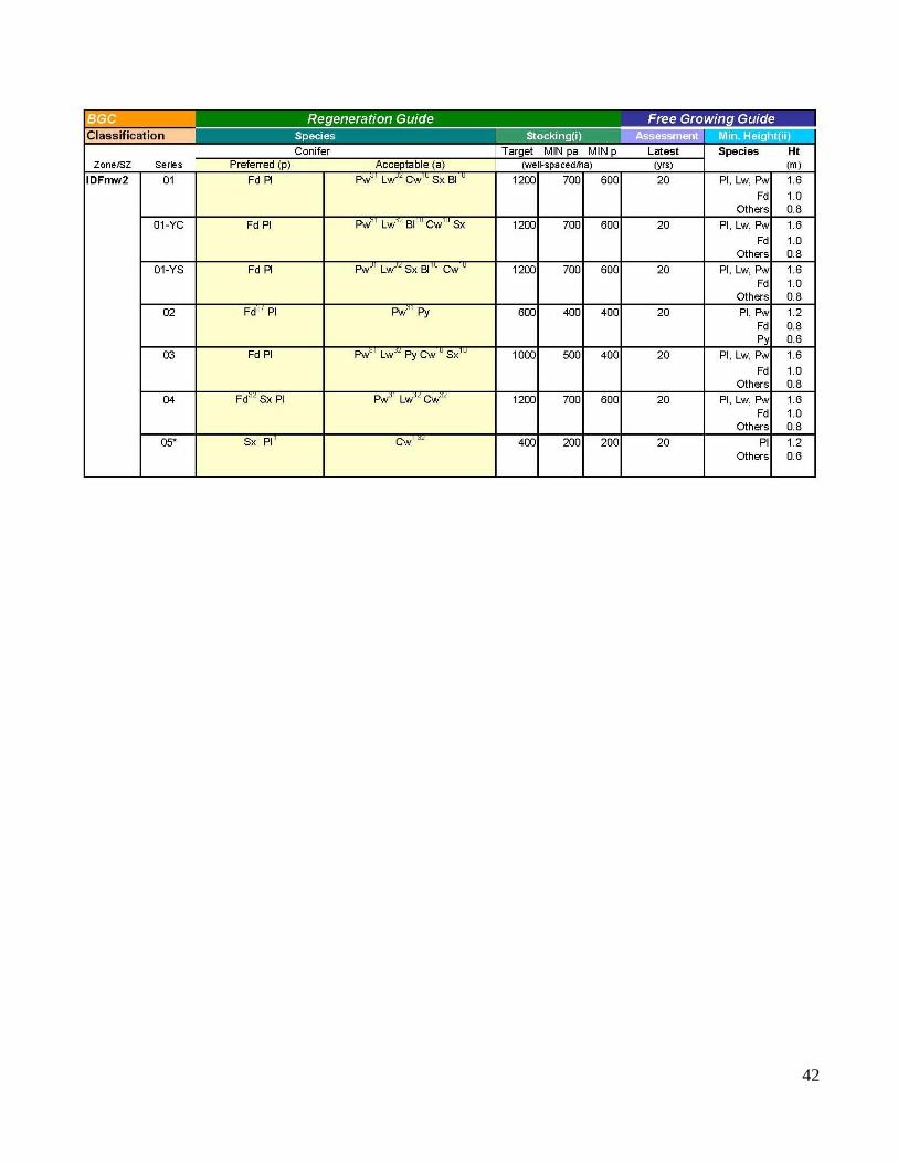
42

43
FDU#1 – K1Z – Multi-Layered Stands
Target Stocking from
Even-Aged Stand
(well-spaced/ha)
Layer Stocking (well-spaced/ha)
Target Minimum Preferred
and Acceptable
Minimum
Preferred
1200 1
2
3
4
600
800
1000
1200
300
400
500
700
250
300
400
600
1000 1
2
3
4
400
600
800
1000
200
300
400
500
200
250
300
400
900 1
2
3
4
400
500
700
900
200
300
400
500
200
250
300
400
800 1
2
3
4
300
400
600
800
150
200
300
400
150
200
300
400
600 1
2
3
4
300
400
500
600
150
200
300
400
150
200
300
400
400 1
2
3
4
200
300
300
400
100
125
150
200
100
125
150
200

44
FDU#1 – K1Z – Stocking Standard Footnotes

45
Appendix B – Forest Stewardship Plan Map by FDU
Individual FDU map comprising Appendix B of this FSP is separate from this document due to file size
limitations.

46
Appendix C – Notice, Review and Comment
Notice, review and comment information comprising Appendix C of this FSP are separate from this document
due to file format limitations.

Ea st Ba rriere La ke
So uth Ba rriere La ke
Needmo re La ke
Dixo n La ke
Sa ms La ke
Lo ng La ke
Ma ins La ke
Sa unders La ke
Little Dixo n La ke
Sha fer La ke
FDU 1
Ba rriere River FSW
Ha gga rd Creek FSW
Dixo n Creek FSWSinma x Creek FSW
Ea st Ba rriere River FSW
W1609
W1596
W1424
W1596
K1Z
VAC - MEVC - PRVQO - PR
VAC - MEVC - PRVQO - PR
VAC - MEVC - PRVQO - PR
VAC - MEVC - PRVQO - PR
VAC - MEVC - PRVQO - PR
VAC - MEVC - PRVQO - PR
VAC - MEVC - PRVQO - PR
VAC - HEVC - PRVQO - PR
VAC - HEVC - PRVQO - PR
VAC - MEVC - PRVQO - PR
VAC - MEVC - PRVQO - PR
VAC - MEVC - PRVQO - PR
VAC - MEVC - RVQO - R
VAC - HEVC - PRVQO - PR
VAC - MEVC - PRVQO - PR
VAC - HEVC - PRVQO - PR
VAC - MEVC - PRVQO - PR
VAC - HEVC - PRVQO - PR
VAC - MEVC - MVQO - M
VAC - MEVC - MVQO - M
VAC - HEVC - PRVQO - PR
VAC - HEVC - RVQO - R
VAC - HEVC - PRVQO - PR
VAC - MEVC - PRVQO - PR
VAC - MEVC - PRVQO - PR
VAC - HEVC - PRVQO - PR
VAC - LEVC - PRVQO - PR
VAC - MEVC - PRVQO - PR
VAC - MEVC - PRVQO - PR
VAC - MEVC - MVQO - M
VAC - HEVC - PRVQO - PR
VAC - HEVC - PRVQO - PR
VAC - MEVC - PRVQO - PR
VAC - HEVC - PRVQO - PR
VAC - HEVC - PRVQO - PR
VAC - MEVC - PRVQO - PR
VAC - MEVC - MVQO - M
VAC - MEVC - PRVQO - PR
VAC - MEVC - PRVQO - PR
VAC - LEVC - RVQO - R
VAC - MEVC - MVQO - M
VAC - HEVC - PRVQO - PR
VAC - MEVC - PRVQO - PR
VAC - MEVC - PRVQO - PR
VAC - MEVC - RVQO - R
VAC - MEVC - PRVQO - PR
VAC - HEVC - PRVQO - PR
VAC - MEVC - PRVQO - PR
VAC - MEVC - PRVQO - PR
VAC - MEVC - MVQO - M
VAC - MEVC - VQO -
VAC - MEVC - PRVQO - PR
VAC - MEVC - PRVQO - PR
VAC - MEVC - PRVQO - PR
VAC - MEVC - PRVQO - PR
VAC - HEVC - PRVQO - PR
VAC - MEVC - PRVQO - PR
VAC - MEVC - VQO -
VAC - MEVC - PRVQO - PR
VAC - MEVC - PRVQO - PR
VAC - HEVC - PRVQO - PR
VAC - MEVC - PRVQO - PR
VAC - LEVC - PRVQO - PR
VAC - LEVC - PRVQO - PR
VAC - MEVC - PRVQO - PR
VAC - MEVC - MVQO - M
VAC - HEVC - PRVQO - PR
VAC - MEVC - PRVQO - PR
VAC - LEVC - MVQO - M
Sources: Esri, Airbus DS, USGS, NGA, NASA, CGIAR, N Robinson, NCEAS, NLS, OS, NMA, Geodatastyrelsen, Rijkswaterstaat, GSA, Geoland, FEMA, Intermap and the GIS user community
KLRMP Moose Winter RangeDeer Winter Range
Mountain Goat Winter Range
Riparian stream class S1 - S4 FISHNon Classified DrainageRivers / Lakes / Ocean
Mountain Caribou UWR #U-3-004
Riparian stream class S2 - S4 FISHRiparian stream class S1 FISH S1
S2S6
MODIFIED HARVEST
NO HARVEST
CORRIDOR CORRIDOR
GOAT
Community Watersheds:
Old Growth Management Area
NON-LEGAL
LEGAL
Moose
Deer
Riparian wetlands
Scenic Areas LabelScenic Areas
ORIGINAL SCALE: 1: 20,0000Projection: BC Albers
Digital Mapping Base - TRIM - 1:20,000
VAC - HEVC - PVQO - M
Prepared By: T.B. (Todd) PhillipsThompson Resource Management444 Clearwater Valley Rd. Clearwater BC, V0E1N1P: 250-674-4092e: [email protected]
Date Submitted: January 2012Date Amended: August 2019
0 500 1,000 1,500250Meters
Lo wer No rth Tho mpso nCo mmunity Fo rest So ciety
P: 250-672-1941 F: 250-672-1942e: [email protected]
PO Box 983 Barriere, BC V0E 1E0
Fo rest Stewa rdship Pla n Ma pFDU1 – K1Z, FSP Appendix B
Operating Area BoundaryProtected Area & ParksPrivate Land
Woodlot BoundaryFDU BoundaryRoads/Access
LEGEND
Fisheries Sensitive Watershed