lower river road concept plan - eugene, oregon
TRANSCRIPT


On June 22, 2009, the Planning Commission acknowledged the Lower River Road Concept Plan
as the final document for planning efforts for the Rasor Mixed Use Center project. The Planning
Commission’s acknowledgement of this document marks the final step in this multi-year
planning process that engaged hundreds of individuals since first initiated in 2007.

LOWER RIVER ROAD CONCEPT PLAN Eugene, Oregon June 22, 2009
Acknowledgements
Community Advisory Committee Members Heidi Beierle Joan Connolly Rick Larson Jim McCoy Ray Neff
Candace Nelson Becky Riley Carl Roach Jolene Siemsen
Emeritus CAC Members Phillip Carroll Aretha DeSpain Majeska Seese Green Rob Handy
Charles Kittleson Steve Norris Dennis Sandow Miaya Sustaita
Technical Advisory Committee Members City of Eugene Gabe Flock Ken Guzowski (Project Manager) Robin Hostick Rob Inerfeld Tom Larsen Gary McNeal Doug Terra Carolyn Weiss Kurt Yeiter
Lane Transit District Mary Archer University of Oregon CPW Bob Parker Casey Kleinhenz Lane Council of Governments Jeff Krueger Jake Callister TGM/ODOT Elizabeth Ledet
Prepared by: The City of Eugene In association with the consultant team of: Spencer & Kupper Donald B. Genasci & Associates Robert Bernstein, PE Landsman Transportation Planning E.D. Hovee & Company TransWatch
This project is partially funded by a grant from the Transportation and Growth Management (TGM) Program, a joint program of the Oregon Department of Transportation and the Oregon Department of Land Conservation and Development. This TGM grant is financed, in part, by federal Safe, Accountable, Flexible, and Efficient Transportation Equity Act-A Legacy for Users (SAFETEA-LU), local government and the State of Oregon funds.

LOWER RIVER ROAD CONCEPT PLAN June 22, 2009
F I N A L R E P O R T
Page 2
LOWER RIVER ROAD CONCEPT PLAN Eugene, Oregon
REVISED DRAFT
June 15, 2009
Table of Contents
1. Introduction 3 1.1 Overall Vision & Future Expectations 6 1.2 The Shaping of the Plan 11 2. Lower River Road Concept Plan 14 2.1 Willamette River Greenway & Rasor Park 14 2.2 Sustainability 17 2.3 Multi-modal Transportation Improvement Concepts 18 2.4 Land Use and Development Concepts 24 2.5 Recommended Code Amendment Concepts 29 3. Implementation Strategies 38 3.1 Introduction 38 3.2 Implementation Strategies 38 Table 1 –Greenway Corridor Enhancement Recommendations 14 Table 2 -Recommended Code Amendment Concepts 33 Table 3 –Implementation Strategies 45 Glossary of Terms and List of Reports 46

LOWER RIVER ROAD CONCEPT PLAN June 22, 2009
F I N A L R E P O R T
Page 3
1. INTRODUCTION The Lower River Road Concept Plan is the final report for the conceptual planning phase of the City of Eugene’s Rasor Mixed Use Center planning process. This phase of planning began in 2007 thanks to a Transportation Growth Management grant from the Oregon Department of Transportation. Planning for higher density mixed-use centers, and also for improved transit, are key strategies adopted by Eugene to implement its growth management and transportation planning policies. The mixed-use center approach aims to create compact, livable, walkable neighborhoods with convenient access to services and transit. When combined with improved transit, mixed-use centers will slow sprawl and reduce reliance on automobile travel. Lower River Road was identified in the regional transportation master plan, TransPlan (2001), as one of dozens of potential areas for mixed-use redevelopment. In 2002, with the support of the River Road Community Organization (RRCO) board, this area was made a priority for more detailed planning. River Road Community Organization leaders noted the challenges of this planning process, but also the opportunities presented by this area, and the desirability and importance of area-specific planning for this zone. Initially, this phase of planning referred to the study area as the Rasor Park Mixed Use Center. After subsequent public process, the study area was expanded to include commercial and residential zones on both sides of the lower River Road corridor between the Northwest Expressway and E. Hillcrest Dr. Reference the project area map on page 5. To guide this phase of planning, a Community Advisory Committee (CAC) was established in 2007, and expanded in 2008. After extensive rounds of committee meetings and public workshops (see section 1.2 for more details of the public involvement and committee process), a majority of the committee in attendance (6 of 8) voted at the final May 28, 2009 committee meeting to approve the following statement:
“The CAC supports the overall vision, Willamette Greenway natural resource planning, sustainability concepts, transportation improvements, concept code and development standards, objectives, and implementation strategies outlined within the Lower River Road Concept Plan.”
Certainly the committee had vigorous debate about some elements, and divergence of opinion on various aspects. Within the community and among other stakeholders, too, there are varying viewpoints and philosophies about the overall planning process, and elements of the Concept Plan. There are disputes about growth projections or the desirability of planning at all. Many are concerned about the natural values of the Greenway, and how these can be protected and enhanced if higher density redevelopment occurs on adjacent parcels. Some believe that this planning process affords an important opportunity to adopt additional requirements that are necessary to protect the Greenway. Others see this planning as inviting

LOWER RIVER ROAD CONCEPT PLAN June 22, 2009
F I N A L R E P O R T
Page 4
higher density development that might not otherwise come. Some believe that planning should be deferred because of the downturn in the local and national economy, and the imminent threat of global climate change. Others feel that planning is especially important for these same reasons—that there is a renewed urgency to change how we live, and that this Plan can help meet important sustainability goals. Ultimately, not every viewpoint could be reconciled or reflected in the Concept Plan. However, the Plan does attempt to “weave” a vast amount of public input into a coherent plan that enjoys broad public support. The Concept Plan is intended to provide the City, neighborhood associations, property owners and residents a map for future action. It includes implementation strategies for: preservation and enhancement of the Willamette River Greenway and parks; a sustainability strategy; a transportation improvement plan; land use and development objectives with concepts for potential changes to the land use code; and a public collaboration and partnerships strategy. The Lower River Road Concept Plan concludes with over thirty recommendations grouped under the five strategies. Major external forces are at work that will affect implementation of this Concept Plan, so good judgment and discretion will be needed as next steps are considered. As noted in section 3.1, implementation strategies and recommendations “should be revisited and revised” and the work program updated periodically to reflect progress or needed adjustments. Further and successful implementation will require support from the City and Lane County, and continued participation, respect, careful listening, and cooperation among property owners, residents, and the established neighborhood organizations. Individual reports and maps for this project can be accessed at the Rasor Mixed Use Center website www.eugene-or.gov/rasorpark or by contacting Ken Guzowski at [email protected] and at 1.541.682-5562.

LOWER RIVER ROAD CONCEPT PLAN June 22, 2009
F I N A L R E P O R T
Page 5
Lower River Road Concept Plan Study Area

LOWER RIVER ROAD CONCEPT PLAN June 22, 2009
F I N A L R E P O R T
Page 6
1.1 Overall Vision and Future Expectations The Area Now The proposed Lower River Road Special Area Zone addressed in this Concept Plan spans the River Road corridor from the Chambers St. overpass to Hillcrest Dr. This area currently is characterized by low intensity auto-oriented commercial strip development in three established commercial zones, with low intensity (and some historic) residential development in between. The central part of the area also includes a considerable amount of property within the Willamette River Greenway. Some of the Greenway is public park land, and some is private commercial and residential land. Much of the area is zoned to allow higher intensity development, specifically, the R-2 and C-2 lands. The Vision: Lower River Road District/Special Area Zone This plan envisions the Lower River Road Special Area Zone as a cohesive, attractive and pedestrian-friendly district that: retains and reuses historic houses and landscape features (mature trees); provides high quality, compact housing for a diverse population at a minimum density of 12 units per acre; offers essential and quality commercial and public services for nearby River Road and Whiteaker residents; and serves as a central hub and backbone unifying and stabilizing the larger lower River Road neighborhood. In keeping with its Greenway setting, this Concept Plan envisions that development and landscaping, and especially land adjacent to the Willamette River, will reflect a deep connection to the river and associated natural values of the riparian landscape. River parks will be managed as an important wildlife corridor, and as a unique and treasured natural asset. Landscaping, signage, pedestrian routes, and view corridors will inform travelers along River Road that they are near the river. Lower River Road will be a leafy boulevard with a center median graced by large canopy native trees. The road corridor will offer a pleasant streetscape and ambience for pedestrians and bicyclists, and safe and convenient connections to Eugene’s comprehensive bike trail system. Many River Road residents will walk or bike to local commercial areas for daily errands, or to commute or recreate along the river path system. River Road will also be served by a rapid transit line (EmX) that connects to an efficient world-class regional transit system. Many commuters will use this system instead of personal cars. The area is also envisioned as a cutting-edge “green” (or sustainable) district where buildings, landscapes and infrastructure incorporate innovative ecological design and construction technologies that minimize resource use, waste, and adverse impact on the environment. Impervious surfaces will be minimized to the extent possible and natural landscaping and water infiltration emphasized. The area will be a recognized center for nurturing small and sustainable local businesses, and for adoption of innovative “green” technologies. It will offer a range of attractive medium density housing options, including those that incorporate native landscapes adjacent to Greenway parks, or use the area’s rich soils as gardens and orchards. This might include cottage housing clustered around central gardens or commons, or apartments or

LOWER RIVER ROAD CONCEPT PLAN June 22, 2009
F I N A L R E P O R T
Page 7
condominiums in mixed-use buildings (above commercial uses) along River Road. Residents will be able to choose from a range of innovative housing types and affordability options, including car-free housing and live/work units. Buildings will be designed to rim and face the public streets and parks, to create an attractive and safe interface. Commercial and residential buildings will be designed to create inter-connected and well-shaped public and social spaces between and beside them, including paths to the river parks. Area residents will enjoy socializing at a keystone public gathering place and services such as a library, community center, neighborhood-scale farmer’s market and small grocery will contribute to neighborhood function, an active public realm and street life. Buildings and uses will be appropriate in scale and intensity so as not to overwhelm the natural values of the river setting or adversely impact adjacent residential neighborhoods. Residents and business and property owners will work collaboratively to plan for the area, and to review and discuss specific development proposals. Willamette Greenway and Parks: Healthy, Ecologically Functional Natural Areas: Public park lands within the Greenway and adjacent to the river will be healthy and actively managed natural areas. Many large trees will provide shade and fulfill other important ecological roles (carbon sequestration, air and water filtration, etc.) Native trees, shrubs, tall grasses, and wildflowers will provide the habitat needed to support a healthy population and diversity of native species (birds, butterflies, etc.) that rely on the riparian and associated upland corridor. Buffer, Refuge and People Space: Greenway parks will serve as a buffer and screen between higher density development and the River, and as relatively undeveloped zones to mitigate the impacts of the higher density development nearby. They will also serve as a refuge for residents from the bustle and noise of the street and commercial areas, and as a place for walking and quiet contemplation. A few simple, rustic “amenities” will help people enjoy the parks for passive recreation and appreciation of nature and river habitat. The parks will provide children with a place for unstructured exploration and play, and a rare place to experience nature in the urban environment. People will continue to enjoy the West Bank bike trail for active recreation, and will also enjoy participating in restoration activities in the Greenway parks. Public Access: Pedestrians and bicyclists will be able to get to the West Bank bike trail from River Road at multiple convenient and inviting entry points. Commercial areas along lower River Road will be easily accessible from the river parks and trail system. Development Adjacent to Greenway Parks: The natural character and ecological values of the river corridor will be visually and functionally extended throughout the Willamette Greenway via conservation easements and native and naturalistic landscaping on commercial and residential property and public rights-of-way. Trees and landscaping will provide habitat corridors and reinforce the visual sense of this area as a special place adjacent to the river.

LOWER RIVER ROAD CONCEPT PLAN June 22, 2009
F I N A L R E P O R T
Page 8
Higher density development will be clustered toward the road, and gardens, orchards, and lower density development will be located along the river edge of development zones. Sustainability: Environmental: Lower River Road will be a district that models good ecological design and function. Buildings, landscapes, and infrastructure will protect natural resources, and incorporate green building construction, local energy generation and use along with conservation and recycling, judicious water use and reuse and green stormwater management. Economic: Lower River Road will be known as a center for nurturing small and local sustainable businesses, including those pioneering innovative new “green” technologies or approaches (energy, transportation, local food systems, etc.). These businesses will provide local jobs, and markets for locally-produced food, goods, and services. Existing businesses will be supported and encouraged to contribute to the economic viability of the area. Social: The area will function as an important social and service hub or backbone for the wider lower River Road neighborhood. It will include safe, comfortable and attractive public areas and gathering places, along with essential and desirable businesses (grocery, farmer’s market) and services (library, community center). Homes and landscapes with historic value will be preserved or adapted for new uses and functions. Residents will be attracted by the “green” or sustainable lifestyles that are supported and encouraged by the community. Existing dirt bike path on City land. Lower River Road Corridor: Neighborhood Identity/Gateway: Travelers along the lower River Road corridor will realize they have entered a unique and special neighborhood, a “Greenway and garden district” and a neighborhood that promotes sustainable development and lifestyles. Large canopy native trees will grace the median and streetscape along River Road. The proximity of the River will be evident, thanks to corridors and pockets of native trees and naturalistic landscaping that visually and functionally extend the Willamette River landscape across commercial and residential areas to River Road.

LOWER RIVER ROAD CONCEPT PLAN June 22, 2009
F I N A L R E P O R T
Page 9
Neighborhood Commercial Centers: The three commercial areas along the corridor will each offer an attractive, neighborhood-scale, pedestrian-oriented commercial/retail streetscape along River Road, along with a mix of office and well designed residential uses. Existing businesses will contribute to the vitality of the area. Cohesive Corridor: Commercial/office and residential zones and streetscapes along the length of the corridor will form a cohesive district, linked by common design and landscaping standards and streetscape elements appropriate to the Willamette Greenway and garden district, which reflect natural values and sustainability. Residential areas between commercial zones will provide an attractive, pedestrian-friendly streetscape along River Road. Roadway Conditions: Traffic will travel smoothly and safely along River Road, at a speed of 35 mph or less. It will be easy, safe and convenient for pedestrians and bicyclists to cross (or travel along) the River Road. People will be able to hold a conversation on the sidewalk or at an outdoor café table without being drowned out by traffic noise. Rapid Transit/Commuter Vehicle Miles Traveled: Efficient rapid transit on the EmX will run along River Road, and will be used by a
THE VISION for the Lower River Road area has as its foundation that Rasor Park and the Willamette Greenway are very significant natural resources, as well as important amenities that give the neighborhood a unique sense of place and stunning setting. Sustainability is also a key value for the neighborhood. There is an opportunity for the built environment to embrace and celebrate the natural environment, but it is important that it does not overwhelm or detract from it. Preservation and enhancement of natural values is paramount in Greenway parks. Natural landscaping, buffers and conservation easements, design standards, and public access are important to ensure that the built environment harmoniously relates to the natural environment and public parks. Transforming River Road into a multi-modal boulevard where it is safe and convenient for pedestrians, bicycles, transit and automobiles to co-exist is one element of sustainability. Making pedestrian and bicycle access to the West Bank Bike Trail easy and convenient is another. Encouraging moderate density mixed use developments in appropriate locations is an important sustainability strategy, so that people have an opportunity to live, work, shop and play without having to use a car. This also allows growth to be considered in more compact, centrally located areas to reduce sprawl and development on outlying farmland. Energy efficiency, green infrastructure, and local green jobs and services are other desired sustainability elements.

LOWER RIVER ROAD CONCEPT PLAN June 22, 2009
F I N A L R E P O R T
Page 10
majority of commuters traveling the corridor. Commuter auto traffic will be significantly less than expected relative to population and today’s auto use patterns. Local Vehicle Miles Traveled: Lower River Road neighborhood residents will use cars less often, and drive fewer miles than they do today, thanks to more local shopping options, and pedestrian, bike and other alternative transportation improvements. Development and Redevelopment: Development Types, Uses, and Functions: New development and redevelopment will bring vitality and function to the neighborhood. A diversity of uses will include small and local businesses, diverse housing types including car-free and live/work options, vertical mixed-uses, and specific desirable neighborhood services such as a small to moderate-sized grocery store, farmer’s market, and public gathering and meeting places. Development Design: New developments will be of high quality and appropriate scale, and relate harmoniously to their surroundings and to each other. Density and building heights will transition from River Road toward the river and existing residential areas. Clear and Objective Standards: Zoning and development requirements will be specific, and standards clear and objective, to offer stability and protection for developers and property owners who choose to invest in their properties. Incentives: Incentives will be used to help achieve important public goals and values, and to bring desired essential neighborhood services. Public Collaboration and Partnerships: Planning: Future plans for the area will be created and implemented with collaboration among residents, property and business owners, and neighborhood associations. Design Input and Review: All development applications and approval processes will include early neighborhood input, and neighborhood participation in design review, should it be required. Public Investment: Neighborhood residents, businesses, neighborhood groups and the City will work in partnership to attract public investments in infrastructure and desired neighborhood services.

LOWER RIVER ROAD CONCEPT PLAN June 22, 2009
F I N A L R E P O R T
Page 11
1.2 The Shaping of the Plan: A Review of Public Involvement The Lower River Road Concept Plan’s vision and subsequent recommendations and implementation strategies have been shaped by over two years of community input beginning in early 2007. Hundreds of people have attended public meetings and the community workshops. The public’s involvement over the course of concept plan development can be broken into three phases:
Phase 1: Introducing the Community to Mixed Use Planning Phase 2: Articulating the Community Vision Phase 3: Developing Strategies to Make the Vision a Reality
Phase 1: Introducing the Community to Mixed Use Planning (2007) Public Meetings Initial public meetings introduced the concept of mixed use center planning and gathered input on the community’s values for mixed use in their neighborhood. A series of three public meetings provided the basis for developing a community vision. During this phase, the River Road Community Organization (RRCO) organized a community charrette led by a professor at the University of Oregon on initial ideas surrounding a mixed use center that included a multi-way boulevard. Technical and Citizen Advisory Committee A series of meetings with a hybrid committee of community and city staff reviewed preliminary conceptual ideas around an initial focus area. The focus area concept later expanded into an overall corridor approach for study. Additional Community Outreach City of Eugene project web page development RRCO project web page development Presentations to RCCO and Whiteaker Community Council (WCC) Mailings, emails and RRCO newsletter articles Neighborhood walking tours with the Historic Review Board and Planning Commission Phase 2: Articulating the Community Vision (2008) Citizen Advisory Committee: After a planning break, a new Citizen Advisory Committee (CAC) formed with representation from the RRCO, WCC, Fir/Lombard neighbors, residents and property owners. The newly formed CAC was charged with:
To serve as a representative community team of stakeholders to discuss and recommend a common conceptual vision to the Eugene Planning Commission for the future development of the Rasor Park Mixed Use Center area that reflect and integrate public input and are further refined by review of the study's technical analysis. [CAC Charter, September 2007]

LOWER RIVER ROAD CONCEPT PLAN June 22, 2009
F I N A L R E P O R T
Page 12
Facilitators conducted initial interviews with CAC members to update them on process, develop group-operating agreements, review the decision-making process, and express the necessity of regular meeting attendance. The CAC committed to an intensive schedule and met ten times over three months to review technical memorandums and community input. The resulting document, “Empowering Innovation: Vital Neighborhoods as Sustainability Engine,” submitted to the Planning Commission on November 2007 articulated the vision for a mixed use corridor and outlined necessary steps to advance its planning. The CAC developed further refinement of the planning steps final work program and presented it to the Planning Commission on April 2008. Stakeholder Meetings The CAC and city staff hosted an informational meeting for property and business owners to update them on the process and hear comments or concerns to address in the planning process. Additional Community Outreach Project booth at River Road Rocks, a major annual outreach event hosted by RCCO Presentations to RCCO and WCC Mailings, email and RRCO newsletter articles Neighborhood walking tours Updates posted on City, RRCO and WCC websites Phase 3: Developing Strategies to Make the Vision a Reality (2009) Community Advisory Committee As represented by the name change from “citizen” to “community,” the CAC welcomed expansion of its representation to include commercial and residential property owners and additional residents. The revised CAC was charged with:
To provide input and direction on the Rasor Mixed Use Center Plan’s (Lower River Road Conceptual Plan) transportation and zoning components and associated implementation strategies to develop an adoption recommendation to the Eugene Planning Commission. [CAC Charter, December 2008]
The CAC met ten times over six months to review, discuss, and develop transportation and land use zoning recommendations and implementation strategies. Public Workshops The CAC, intent on providing the community more in-depth opportunities to help shape the final concept plan, hosted two large community design workshops. Transportation Design Workshop Over 100 participants provided input on what design strategies could create a safer and more accessible River Road for pedestrians, cyclists, and automobile drivers. The public gave specific

LOWER RIVER ROAD CONCEPT PLAN June 22, 2009
F I N A L R E P O R T
Page 13
input on favored pedestrian and bicycle crossings and connectivity to the Willamette River. Additional stop lights in strategic locations were supported by the public and the CAC. This input shaped the CAC’s transportation and implementation strategies recommendations. Land Use and Development Type Design Workshop Over 80 participants gathered to provide input on desired building types along lower River Road with attention to building height, building use, setback, and interface with existing neighborhoods and the Willamette Greenway. This input shaped the CAC’s zoning and associated implementation strategies recommendations. Community Data Gathering: Neighborhood Needs Assessment The CAC recommended that a survey be conducted of residents located in the concept plan study area and surrounding River Road area. This included parts of Whiteaker Neighborhood Association (specifically, the Fir-Lombard area). The survey’s purpose was to understand desired neighborhood commercial services and transportation modes used to access local goods and services. Stakeholder Meetings City staff from the Community and Land Use Planning sections hosted interest group meetings with commercial property owners and another with residential property owners to review preliminary zoning and development code recommendations. CAC Further Outreach CAC members provided expanded outreach with presentations to GEARS & BPAC and a review of low-income housing projects by the Housing and Community Services Agency of Lane County, HACSA. Additional Community Outreach Project booth at River Road Rocks, a major annual outreach event hosted by RCCO Presentations to RCCO and WCC Mailings, emails and RRCO newsletter articles Updates posted to City, RRCO and WCC web sites Community Open House on Lower River Road Conceptual Plan On June 15, 2009, RRCO and the City hosted a community open house to present the final concept plan. For more information on the Lower River Road Concept Plan and public involvement activities and reports, visit: www:eugene-or.gov/rasorpark.

LOWER RIVER ROAD CONCEPT PLAN June 22, 2009
F I N A L R E P O R T
Page 14
2. LOWER RIVER ROAD CONCEPT PLAN The Lower River Road Concept Plan has as its foundation that Rasor Park and the Willamette Greenway are the most significant resources for the neighborhood. This foundation underlies the importance of creating a balance between the built and natural environments, and incorporating sustainable practices whenever possible as a method to achieve this balance. The Lower River Road Concept Plan describes objectives and recommendations for:
Willamette River Greenway and Rasor Park
Sustainability
Multi-Modal Improvement Concepts for River Road
Land Use and Development Concepts
Recommended Amendments to Zoning and Development Standards
2.1 Willamette River Greenway and Rasor Park The Greenway Corridor Enhancement Analysis prepared for this project by the Lane Council of Governments provides background information and recommendations related to natural resources, parks, and open space within the lower River Road study area. The study found that the area’s proximity to the Willamette River and the significant quantities of public park land found in this area provides a set of unique opportunities and challenges. Issues and opportunities related to natural resources, parks and open spaces are identified. Recommendations on how these attributes may ultimately be addressed and incorporated into the Lower River Road Concept Plan are made so that protection and enhancement of the areas’ natural resources, visual quality, recreational facilities and livability are achieved. Table 1 includes a summary of key issues and challenges, and the recommendations that Lane Council of Governments (LCOG) suggested that address these challenges derived from the Greenway Corridor Enhancement Analysis. Many of these recommendations are also described in other sections of this Concept Plan. The map on page 16 identifies the land use regulatory overlays that exist in the project area.
Table 1 Greenway Corridor Enhancement Analysis-Recommendations by LCOG
June 2009
Issues and Opportunities Recommendations
REGULATORY
Because the Lower River Road study area is located along the Willamette River and within the Willamette River Greenway boundary, a set of regulations beyond what is typical for most areas of the City apply.
Consider submitting a single greenway permit for the entire study area.
Include in a greenway permit application the following elements: o Context sensitive design standards for development o Preservation and enhancement of trees and riparian
areas o Additional landscaping requirements o Limit impacts of impervious surface areas o Limit piping of stormwater runoff o Preservation of key viewpoints and view corridors

LOWER RIVER ROAD CONCEPT PLAN June 22, 2009
F I N A L R E P O R T
Page 15
Table 1 Greenway Corridor Enhancement Analysis-Recommendations by LCOG
June 2009
Issues and Opportunities Recommendations
o Public access to the river o Visual landscape screening requirements
Consider the need for balancing general compliance with the need for flexibility.
Improve the accuracy of the mapped 100-foot Water Resources Conservation Overlay Zone.
Consider a single Standards Review application within the /WR Overlay Zone.
Provide assistance to owners to enhance riparian vegetation.
Consider leaving single family lots out of the permitting process.
PUBLIC FACILITEIS AND RECREATION
Convenient and safe bicycle and pedestrian connectivity to the river for residents living on the east side of River Road is limited from some areas. Safe connectivity between the residential areas on the west side of River Road and the West Bank Bike Trail are inadequate due to heavy traffic volumes and limited signal crossings. The level of improved park facilities and amenities such as children’s play equipment are relatively limited.
Implement the Rasor Park Master Plan.
Add sidewalks to neighborhood streets that access the West Bank Trail.
Create multi-use bicycle and pedestrian path connections to the West Bank Trail.
Improve bicycle and pedestrian crossing safety along River Road.
Add additional recreational facilities along this stretch of the river park system.
Construct public parking for Rasor Park.
Support City efforts for a Riparian Tax Incentive Program.
NATURAL RESOURCES AND WATER QUALITY
In addition to what can be achieved through the regulatory framework discussed above, meaningful natural resource and water quality enhancements can be achieved through implementation of capital projects on public land and voluntary efforts on private properties with technical assistance from the City and others.
Implement the Rasor Park Master Plan.
Support habitat restoration efforts elsewhere on the Willamette River.
Develop a comprehensive habitat and invasive species management plan and enhance vegetation along the river.
Work with property owners to preserve mature trees.
Develop programs to control invasive species.
Enhance riparian vegetation immediately along the river.
Use sustainable design principles for Rasor Park parking.
Where safety allows, leave dead and dying trees.
VISUAL QUALITY AND VIEWS
The area’s proximity to the Willamette River gives it a unique sense of place and stunning setting. Providing and preserving views to this central natural feature and surrounding landscape should be a central consideration.
Designate and retain key view corridors along the West Bank Trail.
Provide visual access to the river from River Road.
Construct a river overlook in Rasor Park.
Screen the view of existing buildings from the West Bank Trail.
Implement design standards to ensure visual quality and screening of new development.

LOWER RIVER ROAD CONCEPT PLAN June 22, 2009
F I N A L R E P O R T
Page 16

LOWER RIVER ROAD CONCEPT PLAN June 22, 2009
F I N A L R E P O R T
Page 17
2.2 Sustainability Many of the Lower River Road Concept Plan elements described in this section such as natural resource protection and enhancement, appropriate multi-modal street design, incentives for sustainable design and construction practices and compact mixed-use development are key sustainability strategies. A much broader approach to sustainability was identified in the Empowering Innovation document which called for the preparation of a Neighborhood Sustainability Plan. However, the work program and study efforts completed as part of this project did not have the resources to undertake a Lower River Road Sustainability Plan. A key implementation strategy outlined in Section 3 of this Concept Plan calls for the River Road Community Organization in cooperation with the City to prepare a Neighborhood Action Plan that refines sustainability elements of this Concept Plan. A Lower River Road Sustainability Plan could be an important element of the Neighborhood Action Plan. A more complete description of the elements of a Sustainability Plan is included in Section 3.
The Planning Commission, Historic Review Board and neighborhood leaders tour the Rasor Mixed Use project area in the spring of 2007.

LOWER RIVER ROAD CONCEPT PLAN June 22, 2009
F I N A L R E P O R T
Page 18
2.3 Multi-Modal Transportation Improvement Concept The Lower River Road Multi-modal Transportation Improvement Concept recommendations address street design elements and issues for Lower River Road between Northwest Expressway and Hillcrest. Development of the Improvement Concept recommendations1 was based on input from City of Eugene planning and engineering staff, the Community Advisory Committee (CAC), the general public, and Lane Transit District (LTD) staff. The Improvement Concept includes three primary elements:
A preferred Lower River Road plan and cross-section concept
Principal Lower River Road traffic signal and pedestrian crossing locations, and
Commercial area vehicular access points on Lower River Road. Background An Operations and Safety Analysis conducted for the Lower River Road corridor concluded that although River Road is functioning well as a main thoroughfare for significant volumes of traffic, and will continue to do so in the future, access onto, off of and across River Road for local auto, pedestrian, and bicycle traffic is difficult and worsening. Vehicular, pedestrian and bicycle travel to, from, and between residential neighborhoods in the River Road corridor, businesses on River Road, Rasor Park and the West Bank Bike Path will grow increasingly more difficult in the future with increasing River Road traffic volumes. The Operations and Safety Analysis concluded that street and traffic control improvements and traffic calming measures are necessary to safely and conveniently accommodate the existing and increased local pedestrian and bicycle traffic generated by new development and redevelopment in the area. Concept Guidelines A set of concept development guidelines was identified by the CAC and from input gained during a public workshop on transportation issues on Lower River Road. The guidelines provide direction for identifying more specific multi-modal improvement concepts. The guidelines are:
Use roadway features to reduce traffic speeds: re-stripe roadway with narrower travel lanes and wider bicycle lanes; construct raised medians; install additional signals and time signals to progress through traffic at lower speeds.
Stay within existing right-of-way to the extent possible.
Maintain property and side street accessibility throughout the corridor.
Provide signalized pedestrian/bicycle crossings at regular intervals along the corridor.
Along most of the corridor, on-street parking spaces currently are not needed by adjacent residences and businesses; landscaping and pedestrian/bike facilities are a more effective use of River Road right-of-way outside of the traffic lanes.
1 Final River Road Conceptual Design Plan, Robert Bernstein Transportation Planning and Engineering, March
2009.

LOWER RIVER ROAD CONCEPT PLAN June 22, 2009
F I N A L R E P O R T
Page 19
Do not preclude implementation of LTD’s planned efficient EmX (bus rapid transit) on River Road.
Multi-Modal Transportation Improvement Concepts Eight improvement concept recommendations describe multi-modal transportation improvements along the lower River Road corridor. The recommendations address preferred plan and cross sections, traffic signalization and pedestrian crossing locations, and vehicular access. The Base Concept does not include separate right-of-way for future EmX bus rapid transit. The next steps and recommendations call for preparing a Preliminary Design Plan for Lower River Road and working closely with Lane Transit District (LTD) to evaluate future EmX alternatives including the need for any long-term right-of-way requirements. The Preliminary
Design Plan should be completed as soon as possible so that future set-back standards can be identified that could affect new development along River Road. Lower River Road plan/cross section concept:
1. Apply Base Concept through entire plan corridor: Two travel lanes in each direction, center turn lane/median, outside bike lanes both directions, and no on-street parking.
2. For speed reduction and beautification, stripe travel lanes 11 feet wide and install raised medians. Where medians limit left turns to and from side streets and/or driveways, provide alternate access via public streets, or u-turns at signalized intersections.
3. Provide bus stop pullouts at the outside edge of intersections.
4. Stripe bicycle lanes 6 feet wide for bicycle safety and to serve as emergency shoulders. Principal Lower River Road traffic signal and pedestrian crossing locations: For pedestrian safety and accessibility, design and install crossing
improvements on River Road at Elkay, Knoop, Hansen, and Fir; passively discourage pedestrian crossings elsewhere with appropriate signs.
5. For speed reduction and to provide community accessibility (vehicular and
pedestrian/bicycle), to and from River Road, install traffic and pedestrian signals at Elkay, Knoop, and Hansen.

LOWER RIVER ROAD CONCEPT PLAN June 22, 2009
F I N A L R E P O R T
Page 20
6. Provide multi-use path connections to the West Bank Bike Path at McClure, Rasor, Hansen and Fir: connect all multi-use path West Bank Bike Path linkages directly to improved River Road crossings and provide clear signage.
7. The design of multi-use pathways should be context sensitive and can vary from location to location. For example, Fir Lane could remain a narrow street without curbs and sidewalks where pedestrians, bicycles and vehicles share the same travel path. Pedestrian zones could be identified by different pavement treatments. At Hansen, the pathway could be integrated into public open space. At Rasor, the pathway could be designed and integrated into future mixed use development.
Commercial area vehicular access points on lower River Road: Wherever redevelopment occurs along River Road, minimize the number of direct vehicular access points on to and off of River Road through use of shared driveways or provision of access via side-streets. In the large commercially-zoned area on the east side of River Road between Park and Hansen, permit a maximum of two direct vehicular access points to and from River Road. Next Steps and Implementation Implementation strategies and recommended actions including key next steps toward completion and implementation of the Lower River Road Multi-Modal Transportation Improvement Concepts include:
A. Prepare a Preliminary Design Plan for Lower River Road Multi-modal Transportation Improvement Concepts and EmX Alternatives. Continue to work with LTD to coordinate and leverage the planning and design processes for River Road and EmX improvements. Conceptual d

LOWER RIVER ROAD CONCEPT PLAN June 22, 2009
F I N A L R E P O R T
Page 21
B. Prepare a Phasing & Financing Plan for the Lower River Road improvements. C. Adopt the Lower River Road Preliminary Design Plan and Phasing and Financing Plan in
the City’s Transportation Improvement Program. D. Prepare preliminary and final engineering design plans for improvement phases. E. Construct project improvements in phases according to the engineered plans.
Existing Land Use The study area is characterized by older low intensity automobile-oriented retail, vacant and re-developable land, public park land along the Willamette River and low density housing nestled between River Road and the Willamette River. River Road creates a formidable barrier that separates commercial areas and the Willamette River on the east from the large residential areas to the west. Single family uses abut the west side of River Road to McClure Lane, as well as the east side of River Road south of Hansen Lane. Between Hansen Lane to north of Rasor Avenue, a mix of retail, auto, warehouse and parking uses make up the Community Commercial district on the east side of River Road. North of McClure Lane, a mix of retail, restaurant, financial, auto and parking uses form a one parcel deep strip along both sides of the arterial. The predominant uses east of the properties fronting River Road are park lands along the Willamette River, and single family uses between the park and River Road. There are also significant vacant parcels off Briarcliff Lane and north of McClure Lane. Many of the parcels on the east side of River Road are deep, and may include a primary residence and secondary structures accessed from private lanes. Zoning and land use designations are shown on the zoning map.
Existing multi-family Apartments at the east end of Stults Avenue.

LOWER RIVER ROAD CONCEPT PLAN June 22, 2009
F I N A L R E P O R T
Page 22
There are three existing commercial nodes within the study area and two areas planned for medium density residential uses on the east side of River Road. Land use and development concepts are identified for each of these areas based on community input at open houses and input from the CAC. The Lower River Road Conceptual Plan Areas Map on page 23 identifies the areas described below. These areas are:
North Commercial Area. A mixed commercial area located south of E. Hillcrest Drive on both sides of River Road at the north end of the corridor is zoned for both Neighborhood (C-1) and Community (C-2) Commercial Uses.
North Medium Density Residential Area. North of Rasor Park and east of River Road along Stephens Drive is an existing developed residential area zoned R-2 Medium Density Residential.
Central Commercial Area. An approximately 9.4 acre area, zoned C-2 Community Commercial, is located east of River Road generally centered opposite Knoop Lane.
South Medium Density Residential Area. South of Hansen Lane are two R-2 zoned areas east of River Road. One area is vacant; the other includes three oversized parcels containing existing single family dwellings. Both R-2 areas extend from River Road to public parklands along the Willamette River.
South Commercial Area. A small, predominantly auto-oriented commercial area, zoned C-2 Community Commercial, located on both sides of River Road at the south end of the lower River Road corridor, generally south of Fir Lane.

LOWER RIVER ROAD CONCEPT PLAN June 22, 2009
F I N A L R E P O R T
Page 23

LOWER RIVER ROAD CONCEPT PLAN June 22, 2009
F I N A L R E P O R T
Page 24
2.4 Land Use and Development Concepts Land use and development concepts for the study area were developed during a community workshop and subsequent input from the Community Advisory Committee and Technical Advisory Committee. Nine development types were created that represent different land uses, building massing and density options that could be appropriate for the lower River Road corridor. Public input helped identify the most desirable development types for each of the five key areas. The development types area:
Residential: Small Lot/Cluster Housing-Detached single-family dwellings on small lots, 8-12
units/acre. Rowhouses-Attached single-family dwellings on individual or shared lots, 10-20
units/acre. Low-Rise Garden Housing-Multi-family residential buildings, 1-2 stories, 15-25
units/acre. Mid-Rise Urban Housing- Multi-family residential buildings, 3-6 stories, 25-60
units/acre.
Mixed-Use (Housing over commercial): Low-Rise MU-Two different uses with ground floor non-residential, 2 stories. Mid-Rise MU- Two different uses with ground floor non-residential, 3-6 stories.
Commercial: Single Use Retail-Single tenant commercial building, typically 1 story. Multi-Tennant Commercial-Multi-tenant commercial building, 1-2 stories. Office-Office building with single or multi-tenants, 1-5 stories.
Described below are land use and development concepts for the entire study area, and for each of the five key areas. Icons for the development types preferred for each area are also shown, along with concept diagrams for each area. [finalize with Doug’s map] Concepts Applicable to the Entire Area
1. Encourage a wide range of green building and sustainability practices throughout the area.
2. Incorporate neighborhood input into the design review decision-making process. 3. Focus mixed use and nodal development standards on commercial and medium density
residential areas. 4. Incorporate development standards and requirements that emphasize high quality
pedestrian and bicycle access and orientation. 5. Incorporate minimum density requirements that assure transit-supportive compact
development, that are flexible, and that are responsive to realistic market conditions. 6. Encourage commercial uses that are compatible in scale with the neighborhood and
reflect neighborhood preferences.

LOWER RIVER ROAD CONCEPT PLAN June 22, 2009
F I N A L R E P O R T
Page 25
7. Encourage mixed-use development types fronting River Road. 8. Create design standards and guidelines so that a harmonious relationship between
buildings and public streets and other spaces and between buildings and parks and greenway is achieved.
9. Achieve internal pedestrian and bicycle connectivity within developments and encourage the construction of “people space.”
10. Create buffering and setback standards so that commercial and medium density residential areas provide a harmonious relationship to adjacent single family areas.
11. Create parking standards that assure transit and bicycle-supportive compact development, that are flexible, and that are responsive to realistic market conditions.
12. Preserve and reinforce the single family character of existing R-1 zoned properties fronting River Road.
North Commercial Area The development goal for this area is to encourage smaller commercial, office and mixed use developments, and to resolve several issues including joint-use parking for multiple businesses and non-conforming uses. Development concepts for the North Commercial Area include:
1. Encourage mixed use low rise, multi-tenant commercial and commercial office
development types. 2. Limit heights of commercial and mixed use developments to 2-3 stories. 3. Overcome development problems, especially parking, with the many small commercial
parcels in the area. 4. Address the issue of existing non-conforming automobile services in the area.
North Medium Density Residential Area The development goal for the North Residential Area is to encourage moderate residential density and mixed use infill development on parcels fronting River Road. Lower density residential uses are appropriate near the Willamette Greenway. Development concepts for the Northern Medium Density Residential Area include:
1. Encourage rowhouses and low rise mixed use development types along River Road.
2. Encourage cluster housing

LOWER RIVER ROAD CONCEPT PLAN June 22, 2009
F I N A L R E P O R T
Page 26
and low rise garden apartment development types abutting the park and greenway. 3. Limit heights of commercial and mixed use developments to 2-3 stories. 4. Discourage multiple driveways on to River Road.
Central Commercial Area The development goal for the Central Commercial Area on the east side of River Road is to concentrate commercial and mixed use developments along River Road, and encourage lower density residential uses and dedicated open spaces on portions of the sites adjacent to the Willamette Greenway and Rasor Park. Higher building heights and densities may be permitted along River Road as long as public amenities are provided by the developer. Amenities could include mixed use buildings, desirable uses such as a grocery or farmer’s market, providing a plaza or meeting space, or creating open space areas. Development concepts for the Central Commercial Area include:
1. Concentrate mixed use low-rise and mid-rise and multi-tenant commercial development types along River Road.
2. Allow developments of 4-6 stories along River Road as long as public amenities are provided by the developer.
3. Allow lower density residential types like cluster, rowhouses and garden apartments fronting the Willamette Greenway and parks.
4. Limit heights of developments fronting the Willamette Greenway and Rasor Park to 2-3 stories.
5. Option: Consider preserving areas fronting the Willamette Greenway for open space, community gardens and farmer’s market.
6. Provide for a plaza or some kind of community gathering space in the area. 7. Locate and design buildings, parking areas and other site improvements that face the
Willamette Greenway and parks so that a harmonious relationship is created between development and green spaces.

LOWER RIVER ROAD CONCEPT PLAN June 22, 2009
F I N A L R E P O R T
Page 27
South Medium Density Residential Area The development goal for the South Medium Density Residential areas on the east side of River Road is to concentrate allowable density along River Road, and encourage lower density residential uses and dedicated open spaces on portions of the sites adjacent to the Willamette Greenway. Mixed uses are also encouraged to frontage along River Road. Taller building heights and densities may be permitted along River Road as long as public amenities are also provided. Amenities could include mixed use buildings, desirable uses such as a library or community gardens, providing a range of affordable housing options, or creating open space areas. Development concepts for the South Medium Density Residential area include:
1. Concentrate mid-rise residential and mixed use low-rise development types along River Road.
2. Allow developments of 4-6 stories along River Road as long as public amenities are provided by the developer.
3. Allow lower density residential types like cluster, row houses and garden apartments fronting the greenway and parks.
4. Limit heights of developments fronting the Willamette Greenway and Rasor Park to 2-3 stories.
5. Option: Consider preserving areas fronting the Willamette Greenway for open space, community gardens and farmer’s market.
6. Encourage a diversity of affordable housing and housing types throughout the area. Encourage housing oriented to seniors, and others with special needs.
South Commercial Area The development goal for the South Commercial Area is to create a southern gateway into the lower River Road corridor featuring an employment-oriented mixed use area. Development concepts for the South Commercial Area include:

LOWER RIVER ROAD CONCEPT PLAN June 22, 2009
F I N A L R E P O R T
Page 28
1. Create an employment-oriented mixed use gateway into the area by utilizing office, mid-rise mixed use, and multi-tenant commercial development types.
2. Concentrate taller heights and density along River Road. R-1 Zoned Areas along River Road The development goal for these areas is to preserve and reinforce the single family character of existing R-1 zoned properties fronting River Road and to ensure that a high quality pedestrian environment along River Road is preserved and enhanced.
1. Preserve the historic residential character along lower River Road. 2. Allow for appropriate infill where parcel size permits it. 3. Ensure protection of the residential character of the area while considering appropriate
commercial uses in the future Special Area Zone on a case by case basis. 4. Provide protection of significant landscape resources, like the Douglas fir trees on the
west side of River Road. 5. Consider a reduction of parking standards. 6. Ensure that new development and redevelopment creates a high quality pedestrian
environment along River Road.

LOWER RIVER ROAD CONCEPT PLAN June 22, 2009
F I N A L R E P O R T
Page 29
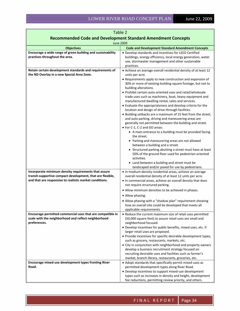
2.5 Recommended Code and Development Standard Amendment Concepts This report identifies preferred development code amendment concepts that were generated through a review of previous public input, studies and reports, input received during public land use workshops, and through input received from the Community Advisory Committee and Technical Advisory Committee. The recommendations outlined in Table 2 on page 33 represent a synthesis of possible development code and zoning options guided by the land use and development preferences identified in the public workshops. The ND Overlay Zone currently applies to a portion of the study area. The same zone with the same development standards applies to five other areas within the City also identified for nodal development. Many of the code and development standard amendment concepts identified in Table 2 are different than the existing ND Overlay Zone. Chapter 9.3000 of the Eugene Code provides for Special Area Zones (S Zones). Special Area Zones provide procedures and criteria for recognition of areas of the city that possess distinctive buildings or natural features that have significance for the community and require special consideration or implementation of conservation and development measures that cannot be achieved through application of the standard base zones. S Zones can act as an overlay to standard base zones or as unique zones specific to a neighborhood, and any standards or requirements defined in an S Zone. For this area, the working assumption is that the existing base zones are appropriate, so an S Overlay Zone would be customized for the area. It is recommended that the ND Overlay Zone (Map on page 30) within the study area be removed, and that a new S Zone (Map on page 31) be adopted that would include some of the ND Overlay requirements and additional standards and requirements that are tailored to the lower River Road area. See Figure 4 for a recommended boundary for a new S Zone designation. This is an overarching code and development standard amendment recommendation, and could effectively implement any or all of the more specific concepts found in Table 2. Table 2 contains a series of recommended code and development standard concepts. The amendment concepts are preceded by objectives so that it is clearly understood what the amendment concepts are meant to achieve. The concepts are organized first by a number of activities that apply to the Willamette Greenway and public parks within the area, general amendments that potentially apply throughout a new Special Area Zone, then finally by specific areas within the study area.

LOWER RIVER ROAD CONCEPT PLAN June 22, 2009
F I N A L R E P O R T
Page 30

LOWER RIVER ROAD CONCEPT PLAN June 22, 2009
F I N A L R E P O R T
Page 31

LOWER RIVER ROAD CONCEPT PLAN June 22, 2009
F I N A L R E P O R T
Page 32

LOWER RIVER ROAD CONCEPT PLAN June 22, 2009
F I N A L R E P O R T
Page 33
Table 2 Recommended Code and Development Standard Amendment Concepts
June 2009
Objectives Code and Development Standard Amendment Concepts
RASOR PARK AND GREENWAY
Implement the Rasor Park Master Plan and consider refinements.
The existing Master Plan that emphasizes preservation as a natural resource area should be implemented.
Consider refinements to the plan that address parking location and design, pedestrian interface along River Road, and location and design of pathways and their relationship to abutting properties.
Consider implement the LCOG’s recommendations from the Greenway Corridor Enhancement Analysis.
Issues, opportunities and recommendations are identified in the Greenway Corridor Enhancement Analysis for: o Regulatory factors, o Public facilities and recreation, o Natural Resources and water quality, and o Views and visual quality.
Consider a number of specific facilities and park functions that were identified during the public workshops: community gardens; children’s play area; gardens; public forum space; sound barrier.
Develop a public process to consider public sites within the study area but outside of Rasor Park for community gardens, public assembly areas, and playground areas.
Coordinate this process with the implementation of the Rasor Park Master Plan.
Address the issue of unpredictability and uncertainty in Willamette Greenway permitting created for both the multiple property owners and the neighborhood. Typically Willamette Greenway permits are considered on a site by site basis and permitting criteria are very general.
Prepare a single Willamette Greenway permit for the entire area that would streamline development approvals and clarify requirements.
Involve the City, property owners and the neighborhood.
The Greenway Corridor Enhancement Analysis includes a number of elements to be addressed in a single greenway permit. These elements should include pedestrian and bicycle connections between River Road and the West Bank Bike Path.
Encourage property owners to grant conservation easements as an incentive.
Provide incentives for private property owners to restore riparian areas.
Take advantage of a district based Willamette Greenway permitting process to address a number of corridor-wide issues including pedestrian/bicycle connectivity from River Road to the bike path, and view corridors to the river.
Adopt the recommendation from the River Road Conceptual Design Plan for signalized intersections and pedestrian crossings on River Road, and for connections to the river.
Utilize a single Willamette Greenway permit application as the method to assure the connections are implemented as development of private property occurs.
Provide incentives for private property owners to dedicate public access easements and make improvements in advance of development. Develop standards for pedestrian/bike connections.
Establish funding priorities for river connections located on public properties.
Identify opportunities for view corridors from River Road to the river. Incorporate view corridor requirements into design guidelines and standards for private developments.
GENERAL-APPLY THROUGHOUT THE AREA
Replace the ND Overlay with a Special Area Zone and focus mixed use and nodal development standards on commercial and residential areas.
Remove the ND Overlay.
Adopt a new Special Area Zone with boundaries that include currently zoned R-2, C-1, C-2 and GO areas within the Study Area. Also include R-1 parcels that front River Road.
LOWER RIVER ROAD CONCEPT PLAN June 22, 2009
F I N A L R E P O R T
Page 34
Table 2 Recommended Code and Development Standard Amendment Concepts
June 2009
Objectives Code and Development Standard Amendment Concepts
Encourage a wide range of green building and sustainability practices throughout the area.
Develop standards and incentives for LEED Certified buildings, energy efficiency, local energy generation, water use, stormwater management and other sustainable practices.
Retain certain development standards and requirements of the ND Overlay in a new Special Area Zone.
Achieve an average overall residential density of at least 12 units per acre.
Requirements apply to new construction and expansion of 30% or more of existing building square footage, but not to building alterations.
Prohibit certain auto-oriented uses and retail/wholesale trade uses such as machinery, boat, heavy equipment and manufactured dwelling rental, sales and services.
Evaluate the appropriateness and develop criteria for the location and design of drive-through facilities.
Building setbacks are a maximum of 15 feet from the street, and auto parking, driving and maneuvering areas are generally not permitted between the building and street.
For C-1, C-2 and GO areas:
A main entrance to a building must be provided facing the street,
Parking and maneuvering areas are not allowed between a building and a street.
Structured parking abutting a street must have at least 50% of the ground floor used for pedestrian-oriented activities.
Land between a building and street must be landscaped and/or paved for use by pedestrians.
Incorporate minimum density requirements that assure transit-supportive compact development, that are flexible, and that are responsive to realistic market conditions.
In medium-density residential areas, achieve an average overall residential density of at least 12 units per acre.
In commercial areas, achieve an overall density that does not require structured parking.
Allow minimum densities to be achieved in phases.
Allow phasing.
Allow phasing with a “shadow plan” requirement showing how an overall site could be developed that meets all applicable requirements.
Encourage permitted commercial uses that are compatible in scale with the neighborhood and reflect neighborhood preferences.
Reduce the current maximum size of retail uses permitted (50,000 square feet) to assure retail uses are small and neighborhood focused.
Develop incentives for public benefits, mixed uses, etc. if larger retail uses are proposed.
Provide incentives for specific desirable development types, such as grocery, restaurants, markets, etc.
City in conjunction with neighborhood and property owners develop a business recruitment strategy focused on recruiting desirable uses and facilities such as farmer’s market, branch library, restaurants, groceries, etc.
Encourage mixed-use development types fronting River Road.
Adopt standards that specifically permit mixed-uses as permitted development types along River Road.
Develop incentives to support mixed-use development types such as increases in density and height, development fee reductions, permitting review priority, and others.

LOWER RIVER ROAD CONCEPT PLAN June 22, 2009
F I N A L R E P O R T
Page 35
Table 2 Recommended Code and Development Standard Amendment Concepts
June 2009
Objectives Code and Development Standard Amendment Concepts
Create design standards and guidelines so that a harmonious relationship between buildings and public streets and other spaces and between buildings and parks and greenway is achieved. Achieve internal pedestrian and bicycle connectivity within developments and encourage the construction of people space. Incorporate neighborhood input into the design review decision-making process
For structures fronting River Road.
For structures fronting parks and greenway.
For screening of commercial activities and parking from parks and the greenway.
For preservation and design of view corridors and access ways to the river.
Develop connectivity standards between uses within developments and between different developments.
Develop standards and incentives so that “people spaces” are incorporated into developments and linked together to form a pedestrian network.
Evaluate the neighborhood infill and compatibility standards now being prepared by the City to address design issues within residential areas.
Evaluate review and approval procedures so that neighborhood input occurs early in the project design process.
Create buffering and setback standards so that commercial and medium density residential areas provide a harmonious relationship to adjacent single family areas.
Evaluate the adequacy of setback, landscaping and screening standards for commercial and medium density properties abutting R-1 areas.
Create parking standards that assure transit and bicycle-supportive compact development, that are flexible, and that are responsive to realistic market conditions.
Reduce or eliminate minimum parking requirements, especially when shared parking opportunities exist, public parking is provided, or when the needs of a specific development type warrant.
Evaluate parking design standards so that attractive, sustainable parking areas (e.g. for stormwater management) are provided and connectivity is considered.
Preserve and reinforce the single family character of existing R-1 zoned properties fronting River Road.
Evaluate standards so that the character of relatively large single family structures set back from River Road is achieved.
Create separation between existing commercial areas so that a continuous commercial strip along River Road is avoided.
Consider appropriate non-residential uses.
Evaluate the need for minimum density requirements in these areas.
Develop requirements that assure a high quality pedestrian environment along River Road.
NORTH COMMERCIAL AREAS-HILLCREST DRIVE VICINITY ON BOTH SIDES OF RIVER ROAD
Encourage mixed use low rise, multi-tenant commercial and commercial office development types. Limit heights of commercial and mixed use developments.
Develop form-based standards for these development types as permitted uses.
Maximum building heights should allow 2-3 story structures.
Assist in overcoming development problems with the many small commercial parcels in the area.
Consider city acquisition of a property for public parking and reducing or eliminating minimum commercial parking requirements.
Address the issue of existing non-conforming auto uses in the area.
Develop a methodology that would allow certain auto-related uses to continue.
NORTH MEDIUM DENSITY RESIDENTIAL AREAS- ON THE EAST SIDE OF RIVER ROAD
Encourage rowhouses and low rise mixed use development types along River Road, and cluster housing and low rise garden apartment development types abutting the park and
Develop form-based standards for these development types as permitted uses.
Maximum building heights should allow 2-3 story

LOWER RIVER ROAD CONCEPT PLAN June 22, 2009
F I N A L R E P O R T
Page 36
Table 2 Recommended Code and Development Standard Amendment Concepts
June 2009
Objectives Code and Development Standard Amendment Concepts
greenway. structures.
Avoid multiple driveways onto River Road. Develop policies for access consolidation onto River Road to be applied when development or redevelopment is proposed. Coordinate with on-going development of access management standards for arterials and major collectors.
CENTRAL COMMERCIAL AREA-OPPOSITE KNOOP LANE
Concentrate mixed use low-rise and mid-rise and multi-tenant commercial development types
along River Road.
Allow lower density residential types like cluster, row houses and garden apartments fronting the greenway and parks.
Develop form-based standards for these development types as permitted uses.
Maximum building heights should allow 4-6 story structures fronting River Road as an incentive for providing mixed uses, or public benefits.
Minimum building heights should allow at least a 2 story structure fronting River Road.
Maximum building heights should allow 2-3 story structures fronting the park and greenway.
Refine height and density standards so that higher heights are permitted along River Road transitioning to lower heights fronting the greenway and parks.
Option: preserve areas fronting the greenway for open space, community gardens and farmer’s market.
Provide incentives for open space/agricultural uses along the greenway in exchange for higher density and heights along River Road.
Provide for a plaza or some kind of community gathering space in the area.
Develop incentives for dedicating land for a community gathering space and encourage a public plaza (e.g. Downtown Park Blocks) versus a private gathering spot (e.g.Valley River Center). Examples could include additional height and density along River Road, earmarking park development fees to gathering space, development fee credit for land and improvements, etc. Coordinate with Parks & Open Space.
Locate and design buildings, parking areas and other site improvements that face the greenway and parks so that a harmonious relationship is created.
Develop design standards for improvements facing the greenway, parks and other public open spaces.
Evaluate buffering and screening standards where parking is located along these edges. Parking areas should be designed to be attractive and sustainable.
SOUTH MEDIUM DENSITY RESIDENTIAL AREAS- EAST OF RIVER ROAD
Concentrate mid-rise residential and mixed use low-rise development types along River Road. Allow lower density residential types like cluster, row houses and garden apartments fronting the greenway and parks.
Develop form-based standards for these development types as permitted uses.
Maximum building heights should allow 4-6 story structures fronting River Road as an incentive for providing mixed uses, or public benefits.
Maximum building heights should allow 2-3 story structures fronting the park and greenway.
Refine height and density standards so that higher heights are permitted along River Road transitioning to lower heights fronting the greenway and parks.
Option: preserve areas fronting the greenway for open space, community gardens and farmer’s market.
Provide incentives for open space/agricultural uses along the greenway in exchange for higher density and heights along River Road.
Encourage a diversity of affordable housing and housing types throughout the area. Encourage housing oriented to seniors, and others with special needs.
Work with HACSA to provide a range of affordability and a variety of housing types.
Provide incentives for affordable housing, special needs

LOWER RIVER ROAD CONCEPT PLAN June 22, 2009
F I N A L R E P O R T
Page 37
Table 2 Recommended Code and Development Standard Amendment Concepts
June 2009
Objectives Code and Development Standard Amendment Concepts
housing and housing type variety.
City to evaluate the feasibility of transfer of development rights for R-2 properties along the river in order to preserve open spaces.
SOUTH COMMERCIAL AREA-BOTH SIDES OF RIVER ROAD NORTH OF CHAMBERS
Create an employment-oriented mixed use gateway into the area; office, mid-rise mixed use, and multi-tenant commercial development types. Concentrate highest heights and density along the west side of River Road.
Develop form-based standards for these development types as permitted uses.
Maximum building heights should allow 4-6 story structures fronting River Road.
Minimum building heights should allow at least a 2 story structure fronting River Road.
Maximum building heights should allow 2-3 story structures adjacent to residential areas.
The Douglas fir trees on the west side of River Road, south of Park Avenue.

LOWER RIVER ROAD CONCEPT PLAN June 22, 2009
F I N A L R E P O R T
Page 38
3. IMPLEMENTATION STRATEGIES
3.1 Introduction The Lower River Road Concept Plan Implementation Strategies are a guide to actions that should be used to translate the Lower River Road Concept Plan described in Section 2 of this report into a reality. It incorporates the vision for the area developed by the Rasor Mixed Use Center Community Advisory Committee into “short term”, “mid-term” and “long-term” actions the City and stakeholders should take to implement the Concept Plan. There are five key implementation strategies with over thirty supporting recommendations. A Short-Term Work Program is also identified. See Table 3. As projects and actions are completed and more experience obtained, these Implementation Strategies and recommendations should be revisited and revised accordingly. It is recommended that the Short-Term Work Program be updated periodically so that progress can be monitored and new plans and programs revised to reflect progress or timeframe adjustments. The Short and Mid-term recommendations should be tied to the City’s Capital Improvement Program to reflect priorities and funding requirements for each project.
3.2 Implementation Strategies The Implementation Strategies and action recommendations described below are activities the City and stakeholders should undertake in order to implement the Lower River Road Concept Plan. It is understood, however, that accomplishing these activities will largely depend on the availability of public and private funds, availability of City staff and neighborhood resources for project assignments, and interest by property and business owners and residents of the area. Strategies and action recommendations should be considered during annual budgeting and work program preparation of the City, and by the River Road Community Organization and Whiteaker Community Council in development of their Neighborhood Action Plans. Implementation Strategy 1: Willamette River, Willamette Greenway and Rasor Park
1. Continue to protect and enhance the resources located within the Willamette
Greenway boundary.
Focus on public lands including Rasor Park and West Bank Bike Path corridor, EWEB and private parcels within the Willamette Greenway boundary. Enhance habitat and natural values, air and water quality, history, land configuration and public access to and from the West Bank Bike Path. Improve the visual/aesthetic relationship between the river corridor and neighborhood and commercial areas, and provide visual connections to the river.
Short-Term Recommendations:
1.1 Consider creation of a tax incentive program that would establish incentives for private property owners to restore riparian areas. If an incentive program is approved, make this area eligible for these incentives.

LOWER RIVER ROAD CONCEPT PLAN June 22, 2009
F I N A L R E P O R T
Page 39
1.2 Consider an area-wide Willamette Greenway permit application. In partnership with
property owners, the neighborhood and other stakeholders, the City should prepare a work program, schedule and a shared funding plan for preparation of a Master Plan for a single Willamette Greenway permit for a designated study area. The major portion of funding should come from benefited property owners.
Mid-Term Recommendations:
1.3 In partnership with property owners and other stakeholders, the City should prepare a work program, schedule and funding plan for preparation of a public process to consider the types of uses and functions identified during the public workshops (community gardens; children’s play area; gardens; public gathering space; vegetated sound barriers, etc). Identify opportunities for additional recreational facilities along the river park system. Include other public lands fronting the river and other opportunity areas within the entire study area.
1.4 Prepare a Willamette Greenway permit application. In partnership with property
owners and other stakeholders, the City should prepare a single Willamette Greenway permit application for a designated study area. The permit application should be based on the Lower River Road Corridor Framework Plan, Rasor Park Master Plan Update, and adopted Special Area Zone Plan.
A. The Greenway Corridor Enhancement Analysis includes a number of elements to be
addressed in a single greenway permit and should be considered for inclusion. B. Incorporate the recommendation from the River Road Conceptual Design Plan for
signalized intersections and pedestrian crossings on River Road, and for pedestrian and bicycle connections to the river.
C. Develop design standards for pedestrian/bicycle connections, and provide for the installation of these connections as development of private property occurs.
D. Develop incentives and methods for private property owners to provide for the installation of these connections in advance of property development. Examples of potential incentives include credits toward future development fees, and purchase of access easements.
E. Identify opportunities to maintain view corridors from River Road to the Willamette River.
F. The single Willamette Greenway permit should provide an efficient, clear and objective approval process for public and private development applications that are consistent with approved Willamette Greenway permit requirements.
Long-Term Recommendations: 1.5 Prepare construction plans for initial phase(s) of the Rasor Park Master Plan Update.
1.6 Construct initial Rasor Park Master Plan Update project improvement phases.
LOWER RIVER ROAD CONCEPT PLAN June 22, 2009
F I N A L R E P O R T
Page 40
Implementation Strategy 2: Sustainability 2. Adopt broad sustainability practices for public and private development and
infrastructure in order to offset negative impacts caused by increased development intensities.
Address environmental factors such as natural resource protection, green buildings, energy generation and use, water use and reuse and stormwater management; economic efforts that attract and support locally-owned businesses, create local jobs and markets for locally-produced food, goods and services; and social-based programs that create public gathering spaces, support desirable businesses, enhance historical assets, and utilize innovative technologies, businesses and services. This is an important implementation strategy identified in the Empowering Innovation document, but the work program and study efforts completed as part of this project did not have the human and financial resources for the development of a Lower River Road Sustainability Plan.
Short-Term Recommendations: 2.1 The River Road Community Organization (RRCO) in cooperation the City and other stakeholders should prepare a Neighborhood Action Plan that includes elements of the Lower River Road Concept Plan. (Also see Recommendation 5.1)
2.2 Prepare a Lower River Road Sustainability Plan. As an element of the Neighborhood Action Plan, RRCO in cooperation the City and other stakeholders, develop a work program, schedule and budget to prepare a Lower River Road Sustainability Plan. The plan should address the following:
A. Environment: Establish performance goals for wildlife habitat, native vegetation and tree cover, “green” buildings, on-site energy generation and conservation, water use and re-use, pervious surfaces, on-site stormwater infiltration and management, carbon emissions, and other relevant factors.
B. Economic: Develop recommendations for local economic sustainability that attracts and supports locally-owned businesses, creates jobs for neighborhood residents, and creates markets for locally-produced food, goods, and services.
C. Social: Develop recommendations for public investments to create public gathering spaces that will support a lively and healthy social atmosphere, such as branch library, plaza/farmer's market, and open spaces. Incentives for a small grocery or investment in a farmer's market may be needed. Explore creating sub-areas for historic designations including heritage trees and orchards as well as the public use of historic places. Consider opportunities for public infrastructure and demonstration projects of innovative technologies, businesses, and services, such as stormwater

LOWER RIVER ROAD CONCEPT PLAN June 22, 2009
F I N A L R E P O R T
Page 41
projects, solar power generation and management, electric car plug-in power stations, community bike loan program, peddle-cab service, or others to promote environmental and economic sustainability goals.
A number of these elements will be addressed in other action items that are part of this implementation strategy including Strategy 1-Willamette River and Willamette Greenway, Strategy 4-Zoning Code and Development Standards, and Strategy 5-Public Collaboration and Partnerships. The City of Eugene also has sustainability practices aimed at encouraging LEED Certified developments, and stormwater facility and street construction standards that already are or could be applicable to this area. The sustainability plan should reflect and incorporate the analysis and recommendations from these identified or existing programs, and emphasize additional projects desired by the neighborhood but not addressed by these other efforts.
An additional resource for identifying factors supporting sustainable neighborhoods is the rating system and standards developed by the U.S. Green Building Council for the Pilot Version, LEED for Neighborhood Development Rating System. More information is available at www.usgbc.org. Implementation Strategy 3: Lower River Road Multi-Modal Transportation Improvements
3. Design and construct multi-modal improvements along the lower River Road corridor in order to create a bicycle and pedestrian-friendly neighborhood and to encourage private investment in redevelopment of the area.
Focus on pedestrian, bicycle and transit improvements that will result in the reduced use of cars by neighborhood residents and improved access and safety for all, and street and traffic control improvements on lower River Road that reduce traffic speeds, noise and improved safety. Improvements should enhance aesthetics and support mixed-use, pedestrian-friendly neighborhood redevelopment at the three existing commercial areas along the corridor. Short-Term Recommendations:
3.1 Adopt policies giving funding priority to transportation improvement projects located in mixed use areas. 3.2 Identify crossing locations. Explore funding options such as federal grants. 3.3 Prepare a Preliminary Design Plan for Lower River Road Multi-modal Transportation Improvement Concepts and EmX Alternatives. The Preliminary Design Plan should specify: A. Median location, configuration; u-turn and alternative left turn access location/design B. Crosswalk design and control C. Options for EmX bus lane location/configuration and station location/layout

LOWER RIVER ROAD CONCEPT PLAN June 22, 2009
F I N A L R E P O R T
Page 42
D. Bus pullout location and design E. Intersection and traffic signal design (and warrant analysis) F. Median landscaping/design, streetscape features
Mid-Term Recommendations:
3.4 Prepare Phasing & Financing Plan for the lower River Road improvements that includes:
Cost Estimates
Phasing Options
Funding Sources 3.5 Adopt the Lower River Road Conceptual Design Plan and Phasing and
Financing Plan in the City’s Transportation Improvement Program, and adopt new policies, if needed, into the Transportation System Plan.
3.6 Prepare preliminary and final engineering design plans for initial phase(s).
Long-Term Recommendations: 3.7 Construct initial project improvement phase(s). 3.8 Prepare preliminary and final engineering design plans for remaining phases.
3.9 Construct remaining project improvement phases.
Implementation Strategy 4: Zoning Code and Development Standards
4. Change zoning and development standards in order to achieve a mix of desired uses and services, to prevent monolithic or single-use development, and to protect the sensitive Willamette Greenway environment and adjacent residential areas.
Create development standards for permitted uses, development types, density and height requirements, and setbacks that are appropriate for this specific neighborhood and the various redevelopment areas within it; develop incentives for private development to provide desirable uses such as a small grocery, mixed-uses, affordable housing, open spaces and meeting places; and prepare design standards and guidelines so that new developments relate harmoniously to their surroundings and to each other. Short-Term Recommendations:
4.1 Conduct an assessment of successful mixed use center implementation tools. Apply results to the lower River Road area.
4.2 Provide interim incentives for desirable development. The City should
consider providing incentives such as reduced development application fees,

LOWER RIVER ROAD CONCEPT PLAN June 22, 2009
F I N A L R E P O R T
Page 43
and expedited development application review for property owners who wish to propose projects that meet the intent of the zoning and development code changes outlined in Section 2 of this report and summarized in Table 1 but are not otherwise permitted under current zoning.
The primary regulatory vehicle providing flexibility in applying development standards is the PD-Planned Unit Development Overlay Zone (Eugene Code Section 9.430). Incentives that would make using a PD cost effective and timely should be considered.
4.3 The City should assign a staff person at the Eugene Planning Division to be
the lead contact and coordinator for activities associated with zoning and development code amendments in the lower River Road area.
Mid-Term Recommendation:
4.4 Initiate creation of a Special Area Zone. The City should prepare a work plan, schedule and budget and initiate a code amendment process to remove the ND Overlay Zone within the study area, and adopt a new (S) Special Area Zone. A new S Zone should include some of the ND Overlay requirements and additional standards and requirements as outlined in Section 2 of this report and summarized in Table 3. The development of a proposed S Zone proposal should involve the active participation of property owners, tenants, residents, RRCO, WCC and other stakeholders.
Long-Term Recommendation:
4.5 Complete plan and amendments for S Zone adoption. The City should complete a proposed S Zone for the area, and submit any necessary Comprehensive Plan and Zoning Code amendments to the Planning Commission and City Council for public hearings, consideration and adoption.
Implementation Strategy 5: Public Collaboration & Partnerships
5. Embrace public input, guidance and investment so that the concept plan and its implementation have the broadest community support, and so that public/private partnership opportunities and investments are assured.
Ensure that plans are developed with as much collaboration as possible among residents and property owners, and early neighborhood input is sought as part of the development application and approval process. Recognize that public investments in infrastructure and services will be a critical part of a successful redevelopment effort and that forging strong partnerships are a key to attracting these investments.

LOWER RIVER ROAD CONCEPT PLAN June 22, 2009
F I N A L R E P O R T
Page 44
Short-Term Recommendations: 5.1 Establish a subcommittee of the River Road Community Organization to take
responsibility for providing ideas, input and creative energy for future proposals that develop for the lower River Road area. There are also suggested activities that should be led by the subcommittee. A. A subcommittee work plan should be developed that outlines how the
committee wishes to be involved, and whether sub-committees or additional neighborhood/stakeholder participants need to be identified and appointed.
B. As funds are available, the City should provide a planning grant in support of on-going planning activities.
C. Also see Recommendation 2.1.
Mid-Term Recommendations: 5.2 Develop business/institutional recruitment strategies. Desirable public and
private uses including a branch library, plaza/farmer's market, community gardens, and small grocery have been identified but individual institutions and businesses need to be recruited and attracted to the Lower River Road Area. The RRCO in partnership with the City and interested property owners should identify specific uses to be recruited to the area and strategies for prospect recruitment.
5.3 Prepare a recruitment plan. The RRCO in partnership with the City economic
development staff should prepare a targeted recruitment plan for each desirable use and develop collateral materials, presentations, spokesperson training, etc. needed to gain the interest of a prospect, support the lower River Road area as a desirable location, and to offer assistance.
5.4 Consider adopting a Vertical Housing Development Zone. This is a State
program which offers a 10 year property tax exemption for mixed-use projects that include housing uses on upper floors. The zone requires local enacting ordinance and regulations, and is a financial incentive for mixed-use projects.

LOWER RIVER ROAD CONCEPT PLAN June 22, 2009
F I N A L R E P O R T
Page 45
Table 3 Lower River Road Concept Plan Implementation Strategies
Short-Term Work Program June 2009
Strategies and Action Recommendations Responsible Parties
Implementation Strategy 1: Willamette River and Greenway
1.1 Create incentives for riparian area restoration and enhancements. City
1.2 Prepare for an area-wide Willamette Greenway permit application. City/Property Owners/Neighborhood
Implementation Strategy 2: Sustainability
2.1 Prepare a Neighborhood Action Plan. RRCO/City
2.2 Prepare for a Lower River Road Sustainability Plan. RRCO
Implementation Strategy 3: Lower River Road Multi-modal Transportation Improvements
3.1 Pursue funding priority for improvement projects located in mixed use areas.
City
3.2 Identify pedestrian/bicycle crossing locations and pursue funding. City
3.3 Prepare a Preliminary Improvement Plan for Lower River Road including EmX City/LTD
Implementation Strategy 4: Zoning Code and Development Standards
4.1 Provide interim incentives for desirable development. City
4.2 Identify a staff lead. City
4.3 Initiate a Special Area Zone Plan. City/Stakeholders
Implementation Strategy 5: Public Collaboration & Partnerships
5.1 Establish a subcommittee of the River Road Community Organization. RRCO
Develop a work plan. RRCO
Pursue planning grant. RRCO/City
Prepare a Neighborhood Action Plan RRCO/City

LOWER RIVER ROAD CONCEPT PLAN June 22, 2009
F I N A L R E P O R T
Page 46
Glossary of Terms Empowering Innovation: Vital Neighborhoods as Sustainability Engine: Statement and Recommendations of the Rasor Park MUC Citizen Advisory Committee, November 2007. Implementation Strategies: Strategies and action recommendations described in Section 3 of this report that are activities the City and stakeholders should undertake in order to implement the Lower River Road Concept Plan. Land Use and Development Concepts: Preferred development types and recommended zoning and development code amendments described in Section 2 of this report. The zoning and code amendments are discussed in Zoning and Development Code Review Memorandum, Spencer & Kupper, May 8, 2009. Lower River Road Concept Plan: An overall plan for the Lower River Road area that includes the Multi-Modal Transportation Improvement Concepts and Land Use and Development Concepts. Multi-modal Transportation Improvement Concepts: Traffic, pedestrian and bicycle improvements identified for the Lower River Road Corridor and described in Section 2 of this report. The source of the improvement concepts is Final River Road Conceptual Design Plan, Robert Bernstein Transportation Planning and Engineering, February 2009. Rasor Park Master Plan: An approved master plan for Rasor Park completed by the City of Eugene, dated 2001. The reports and work products that have been developed as part of this project are the basis for the recommendations contained herein and they include:
Cultural Resource Survey for the Rasor Park Mixed Use Center, Donovan & Associates, November 2007
Market Evaluation for Rasor Park Mixed Use Center Plan, E.D. Hovee & Company, November 2007.
Empowering Innovation: Vital Neighborhoods as Sustainability Engine, Rasor Park MUC Citizen Advisory Committee, November 2007.
2008 River Road Neighborhood Needs Survey and Target Business Needs Survey, Community Planning Workshop, University of Oregon, December 2008.
Eugene Rasor Park Market Assessment Update Memorandum, E.D. Hovee & Company, December 2008.
Greenway Corridor Enhancement Analysis for the Rasor Mixed Use Center, Lane Council of Governments, January 2009.
Final River Road Conceptual Design Plan, Robert Bernstein Transportation Planning and Engineering, March 2009.
Final Zoning & Development Code Review Memorandum, Spencer & Kupper, May 2009.

LOWER RIVER ROAD CONCEPT PLAN June 22, 2009
F I N A L R E P O R T
Page 47
“We envision that this planning process will
provide the underpinnings and the form for a
reinvigorated River Road, serving simultaneously
to stabilize the neighborhood, provide for basic
neighborhood commercial services, and reduce
pressure on the UGB.”
-Jolene Siemsen, Chair of RRCO
