lynx mine modeling system - forum8ftp.forum8.co.jp/forum8lib/pdf/lynx2008-e.pdf · lynx mine...
TRANSCRIPT
Lynx Mine Modeling System3D Geological Modeling
STC Logistics Africa, Tel: 011 472 8040, Fax: 011 674 4703, e-mail: [email protected]
LYNX Geological modeling is based on proven surface and volume modeling technology allowing 3D interpretation andmodeling of complex geological structures. The geological modeling functions are fully integrated with LYNX hole data, dataanalysis, geostatistical estimation and engineering applications.
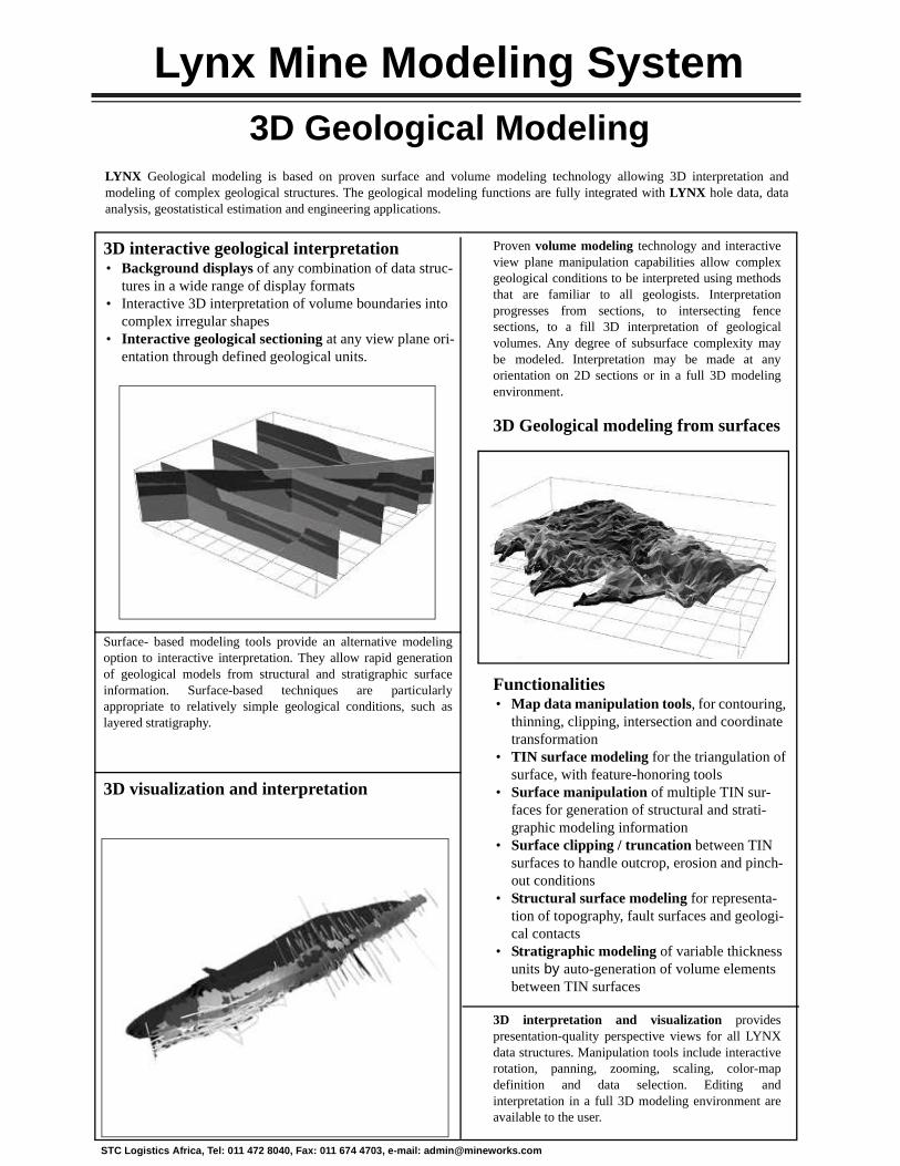
3D interactive geological interpretation • Background displays of any combination of data struc-
tures in a wide range of display formats • Interactive 3D interpretation of volume boundaries into
complex irregular shapes • Interactive geological sectioning at any view plane ori-
entation through defined geological units.
Surface- based modeling tools provide an alternative modelingoption to interactive interpretation. They allow rapid generationof geological models from structural and stratigraphic surfaceinformation. Surface-based techniques are particularlyappropriate to relatively simple geological conditions, such aslayered stratigraphy.
3D visualization and interpretation
Proven volume modeling technology and interactiveview plane manipulation capabilities allow complexgeological conditions to be interpreted using methodsthat are familiar to all geologists. Interpretationprogresses from sections, to intersecting fencesections, to a fill 3D interpretation of geologicalvolumes. Any degree of subsurface complexity maybe modeled. Interpretation may be made at anyorientation on 2D sections or in a full 3D modelingenvironment.
3D Geological modeling from surfaces
Functionalities • Map data manipulation tools, for contouring,
thinning, clipping, intersection and coordinate transformation
• TIN surface modeling for the triangulation of surface, with feature-honoring tools
• Surface manipulation of multiple TIN sur-faces for generation of structural and strati-graphic modeling information
• Surface clipping / truncation between TIN surfaces to handle outcrop, erosion and pinch-out conditions
• Structural surface modeling for representa-tion of topography, fault surfaces and geologi-cal contacts
• Stratigraphic modeling of variable thickness units by auto-generation of volume elements between TIN surfaces
3D interpretation and visualization providespresentation-quality perspective views for all LYNXdata structures. Manipulation tools include interactiverotation, panning, zooming, scaling, color-mapdefinition and data selection. Editing andinterpretation in a full 3D modeling environment areavailable to the user.

Lynx Mine Modeling System3D Geostatistics and Estimation
STC Logistics Africa, Tel: 011 472 8040, Fax: 011 674 4703, e-mail: [email protected]
\The LYNX geostatistical analysis and estimation applications are a windows based implementation of GSLIB 3D geosta-tistics. LYNX also includes Direct Volume Estimation for the estimation of complex volumes, eliminating the need for a3D grid and grid sub-blocking.
Data Functions and Compositing
• Arithmetic, log or trip functions of project variables • Logical functions of characteristics and/or variables • Compositing of hole data samples • Intersection of hole / geology to assign geological
model characteristics to hole data structures
Geostatistical Analysis
• Data transformation capabilities, including log, indica-tor, rank order and normal scores transforms.
• Semi-variogram analysis of the spatial variability of project variables, including 3D trend surfaces.
• Semi-variogram models include nested spherical, gaussian, exponential and power models in any combi-nation.
Estimation capabilities include a range of kriging optionsand semi-variogram model types, and all necessary facil-ities for dealing with variable sample density, anisotropy,non-normal distributions and underlying spatial trends.These ensure that the estimation process can deal withcases of complex spatial variability.
3D grid manipulation capabilities provide a means ofcombining estimated variable values using complexarithmetic or logical functions. 3D grid import / exportfacilities provide the options of using external predictionfacilities where appropriate, and of exporting grid datastructures for external analysis.
Direct volume estimation provides a unique method forestimating variables directly into complex volumes elimi-nating the need for a 3D grids or sub-blocking.
Hole data functions allow generation of variable andcharacteristic functions that are tailored to the project.Sample compositing for regularization of samples in holedata structures, including the honouring of geologicalintersections.
Statistical Analysis
• Univariate statistics including mean, sample size, standard error, histogram, probability, correlation, etc.
Geostatistical Estimation
• 3D kriging estimation of variable values using nor-mal or universal kriging and point or volume kriging algorithms.
• 3D inverse distance interpolation of variables for instances when kriging prediction is inappropriate.
• Geological control of sample and grid cell selection for prediction of geologically influenced variables.
• Spatial data control of sample selection by octant search.
• 3D grid manipulation allows combination of esti-mated values using a wide variety of functions.
• Direct volume estimation for kriging into irregular volumes.
The geostatistical analysis toolkit includes facilities foridentifying and isolating geological influences, direc-tional influences due to anisotropy, and underlying datatrends. A range of data transformation options extendsthe analytical capabilities to deal with cases of non-nor-mal value distribution. All facilities and results areaccessible through an interactive, point-and-click graph-ics interface.

Lynx Mine Modeling SystemUnderground Mine Design & Planning
STC Logistics Africa, Tel: 011 472 8040, Fax: 011 674 4703, e-mail: [email protected]
LYNX Underground Engineering provides a 3D platform for interactive design and layout of underground workings. Arange of design, layout and survey control options facilitate the creation, management and maintenance of complexexcavation geometries for a wide variety of deposits, mining methods and design conditions.
Interactive 3-D layout tools
• Background display for any combination of geological, geostatistical, excavation, mine development, or data-base information
• Interactive definition of excavation boundaries and assignment of engineering parameters for planning
• Assembly tools for replicating and positioning standard excavation units
• 3D perspective views in any orientation to assist in rapid visual appreciation of the spatial relationships of mine geometry
• Analysis tools such as an interactive analyze option for instant quick views of volumes and reserves during the design process
Survey volumes
Mine models representing “as mined” volumesbased on surveyed excavation limits is the basis toexcavation control, reconciliation of production, andmeans to an effective grade control process.
Grade control
• Use of in-situ sample information. • Grade entry via digitizer or direct file transfer. • Analysis of grade variance and distribution. • Direct Volume Estimation of production workings.
Mine development design tools
• Ramp and development design with variable grade, elevation and profiles along centerlines
• Geometric design tools such as curve, straight line and vertical functions
• Profile definition for rectangular, arched and circular excavation profiles

Lynx Mine Modeling SystemGeo-Engineering Design
STC Logistics Africa, Tel: 011 472 8040, Fax: 011 674 4703, e-mail: [email protected]
LYNX geo-engineering design provides a 3D geoscience platform for interactive design, planning and construction con-trol of surface and underground excavations and other engineering structures such as dams, waste or turbine rooms. Itincludes a range of design options that facilitate development of complex excavation geometries for a wide variety ofdesign conditions.
Interactive 3D design tools • Background displays of any combination of geoscience
and/or engineering data structures in a wide range of dis-play formats for design reference purposes
• Interactive 3D editing of excavation boundaries into com-plex irregular shapes
• Assembly facilities for replicating and positioning standard excavation units
• Interactive sectioning at any view plane orientation through defined excavation volumes
Excavation analysis
• Excavation intersection reporting of characteristic and variable values intersected by any selection of excava-tions and their associated volumes
Surface excavation and dump design
• Excavation design of slopes, cuts and berms by conical expansion using excavation sectors and elevation limits
• Top-down or bottom-up design flexibility to allow either optimal excavation or excavations based on surface lim-its or boundaries.
• Automatic creation of excavation crests. • Dump / fill design by conical expansion with Auto-
matic generation of toe line. • TIN surface modeling for representation of both topogra-
phy and pit / dump surfaces. Draping of aerial photos onto TIN surfaces.
A range of interactive centerline-based designtools simplifies tunnel and ramp design with vari-able grade, elevation and profile. All design toolsincorporate the full LYNX interactive graphicsfunctionality including point-and-click selection,snap-to functions, and zoom, scale and refreshfunctions.
Excavation design tools
• Centerline definition for tunnels, ramps and other excavations with elevation or grade alignment
• Curve, straight and figure tools for generation of exca-vations with specified geometries
• Profile definition for rectangular, arched and circular excavation profiles

Lynx Mine Modeling SystemSurface Mine Design & Planning
STC Logistics Africa, Tel: 011 472 8040, Fax: 011 674 4703, e-mail: [email protected]
LYNX Surface Engineering provides a 3D platform for interactive design and planning of surface mining excavation limitswith reference to geological and geostatical models of a deposit. LYNX design methods include Lerchs-Grossmann 3DPit Optimization and the Conical Expansion techniques. A range of design options allows application to strip and openpit mines. Conical expansion dump design tools are also included.
Interactive 3D design tools
• Background displays for any combination of hole geo-logical, geostatistical, excavation data in a wide variety of formats
• Interactive definition of excavation boundaries and assignment of engineering parameters for planning
• 3-D perspective views in any orientation to assist in rapid visual appreciation of the spatial relationships of mine geometry
• Interaction sectioning at any view plane, including excavation profiles
Lerchs-Grossmann pit optimisation
3D pit optimization provides a method for generatingpreliminary open pit limits based on economic crite-ria. Using a 3D grid of net $ values generated fromgeostatistical models of relevant grades; taking intoaccount key variables such as recoverable commod-ity values, mining and processing costs, haulagecosts, depth, metal recovery and other operatingcosts. The method optimizes the total net profit fromthe mining operation, constrained by wall slopes indifferent pit sectors, to obtain the excavation limits,which contain the largest possible profit. Profit con-straints allow definition of staged pits based on profit-ability.
Grade control options
• Excavation volume reporting of any volume or plan-ning unit
• Analysis of grade variance & distribution • Direct volume estimation of production workings
Conical expansion design
• Interactive definition and editing of surface excava-tions or surface dumps
• Slope and berm control by sector and elevation limits. • Geological and topographical control of profile pro-
jections • Top-down or bottom-up design to allow excavation
or dump/fill design based on surface boundary con-straints
Strip mine design tools
• Design of panel, strip or block layouts • Design of box cuts or special excavation shapes • Automatic clipping of cut boundaries
MineWorks CollectionSurvey Office
STC Logistics Africa, Tel: 011 472 8040, Fax: 011 674 4703, e-mail: [email protected]
Survey Office provides the user with all types of survey functions required for both underground and surface miningoperations. Comprehensive database tools for the customising, management and security of the data is the foundationof the package. Survey data can be entered via the keyboard or downloaded from total-station electronic instruments.
Emphasis is placed on the seamless transfer of measurement data through the survey functions database to the 3Ddraughting package StopeCAD. Together these two packages provide the user with a complete practical and productivesolution for the Survey Department.
Database Features • Storage of historical and current survey field data, cal-
culated results, audit trails, errors found etc. • Easy querying and customizeable reporting • User security levels protect the data integrity • Backup and restore functions • User defined error limit setting • Statutory defined error limit setting
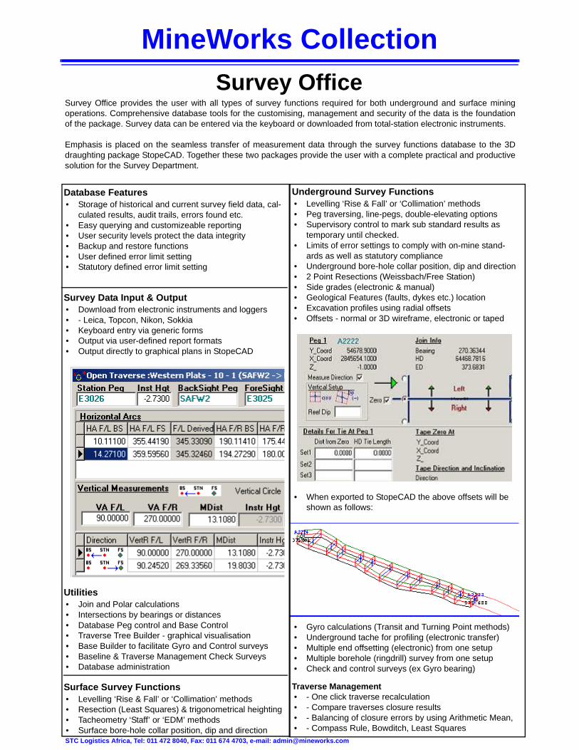
Survey Data Input & Output • Download from electronic instruments and loggers • - Leica, Topcon, Nikon, Sokkia • Keyboard entry via generic forms • Output via user-defined report formats • Output directly to graphical plans in StopeCAD
Utilities • Join and Polar calculations • Intersections by bearings or distances • Database Peg control and Base Control • Traverse Tree Builder - graphical visualisation • Base Builder to facilitate Gyro and Control surveys • Baseline & Traverse Management Check Surveys • Database administration
Surface Survey Functions • Levelling ‘Rise & Fall’ or ‘Collimation’ methods • Resection (Least Squares) & trigonometrical heighting • Tacheometry ‘Staff’ or ‘EDM’ methods • Surface bore-hole collar position, dip and direction
Underground Survey Functions • Levelling ‘Rise & Fall’ or ‘Collimation’ methods • Peg traversing, line-pegs, double-elevating options • Supervisory control to mark sub standard results as
temporary until checked. • Limits of error settings to comply with on-mine stand-
ards as well as statutory compliance • Underground bore-hole collar position, dip and direction • 2 Point Resections (Weissbach/Free Station) • Side grades (electronic & manual) • Geological Features (faults, dykes etc.) location • Excavation profiles using radial offsets • Offsets - normal or 3D wireframe, electronic or taped
• When exported to StopeCAD the above offsets will be shown as follows:
• Gyro calculations (Transit and Turning Point methods) • Underground tache for profiling (electronic transfer) • Multiple end offsetting (electronic) from one setup • Multiple borehole (ringdrill) survey from one setup • Check and control surveys (ex Gyro bearing)
Traverse Management • - One click traverse recalculation • - Compare traverses closure results • - Balancing of closure errors by using Arithmetic Mean, • - Compass Rule, Bowditch, Least Squares

MineWorks CollectionDesigner
STC Logistics Africa, Tel: 011 472 8040, Fax: 011 674 4703, e-mail: [email protected]
MineWorks Designer is a 3D modelling, designing and scheduling package that allows dynamic modelling, active design-ing and immediate updating of scheduling. The system converts center line layouts to 3 dimensional designs and draws information from StopeCAD drawings, Survey Office center line calculations and schedules the modelled layouts.
Emphasis is placed on the transfer of planning data for excavations from Geolog database to Designer. Together thesetwo packages provide the user with a complete practical and productive solution for the Planning department.
Modelling • Construction of plane views • Scaling and setting of rotating points • Selection and deletion of layers or features • Changing feature colours and coordinates • Adding new nodes and edges in layouts • Ability to freeze points at a certain elevation using
planes. • Change curvature and steepness of lines in seconds
using vertical and horizontal curving • Design tools ensure the accuracy of the distance, area
and volume of modelled designs.
3D Visualization
• Geology, survey and planning data displayed in full 3D • Displayed information is dynamic, any changes made
to the scheduling are reflected graphically, instantly
Scheduling • Interactive scheduling, using well established project
management techniques • Simple, easy to use interface for changing durations,
start dates and rates of scheduled activities • Activity duration may be specified in terms of time or
rates
• Allow an activity to be defined by its predecessors start or finish date.
• Allows a working calendar to be associated with individ-ual activities
Reporting • Production figures regarding activities may be displayed
next to each task on the bar chart. • Crosstab values can be used to display activity
attributes over a specific period • Colour periods used for scheduling and visualization
may be adjusted for various levels of details • Production below merit is clearly highlighted • Detailed Reports may be generated using Geolog
Database integration • Designer’s data handling structure allows a one to one
mapping with Geolog. • Changes made in Geolog are reflected in Designer
schedules and graphics • Network database functionality allows multiple users to
simultaneously make changes to a single project
Data Import • Supports the data formats of other MineWorks drafting
and modelling packages such as StopeCAD and Lynx • Supports the import of Lynx Drillhole, Lynx Volumes and
Lynx map information

MineWorks CollectionDrilling Performance Monitor
STC Logistics Africa., Tel: 011 472 8040, Fax: 011 674 4703, e-mail: [email protected]
Utilities • Similar database merging made easy. • Easy user-defined database field calculation, e.g. cal-
culation of core losses per drilled interval from core loss log.
• User definable interface. • Easy and extensive data querying. • Mailing of data and/or reports.
Data Entry • Meters drilled per shift per driller/machine. • Time break-down per shift per driller/machine (catego-
rised as time in production, production time losses or mining delays).
• Personnel info (drillers, drillers' assistants). • Core recovery logging. • Drill bit register (bits issued, meters drilled with a bit, on
which machine used, etc.). • Year planning for meters to be drilled per machine.
Reporting • Use of a Professional Independent Report Writer. • Data availability in user defined format, customisable
reports. • Flexibility of time period being reported: running
reports on daily, weekly or monthly basis. • Daily monitoring of cumulatively drilled meters against
planned figures, machine availability, cumulative calls and deviations from calls, dynamic reallocation of resources.
• Break-down of time allocation per driller/machine on daily or monthly basis.
• Range of graphical representation tools: linear, bar or pie charts; regression curves.
• Correct bonus calculation based on production time, core retrieved, bits usage.
• Comparison of performance figures between machines, drillers, across time span, against planned figures.
• Monthly drill bit utilisation, bit performance of each pro-ducer per area, per machine, per driller, per rock type, etc.
Database Features • User-friendly data capturing. • Customisable database. • Database administration. • Total data storage: historical and current. • Import of historical data from ASCII format. • User security access levels to protect data integrity. • Database backup and restore functions. • Centralised database combining daily production infor-
mation with geological borehole data as geology or core losses logging.
• Consistency checks on entered data, e.g. erroneous duplication of drillers/assistants on the same date, maxi-mum of 8 hours per shift per driller.
• Pick lists for uniformity of entered data.
Drilling Performance Monitoring System is an integrated database system designed for monitoring drilling perform-ance as related to drillers’ performance and machine performance in terms of production time and productivity informa-tion; and drill bits performance. It can be used for drillers’ and drillers assistants’ bonus calculations as well as integratedwith SAP to generate financial costing reports.

MineWorks CollectionGeolog
STC Logistics Africa., Tel: 011 472 8040, Fax: 011 674 4703, e-mail: [email protected]
Geolog enables user efficient and user friendly capture and storage of data originating from borehole logging, channel orgrab sampling, geotechnical logging, ore reserve management, claims management etc. The data can be displayedgraphically in StopeCAD and incorporated in the geological model. The functionality of Geolog extends to calculation ofwashtables which makes it ideal for coal mining.
Database Features • User friendly interactive data capturing operation. • Generic administration setup, user security levels. • Data management. • User customisable interface. • Pick lists for uniformity of entered data. • Easy compositing of assay results over any required
interval. • Direct link between StopeCAD and Geolog database.
Utilities • Honours known logging conventions. • Similar database merging made easy. • Import of digital assay data. • Exporting of data setup in various formats. • Interactive coordinates retrieval from StopeCAD. • Effective database querying.
Reporting • Use of a Professional Independent Report Writer. • Data availability in user defined format, easy user-
defined reporting. • Error reporting. • Audit trail. • Dynamic printing as well as historical printing.
Borehole Logging • Storage of all borehole information: survey, geology,
assay results including coal wash tables, geotechnical logging, downhole geophysical measurements, etc.
• Printing a user-definable log sheet. • Spatial reproduction of boreholes in StopeCAD as
straight boreholes, traces or fence-diagrams. • User defined borehole graphics options: variety of pat-
terns for lithology, stratigraphy, structure or alteration display, value display as histogram or linear graph, etc.
Underground Sampling • Storage of any sampling information originating from
channel or grab sampling. • Incorporating of check samples in average calculations. • Calculation of averages weighted by selected interval
width (current and progressive). • Printing a customisable sampling sheet. • Spatial reproduction of samples in StopeCAD. Direct
link between StopeCAD and Geolog database. • User defined graphics display. • Storing an image from StopeCAD with the position of
the sample underground.
Washability Calculations • Interactive point-and-click selection of the mining seam
interval. • Washtable adjustments for core & sample loss. • Weighted compositing of the washtable for a mining
seam which takes into consideration unproductive inter-vals.
• Multiple productisation. • Validity and trend checks. • Display of seam product values on the log. • Calculation of a washtable for a set of boreholes com-
prising a mining block • User definable graph display.

MineWorks CollectionMineWorks Monitor
STC Logistics Africa, Tel: 011 472 8040, Fax: 011 674 4703, e-mail: [email protected]
MineWorks Monitor is an integrated database system catering for the interactive capturing of ore reserves, ore reserve depletion, LOM and short term planning detail, real-time activity logging, audit measurements and all graphi-cal- and text reporting.
Features • User-friendly interactive data capturing operation. • Designed for capturing of planning, real-time activity log-
ging and audit measurements. • User definable data mapping for easy ASCII data import. • Easy user definable and maintenance of reports. • Data querying on a field selection base. • Data management. • Effective data security per department per user.
MineWorks Monitor Functionality • Single screen standardised data capturing. • Spatial reproduction of all graphics supported data
in StopeCAD (GIS). • Interactive Bi-directional communication between
StopeCAD and MineWorks Monitor database. • User defined graphics reproduction. • Bi-directional link between Visual Planner and
MineWorks Monitor database.
Utilities • Database verification with exception reporting. • Similar database merging made easy. • Easy user-defined database field calculation. • Mailing of data and/or reports.
Other Options • Import of digital data. • Generic Administration Setup. • User definable interface. • Exporting of Data setup in various formats. • Application activity log.
Reporting • Use of a Professional Independent Report
Writer. • Total data storage (historical and current). • Data availability in user defined format. • Error reporting. • Dynamic- or scheduled printing of current as well
as historical reports.

MineWorks CollectionMineWorks Planner
STC Logistics Africa, Tel: 011 472 8040, Fax: 011 674 4703, e-mail: [email protected]
Based on project management tools and techniques, MineWorks Planner enables project members and productionstaff at all levels to do contingency planning quickly and easily. The intuitive graphical interface and powerful data man-agement tools ease the task of reporting complex relationships between scheduled production rates and the many varia-bles and resources associated with mining activities.
The ability to track the project status against a baseline schedule and to report on actual vs. planned values is used tomonitor and control capital projects as well as monthly production in both surface and underground mining environ-ments.
Flexible project definition • Up to 200 base properties can be assigned to each
activity. • Track planned / actual values for selected properties. • Define property values using formulae. • Structure activity names to filter, group & sort activities. • Up to 200 report properties can be defined to report on
the aggregate of base properties. • Multiple user-defined calendars can be created and
assigned to individual or grouped activities.
Interactive scheduling • Define the activity duration by specifying a production
rate in terms of any of the activity base properties or by specifying a fixed duration.
• Define geometrical constraints by graphically linking activities.
• Allow an activity to start when all or any predecessor is complete.
• Drag the activity bar to the start date or to change the rate.
• Allocate a working calendar to individual activities. • Sort and filter activities on any field or combination of
conditions and fields. • Build a work breakdown structure by using the struc-
tured naming convention and the indent / outdent facili-ties.
• Split activities into smaller sections for detailed sched-ulling.
Manage equipment and labour resources • Create a common resource pool which can be shared
by a number of projects. • Assign resources to activities through drag-and-drop. • Resource assignments can be rate driven, duration
driven or effort driven. • Build a resource breakdown structure. • Summarize resource usage for single or multiple
schedules. • Show resource effort or number on histograms or
crosstab. • Vary resource costs and availability over time.
Customisable reporting • Show crosstab indent of bar for each task on bar chart. • Production below merit is highlighted clearly. • Split activities into smaller sections which can be sched-
uled individually for finer blending. • Change the quantity scheduled for an activity during a
specific period by entering the desired value. • Plan/revise production with expected grades/costs on
any basis including earned value.
Powerful data import / export • Copy and paste data to and from text-based applica-
tions via the Windows clipboard. • Use ODBC drivers to import data from relational data-
bases.
MineWorks CollectionStopeCAD
STC Logistics Africa, Tel: 011 472 8040, Fax: 011 6 74 4703, e-mail: [email protected]
StopeCAD is a user friendly 2D – 3D draughting and graphical data base package, designed to cater for all possiblerequirements in the mining industry. Drawings can be updated on a daily basis and when used in conjunction with theother MineWorks Collection modules, information from the survey, sampling, geological and planning departmentscan easily be incorporated.
Drawings are stored under different user departments and can be merged to allow for the easy access of information.Multiple, networked users can work or look at the same plan. Log-on user levels and departments ensure security ofplans. A large selection of draughting features is available. These can be edited by the user to suite specific needs.
Planning • Graphical ore resource management system. • Short and long term planning blocks can be laid out. • Variables are used to store information which can
then be used to run queries or be exported to spreadsheets.
• Block names, dates, volumes and values are typical variables.
• Mining blocks can be linked by means of a network and exported into the MineWorks Planner to update the information contained therein.
• Scripts can be setup, stored and run to assess differ-ent queries.
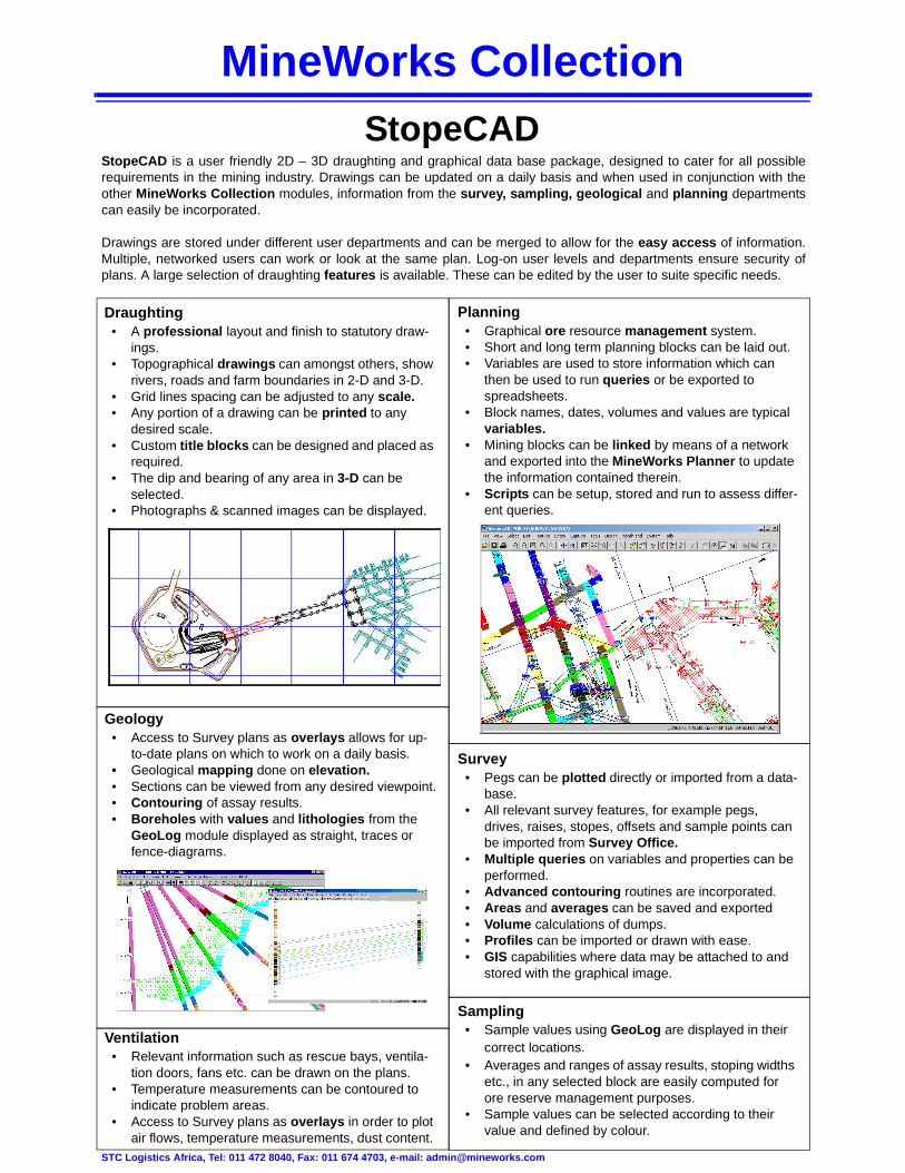
Draughting • A professional layout and finish to statutory draw-
ings. • Topographical drawings can amongst others, show
rivers, roads and farm boundaries in 2-D and 3-D. • Grid lines spacing can be adjusted to any scale. • Any portion of a drawing can be printed to any
desired scale. • Custom title blocks can be designed and placed as
required. • The dip and bearing of any area in 3-D can be
selected. • Photographs & scanned images can be displayed.
Geology • Access to Survey plans as overlays allows for up-
to-date plans on which to work on a daily basis. • Geological mapping done on elevation. • Sections can be viewed from any desired viewpoint. • Contouring of assay results. • Boreholes with values and lithologies from the
GeoLog module displayed as straight, traces or fence-diagrams.
Ventilation • Relevant information such as rescue bays, ventila-
tion doors, fans etc. can be drawn on the plans. • Temperature measurements can be contoured to
indicate problem areas. • Access to Survey plans as overlays in order to plot
air flows, temperature measurements, dust content.
Survey • Pegs can be plotted directly or imported from a data-
base. • All relevant survey features, for example pegs,
drives, raises, stopes, offsets and sample points can be imported from Survey Office.
• Multiple queries on variables and properties can be performed.
• Advanced contouring routines are incorporated. • Areas and averages can be saved and exported • Volume calculations of dumps. • Profiles can be imported or drawn with ease. • GIS capabilities where data may be attached to and
stored with the graphical image.
Sampling • Sample values using GeoLog are displayed in their
correct locations. • Averages and ranges of assay results, stoping widths
etc., in any selected block are easily computed for ore reserve management purposes.
• Sample values can be selected according to their value and defined by colour.