lyonia 6(1) 2004 - conservation of biological and cultural...
TRANSCRIPT

Lyonia 6(1) 2004 - Conservation of Biological and CulturalDiversity in the Andes and the Amazon Basin - Biodiversity
Conservation and Management Vol. 1
Volume 6(1)
December 2004
ISSN: 0888-9619

IntroductionScientists widely agree that species extinction has heavily accelerated in the last decades. The majority of theworlds species are found in tropical forests, covering a mere ten percent of the planets surface. A grave problemfor the conservation of diversity is the still very fragmentary knowledge of the ecology of most species.
The Andes and the Amazon Basin represent one of the most important Biodiversity-Hotspots on Earth. Attempts ofsustainable management and conservation must integrate local communities and their traditional knowledge.Management decisions need to include the high importance of natural resources in providing building materials,food and medicines for rural as well as urbanized communities. The traditional use of forest resources, particularlyof non-timber products like medicinal plants, has deep roots not only in indigenous communities, but is practiced ina wide section of society. The use of medicinal herbs is often an economically inevitable alternative to expensivewestern medicine. The base knowledge of this traditional use is passed from one generation to the next. Especiallythe medical use represents a highly dynamic, always evolving process, where new knowledge is constantly beingobtained, and linked to traditional practices.
An increased emphasis is being placed en possible economic benefits especially of the medicinal use of tropicalforest products instead of pure timber harvesting, an approach particularly appealing to countries with difficulteconomic conditions. Most research efforts, due to lack of manpower, time end resources, focus only on eitherbiodiversity assessments or ethnobotanical inventories, or try to implement management and use measureswithout having a sound scientific base to do so. Often the needs of the local populations, e.g. their dependency onplant resources for health care are entirely ignored.
In 2001, the 1. Congress of Conservation of Biological and Cultural Diversity in the Andes and the Amazon Basin inCusco, Peru, attempted to provide a platform to bridge the existing gap between Scientists, Non GovernmentalOrganizations, Indigenous Populations and Governmental Agencies.
The 2. Congress of this topic was held in Loja, Ecuador in 2003.
Lyonia has dedicated its 2004 issues to the publication of the most important contributions to the Loja congress.
Volumes 6 (1-2) contain papers on the Biodiversity Conservation and Management.
Volume 7 (1) deals with Flora and Vegetation of the Region
Volume 7 (2) focuses on Ethnobotany, Resource use and Zoology
Lyonia, Volume 6(1), December 2004
2odd-right:

Editorial BoardEditor-in-ChiefRainer Bussmann
Contact InformationSurface mail:LyoniaHarold L. Lyon Arboretum3860 Manoa Rd.Honolulu, HI 98622 USAPhone: +1 808 988 0456e-mail: [email protected]
Editorial BoardBalslev, Henrik, University of Aarhus, DenmarkBrandt, Kirsten, DenmarkBush, Marc, Florida Institure of Technology, USACleef, Antoine, University of Amsterdam, NetherlandsCotton, Elvira, University of Aarhus, DenmarkGoldarazena, Arturo, NEIKER, SpainGeldenhuys, Coert, FORESTWOOD, South AfricaGoikoetxea, Pablo G., NEIKER, SpainGradstein, Rob, University of Goettingen, GermanyGunderson, Lance, Emory University, USAHall, John B., University of Bangor, United KingdomJanovec, John, BRIT, USAJoergensen, Peter, Missouri Botanical Garden, USAKilpatrick, Alan, San Diego State University, USAKueppers, Manfred, University of Hohenheim, GermanyLovett, Jon C., University of York, United KingdomLucero Mosquera, Hernan P., Universidad Tecnica Particular Loja, EcuadorMatsinos, Yiannis G., University of the Aegean, GreeceMiller, Marc, Emory University, USANavarete Zambrano, Hugo G., Pontifica Universidad Catholica Quito, EcuadorOnyango, John C., Maseno University, KenyaPritchard, Lowell, Emory University, USAPitman, Nigel, Duke University, USAPohle, Perdita, University of Giessen, GermanyPoteete, Amy R., University of New Orleans, USASarmiento, Fausto, University of Georgia, USASharon, Douglas, University of California at Berkeley, USASilman, Miles, Wake Forest University, USAThiemens, Mark H., University of California San Diego, USAUlloa, Carmen, Missouri Botanical Garden, USAWilcke, Wolfgang, Technical University Berlin, GermanyYandle, Tracy, Emory University, USAZimmermann, Reiner, Max Planck Institute for Ecosystem Research, Jena, Germany
Lyonia, Volume 6(1), December 2004
3

What is Lyonia?What is Lyonia?Lyonia is an electronic, peer-reviewed, interdisciplinary journal devoted to the fast dissemination of current ecologicalresearch and its application in conservation, management, sustainable development and environmental education.Manuscript submission, peer-review and publication are entirely handled electronically. As articles are accepted they areautomatically published as "volume in progress" and immediatelly available on the web. Every six months aVolume-in-Progress is declared a Published Volume and subscribers receive the table of Contents via e-mail.Lyonia seeks articles from a wide field of disciplines (ecology, biology, anthropology, economics, law etc.) concerned withecology, conservation, management, sustainable development and education in mountain and island environments withparticular emphasis on montane forest of tropical regions.In its research section Lyonia published peer-reviewed scientific papers that report original research on ecology,conservation and management, and particularly invites contributions that show new methodologies employinginterdisciplinary and transdisciplinary approaches. The sustainable development and environmental education sectioncontains reports on these activities.
Lyonia, Volume 6(1), December 2004
4odd-right:

Table of ContentsVolume 6(1)
German Research Programs, related to the understanding and conservation ofbiodiversity as an example of the impact of the Convention of Rio on an industrial nation
Programas Alemanes de Investigación, relacionados con la comprensón y la conservación de labiodiversidad como ejemplo del impacto del Convenio de Rio sobre una nación industrializada
Erwin H. Beck [7-18]
Seed Conservation of the Latinamerican flora – an international opportunity.
La conservación de semillas de la flora latinoamericana – una oportunidad internacional.
Kate Gold* & Michael Way [19-24]
Important advances in biodiversity conservation in Peruvian Amazonia
Avances importantes en conservación de la biodiversidad en la Amazonía Peruana
Juvonen, Sanna-Kaisa1* & Tello Fernández, Hernán2 [25-33]
Priority conservation areas and management alternatives for the five ecoregionsof Latin America.
Areas prioritarias para la conservación y sus alternativas de manejo en cinco ecoregiones de AmericaLatina (GEF/1010-00-14)
Xavier Silva*,Marcelo Guevara [35-45]
Visual Plants - An image based tool for plant diversity research.
Visual Plants - Un instrumento basando en imagines para la investigación en ecologia de plantas.
Helmut Dalitz1* & Jürgen Homeier2 [47-59]
Health state of Páramos: an effort to correlate science and practice.
El estado de salud de los páramos: un esfuerzo para relacionar la ciencia con la práctica de manejosustentable.
Lyonia, Volume 6(1), December 2004
5

Robert Hofstede [61-73]
Silvicultural contributions towards sustainable management and conservation offorest genetic resources in Southern Ecuador.
Contribuciones silviculturales para manejo sostenible y conservacion de recursos geneticos forestalesen el Sur del Ecuador.
Sven Günter, Bernd Stimm & Michael Weber* [75-91]
Regeneration and succession patterns in African, Andean and Pacific TropicalMountain Forests: The role of natural and anthropogenic disturbance.
Procesos de regeneración y sucesion en los bosques montanos de Africa, Andes y del Pacifico: El rolde perturbacion natural y antropica.
Rainer W. Bussmann [93-111]
Lyonia, Volume 6(1), December 2004
6odd-right:

Lyonia, Volume 6(1), December 2004
7

Volume 6(1)
German Research Programs, related to the understanding
and conservation of biodiversity as an example of the impactof the Convention of Rio on an industrial nation
Programas Alemanes de Investigación, relacionados con la comprensón y la conservación de labiodiversidad como ejemplo del impacto del Convenio de Rio sobre una nación industrializada
Erwin H. Beck
Departmentof Plant Physiology, University of Bayreuth, Universitaetsstr. 30,95440 Bayreuth, Germany, e-mail: [email protected]
December 2004
Download at: http://www.lyonia.org/downloadPDF.php?pdfID=2.209.1
German Research Programs, related to the understanding andconservation of biodiversity as an example of the impact of the
Convention of Rio on an industrial nation
AbstractAn overview of the various German programs on biodiversity research, which are linked to, or resultfrom the commitments of the Convention on Biological Diversity, and their source of funding, ispresented. Referring briefly the aims of the individual programs the major topics of Germanbiodiversity research, in particular inventories, functionality, dynamics and regeneration, protection,management, valuation, legal aspects, and benefit sharing with counterparts is addressed andcommented. Connections of biodiversity research and global change research are worked out. Keywords: Research German program, Biological diversity, global change
ResumenSe presenta una descripción de varios programas alemanes sobre la investigación de biodiversidadque son unidos a, o que son resultado de los acuerdos de la Convención sobre la DiversidadBiológica, y su fuente de financiamiento. Se describe y se comenta brevemente los objetivos de losprogramas individuales, los temas de la principales investigaciones alemanas de la biodiversidad,particularmente los inventarios, la funcionalidad, la dinámica y regeneración, la protección, elmanejo, evaluación, los aspectos legales, y la ventaja compartida con los homólogos. Estándemostradas las relaciones entre la investigación de biodiversidad y la investigación de cambioglobal. Palabras clave: Programa de Investigación Alemán, Diversidad biológica, Cambio global
IntroductionGermany’s biodiversity is estimated as 28000 plant species, of which 6450 species are vascularplants, about 45000 species of animals and an uncounted number of fungi and microorganisms.Ecuador’s biodiversity is less well known, but estimating it five-fold higher at least with respect toplants, may be fair. In a plain sense, the term "biodiversity" refers to the number of species, genomesor genes of a selected area say Ecuador or Germany. However, in a figurative sense, biodiversityalso implies the idea of communities and of interactions. Therefore biodiversity research connotesmore than only inventory research. The dramatic loss of species caused by global change, and theincreasing public interest in sustainable utilization of ecosystems, resulted in governmental andnon-governmental activities for the worldwide conservation of activities for the worldwideconservation of biodiversity and finally in 1992 in the Convention of Rio, the "CBD".Germany’s participation in international programs and activitiesGermany has signed the CBD and is a member of Conference of the Parties (COP) since 1993.Biodiversity protection and research are therefore genuine tasks and obligations shared by a greatnumber of governmental and non-governmental authorities. In addition to their own terms ofreference, the Federal Ministries and Authorities fulfill the national tasks and internationalcommitments of the Biodiversity agreements.A "National Committee on Global Change Research" and a "Scientific Council for Global Change ofthe Federal Government" (http://www.wbgu.de) were established in Germany which stronglyemphasized the importance of biodiversity conservation and the necessity of biodiversity research.Several secretariats have been set up, e.g. a CBD-secretariat (http://www.biodiv.org), a secretariatfor the Clearinghouse-Mechanisms (http://www.biodiv-chm.de/english/index) , a secretariat ofDiversitas, and several Central Offices for documentation of biodiversity, e.g. for agriculture, forestryand fishery.As a member of the European Union, Germany participates in the 5th and the 6th frameworkprograms. In the scope of the 5th framework biodiversity-research was and is performed under theaspects of "Quality of life and management of living resources" and "Global Change, Climate and
Lyonia, Volume 6(1), Pages [7-18], December 2004
8Erwin H Beck

Species Diversity". In these days the 6th framework programs have just started. There is a researchpriority "Sustainable Development and Global Change" which addresses research into "Biologicaldiversity, Conservation of genetic resources, Functionality in terrestrial and aquatic ecosystems andInteraction of man and ecosystems". Exact figures about financing of biodiversity-research by the German government are not available.However, extrapolations on the basis of the major programs may come up to a magnitude of 100 million $per year.Nature Conservation in GermanyNature Conservation has a long history in Germany. Originally only endangered species wereprotected, but after World War II, habitat protection came into practice. Nature Conservation has beentaken into the Federal as well as most of the Federal States Constitutions and is a matter of the Germanbasic law. It is taught as a subject in primary and secondary schools. Two Universities offer DiplomaStudies in Nature conservation. Establishment and gazetting of the more than 5000 protected areasrange as affairs of the individual states but have to be agreed upon by the Federal authorities. This holdsalso for the 14 National Parks which have been established in Germany since 1978. Botanical Gardens. An important contribution to the commitments of the CBD, is accomplished by the101 German Botanical Gardens, which are either affiliated with Universities or directly financed by thepublic. About one fifth of the worldwide known vascular plants are ex-situ cultivated in theseGardens. Several species which have been eradicated in their natural habitat have survived in BotanicalGardens and in a few cases from there have been reintroduced to their home-country, e.g. Sophora toromino, the only tree of the Easter Island, which was exterminated according to the records ofIUCN. In 1988 one individual was detected in the Botanical Garden of Bonn and an internationalpropagation program was started. In 1996 the first juveniles could be reintroduced to the Easter Islands. Non-governmental organizations: In a similar way numerous NGOs and scientific societies work inthe fields of biodiversity-research and -conservation. Such NGOs, e.g. the German Botanical Society (http://www.deutsche-botanische-gesellschaft.de), Ecological (http://www.uni-giessen.de/gfoe) andZoological Societies (http://www.dzg-ev.de/index.html) not only pursue the protection of endangeredspecies, but also monitor and map the occurrence of the individual species and often investigate theirbiology. The most important NGO for nature protection in Germany is the BUND (http://www.bund.net/).Grant-funded Biodiversity Research in GermanyBiodiversity research on a higher instrumental level, such as genetic population demarcation,analysis of ecological fitness and survival strategies, and of a potential economic use is the task ofinstitutions which have the necessary equipment at their disposal, such as Universities, major researchassociations, e.g. the institutes of the Max Planck Society (http://www.mpg.de/instituteProjekteEinrichtungen/index.html), several Academies, Federal andNon-Federal research departments.Main areas of biodiversity-researchAccording to the programs, biodiversity-research in Germany takes place at 3 levels: Molecularbiodiversity-research, organismic biodiversity-research and ecosystem-related biodiversity-research (Figure 1).
Lyonia, Volume 6(1), Pages [7-18], December 2004
Programas Alemanesde Investigacion relacionados con la comprenson y laconservacion de la biodiversidad como ejemplo del impacto delConvenio de Rio sobre una nacion industrializada9

Figure 1. Major Topics of Biodiversity Research in Germany
Molecular biodiversity-researchMolecular genome inventories are investigated from all kinds of organisms: Microorganisms, fungi,plants and animals. These inventories aim at basic research as well as at useful organisms or at least genes.Molecular biodiversity of microorganismsMicroorganisms accomplish a great multitude of services in natural and anthropogenic habitats, bothterrestrial and marine, and are used in many applications, mostly in foodstuff production and pharmacy;and many of them are pathogenic. Major research programs in Germany [[(Figure 1)]] in which usuallyseveral institutions participate aim at:Inventories of terrestrial microorganisms and marine microorganismsDetection and cultivation of microorganisms which can be used for detoxification of polluted soils and watersThe contribution of microorganisms to a sustainable fertility of agricultural soilsFood-stuff-relevant microorganisms: Diversity of producers, spoilers and pathogenic organismsGenetic diversity and variability of microorganisms of medicinal interest is mainly investigated incooperation with industry and hospitals medicinal aspects of microbialSpecies diversity and monitoring of marine phyto- and zooplanktonGenoMik (http://www.genomik.uni-goettingen.de) is a research program launched in October 2000 bythe Federal Ministry of Education and Research (http://www.bmbf.de/) which covers most of the listedtopics. It is financed with about 20 Million
� for 5 years.
The German Collection of Microorganisms and Cell Cultures (http://www.dsmz.de/), maintains theso-called Center of Biological Resources. It harbors the worldwide biggest collection of plant viruses,plant cell cultures and about 13000 bacterial strains.Molecular Biodiversity-Research in PlantsModern methods of plant breeding require the knowledge of the genetic diversity of crop and forestplants. In 1998 the Federal Government launched a 7-years program "Genome Analysis of Plants as
Lyonia, Volume 6(1), Pages [7-18], December 2004
10Erwin H Beck

Biological Systems" (GABI) (http://www.fz-juelich.de/ptj/datapool/page/455/gabiengl. pdf) focusing on Arabidopsis as model organism and on barley, sugar beet, potato and other important crop plantsand fruit trees. Genome sequencing, but also the functions of the genes, proteomics, is the major goals ofthat program. Many governmental research institutions and universities participate in that program whichhas a financial volume of 80 Million $ for 7 years. A special program is on the genetic variability of forests.A comprehensive gene-bank with viable seeds of more than 100000 accessions of 2000 usefulplants is maintained at the Institute of Plant Genetics and Crop Plant Research (IPK) in Gatersleben (http://www.ipk-gatersleben.de/en/).For the documentation of all the ex-situ stocks of crop plants, medicinal plants and forest plantswhich are cultivated in the individual German institutions an "Information Centre on Biodiversity" (http://www.zadi.de/ibv/) has been established in the Central Office of Agronomic Documentation inBonn (http://www.bmvel-forschung.de/).Molecular biodiversity-research in domestic animalsOngoing loss of many breeds of domestic animals is a worldwide problem. In Germany geneticdiversity of domestic cattle is one of the major subjects of a Federal Research Institute (http://www.fal.de/) maintaining a gene bank of endangered races. Organismic biodiversity researchOrganismic biodiversity-research is predominantly performed on the level of species and populations.It comprises species diversity of a territory, the so-called -diversity,the biology of species and the specific characters of populations such as growth, radiation, maintenance and decline. Many research institutions contribute with a great multitude of individual or collaborative projects toorganismic biodiversity research, which is sponsored by the Federal as well as the Federal States’governments and by the German Research Foundation. It is quite obvious that the knowledge of floristicand faunistic inventory of Germany is much more complete than in tropical countries. Consequently setupand operation of databases with comprehensive information about the organisms on the one hand andbasic research into biodiversity on the other dominates the organismic biodiversity research in Germany.The database "Vascular Plants" (http://www.csdl.tamu.edu/FLORA/gallery.htm) is one of the mostoutstanding projects collecting and providing data on the diversity of plants in Germany. Today it containsmore than 14 million records of species, populations, plant communities, habitats and ecological andother relevant data. By networking with other databases, information can be easily amplified. In a relatedproject, the potential natural vegetation of Germany is recorded and can be provided for theestablishment of the vegetation map of Europe.A global database headed by the Zoological Museum in Bonn is the "Global Register on MigratorySpecies" (http://www.groms.de/) where all the data on migrations are compiled. In context with these data bases the "Global Biodiversity Information Facility" GBIF (http://www.gbif.org) und (http://www.gbif.de) must be mentioned in which Germany participates witha National platform ("node"). GBIF has been established in 2000 and meanwhile more than 70 countriesare contributing members.Programs of Organismic biodiversity-Research in GermanyThere are several focal points of Organismic biodiversity-research in Germany which I will briefly mention:Biodiversity of agricultural areas, as influenced by the various agricultural methods and crops isinvestigated by several institutions, aiming also at an assessment of potential effects of geneticallymodified organisms or of invasive species on the organismic communities.A similar program refers to the accompanying flora of forests, Ecology, reproduction biology andmedicinal aspects of the animal wildlife in Germany are investigated in a special program connected to adatabase for wild animal diseases which also covers animals from outside Europe. Several governmentalinstitutions investigate in collaboration with universities selected issues of marine faunistic and floristicbiodiversity: The German Research Foundation (http://www.dfg.de/) which primarily finances projects of basicresearch has launched a Priority Program "Adaptive Radiation-Origin of Biological Diversity" (http://mansfeld.ipk-gatersleben.de/radiationen/). The objective of that research program is a critical
Lyonia, Volume 6(1), Pages [7-18], December 2004
Programas Alemanesde Investigacion relacionados con la comprenson y laconservacion de la biodiversidad como ejemplo del impacto delConvenio de Rio sobre una nacion industrializada11
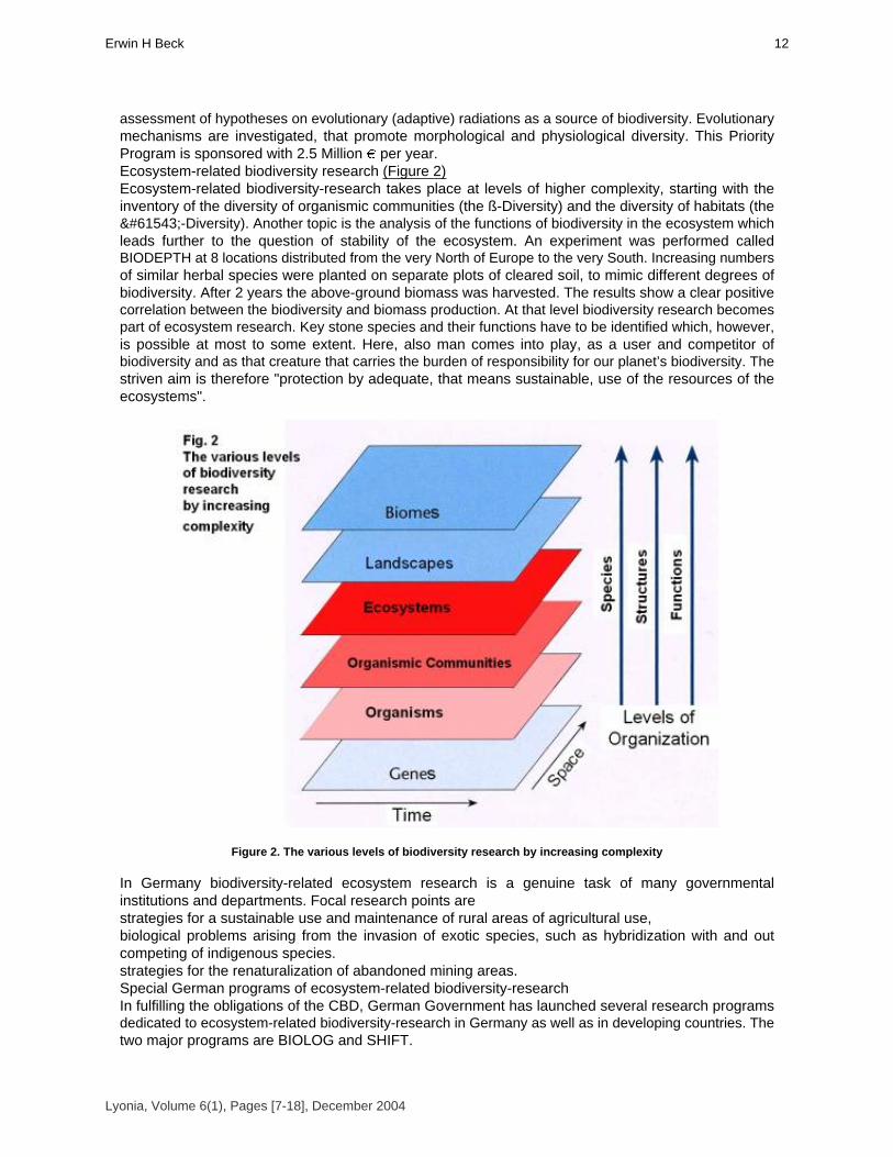
assessment of hypotheses on evolutionary (adaptive) radiations as a source of biodiversity. Evolutionarymechanisms are investigated, that promote morphological and physiological diversity. This PriorityProgram is sponsored with 2.5 Million � per year.Ecosystem-related biodiversity research (Figure 2)Ecosystem-related biodiversity-research takes place at levels of higher complexity, starting with theinventory of the diversity of organismic communities (the ß-Diversity) and the diversity of habitats (the-Diversity). Another topic is the analysis of the functions of biodiversity in the ecosystem whichleads further to the question of stability of the ecosystem. An experiment was performed calledBIODEPTH at 8 locations distributed from the very North of Europe to the very South. Increasing numbersof similar herbal species were planted on separate plots of cleared soil, to mimic different degrees ofbiodiversity. After 2 years the above-ground biomass was harvested. The results show a clear positivecorrelation between the biodiversity and biomass production. At that level biodiversity research becomespart of ecosystem research. Key stone species and their functions have to be identified which, however,is possible at most to some extent. Here, also man comes into play, as a user and competitor ofbiodiversity and as that creature that carries the burden of responsibility for our planet’s biodiversity. Thestriven aim is therefore "protection by adequate, that means sustainable, use of the resources of theecosystems".
Figure 2. The various levels of biodiversity research by increasing complexity
In Germany biodiversity-related ecosystem research is a genuine task of many governmentalinstitutions and departments. Focal research points arestrategies for a sustainable use and maintenance of rural areas of agricultural use, biological problems arising from the invasion of exotic species, such as hybridization with and outcompeting of indigenous species. strategies for the renaturalization of abandoned mining areas. Special German programs of ecosystem-related biodiversity-researchIn fulfilling the obligations of the CBD, German Government has launched several research programsdedicated to ecosystem-related biodiversity-research in Germany as well as in developing countries. Thetwo major programs are BIOLOG and SHIFT.
Lyonia, Volume 6(1), Pages [7-18], December 2004
12Erwin H Beck

BIOLOG (http://www.biolog-online.info) was started in 1999 and 93 projects most of which areclustered, were selected for funding. Work of the projects started out in 2000 and 2001. The topics of BIOLOG (Figure 3)There is no doubt that global change is also relevant to marine ecosystems. However, it is ofparticular and urgent importance to the terrestrial world, in which it gives rise to a great multitude ofsocio-economic problems. Therefore BIOLOG concentrates on research into terrestrial biodiversity. Butsince the success of integrated research into biodiversity is dependent on the accessibility of all kinds ofspecies data, biodiversity informatics is another focal point of BIOLOG. Economists enquire as to thevalue of biodiversity. For that reason, socio-economic aspects of biodiversity and of biodiversityconservation have also been included in the projects of BIOLOG.
Figure 3. BIOLOG
The Pilot Phase: Research into biodiversity requires capacity building BIOLOG has therefore given priority to integrative Research and Development Projects, which arebased on a fair degree of capacity building, especially on the international level. For a proper placementof the approved projects, BIOLOG was started with a pilot phase of 3 years and successful projects arecontinuing into the main phase for another 6 or 7 years. BIOLOG: Why Africa, why Europe?BIOLOG’s policy, as a research program, is to concentrate the projects in regions expressing different levels of biodiversity,in regions of different levels of relevant knowledge and expertise, and in regions of differently endangered biodiversity. Projects in Central Europe (BIOLOG EUROPE) are being funded because of the well-developedscientific background, on the basis of which even complicated biodiversity-related problems can beinvestigated. In the BIOLOG EUROPE projects, the effects of fragmentation of the landscape, andof intentional and accidental invasion of exotic species and other impacts on biodiversity are beingstudied, as well as
Lyonia, Volume 6(1), Pages [7-18], December 2004
Programas Alemanesde Investigacion relacionados con la comprenson y laconservacion de la biodiversidad como ejemplo del impacto delConvenio de Rio sobre una nacion industrializada13
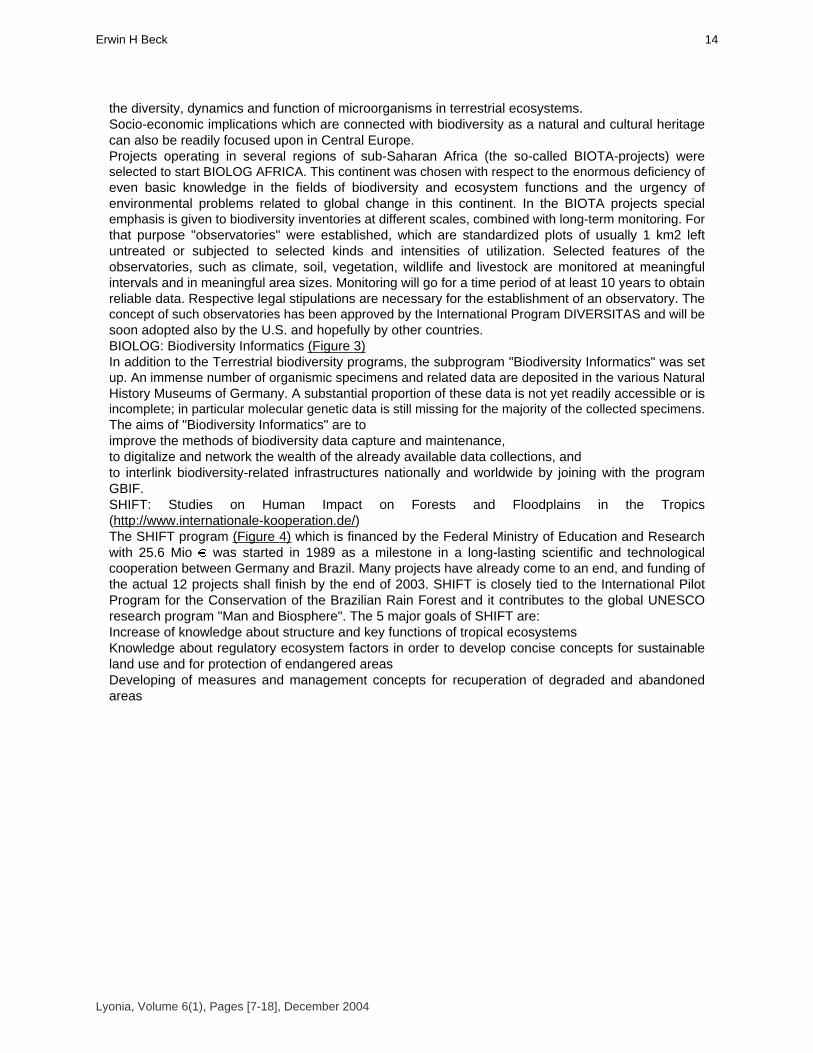
the diversity, dynamics and function of microorganisms in terrestrial ecosystems. Socio-economic implications which are connected with biodiversity as a natural and cultural heritagecan also be readily focused upon in Central Europe.Projects operating in several regions of sub-Saharan Africa (the so-called BIOTA-projects) wereselected to start BIOLOG AFRICA. This continent was chosen with respect to the enormous deficiency ofeven basic knowledge in the fields of biodiversity and ecosystem functions and the urgency ofenvironmental problems related to global change in this continent. In the BIOTA projects specialemphasis is given to biodiversity inventories at different scales, combined with long-term monitoring. Forthat purpose "observatories" were established, which are standardized plots of usually 1 km2 leftuntreated or subjected to selected kinds and intensities of utilization. Selected features of theobservatories, such as climate, soil, vegetation, wildlife and livestock are monitored at meaningfulintervals and in meaningful area sizes. Monitoring will go for a time period of at least 10 years to obtainreliable data. Respective legal stipulations are necessary for the establishment of an observatory. Theconcept of such observatories has been approved by the International Program DIVERSITAS and will besoon adopted also by the U.S. and hopefully by other countries. BIOLOG: Biodiversity Informatics (Figure 3)In addition to the Terrestrial biodiversity programs, the subprogram "Biodiversity Informatics" was setup. An immense number of organismic specimens and related data are deposited in the various NaturalHistory Museums of Germany. A substantial proportion of these data is not yet readily accessible or isincomplete; in particular molecular genetic data is still missing for the majority of the collected specimens. The aims of "Biodiversity Informatics" are to improve the methods of biodiversity data capture and maintenance, to digitalize and network the wealth of the already available data collections, and to interlink biodiversity-related infrastructures nationally and worldwide by joining with the programGBIF. SHIFT: Studies on Human Impact on Forests and Floodplains in the Tropics (http://www.internationale-kooperation.de/)The SHIFT program (Figure 4) which is financed by the Federal Ministry of Education and Researchwith 25.6 Mio � was started in 1989 as a milestone in a long-lasting scientific and technologicalcooperation between Germany and Brazil. Many projects have already come to an end, and funding ofthe actual 12 projects shall finish by the end of 2003. SHIFT is closely tied to the International PilotProgram for the Conservation of the Brazilian Rain Forest and it contributes to the global UNESCOresearch program "Man and Biosphere". The 5 major goals of SHIFT are: Increase of knowledge about structure and key functions of tropical ecosystemsKnowledge about regulatory ecosystem factors in order to develop concise concepts for sustainableland use and for protection of endangered areasDeveloping of measures and management concepts for recuperation of degraded and abandoned areas
Lyonia, Volume 6(1), Pages [7-18], December 2004
14Erwin H Beck

Figure 4. SHIFT and Mata Atlantica
Improvement of the scientific assessment of human actions with respect to environmental risks andreduction of anthropogenically induced environmental problemsTraining of specialists and capacity building for environmental researchThe projects are all performed in cooperation of German and Brazilian researchers and are located infour geographic regions with unique ecological, economic and social impacts:Central Amazonia (which represents the new frontier of agrarian movements into the rain forest andthe inundated river margins). Eastern Amazonia, (a transition zone from forestry systems to pastures and new sustainable landuse forms)The Pantanal (as a central ecosystem of high biological diversity and a social conflict area due tohigh population pressure).The Atlantic Forest, Mata Atlantica that is impaired by heavy industrial and agro-industrial activitiesand a concentration of the population.Biodiversity research of SHIFT will be continued in the scope of the new program "Ecosystem,Economy and Society in the Region MATA ATLANTICA" of the Federal State Rio de Janeiro (http://www.biolog-online.info/PT/Umwelt/F70000/F73000). It was started last year and focuses onthe remnants (5 % of originally 1 million km²) of the previous rain forests of the Atlantic Coast.BIOTEAMThe German programs of biodiversity research show that biodiversity is understood not only as amatter of biology, but is also recognized as an issue of man, especially with respect to the tremendousincrease in population. Therefore biodiversity-research must also cover socio-economic problems ofbiodiversity utilization and conservation. This claim is not new, but the problems are very complex andpromising research strategies are scarce. Biologists and sociologists, economists and lawyers mustcooperate. In 2002, a program has been implemented by the Federal Ministry of Education and research,termed "Biosphere research - integrative and application-oriented model projects", "BIOTEAM" (http://www.biolog-online.info/PT/Umwelt/F70000/F73000) ([[Figure 5]]). BIOTEAM aims atan economic validation of conservation measures on the basis of cost-benefit-analyses,an interlinking of ecosystem-targeted research in hotspots of biodiversity with bioprospecting for new
Lyonia, Volume 6(1), Pages [7-18], December 2004
Programas Alemanesde Investigacion relacionados con la comprenson y laconservacion de la biodiversidad como ejemplo del impacto delConvenio de Rio sobre una nacion industrializada15

pharmaceutical and construction materials, and a fair benefit sharing,the development of strategies for a local or regional biodiversity management for industrialized areasand against the invasion of Neobiota into the indigenous flora and fauna.Nine projects have been approved, four of which are working in Ecuador, 1 in Chile, 1 in Africa, and 3in Germany. From the Ecuadorian projects 3 are focusing on benefit sharing with respect to use ofindigenous plants. The program is financed with about 9 Million � for 3 years.
Figure 5. Bioteam
German Science FoundationThe German Science Foundation (DFG) in several programs also finances ecosystem-relatedbiodiversity-research. Well known in Ecuador is the DFG-Research Unit: Functionality in a tropicalmountain rainforest: Diversity, dynamic processes and potentials of utilization under ecosystemperspectives (http://www.bergregenwald.de). This is the project working since 1997 in South Ecuadorin the forest of the San Francisco valley and on the previous forested areas, which have been cleared foragricultural purposes (Figure 6). The project is centered around the research Station "EstacionCientifica San Francisco" which is run by the Foundation NCI. In a multidisciplinary study, comprising atpresent 32 major projects in relevant bio- and geosciences, in forestry and in sociocultural research, theGerman-Ecuadorian research group aims at an understanding of the ecosystem "mountain rain forest" inthe San Francisco Valley between Loja and Zamora and to develop protocols for reforestation andsustainable use. The study is supported with approximately 2 Million � per year.
Lyonia, Volume 6(1), Pages [7-18], December 2004
16Erwin H Beck
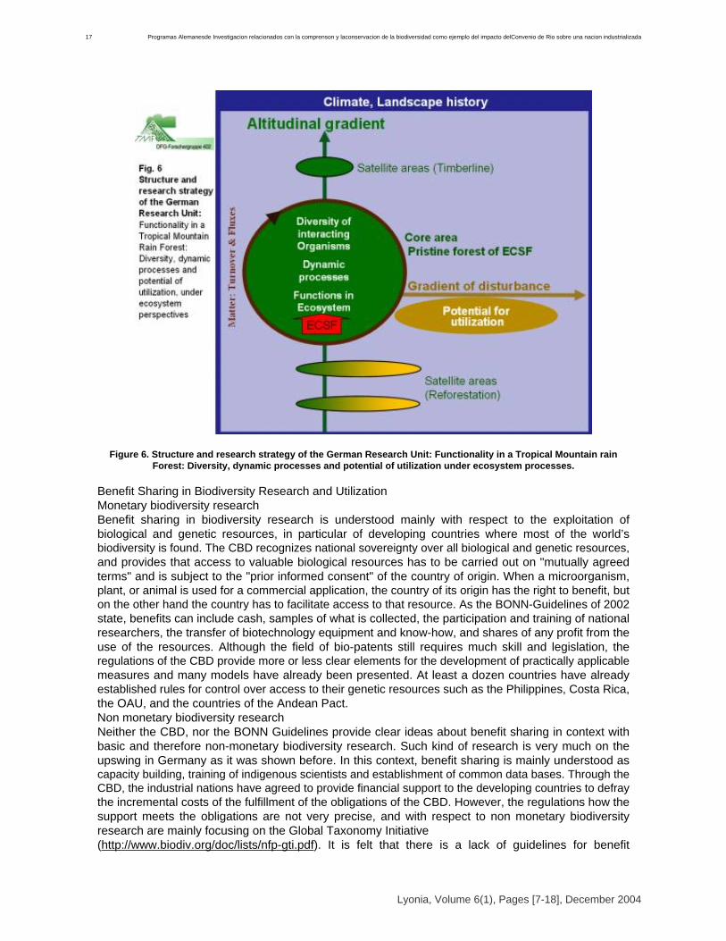
Figure 6. Structure and research strategy of the German Research Unit: Functionality in a Tropical Mountain rainForest: Diversity, dynamic processes and potential of utilization under ecosystem processes.
Benefit Sharing in Biodiversity Research and UtilizationMonetary biodiversity researchBenefit sharing in biodiversity research is understood mainly with respect to the exploitation ofbiological and genetic resources, in particular of developing countries where most of the world’sbiodiversity is found. The CBD recognizes national sovereignty over all biological and genetic resources,and provides that access to valuable biological resources has to be carried out on "mutually agreedterms" and is subject to the "prior informed consent" of the country of origin. When a microorganism,plant, or animal is used for a commercial application, the country of its origin has the right to benefit, buton the other hand the country has to facilitate access to that resource. As the BONN-Guidelines of 2002state, benefits can include cash, samples of what is collected, the participation and training of nationalresearchers, the transfer of biotechnology equipment and know-how, and shares of any profit from theuse of the resources. Although the field of bio-patents still requires much skill and legislation, theregulations of the CBD provide more or less clear elements for the development of practically applicablemeasures and many models have already been presented. At least a dozen countries have alreadyestablished rules for control over access to their genetic resources such as the Philippines, Costa Rica,the OAU, and the countries of the Andean Pact. Non monetary biodiversity researchNeither the CBD, nor the BONN Guidelines provide clear ideas about benefit sharing in context withbasic and therefore non-monetary biodiversity research. Such kind of research is very much on theupswing in Germany as it was shown before. In this context, benefit sharing is mainly understood ascapacity building, training of indigenous scientists and establishment of common data bases. Through theCBD, the industrial nations have agreed to provide financial support to the developing countries to defraythe incremental costs of the fulfillment of the obligations of the CBD. However, the regulations how thesupport meets the obligations are not very precise, and with respect to non monetary biodiversityresearch are mainly focusing on the Global Taxonomy Initiative (http://www.biodiv.org/doc/lists/nfp-gti.pdf). It is felt that there is a lack of guidelines for benefit
Lyonia, Volume 6(1), Pages [7-18], December 2004
Programas Alemanesde Investigacion relacionados con la comprenson y laconservacion de la biodiversidad como ejemplo del impacto delConvenio de Rio sobre una nacion industrializada17

sharing in basic biodiversity research, especially with regard to research into ecosystem aspectsundertaken in developing countries. A working group on benefit sharing in biodiversity-research has therefore been installed in theGerman Research Foundation and the issue has been taken up by the International Union of BiologicalSciences to work on respective guidelines in January 2004. In view of the many promising programs inBIODIVERSITY research which have been started during the last few years, not only in Germany,obstruction of that kind of research due to ill-defined legislative framework must be avoided in any case.
Lyonia, Volume 6(1), Pages [7-18], December 2004
18Erwin H Beck

Volume 6(1)
Seed Conservation of the Latinamerican flora – an
international opportunity. La conservación de semillas de la flora latinoamericana – una oportunidad internacional.
Kate Gold* & Michael Way
Royal Botanic Gardens,Kew, Wakehurst Place, Ardingly, West Sussex, RH17 6TN, Reino Unido. ,
Tel: +44 (0)1444 894159, Fax: +44(0)1444 894110, email:[email protected];[email protected]
* autor para correspondencia
December 2004
Download at: http://www.lyonia.org/downloadPDF.php?pdfID=2.212.1
Seed Conservation of the Latinamerican flora – an international opportunity.
ResumenLas acciones de conservación ex-situ complementan en una forma importante las actividades demanejo in-situ. Los bancos de semillas representan uno de los métodos más efectivos paraconservar la diversidad genética ex-situ, ya que la mayoría de especies silvestres producen semillastolerantes a la desecación que pueden sobrevivir por más de 200 años en condiciones sub zero. Esposible capturar la mayor parte de la diversidad genética de las especies de fecundación cruzada enuna sola muestra. La conservación de muestras de semillas representa una "póliza de seguro"contra las amenazas in-situ y al mismo tiempo permite el desarrollo de protocolos de germinación,técnicas de propagación etc. que contribuyen al uso potencial de la especie. El proyecto Banco deSemillas del Milenio es un programa de 10 años, coordinado por el Real Jardín Botánico de Kew,que pretende conservar semillas de especies silvestres útiles, endémicas y amenazadas. Se haestablecido colaboraciones con alrededor de 30 organizaciones en 16 países para recolectar,conservar e investigar semillas de plantas nativas. Un proyecto piloto con CNCRF-MARNR(Venezuela), colectó e investigó al menos 40 especies. Proyectos actuales con el INIA (Chile) yFESI-UNAM (México) han conservado mas de 287 especies, capacitando a 38 personas yestableciendo programas de investigación conjunta. Es esencial fortalecer las capacidades y redesexistentes y crear nuevos enlaces para proyectos de conservación de semillas que complementaráiniciativas nacionales de manejo de ecosistemas y uso sustentable de la biodiversidad Palabrasclaves: ex situ, especies silvestres, desecación, zonas áridas, capacitación.
AbstractEx situ conservation actions are an important complementary measure to in situ habitatmanagement. Seed-banking is one of the most effective and useful ways of conserving geneticdiversity ex situ, as the majority of wild plant species from dryland environments produce desiccationtolerant seeds that can be successfully stored for over 200 years. In most out-breeding species, themajority of the genetic diversity of the species may be captured by a single large seed sample.Conservation of population seed samples from these species provides insurance against loss of thewild population, whilst allowing biologists to develop germination protocols, propagation techniquesetc. to support use of the species. The Millennium Seed Bank project is a 10-year global initiative ledby RBG Kew aiming to conserve seed of useful, endemic or threatened wild plant species.Partnerships with around 30 organisations in 16 countries are building local scientific and technicalcapacity to collect, conserve, and study seeds of local plants. An initial pilot project withCNCRF-MARNR, Venezuela lead to seed collection and associated studies of at least 40 species.Current projects with INIA, Chile and FESI-UNAM, Mexico have conserved more than 287 species,trained 38 people and established joint research programmes. It is essential that seed conservationprojects strengthen existing capacities and networks, create new links and complement nationalinitiatives in ecosystem management and sustainable use of biodiversity. Key Words: ex situ, wildspecies, drying, arid zones, training.
IntroducciónLas amenazas contra la diversidad de especies son permanentes y en aumento. Un diagnóstico dela situación de la biodiversidad en los países andinos lista varias amenazas, entre ellas los altosniveles de pobreza, la insuficiente educación ambiental, el incremento de población y desarrollourbano, la expansión de la frontera agropecuaria, la extracción forestal, la apertura de nuevoscaminos, el sistema de desmonte, el sobre pastoreo, la quema de pastizales, la sobreexplotación derecursos biológicos, la actividad petrolera, la minería de oro, el comercio, el turismo, la introducciónde especies exóticas y la contaminación (Comunidad Andina de Naciones 2002). Frente a estasituación se hace urgente nuevas acciones de conservación y uso sostenible de la biodiversidad.
Lyonia, Volume 6(1), Pages [19-24], December 2004
20Kate Gold* & Michael Way

Ningún método de conservación satisface todas las necesidades. Factores como la biología de laespecie, el tipo de amenaza, los recursos disponibles para la conservación, la capacidad técnica y lasnecesidades de los usuarios influirán en las decisiones. La conservación in situ conserva tanto ladiversidad genética, como los procesos ecológicos y evolutivos, y las interrelaciones entre especies. Sinembargo, no es posible proteger todas las poblaciones y especies in situ con los recursos actuales.Siempre existirán especies amenazadas que no están incluidas en ningúna área protegida y por lo tantorequerirán otro método de conservación. Squeo et al. (2001) determinó que las actuales áreas protegidasde la región Coquimbo (Chile), conservan sólo un 39% y 56% de las categorías de plantas "en peligro" y"vulnerables" respectivamente. Aún incorporando unas 5 áreas prioritarias quedaría 30% de las plantas"en peligro" y 26% de las "vulnerables" sin protección alguna. El Articulo 9 del Convenio sobre Diversidad Biológica (CDB) compromete a las partes contratantes(principalmente a fin de complementar las medidas in situ) a adoptar "medidas para la conservación ex situ de componentes de la diversidad biológica, preferiblemente en el país de origen de losmismos". (CDB 1992). La Decisión VI/9 de La Conferencia de las Partes de la CDB adoptó la ’Estrategiamundial para la conservación de las especies vegetales’, cuyos objetivos incluye: viii) El 60% de lasespecies vegetales amenazadas en colecciones accesibles ex situ, de preferencia en el país de origen, yel 10% de ellas incluidas en los programas de recuperación y restauración (CDB 2002). La EstrategiaRegional de Biodiversidad para los países del trópico andino, aprobada por el Consejo Andino deMinistros de Relaciones Exteriores por medio de la Decisión 523, reconoce que la conservación in situ necesita de un complemento ex situ "que permite asegurar a largo plazo la propagación deespecies raras y en peligro de extinción…(y) reforzar los mecanismos de conservación de laspoblaciones silvestres" (CAN 2002).Entre los diferentes métodos para conservar la diversidad genética ex-situ, los bancos de semillasson muy efectivos y económicos (Linington & Pritchard 2001; Hawkes et al. 2000). La mayoría de lasplantas silvestres producen semillas tolerantes a la desecación (Tweddle et al. 2002) aptas paraconservación en bancos de semillas. Comparado con otros métodos de conservación ex-situ, losbancos de semillas conservan la diversidad genética de un gran número de especies en un espaciomucho más pequeño y a un costo relativamente bajo. Aparte de representar una "póliza de seguro"contra las amenazas in-situ, los bancos de semillas tambiénpermiten el desarrollo de protocolos degerminación y técnicas de propagación, que podrían contribuir a programas de uso sostenible o derecuperación y restauración de la especie in-situ.Los bancos de semillas han sido ampliamente utilizados para la conservación de especies para laalimentación y la agricultura (FAO 1996) pero hay limitados ejemplos de su uso para la conservación allargo plazo de especies silvestres (Laliberté 1997). Inspirado por la conferencia de las Naciones Unidassobre el Medio Ambiente y Desarrollo ("Cumbre de la Tierra", Rió de Janeiro, 1992), y fundamentado porel Convenio de Diversidad Biológica, el Proyecto Banco de Semillas del Milenio (PBSM) es un programade 10 años, coordinado por el Real Jardín Botánico de Kew, (RéJB Kew) que pretende lograr laconservación ex situ de semillas de las zonas áridas y semi-áridas.El objetivo del PBSM es conservar semillas de 24,000 especies silvestres (principalmente especiesútiles, endémicas y amenazadas) a través de colaboraciones bilaterales de capacitación e investigaciónconjunta. Hasta la fecha (abril 2004) se ha establecido colaboraciones con alrededor de 30organizaciones en 16 países para recolectar, conservar e investigar semillas de plantas nativas. El actualartículo describe los procedimientos básicos de la conservación ex situ de semillas y presenta lasexperiencias de un proyecto piloto en Venezuela y las colaboraciones actuales en México y Chile.
MétodosPriorizaciónEs importante utilizar los recursos disponibles óptimamente con el fin de conseguir los mejoresbeneficios posibles a nivel local, regional y nacional, para ello la priorización juega un papel muyimportante en la conservación. En México, la Comisión Nacional para el Conocimiento y Uso de laBiodiversidad (CONABIO) ha identificado regiones prioritarias para la conservación (Arriaga et al. 2000) yen la Región de Coquimbo, Chile, el libro rojo de la flora nativa y de los sitios prioritarios para suconservación (Squeo et al. 2001) soporta la priorización de las acciones.
Lyonia, Volume 6(1), Pages [19-24], December 2004
Laconservacion de semillas de la flora latinoamericana una oportunidad internacional21

MuestreoLos principios generales sobre la distribución de la diversidad genética indican que se puedecapturar la mayor parte de la variabilidad de una especie de fecundación cruzada en el muestreo de unasola población ’tipica’ (Brown & Marshall 1995; Way 2003). La mayoría de las plantas silvestres son defecundación cruzada, así que una sola muestra de semillas conservará efectivamente la diversidadgenética de la especie. ConservaciónLa gran mayoría de especies de las zonas áridas y semi-áridas, regiones prioritarias del PBSM,poseen semillas tolerantes a la desecación (Tweddle et al. 2003). Para este tipo de semilla, al secarlas, yreducir la temperatura de almacenamiento, se limitan los procesos fisiológicos de envejecimiento y seincrementa la longevidad, o potencial de almacenamiento (Ellis 1998; Probert & Hay 2000). Al reducir elcontenido de humedad de las semillas desde condiciones ambientales hasta 4-7% ch, se incrementa sulongevidad hasta 1000 veces. Almacenar las semillas en condiciones sub-zero prolonga aún más lalongevidad de las semillas. El PBSM almacena las semillas a -20 °C.Colaboraciones del PBSMLos programas de colaboración se fundamentan en combinar el conocimiento local con la largaexperiencia en conservación de semillas del RJB Kew. Los proyectos son diversos, obedeciendo lascapacidades, intereses y prioridades de las contrapartes institucionales, el país y la región (León-Loboset al. 2003; Smith et al. 2002). Cada proyecto está fundado en colectar semillas, conservarlas a largoplazo, y hacerlas accesibles para la investigación. Las actividades pueden incluir, por ejemplo: Prospección y documentación de la flora existenteRescate de germoplasma frente a una amenaza inmediataColecta de germoplasma para suministro inmediato a viveros, campesinos etc. para restauración,propagación y/o producción. Programas coordinados de investigaciónTodas las colaboraciones incluyen actividades de capacitación de personal y de fortalecimiento de lainfraestructura necesaria para la conservación exitosa de semillas de plantas silvestres. Según lospreceptos del CDB, las colaboraciones se rigen por acuerdos legales de acceso y distribución justo yequitativo de los beneficios. Estos acuerdos entre RJB Kew y sus contrapartes científicos nacionales hansido aprobados por las autoridades competentes nacionales. En todo caso se prohíbe el uso comercialpor parte del RJB Kew del material genético transferido.
ResultadosResiultados de PBSM en America LatinaVenezuelaUn proyecto piloto con el Centro Nacional para la Conservación de Recursos Fitogenéticos -Ministerio del Ambiente y de los Recursos Naturales Renovables (CNCRF-MARNR), Venezuela con laasistencia local del ONG PROVITA, colectó y estudió al menos 40 especies de la Isla Margarita con elpropósito de investigación, restauración de hábitat y almacenamiento a largo plazo. Las semillas estánconservadas en el CNCRF, Venezuela y duplicados en el Banco de Semillas del Milenio, Reino Unido.Muestras de 8 accesiones han sido pedidas como material para investigación no-comercial a través de lalista de semillas publicado por RJB Kew.ChileEl proyecto con el Instituto de Investigaciones Agropecuarias (INIA) se inicio en julio del 2001. Sehan realizado colectas de semillas en la III, IV, V y RM regiones de Chile; desde los 28º a los 34º S. Enlas regiones III y IV, las colectas se han realizado principalmente en la franja costera y en las Regiones Vy Metropolitana, desde la costa hasta los pisos subandinos de la Cordillera de los Andes. Las semillasestán conservadas en el Banco Base de Semillas de INIA localizada en Vicuña, y se depositó unduplicado en el banco de semillas del RJB Kew. Desde el inicio del proyecto hasta abril 2003 se colectó170 accesiones correspondientes a 149 especies, de las cuales un 73% son endémicas de Chile(León-Lobos et al. 2003). En Marzo 2002 se organizó un curso de "Colecta de semillas de especiesnativas para su conservación ex-situ" en Olmué, Chile. El curso reunió a 14 participantes y 7 tutores,de 13 institutos diferentes. Se establecieron varios enlaces nuevos y esto ha facilitado una red creciente
Lyonia, Volume 6(1), Pages [19-24], December 2004
22Kate Gold* & Michael Way
entre organizaciones gubernamentales, académicas y técnicas de colección y conservación de semillasde plantas chilenas endémicas, vulnerables y amenazadas.MéxicoEntre febrero 2002 y enero 2003 la Facultad de Estudios Superiores Iztacala (FESI) de laUniversidad Nacional Autónoma de México (UNAM) colectó más de 150 accesiones de 138 especies enel Valle de Tehuacán-Cuicatlán, México central. Se espera una posible expansión del proyecto,dependiendo de las provincias florísticas reconocidas dentro de las regiones xerofíticas de México. Ladivisión del país en regiones florísticas es basado en las afinidades geográficas de la flora,características eco-geográficas generales e información sobre endemismo. Esto provee un útil armazónpara objetivizar acciones de conservación ex-situ. Se ha remodelado un cuarto del banco de semillas de la FESI-UNAM, creando una cámara desecado para recibir las semillas recolectadas. Las condiciones controladas de temperatura y humedadrelativa (16°C, 16% HR) ha permitido reducir los niveles de humedad de las semillas y así mantener laviabilidad y mejorar la longevidad de las colecciones. También ha facilitado un manejo más efectivo ycoordinado de las colecciones. Después de la remodelación del cuarto de secado un técnico del RJBKew visitó al FESI-UNAM para capacitar sobre aspectos de procesamiento, evaluación de calidad yviabilidad de las colecciones de semillas y desarrollar protocolos y técnicas para evaluación y manejo delas semillas. Anteriormente, un curso de teoría y práctica capacitó a 24 personas, de varios institutos.Se han integrado un grupo de investigadores en fisiología vegetal, cultivo de tejidos, bioquímicamolecular y conservación de semillas en la FESI-UNAM, para estudiar diversos aspectos de la biologíade las especies Beaucarnea gracilis y Hechtia podantha. Ambas especies forman componentesimportantes de las comunidades vegetales de la región de Tehuacán-Cuicatlán y se integrará losresultados con otros estudios biológicos para entender mejor el rol biológico, el valor o utilidad de las especies.
DiscusiónLa conservación de germoplasma vegetal a través de los bancos de semillas es práctica y eficienteen costo. Existe mucha experiencia en los bancos de semillas de especies cultivadas pero se necesitamejorar las capacidades para trabajar con un rango diverso de especies silvestres. Al mismo tiempoexisten trabajos de investigación botánica y estudios ecogeográficos que proveen información clave parala priorización de especies y áreas a colectar. Por ejemplo, en el Ecuador se ha definido 32 ÁreasPrioritarias para la flora en base de 4 criterios, incluyendo el grado de endemismo y amenaza deespecies o habitats (Josse & Cano 2000). Es esencial fortalecer las capacidades y redes existentes ycrear nuevos enlaces para proyectos de conservación de semillas que complementará iniciativasnacionales de manejo de ecosistemas y uso sustentable de la biodiversidad. Las áreas prioritarias atrabajar podrían incluir el bosque seco latifoliado, los pastizales, arbustos, los matorrales xéricos ydesiertos, los mismos que pueden estar amenazados por cambios climáticos futuros.
ReferenciasArriaga, L.; J.M. Espinoza; C. Aguilar, E. Martínez; L. Gómez & E. Loa (eds.). 2000. Regionesterrestres prioritarias de México. Comisión Nacional para el Conocimiento y Uso de la Biodiversidad.México. Blackwell Science, Cambridge, Mass. 470 pp.Brown, A.H.D. & D.R. Marshall. 1995. A basic sampling strategy: theory & practice. Pp 75-91 in: L.Guarino; V. Ramanatha Rao & R. Reid. (eds.) Collecting Plant Genetic Diversity, CABICDB. 1992. Convenio sobre la diversidad biológica. http://www.biodiv.org/doc/legal/cbd-es.pdfCDB. 2002. Decisión VI/9. Estrategia mundial para la conservación de las especies vegetales. http://www.biodiv.org/decisions/default.aspx?lg=1&dec=VI/9Comunidad Andina de Naciones. 2002. Decisión 523 de Estrategia Regional de Biodiversidad paralos Países del Trópico Andino. http://www.comunidadandina.org/normativa/dec/D523.htmEllis, R.H. 1998. Longevity of seeds stored hermetically at low moisture contents. Seed Science Research 8 Supplement No. 1, 9-10.FAO. 1996. The State of the World’s Plant Genetic Resources for Food and Agriculture. Rome.
Lyonia, Volume 6(1), Pages [19-24], December 2004
Laconservacion de semillas de la flora latinoamericana una oportunidad internacional23

Hawkes, J.G.; N. Maxted & B.V. Ford-Lloyd. 2000. The Ex Situ Conservation of Plant GeneticResources. Kluwer Academic Publishers NL.Josse, C. & V. Cano. 2000. Iniciativas para la conservación de la biodiversidad in situ y ex situ. Pp.149-196 in: Josse, C. (ed.). Informe sobre la biodiversidad del Ecuador. Ministerio del Ambiente,EcoCiencia y Unión Mundial para la naturaleza (UICN). Quito. http://www.ambiente.gov.ec/AMBIENTE/chmcibe/estrategia/cap05b.pdfLaliberté, B. 1997. Botanic garden seed banks/genebanks worldwide, their facilities, collections andnetwork. Botanic Gardens Conservation News 2:18-23Leon Lobos, P.; M. Way; H. Pritchard; A. Moreira Muñoz; M. León & F. Casado. 2003. Conservación ex situ de la flora de Chile en banco de semillas. Chloris Chilensis, Ano 6(1) http://www.chlorischile.clLinington, S.H. & H.W. Pritchard. 2001. Gene Banks Pp. 165-181 in: Levin, S.A (ed.). Encyclopediaof Biodiversity,Volume3. Academic Press, New York.Squeo, F.A.; G. Arancio & J.R. Gutierrez (eds.). 2001. Libro Rojo de la Flora Nativa y de los SitiosPrioritarios para su conservación: Región de Coquimbo (Primera Edición). Gobierno Regional deCoquimbo/Corporación Nacional Forestal (IV Región)/Universidad de La Serena. http://www.biouls.cl/lrojo/Smith, P.P.; R.D. Smith & M. Wolfson. 2002. The Millennium Seed Bank Project in South Africa. Pp87-97 in: Baijnath, H. & Y. Singh (eds.). Rebirth of Science in Africa - A Shared Vision for Life andEnvironmental Sciences. Umdaus Press, South Africa. Probert, R.J. & F.R. Hay. 2000. Keeping seeds alive. Pp 375-410 in: Black, M. & J.D. Bewley (eds.).Seed Technology and it’s biological basis. Sheffield Academic Press.Tweddle, J.C.; R.M. Turner & J.B. Dickie. 2002. Seed Information Database (release 3.0, Jul.2002) http://www.rbgkew.org.uk/data/sidTweddle, J.C.; J.B. Dickie; C.C. Baskin & J.M. Baskin. 2003. Ecological aspects of seed desiccationsensitivity. Journal of Ecology 91 (2) 294-304.Way, MJ. 2003. Collecting seed from non-domesticated plants for long-term conservation. Pp163-201 in: Smith, R.D.; J.B. Dickie; S.H. Linington; H.W. Pritchard & R.J. Probert (eds.). 2003. SeedConservation: Turning Science into Practice. Royal Botanic Gardens, Kew, UK.
Lyonia, Volume 6(1), Pages [19-24], December 2004
24Kate Gold* & Michael Way

Volume 6(1)
Important advances in biodiversity conservation in Peruvian
Amazonia Avances importantes en conservación de la biodiversidad en la Amazonía Peruana
Juvonen, Sanna-Kaisa1* & Tello Fernández, Hernán2
1University of Turku, 20014 Turku, Finland, tel.+358-40-7559674, fax +358-2-3335730, e-mail:
[email protected];2Instituto de Investigaciones de la Amazonía
Peruana – IIAP, Avenida Abelardo Quiñones Km 2.5,Iquitos, Peru, tel. +51-65-265515, fax +51-65-265527, e-mail:
[email protected]*corresponding author
December 2004
Download at: http://www.lyonia.org/downloadPDF.php?pdfID=2.214.1

Important advances in biodiversity conservation in Peruvian Amazonia
ResumenEl ambiente está deteriorándose rápidamente en todo el mundo, incluyendo áreas que se pensabaneran remotas, como es la Amazonía peruana. La deterioración continua ha resultado en una serie deconvenios internacionales, como el Convenio sobre la Diversidad Biológica, para disminuir y mitigarestos problemas ambientales, proteger derechos de las comunidades indígenas, y conservar flora yfauna, ecosistemas y genes. En este contexto, especialmente vulnerable es la Amazonía peruanaque es un mosaico de ecosistemas asociados con los Andes y biológicamente muy diversa y querepresenta una gran variedad biológica y física que forma la base para una rica diversidad cultural.Esta megadiversidad está seriamente amenazada por la tala de bosques y uso de la tierra nosostenible que extiende ya áreas remotas. Para combatir estos problemas ambientales se inició elProyecto Diversidad Biológica de la Amazonía Peruana, Perú-Finlandia (BIODAMAZ) que es unproyecto de cooperación entre los gobiernos del Perú y de Finlandia (Fase I 1999-2002, Fase II2003-2005). El proyecto BIODAMAZ ha contribuido significativamente a la conservación y usosostenible de la biodiversidad a través de los siguientes resultados: fortalecimiento de administraciónambiental; mejoramiento de acceso a fuentes internacionales de financiamiento en conservación dela biodiversidad; fortalecimiento de capacidad de negociación de los actores ambientales peruanos;mejoramiento de sistematización, organización y acceso de información sobre biodiversidad;fortalecimiento de Zonificación Ecológica Económica; mejoramiento de conocimiento sobre patronesde distribución de biodiversidad amazónica para planificación de uso de la tierra; y fortalecimiento decapacidades regionales y colaboración institucional. Palabras clave: Conservación, Biodiversidad,Perú
AbstractEnvironment is rapidly deteriorating everywhere, including even areas once thought to be remote,such as Peruvian Amazon. The ongoing deterioration has led to a series of international agreementsand conventions, such as the Convention on Biological Diversity, in order to diminish and mitigatethese environmental risks, protect indigenous communities rights, and conserve flora and fauna,ecosystems and genes. In this context, especially vulnerable is the biologically diverse PeruvianAmazonia which is a mosaic of ecosystems that are associated with the Andes, representing a widerange of biological and physical variations that also form the basis for a rich cultural diversity. Thismegadiversity is seriously threatened as logging and unsustainable land use practices reach everremoter areas within the region. In order to deal with the pressing environmental problems theProject Biological Diversity of Peruvian Amazonia, Peru-Finland (BIODAMAZ) came into being. It is acooperation project between the governments of Peru and Finland (Phase I 1999-2002, Phase II2003-2005). The project BIODAMAZ has contributed significantly to biodiversity conservation andsustainable use in Peruvian Amazonia through the following results: strengthening of environmentaladministration and management; enhancement of possibility to access international biodiversityconservation funding sources; strengthening of negotiation capacities of Peruvian environmentalactors; systematisation and organization of and improvement of access to biodiversity information;strengthening of the regional land use planning tool, the Ecological Economic Zoning; enhancementof knowledge on Amazonian biodiversity distribution patterns for land use planning; strengthening ofregional capacities in biodiversity management and institutional collaboration. Key word:Conservation, Biodiversity, Perú
Lyonia, Volume 6(1), Pages [25-33], December 2004
26Juvonen Sanna-Kaisa1* & Tello Fernandez Hernan2

IntroductionEnvironment is rapidly deteriorating everywhere, including even areas once thought to be remote,such as Peruvian Amazonia. This ecological crisis is a global process that is generating much concernand discussion on environmental problems at a worldwide scale, especially on destruction of habitats andthe resulting unavoidable loss of species (UNEP 1995). The Earth is suffering from irreversibledeterioration which at some point ought to change attitudes towards conservation and sustainable use ofbiodiversity to more favourable for those. This should happen especially in countries that harbour vastrichness of species, habitats and ecosystems and whose inhabitants are largely dependent on theresources provided by biological diversity in their daily lives. An example of such an area is PeruvianAmazonia where people’s economies are still largely based on extractive activities that prey onbiodiversity resources.The ongoing deterioration have led to a series of international agreements and conventions, such asthe Convention on Biological Diversity (United Nations Conference on Environment and Development,Rio de Janeiro, Brazil 1992), in order to diminish and mitigate these environmental risks, protectindigenous communities rights, and conserve flora and fauna, ecosystems and genes. These are to beachieved by the fulfilment of the three Convention objectives: 1) conservation of biological diversity, 2)sustainable utilization of its components, and 3) equitable sharing of benefits derived from geneticresources of biological diversity (Convention on Biological Diversity 1992).In this context, especially vulnerable is the biologically diverse Peruvian Amazonia which is a mosaicof ecosystems that are associated with the Andes, representing a wide range of biological and physicalvariations that also form the basis for a rich cultural diversity. (Kalliola et al. 1993). Peruvian Amazonia isalso megadiverse representing one of the richest environments on the Earth. This megadiversity is alsoseriously threatened as logging and unsustainable land use practices reach ever remoter areas within theregion. Uncontrolled and informal logging also threatens the livelihoods and cultures of some nativepeoples, especially those peoples that are so called "not contacted" who have chosen to carry on theirlives as they have done for thousands of years and who do not want to have any contacts with themodern society.Although many areas of Peruvian Amazonia still remain remote the region faces some seriousenvironmental problems, such as contamination of waters, especially of rivers close to large humansettlements such as the city of Iquitos. An example of contamination endangering people’s lives was thecontamination of the Nanay River by mercury pollution which was used in gold mining upriver. Traces ofmercury were found in the people’s blood and the riverside people started to show signs of mercurypoisoning. This lead to a large-scale questioning of the legality of the practice of gold mining in the riverby the local people, and also by the city dwellers of Iquitos, largest city in Peruvian Amazonia with ca. 350000 inhabitants that also get their daily drinking water from the Nanay River. After the problem wasbrought to the attention of the media and received much interest, the Government finally acted to prohibitgold mining in the river.Peru has also showed interest in the protection and conservation of its vast natural and biologicalresources, this is evident in the legislation of the last ten years. The Peruvian Constitution calls forconservation of biodiversity as do a number of laws, such as, for example, the law on biodiversity and thelaw on protected areas. In 2001 Peru finalized its National Biodiversity Strategy (CONAM 2001) thusfulfilling one of the requirements of the Convention on Biological Diversity. This Strategy contains theRegional Biodiversity Strategy of Peruvian Amazonia (BIODAMAZ 2001a) which was finalized with thesupport of the Project Biological Diversity of Peruvian Amazonia (BIODAMAZ), a technical cooperationproject between the governments of Peru and Finland. In 2002, Peruvian political leaders signed aNational Agreement that explicitly calls for conservation of biodiversity and makes it one of the nationalpriorities to promote its research.In order to deal with the pressing environmental problems in the complex Amazonia the ProjectBiological Diversity of Peruvian Amazonia, Peru-Finland (BIODAMAZ) came into being. It is a cooperationproject between the governments of Peru and Finland which in 1999-2002 was implemented through twoagreements: first one for the Components 1 and 2 was signed on the 29th of September in 1999 and thesecond one for the Component 3 was signed on the 17th of January in 2001. The implementation phasefor the Components 1 and 2 was until the 30th of September, 2002, and for the Component 3 until 31st of
Lyonia, Volume 6(1), Pages [25-33], December 2004
Avances importantes en conservacion de la biodiversidad en la Amazonia Peruana27
December, 2002.The Second Phase of the Project was deemed necessary in order to continue the work started in thefirst phase. The agreement regarding the second phase of the project was signed on the 21st of April in2003 and the implementation period is from 2003 to 2005.The national counterpart for the project is the Peruvian Amazonian Research Institute (Instituto deInvestigaciones de la Amazonía Peruana, IIAP) and as the Finnish counterpart there is a consortiumformed by the environmental consulting company, Biota BD Oy, and the University of Turku.The project works in four Peruvian Amazonian provinces: Loreto, Ucayali, San Martín and Madre deDios, focusing mainly on the lowland rain forest areas (below 500 meters above sea level). The projectoffices are located in the headquarters of the IIAP in Iquitos.In this article the main results of this project are presented as important advances in biodiversityconservation in Peruvian Amazonia, including an assessment of the importance and impacts of these results.Necessity of action in biodiversity conservation in Peruvian AmazoniaThe necessity of this project rises from the compromise of the both countries to fulfil the requirementsof the Convention of Biological Diversity. Also it was the first project to really tackle the complexbiodiversity context of Peruvian Amazonia and to implement the requirements of the Convention at aregional level in Peru. One of these requirements is the development of biodiversity strategies and actionplans for conservation and sustainable use of biological diversity. The presentation of strategies andaction plans would allow access to different financing mechanisms of the Convention, such as the GlobalEnvironment Facility (GEF), for Peru. At the onset of the project, the Peruvian national and regionalenvironmental authorities needed also strengthening of their capacities to implement the Convention ofBiological Diversity at the national and regional level.The information that exists on Peruvian Amazonian biodiversity is very scarce and scattered indifferent institutions and thus not easily available to the users, such as decision makers, planners andeducators. Many areas in Peruvian Amazonia have not been exhaustively studied as to their biologicaldiversity, for example due to their inaccessibility and remoteness, resulting in incipient biologicalcollections only covering certain areas. Institutions working on issues related to biological diversity tend toguard their information from others, giving no room for a real development of an information culture:openness, accessibility and transparency.In order to overcome these problems in the biodiversity sector in Peru the objective of the projectBIODAMAZ was to contribute to conservation and sustainable use of Amazonian biological diversity bydevelopment of administrative and management tools and research methodologies for sustainablemanagement of Amazonian biological diversity. The objective of the second phase of the project is tocontribute to conservation and sustainable use of Amazonian biological diversity in order to promotesustainable development and poverty alleviation through strengthening of decentralized capacities anddeveloping of administrative and managerial tools and research methodologies for sustainablemanagement of biological diversity.Advances in administrative and managerial tools for conservation and sustainable use of biodiversityThe project BIODAMAZ contributed to the finalization of the Regional Biodiversity Strategy ofPeruvian Amazonia (ERDBA), which was compiled by biodiversity administrator, manager, planner anduser organizations of Peruvian Amazonia. It is a planning tool whose objective is to set priorities andadopt actions and measures for adequate conservation and sustainable use of biodiversity. ERDBA isintegrated to the National Biodiversity Strategy of Peru (ENDB) and it orients policies and practices ofhow to conserve and sustainably use the Amazonian biodiversity in the next 20 years, emphasising themanagement of the natural biological and cultural capital, promotion of investment and employment, andaccess for the local communities to the benefits derived from sustainable use of biodiversity. The Strategyand its action plans contribute to the decentralized environmental administration at the national andAmazonian level and facilitate the access to funding and national and international cooperation inprioritised projects and activities. ERDBA is published and it is now being disseminated and promoted inorder to guarantee its sustainability.As an integral part of the ERDBA are the biodiversity action plans (BIODAMAZ 2003f) which theproject BIODAMAZ facilitated to develop in the process of the strategy formulation, and which specify theneeded steps to implement the strategy, developing practical aspects. In order to take into account the
Lyonia, Volume 6(1), Pages [25-33], December 2004
28Juvonen Sanna-Kaisa1* & Tello Fernandez Hernan2
particular characteristics of the different administrative regions, action plans were also developed for thefour regions separately: Loreto, Ucayali, Madre de Dios and San Martín. The project BIODAMAZ together with specialists from institutions of the public and private sectorproposed an action plan on in situand ex situ conservation in Loreto (BIODAMAZ 2003e) as a part ofthe action plans of the ERDBA. It focuses on the region of Loreto that represents a third part of thenational territory and which represents biodiversity that is the least altered in Peruvian Amazonia. Loretois situated in the lowland Amazonian rain forest and harbours many areas of unique importance for insitu and ex situ conservation. It is considered fundamental to integrate in situ and ex situconservation strategies to guarantee adequate conservation and sustainable use of biological diversity.The action plan contains a conceptual framework for conservation, strategic objectives and actions and projects.Closely linked to the in situ and ex situ conservation action plan are the development plan ofBotanical Garden-Arboretum El Huayo (JBAH) (BIODAMAZ 2003g), which is a conservation area thatbelongs to the National University of Peruvian Amazonia (UNAP), and the scientific and technical basesand proposals of guidelines for management practices and zoning of Allpahuayo-Mishana Reserved Zone(ZRAM) (BIODAMAZ 2003a) that have been developed by the project BIODAMAZ, as well as theproposal for development of tourism along the Iquitos-Nauta road (BIODAMAZ 2003h). The JBAHdevelopment plan includes actions to strengthen the JBAH in order to conserve economically andscientifically important plant species, especially tree species, of Peruvian Amazonia. The plan alsoincludes sections on tourism and environmental education in order to strengthen the integration of thelocal communities to biodiversity conservation and sustainable use actions within the JBAH. The ZRAM isan important centre of biodiversity in the vicinity of Iquitos, as it is a mosaic of different ecosystemsleading to high biodiversity and as it presents a largest concentration of white sand forests known in Peru,harbouring many endemic and unique species of fauna and flora. Its protection is of utmost importance asit is threatened by not sustainable utilization of its resources.An essential part of biodiversity management is the management of information on biologicaldiversity. An information system is seen as a system where information is located in different institutionsthat organize and maintain information on Amazonian biological diversity, institutions being linked to eachother through different means of communication. It acts as a network that coordinates information, tries tosystematize institutional and personal scientific research and information at regional, national andinternational level. It permits to coordinate standards for information management, including theimmediate inclusion of this information to scientific and technical archives, avoiding thus dispersal ofinformation on biodiversity. The Biodiversity and Environment Information System of Peruvian Amazonia– SIAMAZONIA – was designed by the project BIODAMAZ with these ideas in mind (BIODAMAZ 2001b).Now it is operating on the Internet giving services to different actors in conservation and sustainable useof biodiversity. It can be found at www.siamazonia.org.pe. Related information systems developed by theproject are the Information System of the JBAH (SIHUAYO www.siamazonia.org.pe), Information Systemof the Allpahuayo-Mishana Reserved Zone (SIZRAM www.siamazonia.org.pe) and the Tourist InformationSystem on Iquitos-Río Amazonas (SITURISMO www.siturismo.org.pe) that were designed in closecollaboration with local sector actors and Faculty of System Engineering of the UNAP.Advances in information on biodiversity patterns in Peruvian AmazoniaThe project BIODAMAZ produced the first mosaic of satellite images with 42 images covering thewhole of lowland Peruvian Amazonia which allows appreciate the great environmental variation within thearea. The mosaic is an essential tool in biogeographical studies of biodiversity: the mosaic can help tolocate areas that could have interesting biodiversity patterns and that could be important for conservation.For the first time at a simple glance it is possible to take in the whole of Peruvian Amazonia and theenvironmental variation within. The mosaic is very useful in basic studies; it is also essential in land useplanning. IIAP has now a team of professionals that have capacity to develop satellite image mosaics, thiscapacity can be used for further development of satellite image based maps (BIODAMAZ 2003c). Itserves also as basis for the map of vegetation diversity, showing the vast diversity of different vegetationtypes in Peruvian Amazonia, and map of environmental macro units, depicting areas relativelyhomogenous as to their physical and biological characters. The making of the environmental macro unit’smap also required development of the methodology for the determination of these macro units(BIODAMAZ 2003d). To define these maps a series of ground-truthing studies were conducted in three
Lyonia, Volume 6(1), Pages [25-33], December 2004
Avances importantes en conservacion de la biodiversidad en la Amazonia Peruana29

plant (ferns, family Melastomataceae and palms) and three animal (ants, anuran amphibians and birds)groups in thirteen localities in the lowland rain forest in the northern, central and southern parts ofPeruvian Amazonia. These studies were done and the results analysed using standardized methods(BIODAMAZ 2003b). The results indicate that it is possible to use these groups of plants associated withcertain environmental characteristics to explain patterns of other groups of plants, such as trees. Somelight tendencies were observed in animals as well but the sampling was not extensive enough to provideconcrete results on that. For that more studies are needed. One key result was that vegetation patternscan be observed in the satellite images which provide a remote sensing tool for assessment ofbiodiversity patterns.The mosaic, the map of vegetation diversity and the map of environmental units are all freelyavailable on the Internet through SIAMAZONIA.Other field studies were also carried out by the project BIODAMAZ in the JBAH and in the ZRAM. Inthe JBAH an inventory of the Arboretum was carried out in order to identify the tree species in the area. Inthe ZRAM three research projects were conducted in order to provide information for the ZRAMmanagement plan process: game fauna inventory, white sand forest classification and mapping of path network.The game fauna inventory showed that there are certain areas within the ZRAM that are underintense hunting pressure by locals and outsiders. Within the area there are still certain areas that havegood numbers of game animals present, even rarer ones (Oversluijs 2002). These studies are veryimportant in the zoning of the area. In the white sand forest classification study it was possible for the firsttime tentatively classify the forests into five white sand forest type categories as the categorization wasdone using quantitative as well as qualitative methods (Garcia et al. 2002). The classification isessential to better understand how the white sand forest systems function and to show the existence of amosaic of different forest types in the area in order to enhance the protection of different forest types andtheir characteristic and unique flora and fauna. The mapping exercise showed for the first time on a mapthe path network, this information is very useful for zoning and planning of ZRAM.Capacity building in biodiversity issues in Peruvian AmazoniaThe project BIODAMAZ emphasized the importance of capacity building during all of its activities.Capacity building in the following fields was considered very important: information systems with mapservers, mosaic of satellite images, scientific research, environmental units and their integration to landuse planning, scientific field work methodologies, conceptual framework for conservation and planning ofconservation and sustainable use of biodiversity and biodiversity management.Lessons learned in biodiversity conservation and sustainable use in Peruvian AmazoniaThe implementation of the project has not only allowed the project to acknowledge the fruitfulPeruvian-Finnish cooperation but also to identify lessons learned that will be of use for future researchand development work in Peruvian Amazonia. Several of the lessons learned are presented here.It is assessed that the conceptual framework for sustainable development requires that a fourthdimension is added, the political-institutional, to the three usual dimensions of environmental, social andeconomic, also in the Peruvian Amazonian region.Information management through information systems accessible to decision-makers makingdecisions on policy questions and investment issues, is the key to an effective management of researchand development.Use of contemporary methodologies and technologies, such as remote sensing, facilitatessubstantially the increase in knowledge on biodiversity patterns, especially in spaces so complex andextensive as Peruvian Amazonia.The Amazonian biodiversity issues are to be addressed in a multi-institutional and multidisciplinarymanner in order to achieve sustainability through time and involvement of different actors in thebiodiversity sector, including local communities.There is a necessity in the region to strengthen capacity building and scientific rigor in order toincrease the understanding of conservation, sustainable use and culture of valorisation of biodiversity forAmazonian development.There is a need to look for solutions to the problems of conservation and sustainable use ofbiodiversity beyond mere means, to decide what is wanted and needed, develop attitudes for change;these are key issues in development.
Lyonia, Volume 6(1), Pages [25-33], December 2004
30Juvonen Sanna-Kaisa1* & Tello Fernandez Hernan2
Decentralization of capacities and opportunities is feasible and generate new and better opportunitiesfor the country.The wide integration and shared confidence between the Peruvian and Finnish teams has enrichedvisions and focuses, giving fruit to a productive cooperation.
ConclusionsThe results of BIODAMAZ are an important support to conservation and sustainable use ofbiodiversity in Peruvian Amazonia. The advances in biodiversity conservation brought by these results arepresented in the Table 1, along with an assessment of their importance and impacts. Nevertheless, it isimportant to learn from this experience and strengthen the sustainability of the results, by strengthening ofthe processes commenced and by implementing managerial and administrative tools developed. This isto be done during the second phase of the project BIODAMAZ.Table 1. Main advances in conservation and sustainable use of biodiversity in Peruvian Amazonia bythe project BIODAMAZ and their importance in conservation and sustainable use of biodiversity andlong-term impacts. Tabla 1. Avances en conservación y uso sostenible de biodiversidad en la Amazonía Peruana en elproyecto BIODAMAZ y su importancia en conservación y uso sostenible de biodiversidad y impacto delargo tiempo.
Lyonia, Volume 6(1), Pages [25-33], December 2004
Avances importantes en conservacion de la biodiversidad en la Amazonia Peruana31
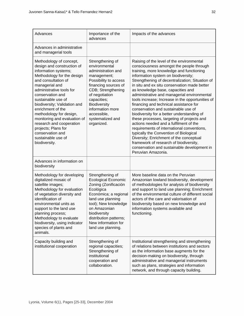
Advances Importance of theadvances
Impacts of the advances
Advances in administrativeand managerial tools
Methodology of concept,design and construction ofinformation systems;Methodology for the designand consultation ofmanagerial andadministrative tools forconservation andsustainable use ofbiodiversity; Validation andenrichment of themethodology for design,monitoring and evaluation ofresearch and cooperationprojects; Plans forconservation andsustainable use ofbiodiversity.
Strengthening ofenvironmentaladministration andmanagement;Possibility to accessfinancing sources ofCDB; Strengtheningof negotiationcapacities;Biodiversityinformation moreaccessible,systematized andorganized.
Raising of the level of the environmentalconsciousness amongst the people throughtraining, more knowledge and functioninginformation system on biodiversity;Strengthening of decentralization; Situation of in situ and ex situ conservation made betteras knowledge base, capacities andadministrative and managerial environmentaltools increase; Increase in the opportunities offinancing and technical assistance forconservation and sustainable use ofbiodiversity for a better understanding ofthese processes, targeting of projects andactions needed and a fulfilment of therequirements of international conventions,typically the Convention of BiologicalDiversity; Enrichment of the conceptualframework of research of biodiversity,conservation and sustainable development inPeruvian Amazonia.
Advances in information onbiodiversity
Methodology for developingdigitalized mosaic ofsatellite images;Methodology for evaluationof vegetation diversity andidentification ofenvironmental units assupport to the land useplanning process;Methodology to evaluatebiodiversity, using indicatorspecies of plants andanimals.
Strengthening ofEcological EconomicZoning (ZonificaciónEcológica Económica; a regionalland use planningtool); New knowledgeon Amazonianbiodiversitydistribution patterns;New information forland use planning.
More baseline data on the PeruvianAmazonian lowland biodiversity, developmentof methodologies for analysis of biodiversityand support to land use planning; Enrichmentof the environmental culture of different socialactors of the care and valorisation ofbiodiversity based on new knowledge andinformation systems available andfunctioning.
Capacity building andinstitutional cooperation
Strengthening ofregional capacities;Strengthening ofinstitutionalcooperation andcollaboration.
Institutional strengthening and strengtheningof relations between institutions and sectorsas the information base augments for thedecision-making on biodiversity, throughadministrative and managerial instrumentssuch as plans, strategies and informationnetwork, and through capacity building.
Lyonia, Volume 6(1), Pages [25-33], December 2004
32Juvonen Sanna-Kaisa1* & Tello Fernandez Hernan2

The Peruvian government within the development priorities has oriented policies towards sustainableuse of Amazonian forests, especially timber resources, sustainable tourism and other resources andservices of Amazonian biodiversity. These decisions have to be supported by solid knowledge oftechnical and scientific base to guarantee favourable socioeconomic and environmental impacts.The project BIODAMAZ, as a result of a significant cooperation between the governments of Peruand Finland, has started and strengthened some processes in order to increase knowledge andstrengthen biodiversity conservation and sustainable use through sustainable management. Theachievement of these results, in the framework of participative and integrated approach betweenconservation and development, would contribute to democratic practices and decentralization, as well asincrease opportunities of investment and employment, with positive impacts in the alleviation of poverty,aspects that are priorities in the cooperation policy of Finland and renowned aspiration of the Peruvian society.
ReferencesBIODAMAZ. 2001a. Estrategia Regional de la Diversidad Biológica Amazónica. Serie Técnica No 1.Serie IIAP-BIODAMAZ. Iquitos, Perú.BIODAMAZ. 2001b. Sistema de Información de la Diversidad Biológica y Ambiental de la AmazoníaPeruana. Serie Técnica No 2. Serie IIAP-BIODAMAZ. Iquitos, Perú.BIODAMAZ. 2003a. Bases técnicas y científicas, propuestas de programas y de zonificación de laZona Reservada Allpahuayo-Mishana. Serie Tecnica No 8. Serie IIAP-BIODAMAZ. Iquitos, Perú. In press.BIODAMAZ. 2003b. Guía para estudiar patrones de diversidad biológica en la Amazonía peruana.Serie Técnica No 6. Serie IIAP-BIODAMAZ. Iquitos, Perú. In press.BIODAMAZ. 2003c. Metodología de elaboración de mosaicos de imágenes de satelice Landsat TM.Serie Técnica No 3. Serie IIAP-BIODAMAZ. Iquitos, Perú. In press.BIODAMAZ. 2003d. Metodología de definición de macro unidades ambientales en la selva bajaperuana. Serie Técnica No 5. Serie IIAP-BIODAMAZ. Iquitos, Perú. In press.BIODAMAZ. 2003e. Plan de acción de conservación in situ y ex situ del departamento de Loreto.Serie Técnica No 7. Serie IIAP-BIODAMAZ. Iquitos, Perú. In press.BIODAMAZ. 2003f. Plan de acción de la Estrategia Regional de la Diversidad Biológica Amazónica.Serie Técnica No 4. Serie IIAP-BIODAMAZ. Iquitos, Perú. In press.BIODAMAZ. 2003g. Plan de desarrollo del Jardín Botánico-Arboretum El Huayo. Serie Técnica No 9.Serie IIAP-BIODAMAZ. Iquitos, Perú. In press.BIODAMAZ. 2003h. Propuesta de plan de desarrollo turístico por la carretera Iquitos-Nauta. SerieTécnica No 10. Serie IIAP-BIODAMAZ. Iquitos, Perú. In press.CONAM. 2001. Estrategia Nacional de la Diversidad Biológica del Perú. Consejo Nacional delAmbiente. Lima, Perú. CONVENTION ON BIOLOGICAL DIVERSITY. 1992. United Nations Conference on Environmentand Development, Rio de Janeiro, Brazil, 1992.Garcia, R.; M. Ahuite & M. Olortegui. 2002. Clasificación de bosques sobre arena blanca de la ZonaReservada Allpahuayo-Mishana. Folia Amazónica 14 (1-2). In press. Kalliola, R.; M. Puhakka & W. Danjoy. (eds.) 1993. Amazonía peruana. Vegetación húmeda tropicalen el llano subandino. 265 pp. + separate map. Paut & Oneren. Jyväskylä, Finland.Overslujis, M. 2002. Animales de caza en la Zona Reservada Allpahuayo-Mishana. Folia Amazónica14 (1-2). In press.UNEP. 1995. Heywood, V.H. (exec. ed.). Global Biodiversity Assessment. United NationsEnvironmental Programme. University Press, Cambridge, Great Britain. 1140 pp.
Lyonia, Volume 6(1), Pages [25-33], December 2004
Avances importantes en conservacion de la biodiversidad en la Amazonia Peruana33

Volume 6(1)
Priority conservation areas and management alternatives for
the five ecoregions of Latin America. Areas prioritarias para la conservación y sus alternativas de manejo en cinco ecoregiones de America
Latina (GEF/1010-00-14)
Xavier Silva*,Marcelo Guevara
[email protected],Teléfono: (5932) 22 48 430, Quito, Ecuador
*autor corresponsal
December 2004
Download at: http://www.lyonia.org/downloadPDF.php?pdfID=2.224.1
Priority conservation areas and management alternatives for the fiveecoregions of Latin America.
ResumenEl proyecto "Áreas prioritarias para la conservación y sus alternativas de manejo en cincoecoregiones de América Latina" es ejecutado por instituciones de investigación en Panamá,Colombia, Ecuador, Perú, Bolivia y Paraguay. El proyecto da a conocer a la comunidad internacionalla selección científica de 5 áreas prioritarias para la conservación dentro de 5 ecoregiones de altaimportancia mundial: el Chocó Biogeográfico, las vertientes andinas orientales de Ecuador, Perú yBolivia y el Chaco Seco. Entre los resultados que condujeron a dicha selección, existe el análisis demás de 6470 especies de flora y fauna (cada una con mapa de distribución) y la producción de másde 6500 mapas temáticos indicando tipos de vegetación, centros de alta diversidad y endemismo,amenazas, fragmentación de bosques, infraestructura, etc. La segunda fase del proyecto consisteen analizar las condiciones ambientales y socioeconómicas de las áreas seleccionadas y formularpropuestas de alternativas de manejo para quienes toman decisiones de conservación a nivelnacional y local. Este proyecto, que se caracteriza por la participación de instanciasgubernamentales y locales, es administrado por The Nature Conservancy Ecuador y apoyado porinstituciones como NASA, Naciones Unidas, NatureServe, Universidad de Maryland y el Centro deTecnologías Espaciales GRID en South Dakota. Palabras clave: Conservación, Ecoregiones,América del sur
AbstractThe project "Catalyzing Conservation Action in Latin America: Identifying priority sites and bestmanagement alternatives in five global significant ecoregions" is executed by conservation/scienceorganizations in Panama, Colombia, Ecuador, Peru, Bolivia and Paraguay. The project provides tothe international community a science-based selection of priority conservation sites in five globalpriority ecoregions: the Choco, the eastern slopes of the Andes in Ecuador, Peru and Bolivia, and theDry Chaco. Among the results conducing to the site selection, more than 6470 species of flora andfauna have been analyzed (each one with a geographic distribution map) and more than 6500thematic maps have been produced, indicating vegetation types, centers of high diversity andendemism, current and potential threats, forest fragmentation, infrastructure, etc. The second phaseof the project analyzes the environmental and socio-economic conditions of the selected sites andformulates alternative management proposals for decision-makers both at national and local levels.This project is characterized by the participation of different organizations at local and national levels.The project is administrated by The Nature Conservancy and technically supported by organizationssuch as NASA, United Nations, NatureServe, University of Maryland and the Center for SpatialTechnologies, GRID, South Dakota. Key words: Conservation, Ecoregions, South-America
IntroducciónEl objetivo principal del proyecto es el de identificar, sobre bases científicas, los sitios de altaprioridad para la conservación en cinco ecoregiones de importancia mundial en América Latina. Paracada uno de los sitios prioritarios se propondrán alternativas prácticas de conservación y manejo derecursos naturales, las cuales serán presentadas ante las autoridades y tomadores de decisiones anivel nacional y local en: Colombia, Ecuador, Perú, Bolivia y Paraguay. El proyecto se caracterizapor la participación de instituciones nacionales, gubernamentales y locales para su desarrollo. Lasecoregiones son: el Chocó Biogeográfico (Panamá, Colombia y Ecuador), la Cordillera Real Oriental(Colombia, Ecuador y Perú), las Yungas Peruanas (Perú), los Yungas Bolivianos (Bolivia) y el ChacoSeco (Bolivia y Paraguay). Para escoger las ecoregiones se tomó inicialmente el esquemaecoregional del WWF y Banco Mundial (Dinerstein et. al. 1995).El análisis comprende tres grandes componentes: (1) el estudio biológico- ecológico, basado en elanálisis de más de 4750 especies de flora y fauna (todos los mamíferos, todas las aves, todos los
Lyonia, Volume 6(1), Pages [35-45], December 2004
36Xavier Silva*Marcelo Guevara
anfibios y todas las especies de dos familias botánicas por ecoregión), cada una con un mapa dedistribución. El objetivo del análisis biológico-ecológico es el de identificar los centros de altabiodiversidad y de endemismo, de especies amenazadas, etc. (2) Luego viene el análisis del estado deconservación (también amenazas) y de fragmentación de bosques y vegetación natural, basado enanálisis de imágenes satelitarias 1999 al 2002 y (3) el estudio del Sistema Nacional de Áreas Protegidas(SNAP) de los 6 países, incluyendo ubicación de áreas y sistemas de manejo. El objetivo del estudio delos SNAP es identificar las zonas que comprenden un cierto grado de protección legal y aquellas que apesar de su estatus dentro del Sistema, necesitan ser reforzadas.La integración de estos 3 grandes ejes (centros de diversidad y endemismo, etc x fragmentación xáreas verdaderamente protegidas) provee elementos necesarios para identificar sitios que deberían serconservados prioritariamente. Generalmente son sitios con alta diversidad, endemismo, con cierto gradode amenazas y que en general no formen parte de un SNAP (excepto las áreas que a pesar de suestatus de protección no alcancen los requerimientos mínimos para su conservación).Durante la primera parte del proyecto el estudio se desarrolló a una escala geográfica de 1:500.000y se identificaron 5 sitios prioritarios, uno por ecoregión. La selección del sitio prioritario por ecoregión,entre muchos otros identificados como importantes por el estudio, se basó en el análisis de los valores (opesos) asignados a las variables de biodiversidad, endemismo, especies amenazadas, fragmentación,estatus de protección, etc.En la segunda fase del proyecto se están analizando los sitios seleccionados en la fase anterior, auna escala más profunda (1:50.000 o 1:100.000). En esta fase se identificarán las mejores alternativasde conservación y manejo para los sitios. Se integra elementos socio-económicos (talleres, decisionesconjuntas con las comunidades, etc) y de oportunidades de conservación, más acentuadamente que enla fase precedente. Además, la segunda fase basa sus estudios en lo siguiente: delimitación del área,mapas base, mapas de vegetación, identificación de objetivos (especies, hábitats) principales paraconservar (incluyendo mapas), definición de amenazas y sus orígenes (incluso con mapas), el mapa dezonificación para manejo del área y la identificación de las mejores alternativas de conservación de los sitios.Los sitios seleccionados son: el enclave de vegetación xerofítica de Dagua en el ChocóBiogeográfico; la zona Shuar de Tsurakú en la Cordillera Real Oriental; estribaciones del alto Huallaga enlas Yungas Peruanas; la zona de Irupana en los Yungas Bolivianos y los Médanos del Chaco en elChaco Seco (ver resultados).La identificación de estos sitios ha sido realizada para este proyecto GEF, pero la gran cantidad deinformación producida por el proyecto invita a que otras instituciones, en base a esta y otra información,seleccione más áreas para desarrollar sus actividades de conservación.Durante el desarrollo del proyecto se han capacitado más de 70 técnicos latinoamericanos enmateria de ciencias para la conservación, sistemas de información geográfica (SIG), análisis de sensoresremotos, GPS, etc. Las instituciones ejecutoras del proyecto se han visto fortalecidas tanto desde elpunto de vista institucional como técnico. El carácter altamente participativo del proyecto ha llevado acontactar más de 100 instituciones (gubernamentales, privadas y locales) en toda la región.Las agencias ejecutoras son: ANCON Panamá; Corporación Valle del Cauca CVC, Colombia;Alianza Jatun Sacha / CDC-Ecuador; Universidad Agraria La Molina, Centro de Datos para laConservación CDC-Perú; Fundación TROPICO, Bolivia y la Secretaría del Ambiente, CDC-Paraguay. Laagencia administradora es The Nature Conservancy – Ecuador, la agencia implementadora es el PNUMAy la agencia financiadora es el GEF. Entre las instituciones que brindan apoyo técnico se encuentranNatureServe, NASA, Universidad de Maryland y el Centro de Tecnologías Espaciales GRID, South Dakota.Metodología (Resumen)El proyecto ha seguido las metodologías más avanzadas desde el punto de vistacartográfico-matemático (modelamientos, etc.), biológico, ecológico, análisis de variables ambientales ysocio-económicas. Debido a la complejidad de dichos modelos, se presenta a continuación un resumende los principales aspectos metodológicos. La metodología incorpora igualmente los métodos másrecientes de biología de la conservación, como la "Planificación Ecoregional" y la "Planificación para laConservación de Sitios" (The Nature Conservancy 2002).A.- Cartografía Principal
Lyonia, Volume 6(1), Pages [35-45], December 2004
Areasprioritarias para la conservacion y sus alternativas de manejoen cinco ecoregiones de America Latina (GEF/1010-00-14) 37

1.- Mapa Base: Escala 1:500.000HidrografíaCarreteras y caminosCentros PobladosCurvas de Nivel: cada 100 metrosLimites Políticos de tercer nivel: (Ej. País, Provincia, Cantón) Cuadrícula de un grado2.- Mapas de Vegetación Actual:Provienen de la interpretación de imágenes de satélite. Identifican vegetación natural y antrópica.3.- Mapa de Clasificación Vegetal (diferentes tipos de vegetación natural)4.- Mapa Áreas ProtegidasÁreas Protegidas reconocidas legalmente por el gobierno de cada país.5.- Bases de Datos Biológicas y Mapas de Distribución de EspeciesLas Bases de Datos de Distribución provienen de fuentes confiables (material publicado o registrosrevisados). Se han considerado los siguientes grupos para cada ecoregión: todos los mamíferos, todaslas aves, todos los anfibios; además se incluyen dos familias de plantas por ecoregión. Las bases dedatos contienen los siguientes campos en cada ecoregión:OrdenFamiliaGénero y especiePaísDepartamento o ProvinciaLocalidadAltitud (m.)Longitud y latitud (mínimo grados y minutos) y/o Coordenadas PlanasHábitat u otra información ecológicaFecha de reporte o colecciónResponsable de la observación o colecciónFuente bibliográficaReferencia de colección (Museo y número de catálogo)Esta información sirve para la elaboración de los Mapas de distribución de especies. El mapa dedistribución de una especie se basa en un polígono en el cual se determinan los límites externos del áreade ocurrencia, basándose en los rangos altitudinales y/o en otros límites geográficos como ríos, cadenasmontañosas, etc.Una segunda base, Base de Datos de Especies, incorpora información sobre cada una de lasespecies consideradas y contiene los siguientes campos:OrdenFamiliaGénero y EspecieNúmero de registros contabilizados en la Base de Datos Endemismo, donde: 0 = Especie de amplia distribución 1 = Entera o parcialmente en la ecoregión de estudio y otra ecoregión más2 = Solamente en la ecoregión de estudioEstatus de Conservación, basado en las categorías de la UICN, donde:CR (peligro crítico) = 3EN (en peligro) = 2VU (vulnerable) = 1Otras categorías = 0Sensibilidad, donde las especies:Muy sensibles a la destrucción de su hábitat = 2Medianamente sensibles = 1Poco o nada sensibles = 0B.- Creación de Información Alfanumérica y Cartográfica
Lyonia, Volume 6(1), Pages [35-45], December 2004
38Xavier Silva*Marcelo Guevara
1. Criterios Biológicos1.1.- Diversidad y Mapas Dado que el análisis es de tipo Raster, usando píxeles con un tamaño tentativo de un kilómetro, seresalta el número de especies que potencialmente se encuentran en cada kilómetro cuadrado.Los mapas de distribución de todas las especies pueden ser visualizados simultáneamente. Dondeconvergen muchos polígonos, éstos obtendrán los mayores valores en diversidad. 1.2.- Endemismo y Mapas de EndemismoSe consideran dos aspectos fundamentales:El rango de distribución global (RDG) de la especie, que se encuentra valorado en la Base de Datosde Especies y,El Tamaño del área de distribución (TAD) de la especie en la ecoregión de estudio.Las especies que solamente se encuentran presentes en una ecoregión tienen mayor valor deendemismo. Mientras más pequeña es el área de distribución de la especie, el valor de endemismo deesa especie es mayor. Por lo tanto, nuestra valoración es: (RDG x TAD)Los valores obtenidos son asignados a cada polígono (área de distribución de la especie). Las áreasde convergencia de muchos polígonos obtienen altos valores de endemismo.1.3.- Especies Amenazadas y Mapas Cada uno de los polígonos correspondientes al área de distribución de cada especie es valorado enfunción de la categoría de amenaza; donde especies en peligro crítico (CR) tienen tres puntos, especiesen peligro (EN) dos puntos, especies vulnerables (VU) un punto y las otras categorías reciben cero puntos.Los valores obtenidos de esta categorización, son asignados a cada polígono (área de distribuciónde la especie). Las áreas de convergencia de muchos polígonos obtienen altos valores de amenaza.1.4.- Sensibilidad (vulnerabilidad de una especie ante disturbios de su hábitat) y MapasComo en el caso anterior, cada especie es valorada de 0 a 2 y la sumatoria de los valores de todaslas especies del grupo es considerado para cada píxel. Los píxeles con mayores valores asumen unacaracterización de 5 puntos y subsecuentemente hasta un punto.1.5.- Especies Especialistas y Mapas Especies especialistas son aquellas que viven en un determinado tipo de hábitat, son importantesporque la perdida de su hábitat repercute directamente en su supervivencia. Para determinar cuales y cuantas son las especies especialistas de hábitat, primero es necesariotrabajar en un modelo cartográfico que represente los diferentes hábitats. Para el Mapa de Hábitats secruza la siguiente información:Mapa de la Clasificación Vegetal Mapa de Geomorfología y PendientesMapa de SuelosPosteriormente se colocan los mapas de distribución de las distintas especies y se cuentan cuantasespecies viven en cada uno de los hábitats. Las especies especialistas estarán presentes en un solohábitat y las generalistas en varios hábitats. A las primeras se les asignará un valor alto (3) y a lasúltimas un valor de cero.Los polígonos analizados representan los diferentes hábitats. Cada hábitat, por sumatoria, tendrámayores valores con relación a la cantidad de especies especialistas que posee. 1.6. Valoración de los Criterios Biológicos En este punto se califica cada uno de los criterios anteriormente expuestos (diversidad, endemismo,especies amenazadas, sensibilidad y especies especialistas). A cada criterio se le designa undeterminado peso: (a*x)+(b*x)+(c*x)+(d*x)+(e*x)El resultado de la sumatoria total de los Criterios Biológicos ponderados, corresponde al primerresultado del análisis: Criterios Biológicos2. Criterios Paisajísticos.2.1.- Mapa de RemanenciaRemanencia significa cuanta vegetación natural de cada tipo existe actualmente, con relación al totaloriginal. Para la obtención del Mapa debe integrarse la siguiente cartografía:
Lyonia, Volume 6(1), Pages [35-45], December 2004
Areasprioritarias para la conservacion y sus alternativas de manejoen cinco ecoregiones de America Latina (GEF/1010-00-14) 39
Mapa de Clasificación Vegetal Mapa de Vegetación (producido por la interpretación de las imágenes de satélite)Para la valoración de este criterio, se asume que aquellos tipos de vegetación que han perdido unalto porcentaje de su cobertura, obtienen valores altos (hasta 5).2.2.- Mapa de FragmentaciónPara la conservación de remanentes de vegetación, existen algunos parámetros que debenevaluarse: Es mejor conservar áreas grandes que pequeñas, es mejor conservar áreas con bordesregulares que áreas con bordes irregulares, es mejor conservar áreas de apariencia ancha que áreas deapariencia delgada, etc.Usando la cartografía de Vegetación Actual (vegetación remanente), cada uno de los fragmentos seha analizado y valorado en función de su forma. 2.3.- Diversidad de HábitatsEste análisis trata de evaluar aquellos lugares donde convergen varios tipos diferentes de hábitats,ya que en los lugares en los cuales se encuentran varias unidades de paisaje, generalmente existe unaalta diversidad. Para este proceso, se requiere el cruzamiento de la cartografía básica producida en el Mapa deHábitats, con el Mapa de Vegetación Actual (remanentes). Los fragmentos de bosque, o polígonos devegetación remanente, que representan diferentes tipos de hábitats son posteriormente analizadosmediante un modelo Raster de tipo Kernell, que calcula la presencia y proximidad de los diferentes tiposde hábitat, para cada píxel. Aquellos píxeles de un determinado tipo de hábitat, que estén próximos aotros hábitats diferentes, obtendrán valores altos.2.4.- Efecto de Borde por Presión HumanaLas zonas de borde de los parches de vegetación natural se ven más afectados que las zonasinternas. Las áreas morfológicamente irregulares, presentan más perímetro que las áreas regulares, ypor lo tanto, a pesar de tener la misma extensión de superficie que un parche regular, la porción devegetación intacta es notoriamente menor.La sumatoria del área perimetral de todos los polígonos de un mismo tipo de vegetación, indicará(aproximadamente) cuanta presión existe sobre este.2.5.- Valoración de los Criterios PaisajísticosEn este punto se califica cada uno de los criterios anteriormente expuestos (Remanencia,Fragmentación, Diversidad de Hábitats y Efecto de Borde). Se define cuales son los criterios másimportantes y se les asigna un peso: (a*x)+(b*x)+(c*x)+(d*x)El resultado de la sumatoria total de los Criterios Paisajísticos corresponde al segundo resultado delanálisis: Criterios paisajísticos.3. Criterios Políticos de Conservación. Representación de tipos de Vegetación y Mapas de Áreas ProtegidasEl Criterio Representación se refiere a la cantidad de cada tipo de vegetación que se encuentraprotegido por un SNAP. En unos casos, puede darse que un determinado tipo de vegetación esteampliamente representado y otro sub-representado. Para la UICN, 1992, es adecuado la protección de almenos el 10% de cada uno de los diferentes hábitats que conforman el paisaje natural de un país oregión. Para este análisis se requiere una cartografía del SNAP de cada país, en cruce con el Mapa deVegetación Actual Remanente. Los llamados "parques de papel" serán considerados comono-protegidos. Los tipos de vegetación sub-representados obtendrán valores altos.C. Valoración Final y Priorización (Selección) de SitiosConsiste en atribuir pesos (ponderación) a los Criterios Biológicos, Paisajísticos y Políticos (deconservación), e integrar todas las capas de información para obtener polígonos considerados como: Áreas prioritarias de conservación = (Criterios Biológicos * x) + (Criterios paisajísticos * x) =(Criterios Políticos * x)
Lyonia, Volume 6(1), Pages [35-45], December 2004
40Xavier Silva*Marcelo Guevara

Flujograma Modelamiento Fase 1: Gráfico 1.
MAPA DE VALORACION DE CRITERIOS DE PAISAJE Layer resultante de la ponderación delos criterios anteriormente citados
Lyonia, Volume 6(1), Pages [35-45], December 2004
Areasprioritarias para la conservacion y sus alternativas de manejoen cinco ecoregiones de America Latina (GEF/1010-00-14) 41

Ejemplos Cartográficos: Gráfico 2.
Fase 2: Estudios de caso y definición de las alternativas de manejo (en curso) Pautas:Mapa Base (1:100.000 o 1:50.000)Mapa de VegetaciónVerificaciones de CampoVarias Reuniones con Comunidades LocalesObjetos de Conservación y MapasAmenazas, sus Fuentes y MapasMapa de Zonificación para ManejoIdentificación de las Mejores Alternativas de Manejo (resultado final, para septiembre 30, 2003).
ResultadosA. Sitios Seleccionados1. Enclave Xerofítico de Dagua y Loboguerrero (Chocó Biogeográfico, Colombia):A pesar de que más del 90% del Chocó Biogeográfico esté constituido de formaciones boscosashúmedas, en esta ecoregión se seleccionó un enclave de vegetación seca, rodeado de vegetaciónhúmeda (bosque húmedo tropical hacia el oeste y diferentes niveles de bosque nublado al norte, sur y aleste). El Valle de Dagua comprende varios pisos altitudinales entre aproximadamente los 2.000 m y los400 m en su parte más occidental.Dicha selección responde al carácter único del Valle de Dagua (por ser un valle aislado), en el cualse encuentran varias especies endémicas, como de cactus (Frailea colombiana, Melocactusloboguerreroi, Opuntia bella) y Anthurium buenaventurae (Araceae), Tillandsia mima (Bromeliaceae)y varias subespecies de otras plantas e incluso animales, como es el caso de una raza endémica de
Lyonia, Volume 6(1), Pages [35-45], December 2004
42Xavier Silva*Marcelo Guevara
venado de cola blanca (Odocoileus virginianus daguae).El valle se encuentra bajo una intensa presión humana por concepto de expansión agrícola, lo quegenera deforestación de ambientes naturales, quemas extensas de vegetación y erosión del suelo tantode tipo laminar como por cárcavas.La Corporación Autónoma Regional del Valle del Cauca (CVC) lleva algunos años trabajando en lazona para controlar básicamente la pérdida de suelos. Mediante este proyecto se dará un enfoque deconservación de hábitats y de especies endémicas y en peligro. El área de estudio comprendeaproximadamente 100.000 hectáreas.2. Zona Shuar de Tsurakú (Cordillera Real Oriental, Ecuador):Esta zona está comprendida entre los 1.000 m y los 600 m en las estribaciones externas de laCordillera Oriental, Provincia de Pastaza, Ecuador. Posee varios pisos altitudinales de bosquepremontano hasta llegar al inicio del bosque húmedo tropical propiamente dicho de la CuencaAmazónica, en su parte más oriental. En su lado occidental cruza de norte a sur la carretera que conducede Puyo a Macas; los bordes de la misma presentan áreas dedicadas a la agricultura de subsistencia y ala ganadería. El resto de las 110.000 hectáreas está cubierto por bosque de buena calidad y comprendevarios caseríos aislados de comunidades Shuar. El área está comprendida entre los ríos Pastaza y Copataza.Dicha zona se caracteriza por poseer una de las más altas concentraciones de caoba (Swetenia macrophyla) en el Ecuador. Las compañías madereras están ya presentes en la zona explotando lacaoba sin control forestal; los árboles en pié son comprados a bajo costo a los propietarios (de parcelasno comunitarias) de la zona. Otra amenaza es la cacería intensa llevada a cabo por los mismosmiembros de las comunidades. Ellos identifican varias especies que han sido sobre-explotadas. Tal es elcaso de 6 especies de Crácidos (pavas de monte) cuyas poblaciones se encuentran muy disminuidasactualmente. De estas quizás la especie Mitu salvini presenta aún poblaciones estables, debidobásicamente a sus hábitos nocturnos. Otra especie de ave sobre-explotada por cacería es el tucángrande (Ramphastos tucanus). En cuanto a los mamíferos de caza, como puercos saínos (Tayassuspp.), venados mazama (Mazama americana), danta (Tapirus terrestris) y varias especies de monos,sus poblaciones están declinando igualmente.La alianza estratégica entre 2 organizaciones de ciencia y conservación, Fundación Jatun-Sacha y elCentro de Datos para la Conservación (CDC-Ecuador), ha llevado a cabo varias visitas y reuniones conmiembros de las comunidades Shuar de la zona, quienes están muy interesados en desarrollaralternativas de manejo que no afecten sus recursos naturales.3. Bosques Nublados del Alto Huallaga (Yungas Peruanas):En las Yungas Peruanas se seleccionó un franja de bosque nublado (desde los 1.3000 maproximadamente, hasta la divisoria de aguas de la Cordillera Andina Oriental). Esta franja se encuentraen el centro-norte de la ecoregión en Perú. Es una zona única y de extremada importancia para laconservación puesto que allí habitan 3 especies de monos endémicos a la zona (uno de los récordsmundiales en endemismo de primates). La alteración de este hábitat provocaría la extinción de dichas especies.Las principales amenazas son la expansión agrícola desde las partes bajas del Valle del Huallaga yla explotación minera, proveniente principalmente desde las zonas más altas. Algunas sub-cuencastransversales han sido ya colonizadas y utilizadas para dichos fines.Esta zona puede considerarse como un corredor biológico y ecológico entre el Área Protegida RíoAbiseo al norte y el Parque Nacional de Tingo María al sur. La distancia de esta zona desde los centrospoblados en donde operan organismos de conservación, hace que el desarrollo de actividades deconservación sea más complicado. 4. Zona de Irupana (Yungas Bolivianos):La región de Irupana en las vertientes orientales andinas del Departamento de La Paz, Bolivia,presenta un gran interés desde el punto de vista ecológico ya que en el valle en donde se encuentraexiste un verdadero mosaico de formaciones vegetales, desde las formaciones xéricas (vegetación seca)hasta las muy húmedas.Son varios los impactos humanos que se presentan en la zona, entre otros la expansión de laactividad minera, la cual acarrea una intensa actividad de colonización, con la consecuente tala delbosque para la agricultura, erosión excesiva de las fuertes pendientes existentes en la zona,
Lyonia, Volume 6(1), Pages [35-45], December 2004
Areasprioritarias para la conservacion y sus alternativas de manejoen cinco ecoregiones de America Latina (GEF/1010-00-14) 43
sedimentación y especialmente contaminación de las aguas.La Fundación TROPICO de Bolivia ha trabajado intensamente con las comunidades de la zona parapromover el uso sustentable de los recursos naturales y la conservación de bosques, como áreas deprotección de pendientes y de la biodiversidad de la región. La respuesta de las comunidades locales hasido muy positiva hasta el momento.5. Médanos del Chaco (Chaco Seco, Paraguay):En la ecoregión del Chaco Seco (Norte del Gran Chaco) se seleccionó una zona que presenta unainteresante y rica variedad de sistemas ecológicos de vegetación seca, desde sabanas tropicales, hastamatorrales espinosos densos e incluso vegetación abierta sobre dunas (médanos). La zona escogida seencuentra en el extremo nor-oeste de Paraguay, cercana a la frontera boliviana. Existen variedadesvegetales únicas al Chaco Seco, como la Rosa del Chaco (Cordia bordasii, Schinopsis cornuta) y elPalo Papel (Cochlospermum tetraporum) además de algunas especies animales, como elrecientemente "redescubierto" Pécari Taguá (Catagonus wagneri) e incluso una especie endémica(a la zona) de Tinamú (Eudromia formosa). Además presenta una característica abióticaexcepcional, como es la de poseer en el subsuelo (entre 50 y 200 metros de profundidad) uno de losacuíferos más grandes de América del Sur; el agua proviene de los Yungas Bolivianos y se infiltraprogresivamente en la región arenosa del Chaco Seco.
DiscusiónEs importante considerar que las áreas seleccionadas en este proyecto no son sino solo una porecoregión. Esto se debe a razones prácticas, por la complejidad que significa el estudio de cada zona,para luego formular propuestas de alternativas de conservación y manejo. De los muchos sitios deimportancia arrojados por el estudio en cada ecoregión, se seleccionó el que mejores visos reales deconservación presentaba. En este sentido el factor de oportunidad de conservación jugó un papelimportante a la hora de seleccionar "el sitio clave" dentro de toda una ecoregión.Los sitios seleccionados en este estudio representan aquellos que fueron identificados como talesdentro del marco del presente proyecto. Por ello exhortamos a otras organizaciones nacionales, locales einternacionales a utilizar la información producida en este proyecto para que seleccionen otros sitios deimportancia, acordes con los criterios de cada institución.Uno de los productos importantes de esteproyecto es el de ofrecer a la comunidad conservacionista, datos científicos sólidos, tanto para laidentificación de áreas prioritarias, cuanto para el desarrollo de acciones prácticas de conservacióndentro de las mismas. Además, gracias a la información producida se han redefinido parámetros cartográficos realizadospor estudios precedentes. Tal es el caso del ajustes de los límites ecoregionales propuestos porDinerstein et. al. con respecto a las ecoregiones aquí estudiadas. En efecto el estudio de Dinerstein fuetrabajado a una escala de 1:1’000.000 mientras que el actual proyecto se basó en un estudio de1:500.000 lo que en cartografía significa cuatro veces más de precisión. De la misma manera seactualizaron bases de datos referentes a todo el grupo de: mamíferos, aves, anfibios y todas lasespecies de dos familias de plantas por ecoregión.Debido al uso de imágenes de satélite recientes, el análisis del estado de los bosques y vegetaciónnatural es bastante actualizado y da una visión más precisa de los procesos de fragmentación y deamenazas generales, como el avance de la conversión de las áreas naturales en pastos, zonas agrícolasu otro tipo de uso del suelo. De estos parámetros se han realizado estudios de los (grandes) remanentesde vegetación natural para evaluar su efecto de borde, etc.En el transcurso del proyecto se han identificado importantes centros de biodiversidad y endemismo,los cuales no habían sido tomados en cuenta previamente. También se confirmó la importancia de otrossitios ya conocidos por ser de relevancia biológica. Se analizaron igualmente las áreas en las cualesexisten más especies sensibles (vulnerables al cambio de hábitat), especies especialistas (dependientesde un solo tipo de hábitat) y las especies que poseen alguna clasificación dentro de la tabla de especiesamenazadas de la UICN.Otra de las intenciones del proyecto fue la de fortalecer a las organizaciones ejecutoras locales encuanto a sus capacidades institucionales y técnicas. Gracias a procesos de capacitación directa, todoslos técnicos de dichas instituciones fueron entrenados, en biología de la conservación, SIG, sensores
Lyonia, Volume 6(1), Pages [35-45], December 2004
44Xavier Silva*Marcelo Guevara

remotos, etc, al igual que algunos técnicos provenientes de otras instituciones, incluyendogubernamentales y locales. Además este ha sido un proyecto con vocación francamente participativa;durante su desarrollo se contactaron más de un centenar de organizaciones de todo tipo(gubernamentales, privadas, nacionales, locales, internacionales), lo cual ha sido muy enriquecedor entérminos de objetividad técnica y política (oportunidades de conservación).No pretendemos que este sea un proyecto en el cual todos los datos producidos tengan precisiónabsoluta, entre otras razones, por el volumen de información elaborada ya que en las 5 ecoregiones sehan analizado más de 6.470 especies y se han producido más de 6.500 mapas temáticos. Invitamos atodos los especialistas en biología, ecología, biología de la conservación, geografía, cartografía, etc, aproporcionarnos correcciones y comentarios.
AgradecimientosEn este proyecto participan unas 100 personas (más o menos directamente) y un gran numero deinstituciones. Nombrar a cada persona e institución sería poco práctico, pero quisiéramos agradecer demanera especial a aquellas organizaciones que desde un principio prestaron apoyo para que el proyectose cristalice; estas son las 6 agencias ejecutoras en cada país (CDCs), el GEF, institución que generó losfondos, el PNUMA, The Nature Conservancy, NatureServe y la NASA. Además extendemos unagradecimiento muy especial a las organizaciones gubernamentales y locales en cada uno de los países,sin los cuales el proyecto no hubiese tenido éxito.
ReferenciasDinerstein et. al. 1995. A conservation assessment of the Terrestrial Ecoregions of Latin America andthe Caribbean. World Bank; WWF. Washington DC.THE NATURE CONSERVANCY. 2000. A geography of hope. (2nd edition). Washington DC.THE NATURE CONSERVANCY. 2000. Handbook for Site Conservation Planning and MeasuringConservation Success. (2nd edition). Washington DC.WORLD CONSERVATION UNION (IUCN). 1992. Protected Areas of the World. Volume 4. Gland,Switzerland.
Lyonia, Volume 6(1), Pages [35-45], December 2004
Areasprioritarias para la conservacion y sus alternativas de manejoen cinco ecoregiones de America Latina (GEF/1010-00-14) 45

Volume 6(1)
Visual Plants - An image based tool for plant diversity
research. Visual Plants - Un instrumento basando en imagines para la investigación en ecologia de plantas.
Helmut Dalitz1* & Jürgen Homeier2
1University of Hohenheim, Institute of Botany (210), 70593Stuttgart, Germany, Email: [email protected];
2University of Bielefeld, Faculty of Biology, Departmentof Ecology, Universitätsstr. 25, 33604 Bielefeld, Germany,
Email: [email protected],Tel.: +49 521 106 5522, Fax: +49 521 106 2963
* corresponding author
December 2004
Download at: http://www.lyonia.org/downloadPDF.php?pdfID=2.227.1

Visual Plants - An image based tool for plant diversity research.
ResumenHay un proceso comenzando de hacer accessible información de biodiversidad tanto con programaspara la computadora como en la red. El espectro se extiende de sistemas de información paraherbarios y sistemas taxonomicas hasta sistemas de información visual mas faciles para el usario.Visual Plants es un exemplo para la ultima categoría presentando imagenes digitales junto con lainformación correspondiente y con caracteristicas para la identificación. Visual Plants es una base dedatos basando en especímenes con función automatica para la compilación de una lista deespecies. Se puede utilizar lo sin conección a la red para la educación de estudiantes, para lapropagación de información botanica y para la investigación taxonomica y ecologica. Palabras clave:Imagen, digital, plantas, ecología
AbstractThere is an ongoing process to make biodiversity information available using computer programs aslocal as well as worldwide accessible Internet-based systems. The range of solutions reaches frominformation systems for herbaria, taxonomic diagnostic systems to more easy to use visualinformation systems. Visual Plants is one of the last category providing digitalized images from plantswith all attached label information together with some characters for the identification of individualplants. Visual Plants is at first a specimen-based database with automatic function to compile theinformation as species-based. It can be used on-site without having an Internet connection for theeducation of students, for dissemination of information and for taxonomic and ecological research.Key words: Imagen, digital, plants, ecology
IntroductionAlthough the diversity of plants is quite smaller than of animals, especially insects, information aboutplant diversity is still not complete and disseminated completely. Especially the treatment of tropicalregions still remains incomplete (Prance et al. 2000). Knowledge about the determination of certainplant groups (e.g. large tropical plant families like the orchids) is often concentrated as the knowledgeof a small number of researchers. Research in tropical regions is therefore due to the high number ofplant species in a given area catchy for young researchers, when information is not jet published andavailable in the country. But it is the most crucial question not only for taxonomical, but more forecological research, that information about the plant taxonomy is available for local researchers. Notonly the availability of information is a critical issue, the ongoing and rapid destruction of tropical rainforests needs a comprehensive and integrated effort of scientists for the inventory of species in thetropics (Hamilton et al. 1994). Otherwise species will disappear without being known by science.Not only the lack of availability of information causes problems for researchers but also the rapidevolving plant taxonomy and systematic. Systematic of plant species now uses modern taxonomictools adopted from genetics, and relations between large plant groups are seen in different manner:families and genera are rearranged (see Judd et al. 1999) and genera are grouped into severalsmaller or larger genera. The effect of renaming or differentiation of taxa into smaller groups is not anew problem. It follows new insights into the relations between certain taxa. As a consequence theknowledge on plant taxa follows a certain notion which sometimes causes serious confusion.Berendsohn (1995) mentioned three different categories under which biological information can beseen: first the purely nomenclature point of view, where a name can be understood as a hypothesis,"as a set of biological objects within a classification unit supposedly linked by phylogenetic descent,or as a set of criteria applying to such objects". In the second category practising taxonomists followa more vague concept of a taxon, which was described as a collection of objects and the sum ofherbarium specimen and living plants with the same set of criteria. The third group are all users ofbotanical names with the demand of an operational definition of a taxon. The resulting confusion,which may occur, can be described as the lack of description or references to which a specimen (!)
Lyonia, Volume 6(1), Pages [47-59], December 2004
48Helmut Dalitz1* & Jurgen Homeier2

not a taxon refers to. The misunderstanding is, that not all specimen which may have the samename, really belong to the same taxa due to differences in nomenclature or the underlying concept. As aconsequence Berendsohn (1995) stated the necessity of specimen-based information with all attachedinformation about the context, the references etc. Asking a simple question: How many plant species exist on our planet? At the moment this questioncannot be answered satisfactorily, because we do not know exactly how many species exist on our planetor, caused by different opinions of researchers and taxonomists, the numbers differs. But the question,how many species do we already know from our planet cannot be answered very easily because theinformation is stored regionally. This means that we know more or less exactly the number of plantspecies in Germany or Middle Europe, but it is quite problematic to have access to this information fromanother regions.[[subheadinh text="What must be concluded from these problems?"]] 1. Information should be stored in a central institution, where the state of the art is transparent for allinterested researchers (see Godfray 2002). This new idea of a more or less virtual taxonomical institute isa little bit revolutionary, but has a lot of advantages, if the existing specialists agree and contribute to thisidea. Several main aspects must be fulfilled: New information about the taxonomical grouping of taxamust be updated regularly including the information about their former systematic state (see Güntsch etal. 2002). Information should be automatically mirrored to other institutions for a more rapid access, andupdating of information must be automatically proceeded. 2. Information must be easily accessible. This demand has at least two main implications: a) Information must be accessible for all researchers using the Internet; this technique is nowaccessible from most places in the world. But, to be honest, in developing countries the access to theInternet is sometimes rather slow and not very stable which means that the dissemination of informationis somewhat restricted. b) Information must be easily accessible due to an easy to use interface without having specialknowledge about data basing of information. This issue is likewise important to the others, because theuser-interface can be understood as the window to have an insight to the information itself. 3. Information must be extractable for the use in the field when no Internet is available. In case ofdeveloping countries information must be extractable from this central system to carry the information toremote places and use it in the field, where no Internet is available.What kind of information should be stored?This question can be discussed controversially, because it depends on the needs and the mainintentions, for what purposes it is meant and for which persons the information is thought. Managers ofherbaria may have other needs; they may prefer to store specimen-based information about theirherbarium specimen, geo-referenced collecting sites etc. Research scientists working in ecological fieldsmay prefer to store information about the ecological needs of the plant species and may need therefore aspecies-based system. Additionally a key system for the identification may be helpful for ecologists andrelated research areas or neighbouring disciplines. This, of course should be easy to use and, in case oftropical trees, based more on vegetative information, if possible. But, "information on plants is used andprocessed by many people outside the taxonomic community, who often will not know what a specimenlooks like" (Berendsohn, 1995). Therefore, images of plants may be helpful to control the identificationand give an "idea" on the habit of a plant. These images must show most of the relevant information,which is necessary to identify a plant. Because this is mostly impossible with only one image, a series ofimages (an assemblage) may show different aspects or parts of the plant.Data-basing provides an excellent chance for managing and disseminating the vast biological data innatural history collections such as museums and at the same time making it reachable widely tospecialists and the public. Capturing much of the data as images and text is also a good back-up ofspecimen data, which would otherwise completely vanish if the voucher specimens were to be destroyedby normal wear and tear or some other catastrophic factors such as fire, flooding, pest attacks, or war andlawlessness. Imaging and data-basing specimens is quite useful from the long term preservation point ofview, because it allows users to access data without necessarily handling the original specimens and thusgreatly reduces the hazard of destruction for the specimens and also drastically reduces the time requiredto access information. The complex relationships in ecosystems between and among the various biotic and abiotic factors
Lyonia, Volume 6(1), Pages [47-59], December 2004
Visual Plants - Un instrumento basando en imagines para lainvestigacion en ecologia de plantas49

necessitate the sharing of information generated by persons working on aspects of biodiversity. Capturingmuch of the already collected data in museums in electronic form is an essential step towards makingtaxonomic information easily accessible and also acts as a back-up of taxon data, that would otherwisecompletely vanish if the vouchers were to be destroyed by normal wear and tear or some othercatastrophic factors.Most of the initiatives in the field of biodiversity informatics concentrate on applications, which provideinformation on the Internet (see [[Table 1]]). Visual Plants (Dalitz 2002) follows another approach:information is provided locally as an on-site application, which can be used in the field for three maintasks. First it allows the data capturing including the visual information using plant images. Secondly itprovides information about plant specimen, species and families. Thirdly a set-based key system isincluded which allows a low level determination using mainly vegetative characters. The user-interface isvery easy to use and special knowledge about databases is not necessary. This means that Visual Plantsmay be useful as a tool for the work in the field, but it cannot fulfil all needs which are mentioned above.Problems of ecologists and vegetation researchers in the tropicsDetermination of plants is sometimes a task only for specialists, especially when difficult groups areinvolved. But also for easy to determine plant species there are some specific problems when working inthe tropics. The diversity of plants is rather high and there is often a lack of fertile characters becauseplants, especially trees, do not flower every time or every year (Newstrom et al. 1994). Getting thematerial as well can be a difficult task when tree flowers hang in 30 or 40 m height. Within difficulttaxonomic groups specimens from herbaria and specialists are needed for a correct determination.Literature is often very comprehensive, incomplete or in revision. Herbarium specimens are often notstored in the tropical field stations because of the high humidity in the field stations. Field guides are oftennot available or incomplete. All these difficulties can be solved with technical solutions at a field station,but research in really remote areas will still be under the proviso that taxonomical literature or herbariacannot be taken into these places. This means that long-term experience is necessary for a correctdetermination in the field.Visual Plants was developed as an on-site database program to give researchers in the field a toolfor their work. On-site means, that the researcher can carry all the information stored in Visual Plants tohis remote research places on a mobile computer. Different types of images can be stored in thedatabase with all attached label information: flat-bed scans of living plant material (see [[Figure 6]]),digitized slides (Figure 4), digitized herbarium specimens (Figure 5) or illustrations can provideinformation about the habit, the leaf and floral characters of a plant species in a series of images of thesedifferent types. This information can be used for comparisons between the collected specimen and theinformation in Visual Plants either in the field or in a herbarium. With the help of specialists the informationmay be updated regularly, to ensure that this information can be used as a reference. Biodiversity information managementIn several attempts different projects try to make biodiversity information accessible for a broaderaudience, e.g. the DELTA-project (CSIRO division of Entomology, Canberra, Australia; see Dallwitz 1974,1980), GBIF (Global Biodiversity Information Facility), SysTax (University of Ulm, Germany; see Hoppe etal. 1996) or the program "Biodiversity informatics" funded by the German Ministry of Science andTechnology (Berendsohn et al. 1999) with two main goals: first to make accessible the information whichis stored in herbaria and secondly to provide taxonomical software, which allows the determination ofselected groups, especially for insects. Most of these attempts are Internet-based, and require therefore afast net access.Advantages of these attempts which have developed since longer time are on the one hand thecompatibility between the systems (see Standard of the International Taxonomic Databases WorkingGroup TDWG, Conn 1996), and on the other hand the possibilities for the identification of species throughdifferent key systems. Additionally these systems are used for the systematic acquisition of information fora further processing. A comparative study about seven systems with their different approaches can befound in Dallwitz (2000). One problem, which still occurs, is the discrepancy between the generalcharacters of one species and the existence or non-existence of a character, which can be found of asingle individual of this species.A particular attribute of computer aided information systems is the user-interface, which allows theuser to access the information. Especially for taxonomic solutions there are often many steps needed to
Lyonia, Volume 6(1), Pages [47-59], December 2004
50Helmut Dalitz1* & Jurgen Homeier2

come to an accepted identification of a specimen or species (see Dallwitz 2000). This is an importantcriticism, because a difficult to use interface, which is not consistent, may frustrate the user or theinformation cannot fully be reached.In [[Table 1]] some important Internet sites were listed, which provide a substantial overview oncurrent systems.Conception and description of Visual PlantsInformation about plant diversity is often given as a check-list of species in a given area or in floras.Species keys, usually dichotomous keys, are given to assist in the identification of taxa. Such informationis of limited practical use to non-specialists, because most people have no idea about what the manyspecies look like. The process of finding out what the species look like can be quite taxing. Thereforeidentification keys and descriptions alone are not sufficient for most people to identify species. The use ofimages of voucher specimens in addition to descriptions and keys greatly simplify the identification ofplants by local researchers, non-specialists, students, and the general public. Images speak forthemselves and users may not need to understand the complex terminology that may be used in keysand descriptions in order to identify a species. Imaging of plant species is thus important in makinginformation widely available and easily understood by participants, local researchers and the public.For this reasons Visual Plants is an image-based system, which can contain an unlimited number ofimages of one species. These images may show different aspects of information. A flatbed-scan of freshcollected material shows the specific colour of the plant parts (see (Figure 6). After the process ofherbarisation a second image may show the plant after drying the voucher specimen, which demonstratesin some cases different colours (see. (Figure 5). Digitized slides provide an "idea" of thethree-dimensional arrangement of plant parts, especially flowers, and may help to identify a plant (in (Figure 4) the characteristic bark of Bursera simarouba is shown). Illustrations show extracted andinterpreted information of the whole plant or of parts of it with all relevant taxonomic features of the plants.All images were coded with the name of the photographer (see (Figure 1), the country (see (Figure 2)and type of the image, but not with taxonomical information. All images were prepared in the samemanner and a copyright sign is included in one corner of the image due to international copyright behaviour.This means that Visual Plants is therefore not specimen-based in the common sense, because theremay be several images of the same specimen. But, browsing through these images gives a clearimpression about the appearance of the plant. Additionally the context of information, finding places,references, habitat, altitude are stored together with each image.All images were stored with the complete set of label information including the habitat asgeo-referenced information (either with UTM or latitude and longitude coordinates), which allows a furtherprocessing in a GIS-system. Names of genera and families are provided from internal lists (using triggerfunctions), to avoid writing errors, which would make it impossible to find these images.The main list therefore is called "List pictures" and shows a list window in two views with differentinformation. The header of the list window is multi-functional with buttons for searching genera, familiesand selected records. An input window allows the description of the image and provides the informationseparated in topics in so-called register cards (see [[Figure 1 to 4]]). One of these register cards providesinformation about the family, if the image is already determined. This gives a possibility to test thecorrectness of the determination.Each record gives the possibility to state characters for the same plant with different characterstatements ((Figure 2). As characters easy detectable features of plants are used such as "Life form","Leaf characters", "Stipules" (absent or present) or "Colour of flower". Some of the character statementscan be chosen from an internal list, other must be typed with additional information. In case of "Stipules"the user can state the position or the shape of stipules, when they are present. This gives the opportunityto describe the habit of a species for each specimen (or image) separately. The information is used in a special search dialogue, which allows a set-based search for thesecharacter statements (see (Figure 7). This set-based search dialogue provides a rapid and easy touse interface as a helping tool for the identification of plants. The results are shown in the lower part ofthe "Search"-dialogue and images can be easily browsed for a visual identification.Depending on the completeness of the character information, specimens can be found using theircharacter information and compared with already determined specimens. At the moment 7 characters
Lyonia, Volume 6(1), Pages [47-59], December 2004
Visual Plants - Un instrumento basando en imagines para lainvestigacion en ecologia de plantas51
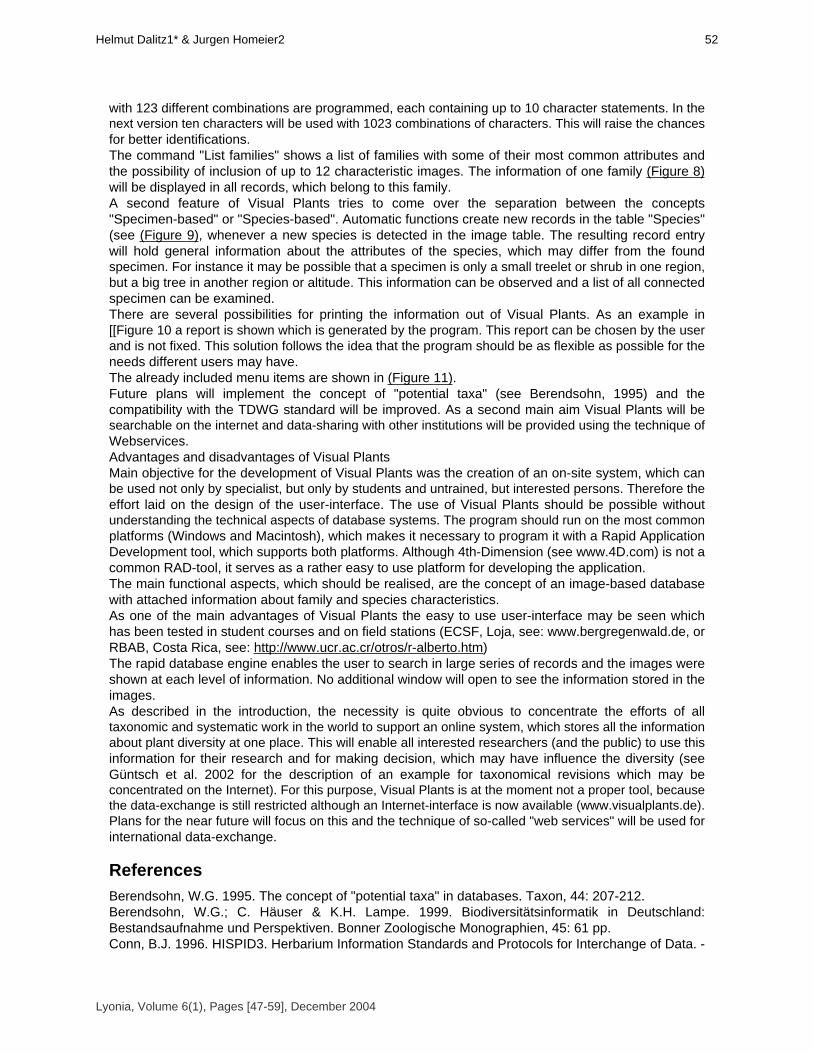
with 123 different combinations are programmed, each containing up to 10 character statements. In thenext version ten characters will be used with 1023 combinations of characters. This will raise the chancesfor better identifications.The command "List families" shows a list of families with some of their most common attributes andthe possibility of inclusion of up to 12 characteristic images. The information of one family (Figure 8)will be displayed in all records, which belong to this family.A second feature of Visual Plants tries to come over the separation between the concepts"Specimen-based" or "Species-based". Automatic functions create new records in the table "Species"(see (Figure 9), whenever a new species is detected in the image table. The resulting record entrywill hold general information about the attributes of the species, which may differ from the foundspecimen. For instance it may be possible that a specimen is only a small treelet or shrub in one region,but a big tree in another region or altitude. This information can be observed and a list of all connectedspecimen can be examined. There are several possibilities for printing the information out of Visual Plants. As an example in[[Figure 10 a report is shown which is generated by the program. This report can be chosen by the userand is not fixed. This solution follows the idea that the program should be as flexible as possible for theneeds different users may have. The already included menu items are shown in (Figure 11).Future plans will implement the concept of "potential taxa" (see Berendsohn, 1995) and thecompatibility with the TDWG standard will be improved. As a second main aim Visual Plants will besearchable on the internet and data-sharing with other institutions will be provided using the technique of Webservices.Advantages and disadvantages of Visual PlantsMain objective for the development of Visual Plants was the creation of an on-site system, which canbe used not only by specialist, but only by students and untrained, but interested persons. Therefore theeffort laid on the design of the user-interface. The use of Visual Plants should be possible withoutunderstanding the technical aspects of database systems. The program should run on the most commonplatforms (Windows and Macintosh), which makes it necessary to program it with a Rapid ApplicationDevelopment tool, which supports both platforms. Although 4th-Dimension (see www.4D.com) is not acommon RAD-tool, it serves as a rather easy to use platform for developing the application.The main functional aspects, which should be realised, are the concept of an image-based databasewith attached information about family and species characteristics. As one of the main advantages of Visual Plants the easy to use user-interface may be seen whichhas been tested in student courses and on field stations (ECSF, Loja, see: www.bergregenwald.de, orRBAB, Costa Rica, see: http://www.ucr.ac.cr/otros/r-alberto.htm)The rapid database engine enables the user to search in large series of records and the images wereshown at each level of information. No additional window will open to see the information stored in the images.As described in the introduction, the necessity is quite obvious to concentrate the efforts of alltaxonomic and systematic work in the world to support an online system, which stores all the informationabout plant diversity at one place. This will enable all interested researchers (and the public) to use thisinformation for their research and for making decision, which may have influence the diversity (seeGüntsch et al. 2002 for the description of an example for taxonomical revisions which may beconcentrated on the Internet). For this purpose, Visual Plants is at the moment not a proper tool, becausethe data-exchange is still restricted although an Internet-interface is now available (www.visualplants.de).Plans for the near future will focus on this and the technique of so-called "web services" will be used forinternational data-exchange.
ReferencesBerendsohn, W.G. 1995. The concept of "potential taxa" in databases. Taxon, 44: 207-212.Berendsohn, W.G.; C. Häuser & K.H. Lampe. 1999. Biodiversitätsinformatik in Deutschland:Bestandsaufnahme und Perspektiven. Bonner Zoologische Monographien, 45: 61 pp.Conn, B.J. 1996. HISPID3. Herbarium Information Standards and Protocols for Interchange of Data. -
Lyonia, Volume 6(1), Pages [47-59], December 2004
52Helmut Dalitz1* & Jurgen Homeier2

version 3 - Royal Botanical Gardens, Sydney. Electronic version under: http://www.rbgsyd.gov.au/hiscom/Dallwitz, M.J. 1974. A flexible computer program for generating identification keys. Syst. Zool., 23: 50-57.Dalitz, H. 2002. Visual Plants - Bildbasierte Datenbank für die vegetationskundliche oder ökologischeForschung in den Tropen. Berichte der Reinhold-Tüxen-Gesellschaft, 14: 119-129.Dallwitz, M.J. 1980. A general system for coding taxonomic descriptions. Taxon, 29: 41-46.Dallwitz, M.J. 2000. A comparison of interactive identification programs. http://biodiversity.uno.edu/delta/Godfrey, H.C.J. 2002. Challenges for taxonomy. Nature 417: 17-19.Güntsch, A.; J. Li & W. Berendsohn. 2002. Euro+Med PlantBase. Design of the Internet taxonomicsector editor. Electronic version under: http://www.bgbm.org/BioDivInf/Projects/ Euro+Med/default.htmHamilton, L.S.; J.O. Juvik & F.N. Scatena. 1994. The Puerto Rico Tropical Cloud Forest Symposium:Introduction and Workshop Synthesis, 1-23. In: Hamilton, L.S.; J.O. Juvik & F.N. Scatena. (eds.).Tropical montane cloud forests. Ecological Studies 110. Springer, New York, Berlin, Heidelberg.Hoppe, J.R.; E. Boos & G. Gottsberger. 1996. The database system SysTax - an aid for systematicsand taxonomy and the management of botanical gardens and herbaria. Albertoa 4, 107-108.Judd, W.S.; C.S. Campbell; E.A. Kellogg & P.F Stevens. 1999. Plant Systematics: A phylogenetic approach. Sinauer Associates, Sunderland, Massachusetts, USA. 464 pp.Newstrom, L.E.; G.W. Frankie; H.G. Baker & R.K. Colwell. 1994. Diversity of long-term floweringpatterns. In: McDade, L.A.; K.S. Bawa; H.A. Hespenheide & G.S. Hartshorn. (eds.). La Selva -Ecology and natural history of a neotropical rain forest. University of Chicago Press, Chicago, 142-160.Prance, G.T.; H. Beentje; j. Dransfield & R. Johns. 2000. The tropical flora remains undercollected. Annals of the Missouri Botanical Garden, 87: 67-71.
Figure 1. Main data entry in Visual Plants. In a window with six register cards all relevant information about aspecimen is stored. The first register card shows the general information.
Figura 1. Registro de datos en Visual Plants. En una ventana de seis tarjetas de registro se graba toda la informaciónde una especies. El registro primero representa la información general.
Lyonia, Volume 6(1), Pages [47-59], December 2004
Visual Plants - Un instrumento basando en imagines para lainvestigacion en ecologia de plantas53

Figure 2: Main data entry in Visual Plants. The second register card allows the input of specimen characters.Figura 2. Registro de datos en Visual Plants. Este segundo registro permite la entrada de caracteristicas del
espécimen.
Figure 3. Main data entry of Visual Plants. The third register card shows the information about the collecting site.Figura 3. Registro de datos en Visual Plants. La tercera ventana indica la información sobre el lugar de colleción.
Lyonia, Volume 6(1), Pages [47-59], December 2004
54Helmut Dalitz1* & Jurgen Homeier2

Figure 4. Main data entry of Visual Plants. The forth register cards shows the image or picture, in this example thebark of Bursera simarouba (Burseraceae) from a digitized slide.
Figura 4. Registro de datos en Visual Plants. El cuarto registro muestra la imagen of dibujo de la planta, en esteejemplo la corteza de Bursera simarouba (Burseraceae) de un slide digitalizado.
Figure 5. Main data entry of Visual Plants. In this example an image of a herbarium specimen of Parinari spec.(Chrysobalanaceae) is shown.
Figura 5. Registro de datos en Visual Plants. En este ejemplo una imagen de un espécimen de herbario de Parinarispec. (Chrysobalanaceae).
Lyonia, Volume 6(1), Pages [47-59], December 2004
Visual Plants - Un instrumento basando en imagines para lainvestigacion en ecologia de plantas55
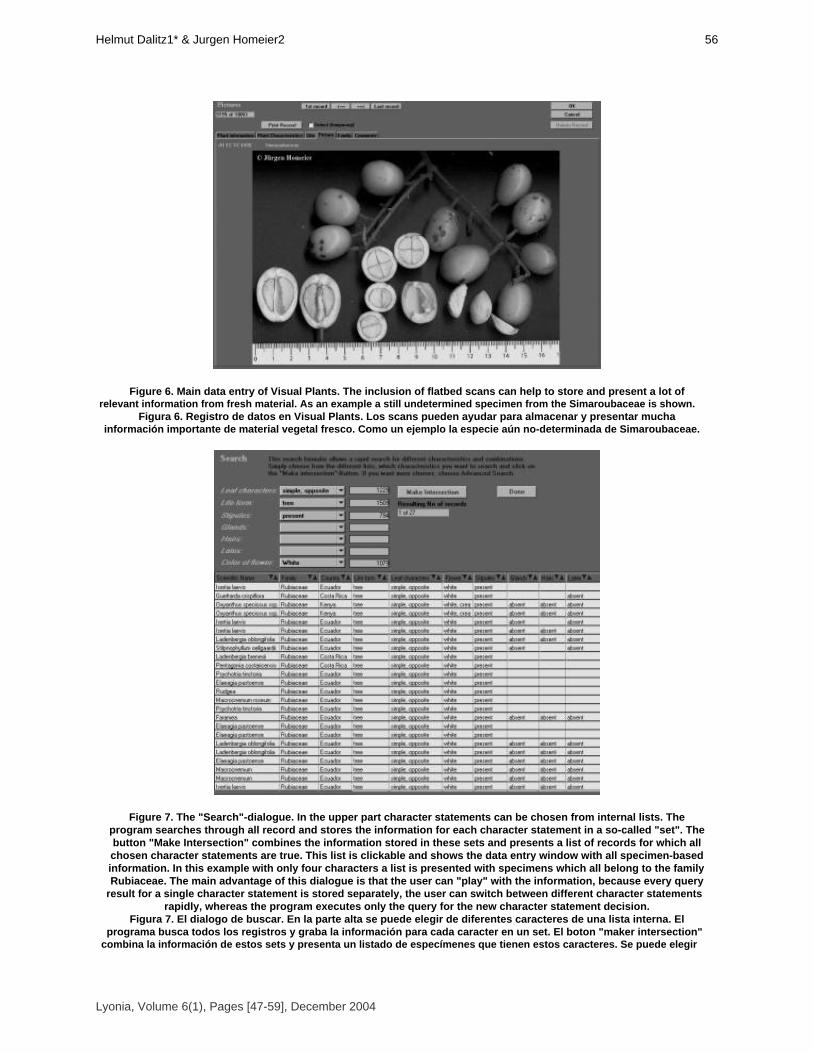
Figure 6. Main data entry of Visual Plants. The inclusion of flatbed scans can help to store and present a lot ofrelevant information from fresh material. As an example a still undetermined specimen from the Simaroubaceae is shown.
Figura 6. Registro de datos en Visual Plants. Los scans pueden ayudar para almacenar y presentar muchainformación importante de material vegetal fresco. Como un ejemplo la especie aún no-determinada de Simaroubaceae.
Figure 7. The "Search"-dialogue. In the upper part character statements can be chosen from internal lists. Theprogram searches through all record and stores the information for each character statement in a so-called "set". Thebutton "Make Intersection" combines the information stored in these sets and presents a list of records for which allchosen character statements are true. This list is clickable and shows the data entry window with all specimen-basedinformation. In this example with only four characters a list is presented with specimens which all belong to the familyRubiaceae. The main advantage of this dialogue is that the user can "play" with the information, because every query
result for a single character statement is stored separately, the user can switch between different character statementsrapidly, whereas the program executes only the query for the new character statement decision.
Figura 7. El dialogo de buscar. En la parte alta se puede elegir de diferentes caracteres de una lista interna. Elprograma busca todos los registros y graba la información para cada caracter en un set. El boton "maker intersection"
combina la información de estos sets y presenta un listado de especímenes que tienen estos caracteres. Se puede elegir
Lyonia, Volume 6(1), Pages [47-59], December 2004
56Helmut Dalitz1* & Jurgen Homeier2

de este listado y se muestra la ventana con todos los datos. En este ejemplo se presentan las especies de Rubiaceae. Lamayor ventaja de este dialogo es que el usario puede jugar con la información y cambiar los caracteres facilmente.
Figure 8. Information about family characteristics of the Passifloraceae. As an example is shown one of the threeregister cards, holding the information about this family .
Figura 8. Información sobre caracteres de la familia Passifloraceae. Un ejemplo muestra una de las tres tarjetas deregistro que contienen la información de la familia.
Figure 9. List window of the menu item "List Species". The records are clickable and the data entry window showsmost of the relevant information about the species (not shown). The list is generated automatically with each record in thepicture list, which is determined to the species. For each record in the species list there is provided a clickable list for all
available specimen in the database.Figura 9. Ventana de "Lista de Epecies". Se puede elegir de los refistros y la ventana de datos musetra la información
mas importante de especies (no se puede ver). El listado se genera automaticamente con enlace a las figures. Para cadaregistro en el listado de especies se presenta un listado con posibilidad de elegir especímenes en la base de datos.
Lyonia, Volume 6(1), Pages [47-59], December 2004
Visual Plants - Un instrumento basando en imagines para lainvestigacion en ecologia de plantas57
Figure 10. One example for a possible output of data in a report. Figura 10. Un ejemplo para un posible informe de datos.
Figure 11 The menu items of Visual Plants.Figura 11. El menu de Visual Plants.
Lyonia, Volume 6(1), Pages [47-59], December 2004
58Helmut Dalitz1* & Jurgen Homeier2

Table 1 Important Internet addresses for biodiversity informatics and realisations of information systems.Tabla 1. Direciones de internet importantes para información sobre informatica de biodiversidad y sistemas de
información.
Lyonia, Volume 6(1), Pages [47-59], December 2004
Visual Plants - Un instrumento basando en imagines para lainvestigacion en ecologia de plantas59
Volume 6(1)
Health state of Páramos: an effort to correlate science and
practice. El estado de salud de los páramos: un esfuerzo para relacionar la ciencia con la práctica de manejo
sustentable.
Robert Hofstede
Instituto de Biodiversity y Dinámicade Ecosistemas, Universidad de Amsterdam, Corporaciòn EcoPar,
Casilla 17-11-6706, Quito-Ecuador, [email protected]
December 2004
Download at: http://www.lyonia.org/downloadPDF.php?pdfID=2.266.1

Health state of Páramos: an effort to correlate science and practice.
ResumenEl páramo como ecorregión Andina presenta atributos ecológicos, geográficos y socioeconomicosque le dan un valor estratégico alto: su vulnerabilidad, su importancia hídrica, su alto grado deendemismo, su carácter de corredor y su uso para la gente. Una de las grandes urgencias para quelos tomadores de decisiones (gobiernos, administración de áreas protegidas, campesinos, etc.)puedan aplicar un manejo integral de este paisaje es el conocimiento del estado de salud en que seencuentra el páramo, tomando en cuenta todos estos atributos. El estado de salud es un conceptomás integral y más dinámica que el estado de conservación, que es meramente ecológica. El estadode salud se basa sobre los criterios vigor, resiliencia y organización, los cuales que se puedenaplicar tanto a attributos geo-biológicos y socioeconómicos. Se desarrollaron unos indicadoresintegrales, que son (1) la capacidad de prestar bienes y servicios ambientales, (2) las diferentesopciones de manejo y (3) la salud de la población del ecosistema. En el Ecuador se hizo un estudioen los Páramos con el objetivo de hacer un primer acercamiento al estado de salud, y de probaralgunas indicadores botánicas y sociales. De este ejemplo, se aprendió que el reto para establecerel estado de salud es identificar indicadores sencillos objetivos para los diferentes atributos, adiferentes escalas, que además sean comparables o ponderables y luego monitoreables. En esto,las ciencias biológicas, sociales, agrícolas y económicas encuentran un espacio idóneo paradesarrollar y aplicar la información necesaria en forma conjunta. Palabras claves: Páramo, Ecuador,estado de salud, estado de conservación, indicadores.
AbstractPáramo as an Andean ecoregion has ecological, geographical and socioeconomical attributes thatdetermine its high strategic value: its vulnerability, its hydrologic importance, its high degree ofendemism, its corridor character and its direct use by people. One of the urgent demands of decisionmakers (governments, protected area managers, farmers, etc.) to apply an integrated managementof this landscape is to know the health status of páramo, taking into consideration all these attributes.The health status of an ecosystem is a more integral and dynamic concept that the conservationstatus, which is merely an ecological concept. Health status is based on three criteria: vigor,resilience and organization, which can be applied on geo-biological attributes as well as onsocio-economical attributes. Three integral indicators are defined: (1) the capacity to provideenvironmental goods and services (2) the amount of different options for management and (3) thehealth of the population of the ecosystem. In Ecuador, a study was executed in páramo aiming at afirst approach towards the health status of an ecosystem, and to test some botanical and socialindicators. From this example, it became clear that the challenge in ecosystem health studies it theidentification of objective indicators for the different attributes, on different scales. Moreover, theseindicators must be comparable and possible to monitor. In this challenge, biological, social,agricultural and economic sciences find an excellent platform to develop and apply in a joint mannerthe necessary information. Key words: páramo, Ecuador, health state; conservation state; indicators
IntroducciónLos páramos del Ecuador y su importanciaLos páramos son ecosistemas (semi)húmedos y fríos que en el Ecuador se encuentran formando uncorredor casi intacto sobre la Cordillera de los Andes, por encima del límite superior actual opotencial de bosque (Mena et al. 2001). Forman un ejemplo ideal para aplicar la visión deecosistema de la Convención de Diversidad Biológica, porque su importancia para la sociedadecuatoriana y para el mundo en general se caracteriza por sus atributos biológicos, pero también susatributos geográficos, sociales y económicos apoyan a su gran valor. Los atributos biológicos que determinan la singularidad son su relativamente rica biodiversidad: es elecosistema de alta montaña más diverso del planeta (Smith & Cleef 1988). Pero más aún que el
Lyonia, Volume 6(1), Pages [61-73], December 2004
62Robert Hofstede

número de especies, impresiona el porcentaje de especies endémicas para el ecosistema: alrededordel 60% de todas las especies de plantas vasculares no se encuentran en otros ecosistemas (Luteyn1992). Este endemismo es un resultado del hecho que las plantas están muy adaptadas a lascondiciones climáticas extremas, que también resulta en una gran fragilidad de su biodiversidad: conpoco disturbio, se pierde una gran cantidad de las especies típicas del páramo (Verweij 1995).Finalmente, un atributo que hace que el ecosistema páramo es importante biológicamente, es el hechoque está formando un corredor Norte-Sur de más de 2000 kilómetros entre Venezuela y el Perú, en unade las cordilleras más dinámicas, geológicamente y biogeográficamente hablando, del mundo (Jorgensen& Ulloa 1994). Probablemente aún más llamativo para grandes grupos de pobladores Andinos que los atributosbiológicos son los geográficos. Especialmente el rol del páramo como regulador hídrica determinaprobablemente más que cualquier otra característica su valor para la población. Todas las grandesciudades de los Andes del Norte dependen para su agua potable y para la mayoría de su electricidad delagua de páramo, pero también el campo, especialmente en la Sierra seca de Venezuela y el centro delEcuador produce los alimentos gracias al agua de riego proveniente del páramo (Medina & Mena 2001).Pero también el suelo en sí ayuda a que el páramo tenga este gran valor. En primer lugar, el sueloorgánico es la clave detrás de la regulación hídrica pero este suelo en sí, especialmente en zonas deorigen volcánico, es un almacén de carbono y un potencial de productividad agrícola aprovechado parapapas, habas, mellocos y pasto para ganado (Podwojewski & Poulenard 2000). Finalmente, el paisaje ensí, con volcanes espectaculares, valles planos con turberas y lagunas vistosas, pendientes yafloramientos rocosos aparentemente inaccesibles y la inmensidad del páramo lo hacen uno de losecosistemas más apreciados por turistas nacionales y extranjeros y las lagunas como Cuicocha ynevados como el Cotopaxi hacen de las Áreas Protegidas en la cual éstos se encuentran, los lugaresnaturales más visitadas del país (Narváez 2001). La diversidad del páramo no está reflejada solo en su flora, fauna y paisaje, sino también en sushabitantes. La diversidad cultural y étnica hacen que la alta montaña, aparte de la amazonía, sea elúnico lugar donde todavía se hallan rasgos del Ecuador nativo, indígena. La mayor población indígenaQuichuahablante vive en los páramos, practica su agricultura con algunas prácticas muy tradicionales,habla su idioma, tiene su cultura y vestimenta y está en un continuo proceso de cambio y adaptación, loque quiere decir que es una cultura diversa y viva (Ramón 2002). Lo que socialmente hace importante elpáramo para la sociedad es que durante los siglos, desde épocas preincaicas hasta ahora, la gente haintervenido en el páramo y lo ha modificado. Esto dio origen al concepto que en alguna manera se puedeconsiderar el páramo como un paisaje cultural y, de todas maneras, como un espacio de vida para casiun millón de habitantes en los Andes (Suárez 2002).Son los atributos económicos los que hacen que el páramo sea importante para un millón deusuarios directos pero también para muchos usuarios indirectos. Primero, su valor para la producciónagrícola que, aunque estamos de acuerdo o no con este uso del ecosistema natural, nos beneficia atodos los que comemos papas y tomamos leche. Pero los servicios ambientales que presta el páramo ensí también representan un valor directo a la población, ya que el precio del agua sería mucho mayor si nofuera posible sacarla tan cerca desde la montaña. Y finalmente, el turismo, que es la tercera fuente deingresos en el Ecuador, se beneficia también económicamente (Vega & Martinez 2000).Una de las grandes urgencias para que los tomadores de decisiones (gobiernos, administración deáreas protegidas, campesinos, etc.) puedan aplicar un manejo integral de este paisaje es el conocimientodel estado en que se encuentra el páramo, tomando en cuenta todos estos atributos. Porque evaluando,estudiando o monitoreando este ecosistema únicamente tomando en cuenta sus atributos biológicossería una actividad muy limitada y no representaría la verdadera importancia de los diferentes grupo deinterés en este ecosistema, cada uno con iguales derechos de control y acceso.Estado de Salud, un concepto relacionado con la visión de ecosistemaReconociendo que un ecosistema es un espacio dinámico, en que, en muchos casos, interfierenpobladores con la biodiversidad y los aspectos abióticos, que está interrelacionado con otrosecosistemas y que presta servicios a diferentes grupos humanos interesados, llevó a nivel internacional apromover la visión ecosistémica en la conservación (Smith & Maltby 2003). Esta visión, entre otros,respeta los diferentes atributos y respeta las diferentes expectativas que tienen diferentes grupos degente sobre un ecosistema o un área natural. Este respeto para diferentes expectativas intrínsecamente
Lyonia, Volume 6(1), Pages [61-73], December 2004
El estado de saludde los paramos: un esfuerzo para relacionar la ciencia con lapractica de manejo sustentable63
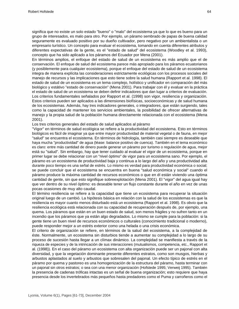
significa que no existe un solo estado "bueno" o "malo" del ecosistema ya que lo que es bueno para ungrupo de interesados, es malo para otro. Por ejemplo, un páramo sembrado de papas de buena calidadseguramente es evaluado positivo por su dueño cultivador, pero negativo por un ambientalista o unempresario turístico. Un concepto para evaluar el ecosistema, tomando en cuenta diferentes atributos ydiferentes expectativas de la gente, es el "estado de salud" del ecosistema (Woodley et al. 1993),concepto que ha sido aplicado a los páramos del Ecuador por Mena (2001).En términos amplios, el enfoque del estado de salud de un ecosistema es más amplio que el deconservación. El enfoque de salud del ecosistema parece más apropiado para los páramos ecuatorianos(y posiblemente para cualquier ecosistema), porque el enfoque del estado de salud de un ecosistemaintegra de manera explícita las consideraciones estrictamente ecológicas con los procesos sociales delmanejo de recursos y las implicaciones que esto tiene sobre la salud humana (Rapport et al. 1998). Elestado de salud de un ecosistema es un tema complejo, holístico y unificador en comparación del másbiológico y estátivo "estado de conservación" (Mena 2001). Para trabajar con él y evaluar en la prácticael estado de salud de un ecosistema se deben definir indicadores que dan lugar a criterios de evaluación.Los criterios fundamentales señalados por Rapport et al. (1998) son vigor, resiliencia y organización.Estos criterios pueden ser aplicados a las dimensiones biofísicas, socioeconómicas y de salud humanade los ecosistemas. Además, hay tres indicadores generales, o integradores, que están surgiendo, talescomo la capacidad de mantener los servicios ambientales, la posibilidad de ofrecer alternativas demanejo y la propia salud de la población humana directamente relacionada con el ecosistema (Mena2001). Los tres criterios generales del estado de salud aplicados al páramo"Vigor" en términos de salud ecológica se refiere a la productividad del ecosistema. Esto en términosbiológicos es fácil de imaginar ya que entre mayor productividad de material vegetal o de fauna, en mejor"salud" se encuentra el ecosistema. En términos de hidrología, también casi siempre es deseable quehaya mucha "productividad" de agua (léase: balance positivo de cuenca). También en el tema económicoes claro: entre más cantidad de dinero puede generar un páramo por turismo o regulación de agua, mejorestá su "salud". Sin embargo, hay que tener cuidado al evaluar el vigor de un ecosistema, porque enprimer lugar se debe relacionar con un "nivel óptimo" de vigor para un ecosistema sano. Por ejemplo, elpáramo es un ecosistema de productividad baja y continua a lo largo del año y una productividad altadurante poco tiempo es una señal de estrés. Lo mismo es verdad para productividad económica o social;se puede concluir que el ecosistema se encuentra en buena "salud económica y social" cuando elpáramo produce la máxima cantidad de recursos económicos o que en él están viviendo una óptimacantidad de gente, sin que esto signifique sobreexplotación (Mena 2001). El "vigor" del agua igual hayque ver dentro de su nivel óptimo: es deseable tener un flujo constante durante el año en vez de unaspocas ocasiones de muy alto caudal.El término resiliencia se refiere a la capacidad que tiene un ecosistema para recuperar la situaciónoriginal luego de un cambió. La hipótesis básica en relación con la salud de los ecosistemas es que laresiliencia es mayor cuanto menos disturbado está un ecosistema (Rapport et al. 1998). Es obvio que laresiliencia ecológica está relacionada con su capacidad de recuperación después de, por ejemplo, unaquema. Los páramos que están en un buen estado de salud, son menos frágiles y no sufren tanto en unincendio que los páramos que ya están algo degradados. Lo mismo se cumple para la población: si lagente tiene un buen nivel de recursos económicos o culturales (conocimiento tradicional o moderno),puede responder mejor a un estrés exterior como una helada o una crisis económica. El criterio de organización se refiere, en términos de la salud del ecosistema, a la complejidad deéste. Normalmente, un ecosistema sin disturbios tiende a aumentar su complejidad a lo largo de suproceso de sucesión hasta llegar a un clímax dinámico. La complejidad se manifiesta a través de lariqueza de especies y de la intrincación de sus interacciones (mutualismos, competencia, etc., Rapport etal. (1998)). En el caso del páramo un ecosistema con alta organización puede ser un pajonal con altadiversidad, y que la vegetación dominante presente diferentes estratos, como son musgos, hierbas yarbustos aplastados al suelo y arbustos que sobresalen del pajonal. Un efecto típico de estrés en elpáramo por quema y pastoreo es una homogenización de la estructura del páramo, hasta terminar conun pajonal sin otros estratos; o sea con una menor organización (Hofstede 1995; Verweij 1995). Tambiénla presencia de cadenas tróficas intactas es un señal de buena organización; esto requiere que hayapresencia desde los invertebrados más pequeños hasta predadores como el Puma y carroñeros como el
Lyonia, Volume 6(1), Pages [61-73], December 2004
64Robert Hofstede
Cóndor, y esta situación se encuentra en muy pocas áreas (Mena 2001). Si aplicamos el criterio deorganización a la sociedad o a la economía de la población, se puede imaginar que si la comunidad estámejor organizada, o si tiene diferentes formas de sustento económica ( o sea, mejor organizada laeconomía) mayores serán su resiliencia y su "salud".Los indicadores integrales de estado de salud aplicados al páramoLa capacidad del páramo de prestar bienes y servicios ambientales es un excelente indicadorintegral, porque sencillamente casi se puede decir que el páramo es un ecosistema "diseñado" paraservir como proveedor de agua a las tierras más bajas (Mena 2001). Otro servicio ambiental fundamentaldel páramo es la retención de carbono en el suelo. La cantidad de carbono retenido en la abundantemateria orgánica de los suelos del páramo puede llegar a ser similar a la cantidad retenida en lavegetación de una extensión equivalente de bosque húmedo tropical (Hofstede et al. 2002). Para que elpáramo esté en la capacidad de prestar servicios ambientales, debe estar en un buen estado de salud.Entre mejor conservado el suelo, más materia orgánica, mejor almacenamiento de carbono y mejorregulación hídrica. Para esto se requiere que los atributos biológicos y geográficos cumplan tanto con unalto vigor, resiliencia y organización. Pero, para poder aprovechar en una forma eficiente y equitativa deestos servicios ambientales, se necesita que también la sociedad esté cumpliendo los criterios generales.Porque ¿cómo se va organizar un sistema efectivo de pago por agua cuando no hay organización en lacuenca? o ¿cómo se puede entrar en un largo camino de gestión de carbono cuando no haya suficienteresiliencia?. Lo que vale para el indicador integral "capacidad de prestar bienes y servicios ambientales" tambiénes verdad para "la posibilidad de ofrecer alternativas de manejo". De un lado, un páramo con buenaproductividad de vegetación, gran profundidad de suelo, suficiente agua, como los que encontramos enCarchi, tiene mayor resiliencia y alta organización. Estos páramos tienen más opciones de manejo(inclusive agrícola) que los páramos sobre suelos delgadas y en condiciones secas en Azuay, donde laconservación estricta es casi la única opción viable. Sin embargo, para realmente emplear estasdiferentes alternativas de manejo, se requiere una comunidad organizada y con opciones de invertir amediano plazo (o sea, con resiliencia) y de un gobierno local bien organizado y con buen vigor (o sea,con dinero para apoyar la iniciativa), entre otros (Mena et al. 2001).Finalmente, la salud de la población humana probablemente es el indicador más integral, pero a lavez el indicador que más difícilmente se relaciona directamente con el ecosistema. La hipótesis aquí, quesuena bastante lógica, es que en un ecosistema sano hay gente sana. La salud de la gente no solo serefiere a las condiciones físicas del aparato respiratorio o de otras funciones semejantes, sino también alestado anímico y psicológico de la gente: en un ecosistema rico y diverso la gente es más sana, feliz,positiva y productiva. En el caso del páramo, la situación de salud integral es grave. De acuerdo conBernal et al. (2000) la "tasa de alfabetismo" tiene un promedio de 24,2%. La relación entre analfabetismoy condiciones bajas de salubridad es bien conocida. El porcentaje de hogares con saneamiento básicotiene promedio de 25,7%. Un tercer indicador, tal vez el más importante, es la incidencia de la pobreza,que tiene un promedio de 75,7% en los páramos de Ecuador. La relación de causa y efecto en el caso dela salud de la gente y la salud del ecosistema es difícil. ¿Es la gente (en su mayoría pobre, analfabeta,mal servida y abatida) la causa de un ecosistema maltratado? ¿O son las condiciones propias delecosistema las que llevan a que la gente en él se empobrezca y se enferme? Esperamos que no hay louno sin lo otro, ni lo otro sin lo uno (Mena 2001) y por lo tanto hace que la salud de la gente misma es unexcelente indicador integral del estado de salud de los páramos, porque hay una relación bidireccional,que involucra tanto los atributos biológicos, geográficos, sociales y económicos.Indicadores objetivos y medibles: punto clave en el manejo de un ecosistemaLos indicadores integrales no se pueden medir directamente porque están compuestos de una seriede indicadores sencillos, que deben ser objetivos, medibles y, más que todo, no ser ambiguos: tienenque indicar con certeza si algo va bien o va mal. Por esto la definición de indicadores es considerada unaciencia en sí. O mejor dicho, la definición y validación de indicadores sencillos y objetivos es un buen retopara la ciencia moderna en general, ya que fundamentalmente son las herramientas que necesitan lostomadores de decisión para guiar sus acciones. En el proyecto Andes del Instituto Alexander vonHumboldt (datos no publicados) se han tratado de identificar, con el apoyo de un grupo multidisciplinariode científicos, una serie de indicadores geo-biológicos y socio-económicos que en su conjunto debenpoder sostener los tres indicadores integrales. Así, entre los indicadores biológicos identificaron la
Lyonia, Volume 6(1), Pages [61-73], December 2004
El estado de saludde los paramos: un esfuerzo para relacionar la ciencia con lapractica de manejo sustentable65

diversidad de especies, la estructura de la vegetación, la biomasa, y la cantidad de especies endémicas.Los indicadores geofísicos fueron la desecación de humedales, la compactación del suelo, la retenciónde humedad y la pérdida y transformación de materia orgánica en el suelo, entre otros. Los indicadoressocioeconómicos incluyeron el uso del suelo, el sistema productivo, la accesibilidad, y el índice decalidad de vida. En las discusiones llevadas a cabo en el grupo, se concluyó que el reto no solamenteera la identificación de indicadores y la comparación de indicadores sociales con biológicos, sino tambiénla escala en la cual se evalúa un indicador (regional, sub-regional, local o puntual). De la teoría a la práctica hay una distancia considerable. Coppus et al (2001) y Hofstede et al (2003)han publicado un estudio en el cual se hizo un primer intento de evaluar el estado de salud de lospáramos de pajonal en el Ecuador. Aquí resumimos este estudio con el fin de demostrar la ambigüedadde los indicadores que a primera vista parecen muy claros. El estado de salud de los páramos en el EcuadorCoppus et al (2001) y Hofstede et al. (2003) procedieron en primera instancia a analizar con unospocos indicadores, combinados con la opinión de expertos, el estado de conservación en los páramos depajonal en el Ecuador. Luego, cruzaron este estado con otros indicadores biológicos y sociales paraidentificar la relación entre estos indicadores. Con base en el mapa preliminar de los páramos delEcuador (Proyecto Páramo 1999) se diferenciaron las zonas de estudio. En total se analizaron 28 áreasde páramo, que comprendieron en su mayoría páramos de pajonal, que según la suposición son lasunidades donde el paisaje ha sido modificado por el uso de la tierra. En cada sitio se determinó lacomposición botánica (especies), la pendiente, la altitud y la posición geográfica. Además, se evaluóvisualmente la evidencia de quemas, pastoreo, degradación directa y otros tipos de disturbio humano. Elcontenido de materia orgánica y la actividad biológica fueron analizados en calicatas de suelo. Ademásse estimó la presencia de fauna silvestre. Estos datos fueron tratados en una formula matemáticaarbitraria, pero basada en supuestos lógicos para llegar a una aproximación del estado de conservación(Coppus et al. 2001), la cual resultó en un índice de estado de "conservacion" de cada sitio, con unaescala entre 1 y 5. Una vez establecido este índice, se hizo una clasificación de los diferentes sitios (Figura 1). Con los valores así obtenidos, resultó un orden de sitios según su estado de conservación bastanteconfiable y aceptable y se procedió a relacionar el estado con la cantidad de especies vegetales paradeterminar el valor de la diversidad de especies como indicador (Figura 2). Si bien la cantidad deespecies encontradas en cada transecto fue relativamente alta (entre 39 y 64) no hubo una tendencia demayor cantidad de especies en mejores condiciones. Sin embargo, si se analiza cuales son las especiesde flora que se encuentran principalmente en los páramos evaluados como en "buen estado", se notaque son todas especies típicas del páramo. Blechnum occidentale, Chusquea tesselata y Diplostephium hartwegii (Verweij 1995; Luteyn 1999) solamente se han encontrado en páramos bienconservados ([[Figura 3]]). Con Puya y Uncinia no se encontró una correlación a nivel de especies,pero sí a nivel de genero. Finalmente, los líquenes sirvieron como indicador como grupo. Por otro lado,las especies consideradas oportunistas, tolerantes a pastoreo e inclusive "malezas" de páramo, talescomo Rumex acetocella, Trifolium repens y Lachemilla orbiculata (Ferwerda 1987; Verweij 1995)están presentes tanto en los páramos evaluados en "buen" estado como en "mal" estado, pero suabundancia era mucho más alta en los páramos muy intervenidos ([[Figura 4]]). Esto quiere decir que lacantidad de especies en sí no es un buen indicador del estado del páramo, pero la presencia deespecies típicas de páramo sí; y más aún, a veces no hay que evaluar la riqueza vegetal a nivel deespecies pero si a nivel de género. Y, en el caso de indicadores de intervención, no vale analizar lapresencia/ausencia pero si es necesario analizar la abundancia.
Lyonia, Volume 6(1), Pages [61-73], December 2004
66Robert Hofstede
Figura 1: Distribución geográfica de todos los páramos en el Ecuador con la localización de los sitios de estudio enpáramos de pajonal. El símbolo representa el estado de conservación evaluado mediante indicadores geo-biológicos
(Coppus et al. 2001).Figure 1. Geographical distribution of the Paramos in Ecuador, with location of study sites. The symbol repreesents
the conservation status, evaluated according to geo-biologic indicators (Coppus et al. 2001).
Lyonia, Volume 6(1), Pages [61-73], December 2004
El estado de saludde los paramos: un esfuerzo para relacionar la ciencia con lapractica de manejo sustentable67
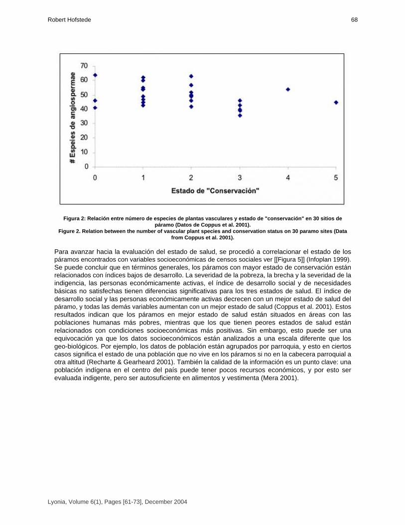
Figura 2: Relación entre número de especies de plantas vasculares y estado de "conservación" en 30 sitios depáramo (Datos de Coppus et al. 2001).
Figure 2. Relation between the number of vascular plant species and conservation status on 30 paramo sites (Datafrom Coppus et al. 2001).
Para avanzar hacia la evaluación del estado de salud, se procedió a correlacionar el estado de lospáramos encontrados con variables socioeconómicas de censos sociales ver [[Figura 5]] (Infoplan 1999).Se puede concluir que en términos generales, los páramos con mayor estado de conservación estánrelacionados con índices bajos de desarrollo. La severidad de la pobreza, la brecha y la severidad de laindigencia, las personas económicamente activas, el índice de desarrollo social y de necesidadesbásicas no satisfechas tienen diferencias significativas para los tres estados de salud. El índice dedesarrollo social y las personas económicamente activas decrecen con un mejor estado de salud delpáramo, y todas las demás variables aumentan con un mejor estado de salud (Coppus et al. 2001). Estosresultados indican que los páramos en mejor estado de salud están situados en áreas con laspoblaciones humanas más pobres, mientras que los que tienen peores estados de salud estánrelacionados con condiciones socioeconómicas más positivas. Sin embargo, esto puede ser unaequivocación ya que los datos socioeconómicos están analizados a una escala diferente que losgeo-biológicos. Por ejemplo, los datos de población están agrupados por parroquia, y esto en ciertoscasos significa el estado de una población que no vive en los páramos si no en la cabecera parroquial aotra altitud (Recharte & Gearheard 2001). También la calidad de la información es un punto clave: unapoblación indígena en el centro del país puede tener pocos recursos económicos, y por esto serevaluada indigente, pero ser autosuficiente en alimentos y vestimenta (Mera 2001).
Lyonia, Volume 6(1), Pages [61-73], December 2004
68Robert Hofstede

Figura 3: Especies de plantas con mayor presencia en páramos en buen estado de "conservación"(Bueno-moderado= valores 3-5, bajo= valores 1 y 2; Datos de Coppus et al. 2001).
Figure 3. Plant species with mayor presence in paramos in good state of conservation (Good-moderate= values 3-5,low=values 1 and 2: Data from Coppus et al. 2001).
Lyonia, Volume 6(1), Pages [61-73], December 2004
El estado de saludde los paramos: un esfuerzo para relacionar la ciencia con lapractica de manejo sustentable69

Figura 4: Especies de plantas con mayor abundancia en páramos en bajo estado de "conservación"(Bueno-moderado= valores 3-5, bajo= valores 1 y 2; Datos de Coppus et al. 2001)
Figure 4. Plant species with mayor presence in paramos in low state of conservation (Good-moderate= values 3-5,low=values 1 and 2: Data from Coppus et al. 2001).
Lyonia, Volume 6(1), Pages [61-73], December 2004
70Robert Hofstede

Figura 5: Relación entre indicadores sociales y estado de "conservación" de 30 sitios de páramo ("Bueno" es valor 4y 5, "moderado" es valor 3, "bajo" es valor 1 y 2. Datos de Coppus et al. 2001).
Figure 5. Relation between social indicators and conservation status of 30 paramo sites (Good-moderate= values 3-5,low=values 1 and 2: Data from Coppus et al. 2001).
ConclusionesEn el Ecuador, tres cuartos de todos los páramos naturales son dominados por pajonales, los cualessufren de algún grado de intervención humana. Sin embargo, todos los páramos brindan múltiplesservicios a la población gracias a sus atributos biológicos, geográficos, sociales y económicos.Evaluando un páramo únicamente tomando en cuenta sus atributos biológicos sería una actividad muylimitada y no estaría acorde a la visión ecosistémica que respeta la interacción naturaleza-ser humano, ladinámica de ecosistemas y la interacción entre ecosistemas. Para que la sociedad pueda aplicar unmanejo integral de este paisaje es necesario definir en que estado está el ecosistema y como es surespuesta a intervenciones y actividades de manejo. Considerando esta dinámica y lamultidisciplinariedad de la evaluación, se propone avanzar hacia la determinación del estado de salud envez del más estrictamente ecológico estado de conservación. El páramo forma un ecosistema en el cuales fácil de entender cómo es la interrelación entre los criterios generales y los indicadores integrales delestado de salud, tanto a nivel geo-biológico como socio-económico. Sin embargo, para realmente poderevaluar y monitorear el estado de salud, falta más conocimiento sobre indicadores sencillos, objetivos y
Lyonia, Volume 6(1), Pages [61-73], December 2004
El estado de saludde los paramos: un esfuerzo para relacionar la ciencia con lapractica de manejo sustentable71
medibles. Este articulo ha demostrado que algunos indicadores relativamente obvios, sin embargopresentan ambigüedades relacionadas con la falta o la calidad de la información, con la escala y con lasinteracciones entre indicadores sociales y biológicos. Es un reto para las diferentes disciplinas diseñar yaprobar esta clase de indicadores. Aqui, las ciencias biológicas, sociales, agrícolas y económicasencuentran un espacio idóneo para desarrollar y aplicar la información necesaria en forma conjunta. Peroademás, es necesario una discusión continua entre científicos y los tomadores de decisiones paraasegurar que la información sea aplicada de manera objetiva, equitativa y adecuada.
AgradecimientosLa teoría y los datos presentados en este articulo fueron desarrollados durante la ejecución delProyecto Páramo en el Ecuador (Universidad de Amsterdam, EcoCiencia, Instituto de Montaña). El autoragradece en especial a Patricio Mena (EcoCiencia) y Pool Segarra (EcoPar), con quienes mantuvimosnumerosas discusiones sobre este tema, y a Ruben Coppus, Lorena Endara, Susana León, VeronicaMera, Marieke Nonhebel y Jan Wolf, quienes ayudaron en el trabajo de campo y en el procesamiento departe de los datos del estudio del estado de salud. Al Instituto Alexander von Humboldt (Colombia)agradezco la invitación a compartir experiencias con el desarrollo de indicadores para el páramo.Reconozco profundamente a los habitantes del páramo que colaboraron en discusiones y en el trabajode campo. Este estudio fue financiado por el Instituto de Biodiversidad y Dinámica de Ecosistemas de laUniversidad de Amsterdam y por la Embajada de los Países Bajos en el Ecuador.
ReferenciasBernal, F.; O. Sánchez & A. Zapata. 2000: Manejo de páramos y zonas de altura. Relacionessocio-organizativas y legales en el páramo y otras zonas de alturas. CAMAREN-IEDECA. Quito.Coppus, R,. L. Endara; M. Nonhebel; V. Mera; S. León-Yánez; P. Mena Vásconez; J. Wolf & R.Hofstede. 2001. El estado de salud de algunos páramos en el Ecuador: una metodología de campo. Pp219-240 in: Mena V., P.; G. Medina & R. Hofstede (eds.). Los páramos del Ecuador:Particularidades, problemas y perspectivas. Abya Yala/Proyecto Páramo. Quito.Pijper D.; I. K. De Rooy & F. Tonneijck. 2001. Impact of land use and soil properties in the páramo ofCochapamba, South Ecuador. Reporte. Proyecto Páramo. Quito.Ferwerda, W. 1987. The influence of potato cultivation on the natural bunchgrass páramo in theColombian Cordillera Oriental. Tesis de M.Sc. Internal Report 220 of the Hugo de Vries Laboratory.Universidad de Amsterdam, Países Bajos. Hofstede, R. G. M. 1995: Effects of burning and grazing on a colombian páramo ecosystem. Tésis de Doctorado. Universidad de Amsterdam. Amsterdam.Hofstede, R. G. M.; J. P. Groenendijk; R. Coppus; J. Fehse & J. Sevink. 2002. Impact of pineplantations on soils and vegetation in the Ecuadorian high Andes. Mountain Research and Development 22 (2): 159-167.Hofstede, R. G. M.; R. Coppus; P. Mena; P Segarra & J. Sevink. 2003. El estado de conservación delos páramos de pajonal en el Ecuador. EcoTropicos 15(1). Infoplan 1999. Información para el desarrollo Oficina de Planificación de la Presidencia ODEPLAN. Quito.Jørgensen, P. M. & C. Ulloa. 1994. Seed plants of the high Andes of Ecuador: a checklist.. AAUreports: 34, 354 pp. Universidad de Aarhus.Luteyn J. L. 1992. Páramos: Why study them?. in: Balslev, H. & J.L. Luteyn, (eds.). Páramo: anandean ecosystem under human influence. London: Academic Press:1-14.Luteyn J. L. 1999. Páramos: a checklist of plant diversity, geographical distribution, and botanicalliterature. Memoirs of the New York Botanical Garden; volume 84.Medina, G. & P. Mena Vásconez (2001) Los Páramos en el Ecuador. Pp 1-24 en: P. Mena; G.Medina & R. Hofstede (Eds). Los páramos del Ecuador. Quito, Editorial Abya YalaMena, P. 2001. El estado de salud de los páramos en el Ecuador: una aproximación conceptual. Pp189-216 in: Mena, P.; G. Medina & R. Hofstede (eds.). Los páramos del Ecuador: Particularidades,Problemas y Perspectivas. Abya Yala/Proyecto Páramo. Quito.
Lyonia, Volume 6(1), Pages [61-73], December 2004
72Robert Hofstede

Mena, P.; G. Medina & R. Hofstede (eds.). 2001. Los páramos del Ecuador. Quito, Editorial AbyaYala MERA O.V. 2001. Prácticas Sociales, Uso de Recursos y Percepciones sobre la Naturaleza: UnaCaracterización Social de los Páramos Ecuatorianos. in: Mena, P.; G. Medina & R. Hofstede (eds.). Los páramos del Ecuador: Particularidades, Problemas y Perspectivas. Abya Yala/Proyecto Páramo. Quito.Narváez, E. M. 2001: La actividad de ecoturismo en el páramo. en: P. Mena & G. Medina (eds.), Páramo y turismo. Serie páramo 7, Quito, Editorial Abya Yala-GTP Podwojewski, P. & J. Poulenard. 2000. Los suelos de los páramos del Ecuador. in: Los suelos de lospáramos. Serie Páramo 5. GTP/Abya Yala. Quito.Proyecto Páramo. 1999. Mapa preliminar de los tipos de páramo del Ecuador. No publicado. Quito.Ramón, G. 2002: Visiones, usos e intervenciones en los páramos del Ecuador. En Páramos yCultura. Serie Páramo 12. GTP/ Abya Yala. QuitoRapport, D.; R. Costanza; P. Epstein; C. Gaudet & R. Levins (eds.). 1998. Ecosystem Health.Blackwell Science. Malden (Ma).Recharte, J. & J. Gearheard. 2001. Los páramos altamente diversos del Ecuador¨Ecología políticade una ecorregión¨. Pp 55-86 in: Mena, P.; G. Medina & R. Hofstede (eds.). Los páramos del Ecuador:Particularidades, Problemas y Perspectivas. Abya Yala/Proyecto Páramo. Quito.Smith, J.M. B. & A.M. Cleef. 1988: Composition and origins of the world’s tropic alpine floras. J. Biogeogr. 15: 631-645.Smith, R.D. & E. Maltby. Using the ecosystem approach to implement the convention of biologicaldiversity. Key issues and case studies. Ecosystem Management Series No. 2. Gland (Suiza) UICN.Suárez, L. 2003. Los páramos como paisajes culturales en el Ecuador. Pp 123-130 in: MujicaBarreda, E. (Ed.). Paisajes Culturales en los Andes. Lima, UNESCO Perú.Vega, E. & D. Martínez. 2000: Productos económicamente sustentables y servicios ambientales delpáramo. Serie Páramo 4. GTP/Abya Yala. Quito.Verweij, P. A. 1995. Spatial and temporal modeling of vegetation patterns: Burning and grazing in thepáramo of Los Nevados National Park, Colombia. Tesis de Ph.D. Universidad de Ámsterdam, Países Bajos.Woodley, S. J. Kay & G. Francis. 1993. Ecological Integrity and the Management of Ecosystems. St.Lucie Press. Ann Arbor.
Lyonia, Volume 6(1), Pages [61-73], December 2004
El estado de saludde los paramos: un esfuerzo para relacionar la ciencia con lapractica de manejo sustentable73

Volume 6(1)
Silvicultural contributions towards sustainable management
and conservation of forest genetic resources in Southern Ecuador.
Contribuciones silviculturales para manejo sostenible y conservacion de recursos geneticos forestales en elSur del Ecuador.
Sven Günter, Bernd Stimm & Michael Weber*
Chair of Silviculture andForest Planning, Technische Universität München,
München, D - 85354 Freising - Weihenstephan, GERMANY , Tel.0049 8161 71 4689 , Fax 0049 8161 71 4616, Email:
[email protected]*) Corresponding author
December 2004
Download at: http://www.lyonia.org/downloadPDF.php?pdfID=2.308.1
Silvicultural contributions towards sustainable management andconservation of forest genetic resources in Southern Ecuador.
ResumenBosques con una diversidad alta de árboles (por área) normalmente son caracterizados por unaabundancia baja de muchas especies. Este hecho tiene implicaciones fuertes hacia un manejosustentable de recursos genéticos forestales como también hacia la conservación. Después de laselección de especies prioritarias utilizando criterios ecológicos y económicos, se inició unaevaluación de la variación genética dentro de cada especie prioritaria. Por ello se estudió lafenología de Cedrela montana, Prumnopitys montana, Myrica pubescens y Clethra revoluta durante por un plazo de dos años en dos sitios diferentes: ECSF (Valle de la Estacón Científica SanFrancisco) y "El Bosque"(cerca de San Pedro de Vilcabamba). Adicionalmente se realizaroninventarios forestales en la Reserva "Estación Científica San Francisco" y en la Reserva "La Ceiba"en el bosque seco. Los resultados demuestran una variación alta de datos de floración yfructificación, no solo entre las dos áreas geográficas, sino también dentro de ellas. Comoconsecuencia, esa variación se debe considerar en planes de manejo y conservación. Losinventarios demostraron que hay varias especies con subpopulaciones sin contacto o flujo de genesentre ellas o que son demasiado pequeñas para conservación estática de recursos genéticos. Paradelinear zonas genecológicas (en la Provincia de Loja) para fuentes semilleros dentro de programasde manejo forestal sustentable como también para conservación de variación genética, los mapasexistentes de condiciones ambientales en la Provincia de Loja fueron cruzados con SIG. Después dela identificación de las zonas genecologicas y sus superficies correspondientes se puede decidir silas superficies son suficientes para conservación en situ o si se debe realizar medidas adicionalescomo establecimiento de seed orchards, archivos clonales o amplificación de áreas protegidas.
AbstractForests with high tree species diversity (per area) are mostly characterized by a low abundance ofthe single species. This fact has strong implications on activities towards a sustainable managementof forest genetic resources as well as towards their conservation. After selection of priority speciesusing ecological and economical criteria, an assessment of the phenotypic and genetic variationwithin each priority species was started. For this purpose the phenology of Cedrela montana, Prumnopitys montana, Myrica pubescens, and Clethra revoluta was studied for a two-years period attwo different sites: ECSF area (San Francisco valley) and "El Bosque" (close to San Pedro deVilcabamba). In addition, forest inventories were carried out in the dry forest "La Ceiba" and at ECSFarea. The results show a high variation in flowering dates and fructification intensity not only betweenthe two geographical areas but also within. Consequently, this high variation must be considered inmanagement as well as conservation activities. The inventories showed that there are severalspecies with subpopulations that may have no contact between each other or might be too smalleven for static conservation purposes. To delineate genecological zones (i.e. provenance regions),which can act as seed sources for sustainable forest management programmes as well as for theconservation of forest genetic variation, the existing maps of environmental conditions in Loja and thevegetation cover were overlaid. After the identification of these zones and their size it can be decidedif the areas will be sufficient for an "in situ" conservation and sustainable management or if additionalmeasures have to be undertaken (e.g. establishment of seed orchards, clonal archives, amplificationof conservation areas).
IntroductionThe objectives of the conservation and sustainable management of forest genetic resources are tosecure the ability of forest tree species to adapt to environmental changes and to maintain the basisfor improving production and other benefits of growing trees (Graudal et al. 1997). This might beeven more important if global change models become true.
Lyonia, Volume 6(1), Pages [75-91], December 2004
76Sven Gunter Bernd Stimm & Michael Weber*

Conservation and sustainable use of forest genetic resources is a major issue in national andinternational policies (Young et al. 2000). New Forest Management is no longer focused on themaximization of profits from timber and non-wood forest products, but it is also concerned aboutsustaining the integrity of forest ecosystems. The strategies for conservation and the applied methodologies depend on the specific objectives andon the scope of the programme. There are two basic strategies for genetic conservation, the one is "insitu" (FAO et al. 2001), the other is "ex situ" conservation (FAO, IUFRO 2002). These two strategies arecomplementary. Because natural ecosystems are not static but dynamic, genetic conservation should not berestricted at promoting the maintenance of a given state (i.e. "static conservation") forever, but shall bedirected at ensuring the adaptability of the ecosystem and the enhancement of the genetic diversitypresently available to meet future requirements (i.e. "dynamic conservation" or "evolutionaryconservation"). The establishment of forest plantations is not only an option to provide sustainable supply with timberand NWFPs and to minimize the pressure on natural forests but can also be an important complementarycontribution to dynamic conservation.Before that background the continuous supply with high quality tree seeds or "forest reproductivematerial" of indigenous species is one of the fundamental challenges for sustainable forest management.The installation of a sound programme for managing tree seed resources on a national or regional level isa very first but nevertheless important step for the realization of successful tree planting activities. Hufford& Mazer (2003) point out that in general data are needed to delineate "seed transfer zones", or regionswithin which plants can be moved with little or no consequences for population fitness. This paper tries toaddress this problem for the Province of Loja, South Ecuador. Regional programmes must be embedded in the national framework for conservation andmanagement of forest resources. However, we are not reflecting in detail about the goals andconsiderations of the National Forest Programme of Ecuador (NFP) and its political, socio-economic,financial and organisational aspects or about strategic considerations therein (for details see Graudal etal. 1997, Graudal 1998), but we will focus on some technical aspects within a regional framework.For instance: What can be the objectives of a regional Tree Seed Programme in the Loja Province? According to Graudal (1998) we suggest to distinguish between long term and short term objectives: Long term objectives can be: (1) improved wood production and provision of other benefits fromgrowing woody plants to help meet the regions’ requirements for timber, poles, fuel, fodder, food, andshelter, (2) contribution to the rehabilitation of degraded environments (e.g. the reforestation ofabandoned pastures), and (3) conservation of genetic resources of trees (Graudal 1998). On the way to a successful realisation of the long-term objectives the achievement of the short-termobjectives is mandatory. One of the most important short-term objectives is the provision and promotionof genetically suitable seed and other reproductive plant material of good physiological quality fromselected seed sources of indigenous woody species. ‘The provision and promotion of suitable seed requires an organisational backbone including afunctioning seed procurement technology (Graudal 1998).Suitable seed means the use and maintenance of defined and well-documented seed sources. Interms of environmental and genetic sustainability a preference should be given to native tree species andtheir provenances, which are well adapted to the specific site conditions. At the moment and as far as weknow, no species specific conservation or management plans have been developed and implemented inEcuador with the objective to protect these genetic resources for sustainable use in future. Within the project "Afforestation with Native Species of Abandoned Pastures of South Ecuador" ofthe German Research Programme (DFG) " Functionality in Tropical Mountain Rain Forest of SouthEcuador" at the Estación Científica San Francisco we try to develop the scientific basis which can beseen as a contribution to the establishment of a "provincial tree seed and plantation programme" whichcan function as a complementary for the conservation of forest genetic resources.
Lyonia, Volume 6(1), Pages [75-91], December 2004
Contribuciones silviculturales para manejo sostenible y conservacion derecursos geneticos forestales en el Sur del Ecuador77

Materials and MethodsFor technical implementation of the short-term objectives we suggest a stepwise approach (see Graudal et al. 1997).1. Selection of priority species (economical and ecological criteria)2. Assessment of the phenotypic and genetic variation within each species: Evaluation ofconservation status; Identification of populations to be conserved; development of conservationmeasures; Planning and organisation of specific conservation activities; formulation of management guidelines3. Identification and delineation of genecological zones (tree seed zones, provenance regions) as aprerequisite for seed supply with adapted forest reproductive material. Overlay of existing maps aboutenvironmental conditions with maps of forest cover or vegetation. 4. In situ conservation measures (amplification of conservation areas, establishment of ’in situ’conservation stands)5. Ex situ conservation measures (establishment of ’ex situ’ conservation stands, seed orchards,clonal archives, seed and gene banks)Box 1. Steps to the conservation and sustainable management of forest genetic resources in South Ecuador.Caja 1. Pasos para conservacion y manejo sostenible de recursos geneticos de los bosques del Surde Ecuador.The investigation within our project tries to develop and provide basic scientific knowledge andmethods for the implementation of some of the above-mentioned steps. Phenology:Phenological studies were carried out from 15 of June 2001 to 15 of June 2003 at San FranciscoStation in the Province of Zamora Chinchipe, 30 km west from Loja and at El Bosque, approx. 10 kmsouthwest from San Pedro de Vilcabamba, Loja. Both sites lie at an altitude of 2100 m a.s.l. in theevergreen montane rainforest zone. Five clustered individuals of similar phenotype (height, diameter,crown position and crown form, vitality) with distances less than 25 m between each other were selectedof each species at one site. The selection criteria should guarantee a minimum of natural variation ofecological parameters and phenotype. Under this precondition we suppose that a variation in theobserved phenological traits exhibits a very first and preliminary estimate of possible genetical variationbetween conspecifics rather than a result from differences in ecological conditions. Phenological data offlowering and fruiting intensity were registered in a two-weeks rhythm for each site.Inventories:Data from forest inventories were analysed for the characterization of tree populations in the ReservaLa Ceiba (dry forest) and Estación Científica San Francisco (cloud forest). In La Ceiba 153 ofsystematically distributed plots with 1000 m² each were established to study all tree vegetation with DBH> 5 cm. In San Francisco eight lines transects were installed in four microcatchments of 8 to 20 hectareseach. For each microcatchment one transects was oriented along the ridge and another one along thecreek. The transects were subdivided into subplots of 10 m in width and 20 m in length. Maps:Maps of soils, temperature (Plan Hidraulico) and dry months (The Nature Conservancy) have beenmodified and overlaid using the GIS programme Arc View.Selection and survey of priority species:Besides the vulnerability and danger of extinction of species the main criteria for including species ingenetic resource conservation programs are their present and their possible future use (Graudal et al.1997). Based on the timber market survey of Leischner and Bussmann (2002) we did a selection ofpriority species. The selected species are of high ecological value and economic importance not only forlocal use. The above-mentioned study refers to the wood market of the Province’s Capital Loja andconsists mainly of species from the lowlands of Zamora Chinchipe. Woods from the Province of Loja arevery scarce due to high deforestation. Because of the necessity of well adapted species to the siteconditions of the reforestation trials at an altitude of 2100 m close to Estación Científica San Francisco wemodified the list and included species with either economic value (for example Prumnopitys montana, Cedrela montana, Tabebuia chrysantha) or known ecological characteristics like Clethra revoluta
Lyonia, Volume 6(1), Pages [75-91], December 2004
78Sven Gunter Bernd Stimm & Michael Weber*

(pioneer), Myrica pubescens, Alnus acuminata (pioneer, nitrogen fixation), endangered species (Prumnopitys montana, Podocarpus oleifolius, Cinchona pubescens) among others. We are aware about the high intrinsic value of other tree species in the mountain forest ecosystemsof Southern Ecuador, which cannot be covered by our project. Genetic variation in forest genetic resources is expressed in differences between species,populations, individuals and chromosomes. High levels of intraspecific genetic variation, which is neededto ensure the adaptability of the species as well as their continuing evolution, characterize many treespecies. It is well known that the ecological conditions in the Andes vary noticeably between the eastern andwestern slope of the cordillera as well as a matter of altitudinal zonation, mesoclimatic differences, orlocal climate systems. The variety of ecological conditions within the natural distribution area of a species, e.g. Cedrela spec. supports the hypothesis of genetic differentiation between populations of the same species as aresult of adaptation to the varying local conditions. Because of the separation of the populations by highelevation mountain borderlines gene flow via pollen and seed between these populations is very limited.Habitat heterogeneity, combined with natural selection, often results in multiple genetically distinctecotypes within an single species (Hufford & Mazer 2003). In a second step we started with phenological investigations (e.g. dates of flowering and fruitripening) of four different tree species (Cedrela montana, Prumnopitys montana, Myrica pubescens,and Clethra revoluta) in two different areas of South Ecuador.
Results(Figure 1) indicates the variation of flowering and fruiting of Cedrela montana in San Francisco duringa two years period of observation. It is notable that the minimum of variation coincides with theculmination of the phenological phenomena. During the initial and the terminal phase one can see themaximum of variation. Even the lowest values of variation reach 56,7 % (flowering) and 77,4 % (fruiting).Practically this means that one can find fruiting and non-fruiting neighboring trees at the same time. Thefurther species under observation show even higher values of variation [[Table 1]]. Fruiting is morevariable than flowering, and the variation in San Francisco in general is much higher than in El Bosque.This could be explained by climatological features, i.e. more distinct dry and wet seasons in El Bosque,and indicates possibly an adaption of species to certain ecological conditions of each site.The differences in phenology of Clethra revoluta between the two study areas are enormous. Thebeginning of flowering and fruiting in El Bosque starts about half a year earlier than in San Francisco. It isnotable that both sites show a seasonal rhythm of phenological characteristics, although especially SanFrancisco area is considered as a perhumid site with very low fluctuation of climatic parameters. Thereare not only differences in the rhythm but also in the intensity of flowering and fruiting. Though a declinein flowering and fruiting was observed in the second year in San Francisco, an increase was registered inEl Bosque. Similar differences in phenological phenomena were present in the other species, too. Ingeneral flowering and fruiting start earlier in El Bosque. Myrica pubescens had almost no seasonalrhythm in San Francisco, but a slight seasonality in El Bosque. This could indicate a more distinctseasonality of dry and rain season in El Bosque in comparison with San Francisco.
Lyonia, Volume 6(1), Pages [75-91], December 2004
Contribuciones silviculturales para manejo sostenible y conservacion derecursos geneticos forestales en el Sur del Ecuador79

Figure 1. Intensity and Variation of Phenology of Cedrela montana in Estación Científica San Francisco in two yearsof observation.
Figura 1. Intensidad y variacion fenologica de Cedrela montana en la Estación Científica San Francisco an dos añosde observacion.
Table 1. Minimum Coefficient of Variation of Flowering and Fruiting Intensity during two years of observation.Different phenological behavior of a single species at the two study sites
Tabla 1. Coeficiente minimo de variacion de intensidad de floracion y frutificacion durante dos años de observacion.
Problem of isolated subpopulations in the study areas La Ceiba and ECSFIn (Figure 3) and (Figure 4) we show the distribution of Prumnopitys montana and Cedrela montanain four watersheds of the San Francisco area. We identified three clusters of Prumnopitys montanaand four of Cedrela montana, each cluster in gorges and separated from each other by pronouncedridges. Prumnopitys montana is a dioecious species and an unbalanced female-to-male ratio insubpopulations can cause malfunction of the reproductive system. On the other hand insects makepollination efficient and facilitate recombination. Under these marked topographical structures it isquestionable whether gene flow between subpopulations of Cedrela montana via pollination by windis efficient as well. Nevertheless the monoecy of Cedrela may compensate for this difficulty. The subpopulations of Prumnopitys montana and Cedrela montana within the gorges pass the critical
Lyonia, Volume 6(1), Pages [75-91], December 2004
80Sven Gunter Bernd Stimm & Michael Weber*

size for static conservation of 50 defined by Graudal et al. (1997) but dynamic conservation only can beguaranteed when there is gene flow between the subpopulations.
Figure 2. Differences of flowering and fruiting of Clethra revoluta between the study areas San Francisco and ElBosque.
Figura 2. Diferencias en floracion y frutificacion de Clethra revoluta entre San Francisco y El Bosque.
Table 2. Total number of individuals (DBH > 5 cm) of rare species in the Reserva La Ceiba with high distancesbetween clusters of individuals*
* Mean distance between clusters = 391 m. The distances between clusters were calculated on basis of frecuency(cluster size of 1000 m²)
Tabla 2. Numero total de individuos (DBH > 5 cm) de especies raras en la Reserva La Ceiba, con densidad alta entrelos clusters de especies.
Lyonia, Volume 6(1), Pages [75-91], December 2004
Contribuciones silviculturales para manejo sostenible y conservacion derecursos geneticos forestales en el Sur del Ecuador81
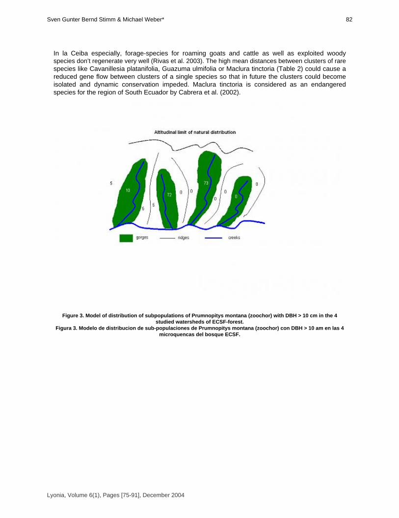
In la Ceiba especially, forage-species for roaming goats and cattle as well as exploited woodyspecies don’t regenerate very well (Rivas et al. 2003). The high mean distances between clusters of rarespecies like Cavanillesia platanifolia, Guazuma ulmifolia or Maclura tinctoria (Table 2) could cause areduced gene flow between clusters of a single species so that in future the clusters could becomeisolated and dynamic conservation impeded. Maclura tinctoria is considered as an endangeredspecies for the region of South Ecuador by Cabrera et al. (2002).
Figure 3. Model of distribution of subpopulations of Prumnopitys montana (zoochor) with DBH > 10 cm in the 4studied watersheds of ECSF-forest.
Figura 3. Modelo de distribucion de sub-populaciones de Prumnopitys montana (zoochor) con DBH > 10 am en las 4microquencas del bosque ECSF.
Lyonia, Volume 6(1), Pages [75-91], December 2004
82Sven Gunter Bernd Stimm & Michael Weber*

Figure 4. Model of distribution of subpopulations of Cedrela montana(anemochor) with DBH > 10 cm in the 4 studiedwatersheds of ECSF-forest.
Figura 3. Modelo de distribucion de sub-populaciones de Cedrela montana (anemochor) con DAP > 10 cm en las 4microcuencas del bosque ECSF.
Deforestation in San Francisco valley is mainly caused by conversion of forest into pastures for cattle(Beck, pers. comm.). The remaining subpopulations of Cedrela montana or Prumnopitys montanaare at the upper limit of their natural distribution. We argue that these subpopulations located inmicro-watersheds become isolated this way because pollen and seeds may hardly be able to overcomethe surrounding natural barriers [[Figure 3 and 4]]. Nevertheless further investigation is necessary to proof whether geographical distance and/or naturalbarriers implicate the development discontinuous genetical variation. Delineation of genecological zonesBased on these observations we suggest the delineation of so-called "genecological" zones, wherethe variation of environmental conditions is investigated and uniform zones are formed based on availabledata. Three ecological parameters (temperature, humidity and soil types) were used for delineation ofgenecological zones. A very broad range of environmental conditions can be observed in the Province ofLoja: The mean temperatures range from 8 to 26 degrees centigrade, the humidity between 0 and 12humid months, and the provincial watershed management plan has identified eleven major soil types. Wedefined 4 distinct classes of temperature and 6 classes of humidity. The three ecological maps wereoverlaid to deduce possible genecological zones. From the 264 theoretically possible zones (11 soils x 4temperature x 6 humidity) 134 potential genecological zones resulted for the Province of Loja. This veryhigh number derives from the high diversity of environmental conditions. Table 3 indicates the highvariability of possible genecological zones in the Province of Loja that results from overlaying the maps ofecological factors.
Lyonia, Volume 6(1), Pages [75-91], December 2004
Contribuciones silviculturales para manejo sostenible y conservacion derecursos geneticos forestales en el Sur del Ecuador83

Figure 5. Number of dry months in the Province of Loja (Source: The Nature Conservancy)Figura 5. Numero de meses secos en la Provincia de Loja (Datos de Nature Conservancy).
Lyonia, Volume 6(1), Pages [75-91], December 2004
84Sven Gunter Bernd Stimm & Michael Weber*

Figure 6. Mean temperatures in the Province of Loja (Source: Plan HidraulicoFigura 6. Temperatiras promedias en la Provincia de Loja (Datos de Plan Hidraulico).
Lyonia, Volume 6(1), Pages [75-91], December 2004
Contribuciones silviculturales para manejo sostenible y conservacion derecursos geneticos forestales en el Sur del Ecuador85
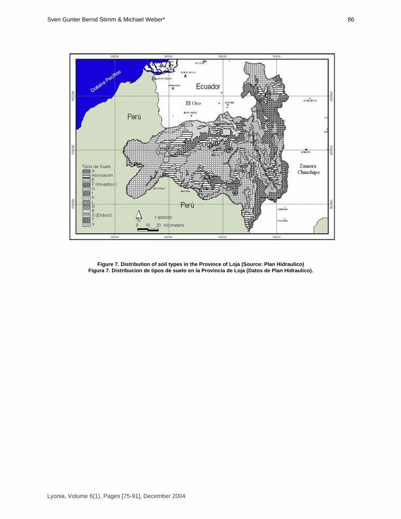
Figure 7. Distribution of soil types in the Province of Loja (Source: Plan Hidraulico)Figura 7. Distribucion de tipos de suelo en la Provincia de Loja (Datos de Plan Hidraulico).
Lyonia, Volume 6(1), Pages [75-91], December 2004
86Sven Gunter Bernd Stimm & Michael Weber*
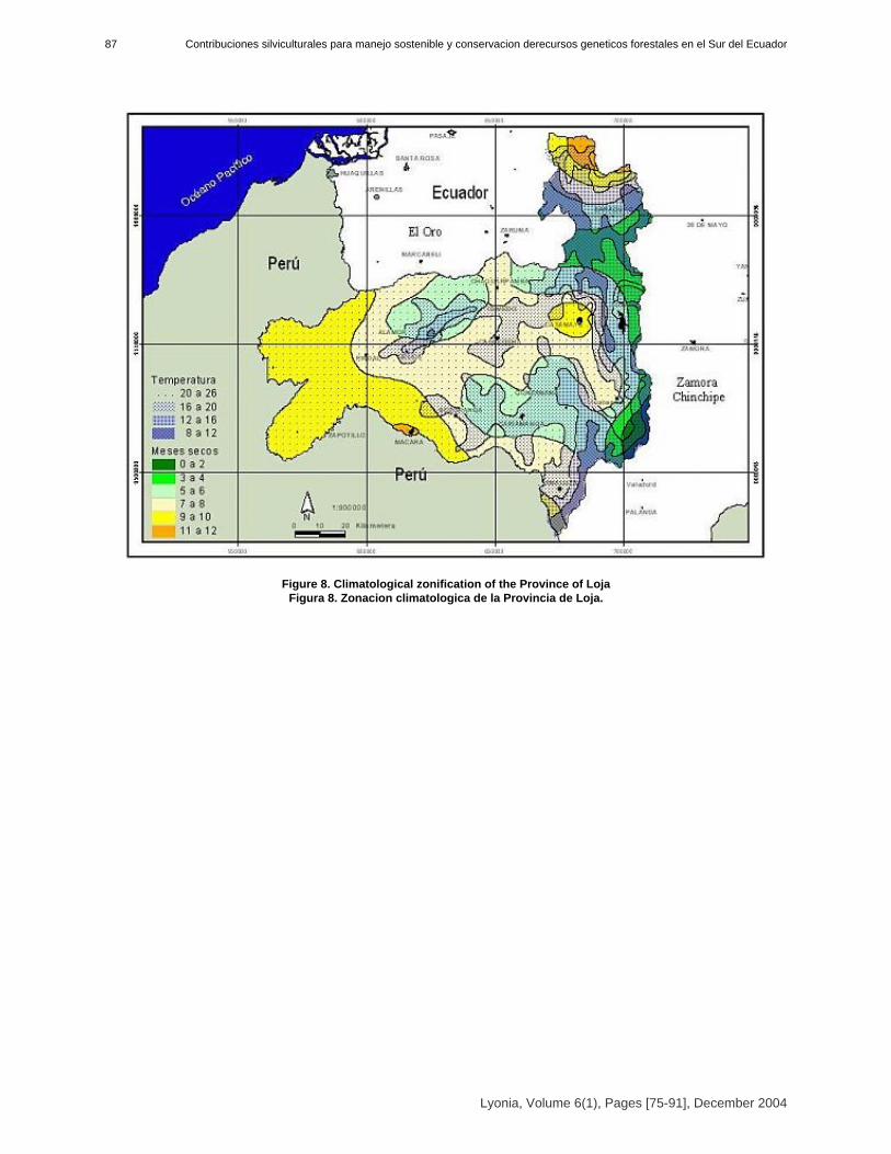
Figure 8. Climatological zonification of the Province of Loja Figura 8. Zonacion climatologica de la Provincia de Loja.
Lyonia, Volume 6(1), Pages [75-91], December 2004
Contribuciones silviculturales para manejo sostenible y conservacion derecursos geneticos forestales en el Sur del Ecuador87
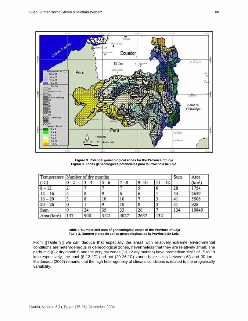
Figure 9. Potential genecological zones for the Province of Loja Figura 9. Zonas genecologicas potenciales para la Provincia de Loja.
Table 3. Number and area of genecological zones in the Province of LojaTable 3. Numero y area de zonas genecologicas de la Provincia de Loja.
From [[Table 3]] we can deduce that especially the areas with relatively extreme environmentalconditions are heterogeneous in genecological zones, nevertheless that they are relatively small. Theperhumid (0-2 dry months) and the very dry zones (11-12 dry months) have promedium sizes of 15 to 19km respectively, the cool (8-12 °C) and hot (20-26 °C) zones have sizes between 63 and 30 km.Maldonado (2002) remarks that the high heterogeneity of climatic conditions is related to the orograficallyvariability.
Lyonia, Volume 6(1), Pages [75-91], December 2004
88Sven Gunter Bernd Stimm & Michael Weber*

Table 4. Size frequency of genecological zones.Tabla 4. Frequencia y tamaño de zonas genecologicas.
Many of the potential genecological zones in the Province of Loja are very small [[Table 5]]. Thereare more than 90 zones smaller than La Reserva La Ceiba, which corresponds to a 67,2 % of all. Many ofLoja’s forests are of a similar or even higher tree diversity than La Reserva La Ceiba so that pollinationdistances between conspecifics are commonly high and human pressure, especially selective logging,exploitation or silvipasture of goats and cows counteract dynamic conservation by their detrimentaleffects, namely through reproductive isolation of subpopulations and individuals and prevention of geneflow. Management of seeds in those areas could become very difficult because high efforts are necessaryto identify the potential seed trees. Therefore it is necessary to delineate major seed zones on basis of afurther map that includes vegetation cover, distribution of target species and barriers for gene flow.
Table 5. Number of genecological zones within certain protection categories in the Province of Loja.Tabla 5. Numero d ezonas genecologicas con categories de proteccion en la Provincia de Loja.
[[Table 5]] shows that only a very low percentage of all potential genecological zones in Loja arerepresented in the SNAP-system of conservation areas (12,7%). Lower protection categories cannotprovide the effectiveness of National Parks and sometimes-even National Parks suffer from humanpressure. Hence it must be concluded that the variety of genecological zones in the Province of Loja arehighly endangered. It is notable that especially in the very dry areas of Loja only a very low percentage of genecologicalzones is represented in any category of protection. Also in the cool parts (corresponding to high altitudes)only 50 % of all genecological zones are protected, although this ecozone is relatively well covered by thePodocarpus National Park.
Lyonia, Volume 6(1), Pages [75-91], December 2004
Contribuciones silviculturales para manejo sostenible y conservacion derecursos geneticos forestales en el Sur del Ecuador89
Table 6. Number of genecological zones without any protection status in the Province of Loja.Tabla 6. Numero de zones genecologicas sin ningun estado de proteccion en la Provincia de Loja.
ConclusionsThe continuous supply of high quality tree seed for planting activities (reforestation, plantationestablishment) requires the establishment of normative and production standards. After formulating national policies and standards, the national and provincial governments providelegal standards and regulations for good practice (e.g. mechanisms to influence and monitor the use ofreproductive material). A first attempt could be the proposal "ley para la conservación y uso sustentablede la biodiversidad", but further more detailed regulations are needed. Within these regulations, the approval and monitoring of seed sources of priority species, but also therevision of seed sources, is one of the basic steps, which will be accomplished by seed certification andcontrol/monitoring of seed procurement. Target groups for tree seed programmes are farmers and communities in rural areas using andplanting trees for a multitude of purposes, but are also enterprises or agencies often undertakingafforestation on a larger scale (Graudal 1998).The build-up of a network of seed production stands is seen as a prerequisite of theprofessionalisation of seed production. This includes the establishment and management of conservationstands. During the initial years the establishment of a working system (including research and developmentin seed procurement) and infrastructure as well as the marketing of seeds may require subsidizing by thegovernment. Types of tree seed suppliers can be either public sector (e.g. government directed) or private (NGOs,communities, farmers etc.). Ways of non-commercial distribution, dissemination and diffusion of seed should be found andencouraged to promote the programme. Herein the private sector will act as a seed supplier as well as aseed user, e.g. through the domestication of trees on farms.From the organisational point of view the establishment of tree seed centres (governmental orprivate) is of utmost importance. These centres are in charge of the implementation of tree seedprogrammes through the development of long term and annual plans for seed supply and thedevelopment of additional seed sources.We are hopeful that a well established and organized tree seed programme can counteract andminimize the uncontrolled and undocumented movement of forest germplasm, including exotic species,for plantation establishment, which is leading to the loss of locally well adapted populations of native species.
AcknowledgementsWe thank Fabian Rodas for the help with GIS, Manuel Cabrera, Maria Luisa Diaz, Manuel Lojan &Eduardo Ordoñez for the observation of phenology, Cesar Caraguay and René Rivas for the fieldwork inLa Ceiba and the crew of Herbario de Loja for the fieldwork in ECSF area. The German ResearchFoundation (DFG) funded the project. Logistic help came from the Foundation Nature and Culture
Lyonia, Volume 6(1), Pages [75-91], December 2004
90Sven Gunter Bernd Stimm & Michael Weber*
International. The project was funded by the German Research Foundation (DFG).
ReferencesCabrera C., O.; M.Z. Aguirre; C.W. Quizhpe & R. Alvarado. 2002. Estado actual y perspectivas deconservación de los bosques secos del sur-occidente ecuatoriano. In: Aguirre, Z.; J.E. Madsen; E. Cotton& H. Balslev (eds.). Botánica Austroecuatoriana. Abya Yala, Quito.FAO, DFSC, IPGRI. 2001. Forest genetic resources conservation and management. Vol. 2: Inmanaged natural forests and protected areas (in situ). International Plant Genetic ResourcesInstitute, Rome, Italy.FAO, IUFRO. 2002. Multilingual Glossary Forest Genetic Resources. http://iufro.ffp.csiro.au/iufro/silvavoc/glossary/index.html , (Rev. 20.08.2003)Gálvez M., J.R., O.R. Ordoñez G. & R.W. Bussmann. 2002. Estructura del bosque montanoperturbado y no-perturbado en el Sur de Ecuador. In: Bussmann, R.W. & S. Lange. (eds.) - Conservación de la Biodiversidad en los Andes y la Amazonía - Conservation of Biodiversity in the Andesand the Amazon, p. 195-208.Graudal, L. 1998. The Functions and Role of a National Tree Seed Programme. Presentation givenat the Premier atelier régional de formation en conservation et l’utlisation durable des ressourcesgénétiques forestières en Afrique de l’Ouest, Afrique Centrale et Madagascar. Centre National deSemences Forestières, Ouagadougou, Burkina Faso 16-27 mars 1998; and at the SAFORGEN RegionalTraining Workshop on the Conservation and Sustainable Use of Forest Genetic Resources in Easternand Southern Africa, Nairobi, Kenya, 6-11 December 1999. http://www.dfsc.dk/pdf/Conference%20papers/8.pdfGraudal, L.; E. Kjaer; A. Thomsen & A.B. Larsen. 1997. Planning national programmes forconservation of forest genetic resources. Danida Forest Seed Centre, Humlebaek, Technical Note No. 48, 58pp.Hufford, K.M. & S.J. Mazer. 2003. Plant ecotypes: genetic differentiation in the age of ecologicalrestoration. Trends in Ecology and Evolution 18/3, 147-155. Kjaer, E.D.; L. Graudal & I. Nathan. 2001: Ex situ conservation of commercial tropical trees:strategies, options and constraints. Presentation given at ITTO international conference on ex situand in situ conservation of commercial tropical trees. Yogyakarta, Indonesia. June 2001.Leischner, B. & R.W. Bussmann. 2002. Mercado y uso de madera en el Sur de Ecuador. In:Bussmann, R.W. & S. Lange. (eds.) - Conservación de la Biodiversidad en los Andes y la Amazonía- Conservation of Biodiversity in the Andes and the Amazon, p. 651-660.Ley para la Conservación y Uso Sustentable de la Biodiversidad: www.ambiente.gov.ec/ AMBIENTE/legislacion/docs/LEY%20BIODIVERSIDAD%20281002.docMaldonado A., N.P. 2002. Clima y vegetación de la region sur del Ecuador. In: Aguirre, Z.; J.E.Madsen; E. Cotton & H. Balslev (eds.). Botánica Austroecuatoriana. Abya Yala, Quito.Manel, S. ; M. Schwartz; G. Luikart & P. Taberlet. 2003. Landscape genetics: combining landscapeecology and population genetics. Trends in Ecology and Evolution 18 (4): 189-197.Plan Hidraulico: Mapa de los Suelos de la Provincia de Loja.Plan Hidraulico: Mapa de las Temperaturas en la Provincia de Loja.Rivas, R. ; C. Caraguay & S. Günter. 2003. Estado de Conservación de poblaciones de árboles en laReserva La Ceiba en el Sur del Ecuador. Presentación en el II Congreso de Conservación de laBiodiversidad de los Andes y la Amazonia. Loja, Ecuador. Sierra, R. 1999. Mapa Vegetación Remanente del Ecuador Continental. Circa 1996. Escala1:1.000.000. Quito: Proyecto INEFAN/GEF y Wildlife Conservation Society.Sierra, R.; Cerón, C.; Palacios, W.; Valencia, R. (1999): Mapa de Vegetación del EcuadorContinental. Escala 1:1.000.000. Quito: Proyecto INEFAN/GEF-BIRF, Wildlife Conservation Society y EcoCiencia.The Nature Conservancy: Mapa de los meses secos en la Provincia de Loja. Young, A.; D. Boshier & T. Boyle (eds.). 2000. Forest Conservation Genetics. Principles and Practice. CSIRO Publishing, Australia. 352 p.
Lyonia, Volume 6(1), Pages [75-91], December 2004
Contribuciones silviculturales para manejo sostenible y conservacion derecursos geneticos forestales en el Sur del Ecuador91

Volume 6(1)
Regeneration and succession patterns in African, Andean and
Pacific Tropical Mountain Forests: The role of natural andanthropogenic disturbance.
Procesos de regeneración y sucesion en los bosques montanos de Africa, Andes y del Pacifico: El rol deperturbacion natural y antropica.
Rainer W. Bussmann
Harold L. Lyon ArboretumUniversity of Hawaii at Manoa, 3860 Manoa Rd., Honolulu, HI 96822, USA. Tel. +808-988-0457, fax +808-988-0462, [email protected]
December 2004
Download at: http://www.lyonia.org/downloadPDF.php?pdfID=1.363.1

Regeneration and succession patterns in African, Andean and PacificTropical Mountain Forests: The role of natural and anthropogenic
disturbance.
Amongst the world biodiversity hotspots, Tropical Mountain Forests are one of the most importantsystems. Harboring larger species numbers per land area than Lowland Rainforests, they are muchsmaller, often highly fragmented, and have a paramount function as water catchments and erosionbarriers. The presented contribution depicts the influence of natural and anthropogenic disturbancesin the regeneration ecology of Andean, African and Pacific mountain forest systems by comparingexamples from Southern Ecuador, Northern Peru, the Hawaiian Islands, Cameroon, and EasternAfrica. All systems show a very comparable forest zonation, with mosaic-climax formationsdominating the lower montane zone, and monotypic forests taking over at higher altitudes.Neotropical mountain forests harbor much higher species diversity, mainly due to the extremeradiation of trees and epiphytes, particularly Orchids and Bromeliads. In Africa, herbs are much moreabundant due to the availability of more large gaps created by large mammals, and in the CentralPacific, island bio-geographic processes have the highest influence on forest species diversity.Similar regeneration processes can be observed in all systems, although the role of naturallandslides is much more important in the Andes and the Pacific region, whereas fire and big-gameinfluence are the dominant motors for regeneration in Africa. The impact of antropogenic influences,e.g. slash and burn, timber extraction, exploitation of forest products, introduction of exotic speciesetc. on the regeneration and succession patterns in Tropical Mountain Forests are discussed, andpossibilities for future management depicted. Entre los puntos calientes de biodiversidad mundial, losbosques montanos tropicales tienen un papel especialmente importante. Estos sistemas contienenun numero más alto de especies por area que los bosques humedos, pero estan mucho maspequeños, seriamente fragmentados, y tienen una funcion muy importante como captaciones deagua y bareras contra la erosion. Este articulo ilumina la influencia de perturbaciones naturals yantropicas por la ecologia de regeneracion de bosques montanos Andinos, Africanos y Pacificos,comparando ejempos desde Ecuador, Peru, Hawaii, Cameroon y el Este de África. Todos estossistemas muestran una zonacion de bosque muy comparable, con formaciones del tipoclimax-mosaica en la zona baja y bosques monotipicos como unidades mas importantes en laszonas altas. La diversidad de especies en los bosques Neotropicales es mucho mas alto,especialmente por la radiacion de arboles y epifitas, en particular Orquideas y Bromelias. En Áfricahierbas son mucho mas abundante por la disponibilidad de claros largos, causados por la actividadde la megafauna y en el Pacifico Central procesos de biogeografia insular tienen la influencia masalta por la diversidad de especies.
IntroductionTropical mountain forests, found mainly at altitudes between 1200 and 3500 m (LaBastille & Pool1978, Stadtmüller 1987, FAO 1992) are amongst the species richest ecosystems worldwide.Particularly the Eastern Andean Region represents one of the hottest "biodiversity-hotspots (Myerset. al. 2000). In striking contrast to tropical lowland rainforests, these tropical montane forests havereceived only marginal attendance in science and society until recently, despite their ecological andeconomical importance as water catchments and erosion barriers. The neotropical montane region isconsidered one of the twelve major crop-gene centers of the world (Churchill et al. 1995). At thesame time, mountain forests are especially sensitive ecosystems due to their steep relief, whichallows extreme erosion under a high rainfall regime. Due to increased population pressure andresource use (firewood, mineral resources, pastures, agriculture), montane forests are more andmore rapidly dwindling. FAO (1993) estimates that tropical mountain forests comprise about 11 % ofthe worlds tropical forest resources, and suffer an annual deforestation of about 1.1 %. Mountainforests generally occur on more humid mountains, and most frequently in Latin America andSoutheast Asia, where the most widespread mountain areas occur, with outposts in tropical Africa(Stadtmüller 1987).
Lyonia, Volume 6(1), Pages [93-111], December 2004
94Rainer W Bussmann

Most studies carried out in tropical ecosystems have focused on the lowland rainforests, and mostresearch stations are located there (Leigh 1999). Even there, very little is known about the regenerationprocesses in the ecosystem (Finegan 1996), and fairly nothing about its functioning. In tropical MountainEcosystems, studies concentrated mainly on the alpine zone, whereas the often-inaccessible forest beltwith its extreme species richness has hardly been studied. The African and Andean zone make noexception. Although particularly Andean forests host an extreme , - and - diversity (Barthlott et al. 1996;Ibisch 1996), often comparable or higher than species counts for Amazonian areas (Balslev. et al. 1998),no comprehensive studies of a tropical mountain forest ecosystem have been undertaken. Evenbroad-focused projects like "Ecoandes" in Colombia (Hammen et. al. 1983, 1984, 1989a, 1995) includedthe forest regions only marginally. First attempts to bring the frugal knowledge existing together weremade only recently (Hamilton et al. 1994, Churchill et al. 1995). The deficit of scientific knowledgeparticularly includes all aspects of regeneration of montane forests, as well as succession processes afterany kind of natural or man-made impact. The habitat requirements and the potential for rejuvenation ofimportant tree species are almost unknown.The present work focuses on a comparison of various Andean, African and Pacific montane forestecosystems, as examples for tropical mountain forests in general.
Materials and MethodsStudy AreasThe border region of Ecuador and Peru is one of the most biologically diverse areas worldwide, andthus a "biodiversity-hotspot" par excellence. Low passes in the Andean chain allow an easy exchangebetween the floras and faunas of the Amazon Basin and the pacific lowlands. Additionally, the regionshows a very fast transition between the humid mountain forests of the northern Andes and the dry,deciduous forests of the northern Peruvian lowlands. Until the recent past, the Podocarpus National Parkand the study area have been almost unknown scientifically. The most recent new approach for theclassification of the vegetation of Ecuador (Sierra 1999) lists all montane forests between 1800 - 3000 maltitude as "bosque de neblina montano", without further distinction. In the Southern part of Ecuador andthe North of Peru, a number of lower ridges with deep and dry valleys are found. The area is the lowestpart of the Andes near the equator. Particularly the peak regions are covered by dense clouds or mistmost time of the year. The main rainfall occurs in February-March and particularly June-September, bothperiods followed by a dry season, which can lead to a negative water balance especially during monthsfrom October-January.The natural forests of Africa have been subjected to heavy tree felling for decades. Moreover, due toselective logging, they also have undergone significant changes of their species composition. Althoughprivate tree planting of exotic species has reduced the fuelwood deficit considerably, the destruction ofthe natural forests has increased drastically in the last decades. If current rates of forest clearingcontinue, no natural forest will remain by the year 2040 (Barnes 1990).The climate of Africa shows the characteristic pattern of inner tropical regions with large diurnaltemperature oscillations, known as "Tageszeitenklima" (Troll 1959), but a small amplitude of the monthlymeans in the course of the year. The "long rains" last from March to June, while the "short rains" occurfrom October to November. Due to the equatorial position, the daylight period is nearly constant all yearround, which is an important factor for vegetation growth.The results of the phytosociological fieldwork and ecological observations conducted in Kenya andEthiopia from 1992-2004 have been presented in a wide array of publications (Bussmann 1997, 1999,2001a,b, 2002; Bussmann & Beck 1995a,b,c; Bussmann & Lange 2000; Bytebier & Bussmann 2000;Lange et al. 1997). Mount Cameroon is located on the coastal belt of the Gulf of Guinea in the South-West of Cameroon,rising steeply from the coast to a height of 4095 m. The summit lies only 20 km inland. It is part of a chainof volcanic mountains, covered by a tropical montane forest. This chain stretches from 100kmSouth-West of Mount Cameroon, from the Islands of Anobon to the highlands of the Adamawa inNorth-Western Cameroon to Obudu in Nigeria.Remaining natural-like forests in the Hawaiian Islands and French Polynesia were visited forcomparison to the other Mountain Forest sites studied in detail.
Lyonia, Volume 6(1), Pages [93-111], December 2004
Procesos de regeneracion y sucesion en los bosques montanos de Africa Andes y del Pacifico: El rol de perturbacion natural y antropica95

MethodologyFor the phytosociological analysis of the African mountain forests in Kenya, Ethiopia and Cameroonfrom 1992-2004, more than 1250 relevés were established and analyzed. In Ecuador and Peru, starting1995, after a detailed floristic inventory based on random samples, 400 plant-sociological relevés wereestablished in physiognomically homogenous forest areas, and 150 plots on natural, as well as 200 plotson antropogenically induced landslides were established. All Plots were selected and sampled accordingto the methods of Braun-Blanquet (1964) and Mueller-Dombois & Ellenberg (1974), as slightly modifiedby Hammen et al. (1989b). All relevés were sampled at least twice and in different seasons, for whichreason the species inventory should be more or less complete in most cases.The collection of environmental data on landslides included soil texture of the upper mineral layer,and the soil pH. The depth of the humus layer was measured as an important indicator of successionalage and ongoing erosion. The inclination and position on the slide was recorded as well as the altitudeabove sea level, the direction aspect and the geographical position of the landslide. Space-for-timesubstitution (Pickett 1989) was employed to describe successional processes of initial stages. Knowledgeabout the history of the slides can be gained by studying the aerial pictures of the regions. However, thetime since the last major sliding event for the plots could not be assessed accurately because most of thelandslide material is not displaced by one big event but by several consecutive "ongoing" slides Stoyan(2000). Further on, many of the slides were invisible at the aerial pictures due to their small size and thesteep relief. During the extensive phytosociological fieldwork special attention was given to regeneration patternsand succession processes in the forests, these observations leading to the regeneration cycles presentedhere.
Results and DiscussionForest vegetation units in Africa, Latin America and the PacificExtremely steep slopes and deeply incised riverine valleys, providing a mosaic of differentmicroclimates, as well as frequent natural landslides, lead to a very variable mosaic of vegetation units inthe Andean region. Based on the dominance-oriented floristic data the montane forests of the area havebeen grouped into three main formations, each covering a specific altitudinal range.The prevalent forest formation in South Ecuador and North Peru at altitudes from 1000 - 2100 m, withan extremely diverse, 2-storeyed tree stratum, reaching 25 m, with emergent trees up to 35 m tall inriverine valleys and mean tree of 100%, is the "Lower Montane broad-leaved forest " (Ocotea -Nectandra forest) (Bussmann 2001c, 2003), extending up to 2300 m at the bottom of wind-protectedriverine valleys. Species belonging to families found mainly at lower altitudes (e.g. Cyclanthaceae,Lauraceae, Hymenophyllaceae) are very common in this formation, whereas representatives of theflora of higher regions are very rare. Undisturbed tracts of the Ocotea-Nectandra forests can bemainly encountered on very steep slopes with an inclination of 30-50° or more, as well as in almostinaccessible valleys. In areas easier to reach, this formation has been almost entirely destroyed byhuman activities, and has been replaced by secondary forest. The epiphyte- and ground-flora containsespecially ferns (particularly Lomariopsidaceae) and Orchidaceae. In contrast to higher altitudes,Bromeliaceae are less frequent. The natural regeneration of gaps in these forests leads to a typicalmosaic-climax. Where the climax forest has been destroyed by natural fires the tree stratum is dominatedby large palms (Arecaceae, Dictyocaryum lamarckianum). Characteristically, the herb stratum isdominated by different species of bamboo (Chusquea spp.), as well as large Gleicheniaceae formingalmost impenetrable thickets. The regeneration of the climax species seems to be inhibited in theseareas. In areas with formerly strong human influence (slash-and-burn, clearcutting), a completelydifferent, monotypic secondary forest develops. These forests have one tree stratum, completelydominated by the 10-12 m tall stems of Axinea quitensis (Melastomataceae). Species diversity ismuch lower. Almost no epiphyte species are encountered, and the ground flora is extremelyimpoverished. At altitudes above 2100 m, up to about 2750 m, the "Upper Montane Forest " (Purdiaea nutans -Myrica pubescens - Myrsine andina forest) (Bussmann 2001c, 2003), a monotypic formation, withonly one tree stratum, with stems between 5-10 m, sometimes up to 15 m tall, replaces the
Lyonia, Volume 6(1), Pages [93-111], December 2004
96Rainer W Bussmann

Ocotea-Nectandraforest. Lowland species are completely disappearing. The canopy is completelydominated by the twisted stems of Purdiaea nutans (Cyrillaceae), which has its main distribution innorthern Peru. A very diverse stratum of small treelets and shrubs occurs, and the undergrowth is oftencompletely dominated by large Bromeliads. Above 2450 m, particularly on wind-exposed ridges, atransition to the "subalpine elfin forest" can be observed. Frequent landslides foster the dynamics inthe upper montane forest, and are inevitable for the maintenance of its high floristic diversity. In overagedforests, species diversity declines drastically. On natural clearings, in flat ridgetop areas, which are mostprobably the effect of fires, the tree stratum almost disappears, making way for a dense layer of grasses,suppressing almost all other species in the ground layer. In extremely dry years, fires occur also onsteeper, wetter slopes. The uppermost forest belt is formed by the "Subalpine-Elfin Forest " (Bussmann 2001c, 2003),which closely resembles the Bolivian "Yalca". This formation - more like an impenetrable bushland than aforest, is closely dovetailed with the adjacent Páramo region. The "timberline" in the area is mainlyinduced by strong winds. Wind-protected areas are densely covered with Yalca vegetation, whereas moreopen, wind-exposed regions at the same altitude are covered with grassy Páramo vegetation. A realtimberline thus does not exist in the study area. The only 1-2 m wide crowns of the dominant species -particularly Cunoniaceae, Clusiaceae, Clethraceae and many small Melastomataceae, form a verydense canopy, allowing only little light to reach the ground. The stems of these "trees" protrude thus froma literally meter-deep carpet of mosses, whereas in contrast to the rich woody flora almost no herbalspecies are found in the ground layer. In East Africa, the montane forest vegetation has been studied intensively in the last decade(Bussmann 1997, 1999, 2001a,b2002; Bussmann & Beck 1995a,b,c; Bussmann & Lange 2000; Bytebier& Bussmann 2000; Lange et al. 1997). The Evergreen Submontane Forest with its two storied treelayer are found mainly on the very wet south-eastern and southern slopes of Mount Kenya on altitudesbetween 1550-2550 m, growing on humic Niti- and Acrisols and receiving an annual rainfall of 1500-2500 mm.In contrast to Latin America, a wider array of montane forest communities can be found. The Evergreen and Evergreen Xeromorphic Montane Forests growing on humic Acrisols (Speck1986) with rainfall between 700 and 1500 mm, represent the typical vegetation of the altitudinal rangebetween 2500 and 2950 m. In these forests, the pencil Cedar (Juniperus procera) grows about 50 mtall under favorable conditions. Other important tree species, mainly of the lower canopy, are the AfricanOlive (Olea europaea ssp. africana) and Podocarpus latifolius. Evergreen Montane BambooForests, dominated by the African Bamboo, Sinarundinaria alpina, are found on various East Africanmountains. Bamboo forests are restricted to a relatively narrow ecological range, mainly depending on asoil temperature of 10-15 °C and the presence of very deep volcanic soils, namely humic Andosols. Thecyclic changes of the bamboo vegetation lead to regular changes of the floristic composition. One singlegrowth cycle of Sinarundinaria alpina is supposed to take 15 to about 40 years (Wimbush 1945;Agnew 1985, and own observations give indications for even longer periods).Finally, the timberline is formed by the Evergreen Subalpine Forests, extending from 2900 to 3300m a.s.l., where low clouds and mist are frequent. The dominant tree is the "Kosso"-tree, Hagenia abyssinica (Bruce) J.G. Gmel., of the Rose family.The vegetation of Mt Cameroon is continuous and largely unbroken from sea level to the summit.Zonation falls in lowland evergreen forest (0 - 800 m), sub-montane forest (800 - 1700 m), montane forest(1600 - 1800 m), montane shrubs (above 1800 m) and sub-alpine grassland (2000 - 3000 m). Regeneration Ecology of Tropical Montane ForestsTypical Mosaic Climax Regeneration in Tropical Montane Broadleaved ForestsOnly few natural remnants of lower montane forests remain after centuries of logging. Under naturalconditions these forests show a typical mosaic-regeneration cycle, where the gaps resulting from naturaltreefall or larger natural clearings are randomly closed by the species arriving first. In most caseshowever, a typical set of fast growing pioneer species acts as shade trees, under which the typical, shadetolerant climax species develop [[(Figure 1)]]. In Southern Ecuadorian Lower Montane Forests ,gaps are rapidly colonized by Cecropiaceae (particularly Cecropia montana with its shiny silveryleaves), Piptocoma discolor (Asteraceae), Isertia laevis (Rubiaceae) and Heliocarpus americanus (Tiliaceae). Rapidly the canopy is being closed again, and climax species are developing.
Lyonia, Volume 6(1), Pages [93-111], December 2004
Procesos de regeneracion y sucesion en los bosques montanos de Africa Andes y del Pacifico: El rol de perturbacion natural y antropica97
Regeneration processes in Africa are less simple. The East African Lower Montane Forests arecharacterized by huge Camphor trees (Ocotea usambarensis). This most characteristic tree of thisvegetation type, is widespread on East African mountains (White 1978, 1983; Friis 1992), where itinhabits an altitudinal range between 1300-2600 m. The species is heavily logged for its valuablehardwood, but natural regeneration is problematic. Willan (1965) described the difficulties to regenerate Ocotea on the southern slopes of Kilimanjaro and in the West Usambara Mountains. According to hisreports, Macaranga is dominant in gaps where Ocotea is absent, i.e. has died naturally or has beenlogged out. Saplings of Ocotea are successfully competed by Macaranga, a fastly growing pioneerspecies, so Willan proposed a removal of all Macaranga trees before replanting Ocotea.Surveys on Mt. Kenya (Bussmann 2001b) revealed, that the remaining stands are almost exclusivelycomposed of very old Ocotea trees of approximately 300-600 years of age (stem diameter 1.2-2.5 m,estimated according to Bussmann 1999). Very few young trees (less than 100 years old) and seedlingswere encountered. In that region, the main flowering of the dioecious Ocotea usambarensis occursbetween early March and late April, at the beginning of the long rains. A second flowering can beobserved after the start of the short rains in November. In most years, however, only few trees flower,whereas every five to seven years mass-flowering occurs. Data for O. kenyensis in Ethiopia suggest,that the number of seeds and seedlings is relatively large in such years, and seedling density might reachup to >700/ ha (Getachew et al. 2002). A large fraction of seeds are attacked by gall-insects and birds,while seedlings suffer heavily from herbivory. Germination rates are high in the shady conditionsindicating the late successional character of the species. The seeds are only viable for a few days, evenunder the most favorable conditions like high humidity and radiation (Katende et al. 1995; Bussmann &Lange 2000). Under natural conditions, few seeds manage to establish (Bussmann & Beck 1995a,b). Thisexplains the often found uniform age structure, although continuous regeneration was also described(Getachew et al. 2002). Ocotea effectively regenerates with suckers growing from stem bases andold roots. This contrasts with the other characteristic tree species of these forests, that mostly depend onsexual regeneration. Even-aged stands of old Ocotea usambarensis trees die over an extendedperiod of time, creating a mosaic of gaps in which the Euphorbiaceae Macaranga kilimandscharicastart growth as a secondary species. This leads to patches of monotonous vegetation, but only on smallscale, and does not change the structure of the forest to a significant extent. Sexual regeneration of Ocotea from seedlings depends on the coincidence of mast years with suitable conditions forseedling establishment, and on the level of herbivory, but usually numerous suckers from the roots of afallen tree, not longer suppressed by the mother tree, start growing. Macaranga kilimandscharicahereby plays an important role as a shade tree, as Ocotea seeds and saplings do not tolerate fullsun. After the break down of the relatively short-lived Macaranga trees, the meanwhile wellestablished young Ocotea trees close the gaps, and effectively prevent further germination orestablishment of M. kilimandscharica by shading. Thus, Ocotea stands of a more or less uniform agestructure result. On many mountains, Ocotea usambarensis is the most heavily exploited species (Lambrechts et al.2002). The typical practice of clear-cutting by means of large scale uprooting of the trees hampersvegetative regeneration of Camphor. The big gaps are fastly closed by Macaranga kilimandscharicaand at higher altitudes by Neoboutonia macrocalyx. As Camphor does not regenerate in theseman-made "gaps" after breakdown of the secondary trees due to the lack of diaspores, these forestsregenerate in a cycle of their own. The possibilities for a regeneration to primary forest are unknown, andpresumably require very long time spans. In any case, a complete logging stop around the gaps seemscrucial to allow colonization.As pointed out, seeds, seedlings and suckers suffer from herbivory. Unfortunately, the influence ofmegaherbivores on vegetation has mainly been studied in savannah ecosystems (Buechner & Dawkins1961, Kortland 1984), and only few data exist on forest habitats (Holloway 1965, Schmitt 1991, Schmitt &Beck 1992, Plumptre 1993; Reed 1997). However, logging certainly is more important that herbivory. The lower montane forest in the Hawaiian Islands have been almost entirely destroyed. Originally, Metrosideros polymorpha (Myrtaceae) and Acacia koa (Mimosaceae) formed a monotypic canopy.This monotypic climax, a very special case for a lower montane forests shows a regeneration cycle verycomparable to higher altitude formations, and is thus treated in the following section.
Lyonia, Volume 6(1), Pages [93-111], December 2004
98Rainer W Bussmann

Figure 1: Regeneration Processes in Tropical Lower Montane Forests.Figura 1: Procesos de regeneración en el Bosque Montano Bajo.
Regeneration of monotypic climax forestsFire apparently plays an important role in the regeneration cycle of Upper Montane Forests [[ (Figure 2)]].The Montane Xeromorphic and Breadleaved Forests in East Africa are an excellent example forthe regeneration strategies of Tropical Clound Forests. Montane broadleaved forests with Cassipourea malosana are locally common at drier afromontane sites. Regeneration generallyseems to be continuous, since trees of all age classes were found. All important species lackcharacteristics of pioneer species, like the capability to build a seed bank, and most of them preferablygerminate in the shade (Olea capensis, Popocarpus gracilior; Getachew et al. 2002). Due to theenvironmental conditions, especially the high rainfall, fires are rare, and, whenever occurring, they arelimited in extent. In unburned forest, Juniperus procera occurs only sporadically, as its germinationand regeneration is suppressed by heavy shade and dense vegetation covering the forest. RegeneratingCedar was only found in gaps where seedlings compete with those of the broad-leaved species.Thus, fires play an important role in the regeneration cycle of the Montane Xeromorphic Forest. Juniperus procera, the African Pencil Cedar, typically grows in the drier montane, submontane andsubalpine areas of the East African mountains between 1000 and 3000 m (Kerfoot 1961). Temperatureas well as rainfall apparently control its distribution (Winiger 1979). In his study of the southern AberdareRange, Wimbush (1937) suggested that in the absence of fire Juniperus forest is only a serial stagein the succession to a broad-leaved forest. After fire, herbaceous pioneer species and Juniperus procera seedlings invade the gap, leading to a regenerating forest, where broad-leaved species as
Lyonia, Volume 6(1), Pages [93-111], December 2004
Procesos de regeneracion y sucesion en los bosques montanos de Africa Andes y del Pacifico: El rol de perturbacion natural y antropica99

Olea capensis ssp. hochstetteri, Olea europaea ssp. africana and Olinia rochetiana become alsoestablished. Cedar is well adopted to the conditions on forest clearings in the montane belt, since itsseeds germinate best in full light and under comparatively low temperatures (15 - 20°C, Demel &Granström 1997a; Bussmann & Lange 2000; Eshetu & Leinonen 2002). Seeds were shown to survive forseveral years in the soil (Demel & Granström 1997b), but showed no apparent dormancy. In contrast, Olea europaea has as strong dormancy, which is broken by scarification of the seed. Germinationrates will be almost zero unless the seed coat is is removed. (Legesse 1993). The Olive builds a transitoryseed bank, too, and seedlings are abundant under full insolation, although they are heavily browsed(Kebrom & Tesfaye 2000; Getachew et al. 2002). Another important member of this cycle, Nuxia congesta, also develops a transitory seed bank (Demel & Granström 1995).
Figure 2: Regeneration Processes in Tropical Upper Montane Forests.Figura 2: Procesos de regeneración en el Bosque Montano Alto
After about 20 years, the Juniperus trees have grown about 9 m high. When a closed canopy isestablished, the Cedar trees start to outgrow the other species, reaching about 30 m after 80-90 years. Ifthe number of Juniperus trees established after a fire was high, a pure Cedar forest results bysuppression of other trees. After about 200 years, the maximum height of about 40-46 m is reached.Although frequently infected by the fungus Fomes juniperinus thinning the crowns, the Juniperustrees may live for another 300-700 years. In case a burnt area is mainly invaded by broad-leaved species,these constitute the canopy and only scattered Juniperus specimens emerge. As Cedar cannotregenerate in closed vegetation, small natural gaps are filled with broad-leaved species. Therefore, purebroad-leaved forests built the climax community after some time. These broad-leaved forests represent astable climax, if not destroyed by fire (Bussmann & Beck 1995c, Bussmann & Lange 1999, Bussmann 2001a).In over-aged climax communities of the Ecuadorian Upper Montane Forests , the ground layer isalmost entirely dominated by large grasses, particularly Neurolepis elata (Bambusoideae), the
Lyonia, Volume 6(1), Pages [93-111], December 2004
100Rainer W Bussmann

canopy gets very depleted and open, with canopy cover as low as 5%. After mass flowering events of Neurolepis, as well as during extremely dry conditions, as occurring during El Niño / La Niña years, alarge amount of dry organic matter is being accumulated, and provides ideal conditions for fires. Afterburning, the resulting open spaces are rapidly invaded by fern species, without a pronounced cryptogamicstage. Within a short time, woody species belonging to the surrounding primary forests start growing.After a few years, the characteristically dominating Bromeliads occur. Due to the very low annual growthof most tree species in this region, a very dense shrub stratum develops and is being maintained formany years. Slowly Purdiaea nutans starts outgrowing all other species, to form the typicalmonotypic climax. After about 4-500 years this dense tree layer starts dying back, and the dense shruband bromeliad layer is replaced by the more light-tolerant grass species again.Cyclic processes in the Bamboo forestsThe African Bamboo, Sinarundinaria alpina, inhabits the highland and mountain areas of East andCentral Africa at altitudes between 1800 and 3400 m (Hedberg 1951; Dale & Greenway 1961). Bambooforests prefer deep volcanic soils, especially Andosols (Speck 1986 and own observations). According toWimbush (1945), Bamboo shoots can reach a height of up to 18 m and a stem diameter of up to 10 cm.New shoots are sprouting from old rhizomes every two to three years. The main growing period startssome weeks after the long rains and lasts for about one to two months. New shoots are to beencountered after each long rainy season. However, maximum rates of biomass production with most ofthe 4500-7000 culms being replaced per hectare require longer periods of favorable climatic conditions.When old culms die and fall over, young sprouts from the dense network of old rhizomes will replacethem, thus giving rise to a homogenous Bamboo forests. In undisturbed areas, where the lifespan of aculm is estimated at about fourteen years, the numbers of dying culms roughly equal the new ones.Flowering, after which the culms die, occurs in areas of about one to several hundred acres in more orless regular intervals (Wimbush 1945). On Mt. Elgon a flowering cycle of fifteen years was observed for agiven stand, but reported figures differ among authors. At a given flowering event, only part of the standsin an area will flower, but occasionally there are mass flowering events with large-scale synchronization.In most years, only small areas of flowering or postflowering Bamboo are found, and populations ofdifferent mountain ranges are not synchronized. Thus, mass flowering events appear to be rare, and thisis in clear contrast to many Asian and South American Bamboo species. Seeds are said to exist (Greenway in Agnew 1985; Katende et al. 1995), but have not beendescribed in the available literature. Thus, we can not rule out that sexual propagation plays some role,but vegetative regeneration is the principal and overwhelmingly important mechanism. Agnew (1985),based on extensive knowledge of the vegetation of the Aberdare Range and after the analysis of ten 1x1m quadrates, distinguished a Bamboo cycle with five stages :1. Pioneer - Regeneration from sections of old rhizomes and rhizome fragments and occasionallyfrom fallen culms, lasting about three to five years, during which dense, 1-3 m tall thickets invade thestill present Sambucus africana stands of the previous cycle. 2. Building - During this period, the growing Bamboo exceeds the average plant height in the stand,and the vegetation becomes floristically depleted as the bright light requiring species of the pioneer stagedisappear and more shade tolerant species of the following stage, which might be survivors of a previouscycle, get momentum. The pH of the soil starts decreasing.3. Mature - No further increase in culm height takes place during this stage. The culms show evenage classes, and the soil pH is decreasing further.4. Flowering and 5. Sambucus Stage - Within two or three years after mass-flowering the culms dieand fall, so light-demanding species invade, above all Sambucus africana. The soil pH increasesagain during this stage. This situation offers opportunities for the establishment of several montane treespecies such as Podocarpus latifolius, Nuxia congesta and Dombeya goetzii. Later, these often forman upper canopy storey above the mature Bamboo stands.The Bamboo cycle is an important source of autogenic dynamics, and many species specialize onthe distinct site conditions of the various stages. Biomass productivity is generally high, and many,especially large herbivores travel the Bamboo belt regularly. Often, their large trails are the onlyopportunity to pass through the otherwise almost impenetrable forest. The high production of durable andrelatively easy to handle "wood", made Bamboo one the preferred building materials for the localpopulation. Moreover, in some places shoots are collected and form an important source of
Lyonia, Volume 6(1), Pages [93-111], December 2004
Procesos de regeneracion y sucesion en los bosques montanos de Africa Andes y del Pacifico: El rol de perturbacion natural y antropica101

carbohydrates at the end of the rainy season, when crops are planted but not yet ripe. Not surprisingly,many Bamboo stands suffer from heavy exploitation (Scott 1994; Banana & Tweheyo 2001).On Mt. Kenya, the neighboring Aberdare Range, and on Mt. Elgon, Bamboo stands grow mainly onthe wetter western, southern and southeastern slopes and are largely absent in the Northern areas. Sinarundinaria alpina appears to require annual precipitation totals of about 800-1000 mm per year,although arid periods are tolerated. On Mt. Kilimanjaro Bamboo is strangely absent (Grimshaw 1999). Ofspecial interest is the occurrence of large areas of Bamboo forests in Ethiopia. They occur at severalsites, albeit with limited extent (Central Ethiopia and Harenna Forest: Tamrat 1993; Bussmann 1997,Illubabor: Friis, pers. comm.). The large Bamboo populations of South and Central Kenya (Mt. Kenya,Aberdares, Mau, about 1000 km South of Harenna) are linked to Harenna only by a small populationoccurring on top of Mt. Nyiro at the southern end of Lake Turkana, which is also at least 500 km awayfrom the Bale mountains (Bytebier & Bussmann 2000). Because the importance of sexual propagation isdoubtful for this species, means of dispersal over such long distances are even less clear than for othervascular plants. Therefore the large gaps between the main population and these outposts pose someinteresting questions regarding the ecology and former distribution of Sinarundinaria, as influencedby the palaeoclimate of the region. This requires further fieldwork, especially since some of the muchmore easily dispersed companions of Bamboo forest are apparently absent from Ethiopia (Sambucus africana; Friis, pers. comm.)Regeneration in the subalpine forestsThe importance of fires for the cyclic regeneration processes in subalpine forests is again high[["Figure 3"]]. Fire cycles can be found in Hagenia abyssinica dominated forests in Africa, Polylepis and other subalpine forests in Latin America, and Metrosideros polymorpha forests in Hawaii. Theregeneration processes in Hagenia abyssinica forests have been described more than a decade ago(Schmitt 1991; Bussmann & Beck 1995). This seems surprising, since forests of Hagenia abyssinicaare predominately located in the misty regions of the East African mountains, where high precipitation, aswell as frequent cloud formations, should prevent plant material from becoming sufficiently dry to burn.Martin (1982), however, stressed that fires tend to be most frequent in areas with a combination ofcomparatively high rates of primary production, slow decomposition rates, and occasional droughts.Houston (1995) stated, that the alternation of wet and dry seasons produces ideal conditions for fires insemi-humid regions. East Africa is notorious for its unreliable precipitation (Nieuwolt 1978), and theoccasional presence of drought conditions triggers large-scale wildlife fires in the East African mountains(Wesche in press). Long-term measurements are rare, but the few records available suggest intervals ofdroughts of 2-10 years for a given mountain range.Thus, in sufficiently wet years, the relatively high plant productivity, the large litter production of anadult Hagenia, with its continuously shed leaves (Miehe & Miehe 1994a), and the low decompositionrates in the cold climate of the subalpine forests, result in massive accumulation of fuel. This facilitatesextensive fires in drought years, although the frequency a given patch gets burnt certainly is lower thenthe drought year intervals. The presence of former fires is indicated by charcoal layers, which have beenfound in soil profiles from Hagenia forests. Field observations revealed, that regeneration stages of Hagenia abyssinica are always growing together with either young seedlings of Juniperus proceraand other fire-tolerant plants. Moreover, the even-aged character of many Hagenia forest standssuggest, that the Kosso is not regenerating successively, but all of a sudden after a disturbing event likefire. Germination tests yielded, that Hagenia seeds do not germinate, unless open conditions areavailable (Lange et al. 1997). Fire is the only natural factor that is able to destroy the undergrowth oflarger areas, and to provide an environment with reduced competition, suitable for germination of theseeds. Since germination was promoted by direct light and by temporary heating equivalent to short fires,regeneration of Kosso clearly depends on a fire event.The climax forest shows adult Kosso trees of uniform size and age, and Juniperus procera as aco--dominant tree species. The canopy of these forests is often closed to nearly 100 %, and theundergrowth consists of a dense herb and grass layer, whereas higher shrubs are rarely found. Theconditions of high competition and intensive shading of the ground are not suitable for the germination of Hagenia abyssinica. A fire event disturbs the climax community by destroying herbs and leaf litter inthe undergrowth, as well as all roots in the upper soil layers, whereas the adult Kosso trees survivealthough more or less severely damaged. Miehe & Miehe (1994a) regarded adult Hagenia trees as
Lyonia, Volume 6(1), Pages [93-111], December 2004
102Rainer W Bussmann
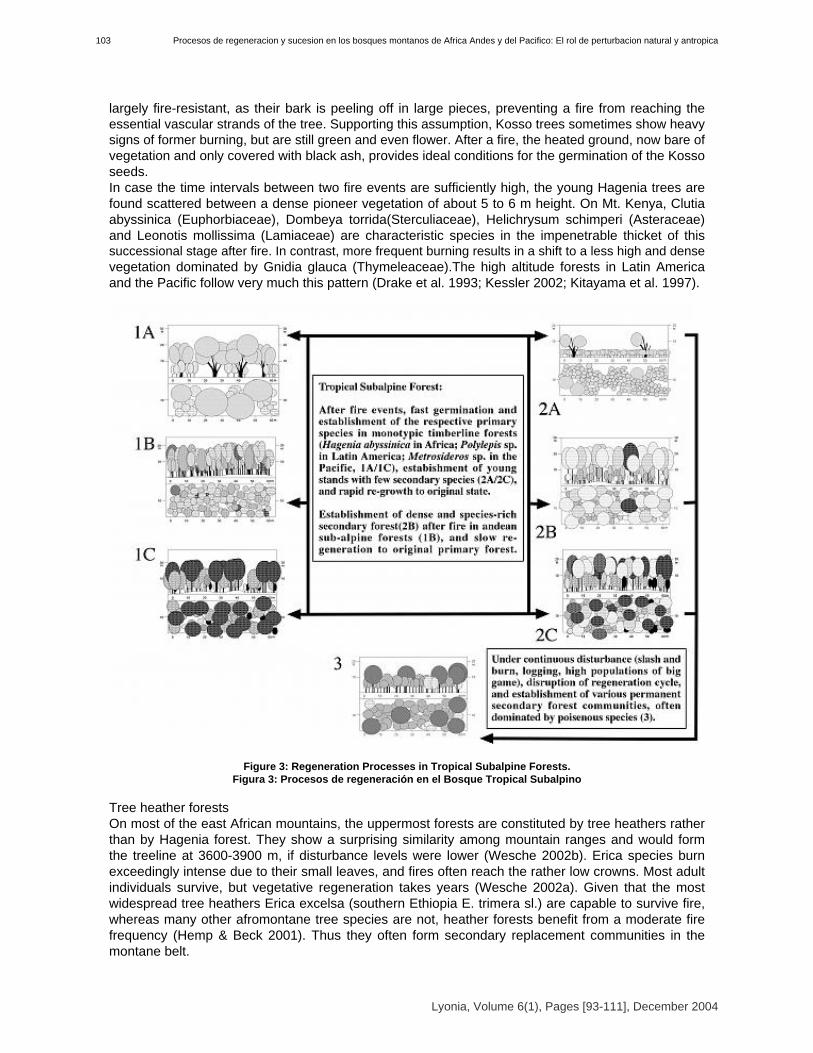
largely fire-resistant, as their bark is peeling off in large pieces, preventing a fire from reaching theessential vascular strands of the tree. Supporting this assumption, Kosso trees sometimes show heavysigns of former burning, but are still green and even flower. After a fire, the heated ground, now bare ofvegetation and only covered with black ash, provides ideal conditions for the germination of the Kossoseeds. In case the time intervals between two fire events are sufficiently high, the young Hagenia trees arefound scattered between a dense pioneer vegetation of about 5 to 6 m height. On Mt. Kenya, Clutiaabyssinica (Euphorbiaceae), Dombeya torrida(Sterculiaceae), Helichrysum schimperi (Asteraceae)and Leonotis mollissima (Lamiaceae) are characteristic species in the impenetrable thicket of thissuccessional stage after fire. In contrast, more frequent burning results in a shift to a less high and densevegetation dominated by Gnidia glauca (Thymeleaceae).The high altitude forests in Latin Americaand the Pacific follow very much this pattern (Drake et al. 1993; Kessler 2002; Kitayama et al. 1997).
Figure 3: Regeneration Processes in Tropical Subalpine Forests. Figura 3: Procesos de regeneración en el Bosque Tropical Subalpino
Tree heather forestsOn most of the east African mountains, the uppermost forests are constituted by tree heathers ratherthan by Hagenia forest. They show a surprising similarity among mountain ranges and would formthe treeline at 3600-3900 m, if disturbance levels were lower (Wesche 2002b). Erica species burnexceedingly intense due to their small leaves, and fires often reach the rather low crowns. Most adultindividuals survive, but vegetative regeneration takes years (Wesche 2002a). Given that the mostwidespread tree heathers Erica excelsa (southern Ethiopia E. trimera sl.) are capable to survive fire,whereas many other afromontane tree species are not, heather forests benefit from a moderate firefrequency (Hemp & Beck 2001). Thus they often form secondary replacement communities in themontane belt.
Lyonia, Volume 6(1), Pages [93-111], December 2004
Procesos de regeneracion y sucesion en los bosques montanos de Africa Andes y del Pacifico: El rol de perturbacion natural y antropica103

However, no other African tree species climbs as high as Erica excelsa and its relatives, so stands atthe timberline cannot be regarded as replacement communities. This is nicely exemplified in theRwenzori, where the most extensive heather forests are found, and where fires are certainly rare due tothe almost permanently wet conditions.In semi-humid mountain ranges, afroalpine vegetation dries out quickly in drought conditions, whilethe upper montane Hagenia forests retain some moisture in all but the most extreme years. Firesmost commonly originate in the open vegetation, and not surprisingly, afroalpine vegetation and thebordering heather forests are much more frequently affected than Kosso forests. If fire intervals becomeshort, time is not sufficient for regenerative recovery of adult Erica trees, nor can saplings grow bigenough to develop a fire resistant bark. Thus, in the long run, Erica excelsa forests are replaced bymore shrubby vegetation types or even afroalpine grasslands (Wesche et al. 2000). At present,timberlines have been depressed by 500 to 800 m due to burning. Several succession schemes have been proposed (Schmitt 1991; Miehe & Miehe 1994b; Hemp &Beck 2001; Wesche 2002a), which all nicely demonstrate how Erica forests degenerate underfrequent fires. However, a major shortcoming is the lack of information about the seedling stage, andabout regeneration in the absence of disturbance. Except for the mostly shrubby E. arborea, noinformation on seed ecology is available, and sound data on re-sprouting are only available for Mt. Elgon(Wesche 2002a). At present, it is largely unclear, if E. excelsa, E. trimera and its relatives should beclassified as re-seeders like the South African heathers or as re-sprouters like most of the Mediterraneanspecies (Ojeda 1998; Pausas 2001). Thus, the available data are not sufficient to infer completesuccession cycles, as they are available for other montane vegetation types.Forest regeneration on tropical landslidesNaturally occurring, often earthquake-triggered landslides are a crucial factor for the dynamics andstability of tropical montane forest systems, and are crucial for the maintenance of high species diversity.In over-aged forest communities, particularly so in the Tropical Upper Montane Forest, species diversitydeclines drastically (Ohl & Bussmann 2004). In East Africa, most montane forests are growing on relatively gentle slopes, and landslides arerestricted to the steep flanks of river valleys, and are comparatively rare. After a slide event, the bareground is rapidly colonized by the same pioneer species as in the Mosaic Climax regeneration cyclealready described above.In contrast, extremely steep slopes are the normal feature in the Andean and Pacific regions, andmany other tropical mountains. Here, natural landslides are very common, and the main motor of forestregeneration. Lower Montane as well as Upper Montane Forests regenerate in a landslide inducedsuccession cycle [[(Figure 4)]].Landslides are extremely frequent in the tropical mountain regions. Destruction of roads andcatastrophic events burying houses or even villages are common. Such slides, however, are usuallyinitiated by human impact; most often by construction projects weakening the underground and bydeforestation accelerating erosion. At some distance from roadsides and settlements, dense forests stillexist. Even in these untouched areas, landslides are a very common phenomenon. Such natural slidesare usually of smaller size than the anthropogenic slides. Investigations on landslide regeneration arescarce. Stern (1995) carried out research on the regeneration of a single landslide in Northern Ecuador(1995). Kessler (1999) studied succession on landslides in Bolivia, and Erickson et al. (1989) in thecentral and southern Andes. In other tropical mountain areas species colonization on landslides wasanalyzed by Garwood (1981 in Panama), Garwood et al. (1979), and Guariguata (1990 in Puerto Rico)and geomorphological processes by Batarya & Valdivia (1989 in the Lesser Himalaya in India), Restrepo& Vitousek (2001, Hawaii), Ohl & Bussmann (2004). Keefer (1984) studied earthquake triggeredlandslides all over the world.
Lyonia, Volume 6(1), Pages [93-111], December 2004
104Rainer W Bussmann

Figure 4: Regeneration of tropical forest landslides. Figure 4: Regeneración de derumbos en bosques tropicales.
The first remarkable thing noted when climbing on landslides, is the ’patchy’ distribution ofvegetation. The slides are very similar in shape, being long and narrow, although they vary in size. Thesurface is smooth and very few rocks are present. Inclination varies between about 30° and 80°. Thisleads to different erosive forces at different parts of the slide. Nevertheless, a direct correlation betweenvegetation cover and inclination or erosive energy would only partly account for the distribution of thevegetation. The study of soil cores of the slides under more, and less, dense vegetation did not produceresults with significant differences in regard to soil texture, structure, color and pH. This excludes theedaphic conditions as principal responsible factors. Landslide areas are colonized quickly either at theborders of the slide or around islands that slipped down without being overturned due to vegetativepropagation from the undisturbed neighboring areas and possibly due to a favorable microclimate. Otherpatches of high vegetation cover are created by the clonal, looping runner-shoot building growth of mostof the individual pioneers that managed to establish seedlings first (Gleicheniaceae, Lycopodiaceae,Bambusoideae and Ericaceae). The majority of abundant species is wind-dispersed and produces manyseeds. Under certain conditions freshly slipped slides do not last very long in the first stage and lichensand mosses do not develop well as the colonization by higher plants starts already in the first year ofsuccession. On landslides well protected against wind and direct sunlight, seedlings of the surroundingflora established themselves after a few months. In contrast, a landslide exposed to wind and directsunlight was bare of any vegetation about eight months after the slide event. Differences in vegetationalong the altitudinal gradient have been found. This altitude corresponds to the change in the vegetationzonation in the surrounding forests (Bussmann 2001c). On the landslides at higher altitudes somespecies typical for alpine vegetation are found. Other distribution patterns do not correspond to vegetationchanges along the altitudinal gradient but show similar patterns to differences in soil chemistry.
Lyonia, Volume 6(1), Pages [93-111], December 2004
Procesos de regeneracion y sucesion en los bosques montanos de Africa Andes y del Pacifico: El rol de perturbacion natural y antropica105

Landslides are a common phenomenon in most tropical mountain systems. Stern (1995) and Kessler(1999) hypothesized that landslides maintain species diversity. Stern (1995) compares the effect oflandslides to the meandering rivers of the lowland ecosystems. They create secondary forests dominatedby colonizing species which are not able to survive in mature stands. Landslides are very common insome tropical areas where long and heavy rainfall and very steep slopes favor slides as well as a highnumber of more or less intense earthquakes. In addition, the building of roads and logging and burningweaken the substrate. The material and degree of weathering of the geological substrate is also important(Brabb & Harrold, 1989). Species richness during the first two stages of regeneration is low due to the dominance of a fewspecies of ferns or grasses. However, during the third stage of succession, species composition stilldiffers somewhat completely to the surrounding forest, but diversity is high. The second stage with adense cover of Gleicheniaceae has not been described from northern Ecuador (Stern 1995) but it wasfound on landslides in Bolivia (Kessler 1999) and Hawaii (Restrepo & Vitousek 2001). There, the role ofGleicheniaceae seems similar, although in Hawaii, the regeneration patterns are more and moreinfluenced by invasive exotic species. Diplopterygium bancroftiiand species of Sticherus dominate. Incontrast, Stern (1995) found a dominant species of Chusquea, 31/2 years after the slide event at thelower zone of a landslide. She adds that the presence of the bamboo is especially noteworthy becauseunder certain environmental conditions it can grow quickly and aggressively. Further on, she describesthe great density of the bamboo, thereby having a profoundly limiting effect on the establishment of otherplant species. The bamboo occurred at sites with a reasonable upper layer of organic debris. Otherinteresting differences in her work are that species of the genus Equisetum are important in the earlystage and Blechnum dominates locally. No species of Gleicheniaceae were found. Reasons for thosevariations might be found in the obvious differences in geological substrate (of quaternary volcanic origin)and the lower humidity and altitude of the site (1440 m). Gleicheniaceae do not hinder the establishmentof bushes, though the time period from when seedlings of bushes appear to when they manage to breakthrough the fern layer, varies. Different types of succession models seem to correspond to theregeneration processes at the slides studies by Stern on one hand and on the other hand the slidesobserved by Kessler and the work on hand. Following the division of succession models according toConnell & Slayter (1977) and Pickett et al. (1987) the model of inhibition will have to be used to describethe situation in northern Ecuador as observed by Stern (1995). In contrast, the tolerance model combinedwith the facilitation model could be used to describe the situation in Bolivia (Kessler) and southernEcuador. Little change in species composition but mainly a change in vegetation density or -height wasobserved due to local erosive energy, time elapsed since the last destruction, depth of the organic layeror the distance towards densely covered sites. Mosses and lichens are not only abundant during the firststage but also during the second and third stage and Gleicheniaceae are present in the second and thirdstage though they loose importance as they are overgrown by the bushes and trees of the pioneerforests. Up to this point, the model of tolerance seems to fit while the missing of species of the primaryforests during the third stage follows the facilitation model. Under mature forest organic layers build up,but due to evaporation and transpiration they will not get heavily waterlogged. In contrast, comparableamounts of water do not transpire from senescent forest. A mosaic-like forest structure with younger andolder forest stages is described in Kessler (1999) from the montane forest in the Bolivian Andes. Heobserved irregularly formed and spaced patches of senescent forest with single trees having alreadycollapsed. This could explain the clustered occurrence of landslides as the risk of slipping in zones ofsenescent forest is higher than in zones of mature forest. In this case the effect of landslides in theecosystem would be very important for the natural regeneration of the system. At altitudes above 2100 m,especially under senescent forest, very dense layers of terrestrial Bromeliads are found. Germination ofother species is very difficult under these circumstances. In contrast, a landslide provides light and a highavailability of minerals for successful plant growth. What is the main difference between the studied natural landslides and the human triggered slides?Hartig (2000) carried out studies on the regeneration of the latter type of slides in Southern Ecuador.Antropogenic slides are usually very extensive. The surface is not smooth but often rocky. A heavyorganic layer slipping over the mineral soil mainly creates natural slides. If thick mats of organic materialbecome waterlogged due to long-lasting heavy rains, the weight of the material reaches a critical pointwhen the adhesive strength gives in to gravity and a slide-event is initiated. The threshold in this area is
Lyonia, Volume 6(1), Pages [93-111], December 2004
106Rainer W Bussmann
very low as the adhesive strength is low due to the slippery mineral soil and the lack of a well developedrootsystem in the B-horizon which could help to fix the upper layers (own obs.; Stern 1995). The humantriggered slides are usually initiated due to the weakened geological underground and have more incommon with rock-falls. Succession differs between the two types of slides. Grasses largely replace theGleicheniaceae and build a very dense layer often limiting the establishment of bush species. Successionseems to follow the inhibition model (Connell & Slayter 1977; Pickett et al. 1987). Especially the numberof orchids is tremendous which leads to a very high diversity on man-made slides (Gross 1998). Incontrast, there are not many species of orchids found at the natural slides but in the few areas with rockyrelief they become more abundant.
ConclusionsThe main formations of Tropical Montane Forests in Africa, Latin America and the pacific share a lotof common characteristics in their zonation and regeneration. Lower Montane Forests characteristicallyform a diverse mosaic climax, where tree-fall represents the main natural disturbance. Natural landslidesand infrequent fires are the main motors driving diversity maintenance, at least in mid-elevation andhigh-altitude forests. All these forest formations tend to shift towards less diverse, and possibly less stabledegenerated secondary forests under heavy human impact. Further research, especially in SoutheastAsia is required, to fully understand the global picture in Tropical Mountain Forest Regeneration.
AcknowledgementsI gratefully acknowledge the continuing support by Deutsche Forschungsgemeinschaft (DFG), andBundesministerium fuer Bildung und Forschung (BmBF). Special thanks are due to all my counterpartsfrom Bolivia, Cameroon, Ecuador, Ethiopia, French Polynesia, Germany, Kenya, Peru, Tanzania, and the USA.
ReferencesAgnew, A.D.Q. 1985. Cyclic sequences in plant communities of the Aberdare mountains, Kenya. J.East Afr. Nat. Hist. Soc. Natl. Mus. 75: 1-12.Balslev, H., R. Valencia, G. Paz y Miño, H. Christensen & I. Nielsen 1998. Species count of vascularplants in one hectare of humid lowland forest in Amazonian Ecuador. In: Dallmeier, F. & J.A. Comiseky(Eds.). Forest biodiversity in North, Central and South America, and the Caribbean. Pearl River, Paris.Banana, A.Y. & M. Tweheyo 2001. The ecological changes of Echuya afromontane bamboo forest,Uganda. Afr. J. Ecol. 39: 366-373.Barnes, R.F.W. 1990. Deforestation trends in tropical Africa. Afr. J. Ecol. 28: 161-173.Bartarya, S.K. & K.S. Valdiya 1989. Landslides and erosion in the catchment of the Gaula River,Kumaun Lesser Himalaya, India. Mountain Res. Dev. 9(4): 405-419.Barthlott, W., W. Lauer & A. Placke 1996. Global distribution of species diversity in vascular plants:towards a world map of phytodiversity. Erdkunde 50: 317-327.Brabb, E.E & B.L. Harrold 1989. Landslides: Extent and Economic Significance. Brookfield, Rotterdam.Braun-Blanquet, J. 1964. Pflanzensoziologie (3rd edition). Springer, Wien, New York.Buechner, H.K. & H.C. Dawkins 1961. Vegetation changes induced by elephants and fire inMurchinson Falls National Park, Uganda. Ecology 42: 752-766.Bussmann, R.W. & E. Beck 1995a. The forests of Mount Kenya (Kenya), a phytosociologicalsynopsis. Phytocoenologia 25 (5): 467-560.Bussmann, R.W. & E. Beck 1995b. Regeneration- and cyclic processes in the Ocotea-Forests (Ocotea usambarensis Engl.) of Mt. Kenya. Verh. Ges. Ökol. 24: 35-38.Bussmann, R.W. & E. Beck 1995c. Regeneration- and succession processes in the Cedar-Forests(Juniperion procerae) of Mt. Kenya. Ecotropica 1: 79-84.Bussmann, R.W. 1997. The forest vegetation of the Harenna escarpment (Bale Province, Ethiopia)syntaxonomy and phytogeographical affinities. Phytocoenologia 27(1): 1-23.
Lyonia, Volume 6(1), Pages [93-111], December 2004
Procesos de regeneracion y sucesion en los bosques montanos de Africa Andes y del Pacifico: El rol de perturbacion natural y antropica107
Bussmann, R.W. 1999. Growth rates of important East African montane forest trees, with particularreference to those of Mt. Kenya. J. E. Afr. Nat. Hist. 88: 69-78.Bussmann, R.W. & S. Lange 2000. Germination of important East African mountain forest trees. J E.Afr. Nat. Hist. 89: 101-111.Bussmann, R.W. 2001a. Juniperus forests in Africa - Regeneration Ecology, Destruction andPossibilities for Management. Proceedings of the International Symposium "Problems of JuniperForests: looking for solutions, Methods, Techniques", Osh, Kyrgysztan, 55-64.Bussmann, R.W. 2001b. Succession and regeneration patterns of East African mountain forests. Syst. Geogr. Pl. 71: 959-974.Bussmann, R.W. 2001c. The montane forests of Reserva Biológica San Francisco. Die Erde 132: 9-25.Bussmann, R.W. 2002. Islands in the desert - forest vegetation of Kenya’s smaller mountains andhighland areas (Nyiru, Ndoto, Kulal, Marsabit, Loroghi, Ndare, Mukogodo, Porror, Mathews, Gakoe,Imenti, Ngaia, Nyambeni, Loita, Nguruman, Nairobi). J. E. Afr. Nat. Hist. 91 (1/2): 27-79, appendices1-7 at www.naturekenya.org/JournalEANH.htm.Bussmann, R.W. 2003. The vegetation of Reserva Biológica San Francisco, Zamora-Chinchipe,Southern Ecuador - a phytosociological synthesis. Lyonia 3(2): 145-254.Bytebier, B. & R.W. Bussmann 2000. The vegetation of Mount Nyiru (Samburu, Kenya): A checklistand syntaxonomical survey. J. E. Afr. Nat. Hist. 89: 45-71.Churchill, S.P. H. Balslev, E. Forero & J.L. Luteyn (Eds.) 1995. Biodiversity and Conservation ofNeotropical Montane Forests. New York Botanical Garden, Bronx.Connell, J.L. & R.O. Slayter 1977. Mechanisms of succession in natural communities and their role incommunity stability and organization. Am. Nat. 111: 1119-1144.Dale, I.R. & P.J. Greenway 1961 Kenya trees and shrubs. Buchanan, Nairobi.Demel, T. & A. Granström 1995. Soil seed banks in dry Afromontane forests of Ethiopia. J. Veg. Sci.6: 777-786.Demel, T. & A. Granström 1997a. Gemination ecology of forest species from the highlands ofEthiopia. J. Trop. Ecol. 14: 793-803.Demel, T. & A. Granström 1997b. Seed viability of Afromontane tree species in forest soils. J. Trop.Ecol. 13: 81-95.Demel, T. 1998. Soil seed bank at an abandoned Afromontane arable site. Feddes Rep. 109: 161-174.Drake, D. & D. Mueller-Dombois 1993. Population Development of Rain-Forest Trees on aChronosequence of Hawaiian lava Flows. Ecology 74(4): 1012-1019.Ericksen, G.E., C.F. Ramirez, J.F. Concha, M.G. Tisnado & B.F. Urquidi 1989. Landslide hazards inthe central and southern Andes. In Brabb, Harrod (Eds.) Landslides: Extent and economic significance. Balkema, Rotterdam.Eshetu, Y. & K. Leinonen 2002. Seed germination response of four afromontane tree species tored/far-red ratio and temperature. For. Ecol. Mgt. 168: 53-61.FAO 1992. Aménagement et conservation des forêts denses en Amérique tropicale. FAO. EtudeForêts 101. FAO, Rome.FAO 1993. Summary of the final report of forest resource assessment 1990 for the tropical world.FAO, Rome.Finegan, B. 1996. Pattern and process in neotropical secondary rain forest: the first 100 years ofsuccession. Trends in Ecol. Evol. 11: 119-124.Friis, I. 1992. Forests & Forest Trees of Northeast Tropical Africa. London, HMSO. Kew BulletinAdditional Series XV.Garwood, N.C. 1981. Earthquake-caused landslides in Panama: recovery of the vegetation. - Res.Rep. Natl. Geogr. Soc. 21: 181-184.Garwood, N.C., D.P. Janos & N. Brokaw 1979. Earthquake-caused landslides: A mayor disturbancein tropical forests. Science 205: 997-999.Getachew, T. , T. Demel & M. Fetene 2002. Regeneration of fourteen tree species in Harenna forest,southeastern Ethiopia. Flora 197: 461-474.
Lyonia, Volume 6(1), Pages [93-111], December 2004
108Rainer W Bussmann

Grimshaw, J. 1999. The afromontane bamboo, Yushania alpina, on Kilimanjaro. J. East Afr. Nat. Hist.88: 69-78.Gross, A.1998. Terrestrische Orchideen einer Hangrutschung im Bergwald Süd-Ecuadors:Verteilung, Phytomasse, Phänologie und Blütenmerkmale. Univ. Ulm, Diploma Thesis, unpubl.Guariguata, M.R. 1990. Landslide disturbance and forest regeneration in the Upper LuquilloMountains of Puerto Rico. J. Ecol. 78: 814-832.Hamilton, L.S., J.O. Juvik & F.N. Scatena (Eds.) 1994. Tropical Montane Cloud Forests. EcologicalStudies 110. Springer, New York.Hammen, T. van der, A. Perez Precario & E.P. Pinto (Eds.) 1983. Studies on tropical andeanecosystems Vol. 1. Cramer, Vaduz.Hammen, T. van der & R.M. Ruiz (Eds.) 1984. Studies on tropical andean ecosystems Vol. 2.Cramer, Vaduz.Hammen, T. van der, S. Diaz-Piedrahita & V.J. Alvarez (Eds.) 1989a. Studies on tropical andeanecosystems Vol. 3. Cramer, Vaduz.Hammen, T. van der, D. Mueller-Dombois & M.A. Little 1989b. Manual of Methods for MountainTransect Studies. IUBS, Paris.Hammen, T. van der & A.G. Dos Santo (Eds.) 1995. Studies on tropical andean ecosystems Vol. 4.Cramer, Vaduz.Hartig, K. 2000. Pflanzensoziologische Untersuchungen von anthropogen gestörten Flächen imtropischen Bergwald Südecuadors. Univ. Bayreuth, Diploma Thesis, unpubl.Hedberg, O. 1951. Vegetation belts of the East African mountains. Svensk Bot. Tidskr. 45: 140-199.Hemp, A. & E. Beck 2001. Erica excelsa as a fire-tolerating component of Mt. Kilimanjaro’s forests. Phytocoenologia 31: 449-475.Holloway, C.W. 1965. The impact of big game on the forest policy in the Mount Kenya andNorth-East Aberdare forest reserves. E .Afr. Agric. For. J. 30(4): 370-389 .Houston, M.A. 1995. Biological Diversity - The coexistance of species on changing landscapes.Cambridge University Press, Cambridge.Hutchinson, J. 1967. Key to the families of flowering plants of the world. Oxford.Ibisch, P.L. 1996. Neotropische Epiphytendiversität - das Beispiel Bolivien. Martina Galunder Verlag, Wiehl.Katende, A.B., A. Birnie & Tengnas 1995. Useful trees and shrubs for Uganda. Identification,Propagation, and Management for agricultural and pastoral communities. Regional Soil ConservationUnit. Kampala, Nairobi. 710 pp.Kebrom, T. & B. Tesfaye 2000. The role of soil seed banks in the rehabilitation of degraded hillslopesin southern Wello, Ethiopia. Biotropica 32: 23-32.Keefer, D.K. 1984. Landslides caused by earthquakes. Geol. Soc. America Bulletin 95: 406-421.Kerfoot, O. 1961. Juniperus procera Endl. (The African Pencil Cedar) in Africa and Arabia - I.Taxonomic affinities and geographical distribution. E. Afr. Agr. For. J. 26: 170-177.Kessler, M.1999. Plant species richness and endemism during natural landslide succession in aperhumid montane forest in the Bolivian Andes. Ecotropica 5(2): 123-136.Kessler, M. 2002. The Polylepis problem - where do we stand? - Ecotropica 8: 97-110.Kitayama, K., E.G.G. Schuur, D. Drake & D. Mueller-Dombois 1997. Fate of a wet montane forestduring soil ageing in Hawaii. J. Ecol. 85: 669-679.Kortland, A. 1984. Vegetation research and the "bulldozer" herbivores of tropical Africa. In:Chadwick, A.C. & S.L. Sutton (Eds.) Tropical Rain-Forest. - The Leeds Symposium. PhilosophicalSociety, LeedsLaBastille A, Poole DJ (1978) On the need for a system of cloud-forest parks in Middle America andthe Caribbean. Environmental Conservation 5(3): 183-190.Lambrechts, C., B. Woodley, A. Hemp, C. Hemp & P. Nyiti 2002. Aerial Survey of the threats to Mt.Kilimanjaro forests, UNF, UNEP, KWS, Univ. Bayreuth, WCFT: 48.Landon J.R. (Ed.) 1991. Booker tropical soil manual. - Essex, New York.Lange, S.H., R.W. Bussmann & E. Beck 1997. Ecology and regeneration of the subalpine Hageniaabyssinica forests of Mt. Kenya. Bot. Acta 110(6): 473-480.
Lyonia, Volume 6(1), Pages [93-111], December 2004
Procesos de regeneracion y sucesion en los bosques montanos de Africa Andes y del Pacifico: El rol de perturbacion natural y antropica109

Legesse, N. 1993. Investigations on the germination behavior of wild olive seeds and the nurseryestablishment of the germinants. Sinet 16: 71-81.Leigh, E.G. 1999. Tropical forest ecology - a view from Barro Colordo Island. Oxford UniversityPress, Oxford.Martin, R.E. 1982. Fire history and its role in succession. In: Means, J.E. (Ed.). Forest Successionand Stand Developement in the Northwest. Corvalis For. Res. Lab., Oregon State University.Miehe, G. & S. Miehe 1994a. Zur oberen Waldgrenze in tropischen Gebirgen. Phytocoenologia 24: 43-110.Miehe, S. & G. Miehe 1994b. Ericaceous forests and heathlands in the Bale Mountains of SouthEthiopia - Ecology and man’s impact. Stiftung Walderhaltung in Afrika. Hamburg. 206 pp.Mueller-Dombois, D. & H. Ellenberg 200. Aims and methods of vegetation ecology. Wiley, New York.Myers, N., R.A. Mittermeier, C.G. Mittermaier, G.A.B. da Fonseca & J. Kent 2000. Biodiversityhotspots for conservation priorities. Nature 403(25): 853-858.Nieuwolt, S. 1978. Rainfall variability and drought frequencies in East Africa. Erdkunde 32: 81-88.Ohl, C. & R.W. Bussmann 2004. Recolonisation of natural landslides in tropical mountain forests ofSouthern Ecuador. Feddes Rep. 115(3-4): 248-264.Ojeda, F. 1998. Biogeography of seeder and re-sprouter Erica species in the Cape Floristic Region -Where are the resprouters? - Bio.l J. Linn. Soc. 63: 331-347.Pausas, J.G. 2001. Resprouting vs. reseeding - a Mediterranean perspective. Oikos 94: 193-194.Pickett, S.T.A. 1989. Space-for-time substitution as an alternative to long-term studies. In Likens,G.E. (Ed.). Long-term studies in ecology. New York, 110-135.Pickett, S.T.A., S.L. Collins & J.J. Armesto 1987. Models, mechanisms and pathways of succession. Bot. Rev. 53: 335-371.Plumptre, A.J. 1993. The effects of trampling damage by herbivores on the vegetation of the ParcNational des Volcans, Rwanda. Afr. J. Ecol. 32: 115-121.Reed, M. 1997. Effects of grazing and cultivation on afromontane plant communities on Mount Elgon, Uganda. Honors Thesis. University of Aberdeen. Aberdeen, 80.Restrepo, C & P. Vitousek 2001. Landslides, Alien Species, and the Diversity of a Hawaiian MontaneMesic Ecosystem. Ecotropica 33(3): 409-420.Schmitt, K. 1991. The vegetation of the Aberdare National Park, Kenya. Hochgebirgsforschung 7: 1-250.Schmitt, K. & E. Beck 1992. Die Zerstörung eines Bergwalds in Kenia: Beispiele desZusammenwirkens von Mensch und Großwild. Jahrb. Verein z. Schutze der Bergwelt 57: 207-226.Scott, P. 1994. Bamboo in Mount Elgon, MECDP.Sierra, R. (Ed.) 1999. Propuesta preliminar de un sistema de clasificación de vegetación para elEcuador Continental. INEFAN/GEF, Quito.Speck, H. 1986. Soils of the Mount Kenya Area, their formation, ecological, andagriculturalsignificance. African Studies Series A1: 47-72.Stadtmüller, T. 1987. Cloud forests in the humid tropics. A bibliographic review. United NationsUniversity, Tokyo and CATIE, Turrialba.Stern, M.J. 1995. Vegetation recovery on earthquake-triggered landslide sites in the ecuadorianAndes. In: Churchill S.P., H. Balslev, E. Forero & J.L. Luteyn (Eds.) Biodiversity and conservation ofneotropical montane forests. Wiley, New York.Stoyan, R. 2000. Aktivität, Ursachen und Klassifikation der Rutschungen in San Francisco/Südecuador. Univ. Erlangen, Diploma Thesis, unpubl.Tamrat, B. 1993. Vegetation ecology of remnant Afromontane forests on the Central Plateau ofShewa, Ethiopia. Opulus Press AB. Uppsala.Troll, C. 1959. Die tropischen Gebirge. Ihre dreidimensionale klimatische und pflanzengeographischeZonierung. Bonner Geogr. Abh. 25.Wesche, K., G. Miehe & M. Kaeppelli 2000. The significance of fire for afroalpine ericaceousvegetation. Mountain Res. Dev. 20: 340-347.Wesche, K. 2002a. The high-altitude environment of Mt. Elgon (Uganda/Kenya) - Climate, vegetationand the impact of fire. Ecotropical Monogr. 2: 1-253.
Lyonia, Volume 6(1), Pages [93-111], December 2004
110Rainer W Bussmann

Wesche, K. 2002b. Structure and dynamics of Erica forest at tropical-African treelines. Verh. Reinh.Tüxen Ges. 14: 145-159.Wesche, K. in press. The importance of occasional droughts for afroalpine landscape ecology. J.Trop. Ecol. 19.White, F. 1978. The Afromontane Region. In: Werger, M.J.A. (Ed.) Biogeography and Ecology ofSouthern Africa. The Hague, Junk, pp 463-513.White, F. 1983. The vegetation of Africa. Paris, Unesco.Willan, R.L. 1965. Natural regeneration of high forest in Tanganyika. E. Afr. Agr. For. J. 31: 43-53.Wimbush, S.H. 1937. Natural succession in the Pencil Cedar forests of Kenya Colony. Emp. For. J.16: 49-53.Wimbush, S.H. 1945. The african alpine Bamboo. Em.p For. J. 24: 33-39.Winiger, M. 1979. Bodentemperaturen und Niederschlag als Indikatoren einerklimatisch-ökologischen Gliederung tropischer Gebirgsräume. Geomethodica 4: 121-15.31
Lyonia, Volume 6(1), Pages [93-111], December 2004
Procesos de regeneracion y sucesion en los bosques montanos de Africa Andes y del Pacifico: El rol de perturbacion natural y antropica111