m m - mediaserver.dnrc.mt.govmediaserver.dnrc.mt.gov/archive/ground_water/flathead/t26n_r20w... ·...
TRANSCRIPT

m mT . .R -
- » - r - ~ ^ : - County ^ ^ ^ ^ ^
MONTANA BUREAU OF MINES AND GEOLOGYButte, Montana ,
S. . ENGINEER
WATER WELL LOG
1 | | owner... l^.L^^Z^ T ± Addr«. J^^jf^^k^
~~TT~T~~ o ^ : ! ^ ^ ^g%0&2P- '___L_j_.._L__ DateSUrt«L..^^^..^^C? Dte Completed^^^^y
! ! • | Location: Sec ! _.. T-JLtJii... R..i?A.^ W sec_L(_iU_'5£.iLil!l-'^ !&B£. | . .
^^.J^M±±- ^^^^^ytA^^^i Due. driven. bor*d. or drilled) :Chum driH. rotary, other) I
^y r—i r"~i r~~iWater use: Domestic I "\ Municipal Stock | | Irrigation | \
Indnstrial I Drainage Cther: _
Casing: Q. ft. to _ ~J. ft. Type €^\ .!*?. Si2e... _
Casing: ft. to ft. Type _ Size _ _
Casing: ft. to ft. Type _ Size
Perforated or Screened: Ft... toft. .Ft. tc t*
Type of screen or perforations -
Static Water level, for non-flowing well: feet.
Shut-in pressure, for flowing well: . 1b. sci. in. on:
<o ( d a t e ) / f?Pumping water level v r-~ feet at / c/C-pr* gal. per Jon-.*!r...yf.Cf
How tested: v^_c^^>~/><
Length of test ^ ^ ' ^ L < k v / »
Remarks: (Gravel packing, cemenUnc packers, type of shut-off, depth of shut-off) I
.::: ~ : - ' : : : : ; • ~ n :
fnver)

Log of Well ^^M
Depth, feet ^ ^ B— — • Description of Material Drilled ^ ^ B
From • To , ^ ^ ^ S
i I ~£sT ^m

\
:• .- N.V - w - T .~JL= RJL2.*
Co tin* j ' -...•..-.... ,
3TATE OF MONTANA
ADMTNISTSATOE OF GROUTTDWATER. CODE
OFFICE OF STATE ENGINEER
Declaration of Vested Groundwaier RightsUn..i-?r Chapter -•!'". Montana .Session Laws. 1961)
i. ^S2sst^..^czr.:.z. ^ l l z . .. . ..r..^r. ZCT .LSsrk. -Name if Ap:'r"pr;ar.T Address (Town)
( o u u t y OL. .-..•*;—.- •.;'-*•—• . M a t e o i ' . i-'-'r-'-.y5*?—Vhave appropriat-.i _'-,;. ;r. : .v:,:er according to "he Montana law.; in effect prior to January 1. 1962. a s follows:
! " 1 ~~ -J. The beneficial use on which the claim is based. A s ..PORt InUCUaI ••- -•• 1 ;.';us:::cll anJ :o .rentier..use.
i .__! „. i •)- Dat^ or approximate date of earlir-st beneficial use- and how con-
- - ! - • • 1 rouses ri:o -ise ha.x V e n . . . ^ ? - ° » 1 ^ °j Tr:c use :-.-is : "or . oor.t ir . jcun or. a i i . i l J
w ^ —-! E -.ecd basis. "'" *"""iI 4. Tli-' ;i:i:ivnr o: jf-timd*A"a:er t-hiimed , in miner's inches o r gallons
J ..— ^,.r miT*-rt. Tho •rounJ-.-atcr q l a l - ^ i Is on tho
! 1 ."j. I: !>•••; -or irriir;»tion. -..'ive the a rt-uir" and description of the landss r.' wiin'i1. -.vir.T has b>»en applied and name of the owner thereof
j>ct, i :.jv..v^..". i T-o 1;2O Uct i t i:-^^;:^) .....'.'...' .....' "...~. Z'".' .. ..
I r . i i i i - a : . ' p o t r u ••! a; T v , , p r \ . t - : " : i
n \ i l p t a i ' > - ' " ' ' > • ' • '•: [ » < . - - ; : • ' •
Kai-h -iniail -'i'.:ir>' r-:.r'-^."!r^ I11 '• T h - HI-MSIS • f ivi tu ' i rau-inu' such w a t e r from the j r round a n d theacres . [(icau-'ii •'( '-a.-h wj;iL1xir..)th''r moans of w i t h r b a w a ! "f*®**.*'"?.•"•*"
7 T h . ' date <>i eoniai t i ic . 'mi ' tu , a:id i^jinr.Iftiorj >>t the .;im.-itri:i-!ion of t h e w.-lt. wells , or o ther w o r k s f o r wi th-
. J w j i -f £rou«ui ir..r *"? ^ ~ : c n c r •• c ^ r t 7 • e l l . r i l l i n g - oosncnecd
- -p,.. '-Mth of w ; . r .,.,;,. - l a c t porous sl.-?.l« at i;o Toct; -nrnt-r ralcod to :o footl -vc l u;:cn '-jnotir'.t.ion of n.':r.le structurrj ,
' - . - : ' . i r n > :* n : i - - '•••• , r . • . ' . i r ' i - . t : > . ' " v p . - . > : / . . i a i , ; J - j p t : i ' t i t - . u ' i i ' v : ' l i > r t i l e i r t ' t u - r a l s p e c i f i c a t i o n s <>f a n v o t h e r
wvr..iMSrlv-,«hdrVWl.of«rV»L.li.,.r ' s U 1 -Ol-th- C<S ?CO?t. 0 tO ?5 J 7Ct - . .. .1 .01 a • . i l l ; ^0 to CO feet - .i; .1 ontar7 reck typical o^ tho icslcn_j.:i o, -';J.B ^c-in.- located nc-\r Ir.a orth "3nd oT 3r.lu r-.i-'. a,
1"O to I;-J foot - Hack roroua c:;^lo v'r.lch i c tho wMtcr Sqarin,"'"forn^tlon.C* ^asirv- Tor 35 -"cct; ro.-Irjlcr a; .-rorloatc 2* N.ole through reck.
;.. T>. . . , . , ,a- .>, i , „ , „ . . •• . r . i : i . : - , , - , -r- . ,«-- .vr i . . ^ -.. , i r 2 C O . C 0 0 T i l l o n s
• " • " " •
: i T - : • . : ••:' t " ^ r r . i . i t : , i i i , - • ' • • ; • ; • - : • • • : - ••;.- : r : i i ' r : _ r •; •':!••!: w e . ! : t a v a i l a b l e
..>za ..z Iti.- j . r--cl .;r;c Ir. tr.c rco!: ns-lo Ir i i l in • li.ri::-jlt, ro-•..irl"- "- • i t j -. ,Tf;i :;*.-ir :v?r7 J :" ct -.rt-.-r - --cu-t':ri-'- -olid '
: _ . ~- i '-. . ; ! • r ; n : ' - ' t t . - . - i r :.••.[! •' ;i - ; r r ; : ' : i r r . a t n r e a > m a y '•• • i<-'r:\ i n ' a r r . - i n . 1 > . - ; r t h e p . - d f - v . j f th.LS a c t . i n c l u d i n g
... •• ,,..- . • . !,„.,; i : ; • - :_... ..-• ..;;;.- -,-:n-:.- r-.-.p!
I)atc....*2U—L*x. ^7, / -S-3
i • " ? • • - " • " ' • : - " • • ; -;.- -;;-• x:i~< w r h r l - , . <',.,•..;•.••_.• r | . - r K a : : - l I . I f " - . - , - , j . . r ,, :- . j , . . , . n , . n r y ; t ( ^ . j j ; .;, » j , . » - v ^ l l LS
" r i - i n : ; ; " ":: • ' ' / : i ' ' ' : - ' "'•• " k •i'->;': :l;.'•''•-• - P 1 : ' - " ' " ' : - " " ' • • " ' K r . - ^ — . - . T n p i i - - a t e ••-.• r h ^ . M o n r a n n B u r e a . i•"•^ V ! n < " ! • < " d t r « - o i i " ' v ; i r i . ; w : ! . t i ! ; " i n ' i O j t i - : ' . , r • h - \ ' • • • r ' - r ' n a t i . ' "


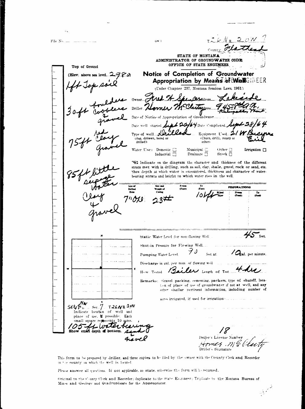
I Fii-Xo- ... .. . . . T..*..*......R....?0*.._ H
I Coua._r nathwd - H
B STATE OF MONTANA ^ H• ADMTNISTSATOH OF GBO USE "WATER CODS ^ ^B OFFICE OF STATE ENGINEER ^ H
B Notice of Completion of Groundwater Appropriation j ftfl• Without Weil ^ •• J . ' u . i - r r < • : ; ; ; : - . - • - • ..'•' ' • [ . • • i t a - . i a > - > - . > J I ; ' . n w * . i ' j t j l ... - . - - • • - ' • T 1 ;"? B^H
• &SSZ2. Da:-ot Apprnpriati-r. ot.Jrvun.I'.vavr.... * ° £ » * 8»JW32 ^ ^
m ?T«rt ^ . P t e e . _ 3 « « t ^ - x ,,_,„ Efrfterk, Montana ^ |
• Ronald K. Plerct? ,. ....,,..,,.. ;, ,,.. j ^ H
• I.'j.; ' ••"t-rr."! D-Uc (_'• mplett'd | ^ ^ ^ |I . . . . . •• N- .I---::-.' ::: :i:;> . : ; : .[:r..r;u- _T'V;:-. i-vater withc.it a -well ""as by ^ ^ HI | j -• : ' •.rriu-iri •:•. tn.i ,.:!;.•:• naf.r.il ^rno'^ses"*. Include depth tn ^ ^ H
I - —• v,v, .n-u a p p u , a b k > t a r a l swfiee a ^ i ^ . ^M
• W j j E ^ ^ H
I j | ' ; ' . . i ! i ; . ' / ••: •."•-• i••• r iit , - i.• • t»•-• I . t m l us.*>t -vith ' ' x p l a n a t i o n o t m e t h o d ^ ^ ^ |• I j j '- • ::• ••• '" ' • T ••*-:;ri.-i:,- ^ i . - r . . w i i ' ^ a i t . I f n:n> i s i n t e r m i t t e n t ^ ^ ^ H
I ( ' ••'.:•..:•• . 1 : • | i : - . - x. • m . i r •• l . T i i r * '•- •;:' : • • • r ; o < i s o t u s e ^ ^ ^ S
I ' * '4 - - 1 ' ^"® 2 inch gnlVifcilMd dr« «3^d the ynar around. ^ Hft I r t t i i c a t ' ' [.i,!!:: •:' , i u i i ' - " p r i ; i - i n n ^ ^ ^ B
I .111:1 : • . ! > • • ' , » ' , l ' > " > M ! •'.•-. ^ ^ ^ B
J\tUMicL. t. ^o.tic B l l
T h i s f ^ r n i t o !>•• p r - i u r - i b y . • • ) i i t r a • • t n r \\ \ v r o : ! . -rv:'^.- :>y •;••• • i i v j . - . ^^Hr
F l ' . r - - " • ( • ! . . : • • ; ' t ' ' : . - u •• ••• . t r "... !>»• : ' . ' . . - . i •.. ••. •.".•• ' ' . . ! • . : ; • / • . r i i ^ . i . ' l i - ••." : - r o : t h t ' i M t i a t y i n w h i i : h t h i * ^ ^ ^ B
[ • ' • • I - . - . , : - • ' • • • • •/.: • • : - • - . : > . I : : < „ ; ..: ;• • : ••• . - . - • • - : - ' . . - , • r : > ; •• -A-!! H - r - r u r t i ^ . i . ^ ^ K
' • n i r i n a i ••• ? : . . • ( ' . . . . r i f . i .•:•-.: a t . - i ?<.:•<•• :• -. - .-••,- •• .- • • ••••• - • > • • • £ : - • • • _ • • ••••- r r ; . h . - a t ' * r r i t h < M - n r a n a BBVL l - r - - a : : ' > M : n ^ , i : l , ; ' , : . . . ! ; : • , - • . , - : l . : - - . - . , - r :'. - •; : . - . p r . . ; • : . : - - " ^ B

LI

M £o^rs*r«~;Jt*f*7i%tC>r. J,Syhrees7 jf-<^ J£<L 7 ^ ^ / .^2tfV. 7**^* ^ , „ **• J 1
• Z£*•£"+~*B'7:7&&rc<i y e s / J f - 3 ^ c / / > r V £ f ^ r •a7^4**'«f «*» ~r^au/Jt &'-•> H I
B jJftrtJrAi/ •£?/<??*.. I*S/?/C/T Jj?r-'/*f /a-^^a p**?*?1 ±-7'*»''"? 0 7*~ 2." h6rrf=+~ f ± \ •
fl io/y^£T a-.r^£Ym^7/t/.»otse £?,c:~re:<= <x )+&£:*• USO- or -**'<x) ^jt>~*i9. ^/,? -IP""? ^ •
^B . . ' • • 9 \ A — . "° /* fl
I /•• / / - ^ I Ifl .T^^w^ &"?.*? 2o&/ S £07/S~s£ V • 7 : •
! i ^ &/ ' L II *» 5 ^ ii 1I 1 • ">9/ 'u • fl
I N / _ - — $> h 1• m .«c><< „ *• JX*?-<0 I ^ n• "I t? >?$*" A iV •fl '• [j| r-y^^ M £+A?*/*y<*o' JL~jy&4* ^"<? - J^ fl• ! I 1 " ~ 2*O o" |N ^*<=a>£>*V • I ^ flB W- &/ertrcr j j OSC* /h^O^T f <S r/**/*^. fl
I ^ i_ h/^y /X^S-o -T-UA/ &24V /-J^/^s^^- I
flK—'" '#r/rx>s:--**t}~»fj/t tie-S £*:'£. •

//
^ ^ S . ; . , * : sp:<ci :•*•; County. .F3Lat2jeS«S,. __.'
STATE OF MONTANA DRILLER'S LOGADMINISTRATOR OF GROUNDWATER CODE d ,h ^ , t W d c .
MONTANA WATER RESOURCES BOARD ^ rf s t r a f a s u c , a j j 0 , L d a y ^
NOTICE OF COMPLETION OF GROUNDWATER s rave l- shale- sandstone, etc show
APPROPRIATION BY MEANS OF WELL J*9?* ? w l J * w a f "! found an.fheight to which water rises in well.
Developed after January 1, 1962
(Under Chapter 237 Montma Session Laws, 1961, as amended) Top of Ground iffprxaUB^. bovc M te.en _5__a__
This form to be prepared by driller, and three copies to be filed '• **«• \ To ;by the owner with the County Clerk and Recorder in the county in I lFttt) I <r**a | . .which the well is located, last copy to be retained by driller. Q 1 l ~ " _ ^ p g a ± l _Please answer ai! questions. If not applicable, so state, otherwise the 1 ' 14 Tan ftlfflfff eobbLLeatones. .form may be returned. i _ I __^-%__O^_^£Q&SL£S--_- .—
I* lfrJf~2*l§"' HLug ffTBT Tf^m " 1S f f i *"-Owner J.n.liHlX H- Tubb I e . . . — 1 L_^_i_2_}<_«_J3_L. - - -
For Administrator s Use 2S2 ! g~7 R g n i a> jftfa f r f - th Tun^l**. Address ...BOX Z L 5 . . F i ! 3 /&£££ \ £&-x—±*l--ft&
A / gTT S 2QQ SLw gray racfe
I .jua*.i«-^..a9»r fi?Jto/9MJ;«p^ .^ajugj^sjt———-—Date well started ....J™?!?..l^..i2T?....GV/ 1 . •
completed JtgMt .28^ .3^72. : ;
Type of well Dri l led — —•—-tDug. driven, bored or drilled) ' , ^ ^ _ _ _ _ _ _ _ __-_—»_____——— . _ _ _ _ _ — —
Equipment used Ai? Notary .i Chora drill. rot»ry or other I I
Water Use: Domestic S Municipal G S f o c k 3 Irrigation Q ! j
Industrial Q Drainage • Other Q * Garden,-Lawn £ I
"Describe •
USEt If used for irrigation, industrial, drainage or other. Explain, j ' ~-.iafe number of acres and location or other dati (i.e. Let, Block u 1 " "
and Addition). ^ . . i rr f f iKte ^2 ac?©3 i n ^sarden, Ism. & ( _ i '
trees. " ' j ~ T ,ESTIMATED ANNUAL WITHDRAWAL 15,.793iaOOO. . ' \ I
Sltt at SU* uut ' From , To ' ~ l ' 'tVtB*d WrigM (F—1) iFert) PERFORATIONS IHut* of Cmln* \ , : i — • —
, Kind From To [i Ml« j iFeft) IF—X) ' |
6" : 6 5/8K ! +2* j 34* ' : 1 r
l&x-i1, ! i jonE j - — j - ; "_: ; i | " ! I ;
1 ; __ i |
; i : .."7 i! ! • j n i l " I
I Sta'ic water ievel .. . 3r ft.* i I'; Pumping water level .231 ft.*1 _ [ I
J '. at 3Q. gallons per minute. ' I: measured 2HD. minutes after pumping I : I
began. ! J I'Measured from ground ievei. ; _J : M
i Wei1 developed by Air. Li£t...Pyrgip ; 1;or ... 3. hours. I
: Pcv.-erDleSel.... Purrp....l5Q HP1 * ~ ~ IRerrarks. (Gravel packing, cementing. I
' : packers, type of shuteff) A3J-..'*g^g3r. : " I
IE ^ .S3..-., sec *• and BeoaaJbelaw^ 2 3 feet;. i Ir. 26 MR 2Q. \ yjallsia thia area caa/iw ^_ _ , I
Sg. w .depended, upoa to produce. ...; , "" 21 I I IINDICATE LOCATION OF WELL AND PLACE OF USE. iF POSSIBLE. ' IE^CH SA/>ALL SQUARE REPRESENTS 40 ACHES. 1 • 1 I
liberty- Droitinff Co. j IDriller's Signature ..... \ . 'v£: . W/v -^v i^ . - ^ v^i_ '• '• ' I
Driller's Address r - C U t e . 2 . • • I
Sal iapel l , VSortana LICENSE NO 5? .^3Z1 Show exact depth of bottom I
tfarte? rises i n wll 93 feet Ia x E r a r f K e - sVjWi I

clear sand £t*«a vater year after year as leas as they ar« not ovur^uuped, ^ ^ Bi . e . , they aJy^iid be puapod at rate* oot in excess of 50 to 60 pwceiri ^ ^ 1o f the tested capacity of the aqulfcsr. ^ ^ |

j- • !
•i 1
^ . o v v - : ^ - ^ " " " Coun tY -a f fS faead - - ,
STATE OF MONTANA DRIILER'S LOG
ADMINISTRATOR OF GROUNDWATER CODE Indicate t he character, color, thick-MONTANA WATER RESOURCES BOARD n e s s of strata such as soil, d a y , sand,
NOTICE OF C^S-fi-ST-TiioUNDWATER & fS^ZT* £-n-_APPROPRIATION B Y MEANS O F WEIL h e i g h t to w h i e h water rises in well.
Developed after January i , 1962
(Under Chaptar 237" Montana Session Uws, 1961 , a* amended) Top of Ground (BCT. »bo.e sa i_-?n ^ftncaur
This form to be prepared by dri l ler, and three copies to be filed j i£~» ! j ^ ^ ^ ^by the owner with t h e County Clerk and Recorder in tne county m ; i .which the well is located, last copy to be retained by driller. :__ j_gg—foatf e i c y . W>bl_^13lta_gaPlease answer all questions. If not applicable, so state, otherwise the | [ <ml -jguItkUS — *
form may be returned. ££? [-?—«Ssy-g-ar-
H^tt -. and £ Lj •!Si^!tr«M_«a_ST-Owner I l4f^---:i.---:?Sks3_»Ti.-e6 - Fnr Administrator's Use ! "* ~ < ^ '•> ** ?- tJ" •
. • I __ - -— C:j- — • _' c£J_J """"~ ' ~ ~ •».»_^f«__—. u«- - v » " .. — _ t _
f Address _ & - , - - > - . - - r " e - •— - C I : ? ' '••" - ^> -UCL ~
- . • " . _ _ • " • " • . - •• 'I T b_5—' J5__-"CSr Si'_v - - J i l - r*SSU*-i";__e5ei«r-----__-__ A t~'"" I ;£ CI-! ;
Date well started J_ E a ^ -5 r , - - i r - p_ GW I .'Mir...1-- - • - -"- ^ —
complex c__rv-rj--r;-;_- I :- ' \ ^ I , .
Type of well &-_-_..» ----- - ,b . , ; ^ ; - ^^ -«^u^ I | -
Equipment used ..f,*^.^^ - — ^ v , — — £ £ , ^ , _ _
Water Use: Domestic .£] Municipal Q Stock Q Irrigation •
t *" " i rH"f Industrial • Drainage • Other Q* Garden/Lawn Q ; — r
•Describe - I __, —USE: If used ''or irrigation, industrial, drainage or o'her. Explain,
state number o f acres and location or other data (i.e. Lot, Block ; T |
ano Addition) . . . •-.. - . H "| '
LSTIMATEP ANNUAL W I T H D ^ W A ^ . ^__r_=---P^" ! 1
^l^^T^i^^TS1.^"^) , --»F0RAT,ON_ ! i jI ! : s ! « i «F««> , l F « " i
k/V--Ui !^'-w ' i ' | - —b 1A* : i : i I I i
!siAf ! ; : i _! 1!Vi/ir : -^-^ ; v77 ^ '"1" p _ L J -
j ; -"^ : i j .
: 1 ; I Static water level . ^ - ^ j - - - . ft.*I Punpir.g w a t e r level .. ._^,, ft.* j. W
; ' af r gallons'p^r minute, j i_ — 9: : measurecf'.-r--jninutes after pumping; i I I
. began. *" ; j j — — jjw ; : K 'Measured from ground level. ; j I H
Wei; deveiaped by ,v—VH-.:-<V . I fl
: " ""; Power, -r-1-^-.-:-- Pu^P- - r - ' H P i 1— .; . Remarks-'*(Graves packing, cementing. •• ' : packers, r /pe cf shutoff) ._11. _C-_-? ', 1 _
" ^ 1 w _Jc_i_s- -^scn zz-v?c£ftc ; 1 jINDICATE LOCATION OF WELL ANO PLACE OF USE, IF PCSSIBt-1. ' 'EACH SA/LA11 SQUARE REPRESENTS 40 ACRES. '
."jiJe-^V :-^~J>L?^r*3^rsC'~'~'' —.Driller's Signature .-.._._...:<| j^v_; i- | -• :
Driller's Address -*n^ ^""-X^.- ^~^ """'""" I*""' * ' " __•_ Show exact depth of bottom I
. . . . . . . - ...:_i_J_«:.^ •".;«.... . LICENSE NO _3- • - - •

H clear ooDd fee© vs&er y jr of tor yoar aa loot; ao t£»y are act ovespaapod aB i^c. tiajy shronrt bo packed gt pgt e sot in ossoaa of 20 to 6o peroasb of IH ths tooted cqpattUg of i±us acjulfcr. I

I *Z^*>^ G\V : Rev.sea «w County . ^ ^ _ ^ 4 . -
I STATE O5= MOftTAM-A. DRILLER'S LOGI ADMINISTRATOR OF GROUNDWATER CODE ,nd !ca te ;h& rJi ^I MONTANA WATER RESOURCES BOARD ne ,s rf s t r a t a such as „ , „ , d a y f sand ,
I NOTICE OF COMPLETION OF OROUND WATER s r i l v e l ' s h a l e - "r.dstone, etc Sho*
I APPROPR.ATION BY MEANS OF WEU gj, I — ™»^• Developed af ter January 1 , 1962
I (Un«i«r Chapter 2 3 7 Montana Se»ion Uw-S , i 9 6 i , as. amended) Top o f Ground AppaKDX,HeT. l b o v e ^ leTe0 _2^O<L_B • • I I I •
• This f o r m to be prepared by dri l ler, and three copies to be filed Fwm ToI by the owner wifh ihe County Clerk and Recorder in t h e count/ in >Fat) (Fw" .• which the well is located, last copy to be retained by drillar. [ 0_ 1 Topso i l• Please answer all questions. If no t applicable, so state, otherwise the I j 12 I Tan claTt SRtfC* "1 bouldersI form may be returned. 12 29~ toay-^gleen_y»Tt_fl"^ brown
I I jroek:I Owner John v - Cooley r——• , | J2^JH*LL?Lrat_fi^jn^ jLight_gra2E_I " For Administrator's Use | I Troclc1 Address Box 1OX H e * / t f <f?3 iJ#L_*JSG_3BS_fiESLSS<L33fflL£SS&I ""' " " """ j jlOO GPMI ^? i« 3 l ? j L *?*???* ^ . ; M 7 i - ^ X . , !_ -LS5_Sss»jBBJLfisL."S«JsadE*I ^ ' ^ I 1 Some "bail nlayI Date well started l/lM]2 GW ! - 2 5 - -520- .£LS£_£aLjnfL££&-Eac&-! "' "' " IWa-be-r* 100 B?M
I completed 7/19/7.2 . __^_;:;;:;;:;:____::^^ j
r c -,.,-M D r i l l e d : _ =
iD-j;. driven, bored or drilled) i , ^ _ _ _ _ _ _ _ _ _ _ _ _ _ _ _ ^ . ^ — -
Bquiprnenr used •Ai?...?;Qta^Z — , •(Churn drill, romy or otxiei} ^ . ^ . ^ . ^ _ ^ ^ H_WM^^H^_M-^n^_^Hi^H^^M.MM^^^M«MwM..M.M-
Water Use: Domestic [g Municipal Q Stock 5 Irrigation Q i ——~
Industrial Q Drainage Q Other a g * Garden/Uwn Q c ~ I
; , . — j•Describe sV55ly...dc^3tlc...-&rato..to..jaaall lo^_ SuD-LUvis±oni j <-USE: I f used for irrigation, industrial, drainage or other . Explain, — — j •
state number of acres and location or other data ' ' i . e . Lot, Block , -*- j
ano' Addition) . . _ , I• i
ESTIAA>\TED ANNUAL WITHDRAWAL 52»5uO,OOO g a l l o n s ' j
SUe o f ' Sl« a n d I Fmm I To ' - ' ' •• ~Drilled [ Wricht Tctl) I (FM<> PERFORATIONS \ IHol« of CMtnK ' ~~T " " " * ~ _ — . — — — — M
; Kind From To , II : Ste , (Peel) ir»«<) • " I
8" I 3 5/S" I ; : i 1 T IOD x. ±n\ +2'6" j 27"2" lil 0 M E I j J I
[~ '• I | I Static vvater level .JPS.^... ^A\.'~_ T I\ Pumping water levei ...J'J'r ...ft.': i_[ I
-' -! at 3.GQ gallons per minule, j j I; measured _£o. minutes aher purnpingf I I
began- ! I T ? I; "" ; "Measured f cm ground level. ; ! _j B: ; Weil developed by ..AAr.L4.Cfc-_.puap i : I: j _ for -....:;_ hours. _ _ _:_ I
• PnwgrilH rppi Pump - L ^ hP ! I' • Rerrarks; (Gravel packing, cementing,, ''^ ^ I
~ packers, type of shufoff) ...-/pi 2 3 ' I __« Iia.^ticLa area cian. be..depedned [ J, I
SW..uS¥.'A Sec. - Jscn- - -ta .rjaduc^- dear. - szazui...'. \ IT..J2C -N R 2C.... E -ics--*jater..-ycai>--after..y:eiar--. j j . . I
J vv as l-ojng-as-i&o-y ar« not- «v8 ib___ i i I
INDICATE LOCATION OF WELL AND PLACE OF USE, IF POSSIBLE. ' 1 r IEACH SAAALL SQUARE REPRESENTS 40 ACRES. 1 ; I
Driller's Signature . . . \ - -V^Tt---V.....V ...L_ .. .. . l . ^ - X ^ ^ - ^ — •- ! ' ' I
Driller's Address 7:?ut€. 2 - . .. • • • I
K a l i d p e l l , . -Ipntana. . LICENSE NO. . 5.2 . ^2Q Show exact depth of bottom fl&ter ri3e3 in. yell 325 feet frca •surface. •
<—/ 1 <r£jS m

IH pm^, t..., ^7 —Od l» p««i .t » t - - I la — °* 50 t. A Per«=t I^ ^ H of the t«rted capacity of -=fae aqaLfcr. m
^H|^^HH^HHIHHHMBHHHHHHHHHKflMHHHBH||M^^»^BI^MB^^^^Hi^^^^BBM^Ba^^M^BiMI^MHBM^BBalB»MBBHPwM»MPBBwaBHHBBBBi^

Pile No .-.<'. -~:,rr...,'.../ - • o w : T R
th:; ••£' -ay - f ^ > ' ^ ^ ' r > ' - , . - '. v_. _.'..'• Coantv...J^k^^r^»^?sLA- .ZLL- • a t - ^ L j ^ / ' • • - - - • - -» STATS OF MOHTAJTA
C'c:c.r... ./^'._M. . i -57*t ADMUnSTRATOB OP QROUHD WATER OODS
I I Top of Orwmd ~~ " OJTICX OT 8TATE EKOIH7EKR
(Bw. «bor« m le^eLr- ; Notice of Completion of Groundwater~ Appropriation by Means of Well
/ Jj — , - ^ - yC-tf- -A I'ader Chapter 237. Sfontana Seesion Laws, 1961)
"•1* •.^r^y^rf^ f>at•• if N'otiw of Appr>?pr:a::on of Groundwater .
J j D«, v :: nart i iAf^^M / Date Completed, ^ ^ ^ . ' / ^ ' j . l j
~ ***•(/' A ^ , Typ, of well J^/MJUJU Equipment U«d.^^..y_(**^**!-*«*.- /) •» ' /) -^fL^ ~ ii l4a^- d : "> e r - 2»r«i or (Churn, drill, rotary or SI/eLfp
_ "R'.it.T U*.>: Domestic X Municipal • Other Q Irrigation Q ]Indastnai Z Drainage Q Stock • '
"^1 Indicate on the diagram the character and thiekneta of the different~ strata met with in drilling, such as soil, elay, shale, gravel, roek or land, eta.
ShoT i^pth at whu'h water is encountered, tbickneaa and character of water-^"A Jj /* £j:t±r4 -^-c '_ bearing s t rau ind height to which water riaea in the welL
^ a it ,.. o - —
' j
n Static Water Lev^I for i,on-flowing "AMI ...mi . ^ . . . . feet.
_ .._ . . . . . . . Shut in Prts«ur« for Flowing WelL ~ - —
: — — - Pu-npin* T.V*r.»r Le.-el. O f feet at &>..<?. gal. per minute.
] Dwoaaric* <a »ai. r-^r m:n of flowing well... „
• ; : * H •* Te«ed / o ^JcJs'S Length of Tert X- . L/.....
j H^-ourka 'irav^i packing, cementing, packer*, type of ihutoff, loca-_ " • *l :;OQ of plac of use of groondwater if not at well, and any
' j'.ft-;r similar pertinent information, including number of__ --. . , . - _ . _ . - . - - ^.
_ I y -I ' d'jr»-s i-rya'i'ii. ;•' used for irrigation)
. ^ ^ X S e c J . . T-?.* RT - 1_ Indicate location of well an i I
place of uae, if powiblt- Each Ismall square represent* 10 acrea I
" tOfJi- /Cr^ ^ _ Show oxact d«|4h of bottom. / )r
^^^^ f . u.Driller's License Number / '
Dnilera Signature Y
This fora to be prepared by driller, and #.ir** —;;«• :•. b : i t i _y :he ,»a«: with the County Clerk and Beeorderin the countj- in which the well m '.•yca.'^i
Pleate anawer all question*. If not ippli.rao.e. so state i± j-w:se :h- :" rm will b« returned.
Original to the County Clerk and Recorder; .iapl^ate to :t* Star- Engineer. Triplicate to the Montana bureau ofMines and Geology and Quadruplicate for the Appropriate

-£rf ~> 7,7
• ' -^c cad Hcccrrf*.

GW 2 Approved Statrfc Form—Slate Publishing CJ.. Helena. Momma—isir. ^ .L?t'f *"•
File No. T 2J6H.___R-__2QH:
DUPLICATE Cvrnty FT a t h e a d _.
L 0 Q STATE OP MONTANAADMTNISTBATOB OF GEOXJNDWATES CODE
| — 1 Top of Ground STATE WATEB CONSERVATION" BOARD
(Hev. above sea I«V»T s n o " ' > Notice of Completion of Groundwater
[— Appropriation by Means of Well
- 'T^TaKSi top ,oil. ' WIBM.umMWiKl.il.— 2 • 15 Shattered (Under Chapter 237 Montana Session Laws, 1961, as amended)_ gray rock.
15 - 66 Gray rock. Q w n ^ r gen Kijoes \AA*™ Lalceside, Montana— 6€ - 6o Tan, brown
& «ray rock D r i H e r_jjjM r .f3jLjiC i i l i .ng_ CoAdd^^MlM^^a^JWontana^
^
.ln alternate,„ „ lay#r«. D a t e o f Notice of appropriation of groundwater—.N.ojie__fil_ed _
_ 6 8 - 7 8 Dark gray roclc.78 - 10* Tan, brown Date well started___5/2^£-9- Date completed—-5/SZ69.
— & s ray rock._ 104 - 218 Oark gray Type of weU.._l^ill&d-____-_-Equipment usedAJJT Rotary
r o c k . (Da;, driven, bored or drilled) (Cham drill, rotary or other)— 2 1 3 - 222 T a n & br^-wn Water use: Domestic [ ? Municipal Q Stock • Irrigation a_ r o c k . Y a t e r . Industrial • Drainage • Other D
"* Indicate on the diagram the character and thickness of the different stratamet with in drilling, 3Uch as soil, clay, shale, gravel, rock or sand, etc. Show
— depth at which water is encountered, thickness and character of water-bearingstrata and height to which the water rises in the well. |
I **•* : »»"~« i Fr«- j i HRFORATIONSHote ; of C t a « Kl^l • p ro . ] T .
! Sin : (Vfrt) I ( F M O6" 6 5/8" I
00 x ." +1 1O5»3* NQNE •— Water rises in the veil ! \_ 13O feet from surface. <
; I— 1
1
— x Static Water Level for non-flowing wellI ! I i I 1 3 0 feet.
: X ;
: . Shut-in Pressure for Flowing WelLJlon«£..
_ ~j^ • ' Pumping Water Level 210— feetDOC, Nd._Zi£JL£Z 1 E a t _ _ Z 2 gal. per minut,.
— Filad fcr record w ! ; E « F^*hig Q '* riav cf_t2k/Z& : Discharge in gal. per min. of flowing well•p. p T O f l ? • * <&'& -.-- -—; -#o«-fldw±ag
~~ D'ClQCK—4LiAm \ How Tested \JLX"-.UXt..J;Hmp
~" I ' 1 '- Length of Tcst..T»#O haur-o-
— NW Corner of T r a c t Remarks: (Gravel packing, cementing, pack-— 5MB „ . ^ , „ ors, type of shutoff).All...w.at.er_.e.n.tJUr-
N « - ^ S e ^ » ~ - T i 6 M R ^ 0 W i n g w e l l ^ ^ c r a c k s & 9 e a , .— Indicate location of well and •, •••*••?•*- _...._ . ^ —
place of use. if possible. Each ^ , ^ , ^ ^ 4 ^ ^ * ^ J L / h l A*small square represents 40 W»H*-4»~«*A«..^r«a. . .ca». .b»-^^-acres. Pe.ni***** UP9™ 1-°.. .P.**?.??H*L*L * i?***
— sand f r e e water y e a r a f t e r year a s long"a«" t1b7e*y""ar« Ia o t ov«rf**»pe^l?- l»«»-r ta«.y <a«»ul<i b« pum-iad -a.t I
— r a t e s : not i a . e x c e s B . o f 4o t& 50 ^ « r c e n t o f t h e . , , IV«*t*^"«af^*cit-y---4xr. •tB4-..3J|iiXJL«ri.(Continue on reverse side)USB—If used for irrigation, industrial, drainage or other. Explain, state
_ number of acres and location or other data (Le.: Lot, Block and Addi-tion).
^ S M J Show exact depth of bottom.Bottom of w e l l 2 3 C
CO
This form to be prepared by driller, and three cop.es to be filed by the owner with the ".' ••••^r- —--County Ccrk and Recorder in the county in which the well is located, tissue co^y to be Dri l lers Lif-onse N'umb.rretained by driller. . v h ' K ? I [
P!ease an.--.ver ai! questions. If not appLicaMe, so state, o t h e r w e the form vl\\ be NJV—'-WAu-~ —v->- >»- —returne-i. Drill.?r's S iz r in tu r" .

\
iI
STATS CF r.o:~?y\ > ,—
A. D. 122>:<ztJJ& S f

Appravff-i S tck Fjr-.-St.it- Pribiishiai Co.. Helcri. Mczta=a—C32» ^^T>i "*
File No .- - T....26S R—2O|£
DUPLICATE C<:ranty_Flath««Ki -T O G STATE OF MONTANA
I ADMUnSTBATOB OF GROUNDWATES CODE' I I Top of Ground OFFICE OF STATE ENGINEER., -
! ~ (Eiev. above sea leveLjiSo^-) Notice of Completion of Groundwater— Fomatiosis Log-. Appropriation by Means of Well
1 - DEVELOPED AFTER JANUARY 1, 19620 - 1 5 Tan c l a y "" ; :_
mdLxsd i n (Under Chapter 237. Montana Session taws, -1961)o =Sat! ' re2 r°Ck* Howard D. Redpath
_ i^ - 52 Shattered ^^^90wmr^^t^mxim»-irw~^l»&pBiU^ddresa^Qm»jp^~it»mitmambrown & gray
— r o c k . r)rinprii t>^T»^y p r t i u m c*>, AiiHr»g«mi««T««'i»> W>n*fly»52 - 80 Dark gray r o c k .80 - 85 Tan, brown. Date of Notice of appropriation of ground water_n©ae~££Xed
t — & g r a y rock .85 - lOO Dark gray r©Ck»ate well started_3./3<^/&9 _ Date eotnpleted_4/-5/69
100 - 105 Tan, brown fc— g^ay rock.* Type of welL-SrslXe4 Equipment iLsed- JJ* Rotary —
lOJ — 192 Dark gray rock*^^1*' Driven, bored or drilled) (Churn drill, rotary or other)1 2 2 - 1 5 6 T a n , brown & Water use: Domestic a Municipal • Stock • Irrigation 2 '
— gra:/ r o c k . Industrial n Drainage • Other Q— 1fcf " 1 * f D a r k p * a y r o c k , jugate o n t i i e diagram the character and thickness of the different strata
3.*» - 1 4 6 T a n , brown & met wjth in drilling, such as soil, clay, shale. gTavel. rock or sand, etc. Show— g r a y r o c k . depth at •which water is encountered, thickness and character of water-bearing
148 - 1 5 2 Dane g r a y strata and height to which the water rises in the well.rocJt , - - —
— 152 - 156 Tan, brown t £ £ j s ^ I SZ \ <£» \ P^FORATIO^Scarf r o c k « Hoic j ofc«uii« \ UHI I mm ; To
~ 156 - 166 Dark gray rock. ! ! ' *• (Fwn | « " *— 166 - 189 Tan & brown 6" j?" OD x ' ! i_ rock. 1.231 *2 66 N p H I ;
189 - 216 Dark gray rock. • : i— 2J.6 - 225 Tan & Urova rock. . ] j
Soara water . -225 - 272 Dark gray rock. : ;
— 272 - 27* Tan & brown rock. !, : •• i , • 127k _ 2 7 6 GraT r o c k N Static Water Level for non-flowing well
— 27S - 2 8 9 ton & brown IOJJ feet.
— „ r o c k . 8 QPM Shut-in Pressure for Flowing Well^--^.^.^.2 8 9 - 2 9 1 Gray rock. _ . _ _ , ^OT^T?291 - 299 Tan & brown Pumping Water LeveL gQ5 feet
r o c k . 25 GPM y . E a t -50- gal. per minute.299 - 328&Derk gra? r o c k . Discharge in gal. per miiu of flowing weU
— 328!6- 332 Tan & brown r o d : ._ 50 GPM. _ Ron~*l-ow±n*-
II.>w T.-ste.i..A.iJP...|.if t -PiMp -"" ' [..-ngth of Test..y<>war-;>onr ._
Water r i s e s i n the w e l l Remarks: >Gravel packing, cementing,pack-_ 195 f « t fro- .urface. _ <•«. type of Cutoff ).Axi^w*ter-ettt*r-
^dicf? location oWlilKS iM..«ll^_9«. J««^to.to..„..„place of use, if possible. Each *"OCk b e l o w 272 f e c i t . V a i l s
— small square represents 40 i*JT~tiKlir~arelA~~ea1a~^«~''a«P'eWdiytt'a("n's- upon t o pro4uc« c l « a r u a d
free water year af ter year as long as 'they are no t_ oVerpumpedv I . e . , " t h e y i h o i a d bt ip t i ip id ' i tTatVi i
no.t_.in...exc.e.sjB...of._.60._^Joif^rf nsftTior irri ramn. inau?trin!. ilraii)uj:e or other. Explain, state
_ aniabiT <>f pcr 's an-l l-.cation or i-thi-r d.-.ta i.e.: Lot . Clock and Addi-tion 1.
_ A" trieL OTP iranxl lying in S e c . fry T2OKY""82©W»"'WH»"gl»thffiiad Con^ty, HOff*,f*nm 1 da«gr4h^^ »« f o l > o y ;
' Show exact depth of bottom. All of the HVHSVA and the SVHKVH of S e e . 6. plusthose pox tluua uJ thy WE'.isyi and the- SBWWyr« "3*et- 6
Bottoa o f well 332'+ lying Vest of the Montana Highway #93 right of wqy.
This form to be prepared by driller, tnd three copies to be ffi^ by the owner with the "5®'County Cerk and Recorder in the county in whkh the well is locatad. tissue copy to be Drillers Lieense Number pretained bj" driller. \ r y >. jl C-P'ease answer all questions. If not applicable, 30 state, otherwise the form will be V^^J-VXJtVe.ViV— r....-returned. Driller's Signature
^

I
iIj
STA-.E O7 MONTANA ;CC'JNTY OF rXAXREAi;, i s / -
i//>)3Y. Jh-3
L ap-jxy
I

I STATE OF MONTANA DRILLER'S LOG
I AOMFNISTRATOR OF 'ROUNDWATER CODE ; n d i c a r e ^ c h a r a c t e r , c o l c r , r h I d t .
S MONTANA WATER RESOURCES BOARD n e s s o f s t r a f d $ u c h a s .Qi i d a y > s a n d
I NOTICE OF COMPLETION OF GROUNDWATER S«vel. shale, sandstone, etc Show
APPROPRIATION BY MEANS OF WELL J g , U ~ t £ nseTT^I Developed after January 1, 1962
I (Under Chapter 237 Montana Session Laws, 1961, as amended) Tcp of Ground JSgPTCai fF?CT , ^ , , .,, ;^.,n3lQ0 f
I This form to be prepared by driller, and rhres copies to be filed From * ^ 1I by the owner with the Count/ Cierk and Recorder in the county in : 'F t* t i I ' ' ' .I whicn the well is located, last copy to ce retained by driller. ;' Q | V ; ^qgp^'fT . . _
Please answer all questions. If not applicable., so state, otherwise the ' ~v- I &'• poMBtlgcd JOCk gltfo afcrfrflg*form may be returned. I ! _-fefS.J?f *g5-£3££. -—
~ ~ r""ZCTSg ~fe«»t~froMP. and dart gray IOwner Cecil C. feaacferg . : — > • _ £S&JfiJ&£&JfttC6Ml»uwner .» For Administrator s Use < ~ ~ T _ _ _ 5 * J * M
Address3tt..7.o ..... ™e/?3?3..M..fyMl. ,~gj-&--jfe^ygB^fe-8ggTa--
° - - " « • " - MZsm. GW , iS^iS^sssioar ;— - ^ ^ I - - 1 W^S^i&i^^*--
rypc of wen . . . . ._9 r« i ^ „ :\^^m^EA^BBL— I(Dug. driven, bored or Jrilltd) ,*"" / * * 1^*^*? *W* - I
E ipmen: used .m..ite*l. ^{S'-fe^S-^^19*1^!: I( C h u m d r i l l , r j t a r y o r o t b e r ) ' i ^ i J S Z - ' ^ ^ V . ^ ^ ^ ^ •
Water Use: Domestic S Municipal ~ Stcxk * ] Irrigation & -»?-T*cf—r-^=jgti»l>gJai. •355 j gH—Mray « « . •
Industrial • Drainage • Other u * Garden/ Lawn £] ; "•; I
"Describe —:— ~r— — ~* ——.———— •
USE: If used for irrigation, industrial, drainage or other. Explain, j " Mstate number of acres and location or other data (i.e. Lot, Block — j " I
] and Addition) * L ^ . V * » . . ^ . ^cT9a '• ; \ I
ESTIMATED ANNUAL WITHDRAWAL ^J^?i^99 i i I
tSlkd i SW^t ifZZtl <r£t) PERFOR.\T1ONS ! i ! IHoi* ' of Calm ! . . — -r *— —-— m
Kind From To 1 _ _ _ _ _ _ _ _ _ _ — . - •^j j '* 0 ! 2 1 ' 1 " S U ' >F««fl |F*««> r I •
3" 6 5/5" ' : • ~HT3—HI Ifcs x V« ; -2 ' ijo«2' :; o ; 5 s , T I
i ! H_^_ - ' H
' • I Static water level -^—jan ...ft.' [ ^ I' ^urr"f/§? water ievel ....fT^ .ft.* ( _ I
— at v» \ 9al'ons per minute, - •; measured minutes after pumping ^ I
began. [ !___ Uw . , • "Measured from grpynd.ieiiel.-. ^ |
We:' de,e,cce2 by * " . . . ^ " - r ^R. "Ill ' I
F^er^*8801.. Pump *??...._ HP 1 •Ser-arks: (Gravel p^ckina, cernenting H
1 ' ; packers, tyDe cf s l,utoff)^.?******.. ' ' Ms packer 14 atfcadbed ta..feot-tcn ~ •
,"v . r- ^ Sec •; cf « l i iacH casing. *trfflOLLa» HT 26 * N s 2? between «ix icch catalog acid e£g3t " •
i3|- - inch ararfac« pip© la groated ' * •INDICATE LOCATION OF WELL AND PLACE OF USE, IF POSSIBLE. • I
EACH SMALL S Q U A R E j ^ ^ f ^ g ^ ^ p ^ -~-^ | •
Driller's Signature _:> -S:..^.. ..- .-..'*^ v*&..~-c''• ~ ~ ~ - - • • — fl
Driller's Address ..&P ? < M e r T O . .. . ^ H I T ' 1.rl3»culn, .'ctitszz 593(31 MCFN F NJO ^2 ^ 'hClV exac t dec!h of bottcrT1 I
' u - >ater ri es in UBU 21 0' i're- surface. •

I i n the reck belsa- 331 feet.
• :tote: folia in thl* area sac be deposded apata to produce d e a r «and free water yearH after year ?s lon^ aa tb«v- ?rQ not cruBTprapadj, i .a . # tlia/ shoald be sosped at r s t s s
not i s flscd3s c£ §0 to 50 percent c£ -th« t«»fc«d caascit^ of tbo aqolfer.

' — — « • • • • • •
aS^s*-- GW : Revised i9«« County....~Tf??™r. /
STATE OF MONTANA DRILLER'S LOGADMINISTRATOR OF GROUNDWATER CODE l n d F c a f e ^ c h g ^ t h i c k .
MONTANA WATER RESOURCES BOARD n e s s rf ^ s u c h fls ^ d a y s a n d
NOTICE OF COMPLETION OF GROUNDWATER 9 r a v e l shale sa"^tone, etc Show
APPROPRIATION BY MEANS OF WELL £ £ , a/0 ZZ 5__"? J S !Developed after January 1, 1962
(Under Chapter 2 3 7 Montana Session Laws, 1961, as amended) top of G-^und fEic» ibove «* ieiei>This form to be prepared by driller, and three copies fo be f i led , F~™ i Toby the owner with the County Clerk and Recorder in the county in ; ir««> j (F««o ^which the well is located, last copy fo be retained by driller. • \ ; . . _,__. - -. -••_._Please answer all questions. If not applicable, so state, otherwise the ' I > •' 1* * r -J •* ;' > *"* •' - <—form may be returned. ' l
owner JlIlliiULJi._:aswajMrt i—rnr A^m;n;ctr,w< r o .—I L—J i.__.i~J—L~-_i>JL_-;_ _ . / _ ror Adm n sfrator s use :
HBXIJM 2 , Bass, h/was.? ; ::f Address IakaBiae#-JSOBtoB»... Rie ...A^.6.CJ. - j-^Jk^-Jif-L -V.J.-a.-^w.^S. J
B*_£U.J0X..36. UkfiWfJ?.!!..^^!... I—~l = r-^ • -— j.'-•/' ^ r - i u /• - i > - ,._ , . • ....- " i f M I {
Date well started Tfy/Sf- GW 1 .J?::£?..J^...ii- : -£_tl-L'_kt
completed - . 7 ^ 9 / S ? I h~j-7~-"""r"7"Type of well ...._.. m-pr.rgn _ | -| LJLiLi£-Jn
(Dug. driven, bored or drilled", • - ^ _ _ _ _ _ ^ _ _ _ — _ ^ _ _ — — — — ^ ^ —
Equipment used _ .CT^..(gAtH^i..nRIU. ' [(Churn drill, roury or other* • ^ « _ _ « ^ _ _ ^ _ _ _ _ _ _ _ _ _ _ _ - _ — _ _ _ _ _ _
Water Use: Domestic 3 Municipal _? Stock • Irrigatio.-. H i T! 1i
Industrial • Drainage Q Other • * Garden/Lawn __^ ;i _ _ _ _ — .^••_^—^-____»^^-____._—___^_._____•
'Describe I
USE: If used for irrigation, industrial, drainage or other. Explain, 'state number o f acres and location or other data (i.e. Lot, Block j ~ j
and Addition) !
ESTIMATED ANNUAL WITHDRAWAL *?t.POOj»00O fl-l-OW .— = | w _ ^ .1
Drilled WdfM (F«i) it tit) PERrORATIONS 1 jHal* ! af Cxinc i ____, —|
I i Kind • From T o I
i 8- 251{b top ! 1 » s t e i 'FMW , <Fw) J I
I I ! ! | j ;"" T iI i ! ! I ---|— |
-—__ 21 —- i
,j Static warer levei . . » » _ - - **•' ! jf \ Purr.ping jwaier level ^ ? ft.*1 i _|
r---~-Y- a* ^ gallons per minute, '/ i' \ j measured minutes after pumping: _ _J i
I / [y & i-gan. • - I T; ; c O * v/v\easured from grniinHlevpl- ! I [i 1 j^v? Well developed by ...••?"™*^L...- | |
; " } ^ " " Power.'.Z?^'.0pump .5 HP |; •. j Remarks: (Gravel packing, cementing,; _ I __
* v \ packers, type cf shutoff) , ! T*G O T H . lo-fc V in j i
W 3W'« Sec 7 • ' 1 TT. 26 ft R_ __ iQ p. ...;._.._;... : i i
» ^ ....:- — , r iINDICATE LOCATION OF WELL AND PLACE OF USE, IF POSSIBLE. j rEACH SMALL SQUARE REPRESENTS 40 ACRES. ! •
This Is *n aamdaBtrt AA Mi * u i n udji'feioQ ~~
'^aesrman^nhiUBfimr. -S?3- **t^ |Drnl^j_^^^i^---« «r« actati •« i s oat, and op-xmtlon. — —
LICENSE NO..- - 3 h 0 W e X a C f d e p f h ° f b o t t o m
' ,

STATi OF MONTANA ) __
fZcczttClukcadStxxxdtz I
^ ^ ^ ^ ^ ^ ^ ^ ^ ^ ^ | ^ |

^ 1 -->Z^~- c-w :scv-« •:*< Cc^'y FV^ead '-
H STATE OF MONTANA DRILLER'S LOG•9 ADMIN-STRATOR OF GROUNDWATER CODE characfer CQ| t W c k .• MONTANA WATER RESOURCES BOARD ^ rf s f fa fa sych as d a y # s a n d ,
H NOTICE OF COMPLETION OF GROUNDWATER S 3 ^ 1 s h a l^ ' "ndstone, etc. Show |
• APPROPRIATION BY MEANS OF WELL %£ ££ ~ "J^JSt I^m Developed after January 1, 1962 •
B (Under Chapter 937 Montana Session Laws, 1961, as amended) Top of GrcundAgfgaoc.fcCT. abort sea ie»cn 2SZ5—_
^ B This form to be prepared by driller, and three copies to be filed | Fpom To jH | by The owner with the County Clerk and Recorder in the county in • (Fca> _^ r* c t l | ,_B which the well is located, last copy to b e retained by driller. j JL-^_4J J t l f ^ ^ l f l n ^ d f l r l JJF* * * " «•*'»»H Please answer all questions, if not applicable, so state, otherwise the ! 4$ __ §7 Jfp ^ l i f y eanri 5 ««—» gT^ f r '
• form m a y be refurned^ LiLL-f ia l f l t f*- jny-todc
H Owner Janes K. 0$*frtt i — r — . , . . , , , , , 1 i L .aiteaaafca-layers-• - rorAdrnmntrators Use I &A | , ^ \^_ ^9 Address Mks&iteiJkmam..5992? F; i e M ^33. ;-15aa-JLfiLlGt«g^JI-yBllx»LJeoct-ia thin
m .. /2»sac;.«< - / J ^ , :-i^3—2XKLLgr«c^inck.• -203—23fLJjStft?=- -a brown rocfc \n Thin—• Date wel l started IQ/9/.72. GW 1 /3.:.3-7 A-<??•. . ! |_alt«*3Ut«.Jla}C«r»- I^B ' • ? ^ I ?4* 1 f7r>y S y>11^ TOCIT in thin II completed 1.0/12/72 jlt«te«ta-layMss I• - 1 ;-2A3—^UJBa^-wck—— I• Type of well ...teUlffdl |-26I—^68-J!g«y- H yillW TOCt I• (OUR. drivra. bored ot drilled) 7ft8 ' 7fll| CT<y TCgli • I• Equiomenr used Air Rotary _ ;.-fflit-2fl0l&»'UL»sllQif_3COclc I• CChani ilriU. routy or oih«> 2 q 0 \j*\ \ flfffy '" WV —
• Wat«r Use: Domestic 3Q Municipal Q SfockJffl Irrigation P i~3MT>35ZT t t11qtA.Mliajnff¥ In t h i n .
5 Industrial D Drainage Q Other D* Garden,LewnXg --3S2. -^362- .JStfJC - ft hffrtMn rock K » t T . —H 'Describe - , j • •H USE: If used for irrigation, industrial, drainage or o'her. Explain, : T* ~~~H state number of acres and location o r other -Jata (i.e. Lot, Block j • • •• ' '
• a n d Addition)...-. .. ..... . ! . .
I ESTIAAATED ANNUAL WITHDRAWAL . 2G-,S27.&QQ..g&ll(mSt.. | J \Z-~--I SUc o* I Slit ami ! From i To ~ " , _ ~ ' ~'| '"i ' ' "
• Hotc : of Cain : ; ' • i • j "— ' •• i i ' Kind fma To . 1 ^ _ ^ ^ •
M i" :8 5/8"0D( * 1 ! S8 f U JO X E HZZHu- II | x v «aai : \ \ \ — J j -j I
I ' . —L. ^ _ _ i — - - — — —— DI I " : I ; I Static water level . * *» . ..ft.' j j II I Purnping water level 20S ft.* i I Iw ' at - ..*". gallons per minute. I . . •1 ; measured ..9.Q minu'es after purnping I ; ^ ^ _- M| ; began. ; l l1 w '. I 'Measured from ground level. ' ._[__ _L— II * •; Well developed by .ai2T..JSur»R : I .. j ^ _~ [ flI .. i ._: fcr 2 hours. ' __[ ; fl
' I Power.DlSSCl . ?ump....l5fl HP' ' j f". "* "" ] I• ' Ren-arks: (Gravel packing, cementing, ! , _ H
" packers, type of shutoff) A l l IfatBT- [ "j" •s efftering Mil threagli cracks. 1__ _; I
*W . -.4. SK.u Sec. 7 S seasu in the lock. JMIDM __Z—L '"^— ~ ~ I[ T. 26 NR 2P....jec S2S feet- Sells in. this..axaa. ^ ^_ •| xx W eaxk be depgnded-upoajL (C0NI.> ^ *" fl
INDICATE LOCATION OF WcLL AND PLACE OF USE, IF POSSIBLE. • . - I
EACH Sr'AALL SQUARE REPRESENTS -iO .. ACRES. ' '— •
Drii'er's iig'-arure ..... . ..7. ~ ^ > - .yv.J - • -——— ... '—• • H
Driller's Address LIBERTY DRILLING CO. — ! •
. .JCALISPELL, MONTANA. . S9901. .:CSNSE \ C _S2 • 3 6 2 ?_. _ Show exact depth of bottom •

iI
I
t
to produce clear sand free water year after year as long as they are not 1I or/erpwped, i.e., they should be puaped at rates not in excess ofI 50-40 percent of the tested capacity of the aquifer.

GV>1 - Approved Stock Fonn—State Publishing Co.. Helena. Montana—50551 ~ ^ ^ S ^ 3
File Xo. T_?^5L __R _ 20V_ _
DUPLICATE County. Flathe&d^
L 0 G ESTATE OP MONTANAADMINISTRATOR OF GROUNDWATER CODE
•"•• Top of Ground STATE WATER CONSERVATION BOARD_ A p p r o x .
cEiev. above sea ieveL5^5j___) Notice of Completion of Groundwaterpormationw Log: Appropriation by Means of Well
~ DEVELOPED AFTER JANUARY 1, 19621 M _ - (Under Chapter 237 Montana Session Laws, 1961. .is amended)A *• A A Tan cXAy
& g r a v e l . Paul L. and22 - 2% Blue b o u l d e r . Owner.. Jftona .L»....Ell»lf.OJPtlt Address.Xake 5 Ade._*.Jlonlaaa ._2* - 28 Tan c l a y
~ wi th g r a v e l DrinerJLlberty..Drilling_CqAddress...Mi^».9.ulaA Mpntaaa.._— mixed i n ,
23 — 69 Gray r o c k . Date of Notice of appropriation of gToundvrater--2tQne.__XJJL.ed.~~ 6 9 - 8 0 Brown & gray - . _ . „
rock. D a t e w e l 1 Parted 6/15/7.Q. Date completed_£ZlJ /7.EL _ _.80 - i l l Light gray
o dar-k »rav Type of vrell._DiraXl«d Equipment I.SPH ^1r p ^ t t r v. * 3 (Dug, driven, bored or drilled; (Churn drill, rotary or other)
— r o c K iH I « 137 Light gray Water use: Domestic 33 Municipal Q Stock 3 Irrigation E
"— & tan r o c k . Industrial • Drainage • Other Q137 • 198 Brown & l i g h t Indicate on the diagram the character and thickness of the different strata
gray r o c k . m e t b m drilling, such as soil, clay, shale, gravel, rock or sand, etc. Show198 — ' 2 8 Dark t r a y depth at which water is encountered, thickness and character of water-bearing
~ ^u. - -„«. strata and height to which the water rises in the well.— rocjc. 5 QPM._ 228^ ^£42 Light gray ^75 ^ Z r n S i T. -4-3 rcroRATioNs
rOCk. O tetJ W^«kl ,F«t) *F«O WypRATW-NS
- so GPM. Tot.1. - -<— • ; « : ( ; ~ ! , * ,_ 242 - 254 Dark gray rock. 1Qft fl , j 2 ; ,
8 5 / 8 • l » 6 « 3 S « 6 " ' N O M E ;
~ Water rises In the well ;— 163 feet to surface. .
— I :__ _! i_ ____J
* Static Water Level for non-flowing well
~ : • . . ld> _.Jeet.
., ___' Shut-in Pressure for Plowing WelttoB*>£-
— / V / 6 > 2 T - '< Pumpinj; Water LeveL...i3JL _ feet
' : : • e : r w . : E at. 6 0 gal. per minute.' ^ *t-«v ' ^-Ct ru -< ; . Discharge in gal. per min. of flowing well
_ *. c. :-3_J7o - • VUA ._____: ____J____ Xon^Xo^rliig. .
^ o . c - ^ , I How> Tested A i r ULf.t-J3wap- _
•• Length of Test-I^u. Jxour*I — — *
^ Remcrks: fGravel packing, cementinvr, pack-• -"- - , , .„_« , ers. tvpe of shutoff > Ann.ular...3pace-~V4—«e^7.-.Ti6jrB2QH. between eigfet i n c h 0D, c a s i n gIndicate location of well and and t e a inch h » I * f t l l « 4 w i f h
__ place of use. if possible. Each puddled c l a y t o s e a l out c o n -small square represents 40 ? f t* i'B*J'?*i A l l wator e n t e r * j
. acres i n « W « H f«"om c r a c k s andseams i n the rock"below 228
—- feet-* Wells i n t b i * areac * n . .b.«....d«P«n<l«<?...upon toL_p.roduee..lContinue o a reverse ^e)USE-—If used for irrigation, fa-lust rial. Jrainajie ot other. Explain, state
number of acres and location or other data 'i.e.: Lot. Block and Addi-tion .
__ ->9F X-6.Q SC. in..JR4...5.«.c .7......L*L... 2.6... 2ng...20.3 0 ^ Larchwood Stumer H o n e s 9
I Show exact depth of bottom. ^t3T ~ AIT 1 0 —Bottom of well 25* • ••»—*-**...*«..«€»* lot 3- 7- a6-2O
This form to be prepared by driller, and three copies to be filed by the owner with the _""."""*"' '7~ v-
County Clerk and Reorder in the county in which the well is located, tissue copy to be Driller s License Number 1
retained by driller. \ v \V\ " ^ \\v\j '
Please answer all <iuestic=s. If not applicable, so state, otherwise the form will be ^ >5HS.L»«VS£^_\J _ _returned. Drillers Signature.

- = - -~-s
I
\
clear send free water year after year as long as they are not o-r«r-pumped, i . e . , they should be pumped at rate* net iri excess of 5O to60 percent of the tested capacity of the aquifer*
Note: Supply Domestic, Stock and Irrigation vater to approximately15 lots on 25 acres.
-i ' i ;
* y. ^ 4

I ^ ;AI ' 7 / / / -r / - / , ,• File No-... T.. .-.. :./..:...B.sL.k:'./.*....
• DUPLICATE .'• Countv..^^2:rZAd^.:E^Z
• \ J / .-• STATE OF MONTANA
• " ; //ADMINISTRATOR OF GRQUNDWATER CODE
I / / OFnCE OF STATE ENGINEER ."- v
I Notice/ i Completion of Gronndwaier Appropriation Wiihooi Well I
• (Under Chapter 237 Montana Session Laws. 1961)
• Date of Appropriation of Groundwater . . . w / ^ C (yfj./l. ' 3
I Ovmer..£.R.fkJcJl Address../^.i?«*/./rAfe(H7<£
I Contractor (if any) - — -
• Address of Contractor
I Date Started..^/. £./££fDate CompletedvE*« Z £ / / K Jn <. Describe means of obtaining groundwater without a well "as by
• cQ sub-irrigation and other natural processes". Include depth to
I —L-J L_j s_4 _ water when applicable-./-^ T£t...E\L«f>.-....BGAU#A'? I
I _ _ _ — 3 _ u _ _ ^ _ frtvfijMQ..'..j)jsL.Zi~F/A/Af*^LA&&.A£h*/ I
I w . ^ ILLJI " I S C H * d./TAILS^ <L JLjJaj=L _ I
I 4$y :^^ "I M \ m V Quantity of water developed and used with explanation of meth- II • V r ^ u T ™ 1 ^ ^ od used to measure or estimate such amount. If use is intermit- II LDj.*f...V* Sec 7 tX'ff^3tJp t e n t estimkte approximate lengths of periods of use L£/?:t.f'y.?*t'i •
I Indicate point of appropriation /J /C Jl~Z $.f.<i': - a" "~ I'JjBeJp.c&ni / / u ^ C - f A t ' l II and place of U s e if possible. " """ " ^ ..... .-... ^ „ •
I Wii id'H c> 'F*''1*1'"* MttfT&tt- iatt$^ II Mil/in-, l*rt 0* - ys ${j/*<xfijj:j $^<i t./~l&<J./??£>'2$(*c I
I ^/^/^^ II Signature of Owner ^/MA^^r'^^'-. I
I D^.-.Jki-^^-^ ^ /Jr^^' II This form to be prepared by contractor (if any), otherwise by thj/owner. I
Three copies of this notice are to be filed with the Coun'y Clerk and Recorder of the county in I
which the works are located. " I
Please answer all questions. If not applicable, so >tate. otherwise rhe form will be returned. I
Original to the County Clerk and Recorder; duplicate to :he State Engineer; Triplicate to :he ISchool of Mines and Quadruplicate for the Appropriated. I

I I
I ^ f 7
I : •"• • .' ^ S ^ f c f e
h _ -

I File No T "?...:; R . ::::
I DUPUCATE County J^ ._ . , - - .^
I STATE OF MONTANA . , . „ . , , -3 ADMINISTRATOR OF GROUNDWATER CODE P 1 J £ _ ^ f.1 OFFiCE OF STATE ENGINEER J ^
1 Declaration of Vested Groundwaier Righis ^ - . ^ -,, ^ c p nI (Under Chapter 237, Montana Session Laws, 1961) -1 " T- - - ^ ! *' t t f 5
I l_...?.t...~'.;.rt.5.1i_.;.-.a.Si«.? o£...2.-...C..._icx __1 Lakes I ~ e . __• (Name of Appropriator) (Address) (Town)• County of. 1.1...1.-?..1.3 _ State of. JiLQntenyB _• have appropriated groundwater according to tlie Montana laws in effect prior to January 1, 1962, as fol-• lows:• v -• -, . -. . ..c- ccr..M:c;a. use n '.vp.'.ch tr.e e:u:rr. is based ..Z-JZLz
I vl :;. 3a:e or approximate date of earliest beneficial use; and how con-• ^] tiruous the use has been J__. . . _ * ".._".; ..~iz.L--u.~^.2.»
• W i : J ; E
I ! HI vj" : • "*• ^ ' e amount of groundwater claimed (in miner's inches or gallons• i —Vt—rvfffc^H— per minute) ....^.O...z.D.LLozi&...^^r...jzl-i~Jt&
I ^WP-• JC—: ' \ \ )< i 5. If used for irrigation, give the acreage snd description of theI s N lands to which water has been applied and name of the owner• thereof . --'. '-.'.. —--- A.- '."- 2_.-JlJI ^.C"f". Sec 7 T2oHR.3w. ,V •* ~ I• Indicate point of appropriation •I anti place of USP. if possible. >•. The r-.eans of withdrawing such water from the ground and the II Each srnail square represents 10 , . , . ,, , , .A. . , •• H f location of each well or other means of withdrawal ....." urr™H 3cres. , ~ - - i- „ ^ „ ^ . „ ; k
7. The date of commencement and completion of the construction of the well, wells, or other works for with-drawal of groundwater CotSi- J ^ I C - -.,-;V -,< ,-T
;i —-~— •...-J.i.:..i.~i:—.-. ....>\.:'.c.'7.-i.i.r >.a4
8. The depth of water table !.:;_ ....,._.
9. So far as it may be available, the type, size and depth of each well or the general specifications of anyother works for the withdrawal of groundwater _/' ~_L r . ,~... ._: _„..L...i. z.T ^.^.i...
10. The estimated amount of groundwater withdrawn each year IC:.Z,.2.~Q..—,ol L^rus
11. The log of formations encountered in the drilling of each well if available ...._-.j.., ..;. ."..._' T __•..„.,.....n^.h«. -*.».. . ^—_^,^« _.«...^ - . . . ^ . .—.—(«... „ , . . . . . w ^ _ i . . . . . . , . . . . . . ^ . „ . - h . . — - . _ . . . . . ,
[2. Such other information of a similar nature as may be useful in carrying out the policy of this act, includingreference to book and page of any county record
Signature of Owner /_./.. ,C.v trf. t-/ y ^ C ^ ^ -
Date. , .«^. . _ . - . . : . , . ..*.;.?.
Three copies to be filed fay the owner with the County Clerk and Recorder of the county in which the well islocated.
Please answer all questions. If net applicable, so state, otherwise the form will be rc-turned.
Original to the County Clerk and Recorder; duplicate to the State Engineer; Triplicate to the School of Mines ,and Quadruplicate for the Appropriator. - •

I Fi.cdca the day d .^jk^L. I

I _ ... w w 7• T _.J,:...._._R_..:r_..-:r:
• - -~ • — County L.^'.^J^^r^X
I ; " _ I MONTANA BUREAU OF MINES AND GEOLOGY• Bntte, Montana
I WATER WELL LOG I
• i ; Owner :-:.:..!r.<d , ,.-.: .-"^ ' :<*r^"- Address _ . - r"*" '^~'<:^^.r;_Z7Z
\ __4—L-i— / ^ - --r yI | 1 j Driller _ ^kLlLLl J^>L£L __. Address.....:....-.l.::^: .^^.^.^L '*• ! | ! Date Started. :.f:±^ / . _ _ Date Completed. ^J^.^.-JL.Z / I
I "~[" "T" - J . - ; I• 1 i ' I Location: Sec_ T.. -.: R...-.Z. H sec - I
I / ' /—-V II Type of welL _T .S.;^.<i~-ZL Equipment used. _r^L! .<:;.:....:. J—r ...-.H (Dug. driven, bored, or drilled) (Churn drill, rotary, other)
I Water use: Domestic | \ Municipal | \ Stock | \ Irrigation | \
Industrial | I Drainage | \ Other:
Casing:. 1. ft. to .?£...>!.. ft. Type Size
Casing: ft. to ft. Type Size _
Casing: ft. to _ ft. Type Size I
Perforated or Screened: Ft- ...::.r. to ft „ Ft_ to ft I
Type of screen or perforations .TT.1.7. r _ -
Static Water level, for non-flowing well: '..'. feet.
Shut-in pressure, for flowing well: 1b. sq. in. on:..(date)
Pumping water level - _ : feet at L^...LJL+ gaL per min^
How tested: — ;.-.£L.s=.s=-.:/-
Length of test Z _u-..f^. _ - _ -
Remarks: (Gravel packing, cementing, packers, type of shut-off, depth of shut-off) .
^ (over)

• Depth, feet I• — ; — Description of Material Drilled I• Prom To I

File Ko 5 W * T - , '--r"' B . - "", -
ICounty
STATE OF MONTANA ^ ~~ ~ - - , , _
ADMUnSTEATOE OF GBOUNDWATEB CODE
OFFICE OF STATE ENOnTEES
Declaration of Vested Groundwater$ig(*ts _(Under Chapter 237, Montana Session Laws, 1961) ^' • ~* LEER
L£.4*/LJ^1&£JLQA.ILL^ __ . of _ J=MHr.SJJl£(Name of Appropriator) (Address) (Town)
Cwmty ot£L£TjiAdt.A ___State of—^l^Cf^ZAS^/hha-v* ippropriated gTormdwater according to the Montana laws in effect prior to January 1, 1962, as follows:
i l l ; ; : 2. The beneficial use on which the claim is bas«d__; :—: ; — — ; — >/».y.f t h^pLJ)
• j 1 : i ' 3. Date or approximate date of earliest beneficial ase; and how con-', ; 1 : 1—: tinuous the use has been. _ _i i i : i >l»ti..l....uf.5.b - _ _ _
w — | 1—;—' :—:—;— z c<>jtf&Tfi:frTLl _ _ _
; \ i ; ; 4. The amount of groundwater claimed ( in miner's inches or gallons' 1 ! ! per minute) _..
I ' ! ' I : • ' I 5. If used for irrigation, give the acreage a n d description of the lands, . « , _ to which water has been applied and n a m e of the owner thereof
36 f -T-tfC iHjtir^^t Utrx. ^ v O
Yi .See....... T V,.'...
Indicate ptint of appropriation "and place of use, if possible. . , ,Each small square represent 10 •>• The means of withdrawing such water from the ground and theacres. location of each well or other means of withdrawal
f.lfct.f £'£«.. ^ry\EZZZ''ZZZ.~ZZ7'"Z
7. The data of commencement and completion of the construction of the well, wells, or other works for with-drawal of ground water
*ju**e. list*
8. The dopth of water table. 3$ ft,..
9. So far at it may be available, the type, size and depth of each well or the general sp*«ifiaAtions of any otherworks for the withdrawal of groundwater —. _. ._....
__ .jP£/.AAftJ) l» /I/...C/9 S.irfJSt _ SQ.Ar:.. QiM-R...
10. The eMunited amount of irrnund-.vaiHr withdrawn each yir....JQQf 0 00 vjr../9Z.*>.C?.A(^S
11. Th*» log of formations i'ticount^red in th.- drillinir of t*a<'h well if available
12. Such ojJwr information of a similar nature as may b» useful in carrying out the policy of this act, includingreference to book and page of any iiounty record _ „
Sisrrature of Owner . 'S»4J$X.-..~.1 u.\>^.CjL ^/'l^-
Date^a»..3iD^ Lf&J
Thr<?e eopies to be riled by the owner with the County Clerk and Recorder of the county in which the well islocated.
Please answer all questions. If not applicable, so state, otherwise the form will be returned.
Original to the County Clerk and Recorder; duplicate to the State Engineer; Triplicate to the Montana Bureauof 5ri*"t»<; vxd Oeil'L'v. and OaadrnDlicate for th.' Arp r nP r i a t o r-
.-)>! :

i
i
^

I STATE OF MONTANA DRILLER'S LOG• ADMINISTRATOR OF GROUNDWATER CODE I n d i c a t e f h e c h a r g c T e r c o l o r t h i c k .I MONTANA WATER RESOURCES BOARD n e s s o f s t r a f a s u c h a3 ^ c l a y , sand#
I NOTICE OF COMPLETION OF GROUNDWATER srave shale sandsone- etc- s h o"I APPROPRIATION BY MEANS OF WELL £ £ « ^ LTTn'Je",?.• Developed after January 1, 1962
• {Under Chapter 237 Montana Session Laws, 1961, *s amended) Top of Ground Apprp«;aCT, ,bove «> iCTeo 28991,
B THis form to be prepared by driller, and three copies Jo be f i led ! F*»>m j To j• b y the owner with the County Clerk and Recorder in the county in t F " ° | l F " " j _ _ _• which the well is located, last copy to be retained by driller. I ft L_2?_kan_C,lay_.ytt:i'fr t yan l r i a raI Please answer all questions. If not applicable, so state, otherwise the I ~S5a g r a V S l BlZ3C«tcl i n• form may be returned. 27 _j^ 33 Red Clay Vith. qraVBxI 2dgar W, Lister [ "tdxed in ~• Owner JSa&USa...S*._U8K£E For Administrator's Use ~ * * .Say ' ™ ^ B " 3T1-gcay..
I Address __ K\*l4i39Xtifc*6$tJ2M ^ - . ^ S E S j X - J M S k .•_ ' s &4 102 Dark crray roolc¥ Lakeside, Hen tana 5992; 10/03 a . /», UL&iJIfi4U DasASCfifiLfcan*—terrain.• " w~<*.~./.... ! I md g r a y r o c k foiI Date well started U/S/31 GW 1 i-^-f- -^-M^EBSfcftllaaaciL..• 1104 |109 ferfc gray roedeI completed 11/9/71 1102-llll-fer.agtlggd tan , -3SCM3L• • — 1 I pn*3 gy»y y y * vI Type of well 9*^*4.... _ . j ",|.iii5_r^k_3r^^OCX
Equipment used ..AlT...5atary. _ |ZIZEIZ_»^^xIs^^-___II-_-(Orara drill, zoiuy o7ithe> 117 J26 fiaylC ggflY rHB1'1
: i
Water Use: Domestic 8 Municipal [ j Stock [ j Irrigation • j j IIndustrial • Drainage • Other • * Garden/Lawn Q I
• B* Describe _ j j 1
IUSE: If used for irrigation, industrial, drainage or other. Explain, { j
state number of acres and location or o ther data (i.e. Lot, Block I jand Addition) { j .
ESTIMATED ANNUAL WITHDRAWAL 39>.42Q 1 Q00 ! 'SU« of i SUe and ' Froa j To !Drilled ! WHstif , |F«M) (Fttt) , PERFORATIONS IHok I of Caalas ! I ~* • -
I ' K l n 4 From To i! S»x» (Fttt) «F«<() j I
8" a 5/8"; +2* 431?1'; n<xq \ 1 i IC D b y ! ! • i | • •
' * l - ' ! ; z - \ - ~ ~ —I ' I ; I Static water ;evel ..2.5, ft.*: j ; II ^ ! Pumping water level .6.3 ft.*; i ! II -- —; at . ...*.P. gallons per minute,: I ; I
measured 120 minutes after pumpingi j j I: began. i | T I
^* : ; "Measured f'om ground level. I I j I; : Well developed byAJLr..lii.£t.-2afeo " ; '_ I: '• for .2. hours. : . I
\ PowerJ^iesftl. Pump .l SO HP! ]" ' ] II ; ' Remarks-. (Gravel packing, cementing,' ' _ _ j •I ' l packers, type of thntnfqftriT^liMf..." ~t ~* T* ~ •
s bety.e«n. eight, inch, casing i [ I.:i5...'.ilW...-4 Sec..7 and t a p inch hole- .is-back- f "t IT....26 N R...2C. :<E fillfed..With puddle^..clay •
% w aad c.ttfctinga,.. .All aratar.;~ ~" *" IINDICATE LOCATION OF WELL AND L?CE OF USE, IF POSSIBLE. ' • IEACH SMALL SQUARE REPRESENTS 40 ACRES. • I
LJ3H.TY D-'ILLIIIQ CCKPAir/ . •Driller's Signature V ^ . . ^ . . ^ . ^ . . ^ . ^ < S i i J c s N % X i S : ^ - I
Driller's Address . 25QG .J^aerve ... ... '• I
, ,, . »^__-, . .,—McC v-i __ 1 2 6 ' Shcjv/ exacr depth cf bottom H•-.Ma*«a(Ul»r--1K(»taia---598C>-l-'CcNSEP.0..s2. vjat^Tiws" in well 21* free •
surface. _ I

<
(Con't) catering well thsroacyh crack* and seaas in the roc& below102 feet.
Mote: Wells in this area can be depended upon to produce clearsand free water year after year as long as thay are not overpoBped*i.e.. they should be punped at rates not in excess of SO to 60percent of the tested capacity of the aquifer.
;|3 i- !•a . { _ _ : i..
^^ _.. _. _ ^ ^ |

F No 0Vf * r h.i>.N n £c yi/c*.. _.. '' •
County. jT.JLSf 7~ft E *i DSTATE OF MONTANA
ADMINISTRATOR OF GROUNDWATER CODE
OFFICE OF STATE ENGINEER • - i=- •• V •? t n%]
Declaration of Vested Groundwater Right*N 6 1964(Under Chapter 237, Montana Session Lairs. 1961)
' l i A l t tWblNttR
i C...£~.C..J£ CT S.J..k..K. £.5 «i.....aiix...ll. y.^AE-5/DS'Name of Appropriates •'Address 1 (Town)
County oL_ZL^—^?r ^.±...^1J?.. __Sute of- MLALZ&AULhave appropriated sroundwster according to the Montana laws in effect prior to January 1, 1962, as follow!:
2. The beneficial use on which the claim is based:-~i — Jj..C.k:A£M.£.A D. i*u. zL£RJJk£l^L£jL~-
3. Date or approximate date of earliest beneficial use; and how eon-tinuous the use has \K*TL.J.-9.-#-9.. £c./?.J^Z*SLjfed_<L.wLv3
f w ——.— — c - zn z T n zi
4. The amount of groundvrater claimed (in miner's inches, or gallonsper minnte).*?/^L.. .. jfeM%<*r»*<?.. 4?*&Jj.J^...r?3zZ£<>tL<*»~£z.-.
x / *
: I 5. If used for irrigation, give the acaage and description of the landss to which water has been japplied and name of the owaer thereof
$ y f c r c i r^a.js..^.^..x..<L _6 W.V4fwitee«. 7-. T£LMI.2L.W<>'1 C J?C /M j : S.ST.tSCJE.S.— _ _Indicate point of appropriationand place of use, if posiiMe.Each small square represents 10 *> The means of withdrawing such water from the ground and theacres. locatior. of each well or other means of withdrawalfcL(!4f.C/_r.i.<CL.
J><i*j?£ jL a k e n de. J..6..t.$. __ i
7. The date of commencemest and completion of the i-onstrtiction of the well, wells, or other works tor with-drawal of groundwater tfc ~f - ffpp // CJ 6 /*-
9. The depth of water table...... /i•£ -i
9. So far as it may be available, the type, size and depth oi each well or the general specifications of nay otherworks for the withdrawal of uroundwaier W? // ->/X. £ C." C.fj.s'lf...Mt.p.J* .&..f.......Yl/.,:./£. ....../.#*:.'. .- - —
10. The .^timated amount of irroundwater withdrawn each year.. . /.&&..,...&&.<> .&&*4Li£3T-+*?f3
11. The lojr of fcrmationa encountered in tho drilling of ea-h well if available.A^t- ^pp^-C..d..alSZ^
12. Suck other information ot a similar nature a* may b» useful in carrying out the policy of this act, includingref.>rerciv to book and pa^e of any county rzcordWc// 4*•<. >» rc^t c ,i AiJ. J.t V: i.A4_ii.3_i.CL.L.?.kz:>.iA*.&x.X:>-Scio-d/*.; ^. thz M3T cr~ rVjf 7/'ccij c r- ft/c' ^jii cf.i?c.i.^y.d..t.n..th.c..C..fiii:.c..c.j73\- Cr *,i?>. C/crl-^ <*,u /?v*t.c r..Wr..< c / / .">/ / 'r . ' i i . (c.^.:/? tj ; . Al&j.(.f..<.?.*i.g^
Signature at Owner C^~.<..c-t*./..jfe. *d.>t*/Sl.-^r.^^...
Tto&.J2^..ZJL4>*U.tiA3..
Three copies to be filed by the owner with the County Clerk and Recorder of the county in which the well islocated.Please answer all questions. If not applicable, so state, otherwise the form x-ill be returned.
Original it the County Clerk and Recorder, duplicate to the State Engineer. Triplicate to the Montana Bureau ofJunes and Geoloiry and Quadruplicate for tiie Appropriator.

i

I File No..— _ ?™ * T - - K £±
I County . - r?-r:-__;_;
I STATS 0 ? MONTANA
I ADMINISTRATOR OF GBOUTTDWATER CODE r~" "7 ••-* T? fl V t j r~T\
F O m O l OF BTATS ENGINEER : . . i l l '
I -J^! JAN 6 19ii£Declaration of Vested Groundwater Rights
I (Under Chaster 237, Montana Session Laws. 1961) '„ • !\ } £. LNGlN E E R
i __ ...J^$i...O^±H.._ of _.£cfif.iii :f 'Name^of Appropriator) (Address) (Town) \I County of .?_^..x.v?.5..r. _. State of. yrrtr- -ra I
have appropriated gronndwater according to the Montana laws in effect prior to January 1, 1962, as follows:
. ';.;,, 2. The beneficial use on which the claim is based ^£ .£E£--?-.4-i-*_....
; ; ; 3. Date or approximate date of earliest beneficial use; and how eon- I. ; tinuous the use has been .v.. f.-.V....X.i k.7-.<^.— i
w • j -^— ' • • '• • • ~ J
' : • : : 4. The amount of groundwater claimed (in miner's inches or gallons I: ; ; , : per minute) .«.'.--.V. ^;-.._L?."..S:S-....t I
• • I ' ' I 5. If used for irrigation, give the acreage and description of the lands I- ! I ' ~ - T - \ ' / * * - T J . ~ t 0 w h i c h water has been applied and name of the owner thereof I.-tjiJ} i n Gt-v L e t <L s . _ ^ . . „ I
—L. ..i.-.*. — i, u_i_XL _ „ I
V. Sec_.....7 T.i.1?. R--??• ,-:- v...~ - — _. I.... .Cvr.e::..;.r*-;ce.rr .^.a^icer __ . __ I
Indicate point of appropriation Iand place of use, if possible. - . , • . - , , t IEach small square represents 10 6. The means of withdrawing such water from the ground and the Iacres. location of each well or other means of withdrawal I
7. The date of commencement and completion of the construction of the well, wells, or other works for with- Idrawal of groundwater . . . . . . I
' f . -r^ed irililJii: 1-r. 2, 1^53 :ini.2.:-l..;ua?....Zv...l2lS I
8. The depth of water table. I':.- ^£.1 i i 1^_ ZecZ. iaep, \a.-C.r. .ri.i.eJ.. Z~-.Ifii.C ^Z.G& Itct^cm I
9. So far as it may be available, the typ*. size and depth of each well or the general specifications of any other 1works for the withdrawal of uroundwater d r i l l e d . ciCcd .i-tir. 2 - i a o v -«i,f t - C t i d C i - t c I
-": • ;Q.-^ zr* LZ. " C ' V . C- C ' ii."*-" ri'C-- " c -Get. to -c ' tc 'z T"-2 fi'e"t") I
10. The estimated amonnt of eroondwater withdrawn each year.. . . . ^ c r . £ ^i_CC.c...iI.-^'L...L5£.C... I
11. The log of formations encountered in th? drillintr of each well if available 2.C111.-.SX—.»....cLSv* - - I
12. Such other information of a similar nature as may b<- useful in carrying out the policy of this act, including Ireferenee to book and pa<r>' )f any county record I . - i l _ _ ^ . _ - . :i l._.-i.c^^..lll.^...l.w5 I
Signature of Owner «!t**/t**<<..i9--U....l.iJc**. •
D»te....^Oi..l...L'?.ir5 I
Three copies to be filed by the owner with the County Clerk and Recorder o; the county in which the well is Ilocated. •Please answer ail questions. If not applicable, so state, otherwise the form will be returned. I
Original to the County C!-?rk and Recorder; duplicate to the Sta'e Engineer: Triplicate to the Montana Bureau cf IMints and Geoloey dnd Quadruplicate for the Appropnator. M
I
I
1
\ • ; • • • ; • ' . • • . * • . " ^ ^
p -:. Jfe:::;;;

' ' . ' ' ' ^ L " 1 ( ^ • • • ^ I ' i l . l f W w p ^ I p f l K " 1 ' ' - ' 1 i j i j ... | ! ' • • ! . . • : • i • '' ' • i ' i ' • • " ; : ' • ' '..'•"'•'''• .,.~-~ " : ' ! ' . ; C J - ' ;^.- !—..| • L . . '" ., | ', ^ L ^ ' 1 ! , '"-"' - " • • i r ' i ' ' - ' i i u ' " i l l I t ' T " t £ j f J - 1 ^ ^ ^ 1
' ^ • i ; ™ H ^ W ? f i t ' ^ i J - - T - : ' • ' • < • • " ' • • ' • . • • . • ' • • - ' • - ' " • - • • : ' 1 . . • - . . ; . . . - • . . i ; . . , v • . - ' • ; ; : ; • • • . • . • ; i V - r . i i ^ u r : i r " ^ : ; ^ - U r M N H J j * ! ' i t , H ^ H: i ' f f ! C ' l - 1 i f : ' ! H ! l H ^ ! . i i ; ^ ^ * « . f i T i ; ( . j - l i , , i - <, - . M '.n
: . . , , '• - 1 ' • • ' • . , . , , . J . « .. ! " ! , • ^ . ^ ;: '• i •- • ' , i ~ | ! :••, : ' * ' ™ ' ; ^ H 3 l ! : t | f j U w M i - 9 i IHJ^UAL^1- ^ H:"—5!7;[" i ' ; ' : -~ 1 ' " ; i i '^8^ t L | i : ! : K ^ - j t - ' - f ! 1 " ' - 1 - ! - • ' ' -' -1.1 • • ' •' •'' j i l - " " • • • "•'''•• '", ' •' "'•'•H'1. ! i-1"^'w!'''--':'':: "-i!'f l j' toa^»«fi^^ ^ H
STATF F W P i M p{ : O ^ T A N A B U R E A U OF MINES AND GEOLOGY, / "•'•'^•te- •Of .HIt tmallM t t K Bntte,Montana J ^ •
WATER WELL LOG y •\ I I ; ; A iff I
L_—' i O ^ ^ - - ^ ^ ^ ^ - ^ ^ . : ^ : ^ ^ - . l _ Address. . .^. , ._^,^. .^k.. •
_ j [_ Mier- ^-^-iWALU^. Address fr'UJHf,y_& M
— f {— D a t e S ^ ^ - ^ - ^ ^ ^ ^ ' Date Completed... . ^ _ i £ £ , . _ •
I r ' ' I Location: Sec...._ T_ R ' s e e ^ 1
isu Type of welL _^ '"^L-^C^Y ~ > /" -r*-" / " ^ 1Ifc, " ~~£Zr£ZZ^r^££ -Equipment used. - . ^ : _ ^ ^ i ? L . . . Z ^ r £ ^ •fg^HHgkj iChurn drill, rotary, other) -. ^^H
| H ^ Waters: Domestic E f MunicIpal Q gt<jck Q ^ ^ Q •
H H Industrial [ J Drainage d ] other: _ I
^ ^ H l i p ' Perforated or Screened: Ft... toft p» I^ ^ ^ ^ H ^ ' -—- - F t to ft- _ ^ H^ P P ^ Type of screen or perforations ^ H
i Static Water level, for non-flowing well: ^M
Shut-in pressure, for flowing well: I b „ l n o r . ^M
. / . , (date) ^ HPumping water level ^..:;'. f e e t a t { C -^ * A ^ , H
jT - - . leecat . . . . . . ....... T ..... ../.^.^ gal. per min _ ^MHow tested: ;*s*..'.:r. :.?r^f ^ |
Length of test. *>— ''.r^S.;. ^ |
Remarks: (Gravel packing, cementing, packers, type of shut-off, depth of shut-off) , fl
: "^^ (over) ^M

I• ''""* n * IH : Los of Well IH Depth, feet \ I^ B —— — ! Description of Material Drilled I
• —\ — -?—: / — - -.~:
I 1I File X.; GW: T.-41-icr../V'..R. ^~r.P..^ _'
I STATE OF MONTANA. ~ = •- ^I ADlfflNISTRATOR OF GROUND WATER CODE \\I | . T o p o f G r o T m d OFFICE OF STATE ENGINEER, , J
I ~ (Kiev, above sea leveL 1J%.$'£) Notice of Completion of Ground waterI ~~ I j , ^ /}jkLO Appropriation by MeaiW"&?EWBBGiiNEERB *VI~ * * / / * I Under Chapter 237. Montana Session Laws. 1961x,
I " i ^ jim-f „-%_ Date of Notice of Appropriation of Groundwater -
I - U(Vr ^ ^ starte.l.>^ut/ $4*4$DM* C»mp\et*d^A!&*4'.£fy-6 £
I ~ /\M*-* Type of. well J&j!jUZ*<*~* Equipment Used.. $?t I^JSLudjLfyM^t.I — »•• i J & SLfr^'^r^ (dug, driver., bored or i Churn, drill, rotary or *1B . '. U
I C/UtAN^' Water Use: Domestic G Municipal L_ «>ther Q Irrigation •I V Industrial LJ Drainage jn Stock •
I "^3 Indicate on the diagram the character and thickness of the differentI . . ±?Q j strata met with in drilling, such as soil. clay, shale, gravel, rock or sand, etc.I fs^^^Jr wk^^*' ~ Show depth at which water is encountered, thickness and character of water-
jf £ ^T^ s * ^ _mQ — bearing strata and hei^iit to which water rises in the well.
* Wj^frs —/>. . , Bute C«l«i . i JT. Ktod ~ F»»» ! T»
* Sta t ic "Water Level f<>r non-flowing Well V * ^ k"et-
— - Shut - in Pressure, for Flcwinir Well—
- ------- •-- •--- •-- Pumping Water Level. ' feet a t ' < ^ a l . per minute.
Discharge in sral. per mm. of flowing well
E II.,w Tested f&jLA~XJU<*S Length of Test ''*>^A>{*S.
i i e m a r k s : • Gravel p a c k i n g , eementing. p a c k e r s , type of shutoff. loca-| _ ••""" " ~'" ;,,,n of plac>" of use of g roundwa te r if not a t wel l , and any
other s imi la r nertinent information, including number of
_ • • ' atT'-s i r r iga ted , if used for i r r iga t ion!
Setftf*.- Sec. 7 l2L£tTL*M_ Indicate location of well and
place r,f use. if possible. Eaoh-;mall square repjesents 10 ai;re.s. <
I I Show exAft depth <& bottom. &d „-* -'(j / ff
rf^ , - ^ ff Dniier'^ License Xum'ier /"
Driiler s Siirnature /
Thi> form to he prepared by dr i l le r , and three copies to b - filed by t h - owner with rh^ Coun ty (lerk a n d Recorder
in ':;•• county m whii-h ?!..' w>!! is Iix-atcd. H
Pl''a>e answer ai! rries'ions. It not applicable, so s t a t e , otherwise th-; form will b> returned. M
Uriu-;nal to the »" unty ri.>rk and Recorder; duplicate to the Sta*** Er._':ne°r: Triplicat- :<j the Montana Bureau of Illin-s and Geoiogv and Q'ladruDlicare for the AuDroDriator. fl

^B 4
I //,^3 j
I I

• FileXo.^.^" R E C I - -' - ^ GW: T ,..L_-_R-^._-^___ _
I _ ____ _ STATE OP MONTANA• . ADHCOTISTBATOR OP GROTJNDWATER CODE• _ _ T o p Qf G n > i m d . OFFICE OF STATE ENGINEER
• ~ (Eiev. above sea TwfLff&j. ) Notice of Completion of GroundwaterI ~ / / / Appropriation by Means of Well j• ^ T ; (Under Chapter 237. Montana Session Laws, 1961)
I _ CttLU, 0^&%Jg^^J^ -I ~ (Js<rfft&\*Ls Drai3Jte4A^-3?P&faZ^H y' .j /) ( Dati' of Notice of Appropriation of Trrcundwater ~f....
R ~ ^ ,-J D a t" v'""!1 ^n**?fi*-v-£'£L(ffry- D a t e Complet.4d-^£<j2*^--/.CU^.I^t
• ~ &^~at~'i/' Type of we!yCM--C-££iu£* Equipment Used^^T^ .7^* ,£^H — * (dujr. driven, bored or (Chum, drill, rotary or O iy , «»• drilled) other) v£>X*^
H ,-; U"at'»r i>i*: Domesti<^/n Municipal • (Jther G Irrigation QI i -j jl~ Industrial Q Drainage • Stock Q
• / Ly^ - -1 ' ^ S Indicate on the diagram the character and thickness of the different II ~ s t ra ta met with in drilling, such as soil, clay, shale, gravel, rock or sand, etc. IH Show depth at \vhi<-h water is encountered, thickness and character of water- II bearing strata and height to which, water rises in the well. 1
I ^ ^ ^ . ^ ^ ^ ^ ^ ^ ^ ^ 1• _ Hate Cnias f ' Ki>i I m « Ta
I "- i/ji^u : | I
I 5 Statie Water Lev«l for nou-flowine Well .. &L. ^ feet. I
I - ... _ . __ . Shut-in Pressure for Flowing Well fl
I ~ •- - - - - - - - •--- Pumpimr Wat.»r L-vel/ r ,' . feet at ^ - ^ gal. per minute. I
I * }C Di-si'harc*" in ^al. per min. of flowing well I
I w 1 1 * u-Zi n *z J I• _ H.,'-v T-<e^ zsr JLAJCJLA^* ... Length of Test. ZZr r^TkA^, 9I Remarks: '.Gravel packing, cementing, packers, type of shutoff, loca- mI _ ""• ' " rion of place cf use of groundwater if not a t well, and any II other -iirailar pertinent information, including number of •
I _ •" • ' acres irrigated, if u-ani for irrigation).... I
I - -l.J^t See- :. T - ' . R.V __ _ _.__ |I _ Ind-oate loeatH'ti of \vM aa'i II pl,Ti; of use. if possible. Eaeii •I -mail square r»pres»'nts 10 acre-. •
I - /^p^y: — JI L ^ J show exact»!^ep'th of bottom. / s^s a• ;/—gy~ - HI Driller's License Number •
I Driller"s Signature / IJ
J Thi.- form to w prepared by <iriller. and three copies to b-- ;;.l-'i ny *Le v.xz.tr with th- County Clerk a n d Recorder I
in t""!*- county ia which the wvti is lo«'ate<l. I
Plt»u«? answr all questions. If not ippli-ab!-*- so stale. o'.i-^n"ise the form will be returned. B
Original to rhe C-unty Clerk and Recorder : duplicate •«> tii-1 Stare Engineer: Triplicate to the Montana Bureau of •Minrrs and Geoioery and Quadruoiicate tor the Appropriator. H

,-i

B County .s^rr^tor-^-^^f^c'i I
B MONTANA BUREAU OF MINES AND GEOLOGY IH Bafte, Montana •
• WATER WELL LOG g
• I ! ; 1 • J - r •--+-?--<-& file I^t \ l
{ Owner .^-:.t".._^r^.' ^..... :.-^:"r^^rSr^- Address.....-- _*_.i Jz.. •
B ! i Driller-- -' .._-. /_..: _.. Address.....! .!Z. _ _ _ •
• i I i *. - .• i / - / -^^- v - "•' I• ! I | Date Started....: _../ _ Date Completed...- •
I ' ' I Location: Sec ...... T. T— 'k* R.tj^JL'i % sec :_-* l._..! . .. I
• Type of well . .' Equipment used. —l •^ B (Dug. driven, bored, or drilled) (Churn drill, rotary, other) H
B Water use: Domestic r^ \ Municipal j \ Stock | I Irrigation \ J I
• jtodustrial [ I Drainage | | Other:.__^r^.__^_..__ ..—^-_ •
• Casing: p. -ft. to I Jt. Type —-:.::.-..:.}: _..Size ." ." I
• Casing: ft. to ft. Type. Size I
• Casing: _ ft. to - —.ft. Type _ Size - I
• Perforated or Screened: Ft- to ft - Ft~ to ft _ I
• Type of screen or perforations — - - - - —- I
• Static Water level, for non-flowing well: feet. I
I Shut-in pressure, for flowing well: 1b. sq. In. en:. -. . I
I t ^ v. A(date) I• Pumping water level .5. feet at v".""— '. *.! gal. per min I
B How tested: lii. '....„..... _ I
• Length of test. ...^~. '..". .*.'. - •
1 Remarks: (Gravel packing, cementing, packers, type of shut-off, depth of shut-off) I

i
\
Lo; of Well
Depth, feet 1— — — Description of Material Drilled 1
From To I
• -r ,<^t ". ' - jy;. I

j
. . T .. IL
County....>..... Uo— i^a- * **&{ ,
MONTANA BUREAU OF MINES AND GEOLOGY
WATER WELL LOG
[ J Owan^^^L^^^.ji.:l:^Vs^t^ Address.. jj^>«flA#tJt.. 'Afe*.
j [__ Driller. hi&*^...^j{.^.(j(ju4^r... Address../ f..^ZdsjZ>&£/:_
' j_ Date Startetf—i-^^.-:'.,..-J.....!Z Date Completed.. _U4^T" J^i/V-..*
' I ' I Location: Sec../../: 1JrJ°.. BJ1.L '4 sec
Type of well *ET. .^d-^^l^fts/. — Equiprrent usM...._V^rCi^(l Ld^kLf.:Du*. drtveifc oored. or drilled} " (Churn drill, rotary. oa»ri
Water use: Domestic nr*i Municipal j \ ctock | J Irrigation j J
Industrial I 1 Drainage \ 1 Other: _
C&sLng:...S-.£.-*?* ft. to <_£_£.. ft. Type _ Size.™
Casing: ft. to ft. Type. Size _
Casing: _ ft. to _ ft. Type Size _.._ ..._
Perforated or Screened: Ft to ft- ._ F* to ft_
Type of screen or perforations -r—
Static Water level, for non-flowing well:. vJ.i_. j^r\... feet.
Shut-in pressure, for flowing well: . Ib.sqin.on:(date)
Pumping water leveL... *...£..;?.. .>,,X. teet at ^ .?.(- S- . /^. /T""^ gaL per niin-; / '
Hcwtested" f*j.u.J~^jX~4 -~
Length of test. . 3 • - /V<^<3 . .... .
Remarks: (Gravel patiiing, cementing, packers, typ- of shut-cf*. <J*pth of shut-of?)
• < ^ ^ fo*-er)

r log of Well
E ->"pth feetI — Description of Material DrilledI From To
I i-S ' *\ -+ 4 ; —. I
I / 8° i ?c -iu-cun $^<*^^-f ^4U<z-*-^^ j

cw:"'^g3» - - -*EV,S T...._-..:, ._R.- .-_. ._ ..
F. Nc County ^J*&&«JL
m-PLIC VTE S T A T E ° F M O X T A * A
U L r L l c - ADMINISTRATOR OF GROUNDWATER CODE_ _ _ „ . _ , OFFICE OF STATE ENGINEER^ ^ ^ ^ Top of Ground
(Eiev. above sea level X f PA Notice o! Compleiioii of Gnrandwaiery j Approprialion by Means of Well
~~ ^CJ^^V^^^'^ (Under Chapter 237. Montana Session Laws, 1961)
l ^ i x l ^ r ^ •• o^er £4L&u^UL*JxtAs Addressy&frffo^A
- <&*<¥; Driller X ^ f e f c ^ ^ ^ < f £ ^ ,t^A' Date of Nonce ot Appropriation of Groundwater .
0 * jQjL*~4-' D a t e "*veiI s t a i t"d "fe^" ''$/&& Date Completed. #Zc>r"&£/&£>
~~ +fS J . Type of -.veil / ^ V - t ^ ^ j C - Equipment Used. ^ P - ^ ' ^ ^ f i ^ U * ^
7 \ /* '. *~-<Lsy~- i<i-aij. driver., bored "r (Churn, drill, rotary or ^0*/Ltlf
U I £*, I iriiiedv other) " ^K2.J?f./2^tK ^y**^-* V.'ater L'se: Domestic X Municipal H Stock G Irrigation [j
^ ^ [ndus'nai 3 Drainage r] Other Q
J]^AJP±^AL, y\sb~Z*"&' * Indicate on the diagram the character and thickness of the differenty&mfSy'*^"^***' strata met with in drilling, such as soil, clay, shale gravel, rock or sand,
j £J *j JSyt— y J\ • i— 'lC' " ° ' ' v Jcpth a: which water :s encountered, thickness and character of' * ~*y^~' >&v7*~<~*S -.vater-hcarin'4 strata and heighi '.o which the water rises in the well.
LO~&2<\^^ ^ _Sue i Size »nd T*om To !
- y of ; Weifht of (F»«ti (F*et) r PtRTOKATlOXl ^
J2.7 /--<-•-*>5I^JI• Drili'd C" l n s /J f ; ""^ p ~ « TO
i . i ;
>' Static Water Lev«l tor non-flowing Well ' J5 e feet.
m Shut-in P-.cssure for Flowing Well
• " ~ ' P'.impin^ Water L^vel • *~ ^ fett at <?-'gal. per minute.
I3i.-chs:- .c .n ,-al. per mm. of flowing well
H..w Test-Kl / \ > ^ - < - ^ ^ < - - Length of Test ^ > ^ - t < - <
Remark.-;: iGravel packing, cementing, pickers, type of shutoff, loca-_ tion of place of use of groundwater if not at well, and any
| other similar pertinent information, including number of
seres irrigated, if used for irrigation)
Ir.d-.L'a'j lacati ' n •! wuil .ir.'ipi."ic»? ii use. it possible, r-ac"
_ J Show exact depth of bottom. / Cr
Dni>r's License Number
Drilier's Signature / ^
T'.-.:.- :'• -:.-. * ~e r j . ' e r a re . : b-. i r : . ' e r . an i !-.rt'.- : *• ; • - — <.-.'-.•*•**>.• =HO • . w r . e : 'A-::h t h e C o u n t y C l e r k a n d Re-
:• : i---r .r. "~.e cci . r . tv '.n ••vr..cn ' r . e ' ve i . ..- . :ca".'.-''.
i-".v.-.se j n . - w ^ r ':".". ^ u e i t i ' j n i . It r - . t .pi- l .ca '^ ' - .- i: - • - • • . . ^ ' ":.e : "- \K\\\ ze r e t u r n e d .
Or. . : : r .dl to t h e C o u n t y Clerk j r J ?.•••.: -vier: -;u-..i.c-"-;- ' '••-• S t a v - Er.j :r . ' ^r , T n ^ . i c a t e to tho S c h o o l of Mines
.T~ OuadrujDikate for the Appropriate. •. V''"*-

• f • " ^
1 ^ <

I *>•_ ft « • •- ' * IH Fila No ow •» T r i JL_
H Coxjtfy
H STATE OF MONTANA
H ABUIHISTEATOB OT GBOUWDWATER CODE f7" ~ ^ 7 '
H 0 7 7 1 0 3 0 7 STATE XNGIHEEB ! n ' !! • I
• ^ j-:3:-ti68 -' I• Declaration of Vested Groundwater Rights IH (Undfr Chapter 237, Montana Session Laws, 1961) w r\ i - 1IV CJ i - E . ? I
I JITJ B, & Iftthlaw H. Cupcr lH^fhrk I
Bfl L— *WC"*fc»«a~ — ~ • °* — -• -— - I• W " M I Appropriator) (AddjJ5*fM"» (Town) I• County of State of __ _ IH * * ? • appropriated groimdwater according to the Montana laws in effect prior tu January 1, 1962, as follows: I
• j I j ! • j 1 ' 2. TyftllhJbdlllil»W^I«lcfl<l*^«ffa baaed..._ _.. I
H ; ; 1 "• : | 3. Date or approximate dAtlflBMfeiem-ifc8Hcial use; and how con- flB 1 • 1 1— tinnous the use has been I
H : ; ! : I- The amount of ?rafUlt4MeMlaiined (in miner's inches or gallons IH j : per minute) _ _ I
H 1 ' ' I I 5. If used for irrigation, give the acreage and description of the lauds •• * MtwflRgfcLMMtlftas been applied and name of the owner thereof •
• : Mi 12 26 X) _ „ _ I• _ 4 Sec T .It - - - I• Indicate point of appropriation ~~ IH and place of uae, if possible. •• Each small square represents 10 *»- The means of withdrawing such watei from the ground and the IH acres. "»cWRi9« JRBP'yell or other means o* withdrawal I
I 7. Tha data of eommaxcem«arlSSt9>jifltuearm the confflWrWrr^ft ffiWwi,*weni;^w other works fop with- II drmwal of groondwaUr I
I ~~ 150 fH«t IW 8. Tha iapth of ^at«r Ubie. .... . .. M
I 9. So tu M it way be available, the typ>-. vz^&J&^l «UASt^$orJ^«^alrt2|S!aflLtJSslalKB^hcr II ^.m tor tk. withdrawal of gr.ondw.t.r Jg^^jjgSg^^^^^^J^. I
I wefcaowa IP 10. Th" -"stimated amount of er':-tm-iw;it.-r .vnii.irawn eai-n y<-ar.- I
• 11. T?..- IonjiTsrHiToilc eu""Cii'^'^Tjr^5'' «innK'~pf^i i'f!'v^rW available I• N M I U UB~WII •iwiiiInTB to depth o* X36 f*vt •I WAtcr hMriac aud mad grvyl to fepth o f 130 tmm% " I
I VI. . ';<•!•. otser information ot A >.milar nature u raav b«- useful in carrying oat the policy of thi« set, inehlding HI -.•:%•'•.-r.*1* t , book and P«ff8 of A:1.-.- ••) m*v record " * * * * * i U * _ H
I >ignatnre of Owner £ ^ 7 ^ ^ d^^^^ I
I Date..._./!>...-r /?-..(• 3 I
I Thr-e ..-opies :•• o» :";•-"! by -a* ">fr.»- -T'.-h :he vonnty Clerk and Re.-order of tec county in which the well is I
I loc&ted. •
I Please answer atf questions. If aot applicable. -«> stale ithcrwise the form will be returned. H
[ Original 'JO the Comity Clerk tad Recorder, liiipli^at* ' 0 the ^tat? £ii)jiseer; Triplicate to th? Montana Bureau II of >f-r->« ir^ n»^T. -j---. ...ml Q'ladrTDlicat- for :h» Ap:>r rria.''-•• ^ |

i n
/f •-. >£co.
»- . .

STATE OF MONTANA _ DRILLER'S LOGADMINISTRATOR OF GROUNDWATER CODE : - V > , n d i c a t e ^ ^ c o ! o r ^
MONTANA WATER RESOURCES BOARD. n e s s o f s u c h a s d a y s a n d
NOTICE OF COMPLETION OF GROUNDWATER sravel- shaIe «ndstone, etc Shew
APPROPRIATION BY MEANS Of WELL * * * * " ^ "T * "I?height to which water rises in well.
Developed after January 1r 1962
(Under Chapter 237 Morrttn. Session laws, 1961, as amended) Top of Ground lEte_. >bove lt,«n
This form to be prepared by driller, and three copies to be filed ' Fram j T o Jby the owner with the County Clerk and Recorder in the county in i ' F M q j < F < € > ) !which the wall is located, last copy to be retained by driller. • | i
Please answer all questions. If not applicable, so state, otherwise the 1 |form may be returned. J I
Owner J^UA^A , ^ - - - - - ^ '^1^J^__Address ^^J^/JkjJU M^J^M^ [ i ^ ^ ^ , ^ ^ ^ ^
Date will started U_*fs^L_y.Z «£•! GW 1. -
complete.Qui^-..?./^ - LJ^./jL
Type of well /SJTAAjLK^r^r'...^ 4 ^——--^jk. ^^_ (Du». driven, bored or dri l l fAo i ' J* ' -^** ^~~~^t^
Equipment used £*-' W • / S K / _ rf •Jt4/\M~(Z~~ fi?^*^t-{Chora £h\. rotary or other) _ ^ _ _
Water Use: Domestic )/ Municipal H Stock •"! Irrigation H s a T ^ T — " ^ * Z ^
Industrial • Drainage Q Other Q* Garden/Lawn Q vr~
* D e s c r : b e . ._, ' —• — ——
USE: If used f t , irrigation, industrial, drainage or other. Explain, j CZHjP*"^ Astate number of acres and location or other data (i.e. Lot, Block - f p—/tZjT^T^Jp
and Addition) I .. .. _ ^ .
ESTIMATED ANNUAL WITHDRAWAL ........... ^frfr, -fi-fMat •< : Sta« ao4 • mm I T» 1 • (/DHOBI W«t«M ir»«) •• K M ) rtRFORATlONS I *Itott •» D*| '•• . f - — —
7 ' <^tf ! LB' W iJf^- *" <F~" "* , I
• l ' I ~ ~
* / A 1 j; Static water level . .gr>..^....ft.* ! jI Pumping w»»er level ft.* [_ _^
— . _ at [£? gallons per minute. | i
measured minutes after pumping i _^ yf****! /
w I . ) r K began T i /• TjutAs
' : "Measured '• 3m ground ^evel. L - - i -X- i—^^ i—~—; ^ Well dej^lcped by T ; \/\JL. 7. ''or ..^f". hours. _ _j
Pcwer Pump HP: Remarks. (Grave! packing, cementing, _ _
packers, type cf shutoff) .. ... ;
£ ^ ^ < Sec. . " . . . _ " . . - •'••'•' I
T ^ . . . N R . ^ J_ - --•-> ,
s w ; ~INDICATE LCX1ATION OF WELL AND PLACE Or USE, IF POSSIBLE. —
EACH SMALL SGUARE/REPRESENTS 40 ACRE?, i / S • • ••
Drillers Signature/./.r..- * './*-i. ^ s' . ;
Dril'.efs Address / .^T^STZP' . . Q^^ O^t^O /**• ->t^dM&JUjJJL 3Y}H*J- LICENSE NO.. . / ^ Z ^ - ^ ^ 4 h o w exact depth of bottom
Ii

I I
FUccL on theJ-dar oiJ^r
•—•• ' ^zf~eSx^"odStcaxiai

,Sfes«- ow : R^ncd ••«•'» Ccunty.h'A:*^.'?^?..... ...'.._..
STATE OF MONTANA DRIILER'S LOGADMINISTRATOR OF GROUNDWATER CODE . ,. , , , . ,
M O N T A N A WATER RESOURCES BOARD I n d l C a t e ! h e **!*«"' " ' " ' * " * 'ness or strata such as soil, day, sand,
NOTICE OF COMPLETION OF GROUNDWATER 9 r a v e l - shaIe- sandstone, etc ShowAPPROPRIATION BY MEANS OF WELL dep th at wh ich wa te r is f o u n d a"?
netgnT to wrucrt water nsas in well.Developed after January 1, 1962
(Under Chapter 2 3 7 Montana Session Laws, 1961, as amended) Top of G r o u n d ' P p T O X ^ ^ l b o w ^ I eTd) 2 0 0 0 '
This form to be prepared by driller, and three copies to be filed F*OB« | TO Iby the owner with the County Clerk and Recorder in the counry in creep • <Fc«t) | . ^ _ _ _ _ _ _ _ _which the well is located, last copy to be retained by driller. 0 l i T O a e O i lPlease answer all questions. If not applicable, so state, otherwise the 1 ' 1 3 rkajTrJ&P:? .-_. ,?dhM<w»ftilWBform may be returned. I j 2tJ3St3 i n t^XO. C l a y
Owner ^9?1^w?st *n^urer?_ 1 : , I 71 9S ^ a y & oraen rock iaFor Administrator's Use j ~T tSli^i aX^T*3aarte laVQTS
4 > j r « . " " . : . " ccc 1267 m <rvjj> i ys I 2.34~^rav rocfcAddress _ . Pi e I^'A'JOW i w « < > » , i » - i » ' • » .
' 7 HTM j 3<>7[ ?rav s green roeaclln
Date well started £ £ , ? £ ? GW 1 ^J lJl b i-ggy ^ ^ , gZZ
completed . . ^ 2 5 / 7 2 L^_i A^ ^-2S-_H I I ! >TT| TJIfeTan, yray & green roc3c
T ~ » «* on "•^--"Ut>c1 i L ifl thin alternato layar
Equipment used . . ^ . . . . T o t ^ |. 6§lr^2ajSSaS.£9^L_Sa^ilLSflW(Churn drill. rot»o or other) ' I _ ^ ^ _ _ _ _ _ _ _ _ _ _ _ _ _ _ _ _ _ _ _
Water Use: Domestic Hf Municipal G Stock ^j Irrigation "£] I -j — — —
Industrial Q Drainage Q Other Q * Garden/Lawn TJ j
•Describe _ : -i _ _ _ _ _ _ _ _ _
USE: If used tcr irrigation, industrial, drainage or other Explain, ; j jstate number of acres and location cr other data (i e Lot Block ' "1 ~
! | !and Addition). ..../-..-'•-?*..2?TO<> rears c r i e - T " _ ( !
ESTIMATED ANNUAL WITHDRAWAL Zl,5Z&,^2~j ';il±0C.3 , ' J- — -=r=^—^=-^=^-"—".:.: l 1
Ste! at %tu and Fnm I T« I •
; • Kind Fro«. To I j
1 C ' • " ' ' - ! - » 7 - !.
ri- C c : j i !"" ; • - I - !';: ^ 2 ' 6 ! : 43'11 ! \;; o :; \z \ 1
1 i
— i
_ _ _ ^ _ _ _ _ _ _ ^ ^ _ _ ^ _ _ _ _ ^ _ ^ - - _ _ , . . . . » — — _ • — ^ — — — . — — . . i — - — -
I Sfaric water ievel .. .."*„ ft.* • IPurrping^ywafer ievel . ' '"- ft.* !_ _!_
: at •/^~n gallo.-.s per minute. :
; measured ft"" ' rninufas after pumping • _began. ' '
; 'Measured from ground le.veL . . _
; Weii developed by ' J J L . : - . ^ . . . : ^ - J ~~* !~ ^ 1 '._. ; c r :**•" ^ . '•.... h o u r s .
P - J V ^ z-~- - o . - - - — c t . v ; . ; - P * "
• * v ?er~arks. Gr3vel cack'ng, cementing, _^
packers, rype cf snuloffj, ^ ' x . . y : : .
»'"'"" ^ i- o"o^ci:t,".'" U * i " ^• • " • • • • • • r c ^ y r * .
INDICATE LOCATION OF WELL AND PLACE CF USE, ir POSSIBLE.EACH SAAALL SQUARE REPRESENTS 4Q AQHEq. ,, —
Driller's Sia^ature '. » "........ .. i—... (V L . . ' —,, x \_ v- ^——6- V > ^
Driller's Address * 5 » 0 u --••;.OSTVS -"Ui '^Jt . . . . — •
^.:- " O u l i , - . .^.-1^:LVJ >iC=N^ENO 5" - < : - — • 5how e ac- depth o: bottcm K.. . " ^ ^ w ^ ^criT rzi-ac u well 43 fi»Gt •
fror". 3' rf,?*co. •

• entering ve.il trough cracks and seaos in the rock below 551 feet. Veiie II In t2ils area c«n be depended upon to produce clear sand £ree water year II after year aa long aa they are not overpunped, i .e . . , they should fc« rpvnped II at ratec not i n excaas of 50 to 60 percent of the tested capacity of the 1• aquifer. 1
I fe^> II ^ ^ \ ^ v 1

^ ^ H File Xo GW* T .... - £ —B -L±L H
^ ^ ^ B County _ WMVflg STATE OF MONTANA flj| ^ H ADMINISTSATOR OF GROUNDWATER CODE H
H B OFFICE OF STATE ENGINEER ;— r5 H
^ B Declaration of Vested Groundwater Rigb$ t»Tll^ I^ ^ H si . / i (Under Chapter 237. Montana Session Laws, 1961) •*•••!) ISIH • •
H x.^^kk>^^.^.^^^^ of _^£L*34*=&^ I^^^^H iN~arn/-T»f Apprppriator) 7 .Address) -, j rTown) ^ H^ ^ ^ H County of _ . j .w/^ . r^4r<r*^^CC. ___State of ^.^^^r^eS^^S^C^.^r.^^S^i ^ |Hj^H have appropriated ;rroandwatei- according to the Jloctana laws in effect prior to January 1, 1962, as follows: ^ H
^ ^ ^ H 2. The beneficial use on which the claim is based .*£<•.&££..'.. ^ H
^^M .„..:..._; 1 . ?-.±r**:. ^^t.dr^.S^. H
^ ^ ^ K 3. Date or approximate date of earliest beneficial use; and how con- ^fl^ ^ ^ ^ F tinuous the use has be$n ..'/...S..^T...JU. — —-- ^^k^ ^ H | ; ; - ^..^-.?.5;.v.i-..-3KCe«tfjs?' iKiSrt^L _ H
^ ^ ^ ^ 1 ; p : : 4. The amount of groundfrater claimed (_in miner's inches or gallons ^ H
^ ^ ^ | : , —, •—- per minute)... ../..£. .^^.Lc^^^L^. ^H
^ ^ H : ; ' • ' '....... _ _ _. H
^ ^ ^ B ' : I 5. If used t'or irrigation, give the acreage and description of the lands ^ H^ ^ ^ ^ H s to which water has been applied and name of the owner thereof ^ H
|H ..,4 sec .T yu. -- ''^*:^.^z:rz£z£ttZ^z:M£Lj II ^^B j.. _ _ ^Hl ^ ^ ^ l Imticate point of appropriation ^ HI ^ ^ ^ B ana place of usf, if possibK-. . I^Hm^m E a c h
rs m a | 1 s q u a r e represents 10 ' ; ^^ means of withdrawing such water from the groond and »ne H
I ^ ^ H acres. location of each well or other means ct" withdrawal— — ^ H
I ^ B .... \....^.<Zc7!icc^.......^^<^aarL^U.^ _ HH^^^H 7- The date of commencement and completion or' the construction of the well, wells, or other works for with- ^ H
^ ^ ^ H drawal of groundvrater ^ r ^ •• ^ BI ^ ^ B 8. The depth of water table. - ~~\-'' ^M
^ ^ ^ ^ k 9. So far as it mar be available the type, size and depth of each well or the general specifications of any other ^ H^ ^ ^ H works for the withdrawal of (rroundwat.T- -... ^ H
^H z~izz#^'^rz?^&^. '#c.&.. Z^'^IZZZZZIZIIZZZZ I
H ^ B 10. The estimated amount of uroundwater withdrawn each year ..."?. Sr.'.jc <"..«T?..S ^/..TZ.^V:.? ^ H
^ ^ ^ H II. Tho log "f formations eneountereil in the drilling of each well if available — ^M
^ H .... - <.•>-.<,/.......3^.C.*£V . • £ ^ - < : - ^ H
^ ^ ^ 5 12. Such oth.-r information of a similar nature as m&y be uselji in carrying out the policy of thi? act, including ^ H^ H ^ B refereiioe to book and pa'Ze of any eounv/ record B^l
^ H ..y tc>u .iH^*«r .-..... HHB Signature nf nw^y:^^i^.;^.:.</iC7-C.^r.C^'... H
B ^ B Three copies ro be fil*»d by the owner wirh the County Clerk and Recorder of the county in which the well is ^ H
J^Hj located. ^^MHH I' -<ie answer all questions. If not applicable, so state, otherwise the form will &e returned. ^ ^ |
^ H | "-"•. n.-.l to !h* County Orrk and Recorder- duplicate u, the Star-? Ensrineer. Triplicate to the ifontan.T Bureau of ^ H• • H T.-. - ir. ; ;~i»oioey and Quadruplicate for the Appropnator. ^^M