macon county comprehensive t lan - ncdot
TRANSCRIPT

MACON COUNTY COMPREHENSIVE TRANSPORTATION PLAN
Steering Committee Meeting #8 January 16, 2020, 1:00 PM – 3:00 PM SCC Groves Center, 44 Siler Farm Rd., Franklin NC
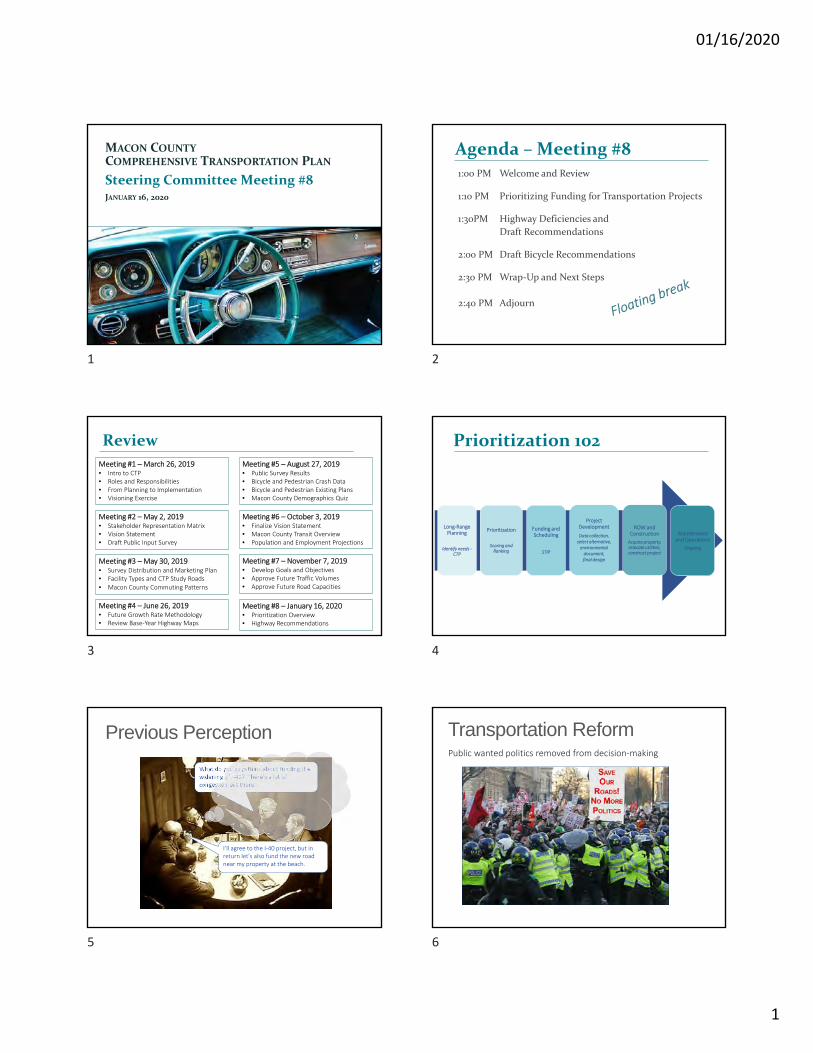
Agenda 1:00 PM Welcome and Review 1:10 PM Prioritizing Funding for Transportation Projects 1:40 PM Highway Deficiencies and Draft Recommendations
2:20 PM Draft Bicycle Recommendations 2:40 PM Wrap-Up and Next Steps 2:50 PM Adjourn
MACON COUNTY COMPREHENSIVE TRANSPORTATION PLAN
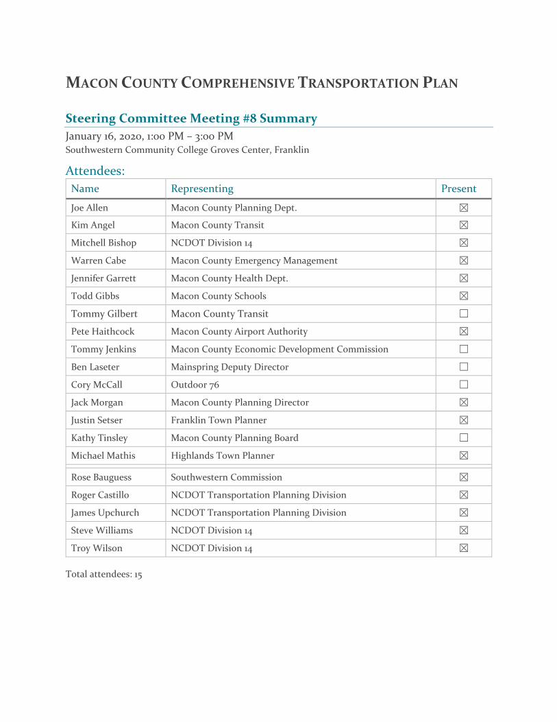
Steering Committee Meeting #8 Summary January 16, 2020, 1:00 PM – 3:00 PM Southwestern Community College Groves Center, Franklin
Attendees: Name Representing Present
Joe Allen Macon County Planning Dept. ☒ Kim Angel Macon County Transit ☒ Mitchell Bishop NCDOT Division 14 ☒ Warren Cabe Macon County Emergency Management ☒ Jennifer Garrett Macon County Health Dept. ☒ Todd Gibbs Macon County Schools ☒ Tommy Gilbert Macon County Transit ☐ Pete Haithcock Macon County Airport Authority ☒ Tommy Jenkins Macon County Economic Development Commission ☐ Ben Laseter Mainspring Deputy Director ☐ Cory McCall Outdoor 76 ☐ Jack Morgan Macon County Planning Director ☒ Justin Setser Franklin Town Planner ☒ Kathy Tinsley Macon County Planning Board ☐ Michael Mathis Highlands Town Planner ☒ Rose Bauguess Southwestern Commission ☒ Roger Castillo NCDOT Transportation Planning Division ☒ James Upchurch NCDOT Transportation Planning Division ☒ Steve Williams NCDOT Division 14 ☒ Troy Wilson NCDOT Division 14 ☒
Total attendees: 15
PAGE | 2
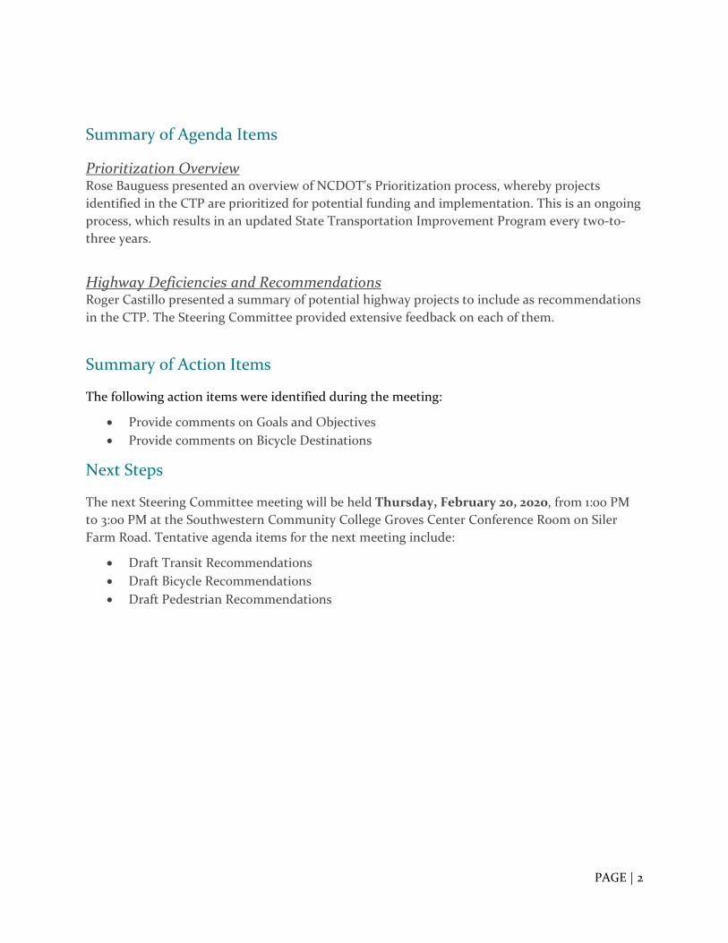
Summary of Agenda Items
Prioritization Overview Rose Bauguess presented an overview of NCDOT’s Prioritization process, whereby projects identified in the CTP are prioritized for potential funding and implementation. This is an ongoing process, which results in an updated State Transportation Improvement Program every two-to-three years.
Highway Deficiencies and Recommendations Roger Castillo presented a summary of potential highway projects to include as recommendations in the CTP. The Steering Committee provided extensive feedback on each of them.
Summary of Action Items
The following action items were identified during the meeting:
• Provide comments on Goals and Objectives • Provide comments on Bicycle Destinations
Next Steps
The next Steering Committee meeting will be held Thursday, February 20, 2020, from 1:00 PM to 3:00 PM at the Southwestern Community College Groves Center Conference Room on Siler Farm Road. Tentative agenda items for the next meeting include:
• Draft Transit Recommendations • Draft Bicycle Recommendations • Draft Pedestrian Recommendations
01/16/2020
1
MACON COUNTY
COMPREHENSIVE TRANSPORTATION PLAN
Steering Committee Meeting #8JANUARY 16, 2020
1:00 PM Welcome and Review
1:10 PM Prioritizing Funding for Transportation Projects
1:30PM Highway Deficiencies and
Draft Recommendations
2:00 PM Draft Bicycle Recommendations
2:30 PM Wrap‐Up and Next Steps
2:40 PM Adjourn
Agenda – Meeting #8
Review
Meeting #2 – May 2, 2019• Stakeholder Representation Matrix• Vision Statement• Draft Public Input Survey
Meeting #3 – May 30, 2019• Survey Distribution and Marketing Plan• Facility Types and CTP Study Roads
• Macon County Commuting Patterns
Meeting #4 – June 26, 2019• Future Growth Rate Methodology• Review Base‐Year Highway Maps
Meeting #1 – March 26, 2019• Intro to CTP• Roles and Responsibilities• From Planning to Implementation• Visioning Exercise
Meeting #5 – August 27, 2019• Public Survey Results• Bicycle and Pedestrian Crash Data• Bicycle and Pedestrian Existing Plans• Macon County Demographics Quiz
Meeting #6 – October 3, 2019• Finalize Vision Statement• Macon County Transit Overview• Population and Employment Projections
Meeting #7 – November 7, 2019• Develop Goals and Objectives• Approve Future Traffic Volumes• Approve Future Road Capacities
Meeting #8 – January 16, 2020• Prioritization Overview• Highway Recommendations
Prioritization 102
Long‐Range Planning
Identify needs ‐CTP
Prioritization
Scoring and Ranking
Funding and Scheduling
STIP
Project Development
Data collection, select alternative,environmental document, final design
ROW and Construction
Acquire property, relocate utilities, construct project
Maintenance and Operations
Ongoing
Previous PerceptionWhat do you guys think about funding the widening of I‐40? There’s a lot of congestion out there.
I’ll agree to the I‐40 project, but in return let’s also fund the new road near my property at the beach.
Session 2: So you’ve heard about prioritization
Transportation ReformPublic wanted politics removed from decision‐making
Session 2: So you’ve heard about prioritization
1 2
3 4
5 6

01/16/2020
2
2013 Strategic Transportation Investments Law
“The Department shall develop and utilize a process for selection of transportation projects that is based on professional standards in order to most efficiently use limited resources to benefit all citizens of the State.
The strategic prioritization process should be a systematic, data‐
driven process that includes a combination of quantitative data,
qualitative input, and multimodal characteristics, and should
include local input.
The Department shall develop a process for standardizing or
approving local methodology used in Metropolitan Planning
Organization and Rural Transportation Planning Organization
prioritization.“ ‐ S.L. 2012‐84
Prioritization Process is now in Law
Session 2: So you’ve heard about prioritization
Strategic Transportation Investments (STI) Law –The Why
Growing state
Modernize funding formula and remove politics
Better connect people, products, and places
0 2 4 6 8 10 12 14
2000
2035
Population in Millions
Session 2: So you’ve heard about prioritization
How Prioritization and STIP Correlate
P4.0 Process
10 Year STIP resulting from
P3.0
P5.0 Process
10 Year STIP resulting from
P4.0
10 Year STIP resulting from P5.0
Prioritization Funding Categories
$
Statewide Mobility
$
Division Needs
A
1 2 3 4 5
6 7 8 9 10
11 12 13 14
B C
E F G
D
Divided based on % of State Population
$
RegionalImpact
Divided based onEqual Share
Statewide Mobility
Draft 2020‐2029 STIP
regions &divisions
Session 2: So you’ve heard about prioritization
40% of Funds 30% of Funds 30% of Funds
Statewide Mobility
Regional Impact
Division Needs
Focus Address Local Needs• Selection based on 50% Data & 50% Local Input
• Funding based on equal share for each Division (14)
Focus Address Significant Congestion and Bottlenecks
• Selection based on 100% Data
• Projects Programmed prior to Local Input Ranking
Focus Improve Connectivity within Regions
• Selection based on 70% Data & 30% Local Input
• Funding based on population within Region (7)
Strategic Transportation Investments
7 8
9 10
11 12

01/16/2020
3
Funding Categories – Southwestern RPO
Statewide Mobility• Interstates and major US
routes across the state
• SWRPO competes with all of North Carolina’s 100 counties for Statewide funds.
• 100% quantitative data, with no local input points.
Regional Impact • Regional connectivity on smaller US
Highways and NC routes.
• US 23, US 441, US 64, NC 106
• Seven funding regions in the state; SWRPO is part of Region G, which includes the 17 western counties in NCDOT Divisions 13 and 14.
• 70% quantitative score and 30% local input.
• The 30% local input is divided equally between the SWRPO (15%) and NCDOT Division 14 (15%).
Division Needs • Secondary roads and non-
highway modes (aviation, bicycle/pedestrian, public transit, and rail)
• The SWRPO’s six counties compete with the 10 western counties within NCDOT Division 14 for these funds.
• 50% quantitative data and 50% local input.
• The 50% local input is divided equally between the SWRPO (25%) and NCDOT Division 14 (25%).
STI Law Highway Scoring OverviewMode Statewide Mobility
OverallWeights
100% Quantitative Data
QuantitativeCriteria
• Benefit‐Cost• Congestion• Economic Comp.• Safety• Freight• Multimodal• Pavement Condition• Lane Width• Shoulder Width
Regional Impact
70% Quantitative Data /30% Local Input
• Benefit‐cost• Congestion• Safety• Freight• Multimodal• Pavement Condition• Lane Width• Shoulder Width• Accessibility and connectivity to employment centers, tourist destinations, or military installations
Division Needs
50% Quantitative Data /50% Local Input
• Benefit‐cost• Congestion.• Safety• Freight• Multimodal• Pavement Condition• Lane Width• Shoulder Width• Accessibility and connectivity to employment centers, tourist destinations, or military installations
Session 2: So you’ve heard about prioritization
NCDOT Quantitative
Score
Local NCDOT Division
Points
LOCAL PLANNINGORGANIZATION POINTS
Total Project $core
Published Methodology for applying Local Input Points
Scoring Process
Statewide Mobility
Regional Impact
Division Needs
• Local input points assigned
• Total scores calculated• Projects programmed
• Projects programmed based on quant. score
• Local input points assigned
• Total scores calculated• Projects programmed
Projects Submitted• Data reviewed• Quantitative scores calculated
Scoring Process
Prioritization Workgroup
§ 136-189.11. Transportation Investment Strategy Formula.
(h) Improvement of Prioritization Process. – The Department shall
endeavor to continually improve the methodology and criteria used to
score highway and non-highway projects pursuant to this Article,
including the use of normalization techniques, and methods to
strengthen the data collection process. The Department is directed to
continue the use of a workgroup process to develop improvements to
the prioritization process.
P6.0 Highway Scoring Changes
Congestion = 20%
Benefit‐Cost = 20%
Safety = 10%
Freight = 10%
Accessibility/Connectivity = 10%
Congestion = 15%
Benefit‐Cost = 15%
Safety = 10%
Freight = 5%
Accessibility/Connectivity = 5%
Regional Impact Division Needs
MOBILITY SCORING
Congestion = 5%
Safety = 25%
Freight = 10%
Lane Width = 10%
Shoulder Width = 10%
Pavement Condition = 10%
Safety = 20%
Freight = 5%
Lane Width = 5%
Shoulder Width = 10%
Pavement Condition = 10%
Regional Impact Division Needs
MODERNIZATION SCORING
13 14
15 16
17 18

01/16/2020
4
Region and Division Competition
Route / Facility NameFrom / Cross
StreetCost to NCDOT
MPO(s) / RPO(s)
County(s)
DIVISION NEEDS
Quantitative Score
(Out of 50)
Division 14 Points
(25%)
SWRPO Draft
Points
LOSRPO Draft
Points
FBRMPO Draft
Points
ISRPO Draft
Points
TOTAL SCORE
(87.5 max)Cumulative Money
Grove Street Sidewalks
Barnwell Street $ 723,040 French Broad River MPO Henderson 38.62 50 100 76.12 723,040$
US 74 (Great Smokey Mountains Expressway)
US 441 Gateway Interchange $ 21,000,000 Southwestern
RPO Jackson 32.08 50 100 69.58 21,000,000$
US 276SR 1134 (Crymes Cove Rd), Raccoon Rd
$ 2,700,000 French Broad River MPO Haywood 31.30 50 100 68.80 23,700,000$
US 276 (Russ Avenue)
US 23-74 (Great Smoky Mountain Expressway)
$ 13,600,000 French Broad River MPO Haywood 30.94 50 100 68.44 37,300,000$
E. Main St/US 441 Bus, SR 1510 (Old Cat Creek Rd), 1st St.
NC 28 (Highlands Rd) $ 176,000 Southwestern
RPO Macon 28.89 50 100 66.39 37,476,000$
US 19, US 74, US 129 US 64 $ 15,300,000 Southwestern RPO Cherokee 28.74 50 100 66.24 52,776,000$
US 23, US 441SR 1649 (Prentiss Bridge Road) $ 59,200,000 Southwestern
RPO Macon 28.38 50 100 65.88 111,976,000$
US 276 (Jonathan Creek)
US 19 $ 20,700,000 Land-of-Sky RPO, French Broad River MPO
Haywood 27.69 50 78 23 65.44 132,676,000$
US 178SR 1156 (Main Street) in Rosman $ 14,083,000 Land-of-Sky RPO Transylvania 27.92 50 100 65.42 146,759,000$
US 74SR 1393 (Wakefield Rd) $ 93,000,000 Southwestern
RPOCherokee,
Macon 27.85 50 100 65.35 239,759,000$
Potentially 9 projects funded in Division 14, 4 within SWRPO
P5.0 EXAMPLE OF DIVISION NEEDS FUNDING – DIVISION 14 Prioritization 6.0 Schedule
Here’s Roger!
Highway Deficiencies and Recommendations
Bicycle Recommendations
Next Steps
Meeting #9: Thursday, February 20?
19 20
21 22
23 24

01/16/2020
1
Meeting #8
Roger CastilloJanuary 16, 2020
Key things to consider for highway recommendation
Macon County CTP
2
• Meeting the community’s vision• Addressing the transportation
deficiency• Minimizing impacts to the natural and
human environment
Examples of Key Identified Needs
Macon County CTP
3
• Legislative Intent;• Congestion;• Safety;• Facility Deficiencies;• Access;• System Linkage;• Mobility;• Emergency Evacuation.• Environmental Protection;• Growth/Economic Development; and• National Defense/Security.
Typical SectionsMacon County CTP
Macon County CTP
5
Contacts• NCDOT Transportation Planning Division (TPD)
– Roger Castillo, [email protected], (919) 707-0942 (Project Engineer)
• Southwestern Rural Planning Organization (RPO)– Rose Bauguess, [email protected], (828) 586-1962 x
213• NCDOT Division 14 Planning Engineer
– Steve Williams, [email protected], (828) 631-1170
6
1 2
3 4
5 6
# Segment From To Category # of Markers Summary of Comments Previous CTP Purpose/Need Recommendation
1 US 64 Clay County West old Murphy Road Modernization 11
‐8 of the comments indicated the need of a climbing lane due to trucks and slower traffic‐1 stated a 4 lane to continue‐1 discussed maintanance
YesRegional mobility and travel time reliability. Freight movement.
Would not be waranted a 4 lane. Modernization with climbing lanes. Warrant a 4 ft paved shoulder
2 US 64 Highlands City Limits Jackson Modernization 2 ‐2 comments: Road needs upgrade Yes Connector to Cashiers. Safety
Bringing road up to standards. Need shoulders. Lane width. Possible need for climbing lane (may not be feasible).
3 US 23 Sanderstown Road Jackson Modernization 8 ‐8 comments: Dangerous road especially around Gold City Lane Yes Mobility from Asheville to AtlantaDivided 4 lane limited left turn movement.
4 US 441 (Georgia Road) Georgia Hickory Knoll Road Modernization 15
‐5 comments stated water runoff problems on this road and hydroplaning‐3 comments stated intersection issues‐7 empty markers
Yes
Numerous driveway cuts, unsignalized left turns, and density of traffic signals. Crashes along this road. Mobility from Asheville to Atlanta.
continute from current projects. Getting ahead of development
5 NC 106 Georgia US 64 Modernization 6 ‐6 comments stated to upgrade or modernize the road YesTruck Traffic and connectivity. One of the few ways to access highlands. System Linkage
Widen Lane and shoulder to standards. Climbing Lanes
6 NC 28 US 441 BUS (Main Street) Sugarfork Road Congestion 17
‐5 comments: Signal Timing/Confusing signs/layout‐4 comments: Truck Traffic/better signals for truck turnaround‐2 comments: Sight obstruction‐3 comments: Widen‐4 comments: other
Yes Congestion; over capacity.
Previous CTP had a boulevard between Main St and US 23. For the part between US 23 and Sugarfor: 12ft lanes and paved shoulders
7 Clarks Chapel Road Clarks Chapel Road Wells Grove Road Intersection 8
‐3 comments: Traffic Congestion During School Times/requires 2 deputies‐2 comments: Hard to see incoming traffic‐3 comments: Other
No
8 Main Street Main Street US 23/441 Intersection 13
‐4 comments: This intersection is poorly designed‐5comments: Dangerous merge area/access‐2 comments: Crash‐1 comment: Congestion‐1 comment: Sight Distance
No
Safety. Regional Mobility. Signal issues. Travel time reliability. No Pedestrian Access. Poor Sight Distance. Crashes
9 Prentiss Bridge Road US 441 (Georgia Road) Clarks Chapel Road Modernization 3‐2 comments: Need to be widened‐1 comment: River Pollution
No 8 ft lanes. Links to schoolsWiden Lane and shoulder to standards
10RiversideHickory KnollClarks Chapel
US 441 (Georgia Road) Prentiss Bridge Road Modernization 6
‐1 comment: Intersection problem at Prentiss‐1 comment: Narrow Lanes‐1 comment: Crash problem‐3 empty markers
No 8ft lanes. Links to schoolsWiden Lane and shoulder to standards
11 Roller Mill Road US 64 US 441 (Georgia Road) Modernization 4‐3 comments: Limited Sight Distance/Dangerous Cruves‐1 comment: widen with bike/ped imporvements
NoSight distance issues. Narrow Lanes. Often used as a shortcut.
Widen Lane and shoulder to standards
12Old Murphy Road/Palmer
Wayah Road W Main Street Modernization 3‐2 comments: Traffic too fast‐1 comment: Narrow between Wilkie St and Main St
PartialParallel to US 64. Near Capacity. Narrow Lanes
intersection improvements. Lane Width, paved shoulders, turn lanes where warranted.
13 Iotla Church Road NC 28 Burningtown Road Modernization 1 ‐1 comment: Traffic with elementary school YesAccess to airport and schools. Mobility and reliability
Widen Lane and shoulder to standards
14 Buck Creek Road US 64 US 64 Modernization 0 ‐ YesTravel time reliability and mobility. Alternate route from the gorge.
Widen Lane and shoulder to standards
DRAFT Roadway Recommendations

Ú
o
Ú
o
Ú
o
å
å
å
å
å
å
å
å
å
å
å
å
å
n
n
n
ÚH
ÚHCashiers Rd
(US-64)
Murphy Rd
(US-64)
Georgia R
d
Cat
Creek Rd
(SR-1513)
Sanderstown Rd(SR-1335)
Lower
Burningtown R
d
(SR-1372)
Old Murphy Rd(SR-1442)
Cla
rks
Cha
pel R
d(S
R-1
653)
Burningtown Rd(SR-1372)Rabbit
Creek Rd(SR-1513)
SouthSkeenah Rd
(SR-1128)
Ned H
ill Rd
(SR-1345)
Dillard Rd
BuckC
reek Rd
(SR-1538)
Walh
alla
Rd(N
C-28
)
Wayah Rd
(SR-1310)
Junaluska Rd
(SR-1401)
Walnut
Creek Rd
(SR-1533)
Highlands Rd
West Old
Murphy Rd
(SR-1448)
Hickory
K noll Rd
( SR-1653)
Ellijay R
d
(SR-1001)
Hicks R
d
(SR-1545)
Leatherman
Gap Rd
(SR-1341)
"$28
"$28
Wayah Rd
(SR-1310)
C L A YC L A YC O U N T YC O U N T Y
G R A H A MG R A H A MC O U N T YC O U N T Y
J A C K S O NJ A C K S O NC O U N T YC O U N T Y
S W A I NS W A I NC O U N T YC O U N T Y
NantahalaLake
Cu
llasa ja River
Little Tennes see RiverNanta
hala
Byway
( Sce
nic)
Waterfall Byway (Scenic)
"$28
"$28"$116
"$107
"$107
"$106
"$28
"$143
"$107
£¤441
£¤441
£¤74
£¤19
£¤129
£¤64
£¤19
£¤64
£¤19
£¤64
£¤64
£¤64FranklinFranklin
SylvaSylva
WebsterWebster
ForestForestHillsHills
DillsboroDillsboro
HighlandsHighlands
MACON COUNTY
Plan Date: January 15, 2020WORKING COPY
Base map date: March 18, 2019
0 2 4 6 81Miles
Sheet 1 of 1
´Full report at:https://tinyurl.com/MaconCTP
DRAFTRECOMMENDATIONS
Comprehensive Transportation Plan
This product contains mapping data for informational and planning purposes only, and is subject to change. Users shouldreview or consult the primary data sources to ascertain the usability of the information.
Legal Disclaimer
Not Feasible
Recommendation
19
54
3
2
14
13
12
11
10
7
8
6
Intersections!(

FranklinFranklin
£¤441
£¤441
£¤441
£¤64
£¤441_̀B U S
441
_̀B U S
441
_̀B U S
441
_̀B U S
441
£¤23
£¤64
£¤23
_̀B U S
23
£¤64
£¤64_²64
£¤23
£¤23
£¤64
£¤23
"$28
"$28
"$28
"$28
"$28
"$28
Depo
t St
(SR
1729
)
North B
laine
Bran
ch R
d
(SR 11
43)
Belle
view
Rd(S
R 16
53)
Roller Mill Rd
(SR 1154)
Lake Emory R
d
(SR 1325)
Mas
hbur
n Br
anch
Rd
(SR
167
0)
nette
Rd
(SR 14
40)
Louisa Chapel Rd
(SR 1148)
Angel Cove Rd
(SR 1666)
Depot St
(SR 1323)
Siler Rd(SR 1660)
Riv
ervi
ew S
t(S
R 1
462)
Rd
(SR
116
8)
Palm
er R
d(S
R 1669
)
Palmer Dr
(SR 1417)
Womack St(SR 1158)
Jones Ridge Rd
(SR 1150)
Mas
hbur
n W
hite
Rd
(SR
1153
)
Wells Grove Rd(SR 1667)
Wile
y Br
own
Rd
(SR
166
2)
Iotla S t(SR
1489)
Old Murphy Rd
(SR 1442)
New Hope Rd
(SR 1318)
Riverview St
(SR 1323)
Te(S
Pressley Rd(SR 1471)
W Palmer St
(SR 1442)
Dowdle Mountain Rd
(SR 1659)
La (S
Jim M
ann R
d
(SR 11
51)
Wayah St(SR 1667)
Rog
ers
Rd(S
R 15
60)
Windy Gap Rd
(SR 1321)
Baird Cove R
d
(SR 1319)
John
Just
ice R
d(S
R 15
09)
Ray Cove Rd
(SR 1315)
Lakeside Dr
(SR 1324)
Golf View Dr(SR 1157)
Laurel L
(SR
Valle
y Vi
ew R
d(S
R 1
169)
Sloan St
(SR 1512)
Jaco
bs B
ranc
h Rd
(SR
1382
)
Dry
man
Rd
(SR
115
6)
Long Rd(SR 1663)
No
Trimont Lake Rd
(SR 1384)
Thom
as R
d
(SR 15
14)
Fulton Rd(SR 1668)
Holly H(SR 157
Trim
ont B
ranc
h Rd
(SR
1316
)
Allman D
r(SR
1687)
Ferguson Rd
(SR 1507)
Dobson Rd
(SR 1149)
Hunnicutt Rd
(SR 1664)
Pressley Circle Rd
(SR 1425)
Patton Rd
(SR 1148)
Gibson Cove Rd(SR 1313)
Medlin Rd(SR 1658)
Wallace Branch R
d
(SR 1314)
Saun
ders
Rd
(SR
1516
)
C R
Cab
e R
d(S
R 1
661)
Wide
Hor
izon
Dr
(SR
1652
)
Brys
on C
ity R
d
Harrison Ave
Cartoogechaye
Cr ee k
Cullasaja River
MACON COUNTY
Plan Date: January 15, 2020WORKING COPY
Base map date: March 18, 2019
0 10.5Miles
Sheet 4 of 4
´Full report at:https://tinyurl.com/MaconCTP
These concepts will need additional analysis to meet state and federalenvironmental regulations, to determine final locations anddesigns, and to be funded for implementation. Local zoningor subdivision ordinances may require the dedication ofright of way based on the concepts shown on the ComprehensiveTransportation Plan and local collector street plans, based on N.C.G.S. § 136-66.2 and § 136-66.10.
Legal Disclaimer
Proposals that address identified needs through 2045
DRAFTRECOMMENDATIONS
Not Feasible
Recommendation
Comprehensive Transportation Plan
12
11
7
8
10
6
Intersections!(