madaket culverts evaluation - march 2019 presentation
TRANSCRIPT

Public Meeting
Town of NantucketMarch 14, 2019
Madaket Culverts Evaluation

Presentation Outline
• Introductions – Project Team
• Project Background and Objectives
• Structural Condition Assessment
• Hydrologic and Hydraulic Assessment
• Alternatives Evaluation
• Recommendations
• Questions and Discussion

Project Team
• Nantucket Department of Public Works – Rob McNeil
– Project lead
– Structural condition assessment
– Childs Engineering – structural dive team
– Hydrologic and hydraulic modeling

Madaket Harbor/Long Pond Estuary
MadaketHarbor Long Pond
NantucketSound
Atlantic Ocean
Nantucket Harbor

Madaket Harbor/Long Pond Estuary
Atlantic Ocean
Madaket Harbor
Long Pond
North HeadLong Pond
EelPoint
Landfill

• Water Quality Issues– Excess nitrogen
– Periodic extreme decreases in DO
– Periodic algae blooms
– Elevated bacteria/pathogens
– Altered benthic community structure
• High nutrient loads– Septic systems
– Runoff from impervious surfaces
– Landfill
– Fertilizers
– Nutrient rich bottom sediments
Water Quality – Hither Creek & Long Pond
Sour
ce: M
adak
etCo
nser
vatio
n As
soci
atio
n

• MA Estuaries ProjectWatershed Embayment Model(2010)
• Madaket Harbor/Long PondEstuary - Nitrogen TMDL (2015)
• Ongoing Water QualityMonitoring
• Management Activities withinMadaket Harbor Watershed– Landfill improvements
– Fertilizer management
– Septic system management
Water Quality Monitoring and Restoration

Coastal Flooding – Storm Surge

Sea Level Rise

• Brackish 70-acre pond
• 6 feet deep
• Tidally restricted
• Long Pond water qualityimproving but still “impaired”
Long Pond

• Artificial connection between Madaket Harbor and LongPond (approx. 3,500 feet long)
• Originally dug in 1665 by island’s early European settlers andWampanoag Indians
• Tidal restriction
• Culverts at both ends
Madaket Ditch
Madaket Road North Cambridge Street

Study Culverts
HitherCreek
Long Pond
North HeadLong Pond
Landfill
Culvert 3
Culvert 2
Culvert 1

Study Objectives and Scope
• Evaluate the need to replace the study culverts:– Structural condition
– Potential water quality improvements
– Flood resilience
• Scope of Work 1. Structural ConditionAssessment
2. Hydrologic & HydraulicModeling
3. Alternatives Evaluation
Structural Condition Assessment
• Structural condition inspections – September 17, 2018– Study culverts and Massasoit Bridge
• MassDOT and FHWA National Bridge InspectionStandards
• Underwater inspections by dive team
• Dates of last culvert replacements uncertain– Reconstructed in 1900 according to MassDOT records
– Local accounts indicate Madaket Road culverts were installedas a temporary measure decades ago to allow for bridgerepairs, but the bridges were never rebuilt

Culvert 1 – Madaket Road
• Corrugated aluminum box culvert
• 50 inches high, 9 feet wide, 50 feet long
• Connects North Head Long Pond to Long Pond
• Good condition, some buildup of sand and marinegrowth (2 to 5 inches), minor sinkhole
Culvert 1

Culvert 2 – Madaket Road
• Corrugated aluminum culvert
• 60 inches high, 16 ft wide, 60 ft long
• Connects upstream end of Madaket Ditch to Long Pond
• Satisfactory condition, minor deformation of easternheadwall, some buildup of sand and marine growth (2inches or less)
Culvert 2

Culvert 3 – North Cambridge St.
• Multi-plate steel corrugated culvert
• 7 feet tall, 50 feet long, tapered ends
• Connects downstream end of Madaket Ditch to Hither Creek
• Satisfactory condition, minor corrosion of plate walls andconnections, original protective coating in poor condition
Culvert 3

Hydrologic & Hydraulic Assessment
• Evaluate existing tidal exchange
• Determine optimal culvert sizing and elevations– Allow for increased tidal flushing
– Limit adverse flooding impacts
Field DataCollection
ModelDevelopment
AlternativesEvaluation

Field Data Collection
• Continuous measurement of water level, temperature, andsalinity at 5 locations (October 24 – November 28, 2018)

Elevation Survey
• Bathymetry survey (RTK GPS) combined with LiDAR
• Survey of culvert elevations

Water Level Data
• Culvert at N. Cambridge Street not restricting tidal flow
• Madaket Ditch channel is the primary tidal restriction

Estuarine Culvert Model
• Topography and bathymetry of basins
• Culvert geometry
• Tidal boundary conditions at Madaket Harbor
Model Simulations
Typical TidesTypical Tides w/SLR100-yr Storm Surge100-yr Rainfall

Model Results – Existing Conditions

Model Results – Existing Conditions
• Madaket Ditch channel is the primary tidal restriction– Natural sinuosity of channel and shoaling at channel bends
• All three study culverts are not restrictive and aresufficiently sized, with the existing channel and current-daytides
• In 100-year storm, Madaket Ditch channel attenuatessurge peak from 7.4 feet in harbor to 4.7 feet in Long Pond
• 4-day drainage period following the storm

Model Results – 2070 Sea Level Rise (4.3 feet)

Model Results – 2070 Sea Level Rise (4.3 feet)
• Culvert at N. Cambridge Street starts to restrict tidal flowto Madaket Ditch
• Culvert under Madaket Road connecting Madaket Ditchto Long Pond slightly restricts tides in Long Pond
• N. Cambridge Street and Madaket Road crossings (orroadway approaches) predicted to be inundated in a100-year coastal storm event and in typical tides

Alternatives Evaluation – Channel Dredging
• Dredging of Madaket Ditch channel– 465 foot channel reach between upper and lower portions of
Madaket Ditch
– Increase cross-sectional flow area
– Reduced channel friction
• Model simulations for typical tides, with and withoutextreme storm events and sea level rise

Channel Dredging – Model Results

Channel Dredging – Model Results
• Typical Tides– Enhanced tidal exchange
– Increased tidal range in Long Pond
– Would not completely alleviate the restriction to tidal exchange
– Culvert to North Head Long Pond would become slightly restrictive(15-foot wide by 5-foot high box culvert required)
– Reduced time required for upper reaches of system to drainfollowing storms
– Reduced local residence time (30-40% reduction) in Long Pond(water quality benefits)

Channel Dredging – Model Results
• 100-year Coastal Storm– Surge elevations in upper reach of Madaket Ditch predicted to
be higher, overtopping Madaket Road
– Reduced drainage period of upstream Long Pond basins from 4days to 2 days
• Sea Level Rise (4.3 feet by 2070)– Both Madaket Road culverts shown to restrict tidal exchange
with an improved Madaket Ditch channel
– To not restrict typical tides in 2070, larger culvert openings arerequired:
Recommendations
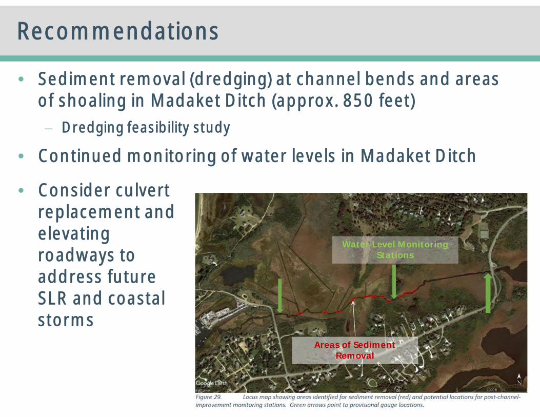
• Sediment removal (dredging) at channel bends and areasof shoaling in Madaket Ditch (approx. 850 feet)– Dredging feasibility study
• Continued monitoring of water levels in Madaket Ditch
• Consider culvertreplacement andelevatingroadways toaddress futureSLR and coastalstorms
Areas of SedimentRemoval
Water Level MonitoringStations

Questions & DiscussionRobert D. McNeil III, P.E., MPA
Public Works Director188 Madaket Road
Nantucket, MA 02554(508) 228-7244