mag chapter 12
TRANSCRIPT

1
Magnetic SurveyingMagnetic Surveying

MAGNETICS
Introduction Geo & Paleo
Magnetism

Role of Geo & Paleo inGeophysics & Geology
Like other geophysical methods, magnetism is also divided into Applied & Paleo areas. • Geomagnetism deals with the exploration of minerals, basement under sedimentary column (oil industry), salt domes, igneous bodies in the subsurface, groundwater in igneous terrain.• Paleomagnetism deals with the history of magnetic poles/polarity, history of rocks, and plate tectonics.

Units Associated with Magnetic Poles
• N / (Amp - m). A N / (Amp - m) is referred to as a tesla (T)
F= G m1 m2 r2

Features of a magnetic Bar
• Magnetic bar has two magnetic poles: S N North pole or +ve pole, and South pole or –ve pole.• The poles are located 1/12 of bar length inside from the end. • Magnetic bar is surrounded by a magnetic field produced by magnetic lines of force which flow from north to south pole.• If an iron needle goes in the magnetic field or touches the pole, the needle is magnetized and starts behaving as a tiny magnet.• Bar magnet behaves as a Line magnet.

Magnetic Parameters• Magnetic moment(M)=2L*m, where ‘L’ is half the distance between two poles, ‘m’ is the magnetic poles.• If ‘L’ is reduced to infinitesimal ds, then bar is converted into Magnetic Particle, its magnetic moment is M= m*ds,• If magnetic bars are placed end-on or side by side, then M=n*m*2L• Unit magnetic pole when is placed 1 cm away from similar pole, is acted upon by a force of 1 dyne.• Unit pole is also equivalent to 4π (12.5667) lines of force.• A magnetic pole of strength ‘m’ will generate 4π*m lines of force.
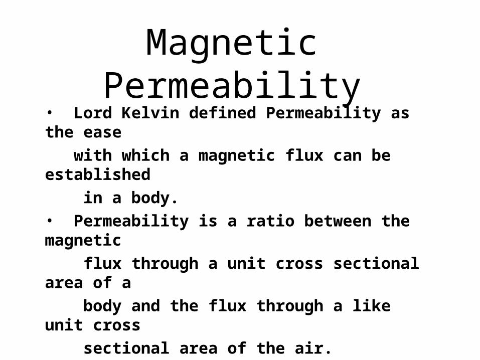
Magnetic Permeability• Lord Kelvin defined Permeability as the ease with which a magnetic flux can be established in a body.• Permeability is a ratio between the magnetic flux through a unit cross sectional area of a body and the flux through a like unit cross sectional area of the air. µ=(φ/A)/H= B/H --------- µ for space (air) is 4π*10‾7 and is indexed as 1.
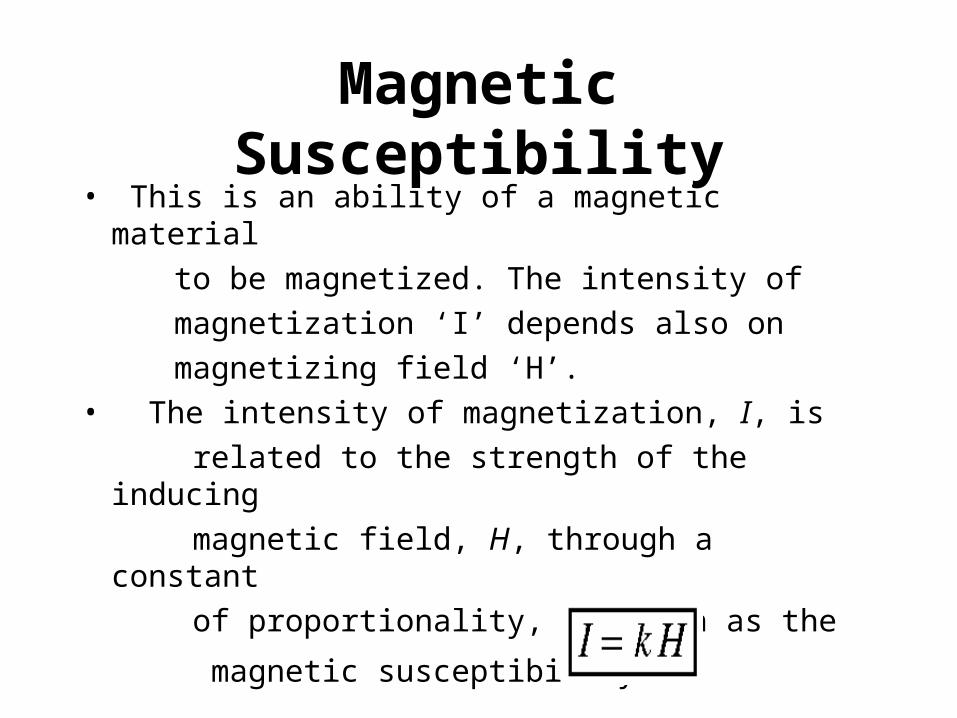
Magnetic Susceptibility• This is an ability of a magnetic material to be magnetized. The intensity of magnetization ‘I’ depends also on magnetizing field ‘H’.• The intensity of magnetization, I, is related to the strength of the inducing magnetic field, H, through a constant of proportionality, k, known as the
magnetic susceptibility.
Magnetic Lines of Force Associated with Magnetic Dipoles
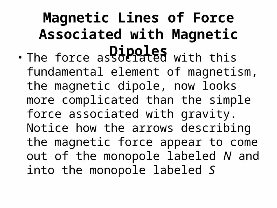
• The force associated with this fundamental element of magnetism, the magnetic dipole, now looks more complicated than the simple force associated with gravity. Notice how the arrows describing the magnetic force appear to come out of the monopole labeled N and into the monopole labeled S

Magnetic Lines of Force Associated with Magnetic Dipoles
• Mag Bar

11
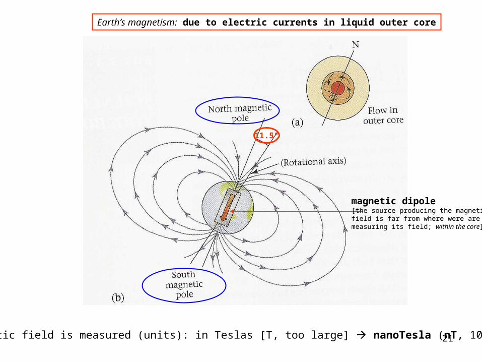
Earth’s magnetism: due to electric currents in liquid outer core
Magnetic field is measured (units): in Teslas [T, too large] nanoTesla (nT, 10-9 T)
11.5º
magnetic dipole[the source producing the magneticfield is far from where were aremeasuring its field; within the core]
12
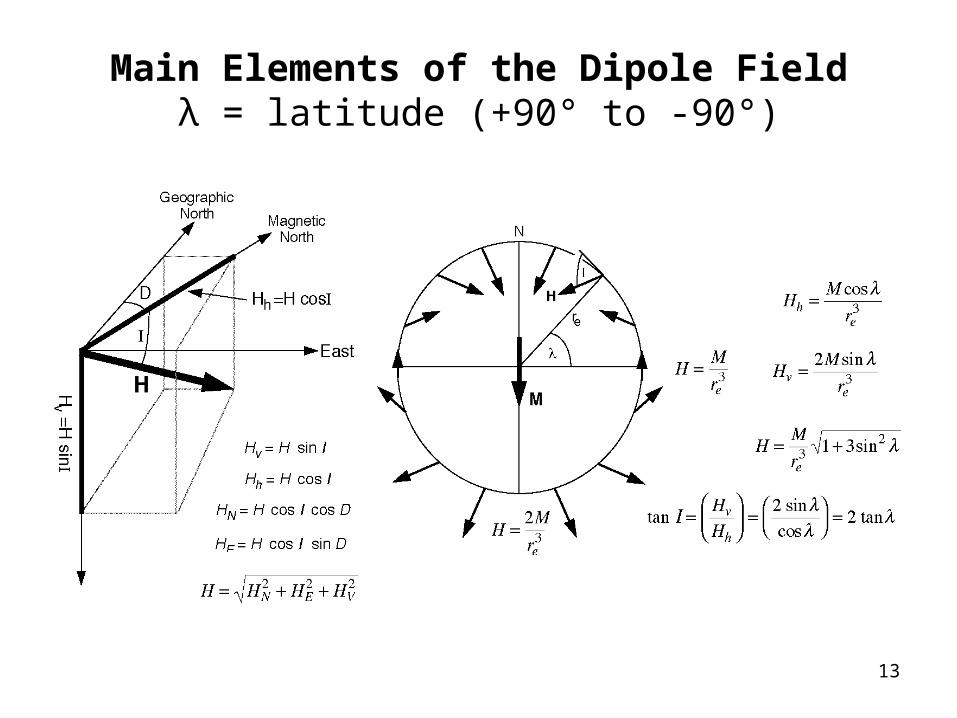
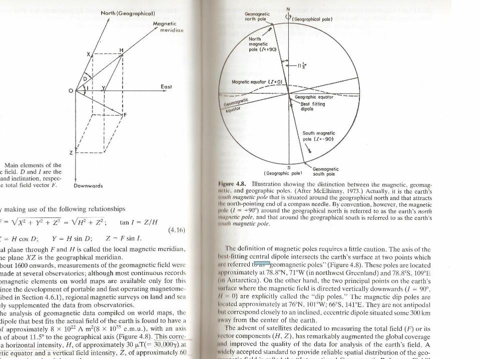
Main Elements of the Dipole Fieldλ = latitude (+90° to -90°)
13
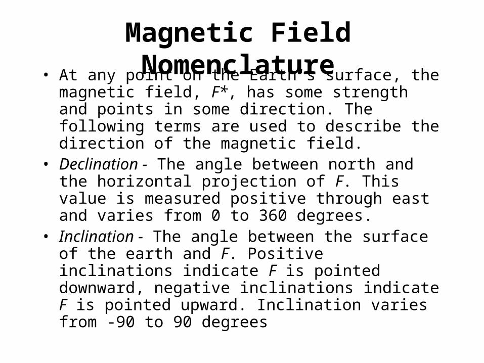
Magnetic Field Nomenclature• At any point on the Earth's surface, the magnetic
field, F*, has some strength and points in some direction. The following terms are used to describe the direction of the magnetic field.
• Declination - The angle between north and the horizontal projection of F. This value is measured positive through east and varies from 0 to 360 degrees.
• Inclination - The angle between the surface of the earth and F. Positive inclinations indicate F is pointed downward, negative inclinations indicate F is pointed upward. Inclination varies from -90 to 90 degrees

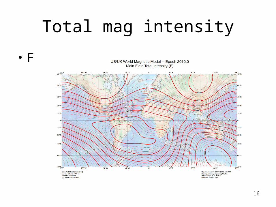
Total mag intensity
• F
16
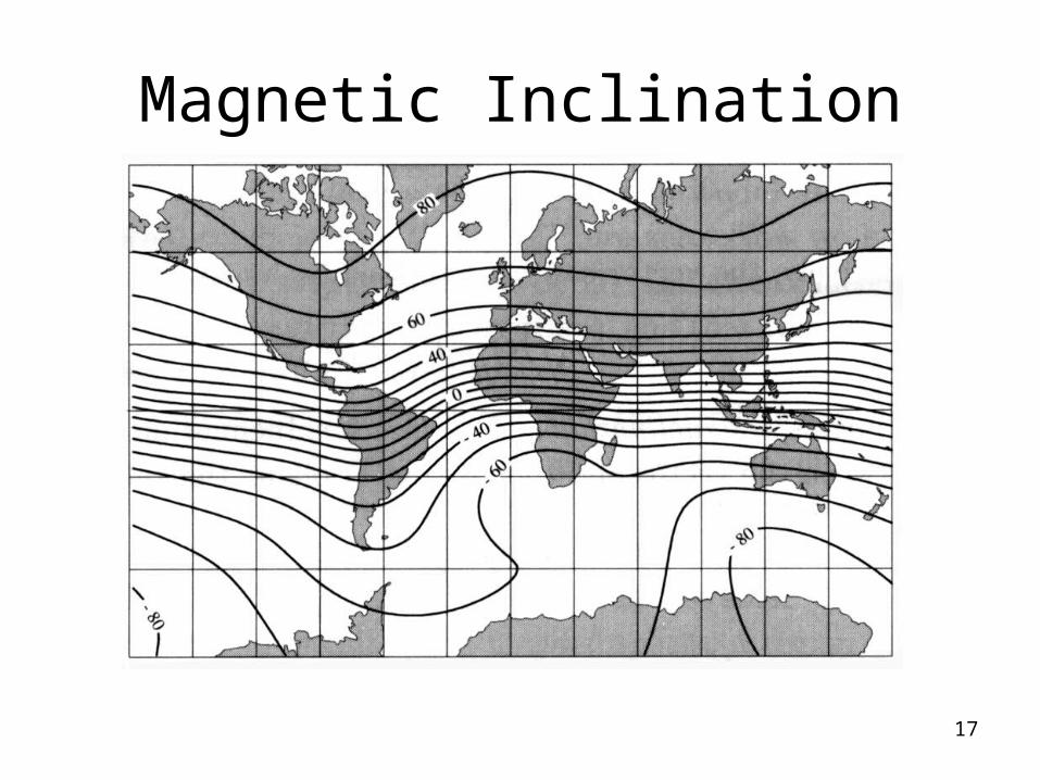
Magnetic Inclination
17

Magnetic declination
18

10th Generation IGRF ResultsField Model Results
Location Latitude Longitude Altitude DateKarachi 25 degs N 67 degs E 0.00 km 2008
Component Field Value Secular VariationDeclination 0.528 degrees 2.6 arcmin/yearInclination 38.376 degrees 6.3 arcmin/yearHorizontal Intensity 35170 nT 2.2 nT/yearNorth Component 35169 nT 2.0 nT/yearEast Component 324 nT 26.1 nT/yearVertical Intensity 27852 nT 107.4 nT/yearTotal Intensity 44863 nT 68.4 nT/year

20
paths of magnetic field[iron filings on a sheet over a magnet]
bar magnet
coil
Earth’s Magnetic Field
where rotation axisintersects the surface
21
Earth’s magnetism: due to electric currents in liquid outer core
Magnetic field is measured (units): in Teslas [T, too large] nanoTesla (nT, 10-9 T)
11.5º
magnetic dipole[the source producing the magneticfield is far from where were aremeasuring its field; within the core]

22
paths of magnetic field[iron filings on a sheet over a magnet]
bar magnet
coil
Earth’s Magnetic Field
where rotation axisintersects the surface

Earth’s magnetic field• Magnetic Equator - The location around the
surface of the Earth where the Earth's magnetic field has an inclination of zero (the magnetic field vector F is horizontal). This location does not correspond to the Earth's rotational equator
• Magnetic Poles - The locations on the surface of the Earth where the Earth's magnetic field has an inclination of either plus or minus 90 degrees (the magnetic field vector F is vertical). These locations do not correspond to the Earth's north and south poles
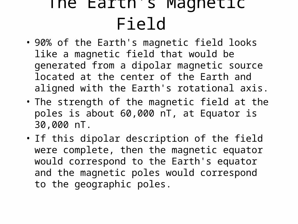
The Earth's Magnetic Field • 90% of the Earth's magnetic field looks like a
magnetic field that would be generated from a dipolar magnetic source located at the center of the Earth and aligned with the Earth's rotational axis.
• The strength of the magnetic field at the poles is about 60,000 nT, at Equator is 30,000 nT.
• If this dipolar description of the field were complete, then the magnetic equator would correspond to the Earth's equator and the magnetic poles would correspond to the geographic poles.

Earth’s magnetic field• The remaining 10% of the magnetic field cannot
be explained in terms of simple dipolar sources. Complex models of the Earth's magnetic field have been developed and are available.
• If the Earth's field were simply dipolar with the axis of the dipole oriented along the Earth's rotational axis, all declinations would be 0 degrees (the field would always point toward the north). As can be seen, the observed declinations are quite complex

Earth’s Magnetic Field• As observed on the surface of the earth, the magnetic field can be
broken into three separate components. • Main Field - This is the largest component of the magnetic field and
is believed to be caused by electrical currents in the Earth's fluid outer core. For exploration work, this field acts as the inducing magnetic field.
• External Magnetic Field - This is a relatively small portion of the observed magnetic field that is generated from magnetic sources external to the earth. This field is believed to be produced by interactions of the Earth's ionosphere with the solar wind. Hence, temporal variations associated with the external magnetic field are correlated to solar activity.
• Crustal Field - This is the portion of the magnetic field associated with the magnetism of crustal rocks. This portion of the field contains both magnetism caused by induction from the Earth's main magnetic field and from remanant magnetization

Magnetics and Geology - A Simple Example
• The portion of the magnetic field that we have described as the main magnetic field is believed to be generated in the Earth's core.
• In addition to these core sources of magnetism, rocks exist near the Earth's surface that are below their Curie temperature and as such can exhibit induced as well as remanent magnetization
• Therefore, if we were to measure the magnetic field along the surface of the earth, we would record magnetization due to both the main and induced fields. The induced field is the one of interest to us because it relates to the existence of rocks of high or low magnetic susceptibility near our instrument

Magnetic Field Nomenclature• At any point on the Earth's surface, the magnetic
field, F*, has some strength and points in some direction. The following terms are used to describe the direction of the magnetic field.
• Declination - The angle between north and the horizontal projection of F. This value is measured positive through east and varies from 0 to 360 degrees.
• Inclination - The angle between the surface of the earth and F. Positive inclinations indicate F is pointed downward, negative inclinations indicate F is pointed upward. Inclination varies from -90 to 90 degrees


Total Field Measurements

Magnetic Anomaly: Magnetized Sphere at the North Pole

Magnetic Anomaly: Magnetized Sphere at the Equator
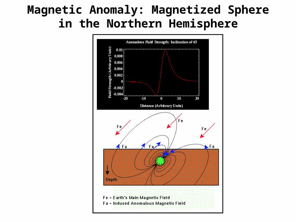
Magnetic Anomaly: Magnetized Sphere in the Northern Hemisphere

34
Magnetic surveying depends on the target producing a magnetic anomaly by locally modifying the Earth’s magnetic field the relationship of the anomaly to its source is more complex than for gravity for as well as depending on the source’s shape and magnetic properties, it also depends on its orientation, the latitude at which the anomaly occurs and if it has a remanent magnetisation (as is usual) upon its history
the measured total field derives fromadding together the field of the body andthe Earth’s field:vector addition of strengths and directions
Buried: short, but powerful dipole
dipole field opposite in the direction toEarth’s field, so measured total fieldis less (than the Earth’s field) givinga negative anomaly
dipole field similar in direction to Earth’s field, so measured totalfield is greater (than the Earth’s field) giving a positive anomaly

35
Magnetometers1. Proton magnetometer [measures total strength of magnetic field but not its direction and so shows a total field anomaly]
2. Fluxgate magnetometer [measures component of field along the axis of sensor; in land survey sensor is aligned vertically vertical component anomaly]
resolution ~1 nT (or less)resolution ~1 nT (or less)
kerosene (reach in hydrogen)

Fluxgate Magnetometer• The fluxgate magnetometer was originally
designed and developed during World War II. It was built for use as a submarine detection device for low-flying aircraft. Today it is used for conducting magnetic surveys from aircraft and for making borehole measurements. A schematic of the fluxgate magnetometer is shown below
• The fluxgate magnetometer is based on what is referred to as the magnetic saturation circuit. Two parallel bars of a ferromagnetic material are placed closely together. The susceptibility of the two bars is large enough so that even the Earth's relatively weak magnetic field can produce magnetic saturation in the bars


Proton Precession Magnetometer
• For land-based magnetic surveys, the most commonly used magnetometer is the proton precession magnetometer. Unlike the fluxgate magnetometer, the proton precession magnetometer only measures the total size of the Earth's magnetic field. These types of measurements are usually referred to as total field measurements. A schematic of the proton precession magnetometer is shown below

Total Field Measurements


• Shipborne - Magnetic surveys can also be completed over water by towing a magnetometer behind a ship. Obviously, marine magnetic surveying is slower than airborne surveying. When other geophysical methods are being conducted by ship, however, it may make sense to acquire magnetic data simultaneously.
• Ground Based - Like gravity surveys, magnetic surveys are also commonly conducted on foot or with a vehicle. Ground-based surveys may be necessary when the target of interest requires more closely-spaced readings than are possible to acquire from the air. In the next discussion we will concentrate on ground-based surveys. All of this discussion, however, could be applied to air- and shipborne surveys also

Modes of Acquiring Magnetic Observations
• Magnetic observations are routinely collected using any one of three different field operational strategies
• Airborne - Both fluxgate and proton precession magnetometers can be mounted within or towed behind aircraft, including helicopters. These so-called aeromagnetic surveys are rapid and cost effective. When relatively large areas are involved, the cost of acquiring 1 km of data from an aeromagnetic survey is about 40% less than the cost of acquiring the same data on the ground

Magnetic Cleanliness and Interference

44
Magnetic Data Acquisition
base station
base station
base station
Ground magnetic surveys
• operator carrying the sensor must be free of magnetic objects (keys, knifes, etc)• measurements must be taken away from ferrous objects (like fences, railway lines, electric wires etc)• return to base station or continuous measurements at base station by a second magnetometer (correct for diurnal variations)
Magnetic character of the measured anomaly can beused as a preliminary identification of lithology

Temporal Variations of the Earth's Magnetic Field - Overview
• Secular Variations - These are long-term (changes in the field that occur over years) variations in the main magnetic field that are presumably caused by fluid motion in the Earth's Outer Core. Because these variations occur slowly with respect to the time of completion of a typical exploration magnetic survey, these variations will not complicate data reduction efforts
• Diurnal Variations - These are variations in the magnetic field that occur over the course of a day and are related to variations in the Earth's external magnetic field. This variation can be on the order of 20 to 30 nT per day and should be accounted for when conducting exploration magnetic surveys

46
Data Reduction: [fewer & less important corrections in comparison to gravity surveying]
1. Diurnal variations [strength of Earth’s magnetic field changes over the course of a day, max. 100 nT over 24hrs; magnetic “storm” if variation exceeds 1000 nT]
correcting for diurnal variation
Mjølnir crater
Mjølnir crater

• Magnetic Storms - Occasionally, magnetic activity in the ionosphere will abruptly increase. The occurrence of such storms correlates with enhanced sunspot activity. The magnetic field observed during such times is highly irregular and unpredictable, having amplitudes as large as 1000 nT. Exploration magnetic surveys should not be conducted during magnetic storms

Diurnal Variations of the Earth's Magnetic Field

Magnetic Storms

50
Data Reduction
2. Subtracting the Earth’s global field varies depending on latitude (from Equator to poles) International Geomagnetic Reference Field (IGRF): revised every 5 years to account for secular variation

Correcting for Main Field Variations
• Corrections for spatial variations in the strength of the Earth's main magnetic field are referred to as geomagnetic corrections. One commonly used method of accounting for these variations is to use one of the many models of the Earth's main magnetic field that are available. One such set of commonly used models of the main field is referred to as the International Geomagnetic Reference Field (IGRF).
52
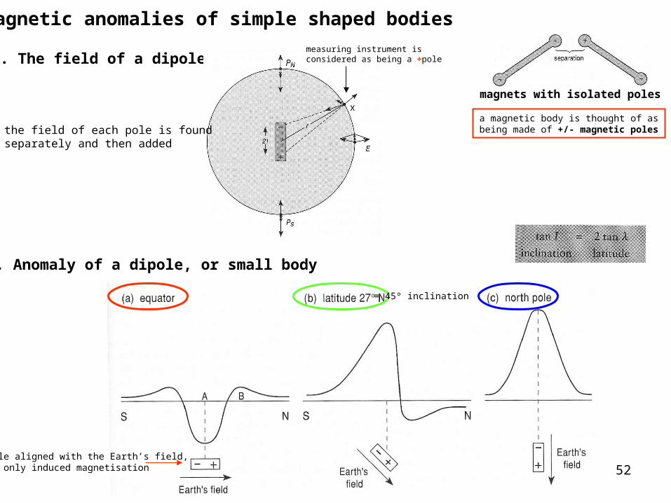
Magnetic anomalies of simple shaped bodies
magnets with isolated poles
1. The field of a dipole
2. Anomaly of a dipole, or small body
a magnetic body is thought of asbeing made of +/- magnetic poles
measuring instrument isconsidered as being a +pole
the field of each pole is foundseparately and then added
dipole aligned with the Earth’s field,i.e. only induced magnetisation
= 45º inclination

53
4. Anomaly of a vertical sheet equator (0º) latitude (27ºN) North pole (+90º)
striking E-W
striking N-S

54
3. Anomaly of a sphere
dividing a magnet

55
Depth of a magnetic body
Peter’s half-slope method:1. draw slope of steepest part of the anomaly (line 1)2. draw a line (line 2) half as steep as line 13. fit line 2 (parallel lines with same slope) on either side of the steepest part of the anomaly (points A & B)4. measure horizontal separation (S) between points A & B5. depth to top of body: d ≈ 1.6 S
similar with gravity:• the shallower a body, the sharper & larger the anomaly• the deeper the body the broader the anomaly

56
Mineral magnetism
Magnetic susceptibility (χ): the ability of a rock to become temporarily magnetised while a magnetic field is applied to it
paramagnetic materials become magnetised only when the field is presentferromagnetic materials increase their magnetisation while a field is applied } this temporary magnetisation is
called induced magnetisation
strength of the magnetic field

57
Köningsberger ratio, Q: the ratio of remanence to induced magnetisation Q = Mr / Mi Q > 1 remanent magnetisation prevails

Susceptibilities of Rocks and Minerals
Material Susceptibility x 103 (SI)* • Air ~0 Quartz -0.01 • Rock Salt -0.01 Calcite -0.001 - 0.01 • Sphalerite 0.4 Pyrite 0.05 - 5 • Hematite 0.5 - 35 Illmenite 300 - 3500 • Magnetite 1200 - 19,200 • Limestones 0 - 3 Sandstones 0 - 20 • Shales 0.01 - 15 Schist 0.3 - 3 • Gneiss 0.1 - 25 Slate 0 - 35 • Granite 0 - 50 Gabbro 1 - 90 • Basalt 0.2 - 175 Peridotite 90 - 200

59
Computer Modeling:
e.g. GM-SYS (Gravity-Magnetic modeling software) 2D, 2½D, 2¾D, 3D
forward modeling
rock samples:measure susceptibilities and remanent magnetisations

60
Advanced Processing of Data1. Reduction to the pole
equator (0º) latitude (27ºN)
North pole (+90º)
2. Pseudogravity• deduce a body by accounting for the produced magnetic anomaly• calculate its gravity anomaly by setting a plausible density• if the pseudogravity anomaly matches the observed gravity anomaly then the shape of the body is correct and the same body produces the magnetic and gravity anomalies• if not, then there are different causative bodies, or the magnetisations and densities are not uniform
3. Upward and Downward continuation
gravity:

61
Magnetic gradiometry
Gradiometer: two sensors (a fixed distance apart),usually one above the other; records the differenceof their readings nT/m
advantage: Earth’s field same at the two sensors and so completely cancels
extensively used for archaelogical prospecting &detection of near-surface bodies
dykes
62
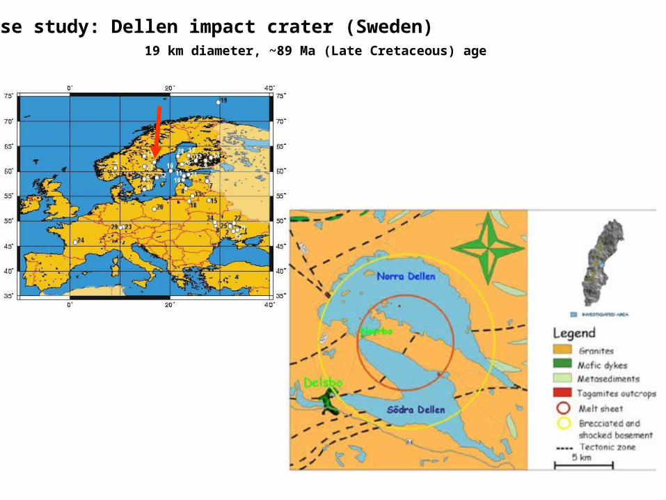
A case study: Dellen impact crater (Sweden) 19 km diameter, ~89 Ma (Late Cretaceous) age

63
Rock type Density (kg/m3) Susceptibility (10-5 SI) Q value1 Target rock 2670 50 02 High density body 2900 6000 03 Lightly shocked target 2600 100 24 Strongly shocked target 2500 100 15 Impact rock layer 2400 1500 16 Melt body 1 2400 2000 5.57 Melt body 2 2400 1500 58 Melt body 3 2400 2000 159 Melt body 4 2400 1500 5.510 Melt body 5 2400 2000 15
gravity profile
magnetic profile
Cross-section along entire crater
64
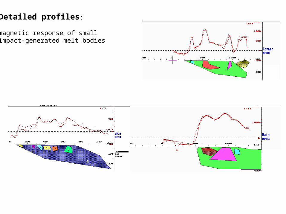
Detailed profiles:
magnetic response of smallimpact-generated melt bodies

65
Aeromagnetic surveys
“bird”
• covers large and, otherwise, inaccessible areas• looses in resolution [due to the height of the plane]

66
Aeromagnetic surveys
offshoreLofoten-Vesterålen

67
Remanent & Induced Magnetisations
remanent magnetisation: the ability to retain magnetisation in theabsence of a field or in the presence of a different magnetic field
alignment and hence magnetisationdisappears as soon as the field is removed
directions of the magnetisations of themagnetic atoms spontaneous align[iron materials & its compounds, e.g. magnetite]