maiden ben hur jorc resource substantial copper ... · the following diagram shows the known...
TRANSCRIPT

Aeon Metals Ltd (formerly Aussie Q Resources Limited)
ABN 91 121 964 725
Suite 11, Level 3, 88 Pitt Street, Sydney NSW 2000, Australia
P.O. Box 8155, Gold Coast MC. Qld 9726, Australia P: 61 7 5574 3830 F: 61 7 5574 3568
W: aeonmetals.com.au E: [email protected]
ASX Code - AQR 12 November 2013. Company Announcements Office Australian Securities Exchange Level 4, Exchange Centre 20 Bridge Street Sydney NSW 2000
MAIDEN BEN HUR JORC RESOURCE – SUBSTANTIAL COPPER, MOLYBDENUM & SILVER
190,000 tonnes of copper, 2,700,000 ounces of silver and 16.7M lbs of molybdenum in maiden Ben Hur Project Mineral Resource estimate.
Combined Ben Hur and Greater Whitewash Mineral Resource estimate now 475,000 tonnes of copper, 14,800,000 ounces of silver and 158M lbs of molybdenum.
Ben Hur upside with large mineralised shell surrounding resource: o Extent of the mineralisation largely set by the drilling coverage,
instead of defined geological or grade limits. o With further drilling, there is potential to add to the current
interpretation of mineralised volume, both laterally and at depth. o Infilling may make it possible to model higher grade zones within the
mineralised domain.
• Combined Ben Hur-Greater Whitewash resources to underpin ongoing strategy to develop a centralised processing plant to service the combined resource base – will also have ability to process ore from new 7B.
• Best in class location with close proximity to all necessary infrastructure. o 150km by road to Gladstone port; o Overhead powerlines; o Major mining service providers servicing nearby Bowen Basin coal
industry. o Nearby regional airport serviced by Qantas
Maiden Ben Hur Project JORC Resource Aeon Metals Ltd (ASX:AQR) (“Aeon” or the “Company”) advises that the maiden November 2013 Mineral Resource estimate for the John Hill copper-silver-molybdenum deposit within the Ben Hur Project contains 190,000 tonnes of copper, 2,700,000 ounces of silver and 16.7M lbs of molybdenum (at a 0.24% copper cut-off). The Mineral Resource estimate has been completed by geological consultant SRK Consulting in accordance with the guidelines of the JORC Code (2012 edition). The resource comprises:
Complete grade tonnage results are given in Appendix 1 noting the fresh component of the resource comprises:
¹See Metal Equivalents assumptions in Appendix 1
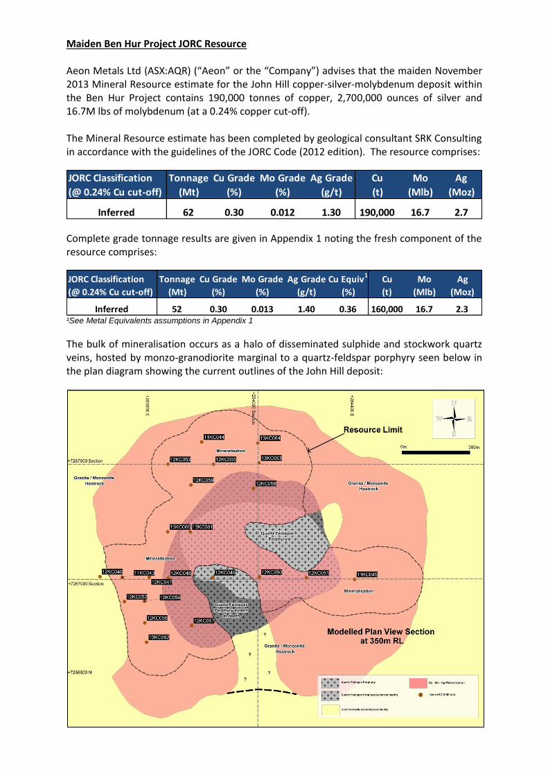
The bulk of mineralisation occurs as a halo of disseminated sulphide and stockwork quartz veins, hosted by monzo-granodiorite marginal to a quartz-feldspar porphyry seen below in the plan diagram showing the current outlines of the John Hill deposit:
JORC Classification Tonnage Cu Grade Mo Grade Ag Grade Cu Mo Ag
(@ 0.24% Cu cut-off) (Mt) (%) (%) (g/t) (t) (Mlb) (Moz)
Inferred 62 0.30 0.012 1.30 190,000 16.7 2.7
JORC Classification Tonnage Cu Grade Mo Grade Ag Grade Cu Equiv1 Cu Mo Ag
(@ 0.24% Cu cut-off) (Mt) (%) (%) (g/t) (%) (t) (Mlb) (Moz)
Inferred 52 0.30 0.013 1.40 0.36 160,000 16.7 2.3
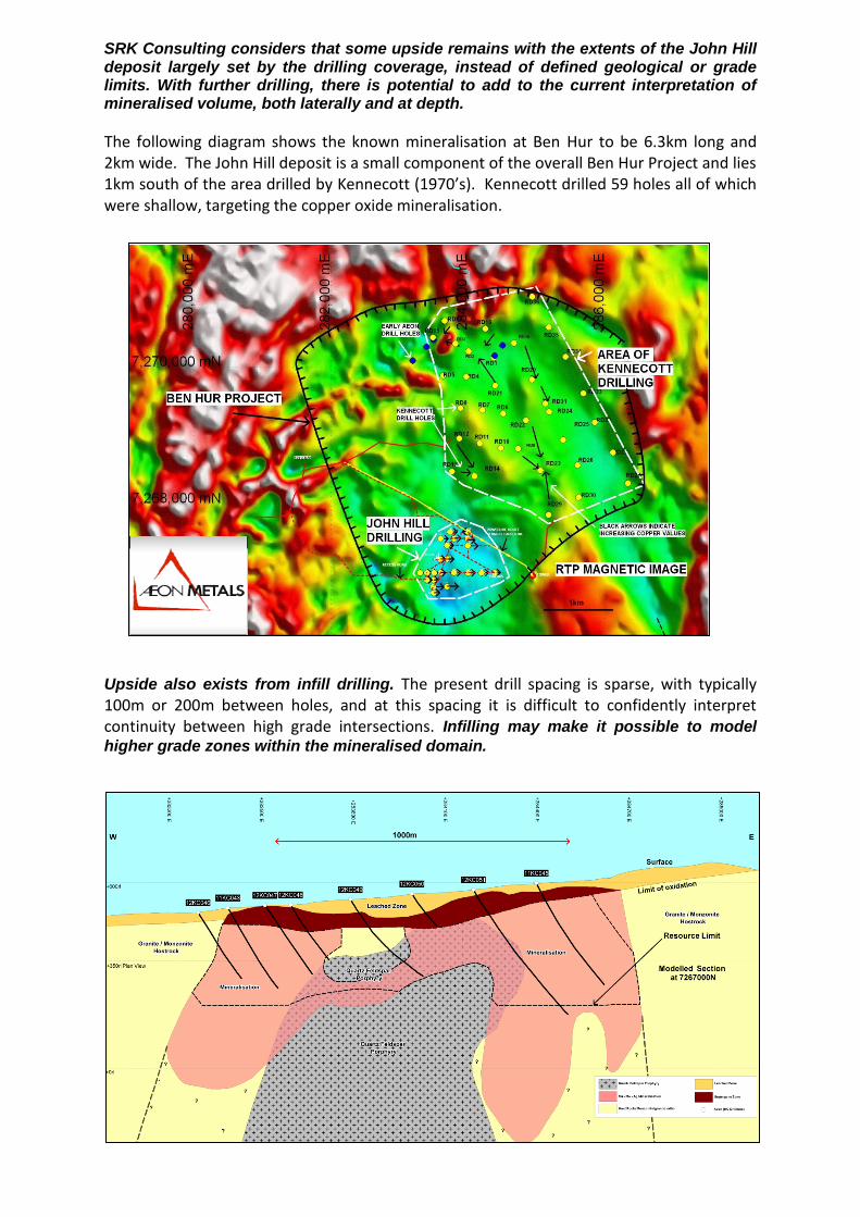
SRK Consulting considers that some upside remains with the extents of the John Hill deposit largely set by the drilling coverage, instead of defined geological or grade limits. With further drilling, there is potential to add to the current interpretation of mineralised volume, both laterally and at depth.
The following diagram shows the known mineralisation at Ben Hur to be 6.3km long and 2km wide. The John Hill deposit is a small component of the overall Ben Hur Project and lies 1km south of the area drilled by Kennecott (1970’s). Kennecott drilled 59 holes all of which were shallow, targeting the copper oxide mineralisation.
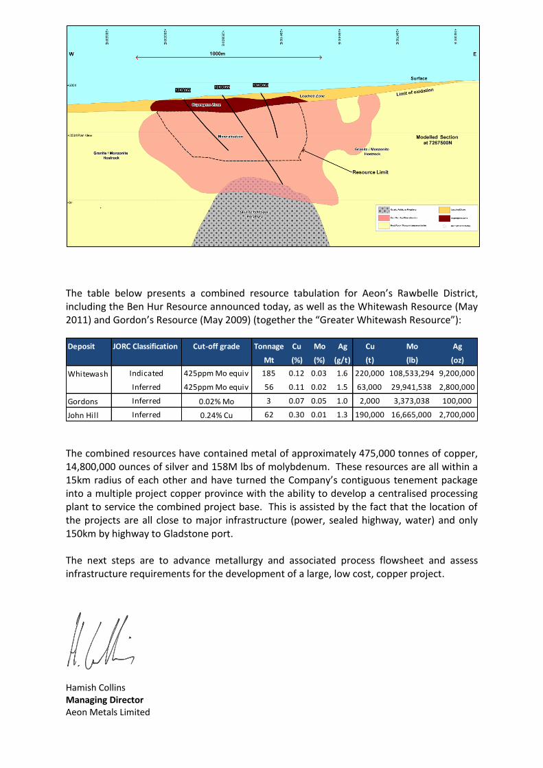
Upside also exists from infill drilling. The present drill spacing is sparse, with typically 100m or 200m between holes, and at this spacing it is difficult to confidently interpret continuity between high grade intersections. Infilling may make it possible to model
higher grade zones within the mineralised domain.
The table below presents a combined resource tabulation for Aeon’s Rawbelle District, including the Ben Hur Resource announced today, as well as the Whitewash Resource (May 2011) and Gordon’s Resource (May 2009) (together the “Greater Whitewash Resource”):
The combined resources have contained metal of approximately 475,000 tonnes of copper, 14,800,000 ounces of silver and 158M lbs of molybdenum. These resources are all within a 15km radius of each other and have turned the Company’s contiguous tenement package into a multiple project copper province with the ability to develop a centralised processing plant to service the combined project base. This is assisted by the fact that the location of the projects are all close to major infrastructure (power, sealed highway, water) and only 150km by highway to Gladstone port. The next steps are to advance metallurgy and associated process flowsheet and assess infrastructure requirements for the development of a large, low cost, copper project.
Hamish Collins Managing Director Aeon Metals Limited
Deposit JORC Classification Cut-off grade Tonnage Cu Mo Ag Cu Mo Ag
Mt (%) (%) (g/t) (t) (lb) (oz)
Whitewash Indicated 425ppm Mo equiv 185 0.12 0.03 1.6 220,000 108,533,294 9,200,000
Inferred 425ppm Mo equiv 56 0.11 0.02 1.5 63,000 29,941,538 2,800,000
Gordons Inferred 0.02% Mo 3 0.07 0.05 1.0 2,000 3,373,038 100,000
John Hill Inferred 0.24% Cu 62 0.30 0.01 1.3 190,000 16,665,000 2,700,000

Appendix 1 – Database, Geology, & Mineral Resource Grade Tonnage Results
Database
The Mineral Resource estimation was based on information from 22 drill holes, of which 18 were
drilled using a Reverse Circulation (“RC”) technique and the remainder were diamond cored holes or
a combination of RC pre-collars and diamond cores.
Total drilling length was 6,083.9m. Drill spacing was typically 100m x 100m to 200m x 200m. Drill
holes predominantly dipped 600 towards the east. Sampling was generally on 1m intervals.
As part of the data quality review, SRK Consulting visited the site in August 2013 and carried out a
comprehensive inspection of project drill core and sample storage facilities. SRK Consulting's
conclusion from the site visit and data review was that the database was suitable to support the
estimation of Inferred Mineral Resources.
Geology
Mineralisation at John Hill occurs within a 1.5 km by 1.5 km ‘wall-rock’ carapace marginal to a
central, largely unmineralised, quartz-feldspar porphyry intrusive. The predominant ‘wall-rock’ host
to mineralisation is a series of granodiorite to diorite igneous intrusives.
The low sulphidation style mineralisation in the marginal carapace occurs principally as a series of
overprinting narrow veins and vein stockworks, which represent progressive phases of
mineralisation. Less visible are fine grained disseminated sulphides interstitial to veining. The main
visible sulphide species are molybdenite, chalcopyrite and pyrite.
The depth to the base of the weathered zone is up to 100m. Although there are lateral trends in the
distribution of mineralisation, concentration of Mo, Cu and Ag in the supergene zone, does not
result in substantially higher grades than the grades found in the main, fresh portion of the deposit.
Mineral Resource Grade Tonnage Results
The cut-off grade (0.24% Cu) was chosen for reporting Mineral Resources and is based on analogies
with mined deposits that have a similar mineralisation style. The John Hill deposit is smaller than
many of these analogous deposits, but the 0.24% Cu cut-off grade is considered reasonable, given
that John Hill is one of several deposits and exploration targets that may eventually be mined
together.
The complete grade tonnage results are as follows:
FRESH
Cu cut off
Mt Cu (%) Ag (g/t) Mo (%) Cu eq
(%) Metal Cu (t)
Metal Ag (t)
Metal Mo (t)
0 488 0.15 0.8 0.009 0.18 730,000 12.6 42,000
800 394 0.17 0.9 0.009 0.21 670,000 11.0 37,000
1000 345 0.18 0.9 0.010 0.22 630,000 10.0 34,000
1200 293 0.19 0.9 0.010 0.24 570,000 8.9 30,000
1400 242 0.21 1.0 0.011 0.25 500,000 7.7 26,000
1600 192 0.22 1.1 0.011 0.27 430,000 6.5 21,000
1800 144 0.24 1.1 0.012 0.29 350,000 5.2 17,000
2000 104 0.26 1.2 0.012 0.31 270,000 4.0 13,000
2200 73 0.28 1.3 0.012 0.33 210,000 3.0 9,000
2400 52 0.30 1.4 0.013 0.36 160,000 2.3 7,000
2600 37 0.32 1.4 0.013 0.38 120,000 1.7 5,000

2800 27 0.34 1.5 0.014 0.40 90,000 1.3 4,000
3000 20 0.36 1.6 0.014 0.42 70,000 1.0 3,000
OXIDE
0 130 0.11 0.8 0.004
150,000 3.4 5,000
800 78 0.16 1.0 0.004
130,000 2.4 3,000
1000 64 0.18 1.0 0.005
110,000 2.0 3,000
1200 52 0.19 1.0 0.005
100,000 1.7 2,000
1400 42 0.21 1.0 0.005
90,000 1.4 2,000
1600 33 0.22 1.1 0.005
70,000 1.1 2,000
1800 26 0.24 1.1 0.005
60,000 0.9 1,000
2000 20 0.26 1.1 0.005
50,000 0.7 1,000
2200 15 0.27 1.1 0.005
40,000 0.5 1,000
2400 11 0.29 1.2 0.005
30,000 0.4 1,000
2600 8 0.30 1.2 0.005
20,000 0.3 0
2800 5 0.32 1.2 0.005
20,000 0.2 0
3000 3 0.33 1.2 0.005
10,000 0.1 0
ALL
0 618 0.14 0.8 0.008
870,000 16.0 47,000
800 473 0.17 0.9 0.009
800,000 13.4 40,000
1000 409 0.18 0.9 0.009
740,000 12.0 37,000
1200 345 0.19 1.0 0.009
670,000 10.6 32,000
1400 284 0.21 1.0 0.010
590,000 9.1 28,000
1600 225 0.22 1.1 0.010
500,000 7.6 23,000
1800 170 0.24 1.1 0.011
410,000 6.1 18,000
2000 124 0.26 1.2 0.011
320,000 4.7 13,000
2200 88 0.28 1.3 0.011
250,000 3.5 10,000
2400 62 0.30 1.3 0.012
190,000 2.7 7,000
2600 45 0.32 1.4 0.012
140,000 2.0 5,000
2800 32 0.34 1.5 0.012
110,000 1.5 4,000
3000 23 0.36 1.5 0.013
80,000 1.1 3,000
Rounding:
Tonnage 1 Mt
Cu grade 0.01 %
Ag grade 0.1 %
Mo grade 0.001 %
Cu equivalent 0.01 %
Cu metal 10,000 t
Ag metal 0.1 t
Mo metal 1,000 t

Metal Equivalents
Metal equivalents were used for reporting the Mineral Resource in the fresh domains.
The price assumptions used to derive the Cu equivalent value are, in Australian dollars: Cu $3.25/lb,
Ag $25/oz, Mo $14/lb.
The recovery factors assumed for the metal equivalent equation are from analysis done by ALS
Ammtec in Sydney. This laboratory carried out a demonstration flotation test on a 1 kg subsample
of primary mineralised John Hill material, split from an 8 kg composite of four assay reject samples.
The test sample assayed 0.4% Cu, 1ppm Ag and 190ppm Mo. The test yielded recoveries of 86.1%
Cu, 56.1% Ag and 69% Mo.
Combining the price and recovery assumptions, the Cu equivalent equation is:
Cu eq (ppm) = Cu (ppm) + 73.1 Ag (ppm) + 3.45 Mo (ppm).
Metal equivalents are not used for reporting the Mineral Resource in the oxide domain. No recovery
information is available for this domain.
Appendix 2
The following section is provided to ensure compliance with the JORC (2012) requirements for the
reporting of the Mineral Resource estimates for the John Hill deposit within the Ben Hur Copper
Project on EPM 14628:
Section 1 Sampling Techniques and Data
Criteria JORC Code Explanation Commentary
Sampling
techniques
Nature and quality of sampling (eg cut channels, random chips, or specific specialised industry standard measurement tools appropriate to the minerals under investigation, such as down hole gamma sondes, or handheld XRF instruments, etc). These examples should not be taken as limiting the broad meaning of sampling.
Between 2011 and 13 August 2013 the
deposit was sampled in three phases by a
total of 22 drill holes (total 6083.9m);
comprising 18 reverse circulation (RC)
holes (4,802m) and 4 diamond drill holes
(DD) (1,282m). Average hole depth is
277m, deepest hole is 555.1m. Drilling
occurred over an area of approximately
1.0km2. All holes are located on an east –
west grid between 100m and 200m line
spacing, with holes spaced along lines at
between 100m and 200m. Industry
standard sampling methods appropriate
for the style of mineralisation were
used:rotary splitting of drill cuttings for
RC, and sawn half core for DD drilling.
Quality of sampling is considered good.
Samples were submitted to a commercial
laboratory for assay. Data from on-site
hand-held XRF analysis were not used for
the Mineral Resource estimation.
No costeaning or excavation bulk
sampling had been undertaken to August
2013.
Include reference to measures taken to ensure sample representivity and the appropriate calibration of any measurement tools or systems used.
Diamond core was orientated prior to
systematic sampling of all mineralised
intervals. Half core sawn samples were
collected from consecutive 1m measured
intervals independent of lithology.
Likewise, RC holes were bulk sampled at
1m intervals and a homogenised, cyclone
split sub-sample, of ~ 2.5kg weight
collected for assay. QA/QC protocols
included submission of commercial
certified reference material (CRM) with
both the RC and DD samples for assay.
CRMs were selected to match the style of
mineralisation being tested. Half core and
4kg RC library samples corresponding to
samples submitted for analysis were
securely stored on site for reference if

required.
Aspects of the determination of mineralisation that are Material to the Public Report. In cases where ‘industry standard’ work has been done this would be relatively simple (eg ‘reverse circulation drilling was used to obtain 1 m samples from which 3 kg was pulverised to produce a 30 g charge for fire assay’). In other cases more explanation may be required, such as where there is coarse gold that has inherent sampling problems. Unusual commodities or mineralisation types (eg submarine nodules) may warrant disclosure of detailed information.
Uniform sampling procedures were
followed for each stage of drilling for all
RC and DD holes used in the resource
estimation. Both RC and DD holes were
sampled at 1m intervals. A~ 2.5 kg RC chip
sample was collected direct from the RC
cyclone for assay submission and the
remainder bulk sample retained. A
duplicate 4kg library sample was collected
by riffle splitter from the excess 1m bulk
sample and stored in a weather proof
facility on site as a duplicate library
sample. DD core was cut at 1m lengths
and ~ 3-4 kg individual half core samples
submitted for assay. The remainder half
core is stored on site. Both sampling
procedures are considered appropriate
for the style of mineralisation and
respective drilling methods.
Drilling Techniques
Drill type (eg core, reverse circulation, open-hole hammer, rotary air blast, auger, Bangka, sonic, etc) and details (eg core diameter, triple or standard tube, depth of diamond tails, face-sampling bit or other type, whether core is oriented and if so, by what method, etc).
The deposit was sampled using Reverse
Circulation (18 holes - 4,438m) and 4
diamond drilling (4 holes - 1,282m). RC
drilling was conducted using a standard 4
½ bit and diamond drilling used NQ tubes
with HQ and RC pre-collars. During
diamond drilling regular core orientation
procedures were undertaken
approximately every 3m and down hole
surveys approximately every 50m. RC
holes were down hole surveyed every 50-
80m.
Drill direction is predominantly west to
east with an inclination at collar of 600,
flattening or steepening to between 350
and 800 at bottom of hole.
Drill sample
recovery
Method of recording and assessing core and chip sample recoveries and results assessed.
Core recoveries were measured and recorded in a hard copy ledger. No significant core loss issue exists.
Measures taken to maximise sample recovery and ensure representative nature of the samples.
Igneous host lithologies within the
mineralised domains are very competent.
Overall core quality is high with minimal
fracturing or friable material. The
standard diamond tube core barrels used
were adequate for the material sampled.
There were no reported adverse ground
water issues and RC chip recoveries were
not affected by the wet samples.
Whether a relationship exists between sample recovery and grade and whether sample bias may have occurred due to preferential loss/gain of fine/coarse material.
Sample recovery from the mineralised
domains is generally considered high. No
material bias is expected.
Logging Whether core and chip samples have been geologically and geotechnically logged to a level of detail to support appropriate Mineral Resource estimation, mining studies and metallurgical studies.
Entire core sample from each diamond
drill hole was initially geologically logged
in detail for style of mineralisation,
lithologies, degree of oxidation, and
alteration. Logs were subsequently
reviewed and checked against stored half
core for accuracy and consistency by
senior geological staff and in addition
validated by an independent specialist
consultant porphyry geologist (Corbett,
2012). RC cuttings for each hole were
logged every 1m interval.
The detail and degree of logging is
sufficient to support the geological model
and Mineral Resource estimation.
Whether logging is qualitative or quantitative in nature. Core (or costean, channel, etc) photography.
Logging of the diamond core and RC
cuttings is qualitative in nature. Records
are recorded digitally. Photographic
record of the drill core is maintained.
The total length and percentage of the relevant intersections logged.
All drill holes are logged for their entire
length (100%).
Sub-
sampling
techniques
and sample
preparation
If core, whether cut or sawn and whether quarter, half or all core taken.
A diamond core saw was used to obtain 1m half core samples.
If non-core, whether riffled, tube sampled, rotary split, etc and whether sampled wet or dry.
All RC assay samples were mechanically
sub-split direct from the RC cyclone. No
significant issues were recorded regarding
wet samples.
For all sample types, the nature, quality and appropriateness of the sample preparation technique.
Diamond core and RC sample preparation
and analysis were completed by ALS
Brisbane. On receipt by the laboratory all

drill samples were weighed (WEI-21) prior
to further sample preparation.
RC samples were oven dried and riffle split into equal halves(1-1.5kg); one half pulverised in an LM5 to 75microns and a 25gm charge taken for assay (PUL-23)
DD core samples were preliminary coarse crushed to 70% nominal -6mm(CRU-21)and oven dried, samples < 3.3kg pulverised to 75microns and 25gm charge taken for assay (PUL-23), samples >3.3kg riffle split into equal halves (SPL-21) and one fraction used for LM5 pulverising.
Bulk pulp and core/RC residues were
retained for all samples. The quality
control sampling done by Aeon does not
extend to the sample preparation stages
(ie. there are no duplicates and no check
sampling of coarse residues), so no
comment is made on sample preparation
quality. Sample preparation methods
adopted are considered appropriate for
the style of mineralisation though.
Quality control procedures adopted for all sub-sampling stages to maximise representivity of samples.
For QA/QC purposes certified reference
materials (CRMs) were submitted in
laboratory sample batches (DD & RC) at
between 20 and 50m sample intervals.
CRMs used were purchased from Ore
Search & Exploration Pty Ltd., and were
selected to match the matrix, mineralogy
and anticipated grade of the deposit. (Au-
Cu-Mo-S CRMs OREAS 50c & 52c and a
quartz blank REAS 22c).
Measures taken to ensure that the sampling is representative of the in situ material collected, including for instance results for field duplicate/second-half sampling.
A total of 180 duplicate drill samples were
submitted to ALS Townsville for analysis.
Results of the QAQC review are contained
in a draft report compiled by N Fordyce
Consulting Data Analyst, Minforrordd Pty
Ltd dated August 2013.
Whether sample sizes are appropriate to the grain size of the material being sampled.
Sulphide grain size across the phases of
mineralisation intersected were generally
<3-5mm in size. The standard 1m
sampling interval adopted for both RC and

core drilling is considered appropriate for
the general moderate to fine grained
nature of the sulphide mineralisation,
given the sampling methods and the
grade ranges of interest for this deposit.
Quality of
assay data
and
laboratory
tests
The nature, quality and appropriateness of the assaying and laboratory procedures used and whether the technique is considered partial or total.
All samples were analysed by standard
ICP-AES method ME-ICP61. Individual
samples reporting Mo and Cu values
above the analytical range for ME-ICP61,
were re-assayed by methods ME-XRF05
and Cu-OG62 for Mo and Cu respectively.
Analytical methods and analysis ranges
are considered appropriate for the nature
of the material sampled.
For geophysical tools, spectrometers, handheld XRF instruments, etc, the parameters used in determining the analysis including instrument make and model, reading times, calibrations factors applied and their derivation, etc.
No systematic sampling procedures other
than those described for use in
commercial laboratory analysis were
adopted. Hand held XRF analysis was
intermittently used on site to determine
mineralogical signatures and preliminary
checks on mineralised intervals, the XRF
results were not used for the Mineral
Resource estimation.
Nature of quality control procedures adopted (eg standards, blanks, duplicates, external laboratory checks) and whether acceptable levels of accuracy (ie lack of bias) and precision have been established.
Three purchased Certified Reference
Materials (CRMs) from Ore Research &
Exploration Pty Ltd were used as
standards for Cu and Mo. No standards
are have been used for Ag. The CRMs
have been inserted at a rate of between 1
in 20 and 1 in 50.
About 180 samples have had their pulps
reanalysed for Cu and Mo by an umpire
laboratory, SGS Townsville.
Results from this quality control work are
compiled in a draft report to Aeon Metals
by consulting data analyst N Fordyce of
Minffordd Pty Ltd. The Competent Person
has reviewed this report. No significant
concerns emerged from the quality
control study, and the levels of accuracy
and precision established are sufficient for
the Inferred classification applied to the
Mineral Resource.

Verification
of sampling
and
assaying
The verification of significant intersections by either independent or alternative company personnel.
Character and distribution of
mineralisation have been reviewed and
verified by Aeon senior staff. In addition,
an independent geological report
verifying the geological model for the
deposit was produced by porphyry
mineralisation expert (Corbett, 2012). The
entire half core from hole 12KC55 and
mineralised sections of holes 12KC45 and
12KC51 were independently reviewed
during the on-site visit as part of the
current Mineral Resource estimation and
found to satisfactorily correspond with
the reported geological logs for each hole.
The use of twinned holes.
Twinned drill holes have not been used as
a sample validation method to date.
Documentation of primary data, data entry procedures, data verification, data storage (physical and electronic) protocols.
Documentation of protocols was not
found.
Discuss any adjustment to assay data.
No adjustments have been made to assay
data.
Location of
data points
Accuracy and quality of surveys used to locate drill holes (collar and down-hole surveys), trenches, mine workings and other locations used in Mineral Resource estimation.
Drill hole collar locations were
determined by GPS. Random collars were
checked during the site visit on 14 August
to verify accuracy. All collars checked
were found to be within 1m of reported
easting and northings.
Down-hole surveys were conducted at
intervals depths down hole of between 50
and 80m.
Specification of the grid system used.
2011-2013 drill hole collars are recorded in MGA GDA 94 Zone 56 co-ordinates.
Quality and adequacy of topographic control.
The deposit is located in an area of low
wooden hills. Initial topographic control
for collar elevations was provided by
barometric GPS calibrated to 1m RL
accuracy. Subsequent collar surveys were
undertaken to 0.01m accuracy.

Data
spacing and
distribution
Data spacing for reporting of Exploration Results
Drilling at John Hills to the 14 August 2013
was on 100 and 200m spaced west-east
grid lines with holes spaced at intervals of
between 100m and 200m. Down hole
sampling was undertaken on 1m intervals.
Whether the data spacing and distribution is sufficient to establish the degree of geological and grade continuity appropriate for the Mineral Resource and Ore Reserve estimation procedure(s) and classifications applied.
The data spacing and distribution is
sufficient to imply geology and grade
continuity to a degree appropriate for
estimation procedures used and the
Inferred classification applied.
Whether sample compositing has been applied.
Samples were composited to 5m for
statistical analysis and estimation of
grades. The compositing was done using a
“best fit” option, to ensure that no short
residual lengths were generated.
Orientation
of data in
relation to
geological
structure
Whether the orientation of sampling achieves unbiased sampling of possible structures and the extent to which this is known, considering the deposit type.
Drill holes predominantly dip 600 towards
the east. The dominant styles of
mineralisation within the deposit are
multidirectional stockwork veins and
disseminated fine grained sulphide
Potential for introduced sample bias
based on drill hole orientation is not
considered a significant risk for these
styles of mineralisation.
A smaller proportion of mineralisation is
hosted within structurally controlled
sheeted veins. Logging of diamond drill
core indicates that the east dipping drill
holes intersect these sheeted veins at
close to perpendicular.
If the relationship between the drilling orientation and the orientation of key mineralised structures is considered to have introduced a sampling bias, this should be assessed and reported if material.
Given the current understanding of
mineralisation within the deposit, it is
unlikely the drill hole orientation used to
date has introduced sample bias.
Sample
security
The measures taken to ensure sample security.
Field samples were delivered by courier to
ALS Brisbane. Chain of custody is
managed by Aeon. Library bulk samples

and ~4kg duplicate splits for each 1m RC
interval are stored at Aeon’s field based
sample storage and processing facility
located on remote private property north
of Biloela. A complete record of half core
from all diamond drill holes is also
securely stored at the same facility.
Sample pulps and coarse rejects are
stored at ALS laboratory Brisbane.
Audits or
reviews
The results of any audits or reviews of sampling techniques and data
A review of sampling techniques was
conducted during a site visit in August
2013 as part of the SRK Consulting
Resource Estimate. Sample data was also
reviewed as part of the estimation
process. Sampling procedures were found
to be appropriate for the style of
mineralisation and of industry standard
Section 2 Reporting of Exploration Results
Criteria Explanation Commentary
Mineral
tenement and
land tenure
status
Type, reference name/number, location and ownership including agreements or material issues with third parties such as joint ventures, partnerships, overriding royalties, native title interests, historical sites, wilderness or national park and environmental settings.
The John Hill Project is contained entirely
within Exploration Permit Minerals
EPM14628. The present status of the
tenements in this report are based on
information provided by the Queensland
Government through the Interactive
Resources and Tenure Maps (IRTM) online
facility, and the report has been prepared
on the assumption that the tenement is, or
will prove to be, lawfully accessible for
evaluation and development.
The security of the tenure held at the time of reporting along with any known impediments to obtaining a licence to operate in the area.
The Competent Person has relied upon
Aeon’s assurances that the tenement is in
good standing and no impediments exist.
Exploration
done by other
parties
Acknowledgment and appraisal of exploration by other parties.
No previous exploration, materially
relevant to the current Mineral Resource
estimate, has been conducted within
EPM14628.
Geology Deposit type, geological setting and style of mineralisation.
The John Hill resource is a porphyry style
Cu-Mo sulphide deposit associated with
granodiorite to diorite igneous intrusives.
Mineralisation occurs within a series of
overprinting narrow veins and vein
stockworks which represent progressive
phases of mineralisation. 3D modelling of
drilling to date indicates the mineralisation
occurs within a 1km by 1km envelope or
carapace marginal to a central, largely
unmineralised, porphyritic rhyodacite
intrusive. The resource is situated within a
20km long corridor hosting a range of
similar character deposits and under-
explored prospects. These are interpreted
to be related to a common deep seated
intrusive complex (Rawbelle Batholith).
Drill hole
information
A summary of all information material to the understanding of the exploration results including a tabulation of the following information for all Material drill holes: 1. Easting and northing of the drill
Summary data for all drilling on the deposit,
from 2011 to 2013, is provided in Table 2
(Collar Information) and Table 3
(Mineralised Intersections). This represents
the sum total of sampling data available for
the Mineral Resource estimate. There is no

hole collar 2. Elevation or RL (Reduced Level – elevation above sea level in metres) of the drill hole collar 3. Dip and azimuth of the hole 4. Down hole length and interception depth 5.Hole length
recorded drill testing of the John Hill
resource prior to commencement of work
by Aeon Metals in 2011.
If the exclusion of this information is justified on the basis that the information is not Material and this exclusion does not detract from the understanding of the report, the Competent Person should clearly explain why this is the case.
No information was excluded.
Data
Aggregation
methods
In reporting Exploration Results, weighting averaging techniques, maximum and/or minimum grade truncations (eg cutting of high grades) and cut-off grades are usually Material and should be stated.
The intersections reported in Table 3
(Mineralised Intersections) were defined by
coding the portions of the drill holes within
the 400ppm Cu envelope used to constrain
the Mineral Resource estimation.
Intersection grades were calculated from
length weighted averaging of the samples.
Maximum and/or minimum grade
truncations were not used for the
intersections reported in Table 3. The grade
capping applied to the Mineral Resource
estimation is discussed in Table 1 Section 3.
Where aggregate intercepts incorporate short lengths of high grade results and longer lengths of low grade results, the procedure used for such aggregation should be stated and some typical examples of such aggregations should be shown in detail.
No separate high grade zones have been
defined.
The assumptions used for any reporting of metal equivalent values should be clearly stated.
Metal equivalents are not reported in Table
3. Metal equivalents were used for
reporting the Mineral Resource in the fresh
domains. The price assumptions used to
derive the Cu equivalent value are, in
Australian dollars: Cu $3.25/lb, Ag $25/oz,
Mo $14/lb. The recovery assumptions
(derived from test work by ALS Ammtec in
Sydney, on a 1kg split from an 8kg
composite of four samples) are: Cu 86.1%,
Ag 59.1%, Mo 69.0%. Combining the price
and recovery assumptions, the Cu
equivalent equation is: Cu eq (ppm) = Cu
(ppm) + 73.1 Ag (ppm) + 3.45 Mo (ppm).

Relationship
between
mineralisation
widths and
intercept
lengths
These relationships are particularly important in the reporting of Exploration Results.
If the geometry of the mineralisation with respect to the drill hole angle is known, its nature should be reported.
If it is not known and only the down hole lengths are reported, there should be a clear statement to this effect (eg ‘down hole length, true width not known’).
Most drill holes dip towards the centre of
the porphyry intrusion, so are at a high
angle to the mineralisation (which is usually
interpreted to dip away from the intrusion).
Therefore, overall, the down hole
intersection lengths are considered to be a
good representation of the actual
mineralisation widths.
The risk of overstating mineralisation
thickness is not considered large for those
holes that dip in the same direction as
mineralisation. From the limited diamond
core drilling conducted to date, it appears
most Cu-Mo mineralisation is hosted by a
vein stockwork. The orientation of
individual veins is variable, and the
thicknesses of the mineralised zones are
large compared to extents in other
directions: anisotropy of grade and geology
is not as extreme as would be the case for a
more planar, structurally controlled style of
mineralisation.
Diagrams Appropriate maps and sections (with scales) and tabulations of intercepts should be included for any significant discovery being reported. These should include, but not be limited to a plan view of drill hole collar locations and appropriate sectional views.
All drilling intercepts are modelled using 3D
software. Representative sections and
plans provided include:
Resource Plan View 350RL (Figure
1)
E-W Section 7267000N (Figure 2)
E-W Section 7267500N (Figure 3)
S-N Section 284000E (Figure 4)
Balanced
reporting
Where comprehensive reporting of all Exploration Results is not practicable, representative reporting of both low and high grades and/or widths should be practiced to avoid misleading reporting of Exploration Results.
All exploration drilling results have been
reported. Results are also presented in
previous ASX news releases (04/07/2013
and 09/07/2013).
Other
substantive
exploration data
Other exploration data, if meaningful and material, should be reported including (but not limited to): geological observations; geophysical survey results; geochemical survey results; bulk samples – size and method of treatment; metallurgical test results; bulk density, groundwater, geotechnical and rock characteristics; potential deleterious or contaminating
Geological logging of drill holes indicates
depth to bottom of oxidation across the
resource is typically between 40m and
100m.
Cu-Mo mineralisation at John Hill is
principally hosted by monzonite /
granodiorite intrusives marginal to a
central, relatively unmineralised, porphyry
intrusive. The central porphyry intrusive has
a lower magnetic susceptibility than the

substances.
mineralised host monzonite/granodiorites.
The lower magnetic character of the central
porphyry has enabled use of regional
airborne magnetics to produce a 3D model
of the porphyry body.
Further work The nature and scale of planned further work (eg tests for lateral extensions or depth extensions or large-scale step-out drilling).
Diagrams clearly highlighting the areas of possible extensions, including the main geological interpretations and future drilling areas, provided this information is not commercially sensitive.
Aeon are planning 18 more drill holes to
improve resource definition, principally in
the south-eastern, central and northern
areas of the resource. A single step-out
hole is proposed on the eastern side of the
prospect.
Figures 1 to 4 show the interpreted
mineralisation zone extends in most
directions laterally, and also at depth. The
areas which are marked as mineralised but
are outside the Mineral Resource represent
possible extensions.
Section 3 Estimation and Reporting of Mineral Resources
Criteria JORC Code Explanation Commentary
Database
integrity
Measures taken to ensure that data has not been corrupted by, for example, transcription or keying errors, between its initial collection and its use for Mineral Resource estimation purposes.
During the course of the site visit, spot checks
were made on primary data against the
information in the database. No significant
errors were found.
Data validation procedures used.
No systematic validation procedures are in place.
During the course of preparing the Mineral
Resource estimation, the tables from the
database were loaded into several different
mining software packages. These packages will
display various warning or error messages if
there are problems with the structure or internal
consistency of the database. Overall, the
database appeared to be well structured and
clean.
Site visits Comment on any site visits undertaken by the Competent Person and the outcome of those visits.
No site visit was completed by the Competent
Person (Robin Simpson. A one day site visit was
undertaken by a colleague of Robin Simpson,
SRK Principal Consultant Colin Wood on 14
August 2013. The visit comprised of
comprehensive inspection of project drill core
and sample storage facilities in the

accompaniment of Martin I’ons (Senior Project
Geologist). The inspection determined that:
(a) geological logging and sampling
protocols are sufficient and suitable for
the lithologies and style of
mineralisation and
(b) sample storage meets industry best
practice.
An inspection of drill collars was also carried out
to validate collar coordinates. Readings taken
with a hand held GPS of a selection of collars
across the project area were found to closely
match those in the project database (to within
<1m precision).
For the Mineral Resource estimation, the
Competent Person has relied on information
collected during this site visit.
If no site visits have been undertaken indicate why this is the case.
Not applicable.
Geological
interpretation
Confidence in (or conversely, the uncertainty of ) the geological interpretation of the mineral deposit.
Geological interpretation of the John Hills
mineralisation has been undertaken by senior
Aeon personnel, independent porphyry
mineralisation expert G Corbett and reviewed as
part of the current resource estimate. Consensus
between the reviewers is good, providing a
relatively high level of confidence on overall
style of mineralisation and geological
interpretation of the deposit.
Nature of the data used and of any assumptions made
Geological interpretation of the deposit is based
on combined information from DD and RC
Drilling (22 holes), 2D modelling of airborne
magnetics, and petrological examination of
diamond drill core. The large circular geophysical
low situated in the centre of the deposit,
identified from airborne magnetics, is
interpreted to represent the low magnetic
character of the unmineralised central porphyry
intrusive and is not an artefact of demagnetising
alteration fluids associated with the Cu-Mo
mineralising event. This assumption is
substantiated by both drill core observations and
limited petrological analysis.
The effect, if any, of alternative interpretations on Mineral Resource estimation.
The oxide zone is well defined by drilling, and
supergene mineralisation trends are obvious
from the assay data, so this interpretation is
considered robust and alternative
interpretations were not evaluated.

The mineralisation domains in the fresh rock are
grade shells, generated at a 400ppm Cu
threshold using anisotropy based on the
interpreted geological controls, in particular the
orientation of the porphyry contact. Isotropic
grade shells at 400ppm Cu were also generated.
Locally the isotropic shells have moderate
differences from the estimation domains, but
overall the volume and form of the isotropic
shells is similar to the estimation domains.
Furthermore, the anisotropy interpreted for the
variogram models and search neighbourhoods is
not particularly extreme. Therefore estimation in
the fresh domains, of mineralisation above the
400ppm grade threshold, is considered to be
reasonably robust to alternative geological
interpretations.
The use of geology in guiding and controlling Mineral Resource estimation
The supergene nature of mineralisation
interpreted for the oxide domain meant that a
hard boundary was used between this domain
and the fresh domains, and horizontal
anisotropy was adopted for the variogram
models and estimation neighbourhoods.
The position and orientation of the porphyry
contact was interpreted as the main control on
the form of mineralisation in the fresh domains,
therefore the interpreted porphyry contact
influenced the shape of the estimation domains,
as well as the anisotropy of the variogram
models and estimation neighbourhoods.
The factors affecting continuity both of grade and geology.
Compositional and textural variations are
identified in the intrusives hosting
mineralisation. These are interpreted to
represent overprinting evolving magma
differentiates from a common source. These
variations, together with some variability in
abundance of veins and stockworks, are likely to
produce local variability in grade.
From the limited amount of core drilling there is
no evidence that continuity of grade or geology
is affected by faulting on the scale required to
have a material impact on the Mineral Resource
estimation.
Dimensions The extent and variability of the Mineral Resource expressed as length (along strike or otherwise), plan width, and depth below surface to the upper and
The minimum and maximum extents of the
Mineral Resource are given below:
Min Max
X 283100 284800

lower limits of the Mineral Resource.
Y 7266475 7267775
Z 200 615
Expressing the dimensions in terms of thickness,
strike length and dip extent is difficult because
the form of the mineralisation roughly rings an
intrusive body. Refer to Figures 1 to 4 for plan
and section views of the resource extents and
interpreted mineralised zone.
Estimation and
modelling
techniques
The nature and appropriateness of the estimation technique(s) applied and key assumptions, including treatment of extreme grade values, domaining, interpolation parameters and maximum distance of extrapolation from data points. If a computer assisted estimation method was chosen include a description of computer software and parameters used.
Cu, Ag and Mo grades were estimated. Four
estimation domains were used: three in the
fresh rock, and one oxide domain. Domain
modelling was done using Leapfrog software.
The oxide domain was defined from logging
information. The fresh domains were defined
from 3D grade contouring at a 400ppm Cu
threshold. Higher grade thresholds were also
tested, but continuity at higher grades could not
be established from the current drill spacing.
The statistical properties of Cu, Ag and Mo are
similar from one fresh domain to another; the
main differences between the fresh domains are
the overall orientations, which set the
anisotropy for the variogram models and kriging
neighbourhoods. The domains were modelled
using Leapfrog software, and then the
wireframes from Leapfrog were used to code the
composites and the block model.
Composites were created within the domains
using a “best fit” option, which allows small
deviations from the nominal 5m composite
length in order to avoid generating short residual
composites at the end of intersections. No sub-
blocking was done. Where blocks had a partial
intersection with the domain wireframe, the
fraction was determined in Gemcom Surpac
software and stored in the block model for later
weighting.
Wireframes were also modelled in Leapfrog to
constrain extrapolation. Mineral Resource
estimation was limited to no more than 150m
away from drill holes laterally, and up to 50m
below the base of drilling coverage. A further
constraint was added to limit the Mineral
Resource to no deeper than 200mRL (usually
about 300 to 400 metres below the surface).
The block fractions and composites were
imported into Isatis software for variogram
modelling and geostatistical estimation. Block
grades for Cu, Ag and Mo were estimated by
Ordinary Kriging from the 5m composites.
The influence of extreme composite grades on
the estimation was controlled by grade and
distance thresholds. Essentially, if the composite
was within the block being estimated, then the
uncapped grade would be used; if the composite
was outside the block, then the capped grade
would be used. In the oxide, the grade
thresholds for Cu, Ag and Mo were 4000ppm,
3ppm and 250ppm respectively. For the fresh
domains, the grade thresholds for Cu, Ag and Mo
were 5000ppm, 3.5ppm and 500ppm
respectively.
The grade-tonnage results given in the
statement of Mineral Resources were prepared
from multivariate Uniform Conditioning of the
kriged block grades. The minimum block size
that could reasonably be estimated by Ordinary
Kriging is limited by the drill hole spacing. For
John Hill, this spacing ranges from 100m by
100m to 200m by 200m, and is large compared
to the likely scale of mining selectivity. To
address this problem, a post-processing method
(Uniform Conditioning) was applied to the
Ordinary Kriging estimate. For each block, the
fraction of the block above a given cut-off, and
the Cu, Ag and Mo grades of that fraction were
derived based on: an assumed scale of mining
selectivity, the variogram model for the domain,
and the estimation results from the Ordinary
Kriging.
The availability of check estimates, previous estimates and/or mine production records and whether the Mineral Resource estimate takes appropriate account of such data.
There are no check estimates, previous
estimates nor mine production records available
for the John Hill deposit.
The assumptions made regarding recovery of by-products.
Cu is the main variable estimated. Ag and Mo
can be considered potential by-products for the
John Hill deposit. Estimated values for Ag and
Mo were modelled directly from the assay data;
no recovery factors were modelled or assumed.
Estimation of deleterious elements or other non-grade variables of economic significance (eg sulphur for acid mine drainage characterisation).
No deleterious elements were modelled.
In the case of block model The drill spacing typically ranges from 100 m by

interpolation, the block size in relation to the average sample spacing and the search employed.
100 m to 200 m by 200 m. A block size of 100 m
by 100 m by 5 m (x by y by z) was used for the
Ordinary Kriging estimation.
In each estimation domain, the orientation of
the search ellipsoid was set to match the overall
geometry of the domain. For the oxide domain,
a search ellipsoid with radii 250 m by 250 m in
the horizontal directions was used, and radius 50
m in the vertical direction. For the fresh
domains, the first pass search ellipsoids have
radii 400 m by 400 m in the dip plane, and radii
150 m perpendicular to the dip plane. Almost all
blocks in the resource were informed with
grades from the first pass search. The
dimensions of the search were increased by a
factor of about 1.5 to inform the few blocks not
estimated in the first pass. For the oxide domain,
the search neighbourhood was divided into 4
sectors, with a maximum of 5 composites per
sector. For the fresh domains, 8 sectors were
used, with a maximum of 6 composites per
sector.
Any assumptions behind modelling of selective mining units.
For the Uniform Conditioning, a Selective Mining
Unit size of 20 m by 20 m by 5 m was assumed.
These dimensions were considered to be a
reasonable approximation to the likely mining
selectivity, given the size, grade and variability of
the deposit.
Any assumptions about correlation between variables.
There are moderate correlations between Cu, Ag
and Mo for all domains. These correlations were
modelled as cross-variograms during the
variogram modelling. The cross-variogram
models had little influence on the kriged block
grades, because Cu, Ag and Mo grades are
usually all available for all composites. The
correlation information from the cross-
variograms was important for the Uniform
Conditioning though, because these correlations
determined how the estimated Ag and Mo
increased with increasing Cu cut-off.
Description of how the geological interpretation was used to control the resource estimates
The contact between the single oxide domain
and the fresh domains was used as a hard
boundary in the estimation: oxide composites
did not influence fresh blocks, and fresh
composites did not influence oxide blocks. The
contacts between the three fresh domains were
soft boundaries: for each fresh domain, there
were distinct variogram models and estimation
neighbourhoods, but the composites from the
other fresh domains were available for
estimating block grades. The choice of hard or
soft boundaries was made after statistical
analysis of how Cu, Ag and Mo grades changed
across domain contacts.
Discussion of basis for using or not using grade cutting or capping.
Grade capping and restrictions on the influence
of extreme values were based on detailed
examination of the high grade tails of the Cu, Ag
and Mo composite grade distributions. Caps
were set to correspond to the grade at which
continuity breaks down. The chosen caps only
result in a minor reduction in metal compared to
estimating with no caps. For the oxide domain, 3
of 313 composites were above the 4000ppm Cu
capping threshold, 2 of 313 were above the
3ppm Ag capping threshold, and 2 of 313 were
above the 250ppm Mo capping threshold. For
the fresh domains, 7 of 866 composites were
above the 5000ppm Cu capping threshold, 2 of
866 were above the 3.5ppm Ag capping
threshold, and 4 of 866 were above the 500ppm
Mo capping threshold.
The process of validation, the checking process used, the comparison of model data to drill hole data, and use of reconciliation data if available.
The model was validated by visual and statistical
checks of the estimated blocks against the drill
hole data. The statistical checks included, for
each domain, comparisons of mean block grades
against mean declustered composite grades.
Swath plots, showing block and composite mean
grades within easting, northing and elevation
slices, were also prepared during the validation
process. No reconciliation data are available for
the John Hill deposit.
Moisture Whether the tonnages are estimated on a dry basis or with natural moisture, and the method of determination of the moisture content.
The tonnages are estimated on a dry basis. No
determination of moisture content has been
made.
Cut-off
parameters
The basis of the adopted cut-off grade(s) or quality parameters applied.
The chosen cut-off grade (0.24% Cu) is based on
analogies with mined deposits that have a
similar mineralisation style. John Hill is smaller
than many of these analagous deposits, but the
0.24% Cu cut-off grade is considered reasonable,
given that John Hill is one of several deposits and
exploration targets that may eventually be
mined together.
Mining factors
or assumptions
Assumptions made regarding possible mining methods, minimum mining dimensions and internal (or, if applicable, external) mining dilution. It is always necessary as part of the process of determining reasonable prospects for eventual economic extraction to consider potential mining methods, but the assumptions made regarding mining methods and parameters when estimating Mineral Resources may not always be rigorous. Where this is the case, this should be reported with an explanation of the basis of the mining assumptions made.
Given the grade and form of the deposit, open
pit mining is the expected method. As noted
above, a Selective Mining Unit size of 20 m by 20
m by 5 m was assumed for the Uniform
Conditioning. No further assumptions have been
made about the details of the mining methods.
Metallurgical
factors or
assumptions
Assumptions made regarding possible waste and process residue disposal options. It is always necessary as part of the process of determining reasonable prospects for eventual economic extraction to consider the potential environmental impacts of the mining and processing operation. While at this stage the determination of potential environmental impacts, particularly for a greenfields project, may not always be well advanced, the status of early consideration of these potential environmental impacts should be reported. Where these aspects have not been considered this should be reported with an explanation of the environmental assumptions made.
ALS Ammetc in Sydney carried out a
demonstration flotation test on a 1kg
subsample, split from an 8kg composite of four
assay reject samples. The test sample assayed
0.4% Cu, 1ppm Ag and 190ppm Mo. The test
yielded recoveries of 86.1% Cu, 56.1% Ag and
69% Mo. These results have been used as the
recovery factors for conversion of Cu, Ag and Mo
grades to a Cu equivalent grade.
Environmental
factors or
assumptions
Assumptions made regarding possible waste and process residue disposal options. It is always necessary as part of the process of determining reasonable prospects for eventual economic extraction to consider the potential environmental impacts of the mining and processing operation. While at this stage
No assumptions have been made.
the determination of potential environmental impacts, particularly for a greenfields project, may not always be well advanced, the status of early consideration of these potential environmental impacts should be reported. Where these aspects have not been considered this should be reported with an explanation of the environmental assumptions made.
Bulk density Whether assumed or determined. If assumed, the basis for the assumptions. If determined, the method used, whether wet or dry, the frequency of the measurements, the nature, size and representativeness of the samples.
The assumed density factors for converting
volumes to tonnages are 2.0 for oxide and 2.7
for fresh. These assumptions are based on
observations of the main minerals that make up
the deposit and the standard density values for
these minerals.
The bulk density for bulk material must have been measured by methods that adequately account for void spaces (vugs, porosity, etc), moisture and differences between rock and alteration zones within the deposit.
Not applicable, the bulk density factors applied
are not from measurements.
Discuss assumptions for bulk density estimates used in the evaluation process of the different materials.
Not applicable, bulk density was not estimated
as a variable.
Classification The basis for the classification of the Mineral Resources into varying confidence categories.
The Mineral Resource is entirely classified as
Inferred, mainly because of the sparse drilling
coverage. Geological and sampling information is
sufficient to imply but not verify geological and
grade continuity. The variogram models used for
the Ordinary Kriging and Uniform Conditioning
are not based on large numbers of composites,
and could change moderately with the addition
of more data.
Whether appropriate account has been taken of all relevant factors (ie relative confidence in tonnage/grade estimations, reliability of input data, confidence in continuity of geology and metal values, quality, quantity and distribution of the data).
Appropriate account has been taken of all
relevant factors.
Whether the result The result appropriately reflects the Competent

appropriately reflects the Competent Person’s view of the deposit.
Person’s view of the deposit.
Audits or
reviews
The results of any audits or reviews of Mineral Resource estimates.
No audits or reviews have been done of this
Mineral Resource estimate.
Discussion of
relative accuracy
/ confidence
Where appropriate a statement of the relative accuracy and confidence level in the Mineral Resource estimate using an approach or procedure deemed appropriate by the Competent Person. For example, the application of statistical or geostatistical procedures to quantify the relative accuracy of the resource within stated confidence limits, or, if such an approach is not deemed appropriate, a qualitative discussion of the factors that could affect the relative accuracy and confidence of the estimate.
The Inferred classification assigned to the
estimation is considered sufficient to represent
the relative accuracy/confidence. No
quantitative analysis of confidence limits has
been undertaken.
For the base case 0.24% Cu cut-off used for
stating the Mineral Resources, only a small
fraction of the total mineralised domain is above
this cut-off. Therefore the estimation at this cut-
off will be sensitive to the input parameters for
the Uniform Conditioning, in particular the
variogram model and the Selective Mining Unit
size. Direct estimation at grades closer to the
0.24% Cu cut-off was not considered
appropriate, because there is little continuity
between these higher grades at the current drill
hole spacing.
The statement should specify whether it relates to global or local estimates, and, if local, state the relevant tonnages, which should be relevant to technical and economic evaluation. Documentation should include assumptions made and the procedures used.
The statement relates to global estimates.
These statements of relative accuracy and confidence of the estimate should be compared with production data, where available.
No production data are available.
COMPETENT PERSON STATEMENT
The information in this report that relates to Exploration Results and Mineral Resources for Ben Hur is
based on information compiled by Mr Robin Simpson, a Competent Person who is a Member of the
Australian Institute of Geoscientists. Mr Simpson is employed by SRK Consulting.

Mr Simpson has sufficient experience that is relevant to the style of mineralisation and type of
deposit under consideration and to the activity being undertaken to qualify as Competent Person as
defined in the 2012 Edition of the “Australasian Code for Reporting of Exploration Results, Mineral
Resources and Ore Reserves” (JORC, 2012). Mr Simpson consents to the inclusion in the report of the
matters based on his information in the form and context in which it appears.
The information in this report that relates to Whitewash Gordon’s Resources is based on information
compiled by Danny Kentwell, a full time employee of SRK Consulting (Australasia) who is a Member
of The Australasian Institute of Mining and Metallurgy and who has sufficient experience which is
relevant to the style of mineralisation and type of deposit under consideration and to the activity
undertaken to qualify as a Competent Person as defined in the 2004 Edition of the Australasian Code
for Reporting of Exploration Results, Mineral Resources and Ore Reserves.
The information in this report that relates to exploration results is based on information compiled by
Mr Martin I’Ons who is a Member of the Australian Institute of Geoscientists and who has sufficient
experience which is relevant to the style of mineralisation and type of deposit under consideration
and to the activity undertaken to qualify as a Competent Person as defined in the 2004 Edition of the
Australasian Code for Reporting of Exploration Results, Mineral Resources and Ore Reserves. Mr
Martin I’Ons is a self-employed consultant who consults to Aeon and has consented to the inclusion
in this report of the matters based on this information in the form and context which it appears.