maidstone borough council level 1 strategic flood risk ......this strategic flood risk assessment...
TRANSCRIPT
Maidstone Borough Council Level 1 Strategic Flood Risk Assessment – Addendum Report Final Report
October 2016
Maidstone Borough Council Maidstone House King Street Maidstone Kent ME15 6JQ
2016s4269 - Maidstone SFRA Addendum - Final Report (v4 October 2016).docx i
JBA Project Manager Ben Gibson JBA Consulting 35 Perrymount Road Haywards Heath West Sussex RH16 3BW
Revision History Revision Ref / Date Issued Amendments Issued to Draft v1 / June 2016 Draft addendum report,
excluding updated climate change information
Cheryl Parks (Maidstone Borough Council)
Draft v2 / October 2016 Updates made following comments received from Cheryl Parks on 12 July 2016
Cheryl Parks (Maidstone Borough Council)
Draft v3 / October 2016 Updates made following draft comments raised by the Environment Agency and received from Maidstone Borough Council on 13 October 2016
Cheryl Parks and Adam Reynolds (Maidstone Borough Council)
Final v4 / October 2016 Updates made following final comments raised by the Environment Agency and received from Maidstone Borough Council on 19 October 2016
Cheryl Parks and Adam Reynolds (Maidstone Borough Council)
Contract This report describes work commissioned by Maidstone Borough Council. The Council's representative for the contract was Cheryl Parks. Georgina Latus and Ben Gibson of JBA Consulting carried out this work.
Prepared by .................................................. Georgina Latus BSc
Technical Assistant
....................................................................... Ben Gibson BSc MSc MCIWEM C.WEM
Chartered Senior Analyst
Reviewed by ................................................. Alastair Dale BSc PGDip MIAHR
Director
2016s4269 - Maidstone SFRA Addendum - Final Report (v4 October 2016).docx ii
Purpose This document has been prepared as a Final Report for Maidstone Borough Council. JBA Consulting accepts no responsibility or liability for any use that is made of this document other than by the Client for the purposes for which it was originally commissioned and prepared.
JBA Consulting has no liability regarding the use of this report except to Maidstone Borough Council.
Copyright © Jeremy Benn Associates Limited 2016
Carbon Footprint A printed copy of the main text in this document will result in a carbon footprint of 280g if 100% post-consumer recycled paper is used and 357g if primary-source paper is used. These figures assume the report is printed in black and white on A4 paper and in duplex.
JBA is aiming to reduce its per capita carbon emissions.
2016s4269 - Maidstone SFRA Addendum - Final Report (v4 October 2016).docx iii
Executive Summary Introduction This Strategic Flood Risk Assessment (SFRA) 2016 addendum document updates elements of the Level 1 SFRA document prepared by Mott MacDonald for Maidstone Borough Council in May 2008. The addendum SFRA replaces sections of the 2008 issue and provides supporting evidence for the emerging Local Plan. The report indicates which sections and figures from the 2008 document are replaced or should be discarded.
Whilst sites allocated in the Local Plan have taken account of the National Planning Policy Framework (NPPF) (2012) and the National Planning Practice Guidance (NPPG), the 2016 SFRA addendum and 2008 SFRA will inform decisions on the location of future development and the preparation of sustainable policies for the long-term management of flood risk.
SFRA objectives The key objectives of this addendum document are:
To take into account the latest flood risk policy following key changes to policy and guidance that have occurred since the previous SFRA was published.
To take into account the latest flood risk information and available data since the previous SFRA.
To provide a comprehensive set of maps presenting flood risk from all sources that can be used as part of the evidence base for the Local Plan.
SFRA outputs To meet the objectives, the outputs prepared as part of this SFRA addendum include the following:
Appraisal of all potential sources of flooding, including Main River, Ordinary Watercourse, surface water and groundwater.
Updated review of historical flooding incidents.
Mapping of location and extent of functional floodplain.
An assessment of the potential increase in flood risk due to climate change.
Areas at risk from other sources of flooding, for example surface water or reservoirs.
Summary of Level 1 Assessment The SFRA addendum has considered all sources of flooding within the borough. Fluvial flood risk has been analysed using the results from computer models supplied by the Environment Agency, as well as existing Environment Agency Flood Zone mapping. Surface water flood risk has been assessed using the updated Flood Map for Surface Water published online by the Environment Agency and recorded flood incidents supplied by various sources. A number of other data sources have been drawn upon as an evidence base, including data from Southern Water, National Inundation Reservoir Mapping from the Environment Agency, historic incidences of flooding from Kent County Council and various geology / groundwater products and datasets from the Environment Agency. Each of the sources of flood risk analysed is based upon updated data compared with that available since the publication of the 2008 SFRA. This includes; updated flood history information, more detailed modelling of fluvial flood risk across the borough, the updated Flood Map for Surface Water (uFMfSW), Areas Susceptible to Groundwater Flooding and Risk of Flooding from Reservoirs dataset.
Using this updated evidence base for flood risk, the Level 1 SFRA addendum concludes the following:
Maidstone Borough has a history of documented flood events and flood records indicate that the main source of risk is from fluvial sources.
The primary source of fluvial flood risk to the borough is the River Medway and its major tributaries, the River Beult and River Teise, which are of fluvial influence in the south and west of the borough. Updated Flood Zone information (2, 3a and 3b) for the borough
2016s4269 - Maidstone SFRA Addendum - Final Report (v4 October 2016).docx iv
typically indicates increased extents compared with the information presented within the previous SFRA, reflecting changes in the understanding of risk in the borough. Additionally, updated climate change guidance now takes account of the vulnerability of development and provides greater definition on predicted changes to flows at various times through the lifetime of development. Generally, the change in peak river flows brought about by climate change are expected to increase compared with the previous guidance, indicating greater flood risk throughout the borough compared with the previous SFRA.
The most significant flood events reported to have affected the borough occurred in 1927, 1963, 1968, 2000 and 2013/14, each of which included notable flooding from the River Medway. The December 2013/14 event ranked the largest flood event recorded in the River Medway catchment at East Farleigh gauging site (upstream of Maidstone), whilst elsewhere in the Maidstone Borough, the event ranked either 1st or 2nd largest.
Maidstone Borough has also experienced a number of historic surface water / drainage related flood events, which have been attributed to a range of sources. The primary source of surface water flooding was attributed to heavy rainfall overloading highway carriageways and paved areas, drains and gullies, but other sources of flooding were perceived to be from blockages and high water levels impeding free discharge from surface water drains and gullies. The uFMfSW shows a number of surface water flow paths which predominantly follow topographical flow paths along existing watercourses or dry valleys with some isolated ponding located in low lying areas.
Up to date data from the Sewer Incident Report Form data supplied by Southern Water indicates a total of 188 recorded flood incidents in Maidstone Borough within the last 5-year period. The more frequently flooded postcodes are TN12 9 (41), ME18 6 (28), TN12 0 (22) and TN27 9 (22). However, it is important to recognise that the information does not present whether flooding incidences were caused by general exceedance of the design sewer system, or by operational issues such as blockages.
Historically, groundwater flood events have been recorded across the borough, but these have typically been isolated incidents (note: Boughton Monchelsea has a number of groundwater flood incident reports historically). The Areas Susceptible to Groundwater Flooding (AStGWF) mapping suggests that areas susceptible to groundwater flooding are primarily located in the central and southern sections of the borough. For the most part, susceptibility to groundwater flooding is considered to be low as less than 25% of the area within the 1km grid squares are considered to be susceptible to groundwater flooding. However, several areas are indicated to have higher susceptibility.
The Risk of Flooding from Reservoirs mapping, not previously available for the 2008 SFRA, indicates that there are ten reservoirs within the borough and nine reservoirs outside of the borough that could affect the borough in the event of a breach. This includes Leigh Flood Storage Area and Weirwood Reservoir, located at the west of the borough, but most notably Bewl Bridge reservoir located south of the borough.
Site-specific FRAs should include assessment of mitigation measures required to safely manage flood risk along with promotion of Sustainable Drainage Systems (SuDS) to create a conceptual drainage strategy and safe access/egress at the development in the event of a flood.
Surface water flooding and the role of the Lead Local Flood Authority (LLFA) and the Local Planning Authority (LPA) in surface water management has been defined with guidance provided for the design and implementation of SuDS as part of the initial planning stage of all types of residential, commercial and industrial developments. The SFRA provides details of the types of SuDS available and when they should be used, and outlines the recommendations included in the relevant national, regional and local guidance documents.
Strategic flood risk solutions should be considered and understood when considering development within the borough. Developers should work with stakeholders to identify issues and provide suitable solutions.
Recommendations Assessing Flood Risk and Developments
The NPPF supports a risk-based and sequential approach to development and flood risk in England, so that development is located in the lowest flood risk areas where possible.

2016s4269 - Maidstone SFRA Addendum - Final Report (v4 October 2016).docx v
A site-specific FRA is required for all developments which are located in the Environment Agency’s Flood Zones 2 and 3, or developments greater than 1ha in size in Flood Zone 1. They are also required for developments less than 1ha in Flood Zone 1 where there is a change in use to a more vulnerable development where they could be affected by sources of flooding other than rivers and the sea (e.g. surface water drains, reservoirs). All developments located in areas of Flood Zone 1 highlighted as having critical drainage problems must also be accompanied by an FRA. The FRA should be proportionate to the degree of flood risk, as well as the scale, nature and location of the development.
It is recommended that the impact of climate change to a proposed site is considered in FRAs and that the percentage increases which relate to the proposed lifetime of the development and the vulnerability classification of the development is identified and taken into account. The Environment Agency and LLFA should be consulted to confirm a suitable approach to climate change in light of the latest guidance.
Opportunities to reduce flood risk to wider communities could be sought through the regeneration of Brownfield sites, through reductions in the amount of surface water runoff generated on a site.
For areas of the Borough where specific surface runoff and drainage issues have been identified, it will normally be expected that development in these areas should contribute to the Community Infrastructure Levy, natural flood management, or local, targeted highways improvements to reduce the local flood risk in the area.
The Local Planning Authority (LPA), Environment Agency and LLFA should be consulted to confirm the level of assessment required and to provide any information on any known local issues. The LLFA (Kent County Council) may also be able to provide guidance on water quality treatment train from new developments and developers should consult with the Kent County Council Flood & Drainage team as early as possible in the design process.
When assessing sites not identified in the Local Plan (windfall sites), developers should use evidence provided in this SFRA to apply the Sequential Test as well as provide evidence to show that they have adequately considered other reasonably available sites.
Future Developments
Development types and their location mean that opportunities and constraints will vary on a site by site basis. However, developments should seek opportunities to reduce overall levels of flood risk at the site, for example by:
Reducing volume and rate of surface water runoff based on Local Plan policy and LLFA Guidance
Locating development to areas with lower flood risk Creating space for flooding. Integrating green infrastructure into mitigation measures for surface water runoff from
potential development and consider using Flood Zones 2 and 3 as public open space. The LPA should consult the NPPF and Environment Agency’s ‘Flood Risk Standing Advice (FRSA) for Local Planning Authorities’, published in March 2014, when reviewing planning applications for proposed developments at risk of flooding.
At the planning application stage, developers may need to undertake more detailed hydrological and hydraulic assessments of the watercourses to verify flood extent (including latest climate change allowances) inform development zoning within the site and prove, if required, whether the Exception Test can be passed.
Promotion of SuDS
Planners should be aware of the conditions set by the LLFA for surface water management and ensure development proposals and applications are compliant with the Council’s policy.
A detailed site-specific assessment of SuDS would be needed to incorporate SuDS successfully into the development proposals. New or re-development should adopt source control SuDS techniques to reduce the risk of frequent low impact flooding due to post-development runoff.

2016s4269 - Maidstone SFRA Addendum - Final Report (v4 October 2016).docx vi
During the review of development applications, Maidstone Borough Council will consider the benefits of proposed SuDS systems at development sites, both in terms of flood reduction and other environmental enhancements, and advise on appropriate measures.
For proposed developments, it is imperative that a site-specific infiltration test is conducted early on as part of the design of the development, to confirm whether the water table is low enough to allow for SuDS techniques that are designed to encourage infiltration.
Where sites lie within or close to Groundwater Source Protection Zones or aquifers, there may be a requirement for a form of pre-treatment prior to infiltration. Further guidance can be found in the CIRIA SuDS manual on the level of water quality treatment required for drainage via infiltration. Further restrictions may still be applicable and guidance should be sought from the LLFA.
Developers need to ensure that new development does not increase the surface water runoff rate from the site and should therefore contact the LLFA and other key stakeholders at an early stage to ensure surface water management is undertaken and that SuDS are promoted and implemented, designed to overcome site-specific constraints.
The LPA will need to consider drainage schemes for major applications, but it is advised developers utilise the LLFA’s Polices and Guidance to develop their drainage scheme for minor applications.
Infrastructure and Access
If a proposed development site is located with areas at flood risk, safe access and egress in times of flood will need to be demonstrated. Consideration of alternative access and egress routes should be made in the event that primary routes are inundated with flood water. Resilience measures will be required if buildings are situated in the flood risk area, and opportunities to enhance green infrastructure and reduce flood risk by making space for water should be sought.
Green Infrastructure and WFD
Opportunities to enhance green infrastructure and reduce flood risk by making space for water should be sought. In addition, opportunities where it may be possible to improve the WFD status of watercourses, for example by opening up culverts, weir removal, and river restoration, should be considered. Green infrastructure should be considered within the mitigation measures for surface water runoff from development.
Use of SFRA data and future updates
It is important to recognise that the SFRA addendum has been prepared using the best available information at the time of preparation.
The SFRA should be periodically updated when new information on flood risk, flood warning or new planning guidance or legislation becomes available. New information on flood risk may be provided by authorities including Maidstone Borough Council, Kent County Council (in its role as LLFA), the Highways Authority, Southern Water and the Environment Agency. It is recommended that the SFRA is reviewed internally on an annual basis, allowing a cycle of review, followed by checking with the above bodies for any new information to allow a periodic update.
Contents
2016s4269 - Maidstone SFRA Addendum - Final Report (v4 October 2016).docx
Executive Summary ............................................................................................................ iii
1 Introduction ............................................................................................................ 4
1.1 Purpose of the Strategic Flood Risk Assessment .............................................................. 4 1.2 SFRA objectives ................................................................................................................. 5 1.3 SFRA outputs ..................................................................................................................... 5 1.4 Approach ............................................................................................................................ 7 1.5 Consultation ....................................................................................................................... 8 1.6 SFRA user guide ................................................................................................................ 8
2 The Planning Framework and Flood Risk Policy ................................................... 10
2.1 Introduction ........................................................................................................................ 10 2.2 Flood Risk Regulations (2009) and Flood and Water Management Act (2010) ................. 10 2.3 National Planning Policy Framework .................................................................................. 13 2.4 Surface Water Management Plans .................................................................................... 14 2.5 Catchment Flood Management Plans ................................................................................ 15 2.6 River Basin Management Plans ......................................................................................... 17 2.7 Water Cycle Studies ........................................................................................................... 18 2.8 Association of British Insurers Guidance on Insurance and Planning in Flood Risk Areas
for Local Planning Authorities in England ........................................................................... 18 2.9 Implications for Maidstone Borough ................................................................................... 18
3 Understanding flood risk in Maidstone Borough .................................................... 21
3.1 Historical flooding ............................................................................................................... 21 3.2 Fluvial flood risk ................................................................................................................. 25 3.3 Tidal flood risk .................................................................................................................... 29 3.4 Surface water flooding ....................................................................................................... 29 3.5 Groundwater flooding ......................................................................................................... 30 3.6 Flooding from artificial sources........................................................................................... 32 3.7 The impact of climate change ............................................................................................ 36
4 Surface water management and SuDS ................................................................. 38
4.1 What is meant by Surface Water Flooding? ....................................................................... 38 4.2 Role of the LLFA and Local Planning Authority in surface water management .................. 38 4.3 Level 1 and 2 Assessment of Surface Water Flood Risk ................................................... 39 4.4 Sustainable Drainage Systems (SuDS) ............................................................................. 40 4.5 Types of SuDS Systems .................................................................................................... 41 4.6 Kent SuDS Guidance ......................................................................................................... 43 4.7 Groundwater Vulnerability Zones ....................................................................................... 46 4.8 Groundwater Source Protection Zones (GSPZ) ................................................................. 46 4.9 Nitrate Vulnerable Zones ................................................................................................... 47
5 Summary ............................................................................................................... 49
5.2 Recommendations ............................................................................................................. 50 5.3 Use of SFRA data and future updates ............................................................................... 51
Appendices ......................................................................................................................... 52
A Watercourses in Maidstone Borough .................................................................... 53
B Flood Zone mapping .............................................................................................. 54
C Climate change mapping ....................................................................................... 55
D Surface water mapping .......................................................................................... 56
E Groundwater mapping ........................................................................................... 57
F Flood warning coverage ........................................................................................ 58
2016s4269 - Maidstone SFRA Addendum - Final Report (v4 October 2016).docx 1
List of Figures Figure 1-1: Flood Risk Management Hierarchy .................................................................. 7
Figure 1-2: Maidstone Borough Council and neighbouring authorities .............................. 9
Figure 2-1: Flood Risk Regulation Requirements .............................................................. 10
Figure 2-2: Flood risk and the preparation of Local Plans† ................................................ 14
Figure 2-3: CFMPs policy units covering Maidstone Borough ........................................... 16
Figure 2-4: Strategic planning links and key documents for flood risk ............................... 20
Figure 3-1: Historical fluvial flooding extent within Maidstone Borough ............................. 22
Figure 3-3: Areas at risk of reservoir flooding following a breach or failure ....................... 35
Figure 4-1: Four pillars of SuDS design ............................................................................. 40
Figure 4-2: SuDS Management Train ................................................................................. 42
Figure 4-3: SuDS selection matrix for site conditions ......................................................... 44
Figure 4-4: Groundwater Source Protection Zones ............................................................ 47
Figure 4-5: Nitrate Vulnerable Zones ................................................................................. 48
List of Tables Table 1-1: Sections of this SFRA addendum report which replace sections of the previous
SFRA document (2008)..................................................................................... 5
Table 1-2: Sections of the 2008 SFRA document which are no longer relevant given updated information........................................................................................... 6
Table 1-3: Figures within the 2008 SFRA document replaced by figures within this addendum document (2016) ............................................................................. 6
Table 1-4: SFRA update structure and contents ................................................................ 8
Table 2-1: Roles and responsibilities in Maidstone Borough ............................................. 19
Table 3-1: Main River watercourses in Maidstone Borough ............................................... 27
Table 3-2: SIRF database for Maidstone Borough ............................................................. 33
Table 3-3: Reservoirs that may potentially affect Maidstone Borough in the event of a breach ............................................................................................................... 34
Table 4-1: uFMfSW risk categories .................................................................................... 39
Table 4-2: Examples of SuDS techniques and potential benefits ...................................... 41
Using this document
Hyperlinks Hyperlinks have been provided where there are useful reference points. These are shown as green bold text.
Contents, list of figures, list of tables and references to other sections, figures and tables have also been hyperlinked to enable easy navigation around the report.
2016s4269 - Maidstone SFRA Addendum - Final Report (v4 October 2016).docx 2
Abbreviations and Glossary of Terms Term Definition
AEP Annual Exceedance Probability AStGWF Areas Susceptible to Groundwater Flooding CFMP Catchment Flood Management Plan - A high-level planning strategy through
which the Environment Agency works with their key decision makers within a river catchment to identify and agree policies to secure the long-term sustainable management of flood risk.
CIRIA Construction Industry Research and Information Association Defra Department for Environment, Food and Rural Affairs Designated Feature A form of legal protection or status reserved for certain key structures or features
that are privately owned and maintained, but which make a contribution to the flood or coastal erosion risk management of people and property at a particular location.
DG5 Register A water-company held register of properties which have experienced sewer flooding due to hydraulic overload, or properties which are 'at risk' of sewer flooding more frequently than once in 20 years.
EA Environment Agency EU European Union FEH Flood Estimation Handbook Flood defence Infrastructure used to protect an area against floods as floodwalls and
embankments; they are designed to a specific standard of protection (design standard).
Flood Risk Area An area determined as having a significant risk of flooding in accordance with guidance published by Defra and WAG (Welsh Assembly Government).
Flood Risk Regulations
Transposition of the EU Floods Directive into UK law. The EU Floods Directive is a piece of European Community (EC) legislation to specifically address flood risk by prescribing a common framework for its measurement and management.
Floods and Water Management Act
Part of the UK Government's response to Sir Michael Pitt's Report on the Summer 2007 floods, the aim of which is to clarify the legislative framework for managing surface water flood risk in England.
Fluvial Flooding Flooding resulting from water levels exceeding the bank level of a main river FRA Flood Risk Assessment - A site specific assessment of all forms of flood risk to the
site and the impact of development of the site to flood risk in the area. FRM Flood Risk Management FWMA Flood and Water Management Act GI Green Infrastructure – a network of natural environmental components and green
spaces that intersperse and connect the urban centres, suburbs and urban fringe Ha Hectare Indicative Flood Risk Area
Nationally identified flood risk areas, based on the definition of ‘significant’ flood risk described by Defra and WAG.
JBA Jeremy Benn Associates LFRMS Local Food Risk Management Strategy LLFA Lead Local Flood Authority - Local Authority responsible for taking the lead on
local flood risk management LPA Local Planning Authority m AOD metres Above Ordnance Datum Main River A watercourse shown as such on the Main River Map, and for which the
Environment Agency has responsibilities and powers NPPF National Planning Policy Framework NPPG National Planning Practice Guidance Ordinary Watercourse
All watercourses that are not designated Main River. Local Authorities or, where they exist, IDBs have similar permissive powers as the Environment Agency in relation to flood defence work. However, the riparian owner has the responsibility of maintenance.
OS NGR Ordnance Survey National Grid Reference PFRA Preliminary Flood Risk Assessment
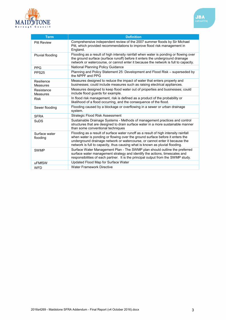
2016s4269 - Maidstone SFRA Addendum - Final Report (v4 October 2016).docx 3
Term Definition Pitt Review Comprehensive independent review of the 2007 summer floods by Sir Michael
Pitt, which provided recommendations to improve flood risk management in England.
Pluvial flooding Flooding as a result of high intensity rainfall when water is ponding or flowing over the ground surface (surface runoff) before it enters the underground drainage network or watercourse, or cannot enter it because the network is full to capacity.
PPG National Planning Policy Guidance PPS25 Planning and Policy Statement 25: Development and Flood Risk – superseded by
the NPPF and PPG Resilience Measures
Measures designed to reduce the impact of water that enters property and businesses; could include measures such as raising electrical appliances.
Resistance Measures
Measures designed to keep flood water out of properties and businesses; could include flood guards for example.
Risk In flood risk management, risk is defined as a product of the probability or likelihood of a flood occurring, and the consequence of the flood.
Sewer flooding Flooding caused by a blockage or overflowing in a sewer or urban drainage system.
SFRA Strategic Flood Risk Assessment SuDS Sustainable Drainage Systems - Methods of management practices and control
structures that are designed to drain surface water in a more sustainable manner than some conventional techniques
Surface water flooding
Flooding as a result of surface water runoff as a result of high intensity rainfall when water is ponding or flowing over the ground surface before it enters the underground drainage network or watercourse, or cannot enter it because the network is full to capacity, thus causing what is known as pluvial flooding.
SWMP Surface Water Management Plan - The SWMP plan should outline the preferred surface water management strategy and identify the actions, timescales and responsibilities of each partner. It is the principal output from the SWMP study.
uFMfSW Updated Flood Map for Surface Water WFD Water Framework Directive
2016s4269 - Maidstone SFRA Addendum - Final Report (v4 October 2016).docx 4
1 Introduction 1.1 Purpose of the Strategic Flood Risk Assessment
This Strategic Flood Risk Assessment (SFRA) 2016 addendum document updates elements of the Level 1 SFRA document prepared by Mott MacDonald for Maidstone Borough Council in May 2008. The addendum SFRA replaces sections of the 2008 issue and provides supporting evidence for the emerging Local Plan.
Sites allocated in the Local Plan have taken account of the National Planning Policy Framework (NPPF) (2012) and the National Planning Practice Guidance (NPPG). Maidstone Borough Council have used the Sequential Test or Exception Test in determining suitability of these sites. Where sites are shown to be at risk of flooding, these have been identified and recorded by Maidstone Borough Council to ensure the appropriate policy is put in place requiring a flood risk assessment.
Whilst NPPF requirements have been considered at allocation sites to date, the 2016 SFRA addendum provides an updated evidence base to inform decisions on the location of future development and the preparation of sustainable policies for the long-term management of flood risk.
The key objectives of the review performed during the preparation of the 2016 SFRA update were:
1. To take into account the latest flood risk policy There is a need to ensure the assessment is up to date with reference to the following key changes to policy and guidance that have occurred since the existing SFRA was published in 2008:
Changes to legislation, both relating to flood risk and planning policy, including the Flood Risk Regulations (2009), Flood and Water Management Act (2010), the National Planning Policy Framework (2012), the Localism Act (2011) and the Climate Change Act (2008); and new powers and responsibilities bestowed on Kent County Council as the Lead Local Flood Authority (LLFA) under the Flood and Water Management Act (2010) and their dependencies therefore with the Council’s local development and forward planning roles.
Recent guidance published in April 2015 regarding the role of LLFAs, Local Planning Authorities and the Environment Agency with regards to SuDS approval.
Changes to technical guidance, for example the Consultation on SuDS Regulations and Standards (2011), Defra’s Non-statutory technical standards for sustainable drainage systems (March 2015), and NPPF Planning Practice Guidance replacing PPS25 and PPG25, CIRIA SuDS Manual C753 (2015)
Latest guidance on climate change allowances for flood risk assessments released by the Environment Agency in February 2016.
2. Take into account the latest flood risk information and available data There have been a number of changes to available data that have occurred since the last SFRA was published in 2008:
Availability of the Environment Agency’s updated tidal flood risk modelling of the North Kent Coast, including the River Medway (2013)
Availability of the Environment Agency’s updated fluvial flood risk modelling of the River Len (2010) and River Medway, River Beult and River Teise (2015), including climate change modelling of the defended and undefended 1% AEP event with +35% and +70% flows (2016)
Fluvial flood risk modelling for a small reach of the Loose Stream (completed to inform this SFRA update)
Availability of the surface water flood risk dataset: updated Flood Map for Surface Water (uFMfSW)
Kent County Council Local Flood Risk Management Strategy (2013)
2016s4269 - Maidstone SFRA Addendum - Final Report (v4 October 2016).docx 5
Maidstone & Malling Surface Water Management Plan (2012) Maidstone Surface Water Management Plan (2013)
3. To provide a comprehensive set of maps including, but not limited to
fluvial flood risk, including functional floodplain and climate change; surface water risk; groundwater risk; and flood warning coverage.
1.2 SFRA objectives The Planning Practice Guidance advocates a tiered approach to risk assessment and identifies the following two levels of SFRA:
Level One: where flooding is not a major issue and where development pressures are low. The assessment should be sufficiently detailed to allow application of the Sequential Test.
Level Two: where land outside Flood Zones 2 and 3 cannot appropriately accommodate all the necessary development creating the need to apply the NPPF’s Exception Test. In these circumstances the assessment should consider the detailed nature of the flood characteristics within a Flood Zone and assessment of other sources of flooding.
In order to provide a robust evidence base and support the Council’s emerging Local Plan, the objectives of this SFRA 2016 document are to provide up to date information and replace sections of the existing Level 1 SFRA published in May 2008. This addendum report does not contain information that provide a complete replacement of the existing SFRA and some content from the 2008 version should still be used. The addendum SFRA only replaces selected sections of evidence from the previous document and the sections updated are discussed in section 1.3.
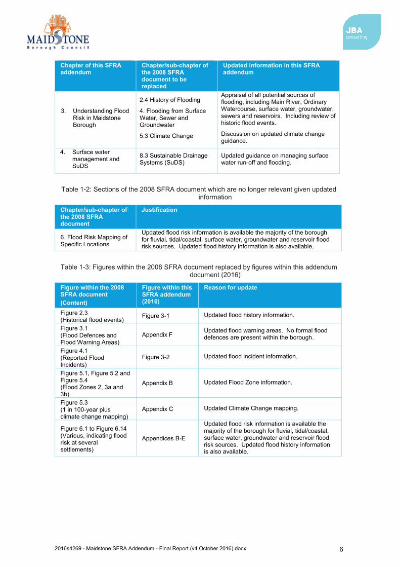
1.3 SFRA outputs To meet the objectives of an SFRA, this document has been prepared as an addendum report to the existing SFRA. It serves to inform and update several key chapters of the 2008 SFRA document. The chapters which this report replaces are outlined in Table 1-1. Sections of the previous 2008 SFRA document that are out of date given availability of new data, and should therefore not be used, are recorded in Table 1-2. Figures within the 2008 SFRA document that are replaced by those within this document are recorded in Table 1-3. Where updates have not been made it is considered that the information provided in the 2008 Level 1 SFRA is relevant to Maidstone Borough and supports the emerging Local Plan.
Table 1-1: Sections of this SFRA addendum report which replace sections of the previous SFRA document (2008)
Chapter of this SFRA addendum
Chapter/sub-chapter of the 2008 SFRA document to be replaced
Updated information in this SFRA addendum
1. Introduction
Including, but not limited to:
2.5 Existing Hydraulic Modelling and Mapping Studies
Update on the most recent flood modelling and mapping studies carried out on the main watercourses within the borough
2. The Planning Framework and Flood Risk Policy
1.2 Government Advice on Flood Risk
Review and update of government advice of flood risk and changes to planning policies and legislation.
2016s4269 - Maidstone SFRA Addendum - Final Report (v4 October 2016).docx 6
Chapter of this SFRA addendum
Chapter/sub-chapter of the 2008 SFRA document to be replaced
Updated information in this SFRA addendum
3. Understanding Flood Risk in Maidstone Borough
2.4 History of Flooding
4. Flooding from Surface Water, Sewer and Groundwater
5.3 Climate Change
Appraisal of all potential sources of flooding, including Main River, Ordinary Watercourse, surface water, groundwater, sewers and reservoirs. Including review of historic flood events.
Discussion on updated climate change guidance.
4. Surface water management and SuDS
8.3 Sustainable Drainage Systems (SuDS)
Updated guidance on managing surface water run-off and flooding.
Table 1-2: Sections of the 2008 SFRA document which are no longer relevant given updated information
Chapter/sub-chapter of the 2008 SFRA document
Justification
6. Flood Risk Mapping of Specific Locations
Updated flood risk information is available the majority of the borough for fluvial, tidal/coastal, surface water, groundwater and reservoir flood risk sources. Updated flood history information is also available.
Table 1-3: Figures within the 2008 SFRA document replaced by figures within this addendum document (2016)
Figure within the 2008 SFRA document (Content)
Figure within this SFRA addendum (2016)
Reason for update
Figure 2.3 (Historical flood events)
Figure 3-1 Updated flood history information.
Figure 3.1 (Flood Defences and Flood Warning Areas)
Appendix F Updated flood warning areas. No formal flood defences are present within the borough.
Figure 4.1 (Reported Flood Incidents)
Figure 3-2 Updated flood incident information.
Figure 5.1, Figure 5.2 and Figure 5.4 (Flood Zones 2, 3a and 3b)
Appendix B Updated Flood Zone information.
Figure 5.3 (1 in 100-year plus climate change mapping)
Appendix C Updated Climate Change mapping.
Figure 6.1 to Figure 6.14 (Various, indicating flood risk at several settlements)
Appendices B-E
Updated flood risk information is available the majority of the borough for fluvial, tidal/coastal, surface water, groundwater and reservoir flood risk sources. Updated flood history information is also available.
2016s4269 - Maidstone SFRA Addendum - Final Report (v4 October 2016).docx 7
1.4 Approach
1.4.1 General assessment of flood risk The flood risk management hierarchy underpins the risk-based approach and is the basis for making all decisions involving development and flood risk. When using the hierarchy, account should be taken of:
the nature of the flood risk (the source of the flooding); the spatial distribution of the flood risk (the pathways and areas affected by
flooding); climate change impacts; and the degree of vulnerability of different types of development (the receptors).
Future developments should reflect the application of the Sequential Test using the maps produced for this SFRA. The relevant information in this SFRA and the 2008 SFRA should be used as evidence and, where necessary, reference should also be made to relevant evidence in other documents referenced in this report. The Flood Zone maps and flood risk information on other sources of flooding contained in this SFRA should be used where appropriate to apply the Sequential Test.
Where other sustainability criteria outweigh flood risk issues, the decision making process should be transparent. Information from this SFRA should be used to justify decisions to allocate land in areas at high risk of flooding.
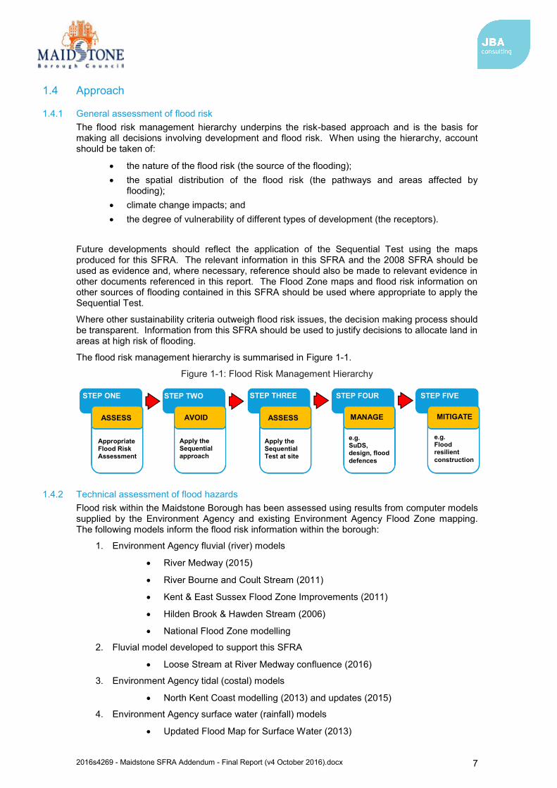
The flood risk management hierarchy is summarised in Figure 1-1.
Figure 1-1: Flood Risk Management Hierarchy
1.4.2 Technical assessment of flood hazards Flood risk within the Maidstone Borough has been assessed using results from computer models supplied by the Environment Agency and existing Environment Agency Flood Zone mapping. The following models inform the flood risk information within the borough:
1. Environment Agency fluvial (river) models
River Medway (2015)
River Bourne and Coult Stream (2011)
Kent & East Sussex Flood Zone Improvements (2011)
Hilden Brook & Hawden Stream (2006)
National Flood Zone modelling
2. Fluvial model developed to support this SFRA
Loose Stream at River Medway confluence (2016)
3. Environment Agency tidal (costal) models
North Kent Coast modelling (2013) and updates (2015)
4. Environment Agency surface water (rainfall) models
Updated Flood Map for Surface Water (2013)
STEP ONE STEP TWO STEP THREE STEP FOUR STEP FIVE
ASSESS AVOID ASSESS MANAGE MITIGATE
Appropriate Flood Risk Assessment
Apply the Sequential approach
Apply the Sequential Test at site
e.g. SuDS, design, flood defences
e.g. Flood resilient construction
2016s4269 - Maidstone SFRA Addendum - Final Report (v4 October 2016).docx 8
1.5 Consultation The following parties (external to Maidstone Borough Council) have been consulted during the preparation of this version of the SFRA:
Environment Agency
Kent County Council (as Lead Local Flood Authority)
Southern Water
1.6 SFRA user guide This SFRA 2016 document is an addendum report that serve to update the key chapters of the existing Level 1 SFRA published in 2008. The structure and contents of this addendum report are outlined in Table 1-4.
Table 1-4: SFRA update structure and contents
Chapter Section Contents
1 Introduction Provides a background to the study, defines objectives, outlines the approach adopted and the consultations performed.
2 The Planning Framework and Flood Risk Policy
Includes information on the implications of recent changes to planning and flood risk policies and legislation.
3 Understanding flood risk in Maidstone Borough
Gives an introduction to the assessment of flood risk and provides an overview of the characteristics of flooding affecting the district. Provides a summary of responses that can be made to flood risk, together with policy and institutional issues that should be considered.
4 Surface water management and SuDS
Advice on managing surface water run-off and flooding. Important to incorporate updates as there have been many changes in regard to surface water management. This includes the latest guidance documents (e.g. Kent SuDS guidance and the Water. People. Places: a guide to master planning sustainable drainage into developments).
5 Summary Reviews the Level 1 SFRA update and provides recommendations
2016s4269 - Maidstone SFRA Addendum - Final Report (v4 October 2016).docx 9
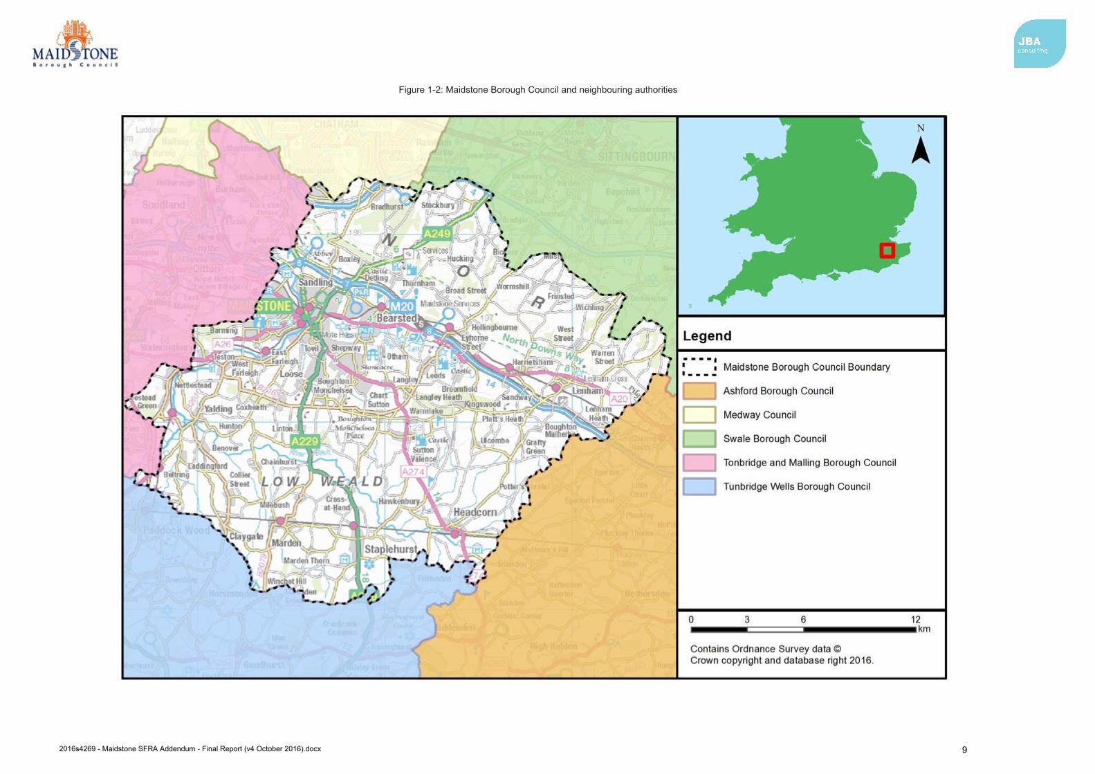
Figure 1-2: Maidstone Borough Council and neighbouring authorities
2016s4269 - Maidstone SFRA Addendum - Final Report (v4 October 2016).docx 10
2 The Planning Framework and Flood Risk Policy 2.1 Introduction
The overarching aim of development and flood risk planning policy in the UK is to ensure that the potential risk of flooding is taken into account at every stage of the planning process. This section of the addendum SFRA provides an overview of the planning framework, flood risk policy and flood risk responsibilities. In preparing the subsequent sections of this SFRA, appropriate planning and policy amendments have been acknowledged and taken into account.
2.2 Flood Risk Regulations (2009) and Flood and Water Management Act (2010)
2.2.1 Flood Risk Regulations (2009) The Flood Risk Regulations (2009) are intended to translate the current EU Floods Directive into UK law and place responsibility upon all Lead Local Flood Authorities (LLFAs) to manage localised flood risk. Under the Regulations, the responsibility for flooding from rivers, the sea and reservoirs lies with the Environment Agency. However, responsibility for local and all other sources of flooding rests with LLFAs. In the instance of this SFRA, the LLFA is Kent County Council.
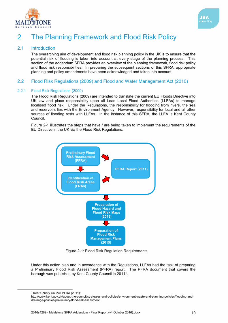
Figure 2-1 illustrates the steps that have / are being taken to implement the requirements of the EU Directive in the UK via the Flood Risk Regulations.
Figure 2-1: Flood Risk Regulation Requirements
Under this action plan and in accordance with the Regulations, LLFAs had the task of preparing a Preliminary Flood Risk Assessment (PFRA) report. The PFRA document that covers the borough was published by Kent County Council in 20111.
1 Kent County Council PFRA (2011): http://www.kent.gov.uk/about-the-council/strategies-and-policies/environment-waste-and-planning-policies/flooding-and-drainage-policies/preliminary-flood-risk-assesment
PFRA Report (2011)
Preparation of Flood Hazard and Flood Risk Maps
(2013)
Identification of Flood Risk Areas
(FRAs)
Preliminary Flood Risk Assessment
(PFRA)
Preparation of Flood Risk
Management Plans (2015)
2016s4269 - Maidstone SFRA Addendum - Final Report (v4 October 2016).docx 11
Under the Regulations the Environment Agency exercised an ‘Exception’ and did not prepare a PFRA for risk from rivers, reservoirs and the sea. This then made it a requirement for the Environment Agency to prepare and publish a Flood Risk Management Plan (FRMP). The FRMP process adopts the same catchments as used in the preparation of River Basin Management Plans, in accordance with the Water Framework Directive. Accordingly, more detailed strategic information on proposed strategic measures and approaches can be found in the Thames River Basin District Flood Risk Management Plan - Parts A, B, C and D2. The FRMP draws on previous policies and actions identified in Catchment Flood Management Plans and also incorporates information from Local Flood Risk Management Strategies. The plan covers all of the London Boroughs and 17 contributing catchments covered by the Thames River Basin, including Maidstone Borough, which lies within the Medway catchment area. The FRMP summarises the flooding affecting the area and describes the measures to be taken to address the risk in accordance with the Flood Risk Regulations.
2.2.2 Flood and Water Management Act (2010) The Flood and Water Management Act (2010)3 aims to create a simpler and more effective means of managing both flood risk and coastal erosion and implements Sir Michael Pitt’s recommendations following his review of the 2007 floods. The FWMA received Royal Assent in April 2010.
Kent County Council as LLFA has developed a Local Flood Risk Management Strategy (LFRMS) under the Act, in consultation with local partners. This is discussed further in section 2.2.5. This Strategy acts as the basis and discharge of duties and responsibilities for Flood Risk Management co-ordinated by Kent County Council. The final version of the strategy was published for June 2013.
Local authorities are responsible for flooding management relating to ‘Ordinary Watercourses’ (i.e. smaller ditches, brooks), groundwater and other sources of risk with the Environment Agency responsible for ‘Main Rivers’, the sea and reservoirs.
When considering planning applications, Local Planning Authorities should consult LLFAs on the management of surface water in order to satisfy that:
1. the proposed minimum standards of operation are appropriate 2. through the use of planning conditions or planning obligations, there are clear
arrangements for on-going maintenance over the development’s lifetime. The FWMA will also update the Reservoirs Act 1975 by reducing the capacity of reservoir regulation from 25,000m3 to 10,000m3. Phase 1 was implemented in 2013 and requires large raised reservoirs to be registered to allow the Environment Agency to categorise whether they are ‘high risk’ or ‘not high risk’.
2.2.3 Lead Local Flood Authorities The FWMA established LLFAs. Kent County Council is the LLFA for the Maidstone Borough Council administrative area. Duties of LLFAs include:
Local Flood Risk Management Strategy: LLFAs must develop, maintain, apply and monitor an LFRMS to outline how they will manage flood risk, identify areas vulnerable to flooding and target resources where they are needed most.
Flood Investigations: When appropriate and necessary, LLFAs must investigate and report on flooding incidents (Section 19 investigations).
Register of Flood Risk Features: LLFAs must establish and maintain a register of structures or features which, in their opinion, are likely to have a significant effect on flood risk in the LLFA area.
Designation of Features: LLFAs may exercise powers to designate structures and features that affect flood risk, requiring the owner to seek consent from the authority to alter, remove or replace it.
2 Environment Agency, Thames River Basin District Flood Risk Management Plan 2015-2021 Part C (March 2016). Available: https://www.gov.uk/government/publications/thames-river-basin-district-flood-risk-management-plan 3 Flood and Water Management Act (2010): http://www.legislation.gov.uk/ukpga/2010/29/pdfs/ukpga_20100029_en.pdf
2016s4269 - Maidstone SFRA Addendum - Final Report (v4 October 2016).docx 12
Consenting: When appropriate LLFAs will perform consenting of works on Ordinary Watercourses.
On 18 December 2014 a Written Ministerial Statement laid by the Secretary of State for Communities and Local Government set out changes to the planning process that would apply for major development from 6 April 2015. In considering planning applications, local planning authorities should consult the LLFA on the management of surface water, satisfy themselves that the proposed minimum standards of operation are appropriate and ensure, and through use of planning conditions or obligations, that there are clear arrangements in place for ongoing maintenance over the lifetime of the development.
In March 2015 the LLFA was made a statutory consultee which came into effect on 15 April 2015. As a result, Kent County Council, will be required to provide technical advice on surface water drainage strategies and designs put forward for new major developments.
Major developments are defined as
Residential development: 10 dwellings or more, or residential development with a site area of 0.5 hectares or more where the number of dwellings is not yet known; and
Non-residential development: provision of a building or buildings where the total floor space to be created is 1,000 square metres or more or, where the floor area is not yet known, a site area of 1 hectare or more.
2.2.4 Kent Preliminary Flood Risk Assessment (2011) The Flood Risk Regulations required Kent County Council (as the LLFA) to prepare and publish a Preliminary Flood Risk Assessment (PFRA) on past and future flood risk from sources of flooding. The PFRA reports on significant past and future flooding from all sources except from Main Rivers and Reservoirs, which are covered by the Environment Agency, and sub-standard performance of the adopted sewer network (covered under the remit of Southern Water).
The PFRA is a high-level screening exercise and considers floods which have significant harmful consequences for human health, economic activity, the environment and cultural heritage. The Regulations require the LLFA to identify significant Flood Risk Areas. The threshold for designating significant Flood Risk Areas is defined by Defra and the PFRA is the process by which these locations can be identified. Of the ten national Indicative Flood Risk Areas that were identified by the Defra/Environment Agency, one was found to encroach on the administrative area of Maidstone Borough Council. However, given that the Flood Risk Area is primarily located in Chatham and Gillingham, the Flood Risk Area was amended to the Medway Council administrative boundary and does not include any parts of Kent County Council.
No Flood Risk Areas have been identified based on critical infrastructure/access routes, sewer/surface water problems and areas prone to significant ponding.
2.2.5 Kent Local Flood Risk Management Strategy (2013)4 Kent County Council is responsible for developing, maintaining, applying and monitoring a LFRMS for Kent, which covers the Maidstone Borough. The Strategy is used as a means by which the LLFA (Kent County Council) co-ordinates Flood Risk Management on a day to day basis. The Strategy also sets measures to manage local flood risk i.e. flood risk from surface water, groundwater and Ordinary Watercourses. The Environment Agency is responsible for managing flooding from main rivers and reservoirs, while the LLFA responsible for managing Ordinary Watercourses. The objectives of the Strategy are to:
1. Improve the understanding of the risks of flooding from surface runoff, groundwater and ordinary watercourses in Kent.
2. Reduce the risk of flooding for people and businesses in Kent. 3. Ensure that development in Kent takes account of flood risk issues and plans to
effectively manage any impacts.
4 http://www.kent.gov.uk/about-the-council/strategies-and-policies/environment-waste-and-planning-policies/flooding-and-drainage-policies/kent-flood-risk-management-plan
2016s4269 - Maidstone SFRA Addendum - Final Report (v4 October 2016).docx 13
4. Provide clear information and guidance on the role of the public sector, private sector and individuals in flood risk management in Kent, how those roles will be delivered and how authorities will work together to manage flood risk.
5. Ensure that emergency plans and responses to flood incidents in Kent are effective, and that communities understand the risks and their role in an emergency.
The Strategy also sets out an action plan of how the LLFA intends to achieve these objectives. The action plan contains the following information:
A description of the action. The objective the action relates to. The driver behind the action. The organisation with key accountability. Supporting organisations. The funding source. When the action was added. Timescale for completion or current status.
The Strategy should be updated regularly or when key triggers are activated. An example of a key trigger would be issues such as amendments to partner responsibilities, updates to legislation, alterations in the nature or understanding of flood risk or a significant flood event, may also require the update of the Strategy and action plan.
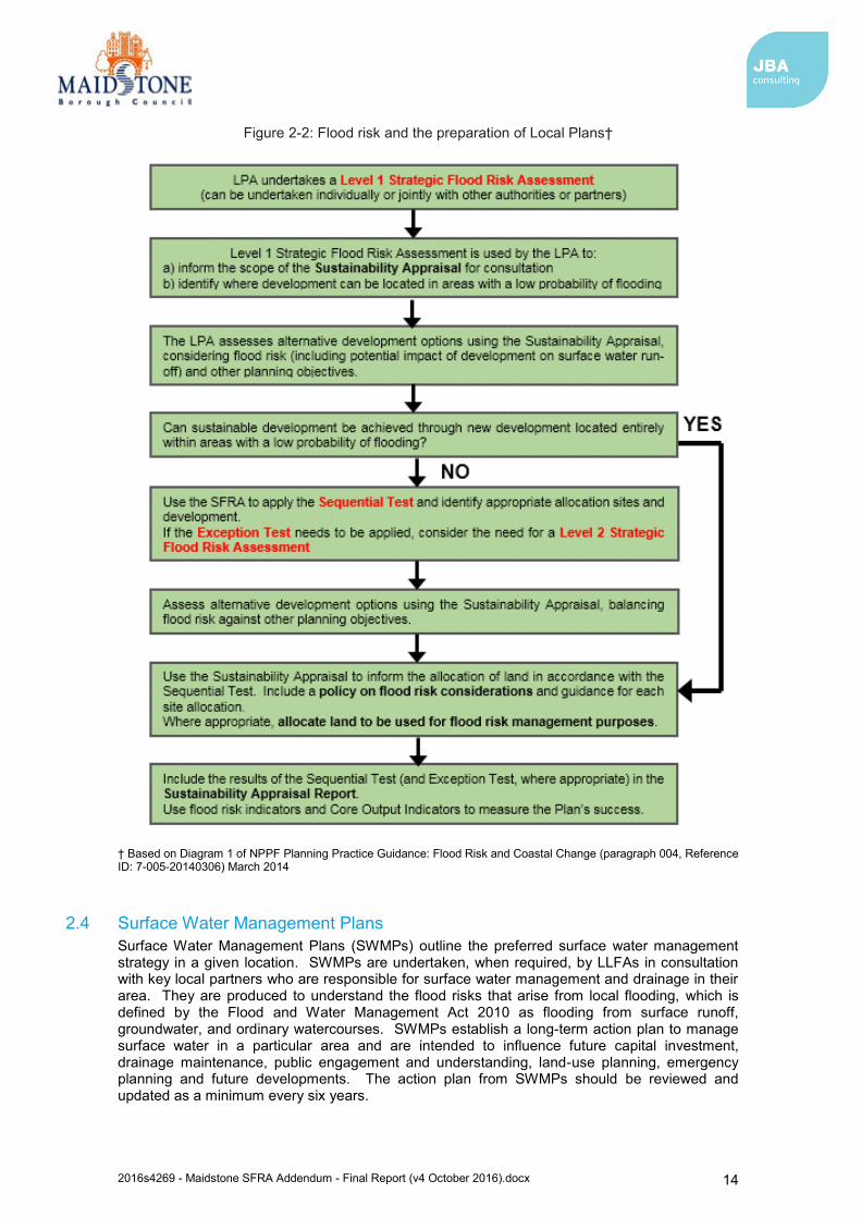
2.3 National Planning Policy Framework The National Planning Policy Framework (NPPF)5 was issued on 27 March 2012 to replace the previous documentation as part of reforms to, firstly, make the planning system less complex and more accessible, and, secondly, to protect the environment and promote sustainable growth. It replaces most of the Planning Policy Guidance Notes (PPGs) and Planning Policy Statements (PPSs) that were referred to in the previous version of the SFRA. The NPPF is a source of guidance for local planning authorities to help them prepare Local Plans and for applicants preparing planning submissions.
Paragraph 100 of the NPPF:
Planning Practice Guidance on flood risk was published in March 2014 and sets out how the policy should be implemented. NPPF sets out Flood Zones, the appropriate land uses for each zone, flood risk assessment requirements and the policy aims for developers and authorities regarding each Flood Zone.
A description of how flood risk should be taken into account in the preparation of Local Plans is outlined in Diagram 1 contained within the Planning Practice Guidance (Figure 2-2).
5 National Planning Policy Framework (Department for Communities and Local Government, March 2012)
“Local Plans should be supported by a strategic flood risk assessment and develop policies to manage flood risk from all sources, taking account of advice from the Environment Agency and other relevant flood risk management bodies, such as Lead Local Flood Authorities and Internal Drainage Boards. Local Plans should apply a sequential, risk-based approach to the location of development to avoid, where possible, flood risk to people and property and manage any residual risk, taking account of the impacts of climate change”.
2016s4269 - Maidstone SFRA Addendum - Final Report (v4 October 2016).docx 14
Figure 2-2: Flood risk and the preparation of Local Plans†
† Based on Diagram 1 of NPPF Planning Practice Guidance: Flood Risk and Coastal Change (paragraph 004, Reference ID: 7-005-20140306) March 2014
2.4 Surface Water Management Plans Surface Water Management Plans (SWMPs) outline the preferred surface water management strategy in a given location. SWMPs are undertaken, when required, by LLFAs in consultation with key local partners who are responsible for surface water management and drainage in their area. They are produced to understand the flood risks that arise from local flooding, which is defined by the Flood and Water Management Act 2010 as flooding from surface runoff, groundwater, and ordinary watercourses. SWMPs establish a long-term action plan to manage surface water in a particular area and are intended to influence future capital investment, drainage maintenance, public engagement and understanding, land-use planning, emergency planning and future developments. The action plan from SWMPs should be reviewed and updated as a minimum every six years.
2016s4269 - Maidstone SFRA Addendum - Final Report (v4 October 2016).docx 15
Surface Water Management Plans (SWMPs) applicable to Maidstone Borough are listed below, with links provided to these documents.
Maidstone Stage 1 SWMP6 (2013)
Maidstone and Malling Stage 1 SWMP7 (2012)
The outcomes and actions from each of these SWMPs should be considered in the context of proposed developments within the area of Maidstone Borough.
It should be noted that Stage 2 SWMPs for Marden, Staplehurst and Headcorn were commissioned in 2014 in order to provide a detailed understanding of the causes and consequences of surface water flooding and test the benefits and costs of proposed mitigation measures. Again, the outcomes and actions from each of these Stage 2 SWMPs should be considered in the context of proposed developments within these areas once these documents have been published by Kent County Council.
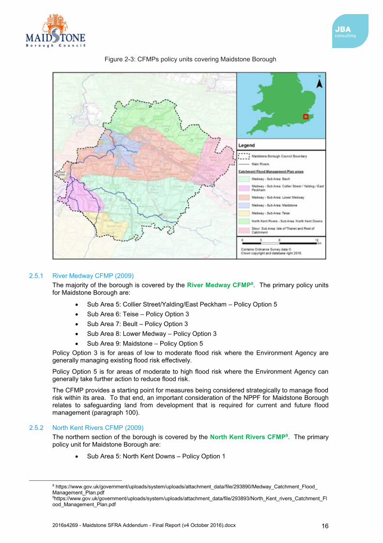
2.5 Catchment Flood Management Plans Catchment Flood Management Plans (CFMPs) are a high-level strategic plan providing an overview of flood risk across each river catchment. The Environment Agency use CFMPs to work with other key-decision makers to identify and agree long-term policies for sustainable flood risk management.
There are six pre-defined national policies provided in the CFMP guidance and these are applied to specific locations through the identification of ‘Policy Units’. These policies are intended to cover the full range of long-term flood risk management options that can be applied to different locations in the catchment.
The six national policies are:
1. No active intervention (including flood warning and maintenance). Continue to monitor and advise.
2. Reducing existing flood risk management actions (accepting that flood risk will increase over time).
3. Continue with existing or alternative actions to manage flood risk at the current level (accepting that flood risk will increase over time from this baseline).
4. Take further action to sustain the current level of flood risk (responding to the potential increases in risk from urban development, land use change and climate change).
5. take action to reduce flood risk (now and/or in the future) 6. Take action with others to store water or manage run-off in locations that provide
overall flood risk reduction or environmental benefits, locally or elsewhere in the catchment.
CFMPs provide a starting point for measures being considered strategically to manage flood risk within their areas. To that end, an important consideration of the NPPF for Maidstone Borough relates to safeguarding land from development that is required for current and future flood management (paragraph 100).
The CFMPs covering Maidstone Borough and the relevant sub-areas with assigned national policies are shown in Figure 2-3.
6 http://www.kent.gov.uk/about-the-council/strategies-and-policies/environment-waste-and-planning-policies/flooding-and-drainage-policies/surface-water-management-plans/maidstone-surface-water-management-plan 7 http://www.kent.gov.uk/about-the-council/strategies-and-policies/environment-waste-and-planning-policies/flooding-and-drainage-policies/surface-water-management-plans/maidstone-and-malling-surface-water-management-plan
2016s4269 - Maidstone SFRA Addendum - Final Report (v4 October 2016).docx 16
Figure 2-3: CFMPs policy units covering Maidstone Borough
2.5.1 River Medway CFMP (2009) The majority of the borough is covered by the River Medway CFMP8. The primary policy units for Maidstone Borough are:
Sub Area 5: Collier Street/Yalding/East Peckham – Policy Option 5 Sub Area 6: Teise – Policy Option 3 Sub Area 7: Beult – Policy Option 3 Sub Area 8: Lower Medway – Policy Option 3 Sub Area 9: Maidstone – Policy Option 5
Policy Option 3 is for areas of low to moderate flood risk where the Environment Agency are generally managing existing flood risk effectively.
Policy Option 5 is for areas of moderate to high flood risk where the Environment Agency can generally take further action to reduce flood risk.
The CFMP provides a starting point for measures being considered strategically to manage flood risk within its area. To that end, an important consideration of the NPPF for Maidstone Borough relates to safeguarding land from development that is required for current and future flood management (paragraph 100).
2.5.2 North Kent Rivers CFMP (2009) The northern section of the borough is covered by the North Kent Rivers CFMP9. The primary policy unit for Maidstone Borough are:
Sub Area 5: North Kent Downs – Policy Option 1
8 https://www.gov.uk/government/uploads/system/uploads/attachment_data/file/293890/Medway_Catchment_Flood_ Management_Plan.pdf 9https://www.gov.uk/government/uploads/system/uploads/attachment_data/file/293893/North_Kent_rivers_Catchment_Flood_Management_Plan.pdf
2016s4269 - Maidstone SFRA Addendum - Final Report (v4 October 2016).docx 17
Policy Option 1 is for areas where there are very few properties at risk of flooding and the Environment Agency will continue to monitor and advise.
The CFMP notes that the sub-area covers the upper reaches of several watercourses in the North Kent Downs and that flood risk in this area is low as no flood damage was identified and no people or property were affected by flooding.
2.5.3 Stour CFMP (2009) The eastern most section of the borough is covered by the Stour CFMP10. The primary policy units for Maidstone Borough are:
Sub Area 9: Isle of Thanet and Rest of Catchment – Policy Option 1 Policy Option 1 is for area where there are very few properties at risk of flooding and the Environment Agency will continue to monitor and advise.
The CFMP notes that there has been little or no risk of flooding from rivers, surface water or foul water flooding.
2.6 River Basin Management Plans River Basin Management Plans (RBMPs) are prepared under the Water Framework Directive (WFD) and assesses the pressure facing the water environment in River Basin Districts. The WFD aims to achieve at least 'good' status for all water bodies by 2015. The Maidstone Borough Council area falls within the Thames River Basin District.
2.6.1 Thames River Basin Management Plan (2015) The second cycle of The Thames RBMP11 was published in February 2016, replacing the previous version published in 2009. The document provides information on the following:
Current state of the water environment Pressures affecting the water environment Environmental objectives for protecting and improving waters Programme of measures. And actions needed to achieve the objectives Progress since the 2009 plan
The Thames RBMP identified a number of significant water management issues, including:
Physical modifications Pollution from waste water Pollution from towns, cities and transport Changes to the natural flow and level of water Negative effects of invasive non-native species Pollution from rural areas
The RBMP describes how development planning needs to consider a number of issues relevant to the RBMP including housing locations, sewage treatment options, initiatives to reduce flow to sewage works, water efficiency measures and the reduction of nutrients from diffuse pollution.
The RBMP notes that 11% of water bodies in the Thames River Basin District currently have a ‘good or better’ overall status, which is expected to increase to 13% by 2021. However, this ‘good or better’ overall status is forecast to increase notably for the extended deadline of 2027 reported in the RBMP.
10https://www.gov.uk/government/uploads/system/uploads/attachment_data/file/293884/Stour_Catchment_Flood_Management_Plan.pdf 11https://www.gov.uk/government/uploads/system/uploads/attachment_data/file/500548/Thames_RBD_Part_1_river_basin_management_plan.pdf
2016s4269 - Maidstone SFRA Addendum - Final Report (v4 October 2016).docx 18
2.7 Water Cycle Studies Future changes in climate and increases in new development are expected to exert greater pressure on the existing waste water supply and infrastructure. A large number of new homes for instance may cause the existing water supply infrastructure to be overwhelmed which would result in adverse effects on the environment both locally and in wider catchments. Planning for water management therefore has to take these potential challenges into account.
Water Cycle Studies (WCS) assist local authorities to select and develop sustainable development allocations so that there is minimal impact on the environment, water quality, water resources, infrastructure and flood risk. This can be achieved in areas where there may be conflict between any proposed development and requirements of the environment through the recommendation of potential sustainable solutions.
Maidstone Borough Council prepared a Water Cycle Study Outline Report12 in June 2010 as part of their planning process following the borough’s designation as a Growth Point for significant new development. The document highlights that there were some potential constraints to development, related to the capacity of the sewerage network in Maidstone Town. It is noted that if a solution is not found, the number of new homes that can be provided in and around Maidstone Town will be seriously restricted, particularly for potential sites in the south-east area adjacent to the town. Furthermore, it is considered that the limited capacity of the wastewater treatment plant at Headcorn will restrict the number of new homes that can be provided in the area, and similar restrictions may occur at Yalding and Harrietsham. The WCS should be consulted to understand and manage potential impacts of a proposed develop on the environment, water quality, water resources, infrastructure and flood risk.
2.8 Association of British Insurers Guidance on Insurance and Planning in Flood Risk Areas for Local Planning Authorities in England The Association of British Insurers (ABI) and the National Flood Forum have published guidance for Local Authorities with regards to planning in flood risk areas13. The guidance aims to assist Local Authorities in England in producing local plans and dealing with planning applications in flood risk areas. The guidance complements the National Planning Policy Framework. The key recommendations from the guidance are:
Ensure strong relationships with technical experts on flood risk. Consider flooding from all sources, taking account of climate change. Take potential impacts on drainage infrastructure seriously. Ensure that flood risk is mitigated to acceptable levels for proposed developments. Make sure Local Plans take account of all relevant costs and are regularly reviewed.
2.9 Implications for Maidstone Borough The new and emerging responsibilities under the Flood and Water Management Act 2010 and the Flood Risk Regulations 2009 are summarised in Table 2-1.
12 Halcrow group Limited, (June, 2010), Maidstone Borough Council Water Cycle Study – Outline Report 13 Guidance on Insurance and Planning in Flood Risk Areas for Local Planning Authorities in England (Association of British Insurers and National Flood Forum, April 2012)
2016s4269 - Maidstone SFRA Addendum - Final Report (v4 October 2016).docx 19
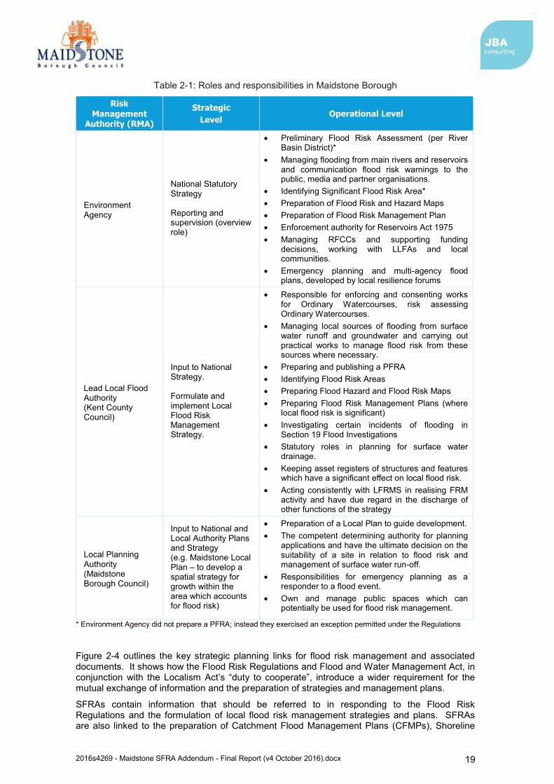
Table 2-1: Roles and responsibilities in Maidstone Borough
Risk Management
Authority (RMA)
Strategic Level
Operational Level
Environment Agency
National Statutory Strategy Reporting and supervision (overview role)
Preliminary Flood Risk Assessment (per River Basin District)*
Managing flooding from main rivers and reservoirs and communication flood risk warnings to the public, media and partner organisations.
Identifying Significant Flood Risk Area* Preparation of Flood Risk and Hazard Maps Preparation of Flood Risk Management Plan Enforcement authority for Reservoirs Act 1975 Managing RFCCs and supporting funding
decisions, working with LLFAs and local communities.
Emergency planning and multi-agency flood plans, developed by local resilience forums
Lead Local Flood Authority (Kent County Council)
Input to National Strategy. Formulate and implement Local Flood Risk Management Strategy.
Responsible for enforcing and consenting works for Ordinary Watercourses, risk assessing Ordinary Watercourses.
Managing local sources of flooding from surface water runoff and groundwater and carrying out practical works to manage flood risk from these sources where necessary.
Preparing and publishing a PFRA Identifying Flood Risk Areas Preparing Flood Hazard and Flood Risk Maps Preparing Flood Risk Management Plans (where
local flood risk is significant) Investigating certain incidents of flooding in
Section 19 Flood Investigations Statutory roles in planning for surface water
drainage. Keeping asset registers of structures and features
which have a significant effect on local flood risk. Acting consistently with LFRMS in realising FRM
activity and have due regard in the discharge of other functions of the strategy
Local Planning Authority (Maidstone Borough Council)
Input to National and Local Authority Plans and Strategy (e.g. Maidstone Local Plan – to develop a spatial strategy for growth within the area which accounts for flood risk)
Preparation of a Local Plan to guide development. The competent determining authority for planning
applications and have the ultimate decision on the suitability of a site in relation to flood risk and management of surface water run-off.
Responsibilities for emergency planning as a responder to a flood event.
Own and manage public spaces which can potentially be used for flood risk management.
* Environment Agency did not prepare a PFRA; instead they exercised an exception permitted under the Regulations
Figure 2-4 outlines the key strategic planning links for flood risk management and associated documents. It shows how the Flood Risk Regulations and Flood and Water Management Act, in conjunction with the Localism Act’s “duty to cooperate”, introduce a wider requirement for the mutual exchange of information and the preparation of strategies and management plans.
SFRAs contain information that should be referred to in responding to the Flood Risk Regulations and the formulation of local flood risk management strategies and plans. SFRAs are also linked to the preparation of Catchment Flood Management Plans (CFMPs), Shoreline
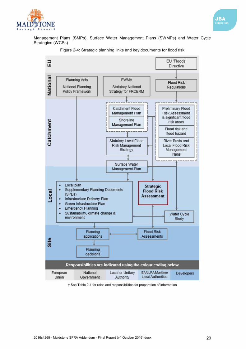
2016s4269 - Maidstone SFRA Addendum - Final Report (v4 October 2016).docx 20
Management Plans (SMPs), Surface Water Management Plans (SWMPs) and Water Cycle Strategies (WCSs).
Figure 2-4: Strategic planning links and key documents for flood risk
† See Table 2-1 for roles and responsibilities for preparation of information
2016s4269 - Maidstone SFRA Addendum - Final Report (v4 October 2016).docx 21
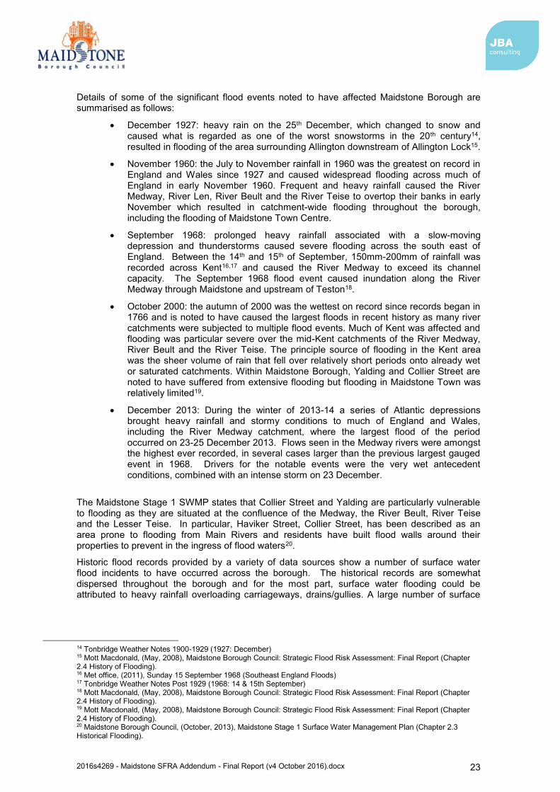
3 Understanding flood risk in Maidstone Borough 3.1 Historical flooding
The Medway has been subject to a number of documented flood events, with the main cause being from ‘fluvial’ (river/watercourse networks) sources.
Historic flood events have been recorded from the River Medway, Teise, Lesser Teise and the River Beult. The most notable flood events recorded from these rivers occurred in 1927, 1960, 1963, 1968 and 2000, and caused widespread flooding across the borough. Data provided by the Environment Agency also indicates that significant flooding occurred within the borough during Winter 2013/2014 and included notable flooding from the River Medway.
Historical flood records provided by the Environment Agency, Maidstone Borough Council and Kent County Council identify fluvial flood events to have occurred between 1927 and 2014. The south-west area of the borough is identified to have experienced extensive flooding between 1927 and 2014 and the following locations are noted to have been effected by at least one historical event during this time period:
Maidstone Ringlestone Bearsted East Farleigh West Farleigh Teston Nettlestead Yalding Laddingford Beltring
Benover Collier Street Chainhurst Claygate Marden Marden Thorn Staplehurst Cross-at-Hand Hawkenbury Headcorn
The maximum extent of flooding indicated by this historical data (all extents from these events combined) and locations of the Main Rivers across Maidstone are shown in Figure 3-1. Whilst an account of historic flooding throughout the Borough is presented within this section, it should be noted that the majority of flooding occurrences are not reported. It is very likely that other areas of the Borough are at risk of flooding and have experienced flooding previously, but this might not have been recorded. Therefore, areas identified in this section should not be taken as definitive, but instead indicative of the distribution of flood risk within Maidstone Borough. Additional investigation into historic flooding which may have influenced proposed development sites should be conducted as site allocations are progressed.

2016s4269 - Maidstone SFRA Addendum - Final Report (v4 October 2016).docx 22
Figure 3-1: Historical fluvial flooding extent within Maidstone Borough
2016s4269 - Maidstone SFRA Addendum - Final Report (v4 October 2016).docx 23
Details of some of the significant flood events noted to have affected Maidstone Borough are summarised as follows:
December 1927: heavy rain on the 25th December, which changed to snow and caused what is regarded as one of the worst snowstorms in the 20th century14, resulted in flooding of the area surrounding Allington downstream of Allington Lock15.
November 1960: the July to November rainfall in 1960 was the greatest on record in England and Wales since 1927 and caused widespread flooding across much of England in early November 1960. Frequent and heavy rainfall caused the River Medway, River Len, River Beult and the River Teise to overtop their banks in early November which resulted in catchment-wide flooding throughout the borough, including the flooding of Maidstone Town Centre.
September 1968: prolonged heavy rainfall associated with a slow-moving depression and thunderstorms caused severe flooding across the south east of England. Between the 14th and 15th of September, 150mm-200mm of rainfall was recorded across Kent16,17 and caused the River Medway to exceed its channel capacity. The September 1968 flood event caused inundation along the River Medway through Maidstone and upstream of Teston18.
October 2000: the autumn of 2000 was the wettest on record since records began in 1766 and is noted to have caused the largest floods in recent history as many river catchments were subjected to multiple flood events. Much of Kent was affected and flooding was particular severe over the mid-Kent catchments of the River Medway, River Beult and the River Teise. The principle source of flooding in the Kent area was the sheer volume of rain that fell over relatively short periods onto already wet or saturated catchments. Within Maidstone Borough, Yalding and Collier Street are noted to have suffered from extensive flooding but flooding in Maidstone Town was relatively limited19.
December 2013: During the winter of 2013-14 a series of Atlantic depressions brought heavy rainfall and stormy conditions to much of England and Wales, including the River Medway catchment, where the largest flood of the period occurred on 23-25 December 2013. Flows seen in the Medway rivers were amongst the highest ever recorded, in several cases larger than the previous largest gauged event in 1968. Drivers for the notable events were the very wet antecedent conditions, combined with an intense storm on 23 December.
The Maidstone Stage 1 SWMP states that Collier Street and Yalding are particularly vulnerable to flooding as they are situated at the confluence of the Medway, the River Beult, River Teise and the Lesser Teise. In particular, Haviker Street, Collier Street, has been described as an area prone to flooding from Main Rivers and residents have built flood walls around their properties to prevent in the ingress of flood waters20.
Historic flood records provided by a variety of data sources show a number of surface water flood incidents to have occurred across the borough. The historical records are somewhat dispersed throughout the borough and for the most part, surface water flooding could be attributed to heavy rainfall overloading carriageways, drains/gullies. A large number of surface
14 Tonbridge Weather Notes 1900-1929 (1927: December) 15 Mott Macdonald, (May, 2008), Maidstone Borough Council: Strategic Flood Risk Assessment: Final Report (Chapter 2.4 History of Flooding). 16 Met office, (2011), Sunday 15 September 1968 (Southeast England Floods) 17 Tonbridge Weather Notes Post 1929 (1968: 14 & 15th September) 18 Mott Macdonald, (May, 2008), Maidstone Borough Council: Strategic Flood Risk Assessment: Final Report (Chapter 2.4 History of Flooding). 19 Mott Macdonald, (May, 2008), Maidstone Borough Council: Strategic Flood Risk Assessment: Final Report (Chapter 2.4 History of Flooding). 20 Maidstone Borough Council, (October, 2013), Maidstone Stage 1 Surface Water Management Plan (Chapter 2.3 Historical Flooding).
2016s4269 - Maidstone SFRA Addendum - Final Report (v4 October 2016).docx 24
water flood incidents are noted to have occurred in Harrietsham, Marden, Staplehurst and Headcorn21.
Other incidents of historical flood records provided by Maidstone Borough Council and Kent County Council are summarised as follows:
Sewer flooding in areas surrounding Headcorn, Staplehurst, Marden, Yalding and Lenham. In particular, records indicate regular flooding east of Marden Thorn due to a broken surcharging sewer. Records do not specify any property flooding
Flooding at Nettlestead Green, Chainhurst and Hunton due to the low-lying nature of the ground in these areas. Records do not specify any property flooding.
Flooding from highway assets at Honey Lane, Church Lane and Lenham Road
Flooding from unknown or other sources in several locations across the borough.
3.1.1 Winter 2013-2014 flooding The most recent significant flood events to affect Maidstone occurred in the winter of 2013-2014. The Kent Severe Weather Impacts Monitoring System (SWIMS) recorded five successive weather events across Kent and Medway:
The St Jude’s storm (28 October 2013) Fluvial event (1 November 2013) East coast tidal surge (5-6 December 2013) Fluvial and Surface water floods (20 December 2013 – 28 March 2014) Groundwater floods (25 January 2014).
The SWIMS Event Summary Report for Kent & Medway states that Kent received 242% of the long-term average rainfall during the 2013-2014 winter. As part of the National Severe Weather Warning Service, 43 Yellow and 7 Amber weather warnings as well as 63 flood alerts were issued.
Of particular note is the storm of the 23rd-24th December 2013, which bought heavy rain (50-70mm) to southern England and caused significant widespread flooding22. Approximately 76mm of rain fell within 24 hours on the saturated Medway catchment, which caused the River Medway to rise significantly23.
The Leigh Flood Storage Area Review states that the December 2013 flows in the Medway rivers were amongst the highest ever recorded and exceeded those of the September 1968 event in several places. Although the Leigh Flood Storage Area (FSA) held back over 5.5 million cubic meters of water between the 24th and 27th of December, the storage capacity at the FSA was insufficient to prevent all flooding from occurring. The communities affected by the flooding within Maidstone Borough were Laddingford, Yalding, Collier Street and Maidstone. The impacts from wider reports are summarised as follows:
Over 900 homes and businesses in Tonbridge, Maidstone, Yalding, East Peckham and other smaller communities were flooded from the River Medway and its tributaries24.
A total of 262 properties were flooded in the Maidstone25.
o Specifically, 207 residential properties and 55 commercial properties were flooded. However, this is likely to be an underestimate as they mainly consist of properties known to have flooded by rivers, groundwater or groundwater-fed rivers. Information of surface water and sewer flooding is less certain. 26.
21 Maidstone Borough Council, (October, 2013), Maidstone Stage 1 Surface Water Management Plan (Chapter 2.3 Historical Flooding). 22 The Met Office: Winter Storms, December 2013 to January 2014 (July, 2014) 23 The Environment Agency Press Release: New defence to reduce flood risk in Tonbridge (December, 2015) 24 Environment Agency, (2015), River Medway Flood Storage Areas (FSAs) Project 25 Thanet District Council: Christmas & New Year 2013-2014 Storms & Floods Final Report (Appendix 1) 26 Thanet District Council: Christmas & New Year 2013-2014 Storms & Floods Final Report (Appendix 1)
2016s4269 - Maidstone SFRA Addendum - Final Report (v4 October 2016).docx 25
197 properties were flooded when river levels peaked on 24 December 201327 and a total of 700 homes were reported to have flooded in Yalding alone28.
Two rest centres were opened in Maidstone with Kent County Council Family and Social Care staff on stand-by at all times to provide a 24-hour continuous response29.
3.2 Fluvial flood risk
3.2.1 Watercourses As noted in the existing Level 1 SFRA, there is approximately 70km of Main River in Maidstone Borough. The main watercourse flowing through the borough is the River Medway and major tributaries include the River Beult and the River Teise, which join the Medway at Yalding upstream of Maidstone Town. The main watercourses flowing through the borough are:
River Medway
River Beult
River Teise
River Len
Lesser Teise
Loose Stream
Paddock Wood Stream
Coult Stream
Great Stour
Tributaries to the watercourses listed above include Ordinary Watercourses and man-made drains. A summary of each main watercourse is provided in Table 3-1.
The River Medway catchment (at Allington Lock: NGR 574850 158150) receives approximately 740mm of rain on average per year30. The average runoff from the Medway catchment through Allington is in excess of 400 million cubic meters. Flows are reported to vary widely, with winter and spring producing three times the average of the summer and autumn months31.
3.2.2 Flood risk The primary source of fluvial flood risk in the catchment is associated with the River Medway. The Main Rivers in Maidstone Borough are detailed in Table 3-1 and a figure of their location is provided in Appendix A.
Water levels in the River Medway are influenced by fluvial inflows for the majority of the borough. However, in the vicinity of Allington, water levels in the River Medway are also influenced by tidal/estuarine effects and it has been known for the backwater effect from tidal water to reach as far upstream as East Farleigh32. The Medway has been subject to many flood events, and, as a result, Maidstone has experienced severe flooding on several occasions. The most recent flood event to affect Maidstone occurred in Winter 2013/2014 when the river exceeded its capacity and caused the town centre as well as Laddingford, Yalding and Collier Street to flood.
Although flooding was worse than that experienced during 2000 for many areas, it is noted that in central Maidstone approximately 2.5ha of floodplain and banks alongside the River Len have been re-naturalised with woodland and wetland since 200233. Therefore, the flood risk to the
27 Thanet District Council: Christmas & New Year 2013-2014 Storms & Floods Final Report (Appendix 1) 28 SWIMS Event Summary Report for Kent & Medway Winter 2013-2014 Full Report 29 SWIMS Event Summary Report for Kent & Medway Winter 2013-2014 Full Report 30 FEH CD-ROM v3.0 © NERC (CEH). © Crown copyright. © AA. (2009) 31 Mott Macdonald, (May, 2008), Maidstone Borough Council: Strategic Flood Risk Assessment: Final Report (Chapter 2. Background) 32 Mott Macdonald, (May, 2008), Maidstone Borough Council: Strategic Flood Risk Assessment: Final Report (Chapter 2. Background Information) 33 Kent County Council (March, 2016), Flood Risk to Communities – Maidstone
2016s4269 - Maidstone SFRA Addendum - Final Report (v4 October 2016).docx 26
area has been reduced and properties that were affected in 2000 were not flooded during Winter 2013/201434.
Other fluvial flood risk areas identified in the borough are from the main tributaries of the River Medway (River Beult, River Teise and the Lesser Teise) and the confluence of these tributaries with the River Medway. For example, the village of Yalding is located on the River Beult approximately 500m upstream of the confluence with the River Medway and flooding to property has occurred on numerous occasions in the past35. Moreover, complex flooding issues are experienced at Collier Street due to its location on the confluence of these watercourses, and residents now have their own property level protection scheme to prevent the ingress of flood water as a result36.
Ordinary watercourses are reported to have contributed to past flooding in the borough. Common factors described in these records report the perceived causes of flooding to be attributed to one or all of the following:
Poor maintenance of watercourses
Blocked infrastructure, such as culverts
Insufficient channel capacity
High water levels in watercourses impeding the drainage of flows from their associated tributaries.
In addition to flood risk shown by the flood risk mapping, there are a number of small watercourses and field drains which may pose a risk to development. Generalised Flood Zone mapping (where more detailed modelling investigations are not available) is only available for watercourses with a catchment greater than 3km2. Therefore, whilst these smaller watercourses may not be shown as having flood risk on the flood risk mapping, it does not necessarily mean that there is no flood risk. As part of a site-specific flood risk assessment it will be necessary to assess the risk from these smaller watercourses where these may influence the site.
Given the widespread flooding recorded historically within the borough (particularly along the River Medway floodplain and the area surrounding the confluence of the Medway with its main tributaries as evidenced in Figure 3-1) particular areas (e.g. roads and settlements) of the borough susceptible to fluvial flooding have not been listed here. Although there are no formal defences within Maidstone Borough, a number of structures (walls and embankments) and formal defences upstream (e.g. Leigh Flood Storage Area) and downstream (e.g. tidal flood walls) of Maidstone act to reduce flooding. This may be particularly important when considering the Functional Floodplain (Flood Zone 3b) for development proposals. For further information regarding the defences in Maidstone Borough, please refer to Chapter 3 (Flood Defence and Management) of the existing Level 1 SFRA.
The delineation of the Flood Zones and the areas of Maidstone Borough which are within these zones is displayed in Appendix B. Consideration of how climate change may influence the predicted Flood Zones in the future is indicated within mapping included in Appendix C.
34 Kent County Council (March, 2016), Flood Risk to Communities – Maidstone 35 Kent County Council (March, 2016), Flood Risk to Communities – Maidstone 36 Kent County Council (March, 2016), Flood Risk to Communities – Maidstone
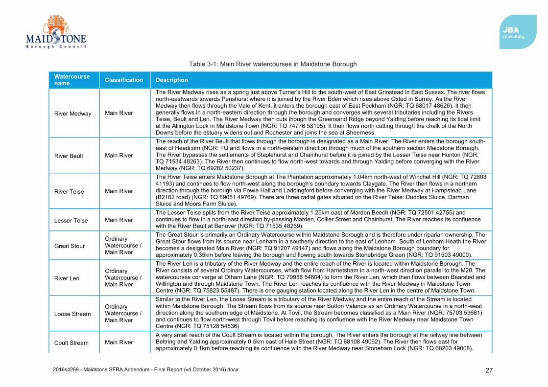
2016s4269 - Maidstone SFRA Addendum - Final Report (v4 October 2016).docx 27
Table 3-1: Main River watercourses in Maidstone Borough
Watercourse name Classification Description
River Medway Main River
The River Medway rises as a spring just above Turner’s Hill to the south-west of East Grinstead in East Sussex. The river flows north-eastwards towards Penshurst where it is joined by the River Eden which rises above Oxted in Surrey. As the River Medway then flows through the Vale of Kent, it enters the borough east of East Peckham (NGR: TQ 68017 48626). It then generally flows in a north-eastern direction through the borough and converges with several tributaries including the Rivers Teise, Beult and Len. The River Medway then cuts though the Greensand Ridge beyond Yalding before reaching its tidal limit at the Allington Lock in Maidstone Town (NGR: TQ 74776 58105). It then flows north cutting through the chalk of the North Downs before the estuary widens out and Rochester and joins the sea at Sheerness.
River Beult Main River
The reach of the River Beult that flows through the borough is designated as a Main River. The River enters the borough south-east of Headcorn (NGR: TQ and flows in a north-western direction through much of the southern section Maidstone Borough. The River bypasses the settlements of Staplehurst and Chainhurst before it is joined by the Lesser Teise near Hunton (NGR: TQ 71534 48263). The River then continues to flow north-west towards and through Yalding before converging with the River Medway (NGR: TQ 69282 50237).
River Teise Main River
The River Teise enters Maidstone Borough at The Plantation approximately 1.04km north-west of Winchet Hill (NGR: TQ 72803 41193) and continues to flow north-west along the borough’s boundary towards Claygate. The River then flows in a northern direction through the borough via Fowle Hall and Laddingford before converging with the River Medway at Hampstead Lane (B2162 road) (NGR: TQ 69051 49769). There are three radial gates situated on the River Teise: Duddies Sluice, Darman Sluice and Moors Farm Sluice).
Lesser Teise Main River The Lesser Teise splits from the River Teise approximately 1.25km east of Marden Beech (NGR: TQ 72501 42755) and continues to flow in a north-east direction by-passing Marden, Collier Street and Chainhurst. The River reaches its confluence with the River Beult at Benover (NGR: TQ 71535 48259).
Great Stour Ordinary Watercourse / Main River
The Great Stour is primarily an Ordinary Watercourse within Maidstone Borough and is therefore under riparian ownership. The Great Stour flows from its source near Lenham in a southerly direction to the east of Lenham. South of Lenham Heath the River becomes a designated Main River (NGR: TQ 91207 49147) and flows along the Maidstone Borough boundary for approximately 0.35km before leaving the borough and flowing south towards Stonebridge Green (NGR: TQ 91503 49000).
River Len Ordinary Watercourse / Main River
The River Len is a tributary of the River Medway and the entire reach of the River is located within Maidstone Borough. The River consists of several Ordinary Watercourses, which flow from Harrietsham in a north-west direction parallel to the M20. The watercourses converge at Otham Lane (NGR: TQ 79956 54804) to form the River Len, which then flows between Bearsted and Willington and through Maidstone Town. The River Len reaches its confluence with the River Medway in Maidstone Town Centre (NGR: TQ 75823 55487). There is one gauging station located along the River Len in the centre of Maidstone Town.
Loose Stream Ordinary Watercourse / Main River
Similar to the River Len, the Loose Stream is a tributary of the River Medway and the entire reach of the Stream is located within Maidstone Borough. The Stream flows from its source near Sutton Valence as an Ordinary Watercourse in a north-west direction along the southern edge of Maidstone. At Tovil, the Stream becomes classified as a Main River (NGR: 75703 53661) and continues to flow north-west through Tovil before reaching its confluence with the River Medway near Maidstone Town Centre (NGR: TQ 75128 54836)
Coult Stream Main River A very small reach of the Coult Stream is located within the borough. The River enters the borough at the railway line between Beltring and Yalding approximately 0.5km east of Hale Street (NGR: TQ 68108 49062). The River then flows east for approximately 0.1km before reaching its confluence with the River Medway near Stoneham Lock (NGR: TQ 68203 49008).
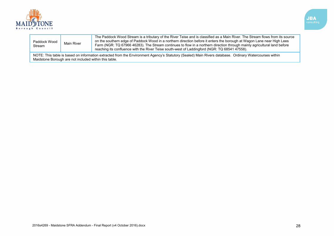
2016s4269 - Maidstone SFRA Addendum - Final Report (v4 October 2016).docx 28
Paddock Wood Stream
Main River
The Paddock Wood Stream is a tributary of the River Teise and is classified as a Main River. The Stream flows from its source on the southern edge of Paddock Wood in a northern direction before it enters the borough at Wagon Lane near High Lees Farm (NGR: TQ 67966 46283). The Stream continues to flow in a northern direction through mainly agricultural land before reaching its confluence with the River Teise south-west of Laddingford (NGR: TQ 68541 47558).
NOTE: This table is based on information extracted from the Environment Agency’s Statutory (Sealed) Main Rivers database. Ordinary Watercourses within Maidstone Borough are not included within this table.
2016s4269 - Maidstone SFRA Addendum - Final Report (v4 October 2016).docx
3.3 Tidal flood risk Tidal flood risk is assessed based on Extreme Still Water Sea Levels (ESWSL). An ESWSL is the level the sea is expected to reach during a storm event for a particular magnitude of flood event as a result of the combination of tides and surges. As these levels are based on ‘still’ water, the effect of short-term fluctuations in sea level associated with wind and swell waves are not included.
The tidal influence of the River Medway extends from the far north of the borough to beyond Allington Lock which is located within near the boundary of the borough. The tidal limit of the River Medway is at Allington Sluice. However, despite the presence of Sluice gates at Allington, tidal backwater effects can influence water level depths upstream during extreme events and it has been known for the backwater effect to reach as far upstream as East Farleigh37. Interrogation of the Environment Agency’s recorded flood outline dataset38 indicates the last known tidal flood event to flood areas of Maidstone Borough occurred in 1927 when the channel capacity was exceeded and there was no presence of raised flood defences. This flood event caused areas of Aylesford and Allington to flood as a result and the Maidstone Borough Stage 1 SWMP states that there are approximately 7 properties that may have been affected by flooding39.
However, the dataset also indicates that that the most significant even recorded occurred in 1953 when defences lining this part of the River Medway were overtopped (outside of Maidstone Borough boundary). Areas within the settlements of Aylesford, Lunsford, New Hythe and Snodland flooded as a result. Although no areas within Maidstone Borough were flooded during this event, improvements to the costal and tidal defences following the 1953 event should be kept in mind when reviewing the dataset.
Tidal flooding is caused by extreme tide levels exceeding ground and/or defence levels. Flood Zones 1, 2 and 3 delineate areas at low risk, medium risk and high risk respectively from both tidal and fluvial flooding. Flood Zones do not take into account the effects of flood defences, and as such typically provide a worst-case assessment of flood risk. The delineation of the Flood Zones and the areas of Maidstone Borough which are within zones is displayed in Appendix B. Consideration of how climate change may influence the predicted Flood Zones in the future is indicated within mapping of Appendix C.
Flood Zones 2 and 3 represent the area that would be flooded in the 0.5% AEP and 0.1% AEP tidal events, respectively, in the absence of defences. In the context of the borough, tidal Flood Zone extents are small. Where tidal flooding is predicted Flood Zone 2 is larger in extent than Flood Zone 3a north of the M20, and Flood Zone 2 is also shown to extend upstream along the River Medway channel which Flood Zone 3a is not. It is expected that Flood Zone 3a should also extend upstream along the River Medway beyond Allington Lock, but flood risk modelling has not been completed to date to evidence this.
It has been identified that no formal defences are present within the borough. However, defences are located upstream (Leigh FSA and East Peckham FSA) and downstream (tidal flood walls/embankments) of the borough. The probability of failure of defences is reduced by the actions of the defence owners in maintaining these, but there remains a residual risk from flooding. Should defences form part of future development plans within the borough, it would be necessary that assessment of the ‘residual’ risk of defence failure (e.g. breach) be considered. It may also be important to understand how existing defences outside of the borough may influence flood risk at a future development site.
3.4 Surface water flooding Flooding from surface water runoff (or ‘pluvial’ flooding) is usually caused by intense rainfall that may only last a few hours. Flooding usually occurs when rainfall fails to infiltrate to the ground or enter the drainage system. Ponding generally occurs at low points in the topography. The likelihood of flooding is dependent on not only the rate of runoff but also saturation of the
37 Mott Macdonald, (May, 2008), Maidstone Borough Council: Strategic Flood Risk Assessment: Final Report (Chapter 2 Background Information) 38 Environment Agency Historic Flood Map 39 Maidstone Borough Council, (October, 2013), Maidstone Stage 1 Surface Water Management Plan (Appendix C2: DA02 – Maidstone Rural Mid).
2016s4269 - Maidstone SFRA Addendum - Final Report (v4 October 2016).docx
receiving soils, the groundwater levels and the condition of the surface water drainage system (i.e. surface water sewers, highway authority drains and gullies, open channels, ordinary watercourses and SuDS). Surface water flooding problems are inextricably linked to issues of poor drainage, or drainage blockage by debris, and sewer flooding.
The updated Flood Map for Surface Water (uFMfSW) predominantly follows topographical flow paths of existing watercourses or dry valleys with some isolated ponding located in low lying areas. Mapping of the uFMfSW throughout the borough is provided in Appendix D.
Surface water flood records provided by a variety of data sources are shown in Figure 3-2. It should be noted that the records provided cover the period from 2008 to 2016 or do not have a date specified. Therefore, it is assumed that there have been at least 153 records of surface water flooding across the borough since 2008.
Although the Maidstone Borough Stage 1 SWMP states that historical records are relatively dispersed throughout the borough, several historical records are found to be located in clusters surrounding Marden, Staplehurst, Headcorn, Harrietsham and Bearsted (Figure 3-2). For the most part, surface water flooding was attributed to heavy rainfall overloading carriageways, drains and gullies. However, in other instances, the cause of flooding was perceived to be from blocked drains and gullies, which was the result of receiving watercourses impeding free discharge from surface water drains and gullies.
Repeated incidents have been highlighted within Harrietsham, Marden, Staplehurst and Headcorn. Specifically, it is noted that gullies located near Ashford Road, Harrietsham, require regular cleansing otherwise the whole carriageway floods. Furthermore, perceived causes of recorded flood events in the latter locations include local topography, inefficient drainage systems, or blockages in the drainage system. For areas of the Borough where specific surface runoff and drainage issues have been identified, it will normally be expected that development in these areas should contribute to the Community Infrastructure Levy, natural flood management, or local, targeted highways improvements to reduce the local flood risk in the area.
3.5 Groundwater flooding Compared with other sources of flooding, the current understanding of the risks posed by groundwater flooding is limited and mapping of flood risk from groundwater sources is in its infancy. Under the Flood and Water Management Act (2010), LLFAs have powers to undertake risk management functions in relation to groundwater flood risk. Groundwater level monitoring records are available for areas on Major Aquifers. However, for low lying valley areas, which are typically associated with mudstones, clays and superficial alluvial deposits, very few records are available. In these areas, flooding from the ground may be more likely to result from prolonged periods of rainfall resulting in periods where water levels are perched near to the ground surface and potentially enhanced springflows. Additionally, there is increased risk of groundwater flooding where long reaches of watercourses are culverted due to elevated groundwater levels not being able to naturally pass into watercourses and be conveyed to less susceptible areas.
As part of the SFRA deliverables, mapping of the whole borough has been provided showing the Areas Susceptible to Groundwater Flooding (AStGWF). This information is provided in Appendix E. The AStGWF is a strategic-scale map showing groundwater flood areas on a 1km square grid. The data was produced to annotate indicative Flood Risk Areas for PFRA studies and allow the LLFAs to determine whether they may be at risk of flooding from groundwater. This data shows the proportion of each 1km grid square, where geological and hydrogeological conditions indicate that groundwater might emerge. It does not show the likelihood of groundwater flooding occurring, nor does it take account of the chance of flooding from groundwater rebound. This dataset covers a large area of land and only isolated locations within the overall susceptible area are actually likely to suffer the consequences of groundwater flooding.
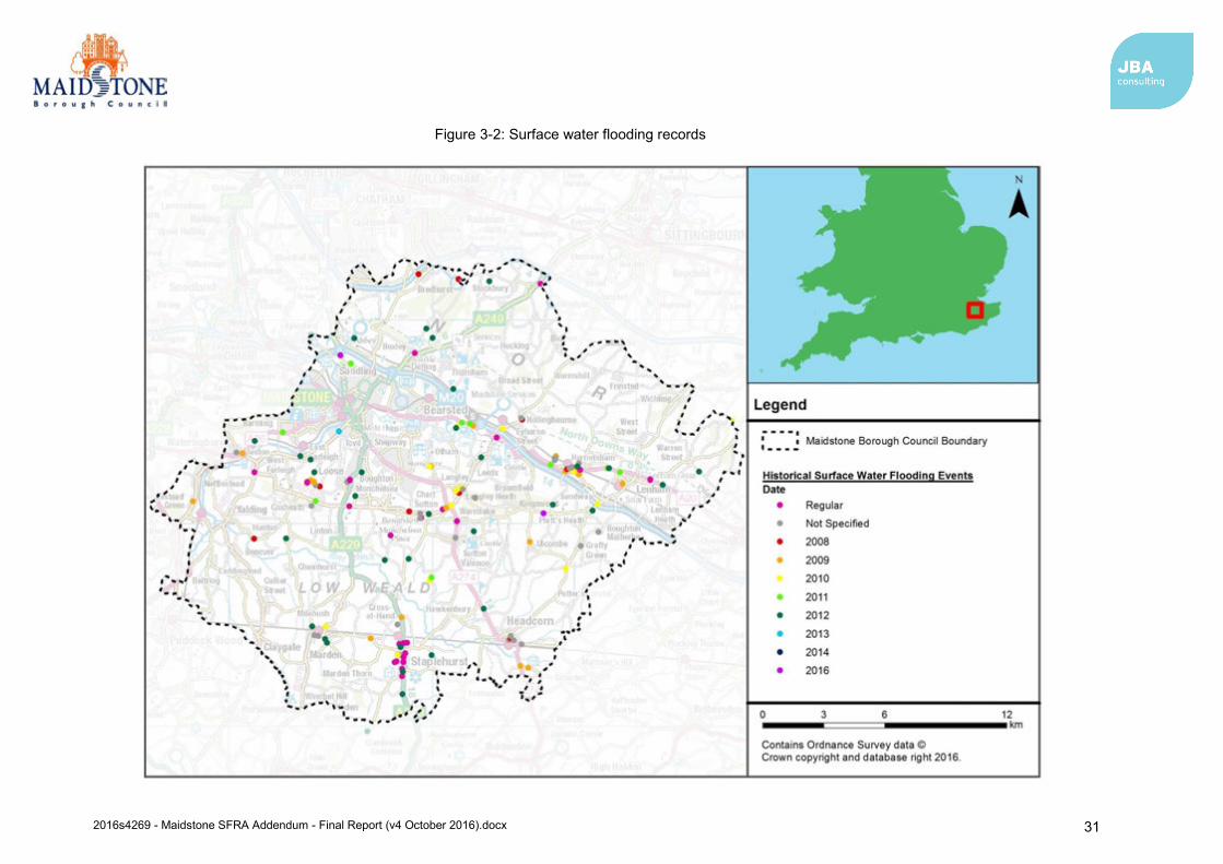
2016s4269 - Maidstone SFRA Addendum - Final Report (v4 October 2016).docx 31
Figure 3-2: Surface water flooding records
2016s4269 - Maidstone SFRA Addendum - Final Report (v4 October 2016).docx 32
The information indicates that the areas susceptible to groundwater flooding are primarily located in the central and southern sections of the borough. For the most part, susceptibility to groundwater flooding is considered to be low as less than 25% of the area within the 1km grid squares are considered to be susceptible to groundwater flooding.
However, the greatest susceptibility of groundwater flooding is focused in the following areas as greater than 25% of the area within the 1km grid squares are considered to be susceptible to groundwater flooding:
Headcorn
Staplehurst
Marden
Benover
Hunton
Yalding
Harrietsham
Bearsted
Willington
This strongly links with the bedrock and superficial deposits in the borough. Harrietsham, Bearsted and Willington overly the Lower Greensand Group, which is an unconfined aquifer and the high permeability of these deposits are likely to contribute to groundwater flooding in these areas.
Although the clay in the Wealden Group beneath the southern section of the borough prohibits groundwater, the superficial geology (River Terrace and Alluvial deposits) underlying these areas may be a contributing factor to their susceptibility to groundwater flooding.
The AStGWF data should be used only in combination with other information, for example local or historical data. It should not be used as sole evidence for any specific flood risk management, land use planning or other decisions at any scale. However, the data can help to identify areas for assessment at a local scale where finer resolution datasets exist. It should be noted that although an area may be designated as susceptible to groundwater flooding, this does not mean that groundwater flooding will definitely be a problem within these areas, rather it provides an indication of the risk.
The 2008 Level 1 SFRA states that most of the reports of groundwater flooding are noted to be isolated singular incidents. However, a number of groundwater flooding incidents were reported in Boughton Monchelsea40. Boughton Monchelsea is a complex area for flood risk, and flood risk in the area is likely to be a combination of fluvial, groundwater and surface water flood sources. Proposed developments in this area and others will need to consider how these sources of risk, and possible interaction can be managed. Elsewhere, the Maidstone Stage 1 SWMP identified one recorded event of groundwater flooding at Water Lane, Harrietsham, due to the local springs affecting the highway41.
It is noted that it can be difficult to ascertain if a source of flooding is from groundwater. This is because the flood risk may be the result of a combination of sources, or a culverted watercourse that may have been mistaken for a spring or an underground stream42. Nonetheless, developers planning to build within groundwater emergence zones should still investigate whether groundwater flooding is likely to be a problem locally.
3.6 Flooding from artificial sources
3.6.1 Flooding from sewers Sewer flooding occurs when intense rainfall overloads the sewer system capacity (surface water, foul or combined), and/or when sewers cannot discharge freely into watercourses due to high water levels. Sewer flooding can also be caused when problems such as blockages, collapses or equipment failure occur in the sewerage system. Infiltration, entry of soil or groundwater into sewer systems via faults within the fabric of the sewerage system, is another cause of sewer
40 Mott Macdonald, (May, 2008), Maidstone Borough Council: Strategic Flood Risk Assessment: Final Report (Chapter 4 Flooding from Surface Water, Sewer and Groundwater) 41 Maidstone Borough Council, (October, 2013), Maidstone Stage 1 Surface Water Management Plan (Chapter 2.3 Historical Flooding). 42 Maidstone Borough Council, (October, 2013), Maidstone Stage 1 Surface Water Management Plan (Chapter 2.3 Historical Flooding).
2016s4269 - Maidstone SFRA Addendum - Final Report (v4 October 2016).docx 33
flooding. Infiltration is often related to shallow groundwater, and may cause high flows for prolonged periods of time. The Maidstone Stage 1 SWMP identified that records of historical flooding were predominantly caused by hydraulic overload of sewers or an overloaded pumping station43.
The existing Level 1 SFRA identifies that incidents of sewer flooding are more prominent in urban areas where there is a higher density of sewers and more water being discharged into the sewer system, although local incidents have been reported in more rural areas of the borough44. The majority of sewer flooding events are described to have occurred in the areas surrounding Maidstone, Staplehurst, Marden, Headcorn and Lenham.
Since 1980, the Sewers for Adoption45 guidelines have meant that the majority of new surface water sewers have been designed to have capacity for a rainfall event with a 1 in 30 chance of occurring in any given year. However, until recently this did not apply to smaller private systems. This therefore means that even where sewers are built to the current specification, they are likely to be overwhelmed by events of magnitude often considered when investigating the risk of river or surface water flooding (e.g. 1 in 100 chance of occurring in any given year). Existing sewers can also become overloaded due to new developments adding to their catchment or incremental increases in roofed and paved surfaces at the individual property scale (urban creep). Sewer flooding is therefore a problem that could occur in many locations across the borough.
Historical incidents of flooding are detailed by Southern Water in their DG5 register. This database records incidents of flooding relating to public foul, combined or surface water sewers and displays which properties experienced flooding. For confidentiality reasons, this data has been supplied on a postcode basis from the Sewer Incident Report Form (SIRF) hydraulic overload database. Data covers all reported incidence as of its export of 28 April 2016. The information from the SIRF database is shown in Table 3-2.
The SIRF hydraulic overload information indicates a total of 188 recorded flood incidents in Maidstone Borough within the last 5-year period. The more frequently flooded postcodes are TN12 9 (41), ME18 6 (28), TN12 0 (22) and TN27 9 (22). It is important to recognise that the information does not present whether flooding incidences were caused by general exceedance of the design sewer system, or by operational issues such as blockages. The information also represents a snap shot in time and may become outdated following future rainfall events.
Furthermore, risk in some areas may reduce in some locations by capital investment to increase of the capacity of the network. As such, the sewer flooding flood risk is not a comprehensive ‘at risk register’ and updated information should be sought to enhance understanding of flood risk from sewers at a given location.
Table 3-2: SIRF database for Maidstone Borough
Post Code Number of Recorded Flood Incidents Post Code Number of Recorded
Flood Incidents ME14 2 9 ME17 1 4 ME14 3 1 ME17 2 4 ME14 4 4 ME17 3 3 ME14 5 3 ME17 4 3 ME15 0 5 ME18 5 5 ME15 6 4 ME18 6 28 ME15 7 8 TN12 0 22 ME15 8 9 TN12 5 1 ME15 9 2 TN126 2 ME16 0 2 TN12 9 41 ME16 8 4 TN27 9 22 ME16 9 2
Total: 188 Note: based on information exported on 28/04/2016
43 Maidstone Borough Council, (October, 2013), Maidstone Stage 1 Surface Water Management Plan (Chapter 2.3 Historical Flooding). 44 Mott Macdonald, (May, 2008), Maidstone Borough Council: Strategic Flood Risk Assessment: Final Report (Chapter 4 Flooding from Surface Water, Sewer and Groundwater) 45 Sewers for Adoption 7th Edition - A Design & Construction Guide for Developer. WRc plc. September 2012.
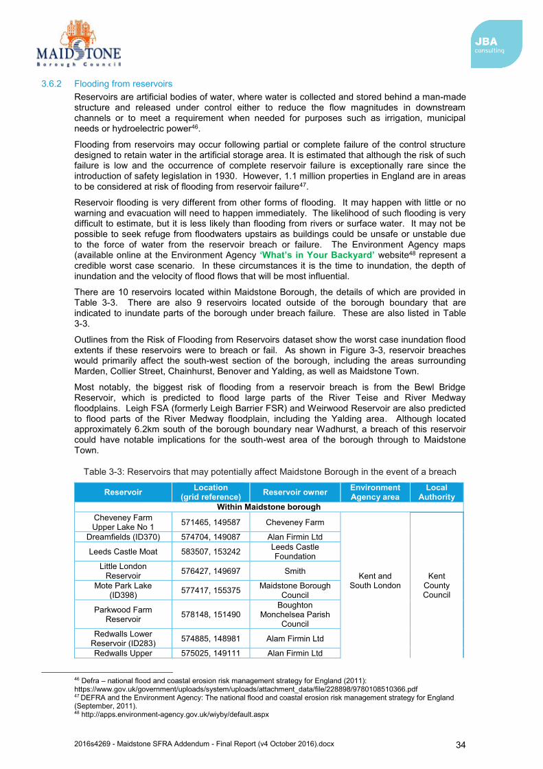
2016s4269 - Maidstone SFRA Addendum - Final Report (v4 October 2016).docx 34
3.6.2 Flooding from reservoirs Reservoirs are artificial bodies of water, where water is collected and stored behind a man-made structure and released under control either to reduce the flow magnitudes in downstream channels or to meet a requirement when needed for purposes such as irrigation, municipal needs or hydroelectric power46.
Flooding from reservoirs may occur following partial or complete failure of the control structure designed to retain water in the artificial storage area. It is estimated that although the risk of such failure is low and the occurrence of complete reservoir failure is exceptionally rare since the introduction of safety legislation in 1930. However, 1.1 million properties in England are in areas to be considered at risk of flooding from reservoir failure47.
Reservoir flooding is very different from other forms of flooding. It may happen with little or no warning and evacuation will need to happen immediately. The likelihood of such flooding is very difficult to estimate, but it is less likely than flooding from rivers or surface water. It may not be possible to seek refuge from floodwaters upstairs as buildings could be unsafe or unstable due to the force of water from the reservoir breach or failure. The Environment Agency maps (available online at the Environment Agency ‘What’s in Your Backyard’ website48 represent a credible worst case scenario. In these circumstances it is the time to inundation, the depth of inundation and the velocity of flood flows that will be most influential.
There are 10 reservoirs located within Maidstone Borough, the details of which are provided in Table 3-3. There are also 9 reservoirs located outside of the borough boundary that are indicated to inundate parts of the borough under breach failure. These are also listed in Table 3-3.
Outlines from the Risk of Flooding from Reservoirs dataset show the worst case inundation flood extents if these reservoirs were to breach or fail. As shown in Figure 3-3, reservoir breaches would primarily affect the south-west section of the borough, including the areas surrounding Marden, Collier Street, Chainhurst, Benover and Yalding, as well as Maidstone Town.
Most notably, the biggest risk of flooding from a reservoir breach is from the Bewl Bridge Reservoir, which is predicted to flood large parts of the River Teise and River Medway floodplains. Leigh FSA (formerly Leigh Barrier FSR) and Weirwood Reservoir are also predicted to flood parts of the River Medway floodplain, including the Yalding area. Although located approximately 6.2km south of the borough boundary near Wadhurst, a breach of this reservoir could have notable implications for the south-west area of the borough through to Maidstone Town.
Table 3-3: Reservoirs that may potentially affect Maidstone Borough in the event of a breach
Reservoir Location (grid reference) Reservoir owner Environment
Agency area Local
Authority Within Maidstone borough
Cheveney Farm Upper Lake No 1 571465, 149587 Cheveney Farm
Kent and South London
Kent County Council
Dreamfields (ID370) 574704, 149087 Alan Firmin Ltd
Leeds Castle Moat 583507, 153242 Leeds Castle Foundation
Little London Reservoir 576427, 149697 Smith
Mote Park Lake (ID398) 577417, 155375 Maidstone Borough
Council
Parkwood Farm Reservoir 578148, 151490
Boughton Monchelsea Parish
Council Redwalls Lower
Reservoir (ID283) 574885, 148981 Alam Firmin Ltd
Redwalls Upper 575025, 149111 Alan Firmin Ltd
46 Defra – national flood and coastal erosion risk management strategy for England (2011): https://www.gov.uk/government/uploads/system/uploads/attachment_data/file/228898/9780108510366.pdf 47 DEFRA and the Environment Agency: The national flood and coastal erosion risk management strategy for England (September, 2011). 48 http://apps.environment-agency.gov.uk/wiyby/default.aspx
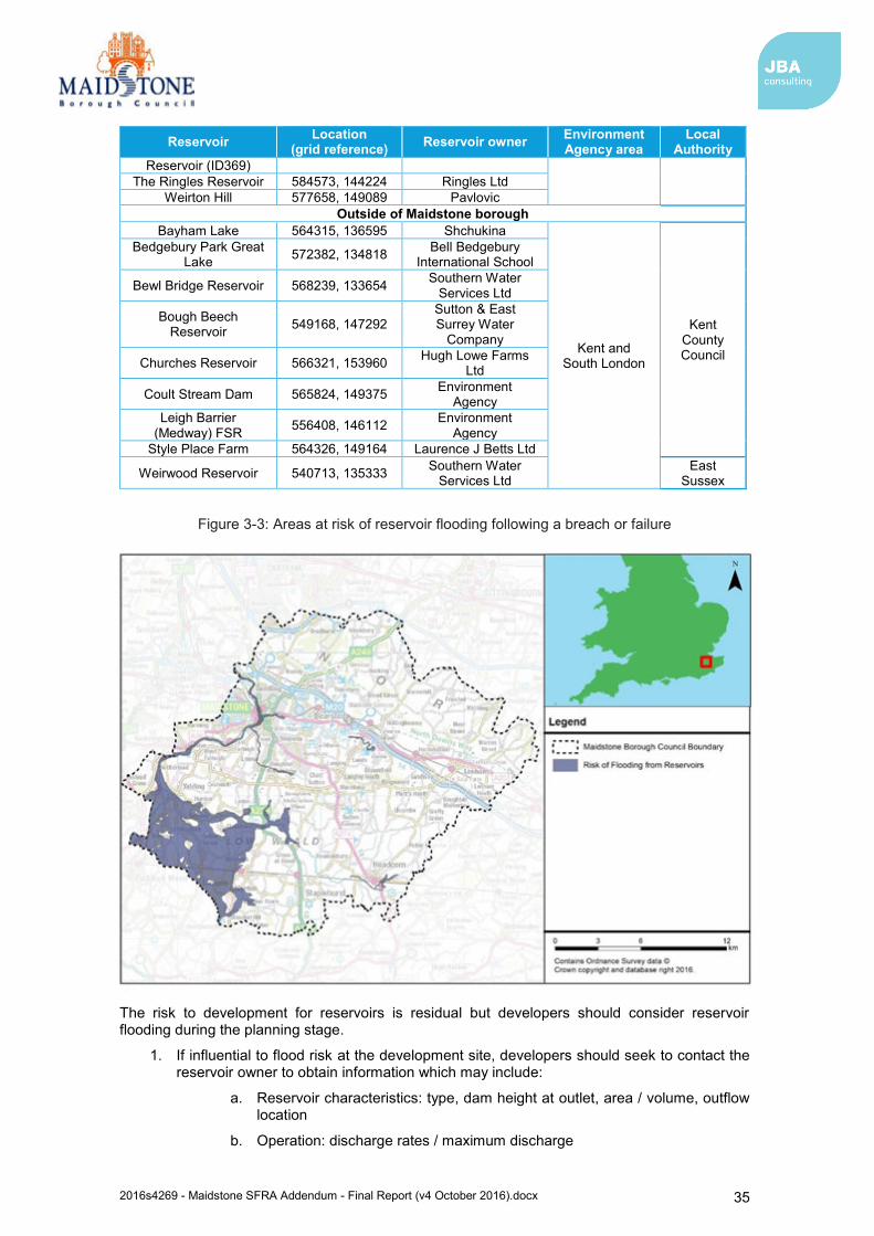
2016s4269 - Maidstone SFRA Addendum - Final Report (v4 October 2016).docx 35
Reservoir Location (grid reference) Reservoir owner Environment
Agency area Local
Authority Reservoir (ID369)
The Ringles Reservoir 584573, 144224 Ringles Ltd Weirton Hill 577658, 149089 Pavlovic
Outside of Maidstone borough Bayham Lake 564315, 136595 Shchukina
Kent and South London
Kent County Council
Bedgebury Park Great Lake 572382, 134818 Bell Bedgebury
International School
Bewl Bridge Reservoir 568239, 133654 Southern Water Services Ltd
Bough Beech Reservoir 549168, 147292
Sutton & East Surrey Water
Company
Churches Reservoir 566321, 153960 Hugh Lowe Farms Ltd
Coult Stream Dam 565824, 149375 Environment Agency
Leigh Barrier (Medway) FSR 556408, 146112 Environment
Agency Style Place Farm 564326, 149164 Laurence J Betts Ltd
Weirwood Reservoir 540713, 135333 Southern Water Services Ltd
East Sussex
Figure 3-3: Areas at risk of reservoir flooding following a breach or failure
The risk to development for reservoirs is residual but developers should consider reservoir flooding during the planning stage.
1. If influential to flood risk at the development site, developers should seek to contact the reservoir owner to obtain information which may include:
a. Reservoir characteristics: type, dam height at outlet, area / volume, outflow location
b. Operation: discharge rates / maximum discharge
2016s4269 - Maidstone SFRA Addendum - Final Report (v4 October 2016).docx 36
c. Discharge during emergency drawdown
d. Inspection / maintenance regime
2. Developers should apply the sequential approach to locating development within the site. The following questions should be considered:
a. Can risk be avoided through substituting less vulnerable uses or by amending the site layout?
b. Can it be demonstrated that less vulnerable uses for the site have been considered and reasonably discounted?
c. Can layout be varied to reduce the number of people or flood risk vulnerability or building units located in higher risk parts of the site?
3. Developers should consult with relevant authorities regarding emergency plans in case of reservoir breach.
3.7 The impact of climate change Flood Risk Assessments (FRAs) are required to demonstrate future implications of climate change have been considered, and risks managed where possible, for the lifetime of the proposed development. This may include for instance:
Consideration of the vulnerability of the proposed development types or land use allocations to flooding and directing the more vulnerable away from areas at higher risk due to climate change.
Use of ‘built in’ resilience measures. For example, raised floor levels.
Capacity or space in the development to include additional resilience measures in the future, using a ‘managed adaptive’ approach.
This latter point acknowledges that there may be instances where some flood risk management measures are not necessary needed now but may be in the future. This ‘managed adaptive’ approach may include for example setting a development away from a river so it is easier to improve flood defences in the future.
The latest guidance on climate change allowances for flood risk assessment released by the Environment Agency49provide predictions of anticipated change for
peak river flow;
peak rainfall intensity;
sea level rise; and
offshore wind speed and extreme wave height.
3.7.1 Fluvial flooding Climate change mapping for Maidstone Borough has been provided in Appendix C.
To be supplied once the updated flood risk mapping information is available.
It is important to note that climate change does not just affect the extent of flooding. Even where flood extents do not significantly change; flooding is likely to become more frequent under a climate change scenario. The impact of an event with a given probability is also likely to become more severe. For example, as water depths, velocities and flood hazard increase, so will the risk to people and property. Although qualitative statements can be made as to whether extreme events are likely to increase or decrease over the UK in the future, there is still considerable uncertainty regarding the magnitude of localised impact of these changes. Further details regarding the uncertainties in predicting the impacts of climate change can be found in:
Environment Agency (2016) Flood Risk Assessments: Climate Change Allowances
49 https://www.gov.uk/guidance/flood-risk-assessments-climate-change-allowances
2016s4269 - Maidstone SFRA Addendum - Final Report (v4 October 2016).docx 37
UK Climate Projections (UKCP09)
3.7.2 Tidal flooding Climate change is predicted to influence the rate of sea level rise, in addition to offshore wind speed and extreme wave height. For Maidstone Borough, the influence of offshore wind speed and extreme wave height on predicted flooding is likely to be negligible given that the tidal Medway is some way inland. However, sea level rise will influence the tidal levels which propagate upstream along the Medway, thereby impacting flood risk. Guidance on required net sea level rise allowances (after adjustment for land movement changes) is presented within the updated guidance released by the Environment Agency. The adjustments to the allowances from previous guidance are less marked. However, the information presented within this SFRA document remains as per the previous guidance and it is expected that development applications use the updated guidance to inform their assessment of flood risk.
3.7.3 Surface Water flooding Climate change is predicted to increase rainfall intensity in the future by up to 40%50 under the new range of allowances published by the Environment Agency. This will increase the likelihood and frequency of surface water flooding, particularly in impermeable urban areas, and areas that are already susceptible. Changes to predicted rainfall should be incorporated into flood risk assessments and drainage and surface water attenuation schemes associated with developments.
3.7.4 Groundwater flooding The effect of climate change on groundwater flooding problems, and those watercourses where groundwater has a large influence on winter flood flows, is more uncertain. The updated climate change guidance released February 2016 does not provide information on expected changes to groundwater flooding under future climate change. However, milder wetter winters may increase the frequency of groundwater flooding incidents in areas that are already susceptible, but warmer drier summers could counteract this effect by drawing down groundwater levels to a greater extent during the summer months. Where groundwater flooding is expected to influence a development site, it will be expected that consideration of groundwater flooding under a changing climate is assessed and measures taken to mitigate any change in risk.
50 https://www.gov.uk/guidance/flood-risk-assessments-climate-change-allowances
2016s4269 - Maidstone SFRA Addendum - Final Report (v4 October 2016).docx 38
4 Surface water management and SuDS 4.1 What is meant by Surface Water Flooding?
For the purposes of this SFRA, the definition of surface water flooding is that set out in the Defra SWMP guidance51. Surface water flooding describes flooding from sewers, drains, and ditches that occurs during heavy rainfall in urban areas.
Surface water flooding includes
pluvial flooding: flooding as a result of high intensity rainfall when water is ponding or flowing over the ground surface (overland surface runoff) before it either enters the underground drainage network or watercourse or cannot enter it because the network is full to capacity;
sewer flooding: flooding that occurs when the capacity of underground water conveyance systems is exceeded, resulting in flooding inside and outside of buildings. Normal discharge of sewers and drains through outfalls may be impeded by high water levels in receiving waters which may cause water to back up and flood on the urban surface. Sewer flooding can also arise from operational issues such as blockages or collapses of parts of the sewer network; and
overland flows entering the built up area from the rural/urban fringe: includes overland flows originating from groundwater springs.
4.2 Role of the LLFA and Local Planning Authority in surface water management From April 2015 local planning policies and decisions on planning applications relating to major development or major commercial development should make provision for sustainable drainage systems to manage run-off, where major development is defined as:
residential development: 10 dwellings or more, or residential development with a site area of 0.5 hectares or more where the number of dwellings is not yet known; and
non-residential development: provision of a building or buildings where the total floor space to be created is 1,000 square metres or more or, where the floor area is not yet known, a site area of one hectare or more.
(The LLFA will also provide advice on minor development on a non-statutory basis).
The Local Planning Authority must satisfy themselves that clear arrangements are in place for future maintenance of the management arrangements and the LLFA (Kent County Council), as statutory consultee is required to review the drainage and Sustainable Urban Drainage (SuDS) proposals to confirm they are appropriate.
When considering planning applications, local planning authorities should seek advice from the relevant flood risk management bodies, principally the LLFA on the management of surface water (including what sort of SuDS they would consider to be reasonably practicable), satisfy themselves that the proposed minimum standards of operation are appropriate and ensure, through the use of planning conditions or planning obligations, that there are clear arrangements for on-going maintenance over the development’s lifetime. Judgement on what SuDS system would be reasonably practicable should be through reference to Defra’s technical standards and should take into account design and construction costs.
It is essential that the consideration of sustainable drainage takes place at an early stage of the development process – ideally at the master-planning stage. This will assist with the delivery of well designed, appropriate and effective SuDS. Proposals should also comply with the key SuDS principles regarding solutions that deliver multiple long-term benefits. These principles are:
Quantity: should be able to cope with the quantity of water generated by the development at the agreed rate with due consideration for climate change via a micro-catchment based approach
51 Defra, Surface Water Management Plan Technical Guidance (March 2010). https://www.gov.uk/government/uploads/system/uploads/attachment_data/file/69342/pb13546-swmp-guidance-100319.pdf
2016s4269 - Maidstone SFRA Addendum - Final Report (v4 October 2016).docx 39
Quality: should utilise SuDS features in a “treatment train” that will have the effect of treating the water before infiltration or passing it on to a subsequent water body
Amenity/Biodiversity: should be incorporated within “open space” or “green corridors” within the site and designed with a view to performing a multifunctional purpose
Kent County Council and Maidstone Borough Council should:
promote the use of SuDS for the management of run off; ensure their policies and decisions on applications support and complement the
Building Regulations on sustainable rainwater drainage, giving priority to infiltration over watercourses and then sewer conveyance;
Incorporate locally distinctive favourable policies within development plans, where appropriate;
adopt locally distinctive policies for incorporating SuDS requirements into Local Plans, where appropriate;
encourage developers to utilise SuDS whenever practical, if necessary, through the use of appropriate planning conditions; and
develop joint strategies with sewerage undertakers to further encourage the use of SuDS.
4.3 Level 1 and 2 Assessment of Surface Water Flood Risk In assessing the surface water flood risk across the Maidstone administrative area, the Environment Agency’s updated Flood Map for Surface Water (uFMfSW) has been used (Appendix D). These maps are intended to provide a consistent standard of assessment for surface water flood risk across England and Wales in order to help LLFAs, the Environment Agency and any potential developers to focus their management of surface water flood risk.
The uFMfSW is derived primarily from identifying topographical flow paths of existing watercourses or dry valleys that contain some isolated ponding locations in low lying areas. They provide a map which displays different levels of surface water flood risk depending on the annual probability of the land in question being inundated by surface water (Table 4-1).
Table 4-1: uFMfSW risk categories
Category Definition
High Flooding occurring as a result of rainfall with a greater than 1 in 30 chance in any given year (annual probability of flooding 3.3%)
Medium Flooding occurring as a result of rainfall of between 1 in 100 (1%) and 1 in 30 (3.3%) chance in any given year.
Low Flooding occurring as a result of rainfall of between 1 in 1,000 (0.1%) and 1 in 100 (1%) chance in any given year.
Very Low Flooding occurring as a result of rainfall with less than 1 in 1,000 (0.1%) chance in any given year.
Although the uFMfSW offers improvement on previously available datasets, the results should not be used to understand flood risk for individual properties. The results should be used for high level assessments such as SFRAs for local authorities. If a particular site is indicated in the Environment Agency mapping to be at risk from surface water flooding, a more detailed assessment should be considered to more accurately illustrate the flood risk at a site specific scale. Such an assessment will use the uFMfSW in partnership with other sources of local flooding information to confirm the presence of a surface water risk at that particular location. This may include information within other strategy documents, such as the Kent Local Flood Risk Management Strategy (see section 2.2.5). It will be important for this to consider the potential impacts of climate change. Guidance relating to climate change allowances is made in section 3.7.
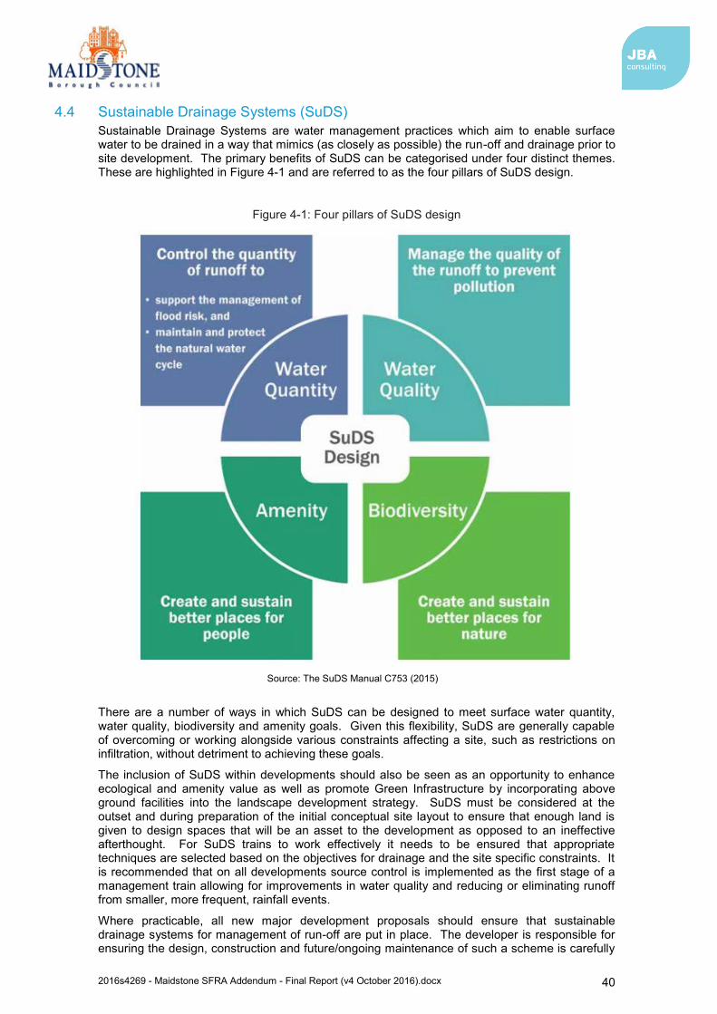
2016s4269 - Maidstone SFRA Addendum - Final Report (v4 October 2016).docx 40
4.4 Sustainable Drainage Systems (SuDS) Sustainable Drainage Systems are water management practices which aim to enable surface water to be drained in a way that mimics (as closely as possible) the run-off and drainage prior to site development. The primary benefits of SuDS can be categorised under four distinct themes. These are highlighted in Figure 4-1 and are referred to as the four pillars of SuDS design.
Figure 4-1: Four pillars of SuDS design
There are a number of ways in which SuDS can be designed to meet surface water quantity, water quality, biodiversity and amenity goals. Given this flexibility, SuDS are generally capable of overcoming or working alongside various constraints affecting a site, such as restrictions on infiltration, without detriment to achieving these goals.
The inclusion of SuDS within developments should also be seen as an opportunity to enhance ecological and amenity value as well as promote Green Infrastructure by incorporating above ground facilities into the landscape development strategy. SuDS must be considered at the outset and during preparation of the initial conceptual site layout to ensure that enough land is given to design spaces that will be an asset to the development as opposed to an ineffective afterthought. For SuDS trains to work effectively it needs to be ensured that appropriate techniques are selected based on the objectives for drainage and the site specific constraints. It is recommended that on all developments source control is implemented as the first stage of a management train allowing for improvements in water quality and reducing or eliminating runoff from smaller, more frequent, rainfall events.
Where practicable, all new major development proposals should ensure that sustainable drainage systems for management of run-off are put in place. The developer is responsible for ensuring the design, construction and future/ongoing maintenance of such a scheme is carefully
Source: The SuDS Manual C753 (2015)
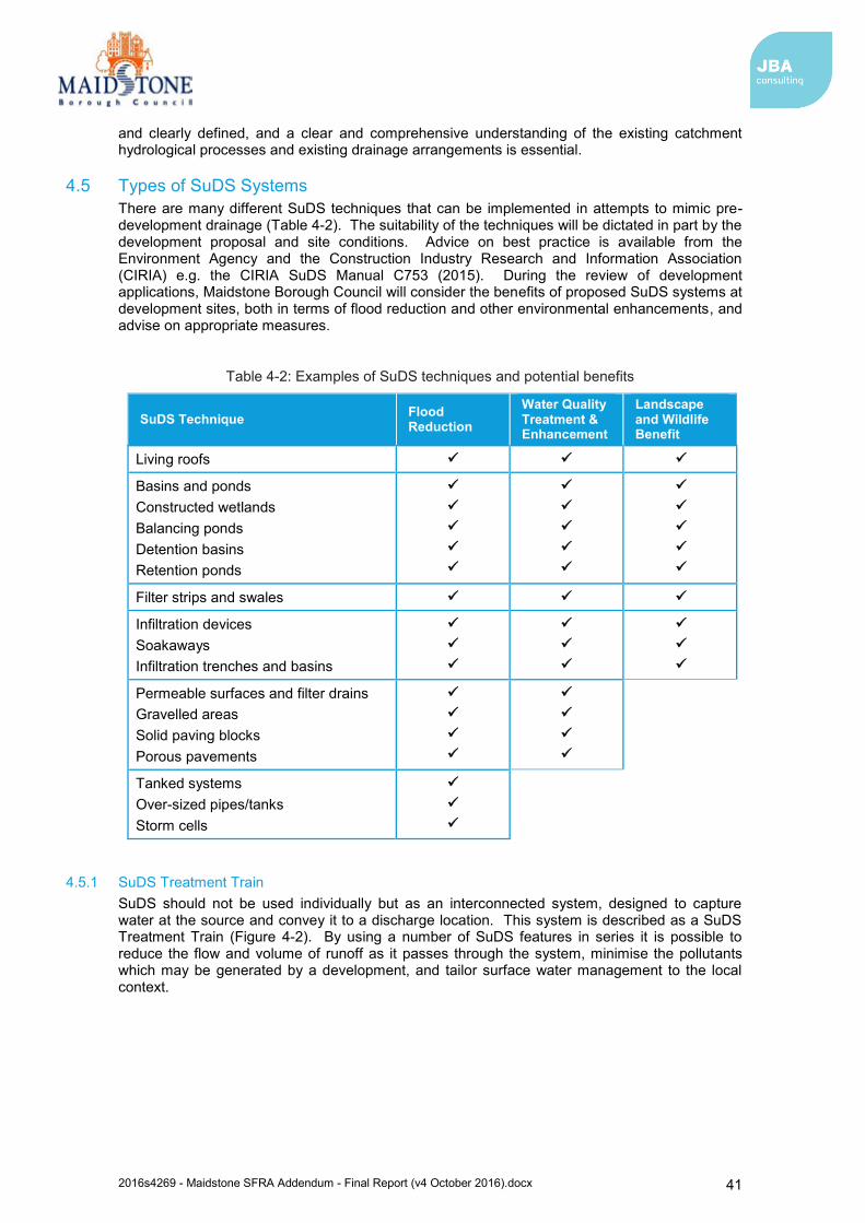
2016s4269 - Maidstone SFRA Addendum - Final Report (v4 October 2016).docx 41
and clearly defined, and a clear and comprehensive understanding of the existing catchment hydrological processes and existing drainage arrangements is essential.
4.5 Types of SuDS Systems There are many different SuDS techniques that can be implemented in attempts to mimic pre-development drainage (Table 4-2). The suitability of the techniques will be dictated in part by the development proposal and site conditions. Advice on best practice is available from the Environment Agency and the Construction Industry Research and Information Association (CIRIA) e.g. the CIRIA SuDS Manual C753 (2015). During the review of development applications, Maidstone Borough Council will consider the benefits of proposed SuDS systems at development sites, both in terms of flood reduction and other environmental enhancements, and advise on appropriate measures.
Table 4-2: Examples of SuDS techniques and potential benefits
SuDS Technique Flood Reduction
Water Quality Treatment & Enhancement
Landscape and Wildlife Benefit
Living roofs
Basins and ponds Constructed wetlands Balancing ponds Detention basins Retention ponds
Filter strips and swales
Infiltration devices Soakaways Infiltration trenches and basins
Permeable surfaces and filter drains Gravelled areas Solid paving blocks Porous pavements
Tanked systems Over-sized pipes/tanks Storm cells
4.5.1 SuDS Treatment Train SuDS should not be used individually but as an interconnected system, designed to capture water at the source and convey it to a discharge location. This system is described as a SuDS Treatment Train (Figure 4-2). By using a number of SuDS features in series it is possible to reduce the flow and volume of runoff as it passes through the system, minimise the pollutants which may be generated by a development, and tailor surface water management to the local context.
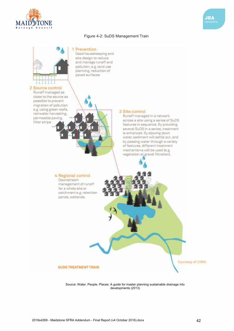
2016s4269 - Maidstone SFRA Addendum - Final Report (v4 October 2016).docx 42
Figure 4-2: SuDS Management Train
Source: Water. People. Places: A guide for master planning sustainable drainage into developments (2013)
2016s4269 - Maidstone SFRA Addendum - Final Report (v4 October 2016).docx 43
4.5.2 Treatment A key part of the four pillars of SuDS is to provide the maximum improvement to water quality through the use of the SuDS Treatment Train. To maximise the treatment within SuDS, CIRIA recommends the following good practice guide is implemented in the treatment process:
Manage surface water runoff close to source: This makes treatment easier due to the slower velocities and also helps isolate incidents rather than transport pollutants over a large area.
Treat surface water runoff on the surface: This allows treatment to be delivered by vegetation and the sources of pollution to be more easily identified. It helps with future maintenance work and identifying damaged or failed components of the treatment train.
Treat a range of contaminants: SuDS should be chosen and designed to deal with the likely contaminants that may pose a risk to the receiving environment and be able to reduce them to acceptably low levels.
Minimise the risk of sediment remobilisation: SuDS should be designed to prevent sediments being washed into receiving water bodies or systems during events greater than those for which the component may have been specifically designed.
Minimise the impact of a spill: Designing SuDS to be able to trap spills close to the course, facilitate contamination management and removal. The selected SuDS should also provide robust treatment along several components in series.
The number of treatment stages required depends primarily on the source of the runoff. The C753 SuDS Manual advises a simple index approach to determining the number of treatment stages. This involves determining a pollutant hazard score for each pollutant type. An index is then used to determine the treatment potential of different SuDS features for different pollutant types. This is known as the mitigation index. The Total SuDS mitigation index should be equal or greater than the pollution hazard score to deliver adequate treatment.
4.6 Kent SuDS Guidance Information and guidance regarding SuDS design and implementation is available from a number of sources published by Kent County Council and Maidstone Borough Council.
4.6.1 Water. People. Places: A guide for master planning sustainable drainage into developments52 The guide for master planning sustainable drainage into developments was published in 2013 by the LLFAs of the South East of England, of which Kent County Council is a part, to outline the process for integrating SuDS into the master planning of large and small developments. The South East LLFAs expect this guidance to be used as part of the initial planning and design plans for all types of residential, commercial and industrial development. The guidance complements existing guidance on SuDS design, maintenance and operation which should also be used to inform detailed design and delivery of SuDS.
Although SuDS can be applied to any site, there are a variety of conditions and constraints that could restrict the suitability of different types of SuDS or trigger the need for bespoke design. Therefore, consideration of the movement of water and its interaction with site-specific conditions at the earliest stage of design is crucial to the success of a SuDS scheme.
Section 4 of the ‘Water. People. Places’ document provides detailed SuDS design guidance for a range of commonly encountered site conditions. A summary of this guidance is provided in the SuDS Selection Matrix (Figure 4-3), whereby the suitability of each type of SuDS is presented for each common site condition.
It is noted in the guidance document that SuDS design should be fully integrated into a master plan as an essential part of land use and development planning, and considered in conjunction with other aspects of the design. Although there is no formal process for master planning, a typical design process for SuDS is outlined in Sections 5 and 6 of the guidance document. The process is designed to allow planners and designers to scope and embed opportunities for SuDS as land use and design ideas evolve.
52 Water. People. Places: A guide for master planning sustainable drainage into developments. Prepared by the Lead Local Flood Authorities of the South East of England (AECOM, 2013)
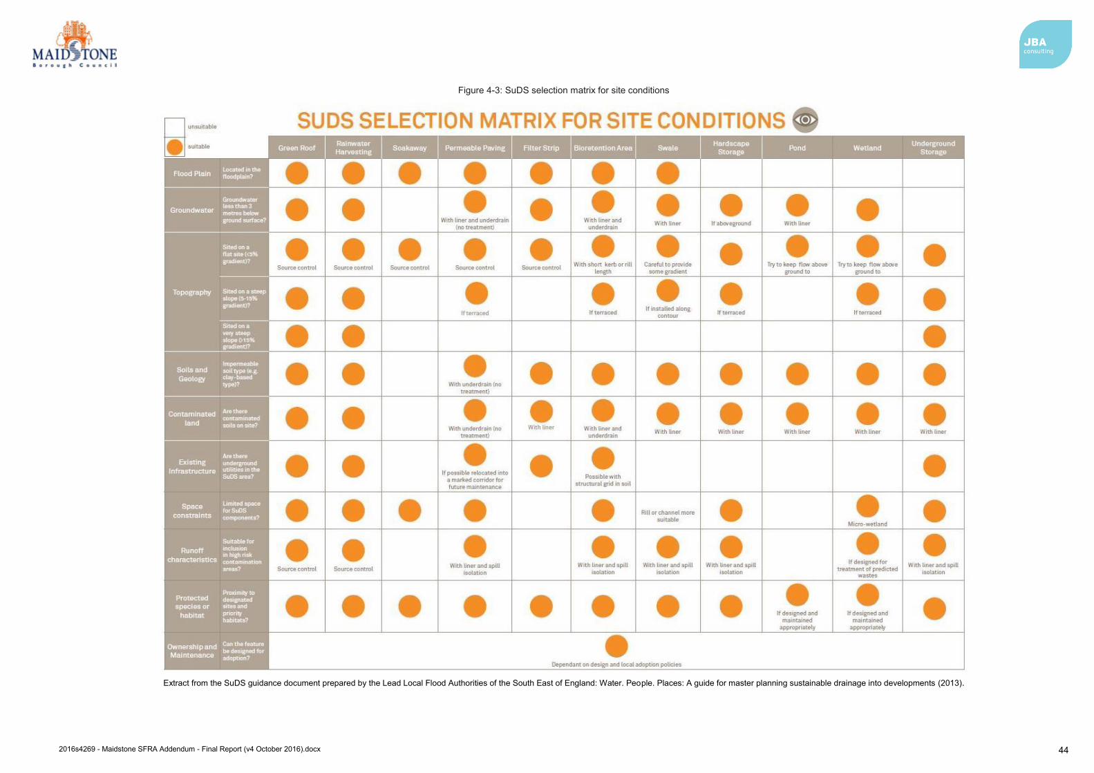
2016s4269 - Maidstone SFRA Addendum - Final Report (v4 October 2016).docx 44
Figure 4-3: SuDS selection matrix for site conditions
Extract from the SuDS guidance document prepared by the Lead Local Flood Authorities of the South East of England: Water. People. Places: A guide for master planning sustainable drainage into developments (2013).
2016s4269 - Maidstone SFRA Addendum - Final Report (v4 October 2016).docx 45
4.6.2 Maidstone Stage 1 SWMPs Kent County Council state that the relevant SWMPs should also be referred to during the formulation of a SuDS scheme for a site. In this case SuDS developers should refer to the guidance provided in the following SWMPS:
Maidstone and Malling Stage 1 SWMP (2012)
Maidstone Stage 1 SWMP (2013)
These documents provide advice regarding the feasibility of SuDS across Maidstone Borough.
Again, it is noted that the choice of a SuDS technique is site-specific; depending on the nature of the proposed development and local conditions. The suitability of areas for different types of SuDS techniques if often determined by:
Existing land use;
Soil type;
Underlying geology; and
Groundwater conditions.
When considering infiltration options, Groundwater Source Protection Zones must also be considered. The Maidstone SWMP states that Zone I (Inner protection zones), Zone II (Outer protection zones) and Zone III (Total catchment) are within the borough (see Section 4.8). These zones show the risk of contamination from any activities that that may cause pollution. If discharge is proposed within a Source Protection Zone, then additional information may be required to demonstrate that there is not an unacceptable risk to groundwater and the surrounding environment. Additional information and advice can be found on the website and within the ‘Groundwater protection: Principles and practice (GP3)53’ document.
The SWMP also states that new development should seek to incorporate SuDS to reduce surface water runoff where feasible and appropriate to the size and scale of development. The hierarchy of surface water disposal is as follows:
The use of SuDS techniques, appropriate to the location, size and type of the development.
Discharge to the watercourse.
Discharge to a surface sewer.
Discharge to a combined sewer.
4.6.3 Further information and guidance Other sources of information and guidance regarding SuDS can be found in the Kent Design Guide54. The guide updates the ‘Kent Design – A Guide to Sustainable Development’ originally published in 2000 and assists designers to achieve high standards of design and construction by promoting a common approach to the main principles that underlie the criteria for assessing planning applications.
The guide is also accompanied by a set of technical appendices that replace previous advice about the design of housing and industrial estates. The ‘Making it Happen – Sustainability (Drainage Systems)’55 document includes advice, guidance and information about the design and implementation of drainage systems, including SuDS for both residential and industrial developments.
Along with the guidance provided by the South East LLFAs and the Stage 1 SWMPs, development applications should have regard for and consider the above documents during the design and delivery of SuDS for all types of development.
53 Groundwater protection: principles and practice (GP3), (Environment Agency, 2013). 54 The Kent Design Guide 55 Making It Happen – Sustainability (Drainage Systems) (Kent County Council, 2007)
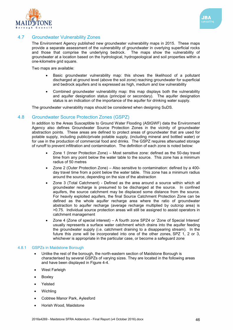
2016s4269 - Maidstone SFRA Addendum - Final Report (v4 October 2016).docx 46
4.7 Groundwater Vulnerability Zones The Environment Agency published new groundwater vulnerability maps in 2015. These maps provide a separate assessment of the vulnerability of groundwater in overlying superficial rocks and those that comprise the underlying bedrock. The maps show the vulnerability of groundwater at a location based on the hydrological, hydrogeological and soil properties within a one-kilometre grid square.
Two maps are available:
Basic groundwater vulnerability map: this shows the likelihood of a pollutant discharged at ground level (above the soil zone) reaching groundwater for superficial and bedrock aquifers and is expressed as high, medium and low vulnerability
Combined groundwater vulnerability map: this map displays both the vulnerability and aquifer designation status (principal or secondary). The aquifer designation status is an indication of the importance of the aquifer for drinking water supply.
The groundwater vulnerability maps should be considered when designing SuDS.
4.8 Groundwater Source Protection Zones (GSPZ) In addition to the Areas Susceptible to Ground Water Flooding (AStGWF) data the Environment Agency also defines Groundwater Source Protection Zones in the vicinity of groundwater abstraction points. These areas are defined to protect areas of groundwater that are used for potable supply, including public/private potable supply, (including mineral and bottled water) or for use in the production of commercial food and drinks. The GSPZ requires attenuated storage of runoff to prevent infiltration and contamination. The definition of each zone is noted below:
Zone 1 (Inner Protection Zone) – Most sensitive zone: defined as the 50-day travel time from any point below the water table to the source. This zone has a minimum radius of 50 metres
Zone 2 (Outer Protection Zone) – Also sensitive to contamination: defined by a 400-day travel time from a point below the water table. This zone has a minimum radius around the source, depending on the size of the abstraction
Zone 3 (Total Catchment) - Defined as the area around a source within which all groundwater recharge is presumed to be discharged at the source. In confined aquifers, the source catchment may be displaced some distance from the source. For heavily exploited aquifers, the final Source Catchment Protection Zone can be defined as the whole aquifer recharge area where the ratio of groundwater abstraction to aquifer recharge (average recharge multiplied by outcrop area) is >0.75. Individual source protection areas will still be assigned to assist operators in catchment management
Zone 4 (Zone of special interest) – A fourth zone SPZ4 or ‘Zone of Special Interest’ usually represents a surface water catchment which drains into the aquifer feeding the groundwater supply (i.e. catchment draining to a disappearing stream). In the future this zone will be incorporated into one of the other zones, SPZ 1, 2 or 3, whichever is appropriate in the particular case, or become a safeguard zone
4.8.1 GSPZs in Maidstone Borough Unlike the rest of the borough, the north-eastern section of Maidstone Borough is
characterised by several GSPZs of varying sizes. They are located in the following areas and have been displayed in Figure 4-4.
West Farleigh
Boxley
Yelsted
Wichling
Cobtree Manor Park, Aylesford
Horish Wood, Maidstone
2016s4269 - Maidstone SFRA Addendum - Final Report (v4 October 2016).docx 47
Crismill Lane, Maidstone
Longham Wood, Maidstone
Pilgrims Way, Maidstone
Goddington Lane, Harrietsham
Greenway Court Road, Hollingbourne
Harple Lane, Detling
Boarley Farm, Sandling
Hayes Lane, Sittingbourne
Trundle Wood, Sittingbourne
There are no Zones of Special Interest located within Maidstone Borough.
Figure 4-4: Groundwater Source Protection Zones
4.9 Nitrate Vulnerable Zones Nitrate Vulnerable Zones (NVZs) are areas designated as being at risk from agricultural nitrate pollution. Nitrate levels in waterbodies are affected by surface water runoff from surrounding agricultural land entering receiving waterbodies. The level of nitrate contamination will potentially influence the choice of SuDS and should be assessed as part of the design process. The definition of each NVZ is as follows:
Groundwater NVZ – an area of land where groundwater supplies are at risk from containing nitrate concentrations exceeding the 50 mg/l level dictated by the EU Council’s Surface Water Abstraction Directive (1975)56 and Nitrates Directive (1991)57.
Surface Water NVZ – an area of land where surface waters (in particular those used or
56 The EU Council’s Surface Water Abstraction Directive (Annex II, parameter 7*), June 1975 57 The EU Council’s Nitrates Directive (Annex I), December 1991

2016s4269 - Maidstone SFRA Addendum - Final Report (v4 October 2016).docx 48
intended for the abstraction of drinking water) are at risk from containing nitrate concentrations exceeding the 50 mg/l level dictated by the EU Council’s Surface Water Abstraction Directive (1975) and Nitrates Directive (1991).
Eutrophic NVZ- an area of land where nitrate concentrations are such that they could/will trigger the eutrophication of freshwater bodies, estuaries, coastal waters and marine waters.
The location of NVZs within the Maidstone Borough are shown in Figure 4-5. As can be seen, the borough is primarily characterised by an extensive groundwater NVZ, and four significant areas are classed as surface water NVZs. There are no eutrophic NVZs located within the borough.
Figure 4-5: Nitrate Vulnerable Zones
2016s4269 - Maidstone SFRA Addendum - Final Report (v4 October 2016).docx 49
5 Summary This Strategic Flood Risk Assessment (SFRA) 2016 addendum document updates elements of the Level 1 SFRA document prepared in May 2008. The addendum SFRA replaces sections of the 2008 issue and provides supporting evidence for the emerging Local Plan.
5.1.1 Sources of flood risk Maidstone Borough has a history of documented flood events and flood records indicate
that the main source of risk is from fluvial sources. The primary source of fluvial flood risk to the borough is the River Medway and its major
tributaries, the River Beult and River Teise. The most significant flood events reported to have affected the borough occurred in 1927, 1963, 1968, 2000 and 2013/14, each of which included notable flooding from the River Medway.
Maidstone Borough has also experienced a number of historic surface water / drainage related flood events, which have been attributed to a range of sources. The primary source of surface water flooding was attributed to heavy rainfall overloading highway carriageways and paved areas, drains and gullies, but other sources of flooding were associated with blockages and high water levels impeding free discharge from surface water drains and gullies. The updated Flood Map for Surface Water (uFMfSW) shows a number of surface water flow paths which predominantly follow topographical flow paths along existing watercourses or dry valleys with some isolated ponding located in low lying areas.
Data from the Sewer Incident Report Form data supplied by Southern Water indicates a total of 188 recorded flood incidents in Maidstone Borough within the last 5-year period. The more frequently flooded postcodes are TN12 9 (41), ME18 6 (28), TN12 0 (22) and TN27 9 (22).
Historically, groundwater flood events have been recorded across the borough, but these have typically been isolated incidents. The Areas Susceptible to Groundwater Flooding (AStGWF) mapping suggests that areas susceptible to groundwater flooding are primarily located in the central and southern sections of the borough, but for the most part, susceptibility to groundwater flooding is considered to be low as less than 25% of the area within the 1km grid squares are considered to be susceptible to groundwater flooding.
National Reservoir Inundation Mapping indicates that there are ten reservoirs within the borough and nine reservoirs outside of the borough that could affect the borough in the event of a breach. This includes Leigh Flood Storage Area and Weirwood Reservoir, located at the west of the borough, but most notably Bewl Bridge reservoir located south of the borough.
5.1.2 Key Policies There are a number of regional and local key policies which have been considered with the SFRA. The regional policies include the River Medway CFMP (2009), the River Thames Basin Management Plan (2009), the Medway Estuary and Swale SMP (2010) and the Thames River Basin District Flood Risk Management Plan (FRMP) - Parts A, B, C and D (March 2016).
Key local policies include the following:
Thames River Basin District Flood Risk Management Plan (FRMP): within Part C identified priorities are to implement outcomes of the Middle Medway Strategy and improve flood warning.
Kent County Council Preliminary Flood Risk Assessment (PFRA): The PFRA reports significant past and future flooding from all sources except Main Rivers, the Sea and Reservoirs, which are covered by the Environment Agency, and sub-standard performance of the adopted sewer network (covered under the remit of Southern Water). The Flood Risk Regulations (2009) require the Lead Local Flood Authority (LLFA) to identify significant Flood Risk Areas. No Flood Risk Areas have been identified in Maidstone Borough based on critical infrastructure/access routes, sewer/surface water problems and areas prone to significant ponding.
2016s4269 - Maidstone SFRA Addendum - Final Report (v4 October 2016).docx 50
Kent Local Flood Risk Management Strategy (2013): The Strategy is used as a means by which the LLFA co-ordinates Flood Risk Management on a day to day basis and sets out measures to manage local flood risk (i.e. flood risk from surface water, groundwater and Ordinary Watercourses). The Strategy also sets out an action plan of how the LLFA intends to achieve the high-level objectives proposed for managing flood risk.
Surface Water Management Plans (SWMPs): SWMPs are produced to understand the flood risks that arise from local flooding, which is defined by the Flood and Water Management Act 2010 as flooding from surface runoff, groundwater, and Ordinary Watercourses. Options to alleviate the risks are identified and presented as a long-term action plan to manage local flooding in a particular area. The published SWMPs relevant to Maidstone Borough that have been considered in this SFRA are the:
o Maidstone Stage 1 SWMP (2013) o Maidstone and Malling Stage 1 SWMP (2012) o Other Stage 2 SWMPs which have been commissioned yet to be published
are for Marden, Staplehurst and Headcorn.
5.1.3 Development and flood risk The Sequential approach to development and flood risk has been defined with guidance provided for the application of the Sequential and Exception Tests for both the Local Plan and for detailed site-specific Flood Risk Assessments. Site-specific FRAs should include assessment of mitigation measures required to safely manage flood risk along with the promotion of Sustainable Drainage Systems (SuDS) to create a conceptual drainage strategy and safe access/egress at the development in the event of a flood.
Surface water flooding and the role of the LLFA and the Local Planning Authority (LPA) in surface water management has also been defined with guidance provided for the design and implementation of SuDS as part of the initial planning stage of all types of residential, commercial and industrial developments. The SFRA provides details of the types of SuDS available and when they should be used, and outlines the recommendations included in the relevant national, regional and local guidance documents.
The merits of strategic flood risk solutions should be identified and understood when considering development within the borough as these can involve measures that deliver wider strategic benefits and can be more easily and efficiently maintained than a myriad of individual smaller scale measures. Developers should work with stakeholders to identify issues and provide appropriate solutions.
5.1.4 Flood warning and emergency planning Emergency planning considerations are reported in the 2008 SFRA document, but flood warning coverage has been indicated within the appendix mapping in this addendum SFRA.
5.2 Recommendations
5.2.1 Future Developments Development types and their location mean that opportunities and constraints will vary on a site by site basis. However, developments should seek opportunities to reduce overall levels of flood risk at the site, for example by:
Reducing volume and rate of surface water runoff based on Local Plan policy and LLFA Guidance
Locating development to areas with lower flood risk Creating space for flooding. Integrating green infrastructure into mitigation measures for surface water runoff from
potential development and consider using Flood Zones 2 and 3 as public open space. The LPA should consult the NPPF and Environment Agency’s ‘Flood Risk Standing Advice (FRSA) for Local Planning Authorities’, published in March 2014, when reviewing planning applications for proposed developments at risk of flooding.
2016s4269 - Maidstone SFRA Addendum - Final Report (v4 October 2016).docx 51
At the planning application stage, developers may need to undertake more detailed hydrological and hydraulic assessments of the watercourses to verify flood extent (including latest climate change allowances) inform development zoning within the site and prove, if required, whether the Exception Test can be passed.
5.2.2 Promotion of SuDS Planners should be aware of the conditions set by the LLFA for surface water management and ensure development proposals and applications are compliant with the Council’s policy.
A detailed site-specific assessment of SuDS would be needed to incorporate SuDS successfully into the development proposals. New or re-development should adopt source control SuDS techniques to reduce the risk of frequent low impact flooding due to post-development runoff.
For proposed developments, it is imperative that a site-specific infiltration test is conducted early on as part of the design of the development, to confirm whether the water table is low enough to allow for SuDS techniques that are designed to encourage infiltration.
Where sites lie within or close to Groundwater Source Protection Zones or aquifers, there may be a requirement for a form of pre-treatment prior to infiltration. Further guidance can be found in the CIRIA SuDS manual on the level of water quality treatment required for drainage via infiltration. Further restrictions may still be applicable and guidance should be sought from the LLFA.
Developers need to ensure that new development does not increase the surface water runoff rate from the site and should therefore contact the LLFA and other key stakeholders at an early stage to ensure surface water management is undertaken and that SuDS are promoted and implemented, designed to overcome site-specific constraints.
The LPA will need to consider drainage schemes for major applications, but it is advised developers utilise the LLFA’s Polices and Guidance to develop their drainage scheme for minor applications.
5.2.3 Infrastructure and Access Safe access and egress will need to be demonstrated at development sites. Consideration of alternative access and egress routes should be made in the event that primary routes are inundated with flood water. Resilience measures will be required if buildings are situated in the flood risk area, and opportunities to enhance green infrastructure and reduce flood risk by making space for water should be sought.
5.2.4 Green Infrastructure and WFD Opportunities to enhance green infrastructure and reduce flood risk by making space for water should be sought. In addition, opportunities where it may be possible to improve the WFD status of watercourses, for example by opening up culverts, weir removal, and river restoration, should be considered. Green infrastructure should be considered within the mitigation measures for surface water runoff from development.
5.3 Use of SFRA data and future updates It is important to recognise that the SFRA has been developed using the best available information at the time of preparation.
The SFRA should be periodically updated when new information on flood risk, flood warning or new planning guidance or legislation becomes available. New information on flood risk may be provided by authorities including Maidstone Borough Council, Kent County Council (in its role as LLFA), the Highways Authority, Southern Water and the Environment Agency. It is recommended that the SFRA is reviewed internally on an annual basis, allowing a cycle of review, followed by checking with the above bodies for any new information to allow a periodic update.

2016s4269 - Maidstone SFRA Addendum - Final Report (v4 October 2016).docx 52
Appendices

2016s4269 - Maidstone SFRA Addendum - Final Report (v4 October 2016).docx 53
A Watercourses in Maidstone Borough
2016s4269 - Maidstone SFRA Addendum - Final Report (v4 October 2016).docx 54
B Flood Zone mapping The flood zone maps show the extents of Flood Zones 1, 2, 3a and 3b in Maidstone Borough. The flood zones are defined as follows:
Zone 1: Comprised of land having a less than 1 in 1,000 annual probability of river or sea flooding in any year.
Zone 2: Comprised of land having between a 1 in 100 and a 1 in 1,000 annual probability of river flooding or 1 in 200 and 1 in 1,000 annual probability of sea flooding in any year.
Zone 3a: Comprised of land assessed as having a greater than 1 in 100 annual probability of river flooding or a greater than 1 in 200 annual probability of flooding from the sea in any year.
Zone 3b: Comprised of land where water has to flow or be stored in times of flood (the functional floodplain). The SFRA identified this Flood Zone as land which would flood with an annual probability of 1 in 20 years, where detailed hydraulic modelling exists. In the absence of detailed hydraulic model information, a precautionary approach was adopted with the assumption that the extent of Flood Zone 3b would be equal to Flood Zone 3a. If development is shown to be in Flood Zone 3a, further work should be undertaken as part of a detailed site specific flood risk assessment to define the extent of Flood Zone 3b.
2016s4269 - Maidstone SFRA Addendum - Final Report (v4 October 2016).docx 55
C Climate change mapping Hydraulic modelling has been undertaken by the Environment Agency to provide updated climate change flood mapping for the River Medway catchment (including the River Beult and River Teise). Modelling has also been completed as part of this SFRA to prepare this information for Loose Stream close to its confluence with the River Medway. This modelling followed the latest guidance for climate change in FRAs/SFRAs released by the Environment Agency in February 2016 (and updated in April 2016).
Climate change for fluvial events has been prepared for the Higher Central and Upper End estimates for the 2080s epoch (2070-2115). Present day flood risk information is available for comparison. The River Medway catchment is within the Thames River Basin District and therefore allowances are:
Higher Central (2080s) = +35% flows Upper End (2080s) = +70% flows
For tidal/coastal models, undefended case still water level simulations are available to inform future flood risk within the borough. Net sea level rise adjustments to 2115 were used within the climate change mapping for both +35% and +70% flows, meaning tidal/coastal flood extents are comparable in these events.
Flood Zone 2 information has also been displayed on the map. This is included to help identify potential sensitivity to climate change for watercourses where climate change modelling which follows the latest guidance is not available. This is expected to provide a conservative estimate of future Flood Zone 3a flood risk.

2016s4269 - Maidstone SFRA Addendum - Final Report (v4 October 2016).docx 56
D Surface water mapping The updated Flood Map for Surface Water (uFMfSW) maps show the flooding that takes place from the ‘surface runoff’ generated by rainwater (including snow and other precipitation) which: (a) is on the surface of the ground (whether or not it is moving), and (b) has not yet entered a watercourse, drainage system or public sewer.
The uFMfSW will pick out natural drainage channels, rivers, low areas in the floodplain and flow paths between buildings but it will only indicate flooding caused by local rainfall.
The uFMfSW shows predictions of flooded area but does not show whether individual properties will be affected by surface water flooding or have been affected in the past. The uFMfSW should not be used to predict if individual properties will flood.
2016s4269 - Maidstone SFRA Addendum - Final Report (v4 October 2016).docx 57
E Groundwater mapping The Areas Susceptible to Groundwater Flooding (AStGWF) maps are a set of strategic maps which show groundwater flood areas on a 1km square grid. The data was produced to annotate indicative Flood Risk Areas for Preliminary Flood Risk Assessment (PFRA) studies and allow the Lead Local Flood Authorities (LLFAs) to determine whether there may be a risk of flooding from groundwater.
This data shows the proportion of each 1km grid square where geological and hydrogeological condition show that groundwater might emerge. It does not show the likelihood of groundwater flooding occurring. It does not take account of the chance of flooding from groundwater rebound. This dataset covers a large area of land, and only isolated locations within the overall susceptible area are actually likely to suffer the consequences of ground water flooding.
The AStGWF data should only be used in combination with other information, for example local data or historical data. It should not be used as sole evidence for any specific flood risk management, land use planning or other decisions at any scale. However, the data can help to identify areas for assessment at a local scale where finer resolution datasets exist.
2016s4269 - Maidstone SFRA Addendum - Final Report (v4 October 2016).docx 58
F Flood warning coverage Flood Warning coverage maps are displayed.
Flood Alerts are used to warn people of the possibility of flooding and encourage them to be alert, stay vigilant and make early preparations. It is issued earlier than a flood warning, to give customers advance notice of the possibility of flooding, but before the Environment Agency are fully confident that flooding in Flood Warning Areas is expected.
Flood Warnings warn people of expected flooding to property and encourage them to take action to protect themselves and their property.
Some areas may be covered by more than one flood warning area as they may be at risk of flooding from more than one watercourse.

Offices at
Coleshill Doncaster Dublin Edinburgh Exeter Glasgow Haywards Heath Isle of Man Limerick Newcastle upon Tyne Newport Peterborough Saltaire Skipton Tadcaster Thirsk Wallingford Warrington
Registered Office
South Barn Broughton Hall SKIPTON North Yorkshire BD23 3AE United Kingdom
t:+44(0)1756 799919 e:[email protected] Jeremy Benn Associates Ltd
Registered in England 3246693
Visit our website
www.jbaconsulting.com