main heading conservation area character appraisal · main heading thame conservation area...
TRANSCRIPT

Main Heading
Thame
Conservation Area
Character AppraisalThe conservation area character appraisal - this sets
the context for the proposals contained in Part 2.
Part 1 was adopted by Council in September and
is included for information only.
April 2006


THAME CONSERVATION AREA CHARACTER APPRAISAL
South Oxfordshire District Council 1
Introduction
This conservation area character
appraisal has been undertaken to
assist in defining the special character
of the Thame Conservation Area. An
appreciation of this special character is
essential in order to manage change
within the conservation area. This
appraisal is part of the duty placed on
the local authority by the 1990
Planning (Listed Buildings and
Conservation Areas) Act to determine
which parts of their area are areas of
special architectural or historic interest,
the character or appearance of which it
is desirable to preserve or enhance.
The Act also states that the local
planning authority should, from time to
time, formulate and publish proposals
for the preservation and enhancement
of these Conservation Areas. These
are the subject of a separate
management plan.
As part of this exercise a plan of the
conservation area had been produced
which aims to identify the elements
which contribute to the character. The
plan includes the conservation area
boundary, listed buildings (buildings
identified by the Department of Culture,
Media and Sport as being of special
architectural or historic interest), former
Grade III listed buildings (a now
obsolete category but where the
buildings may still be of architectural or
historic interest) and other buildings of
local note. This latter group consists of
buildings that play a part in establishing
the character of the street scene but
have not yet been considered to be of
sufficient importance to meet the
current criteria for listing. Recent
government guidance contained in
PPG.15 - Planning and the Historic
Environment indicates, however, that
there is a presumption against the
demolition of such buildings. Important
trees are also identified. These are
usually highly visible from public places
and/or they contribute to the setting of
a listed building. Important open
spaces are identified, as these are a
vital element in the character of an
area. Character is defined not just by
buildings, walls and trees, but also by
the spaces between them. These
contribute to the setting of buildings.
They allow views around the area and
they are often an important element in
the historical development of a
settlement.
Important unlisted walls are identified.
These are usually built of local
materials and help to define spaces
and frame views. Lastly, important
views into, out of and around the
Conservation Area are identified. It
should be appreciated that a
Conservation Area's character does not
end with a line drawn on a map. Often
the character is closely associated with
attractive views out to surrounding
countryside, sometimes via gaps
between buildings. Views within an
area such as that to a church or
particularly attractive group of buildings
are also important.
Part 1

2 THAME CONSERVATION AREA CHARACTER APPRAISAL
South Oxfordshire District Council

There is speculation that Thame
suffered a Danish raid in the tenth
century, but there is scant evidence for
this.
Along with Banbury, Cropredy, Great
Milton and Dorchester itself, Thame
was part of the demesne lands of the
Bishop of Dorchester in the late Anglo
Saxon Period.
Domesday Period (1066 - 1099)
The Domesday Book, compiled in
1086, records the manor of Thame as
belonging to the Bishop of Lincoln, a
man named Remigius. The entry for
the manor of Thame included the
settlements at Moreton, North Weston,
Tetsworth, Attington and possibly
Waterstock.
Before the Norman Conquest, Thame
belonged to the Bishop of Dorchester,
who in 1066 was a man named Wulfig,
appointed by Edward the Confessor.
A Benedictine monk, Remigius from
Fecamp on the coast of Normandy had
provided ships and men to William the
Conqueror's cause and had been
promised the first available Bishopric in
England in return. When Wulfwig died
in 1067 Remigius duly became Bishop
of Dorchester, and when in or around
1072 the seat of this huge diocese was
moved from Dorchester to Lincoln,
Remigius became the first ever Bishop
of Lincoln, and Thame entered into a
long period of being one of the
demesne lands of the Bishopric of
Lincoln.
12th Century Period
(1100 - 1199)
Alexander de Blois, known as
Alexander the Magnificent, was Bishop
of Lincoln from 1123 to 1147. During
this time he was lord of the manor of
Thame. Originally planning to turn a
1 Thame
- Historical context
Anglo Saxon Period
(400 AD - 1066)
The story of modern day Thame really
begins in the Anglo Saxon period. In
the four hundred years from the dawn
of English Christianity to the Norman
Conquest, Thame and nearly all of the
towns and villages around it were
established.
Thame was on the southern fringes of
the Anglo Saxon kingdom of Mercia,
Wulfhere, son of Penda, and related to
the later King Offa, was King of Mercia
in the late seventh century. He was the
first of the royal line of Mercia to be
converted to Christianity, and in a
charter dated 675 King Wulfhere of
Mercia bestowed an abbey at Chertsey
whilst himself at Thame.
Historians have speculated that Thame
was at this time one of a number of
royal minster settlements, under
Mercian overlordship. St. Mary's
Church at Thame dates from after the
Norman Conquest, but it is known to
have been built on the site of an earlier
Anglo Saxon church. This may have
been the original site of the royal
minster building, perhaps with a
surrounding enclosure.
There is reference in the Anglo Saxon
Chronicles to Thame only once. This is
in the year 970 or 971 (depending on
the interpretation chosen), when a man
called Oskytel, Bishop of Dorchester
and Archbishop of York, died whilst at
Thame.
In the centuries before Domesday, the
Anglo Saxons developed a system of
land tenure based on the hundred and
the hide. Thame appears to have been
a regional administrative centre during
these times.
THAME CONSERVATION AREA CHARACTER APPRAISAL
South Oxfordshire District Council 3

large tract of uncultivated land
bordering on his manor at Thame into
a deer park, in 1138 this land, known to
us today as Thame Park, was given to
the Cistercian monks of Otmoor by
Bishop Alexander. The monks moved
in, and presumably an abbey was
constructed, between 1139 and 1142
becoming named as Sancta Maria de
Parco Thame.
During the time of Bishop Alexander,
Thame church became a prebend of
the Cathedral of Lincoln, increasing its
importance within the diocese. The
establishment of a prebendal
community based around the new
Prebendal House followed, giving
Priestend its name.
A new town was built at Thame in the
twelfth century, with its characteristic
burgage plots and wide market place,
typical of many new towns of the time.
It is thought this new town, known as
New Thame, was laid out during the
time of Alexander the Magnificent of
Lincoln, between 1123 and 1147. The
manors of Old Thame and Priestend,
together with New Thame, were for
several centuries administered as
separate manors.
The see of Lincoln fell vacant for a
period in the late twelfth century, and
the manors reverted to the King, Henry
II. However, Walter de Coutances,
Bishop of Lincoln from 1183 to 1186,
restored Thame to at least partial
Episcopal control. He secured market
charters for the town from Henry II and
held regular Tuesday markets and a
fair at Michaelmas.
13th Century Period (1200 - 1299)
Bishop Hugh de Welles, also known as
Hugh Trotman, regained full
possession of the manors of New
Thame and Old Thame in 1213 from
King John. In 1215, the year of Magna
Carta, King John granted a market
charter for Thame to Bishop Hugh de
Welles. This was confirmed in 1227 by
Henry III (1216 - 1272).
King Henry III also granted Hugh de
Welles a licence to divert the King's
Highway through Thame in 1219. This
is a crucial event in the development of
Thame as a town. In the same year,
1219, Bishop Hugh de Welles granted
timber for the construction of a Court
House, near what is now Church Row,
to replace an earlier administrative hall.
At Thame Park, the Cistercian monks
also received favour from Henry III. In
1224 the Abbot of Thame received the
right to export wool free of royal
customs duty and in 1232 new choir
stalls were paid for at Thame Abbey by
the King
In 1235 Robert Grosseteste, the then
Bishop of Lincoln, instructed a new
church to be built at Thame. The new
construction of St. Mary's began in
1240 destroying most of what would
have almost certainly been a timber
building, possibly remnants of the
former Anglo Saxon church
In 1241 the chapel within the grounds
of the Prebendal House was built, and
in this same year Bishop Grosseteste
entered into a bitter dispute with King
Henry III over the prebend at Thame.
This was finally resolved when John
Mansel, who as Royal Chancellor and
one of the most wealthy ecclesiastics
of the time declined the office of the
prebend offered to him by the King,
allowing Bishop Grosseteste's
nominee, a man called Simon of
London, to take up office.
Royal inquests into the affairs of the
realm, known as Hundredal Inquests
and recorded for us today in well
preserved manuscripts called Hundred
4 THAME CONSERVATION AREA CHARACTER APPRAISAL
South Oxfordshire District Council

Rolls, reveal that the Bishops of
Lincoln expanded the town of New
Thame by erecting permanent shops
and stalls in the middle of the market
place. In 1255 the Hundred Rolls of
King Henry III tell us that a certain
Geoffrey Taylor and five others were
paying rent to the Bishop of Lincoln for
their shops in the middle of Thame
market place.
Although Thame's wide high street is
one of many such well preserved
examples in England, it is very rare for
the road still to pass either side of this
thirteenth century infill as we see at
Thame today.
Thame's Cistercian Abbey, which had
originally been founded as a daughter
house of Waverley Abbey, the first
Cistercian house in Britain, itself
founded its own daughter house,
Rewley Abbey in Oxford in 1281.
In 1293 and 1294 there was another
dispute over the prebend of Thame,
this time involving a prolonged and
violent occupation of Thame church by
the supporters of the Pope's nominee
Edward son of St. John de St. John,
against the wishes of Oliver Sutton,
then Bishop of Lincoln, who had
appointed his nephew Thomas de
Sutton, Archdeacon of Northampton.
The bailiffs of Thame and Banbury, and
various other men of the Bishop
eventually blockaded the town, digging
dykes across five roads into the town
and breaking down the Crendon
Bridge.
14th Century Period (1300 - 1399)
The first half of the fourteenth century
saw Thame build upon the prosperity
its market charter, religious houses and
new town had brought in the previous
century. In 1302 Bishop John d'Alderby,
Bishop of Lincoln, succeeded in
persuading King Edward I to withdraw
the market charter from nearby
Haddenham, on competition grounds.
In 1309 the Bishop granted money to
repair the Crendon Bridge, which had
been broken down in 1294. In 1335
however the bridge collapsed and there
was for many years thereafter a
dispute over who should maintain it. In
1317, the year following two bad
harvests throughout England, the road
from Thame to Sydenham was
enclosed within Thame Park. This
extension to the park may have been
to accommodate more sheep.
An early act of the new King Edward III
was to confirm Thame's market charter,
which he did in 1329. The fourteenth
century also brought a new style of
house construction to Thame, and
houses built using a 'cruck' frame
began to appear. Prosperous merchant
families were developing in Thame.
The Elys family were wool merchants,
and the wool of Robert Elys of Thame
was on board a ship captured by the
Admiral of Calais in 1316. In 1340
Richard Elys became one of the few
local men to be appointed Vicar of
Thame. In 1345 a certain Edward le
Spicer, a mercer of Thame, used his
money to begin constructing a
causeway between Thame and Rycote,
which was then still a village
community.
The middle years of the 14th century
saw the plague known as the Black
Death introduced into England, and
fully one third of the country's
population is thought to have perished.
Enclosure of land for sheep, together
with the Black Death, may have
contributed towards the eventual
demise of local villages such as Rycote
and Albury. Thame however, was
without doubt a prosperous and
growing town, and it survived the
THAME CONSERVATION AREA CHARACTER APPRAISAL
South Oxfordshire District Council 5

ravages of the plague, playing host to
King Edward III in 1365 and Edmund of
York, Guardian of England, in 1399.
15th Century Period (1400 - 1499)
Richard Quartermain was a significant
fifteenth century benefactor of Thame.
His family had held the manor of North
Weston since the twelfth century. North
Weston was not mentioned in the
Domesday Book, being a part of the
manor of Thame, but it later became a
'subinfeudated' manor of Old Thame.
That is to say, a subsidiary manor
whose lord was vested with feudal
rights such as the ability to hold
manorial courts.
The Domesday manor of Rycote had
passed by marriage to the steward of
Richard II's household, Nicholas
Englefield, in the fourteenth century. In
1415 Nicholas Englefield died and the
manor of Rycote passed to Richard
Quartermain of North Weston through
his marriage to Richard Englefield's
daughter Sybil.
Richard had been trained in the
Customs in London, and was
throughout his life a patron of trade and
commerce and a benefactor of the
poor and needy. At Thame he endowed
the original Alms House near the
Church, and created the Chantry or
Guild of St. Christopher. The south
transept of St. Mary's Church became
known as St. Christopher's Chapel.
At Rycote, close to his own manor
house, Richard Quartermain built a
chapel and chantry, consecrated in
1449. Richard Quartermain died
childless and left the bulk of his estate
to his protégé Richard Fowler, who had
risen to become Chancellor of the
Duchy of Lancaster and lived at North
Weston manor house whilst the
Quartermains lived at Rycote manor
house. North Weston manor house
was known as Hall Place and little or
nothing of it remains today. Richard
and Sybil Quartermain are buried in
Thame Church, where their tomb is
decorated with fine brasses depicting
them and, it is thought, Richard Fowler.
In 1419 another 'subinfeudated' manor
is first recorded at Thame. Baldington
manor was named after the Baldington
family. The manor had lands in Old
Thame, Moreton and North Weston
and property in New Thame. Richard
Quartermain was only one of two
exceptionally wealthy fifteenth century
merchants within the parish of Thame,
the other was Geoffrey Dormer. The
Dormer family had long been resident
in Thame and Geoffrey Dormer
became a merchant of the staple of
Calais. In 1473 this wealthy wool
merchant is said to have bought the
Baldington Manor House, also known
as Place House, which was situated off
what is now North St., Thame.
The Dormers were noted for their
acquisition of land throughout the
manors of Thame, and had a
reputation for enclosing land much to
the inconvenience of other tenants.
Geoffrey Dormer, for instance, was
presented in 1481 for enclosing land at
Moreton. The manor of Baldington was
passed on by Geoffrey Dormer to his
son, also Geoffrey Dormer, in 1498.
Early 16th Century Period
(1500 - 1530)
In the first year of the reign of King
Henry VIII, there is the first mention of
the market hall or 'moot' hall at Thame.
Prior to this market hall, which stood
more or less where Thame Town Hall
stands today, it is thought that the
building used for conducting market
business and for confining
transgressors was the oldest part of
6 THAME CONSERVATION AREA CHARACTER APPRAISAL
South Oxfordshire District Council

the building which is today the
Birdcage pub.
In 1514 Thomas Wolsey, King Henry's
Lord Chancellor, began building
Hampton Court Palace. It is thought
that Rycote Palace, a building of
similar style and proportions, was built
around 1520-25, on the site of Richard
Quartermain's former manor house at
Rycote Park.
It is not known for certain who built
Rycote Palace and when, the accepted
date of its construction coming from
comparison with such building styles as
those seen at Hampton Court. Richard
Fowler the younger with a reputation
as a spendthrift sold the Rycote estate
to Sir John Heron, treasurer of the
royal household, in 1521, after plunging
it into ruin. The construction of the
Tudor palace at Rycote was either the
cause of Richard Fowler's ruin, or the
work of the King's treasurer, Sir John
Heron.
At Thame Park, the Cistercian Abbey
was only a few decades away from
final dissolution. The behaviour of the
monks and the Abbot were giving
cause for concern. In 1525 the Bishop
of Lincoln, John Longlands, who was
also confessor to King Henry VIII,
wrote to the person responsible for
order at Thame Abbey, the Abbot at
Waverley, complaining about the state
of affairs at the Abbey. The buildings
were reported to be in ruin, although
the Abbot of Thame Abbey, John
Warren, was said to be furnishing
himself with a grand lodging. The
monks were said to hold great feasts at
the local taverns, although the Abbey
was in debt, owing money to the Vicar
of Thame among others.
At John Warren's death in 1529 Bishop
Longlands advised Cardinal Wolsey
that none of the local monks should be
made Abbot and instead Robert King,
whose brother William was a brother-
in-law to Sir John Williams, was
appointed as the last Abbot of Thame.
The following year, 1530, King Henry
VIII is said to have visited Thame and
been entertained at the Red Lion Inn
with both his first wife Catherine of
Aragon and his next wife, then a lady
in waiting, Anne Boleyn.
The Reformation Period
(1531 - 1559)
The Reformation of the English Church
and Dissolution of the Monasteries
were to have a profound effect on
Thame Church and Thame Park. In
1537 John Stribblehill and his father
Thomas, two leading church wardens
and supporters of King Henry VIII's
policy towards the Church, made a
complaint to their fellow churchwardens
about the remarks of one Robert
Johns. Johns had been heard to
suggest that the parish jewels be sold
in order to repair the church, which was
in a state of decay, before Henry
confiscated them. Thame Abbey was
dissolved in 1539, along with all other
monastic foundations in England. The
lands belonging to the Abbey were
shortly afterwards given to Sir John
Williams. The choir stalls and linenfold
panelling, perhaps those provided by
King Henry III in the thirteenth century,
were removed to Thame Church in
1540.
In 1539, Sir John Williams also
acquired Rycote Palace from Sir Giles
Heron, the son of Sir John Heron who
had bought it in 1521. King Henry VIII
spent part of his honeymoon with his
fifth wife, Catherine Howard, at Rycote
Palace in 1540.
In 1541 Robert King, brother-in-law to
Sir John Williams and last Abbot of
THAME CONSERVATION AREA CHARACTER APPRAISAL
South Oxfordshire District Council 7

Thame Park, for whom Sir John
Williams had secured the position of
Abbot of Osney in 1537, became
Bishop of Thame and Osney. In 1545
he was appointed first Bishop of
Oxford, initially based at Osney, and
the see of Thame and Osney lapsed.
In 1543 a clock is first recorded in
Thame market hall, when the
churchwardens paid 5 shillings to
repair it. Thame's ancient wooden
market cross was reportedly taken
down in 1553.
Henry VIII died in 1547 and it was
during the reign of his infant son,
Edward VI (1547-1553), that the manor
and prebend of Thame were
relinquished by the Bishop of Lincoln,
Henry Holbeach, and given to the King.
The manor of Thame was passed on to
Sir John Williams and the prebend to
Sir John Thynne. Sir John Williams
was seemingly an unpopular landlord,
and in 1549 the people rose up and
killed the deer in Rycote Park and
Thame Park. In the same year two
men were ordered to 'suffer at Thame'
for their part in a revolt in Oxfordshire
against the religious changes made by
Henry VIII.
Sir John Williams was instrumental in
facilitating the accession to the throne
of Queen Mary, and was rewarded with
a Baronetcy, becoming Baron Williams
of Thame. He was also President of
the Council of the Marches of Wales,
being of Welsh origin himself, and it
was whilst at Ludlow Castle in 1559
that Baron Williams of Thame died.
John Williams' body was brought back
to Thame and today lies in St. Mary's
Church.
The Elizabethan Period
(1560 - 1603)
The will of Lord Williams, former lord of
the manor of Thame, contained several
endowments to the benefit of the town,
the most notable of these being the
establishment of Thame Grammar
School and the endowment of Thame's
Alms Houses.
Lord Williams' elder daughter Marjorie
inherited the manor of Thame and also
her father's former home at Rycote
Palace. She married Henry Norreys in
1546, whose father had been executed
in 1536 as a suspected lover of Anne
Boleyn, mother of Queen Elizabeth I.
The Queen is believed to have
sympathised with Henry Norreys over
the wrongful execution of his father.
She made him her ambassador to
France. Marjorie Norreys initiated the
building of Thame Grammar School in
1569 and it opened in the following
year, 1570. Both the new Grammar
School and the Alms Houses passed
into the care of the warden of New
College Oxford in 1575. There was a
long and close friendship between
Queen Elizabeth I and Henry and
Marjorie Norreys. Elizabeth paid
affectionate visits to Rycote Palace for
over a quarter of a century whilst she
was Queen of England. She had also
spent much time there during her
childhood. Henry Norreys, then Baron
Norreys of Rycote, died in 1601, two
years before his beloved Queen
Elizabeth herself.
John Williams' younger daughter Isobel
inherited Thame Park from her father.
She had married Sir Richard Wenman,
a wealthy wool merchant from Witney,
who died in 1572. In 1596, the
grandson of Sir Richard Wenman, also
called Richard, and resident at Thame
Park, received a knighthood whilst
serving at Cadiz.
8 THAME CONSERVATION AREA CHARACTER APPRAISAL
South Oxfordshire District Council

The Early Stuart Period
(1604 - 1641)
Although Sir Richard Wenman of
Thame Park was suspected of
complicity in the Gunpowder Plot of
1605, nothing seems to have been
proven as he became the first Viscount
Wenman in 1628.
King James enforced a penalty for not
attending Church, as an attempt to
quell Roman Catholic opposition, and
at Thame several Roman Catholics
were fined for not attending St. Mary's
Church in the years following the
Gunpowder Plot. The Vicar of Thame
at the start of the 17th century was
John Trinder, who began keeping
parish records, most of which have
survived to this day.
Thomas Hennant, related by marriage
to the family of Oliver Cromwell and
John Hampden, who were themselves
cousins, was appointed Vicar of Thame
from 1631. The Grammar School at
Thame was at this time prospering,
educating amongst others the young
John Hampden. Its Head Master from
1631 to 1647 was William Burt, who
was also related by marriage to the
Cromwells and Hampdens. With both
the Vicar and Grammar School
Principal possessing strong Puritan
beliefs, we can perhaps conclude
where the loyalties of the
churchwardens lay, and they granted
Thomas Hennant a house in Thame
churchyard.
The grandson of Sir Henry Norreys had
inherited Rycote, but he committed
suicide in 1623. His daughter Elizabeth
married Edward Wray, Groom of the
Bedchamber to King James I, in 1622.
In 1625 King Charles I moving his
court to Oxford, to avoid plague in
London, and broke his journey at
Rycote Palace, to be entertained by
the Wrays. Although lords of the manor
of Thame, the Wray's leased the manor
house and lands of Old Thame to
Vincent Barry, possibly in 1626.
The Civil War Period (1642 - 1646)
During the early years of the English
Civil War between Parliament and
Charles I, the land east of the Chiltern
Hills, towards London, and to the north
of the Vale of Aylesbury, was controlled
by Parliament. The land to the west of
Oxford, Oxford City itself and key towns
in the Thames Valley, such as
Wallingford, were controlled by the
King. The King himself set up court at
Oxford. Manor houses and market
towns along the Oxfordshire border,
such as Thame, were called upon to
feed, house and tend the wounds of
soldiers from both sides as the conflict
progressed. In 1643 Thame was not
openly Royalist or Parliamentarian,
although the sentiment within the town
was said to be generally Puritan and
pro Parliament.
The Earl of Essex, commanding the
Parliamentary army locally made a
push in early 1643 to close in on
Oxford, and set up his headquarters in
Thame. This was to have a devastating
effect on Thame. In the summer of
1643 an outbreak of what is thought to
have been typhus hit Thame, and 141
people out of an estimated population
of 1300 died in a single ten week
period.
Prince Rupert mounted raids out of
Oxford against the Parliamentarian
army's positions. It was in returning to
Oxford from one such raid that the
Royalist party engaged at Chalgrove
with a Parliamentarian contingent led
by John Hampden. In the resulting
battle John Hampden was mortally
wounded. He managed to make his
way to Thame, where six days later he
THAME CONSERVATION AREA CHARACTER APPRAISAL
South Oxfordshire District Council 9

died, on 24th June 1643. The following
month the Parliamentarian army
retreated from Thame and the Earl of
Essex moved his headquarters to
Aylesbury. Anthony Wood was a
scholar at Thame Grammar School and
was lodging at Thame vicarage during
the conflict. His diaries give a good
account of a Royalist party fleeing back
to Wallingford from Long Crendon,
through the west end of Thame, in
January 1644.
There was a further skirmish at Thame
in April 1645, and by September 1645 a
substantial Parliamentarian force was
once again garrisoned at Thame. One
Sunday morning a Royalist force from
Oxford rode into Thame market place
and attacked them. In December 1645
two regiments of horses from Sir
Thomas Fairfax's army at High
Wycombe were moved to Thame, and
that was an end to Royalist attacks.
When the Royalist garrison at Oxford
under Sir Thomas Glemham
surrendered to Fairfax in June 1646
they were allowed to march out of
Oxford with a Regiment on foot of some
3000 men, fully armed and with their
colours flying. King Charles had
ordered them to disband, and when
they reached Thame they disbanded
and were allowed to return home or to
leave the country.
The surrender of Oxford and the
dignified dispersal of Glemham's troops
at Thame marked the end of what is
known as the first English Civil War.
The Late 17th Century Period
(1647 - 1699)
The Parliamentarian army had been
headquartered in Thame during the
Civil War. As well as the human cost,
with a plague in 1643, there was also
much physical damage done to the
buildings taken over by the soldiers,
including the Grammar School, the
Vicarage and St. Mary's Church. The
churchwardens of Thame were left to
repair their community.
The prebend of Thame, which in normal
times benefited from the church dues,
had passed into the hands of the family
of Sir John Thynne at the Reformation,
over a century before. Thomas, first
Viscount Weymouth, was descended
from Sir Thomas Thynne and it was to
him that the churchwardens turned. The
Thynne family had long since
abandoned the Prebendal House in
Thame. In 1661 it stood in ruins.
The market at Thame had continued to
operate throughout the Civil War, but
the local economy suffered several side
effects of the conflict. One problem was
a shortage of coinage. The town traders
at Thame issued tokens to be used in
place of coins between 1653 and 1659.
Upon the restoration of the monarchy in
1660, Charles II imposed a number of
'briefs' on Thame, so that there had to
be collections at the church for
specified charities. These were not
popular with the struggling Thame
churchwardens. Firstly, in 1660 he
created the Order of the Royal Oak,
one purpose of which was to raise
money from rich landowners in return
for membership. Local landowners who
offered to contribute up to £2000
included Sir John Clerke of North
Weston and Sir Francis Wenman later
of Thame Park.
Then, in 1662 the King introduced a
Hearth Tax, under which anyone who
owned property was taxed according to
the number of hearths, effectively
rooms, in their house. This tax lasted
until 1689, and the Hearth Tax Returns
for Thame have survived.
At Thame Park the second Viscount
10 THAME CONSERVATION AREA CHARACTER APPRAISAL
South Oxfordshire District Council

Wenman died in 1664, in a poor state
of finances. He had suffered at the
hands of the Cavaliers during the Civil
War, having supported Parliament. His
daughter Mary married her cousin Sir
Francis Wenman in 1671 and thereby
kept Thame Park in the Wenman family.
Bridget, daughter of Edward and
Elizabeth Wray, had married Montagu
Bertie, second Earl of Lindsey, and it
was their son James Bertie who was
created Earl of Abingdon by Charles II
in 1682, and who inherited the manor of
Thame, part of it leased to the Barry
family. Perhaps to mark his new
position as Earl of Abingdon, James
Bertie built a new market hall for Thame
in 1684.
The countryside around Thame had
seen both Royalist and Parliamentarian
raiding parties during the war. Fifty
years later the problem was
'freebooters', or highwaymen. In 1692 a
party of fifteen butchers travelling to
Thame market was ambushed outside
Thame.
The Early 18th Century Period
(1700 - 1759)
In the early years of the eighteenth
century, particularly after the
succession of George I, there was the
whiff of rebellion in the air in both
England and Scotland. There were
several ill-fated Jacobite uprisings and
consequent arrest and prosecution of
suspected Jacobite sympathizers.
Oxford was known as something of a
centre of Jacobite sympathies, and
evidently there were some in Thame. In
1714 a certain John Dorrell of Thame
was hanged as a Jacobite rebel.
The 1720's were the hey-day of one of
Thame's famous sons, James Figg the
illustrious boxer, champion of England.
In the religious sphere, Nonconformists
were beginning to organize in Thame.
In 1728 the first Presbyterian meeting
house opened in the yard of the Sun
Inn, in Thame High St. The minister
was Rev Matthew Leeson. The Rev
Matthew Leeson took as a pupil a
young John Wilkes in 1739. Wilkes
was to become a hugely important
figure in the political life of eighteenth
century Britain. Leeson and Wilkes
subsequently moved from Thame to
Aylesbury.
The year 1745 was a year of tragedy
for Thame's lord of the manor and his
family. The heir to the title of Earl of
Abingdon was killed in a fire at Rycote
Palace, a fire that destroyed the grand
Tudor Palace patronized by King Henry
VIII and Queen Elizabeth I.
The same year, 1745, saw happier
times for the Wenman family at Thame
Park. The 6th Viscount Wenman added
a grand Palladian frontage to Thame
Park House and so created the classic
picture of an English country house we
see today. Thame High St. displays to
this day something of the grandeur of
Georgian times, with several three
storey frontages built onto earlier
buildings.
The Parliamentary seat of Oxfordshire
had been held uncontested by the Tory
Party for many years, often with a
member of the Wenman family being
sent to Westminster. In 1754 the ruling
Whig Party (the forerunner of the
Liberal Party) contested the seat.
Women had no vote, and nor did most
of the men of Thame. Only 83 men,
those holding property by freehold, had
the vote. The votes for the town were
declared and they were 71 for the Tory
candidates and 12 for the Whig
(Liberal) candidates, thereby helping to
maintain the status quo in Oxfordshire.
THAME CONSERVATION AREA CHARACTER APPRAISAL
South Oxfordshire District Council 11

The George III Period (1760 - 1820)
Turnpike trusts and the building of high
quality toll roads proliferated
throughout the latter half of the
eighteenth century. Comfortable and
safe travel by stagecoach from Oxford
to London via Thame, and from Thame
to many other places now became a
reality. The Aylesbury to Shillingford
turnpike opened in 1770. This road
runs from Thame via Milton Common
to Stadhampton and on to Shillingford.
The hunting of foxes with hounds in
organised hunts in the Thame area
began in the same year. The fourth
Earl of Abingdon, Willoughby Bertie,
who inherited the title in 1760, stabled
not only horses but also hunting dogs
at Rycote House, which he was
renovating after the fire of 1745.The
land between Thame and Tetsworth
became the hunting ground for the Earl
of Abingdon's hunt.
At Rycote Park Willoughby Bertie
employed the renowned landscape
gardener, Lancelot 'Capability' Brown
to transform the gardens, paying him
£2,500 in 1778. Willoughby Bertie, the
fourth Earl of Abingdon, was a political
radical, as well as huntsman, horse
breeder and renovator of Rycote
House. Rycote House had been
refurbished since the fire, but in 1779
the entire contents of the house, such
as paintings etc., were sold off.
Willoughby Bertie died in 1799, and the
fifth Earl, Montagu Bertie, took the
drastic step of dismantling Rycote
House altogether. In 1807 the actual
fabric of the building was sold off, such
that today only the stables remain,
converted into a house.
In the eighteenth century, providing
relief for the poor was the responsibility
of each parish. Parishes were allowed
by law to house the poor in
workhouses, so as to defray the costs
of their keep by the fruits of their
labour. In 1763-4 the churchwardens of
Thame, effectively the parish council,
advertised for a suitable person to run
a local workhouse. In 1790 a building
used in the Middle Ages as a 'bridewell'
or local prison in Wellington St., then
called Pound Lane, was converted into
such a workhouse. This venture
apparently failed and the building has
since burnt down.
Without the workhouse, the people of
Thame had to support the poor through
the Poor Rate. In 1811 the sum
required was £3,686, a crippling
burden for the town and its farming
community.
Fleeing persecution in France, 18
Catholic clergy arrived in England and
found their way via Reading to Thame.
They were accommodated in Thame in
1792, in the mansion that stood in the
High St. In 1806 the town
accommodated more Frenchmen, this
time Napoleonic prisoners awaiting
repatriation after the end of the war
with France.
The Early 19th Century Period
(1821 - 1850)
Land enclosure and rural poverty were
two great themes of early nineteenth
century Thame life. Thame's open
fields were enclosed in 1826, with the
town's Enclosure Award. Enclosure
brought new hedges to the landscape,
and turned many smallholders into
agricultural workers paid a wage.
There was already great poverty in
rural communities and enclosure was
often met with resistance from the local
agricultural population. Otmoor saw
resistance to enclosure in 1829-32 and
in 1830-31 there was a rural revolt
across southern England, known as
12 THAME CONSERVATION AREA CHARACTER APPRAISAL
South Oxfordshire District Council

the 'Captain Swing' uprising. Machinery
was smashed at Long Crendon, but
Thame seems to have avoided trouble.
The Poor Law Amendment Act of 1834
divided the country into Poor Law
Unions, also known as Registration
Districts, and each district was to have
a workhouse. Poor relief became a
national matter and no longer a local
obligation. The Thame Poor Law Union
comprised 35 local parishes and a
substantial workhouse was built at
Thame in 1836.
Another great theme of Thame life at
this time was the growing influence of
the Nonconformist population. In 1827
a Congregationalist Chapel opened at
14 High St., now the site of the
Masonic Hall. A Primitive Methodist
chapel began at Moreton in 1830.
The Nonconformist influenced 'British
and Foreign Schools Society' opened a
Royal British School in Park St., Thame
in 1836, now the John Hampden
County Primary School.
Following a local meeting, the 'National
Society for the Education of the Poor in
the Principles of the Church of
England' opened a National School on
land donated by the Earl of Abingdon
in the Hog Fair, just off the Lower High
St., also in 1836.
East St. was built in the early 1830's. It
was then called New Road, and was
linked to a new turnpike road from
Thame to Princes Risborough. Several
new houses were built along East St.
and Park St., one seemingly by a
family of Quakers in 1833.
Thame broke onto the national stage in
1840. The first letter sent with a Penny
Black stamp was sent in 1840 to a
certain George Waterman in Thame.
Mr John Stone, a wealthy local man,
purchased and began to renovate the
Prebendal House in 1835, as it had
been in a state of disrepair for some
time.
The Poor Law Unions or Registration
Districts were the basis for the
nineteenth century population
censuses. The first detailed census
was in 1841. The 1841 census returns
for Thame give us a view of Thame's
population make-up following the
upheavals of enclosure, dire local
poverty and the beginnings of new
building in the eastern part of the town.
In 1844 Montagu Bertie, 5th Earl of
Abingdon, offered his lands in Thame
for sale. He succeeded in selling
Priestend, but not Old Thame, New
Thame and North Weston, which
remained in the Bertie family.
The Mid 19th Century Period
(1851 - 1870)
The years between 1851 and around
1865 are known by historians as a
Golden Age of High Farming in
England. This was also a time when
Britain was known as 'The Workshop of
the World'. Rural towns like Thame
supplied food to a growing industrial
population. In turn, local agriculture
and town life in general began to
benefit from increased mechanisation
and innovation.
Gaslight, an evocative symbol of the
Victorian age, began to illuminate
Thame's streets at night from around
1851, the year of the Great Exhibition,
with the opening of Thame Gas Works
(now demolished). By compulsory Act
of Parliament, Thame acquired its own
County Police Station in 1854 and its
own County Court in 1861. Thame
Agricultural Society began in 1855,
organising an annual ploughing match.
This developed to become the Thame
Show. To report on these and other
THAME CONSERVATION AREA CHARACTER APPRAISAL
South Oxfordshire District Council 13

events, the Thame Gazette started in
1856.
A number of local trade directories date
from this period, giving us a view of the
trades being carried out in Thame.
Combined with the population census
returns for 1851 and 1861, these
directories provide an insight into
prosperous mid-nineteenth century
town life at Thame. The crowning glory
of these years of progress and
prosperity was without doubt the
coming of the railway to Thame in
1858, and its extension to Oxford in
1864.
The Late Victorian Period
(1871 - 1901)
Despite the town's many new
advantages, there were still open
ditches to carry away waste from the
High St., including from the town centre
slaughter houses. A local Board of
Health was formed in 1871 to address
the sanitary conditions within the town.
The first priority was the drainage and
sewerage situation.
There had been several attempts to
run a local fire service, but it was not
until 1878 that Thame acquired a
permanent fire station with its own fire
engines. Thame's Fire Engine House
opened in Park St. in 1878.
New building during this period
included the current Lord Williams
Grammar School on the Oxford Road
built in 1879 to replace the original
Grammar School in Church Row.
During the 1880's many new terraced
houses were built along Chinnor Road,
Park St. and East St. The Market Hall
in the middle of Thame High St. dated
from 1684, and although it had been
adorned with an external spiral
staircase, was not considered fit for the
purpose. In 1887 the old Market Hall
was pulled down and the present Town
Hall built, on the occasion of Queen
Victoria's Golden Jubilee. The town
roads were greatly improved in 1894
and in 1897 the Victoria Cottage
Hospital was opened in East St., on the
occasion of Queen Victoria's Diamond
Jubilee.
This brief history has been edited by
Allan Hickman from information
contained on the website
www.thamehistory.net constructed by
Phil Williams of Thame Historical
Society Research Group.
14 THAME CONSERVATION AREA CHARACTER APPRAISAL
South Oxfordshire District Council

THAME CONSERVATION AREA CHARACTER APPRAISAL
South Oxfordshire District Council15
2 The Established
Character
Introduction
The previous section explains how the
historic centre of Thame, covered by
the conservation area, has developed
over many centuries. Evidence of this
is to be seen everywhere in both the
fine collection of historic buildings and
the layout of streets, buildings, private
gardens and public open areas. This
history of development has also
invested the town with areas of subtly
differing character. The following
consideration of the established
character of the conservation area will
look at these areas in turn, partly to
render the descriptions of the
conservation area into manageable
portions but also to respect the
different characters to be found within it
and establish the attributes of each.
Chief among these areas are those
around the Prebendal and St. Mary's
Church and on the High St. The former
is based on the earliest settlement at
Thame and the latter is essentially a
product of the 13th century planned
town. The High St. itself has been sub-
divided for this study as there are
other, subtle changes in character
between the formally planned central
area and the more organically
developed area between the High St.
proper and the church. Two of the
principal approaches to the town
(Oxford Road and Aylesbury
Road/North St.) owe much of their
character to historic 'ribbon'
development into countryside and the
inclusion of buildings and spaces
formerly in a rural location. They are
therefore considered separately as are
the predominantly 19th century areas
such as Park St. and East St.
Oxford Road
At the western boundary of the
conservation area is Town Farm, once
situated beyond the edge of the town.
This side of the town still has a green
and fairly rural feel, mainly due to the
valley of the Cuttle Brook, which
provides an important open space and
views into fields on either side of
Oxford Road. To the north west can be
seen the Thame valley, whilst on the
south east the meadows stretch off to
the east around the back of Southern
Road, the historic southern boundary
of the medieval town. Although there is
a good deal of modern building along
the road between the brook and Town
Farm much of it consists of bungalows
set back from the road behind their
gardens which limits the impact on the
south-eastern side. Town Farmhouse is
an early 17th century building with an
earlier core and a timber-framed cross-
wing at the rear. It faces the road and
is an important building in the street
scene on the approach to Thame.
Behind the house the former farmyard
contains two 18th century barns, both
clad in weatherboarding, which make
an attractive group with the house.
Whilst the contribution to the landscape
made by the historic Town Farm
complex is an important one it has
been adversely affected by the modern
housing development adjacent to it. A
little closer to the town are a pair of
buildings that also make a contribution
to the scene, Waterloo Cottage and
Jemmetts Cottage. The former is built
of cob, known locally as wychert (which
means 'white mud'); and the latter
features some attractive old stonework
in the gable end facing the road and
mature yew trees in the front garden.
The road climbs a low hill as it
approaches the edge of the town.
Stone walls line the south-eastern side
Part 2

and the tower of St. Mary's church
draws the eye to the brow of the hill.
The thatched roof of 2 Priestend is
both an attractive feature and a visual
reminder of the once rural nature of
this part of the conservation area.
Opposite 2 Priestend is Rycotewood
College, the former Thame Union
workhouse. The lodges are distinctive
but relatively modest and the main
building is contained wholly within its
own grounds. This, together with some
attractive trees helps the college
contribute to, rather than dominant, the
street scene. In this sense it is
interesting to compare the college with
the adjacent office building (Oxford
House), also a large institutional
building on the edge of the historic
town. Even though the building is set
back from the roadside (and so does
not wholly impose itself on views of the
distant church) it is a visually intrusive
modern presence which an attractive
tile roof and less successful stone
boundary wall do little to enliven.
At the junction of Oxford Road with
Priestend and the western end of the
Lower High St. are a fine group of
buildings (the Old Crown, Stribblehills
and 56 High St.) which display the
principal traditional building materials
found in the town: stone, brick, thatch,
tile and timber framing (see Fig. 1).
The buildings stand quite close
together where the road narrows as it
turns into Lower High St. making an
almost gateway-like feeling around the
western entrance to the town centre.
This is both an appropriate entrance to
the town and one that serves to
emphasise the broad character of the
High St. by contrasting with it.
St. Mary's Church and The
Prebendal
The area around St. Mary's Church is
the ancient heart of the town. Priestend
is a broad open road with the
churchyard and allotments to one side
and the walls of the Prebendal, with
mature trees behind on the other.
Although an open area this space feels
remarkably isolated from the town,
almost like a village in its own right.
This is emphasised by the open space
separating it from the town on all but
the High St. side. The two key
components to this area are the church
and the Prebendal but it is the spaces
between these two, as much as the
buildings themselves, which give
Priestend its character. The
Prebendal's grounds and St. Mary's
16 THAME CONSERVATION AREA CHARACTER APPRAISAL
South Oxfordshire District Council
Fig. 1. Stribblehills
Fig. 2. The approach to St. Mary’s Church

face each other across the road and
churchyard. Trees and walls in local
stone frame the scene and the
Prebendal's 1930s gatehouse built in
stone blends into the established
scene. When entering Priestend low
walls contribute to the open feel and
the trees are important in giving the
space a definite, but soft boundary. The
allotments beside the churchyard not
only complement the open green space
character of the churchyard but also
represent a visual reminder of the
traditional use of plots behind this part
of the High St. as smallholdings (see
Fig. 3). Looking back out of Priestend
the multiple extensions behind 56 High
St. present a rhythm of descending
rooflines whilst the Old Crown
terminates the view with an attractive
jumble of roofs and walls in contrasting
materials.
The churchyard is a very important
open space. Avenues of pollarded
limes planted for Queen Victoria's
Diamond Jubilee cross the churchyard
on its north, south and east sides,
dividing it into a series of smaller
spaces, especially in summer when the
trees' dense foliage forms a solid
mass. In this way the churchyard
maintains an open aspect. The church
is the obvious dominant feature in the
churchyard and there are intriguing
views of it through the lime avenues as
well as a fuller view from the western
edge of the churchyard. The earliest
parts of the present building are early
13th century in date, the tower, nave
and transepts being of this period. The
church was substantially altered in the
14th century and the aisles, south
porch, the clerestorey windows in the
nave and the upper part of the tower all
date from then. The magnificent
windows of the transepts were installed
around 1442 when the transepts were
remodelled and extended. The
churchyard has been extended to the
south and the headstones and
monuments reflect this. The earliest
headstones, characterised by their
random distribution (including one of
1630 and another of 1668) are near
the church and along the main paths.
Further into the churchyard extension
the memorials are more uniform and
regularly placed and on the south side
of the church there are mostly simple
headstones in rows. This makes for a
very open feeling in the area between
the lime avenue and Church Farm. In
this space sits the 'Sexton's Hut', a
former dovecote originally belonging to
the neighbouring Church Farm (see
Fig. 4). It is far enough away from the
church to be a prominent feature in its
own right,
especially
when seen
from the east.
THAME CONSERVATION AREA CHARACTER APPRAISAL
South Oxfordshire District Council 17
Fig. 3. Allotments on Priestend
Fig. 4. Former dovecote in StMary’s Churchyard

Although Priestend narrows as it turns
into the old Long Crendon Road the
grass verges on either side maintain an
open feel until the tall trees in the
Prebendal's grounds and the front of
the Old Vicarage frame a view out into
the low flood plain of the River Thame.
This is an important view into and out
of the conservation area. Looking
across the river the willows and rough
pasture are crucial to the setting of the
conservation area and unspoiled by the
distant main road. Looking back from
Thame Bridge in the midst of the
meadows, the Old Vicarage and the
tower of St. Mary's are prominently
displayed amongst the trees. Although
a defining part of this scene, the
Prebendal is hidden within its grounds,
mainly contributing to the wider scene
by maintaining an open green space
which balances that around the church.
The Old Vicarage is an attractive
house of 1842 with several mature
specimen trees in its gardens, which
are bounded by important stone walls
on the town side.
On the eastern side of the church and
Prebendal area is Church Meadow.
This separates the town from the
church, seen to good advantage across
the broad, open expanse of the cricket
pitch on its raised mound. The view
eastwards from the church is of
Aylesbury Road, where, in the distance
the thatched roofs of Gable Cottage
and Godbegot make an attractive
group with Regency Cottage. To the
south is the rear of properties on the
lower part of High St. In essence these
rear elevations contribute well to the
scene, presenting a generally attractive
jumble of roof forms and materials
rising behind hedges and trees. The
bulk of the Waitrose building in the
distance detracts from this. The
eastern edge of the churchyard is
bounded by a stone retaining wall with
purplish triangular coping bricks and a
stone-on-edge path, which leads out
onto the cricket pitch through a
wrought iron kissing gate.
Running between the stone walls of the
Old Vicarage and St. Mary's
churchyard is a footpath that links
Priestend with Aylesbury Road. At the
church end there are broad grass
verges beside the path and the view
towards the Aylesbury Road end is
partly closed by a 5-bar gate and the
overhanging branches of trees in the
Old Vicarage's garden, all of which
produces a scene quite rural in
character that contributes to the area's
village feel. The footpath leads to the
drive of Lashlake House and Jasmine
Cottage, a pair of fine 18th century
houses that form an attractive
backdrop to the north side of the
cricket pitch. Brick garden walls flank
these houses and the pavement in
front has stone kerbs. The northern
edge of the cricket pitch is bordered by
a 19th century wrought iron estate
fence instead of a wall, giving the drive
to the houses a very open aspect and
visually bringing the houses almost
onto the cricket pitch. This helps impart
the feel of a village green to the area.
18 THAME CONSERVATION AREA CHARACTER APPRAISAL
South Oxfordshire District Council
Fig. 5. View across cricket pitch

The entrance to the drive on Aylesbury
Road is screened with trees giving a
secluded and rural look.
Aylesbury Road
Aylesbury Road runs from the
roundabout at the western end of North
St. northwards out of the conservation
area. It is a very important component
of the conservation area as a whole
because it is a major historic route into
the town, established when the Bishop
of Lincoln diverted the road from Old
Thame to run through his newly
established market place. The road
curves along the edge of the cricket
pitch, expressing the ancient boundary
of the Saxon enclosure around the
church.
Coming into the town from the north
and approaching the cricket pitch, the
northern end of the conservation area
in Aylesbury Road still has a strong
sense of the former rural fringe of the
town The road is flanked by brick walls
on both sides giving a narrow and
enclosed feel but with views into and
out of the conservation area. At this
point the works of H&C Pearce are a
major feature. This woolstapler and
rural supplies company is an important
part of this corner of the conservation
area and their yard contains a mixture
of late 19th and early 20th century
buildings that are built of a uniform red
brick and share a plain, industrial
character. Whilst views out of the
conservation area along Aylesbury
Road are of an uninspiring mixture of
modern housing (with the exception of
no. 41), street lamps and road signs,
the edge of the area is marked by an
attractive group of houses: Ash Tree
Cottage, (a 17th century timber-framed
house extended in the 18th century),
its neighbour no. 21 and the adjoining
building in Pearce's yard. Opposite the
latter is a pair of well-preserved
Victorian semi-detached houses (nos.
42 and 44). All these buildings are set
back behind walls, opening the view
slightly on the way out of town. Looking
back in towards Thame the walls of
Pearce's yard and no. 40 close the
view as the road curves and trees on
the edge of the cricket pitch partly
obscure the view.
Beside 32 Aylesbury Road ('Dolphins')
is a path leading to an area of open
ground. This forms a gap between the
housing on Yeates Close and the
neighbouring modern development on
Brookside. More importantly for the
setting of the conservation area, it is a
remaining piece of open ground on
what was once the rural fringe of the
town. The entrance from Aylesbury
Road is a wide grass track closed by a
five-bar gate and flanked by trees
giving the impression of a field
entrance. This small feature, along with
the trees around it, makes a significant
contribution to the setting of the
conservation area.
A good deal of the eastern side of
Aylesbury Road as it approaches the
town centre is dominated by modern
housing of non-traditional form. Further
up the road to the south a series of
bungalows (nos. 2-10), the Waitrose
building and the police station
dominate the scene. Although small,
the bungalows stand out because of
their non-traditional materials and form.
Despite efforts to lessen the impact of
the Waitrose building by cladding it in
red brick and tile the sheer scale of the
structure overwhelms its setting and
sadly dominates the view into town.
The roundabout with its hard
landscaping and plethora of signs and
lights also detracts from the
appearance of this part of the
conservation area.
THAME CONSERVATION AREA CHARACTER APPRAISAL
South Oxfordshire District Council 19

High St.: Lower (Western) Area
Historically the lower part of High St.
was the original settlement of Old
Thame prior to the addition of the
planned extension of 12th century to
the west. The variety of size and shape
of building plots contrasts sharply with
the uniformity of the long narrow
burgage plots of New Thame. Its
historic character is compromised in
places by some inappropriate modern
development.
Looking out of town the view is closed
by Stribblehills, a 17th century house of
medieval origins much remodelled in
the 1840s. Looking into Thame from
this point the High St. slowly opens out
with the Victorian Town Hall visible in
the distance. The dominant historic
character of the lower part of High St.
is of two storey houses, singly or in
small groups, built right onto the
pavement with no front gardens,
although there are several notable
historic exceptions to this. This is much
more prevalent at the western end
where the road is narrow. A number of
early buildings follow this pattern,
including the Six Bells and The Cruke,
but this form of building directly onto
the pavement was respected late into
the 19th century, as seen in properties
such as no. 59 which dates from this
period. The prevalence of this form at
the western end of the High St. makes
the incursion of modern buildings that
go against this grain all the more
noticeable.
The lower part of High St. contains a
fine collection of historic buildings,
diverse in form and type. Several
thatch and timber framed buildings can
be seen including no. 69, The Six
Bells, The Old Trout and The Cruke,
whilst the street frontage of no. 78 (The
Brewer's House) is distinguished by the
fine chequered brickwork (see Fig. 6).
Although most buildings are two
storeys high there are several of one-
and-a-half and three storeys, making
the roofscape more varied and
interesting. No. 69 has a jettied gable
to the street, breaking with the overall
pattern of building, and there are
several spaces between the buildings.
This gives a character quite distinct
from the parade of contiguous facades
seen on the main part of High St. in the
medieval planned town and also allows
views of some interesting features on
the side elevations of buildings. The
16th century cruck frame of The Cruke
is revealed in its small garden. The
spectacular chimneys of The Old Trout
are also prominent. More variation
comes from the fine entrance gates to
the Old Grammar School through
which the relocated Victorian
bandstand can be seen. No. 79, a well-
preserved Victorian house, is set back
from the street behind a low wall. Also
Victorian are the former Magistrates'
Court (see Fig. 7) which has its own
space defined by a small frontage and
a pair of flanking driveways which lead
to no. 78a and the Old Maltings .
These buildings illustrate how the more
gradual and less formally planned
development of the lower part of High
St. has resulted in building behind the
street. The 19th century Old Maltings
20 THAME CONSERVATION AREA CHARACTER APPRAISAL
South Oxfordshire District Council
Fig. 6. The Cruke, High Street

retains a good degree of its character
despite conversion to residential use
and the forecourt to the houses makes
a quiet space off the main road.
The garden plots behind the lower part
of High St. have been much affected
by modern development. Several of the
older buildings have land to the rear
reminiscent of the burgage plots seen
in the town centre (for example no. 50,
a small late 17th century house
squeezed into a narrow plot). Others
had larger pieces of ground to go with
the larger street frontages, like The Old
Trout (itself the product of several
phases of 16th and 17th century
building). In many cases, however,
these grounds have long been taken
by other properties, including the large
Victorian house, Elm Trees.
Towards the western end of Lower
High St. is the entrance to Church
Road. In the same way that Priestend
connects the Prebendal area to High
St. so Church Road provides a link to
St. Mary's Church. This street contains
a remarkable variety of buildings and
spaces in its short length. The view
from High St. reveals an extremely
attractive street with St. Mary's tower
rising above the trees of the
churchyard. The road appears quite
broad, partly due to the wide pavement
on its eastern side. Despite some
modern tarmac its predominant
materials are Victorian brick and stone
setts with stone kerbs which overall
give an appearance of interestingly
mixed textures. The western side of the
street has a narrower pavement
surfaced in tarmac. The buildings are
either quite low or set back from the
road, adding to this broad, open feel.
The first half of the road, coming from
High St., has two dramatically
contrasting sides. The timber-framed
side elevation of no. 69 High St. (the
16th century almshouses - see Fig. 8)
turns the corner into Church Road but
the Old Grammar School (now offices)
occupies most of the eastern side of
the street. Behind low stone walls, this
16th century building is set back
behind a small lawn with mature trees
making an important contribution to the
scene. The modern office extension is
set back behind and to the side of the
old school. The western side of Church
Road is in strong contrast. The almost
perfectly preserved façade of a 19th
century terrace (nos. 1-6) is set straight
onto the pavement. In some ways
these buildings seem at odds with the
rest of the area and are perhaps more
akin to those seen on Victorian East St.
The warm orange-red brick and
THAME CONSERVATION AREA CHARACTER APPRAISAL
South Oxfordshire District Council 21
Fig. 7. The former Magistrates Court
Fig. 8. The Almshouses

Brook Lane leaves the High St. beside
The Six Bells and forms part of the
boundary of the conservation area
before becoming a path to the Cuttle
Brook. Looking into the lane from the
High St. the trees at the rear of The Six
Bells car park close the view and the
lane turns out of sight. The road is
narrow and winding as it follows the
rear boundaries of houses on High St.
Two sections of old wall survive behind
the houses as well as the stone and
timber outbuilding in the garden of
no.41. Brook Lane provides a
fascinating view of the jumble of tile,
slate and thatch roofs behind the
houses of High St.
The junction of High St. with Southern
Road and Bell Lane is one of the
busiest parts of the town in terms of
road traffic. However, the width of the
High St. and its junction with Bell Lane
accommodate the roundabout and the
area is therefore not wholly blighted by
traffic. A fine group of buildings
addresses this broad, open space. In
the foreground of the view into High St.
is no.85. The building stands at the
head of the closely packed and rigidly
ordered row of facades that front one
side of High St. and Buttermarket and,
despite its relatively small scale, it is a
major landmark in the street scene. On
the north side of Bell Lane are nos. 80-
83, a fine group of buildings with dates
that span from the 16th to 19th
centuries. No. 83 (Croft Cottage) is a
timber and brick house of the 17th
century and whilst no. 80 presents an
early 18th century façade to the street
it has a rear section that is probably
earlier. The more ordered facades of
nos. 81 and 82 complete the group.
The entrance to Southern Road is the
narrowest of the four exits from the
roundabout and is flanked by two,
suitably modest, one-and-a-half storey
uniform fenestration make a significant
contribution to this most attractive
street and demonstrate well how the
slow growth of Thame's historic centre
has produced a mixed, yet perfectly
integrated character.
Between the churchyard and the
terrace, the character of Church Road
is distinctly different. The former
agricultural buildings of Church Farm
are the dominant historic features.
Their arrangement around the former
farmyard opens out the scene
effectively to make it blend pleasingly
with the churchyard. On the western
side of the road stands the Tithe Barn.
This is one of the major historic
buildings in the town. It has a well-
preserved timber frame and
herringbone brickwork infill and dates
from the 16th century. The current
business use has not compromised its
contribution to the streetscape. Church
Farm is on the eastern side where the
tiled roofs rise above the patchwork
stone boundary wall. The only alien
element in Church Lane is the pair of
1930s semi-detached houses, nos. 7
and 8, which, despite the large amount
of herringbone brickwork inspired by
the Tithe Barn, do not fit well with
either terrace or barns.
22 THAME CONSERVATION AREA CHARACTER APPRAISAL
South Oxfordshire District Council
Fig. 9. Church Road

buildings, The Malthouse and The
Rising Sun. The Malthouse, dating
from the 18th century, may indeed
have started life as a maltings and
turns the corner with its roughly
textured rubble stone walls. The Rising
Sun has a jettied rear wing onto
Southern Road and a 19th century
former off licence shopfront to the left
on the High St. side. As well as
marking the entrance to Southern
Road, the Rising Sun also forms, with
nos. 23-25, an attractive and
interesting group of buildings on the
southern side of High St.
Bell Lane curves gently downhill from
High St. to join Aylesbury Road and the
north end of North St. Its historic
character is that of unplanned building
between the rear of garden plots
behind the houses of High St. and the
edge of the countryside surrounding
Thame prior to the 20th century.
Reflecting this, the lower part of Bell
Lane is still notable for relatively low-
density development and significant
numbers of trees. Development is
irregular and spaces between the
buildings are vital to its character. At
the top of the lane building is denser,
typified by the rear elevations of nos.
85-90 High St. which form quite a
prominent feature at the top of Bell
Lane. Lower down the lane is no.12
Bell Lane, an early 17th century,
timber-framed, thatched house with a
cross-wing partly built in rubblestone.
Not only is this an extremely attractive
property but the gardens (although
much reduced by the construction of
car parking space in the Waitrose
complex) are important in maintaining
the green feel and low-density of
building on the lane. On the west side
of the lane stands no. 7; a substantial
house with origins in the early 17th
century, or possibly earlier. The house
THAME CONSERVATION AREA CHARACTER APPRAISAL
South Oxfordshire District Council 23
has been altered and extended on
more than one occasion. Corner Close
Cottage sits in an extremely important
position, being visible across the
Aylesbury Road roundabout and
marking the entrance to Bell Lane. This
is another fine survival of timber-
framed building, still with a thatched
roof, on the fringe of the historic town
centre. In this case it is a modest
house originating in the early 17th
century and extended later in that
century. With a stone wall in front and
the trees bounding the cricket pitch
behind, it is an important landmark on
the way into and out of the town
centre. Bell Close is populated by
modern detached houses of various
styles. These are mostly set in fairly
generous gardens which help the edge
of the town blend softly with the
openness of the cricket pitch. The
properties on the north side of the
Close are particularly important in
establishing the character of the
boundary between these two areas.
High St. (Main Area)
The dominant character of High St. is
its broad, open aspect with the facades
of buildings forming an unbroken front
uniformly on both sides. The buildings
are built right onto the pavement
without front gardens, boundary walls,
porches or steps and are tightly packed
together, reflecting the narrow medieval
burgage plots on which they stand. The
only spaces between the buildings are
the occasional passageways which
give access to the land behind but as
these are mostly covered by the upper
storeys of the buildings and closed by
solid gates they do not significantly
break the continuous line of building.
This character continues along
Cornmarket and Upper High St. and is
especially prevalent on the southern

side where views from either end of the
town centre reveal a continuous sweep
of closely packed buildings only broken
by the entrances to Rooks Lane and
Nelson St. Although there is a variety
of building types on High St., a
common form is the classically inspired
façade, often applied to earlier
buildings, such as no. 93, The Book
House, and mainly dating from the 18th
and early 19th centuries. These often
have parapets to hide their roofs.
These buildings present a formal face
to the street, imparting even more
regularity to the streetscape. Most of
High St.'s 18th and 19th century
houses have been converted to
commercial use on the ground floor
although some, such as nos. 91 and
92, remain relatively unaltered
externally. Even with the variations in
shop design there is still a strong
continuity among groups of such
buildings. A good example of this can
be seen in nos. 104-109, where all
date from the early 19th century except
no. 107, mid 18th century and no. 106
with its striking Venetian windows,
which is early 18th century. There are
many other buildings, such as the
numerous smaller houses of 17th and
18th century date, that are less
imposing than the Georgian houses
and display attractive sweeps of red tile
roof. Others, both early vernacular
buildings and later Victorian ones, have
prominent gables to the street, giving a
more varied rhythm to the roofscape.
Although there is almost as much
variety of building type in this part of
High St. as at its lower end, the
formality of planning imposed by the
burgage plots makes the overall
appearance much more regular. This is
not to say the area is bland and
uninteresting. Rather, views along High
St. from any direction show a
fascinating mixture of roofs and
parapets, gables and dormers,
rendered façades and decorative
brickwork. The dominant material seen
in these facades is the local red brick,
commonly combined with the grey
flared headers to make a pattern (as at
no. 109) or to contrast decoratively with
red brick, as at no. 91. Render is also
used as a surface finish, usually
painted white or a light pastel shade.
At its western end the main part of
High St. starts with a group of buildings
less ordered than those seen
elsewhere in the street. No. 22,
Lancastrian Cottage, is a 16th century
timber framed house with a partially
surviving cruck frame visible in the
gable end. It has a small garden on
High St. bounded by a brick wall. As a
result of this the building is in some
ways at odds with the regularity of the
rest of the street but makes a delightful
visual link with the more relaxed
planning of the lower part of High St.,
as well as helping to open out
gradually views into main High St.
area. Starbank House is a 19th century
re-fronted Georgian town house which
also deviates slightly from High St.'s
other frontages, playing a similar role
to Lancastrian Cottage in allowing the
opening out of views along the street. It
is significant too in views to the west
because, as it is set forward of the
principal building line, it presents a
large portion of its end wall to the
street, whilst the buildings beyond
close this view. Of particular interest at
this point is no. 24 High St., an
attractive roughcast timber-framed
building containing a passage with an
arched timber entrance. This leads to a
row of stone cottages built on the
burgage plot in the 19th century. Today
this is a quiet space away from the
busy High St.
24 THAME CONSERVATION AREA CHARACTER APPRAISAL
South Oxfordshire District Council

On the south side of High St. are nos.
16, 17 and 18 which date from the 19th
century and 15a which has a fine mid-
18th century façade. Together this
group of three-storey structures forms
quite an imposing group. They are
given an added sense of group
cohesion by the space in front of the
Masonic Hall visually separating them
from the rest of the High St. buildings.
To the rear of 15a three burgage plots
have been combined and a part given
to the modern Garden House. Access
through some Victorian gates leads to
a car park with mature trees and the
house's garden beyond which make
this quiet, leafy spot. From here the
rear of the Masonic Hall can be seen
with its blocked chapel-like windows.
Some rubble stone walling in the side
of 16a is also visible, perhaps
suggesting the rear may be older than
the front of the building, and the stone
setts beneath the drive from the street
can also be seen. Nos. 9 -13 High St.
are of a very different character but
form a similarly coherent group. These
are smaller buildings all converted to
shops on the ground floor and
separated from the modern shops to
the east by the alleyway which leads to
the car parks behind. The side
elevation of 9 shows its early timber-
frame. The group identity of these
buildings is underlined by similarities in
exterior colour scheme and shop front
detailing that appear in more than one
property and combine to form a
pleasing effect.
On the northern side of High St. there
is perhaps less of the continuity, both in
style and date. No. 98 is a 17th century
building with an 18th century front and
features a low opening on the left of
the front elevation that leads to the
office's car park. From the car park, the
timber framing in the rear wing of the
building and a leaded casement
window can be seen, as well as the
brick boundary walls of the burgage
plots flanking it. The centre of the car
park is occupied by a majestic willow
tree and behind this can be glimpsed
the thatched roof of no.12 Bell Lane.
No. 98 is flanked on one side by a
Victorian property bristling with gabled
bay windows and on the other by a
severely altered house, no. 100. The
latter stands next to no. 100a, a
modern building which, whilst not
wholly out of keeping with the area in
terms of scale, it is let down by its ill-
matching brick laid in dull stretcher
bond and poorly proportioned
aluminium framed windows. Modern
buildings also appear on the south side
of the High St. where the Co-op store
occupies several units between nos. 5
and 9. The central part (the right hand
part of the supermarket) is fairly well
designed in terms of scale and form
with correctly proportioned windows.
The façade as a whole has references
to buildings in the rest of the street but
the tall window and panel arrangement
and the jettied bay are perhaps a little
too prominent and draw unnecessary
attention to the building.
The former Post Office, on the northern
side of High St., is quite a substantial
building, dating from the 17th century
but with an 18th century façade that is
almost forbidding in appearance with
its simple decoration and heavy
window surrounds. Many extensions
have been added to the rear; most
relating to the post office phase of the
building's life, but those immediately
behind the frontage building are also of
some interest. The yard behind the
post office is fronted by some attractive
iron gates and in the yard itself
boundary walls of the flanking burgage
plots can be seen.
THAME CONSERVATION AREA CHARACTER APPRAISAL
South Oxfordshire District Council25

The Town Hall is a major feature in the
centre of High St (see Fig. 10). Not
only is it prominent in views from the
west but it largely obscures the
buildings between Cornmarket and
Buttermarket when seen from this end
of the town. Built in 1888 to replace an
earlier town hall it commands views of
the entrance to the centre of the town
and all the activity in this area. The
setting is ideal for such a grand and
ornate structure, with other buildings
being lower than the hall and set well
away from it. The town hall benefits
from an attractive paving which,
through its use of York stone and
granite setts enhances this part of the
town. Granite setts also survive in
some of the access roads to burgage
plots through passages in High St.
properties (such as at no. 10 High St.,
where cast iron drainage grates also
survive).
The Victorian era contributed several
other buildings to the High St. scene.
They are often dramatically different
from the dominant pattern of earlier
vernacular buildings and 18th and early
19th century facades. No. 2 High St.
and the distinctive purpose built Lloyd's
Bank on Cornmarket are both typical of
this period (see Fig. 11). Relatively
dense ornamentation is crammed onto
the small frontages in a fashion quite
distinct from the more restrained
decoration of Georgian cornices and
patterned brickwork seen elsewhere.
However, these Victorian buildings
commonly use traditional materials and
are neither too numerous nor out of
scale with the rest of the street to
detract from it and in fact make a
valuable contribution to the scene.
Buttermarket and Cornmarket
Cornmarket and Buttermarket, as
areas distinct from the rest of High St.,
owe their existence to the
encroachment of building into the
medieval planned market place that
separates them. The group of buildings
between the two streets is a fascinating
one and the area has a character very
much its own. The view from the Town
Hall is dominated by the impressive
four-storey no. 20a Buttermarket. A
handsome shop front wraps around the
ground floor and a large bay window
and heavy cornice capped with tile
dominate the upper floors. The
alleyway separating the building from
no. 1 Cornmarket is too narrow for use
by the public, and is indicative of the
26 THAME CONSERVATION AREA CHARACTER APPRAISAL
South Oxfordshire District Council
Fig. 10. The Town Hall
Fig. 11. Lloyds Bank

way the middle area of Buttermarket
and Cornmarket developed by
encroaching onto High St. The original
buildings here were temporary
structures, some of which later
developed into permanent buildings.
This alley, The Shambles and Pump
Lane illustrate this development and
show these sites as distinct entities,
unlike the contiguous building of the
burgage plots. No. 1 Cornmarket
presents an attractive shop front to the
Town Hall but behind this the jettied
side of an earlier and smaller building
can be seen whilst on the other side a
single storey extension has
encroached into the alley. The divisions
between some of these encroachment
plots are very narrow and that between
nos. 1 and 2 Cornmarket has been
closed by infill, making it almost
impossible to distinguish where one
ends and the other begins. This mix of
chaotic development and independent
building plots gives the area between
Cornmarket and Buttermarket much of
its charm and character and
distinguishes it from High St. There are
several important views into the
cluttered interior of this area.
The Shambles is in fact a much more
interesting area than the view in from
Buttermarket might at first suggest. It is
formed by a dramatically contrasting
mixture of buildings. The rear of 19
Buttermarket presents the front façade
of a pleasant early 19th century town
house (although one covered by
pebble-dashing). Facing this is the rear
of the National Westminster Bank
which, although plainer than its fanciful
front, has a plentiful amount of warm
red brick. The other sides of The
Shambles are formed by the far more
rugged buildings at the rear of 20 and
20a Buttermarket, 3 Pump Lane and
1A Cornmarket. From the southern end
of The Shambles there is also a view
of The Spread Eagle Hotel and the
Georgian facades of houses on the
south side of Cornmarket.
Views along Buttermarket show a
narrow street that has an intimate and
busy feel. The slight curve of the road
in such a narrow space makes the
buildings seem more crowded and the
shop fronts pressed together, even
though those on the north side still
adhere to the planned layout of the
medieval town. This side of the street
has a pleasantly 'jumbled' feel in which
projecting shop fronts, jettied upper
storeys and hanging shop signs jostle
for space in the narrow street. The
western end of Buttermarket is marked
by no.1 which has a pair of jettied
gables above a rather plain, modern
shop front. Although the whole façade
is a little austere it has a strong
presence in the street. The side of no.
20a, opposite, is also quite plain and
marred by the small ground floor
windows. More interesting are nos. 3-
11 Buttermarket, the group which forms
most of the northern side of the street.
These are mainly quite low 2 storey
buildings with 18th or 19th century
fronts on older houses and present a
string of consistently pleasing
traditional shop fronts with sash or
casement windows at first floor level
and tiled roofs above. Prominent
among this group is the former
Saracen's Head, now offices, that has
its origins in the late medieval period
and saw some alteration in the
17th,19th and 20th centuries. The tall
gabled roof is a significant part of the
street scene but perhaps the most
interesting aspect of the building is the
timber framing visible in the side wall.
This can be seen from the side
passage to the rear of the property and
once formed the screens passage of
THAME CONSERVATION AREA CHARACTER APPRAISAL
South Oxfordshire District Council27

the medieval building. This is also one
of the few places from which the
burgage plots on the north side of
Buttermarket can be seen.
The south side of Buttermarket very
much complements the north side with
many fine buildings lining the street,
although the alleyways through to
Cornmarket perforate the line of
facades and subtly alter the feel of this
side of the street. Nos. 14 and 15, near
the eastern end, have their origins in
the 17th century but the first floor bay
windows and ornamental bargeboards
that are prominent features of the twin
gables are Victorian. This building is
flanked by Victorian mock timber
framed buildings which, whilst not
unattractive in themselves alter the
mood of this end of Buttermarket. The
middle of the south side of the street is
occupied by an interesting group of
buildings, nos. 17-19. The front of no.
19 displays early 19th century windows
and brickwork which are quite a
contrast to the rear elevation facing into
The Shambles. Nos. 17 and 18 are
both of 17th century date but present
later facades to Buttermarket.
Cornmarket has similar origins to
Buttermarket in that one side (the
south) is formed by the facades of
buildings on the regular plots of the
medieval planned town whilst opposite
is the more irregular development of
the infilled middle row of buildings.
Perhaps the real landmark buildings of
Cornmarket are the two public houses
opposite each other. The Spread
Eagle, once the home of the celebrated
landlord and diarist John Fothergill
(1876-1957), originated as a private
house in 1765 (on medieval burgage
plots) and became an inn only in 1852
(see Fig. 12). The regularity of its
domestic Georgian façade is in tune
with the formality of the High St. but in
striking contrast to the Birdcage Public
House across the road (see Fig. 13).
Dating from the 15th century this is one
of the most interesting buildings in the
conservation area. There was a
building on this plot in the 13th century
and fabric from this date can be found
in the cellar which was used as a gaol.
The present Birdcage Public House
also housed prisoners during the
28 THAME CONSERVATION AREA CHARACTER APPRAISAL
South Oxfordshire District Council
Fig. 12. The Spreadeagle Hotel Fig. 13. The Birdcage Public House

Napoleonic Wars. Standing on the
corner of Cornmarket and the entrance
to the Shambles the building displays
some excellent jettied timber framing
and a massive corner post is visible by
the side entrance. The other buildings
on this side of Cornmarket are not of
such great antiquity but all occupy plots
that originated from gradual infill and
consequently form an irregular and
characterful group. Whilst nos. 2 and
2a Cornmarket are of 17th century
original, they display many Victorian
details externally.
Most of the buildings on the southern
side of Cornmarket present 18th
century facades to the street, including
the Black Horse Hotel, another inn that
is a major feature of the street and nos.
18 and 19. No. 12 also has an 18th
century façade and a passageway to
the side. Behind the gates is a view of
the series of extensions stretching
back from the main building and a
small outbuilding (perhaps a former
stable) situated in the burgage plot, the
stone and brick walls of which flank the
garden. Quite at odds with the rest of
Cornmarket, but a major feature of it, is
the Lloyds TSB Bank.
Upper High St. and Market Place
Upper High St. shares the broad open
character of the main High St. area to
the west, narrowing only at its eastern
end at the junction with Park St. and
East St. The western part of Upper
High St. is dominated by the market
place, an open area subtly separated
from the main road on its southern side
by a visually low-key area of pavement
planted with a row of plane trees. At
the western end of the market place
the Market House is a major feature. It
is a modest building that is said to
have originated as a chapel in the mid
18th century but has undergone many
changes and now houses the tourist
information centre among other uses. It
is highly prominent in views of Upper
High St. from the Park St. end where
the buildings at the end of Cornmarket
and Buttermarket form a backdrop to
the Market Hall (see Fig. 14). Chief
among this group is the 'mock-Tudor'
pub, a striking building executed with
some attention to detail. When looking
along Upper High St. from the market
place the influence of the town's
medieval planning is again evident in
the orderly facades of buildings
flanking the open space. Whilst regular
and classically designed brick facades
of the 18th and early 19th centuries
dominate the streetscape (especially
on the north side) there are also
occasional breaks formed by older or
later properties.
The north side of Upper High St. is
marked at its western end by a series
of buildings (nos. 2-7) that are
relatively low, 2-storey structures of
predominantly 18th century date,
together presenting an attractive sweep
of tiled roof to the market place. No. 1
Upper High St. marks the turning into
North St. in an understated way. This
three-storied, 18th-century building
forms one half of an attractive pair with
THAME CONSERVATION AREA CHARACTER APPRAISAL
South Oxfordshire District Council29
Fig. 14. The Market Hall

the grander Victorian building opposite
(12 Buttermarket). Being taller than
their neighbouring buildings both are
landmarks. Whilst not being
overbearing they lead the viewer's eye
around the corner into North St. Nos.
2-7 Upper High St. form an attractive
group with their traditional shop fronts.
An interesting detail is to be seen in
the side entrance to no. 4 where heavy
timber beams supporting the building
above are exposed.
Although quite different in character to
nos. 2-7, nos. 8-13 share many
features in common that make them a
coherent group. Their tall brick facades
and tiled roof, whilst varied, are broadly
similar. The Swan Hotel and no.13 are
perhaps the most prominent buildings
in this group (see Fig. 15). The 18th
century front of the Swan features a tall
and relatively narrow central part that is
balanced by the flanking buildings
whilst at the centre the passageway
allows access into the bar. The timber
framing in the side walls of the Swan,
which suggests its earlier origins, can
be seen from inside the passageway
with sash windows giving views into
the bar. The passageway also provides
access to the modern shopping area of
Swan Walk and a small residential cul-
de-sac behind. This housing is built
upon part of the burgage plots behind
Upper High St. Other areas of burgage
plot survive behind nos. 7 and 8 Upper
High St. as well as no. 11, which can
be seen from Swan Walk. The full
length of the rear burgage plot
boundary wall can also be seen at this
point.
No.13 Upper High St. is an extremely
well preserved early 18th century
townhouse with original windows and
door, which is one of the few not
having had a shop inserted on the
ground floor. No.16, a few doors along,
also has an immaculately preserved
18th century frontage (placed on an
earlier building) and is notable for a
fine Doric pilaster door case. The style
of door at 16 is echoed in the large
entrance gate set in no.16a. A more
modest doorway can be seen at 11
where the simple rusticated stucco is
an attractive part of the shop front.
No.15 is another 18th century building
with a striking oriel window on the first
floor.
A remarkable survival in this part of the
High St. is no.14 (see Fig. 16). A
30 THAME CONSERVATION AREA CHARACTER APPRAISAL
South Oxfordshire District Council
Fig. 15. The Swan Hotel
Fig. 16. 14 Upper High Street

small highly attractive building with
interesting historic details, it is actually
quite at odds with the surrounding
buildings as it is both in the vernacular
style of the area (rather than the
classically-inspired formality of the
Georgian and later town house) and is
set back from the street. The gable end
of this 17th century house, prominent
in views along the street, displays a
queen post roof truss whilst there is
18th century brickwork facing the
street. It stands out from the general
pattern of building in the street and this
is emphasised by the open area at its
western side. This is the entrance to
Belmont Mews, a modern development
on the burgage plots of nos. 12-14
Upper High St., which is flanked by old
boundary walls and incorporates some
19th century buildings.
From Rooks Lane to the War Memorial
Gardens the southern side of Upper
High St. contains a varied collection of
buildings. The two Victorian churches
have their frontages set back from the
pavement and do not follow the formal
arrangement of buildings elsewhere in
the street. The former Methodist
Chapel of 1876 (no.43) has a plain
gabled façade with three lancet
windows dominated by the large
entrance porch with elaborate wrought
iron hinges on the heavy timber door.
The church is now in commercial use
but retains its historic character. A more
ornate facade is presented to the street
by United Reformed Church (formerly a
Congregational chapel built in 1871 to
designs by WF Poulton of Reading). Its
roughly dressed stone façade is set
back from the street and raised above
it at the top of a flight of stone steps.
Two large windows with cusped tracery
are surmounted by a rose window and
the whole topped with a large finial.
Other Victorian buildings on the south
side of the street (nos. 36, 37 and 38)
are also pleasant examples of the
typical architecture of the period but
their projecting bay windows intrude
into the street and are somewhat at
odds with its overall character.
Chief among the early buildings on the
south side of Upper High St. are The
Old Nag's Head, no. 42 and nos. 34
and 35. The Old Nags Head, dating
from the 16th century, has a three
jettied gable announcing its high status
(see Fig. 17). These are a prominent
feature of the street scene and the fine
example of close-studded timber
framing displayed on the western side
contrasts with the solid Victorian
stonework of the chapel adjacent.
No.42 is a substantial building with its
origins in the 17th century. The front is
adorned with an ornate five-pointed
arched doorway at the entrance to a
passageway, which was added in the
Victorian era. In this passageway
THAME CONSERVATION AREA CHARACTER APPRAISAL
South Oxfordshire District Council31
Fig. 17. The Old Nag’s Head

carved corbels in the shape of lions
can be seen along with a timber
pointed arch. To the rear of no. 42 a
courtyard has been created by new
offices built on the burgage plot. The
stone side wall of the rear wing of the
adjacent pub forms one side of this
yard against which an old water pump
stands. Several phases of building are
immediately evident in the front of nos.
34 and 35. Originating as a 16th
century house and extended in the
17th century, the most eye-catching
features today are the closely-framed
timberwork of the gable of no.34 and
the large passage entrance to its left.
Above the latter is an element of
jettying and through the passage, from
the car park behind, the roof of the
coach house, stables and barn of The
Elms can be glimpsed.
The eastern end of Upper High St. has
a distinctly different character from the
rest of the street. The southern side of
the road is dominated by the well-
tended and quietly dignified War
Memorial gardens. Behind the stone
wall at the back of the gardens trees
growing in the grounds of The Elms
form a soft green backdrop and a
suitably peaceful setting for the
memorial. The gardens are fronted by
a low stone wall facing the street with
understated but elegant iron gates.
Whilst the steady narrowing of the road
towards the junction with Park St. is
softened by the trees setback across
the road, the buildings on the north
side follow the same form as
elsewhere on High St. (they are
straight onto the pavement without
gardens). There is a mixture of
buildings on this side. Nos. 18-20 have
18th century facades though no. 18
has earlier origins which are clearly
visible in the large ornate chimney
rising from the roof above the late 19th
century shop front. After a series of
Victorian buildings (a group which
makes a positive contribution to the
scene) is no. 26, a late 18th century
house with several phases of extension
to the rear. The access to St. Andrew's
Court business area allows views of
the quite spectacular boundary wall,
curving and dropping in height with a
series of ramps before continuing as a
complete burgage plot boundary wall
ending on Wellington St. The view from
St. Andrew's Court shows a series of
well-preserved burgage plots behind
nos. 15-26 Upper High St., many of
which are still in use as private
gardens. The view across them is, in
summer, a green and leafy one
benefiting from a variety of mature
trees. A series of descending roof lines
at the rear of no. 27 Upper High St.
can also be seen from St. Andrew's
Court. These terminate in a large oriel
window that no doubt once gave views
over the burgage plot gardens but now
looks mainly on to car parks and
offices.
The very eastern end of Upper High St.
is mainly occupied by Victorian
buildings (nos. 27 and 27a making an
imposing pair amongst them) but is
most notable for 30, an elegantly
proportioned, early 19th century house
that probably once stood among
gardens on the fringe of the town.
Other examples of this type of
development can be seen on Park St.
and East St., suggesting that this end
of Upper High St., whilst abutting the
planned medieval town, developed in
the same piecemeal way as the
fringes. Behind no. 30 is a
weatherboarded granary on 10 staddle
stones and a rubble stone outbuilding.
Nelson St. joins Upper High St. beside
no.34 on the south side and links it to
Southern Road. Nelson St. is an
32 THAME CONSERVATION AREA CHARACTER APPRAISAL
South Oxfordshire District Council

Edwardian street developed to fill the
gaps between the old planned town
and the grounds of The Elms and is a
good example of its kind. The southern
half of the street is lined with mid and
late 19th century houses with well-
preserved and well-maintained
frontages. Towards the Upper High St.
end the street is more varied with
some modern building and a 1937 fire
station which are a little at odds with
the overall Victorian feel. The view into
Upper High St. is closed by no. 13 and
the trees in the market place car park.
Southern Road
The present Southern Road follows the
line of a service road or back lane
originally laid out as part of the
medieval planned town to provide rear
access to the burgage plots on the
southern side of the High St.,
Cornmarket and Upper High St. It
bordered open fields and defined the
extent of the town and continued to do
so for many centuries. Today it marks
the extent of the conservation area on
the southern side of the town centre
and continues to provide access to the
land behind High St. There is, however,
little historic building on the road, only
an occasional outbuilding built at the
rear of the burgage plots. The
exception to this is a row of cottages at
the western end of the road. These are
on the eastern side of Southern Road
and probably exploited small pockets of
land on the fringe of the town. These
continue from the rear of the Rising
Sun, at the corner of High St. and
Southern Road, and include no.5, a
timber framed building, and a series of
18th century houses all of which
present well-preserved facades to the
street and continue the style of building
seen in the lower part of High St.
Opposite these houses the land to the
rear of High St. has been developed for
modern housing including the Mitchell
Close development. As Southern Road
continues eastwards, however, its
'outer' side, (the land away from the
town centre) is still open. The
recreation ground and school playing
fields, running from Spring Path to
Moreton Lane, are hugely important in
preserving the essence of a rural fringe
to the town bounded by Southern
Road. The playing fields stretch to the
Cuttle Brook and form a continuous
green area with the fields flanking the
brook beside the Oxford Road.
The burgage plots between Southern
Road and High St. have, inevitably
seen a great deal of change but the
degree to which such an ancient
landscape has survived is remarkable.
Southern Road has provided modern
developers with a ready access route
to the rear of the burgage plots and the
inside of the road is now lined with
houses from opposite Mitchell Close to
Dorchester Place. In many instances,
however, this development merely
rings a core of surviving burgage plots.
An investigation of the modern
THAME CONSERVATION AREA CHARACTER APPRAISAL
South Oxfordshire District Council33
Fig. 18. Southern Road
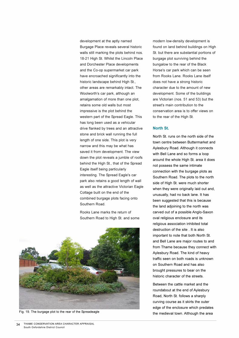
development at the aptly named
Burgage Place reveals several historic
walls still marking the plots behind nos.
18-21 High St. Whilst the Lincoln Place
and Dorchester Place developments
and the Co-op supermarket car park
have encroached significantly into the
historic landscape behind High St.,
other areas are remarkably intact. The
Woolworth's car park, although an
amalgamation of more than one plot,
retains some old walls but most
impressive is the plot behind the
western part of the Spread Eagle. This
has long been used as a vehicular
drive flanked by trees and an attractive
stone and brick wall running the full
length of one side. This plot is very
narrow and this may be what has
saved it from development. The view
down the plot reveals a jumble of roofs
behind the High St., that of the Spread
Eagle itself being particularly
interesting. The Spread Eagle's car
park also retains a good length of wall
as well as the attractive Victorian Eagle
Cottage built on the end of the
combined burgage plots facing onto
Southern Road.
Rooks Lane marks the return of
Southern Road to High St. and some
modern low-density development is
found on land behind buildings on High
St. but there are substantial portions of
burgage plot surviving behind the
bungalow to the rear of the Black
Horse's car park which can be seen
from Rooks Lane. Rooks Lane itself
does not have a strong historic
character due to the amount of new
development. Some of the buildings
are Victorian (nos. 51 and 53) but the
street's main contribution to the
conservation area is to offer views on
to the rear of the High St.
North St.
North St. runs on the north side of the
town centre between Buttermarket and
Aylesbury Road. Although it connects
with Bell Lane and so forms a loop
around the whole High St. area it does
not possess the same intimate
connection with the burgage plots as
Southern Road. The plots to the north
side of High St. were much shorter
when they were originally laid out and,
unusually, had no back lane. It has
been suggested that this is because
the land adjoining to the north was
carved out of a possible Anglo-Saxon
oval religious enclosure and its
religious association inhibited total
destruction of the site . It is also
important to note that both North St.
and Bell Lane are major routes to and
from Thame because they connect with
Aylesbury Road. The kind of heavy
traffic seen on both roads is unknown
on Southern Road and has also
brought pressures to bear on the
historic character of the streets.
Between the cattle market and the
roundabout at the end of Aylesbury
Road, North St. follows a sharply
curving course as it skirts the outer
edge of the enclosure which predates
the medieval town. Although the area
34 THAME CONSERVATION AREA CHARACTER APPRAISAL
South Oxfordshire District Council
Fig. 19. The burgage plot to the rear of the Spreadeagle

between the road and the town centre
has been dramatically affected by the
Waitrose and police station
developments and there is a good deal
of modern housing on the other side
(the Lashlake Road area) the character
of the road is quite well preserved.
Despite the constant traffic on this
relatively narrow road the impression of
low-density development,
predominantly characterised by small
cottages on the margin between town
and country, survives. A hedge and
stone wall screens the Waitrose car
park quite effectively for much of its
length. The hedge fronting no. 39 and
the trees opposite play an important
role where the road bends. A pair of
modern garages with a large area of
hard standing do little to contribute to
the street scene at this point and the
entrance to Lashlake Road is very wide
with broad expanses of tarmac
pavement flanking it. Unfortunately this
emphasises the intrusive nature of the
Lashlake Road development. Looking
towards Aylesbury Road, Corner Close
Cottage and the cricket pitch form a
soft and attractive termination to the
view but the modern development and
roundabout are a little too overbearing
and harsh.
The most interesting buildings on the
lower part of North St. are the two early
ones, Tripps Cottage and the Bishops
Palace and the group of 19th century
cottages around them (see Fig.20).
This group, centred on Moorend Lane,
represents both early building beyond
the edge of the town and later
development along a major route into
it. Moorend Lane probably originated
as a route out into the country with the
mainly 17th century Bishop's Palace
built in what were then open fields.
This is a beautifully preserved timber
framed building that was originally built
by the Bishop of Lincoln who used it as
a temporary residence when touring
his diocese. It incorporates a 16th
century wing with a cruck frame. The
house closes the view into Moorend
Lane, its weathered and textured tile
roof catching the eye. It also retains
some sense of separation from the
buildings around it due to its gardens
and the drive to Tripps Cottage. This
cottage, also originating in the 16th
century, can be seen from Moorend
Lane behind the later houses, and
presents its rear elevation to Lashlake
Road. The 19th century cottages that
cluster around the junction of Moorend
Lane and Lashlake Road are an
interesting group, mixing brick and
stone construction. No. 45 North St.
has an unusual road sign on a stone
panel to the front that is indicative of
the development of the road into a
major route. The blocked door and
window also visible at the front result
from the building's conversion from a
public house. Nos. 41-45 North St. are
stone and rendered brick cottages and
nos. 9-10 and 3-6 Moorend Lane are
19th century terraced houses similar to
those seen elsewhere on the fringes of
Thame (for example in East St. and
Nelson St.). Slate predominates on the
roofs of this group but some traditional
THAME CONSERVATION AREA CHARACTER APPRAISAL
South Oxfordshire District Council35
Fig. 20. The Bishops Palace

clay tile can be seen on nos. 9-10
Moorend Lane.
When seen from the junction with
Buttermarket, North St. rapidly assumes
a distinctly different character from that
of High St. The raised pavement on
either side of the road leaves the
buildings set above the street and this
is particularly noticeable on the western
side giving the mostly small buildings a
greater prominence. The road is quite
wide and becomes broader as it
approaches the junction with Wellington
St. Looking up the road, the Market
Square pub is a prominent feature with
the buildings at the corners of Upper
High St. and Buttermarket flanking it.
Looking away from High St., the road
widens and curves away to the left with
the trees on the grass verge in front of
the cattle market softening the view.
Two unremarkable buildings made
prominent by distinctive colour
schemes draw attention away from the
more subtle tones of the stone cottage
at the corner of Moorend Lane that
closes the view in the distance.
The two sides of the southern part of
North St. are subtly different. Building
on the sides and ends of burgage plots
on the Upper High St. side has mostly
occurred at an early date and many of
the small houses from Upper High St.
to Wellington St. have 17th or early
18th century origins. Particularly
notable among these is the central
group, nos. 53-60, most of which date
from the 17th century. Patterned
brickwork and rendered facades
dominate, whilst an attractive rhythm
formed by the falling slope of roofs,
windows and shopfronts as the terrace
follows the slope gives an interesting
and pleasingly coherent look to the
group.
The western side of North St. is
notable for an almost unbroken line of
small 19th century houses. The houses
comprising this terrace range from
small 1½-storey buildings (reminiscent
of earlier houses on High St.) to more
decorative late Victorian houses with
polychromatic brickwork and
bargeboards (nos. 21-23). Overall
these houses are well preserved and
make a strong contribution to the
streetscape. The top of North St. is
notable for The Beeches (no.5a) set
behind a high stone wall capped in tile.
This 18th century house is set back
from the road and marks an important
visual break between the properties on
Buttermarket and the later terraced
houses on North St. On the western
side of the street is a narrow road
between nos. 21 and 23. This leads to
an area at the rear of Buttermarket
where The Old Candle Factory (a
Victorian building constructed on the
burgage plot) stands. From here
several boundary walls can be seen
defining substantial areas of surviving
burgage plots.
Whilst the cattle market features large
utilitarian modern sheds it is also a
large open area that does not dominate
the edge of the conservation area as it
is set back behind a grass verge and
low wall. This provides something of a
softening effect on the roadside. In the
view up North St. from Moorend Lane
39 (The Blue Man) is prominent.
Although this has been altered it is an
interesting house that may have
originated in the late 17th or early 18th
centuries. It has two large chimneys
prominent in views both on the street
and from the supermarket car park
behind. Between 39 and Friday Court
are a series of Victorian terraced
houses. In form, scale and position
they are in keeping with the street and
contribute to its appearance. Most of
them have been substantially altered
36 THAME CONSERVATION AREA CHARACTER APPRAISAL
South Oxfordshire District Council

and nos. 34 - 37 with their stone
mullioned windows are perhaps the
most characterful.
Park St. and East St.
In contrast to High St., the Park St. and
East St. portions of the conservation
area are predominantly 19th century in
date and distinctly different in
character. The visual character of Park
St. is very different from that of Upper
High St. At its eastern end Upper High
St. is still very much an open,
expansive space, despite the road
narrowing as it moves away from the
market place. This is due to the war
memorial gardens and The Poplars, an
early 18th century house with two
splendid blue cedars in its large front
garden. Not only do these spaces open
out the street visually but their lawns
and trees set against a background of
mature trees in the grounds of The
Elms make an important visual 'pause'
between the dense building of Upper
High St. and Park St.
Red brick is the dominant building
material to be seen on Park St. and
there is an attractive mixture of slate
and tile roofs. There is some stone
building evident, mostly on larger or
earlier buildings such as the John
Hampden School, the Police Station
and 33 Park St. In addition some
terraced houses use rubble stone in
their front or side walls (15 and 16 Park
St.). Whilst most boundary walls are
also in red brick some stone is used,
such as beside St. Mary's Cottage. The
Cross Keys pub, situated on the corner
of East St. and Park St. and
commanding a view back into Upper
High St. is an understated building for
such a prominent position. It is an early
19th century building and has an
attractively textured tile roof and
presents quite a plain facade to Upper
High St. Beyond the Cross Keys, Park
St. is narrow in comparison to Upper
High St., with many of its houses built
right on to the pavement and although
they are quite low, principally two
storeys, the feeling is a close and
contained one.
Before the mid-19th century Park St.
was very much at the rural fringe of the
town and some of the early buildings
seen today were built in formerly open
ground. Perhaps the most notable of
these are nos. 34 and 35 Park St., a
pair of 18th century townhouses
probably constructed in the expectation
of other genteel architecture being built
to accompany them in their prominent
site on the main road into town. In the
early and mid-19th century other
houses followed and by the middle of
the 19th century the gaps between
these houses were becoming filled in
and the densely built character of Park
St. established. The terrace of houses
adjoining the Cross Keys (nos. 2-8)
was built in the early 19th century but it
cannot have been long afterwards that
the terrace nos. 36-40 was erected
along with other small houses.
The mixture of large and small houses
gives Park St. a diverse but ultimately
enclosing feeling. The dominant
building types are 2 storey, terraced
houses and 2 storey, semi-detached
houses with large gabled dormers in
the roof facing the road. The houses
are either built right on to the pavement
edge or set behind small front gardens
some with original low brick walls (nos.
17 and 18) and cast iron railings (nos.
88a-93). These gardens do not provide
enough space for trees but some
greenery is provided by the front
gardens.
Further along the street are more
terraced houses, like nos. 36-40, and
larger houses, such as 33. The street
THAME CONSERVATION AREA CHARACTER APPRAISAL
South Oxfordshire District Council37

also features the non-residential
buildings that fill spaces between the
houses. The John Hampden School
was built in 1837 as the Royal British
School when much of the street would
still have been undeveloped. It takes
the form of a handsome stone house
with flanking wings and is still topped
with its original belfry. Unlike any other
building in the street it is set back a
considerable distance from the
pavement behind two mature copper
beech trees. The low front wall is
topped with large and unusual shaped
bricks (also seen on a wall in
Priestend) that were originally crowned
by iron railings. Replacement metal
railings are now set just inside the wall.
Despite the expansion of school
grounds and the addition of ancillary
school buildings the original school is
still the principal building on the site.
The school maintains an important
place in the street scene and is a
centre of activity for the local
community. The Baptist Chapel (built in
1836) is also a building important to the
community as well as being of some
historic interest. To the rear of the
south side of Park St. is The Elms
Park. This has played an important role
in restricting development behind the
rear boundaries of the properties on
Park St. and today allow views of the
rear of the houses. There is also a
view into and out of the street via the
entrance to the fields. For these
reasons it is proposed to bring the
Elms Park and playing fields into the
conservation area (see Fig. 21).
The area of Park St. around the petrol
station has a negative impact on the
historic character of the area. Opposite
Victoria Mead is a series of modern
commercial premises which form an
unsightly group not helped by the
plethora of signs attached to their
frontages. However, commercial
premises have long been a part of Park
St.'s character, both as purpose-built
premises and adapted houses. A
surviving late Victorian workshop and
several shops with attractive shop
fronts testify to this tradition.
The eastern end of Park St. is marked
by the junction with Chinnor Road
where the former Police Station
dominates the scene. It is situated at
the fork in the road and so is both an
eye-catcher when looking from the
town and has a commanding view back
down Park St. to the High St. It is not a
large building but its stonework and
unadorned front façade give it an
imposing and severe look. The large
area of open ground around it further
marks out the Police Station, from the
surrounding area. Flanking the Police
Station is a pair of interesting buildings.
On the northern side is 1 Chinnor
Road, an attractive and well-preserved
Victorian gothic house and on the
south is The Falcon pub, a fanciful and
eclectic piece of Edwardian design that
is in strong contrast to the other two
buildings. Between these buildings and
the petrol station are some typical 19th
century terraced houses that form a
link with those on Park St. and the view
out along Chinnor Road.
38 THAME CONSERVATION AREA CHARACTER APPRAISAL
South Oxfordshire District Council
Fig. 21. The Elms Park

East St., in contrast to Park St., is
almost wholly dominated by small
terraced and detached houses. The
north side is taken up by a terrace of
ten Victorian houses with a later pair
added at the east end. Although few
original windows and doors can be
seen, the terrace is substantially intact.
Where the south side of East St. meets
Park St. earlier and more varied
buildings can be seen. Here stone is
mixed with brick and the cluster of
small white-painted cottages, nos. 67-
70 together with the outbuilding of the
Cross Keys, are more representative of
the vernacular building of the area than
the urban terrace opposite. However,
all these buildings are no more than
two storeys high and built straight onto
the pavement, giving the street a
narrow feeling. The Primitive Methodist
Chapel, built in 1864, is also of note
here. Views in and out of the
conservation area along East St. are
quite constrained. The orientation of
the street does not allow a view into
the open vista of High St., as on Park
St., and the curve of the road reduces
views along East St. itself.
Whilst the conservation area in East St.
finishes on the south side of the street
with the start of inter-war semi-
detached housing, on the north side
Gas Alley marks a short break before a
pair of larger detached houses. These
are mid-19th century in date and as in
Park St. are probably the result of the
movement towards building large
houses in the open countryside on the
edge of the town prior to the
construction of terraced housing.
Interestingly, the inclusion of
commercial premises in the area later
in the 19th century, also seen on Park
St., is displayed by the large workshop
in the garden of No 16. These houses
still have a sense of separation from
the rest of 19th century East St. due to
Gas Alley and the front garden of no
15a which breaks the terrace's line of
facades. Gas Alley itself is an
interesting area. The attractively
weathered brick walls and the white-
painted walls of nos. 3 and 4 frame the
view back into East St.
Proposed extensions to the
conservation area
The plot behind the Six Bells in High
St. is an area of former garden that has
not so far been developed as has so
often happened elsewhere on the
southern side of the town. Although
presently used as the pub's car park, it
is still an open space that keeps the
modern building beyond at a distance
from the rear of the High St. and allows
interesting views of the rear of these
houses with their fascinating mixture of
roofs and chimneys. The car park itself
is also very visible from Brook Lane.
Including this small but valuable area in
the conservation area will recognise
this unusual survival as a component
of the historic town and consequently
focus interest on the best way it can be
managed and enhanced in the future.
The extensive grounds of The Elms
and the adjoining recreation
ground/playing field form a very
important green space within the town.
The grounds of The Elms, whilst not
publicly accessible, make a strong
contribution to the conservation area in
views from the playing fields behind
John Hampden School and from Elms
Road. They also form a vital part of the
setting of The Elms itself. Together
these two green spaces frame the
south-eastern side of the conservation
area. They also separate Park St. and
Nelson St. from the modern housing on
Elms Road and Broadwater Avenue
and so not only create an important
THAME CONSERVATION AREA CHARACTER APPRAISAL
South Oxfordshire District Council39

part of the character of this part of the
conservation area but also maintain its
historic integrity as a one-time fringe of
the town.
Bringing these two areas into the
conservation area will formally
acknowledge the role they play and
help focus attention on the historic
character of the area should
development around or on them ever
be proposed.
Management proposals
Proposals for the preservation and
enhancement of the conservation area
are included in a separate document
Thame Conservation Area;
Management Plan. This includes
proposals for the maintenance of
historic buildings, trees and open
spaces, design guidance for new
development and public realm works
and relevant conservation policies. This
document is available from South
Oxfordshire District Council,
Conservation and Design Team; tel
01491 823771 or email:
Bibliography
Brown, JH and Guest, W
A History of Thame, 1935
Brown, JH
A Guide to St. Mary's Church, Thame,
1961 (5th Ed.)
Clarke, G
The Book of Thame , 1978
Dobie, B
Victorian Thame: A Vignette, 1988
Golfe, S
Thame Past and Present, 1998
Hickman, A and Bretherton, D
Thame Inns Discovered, 2000
Horton, V
St. Mary's Church, Thame, 1992
Lee, FG
The History of the Prebend Church of
the Blessed Virgin Mary of Thame,
1883
www.thamehistory.net
40 THAME CONSERVATION AREA CHARACTER APPRAISAL
South Oxfordshire District Council