main roads
TRANSCRIPT
1 -
Main Roads
Mitchell Freeway Extension
Phytophthora Dieback occurrence assessment – Version 1.0

2 -
Disclaimer
This report has been prepared in accordance with the scope of work agreed between the Client and Glevan Consulting and contains results and recommendations specific to the agreement. Results and recommendations in this report should not be referenced for other projects without the written consent of Glevan Consulting. Procedures and guidelines stipulated in various Department of Environment and Conservation and Dieback Working Group manuals are applied as the base methodology used by Glevan Consulting in the delivery of the services and products required by this scope of work. These guidelines, along with overarching peer review and quality standards ensure that all results are presented to the highest standard. Glevan Consulting has assessed areas based on existing evidence presented at the time of assessment. The Phytophthora pathogen may exist in the soil as incipient disease. Methods have been devised and utilised that compensate for this phenomenon; however, very new centres of infestation, that do not present any visible evidence, may remain undetected during the assessment. Author Evan Brown
3 -
Table of Contents
1 Summary .......................................................................................... 6
2 Introduction ...................................................................................... 8
2.1 Background .................................................................................................................8
2.2 Study team..................................................................................................................8
3 Phytophthora Dieback ....................................................................... 10
3.1 The Pathogen ........................................................................................................... 10
3.2 Host.......................................................................................................................... 10
3.3 Environment ............................................................................................................ 11
4 Methods .......................................................................................... 13
4.1 Defining the assessment area ................................................................................. 13
4.2 Interpreting the vegetation for Phytophthora ........................................................ 15
4.3 Mapping ................................................................................................................... 16
4.4 Limitations of disease mapping ............................................................................... 17
5 Project area environmental data ........................................................ 18
5.1 Rainfall ..................................................................................................................... 18
5.2 Soil types .................................................................................................................. 18
5.3 Vegetation structure ............................................................................................... 19
6 Results ........................................................................................... 22
6.1 Pre survey desktop study ........................................................................................ 22
6.2 Field Assessment ..................................................................................................... 22
7 Discussion ........................................................................................25
8 Recommendations ............................................................................ 30
9 Bibliography .................................................................................... 36
4 -
10 Appendix A – Phytophthora occurrence maps (Figures 7 – 13) .................. 37
11 Appendix B – Sample sites (Plates 1 – 12) ............................................ 45
12 Appendix C – Keighery disturbance scale .......................................... 51
List of Figures
Figure 1 - Location of Project Area .............................................................................................9
Figure 2 - Phytophthora recoveries near Project Area ............................................................ 14
Figure 3 - Landscapes in Project Area...................................................................................... 20
Figure 4 - Vegetation Complexes in Project Area .................................................................... 21
Figure 5 - Sample locations ..................................................................................................... 24
Figure 6 - Fenced rehabilitation area ...................................................................................... 28
Figure 7 – Romeo Road (north) ............................................................................................... 38
Figure 8 – Romeo Road (south) ............................................................................................... 39
Figure 9 – Mitchell Fwy, Butler ................................................................................................ 40
Figure 10 – Mitchell Freeway, Butler (near Lukin Drive) ......................................................... 41
Figure 11 – Wanneroo Road (near Lake Nowergup) ............................................................... 42
Figure 12 - Mitchell Freeway, Ridgewood and Wanneroo Road / Dunstan Road ................... 43
Figure 13 -Mitchell Fwy / Hester Avenue Intersection ........................................................... 44
List of Tables
Table 1 - Soil profiles in Project Area....................................................................................... 18
Table 2 - Vegetation Types in Project Area ............................................................................. 19
Table 3 - Area Summary .......................................................................................................... 23
Table 4 – Project Area Sample Summary ................................................................................ 23
Table 5 – Table of Management Measures and Actions ......................................................... 31

5 -
List of Plates
Plates 1 – 8 – See Appendix B
6 -
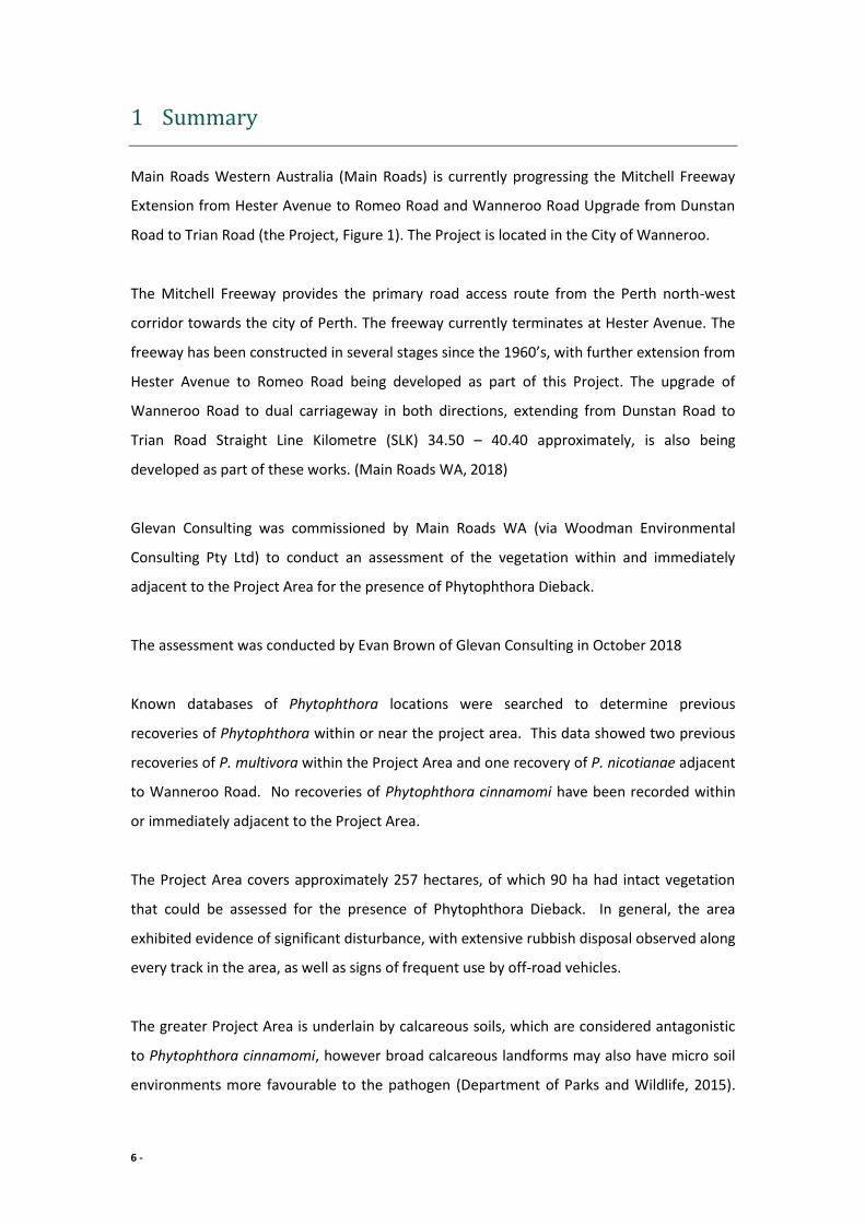
1 Summary
Main Roads Western Australia (Main Roads) is currently progressing the Mitchell Freeway
Extension from Hester Avenue to Romeo Road and Wanneroo Road Upgrade from Dunstan
Road to Trian Road (the Project, Figure 1). The Project is located in the City of Wanneroo.
The Mitchell Freeway provides the primary road access route from the Perth north-west
corridor towards the city of Perth. The freeway currently terminates at Hester Avenue. The
freeway has been constructed in several stages since the 1960’s, with further extension from
Hester Avenue to Romeo Road being developed as part of this Project. The upgrade of
Wanneroo Road to dual carriageway in both directions, extending from Dunstan Road to
Trian Road Straight Line Kilometre (SLK) 34.50 – 40.40 approximately, is also being
developed as part of these works. (Main Roads WA, 2018)
Glevan Consulting was commissioned by Main Roads WA (via Woodman Environmental
Consulting Pty Ltd) to conduct an assessment of the vegetation within and immediately
adjacent to the Project Area for the presence of Phytophthora Dieback.
The assessment was conducted by Evan Brown of Glevan Consulting in October 2018
Known databases of Phytophthora locations were searched to determine previous
recoveries of Phytophthora within or near the project area. This data showed two previous
recoveries of P. multivora within the Project Area and one recovery of P. nicotianae adjacent
to Wanneroo Road. No recoveries of Phytophthora cinnamomi have been recorded within
or immediately adjacent to the Project Area.
The Project Area covers approximately 257 hectares, of which 90 ha had intact vegetation
that could be assessed for the presence of Phytophthora Dieback. In general, the area
exhibited evidence of significant disturbance, with extensive rubbish disposal observed along
every track in the area, as well as signs of frequent use by off-road vehicles.
The greater Project Area is underlain by calcareous soils, which are considered antagonistic
to Phytophthora cinnamomi, however broad calcareous landforms may also have micro soil
environments more favourable to the pathogen (Department of Parks and Wildlife, 2015).

7 -
Phytophthora Dieback has been recorded in calcareous soils, relating to poor hygiene used
in developments.
All vegetation within the Project Area that could be assessed for the presence of
Phytophthora Dieback has been classified as Uninfested. The remaining infrastructure areas,
road surfaces and extensively degraded vegetation has been excluded from the assessment.
Twelve samples were taken to assist the interpretation process. Three samples adjacent to
Wanneroo Road showed the presence of P. nicotianae whilst the remaining samples proved
negative.
8 -
2 Introduction
2.1 Background
Main Roads Western Australia (Main Roads) is currently progressing the Mitchell Freeway
Extension from Hester Avenue to Romeo Road and Wanneroo Road Upgrade from Dunstan
Road to Trian Road (the Project, Figure 1). The Project is located in the City of Wanneroo.
A Dieback assessment was previously undertaken for a large portion of the current Project
area in 2013. Given the age of the Dieback mapping and the additional smaller project areas
that were previously not surveyed, the Project requires resurvey to confirm the Dieback
boundaries on site. The Project construction is anticipated to commence mid-late 2020.
The Mitchell Freeway provides the primary road access route from the Perth north-west
corridor towards the city of Perth. The freeway currently terminates at Hester Avenue. The
freeway has been constructed in several stages since the 1960’s, with further extension from
Hester Avenue to Romeo Road being developed as part of this Project. The upgrade of
Wanneroo Road to dual carriageway in both directions, extending from Dunstan Road to
Trian Road Straight Line Kilometre (SLK) 34.50 – 40.40 approximately, is also being
developed as part of these works. (Main Roads WA, 2018)
Glevan Consulting was commissioned by Main Roads WA (via Woodman Environmental
Consulting Pty Ltd) to conduct an assessment of the vegetation within and immediately
adjacent to the Project Area for the presence of Phytophthora Dieback.
2.2 Study team
The assessment was conducted by Evan Brown of Glevan Consulting in October 2018. Mr
Brown is registered (DPW-PDI-004) with the Department of Biodiversity, Conservation and
Attractions (DBCA) in the detection, diagnosis and mapping of the Dieback disease. This
accreditation recognises the skills and experience of Mr Brown.

9 -
Figure 1 - Location of Project Area
10 -
3 Phytophthora Dieback
The pathogen Phytophthora cinnamomi is an agent of environmental disease found in
vulnerable areas of Western Australia. Phytophthora Dieback is the common name for the
observable disease result of interaction between the pathogen (P. cinnamomi) and the
vegetation hosts (susceptible plant species within vulnerable areas).
The environmental conditions of the site significantly affect the pathogens ability to survive
or flourish and spread over time. All land with an annual average rainfall of more than 400
millimetres and suitable soil composition is considered vulnerable to Phytophthora Dieback.
This large area stretches approximately from Perth, Bunbury and Augusta in the west to
Narrogin, Ravensthorpe and Esperance in the east, and as far north as Kalbarri.
This vulnerable area has many different bioregions, having specific characteristics formed by
climate and geology. These two factors are highly significant in determining the pathogen’s
effectiveness and resulting disease impact levels.
3.1 The Pathogen
Phytophthora cinnamomi is a microscopic water mould. It belongs to the class Oomycetes
and belongs in the Kingdom Stramenopila. It is more closely related to brown algae than to
true fungi. Oomycetes organisms occupy both saprophytic and pathogenic lifestyles
however P. cinnamomi is considered parasitic. It behaves largely as a necrotrophic pathogen
causing damage to the host plant’s root tissues because of infection and invasion.
The life cycle of Phytophthora cinnamomi is a continuous circle of infection, sporulation and
further infection and is readily vectored by animals and human activity allowing for rapid
invasion into new areas.
3.2 Host
A population of hosts is made up of susceptible, infected and immune or resistant
individuals. The infection of host plants is an unseen activity happening constantly beneath
the soil at an infested site.
11 -
The environmental conditions favouring or disfavouring the pathogen may change at a
critical point during disease development, temporarily changing the rates of infection and
invasion. This can be observed symptomatically after soil temperature change through
winter months.
The plant host is a highly variable component of the disease development. Sites may range
from having no susceptible host, to containing vegetation that is almost entirely susceptible.
Within vulnerable areas, three main family groups are regarded as highly susceptible to
Phytophthora Dieback disease, being:
Proteaceae
Ericaceae
Xanthorrhoeaceae.
3.3 Environment
Two fundamental environmental characteristics influencing Phytophthora Dieback disease
are rainfall and soil. Areas vulnerable to Phytophthora Dieback are defined as native
vegetation which occur west of the 400 millimetre rainfall isohyet. The correlation of
increased Phytophthora Dieback impact with increased annual rainfall is generally
applicable.
Certain soil properties influence Phytophthora Dieback disease development within the
vulnerable areas:
1. Moisture is critical for Phytophthora cinnamomi to survive in the soil and for
sporangia production.
2. Soil pH affects the growth and reproduction of the pathogen. The calcareous sands
closest to the coast are alkaline and hostile to Phytophthora cinnamomi, but are
favourable to P. multivora.
3. Fertile soils are less favourable to Phytophthora Dieback because the richness of
nutrients aids strong host resistance, good soil structure allows water movement
and drainage, and high organic matter provides antagonistic microflora.
4. Coarse-textured soils have larger pore spaces which favour dispersal of spores.
5. The optimum temperature for Phytophthora cinnamomi sporulation is 21 to 30°C,
peaking at 25°C., but some sporangia can still be produced at temperatures as low as
12°C. The optimum growth range is 15 to 30°C and temperatures lower than 5°C or

12 -
greater than 35°C are unfavourable for the persistence of survival of spores and the
vegetative mycelia of P. cinnamomi.
13 -
4 Methods
4.1 Defining the assessment area
The assessment area covers all assessable vegetation within the Project Area, and vegetation
that may be outside of the Project Area that if infected with Phytophthora Dieback, would
have hygiene or management implications on the Project Area. This would generally be
vegetation immediately upslope of the Project Area or adjacent sites with recent
disturbance.
Assessable vegetation is defined as “Naturally vegetated areas with a Keighery disturbance
rating of 3 or less and where Phytophthora occurrence categorisation is possible.”
(Department of Parks and Wildlife, 2015). This vegetation will be categorised following the
assessment as being:
• Infested: Determined by a qualified interpreter to have plant disease symptoms
consistent with the presence of Phytophthora cinnamomi.
• Uninfested: Determined by a registered interpreter to be free of plant disease
symptoms that indicate the presence of P. cinnamomi.
• Uninterpretable: undisturbed areas where susceptible plants are absent, or too few to
make a determination of the presence or absence of P. cinnamomi.
• Not yet resolved: Phytophthora occurrence diagnosis cannot be made at the time of
assessment because of inconsistent or incomplete evidence.
Areas that cannot be assessed because of disturbance will be categorised as:
• Temporarily Uninterpretable: vegetation structure is temporarily altered and
assessment will be possible when the vegetation recovers, e.g. post-burn
• Excluded: areas of high disturbance where natural vegetation has been cleared and is
unlikely to recover to a level that is interpretable.

14 -
Figure 2 - Phytophthora recoveries near Project Area
15 -
4.2 Interpreting the vegetation for Phytophthora
Phytophthora Dieback will only be observable when the pathogen is causing the death of
susceptible species. The interpretation will focus on those species that are reliably
susceptible to Phytophthora. The deaths will only occur when the three components of the
disease triangle (pathogen, host and environment) are satisfied.
When observing possible deaths caused by Phytophthora, consideration will be given to the
relationship between the death and other factors including:
Is the death isolated?: These are single dead indicator species plants that have no apparent
association with any other death and may be within an area populated by many other
healthy indicator plants. These deaths are often unrelated to Phytophthora Dieback, but
they will be fully examined because of the possibility of infestation.
Are there scattered deaths?: There may be many healthy indicator species between
scattered deaths which may occur over a wide area and have no apparent association
between deaths.
Clusters of deaths: are two or more dead plants of one species near one another with an
apparent association between the deaths?
Multiple deaths: Some or all of the indicator species are dead within the same area and multiple species deaths are observed.
Chronology of deaths: A strong chronological pattern exhibiting in multiple indicator species
would suggest a high likelihood of Phytophthora presence. Weaker chronological patterns
may indicate non-Phytophthora factors.
Pattern of deaths: The spatial distribution of the deaths may suggest a logical progression of
the disease, based on topography, soil type, vegetation type and drainage characteristics of
an area.
Topographical position: The topographical position of the deaths may indicate the
probability of infestation. In lower rainfall areas, Phytophthora deaths may be confined to
gullies and other water-gaining sites.
Vectoring: consideration will be given to any possible cause of introduction of the pathogen
to the Project Area, through uncontrolled access, water flow, soil and rubbish dumping etc.
Biomass change: sites may undergo a change in vegetation density and composition post
infection with indicator species being less dense and the possible dominance of non-
susceptible species.
16 -
Other causes of plant deaths:
• Armillaria luteobubalina
• various cankers
• insects
• drought, wind scorch and frost
• salinity and waterlogging
• fire and lightning
• senescence and competition
• physical damage
• herbicides and chemical spills.
All assessable vegetation was interpreted during the assessment for possible presence of
Phytophthora Dieback.
4.3 Mapping
Evidence is collected in the field to substantiate the diagnosis of possible Phytophthora
Dieback presence. These points will also justify the categorisation of the vegetation on the
Phytophthora Dieback Occurrence Map. The primary evidence collected can be:
• Points located at deaths where field diagnosis is certain or almost certain of
Phytophthora Dieback infestation.
• Points located at an area of healthy indicator species where field diagnosis is almost
certain of the site being uninfested.
• Points located at sites with too few or devoid of indicator species, thus supporting
uninterpretable classification.
• Points located at areas of disturbance, which are temporarily uninterpretable or
excluded from assessment.
• Points located at soil and tissue sample sites
• Points located where field diagnosis is certain or almost certain of Armillaria Rot
Disease (Department of Parks and Wildlife, 2015).
All data was collected using the ESRI Collector App with the recorded data then transferred
to a desktop computer and used to produce the relevant maps.
17 -
4.4 Limitations of disease mapping
The assessment for the disease caused by Phytophthora Dieback is based on interpreting the
vegetation for symptoms which can be ascribed to the disease presence. These observable
factors must be present during the assessment period. Management recommendations may
be included if it is considered that the disease may be cryptic, or the project area displays
evidence of activities that are considered a high risk of introducing the disease.
18 -
5 Project area environmental data
The pathogen requires a suitable host and environment for disease to occur. As detailed in
the following sections, the soil type is predominantly alkaline and hostile to Phytophthora
cinnamomi (Department of Parks and Wildlife, 2015) (but possibly favourable to other
species). The majority of the Project Area contains species that are susceptible to
Phytophthora and would exhibit the disease symptoms if the pathogen was present.
5.1 Rainfall
The area (Tamala Park weather station) has received approximately 659 mm of rainfall this
calendar year (Bureau of Meteorology). This would place the area as being within the
vulnerable zone, as defined by DBCA (Department of Parks and Wildlife, 2015). Significant
rainfall occurred in January 2018 which would provide suitable conditions of warm, moist
soil for Phytophthora to flourish.
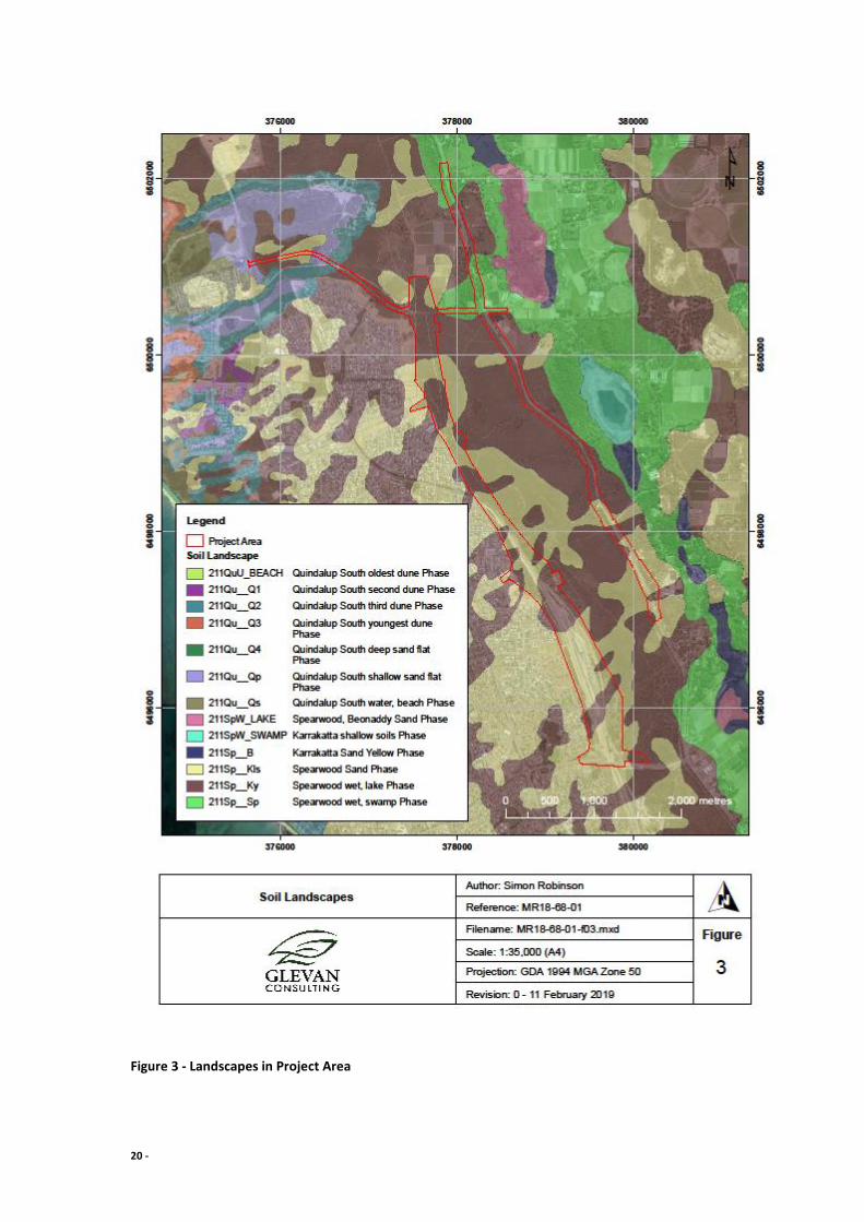
5.2 Soil types
The Project Area is located over three landscapes as defined by the Department of Primary
Industry and Regional Development’s 027 dataset (DPIRD, 2018). The Karrakatta complex is
dominant in the Project Area covering 93.7%, whilst the Spearwood complex (5.7%) and
Quindalup complexes (0.6%) are less prevalent in the Project Area (Figure 3). The
Karrakatta, Quindalup and Spearwood complexes contain calcareous soils.
Table 1 - Soil profiles in Project Area
Name Description
Karrakatta shallow soils Phase
Low hills and ridges. Bare limestone or shallow siliceous or calcareous sand over limestone. Dense low shrub dominated by Dryandra sessilis, Melaleuca huegellii and species of Grevillea.
Karrakatta Sand Yellow Phase
Low hilly to gently undulating terrain. Yellow sand over limestone at 1-2 m. Banksia spp. woodland with scattered emergent E. gomphocephala and E. marginata and a dense shrub layer.
Quindalup South deep sand flat Phase
Undulating landscapes with deep calcareous sands overlying limestone. Soils have dark grey-brown sand to about 50 cm and then pale brown sand. Remnants of hummocks are often present.
Quindalup South second dune Phase
The second phase. A complex pattern of dunes with moderate relief. Calcareous sands have organic staining to about 20 cm, passing into pale brown sand; some cementation below 1 m.
Spearwood Sand Irregular banks of karst depressions. Some limestone outcrop. Shallow
19 -
Phase brown sands. Banksia spp. woodland with emergent E. gomphocephala and E. marginata; dense shrub layer.
5.3 Vegetation structure
The Vegetation Types (Table 2, Figure 4) have been extracted from the SLIP data
“VegetationComplexes_SwanCoastalPlainDBCA_046” and are listed in Table 2 below. The
Cottesloe Complex has numerous species that are considered reliable indicators to the
presence of Phytophthora.
Table 2 - Vegetation Types in Project Area
Vegetation Type Description
Herdsman Complex Sedgelands and fringing woodland of Eucalyptus rudis (Flooded Gum) - Melaleuca species.
Cottesloe Complex-
Central and South
Mosaic of woodland of Eucalyptus gomphocephala (Tuart) and open forest of Eucalyptus gomphocephala - Eucalyptus marginata (Jarrah) - Corymbia calophylla (Marri); closed heath on the Limestone outcrops.
Quindalup Complex Coastal dune complex consisting mainly of two alliances - the strand and fore-dune alliance and the mobile and stable dune alliance. Local variations include the low closed forest of Melaleuca lanceolata (Rottnest Teatree) - Callitris preissii (Rottnest Island Pine), the closed scrub of Acacia rostellifera (Summer-scented Wattle) and the low closed Agonis flexuosa (Peppermint) forest of Geographe Bay.
20 -
Figure 3 - Landscapes in Project Area

21 -
Figure 4 - Vegetation Complexes in Project Area
22 -
6 Results
6.1 Pre survey desktop study
Known databases of Phytophthora locations retained by Glevan Consulting, Vegetation
Health Services (DBCA) and the Dieback Information Delivery and Management System
(DIDMS) were searched to determine previous recoveries of Phytophthora within or near the
project area.
These Phytophthora locations (Figure 2) show two recoveries of P. multivora (from the 2013
and 2000 surveys) within the Project Area and one recovery of P. nicotianae (from a 2001
survey) adjacent to Wanneroo Road.
No recoveries of Phytophthora cinnamomi have been recorded within or immediately
adjacent to the Project Area.
6.2 Field Assessment
All intact vegetation within the Project Area that could be assessed for the presence of
Phytophthora Dieback has been classified as Uninfested (Section 10 – Appendix A). The
remaining infrastructure areas, road surfaces and extensively degraded vegetation has been
excluded from the assessment (Table 3).
The results of the current assessment align mostly with the results of an assessment
undertaken by Glevan Consulting in 2013. In that survey however, (Glevan Consulting, 2013)
an area in the Romeo Road alignment was classified as Infested. This area was showing
multiple Banksia attenuata deaths with some chronology and pattern to the deaths. A
sample taken at the time, and another sample taken during the current assessment have
returned a negative result to the presence of Phytophthora. This area is now classified as
Uninfested.

23 -
Table 3 - Area Summary
Category Total Area (ha) % Assessed Area %Project Area
Infested Uninfested 89.8273 100% 34.97%
Uninterpretable Temporarily Uninterpretable
Not yet resolved Total Assessed Area 89.8273
Excluded 167.0271 65.03%
Project Area 256.8544
Twelve samples were taken to assist the interpretation process (Figure 5). Three samples
taken adjacent to Wanneroo Road recovered P. nicotianae, whilst the remaining samples
returned a negative result (Table 4).
Table 4 – Project Area Sample Summary
Sample Plant sampled Easting Northing Result
1 B. sessilis 379527 6498342 Negative
2 B.attenuata 379301 6499082 Negative
3 B.attenuata 379209 6499153 P. nicotianae
4 B.attenuata 378934 6499389 P. nicotianae
5 B. menziesii 378718 6499823 P. nicotianae
6 B.attenuata 377538 6500409 Negative
7 B.attenuata 377336 6500487 Negative
8 Xanthorrhoea sp. 379157 6497346 Negative
9 B. menziesii 379464 6496823 Negative
10 B.attenuata 377544 6499831 Negative
11 B. menziesii 378773 6497605 Negative
12 B.attenuata 379400 6496138 Negative

24 -
Figure 5 - Sample locations
25 -
7 Discussion
The Project Area covers approximately 257 hectares, of which 90 ha had intact vegetation
that could be assessed for the presence of Phytophthora Dieback. In general, the area
exhibited evidence of significant disturbance, with extensive rubbish disposal observed along
every track in the area, as well as signs of frequent use by off-road vehicles.
The greater Project Area is underlain by calcareous soils which are considered antagonistic
to Phytophthora cinnamomi, however broad calcareous landforms may also have micro soil
environments more favourable to the pathogen. (Department of Parks and Wildlife, 2015).
Phytophthora Dieback has been recorded in calcareous soils, relating to poor hygiene used
in developments.
Romeo Road (north).
The majority of the survey area on Wanneroo Road from the intersection with Romeo Road
to Trian Road has been excluded from the assessment due to the vegetation along the road
verge being degraded or completely degraded. One section has been classified as
Uninfested due the vegetation being in better condition, and also being contiguous with
vegetation extending into Lot 6286 Wanneroo Road, Carabooda, currently vested with the
Water Corporation. (Appendix A, Figure 8).
The vegetation on the northern and southern side of Romeo Road varies in condition, with
no areas of good quality vegetation considered large enough to be assessed. The section of
the alignment west of Romeo Road that extends to Marmion Avenue was observed to
contain two sections of Uninfested vegetation (Figure 5).
One of these sections was considered to be Infested from the 2013 assessment. At that
time, the vegetation was showing some decline in the Banksia species with some chronology
in the deaths adjacent to a disturbed area. A sample taken at the time (2013 Sample 10) did
not prove the presence of Phytophthora. An additional sample (Sample 7) taken during the
current survey (Appendix B, Plate 7) also did not prove the presence of Phytophthora and it
is now considered that the Banksia decline has been caused by other factors.
26 -
At the western end of the sealed section of Romeo Road, Uninfested vegetation is located
on the northern side. This vegetation is bound by disturbed vegetation on the western
boundary and farmland on the northern and eastern boundaries and is not contiguous with
the Uninfested vegetation on the southern side as the verges of Romeo Road have suffered
significant disturbance.
Freeway alignment (south of Romeo Road)
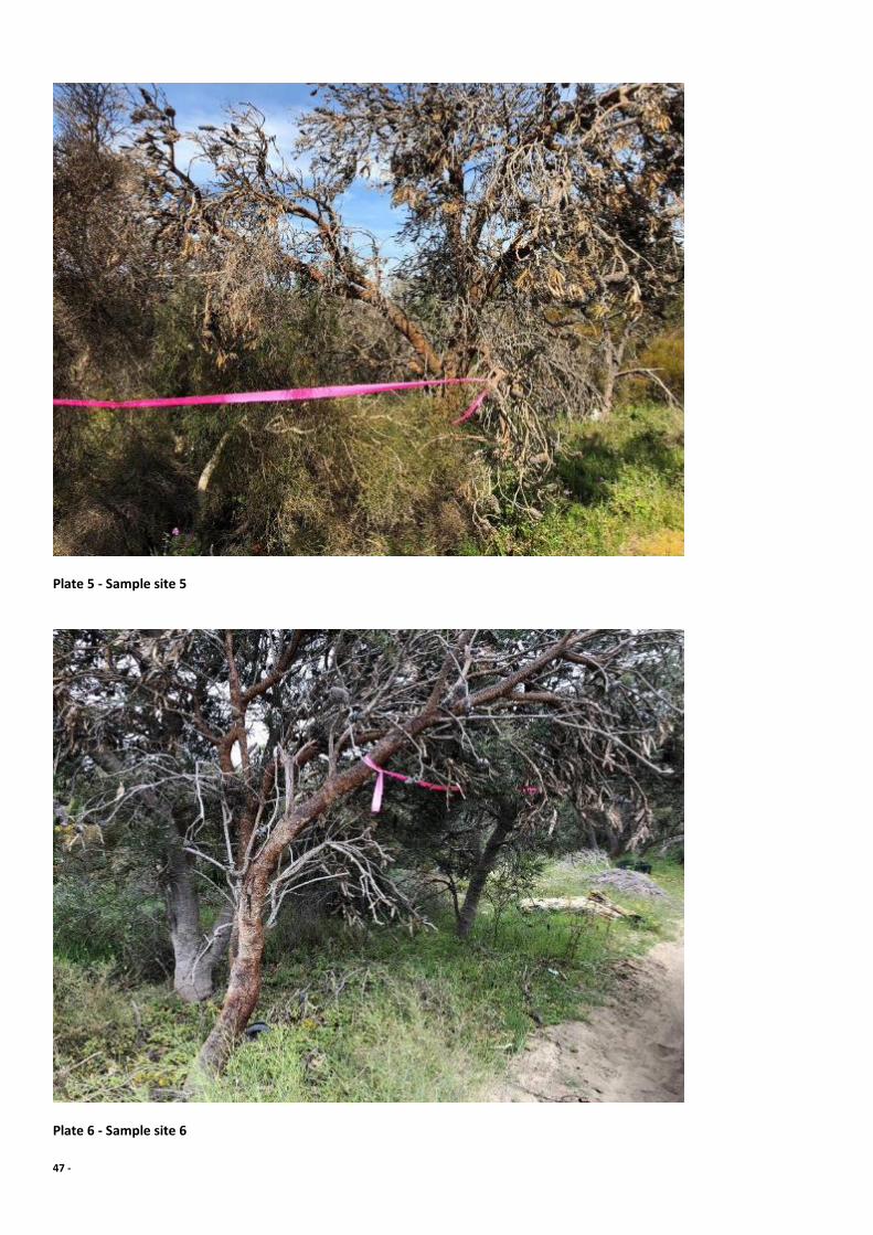
Sample 6 was taken at the entrance to the Uninfested vegetation on the southern side of
Romeo Road (Figure 5; Appendix B, Plate 6). This sample returned a negative result for the
presence of Phytophthora. This site is associated with a well-used track, which then
intersects with all tracks that traverse south through the Neerabup NR.
The vegetation through this area generally has a dense coverage of Banksia and
Xanthorrhoea species that should allow Phytophthora Dieback to be visible, if the pathogen
is present. Some smaller areas are dominated by a myrtaceous heath, although scattered
Phytophthora Dieback indicating species were still present.
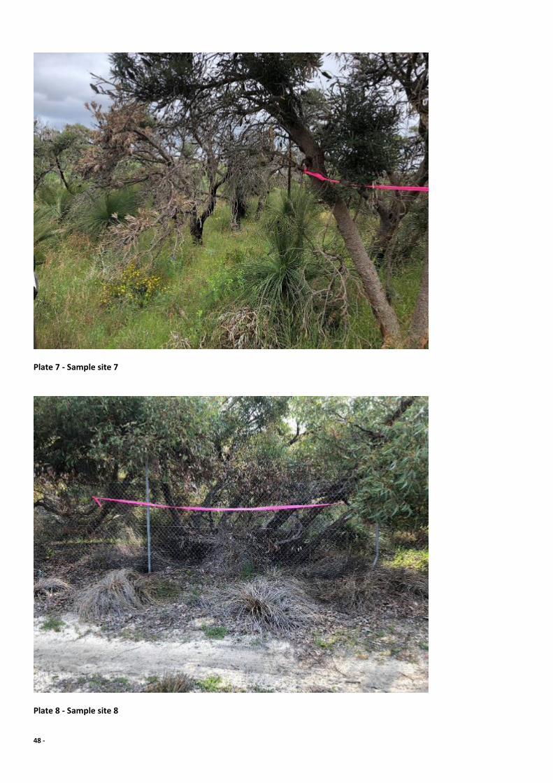
Within this area is a fenced section that has been rehabilitated (Figure 6). Although there
are numerous Phytophthora Dieback indicating species within this area, the site has been
classified as Excluded because of the overall disturbance. Two samples were taken in this
area, Sample 9 (Figure 5; Appendix B Plate 9) at the southern end adjacent to the gate which
returned a negative result. There were many deaths of many different species along the
fence line which were probably caused by poisoning. One sample was taken (Sample 8)
(Figure 5; Appendix B, Plate 8) at a location with a cluster of Xanthorrhoea deaths. This
sample returned a negative result which added support to Phytophthora not being the cause
of the deaths along the fence line.
The vegetation from Romeo Road to the fenced rehabilitation area has been classified as
Uninfested (Figure 5; Appendix A, Figures 8 & 9). Some small areas are devoid of vegetation
or heavily disturbed, however it was not considered necessary to isolate these areas because
of the low risk of Phytophthora presence. Sample 10 (Figure 5; Appendix B, Figure 21) was
taken on the western boundary in this area and returned a negative result.

27 -
A section of vegetation is situated on the western side of the rail alignment that contains
one small area of Uninfested vegetation. A sample from 2013 showed the presence of P.
multivora in this area but it was not causing significant disease symptoms at that time.
Sample 11 (Figure 5; Appendix B, Plate 11) was taken to the south of the Uninfested area in
a section of vegetation that was disturbed and returned a negative result.
On the eastern side of the rail alignment, and south of the fenced rehabilitation area, two
areas of Uninfested vegetation were denoted (Appendix A, Figure 10). The remaining
vegetation has been Excluded from the assessment due to the area being significantly
disturbed.

28 -
Figure 6 - Fenced rehabilitation area

29 -
Wanneroo Road, south of Romeo Road intersection
The western side of Wanneroo Road, south of Romeo Road contains one section of
uninfested vegetation which extends almost to Nowergup Road (Appendix A, Figure 8). The
eastern side of the road contains three small sections of uninfested vegetation, two north of
Nowergup Road and one on the southern boundary (Appendix A, Figures 8 & 9). The two
northern areas are contiguous with the larger area of the Neerabup NR whilst the southern
Uninfested area is bound by roads.
Four samples were taken in this area during the current survey. Three samples (Sample 3,
Sample 4 and Sample 5) proved the presence of P. nicotianae at the sampled locations
(Figure 5; Appendix B, Plates 3, 4 and 5). All samples locations were on the boundary of
vegetation with the road verge. One sample from the current survey (Sample 2) and two
from the previous survey (2013 Sample 9 and 2013 Sample 11) returned negative results
(Appendix B, Plate 2).
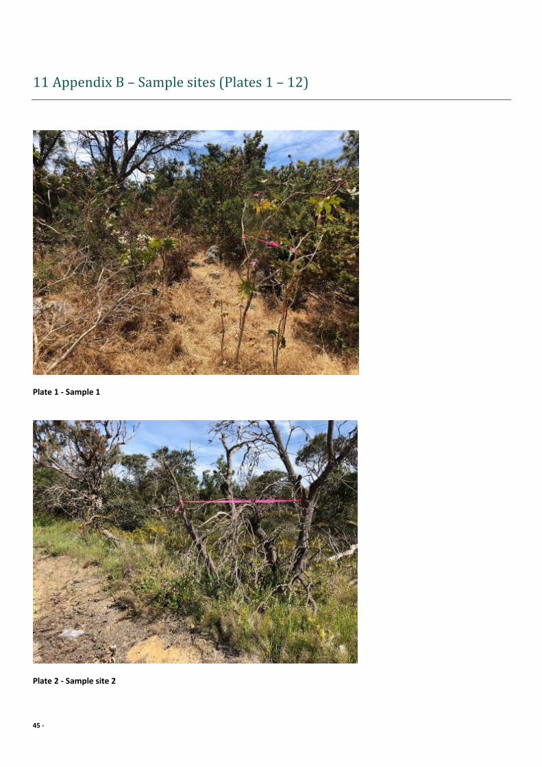
Sample 1 was taken adjacent to a highly disturbed site that extends from Wanneroo Road to
the western boundary and returned a negative result (Appendix B, Plate 1). This area is
densely covered in weeds and some historic soil dumping was evident. Because of the
disturbance, and a the depauperate nature of the vegetation to the south, this section has
been classified as Excluded.
30 -
8 Recommendations
Soil and plant material of infested or unknown dieback status should not be
introduced to Uninfested sections of the study area.
Soil and plant material should not be transported from the Excluded sections of the
Project Area for use at any protectable area.
Vehicles and machinery should be clean upon entry into the uninfested sections of the Project Area.
While the impact of the pathogens P. nicotianae and P. multivora (recovered during
previous survey) does not appear to be significant at this stage, it is still
recommended that movement of soil and plant material from the areas immediately
surrounding (i.e. 20m radius) the sites from which they were recovered, to any
protectable areas, be avoided.

31 -
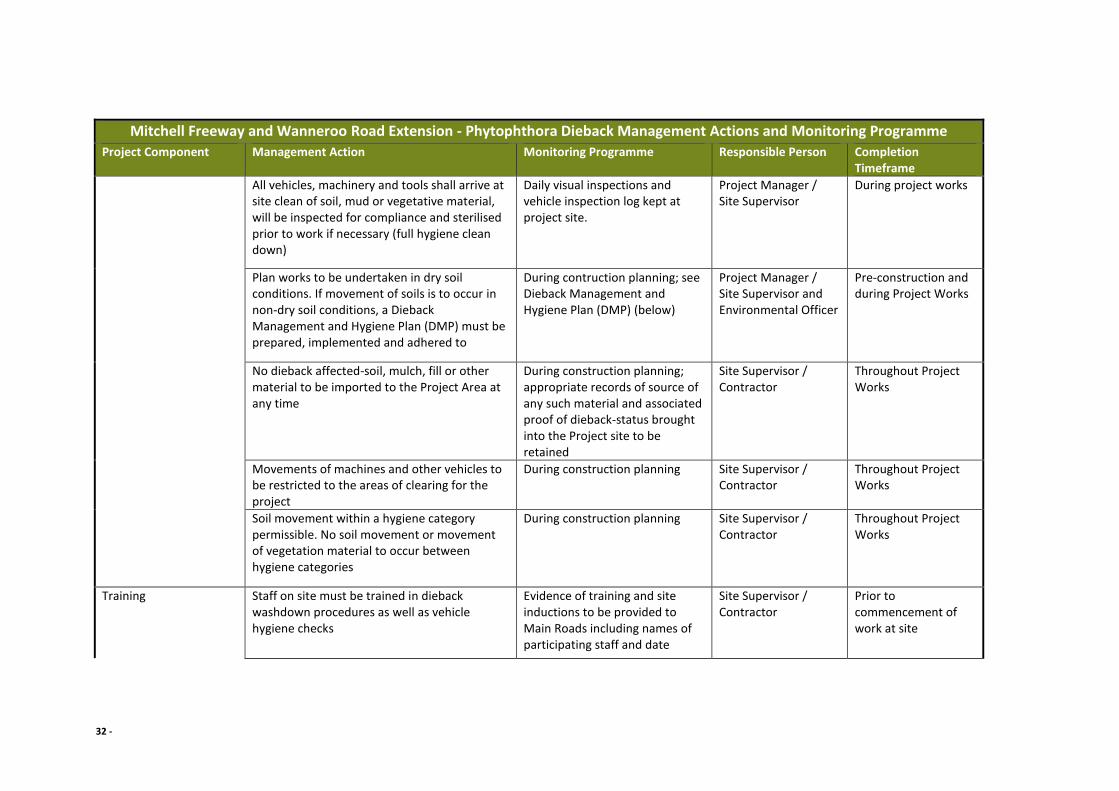
Table 5 – Table of Management Measures and Actions
Mitchell Freeway and Wanneroo Road Extension - Phytophthora Dieback Management Actions and Monitoring Programme
Project Component Management Action Monitoring Programme Responsible Person Completion Timeframe
Pre-Construction Dieback Survey and Assessment
Survey and Assess Dieback Status
Undertake a Dieback survey of the project area using a Phytophthora Dieback Interpreter registered with DBCA, prior to the commencement of project activities.
As part of pre-construction environmental approvals.
Environment Officer Completed
Identify and map the Dieback status of the project area (and surrounds) from the Dieback survey.
Identify Dieback Occurrence Areas
Dieback interpretation boundaries to be marked on site as per DBCA standards
As part of pre-construction environmental approvals.
Environment Officer To be completed
This tape must be renewed and remarked at 12 monthly intervals; re-assessment due October 2019.
Will require potential re-check during project depending upon project timeline
Potential recheck depending upon project timeline
Project Specific Aspects and Clearing Permit Approval
Dieback Controls All works are to be undertaken under the requirements as stipulated in the relevant Clearing Permit
Pre-construction planning and during project works
Project Manager / Site Supervisor and Environmental Officer
Pre-construction and during Project Works
32 -
Mitchell Freeway and Wanneroo Road Extension - Phytophthora Dieback Management Actions and Monitoring Programme
Project Component Management Action Monitoring Programme Responsible Person Completion Timeframe
All vehicles, machinery and tools shall arrive at site clean of soil, mud or vegetative material, will be inspected for compliance and sterilised prior to work if necessary (full hygiene clean down)
Daily visual inspections and vehicle inspection log kept at project site.
Project Manager / Site Supervisor
During project works
Plan works to be undertaken in dry soil conditions. If movement of soils is to occur in non-dry soil conditions, a Dieback Management and Hygiene Plan (DMP) must be prepared, implemented and adhered to
During contruction planning; see Dieback Management and Hygiene Plan (DMP) (below)
Project Manager / Site Supervisor and Environmental Officer
Pre-construction and during Project Works
No dieback affected-soil, mulch, fill or other material to be imported to the Project Area at any time
During construction planning; appropriate records of source of any such material and associated proof of dieback-status brought into the Project site to be retained
Site Supervisor / Contractor
Throughout Project Works
Movements of machines and other vehicles to be restricted to the areas of clearing for the project
During construction planning Site Supervisor / Contractor
Throughout Project Works
Soil movement within a hygiene category permissible. No soil movement or movement of vegetation material to occur between hygiene categories
During construction planning Site Supervisor / Contractor
Throughout Project Works
Training Staff on site must be trained in dieback washdown procedures as well as vehicle hygiene checks
Evidence of training and site inductions to be provided to Main Roads including names of participating staff and date
Site Supervisor / Contractor
Prior to commencement of work at site

33 -
Mitchell Freeway and Wanneroo Road Extension - Phytophthora Dieback Management Actions and Monitoring Programme
Project Component Management Action Monitoring Programme Responsible Person Completion Timeframe
Training (induction/toolbox) undertaken for site personnel including sub-contractors regarding dieback and the importance of preventing the spread of the pathogen
Throughout Project Works
Dieback Management and Hygiene Plan
Consult and Prepare a Dieback Management and Hygiene Plan (DMP) if works are to be conducted in conditions other than dry soil conditions
Prepare a DMP in consultation with DBCA when undertaking vegetation clearing or revegetation activities if works are required outside of dry soil conditions
As part of pre-construction environmental approvals.
Environment Officer To be undertaken prior to Project Works
Include a map of project Dieback occurrence areas within the DMP
Include a map of hygiene management areas and associated Clean on Entry (CoE) points
Dieback Controls Required - Non Dry Soil Conditions
Clearing will be undertaken in non-dry conditions only if unavoidable to reduce the risk of spread of the pathogen.
Project timing Project Manager / Site Supervisor
Throughout Project Works
Vehicles, machinery and tools should be inspected to be free of soil, mud or plant matter as well as other contaminants before work is commenced and sterilized if necessary (complete hygiene washdown)
Daily visual inspections and vehicle inspection log kept at project site.
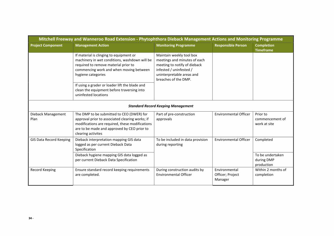
34 -
Mitchell Freeway and Wanneroo Road Extension - Phytophthora Dieback Management Actions and Monitoring Programme
Project Component Management Action Monitoring Programme Responsible Person Completion Timeframe
If material is clinging to equipment or machinery in wet conditions, washdown will be required to remove material prior to commencing work and when moving between hygiene categories
Maintain weekly tool box meetings and minutes of each meeting to notify of dieback infested / uninfested / uninterpretable areas and breaches of the DMP.
If using a grader or loader lift the blade and clean the equipment before traversing into uninfested locations
Standard Record Keeping Management
Dieback Management Plan
The DMP to be submitted to CEO (DWER) for approval prior to associated clearing works; if modifications are required, these modifications are to be made and approved by CEO prior to clearing activites
Part of pre-construction approvals
Environmental Officer Prior to commencement of work at site
GIS Data Record Keeping Dieback interpretation mapping GIS data logged as per current Dieback Data Specification
To be included in data provision during reporting
Environmental Officer Completed
Dieback hygiene mapping GIS data logged as per current Dieback Data Specification
To be undertaken during DMP production
Record Keeping Ensure standard record keeping requirements are completed.
During construction audits by Environmental Officer
Environmental Officer; Project Manager
Within 2 months of completion
35 -
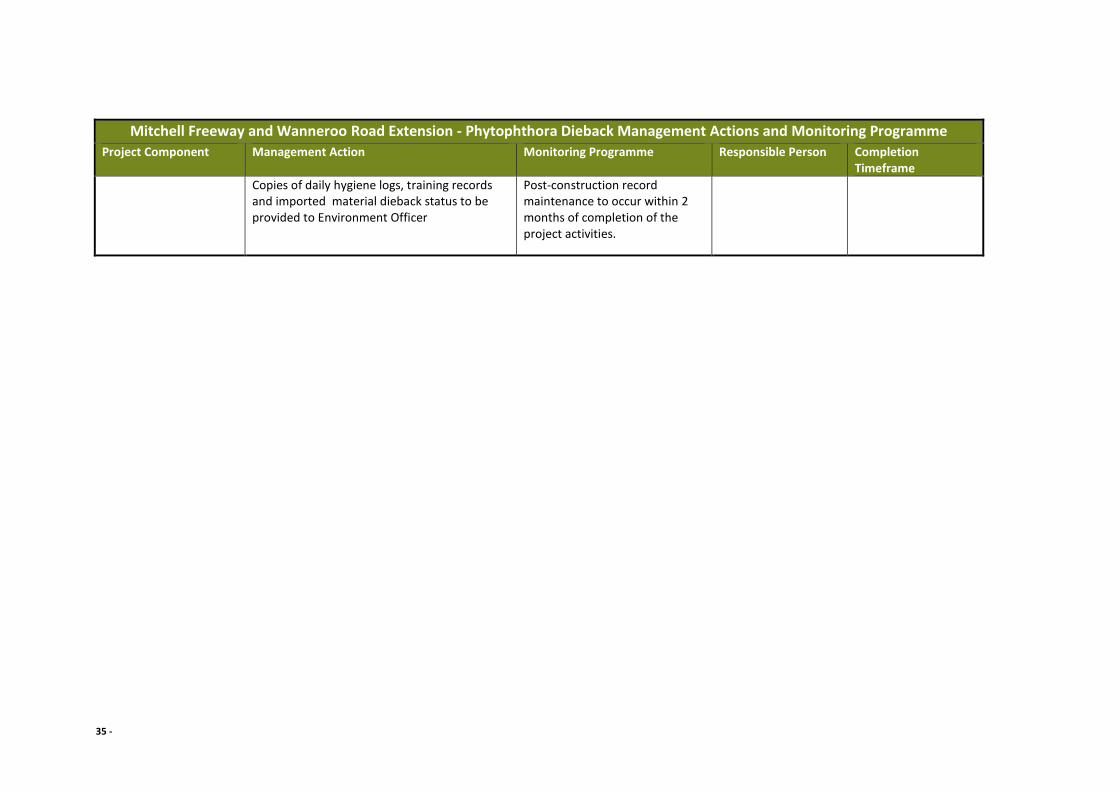
Mitchell Freeway and Wanneroo Road Extension - Phytophthora Dieback Management Actions and Monitoring Programme
Project Component Management Action Monitoring Programme Responsible Person Completion Timeframe
Copies of daily hygiene logs, training records and imported material dieback status to be provided to Environment Officer
Post-construction record maintenance to occur within 2 months of completion of the project activities.

36 -
9 Bibliography
Bureau of Meteorology. (n.d.). Average annual, seasonal and monthly rainfall. Retrieved
from Average annual, seasonal and monthly rainfall
Department of Parks and Wildlife. (2015). FEM047 Phytophthora Dieback Interpreter's
Manual for lands managed by the department. Unpublished.
Glevan Consulting. (2013). Mitchell Freeway Extension Phytophthora Dieback occurrence
assessment and Management Plan. Prepared for GHD.
Main Roads WA. (2018). Dieback Survey Consultant Brief. D18#792329.
37 -
10 Appendix A – Phytophthora occurrence maps (Figures 7 – 13)

38 -
Figure 7 – Romeo Road (north)

39 -
Figure 8 – Romeo Road (south)

40 -
Figure 9 – Mitchell Fwy, Butler

41 -
Figure 10 – Mitchell Freeway, Butler (near Lukin Drive)
42 -
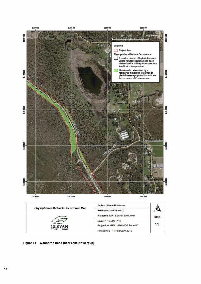
Figure 11 – Wanneroo Road (near Lake Nowergup)
43 -
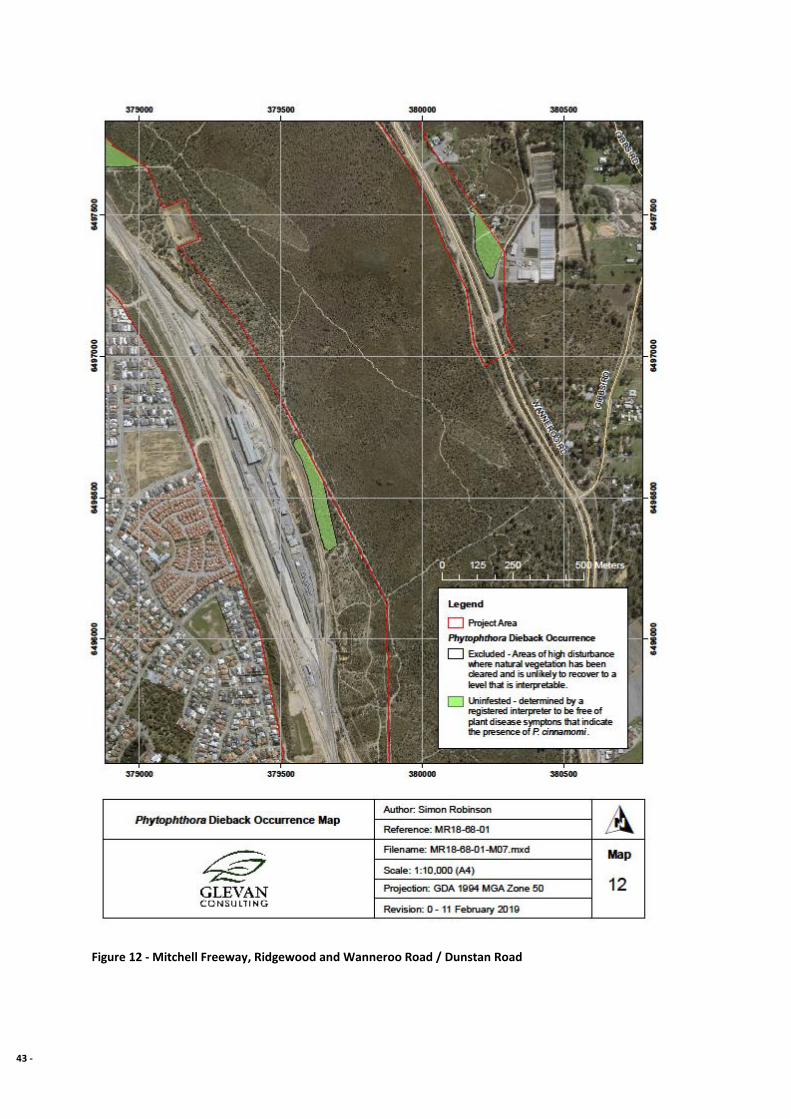
Figure 12 - Mitchell Freeway, Ridgewood and Wanneroo Road / Dunstan Road
44 -
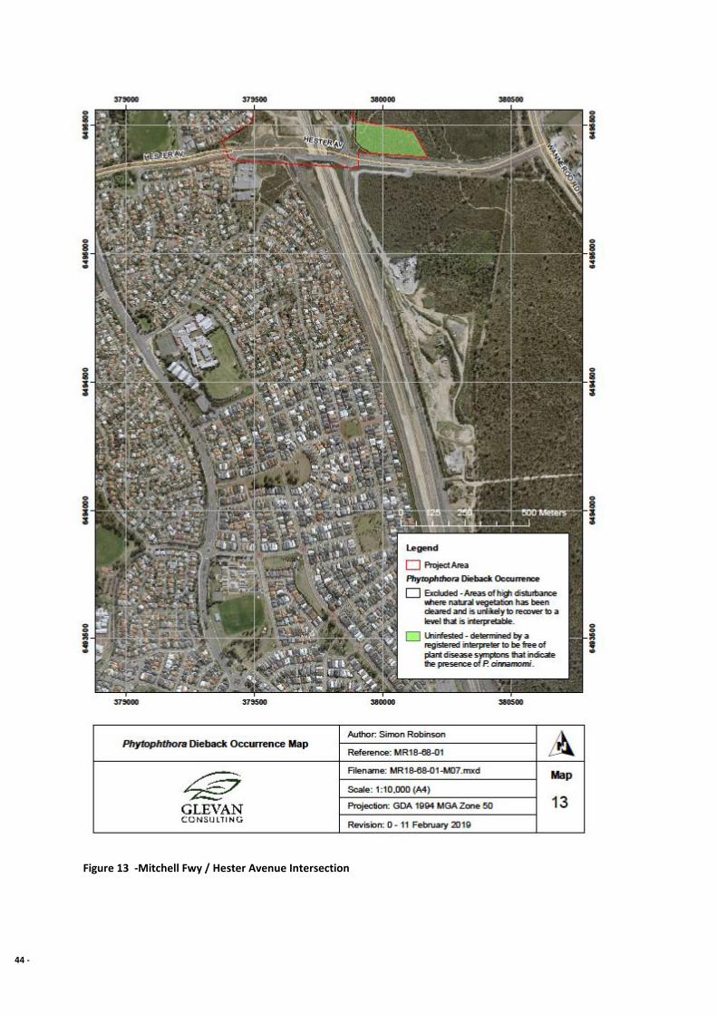
Figure 13 -Mitchell Fwy / Hester Avenue Intersection
45 -
11 Appendix B – Sample sites (Plates 1 – 12)
Plate 1 - Sample 1
Plate 2 - Sample site 2

46 -
Plate 3 - Sample site 3
Plate 4 - Sample site 4
47 -
Plate 5 - Sample site 5
Plate 6 - Sample site 6
48 -
Plate 7 - Sample site 7
Plate 8 - Sample site 8

49 -
Plate 9 - Sample site 9
Plate 10 - Sample site 10

50 -
Plate 11 - Sample site 11
Plate 12 - Sample site 12

51 -
12 Appendix C – Keighery disturbance scale
Assessability Scale Vegetation condition
Assessable
1 Pristine Pristine or nearly so; no obvious signs of disturbance.
2 Excellent Vegetation structure intact; disturbance affecting individual species and weeds
are non-aggressive species.
3
Very good Vegetation structure altered; obvious signs of disturbance. For example,
disturbance to vegetation structure caused by repeated fires, the presence of
some more aggressive weeds, dieback, logging and grazing.
Possibly
assessable,
discretion
required
4
Good Vegetation structure significantly altered by very obvious signs of multiple
disturbances. Retains basic vegetation structure or ability to regenerate it. For
example, disturbance to vegetation structure caused by very frequent fires, the
presence of some very aggressive weeds at high density, partial clearing, dieback
and grazing.
Not assessable,
excluded from
assessment
5
Degraded Basic vegetation structure severely impacted by disturbance. Scope for
regeneration but not to a state approaching good condition without intensive
management. For example, disturbance to vegetation structure caused by
frequent fires, the presence of very aggressive weeds, partial clearing, dieback
and grazing.
6
Completely
degraded The structure of the vegetation is no longer intact and the area is completely or
almost completely without native species. These areas are often described as
‘parkland cleared’ with the flora comprising weed or crop species with isolated
native trees or shrubs.