management against sediment disasters in the imogawa … · occurred at higashi-takezawa district...
TRANSCRIPT

Disaster Mitigation of Debris Flows, Slope Failures and Landslides 769
Management against Sediment Disasters in the Imogawa-River Basin Caused bythe Mid Niigata Prefecture Earthquake in 2004, Japan
Shinji Yamaguchi,1) Hiroshi Nishii,2) Shigeru Motousu,3) Koichi Kondo,4) Akihiko Ikeda4) and MikiteruShimizu4)
1) Yuzawa Sabo Office, Hokuriku Regional Development Bureau, Ministry of Land, Infrastructureand TransportKandachi 23, Yuzawa Town, Minami-Uonuma gun, Niigata Prefecture, 949-6102 Japan([email protected])2) Sabo Division, River and Harbor Department, Public Works Bureau, Ehime Prefecture Government Ichiban-cho 4-4-2, Matsuyama City, Ehime Prefecture, 790-8570 Japan3) Tateyama Sabo Work Office, Hokuriku Regional Development Bureau, Ministry of Land, Infrastructure andTransport Bunazaka 61, Ajikuraji, Tateyama Town, Naka-Niikawa gun, Toyama Prefecture, 930-1405 Japan4) SABO Technical Center, Yamawaki Bldg., Kudan Minami 4-8-21, Chiyoda Ward, Tokyo 102-0074 Japan
Abstract
This report describes various management operations by the central government against sedimentdisasters caused by the Mid Niigata Prefecture Earthquake on October 23, 2004. The operations includeinstallation of emergency and permanent measures for stabilization of the landslide dam at Higashi-Takezawadistrict and also policy making of sabo (erosion and sediment control) master plan for the Imogawa-Riverbasin. The earthquake caused many collapses and landslides in the Imogawa-River basin. The landslide thatoccurred at Higashi-Takezawa district formed the landslide dam whose height reached as high as 30m. Thewater level could become high enough for overtopping and successive collapse of its blockage. Therefore, saboworks by the central government were operated in order to plan emergency countermeasures and to implementthem. Yuzawa Sabo Office, Ministry of Land, Infrastructure and Transport was directly responsible for theseemergency actions. The emergency actions included pumping out water from the reservoir to reduce thewater level so that the landslide dam could be kept undestroyed and constructing temporary drainage channelpreparing for the coming snow melting and rainy season. These emergency measures could ensure the safety ofthe downward area.The local headquarter established in the Yuzawa Sabo Office kept monitoring the changingconditions in the area and further planned and performed preventive and recovery actions with consultingthe expert meeting. In addition, an advisory committee on landslide dams in the Imogawa-River basin andad hoc meeting for mitigation of successive disasters were established in order to discuss about emergencyand permanent measures for stabilization of landslide dams and also sabo master plan for the Imogawa-Riverbasin. Most of past large earthquakes caused serious sediment disasters. A large number of cracks, gaps and/orloosening of grounds were caused by the large earthquakes. Therefore, during the period of snow melting andrainy season in 2004/2005, aerial (by helicopter) and terrestrial patrolling were performed. As a result ofpatrolling, no significant new collapses that could possibly affect the downstream area were found.
However, considering that the area was subjected to the heaviest rainfall corresponding to the maximumdaily rainfall record of the area in the rainy season in 2005 and heavy snowfall as well, the monitoring activitiesshould be continued. It is necessary to evaluate sediment production and discharge in and from the Imogawa-River basin at the earliest opportunity for the soonest recovery of the target area.
Keywords: earthquake, collapse, landslide, landslide dam, emergency action, permanent measure, sabo masterplan, Imogawa
1. Introduction
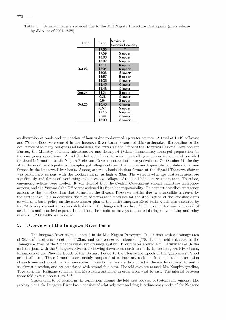
At 17:56 on October 23, 2004, an earthquake with a magnitude of 6.8 occurred in the Mid NiigataPrefecture on the northeastern part of Japan. In Kawaguchi Town close to the hypocenter, a seismic intensityof 7 (by JMA scale: Japan Meteorological Agency) was recorded for the first time since the beginning of itsrecording using a seismometer. Strong aftershocks followed one after another, for example, a seismic intensityof 6 was recorded four times. Due to this earthquake, a large number of collapses and landslides were causedaround the Mid Niigata Prefecture. In particular, in the Imogawa-River basin, which is located close to thehypocenter, a large volume of sediment produced by those collapses and landslides accumulated in the rivercourses and blocked them seriously. As a result tremendous damage was caused in the entire basin area, such
pp. 769–777 c©2006 by Universal Academy Press, Inc. / Tokyo, Japan
770
Table 1. Seismic intensity recorded due to the Mid Niigata Prefecture Earthquake (press releaseby JMA, as of 2004.12.28)
as disruption of roads and inundation of houses due to dammed up water courses. A total of 1,419 collapsesand 75 landslides were caused in the Imogawa-River basin because of this earthquake. Responding to theoccurrence of so many collapses and landslides, the Yuzawa Sabo Office of the Hokuriku Regional DevelopmentBureau, the Ministry of Land, Infrastructure and Transport (MLIT) immediately arranged preparation forthe emergency operations. Aerial (by helicopter) and terrestrial patrolling were carried out and providedfirsthand information to the Niigata Prefecture Government and other organizations. On October 24, the dayafter the major earthquake, a helicopter patrolling confirmed that numerous large-scale landslide dams wereformed in the Imogawa-River basin. Among others, a landslide dam formed at the Higashi-Takesawa districtwas particularly serious, with the blockage height as high as 30m. The water level in the upstream area rosesignificantly and threat of overflowing and successive collapse of the landslide dam was imminent. Therefore,emergency actions were needed. It was decided that the Central Government should undertake emergencyactions, and the Yuzawa Sabo Office was assigned its front-line responsibility. This report describes emergencyactions to the landslide dam that formed at the Higashi-Takesawa district due to a landslide triggered bythe earthquake. It also describes the plan of permanent measures for the stabilization of the landslide damsas well as a basic policy on the sabo master plan of the entire Imogawa-River basin which was discussed bythe “Advisory committee on landslide dams in the Imogawa-River basin”. The committee was comprised ofacademics and practical experts. In addition, the results of surveys conducted during snow melting and rainyseasons in 2004/2005 are reported.
2. Overview of the Imogawa-River basin
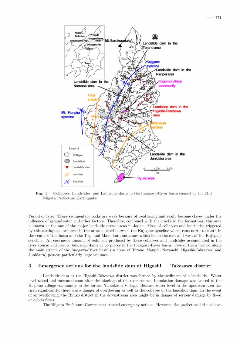
The Imogawa-River basin is located in the Mid Niigata Prefecture. It is a river with a drainage areaof 38.4km2, a channel length of 17.2km, and an average bed slope of 1/70. It is a right tributary of theUonogawa-River of the Shinanogawa-River drainage system. It originates around Mt. Sarukuradake (679masl) and joins with the Uonogawa-River after flowing down from north to south. In the Imogawa-River basin,formations of the Pliocene Epoch of the Tertiary Period to the Pleistocene Epoch of the Quaternary Periodare distributed. Those formations are mainly composed of sedimentary rocks, such as mudstone, alternationof sandstone and mudstone, and sandstone. Those formations are distributed in the north-northeast to south-southwest direction, and are associated with several fold axes. The fold axes are named; Mt. Konpira syncline,Toge anticline, Kajigane syncline, and Matsukura anticline, in order from west to east. The interval betweenthose fold axes is about 1 km.1),2)
Cracks tend to be caused in the formations around the fold axes because of tectonic movements. Thegeology along the Imogawa-River basin consists of relatively new and fragile sedimentary rocks of the Neogene
771
Fig. 1. Collapses, Landslides, and Landslide dams in the Imogawa-River basin caused by the MidNiigata Prefecture Earthquake
Period or later. These sedimentary rocks are weak because of weathering and easily become clayey under theinfluence of groundwater and other factors. Therefore, combined with the cracks in the formations, this areais known as the one of the major landslide prone areas in Japan. Most of collapses and landslides triggeredby this earthquake occurred in the areas located between the Kajigane syncline which runs north to south inthe center of the basin and the Toge and Matsukura anticlines which lie on the east and west of the Kajiganesyncline. An enormous amount of sediment produced by those collapses and landslides accumulated in theriver course and formed landslide dams at 55 places in the Imogawa-River basin. Five of them formed alongthe main stream of the Imogawa-River basin (in areas of Terano, Nanpei, Naranoki, Higashi-Takesawa, andJunidaira) possess particularly large volumes.
3. Emergency actions for the landslide dam at Higashi — Takesawa district
Landslide dam at the Higashi-Takesawa district was formed by the sediment of a landslide. Waterlevel raised and increased soon after the blockage of the river course. Inundation damage was caused to theKogomo village community in the former Yamakoshi Village. Because water level in the upstream area hasrisen significantly, there was a danger of overflowing as well as the collapse of the landslide dam. In the eventof an overflowing, the Ryuko district in the downstream area might be in danger of serious damage by floodor debris flows.
The Niigata Prefecture Government started emergency actions. However, the prefecture did not have

772
appropriate data for coping with such a large-scale landslide dam. Therefore, by the request of the prefecturegovernor, emergency actions began to be undertaken by the central government from November 5. The YuzawaSabo Office was assigned to supervise this work. At that date time, the water level in the upstream area hasrisen up to 6 m below the level of danger of overflowing(161m asl).
3.1. Conditions and objectives of emergency actionsIn implementing emergency actions for the landslide dam at the Higashi-Takesawa district, there were
problems and requirements. Emergency actions had to be completed before snow season because the snowlayer amounted to about 3m in depth.[Conditions]
1. Roads to the working site were severely disrupted by the earthquake and it was difficult to transportconstruction equipment and materials for emergency actions.
2. The water level on the upstream side of the landslide dam rose day after day and it was necessary tolower the water level as soon as possible.
3. It was necessary to secure a safe discharge of snowmelt water in the snow-melting season.
To fulfill these requirements, the objectives of emergency actions were set as follows.[Concrete objectives]
1. To transport equipment and materials for emergency actions by helicopter, and to construct a road forcarry heavy machinery by land.
2. To reduce water level by constructing an emergency pumping drainage.
3. To secure a flow cross-section for the safe discharge of snowmelt water by constructing a temporarydrainage channel.
3.2. Implementation system of emergency actionsTo implement emergency actions responding to the continuously changing situations on the site, the
Local Headquarters for Emergency actions for landslide dams at the Imogawa-River basin (Head: Director ofLand Conservation Division, Sabo Department of MLIT) was established at the Yuzawa Sabo Office. The localheadquarters was operated until December 28 when the construction of the temporary diversion channel at theHigashi-Takesawa district for discharging snowmelt water was completed. During that period, countermeasureswere planned and implemented with the participation of over 400 officials (man-days), including those from theSabo Department of the River Bureau of MLIT, the River Department of the Hokuriku Regional DevelopmentBureau, and its local offices, as well as with the support from academic and practical experts of the NiigataUniversity and the National Institute for Land and Infrastructure Development, etc.
3.3. Emergency actions for the landslide dam at the Higashi-Takesawa district
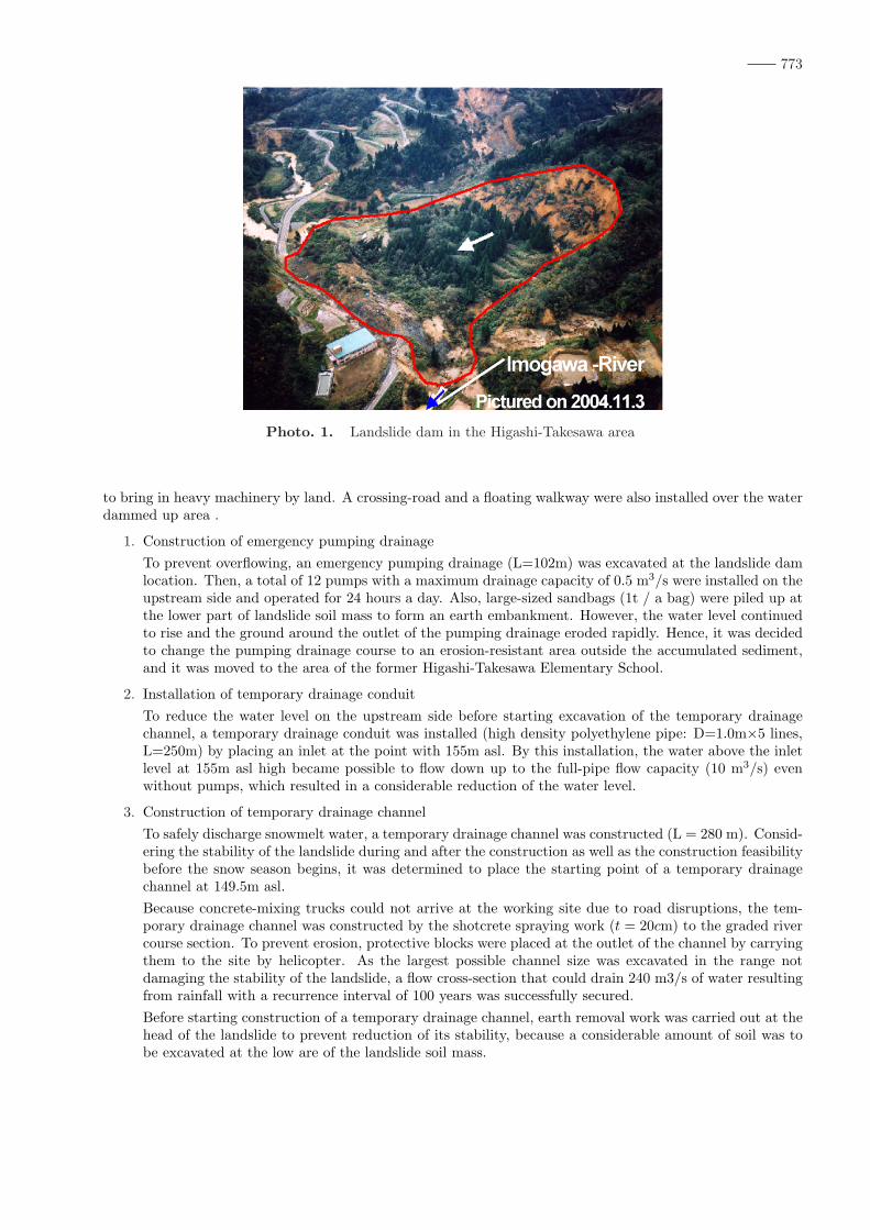
3.3.1. Conditions of the landslide damThe landslide dam at the Higashi-Takesawa district was formed as a result of landslide (350 m long,
295 m wide, and 30 m deep (estimated value)) that occurred on the left bank slope of the Imogawa-River basin.The amount of the original landslide movement at the upper part of the slope was about 70 m. The end ofthe landslide mass blocked the Imogawa-River and reached to the National Road 291 running parallel to theriver. The sediment volume that blocked the river course was 655,940 m3 and the maximum dammed up watervolume was 2,560,500 m3 , at the highest water level.
Based on the results of site reconnaissance, it was judged that the sliding soil mass itself was stable,and that the possibility of its collapse due to water pressure was slight, because the length of the blockagewas large enough compared with the water depth. However, as the water level continued to rise day after day,drainage of dammed up water was urgently needed to prevent the collapse of the blockage due to overflowing.
3.3.2. Emergency actions for the landslide damAt the Higashi-Takesawa district, the emergency actions were undertaken while continuous monitoring
of the landslide on the left bank side was carried out. In implementing emergency actions, helicopters were uti-lized to transport the necessary construction materials to the working site, and an access road was constructed
773
Photo. 1. Landslide dam in the Higashi-Takesawa area
to bring in heavy machinery by land. A crossing-road and a floating walkway were also installed over the waterdammed up area .
1. Construction of emergency pumping drainageTo prevent overflowing, an emergency pumping drainage (L=102m) was excavated at the landslide damlocation. Then, a total of 12 pumps with a maximum drainage capacity of 0.5 m3/s were installed on theupstream side and operated for 24 hours a day. Also, large-sized sandbags (1t / a bag) were piled up atthe lower part of landslide soil mass to form an earth embankment. However, the water level continuedto rise and the ground around the outlet of the pumping drainage eroded rapidly. Hence, it was decidedto change the pumping drainage course to an erosion-resistant area outside the accumulated sediment,and it was moved to the area of the former Higashi-Takesawa Elementary School.
2. Installation of temporary drainage conduitTo reduce the water level on the upstream side before starting excavation of the temporary drainagechannel, a temporary drainage conduit was installed (high density polyethylene pipe: D=1.0m×5 lines,L=250m) by placing an inlet at the point with 155m asl. By this installation, the water above the inletlevel at 155m asl high became possible to flow down up to the full-pipe flow capacity (10 m3/s) evenwithout pumps, which resulted in a considerable reduction of the water level.
3. Construction of temporary drainage channelTo safely discharge snowmelt water, a temporary drainage channel was constructed (L = 280 m). Consid-ering the stability of the landslide during and after the construction as well as the construction feasibilitybefore the snow season begins, it was determined to place the starting point of a temporary drainagechannel at 149.5m asl.Because concrete-mixing trucks could not arrive at the working site due to road disruptions, the tem-porary drainage channel was constructed by the shotcrete spraying work (t = 20cm) to the graded rivercourse section. To prevent erosion, protective blocks were placed at the outlet of the channel by carryingthem to the site by helicopter. As the largest possible channel size was excavated in the range notdamaging the stability of the landslide, a flow cross-section that could drain 240 m3/s of water resultingfrom rainfall with a recurrence interval of 100 years was successfully secured.Before starting construction of a temporary drainage channel, earth removal work was carried out at thehead of the landslide to prevent reduction of its stability, because a considerable amount of soil was tobe excavated at the low are of the landslide soil mass.

774
Fig. 2. Cross-section of the landslide dam in the Higashi-Takesawa area
Fig. 3. Water level fluctuations at the landslide dam in the Higashi-Takesawa area. Both thewater level and rainfall were measured at this location. Before the earthquake, the riverbed atthis location was about 130 m asl.
4. Permanent measures for landslide dams and sabo master plan for the entire
Imogawa-River basin
In the Imogawa-River basin, while taking emergency actions for the large-scale landslide dam at theHigashi-Takesawa district and other area, it was also necessary to implement permanent measures for otherlandslide dams. There was a danger that discharge of a large amount of unstable sediment over a long periodmight affect not only the Imogawa-River basin but also the Uonogawa River. Therefore, formulation of asabo master plan that can adequately address these problems was urgently needed. Because these measuresagainst landslide dam and a sabo master plan had to deal with rapid and serious devastation which wasunprecedented in recent years, advanced technologies that could meet severe topographical, meteorological,and construction conditions were required. Therefore, to gain advice and suggestion from academics andexperts, the Advisory committee on landslide dams at the Imogawa-River basin (Chairman: Prof. HideakiMarui of Niigata University) was established. The meetings were held four times from November.17, 2004 toMarch.1, 2005. The committee deliberated on the direction of the permanent measures for the landslide damat the Higashi-Takesawa district and other districts, as well as on the basic policy related to the sabo masterplan of the entire Imogawa-River basin.
775
4.1. Permanent measures for landslide dams
4.1.1. Requirements of permanent measuresPermanent measures for landslide dams such as at the Higashi-Takesawa district were determined to
be carried out as the measures concerning the unstable soil mass which blocked the river course and as themeasures for the stabilization of the landslide on the left bank side which resulted in the blockage of river.To verify the safety of those measures, stability analysis was performed on the blockage of landslide dam(evaluation of stability in the river course direction) and the soil mass on slope (evaluation of stability inthe direction perpendicular to the river course). Also, numerical analysis was performed on the possibility ofpiping at the landslide dam (possibility of erosion of the blockage) and its safety was verified. In implementingpermanent measures for landslide dam such as at the Higashi-Takesawa district, the following two requirementshad to be fulfilled.
1. To safely discharge water by the design rainfall specified in the sabo master plan (to prevent erosion oflandslide dam due to overflowing).
2. To prevent the collapse of the landslide dam by the water pressure due to dammed up water in theupstream area, and to prevent flooding of water and sediment in the downstream area due to sedimentdischarge.
4.2. Permanent measures for landslide dam at the Higashi-Takesawa districtConcerning the landslide dam at the Higashi-Takesawa district, two measures were considered because
the inundation damage reached the Kogomo village community in the upstream: one was to remove blockageto the depth of original riverbed; and the other was to consolidate the blockage keeping the present inlet height(EL: 149.5m) of the temporary drainage channel The original riverbed was 19.5m lower than the height of thetemporary drainage channel. Therefore, if the blockage is consolidated at the present height, the constructioncost is estimated to be 1.4 billion yen and 16 months construction period is needed. If the complete removalof blockage is operated, the construction cost is estimated to be 6.6 billion yen and 37 months constructionperiod is needed, in addition to the need of removing 565,000 m3 of soils. Even though the landslide dam iscompletely removed and inundation in the Kogomo village is eliminated, it takes many years to ensure safetyof the area. Therefore, in terms of promoting early return of evacuated villagers, a plan to consolidate theblockage at the present height and evacuated villagers would be transferred to safety area was recommended.
1. Prevention of erosion due to overflowing
Policy: To construct a channel to safely discharge water so that landslide dam will not be collapsed by theerosion due to overflowing.
Measures: Channel works(W = 2−14m, L = 230m,design discharge: 240m3/s)
2. Prevention of collapse due to water pressure
Policy: To install sabo dams on the downstream of the blockage to prevent its movement due to waterpressure and to retain it within the sedimentation area of those dams.
Measures: Construction of two sabo dams(H=14.5m, H=11.5m).
4.3. Sabo master plan for the entire Imogawa-River basinThis advisory committee studied the possible sediment movements in the future based on the present
conditions of the Imogawa-River basin, and recommended a sediment control policy for ensuring safety of localareas from sediment-related disasters caused by those phenomena.
4.3.1. Possible sediment movements and sediment disastersConcerning possible sediment movements and sediment disasters in the Imogawa-River basin, this
advisory committee predicted as follows:
1. Because a number of landslide dams caused by collapses and landslides exit in the river courses, floodingof water and sediment may occur as a result of sediment discharge due to erosion or collapse of thoselandslide dams.
2. Because a large amount of unstable sediment in the river basin may flow out constantly due to rainfall orsnow melting, aggradations of the riverbed may be caused, resulting in flooding of water and sedimentnot only in the Imogawa-River basin but also in the lower reaches of Uonogawa-River.
776
3. It is highly likely that sediment disasters may be caused by the secondary erosion or secondary dischargeof unstable sediment at collapses and the foot of landslides.
4. It is highly likely that debris flows will be triggered in case of tributaries having a steep riverbed.
4.4. Sediment control policyTo secure the safety of local areas against sediment movements and sediment-related disasters that
may occur in the Imogawa-River basin in the future, the following sediment control policy was proposed.
1. To remove landslide dam or to control its discharge at landslide dam locations.
2. To control discharge of unstable sediment which is accumulated in the river course.
3. To control production of sediment at collapses and the foot of landslides (measures against the sedimentproduction area).
4. To control occurrence of a debris flow and to entrap it’s sediment in case of tributaries having a steepriverbed.
Based on this sabo master plan, the Yuzawa Sabo Office has been implementing necessary sabo works,according to the priority, at earthquake-damaged locations like a large-scale landslide dam, including theHigashi-Takesawa district where emergency countermeasures were undertaken, by maintaining coordinationwith a local reconstruction plan. Those sabo works are expected to complete until March, 2007 (Photo. 3).
5. Monitoring system and the results of survey in the snow melting and rainy
season in 2004/2005
An enormous amount of unstable sediment and landslide dams still remain in the Imogawa-Riverbasin. Also, geological defects such as cracks, lags, and looseness probably exist in the ground as a resultof strong shaking of the earthquake. Because of these conditions, t is feared that, if some severe rainfallattacks, unstable sediment existing in the river course may flow out and new sediment may flow down fromhillside slopes. To secure safety for the construction of sabo works in such dangerous conditions and to monitorsediment discharge to the downstream areas, aerial (helicopter) and terrestrial patrolling were performed inthe snow melting and rainy season in 2004/2005. In particular, at the Higashi-Takesawa district, the landslidesoil mass was monitored using a groundwater gauge, borehole inclinometer, and surface inclinometer installedon them, and the rainfall and water level in the reservoir areas were also gauged, in addition to the overallmonitoring with the installation of monitor cameras. From this monitoring, no new collapses that mighthave a significant effect on the downstream areas were found. However, because of the potential of sedimentproduction and sediment discharge is still high, monitoring has been continued to date. When a rain or anearthquake exceeding the standard occurs, the degree of sediment discharge and the conditions of sabo facilitiesare always checked. We are also considering to improve the monitoring system so that an immediate responsecould be undertaken in emergency situations.
5.1. Concluding remarksThis report described an overview of the sediment disasters, such as a large-scale landslide dam formed
in the Imogawa-River basin by the Mid Niigata Prefecture Earthquake in 2004, together with the risk manage-ment response taken by the Central Government. A large amount of unstable sediment produced by collapsesand landslides as well as landslide dams formed by displaced soil mass still remains in the river basin. Thissediment may flow out over a long period due to snow melting or rainfall, causing effects on the main stream ofthe Uonogawa-River. What is needed hereafter is to carry out permanent measures for landslide dams in theHigashi-Takesawa area and other areas based on the suggestion by the Advisory committee and the results ofsurvey. It is also needed to formulate a sabo master plan by reflecting the actual state of sediment movementafter the earthquake, based on the basic policy proposed by the Advisory committee, and maintaining coordi-nation with a local restoration plan. In addition, sabo works should be promoted in the entire Imogawa-Riverbasin, together with the implementation of landslide prevention measures. The Yuzawa Sabo Office carriedout aerial (helicopter) and terrestrial patrolling from the snow melting to rainy season in 2004/2005. Wewill continue to grasp the actual state of sediment production and sediment discharge through patrolling andmonitoring of the Imogawa-River basin. Providing information to local people and implementing activities forearly restorations of damaged areas by the earthquake are also important tasks.

777
References
Kobayashi, I., Tateishi, M., Yoshioka, T., and Shimazu, M. (1990) Geology of the Nagaoka Area, ResearchReport on Regional Geologies (Geological map of 1/50,000), Geological Survey of Japan, p.132 (In Japanese)
Yanagisawa, Y., Kobayashi, I., Takeuchi, K., Tateishi, M., Chihara, K., and Kato, H. (1986) Geology of theOjiya Area, Research Report on Regional Geologies (Geological map of 1/50,000), Geological Survey ofJapan, p.177 (In Japanese)