manhattan bridge bicycle access network - new york city · manhattan bridge bicycle access network...
TRANSCRIPT

Manhattan Bridge Bicycle Manhattan Bridge Bicycle Access NetworkAccess Network
NYC Department of TransportationOffice of Alternative Modes
May 2008Presentation to Manhattan Community Board 3

2
• Bicycle Fatality & Serious Injury Study – Improve Safety
• Senior Pedestrian Focus Area – Improve Senior Pedestrian Safety
• Mayor’s PlaNYC – A Greener Transportation Network
• 1997 Bicycle Master Plan
Why are we here?Why are we here?

3
• 200 Mile, 3 Year Bicycle Route Commitment
• Targeting Areas of High Demand & Key Connections
• Design Approach:1. Study Best Practices2. Develop Innovative Designs for Constrained
NYC Environment3. “Complete Streets” Design Philosophy
NYC DOT Bicycle ProgramNYC DOT Bicycle Program
4
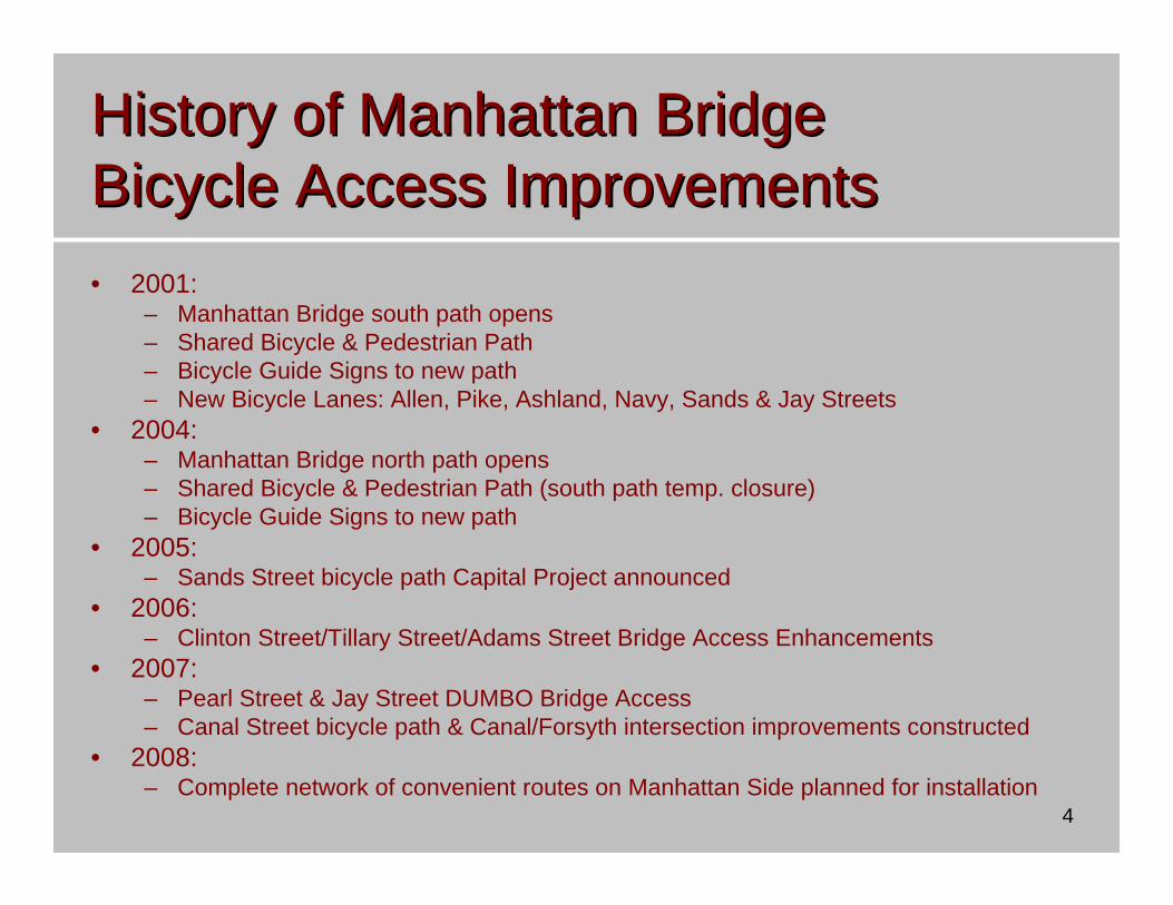
History of Manhattan Bridge History of Manhattan Bridge Bicycle Access ImprovementsBicycle Access Improvements• 2001:
– Manhattan Bridge south path opens– Shared Bicycle & Pedestrian Path– Bicycle Guide Signs to new path– New Bicycle Lanes: Allen, Pike, Ashland, Navy, Sands & Jay Streets
• 2004:– Manhattan Bridge north path opens– Shared Bicycle & Pedestrian Path (south path temp. closure)– Bicycle Guide Signs to new path
• 2005:– Sands Street bicycle path Capital Project announced
• 2006:– Clinton Street/Tillary Street/Adams Street Bridge Access Enhancements
• 2007:– Pearl Street & Jay Street DUMBO Bridge Access– Canal Street bicycle path & Canal/Forsyth intersection improvements constructed
• 2008:– Complete network of convenient routes on Manhattan Side planned for installation

5
Manhattan Bridge Bicycle Access & Senior Manhattan Bridge Bicycle Access & Senior Pedestrian Safety: Pedestrian Safety: Design ObjectivesDesign Objectives1. Creating Dedicated
Cycling Space on Direct and Convenient Routes to and from MN Br
2. Improving Safety for All Street Users, particularlySenior Pedestrians
3. Traffic Calming for All Street Users
4. Maintaining Vehicular Access and Traffic Flow
Project Goal: Safer and More Comfortable Streetsfor ALL Street Users

6
1. Creating Dedicated Cycling Space1. Creating Dedicated Cycling Space
New Bicycle Lanes and Routes Will Provide Direct and Convenient Access to the Manhattan Bridge Bicycle Path
Canal St
Proposed Route
Existing On-Street Bicycle Lane
Existing Off-Street Path
Shared Lane/Signed Route
Madison St
Grand StEldridge St
Forsyth St
Clin
ton
St
Chry
stie
St
Manhattan Br
East Broadway
Williamsburg BrAl
len
St
Rivington St
Prince St
Lafa
yette
St

7
• No dedicated space for cycling
• Uncomfortable cycling environment
• Insufficient room for safe passing by vehicles
Existing Condition
• Exclusive bicycle lanes
• Buffers from moving traffic
Planned Condition
S I D
E W
A L K
CEN
TERLIN
E11’
Moving Lane
S I D
E W
A L K
5’C
ENTER
LINE
West E
ast
8’Parking
Lane
5’ 11’Moving Lane
Southbound Northbound
22’Combined Parking &
Moving Lane
S I
D E
W A
L K
S I
D E
W A
L K
12’Moving Lane
12’Moving Lane
22’Combined Parking &
Moving Lane
11’Moving Lane
11’Moving Lane
1. Creating Dedicated Cycling Space1. Creating Dedicated Cycling Space
Chrystie Street

8
Existing Condition
Planned Condition
1. Creating Dedicated Cycling Space1. Creating Dedicated Cycling SpaceChrystie Street
• No dedicated space for cycling
• Uncomfortable cycling environment
• Insufficient room for safe passing by vehicles
• Exclusive bicycle lanes
• Buffers from moving traffic

9
Existing Condition
Planned Condition
1. Creating Dedicated Cycling Space1. Creating Dedicated Cycling SpaceEast Broadway
• No dedicated space for cycling
• Undefined lanes• Uncomfortable cycling
environment
• Exclusive bicycle lanes
• Better Organization & Separation of Traffic

10
Existing Condition
Planned Condition
1. Creating Dedicated Cycling Space1. Creating Dedicated Cycling SpaceCanal Street
• No dedicated space for cycling
• No guidance for cyclists or motorists
• Uncomfortable cycling environment
• Shared Bicycle/Vehicle Lanes
• Shared Condition emphasized by signs & pavement markings

11
2. Improving Safety for All Street Users2. Improving Safety for All Street Users
Safe Streets for Seniors –LES Pilot Area
• History of Crashes Involving Seniors
• Area-Wide Pedestrian Safety Improvements:– Increased Pedestrian Signal
Time– Crosswalk Improvements
• Additional Improvements at Key Intersections:– Pedestrian Refuge Islands– Left-Turn Bays

12
2. Improving Safety for All Street Users2. Improving Safety for All Street Users
Chrystie: Canal to E. HoustonTotal Crashes: 864
Pedestrian Crashes: 116Bicycle Crashes:36Bicycle Fatality: 1
Ped Fatality: 4 (2 Seniors)
@Canal: 1 Ped Injury
@Hester: 5 Ped Injuries1 Bicycle Injury
@Grand: 14 Ped Injuries3 Senior Severe Injuries2 Bicycle Injuries1 Ped Fatal
@Broome: 7 Ped Injuries3 Senior Severe Injuries1 Senior Fatality1 Ped Fatality
@Delancey: 12 Ped Injuries1 Senior Severe Injury6 Bicycle Injuries
@Rivington: 3 Ped Injuries 3 Bicycle Injuries
@Stanton: 4 Ped Injuries1 Bicycle Injuries
Btwn Canal and Hester:1 Ped Injury1 Bicycle Injury
Btwn Hester and Grand:3 Ped Injuries1 Senior Fatal1 Bicycle Fatal
Btwn Grand and Broome:2 Ped Injuries
Btwn Broome and Delancey:1 Ped Injury3 Bicycle Injuries
Btwn Rivington and Stanton:1 Ped Injury
Chrystie Street Crash History: 2001-2006@Houston: 5 Ped Injuries6 Bicycle Injuries

13
Dedicated LeftTurn Bay:
•Organizes vehicular traffic
• Provides vehicle storage space
• Reduces queuing in crosswalks
Pedestrian Refuge Island:
• Provides mid- crosswalk pedestrian waiting area
• Reduces NB roadway to one thru lane, slowing traffic
Flush Painted Median:•Narrows NB roadway to one thru lane, slowing traffic
•Provides pedestrian refuge
Bicycle Lane:• Creates safe, on-street bicycle connection to/from Manhattan Bridge
• Heightens vehicle awareness of other roadway users
Traffic Calming:• All Chrystie improvements will calm traffic along the entire corridor
• Vehicular traffic will be slowed and organized
• Ped and bicycle traffic will be safer and fully accommodated
2. Improving Safety for All Street Users2. Improving Safety for All Street UsersChrystie Street: Planned Improvements
14
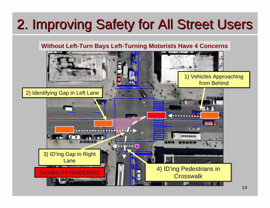
1) Vehicles Approaching from Behind
1) Vehicles Approaching from Behind
3) ID’ing Gap in Right Lane
3) ID’ing Gap in Right Lane
4) ID’ing Pedestrians in Crosswalk
4) ID’ing Pedestrians in Crosswalk
2) Identifying Gap in Left Lane2) Identifying Gap in Left Lane
(VISIBILITY HINDERED)(VISIBILITY HINDERED)
2. Improving Safety for All Street Users2. Improving Safety for All Street UsersWithout Left-Turn Bays Left-Turning Motorists Have 4 Concerns

15
Safety Benefits of Left Turn Bays on Two-Way Streets
Vehicles from behind in different lane
No “Back Pressure”
Vehicles from behind in different lane
No “Back Pressure”
Driver only needs ONE gap to turn; can then look at crosswalkDriver only needs ONE gap to
turn; can then look at crosswalk
• Only 2 Points of Focus• No Visibility Problem• Only 2 Points of Focus• No Visibility Problem
2. Improving Safety for All Street Users2. Improving Safety for All Street Users

16
1. Shortens crossing distance, provides mid-crosswalk layover
2. Wide cut-thru allows two pairs of pedestrians to cross
3. Trees enhance visibility, safety, and streetscape
4. Enforce better driver behavior
5. ADA accessible
Safety Benefits of Pedestrian Refuge Islands
2. Improving Safety for All Street Users2. Improving Safety for All Street Users

17
Turning Conflicts at Intersections are Problematic for Cyclists– 9 of 10 NYC cyclist fatalities– 8 of 10 NYC cyclist serious injuries
Existing Conditions• No Guidance at Intersections
Planned Conditions• Bicycle lanes increase driver’s
visibility and awareness of cyclists• Intersection markings highlight
potential conflict
2. Improving Safety for All Street Users2. Improving Safety for All Street Users

18
3. Traffic Calming for All Street Users3. Traffic Calming for All Street Users
• Excess Road Space Can Encourage Speeding and Increase Crash Severity
• Project Removes Excess Lane from Chrystie Street
• Organizes & Separates Vehicles & Bicycles
• Reduces Oversized Lanes on East Broadway, Forsyth & Eldridge to Standard Width

19
1. Before: Multiple wide lanes encourage speeding, pedestrian crossing challenging
2. After: Fewer travel lanes and less speeding
3. Buffers create comfortable travel lanes and bike lane
4. Marked bicycle route raises awareness of bicycles in roadway
5. Flush painted median further narrows roadway to help slow traffic, provides space for dedicated turning bays
Traffic Calming 9th Street, Brooklyn
Before
After
Buffered Bike LaneFlush Painted Median
Other Successfully Traffic Calmed Streets:
∙ Oriental Boulevard – Bk∙ Vanderbilt Avenue – Bk∙ E. 20th Street – Mn∙ Gerritsen Avenue – Bk
3. Traffic Calming for All Street Users3. Traffic Calming for All Street Users

20
4. Maintaining Vehicular Access & 4. Maintaining Vehicular Access & Traffic FlowTraffic Flow
• Design Tailored to Preserve Traffic Capacity on Key Access Routes
• Parking Preserved for Active Land Uses
• About 50 Parking Spaces to be Removed on East Side of Chrystie Street

21
4. Maintaining Vehicular Access & 4. Maintaining Vehicular Access & Traffic FlowTraffic Flow
52112Total1919Subtotal Metered Parking
3365Subtotal All Day Parking
028Subtotal Time-Limited Parking
019N/P Midnight to 3a, M, W, FNoStanton Street to East Houston
Street
720N/P Midnight to 3a, M, W, FPartialRivington Street to Stanton Street
19192 Hour Parking** 9a-7p, Night
CleaningYesDelancey Street to Rivington Street
1212N/P Midnight to 3a, M, W, FYesBroome Street to Delancey Street
1414N/P Midnight to 3a, M, W, FYesGrand Street to Broome Street
0192 Hour Parking* 10a-7p, N/S 7a-10pNoHester Street to Grand Street
092 Hour Parking* 10a-7p, N/S 7a-10pNoCanal St to Hester Street
RemovedCapacityCurrent RegParkingRemovalBlock
Parking Restricted: East Side of Chrystie between Grand & Stanton Streets

22
Project Summary: Achieving ObjectivesProject Summary: Achieving Objectives
1. Creating Dedicated Cycling Space on Direct and Convenient Routes to and from MN Br
2. Improving Safety for All Street Users, particularlySenior Pedestrians
3. Traffic Calming for All Street Users
4. Maintaining Vehicular Access and Traffic Flow
• Bicycle Lanes on ChrystieSt, East Broadway, Forsyth St, Eldridge St
• Left-Turn Bays & Refuge Islands on Chrystie St
• Bicycle Lanes & Buffer markings to visually narrow roadways
• Parking Preserved at Active land Uses, No Reduction in Vehicle Capacity of Roadways

23
Next StepsNext Steps
•• Community & Stakeholder InputCommunity & Stakeholder Input•• Project RefinementProject Refinement•• Additional Senior Pedestrian Safety Additional Senior Pedestrian Safety
Improvements to Be Developed Improvements to Be Developed Throughout Study AreaThroughout Study Area

24
End of PresentationEnd of Presentation