manipur - 2011 census of india€¦ · census of india 2011 manipur series-15 part xii - b district...
TRANSCRIPT

MANIPUR
SERIES-15
PART XII-B
DISTRICT CENSUS HANDBOOK
IMPHAL WEST
VILLAGE AND TOWN WISE
PRIMARY CENSUS ABSTRACT (PCA)
DIRECTORATE OF CENSUS OPERATIONS
MANIPUR
Census of India 2011


P
R
R
R
IMPHAL WEST DISTRICTB
IS
HN
UP
UR
D
IS
TR
IC
TS
EN
AP
AT
I
DI
ST
RI
CT
SE
NA
PA
T I DI S T R I C
T
I MP
HA
L E
AS
T DIS
TRIC
T
TH
OU
BA
L
DI
ST
RI
CT
LANGJING(C T)
TAKYEL MAPAL(C T) SAGOLBAND
(PART) (C T)
Area (in Sq. Km.)................ 519Number of Sub-Divisions.... 4Number of Statutory Towns 8Number of Census Towns.. 5Number of Outgrowths....... 5Number of Villages.............. 124
!
!
KANGLATONGBI
!SEKMAI(PART)
KHURKHUL!
!
!!
!
!
!!
!
!
!
!
!
!
!
District Headquarters is also Sub-Division Headquarters.
Imphal West District has two C.D./T.D. Blocks as Imphal West-Iand Imphal West-II. Imphal West-I C.D. Block comprisesLamshang and Patsoi Sub-Divisions and Imphal West-II C.D.Block comprises Lamphelpat and Wangoi Sub-Divisions.
101
BOUNDARY, DISTRICT.......................................................................
VILLAGES HAVING 5000 AND ABOVE POPULATION WITH NAME..URBAN AREA WITH POPULATION SIZE:- I,III, IV, V & VI...................NATIONAL HIGHWAY...........................................................................STATE HIGHWAY.................................................................................IMPORTANT METALLED ROADS.......................................................RIVER AND STREAM..........................................................................WATER FEATURES : POND /LAKE....................................................
HEADQUARTERS: STATE...................................................................SUB-DIVISION................................................................"
DISTRICT.............................................................."
NH 2SH
R
P
!
KHURKHUL
!!!!!
SUB-DIVISION....................................................."
^
^Imphal
(MAJOR PART)
LILONG(IMPHAL WEST)
(N P)
LAMSHANGIMPHAL(M Cl)
LAMSHANG (N P)
SAMUROU (N P)(MAJOR PART)
MAYANG IMPHAL(M CI)
THONGKHONGLAXMI BAZAR
(N P)
WANGOI (N P)
WANGOI
SEKMAI BAZAR (N P)
NAMBOL (M Cl)(MINOR PART)
NAORIAPAKHANGLAKPA
(C T)
PATSOILAMJAOTONGBA
(C T)
LAMPHELPAT
Kilometres
SUB-DIVISIONWANGOI
PATSOI
LAMPHELPATSUB-DIVISION
LAMSHANGSUB-DIVISION
SUB-DIVISION
MANIPURFrom Dimapur
From Leimakhong
From Kangchup
From Jiribam
To Kakching
To Moreh
SH
NH 10
2
To Imphal
SHNH
2
SH
From Churachandpur
NH 2
NH 37
Yang
oi
Macha River
Nambul River
Kho rd ak River
Nambul R
iver
Imph
al Riv
erNa
g a R
iver
Nambul River
Imph
a l Ri
verMa
nipur
River

CENSUS OF INDIA 2011
MANIPUR
SERIES-15 PART XII - B
DISTRICT CENSUS HANDBOOK
IMPHAL WEST
VILLAGE AND TOWN WISE PRIMARY CENSUS ABSTRACT (PCA)
Directorate of Census Operations Manipur

MOTIF
Hiyang Tannaba (Boat Race)
Hiyang Tannaba (Boat Race) : Hiyang tannaba (Hi Yangba Tannaba) is a
traditional function of the Panas. This is held during the month of November.
This was introduced during the time of Ningthourel Khunjaoba, the second son
of King Khagemba, who dug the Kangla Moat around the Palace to make it
impregnable in the year of 1660 after he ascended the throne in 1652.

Pages
1 1
2 3
3 5
4 7
5 9
6 10
7 12
8 14
9
(i) 18
(ii) 23
(iii) 31
(iv) 47
(v) 55
(vi) 63
(vii) 83
10 Section –II Tables based on Households Amenities and Assets (Rural
/Urban) at District and Sub-District level.
(i) Table -1:Households by Ownership status and by Number of Dwelling
rooms occupied in the District, 201199
Contents
Administrative Setup
Important Statistics
District Highlights - 2011 Census
Brief History of the District
Foreword
Preface
Acknowledgement
History and Scope of the District Census Handbook
Urban PCA-Town wise Primary Census Abstract
Section - I Primary Census Abstract (PCA)
Brief note on Primary Census Abstract
District Primary Census Abstract
Appendix to District Primary Census Abstract Total, Scheduled Castes and
Scheduled Tribes Population - Urban Block wise
Primary Census Abstract for Scheduled Castes (SC)
Primary Census Abstract for Scheduled Tribes (ST)
Rural PCA-C.D. blocks wise Village Primary Census Abstract

(ii) Table -2:Percentage distribution of Households living in Permanent,
Semi permanent and Temporary houses, 2011100
(iii) Table -3:Number and Percentage of Households by main source of
Drinking water, 2011102
(iv) Table -4:Number and Percentage of Households by main source of
Lighting, 2011104
(v) Table -5:Number and Percentage of Households by type of Latrine
facility, 2011106
(vi) Table -6:Number and Percentage of Households by type of Drainage
connectivity for waste water outlet, 2011108
(vii) Table -7:Number and Percentage of Households by availability of
Kitchen facility, 2011109
(viii) Table -8:Number and Percentage of Households by type of fuel used for
Cooking, 2011110
(ix) Table -9:
Number and Percentage of Households availing Banking
services and number of Households having each of the
specified Assets in, 2011
112

1
FOREWORD The District Census Handbook (DCHB) is an important publication of the Census Organization since 1951. It contains both Census and non-Census data of urban and rural areas for each District. The Census data provide information on demographic and socio-economic characteristics of population at the lowest administrative unit i.e. of each Village and Town and ward of the District. The Primary Census Abstract (PCA) part of this publication contains Census data including data on household amenities collected during 1st.phase of the Census i.e. House Listing and Housing Census. The non-Census data presented in the DCHB is in the form of Village Directory and Town Directory contain information on various infrastructure facilities available in the village and town viz; education, medical, drinking water, communication and transport, post and telegraph, electricity, banking, and other miscellaneous facilities. Later on, the Telegraph Services were closed by the Government of India on 15th. July, 2013. The data of DCHB are of considerable importance in the context of planning and development at the grass-root level. 2. In the 1961 Census, DCHB provided a descriptive account of the District, administrative statistics, Census tables and Village and Town Directory including Primary Census Abstract. This pattern was changed in 1971 Census and the DCHB was published in three parts: Part-A related to Village and Town Directory, Part-B to Village and Town PCA and Part-C comprised analytical report, administrative statistics, District Census tables and certain analytical tables based on PCA and amenity data in respect of Villages. The 1981 Census DCHB was published in two parts: Part-A contained Village and Town Directory and Part-B the PCA of Village and Town including the SCs and STs PCA up to Tahsil/Town levels. New features along with restructuring of the formats of Village and Town Directory were added. In Village Directory, all amenities except electricity were brought together and if any amenity was not available in the referent Village, the distance in broad ranges from the nearest place having such an amenity, was given. 3. The pattern of 1981 Census was followed by and large for the DCHB of 1991 Census except the format of PCA. It was restructured. Nine-fold industrial classification of main workers was given against the four-fold industrial classification presented in the 1981 Census. In addition, sex wise population in 0-6 age group was included in the PCA for the first time with a view to enable the data users to compile more realistic literacy rate as all children below 7 years of age had been treated as illiterate at the time of 1991 Census. One of the important innovations in the 1991 Census was the Community Development Block (CD Block) level presentation of Village Directory and PCA data instead of the traditional Tahsil/Taluk/PS level presentation. 4. As regards DCHB of 2001 Census, the scope of Village Directory was improved by including some other amenities like banking, recreational and cultural facilities, newspapers & magazines and `most important commodity’ manufactured in a Village in addition to prescribed facilities of earlier Censuses. In Town Directory, the statement on Slums was modified and its coverage was enlarged by including details on all slums instead of ‘notified slums’. 5. The scope and coverage of Village Directory of 2011 DCHB has been widened by including a number of new amenities in addition to those of 2001. These newly added amenities are: Pre-Primary School, Engineering College, Medical College,

2
Management Institute, Polytechnic, Non-formal Training Centre, Special School for Disabled, Community Health Centre, Veterinary Hospital, Mobile Health Clinic, Medical Practitioner with MBBS Degree, Medical Practitioner with no degree, Traditional Practitioner and faith Healer, Medicine Shop, Community Toilet, Rural Sanitary Mart or Sanitary Hardware Outlet in the Village, Community Bio- gas, Sub Post Office, Village Pin Code, Public Call Office, Mobile Phone Coverage, Internet Cafes/ Common Service Centre, Private Courier Facility, Auto/Modified Autos, Taxis and Vans, Tractors, Cycle-pulled Rickshaws, Carts driven by Animals, Village connected to National Highway, State Highway, Major District Road, and Other District Road, Availability of Water Bounded Macadam Roads in Village, ATM, Self-Help Group, Public Distribution System(PDS) Shop, Mandis/Regular Market, Weekly Haat, Agricultural Marketing Society, Nutritional Centers (ICDS), Anganwadi Centre, ASHA (Accredited Social Health Activist), Sports Field, Public Library, Public Reading Room, Assembly Polling station, Birth & Death Registration Office. In the Town Directory, seven Statements containing the details and the data of each Town have been presented viz.; (i) Status and Growth History of Towns,(ii) Physical Aspects and Location of Towns, (iii) Civic and other Amenities, (iv) Medical Facilities, (v) Educational, Recreational & Cultural Facilities, (vi) Industry & Banking, and (vii) Civic & other amenities in Slums respectively. CD Block wise data of Village Directory and Village PCA have been presented in DCHB of 2011 Census as presented in earlier Census. 6. The data of DCHB 2011 Census have been presented in two parts, Part-A contains Village and Town Directory and Part-B contains Village and Town wise Primary Census Abstract. Both the Parts have been published in separate volumes in 2011 Census. 7. The Village and Town level amenities data have been collected, compiled and computerized under the supervision of Shri Y. Thamkishore Singh, I.A.S, Director of Census Operations Manipur. The task of Planning, Designing and Co-ordination of this publication was carried out by Dr. Pratibha Kumari, Assistant Registrar General (SS) under the guidance & supervision of Dr. R.C. Sethi, Ex-Addl. RGI and Shri Deepak Rastogi present Addl.RGI. Shri A.P. Singh, Deputy Registrar General, (Map) provided the technical guidance in the preparation of maps. Shri A.K. Arora, Joint Director of Data Processing Division under the overall supervision of Shri M.S. Thapa, Addl. Director (EDP) provided full cooperation in preparation of record structure for digitization and validity checking of Village and Town Directory data and the programme for the generation of Village Directory and Town Directory including various analytical inset tables as well as Primary Census Abstract (PCA). The work of preparation of DCHB, 2011 Census has been monitored in the Social Studies Division. I am thankful to all of them and others who have contributed to bring out this publication in time.
(C. Chandramouli) Registrar General &
Census Commissioner, India New Delhi. Dated:- 16-06-2014

3
Preface
The District Census Handbook is an important set of census publication of the census organization and are widely used by the State Government and its district level and other officers for Planning, development and administrative purposes as well as by a large cross section of data users like academicians, scholars, researchers and other non- governmental agencies. This volume presents the Village and Town Directory under part A and the Primary Census Abstract under part B. The village Directory gives each village its area, population, educational, medical, and civic and other amenities and land use pattern. The town Directory gives for each town, the area, population characteristics, physical aspects, communications, municipal finance, educational, medical, civic and other amenities and trade, commerce, industry and banking facilities. The primary census Abstract presents other basic data like number of residential houses and household, literates, Scheduled Caste and Tribes population, Workers by main categories, marginal workers and Nonworkers. The data presented under Village and Town Directories were furnished by the Village Officers through the Sub-district collector in respect of rural areas i.e villages and by the Excutive officers concerned in respect of urban areas respectively. The data presented under Primary Census Abstract were collected during the census operations by the field workers consisted of Enumerators, Supervisors, Charge Officers and District Census Officers. Question on Sex (Male / Female /others )into three adding code 3 for others during 2011 Census and one additional question was canvass during 2011 Census for marginal workers who worked for less than 6 months by splitting it into two viz. 1) Marginal workers who have worked for 3 months or more but less than 6 months, 2) Marginal workers who have worked for less than 3 months. Thanks are due to all these field officials who have provided the basic data required for the compilation of this volume. The 2011 census DCHB, by and large, followed the pattern of 2001 census in presenting and publication of Primary Census Abstract at the level of Community Development /Tribal Development blocks (CD/TD Blocks) instead of tahsil and sub-divisional level. But as decided the Registrar General and Census Commissioner, India District Census Handbook (DCHB) will be printed into two separate volumes Part – A and Part – B in 2011 Census instead of single volume as was the practice during previous Censuses. I am extremely thankful to Dr. C. Chandramouli, Registrar General and Census Commissioner, India for his guidance and inspiration in bringing out this publication. I am also grateful to Shri D. K Sikri, former Registrar General and Census Commissioner of India for his constant guidance and advice in the initial stage.I am thankful to Dr. D. Roy Chaudhary then Deputy Registrar General ( C&T) and Shri P. K. Banerjee for Planning , Designing and Co-ordination of this publication, Mrs. Pritibha Kumari, Assistant Registrar General Social Studies Division, for finalizing data and analytical notes, Shri A. P. Singh, Deputy Registrar General, Map Division for providing technical guidance in preparation of Maps, Shri M.S. Thapa, Additional Director and Shri Anil Kumar, Joint Director, Data processing Division, for record structure and data computerization. I would like to place my heartful thanks to Dr. N. Roshini Kumar, Deputy Director who played vital role at various stages of census and overall supervision of collection and compilation of this volume. My thanks are also due to Shri Biju Basumatary, Shri R.K. Manisana Singh, Assistant Directors, Dr. M. Manimohon Meetei, Senior Geographer, Shri L. Okendra Singh and Shri Govind Soni, S.I. Grade II and Shri O. Jugindro Singh, Senior Technical Assistant for their painstaking labour and constant involvement in different stages while bringing out

4
this publication. I would also express my thanks to all those who rendered timely and necessary help at different stages in the finalization of this publication.
( Balwanr Rai) Deputy Director

5

6
ORGI- Data Processing Division
1. Shri Jaspal Singh Lamba, DD(EDP)
2. Ms. Usha, AD(EDP)
3. Shri Anurag Gupta, DPA Grade ‘A’
4. Shri Mukesh Kumar Mahawar, DPA Grade ‘A’
5. Ms. Shagufta Nasreen Bhat, DPA Grade ‘A’
6. Ms. Kiran Bala Saxena, Sr. Supervisor
7. Shri Khem Verma Jadon, Sr. Consultant
8. Shri Yashwant Singh, Sr. Consultant
9. Shri Susanta Kumar Sahu, Software Developer

7
HISTORY AND SCOPE OF THE DISTRICT CENSUS HANDBOOK
The need of data at the grass root level for the administrative and planning purposes at sub micro level as well as academic studies prompted the innovation of District Census Handbook. District Census Handbook is a unique publication from the Census organization which provides most authentic details of census and non-census information from village and town level to district level. The District Census Handbook was firstly introduced during the 1951 Census. It contains both census and non census data of urban as well as rural areas for each district. The census data contain several demographic and socio-economic characteristics of the lowest administrative unit i.e. of each village and town and ward of the district. The non census data comprise of data on availability of various civic amenities and infrastructural facilities etc. at the town and village level which constitute Village Directory and Town Directory part of the DCHB. The data of DCHB are of considerable importance in the context of planning and development at grass-root level.
In 1961 census DCHB provided a descriptive account of the district, administrative statistics, census tables and village and town directory including Primary Census Abstract. This pattern was changed in 1971 Census and the DCHB was published in three parts: Part-A related to village and town directory, Part-B to village and town PCA and Part-C comprised analytical report, administrative statistics, district census tables and certain analytical tables based on PCA and amenity data in respect of villages. The 1981 census DCHB was published in two parts: Part-A contained village and town directory and Part-B the PCA of village and town including the SCs and STs PCA up to tahsil/town levels. New features along with restructuring of the formats of village and town directory were added into it. In Village Directory, all amenities except electricity were brought together and if any amenity was not available in the referent village, the distance in broad ranges from the nearest place having such an amenity, was given. The pattern of 1981 census was followed by and large for the DCHB of 1991 Census except the format of PCA. It was restructured. Nine-fold industrial classification of main workers was given against the four-fold industrial classification presented in the 1981 census. In addition, sex wise population in 0-6 age group was included in the PCA for the first time with a view to enable the data users to compile more realistic literacy rate as all children below 7 years of age had been treated as illiterate at the time of 1991 census. One of the important innovations in the 1991 census was the Community Development Block (CD Block) level presentation of village directory and PCA data instead of the traditional tahsil/taluk/PS level presentation.
As regards DCHB of 2001 Census, the scope of Village Directory was improved by including some other amenities like banking, recreational and cultural facilities, newspapers & magazines and `most important commodity’

8
manufactured in a village in addition to prescribed facilities of earlier censuses. In Town Directory, the statement on Slums was modified and its coverage was enlarged by including details on all slums instead of ‘notified slums’.
The scope and coverage of Village Directory of 2011 DCHB has been widened by including a number of new amenities in addition to those of 2001. In the Town Directory, seven Statements containing the details and the data of each town have been presented viz.; (i) Status and Growth History of towns, (ii) Physical Aspects and Location of Towns, (iii) Civic and other Amenities, (iv) Medical Facilities, (v) Educational, Recreational & Cultural Facilities, (vi) Industry & Banking, and (vii) Civic & other amenities in Slums respectively. CD Block wise data of Village Directory and Village PCA have been presented in DCHB of 2011 census as presented in earlier census. The data of DCHB 2011 Census have been presented in two parts, Part-A contains Village and Town Directory and Part-B contains Village and Town wise Primary Census Abstract. Both the Parts have been published in separate volumes in 2011 Census.
--------------------------------------------------------

9
Brief History of the District
Imphal West district was created in 1997 out of the erstwhile Imphal district by
transferring all the villages and towns of Imphal West I and Imphal West II
sub-divisions vide Government of Manipur (Secretariate) Revenue Department
Order No. 6/1/ 73-R(Pt-VIII) dated 17th June,1997 under the Manipur Land
Revenue and Land Reforms Act of 1960. Along with the creation of this district
Imphal West I sub-division was also bifurcated into Lamshang sub-division
and Patsoi sub-division while Imphal West II sub-division was bifurcated into
Lamphelpat sub-division and Wangoi sub-division under the same notification
bringing the total number of sub-divisions to four. The district has two
Community Development Blocks, namely, Imphal West I C.D.Block and Imphal
West II C.D.Block. The sub-divisions are further divided into ten circles.
Lamshang sub-division has 3 circles (Sekmai, Lamshang and Salam), Patsoi
sub-division has 2 circles (Konthoujam and Patsoi), Lamphelpat sub-division
has one circle (Lamphel Central) and Wangoi sub-division has 4 circles
(Wangoi, Mayang Imphal, Hiyangthang and Lilong).

10
Administrative Set Up
The administration of the district is headed by the District Magistrate-cum-
Deputy Commissioner (Collector). He is assisted by other officers and staff as
are appointed from time to time. Maintenance of law and order, revenue
administration and other developmental activities of the district are the basic
duties of the district administration.
Each sub-division is in charge of a Sub-divisional Officer (SDO) who is also
concurrently a Sub-Divisional Magistrate. Within each sub-division there are
smaller administrative circles headed by Sub-Deputy Collectors. Two
Community Development Blocks function in the district, the headquarters of
Imphal West I C.D.Block is at Wangoi while the headquarters of Imphal West II
C.D.Block is at Haorangsabal. Other district heads are Superintendent of
Police, District Officer (Horticulture and Soil Conservation), Chief Medica
Officer, Director of Forest, Director of Agriculture, Director of Animal
Husbandry, Director of Education, Zonal Education Officer, Director of
Settlement & land Records, etc. The district has 8 statutory towns of which 6
towns [namely, Sekmai Bazar NP, Lamshang NP, Lilong (Imphal West) NP,
Wangoi NP, Thongkhong Laxmi Bazar NP and Mayang Imphal NP fall wholly
within the district while the area of Samurou NP comprising 4 wards is spread
over to the adjoining areas of Thoubal district and the extended portion of
Nambol M Cl of Bishnupur district falls in this district. Lamjaotongba, Naoriya
Pakhanglakpa, Sagolband and Takyel Mapal are Census Towns taken as an
urban area on the fulfillment of the demographic conditions. Each statutory
town is divided into a number of wards and has an elected body, the
administration of which is run by the Chairman of each town under the close
supervision and co-operation of the District and Sub-divisional Officers. For
maintenance of law and order the district has a number of police stations
working under the direction of the Superintendent of Police. Post Graduate

11
Institute of Medical Sciences known as Regional Institute of Medical Sciences is
located in this district besides two main bazars named after Thangal General
and Major Paona Brajavarshi also falls in this district. The Manipur Land
Revenue and Land reforms Act, 1960 (No.33 of 1960) which consolidates and
amends the law relating to land revenue and provides measures of land reform
is also applicable to this district.
The district is one of the four valley districts of Manipur and is situated in the
central region of the state. Consequent upon the enactment of the 73 rd
Amendment of the Constitution Act, 1992 the Manipur Panchayat Raj Act was
enacted and became effective from 24 th April, 1994 in all the valley districts of
the state including this district. This Act was subsequently amended in 1996.
Under the Act two tier panchayat system has been established, Gram
Panchayat at the lower level and Zilla Parishad at the upper level. Proverty
alleviation and rural development programmes come under panchayat.

12
District Highlights 2011 Census
Imphal West is a valley district where the capital of the state, Imphal, is situated. The district has an area of 519 sq. km. and ranks seventh in terms of area and covers only 2.32 percent of the total area of the state.The total number of villages in the district is 124 of which 17 villages are uninhabited.
The density of population per sq.km. is very high in the district and has 998 persons against the state density of 128 persons.
In terms of population the district has 18.1 percent of the total population of the state and ranks first position in population size among the 9 districts.
Sex ratio of the district is 1031 females for every 1000 males and is well above the state sex ratio of 985.
The total literacy rate of the district is 86.1 percent and is also higher than the state literacy rate of 76.9 percent. The literacy rate of the Scheduled Tribes (89.8 percent) and that of the Scheduled Caste population (81.1 percent).
. Scheduled Tribes constitute only 4.6 per cent of the total population
against the state average of 40.8 percent. The proportion of Scheduled Castes population in the district is 3.2 percent which is a little lower than the state average of 3.4 percent.
The average size of the household in the district is 4.6 persons which is a little lower than the state average of 5.1 persons.
The percentage of population in the age-group 0-6 years is 11.9 percent while the state average is 14.2 percent meaning that the fertility level of the district is lower than the other districts..
Sex ratio for the child population is 949 and is much lower than the total sex ratio of the district (1031). State sex ratio for 0-6 years population is 930.
Work participation rate for the total population is 41.2 percent, the stateaverage being 45.6 percent. Main workers constitute 32.1 percent of thetotal workers. The percentage of marginal workers is 9.1 percent and therest are non-workers.
‘Other Workers’ is the main constituent of the total workers in the district accounting for 67.2 percent of the total workers. Cultivators and agricultural labourers constitute 17.4 percent and 6.0 percent respectively. Percentage of household industry workers (9.3 percent of the total workers) is second highest of all the districts (state average is 7.0 percent).


Number of Villages Total 2,582 124 Inhabited 2,515 107 Uninhabited 67 17
Number of Towns Statutory 28 8 Census 23 5 Total 51 13
Number of Households Normal 5,55,234 1,10,672 Institutional 1,919 250 Houseless 706 234
Population Total Persons 28,55,794 5,17,992 Males 14,38,586 2,55,054 Females 14,17,208 2,62,938
Rural Persons 20,21,640 1,95,113 Males 10,26,884 96,948 Females 9,94,756 98,165
Urban Persons 8,34,154 3,22,879 Males 4,11,702 1,58,106 Females 4,22,452 1,64,773
Percentage Urban Population 29.21 62.33
Number Percentage Number Percentage
Persons 6,89,006 31.80 73,610 16.56
Males 3,42,952 31.30 33,273 15.00
Females 3,46,054 32.31 40,337 18.12
Area (in sq Km.) 22327 519.00
128 998
Sex Ratio Total 985 1,031 (Number of females per 1000 males) Rural 969 1,013
Urban 1,026 1,042
District
Important Statistics
Decadal Population Growth 2001-2011
Density of Population (Persons per sq Km.)
State
14

Important Statistics
Number Percentage Number Percentage
Literates Persons 19,08,476 76.94 3,92,626 86.08Males 10,39,858 83.58 2,05,985 92.24Females 8,68,618 70.26 1,86,641 80.17
Scheduled Castes Persons 97,328 3.41 16,530 3.19Males 48,863 3.4 8,308 3.26Females 48,465 3.42 8,222 3.13
Scheduled Tribes Persons 11,67,422 40.88 24,161 4.66Males 5,88,279 40.89 11,560 4.53Females 5,79,143 40.87 12,601 4.79
Workers and Non-WorkersPersons 13,04,610 45.68 2,13,387 41.20Males 7,39,408 51.4 1,28,540 50.40Females 5,65,202 39.88 84,847 32.27
(i) Main Workers Persons 9,74,163 34.11 1,66,009 32.05Males 6,15,135 42.76 1,10,440 43.30Females 3,59,028 25.33 55,569 21.13
(ii) Marginal Workers Persons 3,30,447 11.57 47,378 9.15Males 1,24,273 8.64 18,100 7.10Females 2,06,174 14.55 29,278 11.13
Non-Workers Persons 15,51,184 54.32 3,04,605 58.80Males 6,99,178 48.6 1,26,514 49.60Females 8,52,006 60.12 1,78,091 67.73
(i) Cultivators Persons 5,74,031 44 37,107 17.39Males 3,27,109 44.24 26,459 20.58Females 2,46,922 43.69 10,648 12.55
(ii)Agricultural Labourers Persons 1,14,918 8.81 12,870 6.03Males 46,032 6.23 5,479 4.26Females 68,886 12.19 7,391 8.71
Persons 91,356 7 19,918 9.33Males 20,870 2.82 4,916 3.82Females 70,486 12.47 15,002 17.68
(iv) Other Workers Persons 5,24,305 40.19 1,43,492 67.24Males 3,45,397 46.71 91,686 71.33Females 1,78,908 31.65 51,806 61.06
Total Workers (Main and Marginal)
Category of Workers (Main & Marginal)
(iii)Workers in household industry
State District
15


Section - I
Primary Census Abstract (PCA)

18
Brief Note on Primary Census Abstract
Introduction: The Indian Census has the reputation of being one of the best in the world. The first Census in India was conducted in the year 1872. This was conducted at different points of time in different parts of the country. In 1881 a Census was taken for the entire country simultaneously. Since then, Census has been conducted every ten years, without a break. Thus, the Census of India 2011 was the fifteenth in this unbroken series since 1872, the seventh after independence and the second census of the third millennium and twenty first century. The census has been uninterruptedly continued despite of several adversities like wars, epidemics, natural calamities, political unrest, etc.
The Census of India is conducted under the provisions of the Census Act 1948 and the Census Rules, 1990. In Censuses until 1931, a synchronous de-facto method was adopted wherein the Census was conducted throughout the country on a single night. This being a very costly affair and involved the deployment of very large force at one point of time was given up in 1941. Since then the same methodology has been followed in all the Censuses. It is a gigantic operation and considered to be the single largest, complex, peace time administrative exercise in the world.
The Census Operation in India is carried out in two distinct but inter connected phases - the House listing and Housing Census followed by the Population Enumeration. During the first phase of Census 2011 i.e., House listing and Housing Census, the buildings, census houses and households were identified and systematically listed in the House Listing and Housing Census Schedule during the period April to September, 2010 in different States/Union Territories. Apart from listing of houses, some useful data on the amenities available to the households was also collected for assessing condition of human settlements, housing deficits etc.
Censuses prior to Census 2001 had the system of collecting the information through Individual Slip which was a key schedule for every individual. The information collected through slip was then compiled for a household. Some information was also collected in addition to this for the household. During 2001 Census a comprehensive Household Schedule was adopted replacing the individual slip concept. In 2011 Census also similar household schedule was used for canvassing. The scope of demographic, socio-economic parameters has been widened in every census.
2. Population Enumeration - Census 2011: The field work of the second phase i.e. Population Enumeration was carried out during February-March, 2011. One of the essential features of Population Enumeration in the second phase was that each person was enumerated and her/his individual particulars were collected at a well-defined point of time.

19
The Census moment and the reference date for the Census of India 2011 was 00:00 hours of 1st March, 2011. The enumeration was conducted from 9th February to 28th February, 2011 along with a revisional round from 1st March, 2011 to 5th March, 2011 synchronously all over the country except for few specific areas of the Jammu & Kashmir, Himachal Pradesh and Uttarakhand states that remain snowbound in February. In these locations the population enumeration was done from 11th September, 2010 to 30th September, 2010 along with a revisional round from 1st October, 2010 to 5th October, 2010. The reference date for the census in snow bound non-synchronous areas of these states was 00.00 hours of the first day of October, 2010. In addition to the coverage during House listing & Housing Census, the enumeration of the Houseless population was carried out on the night of 28th February, 2011, as has been the usual practice. For the purpose of Census, certain areas where the access of the civilian enumerators was not permissible due to security reasons termed as ‘Special Charges’ such as the Defence and strictly Military/Para-Military areas, including operational areas were also covered. Such areas were not covered during the House listing & Housing Census. In addition to the defence/para-military areas, Special Charges also included certain factory areas, certain colonies, sensitive areas, scientific establishments, etc. These also formed Special Charges as these were not accessible by the usual census enumerator.
3. Quality Assurance:
A Task Force for Quality Assurance (TFQA) functioned under the chairmanship of the RG & CCI. Experienced officers of the different divisions of the organization i.e. Heads and senior officers of the Census Division, Data Processing Division, Map Division, Demography Division and Social Studies Division comprised the TFQA. The Directors of Census Operations were co-opted as members whenever the TFQA discussed the data for their States/Union territories. The main objective of constituting the TFQA was to subject the data to stringent validation checks and ensure its quality before release as it was expedient to be satisfied itself about the quality of data before putting the same in public domain.
The Directors and their senior officers were involved at all levels with respect to the quality and the coverage of their states/Uts. The TFQA intensively scrutinized coverage and content parameters including edit and imputation logic. The most important aspect of the data quality was to ensure complete coverage of all geographical areas especially for the population enumeration phase where the data is disseminated right up to the village level in the rural areas and the ward level in the urban areas. Thus ensuring the complete coverage and correct geographical linkage of each enumeration block was one of the major planks of the quality control, especially for small area population statistics. The content was scrutinized mainly through the process of internal consistency, comparison with similar data in the past and also through validation with likewise data if available, from external sources. Quite often the local knowledge and perception was looked at to understand both the existing and the new emerging trends of

20
population distribution and characteristics. A very comprehensive check and edit mechanism was put in place to objectively examine the preliminary Census 2011 Population Enumeration results and finally clear them for use. The population data was cleared only after the full possible satisfaction of the TFQA.
The entire work relating to the data validation and scrutiny was completed by all the States/Union territories under the overall supervision and monitoring of the Census Division of the Office of the Registrar General, India with active cooperation and support of the Social Studies Division, Data Processing Division, Data Dissemination Division and Map Division.
4. Primary Census Abstract: The Primary Census Abstract which is important publication of 2011 Census gives basic information on Area, Total Number of Households, Total Population, Scheduled Castes, Scheduled Tribes Population, Population in the age group 0-6, Literates, Main Workers and Marginal Workers classified by the four broad industrial categories, namely, (i) Cultivators, (ii) Agricultural Labourers, (iii) Household Industry Workers, and (iv) Other Workers and also Non-Workers. The characteristics of the Total Population include Scheduled Castes, Scheduled Tribes, Institutional and Houseless Population and are presented by sex and rural-urban residence.
In 1981 census main workers were presented into four categories. As regards 1991 Census, the nine-fold industrial classification of main workers has been given in the Primary Census Abstract. One of the important features of the Primary Census Abstract of 1991 Census was the presentation of population of the age group 0-6 which is continued in 2001 and 2011 Census. All the children of age 6 years or less have been treated as illiterate even if the child is going to a school and may have picked up reading and writing. This will help the data users in better analysis and understanding of the literacy data as the literacy rate is calculated with 7 years and above population and it is referred as effective literacy rate. In 2001 and 2011 census four categories of main workers have been given in the Primary Census Abstract.
5. Level of Presentation of PCA data in District Census Handbooks: The format of Primary Census Abstract (PCA) adopted in the DCHB of 2001 Census has been continued for 2011 Census as the data on four categories of works have been presented similar to 2001 census. The Primary Census Abstract data in different PCAs are presented at different levels. The level of presentation of Primary Census Abstracts in DCHB is as under:

21
1. District Primary Census Abstract -District/C.D. Block/Town.2. Primary Census Abstract for Scheduled Castes- District/C.D. Block/Town.3. Primary Census Abstract for Scheduled Tribes -District/C.D. Block/Town.4. Village Primary Census Abstract -C.D. Block/Village wise.5. Urban Primary Census Abstract- Town/Ward level.
The PCA Data for villages was presented C.D. Block wise for the first time in 1991 Census. This practice is continued in 2001 and 2011 Census. The term ‘Total Population’ includes the Scheduled Castes, the Scheduled Tribes, the Institutional and the Houseless populations. An appendix to District Primary Census Abstract has also been furnished showing urban enumeration block-wise particulars on Total Population, the Scheduled Castes Population and the Scheduled Tribes Population for each town.
6. Area Figures:
The area figures supplied by local revenue authorities of the district in respect of tahsils, Police Stations and by the local bodies in respect of towns are given in square kilometers. The area figures of the villages supplied by the Tahsildars in acres have been converted and shown in hectares. The area figures of the C.D. Block are the total of the village areas coming under each C.D. Block. The area figures for the district are the same as adopted by the Surveyor General of India to maintain uniformity at the national level.
-----------------------------------------------------------------


District Primary Census Abstract

DISTRICT CENSUS HANDBOOK : IMPHAL WEST
DISTRICT PRIMARY
Persons Males Females Persons Males Females1 2 3 4 5 6 7 8 9 10 11
277 Imphal West - District Total 519.00 1,11,156 5,17,992 2,55,054 2,62,938 61,875 31,747 30,128 Rural 449.82 41,595 1,95,113 96,948 98,165 25,459 13,141 12,318 Urban 69.18 69,561 3,22,879 1,58,106 1,64,773 36,416 18,606 17,810
0026 Imphal West-I Total 283.02 34,343 1,59,032 78,749 80,283 20,044 10,310 9,734 Rural 276.65 25,981 1,20,851 60,005 60,846 15,579 8,048 7,531 Urban 6.37 8,362 38,181 18,744 19,437 4,465 2,262 2,203
270116 Lamjaotongba (CT) Urban 0.00 2,328 10,593 5,088 5,505 1,211 623 588 270117 Langjing (CT) Urban 1.87 1,163 5,451 2,781 2,670 707 353 354
801487
Bijoy Govinda (OG) WARD NO.-0028 (Rural MDDS CODE:269934)
Urban NA 945 3,897 1,885 2,012 423 211 212
270122Naoriya Pakhanglakpa (CT) Urban 0.74 1,612 7,501 3,643 3,858 899 455 444
270123 Sagolband (Part) (CT) Urban 0.38 1,127 4,964 2,431 2,533 572 288 284 270124 Takyel Mapal (CT) Urban 3.38 1,187 5,775 2,916 2,859 653 332 321 0027 Imphal West-II Total 58.24 17,442 82,425 40,906 41,519 10,746 5,516 5,230
Rural 58.24 15,614 74,262 36,943 37,319 9,880 5,093 4,787 Urban 0.00 1,828 8,163 3,963 4,200 866 423 443
801487
Oinam Thingel (OG) WARD NO.-0029 (Rural MDDS CODE:269935)
Urban NA 719 3,024 1,460 1,564 328 154 174
801492
Langthabal Kunja (OG) WARD NO.-0010 (Rural MDDS CODE:269936)
Urban NA 206 938 454 484 107 54 53
801492
Langthabal Mantrikhong (OG) (Part) WARD NO.-0011 (Rural MDDS CODE:270152)
Urban NA 106 889 447 442 37 27 10
801492
Naorem Leikai (OG) WARD NO.-0012 (Rural MDDS CODE:269937)
Urban NA 797 3,312 1,602 1,710 394 188 206
URBAN801485 Lamsang (NP) Urban 7.02 1,783 8,130 3,837 4,293 991 479 512 801486 Sekmai Bazar (NP) Urban 0.00 1,111 5,065 2,467 2,598 634 342 292
801469Nambol (MCI) (Minor part) Urban 0.00 1,210 5,431 2,682 2,749 633 314 319
270116 Lamjaotongba (CT) Urban 0.00 2,328 10,593 5,088 5,505 1,211 623 588 270117 Langjing (CT) Urban 1.87 1,163 5,451 2,781 2,670 707 353 354
801487Imphal (MCI + OG) (Major part) Urban 0.00 42,820 1,93,459 94,451 99,008 19,830 10,184 9,646
270122Naoriya Pakhanglakpa (CT) Urban 0.74 1,612 7,501 3,643 3,858 899 455 444
270123 Sagolband (Part) (CT) Urban 0.38 1,127 4,964 2,431 2,533 572 288 284 270124 Takyel Mapal (CT) Urban 3.38 1,187 5,775 2,916 2,859 653 332 321
801488Samurou NP (Major part) Urban 1.61 2,180 10,721 5,274 5,447 1,422 734 688
801489 Mayang Imphal (MCl) Urban 3.45 4,501 24,239 11,984 12,255 3,657 1,824 1,833
801490Thongkhong Laxmi Bazar (NP) Urban 5.37 2,926 14,878 7,405 7,473 2,068 1,060 1,008
801491 Wangoi (NP) Urban 3.20 1,836 9,106 4,567 4,539 1,167 619 548
801492Lilong (Imphal West) (NP + OG) Urban 3.10 3,777 17,566 8,580 8,986 1,972 999 973
Location code
numberDistrict/ CD Block/
Town
Total/ Rural/ Urban
Area in Square
KilometreNumber of households
Total population (including institutional and houseless population) Population in the age-group 0-6
24

PRIMARY CENSUS ABSTRACT
CENSUS ABSTRACT
Persons Males Females Persons Males Females Persons Males Females12 13 14 15 16 17 18 19 20 3 2
16,530 8,308 8,222 24,161 11,560 12,601 3,92,626 2,05,985 1,86,641 Total Imphal West - District11,711 5,846 5,865 4,240 2,037 2,203 1,39,391 74,969 64,422 Rural4,819 2,462 2,357 19,921 9,523 10,398 2,53,235 1,31,016 1,22,219 Urban
12,113 6,138 5,975 4,901 2,332 2,569 1,16,255 61,703 54,552 Total Imphal West-I11,679 5,829 5,850 3,845 1,850 1,995 86,162 46,171 39,991 Rural
434 309 125 1,056 482 574 30,093 15,532 14,561 Urban15 6 9 608 283 325 7,993 4,030 3,963 Urban Lamjaotongba (CT)37 27 10 328 137 191 4,299 2,345 1,954 Urban Langjing (CT)
12 5 7 18 7 11 3,194 1,614 1,580 Urban
Bijoy Govinda (OG) WARD NO.-0028 (Rural MDDS CODE:269934)
1 - 1 20 8 12 5,914 2,992 2,922 UrbanNaoriya Pakhanglakpa (CT)
18 10 8 2 - 2 4,069 2,091 1,978 Urban Sagolband (Part) (CT)351 261 90 80 47 33 4,624 2,460 2,164 Urban Takyel Mapal (CT)137 47 90 1,645 845 800 59,836 32,197 27,639 Total Imphal West-II32 17 15 395 187 208 53,229 28,798 24,431 Rural
105 30 75 1,250 658 592 6,607 3,399 3,208 Urban
- - - - - - 2,438 1,256 1,182 Urban
Oinam Thingel (OG) WARD NO.-0029 (Rural MDDS CODE:269935)
- - - 925 446 479 716 383 333 Urban
Langthabal Kunja (OG) WARD NO.-0010 (Rural MDDS CODE:269936)
99 29 70 312 205 107 845 418 427 Urban
Langthabal Mantrikhong (OG) (Part) WARD NO.-0011 (Rural MDDS CODE:270152)
6 1 5 13 7 6 2,608 1,342 1,266 Urban
Naorem Leikai (OG) WARD NO.-0012 (Rural MDDS CODE:269937)URBAN
22 3 19 485 207 278 6,132 3,144 2,988 Urban Lamsang (NP)3,187 1,572 1,615 57 20 37 3,676 1,881 1,795 Urban Sekmai Bazar (NP)
2 1 1 67 34 33 4,258 2,262 1,996 UrbanNambol (MCI) (Minor part)
15 6 9 608 283 325 7,993 4,030 3,963 Urban Lamjaotongba (CT)37 27 10 328 137 191 4,299 2,345 1,954 Urban Langjing (CT)
1,077 550 527 16,623 7,934 8,689 1,59,216 80,754 78,462 UrbanImphal (MCI + OG) (Major part)
1 - 1 20 8 12 5,914 2,992 2,922 UrbanNaoriya Pakhanglakpa (CT)
18 10 8 2 - 2 4,069 2,091 1,978 Urban Sagolband (Part) (CT)351 261 90 80 47 33 4,624 2,460 2,164 Urban Takyel Mapal (CT)
- - - 2 1 1 7,655 4,190 3,465 UrbanSamurou NP (Major part)
- - - 71 42 29 15,266 8,558 6,708 Urban Mayang Imphal (MCl)
- - - 209 98 111 9,886 5,528 4,358 UrbanThongkhong Laxmi Bazar (NP)
- - - 117 53 64 6,532 3,600 2,932 Urban Wangoi (NP)
109 32 77 1,252 659 593 13,715 7,181 6,534 UrbanLilong (Imphal West) (NP + OG)
Scheduled Castes population Scheduled Tribes population LiteratesTotal/ Rural/ Urban
District/ CD Block/ Town
25

DISTRICT CENSUS HANDBOOK : IMPHAL WEST
DISTRICT PRIMARY
Persons Males Females Persons Males Females Persons Males Females1 2 3 21 22 23 24 25 26 27 28 29
277Imphal West - District Total 2,13,387 1,28,540 84,847 1,66,009 1,10,440 55,569 30,101 23,001 7,100
Rural 84,176 50,493 33,683 64,231 44,090 20,141 22,351 16,821 5,530 Urban 1,29,211 78,047 51,164 1,01,778 66,350 35,428 7,750 6,180 1,570
0026 Imphal West-I Total 65,709 40,594 25,115 50,434 35,543 14,891 15,394 12,632 2,762 Rural 50,715 31,195 19,520 38,007 27,377 10,630 15,164 12,434 2,730 Urban 14,994 9,399 5,595 12,427 8,166 4,261 230 198 32
270116 Lamjaotongba (CT) Urban 4,351 2,509 1,842 3,291 2,046 1,245 23 18 5 270117 Langjing (CT) Urban 2,476 1,680 796 2,242 1,608 634 148 130 18
801487
Bijoy Govinda (OG) WARD NO.-0028 (Rural MDDS CODE:269934)
Urban 1,607 972 635 1,180 760 420 6 4 2
270122Naoriya Pakhanglakpa (CT) Urban 2,601 1,750 851 2,070 1,429 641 13 11 2
270123 Sagolband (Part) (CT) Urban 1,782 1,093 689 1,657 1,037 620 1 1 - 270124 Takyel Mapal (CT) Urban 2,177 1,395 782 1,987 1,286 701 39 34 5 0027 Imphal West-II Total 36,872 21,248 15,624 28,725 18,263 10,462 7,329 4,505 2,824
Rural 33,461 19,298 14,163 26,224 16,713 9,511 7,187 4,387 2,800 Urban 3,411 1,950 1,461 2,501 1,550 951 142 118 24
801487
Oinam Thingel (OG) WARD NO.-0029 (Rural MDDS CODE:269935)
Urban 1,353 765 588 1,017 610 407 2 1 1
801492
Langthabal Kunja (OG) WARD NO.-0010 (Rural MDDS CODE:269936)
Urban 426 239 187 233 167 66 49 30 19
801492
Langthabal Mantrikhong (OG) (Part) WARD NO.-0011 (Rural MDDS CODE:270152)
Urban 132 93 39 121 84 37 - - -
801492
Naorem Leikai (OG) WARD NO.-0012 (Rural MDDS CODE:269937)
Urban 1,500 853 647 1,130 689 441 91 87 4
URBAN801485 Lamsang (NP) Urban 3,868 2,184 1,684 2,933 2,004 929 800 691 109 801486 Sekmai Bazar (NP) Urban 2,068 1,232 836 1,372 901 471 436 394 42
801469Nambol (MCI) (Minor part) Urban 2,064 1,277 787 1,622 1,062 560 247 223 24
270116 Lamjaotongba (CT) Urban 4,351 2,509 1,842 3,291 2,046 1,245 23 18 5 270117 Langjing (CT) Urban 2,476 1,680 796 2,242 1,608 634 148 130 18
801487Imphal (MCI + OG) (Major part) Urban 76,628 46,465 30,163 62,092 39,569 22,523 360 220 140
270122Naoriya Pakhanglakpa (CT) Urban 2,601 1,750 851 2,070 1,429 641 13 11 2
270123 Sagolband (Part) (CT) Urban 1,782 1,093 689 1,657 1,037 620 1 1 - 270124 Takyel Mapal (CT) Urban 2,177 1,395 782 1,987 1,286 701 39 34 5
801488Samurou NP (Major part) Urban 4,029 2,531 1,498 3,277 2,203 1,074 462 363 99
801489 Mayang Imphal (MCl) Urban 9,242 5,732 3,510 6,932 4,891 2,041 2,549 2,050 499
801490Thongkhong Laxmi Bazar (NP) Urban 6,265 3,610 2,655 4,033 2,922 1,111 1,684 1,251 433
801491 Wangoi (NP) Urban 3,675 2,268 1,407 2,694 1,871 823 622 491 131
801492Lilong (Imphal West) (NP + OG) Urban 7,985 4,321 3,664 5,576 3,521 2,055 366 303 63
CultivatorsDistrict/ CD Block/ Town
Total/ Rural/ Urban
Total workers Main workers
Industrial categoryLocation
code number
26

PRIMARY CENSUS ABSTRACT
CENSUS ABSTRACT
Persons Males Females Persons Males Females Persons Males Females30 31 32 33 34 35 36 37 38 3 2
5,044 3,057 1,987 11,439 3,576 7,863 1,19,425 80,806 38,619 Total Imphal West - District2,756 1,639 1,117 4,823 1,218 3,605 34,301 24,412 9,889 Rural2,288 1,418 870 6,616 2,358 4,258 85,124 56,394 28,730 Urban2,001 1,260 741 3,293 818 2,475 29,746 20,833 8,913 Total Imphal West-I1,789 1,111 678 2,635 532 2,103 18,419 13,300 5,119 Rural
212 149 63 658 286 372 11,327 7,533 3,794 Urban37 15 22 343 140 203 2,888 1,873 1,015 Urban Lamjaotongba (CT)96 77 19 16 10 6 1,982 1,391 591 Urban Langjing (CT)
8 4 4 60 25 35 1,106 727 379 Urban
Bijoy Govinda (OG) WARD NO.-0028 (Rural MDDS CODE:269934)
17 12 5 87 43 44 1,953 1,363 590 UrbanNaoriya Pakhanglakpa (CT)
3 3 - 18 10 8 1,635 1,023 612 Urban Sagolband (Part) (CT)51 38 13 134 58 76 1,763 1,156 607 Urban Takyel Mapal (CT)
972 532 440 2,475 775 1,700 17,949 12,451 5,498 Total Imphal West-II967 528 439 2,188 686 1,502 15,882 11,112 4,770 Rural
5 4 1 287 89 198 2,067 1,339 728 Urban
2 1 1 199 47 152 814 561 253 Urban
Oinam Thingel (OG) WARD NO.-0029 (Rural MDDS CODE:269935)
2 2 - 2 2 - 180 133 47 Urban
Langthabal Kunja (OG) WARD NO.-0010 (Rural MDDS CODE:269936)
- - - 1 1 - 120 83 37 Urban
Langthabal Mantrikhong (OG) (Part) WARD NO.-0011 (Rural MDDS CODE:270152)
1 1 - 85 39 46 953 562 391 Urban
Naorem Leikai (OG) WARD NO.-0012 (Rural MDDS CODE:269937)URBAN
135 50 85 227 33 194 1,771 1,230 541 Urban Lamsang (NP)220 124 96 172 26 146 544 357 187 Urban Sekmai Bazar (NP)
133 96 37 275 58 217 967 685 282 UrbanNambol (MCI) (Minor part)
37 15 22 343 140 203 2,888 1,873 1,015 Urban Lamjaotongba (CT)96 77 19 16 10 6 1,982 1,391 591 Urban Langjing (CT)
581 389 192 3,424 1,491 1,933 57,727 37,469 20,258 UrbanImphal (MCI + OG) (Major part)
17 12 5 87 43 44 1,953 1,363 590 UrbanNaoriya Pakhanglakpa (CT)
3 3 - 18 10 8 1,635 1,023 612 Urban Sagolband (Part) (CT)51 38 13 134 58 76 1,763 1,156 607 Urban Takyel Mapal (CT)
223 120 103 419 45 374 2,173 1,675 498 UrbanSamurou NP (Major part)
368 233 135 376 96 280 3,639 2,512 1,127 Urban Mayang Imphal (MCl)
127 84 43 76 37 39 2,146 1,550 596 UrbanThongkhong Laxmi Bazar (NP)
151 80 71 263 39 224 1,658 1,261 397 Urban Wangoi (NP)
146 97 49 786 272 514 4,278 2,849 1,429 UrbanLilong (Imphal West) (NP + OG)
Agricultural labourers Household industry workers Other workersTotal/ Rural/ Urban
District/ CD Block/ Town
of main workers
27

DISTRICT CENSUS HANDBOOK : IMPHAL WEST
DISTRICT PRIMARY
Persons Males Females Persons Males Females Persons Males Females1 2 3 39 40 41 42 43 44 45 46 47
277 Imphal West - District Total 47,378 18,100 29,278 7,006 3,458 3,548 7,826 2,422 5,404 Rural 19,945 6,403 13,542 4,371 1,993 2,378 4,523 1,331 3,192 Urban 27,433 11,697 15,736 2,635 1,465 1,170 3,303 1,091 2,212
0026 Imphal West-I Total 15,275 5,051 10,224 2,950 1,333 1,617 2,628 818 1,810 Rural 12,708 3,818 8,890 2,838 1,265 1,573 2,494 750 1,744 Urban 2,567 1,233 1,334 112 68 44 134 68 66
270116 Lamjaotongba (CT) Urban 1,060 463 597 29 17 12 59 19 40 270117 Langjing (CT) Urban 234 72 162 3 - 3 6 4 2
801487
Bijoy Govinda (OG) WARD NO.-0028 (Rural MDDS CODE:269934)
Urban 427 212 215 10 8 2 6 3 3
270122Naoriya Pakhanglakpa (CT) Urban 531 321 210 26 14 12 15 9 6
270123 Sagolband (Part) (CT) Urban 125 56 69 9 3 6 2 1 1 270124 Takyel Mapal (CT) Urban 190 109 81 35 26 9 46 32 14 0027 Imphal West-II Total 8,147 2,985 5,162 1,582 765 817 2,143 624 1,519
Rural 7,237 2,585 4,652 1,533 728 805 2,029 581 1,448 Urban 910 400 510 49 37 12 114 43 71
801487
Oinam Thingel (OG) WARD NO.-0029 (Rural MDDS CODE:269935)
Urban 336 155 181 3 1 2 13 6 7
801492
Langthabal Kunja (OG) WARD NO.-0010 (Rural MDDS CODE:269936)
Urban 193 72 121 45 35 10 85 28 57
801492
Langthabal Mantrikhong (OG) (Part) WARD NO.-0011 (Rural MDDS CODE:270152)
Urban 11 9 2 1 1 - - - -
801492
Naorem Leikai (OG) WARD NO.-0012 (Rural MDDS CODE:269937)
Urban 370 164 206 - - - 16 9 7
URBAN801485 Lamsang (NP) Urban 935 180 755 117 68 49 417 35 382 801486 Sekmai Bazar (NP) Urban 696 331 365 305 237 68 318 65 253
801469Nambol (MCI) (Minor part) Urban 442 215 227 51 47 4 99 75 24
270116 Lamjaotongba (CT) Urban 1,060 463 597 29 17 12 59 19 40 270117 Langjing (CT) Urban 234 72 162 3 - 3 6 4 2
801487Imphal (MCI + OG) (Major part) Urban 14,536 6,896 7,640 261 150 111 341 179 162
270122Naoriya Pakhanglakpa (CT) Urban 531 321 210 26 14 12 15 9 6
270123 Sagolband (Part) (CT) Urban 125 56 69 9 3 6 2 1 1 270124 Takyel Mapal (CT) Urban 190 109 81 35 26 9 46 32 14
801488Samurou NP (Major part) Urban 752 328 424 86 52 34 140 95 45
801489 Mayang Imphal (MCl) Urban 2,310 841 1,469 708 312 396 553 197 356
801490Thongkhong Laxmi Bazar (NP) Urban 2,232 688 1,544 577 254 323 810 213 597
801491 Wangoi (NP) Urban 981 397 584 256 192 64 214 65 149
801492Lilong (Imphal West) (NP + OG) Urban 2,409 800 1,609 172 93 79 283 102 181
Location code
numberDistrict/ CD Block/
Town
Total/ Rural/ Urban
Industrial category
Agricultural labourersMarginal workers Cultivators
28

PRIMARY CENSUS ABSTRACT
CENSUS ABSTRACT
Persons Males Females Persons Males Females Persons Males Females48 49 50 51 52 53 54 55 56 3 2 1
8,479 1,340 7,139 24,067 10,880 13,187 3,04,605 1,26,514 1,78,091 Total Imphal West - District 2774,148 456 3,692 6,903 2,623 4,280 1,10,937 46,455 64,482 Rural4,331 884 3,447 17,164 8,257 8,907 1,93,668 80,059 1,13,609 Urban3,066 326 2,740 6,631 2,574 4,057 93,323 38,155 55,168 Total Imphal West-I 00262,800 282 2,518 4,576 1,521 3,055 70,136 28,810 41,326 Rural
266 44 222 2,055 1,053 1,002 23,187 9,345 13,842 Urban57 15 42 915 412 503 6,242 2,579 3,663 Urban Lamjaotongba (CT) 27011664 - 64 161 68 93 2,975 1,101 1,874 Urban Langjing (CT) 270117
35 2 33 376 199 177 2,290 913 1,377 Urban
Bijoy Govinda (OG) WARD NO.-0028 (Rural MDDS CODE:269934)
801487
65 14 51 425 284 141 4,900 1,893 3,007 UrbanNaoriya Pakhanglakpa (CT) 270122
27 10 17 87 42 45 3,182 1,338 1,844 Urban Sagolband (Part) (CT) 27012318 3 15 91 48 43 3,598 1,521 2,077 Urban Takyel Mapal (CT) 270124
1,553 202 1,351 2,869 1,394 1,475 45,553 19,658 25,895 Total Imphal West-II 00271,348 174 1,174 2,327 1,102 1,225 40,801 17,645 23,156 Rural
205 28 177 542 292 250 4,752 2,013 2,739 Urban
42 2 40 278 146 132 1,671 695 976 Urban
Oinam Thingel (OG) WARD NO.-0029 (Rural MDDS CODE:269935)
801487
55 2 53 8 7 1 512 215 297 Urban
Langthabal Kunja (OG) WARD NO.-0010 (Rural MDDS CODE:269936)
801492
1 1 - 9 7 2 757 354 403 Urban
Langthabal Mantrikhong (OG) (Part) WARD NO.-0011 (Rural MDDS CODE:270152)
801492
107 23 84 247 132 115 1,812 749 1,063 Urban
Naorem Leikai (OG) WARD NO.-0012 (Rural MDDS CODE:269937)
801492
URBAN110 1 109 291 76 215 4,262 1,653 2,609 Urban Lamsang (NP) 80148532 - 32 41 29 12 2,997 1,235 1,762 Urban Sekmai Bazar (NP) 801486
159 4 155 133 89 44 3,367 1,405 1,962 UrbanNambol (MCI) (Minor part) 801469
57 15 42 915 412 503 6,242 2,579 3,663 Urban Lamjaotongba (CT) 27011664 - 64 161 68 93 2,975 1,101 1,874 Urban Langjing (CT) 270117
1,524 554 970 12,410 6,013 6,397 1,16,831 47,986 68,845 UrbanImphal (MCI + OG) (Major part) 801487
65 14 51 425 284 141 4,900 1,893 3,007 UrbanNaoriya Pakhanglakpa (CT) 270122
27 10 17 87 42 45 3,182 1,338 1,844 Urban Sagolband (Part) (CT) 27012318 3 15 91 48 43 3,598 1,521 2,077 Urban Takyel Mapal (CT) 270124
160 27 133 366 154 212 6,692 2,743 3,949 UrbanSamurou NP (Major part) 801488
433 49 384 616 283 333 14,997 6,252 8,745 Urban Mayang Imphal (MCl) 801489
316 26 290 529 195 334 8,613 3,795 4,818 UrbanThongkhong Laxmi Bazar (NP) 801490
318 19 299 193 121 72 5,431 2,299 3,132 Urban Wangoi (NP) 801491
1,048 162 886 906 443 463 9,581 4,259 5,322 UrbanLilong (Imphal West) (NP + OG) 801492
Household industry workers Other workers Non-workers
of marginal workersTotal/ Rural/ Urban
District/ CD Block/ Town
Location code
number
29


Appendix to District Primary Census Abstract
Total, Scheduled Castes and Scheduled Tribes
Population - Urban Block wise

Location Code
Name of Town Name of Ward Boundaries of Urban Block / EB Number
Total Population
Scheduled Castes
Population
1 2 3 4 5 6
801485 Lamsang (NP) WARD No.-0001 EB No.-000100 690 -
801485 Lamsang (NP) WARD No.-0002 EB No.-000200 485 -
801485 Lamsang (NP) WARD No.-0002 EB No.-000300 594 -
801485 Lamsang (NP) WARD No.-0003 EB No.-000400 561 -
801485 Lamsang (NP) WARD No.-0004 EB No.-000500 547 1
801485 Lamsang (NP) WARD No.-0004 EB No.-000600 346 -
801485 Lamsang (NP) WARD No.-0005 EB No.-0007 SUB-EB No.01 534 -
801485 Lamsang (NP) WARD No.-0005 EB No.-0007 SUB-EB No.02 464 21
801485 Lamsang (NP) WARD No.-0006 EB No.-000800 558 -
801485 Lamsang (NP) WARD No.-0006 EB No.-000900 690 -
801485 Lamsang (NP) WARD No.-0007 EB No.-001000 452 -
801485 Lamsang (NP) WARD No.-0007 EB No.-001100 399 -
801485 Lamsang (NP) WARD No.-0008 EB No.-001200 488 -
801485 Lamsang (NP) WARD No.-0008 EB No.-001300 374 -
801485 Lamsang (NP) WARD No.-0009 EB No.-001400 260 -
801485 Lamsang (NP) WARD No.-0009 EB No.-001500 688 -
801486 Sekmai Bazar (NP) WARD No.-0001 EB No.-001600 555 104
801486 Sekmai Bazar (NP) WARD No.-0001 EB No.-001700 468 68
801486 Sekmai Bazar (NP) WARD No.-0001 EB No.-001800 395 106
801486 Sekmai Bazar (NP) WARD No.-0002 EB No.-001900 410 286
801486 Sekmai Bazar (NP) WARD No.-0003 EB No.-002000 626 480
801486 Sekmai Bazar (NP) WARD No.-0004 EB No.-002100 587 460
801486 Sekmai Bazar (NP) WARD No.-0005 EB No.-002200 340 275
801486 Sekmai Bazar (NP) WARD No.-0006 EB No.-002300 656 635
801486 Sekmai Bazar (NP) WARD No.-0007 EB No.-002400 216 208
801486 Sekmai Bazar (NP) WARD No.-0008 EB No.-002500 434 260
801486 Sekmai Bazar (NP) WARD No.-0009 EB No.-002600 378 305
801469 Nambol (MCI) (Minor part) WARD No.-0001 EB No.-000100 1049 -
801469 Nambol (MCI) (Minor part) WARD No.-0002 EB No.-000200 1173 -
801469 Nambol (MCI) (Minor part) WARD No.-0003 EB No.-000300 928 2
801469 Nambol (MCI) (Minor part) WARD No.-0017 EB No.-000400 1025 -
801469 Nambol (MCI) (Minor part) WARD No.-0018 EB No.-000500 472 -
801469 Nambol (MCI) (Minor part) WARD No.-0018 EB No.-000600 171 -
801469 Nambol (MCI) (Minor part) WARD No.-0018 EB No.-000700 361 -
801469 Nambol (MCI) (Minor part) WARD No.-0018 EB No.-000800 252 -
270116 Lamjaotongba (CT) WARD No.-0001 EB No.-000900 892 5
270116 Lamjaotongba (CT) WARD No.-0001 EB No.-001000 1042 -
270116 Lamjaotongba (CT) WARD No.-0001 EB No.-001100 953 5
270116 Lamjaotongba (CT) WARD No.-0001 EB No.-001200 982 -
270116 Lamjaotongba (CT) WARD No.-0001 EB No.-001300 572 -
270116 Lamjaotongba (CT) WARD No.-0001 EB No.-001400 635 -
270116 Lamjaotongba (CT) WARD No.-0001 EB No.-001500 797 -
270116 Lamjaotongba (CT) WARD No.-0001 EB No.-001600 844 -
270116 Lamjaotongba (CT) WARD No.-0001 EB No.-001700 719 3
APPENDIX TO DISTRICT PRIMARY CENSUS ABSTRACT TOTAL, SCHEDULED CASTES AND SCHEDULED TRIBES POPULATION - URBAN BLOCK WISE
32

Location Code
Name of Town Name of Ward Boundaries of Urban Block / EB Number
Total Population
Scheduled Castes
Population
1 2 3 4 5 6
APPENDIX TO DISTRICT PRIMARY CENSUS ABSTRACT TOTAL, SCHEDULED CASTES AND SCHEDULED TRIBES POPULATION - URBAN BLOCK WISE
270116 Lamjaotongba (CT) WARD No.-0001 EB No.-0018 SUB-EB No.01 656 -
270116 Lamjaotongba (CT) WARD No.-0001 EB No.-0018 SUB-EB No.02 660 -
270116 Lamjaotongba (CT) WARD No.-0001 EB No.-0019 SUB-EB No.01 1011 1
270116 Lamjaotongba (CT) WARD No.-0001 EB No.-0019 SUB-EB No.02 830 1
270117 Langjing (CT) WARD No.-0001 EB No.-002000 711 -
270117 Langjing (CT) WARD No.-0001 EB No.-002100 941 -
270117 Langjing (CT) WARD No.-0001 EB No.-002200 633 -
270117 Langjing (CT) WARD No.-0001 EB No.-002300 649 -
270117 Langjing (CT) WARD No.-0001 EB No.-002400 636 4
270117 Langjing (CT) WARD No.-0001 EB No.-310100 251 9
270117 Langjing (CT) WARD No.-0001 EB No.-310200 457 2
270117 Langjing (CT) WARD No.-0001 EB No.-310300 646 13
270117 Langjing (CT) WARD No.-0001 EB No.-310400 369 1
270117 Langjing (CT) WARD No.-0001 EB No.-310500 94 1
270117 Langjing (CT) WARD No.-0001 EB No.-320100 64 7
801487 Imphal (MCI + OG) (Major part) WARD No.-0001 EB No.-000100 484 -
801487 Imphal (MCI + OG) (Major part) WARD No.-0001 EB No.-000200 413 -
801487 Imphal (MCI + OG) (Major part) WARD No.-0001 EB No.-000300 330 -
801487 Imphal (MCI + OG) (Major part) WARD No.-0001 EB No.-000400 397 -
801487 Imphal (MCI + OG) (Major part) WARD No.-0001 EB No.-000500 728 4
801487 Imphal (MCI + OG) (Major part) WARD No.-0001 EB No.-000600 543 1
801487 Imphal (MCI + OG) (Major part) WARD No.-0001 EB No.-000700 539 -
801487 Imphal (MCI + OG) (Major part) WARD No.-0001 EB No.-000800 392 10
801487 Imphal (MCI + OG) (Major part) WARD No.-0001 EB No.-000900 446 -
801487 Imphal (MCI + OG) (Major part) WARD No.-0001 EB No.-001000 649 -
801487 Imphal (MCI + OG) (Major part) WARD No.-0001 EB No.-001100 667 -
801487 Imphal (MCI + OG) (Major part) WARD No.-0001 EB No.-001200 395 -
801487 Imphal (MCI + OG) (Major part) WARD No.-0001 EB No.-001300 526 -
801487 Imphal (MCI + OG) (Major part) WARD No.-0001 EB No.-001400 561 4
801487 Imphal (MCI + OG) (Major part) WARD No.-0001 EB No.-001500 755 -
801487 Imphal (MCI + OG) (Major part) WARD No.-0001 EB No.-001600 701 -
801487 Imphal (MCI + OG) (Major part) WARD No.-0001 EB No.-001700 848 22
801487 Imphal (MCI + OG) (Major part) WARD No.-0001 EB No.-001800 714 3
801487 Imphal (MCI + OG) (Major part) WARD No.-0001 EB No.-001900 532 5
801487 Imphal (MCI + OG) (Major part) WARD No.-0001 EB No.-002000 722 22
801487 Imphal (MCI + OG) (Major part) WARD No.-0002 EB No.-002100 416 33
801487 Imphal (MCI + OG) (Major part) WARD No.-0002 EB No.-002200 329 -
801487 Imphal (MCI + OG) (Major part) WARD No.-0002 EB No.-002300 477 1
801487 Imphal (MCI + OG) (Major part) WARD No.-0002 EB No.-002400 562 4
801487 Imphal (MCI + OG) (Major part) WARD No.-0002 EB No.-002500 554 -
801487 Imphal (MCI + OG) (Major part) WARD No.-0002 EB No.-002600 752 12
801487 Imphal (MCI + OG) (Major part) WARD No.-0002 EB No.-002700 707 -
801487 Imphal (MCI + OG) (Major part) WARD No.-0002 EB No.-002800 601 49
801487 Imphal (MCI + OG) (Major part) WARD No.-0002 EB No.-002900 287 -
33

Location Code
Name of Town Name of Ward Boundaries of Urban Block / EB Number
Total Population
Scheduled Castes
Population
1 2 3 4 5 6
APPENDIX TO DISTRICT PRIMARY CENSUS ABSTRACT TOTAL, SCHEDULED CASTES AND SCHEDULED TRIBES POPULATION - URBAN BLOCK WISE
801487 Imphal (MCI + OG) (Major part) WARD No.-0002 EB No.-003000 613 6
801487 Imphal (MCI + OG) (Major part) WARD No.-0002 EB No.-003100 661 23
801487 Imphal (MCI + OG) (Major part) WARD No.-0002 EB No.-003200 570 20
801487 Imphal (MCI + OG) (Major part) WARD No.-0002 EB No.-003300 770 -
801487 Imphal (MCI + OG) (Major part) WARD No.-0002 EB No.-003400 532 -
801487 Imphal (MCI + OG) (Major part) WARD No.-0002 EB No.-003500 433 -
801487 Imphal (MCI + OG) (Major part) WARD No.-0002 EB No.-003600 365 1
801487 Imphal (MCI + OG) (Major part) WARD No.-0002 EB No.-003700 572 -
801487 Imphal (MCI + OG) (Major part) WARD No.-0002 EB No.-003800 497 1
801487 Imphal (MCI + OG) (Major part) WARD No.-0002 EB No.-003900 834 -
801487 Imphal (MCI + OG) (Major part) WARD No.-0002 EB No.-004000 419 5
801487 Imphal (MCI + OG) (Major part) WARD No.-0003 EB No.-004100 640 -
801487 Imphal (MCI + OG) (Major part) WARD No.-0003 EB No.-004200 604 -
801487 Imphal (MCI + OG) (Major part) WARD No.-0003 EB No.-004300 725 -
801487 Imphal (MCI + OG) (Major part) WARD No.-0003 EB No.-004400 655 -
801487 Imphal (MCI + OG) (Major part) WARD No.-0003 EB No.-004500 451 -
801487 Imphal (MCI + OG) (Major part) WARD No.-0003 EB No.-004600 451 -
801487 Imphal (MCI + OG) (Major part) WARD No.-0003 EB No.-004700 327 -
801487 Imphal (MCI + OG) (Major part) WARD No.-0003 EB No.-004800 399 -
801487 Imphal (MCI + OG) (Major part) WARD No.-0003 EB No.-004900 274 -
801487 Imphal (MCI + OG) (Major part) WARD No.-0003 EB No.-005000 657 -
801487 Imphal (MCI + OG) (Major part) WARD No.-0003 EB No.-005100 536 -
801487 Imphal (MCI + OG) (Major part) WARD No.-0003 EB No.-005200 529 -
801487 Imphal (MCI + OG) (Major part) WARD No.-0003 EB No.-005300 521 11
801487 Imphal (MCI + OG) (Major part) WARD No.-0003 EB No.-005400 696 14
801487 Imphal (MCI + OG) (Major part) WARD No.-0004 EB No.-005500 690 29
801487 Imphal (MCI + OG) (Major part) WARD No.-0004 EB No.-005600 854 5
801487 Imphal (MCI + OG) (Major part) WARD No.-0004 EB No.-005700 669 -
801487 Imphal (MCI + OG) (Major part) WARD No.-0004 EB No.-005800 815 2
801487 Imphal (MCI + OG) (Major part) WARD No.-0004 EB No.-005900 563 -
801487 Imphal (MCI + OG) (Major part) WARD No.-0004 EB No.-006000 485 -
801487 Imphal (MCI + OG) (Major part) WARD No.-0004 EB No.-006100 558 1
801487 Imphal (MCI + OG) (Major part) WARD No.-0004 EB No.-006200 383 3
801487 Imphal (MCI + OG) (Major part) WARD No.-0004 EB No.-006300 593 1
801487 Imphal (MCI + OG) (Major part) WARD No.-0004 EB No.-006400 80 -
801487 Imphal (MCI + OG) (Major part) WARD No.-0004 EB No.-006500 642 -
801487 Imphal (MCI + OG) (Major part) WARD No.-0004 EB No.-006600 858 3
801487 Imphal (MCI + OG) (Major part) WARD No.-0005 EB No.-006700 459 -
801487 Imphal (MCI + OG) (Major part) WARD No.-0005 EB No.-006800 235 -
801487 Imphal (MCI + OG) (Major part) WARD No.-0005 EB No.-006900 283 -
801487 Imphal (MCI + OG) (Major part) WARD No.-0005 EB No.-007000 422 9
801487 Imphal (MCI + OG) (Major part) WARD No.-0005 EB No.-007100 322 -
801487 Imphal (MCI + OG) (Major part) WARD No.-0005 EB No.-007200 543 -
801487 Imphal (MCI + OG) (Major part) WARD No.-0005 EB No.-007300 397 3
34

Location Code
Name of Town Name of Ward Boundaries of Urban Block / EB Number
Total Population
Scheduled Castes
Population
1 2 3 4 5 6
APPENDIX TO DISTRICT PRIMARY CENSUS ABSTRACT TOTAL, SCHEDULED CASTES AND SCHEDULED TRIBES POPULATION - URBAN BLOCK WISE
801487 Imphal (MCI + OG) (Major part) WARD No.-0005 EB No.-007400 277 -
801487 Imphal (MCI + OG) (Major part) WARD No.-0005 EB No.-007500 356 6
801487 Imphal (MCI + OG) (Major part) WARD No.-0005 EB No.-007600 373 4
801487 Imphal (MCI + OG) (Major part) WARD No.-0005 EB No.-007700 396 -
801487 Imphal (MCI + OG) (Major part) WARD No.-0005 EB No.-007800 522 4
801487 Imphal (MCI + OG) (Major part) WARD No.-0005 EB No.-007900 416 -
801487 Imphal (MCI + OG) (Major part) WARD No.-0005 EB No.-008000 430 -
801487 Imphal (MCI + OG) (Major part) WARD No.-0005 EB No.-008100 493 9
801487 Imphal (MCI + OG) (Major part) WARD No.-0005 EB No.-008200 559 13
801487 Imphal (MCI + OG) (Major part) WARD No.-0005 EB No.-008300 718 140
801487 Imphal (MCI + OG) (Major part) WARD No.-0005 EB No.-008400 416 20
801487 Imphal (MCI + OG) (Major part) WARD No.-0005 EB No.-008500 492 8
801487 Imphal (MCI + OG) (Major part) WARD No.-0005 EB No.-008600 466 -
801487 Imphal (MCI + OG) (Major part) WARD No.-0005 EB No.-008700 498 3
801487 Imphal (MCI + OG) (Major part) WARD No.-0005 EB No.-008800 325 13
801487 Imphal (MCI + OG) (Major part) WARD No.-0005 EB No.-008900 553 -
801487 Imphal (MCI + OG) (Major part) WARD No.-0005 EB No.-009000 505 11
801487 Imphal (MCI + OG) (Major part) WARD No.-0005 EB No.-009100 500 -
801487 Imphal (MCI + OG) (Major part) WARD No.-0005 EB No.-009200 504 3
801487 Imphal (MCI + OG) (Major part) WARD No.-0005 EB No.-009300 494 -
801487 Imphal (MCI + OG) (Major part) WARD No.-0005 EB No.-009400 523 3
801487 Imphal (MCI + OG) (Major part) WARD No.-0005 EB No.-009500 544 14
801487 Imphal (MCI + OG) (Major part) WARD No.-0005 EB No.-009600 383 -
801487 Imphal (MCI + OG) (Major part) WARD No.-0005 EB No.-009700 329 -
801487 Imphal (MCI + OG) (Major part) WARD No.-0005 EB No.-009800 256 -
801487 Imphal (MCI + OG) (Major part) WARD No.-0005 EB No.-009900 379 4
801487 Imphal (MCI + OG) (Major part) WARD No.-0005 EB No.-010000 428 -
801487 Imphal (MCI + OG) (Major part) WARD No.-0005 EB No.-010100 527 12
801487 Imphal (MCI + OG) (Major part) WARD No.-0005 EB No.-010200 347 -
801487 Imphal (MCI + OG) (Major part) WARD No.-0005 EB No.-010300 572 35
801487 Imphal (MCI + OG) (Major part) WARD No.-0005 EB No.-010400 585 -
801487 Imphal (MCI + OG) (Major part) WARD No.-0005 EB No.-010600 172 2
801487 Imphal (MCI + OG) (Major part) WARD No.-0005 EB No.-010700 174 13
801487 Imphal (MCI + OG) (Major part) WARD No.-0005 EB No.-010800 342 -
801487 Imphal (MCI + OG) (Major part) WARD No.-0005 EB No.-010900 439 -
801487 Imphal (MCI + OG) (Major part) WARD No.-0005 EB No.-011000 686 14
801487 Imphal (MCI + OG) (Major part) WARD No.-0005 EB No.-011100 862 -
801487 Imphal (MCI + OG) (Major part) WARD No.-0005 EB No.-011200 630 1
801487 Imphal (MCI + OG) (Major part) WARD No.-0005 EB No.-011300 519 -
801487 Imphal (MCI + OG) (Major part) WARD No.-0005 EB No.-011400 552 4
801487 Imphal (MCI + OG) (Major part) WARD No.-0005 EB No.-011500 577 -
801487 Imphal (MCI + OG) (Major part) WARD No.-0005 EB No.-011600 769 -
801487 Imphal (MCI + OG) (Major part) WARD No.-0005 EB No.-011700 714 -
801487 Imphal (MCI + OG) (Major part) WARD No.-0005 EB No.-011800 667 12
35

Location Code
Name of Town Name of Ward Boundaries of Urban Block / EB Number
Total Population
Scheduled Castes
Population
1 2 3 4 5 6
APPENDIX TO DISTRICT PRIMARY CENSUS ABSTRACT TOTAL, SCHEDULED CASTES AND SCHEDULED TRIBES POPULATION - URBAN BLOCK WISE
801487 Imphal (MCI + OG) (Major part) WARD No.-0005 EB No.-050400 168 47
801487 Imphal (MCI + OG) (Major part) WARD No.-0005 EB No.-320100 64 4
801487 Imphal (MCI + OG) (Major part) WARD No.-0006 EB No.-011900 582 9
801487 Imphal (MCI + OG) (Major part) WARD No.-0006 EB No.-012000 584 -
801487 Imphal (MCI + OG) (Major part) WARD No.-0006 EB No.-012100 663 -
801487 Imphal (MCI + OG) (Major part) WARD No.-0006 EB No.-012200 673 4
801487 Imphal (MCI + OG) (Major part) WARD No.-0006 EB No.-012300 736 -
801487 Imphal (MCI + OG) (Major part) WARD No.-0006 EB No.-012400 542 -
801487 Imphal (MCI + OG) (Major part) WARD No.-0006 EB No.-012500 727 -
801487 Imphal (MCI + OG) (Major part) WARD No.-0006 EB No.-012600 715 -
801487 Imphal (MCI + OG) (Major part) WARD No.-0006 EB No.-012700 498 -
801487 Imphal (MCI + OG) (Major part) WARD No.-0006 EB No.-012800 469 -
801487 Imphal (MCI + OG) (Major part) WARD No.-0006 EB No.-012900 820 -
801487 Imphal (MCI + OG) (Major part) WARD No.-0006 EB No.-013000 924 -
801487 Imphal (MCI + OG) (Major part) WARD No.-0006 EB No.-013100 273 39
801487 Imphal (MCI + OG) (Major part) WARD No.-0007 EB No.-013200 389 1
801487 Imphal (MCI + OG) (Major part) WARD No.-0007 EB No.-013300 399 3
801487 Imphal (MCI + OG) (Major part) WARD No.-0007 EB No.-013400 609 6
801487 Imphal (MCI + OG) (Major part) WARD No.-0007 EB No.-013500 621 -
801487 Imphal (MCI + OG) (Major part) WARD No.-0007 EB No.-013600 576 3
801487 Imphal (MCI + OG) (Major part) WARD No.-0007 EB No.-013700 678 6
801487 Imphal (MCI + OG) (Major part) WARD No.-0007 EB No.-013800 549 2
801487 Imphal (MCI + OG) (Major part) WARD No.-0007 EB No.-013900 414 -
801487 Imphal (MCI + OG) (Major part) WARD No.-0007 EB No.-014000 691 -
801487 Imphal (MCI + OG) (Major part) WARD No.-0007 EB No.-014100 472 1
801487 Imphal (MCI + OG) (Major part) WARD No.-0007 EB No.-014200 719 -
801487 Imphal (MCI + OG) (Major part) WARD No.-0007 EB No.-014300 411 20
801487 Imphal (MCI + OG) (Major part) WARD No.-0007 EB No.-014400 494 -
801487 Imphal (MCI + OG) (Major part) WARD No.-0007 EB No.-014500 616 -
801487 Imphal (MCI + OG) (Major part) WARD No.-0007 EB No.-014600 702 -
801487 Imphal (MCI + OG) (Major part) WARD No.-0008 EB No.-014700 393 -
801487 Imphal (MCI + OG) (Major part) WARD No.-0008 EB No.-014800 745 -
801487 Imphal (MCI + OG) (Major part) WARD No.-0008 EB No.-014900 559 -
801487 Imphal (MCI + OG) (Major part) WARD No.-0008 EB No.-015000 618 -
801487 Imphal (MCI + OG) (Major part) WARD No.-0008 EB No.-015100 765 2
801487 Imphal (MCI + OG) (Major part) WARD No.-0008 EB No.-015200 540 -
801487 Imphal (MCI + OG) (Major part) WARD No.-0008 EB No.-015300 857 8
801487 Imphal (MCI + OG) (Major part) WARD No.-0008 EB No.-015400 576 -
801487 Imphal (MCI + OG) (Major part) WARD No.-0008 EB No.-015500 626 -
801487 Imphal (MCI + OG) (Major part) WARD No.-0008 EB No.-015600 625 -
801487 Imphal (MCI + OG) (Major part) WARD No.-0008 EB No.-015700 509 -
801487 Imphal (MCI + OG) (Major part) WARD No.-0008 EB No.-015800 764 -
801487 Imphal (MCI + OG) (Major part) WARD No.-0009 EB No.-015900 703 6
801487 Imphal (MCI + OG) (Major part) WARD No.-0009 EB No.-016000 604 -
36

Location Code
Name of Town Name of Ward Boundaries of Urban Block / EB Number
Total Population
Scheduled Castes
Population
1 2 3 4 5 6
APPENDIX TO DISTRICT PRIMARY CENSUS ABSTRACT TOTAL, SCHEDULED CASTES AND SCHEDULED TRIBES POPULATION - URBAN BLOCK WISE
801487 Imphal (MCI + OG) (Major part) WARD No.-0009 EB No.-016100 656 -
801487 Imphal (MCI + OG) (Major part) WARD No.-0009 EB No.-016200 712 -
801487 Imphal (MCI + OG) (Major part) WARD No.-0009 EB No.-016300 832 -
801487 Imphal (MCI + OG) (Major part) WARD No.-0009 EB No.-016400 635 -
801487 Imphal (MCI + OG) (Major part) WARD No.-0009 EB No.-016500 712 -
801487 Imphal (MCI + OG) (Major part) WARD No.-0009 EB No.-016600 661 -
801487 Imphal (MCI + OG) (Major part) WARD No.-0009 EB No.-016700 443 -
801487 Imphal (MCI + OG) (Major part) WARD No.-0009 EB No.-016800 591 -
801487 Imphal (MCI + OG) (Major part) WARD No.-0009 EB No.-016900 481 -
801487 Imphal (MCI + OG) (Major part) WARD No.-0009 EB No.-017000 726 -
801487 Imphal (MCI + OG) (Major part) WARD No.-0009 EB No.-017100 582 -
801487 Imphal (MCI + OG) (Major part) WARD No.-0010 EB No.-017200 810 -
801487 Imphal (MCI + OG) (Major part) WARD No.-0010 EB No.-017300 684 -
801487 Imphal (MCI + OG) (Major part) WARD No.-0010 EB No.-017400 619 4
801487 Imphal (MCI + OG) (Major part) WARD No.-0010 EB No.-017500 681 26
801487 Imphal (MCI + OG) (Major part) WARD No.-0010 EB No.-017600 412 5
801487 Imphal (MCI + OG) (Major part) WARD No.-0010 EB No.-017700 761 -
801487 Imphal (MCI + OG) (Major part) WARD No.-0010 EB No.-017800 853 -
801487 Imphal (MCI + OG) (Major part) WARD No.-0010 EB No.-017900 341 2
801487 Imphal (MCI + OG) (Major part) WARD No.-0010 EB No.-018000 657 5
801487 Imphal (MCI + OG) (Major part) WARD No.-0010 EB No.-018100 497 -
801487 Imphal (MCI + OG) (Major part) WARD No.-0010 EB No.-018200 478 9
801487 Imphal (MCI + OG) (Major part) WARD No.-0010 EB No.-018300 445 3
801487 Imphal (MCI + OG) (Major part) WARD No.-0010 EB No.-018400 404 -
801487 Imphal (MCI + OG) (Major part) WARD No.-0010 EB No.-018500 332 -
801487 Imphal (MCI + OG) (Major part) WARD No.-0011 EB No.-018600 689 -
801487 Imphal (MCI + OG) (Major part) WARD No.-0011 EB No.-018700 653 -
801487 Imphal (MCI + OG) (Major part) WARD No.-0011 EB No.-018800 459 -
801487 Imphal (MCI + OG) (Major part) WARD No.-0011 EB No.-018900 627 -
801487 Imphal (MCI + OG) (Major part) WARD No.-0011 EB No.-019000 637 -
801487 Imphal (MCI + OG) (Major part) WARD No.-0011 EB No.-019100 678 -
801487 Imphal (MCI + OG) (Major part) WARD No.-0011 EB No.-019200 756 -
801487 Imphal (MCI + OG) (Major part) WARD No.-0011 EB No.-019300 595 -
801487 Imphal (MCI + OG) (Major part) WARD No.-0011 EB No.-019400 742 -
801487 Imphal (MCI + OG) (Major part) WARD No.-0011 EB No.-019500 679 -
801487 Imphal (MCI + OG) (Major part) WARD No.-0011 EB No.-019600 649 -
801487 Imphal (MCI + OG) (Major part) WARD No.-0011 EB No.-019700 543 -
801487 Imphal (MCI + OG) (Major part) WARD No.-0012 EB No.-019800 1008 2
801487 Imphal (MCI + OG) (Major part) WARD No.-0012 EB No.-019900 674 -
801487 Imphal (MCI + OG) (Major part) WARD No.-0012 EB No.-020000 574 -
801487 Imphal (MCI + OG) (Major part) WARD No.-0012 EB No.-020100 351 -
801487 Imphal (MCI + OG) (Major part) WARD No.-0012 EB No.-020200 548 4
801487 Imphal (MCI + OG) (Major part) WARD No.-0012 EB No.-020300 481 -
801487 Imphal (MCI + OG) (Major part) WARD No.-0012 EB No.-020400 838 -
37

Location Code
Name of Town Name of Ward Boundaries of Urban Block / EB Number
Total Population
Scheduled Castes
Population
1 2 3 4 5 6
APPENDIX TO DISTRICT PRIMARY CENSUS ABSTRACT TOTAL, SCHEDULED CASTES AND SCHEDULED TRIBES POPULATION - URBAN BLOCK WISE
801487 Imphal (MCI + OG) (Major part) WARD No.-0012 EB No.-020500 509 -
801487 Imphal (MCI + OG) (Major part) WARD No.-0012 EB No.-020600 664 -
801487 Imphal (MCI + OG) (Major part) WARD No.-0012 EB No.-020700 475 15
801487 Imphal (MCI + OG) (Major part) WARD No.-0012 EB No.-020800 342 -
801487 Imphal (MCI + OG) (Major part) WARD No.-0012 EB No.-020900 732 -
801487 Imphal (MCI + OG) (Major part) WARD No.-0012 EB No.-021000 430 -
801487 Imphal (MCI + OG) (Major part) WARD No.-0012 EB No.-021100 394 -
801487 Imphal (MCI + OG) (Major part) WARD No.-0013 EB No.-021200 502 -
801487 Imphal (MCI + OG) (Major part) WARD No.-0013 EB No.-021300 538 -
801487 Imphal (MCI + OG) (Major part) WARD No.-0013 EB No.-021400 562 -
801487 Imphal (MCI + OG) (Major part) WARD No.-0013 EB No.-021500 434 -
801487 Imphal (MCI + OG) (Major part) WARD No.-0013 EB No.-021600 334 -
801487 Imphal (MCI + OG) (Major part) WARD No.-0013 EB No.-021700 494 -
801487 Imphal (MCI + OG) (Major part) WARD No.-0013 EB No.-021800 446 -
801487 Imphal (MCI + OG) (Major part) WARD No.-0013 EB No.-021900 473 -
801487 Imphal (MCI + OG) (Major part) WARD No.-0013 EB No.-022000 435 -
801487 Imphal (MCI + OG) (Major part) WARD No.-0013 EB No.-022100 664 -
801487 Imphal (MCI + OG) (Major part) WARD No.-0013 EB No.-022200 630 -
801487 Imphal (MCI + OG) (Major part) WARD No.-0013 EB No.-022300 1007 -
801487 Imphal (MCI + OG) (Major part) WARD No.-0013 EB No.-022400 436 -
801487 Imphal (MCI + OG) (Major part) WARD No.-0013 EB No.-022500 1195 -
801487 Imphal (MCI + OG) (Major part) WARD No.-0013 EB No.-022600 989 -
801487 Imphal (MCI + OG) (Major part) WARD No.-0013 EB No.-022700 418 -
801487 Imphal (MCI + OG) (Major part) WARD No.-0013 EB No.-022800 495 -
801487 Imphal (MCI + OG) (Major part) WARD No.-0013 EB No.-022900 684 -
801487 Imphal (MCI + OG) (Major part) WARD No.-0014 EB No.-023000 527 -
801487 Imphal (MCI + OG) (Major part) WARD No.-0014 EB No.-023100 721 -
801487 Imphal (MCI + OG) (Major part) WARD No.-0014 EB No.-023200 236 -
801487 Imphal (MCI + OG) (Major part) WARD No.-0014 EB No.-023300 530 -
801487 Imphal (MCI + OG) (Major part) WARD No.-0014 EB No.-023400 457 -
801487 Imphal (MCI + OG) (Major part) WARD No.-0014 EB No.-023500 460 -
801487 Imphal (MCI + OG) (Major part) WARD No.-0014 EB No.-023600 537 -
801487 Imphal (MCI + OG) (Major part) WARD No.-0014 EB No.-023700 752 3
801487 Imphal (MCI + OG) (Major part) WARD No.-0014 EB No.-023800 743 -
801487 Imphal (MCI + OG) (Major part) WARD No.-0014 EB No.-023900 390 -
801487 Imphal (MCI + OG) (Major part) WARD No.-0014 EB No.-024000 612 4
801487 Imphal (MCI + OG) (Major part) WARD No.-0014 EB No.-024100 769 -
801487 Imphal (MCI + OG) (Major part) WARD No.-0014 EB No.-024200 512 -
801487 Imphal (MCI + OG) (Major part) WARD No.-0015 EB No.-024300 561 -
801487 Imphal (MCI + OG) (Major part) WARD No.-0015 EB No.-024400 641 4
801487 Imphal (MCI + OG) (Major part) WARD No.-0015 EB No.-024500 503 -
801487 Imphal (MCI + OG) (Major part) WARD No.-0015 EB No.-024600 480 -
801487 Imphal (MCI + OG) (Major part) WARD No.-0015 EB No.-024700 763 -
801487 Imphal (MCI + OG) (Major part) WARD No.-0015 EB No.-024800 677 -
38

Location Code
Name of Town Name of Ward Boundaries of Urban Block / EB Number
Total Population
Scheduled Castes
Population
1 2 3 4 5 6
APPENDIX TO DISTRICT PRIMARY CENSUS ABSTRACT TOTAL, SCHEDULED CASTES AND SCHEDULED TRIBES POPULATION - URBAN BLOCK WISE
801487 Imphal (MCI + OG) (Major part) WARD No.-0015 EB No.-024900 496 -
801487 Imphal (MCI + OG) (Major part) WARD No.-0015 EB No.-025000 613 -
801487 Imphal (MCI + OG) (Major part) WARD No.-0015 EB No.-025100 493 -
801487 Imphal (MCI + OG) (Major part) WARD No.-0015 EB No.-025200 253 -
801487 Imphal (MCI + OG) (Major part) WARD No.-0015 EB No.-025300 963 -
801487 Imphal (MCI + OG) (Major part) WARD No.-0015 EB No.-025400 513 -
801487 Imphal (MCI + OG) (Major part) WARD No.-0015 EB No.-025500 564 -
801487 Imphal (MCI + OG) (Major part) WARD No.-0016 EB No.-025600 362 -
801487 Imphal (MCI + OG) (Major part) WARD No.-0016 EB No.-025700 654 -
801487 Imphal (MCI + OG) (Major part) WARD No.-0016 EB No.-025800 774 -
801487 Imphal (MCI + OG) (Major part) WARD No.-0016 EB No.-025900 822 -
801487 Imphal (MCI + OG) (Major part) WARD No.-0016 EB No.-026000 672 -
801487 Imphal (MCI + OG) (Major part) WARD No.-0016 EB No.-026100 740 -
801487 Imphal (MCI + OG) (Major part) WARD No.-0016 EB No.-026200 645 -
801487 Imphal (MCI + OG) (Major part) WARD No.-0016 EB No.-026300 660 -
801487 Imphal (MCI + OG) (Major part) WARD No.-0016 EB No.-026400 803 -
801487 Imphal (MCI + OG) (Major part) WARD No.-0016 EB No.-026500 740 -
801487 Imphal (MCI + OG) (Major part) WARD No.-0017 EB No.-026600 698 -
801487 Imphal (MCI + OG) (Major part) WARD No.-0017 EB No.-026700 439 -
801487 Imphal (MCI + OG) (Major part) WARD No.-0017 EB No.-026800 738 -
801487 Imphal (MCI + OG) (Major part) WARD No.-0017 EB No.-026900 540 -
801487 Imphal (MCI + OG) (Major part) WARD No.-0017 EB No.-027000 720 -
801487 Imphal (MCI + OG) (Major part) WARD No.-0017 EB No.-027100 453 -
801487 Imphal (MCI + OG) (Major part) WARD No.-0017 EB No.-027200 573 -
801487 Imphal (MCI + OG) (Major part) WARD No.-0017 EB No.-027300 687 -
801487 Imphal (MCI + OG) (Major part) WARD No.-0017 EB No.-027400 756 -
801487 Imphal (MCI + OG) (Major part) WARD No.-0017 EB No.-027500 487 -
801487 Imphal (MCI + OG) (Major part) WARD No.-0017 EB No.-027600 641 -
801487 Imphal (MCI + OG) (Major part) WARD No.-0017 EB No.-027700 576 -
801487 Imphal (MCI + OG) (Major part) WARD No.-0017 EB No.-027800 576 -
801487 Imphal (MCI + OG) (Major part) WARD No.-0017 EB No.-027900 668 -
801487 Imphal (MCI + OG) (Major part) WARD No.-0017 EB No.-028000 617 3
801487 Imphal (MCI + OG) (Major part) WARD No.-0017 EB No.-028100 438 -
801487 Imphal (MCI + OG) (Major part) WARD No.-0017 EB No.-028200 696 -
801487 Imphal (MCI + OG) (Major part) WARD No.-0017 EB No.-028300 682 -
801487 Imphal (MCI + OG) (Major part) WARD No.-0017 EB No.-028400 687 -
801487 Imphal (MCI + OG) (Major part) WARD No.-0024 EB No.-041000 270 -
801487 Imphal (MCI + OG) (Major part) WARD No.-0024 EB No.-041100 586 2
801487 Imphal (MCI + OG) (Major part) WARD No.-0024 EB No.-041200 309 -
801487 Imphal (MCI + OG) (Major part) WARD No.-0024 EB No.-041300 530 -
801487 Imphal (MCI + OG) (Major part) WARD No.-0024 EB No.-041400 786 -
801487 Imphal (MCI + OG) (Major part) WARD No.-0024 EB No.-041500 104 -
801487 Imphal (MCI + OG) (Major part) WARD No.-0024 EB No.-041600 300 -
801487 Imphal (MCI + OG) (Major part) WARD No.-0024 EB No.-041700 920 -
39

Location Code
Name of Town Name of Ward Boundaries of Urban Block / EB Number
Total Population
Scheduled Castes
Population
1 2 3 4 5 6
APPENDIX TO DISTRICT PRIMARY CENSUS ABSTRACT TOTAL, SCHEDULED CASTES AND SCHEDULED TRIBES POPULATION - URBAN BLOCK WISE
801487 Imphal (MCI + OG) (Major part) WARD No.-0024 EB No.-041800 339 -
801487 Imphal (MCI + OG) (Major part) WARD No.-0024 EB No.-041900 667 -
801487 Imphal (MCI + OG) (Major part) WARD No.-0024 EB No.-042000 489 -
801487 Imphal (MCI + OG) (Major part) WARD No.-0024 EB No.-042100 744 -
801487 Imphal (MCI + OG) (Major part) WARD No.-0024 EB No.-042200 511 8
801487 Imphal (MCI + OG) (Major part) WARD No.-0024 EB No.-042300 216 4
801487 Imphal (MCI + OG) (Major part) WARD No.-0024 EB No.-049200 18 -
801487 Imphal (MCI + OG) (Major part) WARD No.-0024 EB No.-310100 66 -
801487 Imphal (MCI + OG) (Major part) WARD No.-0024 EB No.-310200 64 2
801487 Imphal (MCI + OG) (Major part) WARD No.-0024 EB No.-310300 78 -
801487 Imphal (MCI + OG) (Major part) WARD No.-0024 EB No.-310400 207 14
801487 Imphal (MCI + OG) (Major part) WARD No.-0024 EB No.-310500 85 -
801487 Imphal (MCI + OG) (Major part) WARD No.-0024 EB No.-310600 77 2
801487 Imphal (MCI + OG) (Major part) WARD No.-0024 EB No.-310700 70 -
801487 Imphal (MCI + OG) (Major part) WARD No.-0024 EB No.-310800 74 -
801487 Imphal (MCI + OG) (Major part) WARD No.-0024 EB No.-311000 103 1
801487 Imphal (MCI + OG) (Major part) WARD No.-0024 EB No.-311100 63 -
801487 Imphal (MCI + OG) (Major part) WARD No.-0024 EB No.-311200 136 -
801487 Imphal (MCI + OG) (Major part) WARD No.-0024 EB No.-311300 653 3
801487 Imphal (MCI + OG) (Major part) WARD No.-0024 EB No.-330100 11 -
801487 Imphal (MCI + OG) (Major part) WARD No.-0024 EB No.-340100 84 -
801487 Imphal (MCI + OG) (Major part) WARD No.-0024 EB No.-350100 50 -
801487 Imphal (MCI + OG) (Major part) WARD No.-0024 EB No.-360100 121 -
801487 Imphal (MCI + OG) (Major part) WARD No.-0024 EB No.-370100 29 -
801487 Imphal (MCI + OG) (Major part) WARD No.-0025 EB No.-042400 342 -
801487 Imphal (MCI + OG) (Major part) WARD No.-0025 EB No.-042500 424 14
801487 Imphal (MCI + OG) (Major part) WARD No.-0025 EB No.-042600 284 -
801487 Imphal (MCI + OG) (Major part) WARD No.-0025 EB No.-042700 428 15
801487 Imphal (MCI + OG) (Major part) WARD No.-0025 EB No.-042800 371 1
801487 Imphal (MCI + OG) (Major part) WARD No.-0025 EB No.-042900 586 -
801487 Imphal (MCI + OG) (Major part) WARD No.-0025 EB No.-043000 536 -
801487 Imphal (MCI + OG) (Major part) WARD No.-0025 EB No.-043100 737 11
801487 Imphal (MCI + OG) (Major part) WARD No.-0025 EB No.-043200 469 -
801487 Imphal (MCI + OG) (Major part) WARD No.-0025 EB No.-043300 555 -
801487 Imphal (MCI + OG) (Major part) WARD No.-0025 EB No.-043400 373 -
801487 Imphal (MCI + OG) (Major part) WARD No.-0025 EB No.-043500 363 -
801487 Imphal (MCI + OG) (Major part) WARD No.-0025 EB No.-043600 396 -
801487 Imphal (MCI + OG) (Major part) WARD No.-0025 EB No.-043700 346 4
801487 Imphal (MCI + OG) (Major part) WARD No.-0025 EB No.-043800 459 -
801487 Imphal (MCI + OG) (Major part) WARD No.-0025 EB No.-043900 374 12
801487 Imphal (MCI + OG) (Major part) WARD No.-0027 EB No.-047600 328 2
801487 Imphal (MCI + OG) (Major part) WARD No.-0027 EB No.-047700 627 -
801487 Imphal (MCI + OG) (Major part) WARD No.-0027 EB No.-047800 361 -
801487 Imphal (MCI + OG) (Major part) WARD No.-0027 EB No.-047900 969 -
40

Location Code
Name of Town Name of Ward Boundaries of Urban Block / EB Number
Total Population
Scheduled Castes
Population
1 2 3 4 5 6
APPENDIX TO DISTRICT PRIMARY CENSUS ABSTRACT TOTAL, SCHEDULED CASTES AND SCHEDULED TRIBES POPULATION - URBAN BLOCK WISE
801487 Imphal (MCI + OG) (Major part) WARD No.-0027 EB No.-048000 619 -
801487 Imphal (MCI + OG) (Major part) WARD No.-0027 EB No.-048100 607 14
801487 Imphal (MCI + OG) (Major part) WARD No.-0027 EB No.-048200 418 5
801487 Imphal (MCI + OG) (Major part) WARD No.-0027 EB No.-048300 481 4
801487 Imphal (MCI + OG) (Major part) WARD No.-0027 EB No.-048400 644 -
801487 Imphal (MCI + OG) (Major part) WARD No.-0027 EB No.-048500 371 -
801487 Imphal (MCI + OG) (Major part) WARD No.-0027 EB No.-048600 539 1
801487 Imphal (MCI + OG) (Major part) WARD No.-0027 EB No.-048700 706 18
801487 Imphal (MCI + OG) (Major part) WARD No.-0027 EB No.-048800 602 -
801487 Imphal (MCI + OG) (Major part) WARD No.-0027 EB No.-048900 776 23
801487 Imphal (MCI + OG) (Major part) WARD No.-0027 EB No.-049000 566 -
801487 Imphal (MCI + OG) (Major part) WARD No.-0027 EB No.-049100 803 -
801487 Imphal (MCI + OG) (Major part) WARD No.-0028 EB No.-049300 592 -
801487 Imphal (MCI + OG) (Major part) WARD No.-0028 EB No.-049400 745 -
801487 Imphal (MCI + OG) (Major part) WARD No.-0028 EB No.-049500 418 12
801487 Imphal (MCI + OG) (Major part) WARD No.-0028 EB No.-049600 792 -
801487 Imphal (MCI + OG) (Major part) WARD No.-0028 EB No.-049700 525 -
801487 Imphal (MCI + OG) (Major part) WARD No.-0028 EB No.-049800 825 -
801487 Imphal (MCI + OG) (Major part) WARD No.-0029 EB No.-002600 929 -
801487 Imphal (MCI + OG) (Major part) WARD No.-0029 EB No.-002700 535 -
801487 Imphal (MCI + OG) (Major part) WARD No.-0029 EB No.-002800 649 -
801487 Imphal (MCI + OG) (Major part) WARD No.-0029 EB No.-002900 645 -
801487 Imphal (MCI + OG) (Major part) WARD No.-0029 EB No.-003000 266 -
270122 Naoriya Pakhanglakpa (CT) WARD No.-0001 EB No.-001400 666 -
270122 Naoriya Pakhanglakpa (CT) WARD No.-0001 EB No.-001500 713 -
270122 Naoriya Pakhanglakpa (CT) WARD No.-0001 EB No.-001600 547 -
270122 Naoriya Pakhanglakpa (CT) WARD No.-0001 EB No.-001700 538 -
270122 Naoriya Pakhanglakpa (CT) WARD No.-0001 EB No.-001800 677 -
270122 Naoriya Pakhanglakpa (CT) WARD No.-0001 EB No.-001900 642 -
270122 Naoriya Pakhanglakpa (CT) WARD No.-0001 EB No.-002000 528 -
270122 Naoriya Pakhanglakpa (CT) WARD No.-0001 EB No.-002100 626 -
270122 Naoriya Pakhanglakpa (CT) WARD No.-0001 EB No.-002200 636 -
270122 Naoriya Pakhanglakpa (CT) WARD No.-0001 EB No.-002300 881 -
270122 Naoriya Pakhanglakpa (CT) WARD No.-0001 EB No.-002400 522 -
270122 Naoriya Pakhanglakpa (CT) WARD No.-0001 EB No.-002500 525 1
270123 Sagolband (Part) (CT) WARD No.-0001 EB No.-000700 617 -
270123 Sagolband (Part) (CT) WARD No.-0001 EB No.-000800 801 -
270123 Sagolband (Part) (CT) WARD No.-0001 EB No.-000900 641 -
270123 Sagolband (Part) (CT) WARD No.-0001 EB No.-0010 SUB-EB No.01 405 -
270123 Sagolband (Part) (CT) WARD No.-0001 EB No.-0010 SUB-EB No.02 632 -
270123 Sagolband (Part) (CT) WARD No.-0001 EB No.-001100 486 -
270123 Sagolband (Part) (CT) WARD No.-0001 EB No.-001200 686 18
270123 Sagolband (Part) (CT) WARD No.-0001 EB No.-001300 696 -
270124 Takyel Mapal (CT) WARD No.-0001 EB No.-000100 874 -
41

Location Code
Name of Town Name of Ward Boundaries of Urban Block / EB Number
Total Population
Scheduled Castes
Population
1 2 3 4 5 6
APPENDIX TO DISTRICT PRIMARY CENSUS ABSTRACT TOTAL, SCHEDULED CASTES AND SCHEDULED TRIBES POPULATION - URBAN BLOCK WISE
270124 Takyel Mapal (CT) WARD No.-0001 EB No.-0002 SUB-EB No.01 503 -
270124 Takyel Mapal (CT) WARD No.-0001 EB No.-0002 SUB-EB No.02 565 -
270124 Takyel Mapal (CT) WARD No.-0001 EB No.-000300 835 -
270124 Takyel Mapal (CT) WARD No.-0001 EB No.-000400 934 -
270124 Takyel Mapal (CT) WARD No.-0001 EB No.-0005 SUB-EB No.01 886 -
270124 Takyel Mapal (CT) WARD No.-0001 EB No.-0005 SUB-EB No.02 683 -
270124 Takyel Mapal (CT) WARD No.-0001 EB No.-000600 495 351
801488 Samurou NP (Major part) WARD No.-0001 EB No.-009200 414 -
801488 Samurou NP (Major part) WARD No.-0001 EB No.-009300 395 -
801488 Samurou NP (Major part) WARD No.-0001 EB No.-009400 292 -
801488 Samurou NP (Major part) WARD No.-0002 EB No.-009500 635 -
801488 Samurou NP (Major part) WARD No.-0002 EB No.-009600 296 -
801488 Samurou NP (Major part) WARD No.-0002 EB No.-009700 465 -
801488 Samurou NP (Major part) WARD No.-0003 EB No.-009800 876 -
801488 Samurou NP (Major part) WARD No.-0003 EB No.-009900 741 -
801488 Samurou NP (Major part) WARD No.-0004 EB No.-010000 574 -
801488 Samurou NP (Major part) WARD No.-0004 EB No.-010100 558 -
801488 Samurou NP (Major part) WARD No.-0005 EB No.-010200 396 -
801488 Samurou NP (Major part) WARD No.-0005 EB No.-0103 SUB-EB No.01 474 -
801488 Samurou NP (Major part) WARD No.-0005 EB No.-0103 SUB-EB No.02 469 -
801488 Samurou NP (Major part) WARD No.-0006 EB No.-010400 646 -
801488 Samurou NP (Major part) WARD No.-0006 EB No.-010500 562 -
801488 Samurou NP (Major part) WARD No.-0007 EB No.-010600 501 -
801488 Samurou NP (Major part) WARD No.-0007 EB No.-010700 660 -
801488 Samurou NP (Major part) WARD No.-0008 EB No.-010800 372 -
801488 Samurou NP (Major part) WARD No.-0008 EB No.-010900 872 -
801488 Samurou NP (Major part) WARD No.-0008 EB No.-011000 523 -
801489 Mayang Imphal (NP) WARD No.-0001 EB No.-000100 520 -
801489 Mayang Imphal (NP) WARD No.-0001 EB No.-000200 448 -
801489 Mayang Imphal (NP) WARD No.-0001 EB No.-000300 377 -
801489 Mayang Imphal (NP) WARD No.-0001 EB No.-000400 362 -
801489 Mayang Imphal (NP) WARD No.-0002 EB No.-0005 SUB-EB No.01 462 -
801489 Mayang Imphal (NP) WARD No.-0002 EB No.-0005 SUB-EB No.02 495 -
801489 Mayang Imphal (NP) WARD No.-0002 EB No.-000600 274 -
801489 Mayang Imphal (NP) WARD No.-0002 EB No.-000700 343 -
801489 Mayang Imphal (NP) WARD No.-0002 EB No.-000800 408 -
801489 Mayang Imphal (NP) WARD No.-0003 EB No.-000900 322 -
801489 Mayang Imphal (NP) WARD No.-0003 EB No.-001000 534 -
801489 Mayang Imphal (NP) WARD No.-0003 EB No.-001100 662 -
801489 Mayang Imphal (NP) WARD No.-0004 EB No.-001200 665 -
801489 Mayang Imphal (NP) WARD No.-0004 EB No.-001300 389 -
801489 Mayang Imphal (NP) WARD No.-0004 EB No.-001400 321 -
801489 Mayang Imphal (NP) WARD No.-0005 EB No.-001500 603 -
801489 Mayang Imphal (NP) WARD No.-0005 EB No.-0016 SUB-EB No.01 426 -
42

Location Code
Name of Town Name of Ward Boundaries of Urban Block / EB Number
Total Population
Scheduled Castes
Population
1 2 3 4 5 6
APPENDIX TO DISTRICT PRIMARY CENSUS ABSTRACT TOTAL, SCHEDULED CASTES AND SCHEDULED TRIBES POPULATION - URBAN BLOCK WISE
801489 Mayang Imphal (NP) WARD No.-0005 EB No.-0016 SUB-EB No.02 490 -
801489 Mayang Imphal (NP) WARD No.-0006 EB No.-001700 707 -
801489 Mayang Imphal (NP) WARD No.-0006 EB No.-001800 585 -
801489 Mayang Imphal (NP) WARD No.-0006 EB No.-001900 259 -
801489 Mayang Imphal (NP) WARD No.-0006 EB No.-002000 316 -
801489 Mayang Imphal (NP) WARD No.-0007 EB No.-002100 802 -
801489 Mayang Imphal (NP) WARD No.-0008 EB No.-002200 434 -
801489 Mayang Imphal (NP) WARD No.-0008 EB No.-002300 438 -
801489 Mayang Imphal (NP) WARD No.-0008 EB No.-002400 315 -
801489 Mayang Imphal (NP) WARD No.-0009 EB No.-002500 467 -
801489 Mayang Imphal (NP) WARD No.-0009 EB No.-002600 587 -
801489 Mayang Imphal (NP) WARD No.-0009 EB No.-0027 SUB-EB No.01 524 -
801489 Mayang Imphal (NP) WARD No.-0009 EB No.-0027 SUB-EB No.02 498 -
801489 Mayang Imphal (NP) WARD No.-0009 EB No.-002800 349 -
801489 Mayang Imphal (NP) WARD No.-0009 EB No.-002900 538 -
801489 Mayang Imphal (NP) WARD No.-0009 EB No.-003000 517 -
801489 Mayang Imphal (NP) WARD No.-0009 EB No.-003100 484 -
801489 Mayang Imphal (NP) WARD No.-0009 EB No.-003200 475 -
801489 Mayang Imphal (NP) WARD No.-0010 EB No.-003300 238 -
801489 Mayang Imphal (NP) WARD No.-0010 EB No.-003400 365 -
801489 Mayang Imphal (NP) WARD No.-0010 EB No.-003500 453 -
801489 Mayang Imphal (NP) WARD No.-0010 EB No.-003600 745 -
801489 Mayang Imphal (NP) WARD No.-0010 EB No.-0037 SUB-EB No.01 480 -
801489 Mayang Imphal (NP) WARD No.-0010 EB No.-0037 SUB-EB No.02 555 -
801489 Mayang Imphal (NP) WARD No.-0011 EB No.-0038 SUB-EB No.01 471 -
801489 Mayang Imphal (NP) WARD No.-0011 EB No.-0038 SUB-EB No.02 466 -
801489 Mayang Imphal (NP) WARD No.-0011 EB No.-003900 394 -
801489 Mayang Imphal (NP) WARD No.-0012 EB No.-004000 518 -
801489 Mayang Imphal (NP) WARD No.-0012 EB No.-004100 298 -
801489 Mayang Imphal (NP) WARD No.-0012 EB No.-004200 473 -
801489 Mayang Imphal (NP) WARD No.-0012 EB No.-004300 565 -
801489 Mayang Imphal (NP) WARD No.-0013 EB No.-004400 513 -
801489 Mayang Imphal (NP) WARD No.-0013 EB No.-004500 727 -
801489 Mayang Imphal (NP) WARD No.-0013 EB No.-004600 582 -
801490 Thongkhong Laxmi Bazar (NP) WARD No.-0001 EB No.-004700 410 -
801490 Thongkhong Laxmi Bazar (NP) WARD No.-0001 EB No.-004800 356 -
801490 Thongkhong Laxmi Bazar (NP) WARD No.-0001 EB No.-004900 685 -
801490 Thongkhong Laxmi Bazar (NP) WARD No.-0002 EB No.-005000 496 -
801490 Thongkhong Laxmi Bazar (NP) WARD No.-0002 EB No.-005100 431 -
801490 Thongkhong Laxmi Bazar (NP) WARD No.-0002 EB No.-005200 503 -
801490 Thongkhong Laxmi Bazar (NP) WARD No.-0003 EB No.-0053 SUB-EB No.01 507 -
801490 Thongkhong Laxmi Bazar (NP) WARD No.-0003 EB No.-0053 SUB-EB No.02 498 -
801490 Thongkhong Laxmi Bazar (NP) WARD No.-0003 EB No.-005400 415 -
801490 Thongkhong Laxmi Bazar (NP) WARD No.-0003 EB No.-005500 324 -
43

Location Code
Name of Town Name of Ward Boundaries of Urban Block / EB Number
Total Population
Scheduled Castes
Population
1 2 3 4 5 6
APPENDIX TO DISTRICT PRIMARY CENSUS ABSTRACT TOTAL, SCHEDULED CASTES AND SCHEDULED TRIBES POPULATION - URBAN BLOCK WISE
801490 Thongkhong Laxmi Bazar (NP) WARD No.-0004 EB No.-005600 337 -
801490 Thongkhong Laxmi Bazar (NP) WARD No.-0004 EB No.-0057 SUB-EB No.01 467 -
801490 Thongkhong Laxmi Bazar (NP) WARD No.-0004 EB No.-0057 SUB-EB No.02 518 -
801490 Thongkhong Laxmi Bazar (NP) WARD No.-0004 EB No.-005800 389 -
801490 Thongkhong Laxmi Bazar (NP) WARD No.-0005 EB No.-005900 513 -
801490 Thongkhong Laxmi Bazar (NP) WARD No.-0005 EB No.-006000 469 -
801490 Thongkhong Laxmi Bazar (NP) WARD No.-0005 EB No.-006100 480 -
801490 Thongkhong Laxmi Bazar (NP) WARD No.-0006 EB No.-006200 642 -
801490 Thongkhong Laxmi Bazar (NP) WARD No.-0006 EB No.-006300 528 -
801490 Thongkhong Laxmi Bazar (NP) WARD No.-0007 EB No.-006400 703 -
801490 Thongkhong Laxmi Bazar (NP) WARD No.-0007 EB No.-006500 181 -
801490 Thongkhong Laxmi Bazar (NP) WARD No.-0007 EB No.-006600 515 -
801490 Thongkhong Laxmi Bazar (NP) WARD No.-0008 EB No.-006700 417 -
801490 Thongkhong Laxmi Bazar (NP) WARD No.-0008 EB No.-006800 829 -
801490 Thongkhong Laxmi Bazar (NP) WARD No.-0009 EB No.-006900 364 -
801490 Thongkhong Laxmi Bazar (NP) WARD No.-0009 EB No.-007000 739 -
801490 Thongkhong Laxmi Bazar (NP) WARD No.-0010 EB No.-007100 747 -
801490 Thongkhong Laxmi Bazar (NP) WARD No.-0010 EB No.-007200 398 -
801490 Thongkhong Laxmi Bazar (NP) WARD No.-0011 EB No.-007300 546 -
801490 Thongkhong Laxmi Bazar (NP) WARD No.-0011 EB No.-007400 471 -
801491 Wangoi (NP) WARD No.-0001 EB No.-007500 404 -
801491 Wangoi (NP) WARD No.-0001 EB No.-0076 SUB-EB No.01 456 -
801491 Wangoi (NP) WARD No.-0001 EB No.-0076 SUB-EB No.02 467 -
801491 Wangoi (NP) WARD No.-0002 EB No.-007700 553 -
801491 Wangoi (NP) WARD No.-0002 EB No.-007800 595 -
801491 Wangoi (NP) WARD No.-0003 EB No.-007900 576 -
801491 Wangoi (NP) WARD No.-0003 EB No.-008000 412 -
801491 Wangoi (NP) WARD No.-0004 EB No.-008100 745 -
801491 Wangoi (NP) WARD No.-0004 EB No.-008200 200 -
801491 Wangoi (NP) WARD No.-0004 EB No.-008300 551 -
801491 Wangoi (NP) WARD No.-0005 EB No.-008400 500 -
801491 Wangoi (NP) WARD No.-0005 EB No.-008500 380 -
801491 Wangoi (NP) WARD No.-0006 EB No.-008600 730 -
801491 Wangoi (NP) WARD No.-0007 EB No.-008700 558 -
801491 Wangoi (NP) WARD No.-0008 EB No.-008800 485 -
801491 Wangoi (NP) WARD No.-0008 EB No.-008900 506 -
801491 Wangoi (NP) WARD No.-0008 EB No.-009000 644 -
801491 Wangoi (NP) WARD No.-0008 EB No.-009100 344 -
801492 Lilong (Imphal West) (NP + OG) WARD No.-0001 EB No.-011100 597 -
801492 Lilong (Imphal West) (NP + OG) WARD No.-0001 EB No.-0112 SUB-EB No.01 468 -
801492 Lilong (Imphal West) (NP + OG) WARD No.-0001 EB No.-0112 SUB-EB No.02 550 -
801492 Lilong (Imphal West) (NP + OG) WARD No.-0002 EB No.-011300 607 -
801492 Lilong (Imphal West) (NP + OG) WARD No.-0002 EB No.-011400 476 -
801492 Lilong (Imphal West) (NP + OG) WARD No.-0002 EB No.-011500 497 -
44

Location Code
Name of Town Name of Ward Boundaries of Urban Block / EB Number
Total Population
Scheduled Castes
Population
1 2 3 4 5 6
APPENDIX TO DISTRICT PRIMARY CENSUS ABSTRACT TOTAL, SCHEDULED CASTES AND SCHEDULED TRIBES POPULATION - URBAN BLOCK WISE
801492 Lilong (Imphal West) (NP + OG) WARD No.-0003 EB No.-011600 609 -
801492 Lilong (Imphal West) (NP + OG) WARD No.-0003 EB No.-011700 479 -
801492 Lilong (Imphal West) (NP + OG) WARD No.-0003 EB No.-011800 595 -
801492 Lilong (Imphal West) (NP + OG) WARD No.-0004 EB No.-011900 667 -
801492 Lilong (Imphal West) (NP + OG) WARD No.-0004 EB No.-012000 482 -
801492 Lilong (Imphal West) (NP + OG) WARD No.-0005 EB No.-012100 614 -
801492 Lilong (Imphal West) (NP + OG) WARD No.-0005 EB No.-012200 460 -
801492 Lilong (Imphal West) (NP + OG) WARD No.-0005 EB No.-012300 374 -
801492 Lilong (Imphal West) (NP + OG) WARD No.-0006 EB No.-012400 681 -
801492 Lilong (Imphal West) (NP + OG) WARD No.-0006 EB No.-012500 385 -
801492 Lilong (Imphal West) (NP + OG) WARD No.-0006 EB No.-012600 413 -
801492 Lilong (Imphal West) (NP + OG) WARD No.-0007 EB No.-012700 659 -
801492 Lilong (Imphal West) (NP + OG) WARD No.-0008 EB No.-012800 834 4
801492 Lilong (Imphal West) (NP + OG) WARD No.-0008 EB No.-012900 737 -
801492 Lilong (Imphal West) (NP + OG) WARD No.-0008 EB No.-013000 265 -
801492 Lilong (Imphal West) (NP + OG) WARD No.-0009 EB No.-013100 387 -
801492 Lilong (Imphal West) (NP + OG) WARD No.-0009 EB No.-013200 591 -
801492 Lilong (Imphal West) (NP + OG) WARD No.-0010 EB No.-013800 468 -
801492 Lilong (Imphal West) (NP + OG) WARD No.-0010 EB No.-013900 470 -
801492 Lilong (Imphal West) (NP + OG) WARD No.-0011 EB No.-014000 889 99
801492 Lilong (Imphal West) (NP + OG) WARD No.-0012 EB No.-013300 477 -
801492 Lilong (Imphal West) (NP + OG) WARD No.-0012 EB No.-013400 853 6
801492 Lilong (Imphal West) (NP + OG) WARD No.-0012 EB No.-0135 SUB-EB No.01 497 -
801492 Lilong (Imphal West) (NP + OG) WARD No.-0012 EB No.-0135 SUB-EB No.02 604 -
801492 Lilong (Imphal West) (NP + OG) WARD No.-0012 EB No.-013600 384 -
801492 Lilong (Imphal West) (NP + OG) WARD No.-0012 EB No.-013700 497 -
45


Primary Census Abstract for Scheduled Castes (SC)

DISTRICT CENSUS HANDBOOK : IMPHAL WEST
PRIMARY CENSUS ABSTRACT
Persons Males Females Persons Males Females1 2 3 4 5 6 7 8 9 10
277 Imphal West - District Total 3,727 16,530 8,308 8,222 2,112 1,115 997 Rural 2,722 11,711 5,846 5,865 1,589 831 758 Urban 1,005 4,819 2,462 2,357 523 284 239
0026 Imphal West-I Total 2,761 12,113 6,138 5,975 1,604 837 767 Rural 2,717 11,679 5,829 5,850 1,588 830 758 Urban 44 434 309 125 16 7 9
0027 Imphal West-II Total 16 137 47 90 8 4 4 Rural 5 32 17 15 1 1 - Urban 11 105 30 75 7 3 4
URBAN801485 Lamsang (NP) Urban 1 22 3 19 2 1 1 801486 Sekmai Bazar (NP) Urban 727 3,187 1,572 1,615 394 218 176
801469Nambol (MCI) (Minor part) Urban - 2 1 1 1 - 1
270116 Lamjaotongba (CT) Urban 6 15 6 9 2 - 2 270117 Langjing (CT) Urban 7 37 27 10 5 2 3
801487Imphal (MCI + OG) (Major part) Urban 225 1,077 550 527 104 55 49
270122Naoriya Pakhanglakpa (CT) Urban - 1 - 1 - - -
270123 Sagolband (Part) (CT) Urban 2 18 10 8 2 1 1 270124 Takyel Mapal (CT) Urban 26 351 261 90 6 4 2
801492Lilong (Imphal West) (NP + OG) Urban 11 109 32 77 7 3 4
Location code
numberDistrict/ CD Block/
Town
Total/ Rural/ Urban
Number of households with SC as
head
Total population (including institutional and houseless population) Population in the age-group 0-6
48

PRIMARY CENSUS ABSTRACT
FOR SCHEDULED CASTES
Persons Males Females Persons Males Females Persons Males Females11 12 13 14 15 16 17 18 19 3 2
11,700 6,314 5,386 4,830 1,994 2,836 6,873 4,166 2,707 TotalImphal West - District
7,938 4,310 3,628 3,773 1,536 2,237 4,952 3,013 1,939 Rural3,762 2,004 1,758 1,057 458 599 1,921 1,153 768 Urban8,327 4,597 3,730 3,786 1,541 2,245 5,019 3,067 1,952 Total Imphal West-I7,912 4,295 3,617 3,767 1,534 2,233 4,941 3,004 1,937 Rural
415 302 113 19 7 12 78 63 15 Urban124 42 82 13 5 8 25 16 9 Total Imphal West-II26 15 11 6 2 4 11 9 2 Rural98 27 71 7 3 4 14 7 7 Urban
URBAN20 2 18 2 1 1 2 1 1 Urban Lamsang (NP)
2,319 1,198 1,121 868 374 494 1,395 798 597 Urban Sekmai Bazar (NP)
1 1 - 1 - 1 1 1 - UrbanNambol (MCI) (Minor part)
13 6 7 2 - 2 5 4 1 Urban Lamjaotongba (CT)31 25 6 6 2 4 24 23 1 Urban Langjing (CT)
916 477 439 161 73 88 433 285 148 UrbanImphal (MCI + OG) (Major part)
1 - 1 - - - - - - UrbanNaoriya Pakhanglakpa (CT)
16 9 7 2 1 1 4 2 2 Urban Sagolband (Part) (CT)343 257 86 8 4 4 42 32 10 Urban Takyel Mapal (CT)
102 29 73 7 3 4 15 7 8 UrbanLilong (Imphal West) (NP + OG)
District/ CD Block/ Town
Total/ Rural/ Urban
Total workersLiterates Illiterates
49

DISTRICT CENSUS HANDBOOK : IMPHAL WEST
PRIMARY CENSUS ABSTRACT
Persons Males Females Persons Males Females Persons Males Females1 2 3 20 21 22 23 24 25 26 27 28
277 Imphal West - District Total 5,020 3,596 1,424 2,375 1,911 464 491 287 204 Rural 3,601 2,623 978 2,066 1,625 441 290 172 118 Urban 1,419 973 446 309 286 23 201 115 86
0026 Imphal West-I Total 3,662 2,671 991 2,065 1,625 440 290 172 118 Rural 3,591 2,614 977 2,064 1,624 440 290 172 118 Urban 71 57 14 1 1 - - - -
0027 Imphal West-II Total 23 15 8 2 1 1 - - - Rural 10 9 1 2 1 1 - - - Urban 13 6 7 - - - - - -
URBAN801485 Lamsang (NP) Urban 2 1 1 - - - - - - 801486 Sekmai Bazar (NP) Urban 966 654 312 307 284 23 197 113 84
801469Nambol (MCI) (Minor part) Urban - - - - - - - - -
270116 Lamjaotongba (CT) Urban 5 4 1 1 1 - - - - 270117 Langjing (CT) Urban 24 23 1 - - - - - -
801487Imphal (MCI + OG) (Major part) Urban 369 257 112 1 1 - 4 2 2
270122Naoriya Pakhanglakpa (CT) Urban - - - - - - - - -
270123 Sagolband (Part) (CT) Urban 4 2 2 - - - - - - 270124 Takyel Mapal (CT) Urban 35 26 9 - - - - - -
801492Lilong (Imphal West) (NP + OG) Urban 14 6 8 - - - - - -
CultivatorsMain workersLocation
code number
District/ CD Block/ Town
Total/ Rural/ Urban
Industrial category
Agricultural labourers
50

PRIMARY CENSUS ABSTRACT
FOR SCHEDULED CASTES
Persons Males Females Persons Males Females Persons Males Females29 30 31 32 33 34 35 36 37 3 2
329 44 285 1,825 1,354 471 1,853 570 1,283 Total Imphal West - District203 19 184 1,042 807 235 1,351 390 961 Rural126 25 101 783 547 236 502 180 322 Urban210 23 187 1,097 851 246 1,357 396 961 Total Imphal West-I203 19 184 1,034 799 235 1,350 390 960 Rural
7 4 3 63 52 11 7 6 1 Urban- - - 21 14 7 2 1 1 Total Imphal West-II- - - 8 8 - 1 - 1 Rural- - - 13 6 7 1 1 - Urban
URBAN- - - 2 1 1 - - - Urban Lamsang (NP)108 19 89 354 238 116 429 144 285 Urban Sekmai Bazar (NP)
- - - - - - 1 1 - UrbanNambol (MCI) (Minor part)
- - - 4 3 1 - - - Urban Lamjaotongba (CT)- - - 24 23 1 - - - Urban Langjing (CT)
11 2 9 353 252 101 64 28 36 UrbanImphal (MCI + OG) (Major part)
- - - - - - - - - UrbanNaoriya Pakhanglakpa (CT)
- - - 4 2 2 - - - Urban Sagolband (Part) (CT)7 4 3 28 22 6 7 6 1 Urban Takyel Mapal (CT)
- - - 14 6 8 1 1 - UrbanLilong (Imphal West) (NP + OG)
Household industry workers Marginal workersTotal/ Rural/ Urban
District/ CD Block/ Town
of main workers
Other workers
51

DISTRICT CENSUS HANDBOOK : IMPHAL WEST
PRIMARY CENSUS ABSTRACT
Persons Males Females Persons Males Females Persons Males Females1 2 3 38 39 40 41 42 43 44 45 46
277 Imphal West - District Total 661 299 362 543 167 376 112 10 102 Rural 554 214 340 263 114 149 79 6 73 Urban 107 85 22 280 53 227 33 4 29
0026 Imphal West-I Total 561 220 341 263 114 149 79 6 73 Rural 554 214 340 263 114 149 79 6 73 Urban 7 6 1 - - - - - -
0027 Imphal West-II Total - - - - - - - - - Rural - - - - - - - - - Urban - - - - - - - - -
URBAN801485 Lamsang (NP) Urban - - - - - - - - - 801486 Sekmai Bazar (NP) Urban 99 78 21 279 52 227 27 - 27
801469Nambol (MCI) (Minor part) Urban - - - - - - - - -
270116 Lamjaotongba (CT) Urban - - - - - - - - - 270117 Langjing (CT) Urban - - - - - - - - -
801487Imphal (MCI + OG) (Major part) Urban 1 1 - 1 1 - 6 4 2
270122Naoriya Pakhanglakpa (CT) Urban - - - - - - - - -
270123 Sagolband (Part) (CT) Urban - - - - - - - - - 270124 Takyel Mapal (CT) Urban 7 6 1 - - - - - -
801492Lilong (Imphal West) (NP + OG) Urban - - - - - - - - -
Location code
numberDistrict/ CD Block/
Town
Total/ Rural/ Urban
Agricultural labourers
Industrial category of
Cultivators Household industry workers
52

PRIMARY CENSUS ABSTRACT
FOR SCHEDULED CASTES
Persons Males Females Persons Males Females47 48 49 50 51 52 3 2 1
537 94 443 9,657 4,142 5,515 Total Imphal West - District 277455 56 399 6,759 2,833 3,926 Rural82 38 44 2,898 1,309 1,589 Urban
454 56 398 7,094 3,071 4,023 Total Imphal West-I 0026454 56 398 6,738 2,825 3,913 Rural- - - 356 246 110 Urban
2 1 1 112 31 81 Total Imphal West-II 00271 - 1 21 8 13 Rural1 1 - 91 23 68 Urban
URBAN- - - 20 2 18 Urban Lamsang (NP) 80148524 14 10 1,792 774 1,018 Urban Sekmai Bazar (NP) 801486
1 1 - 1 - 1 UrbanNambol (MCI) (Minor part) 801469
- - - 10 2 8 Urban Lamjaotongba (CT) 270116- - - 13 4 9 Urban Langjing (CT) 270117
56 22 34 644 265 379 UrbanImphal (MCI + OG) (Major part) 801487
- - - 1 - 1 UrbanNaoriya Pakhanglakpa (CT) 270122
- - - 14 8 6 Urban Sagolband (Part) (CT) 270123- - - 309 229 80 Urban Takyel Mapal (CT) 270124
1 1 - 94 25 69 UrbanLilong (Imphal West) (NP + OG) 801492
Non-workersTotal/ Rural/ Urban
marginal workers
District/ CD Block/ Town
Location code
numberOther workers
53


Primary Census Abstract for Scheduled Tribes (ST)

DISTRICT CENSUS HANDBOOK : IMPHAL WEST
PRIMARY CENSUS ABSTRACT
Persons Males Females Persons Males Females1 2 3 4 5 6 7 8 9 10
277 Imphal West - District Total 4,527 24,161 11,560 12,601 2,519 1,262 1,257 Rural 791 4,240 2,037 2,203 451 229 222 Urban 3,736 19,921 9,523 10,398 2,068 1,033 1,035
0026 Imphal West-I Total 926 4,901 2,332 2,569 525 252 273 Rural 717 3,845 1,850 1,995 413 210 203 Urban 209 1,056 482 574 112 42 70
0027 Imphal West-II Total 306 1,645 845 800 149 76 73 Rural 74 395 187 208 38 19 19 Urban 232 1,250 658 592 111 57 54
URBAN801485 Lamsang (NP) Urban 87 485 207 278 47 13 34 801486 Sekmai Bazar (NP) Urban 10 57 20 37 8 6 2
801469Nambol (MCI) (Minor part) Urban 17 67 34 33 3 1 2
270116 Lamjaotongba (CT) Urban 122 608 283 325 48 23 25 270117 Langjing (CT) Urban 68 328 137 191 51 14 37
801487Imphal (MCI + OG) (Major part) Urban 3,103 16,623 7,934 8,689 1,742 885 857
270122Naoriya Pakhanglakpa (CT) Urban 3 20 8 12 - - -
270123 Sagolband (Part) (CT) Urban - 2 - 2 - - - 270124 Takyel Mapal (CT) Urban 15 80 47 33 10 5 5
801488Samurou NP (Major part) Urban - 2 1 1 - - -
801489 Mayang Imphal (MCl) Urban 16 71 42 29 7 6 1
801490Thongkhong Laxmi Bazar (NP) Urban 41 209 98 111 22 12 10
801491 Wangoi (NP) Urban 22 117 53 64 19 11 8
801492Lilong (Imphal West) (NP + OG) Urban 232 1,252 659 593 111 57 54
Location code
numberDistrict/ CD Block/
Town
Total/ Rural/ Urban
Number of households with ST as
head
Total population (including institutional and houseless population) Population in the age-group 0-6
56

PRIMARY CENSUS ABSTRACT
FOR SCHEDULED TRIBES
Persons Males Females Persons Males Females Persons Males Females11 12 13 14 15 16 17 18 19 3 2
19,431 9,755 9,676 4,730 1,805 2,925 7,584 4,600 2,984 TotalImphal West - District
3,341 1,692 1,649 899 345 554 1,348 824 524 Rural16,090 8,063 8,027 3,831 1,460 2,371 6,236 3,776 2,460 Urban3,879 1,947 1,932 1,022 385 637 1,534 963 571 Total Imphal West-I3,074 1,552 1,522 771 298 473 1,133 727 406 Rural
805 395 410 251 87 164 401 236 165 Urban1,288 724 564 357 121 236 674 359 315 Total Imphal West-II
267 140 127 128 47 81 215 97 118 Rural1,021 584 437 229 74 155 459 262 197 Urban
URBAN405 186 219 80 21 59 152 92 60 Urban Lamsang (NP)42 13 29 15 7 8 20 5 15 Urban Sekmai Bazar (NP)
53 30 23 14 4 10 31 16 15 UrbanNambol (MCI) (Minor part)
440 219 221 168 64 104 283 155 128 Urban Lamjaotongba (CT)266 121 145 62 16 46 88 61 27 Urban Langjing (CT)
13,511 6,719 6,792 3,112 1,215 1,897 4,998 3,075 1,923 UrbanImphal (MCI + OG) (Major part)
18 7 11 2 1 1 5 3 2 UrbanNaoriya Pakhanglakpa (CT)
1 - 1 1 - 1 - - - Urban Sagolband (Part) (CT)66 41 25 14 6 8 18 13 5 Urban Takyel Mapal (CT)
2 1 1 - - - 1 1 - UrbanSamurou NP (Major part)
30 21 9 41 21 20 39 19 20 Urban Mayang Imphal (MCl)
155 82 73 54 16 38 79 43 36 UrbanThongkhong Laxmi Bazar (NP)
78 38 40 39 15 24 62 31 31 Urban Wangoi (NP)
1,023 585 438 229 74 155 460 262 198 UrbanLilong (Imphal West) (NP + OG)
District/ CD Block/ Town
Total/ Rural/ Urban
Total workersLiterates Illiterates
57

DISTRICT CENSUS HANDBOOK : IMPHAL WEST
PRIMARY CENSUS ABSTRACT
Persons Males Females Persons Males Females Persons Males Females1 2 3 20 21 22 23 24 25 26 27 28
277 Imphal West - District Total 6,318 4,036 2,282 584 464 120 137 87 50 Rural 1,091 722 369 389 335 54 41 19 22 Urban 5,227 3,314 1,913 195 129 66 96 68 28
0026 Imphal West-I Total 1,177 820 357 336 298 38 42 18 24 Rural 895 639 256 326 292 34 40 18 22 Urban 282 181 101 10 6 4 2 - 2
0027 Imphal West-II Total 460 269 191 112 73 39 3 3 - Rural 196 83 113 63 43 20 1 1 - Urban 264 186 78 49 30 19 2 2 -
URBAN801485 Lamsang (NP) Urban 145 88 57 18 13 5 - - - 801486 Sekmai Bazar (NP) Urban 17 5 12 3 2 1 - - -
801469Nambol (MCI) (Minor part) Urban 30 16 14 13 12 1 - - -
270116 Lamjaotongba (CT) Urban 185 107 78 8 5 3 2 - 2 270117 Langjing (CT) Urban 69 55 14 1 - 1 - - -
801487Imphal (MCI + OG) (Major part) Urban 4,376 2,766 1,610 50 33 17 85 59 26
270122Naoriya Pakhanglakpa (CT) Urban 4 2 2 - - - - - -
270123 Sagolband (Part) (CT) Urban - - - - - - - - - 270124 Takyel Mapal (CT) Urban 18 13 5 - - - - - -
801488Samurou NP (Major part) Urban 1 1 - 1 1 - - - -
801489 Mayang Imphal (MCl) Urban 36 19 17 28 15 13 - - -
801490Thongkhong Laxmi Bazar (NP) Urban 48 35 13 12 10 2 6 6 -
801491 Wangoi (NP) Urban 33 21 12 12 8 4 1 1 -
801492Lilong (Imphal West) (NP + OG) Urban 265 186 79 49 30 19 2 2 -
District/ CD Block/ Town
Total/ Rural/ Urban
Industrial category
Agricultural labourersMain workersLocation
code number
Cultivators
58

PRIMARY CENSUS ABSTRACT
FOR SCHEDULED TRIBES
Persons Males Females Persons Males Females Persons Males Females29 30 31 32 33 34 35 36 37 3 2
175 56 119 5,422 3,429 1,993 1,266 564 702 Total Imphal West - District44 9 35 617 359 258 257 102 155 Rural
131 47 84 4,805 3,070 1,735 1,009 462 547 Urban64 21 43 735 483 252 357 143 214 Total Imphal West-I37 8 29 492 321 171 238 88 150 Rural27 13 14 243 162 81 119 55 64 Urban9 3 6 336 190 146 214 90 124 Total Imphal West-II7 1 6 125 38 87 19 14 5 Rural2 2 - 211 152 59 195 76 119 Urban
URBAN16 1 15 111 74 37 7 4 3 Urban Lamsang (NP)2 - 2 12 3 9 3 - 3 Urban Sekmai Bazar (NP)
5 - 5 12 4 8 1 - 1 UrbanNambol (MCI) (Minor part)
25 12 13 150 90 60 98 48 50 Urban Lamjaotongba (CT)- - - 68 55 13 19 6 13 Urban Langjing (CT)
75 29 46 4,166 2,645 1,521 622 309 313 UrbanImphal (MCI + OG) (Major part)
- - - 4 2 2 1 1 - UrbanNaoriya Pakhanglakpa (CT)
- - - - - - - - - Urban Sagolband (Part) (CT)2 1 1 16 12 4 - - - Urban Takyel Mapal (CT)
- - - - - - - - - UrbanSamurou NP (Major part)
- - - 8 4 4 3 - 3 Urban Mayang Imphal (MCl)
- - - 30 19 11 31 8 23 UrbanThongkhong Laxmi Bazar (NP)
4 2 2 16 10 6 29 10 19 Urban Wangoi (NP)
2 2 - 212 152 60 195 76 119 UrbanLilong (Imphal West) (NP + OG)
of main workers
Other workersHousehold industry workers Marginal workersTotal/ Rural/ Urban
District/ CD Block/ Town
59

DISTRICT CENSUS HANDBOOK : IMPHAL WEST
PRIMARY CENSUS ABSTRACT
Persons Males Females Persons Males Females Persons Males Females1 2 3 38 39 40 41 42 43 44 45 46
277 Imphal West - District Total 169 107 62 182 74 108 106 13 93 Rural 40 27 13 37 12 25 17 4 13 Urban 129 80 49 145 62 83 89 9 80
0026 Imphal West-I Total 31 18 13 42 15 27 23 5 18 Rural 24 13 11 35 12 23 17 4 13 Urban 7 5 2 7 3 4 6 1 5
0027 Imphal West-II Total 60 49 11 86 28 58 54 1 53 Rural 16 14 2 2 - 2 - - - Urban 44 35 9 84 28 56 54 1 53
URBAN801485 Lamsang (NP) Urban - - - - - - - - - 801486 Sekmai Bazar (NP) Urban 1 - 1 1 - 1 1 - 1
801469Nambol (MCI) (Minor part) Urban - - - 1 - 1 - - -
270116 Lamjaotongba (CT) Urban 5 5 - 5 3 2 4 1 3 270117 Langjing (CT) Urban 2 - 2 1 - 1 2 - 2
801487Imphal (MCI + OG) (Major part) Urban 36 28 8 41 26 15 27 7 20
270122Naoriya Pakhanglakpa (CT) Urban - - - - - - - - -
270123 Sagolband (Part) (CT) Urban - - - - - - - - - 270124 Takyel Mapal (CT) Urban - - - - - - - - -
801488Samurou NP (Major part) Urban - - - - - - - - -
801489 Mayang Imphal (MCl) Urban - - - - - - - - -
801490Thongkhong Laxmi Bazar (NP) Urban 20 6 14 6 2 4 1 - 1
801491 Wangoi (NP) Urban 21 6 15 6 3 3 - - -
801492Lilong (Imphal West) (NP + OG) Urban 44 35 9 84 28 56 54 1 53
Cultivators Household industry workersLocation
code number
District/ CD Block/ Town
Total/ Rural/ Urban
Agricultural labourers
Industrial category of
60

PRIMARY CENSUS ABSTRACT
FOR SCHEDULED TRIBES
Persons Males Females Persons Males Females47 48 49 50 51 52 3 2 1
809 370 439 16,577 6,960 9,617 Total Imphal West - District 277163 59 104 2,892 1,213 1,679 Rural646 311 335 13,685 5,747 7,938 Urban261 105 156 3,367 1,369 1,998 Total Imphal West-I 0026162 59 103 2,712 1,123 1,589 Rural99 46 53 655 246 409 Urban14 12 2 971 486 485 Total Imphal West-II 00271 - 1 180 90 90 Rural
13 12 1 791 396 395 UrbanURBAN
7 4 3 333 115 218 Urban Lamsang (NP) 801485- - - 37 15 22 Urban Sekmai Bazar (NP) 801486
- - - 36 18 18 UrbanNambol (MCI) (Minor part) 801469
84 39 45 325 128 197 Urban Lamjaotongba (CT) 27011614 6 8 240 76 164 Urban Langjing (CT) 270117
518 248 270 11,625 4,859 6,766 UrbanImphal (MCI + OG) (Major part) 801487
1 1 - 15 5 10 UrbanNaoriya Pakhanglakpa (CT) 270122
- - - 2 - 2 Urban Sagolband (Part) (CT) 270123- - - 62 34 28 Urban Takyel Mapal (CT) 270124
- - - 1 - 1 UrbanSamurou NP (Major part) 801488
3 - 3 32 23 9 Urban Mayang Imphal (MCl) 801489
4 - 4 130 55 75 UrbanThongkhong Laxmi Bazar (NP) 801490
2 1 1 55 22 33 Urban Wangoi (NP) 801491
13 12 1 792 397 395 UrbanLilong (Imphal West) (NP + OG) 801492
District/ CD Block/ Town
Location code
numberOther workers Non-workers
Total/ Rural/ Urban
marginal workers
61


Rural PCA-C.D. blocks wise Village Primary Census
Abstract

DISTRICT CENSUS HANDBOOK : IMPHAL WEST
VILLAGE PRIMARY
Persons Males Females Persons Males Females1 2 3 4 5 6 7 8 9 10
0026 Imphal West-I (Total) 28,301.90 34,343 1,59,032 78,749 80,283 20,044 10,310 9,734 0026 Imphal West-I (Rural) 27,664.90 25,981 1,20,851 60,005 60,846 15,579 8,048 7,531
0026 Imphal West-I (Urban) 637.00 8,362 38,181 18,744 19,437 4,465 2,262 2,203 RURAL
270024 Kuraopokpi 0.00 - - - - - - - 270025 Ekpan Khullen 0.00 - - - - - - - 270026 Ekpal Khunou 0.00 - - - - - - - 270027 Heinoupokpi 0.00 - - - - - - - 270028 Tokpa Khul 0.00 - - - - - - - 270029 Thonamba 0.00 - - - - - - - 270030 Tumnoupokpi 0.00 - - - - - - - 270031 Tumuyon Khunou 0.00 - - - - - - - 270032 Malken Halkhothang 0.00 - - - - - - - 270033 Tumuyon Khullen 0.00 - - - - - - - 270034 Keithelmanbi 0.00 19 131 96 35 20 11 9 270035 Khoiren Tampak 0.00 - - - - - - - 270036 Kanglatongbi 1,201.60 1,378 7,152 3,433 3,719 897 450 447 270037 Sekmai(Part) 1,353.90 1,029 5,162 2,611 2,551 725 371 354 270038 Keingam 364.63 47 247 129 118 32 22 10 270039 Kanto 449.44 209 977 491 486 153 94 59 270040 Khurkhul 1,227.20 1,344 6,450 3,300 3,150 842 461 381 270041 Maharabi 295.01 270 1,275 631 644 184 100 84 270042 Mandop Yumpham 188.64 5 16 9 7 1 1 - 270043 Awang Laikinthabi 345.31 341 1,669 822 847 207 112 95 270044 Tingri 401.34 116 520 256 264 66 29 37 270045 Potsangbam Khoiru 200.73 471 2,298 1,142 1,156 301 148 153 270046 Thouriphai 267.96 58 280 149 131 35 17 18 270047 Tendongyan 228.60 257 1,212 595 617 163 82 81 270048 Konsakhul 65.95270049 Senjam Khunou 430.81 439 1,985 1,004 981 316 176 140 270050 Loitang Khunou 483.97 228 1,081 550 531 114 62 52 270051 Loitang Laikinthabi 246.08 80 424 210 214 64 29 35 270052 Pheidinga 101.66 90 406 201 205 55 30 25 270053 Khonghampat 245.52 554 2,464 1,203 1,261 292 143 149 270054 Loitang Khullen 238.64 260 1,215 605 610 171 84 87 270055 Loitang Sandum 211.18 48 230 112 118 26 7 19 270056 Mantri Leikai 101.75 127 543 272 271 63 36 27 270057 Khamral 126.94 129 609 293 316 76 28 48 270058 Phumlou 432.49 462 2,138 1,086 1,052 276 139 137 270059 Kameng 767.53 211 974 503 471 129 60 69 270060 Koutruk 245.62 103 472 225 247 69 37 32 270061 Lairensajik 367.28 145 705 359 346 82 41 41 270062 Kadangband 239.48 269 1,262 642 620 154 90 64 270063 Lamlongei 297.98 215 1,028 517 511 161 78 83 270064 Mayang Langjing 657.19 621 2,895 1,456 1,439 372 207 165 270065 Kangchup 38.44 64 286 138 148 32 18 14 270066 Kharang Koireng 124.04 281 1,303 630 673 185 91 94 270067 Kha-Leirenkabi 81.69 17 79 40 39 7 5 2 270068 Awang Leirenkabi 159.54 183 851 423 428 105 54 51 270069 Thangjing Khullen 233.36 209 1,070 519 551 154 76 78 270070 Maklang 224.59 269 1,271 659 612 169 94 75 270071 Luker 263.71 303 1,485 735 750 181 92 89 270072 Salam Keikhu 102.22 440 1,974 964 1,010 266 145 121 270073 Awangkhunou 149.07 678 2,878 1,429 1,449 375 191 184 270074 Ngairangbam 596.51 537 2,578 1,276 1,302 334 164 170 270075 Longa Koireng 660.33 205 963 493 470 109 48 61 270076 Kabui Anouba 271.84270077 Lambal 624.83 168 802 389 413 106 46 60 270078 Lamshang (Part) 552.29 63 282 145 137 44 25 19
-------------Un-inhabited--------------
-------------Un-inhabited--------------
C D Block -
Population in the age-group 0-6Number of householdsName of Village
Location code
number
Total population (including institutional and houseless
population)Area of
Village in hectares
64

PRIMARY CENSUS ABSTRACT
CENSUS ABSTRACTImphal West-I
Persons Males Females Persons Males Females Persons Males Females11 12 13 14 15 16 17 18 19 2
12,113 6,138 5,975 4,901 2,332 2,569 1,16,255 61,703 54,552 Imphal West-I (Total)11,679 5,829 5,850 3,845 1,850 1,995 86,162 46,171 39,991 Imphal West-I (Rural)
434 309 125 1,056 482 574 30,093 15,532 14,561 Imphal West-I (Urban)
RURAL- - - - - - - - - Kuraopokpi - - - - - - - - - Ekpan Khullen - - - - - - - - - Ekpal Khunou - - - - - - - - - Heinoupokpi - - - - - - - - - Tokpa Khul - - - - - - - - - Thonamba - - - - - - - - - Tumnoupokpi- - - - - - - - - Tumuyon Khunou - - - - - - - - - Malken Halkhothang - - - - - - - - - Tumuyon Khullen
1 1 - 1 1 - 107 85 22 Keithelmanbi - - - - - - - - - Khoiren Tampak 38 16 22 533 252 281 5,490 2,814 2,676 Kanglatongbi
1,607 793 814 526 280 246 3,515 1,911 1,604 Sekmai(Part)- - - - - - 156 88 68 Keingam264 140 124 14 6 8 584 316 268 Kanto
3,915 1,990 1,925 307 143 164 4,383 2,471 1,912 Khurkhul101 52 49 2 - 2 887 468 419 Maharabi- - - - - - 11 6 5 Mandop Yumpham - - - 1 - 1 1,165 612 553 Awang Laikinthabi- - - - - - 338 184 154 Tingri- - - - - - 1,545 847 698 Potsangbam Khoiru- - - - - - 199 118 81 Thouriphai- - - - - - 790 410 380 Tendongyan
Konsakhul- - - - - - 1,266 690 576 Senjam Khunou104 52 52 3 1 2 840 454 386 Loitang Khunou- - - 2 - 2 244 142 102 Loitang Laikinthabi
4 2 2 - - - 285 151 134 Pheidinga7 3 4 - - - 1,579 857 722 Khonghampat
- - - - - - 747 435 312 Loitang Khullen2 2 - - - - 153 86 67 Loitang Sandum
- - - - - - 419 225 194 Mantri Leikai- - - - - - 455 245 210 Khamral- - - - - - 1,377 784 593 Phumlou- - - - - - 701 398 303 Kameng295 146 149 8 4 4 282 145 137 Koutruk- - - - - - 476 269 207 Lairensajik495 250 245 8 3 5 760 425 335 Kadangband- - - 1 - 1 468 278 190 Lamlongei
6 3 3 - - - 2,199 1,174 1,025 Mayang Langjing19 9 10 41 18 23 212 110 102 Kangchup
942 450 492 88 42 46 857 458 399 Kharang Koireng- - - - - - 48 25 23 Kha-Leirenkabi- - - - - - 604 333 271 Awang Leirenkabi- - - - - - 739 386 353 Thangjing Khullen- - - 1 1 - 953 523 430 Maklang- - - - - - 1,059 557 502 Luker- - - - - - 1,343 710 633 Salam Keikhu
1 - 1 5 2 3 2,075 1,133 942 Awangkhunou- - - - - - 1,723 937 786 Ngairangbam383 192 191 227 112 115 661 359 302 Longa Koireng
Kabui Anouba- - - - - - 511 277 234 Lambal- - - - - - 190 108 82 Lamshang (Part)
-------------Un-inhabited--------------
-------------Un-inhabited--------------
Scheduled Castes population Scheduled Tribes populationName of Village
Literates
65

DISTRICT CENSUS HANDBOOK : IMPHAL WEST
VILLAGE PRIMARYC D Block -
Persons Males Females Persons Males Females Persons Males Females1 2 20 21 22 23 24 25 26 27 28
0026 Imphal West-I (Total) 42,777 17,046 25,731 65,709 40,594 25,115 50,434 35,543 14,891 0026 Imphal West-I (Rural) 34,689 13,834 20,855 50,715 31,195 19,520 38,007 27,377 10,630
0026 Imphal West-I (Urban) 8,088 3,212 4,876 14,994 9,399 5,595 12,427 8,166 4,261 RURAL
270024 Kuraopokpi - - - - - - - - - 270025 Ekpan Khullen - - - - - - - - - 270026 Ekpal Khunou - - - - - - - - - 270027 Heinoupokpi - - - - - - - - - 270028 Tokpa Khul - - - - - - - - - 270029 Thonamba - - - - - - - - - 270030 Tumnoupokpi - - - - - - - - - 270031 Tumuyon Khunou - - - - - - - - - 270032 Malken Halkhothang - - - - - - - - - 270033 Tumuyon Khullen - - - - - - - - - 270034 Keithelmanbi 24 11 13 79 78 1 79 78 1 270035 Khoiren Tampak - - - - - - - - - 270036 Kanglatongbi 1,662 619 1,043 1,821 1,451 370 1,562 1,334 228 270037 Sekmai(Part) 1,647 700 947 1,401 1,152 249 1,259 1,036 223 270038 Keingam 91 41 50 125 59 66 74 55 19 270039 Kanto 393 175 218 419 242 177 346 223 123 270040 Khurkhul 2,067 829 1,238 2,616 1,698 918 1,722 1,355 367 270041 Maharabi 388 163 225 484 318 166 458 304 154 270042 Mandop Yumpham 5 3 2 8 5 3 8 5 3 270043 Awang Laikinthabi 504 210 294 859 468 391 705 420 285 270044 Tingri 182 72 110 261 153 108 194 136 58 270045 Potsangbam Khoiru 753 295 458 847 565 282 698 501 197 270046 Thouriphai 81 31 50 123 88 35 109 87 22 270047 Tendongyan 422 185 237 445 332 113 319 286 33 270048 Konsakhul270049 Senjam Khunou 719 314 405 878 534 344 737 480 257 270050 Loitang Khunou 241 96 145 540 276 264 453 269 184 270051 Loitang Laikinthabi 180 68 112 174 109 65 158 101 57 270052 Pheidinga 121 50 71 143 94 49 132 85 47 270053 Khonghampat 885 346 539 1,010 633 377 494 416 78 270054 Loitang Khullen 468 170 298 507 324 183 383 289 94 270055 Loitang Sandum 77 26 51 105 59 46 98 57 41 270056 Mantri Leikai 124 47 77 277 164 113 261 150 111 270057 Khamral 154 48 106 169 144 25 168 143 25 270058 Phumlou 761 302 459 1,125 636 489 831 588 243 270059 Kameng 273 105 168 397 278 119 205 186 19 270060 Koutruk 190 80 110 134 119 15 133 119 14 270061 Lairensajik 229 90 139 234 180 54 199 170 29 270062 Kadangband 502 217 285 579 326 253 352 250 102 270063 Lamlongei 560 239 321 491 277 214 194 143 51 270064 Mayang Langjing 696 282 414 1,343 831 512 1,053 785 268 270065 Kangchup 74 28 46 77 55 22 76 54 22 270066 Kharang Koireng 446 172 274 650 326 324 401 294 107 270067 Kha-Leirenkabi 31 15 16 35 19 16 25 19 6 270068 Awang Leirenkabi 247 90 157 419 232 187 239 198 41 270069 Thangjing Khullen 331 133 198 429 292 137 380 285 95 270070 Maklang 318 136 182 593 358 235 458 357 101 270071 Luker 426 178 248 565 409 156 474 402 72 270072 Salam Keikhu 631 254 377 795 517 278 678 466 212 270073 Awangkhunou 803 296 507 1,429 816 613 1,220 784 436 270074 Ngairangbam 855 339 516 1,335 688 647 749 619 130 270075 Longa Koireng 302 134 168 455 248 207 302 228 74 270076 Kabui Anouba270077 Lambal 291 112 179 499 242 257 441 227 214 270078 Lamshang (Part) 92 37 55 121 68 53 115 63 52
-------------Un-inhabited--------------
-------------Un-inhabited--------------
Illiterates Total workers Main workersName of Village
Location code
number
66

PRIMARY CENSUS ABSTRACT
CENSUS ABSTRACTImphal West-I
Persons Males Females Persons Males Females Persons Males Females Persons Males Females29 30 31 32 33 34 35 36 37 38 39 40 2
15,394 12,632 2,762 2,001 1,260 741 3,293 818 2,475 29,746 20,833 8,913 Imphal West-I (Total)15,164 12,434 2,730 1,789 1,111 678 2,635 532 2,103 18,419 13,300 5,119 Imphal West-I (Rural)
230 198 32 212 149 63 658 286 372 11,327 7,533 3,794 Imphal West-I (Urban)
RURAL- - - - - - - - - - - - Kuraopokpi - - - - - - - - - - - - Ekpan Khullen - - - - - - - - - - - - Ekpal Khunou - - - - - - - - - - - - Heinoupokpi - - - - - - - - - - - - Tokpa Khul - - - - - - - - - - - - Thonamba - - - - - - - - - - - - Tumnoupokpi- - - - - - - - - - - - Tumuyon Khunou - - - - - - - - - - - - Malken Halkhothang - - - - - - - - - - - - Tumuyon Khullen - - - - - - - - - 79 78 1 Keithelmanbi - - - - - - - - - - - - Khoiren Tampak 505 449 56 7 5 2 22 15 7 1,028 865 163 Kanglatongbi770 726 44 60 49 11 104 13 91 325 248 77 Sekmai(Part)48 37 11 7 2 5 - - - 19 16 3 Keingam
206 101 105 24 22 2 3 1 2 113 99 14 Kanto875 701 174 69 37 32 59 22 37 719 595 124 Khurkhul73 68 5 2 1 1 11 3 8 372 232 140 Maharabi3 3 - - - - - - - 5 2 3 Mandop Yumpham
253 195 58 68 38 30 101 12 89 283 175 108 Awang Laikinthabi88 64 24 44 28 16 1 - 1 61 44 17 Tingri
235 189 46 24 21 3 10 5 5 429 286 143 Potsangbam Khoiru37 36 1 1 1 - - - - 71 50 21 Thouriphai
120 115 5 45 40 5 2 2 - 152 129 23 TendongyanKonsakhul
359 273 86 183 83 100 30 6 24 165 118 47 Senjam Khunou398 239 159 20 6 14 8 - 8 27 24 3 Loitang Khunou24 20 4 5 5 - 20 - 20 109 76 33 Loitang Laikinthabi9 8 1 15 13 2 7 2 5 101 62 39 Pheidinga
168 160 8 9 7 2 11 8 3 306 241 65 Khonghampat153 138 15 - - - 21 5 16 209 146 63 Loitang Khullen23 22 1 1 - 1 2 - 2 72 35 37 Loitang Sandum9 6 3 2 - 2 3 - 3 247 144 103 Mantri Leikai
106 100 6 - - - - - - 62 43 19 Khamral557 401 156 24 16 8 107 47 60 143 124 19 Phumlou144 143 1 4 4 - 7 3 4 50 36 14 Kameng118 105 13 - - - - - - 15 14 1 Koutruk134 113 21 3 2 1 7 3 4 55 52 3 Lairensajik245 170 75 9 7 2 23 5 18 75 68 7 Kadangband91 82 9 8 3 5 28 5 23 67 53 14 Lamlongei
475 419 56 78 35 43 106 17 89 394 314 80 Mayang Langjing17 15 2 - - - 7 5 2 52 34 18 Kangchup
158 113 45 27 26 1 3 - 3 213 155 58 Kharang Koireng5 5 - 2 2 - 1 - 1 17 12 5 Kha-Leirenkabi
29 29 - 52 49 3 5 3 2 153 117 36 Awang Leirenkabi280 241 39 13 3 10 22 2 20 65 39 26 Thangjing Khullen399 315 84 1 1 - 6 3 3 52 38 14 Maklang282 266 16 20 4 16 18 2 16 154 130 24 Luker187 157 30 52 39 13 16 7 9 423 263 160 Salam Keikhu438 432 6 20 7 13 343 14 329 419 331 88 Awangkhunou322 292 30 171 150 21 41 13 28 215 164 51 Ngairangbam242 179 63 6 4 2 6 4 2 48 41 7 Longa Koireng
Kabui Anouba307 205 102 6 1 5 98 1 97 30 20 10 Lambal41 26 15 3 2 1 22 3 19 49 32 17 Lamshang (Part)
-------------Un-inhabited--------------
-------------Un-inhabited--------------
CultivatorsName of Village
Household industry workersAgricultural labourers
Industrial category of main workers
Other workers
67

DISTRICT CENSUS HANDBOOK : IMPHAL WEST
VILLAGE PRIMARYC D Block -
Persons Males Females Persons Males Females Persons Males Females1 2 41 42 43 44 45 46 47 48 49
0026 Imphal West-I (Total) 15,275 5,051 10,224 2,950 1,333 1,617 2,628 818 1,810 0026 Imphal West-I (Rural) 12,708 3,818 8,890 2,838 1,265 1,573 2,494 750 1,744
0026 Imphal West-I (Urban) 2,567 1,233 1,334 112 68 44 134 68 66 RURAL
270024 Kuraopokpi - - - - - - - - - 270025 Ekpan Khullen - - - - - - - - - 270026 Ekpal Khunou - - - - - - - - - 270027 Heinoupokpi - - - - - - - - - 270028 Tokpa Khul - - - - - - - - - 270029 Thonamba - - - - - - - - - 270030 Tumnoupokpi - - - - - - - - - 270031 Tumuyon Khunou - - - - - - - - - 270032 Malken Halkhothang - - - - - - - - - 270033 Tumuyon Khullen - - - - - - - - - 270034 Keithelmanbi - - - - - - - - - 270035 Khoiren Tampak - - - - - - - - - 270036 Kanglatongbi 259 117 142 19 10 9 68 41 27 270037 Sekmai(Part) 142 116 26 104 91 13 27 22 5 270038 Keingam 51 4 47 4 - 4 44 2 42 270039 Kanto 73 19 54 4 2 2 5 2 3 270040 Khurkhul 894 343 551 491 220 271 235 94 141 270041 Maharabi 26 14 12 3 2 1 12 8 4 270042 Mandop Yumpham - - - - - - - - - 270043 Awang Laikinthabi 154 48 106 102 27 75 8 5 3 270044 Tingri 67 17 50 5 3 2 14 7 7 270045 Potsangbam Khoiru 149 64 85 9 5 4 54 29 25 270046 Thouriphai 14 1 13 1 - 1 - - - 270047 Tendongyan 126 46 80 87 26 61 33 18 15 270048 Konsakhul270049 Senjam Khunou 141 54 87 41 21 20 84 29 55 270050 Loitang Khunou 87 7 80 69 2 67 4 1 3 270051 Loitang Laikinthabi 16 8 8 - - - - - - 270052 Pheidinga 11 9 2 - - - - - - 270053 Khonghampat 516 217 299 84 80 4 263 85 178 270054 Loitang Khullen 124 35 89 8 5 3 26 2 24 270055 Loitang Sandum 7 2 5 3 2 1 3 - 3 270056 Mantri Leikai 16 14 2 14 12 2 1 1 - 270057 Khamral 1 1 - - - - - - - 270058 Phumlou 294 48 246 143 35 108 40 1 39 270059 Kameng 192 92 100 81 45 36 6 3 3 270060 Koutruk 1 - 1 1 - 1 - - - 270061 Lairensajik 35 10 25 11 3 8 9 6 3 270062 Kadangband 227 76 151 129 24 105 67 28 39 270063 Lamlongei 297 134 163 199 96 103 32 14 18 270064 Mayang Langjing 290 46 244 78 25 53 60 13 47 270065 Kangchup 1 1 - - - - - - - 270066 Kharang Koireng 249 32 217 6 4 2 14 5 9 270067 Kha-Leirenkabi 10 - 10 - - - - - - 270068 Awang Leirenkabi 180 34 146 13 5 8 35 10 25 270069 Thangjing Khullen 49 7 42 - - - 10 3 7 270070 Maklang 135 1 134 36 1 35 62 - 62 270071 Luker 91 7 84 6 1 5 5 1 4 270072 Salam Keikhu 117 51 66 3 2 1 4 2 2 270073 Awangkhunou 209 32 177 1 1 - 56 5 51 270074 Ngairangbam 586 69 517 201 48 153 26 9 17 270075 Longa Koireng 153 20 133 32 8 24 9 2 7 270076 Kabui Anouba270077 Lambal 58 15 43 11 10 1 5 3 2 270078 Lamshang (Part) 6 5 1 - - - 6 5 1
-------------Un-inhabited--------------
-------------Un-inhabited--------------
Location code
number Name of VillageMarginal workers Cultivators Agricultural labourers
Industrial category
68
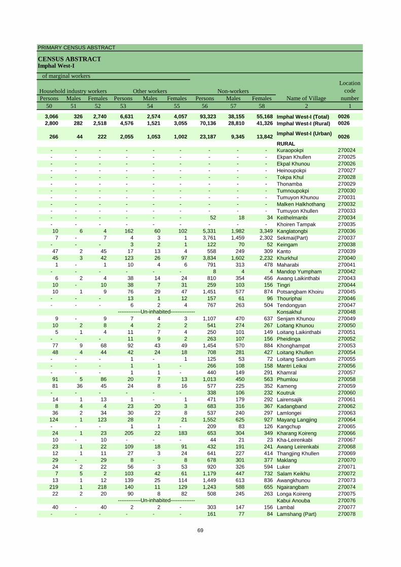
PRIMARY CENSUS ABSTRACT
CENSUS ABSTRACTImphal West-I
Persons Males Females Persons Males Females Persons Males Females50 51 52 53 54 55 56 57 58 2 1
3,066 326 2,740 6,631 2,574 4,057 93,323 38,155 55,168 Imphal West-I (Total) 00262,800 282 2,518 4,576 1,521 3,055 70,136 28,810 41,326 Imphal West-I (Rural) 0026
266 44 222 2,055 1,053 1,002 23,187 9,345 13,842 Imphal West-I (Urban) 0026RURAL
- - - - - - - - - Kuraopokpi 270024- - - - - - - - - Ekpan Khullen 270025- - - - - - - - - Ekpal Khunou 270026- - - - - - - - - Heinoupokpi 270027- - - - - - - - - Tokpa Khul 270028- - - - - - - - - Thonamba 270029- - - - - - - - - Tumnoupokpi 270030- - - - - - - - - Tumuyon Khunou 270031- - - - - - - - - Malken Halkhothang 270032- - - - - - - - - Tumuyon Khullen 270033- - - - - - 52 18 34 Keithelmanbi 270034- - - - - - - - - Khoiren Tampak 27003510 6 4 162 60 102 5,331 1,982 3,349 Kanglatongbi 2700367 - 7 4 3 1 3,761 1,459 2,302 Sekmai(Part) 270037
- - - 3 2 1 122 70 52 Keingam 27003847 2 45 17 13 4 558 249 309 Kanto 27003945 3 42 123 26 97 3,834 1,602 2,232 Khurkhul 2700401 - 1 10 4 6 791 313 478 Maharabi 270041
- - - - - - 8 4 4 Mandop Yumpham 2700426 2 4 38 14 24 810 354 456 Awang Laikinthabi 270043
10 - 10 38 7 31 259 103 156 Tingri 27004410 1 9 76 29 47 1,451 577 874 Potsangbam Khoiru 270045
- - - 13 1 12 157 61 96 Thouriphai 270046- - - 6 2 4 767 263 504 Tendongyan 270047
Konsakhul 2700489 - 9 7 4 3 1,107 470 637 Senjam Khunou 270049
10 2 8 4 2 2 541 274 267 Loitang Khunou 2700505 1 4 11 7 4 250 101 149 Loitang Laikinthabi 270051
- - - 11 9 2 263 107 156 Pheidinga 27005277 9 68 92 43 49 1,454 570 884 Khonghampat 27005348 4 44 42 24 18 708 281 427 Loitang Khullen 270054
- - - 1 - 1 125 53 72 Loitang Sandum 270055- - - 1 1 - 266 108 158 Mantri Leikai 270056- - - 1 1 - 440 149 291 Khamral 27005791 5 86 20 7 13 1,013 450 563 Phumlou 27005881 36 45 24 8 16 577 225 352 Kameng 270059
- - - - - - 338 106 232 Koutruk 27006014 1 13 1 - 1 471 179 292 Lairensajik 2700618 4 4 23 20 3 683 316 367 Kadangband 270062
36 2 34 30 22 8 537 240 297 Lamlongei 270063124 1 123 28 7 21 1,552 625 927 Mayang Langjing 270064- - - 1 1 - 209 83 126 Kangchup 27006524 1 23 205 22 183 653 304 349 Kharang Koireng 27006610 - 10 - - - 44 21 23 Kha-Leirenkabi 27006723 1 22 109 18 91 432 191 241 Awang Leirenkabi 27006812 1 11 27 3 24 641 227 414 Thangjing Khullen 27006929 - 29 8 - 8 678 301 377 Maklang 27007024 2 22 56 3 53 920 326 594 Luker 2700717 5 2 103 42 61 1,179 447 732 Salam Keikhu 270072
13 1 12 139 25 114 1,449 613 836 Awangkhunou 270073219 1 218 140 11 129 1,243 588 655 Ngairangbam 27007422 2 20 90 8 82 508 245 263 Longa Koireng 270075
Kabui Anouba 27007640 - 40 2 2 - 303 147 156 Lambal 270077
- - - - - - 161 77 84 Lamshang (Part) 270078
-------------Un-inhabited--------------
-------------Un-inhabited--------------
Non-workers
of marginal workersLocation
code number
Household industry workersName of Village
Other workers
69

DISTRICT CENSUS HANDBOOK : IMPHAL WEST
VILLAGE PRIMARY
Persons Males Females Persons Males Females1 2 3 4 5 6 7 8 9 10
C D Block -
Population in the age-group 0-6Number of householdsName of Village
Location code
number
Total population (including institutional and houseless
population)Area of
Village in hectares
270079 Akham 252.65 99 500 240 260 58 33 25 270080 Ngariyambam 252.83 91 449 215 234 62 26 36 270081 Heibongpokpi 364.27 117 595 298 297 77 42 35 270082 Sanjenbam 259.03 153 749 381 368 93 52 41 270083 Phayeng 983.65 660 2,728 1,334 1,394 364 199 165 270084 Tairenpokpi 431.92 218 892 440 452 133 64 69 270085 Khongakhul 450.41 17 71 33 38 11 7 4 270086 Polangsoi 192.47 36 181 90 91 35 10 25 270087 Kangdabi 375.69 63 314 149 165 47 21 26 270088 Atom Khuman 109.77 30 157 67 90 25 10 15 270089 Haorang Keirel 816.14 183 894 448 446 131 68 63 270090 Haorang Sabal 719.94 156 761 341 420 103 49 54 270091 Kiyam 325.01 93 426 222 204 59 39 20 270092 Tharoijam 432.70 263 1,302 637 665 177 88 89 270093 Leingangpokpi 31.74270094 Moidangpok Khullen 587.49 794 3,429 1,775 1,654 405 223 182 270095 Moidangpok Khunou 126.67 170 783 412 371 104 65 39 270096 Maha Koireng 106.63270097 Manamyang 47.52270098 Meisnam Kangmong 809.89 1,005 4,553 2,254 2,299 620 304 316 270099 Awang Jiri 116.28 345 1,477 731 746 191 84 107 270100 Heigrujam 227.36 497 2,285 1,165 1,120 236 135 101 270101 Sajirok 136.58 92 449 219 230 56 32 24 270102 Khaidem 309.44 408 1,750 895 855 225 113 112 270103 Khumbong 318.35 543 2,374 1,147 1,227 293 153 140 270104 Lanshonbi 290.67 566 2,597 1,287 1,310 328 161 167 270105 Konthoujam 364.97 938 4,025 1,989 2,036 501 270 231 270106 Top Khabi 156.48 291 1,261 633 628 136 82 54 270107 Yarou Bamdiar 370.69 459 2,195 1,088 1,107 243 129 114 270108 Yarou Meitram 33.67270109 Yurembam 333.67 821 3,701 1,796 1,905 482 237 245 270110 Patsoi 479.63 1,125 5,358 2,605 2,753 683 344 339 270111 Langjing Achouba 235.02 130 609 298 311 63 30 33 270112 Taobungkhok 212.53 543 2,559 1,297 1,262 324 186 138 270113 Changangei 341.17 997 4,581 2,264 2,317 568 289 279 270114 Ghari 137.68 484 2,078 1,022 1,056 293 137 156 270115 Sangaiprou Maning 57.40 652 3,126 1,491 1,635 340 172 168
URBAN270116 Lamjaotongba (CT) 0.00 2,328 10,593 5,088 5,505 1,211 623 588 270117 Langjing (CT) 187.00 1,163 5,451 2,781 2,670 707 353 354
801487Bijoy Govinda (OG) WARD NO.-0028 (Rural MDDS CODE:269934)
945 3,897 1,885 2,012 423 211 212
270122Naoriya Pakhanglakpa (CT) 74.00 1,612 7,501 3,643 3,858 899 455 444
270123 Sagolband (Part) (CT) 38.00 1,127 4,964 2,431 2,533 572 288 284 270124 Takyel Mapal (CT) 338.00 1,187 5,775 2,916 2,859 653 332 321
-------------Un-inhabited--------------
-------------Un-inhabited---------------------------Un-inhabited--------------
-------------Un-inhabited--------------
70

PRIMARY CENSUS ABSTRACT
CENSUS ABSTRACTImphal West-I
Persons Males Females Persons Males Females Persons Males Females11 12 13 14 15 16 17 18 19 2
Scheduled Castes population Scheduled Tribes populationName of Village
Literates
- - - - - - 371 192 179 Akham- - - - - - 349 185 164 Ngariyambam- - - - - - 446 238 208 Heibongpokpi- - - - - - 532 291 241 Sanjenbam
2,551 1,256 1,295 45 21 24 1,777 952 825 Phayeng855 425 430 14 9 5 582 307 275 Tairenpokpi- - - - - - 56 25 31 Khongakhul- - - - - - 88 49 39 Polangsoi- - - - - - 236 122 114 Kangdabi- - - - - - 81 35 46 Atom Khuman- - - - - - 671 364 307 Haorang Keirel- - - - - - 511 264 247 Haorang Sabal- - - - - - 298 166 132 Kiyam- - - - - - 914 486 428 Tharoijam
Leingangpokpi- - - 101 51 50 2,285 1,252 1,033 Moidangpok Khullen- - - - - - 478 266 212 Moidangpok Khunou
Maha KoirengManamyang
1 - 1 - - - 3,349 1,801 1,548 Meisnam Kangmong- - - - - - 1,166 622 544 Awang Jiri- - - 77 35 42 1,621 895 726 Heigrujam- - - - - - 316 158 158 Sajirok
1 - 1 1 - 1 1,170 661 509 Khaidem- - - 21 10 11 1,747 917 830 Khumbong11 3 8 1 1 - 1,847 998 849 Lanshonbi3 1 2 510 239 271 3,058 1,616 1,442 Konthoujam
- - - - - - 1,012 524 488 Top Khabi- - - 163 83 80 1,667 895 772 Yarou Bamdiar
Yarou Meitram- - - 280 130 150 2,740 1,441 1,299 Yurembam- - - - - - 4,176 2,134 2,042 Patsoi- - - 92 39 53 455 242 213 Langjing Achouba- - - 1 - 1 1,959 1,045 914 Taobungkhok
2 1 1 257 124 133 3,636 1,901 1,735 Changangei30 19 11 - - - 1,598 842 756 Ghari41 23 18 514 243 271 2,574 1,281 1,293 Sangaiprou Maning
URBAN15 6 9 608 283 325 7,993 4,030 3,963 Lamjaotongba (CT)37 27 10 328 137 191 4,299 2,345 1,954 Langjing (CT)
12 5 7 18 7 11 3,194 1,614 1,580 Bijoy Govinda (OG) WARD NO.-0028 (Rural MDDS CODE:269934)
1 - 1 20 8 12 5,914 2,992 2,922 Naoriya Pakhanglakpa (CT)
18 10 8 2 - 2 4,069 2,091 1,978 Sagolband (Part) (CT)351 261 90 80 47 33 4,624 2,460 2,164 Takyel Mapal (CT)
-------------Un-inhabited--------------
-------------Un-inhabited---------------------------Un-inhabited--------------
-------------Un-inhabited--------------
71

DISTRICT CENSUS HANDBOOK : IMPHAL WEST
VILLAGE PRIMARYC D Block -
Persons Males Females Persons Males Females Persons Males Females1 2 20 21 22 23 24 25 26 27 28
Illiterates Total workers Main workersName of Village
Location code
number
270079 Akham 129 48 81 199 116 83 190 111 79 270080 Ngariyambam 100 30 70 219 115 104 155 103 52 270081 Heibongpokpi 149 60 89 334 168 166 239 150 89 270082 Sanjenbam 217 90 127 409 208 201 90 66 24 270083 Phayeng 951 382 569 1,168 657 511 878 599 279 270084 Tairenpokpi 310 133 177 427 225 202 401 221 180 270085 Khongakhul 15 8 7 43 21 22 33 21 12 270086 Polangsoi 93 41 52 95 54 41 58 43 15 270087 Kangdabi 78 27 51 172 88 84 149 78 71 270088 Atom Khuman 76 32 44 73 33 40 48 32 16 270089 Haorang Keirel 223 84 139 522 266 256 410 254 156 270090 Haorang Sabal 250 77 173 358 179 179 196 137 59 270091 Kiyam 128 56 72 164 117 47 146 110 36 270092 Tharoijam 388 151 237 627 341 286 378 275 103 270093 Leingangpokpi270094 Moidangpok Khullen 1,144 523 621 1,279 990 289 993 898 95 270095 Moidangpok Khunou 305 146 159 302 208 94 239 192 47 270096 Maha Koireng270097 Manamyang270098 Meisnam Kangmong 1,204 453 751 2,537 1,297 1,240 1,986 1,150 836 270099 Awang Jiri 311 109 202 702 415 287 644 397 247 270100 Heigrujam 664 270 394 875 571 304 647 493 154 270101 Sajirok 133 61 72 222 127 95 214 123 91 270102 Khaidem 580 234 346 809 482 327 482 405 77 270103 Khumbong 627 230 397 1,058 608 450 917 585 332 270104 Lanshonbi 750 289 461 1,278 693 585 624 512 112 270105 Konthoujam 967 373 594 1,878 1,030 848 1,119 781 338 270106 Top Khabi 249 109 140 633 318 315 403 293 110 270107 Yarou Bamdiar 528 193 335 874 565 309 635 544 91 270108 Yarou Meitram270109 Yurembam 961 355 606 1,361 921 440 1,143 837 306 270110 Patsoi 1,182 471 711 1,938 1,320 618 1,839 1,259 580 270111 Langjing Achouba 154 56 98 225 149 76 150 117 33 270112 Taobungkhok 600 252 348 1,111 678 433 654 474 180 270113 Changangei 945 363 582 1,932 1,168 764 1,395 975 420 270114 Ghari 480 180 300 850 530 320 707 500 207 270115 Sangaiprou Maning 552 210 342 1,045 674 371 903 595 308
URBAN270116 Lamjaotongba (CT) 2,600 1,058 1,542 4,351 2,509 1,842 3,291 2,046 1,245 270117 Langjing (CT) 1,152 436 716 2,476 1,680 796 2,242 1,608 634
801487Bijoy Govinda (OG) WARD NO.-0028 (Rural MDDS CODE:269934)
703 271 432 1,607 972 635 1,180 760 420
270122Naoriya Pakhanglakpa (CT) 1,587 651 936 2,601 1,750 851 2,070 1,429 641
270123 Sagolband (Part) (CT) 895 340 555 1,782 1,093 689 1,657 1,037 620 270124 Takyel Mapal (CT) 1,151 456 695 2,177 1,395 782 1,987 1,286 701
-------------Un-inhabited--------------
-------------Un-inhabited---------------------------Un-inhabited--------------
-------------Un-inhabited--------------
72

PRIMARY CENSUS ABSTRACT
CENSUS ABSTRACTImphal West-I
Persons Males Females Persons Males Females Persons Males Females Persons Males Females29 30 31 32 33 34 35 36 37 38 39 40 2
CultivatorsName of Village
Household industry workersAgricultural labourers
Industrial category of main workers
Other workers
88 51 37 13 8 5 29 3 26 60 49 11 Akham57 40 17 1 - 1 11 1 10 86 62 24 Ngariyambam38 23 15 1 1 - 38 3 35 162 123 39 Heibongpokpi37 35 2 - - - 9 1 8 44 30 14 Sanjenbam
490 321 169 128 106 22 21 2 19 239 170 69 Phayeng151 143 8 122 32 90 73 5 68 55 41 14 Tairenpokpi
9 8 1 2 2 - 4 1 3 18 10 8 Khongakhul9 8 1 10 6 4 1 - 1 38 29 9 Polangsoi
83 44 39 5 3 2 17 3 14 44 28 16 Kangdabi16 15 1 7 4 3 1 - 1 24 13 11 Atom Khuman
204 143 61 34 8 26 41 2 39 131 101 30 Haorang Keirel55 49 6 41 28 13 22 2 20 78 58 20 Haorang Sabal76 71 5 6 6 - 27 2 25 37 31 6 Kiyam
143 118 25 22 20 2 30 7 23 183 130 53 TharoijamLeingangpokpi
726 715 11 - - - 31 16 15 236 167 69 Moidangpok Khullen109 98 11 21 19 2 21 5 16 88 70 18 Moidangpok Khunou
Maha KoirengManamyang
1,245 783 462 79 21 58 200 41 159 462 305 157 Meisnam Kangmong216 200 16 19 6 13 159 40 119 250 151 99 Awang Jiri367 352 15 21 18 3 9 5 4 250 118 132 Heigrujam27 18 9 1 - 1 - - - 186 105 81 Sajirok
196 188 8 17 17 - 55 28 27 214 172 42 Khaidem302 220 82 21 12 9 32 7 25 562 346 216 Khumbong165 161 4 11 5 6 31 7 24 417 339 78 Lanshonbi463 433 30 34 17 17 183 30 153 439 301 138 Konthoujam207 183 24 4 2 2 11 7 4 181 101 80 Top Khabi282 269 13 15 6 9 29 9 20 309 260 49 Yarou Bamdiar
Yarou Meitram34 32 2 5 4 1 6 1 5 1,098 800 298 Yurembam
147 134 13 22 16 6 126 14 112 1,544 1,095 449 Patsoi9 9 - - - - 5 4 1 136 104 32 Langjing Achouba
94 76 18 25 19 6 12 6 6 523 373 150 Taobungkhok98 91 7 13 8 5 42 14 28 1,242 862 380 Changangei58 26 32 2 2 - 20 10 10 627 462 165 Ghari30 19 11 2 2 - 58 25 33 813 549 264 Sangaiprou Maning
URBAN23 18 5 37 15 22 343 140 203 2,888 1,873 1,015 Lamjaotongba (CT)
148 130 18 96 77 19 16 10 6 1,982 1,391 591 Langjing (CT)
6 4 2 8 4 4 60 25 35 1,106 727 379 Bijoy Govinda (OG) WARD NO.-0028 (Rural MDDS CODE:269934)
13 11 2 17 12 5 87 43 44 1,953 1,363 590 Naoriya Pakhanglakpa (CT)
1 1 - 3 3 - 18 10 8 1,635 1,023 612 Sagolband (Part) (CT)39 34 5 51 38 13 134 58 76 1,763 1,156 607 Takyel Mapal (CT)
-------------Un-inhabited--------------
-------------Un-inhabited---------------------------Un-inhabited--------------
-------------Un-inhabited--------------
73

DISTRICT CENSUS HANDBOOK : IMPHAL WEST
VILLAGE PRIMARYC D Block -
Persons Males Females Persons Males Females Persons Males Females1 2 41 42 43 44 45 46 47 48 49
Location code
number Name of VillageMarginal workers Cultivators Agricultural labourers
Industrial category
270079 Akham 9 5 4 - - - 9 5 4 270080 Ngariyambam 64 12 52 36 8 28 - - - 270081 Heibongpokpi 95 18 77 20 4 16 6 2 4 270082 Sanjenbam 319 142 177 125 91 34 - - - 270083 Phayeng 290 58 232 4 2 2 73 37 36 270084 Tairenpokpi 26 4 22 18 2 16 5 2 3 270085 Khongakhul 10 - 10 1 - 1 4 - 4 270086 Polangsoi 37 11 26 3 3 - 12 3 9 270087 Kangdabi 23 10 13 1 1 - 17 6 11 270088 Atom Khuman 25 1 24 8 - 8 9 1 8 270089 Haorang Keirel 112 12 100 22 8 14 43 3 40 270090 Haorang Sabal 162 42 120 26 8 18 48 21 27 270091 Kiyam 18 7 11 2 1 1 - - - 270092 Tharoijam 249 66 183 27 7 20 100 38 62 270093 Leingangpokpi270094 Moidangpok Khullen 286 92 194 9 6 3 9 2 7 270095 Moidangpok Khunou 63 16 47 6 6 - 3 2 1 270096 Maha Koireng270097 Manamyang270098 Meisnam Kangmong 551 147 404 218 94 124 74 26 48 270099 Awang Jiri 58 18 40 4 3 1 3 - 3 270100 Heigrujam 228 78 150 63 59 4 12 4 8 270101 Sajirok 8 4 4 - - - 2 1 1 270102 Khaidem 327 77 250 3 3 - 59 27 32 270103 Khumbong 141 23 118 20 8 12 59 3 56 270104 Lanshonbi 654 181 473 22 19 3 163 21 142 270105 Konthoujam 759 249 510 51 42 9 136 14 122 270106 Top Khabi 230 25 205 31 16 15 35 1 34 270107 Yarou Bamdiar 239 21 218 6 3 3 90 14 76 270108 Yarou Meitram270109 Yurembam 218 84 134 14 6 8 42 20 22 270110 Patsoi 99 61 38 19 15 4 15 8 7 270111 Langjing Achouba 75 32 43 4 3 1 8 3 5 270112 Taobungkhok 457 204 253 34 15 19 62 19 43 270113 Changangei 537 193 344 26 15 11 47 8 39 270114 Ghari 143 30 113 12 - 12 11 - 11 270115 Sangaiprou Maning 142 79 63 4 1 3 11 3 8
URBAN270116 Lamjaotongba (CT) 1,060 463 597 29 17 12 59 19 40 270117 Langjing (CT) 234 72 162 3 - 3 6 4 2
801487Bijoy Govinda (OG) WARD NO.-0028 (Rural MDDS CODE:269934)
427 212 215 10 8 2 6 3 3
270122Naoriya Pakhanglakpa (CT) 531 321 210 26 14 12 15 9 6
270123 Sagolband (Part) (CT) 125 56 69 9 3 6 2 1 1 270124 Takyel Mapal (CT) 190 109 81 35 26 9 46 32 14
-------------Un-inhabited--------------
-------------Un-inhabited---------------------------Un-inhabited--------------
-------------Un-inhabited--------------
74

PRIMARY CENSUS ABSTRACT
CENSUS ABSTRACTImphal West-I
Persons Males Females Persons Males Females Persons Males Females50 51 52 53 54 55 56 57 58 2 1
Non-workers
of marginal workersLocation
code number
Household industry workersName of Village
Other workers
- - - - - - 301 124 177 Akham 27007919 - 19 9 4 5 230 100 130 Ngariyambam 27008028 2 26 41 10 31 261 130 131 Heibongpokpi 270081
133 3 130 61 48 13 340 173 167 Sanjenbam 2700827 - 7 206 19 187 1,560 677 883 Phayeng 270083
- - - 3 - 3 465 215 250 Tairenpokpi 2700845 - 5 - - - 28 12 16 Khongakhul 2700851 - 1 21 5 16 86 36 50 Polangsoi 2700862 - 2 3 3 - 142 61 81 Kangdabi 2700872 - 2 6 - 6 84 34 50 Atom Khuman 270088
41 1 40 6 - 6 372 182 190 Haorang Keirel 27008953 - 53 35 13 22 403 162 241 Haorang Sabal 2700905 2 3 11 4 7 262 105 157 Kiyam 270091
19 2 17 103 19 84 675 296 379 Tharoijam 270092Leingangpokpi 270093
151 2 149 117 82 35 2,150 785 1,365 Moidangpok Khullen 27009440 - 40 14 8 6 481 204 277 Moidangpok Khunou 270095
Maha Koireng 270096Manamyang 270097
161 6 155 98 21 77 2,016 957 1,059 Meisnam Kangmong 27009819 1 18 32 14 18 775 316 459 Awang Jiri 27009973 1 72 80 14 66 1,410 594 816 Heigrujam 270100
- - - 6 3 3 227 92 135 Sajirok 27010142 3 39 223 44 179 941 413 528 Khaidem 27010215 - 15 47 12 35 1,316 539 777 Khumbong 270103
226 29 197 243 112 131 1,319 594 725 Lanshonbi 270104322 94 228 250 99 151 2,147 959 1,188 Konthoujam 27010515 1 14 149 7 142 628 315 313 Top Khabi 270106
136 2 134 7 2 5 1,321 523 798 Yarou Bamdiar 270107Yarou Meitram 270108
28 5 23 134 53 81 2,340 875 1,465 Yurembam 2701097 2 5 58 36 22 3,420 1,285 2,135 Patsoi 2701103 2 1 60 24 36 384 149 235 Langjing Achouba 270111
76 12 64 285 158 127 1,448 619 829 Taobungkhok 27011273 6 67 391 164 227 2,649 1,096 1,553 Changangei 27011315 4 11 105 26 79 1,228 492 736 Ghari 27011421 9 12 106 66 40 2,081 817 1,264 Sangaiprou Maning 270115
URBAN57 15 42 915 412 503 6,242 2,579 3,663 Lamjaotongba (CT) 27011664 - 64 161 68 93 2,975 1,101 1,874 Langjing (CT) 270117
35 2 33 376 199 177 2,290 913 1,377 Bijoy Govinda (OG) WARD NO.-0028 (Rural MDDS CODE:269934)
801487
65 14 51 425 284 141 4,900 1,893 3,007 Naoriya Pakhanglakpa (CT) 270122
27 10 17 87 42 45 3,182 1,338 1,844 Sagolband (Part) (CT) 27012318 3 15 91 48 43 3,598 1,521 2,077 Takyel Mapal (CT) 270124
-------------Un-inhabited--------------
-------------Un-inhabited---------------------------Un-inhabited--------------
-------------Un-inhabited--------------
75

DISTRICT CENSUS HANDBOOK : IMPHAL WEST
VILLAGE PRIMARY
Persons Males Females Persons Males Females1 2 3 4 5 6 7 8 9 10
0027 Imphal West-II (Total) 5,824.07 17,442 82,425 40,906 41,519 10,746 5,516 5,230
0027 Imphal West-II (Rural) 5,824.07 15,614 74,262 36,943 37,319 9,880 5,093 4,787
0027 Imphal West-II (Urban) 0.00 1,828 8,163 3,963 4,200 866 423 443 RURAL
270118 Heinoukhongnembi 16.65 726 3,591 1,727 1,864 443 227 216 270119 Maibam Leikai 42.80 664 3,030 1,477 1,553 375 210 165 270120 Ahongsangbam Leikai 8.45 277 1,175 556 619 137 68 69 270121 Sorokhaibam Leikai 18.77 449 1,927 934 993 196 107 89 270125 Sangaiprou Mamang 223.70 1,010 4,613 2,242 2,371 559 270 289 270126 Malom Tulihal 191.31 504 2,879 1,745 1,134 296 158 138 270127 Malom Tuliyaima 306.19 737 3,096 1,514 1,582 415 218 197 270128 Meitram 194.69 366 1,644 815 829 216 117 99 270129 Ningombam 274.28 567 2,595 1,279 1,316 318 171 147 270130 Kodompokpi 268.27 775 3,562 1,781 1,781 499 249 250 270131 Lairenjam 212.41 565 2,651 1,312 1,339 313 149 164 270132 Wakching Khullen 220.97 280 1,304 642 662 172 88 84 270133 Irom Meijrao 265.93 536 2,373 1,188 1,185 320 173 147 270134 Hiyangthang 513.51 927 4,778 2,307 2,471 690 356 334 270135 Langthabal Lep 238.43 733 3,528 1,741 1,787 447 232 215
270136Langthabal Phuramakhong 9.45 188 941 446 495 128 51 77
270137 Mongsangei 311.30 745 3,639 1,919 1,720 422 231 191 270138 Oinam Leikai 70.04 264 1,182 569 613 125 69 56 270139 Leiphrakpam Leikai 18.30 389 1,759 832 927 214 101 113 270140 Naral Konjil 87.27 235 1,007 498 509 154 77 77 270141 Takhellambam Konjil 48.88 76 337 166 171 49 22 27 270142 Bitra Urokhong 129.71 368 1,685 839 846 233 128 105 270143 Chongtham Kona 25.07 100 411 221 190 63 37 26 270144 Uchiwa 529.29 740 3,783 1,862 1,921 585 303 282 270145 Hayel 113.49 98 474 237 237 60 28 32 270146 Hangoon 188.54 170 866 411 455 116 51 65 270147 Thongam 135.93 213 1,121 532 589 136 69 67 270148 Phoubakchao 311.86 670 3,588 1,794 1,794 644 332 312 270149 Komlakhong 310.65 452 2,385 1,164 1,221 421 207 214 270150 Laphupat Tera 102.78 831 4,129 2,076 2,053 654 354 300 270151 Samushang 333.20 391 1,645 877 768 144 72 72 270152 Langthabal Mantrikhong 101.95 568 2,564 1,240 1,324 336 168 168
URBAN
801487Oinam Thingel (OG) WARD NO.-0029 (Rural MDDS CODE:269935)
719 3,024 1,460 1,564 328 154 174
801492Langthabal Kunja (OG) WARD NO.-0010 (Rural MDDS CODE:269936)
206 938 454 484 107 54 53
801492
Langthabal Mantrikhong (OG) (Part) WARD NO.-0011 (Rural MDDS CODE:270152)
106 889 447 442 37 27 10
801492Naorem Leikai (OG) WARD NO.-0012 (Rural MDDS CODE:269937)
797 3,312 1,602 1,710 394 188 206
C D Block -
Population in the age-group 0-6Number of householdsName of Village
Location code
number
Total population (including institutional and houseless
population)Area of
Village in hectares
76
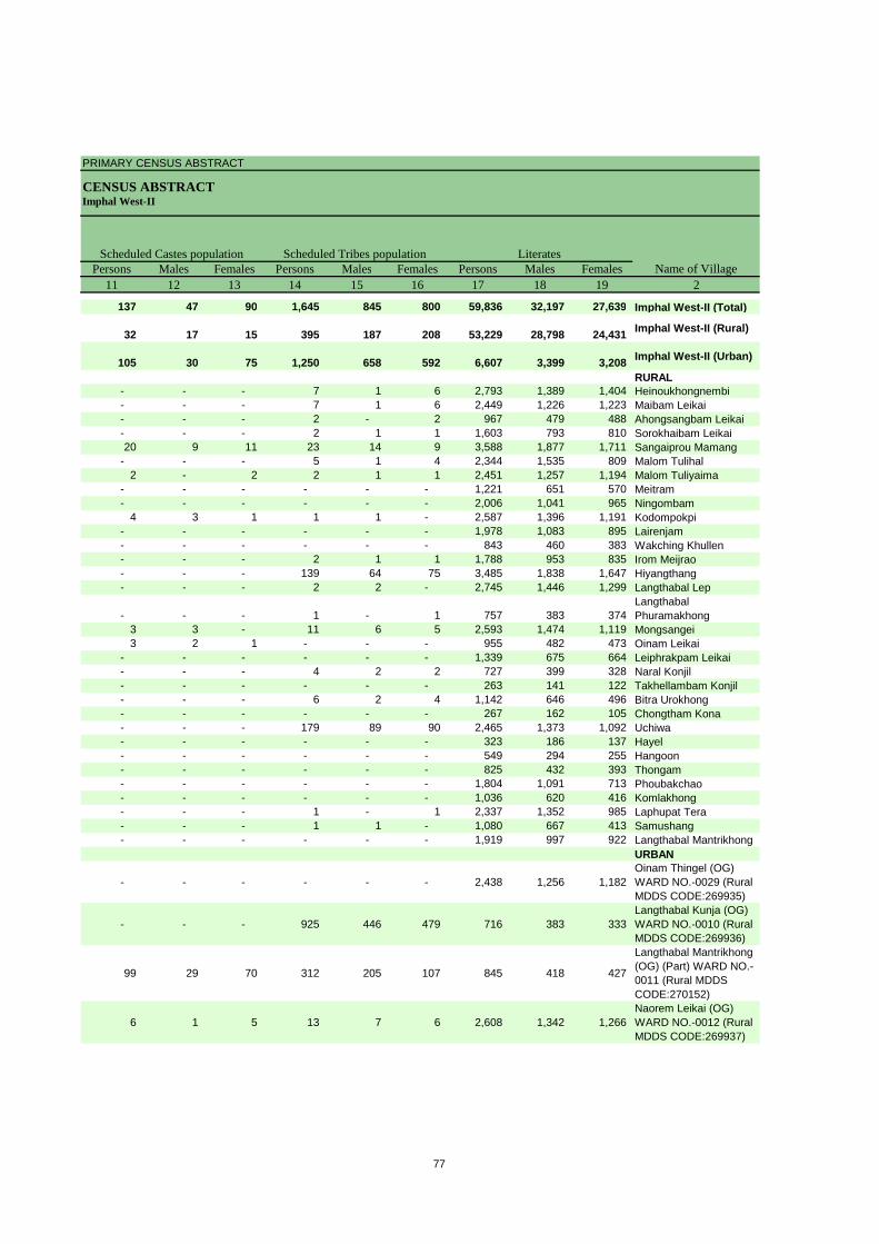
PRIMARY CENSUS ABSTRACT
CENSUS ABSTRACTImphal West-II
Persons Males Females Persons Males Females Persons Males Females11 12 13 14 15 16 17 18 19 2
137 47 90 1,645 845 800 59,836 32,197 27,639 Imphal West-II (Total)
32 17 15 395 187 208 53,229 28,798 24,431 Imphal West-II (Rural)
105 30 75 1,250 658 592 6,607 3,399 3,208 Imphal West-II (Urban)
RURAL- - - 7 1 6 2,793 1,389 1,404 Heinoukhongnembi- - - 7 1 6 2,449 1,226 1,223 Maibam Leikai- - - 2 - 2 967 479 488 Ahongsangbam Leikai- - - 2 1 1 1,603 793 810 Sorokhaibam Leikai20 9 11 23 14 9 3,588 1,877 1,711 Sangaiprou Mamang
- - - 5 1 4 2,344 1,535 809 Malom Tulihal2 - 2 2 1 1 2,451 1,257 1,194 Malom Tuliyaima
- - - - - - 1,221 651 570 Meitram- - - - - - 2,006 1,041 965 Ningombam
4 3 1 1 1 - 2,587 1,396 1,191 Kodompokpi- - - - - - 1,978 1,083 895 Lairenjam- - - - - - 843 460 383 Wakching Khullen- - - 2 1 1 1,788 953 835 Irom Meijrao- - - 139 64 75 3,485 1,838 1,647 Hiyangthang- - - 2 2 - 2,745 1,446 1,299 Langthabal Lep
- - - 1 - 1 757 383 374 Langthabal Phuramakhong
3 3 - 11 6 5 2,593 1,474 1,119 Mongsangei3 2 1 - - - 955 482 473 Oinam Leikai
- - - - - - 1,339 675 664 Leiphrakpam Leikai- - - 4 2 2 727 399 328 Naral Konjil- - - - - - 263 141 122 Takhellambam Konjil- - - 6 2 4 1,142 646 496 Bitra Urokhong- - - - - - 267 162 105 Chongtham Kona- - - 179 89 90 2,465 1,373 1,092 Uchiwa- - - - - - 323 186 137 Hayel- - - - - - 549 294 255 Hangoon- - - - - - 825 432 393 Thongam- - - - - - 1,804 1,091 713 Phoubakchao- - - - - - 1,036 620 416 Komlakhong- - - 1 - 1 2,337 1,352 985 Laphupat Tera- - - 1 1 - 1,080 667 413 Samushang- - - - - - 1,919 997 922 Langthabal Mantrikhong
URBAN
- - - - - - 2,438 1,256 1,182 Oinam Thingel (OG) WARD NO.-0029 (Rural MDDS CODE:269935)
- - - 925 446 479 716 383 333 Langthabal Kunja (OG) WARD NO.-0010 (Rural MDDS CODE:269936)
99 29 70 312 205 107 845 418 427
Langthabal Mantrikhong (OG) (Part) WARD NO.-0011 (Rural MDDS CODE:270152)
6 1 5 13 7 6 2,608 1,342 1,266 Naorem Leikai (OG) WARD NO.-0012 (Rural MDDS CODE:269937)
Scheduled Castes population Scheduled Tribes populationName of Village
Literates
77

DISTRICT CENSUS HANDBOOK : IMPHAL WEST
VILLAGE PRIMARYC D Block -
Persons Males Females Persons Males Females Persons Males Females1 2 20 21 22 23 24 25 26 27 28
0027 Imphal West-II (Total) 22,589 8,709 13,880 36,872 21,248 15,624 28,725 18,263 10,462
0027 Imphal West-II (Rural) 21,033 8,145 12,888 33,461 19,298 14,163 26,224 16,713 9,511
0027 Imphal West-II (Urban) 1,556 564 992 3,411 1,950 1,461 2,501 1,550 951 RURAL
270118 Heinoukhongnembi 798 338 460 1,272 823 449 1,247 813 434 270119 Maibam Leikai 581 251 330 1,248 700 548 1,170 657 513 270120 Ahongsangbam Leikai 208 77 131 414 268 146 314 202 112 270121 Sorokhaibam Leikai 324 141 183 720 460 260 616 403 213 270125 Sangaiprou Mamang 1,025 365 660 1,991 1,131 860 1,537 1,035 502 270126 Malom Tulihal 535 210 325 1,637 1,218 419 1,470 1,125 345 270127 Malom Tuliyaima 645 257 388 1,274 788 486 919 639 280 270128 Meitram 423 164 259 734 432 302 470 330 140 270129 Ningombam 589 238 351 1,392 648 744 991 595 396 270130 Kodompokpi 975 385 590 1,581 969 612 857 671 186 270131 Lairenjam 673 229 444 1,013 653 360 887 621 266 270132 Wakching Khullen 461 182 279 513 317 196 351 291 60 270133 Irom Meijrao 585 235 350 1,022 569 453 1,009 562 447 270134 Hiyangthang 1,293 469 824 2,100 1,077 1,023 1,680 897 783 270135 Langthabal Lep 783 295 488 1,483 908 575 1,285 832 453
270136Langthabal Phuramakhong 184 63 121 400 229 171 209 136 73
270137 Mongsangei 1,046 445 601 1,668 1,083 585 1,393 1,035 358 270138 Oinam Leikai 227 87 140 328 236 92 293 219 74 270139 Leiphrakpam Leikai 420 157 263 685 408 277 487 278 209 270140 Naral Konjil 280 99 181 320 245 75 273 225 48 270141 Takhellambam Konjil 74 25 49 223 113 110 111 76 35 270142 Bitra Urokhong 543 193 350 891 449 442 469 309 160 270143 Chongtham Kona 144 59 85 248 126 122 198 105 93 270144 Uchiwa 1,318 489 829 1,977 989 988 1,602 855 747 270145 Hayel 151 51 100 297 143 154 262 126 136 270146 Hangoon 317 117 200 534 251 283 427 204 223 270147 Thongam 296 100 196 476 284 192 349 234 115 270148 Phoubakchao 1,784 703 1,081 1,730 919 811 1,151 770 381 270149 Komlakhong 1,349 544 805 885 527 358 769 494 275 270150 Laphupat Tera 1,792 724 1,068 2,275 1,097 1,178 1,622 862 760 270151 Samushang 565 210 355 1,051 582 469 872 505 367 270152 Langthabal Mantrikhong 645 243 402 1,079 656 423 934 607 327
URBAN
801487Oinam Thingel (OG) WARD NO.-0029 (Rural MDDS CODE:269935)
586 204 382 1,353 765 588 1,017 610 407
801492Langthabal Kunja (OG) WARD NO.-0010 (Rural MDDS CODE:269936)
222 71 151 426 239 187 233 167 66
801492
Langthabal Mantrikhong (OG) (Part) WARD NO.-0011 (Rural MDDS CODE:270152)
44 29 15 132 93 39 121 84 37
801492Naorem Leikai (OG) WARD NO.-0012 (Rural MDDS CODE:269937)
704 260 444 1,500 853 647 1,130 689 441
Illiterates Total workers Main workersName of Village
Location code
number
78

PRIMARY CENSUS ABSTRACT
CENSUS ABSTRACTImphal West-II
Persons Males Females Persons Males Females Persons Males Females Persons Males Females29 30 31 32 33 34 35 36 37 38 39 40 2
7,329 4,505 2,824 972 532 440 2,475 775 1,700 17,949 12,451 5,498 Imphal West-II (Total)
7,187 4,387 2,800 967 528 439 2,188 686 1,502 15,882 11,112 4,770 Imphal West-II (Rural)
142 118 24 5 4 1 287 89 198 2,067 1,339 728 Imphal West-II (Urban)
RURAL9 6 3 7 5 2 33 16 17 1,198 786 412 Heinoukhongnembi
18 12 6 85 50 35 174 47 127 893 548 345 Maibam Leikai1 1 - 4 3 1 2 1 1 307 197 110 Ahongsangbam Leikai
24 16 8 2 2 - 60 28 32 530 357 173 Sorokhaibam Leikai48 35 13 12 11 1 37 23 14 1,440 966 474 Sangaiprou Mamang
109 69 40 14 9 5 251 118 133 1,096 929 167 Malom Tulihal112 89 23 45 40 5 87 22 65 675 488 187 Malom Tuliyaima82 72 10 24 18 6 30 16 14 334 224 110 Meitram
598 346 252 71 21 50 27 6 21 295 222 73 Ningombam110 97 13 20 14 6 22 15 7 705 545 160 Kodompokpi305 278 27 76 29 47 121 47 74 385 267 118 Lairenjam88 68 20 1 - 1 4 3 1 258 220 38 Wakching Khullen
657 330 327 20 8 12 13 2 11 319 222 97 Irom Meijrao133 58 75 37 32 5 57 13 44 1,453 794 659 Hiyangthang138 104 34 31 25 6 171 86 85 945 617 328 Langthabal Lep
11 7 4 6 3 3 15 2 13 177 124 53 Langthabal Phuramakhong
56 52 4 22 16 6 131 38 93 1,184 929 255 Mongsangei9 7 2 2 1 1 18 12 6 264 199 65 Oinam Leikai
13 5 8 6 2 4 37 5 32 431 266 165 Leiphrakpam Leikai39 32 7 3 1 2 2 2 - 229 190 39 Naral Konjil
- - - - - - 19 4 15 92 72 20 Takhellambam Konjil45 34 11 23 13 10 87 12 75 314 250 64 Bitra Urokhong40 23 17 48 30 18 46 5 41 64 47 17 Chongtham Kona
912 472 440 8 2 6 146 18 128 536 363 173 Uchiwa80 47 33 8 2 6 52 13 39 122 64 58 Hayel
328 174 154 56 14 42 24 2 22 19 14 5 Hangoon103 80 23 9 6 3 24 5 19 213 143 70 Thongam891 566 325 24 16 8 18 4 14 218 184 34 Phoubakchao545 342 203 11 5 6 15 2 13 198 145 53 Komlakhong877 476 401 130 58 72 264 57 207 351 271 80 Laphupat Tera699 420 279 110 50 60 23 6 17 40 29 11 Samushang107 69 38 52 42 10 178 56 122 597 440 157 Langthabal Mantrikhong
URBAN
2 1 1 2 1 1 199 47 152 814 561 253 Oinam Thingel (OG) WARD NO.-0029 (Rural MDDS CODE:269935)
49 30 19 2 2 - 2 2 - 180 133 47 Langthabal Kunja (OG) WARD NO.-0010 (Rural MDDS CODE:269936)
- - - - - - 1 1 - 120 83 37
Langthabal Mantrikhong (OG) (Part) WARD NO.-0011 (Rural MDDS CODE:270152)
91 87 4 1 1 - 85 39 46 953 562 391 Naorem Leikai (OG) WARD NO.-0012 (Rural MDDS CODE:269937)
CultivatorsName of Village
Household industry workersAgricultural labourers
Industrial category of main workers
Other workers
79

DISTRICT CENSUS HANDBOOK : IMPHAL WEST
VILLAGE PRIMARYC D Block -
Persons Males Females Persons Males Females Persons Males Females1 2 41 42 43 44 45 46 47 48 49
0027 Imphal West-II (Total) 8,147 2,985 5,162 1,582 765 817 2,143 624 1,519
0027 Imphal West-II (Rural) 7,237 2,585 4,652 1,533 728 805 2,029 581 1,448
0027 Imphal West-II (Urban) 910 400 510 49 37 12 114 43 71 RURAL
270118 Heinoukhongnembi 25 10 15 3 1 2 1 - 1 270119 Maibam Leikai 78 43 35 8 5 3 6 2 4 270120 Ahongsangbam Leikai 100 66 34 6 6 - 2 2 - 270121 Sorokhaibam Leikai 104 57 47 1 1 - 1 1 - 270125 Sangaiprou Mamang 454 96 358 48 11 37 17 8 9 270126 Malom Tulihal 167 93 74 41 30 11 3 1 2 270127 Malom Tuliyaima 355 149 206 18 11 7 93 35 58 270128 Meitram 264 102 162 20 15 5 31 20 11 270129 Ningombam 401 53 348 60 25 35 205 6 199 270130 Kodompokpi 724 298 426 102 86 16 203 55 148 270131 Lairenjam 126 32 94 12 4 8 47 6 41 270132 Wakching Khullen 162 26 136 30 15 15 58 7 51 270133 Irom Meijrao 13 7 6 8 5 3 3 1 2 270134 Hiyangthang 420 180 240 111 76 35 61 30 31 270135 Langthabal Lep 198 76 122 28 15 13 7 3 4
270136Langthabal Phuramakhong 191 93 98 13 9 4 39 19 20
270137 Mongsangei 275 48 227 28 14 14 84 14 70 270138 Oinam Leikai 35 17 18 6 3 3 9 4 5 270139 Leiphrakpam Leikai 198 130 68 4 2 2 1 1 - 270140 Naral Konjil 47 20 27 11 3 8 28 12 16 270141 Takhellambam Konjil 112 37 75 84 30 54 2 1 1 270142 Bitra Urokhong 422 140 282 70 20 50 136 52 84 270143 Chongtham Kona 50 21 29 19 6 13 7 4 3 270144 Uchiwa 375 134 241 276 109 167 15 7 8 270145 Hayel 35 17 18 12 8 4 - - - 270146 Hangoon 107 47 60 8 2 6 91 45 46 270147 Thongam 127 50 77 3 2 1 59 21 38 270148 Phoubakchao 579 149 430 40 17 23 489 116 373 270149 Komlakhong 116 33 83 5 2 3 104 29 75 270150 Laphupat Tera 653 235 418 366 149 217 132 34 98 270151 Samushang 179 77 102 85 42 43 78 31 47 270152 Langthabal Mantrikhong 145 49 96 7 4 3 17 14 3
URBAN
801487Oinam Thingel (OG) WARD NO.-0029 (Rural MDDS CODE:269935)
336 155 181 3 1 2 13 6 7
801492Langthabal Kunja (OG) WARD NO.-0010 (Rural MDDS CODE:269936)
193 72 121 45 35 10 85 28 57
801492
Langthabal Mantrikhong (OG) (Part) WARD NO.-0011 (Rural MDDS CODE:270152)
11 9 2 1 1 - - - -
801492Naorem Leikai (OG) WARD NO.-0012 (Rural MDDS CODE:269937)
370 164 206 - - - 16 9 7
Location code
number Name of VillageMarginal workers Cultivators Agricultural labourers
Industrial category
80

PRIMARY CENSUS ABSTRACT
CENSUS ABSTRACTImphal West-II
Persons Males Females Persons Males Females Persons Males Females50 51 52 53 54 55 56 57 58 2 1
1,553 202 1,351 2,869 1,394 1,475 45,553 19,658 25,895 Imphal West-II (Total) 0027
1,348 174 1,174 2,327 1,102 1,225 40,801 17,645 23,156 Imphal West-II (Rural) 0027
205 28 177 542 292 250 4,752 2,013 2,739 Imphal West-II (Urban) 0027RURAL
- - - 21 9 12 2,319 904 1,415 Heinoukhongnembi 27011825 9 16 39 27 12 1,782 777 1,005 Maibam Leikai 2701191 - 1 91 58 33 761 288 473 Ahongsangbam Leikai 270120
10 2 8 92 53 39 1,207 474 733 Sorokhaibam Leikai 27012122 2 20 367 75 292 2,622 1,111 1,511 Sangaiprou Mamang 27012522 7 15 101 55 46 1,242 527 715 Malom Tulihal 27012646 5 41 198 98 100 1,822 726 1,096 Malom Tuliyaima 270127
172 42 130 41 25 16 910 383 527 Meitram 27012890 6 84 46 16 30 1,203 631 572 Ningombam 270129
130 14 116 289 143 146 1,981 812 1,169 Kodompokpi 27013021 9 12 46 13 33 1,638 659 979 Lairenjam 27013166 1 65 8 3 5 791 325 466 Wakching Khullen 270132
- - - 2 1 1 1,351 619 732 Irom Meijrao 270133148 8 140 100 66 34 2,678 1,230 1,448 Hiyangthang 27013441 5 36 122 53 69 2,045 833 1,212 Langthabal Lep 270135
56 9 47 83 56 27 541 217 324 Langthabal Phuramakhong 270136
111 1 110 52 19 33 1,971 836 1,135 Mongsangei 2701371 - 1 19 10 9 854 333 521 Oinam Leikai 270138
12 4 8 181 123 58 1,074 424 650 Leiphrakpam Leikai 270139- - - 8 5 3 687 253 434 Naral Konjil 27014025 5 20 1 1 - 114 53 61 Takhellambam Konjil 270141
131 8 123 85 60 25 794 390 404 Bitra Urokhong 27014217 6 11 7 5 2 163 95 68 Chongtham Kona 27014355 4 51 29 14 15 1,806 873 933 Uchiwa 27014410 2 8 13 7 6 177 94 83 Hayel 2701455 - 5 3 - 3 332 160 172 Hangoon 270146
34 4 30 31 23 8 645 248 397 Thongam 27014711 2 9 39 14 25 1,858 875 983 Phoubakchao 2701484 - 4 3 2 1 1,500 637 863 Komlakhong 270149
68 17 51 87 35 52 1,854 979 875 Laphupat Tera 27015013 2 11 3 2 1 594 295 299 Samushang 2701511 - 1 120 31 89 1,485 584 901 Langthabal Mantrikhong 270152
URBAN
42 2 40 278 146 132 1,671 695 976 Oinam Thingel (OG) WARD NO.-0029 (Rural MDDS CODE:269935)
801487
55 2 53 8 7 1 512 215 297 Langthabal Kunja (OG) WARD NO.-0010 (Rural MDDS CODE:269936)
801492
1 1 - 9 7 2 757 354 403
Langthabal Mantrikhong (OG) (Part) WARD NO.-0011 (Rural MDDS CODE:270152)
801492
107 23 84 247 132 115 1,812 749 1,063 Naorem Leikai (OG) WARD NO.-0012 (Rural MDDS CODE:269937)
801492
Non-workers
of marginal workersLocation
code number
Household industry workersName of Village
Other workers
81


Urban PCA-Town wise Primary Census Abstract

DISTRICT CENSUS HANDBOOK : IMPHAL WEST
URBAN PRIMARY
Persons Males Females Persons Males Females1 2 3 4 5 6 7 8 9 10
801485 Lamsang (NP) 7.02 1,783 8,130 3,837 4,293 991 479 512 0001 Ward No. 1 148 690 338 352 93 47 46 0002 Ward No. 2 247 1,079 520 559 141 61 80 0003 Ward No. 3 125 561 290 271 61 32 29 0004 Ward No. 4 200 893 435 458 110 56 54 0005 Ward No. 5 166 998 352 646 81 48 33 0006 Ward No. 6 270 1,248 615 633 175 84 91 0007 Ward No. 7 209 851 425 426 96 48 48 0008 Ward No. 8 192 862 402 460 78 36 42 0009 Ward No. 9 226 948 460 488 156 67 89 801486 Sekmai Bazar (NP) 0.00 1,111 5,065 2,467 2,598 634 342 292 0001 Ward No. 1 292 1,418 686 732 175 86 89 0002 Ward No. 2 96 410 195 215 61 35 26 0003 Ward No. 3 149 626 301 325 58 37 21 0004 Ward No. 4 137 587 299 288 61 39 22 0005 Ward No. 5 72 340 158 182 57 29 28 0006 Ward No. 6 141 656 321 335 84 44 40 0007 Ward No. 7 50 216 104 112 32 14 18 0008 Ward No. 8 92 434 222 212 50 32 18 0009 Ward No. 9 82 378 181 197 56 26 30
801469Nambol (MCI) (Minor part) 0.00 1,210 5,431 2,682 2,749 633 314 319
0001 Ward No. 1 221 1,049 517 532 120 61 59 0002 Ward No. 2 276 1,173 570 603 131 66 65 0003 Ward No. 3 207 928 464 464 124 63 61 0017 Ward No. 17 218 1,025 496 529 91 41 50 0018 Ward No. 18 288 1,256 635 621 167 83 84 270116 Lamjaotongba (CT) 0.00 2,328 10,593 5,088 5,505 1,211 623 588 0001 Ward No. 1 2,328 10,593 5,088 5,505 1,211 623 588 270117 Langjing (CT) 1.87 1,163 5,451 2,781 2,670 707 353 354 0001 Ward No. 1 1,163 5,451 2,781 2,670 707 353 354
801487Imphal (MCI + OG) (Major part) 0.00 42,820 1,93,459 94,451 99,008 19,830 10,184 9,646
0001 Ward No. 1 2,292 11,342 5,438 5,904 1,181 580 601 0002 Ward No. 2 2,354 10,951 5,282 5,669 1,241 640 601 0003 Ward No. 3 1,676 7,465 3,599 3,866 774 409 365 0004 Ward No. 4 1,639 7,190 3,543 3,647 669 345 324 0005 Ward No. 5 4,931 24,162 11,854 12,308 2,648 1,351 1,297 0006 Ward No. 6 1,899 8,206 3,813 4,393 820 408 412 0007 Ward No. 7 1,978 8,340 3,938 4,402 905 466 439 0008 Ward No. 8 1,803 7,577 3,610 3,967 720 377 343 0009 Ward No. 9 1,925 8,338 3,959 4,379 800 430 370 0010 Ward No. 10 1,787 7,974 3,961 4,013 847 467 380 0011 Ward No. 11 1,811 7,707 3,671 4,036 760 382 378 0012 Ward No. 12 1,918 8,020 3,883 4,137 766 416 350 0013 Ward No. 13 2,452 10,736 5,151 5,585 1,159 592 567 0014 Ward No. 14 1,608 7,246 3,466 3,780 637 333 304 0015 Ward No. 15 1,794 7,520 3,661 3,859 755 393 362 0016 Ward No. 16 1,632 6,872 3,247 3,625 682 340 342 0017 Ward No. 17 2,634 11,672 5,483 6,189 1,168 599 569 0024 Ward No. 24 1,427 8,760 5,214 3,546 684 363 321 0025 Ward No. 25 1,489 7,043 3,765 3,278 748 390 358 0027 Ward No. 27 2,107 9,417 4,568 4,849 1,115 538 577 0028 Ward No. 28 945 3,897 1,885 2,012 423 211 212 0029 Ward No. 29 719 3,024 1,460 1,564 328 154 174
270122Naoriya Pakhanglakpa (CT) 0.74 1,612 7,501 3,643 3,858 899 455 444
0001 Ward No. 1 1,612 7,501 3,643 3,858 899 455 444 270123 Sagolband (Part) (CT) 0.38 1,127 4,964 2,431 2,533 572 288 284 0001 Ward No. 1 1,127 4,964 2,431 2,533 572 288 284 270124 Takyel Mapal (CT) 3.38 1,187 5,775 2,916 2,859 653 332 321 0001 Ward No. 1 1,187 5,775 2,916 2,859 653 332 321
Name of Town/ Ward
Location code
number
Total population (including institutional and houseless
population)
Area in Square
Kilometre
Number of households
Population in the age-group 0-6
84

PRIMARY CENSUS ABSTRACT
CENSUS ABSTRACT
Persons Males Females Persons Males Females Persons Males Females11 12 13 14 15 16 17 18 19 2
22 3 19 485 207 278 6,132 3,144 2,988 Lamsang (NP)- - - - - - 485 269 216 Ward No. 1- - - 283 127 156 814 431 383 Ward No. 2- - - - - - 396 230 166 Ward No. 3
1 1 - - - - 625 333 292 Ward No. 421 2 19 31 - 31 825 282 543 Ward No. 5
- - - 169 80 89 951 508 443 Ward No. 6- - - 1 - 1 645 358 287 Ward No. 7- - - - - - 659 346 313 Ward No. 8- - - 1 - 1 732 387 345 Ward No. 9
3,187 1,572 1,615 57 20 37 3,676 1,881 1,795 Sekmai Bazar (NP)278 132 146 10 4 6 1,087 558 529 Ward No. 1286 138 148 2 - 2 339 160 179 Ward No. 2480 238 242 16 5 11 498 245 253 Ward No. 3460 240 220 9 3 6 419 228 191 Ward No. 4275 128 147 1 1 - 231 111 120 Ward No. 5635 310 325 5 2 3 410 216 194 Ward No. 6208 101 107 1 - 1 147 78 69 Ward No. 7260 136 124 9 4 5 277 149 128 Ward No. 8305 149 156 4 1 3 268 136 132 Ward No. 9
2 1 1 67 34 33 4,258 2,262 1,996 Nambol (MCI) (Minor part)
- - - - - - 814 430 384 Ward No. 1- - - - - - 951 486 465 Ward No. 2
2 1 1 2 - 2 714 392 322 Ward No. 3- - - - - - 797 427 370 Ward No. 17- - - 65 34 31 982 527 455 Ward No. 1815 6 9 608 283 325 7,993 4,030 3,963 Lamjaotongba (CT)15 6 9 608 283 325 7,993 4,030 3,963 Ward No. 137 27 10 328 137 191 4,299 2,345 1,954 Langjing (CT)37 27 10 328 137 191 4,299 2,345 1,954 Ward No. 1
1,077 550 527 16,623 7,934 8,689 1,59,216 80,754 78,462 Imphal (MCI + OG) (Major part)
71 34 37 2,233 1,077 1,156 9,135 4,641 4,494 Ward No. 1155 75 80 408 191 217 8,885 4,411 4,474 Ward No. 225 10 15 52 22 30 6,175 3,049 3,126 Ward No. 344 25 19 6 1 5 5,984 3,013 2,971 Ward No. 4
411 212 199 10,268 4,963 5,305 19,559 10,017 9,542 Ward No. 552 19 33 14 5 9 6,716 3,252 3,464 Ward No. 642 21 21 12 3 9 6,850 3,350 3,500 Ward No. 710 7 3 18 3 15 6,473 3,148 3,325 Ward No. 86 3 3 6 1 5 6,912 3,390 3,522 Ward No. 9
54 25 29 17 13 4 6,627 3,408 3,219 Ward No. 10- - - 21 9 12 6,506 3,220 3,286 Ward No. 1121 8 13 10 2 8 6,795 3,378 3,417 Ward No. 12
- - - 4 1 3 8,925 4,449 4,476 Ward No. 137 4 3 135 68 67 6,222 3,076 3,146 Ward No. 144 4 - - - - 6,245 3,122 3,123 Ward No. 15
- - - 6 1 5 5,809 2,834 2,975 Ward No. 163 2 1 1 1 - 9,506 4,656 4,850 Ward No. 17
36 29 7 2,478 1,161 1,317 7,381 4,620 2,761 Ward No. 2457 35 22 838 370 468 5,591 3,093 2,498 Ward No. 2567 32 35 78 35 43 7,288 3,757 3,531 Ward No. 2712 5 7 18 7 11 3,194 1,614 1,580 Ward No. 28
- - - - - - 2,438 1,256 1,182 Ward No. 29
1 - 1 20 8 12 5,914 2,992 2,922 Naoriya Pakhanglakpa (CT)
1 - 1 20 8 12 5,914 2,992 2,922 Ward No. 118 10 8 2 - 2 4,069 2,091 1,978 Sagolband (Part) (CT)18 10 8 2 - 2 4,069 2,091 1,978 Ward No. 1
351 261 90 80 47 33 4,624 2,460 2,164 Takyel Mapal (CT)351 261 90 80 47 33 4,624 2,460 2,164 Ward No. 1
Name of Town/ WardLiteratesScheduled Castes population Scheduled Tribes population
85

DISTRICT CENSUS HANDBOOK : IMPHAL WEST
URBAN PRIMARY
Persons Males Females Persons Males Females Persons Males Females1 2 20 21 22 23 24 25 26 27 28
801485 Lamsang (NP) 1,998 693 1,305 3,868 2,184 1,684 2,933 2,004 929 0001 Ward No. 1 205 69 136 416 207 209 295 186 109 0002 Ward No. 2 265 89 176 448 277 171 362 256 106 0003 Ward No. 3 165 60 105 324 176 148 186 171 15 0004 Ward No. 4 268 102 166 369 242 127 345 238 107 0005 Ward No. 5 173 70 103 372 191 181 148 101 47 0006 Ward No. 6 297 107 190 631 352 279 566 344 222 0007 Ward No. 7 206 67 139 416 256 160 351 244 107 0008 Ward No. 8 203 56 147 380 230 150 334 220 114 0009 Ward No. 9 216 73 143 512 253 259 346 244 102 801486 Sekmai Bazar (NP) 1,389 586 803 2,068 1,232 836 1,372 901 471 0001 Ward No. 1 331 128 203 481 334 147 236 157 79 0002 Ward No. 2 71 35 36 113 88 25 77 57 20 0003 Ward No. 3 128 56 72 187 145 42 185 143 42 0004 Ward No. 4 168 71 97 125 113 12 89 78 11 0005 Ward No. 5 109 47 62 189 84 105 158 73 85 0006 Ward No. 6 246 105 141 395 187 208 148 129 19 0007 Ward No. 7 69 26 43 130 63 67 74 49 25 0008 Ward No. 8 157 73 84 239 121 118 228 119 109 0009 Ward No. 9 110 45 65 209 97 112 177 96 81
801469Nambol (MCI) (Minor part) 1,173 420 753 2,064 1,277 787 1,622 1,062 560
0001 Ward No. 1 235 87 148 439 231 208 293 221 72 0002 Ward No. 2 222 84 138 359 267 92 246 175 71 0003 Ward No. 3 214 72 142 394 239 155 346 207 139 0017 Ward No. 17 228 69 159 253 187 66 160 114 46 0018 Ward No. 18 274 108 166 619 353 266 577 345 232 270116 Lamjaotongba (CT) 2,600 1,058 1,542 4,351 2,509 1,842 3,291 2,046 1,245 0001 Ward No. 1 2,600 1,058 1,542 4,351 2,509 1,842 3,291 2,046 1,245 270117 Langjing (CT) 1,152 436 716 2,476 1,680 796 2,242 1,608 634 0001 Ward No. 1 1,152 436 716 2,476 1,680 796 2,242 1,608 634
801487Imphal (MCI + OG) (Major part) 34,243 13,697 20,546 76,628 46,465 30,163 62,092 39,569 22,523
0001 Ward No. 1 2,207 797 1,410 4,274 2,568 1,706 3,630 2,249 1,381 0002 Ward No. 2 2,066 871 1,195 4,351 2,448 1,903 3,462 2,105 1,357 0003 Ward No. 3 1,290 550 740 2,841 1,611 1,230 2,377 1,379 998 0004 Ward No. 4 1,206 530 676 3,002 1,841 1,161 2,108 1,364 744 0005 Ward No. 5 4,603 1,837 2,766 8,071 5,057 3,014 6,785 4,412 2,373 0006 Ward No. 6 1,490 561 929 2,845 1,768 1,077 2,509 1,586 923 0007 Ward No. 7 1,490 588 902 3,602 2,062 1,540 2,516 1,540 976 0008 Ward No. 8 1,104 462 642 3,045 1,727 1,318 2,654 1,557 1,097 0009 Ward No. 9 1,426 569 857 3,435 1,892 1,543 2,725 1,551 1,174 0010 Ward No. 10 1,347 553 794 3,162 1,873 1,289 2,627 1,637 990 0011 Ward No. 11 1,201 451 750 2,950 1,718 1,232 2,559 1,553 1,006 0012 Ward No. 12 1,225 505 720 3,114 1,748 1,366 2,266 1,376 890 0013 Ward No. 13 1,811 702 1,109 4,136 2,471 1,665 3,079 1,945 1,134 0014 Ward No. 14 1,024 390 634 3,118 1,678 1,440 2,375 1,351 1,024 0015 Ward No. 15 1,275 539 736 3,298 1,893 1,405 2,737 1,637 1,100 0016 Ward No. 16 1,063 413 650 2,967 1,681 1,286 2,176 1,319 857 0017 Ward No. 17 2,166 827 1,339 4,644 2,645 1,999 3,782 2,290 1,492 0024 Ward No. 24 1,379 594 785 4,292 3,497 795 3,727 3,152 575 0025 Ward No. 25 1,452 672 780 2,646 2,198 448 2,461 2,073 388 0027 Ward No. 27 2,129 811 1,318 3,875 2,352 1,523 3,340 2,123 1,217 0028 Ward No. 28 703 271 432 1,607 972 635 1,180 760 420 0029 Ward No. 29 586 204 382 1,353 765 588 1,017 610 407
270122Naoriya Pakhanglakpa (CT) 1,587 651 936 2,601 1,750 851 2,070 1,429 641
0001 Ward No. 1 1,587 651 936 2,601 1,750 851 2,070 1,429 641 270123 Sagolband (Part) (CT) 895 340 555 1,782 1,093 689 1,657 1,037 620 0001 Ward No. 1 895 340 555 1,782 1,093 689 1,657 1,037 620 270124 Takyel Mapal (CT) 1,151 456 695 2,177 1,395 782 1,987 1,286 701 0001 Ward No. 1 1,151 456 695 2,177 1,395 782 1,987 1,286 701
Name of Town/ Ward
Location code
numberIlliterates Total workers Main workers
86

PRIMARY CENSUS ABSTRACT
CENSUS ABSTRACT
Persons Males Females Persons Males Females Persons Males Females Persons Males Females29 30 31 32 33 34 35 36 37 38 39 40 2
800 691 109 135 50 85 227 33 194 1,771 1,230 541 Lamsang (NP)131 80 51 6 1 5 2 2 - 156 103 53 Ward No. 162 51 11 4 1 3 10 1 9 286 203 83 Ward No. 2
119 117 2 - - - 5 1 4 62 53 9 Ward No. 3149 137 12 74 14 60 14 4 10 108 83 25 Ward No. 421 17 4 7 6 1 - - - 120 78 42 Ward No. 564 53 11 16 7 9 76 3 73 410 281 129 Ward No. 669 63 6 10 7 3 41 10 31 231 164 67 Ward No. 7
115 110 5 18 14 4 44 6 38 157 90 67 Ward No. 870 63 7 - - - 35 6 29 241 175 66 Ward No. 9
436 394 42 220 124 96 172 26 146 544 357 187 Sekmai Bazar (NP)55 42 13 - - - 2 2 - 179 113 66 Ward No. 1
- - - 1 1 - 1 1 - 75 55 20 Ward No. 282 79 3 1 1 - 1 - 1 101 63 38 Ward No. 347 47 - - - - - - - 42 31 11 Ward No. 44 2 2 85 39 46 37 13 24 32 19 13 Ward No. 5
28 28 - 76 69 7 - - - 44 32 12 Ward No. 648 39 9 22 7 15 - - - 4 3 1 Ward No. 7
104 103 1 3 1 2 100 3 97 21 12 9 Ward No. 868 54 14 32 6 26 31 7 24 46 29 17 Ward No. 9
247 223 24 133 96 37 275 58 217 967 685 282 Nambol (MCI) (Minor part)
52 52 - 1 - 1 2 1 1 238 168 70 Ward No. 144 40 4 18 17 1 35 21 14 149 97 52 Ward No. 29 9 - 21 21 - 101 12 89 215 165 50 Ward No. 32 - 2 1 1 - 2 1 1 155 112 43 Ward No. 17
140 122 18 92 57 35 135 23 112 210 143 67 Ward No. 1823 18 5 37 15 22 343 140 203 2,888 1,873 1,015 Lamjaotongba (CT)23 18 5 37 15 22 343 140 203 2,888 1,873 1,015 Ward No. 1
148 130 18 96 77 19 16 10 6 1,982 1,391 591 Langjing (CT)148 130 18 96 77 19 16 10 6 1,982 1,391 591 Ward No. 1
360 220 140 581 389 192 3,424 1,491 1,933 57,727 37,469 20,258 Imphal (MCI + OG) (Major part)
49 26 23 68 42 26 99 34 65 3,414 2,147 1,267 Ward No. 113 9 4 28 23 5 268 96 172 3,153 1,977 1,176 Ward No. 221 9 12 14 11 3 133 80 53 2,209 1,279 930 Ward No. 33 1 2 10 6 4 22 14 8 2,073 1,343 730 Ward No. 4
91 67 24 137 90 47 218 90 128 6,339 4,165 2,174 Ward No. 56 6 - 10 7 3 95 41 54 2,398 1,532 866 Ward No. 66 1 5 5 3 2 86 44 42 2,419 1,492 927 Ward No. 78 4 4 5 3 2 88 41 47 2,553 1,509 1,044 Ward No. 8
27 13 14 16 11 5 329 157 172 2,353 1,370 983 Ward No. 94 2 2 13 10 3 83 35 48 2,527 1,590 937 Ward No. 104 1 3 8 6 2 205 107 98 2,342 1,439 903 Ward No. 118 3 5 131 83 48 102 38 64 2,025 1,252 773 Ward No. 12
12 5 7 36 26 10 113 61 52 2,918 1,853 1,065 Ward No. 1323 10 13 6 5 1 108 51 57 2,238 1,285 953 Ward No. 142 1 1 12 6 6 397 177 220 2,326 1,453 873 Ward No. 151 1 - 13 10 3 137 67 70 2,025 1,241 784 Ward No. 16
34 24 10 19 11 8 259 101 158 3,470 2,154 1,316 Ward No. 1710 6 4 8 6 2 90 57 33 3,619 3,083 536 Ward No. 242 2 - 3 3 - 29 22 7 2,427 2,046 381 Ward No. 25
28 24 4 29 22 7 304 106 198 2,979 1,971 1,008 Ward No. 276 4 2 8 4 4 60 25 35 1,106 727 379 Ward No. 282 1 1 2 1 1 199 47 152 814 561 253 Ward No. 29
13 11 2 17 12 5 87 43 44 1,953 1,363 590 Naoriya Pakhanglakpa (CT)
13 11 2 17 12 5 87 43 44 1,953 1,363 590 Ward No. 11 1 - 3 3 - 18 10 8 1,635 1,023 612 Sagolband (Part) (CT)1 1 - 3 3 - 18 10 8 1,635 1,023 612 Ward No. 1
39 34 5 51 38 13 134 58 76 1,763 1,156 607 Takyel Mapal (CT)39 34 5 51 38 13 134 58 76 1,763 1,156 607 Ward No. 1
Name of Town/ Ward
Household industry workersAgricultural labourers
Industrial category of main workers
Other workersCultivators
87

DISTRICT CENSUS HANDBOOK : IMPHAL WEST
URBAN PRIMARY
Persons Males Females Persons Males Females Persons Males Females1 2 41 42 43 44 45 46 47 48 49
801485 Lamsang (NP) 935 180 755 117 68 49 417 35 382 0001 Ward No. 1 121 21 100 20 9 11 43 2 41 0002 Ward No. 2 86 21 65 1 1 - 40 8 32 0003 Ward No. 3 138 5 133 - - - 128 5 123 0004 Ward No. 4 24 4 20 5 - 5 15 2 13 0005 Ward No. 5 224 90 134 73 48 25 15 5 10 0006 Ward No. 6 65 8 57 5 3 2 9 1 8 0007 Ward No. 7 65 12 53 6 5 1 10 1 9 0008 Ward No. 8 46 10 36 - - - 26 9 17 0009 Ward No. 9 166 9 157 7 2 5 131 2 129 801486 Sekmai Bazar (NP) 696 331 365 305 237 68 318 65 253 0001 Ward No. 1 245 177 68 208 154 54 21 9 12 0002 Ward No. 2 36 31 5 18 18 - 6 6 - 0003 Ward No. 3 2 2 - - - - 2 2 - 0004 Ward No. 4 36 35 1 33 33 - 1 1 - 0005 Ward No. 5 31 11 20 - - - 28 11 17 0006 Ward No. 6 247 58 189 37 29 8 194 22 172 0007 Ward No. 7 56 14 42 8 2 6 43 12 31 0008 Ward No. 8 11 2 9 1 1 - 5 1 4 0009 Ward No. 9 32 1 31 - - - 18 1 17
801469Nambol (MCI) (Minor part) 442 215 227 51 47 4 99 75 24
0001 Ward No. 1 146 10 136 3 3 - 1 1 - 0002 Ward No. 2 113 92 21 41 41 - 56 46 10 0003 Ward No. 3 48 32 16 2 2 - 27 22 5 0017 Ward No. 17 93 73 20 2 1 1 8 6 2 0018 Ward No. 18 42 8 34 3 - 3 7 - 7 270116 Lamjaotongba (CT) 1,060 463 597 29 17 12 59 19 40 0001 Ward No. 1 1,060 463 597 29 17 12 59 19 40 270117 Langjing (CT) 234 72 162 3 - 3 6 4 2 0001 Ward No. 1 234 72 162 3 - 3 6 4 2
801487Imphal (MCI + OG) (Major part) 14,536 6,896 7,640 261 150 111 341 179 162
0001 Ward No. 1 644 319 325 33 22 11 86 37 49 0002 Ward No. 2 889 343 546 14 9 5 10 5 5 0003 Ward No. 3 464 232 232 14 8 6 4 3 1 0004 Ward No. 4 894 477 417 9 4 5 6 2 4 0005 Ward No. 5 1,286 645 641 29 22 7 38 17 21 0006 Ward No. 6 336 182 154 2 2 - 11 5 6 0007 Ward No. 7 1,086 522 564 13 6 7 5 3 2 0008 Ward No. 8 391 170 221 5 2 3 6 1 5 0009 Ward No. 9 710 341 369 8 5 3 10 7 3 0010 Ward No. 10 535 236 299 3 3 - 3 2 1 0011 Ward No. 11 391 165 226 4 2 2 1 1 - 0012 Ward No. 12 848 372 476 6 2 4 7 2 5 0013 Ward No. 13 1,057 526 531 28 10 18 81 53 28 0014 Ward No. 14 743 327 416 26 13 13 3 1 2 0015 Ward No. 15 561 256 305 7 3 4 2 2 - 0016 Ward No. 16 791 362 429 3 2 1 10 7 3 0017 Ward No. 17 862 355 507 14 8 6 11 4 7 0024 Ward No. 24 565 345 220 10 5 5 6 2 4 0025 Ward No. 25 185 125 60 1 1 - - - - 0027 Ward No. 27 535 229 306 19 12 7 22 16 6 0028 Ward No. 28 427 212 215 10 8 2 6 3 3 0029 Ward No. 29 336 155 181 3 1 2 13 6 7
270122Naoriya Pakhanglakpa (CT) 531 321 210 26 14 12 15 9 6
0001 Ward No. 1 531 321 210 26 14 12 15 9 6 270123 Sagolband (Part) (CT) 125 56 69 9 3 6 2 1 1 0001 Ward No. 1 125 56 69 9 3 6 2 1 1 270124 Takyel Mapal (CT) 190 109 81 35 26 9 46 32 14 0001 Ward No. 1 190 109 81 35 26 9 46 32 14
Name of Town/ WardMarginal workers Cultivators Agricultural labourers
Industrial categoryLocation
code number
88

PRIMARY CENSUS ABSTRACT
CENSUS ABSTRACT
Persons Males Females Persons Males Females Persons Males Females50 51 52 53 54 55 56 57 58 2 1
110 1 109 291 76 215 4,262 1,653 2,609 Lamsang (NP) 8014851 - 1 57 10 47 274 131 143 Ward No. 1 0001
11 - 11 34 12 22 631 243 388 Ward No. 2 000210 - 10 - - - 237 114 123 Ward No. 3 00031 1 - 3 1 2 524 193 331 Ward No. 4 00041 - 1 135 37 98 626 161 465 Ward No. 5 0005
35 - 35 16 4 12 617 263 354 Ward No. 6 000624 - 24 25 6 19 435 169 266 Ward No. 7 000712 - 12 8 1 7 482 172 310 Ward No. 8 000815 - 15 13 5 8 436 207 229 Ward No. 9 000932 - 32 41 29 12 2,997 1,235 1,762 Sekmai Bazar (NP) 801486
- - - 16 14 2 937 352 585 Ward No. 1 0001- - - 12 7 5 297 107 190 Ward No. 2 0002- - - - - - 439 156 283 Ward No. 3 0003- - - 2 1 1 462 186 276 Ward No. 4 0004
3 - 3 - - - 151 74 77 Ward No. 5 00055 - 5 11 7 4 261 134 127 Ward No. 6 00065 - 5 - - - 86 41 45 Ward No. 7 00075 - 5 - - - 195 101 94 Ward No. 8 0008
14 - 14 - - - 169 84 85 Ward No. 9 0009
159 4 155 133 89 44 3,367 1,405 1,962 Nambol (MCI) (Minor part) 801469
122 - 122 20 6 14 610 286 324 Ward No. 1 00019 3 6 7 2 5 814 303 511 Ward No. 2 00026 1 5 13 7 6 534 225 309 Ward No. 3 00032 - 2 81 66 15 772 309 463 Ward No. 17 0017
20 - 20 12 8 4 637 282 355 Ward No. 18 001857 15 42 915 412 503 6,242 2,579 3,663 Lamjaotongba (CT) 27011657 15 42 915 412 503 6,242 2,579 3,663 Ward No. 1 000164 - 64 161 68 93 2,975 1,101 1,874 Langjing (CT) 27011764 - 64 161 68 93 2,975 1,101 1,874 Ward No. 1 0001
1,524 554 970 12,410 6,013 6,397 1,16,831 47,986 68,845 Imphal (MCI + OG) (Major part) 801487
53 12 41 472 248 224 7,068 2,870 4,198 Ward No. 1 000147 8 39 818 321 497 6,600 2,834 3,766 Ward No. 2 000217 5 12 429 216 213 4,624 1,988 2,636 Ward No. 3 000355 25 30 824 446 378 4,188 1,702 2,486 Ward No. 4 000465 15 50 1,154 591 563 16,091 6,797 9,294 Ward No. 5 000536 16 20 287 159 128 5,361 2,045 3,316 Ward No. 6 0006
177 91 86 891 422 469 4,738 1,876 2,862 Ward No. 7 000737 9 28 343 158 185 4,532 1,883 2,649 Ward No. 8 000846 15 31 646 314 332 4,903 2,067 2,836 Ward No. 9 000948 11 37 481 220 261 4,812 2,088 2,724 Ward No. 10 001021 6 15 365 156 209 4,757 1,953 2,804 Ward No. 11 001157 10 47 778 358 420 4,906 2,135 2,771 Ward No. 12 0012
128 32 96 820 431 389 6,600 2,680 3,920 Ward No. 13 001341 10 31 673 303 370 4,128 1,788 2,340 Ward No. 14 001446 12 34 506 239 267 4,222 1,768 2,454 Ward No. 15 0015
263 121 142 515 232 283 3,905 1,566 2,339 Ward No. 16 0016105 19 86 732 324 408 7,028 2,838 4,190 Ward No. 17 0017145 121 24 404 217 187 4,468 1,717 2,751 Ward No. 24 0024
3 1 2 181 123 58 4,397 1,567 2,830 Ward No. 25 002557 11 46 437 190 247 5,542 2,216 3,326 Ward No. 27 002735 2 33 376 199 177 2,290 913 1,377 Ward No. 28 002842 2 40 278 146 132 1,671 695 976 Ward No. 29 0029
65 14 51 425 284 141 4,900 1,893 3,007 Naoriya Pakhanglakpa (CT) 270122
65 14 51 425 284 141 4,900 1,893 3,007 Ward No. 1 000127 10 17 87 42 45 3,182 1,338 1,844 Sagolband (Part) (CT) 27012327 10 17 87 42 45 3,182 1,338 1,844 Ward No. 1 000118 3 15 91 48 43 3,598 1,521 2,077 Takyel Mapal (CT) 27012418 3 15 91 48 43 3,598 1,521 2,077 Ward No. 1 0001
Location code
numberHousehold industry workers
Name of Town/ WardOther workers
of marginal workers
Non-workers
89

DISTRICT CENSUS HANDBOOK : IMPHAL WEST
URBAN PRIMARY
Persons Males Females Persons Males Females1 2 3 4 5 6 7 8 9 10
Name of Town/ Ward
Location code
number
Total population (including institutional and houseless
population)
Area in Square
Kilometre
Number of households
Population in the age-group 0-6
801488Samurou NP (Major part) 1.61 2,180 10,721 5,274 5,447 1,422 734 688
0001 Ward No. 1 223 1,101 555 546 159 86 73 0002 Ward No. 2 241 1,396 671 725 197 95 102 0003 Ward No. 3 340 1,617 808 809 217 113 104 0004 Ward No. 4 238 1,132 545 587 152 73 79 0005 Ward No. 5 261 1,339 653 686 163 90 73 0006 Ward No. 6 256 1,208 604 604 140 73 67 0007 Ward No. 7 249 1,161 569 592 152 82 70 0008 Ward No. 8 372 1,767 869 898 242 122 120 801489 Mayang Imphal (MCl) 3.45 4,501 24,239 11,984 12,255 3,657 1,824 1,833 0001 Ward No. 1 338 1,707 856 851 191 104 87 0002 Ward No. 2 390 1,982 987 995 253 114 139 0003 Ward No. 3 277 1,518 719 799 213 107 106 0004 Ward No. 4 245 1,375 665 710 183 94 89 0005 Ward No. 5 307 1,519 754 765 207 112 95 0006 Ward No. 6 377 1,867 970 897 251 134 117 0007 Ward No. 7 154 802 407 395 101 54 47 0008 Ward No. 8 239 1,187 544 643 140 60 80 0009 Ward No. 9 785 4,439 2,179 2,260 811 393 418 0010 Ward No. 10 456 2,836 1,381 1,455 532 261 271 0011 Ward No. 11 225 1,331 662 669 286 137 149 0012 Ward No. 12 348 1,854 946 908 228 127 101 0013 Ward No. 13 360 1,822 914 908 261 127 134
801490Thongkhong Laxmi Bazar (NP) 5.37 2,926 14,878 7,405 7,473 2,068 1,060 1,008
0001 Ward No. 1 301 1,451 718 733 205 106 99 0002 Ward No. 2 261 1,430 733 697 178 93 85 0003 Ward No. 3 318 1,744 833 911 310 156 154 0004 Ward No. 4 299 1,711 882 829 323 169 154 0005 Ward No. 5 307 1,462 720 742 212 100 112 0006 Ward No. 6 239 1,170 594 576 155 81 74 0007 Ward No. 7 263 1,399 705 694 152 83 69 0008 Ward No. 8 260 1,246 594 652 158 78 80 0009 Ward No. 9 214 1,103 531 572 149 68 81 0010 Ward No. 10 252 1,145 574 571 107 58 49 0011 Ward No. 11 212 1,017 521 496 119 68 51 801491 Wangoi (NP) 3.20 1,836 9,106 4,567 4,539 1,167 619 548 0001 Ward No. 1 274 1,327 690 637 187 105 82 0002 Ward No. 2 243 1,148 588 560 139 85 54 0003 Ward No. 3 192 988 491 497 115 57 58 0004 Ward No. 4 256 1,496 736 760 207 107 100 0005 Ward No. 5 182 880 434 446 108 54 54 0006 Ward No. 6 173 730 375 355 90 51 39 0007 Ward No. 7 115 558 280 278 77 43 34 0008 Ward No. 8 401 1,979 973 1,006 244 117 127
801492Lilong (Imphal West) (NP + OG) 3.10 3,777 17,566 8,580 8,986 1,972 999 973
0001 Ward No. 1 364 1,615 794 821 179 89 90 0002 Ward No. 2 362 1,580 773 807 190 100 90 0003 Ward No. 3 341 1,683 816 867 157 90 67 0004 Ward No. 4 267 1,149 535 614 102 48 54 0005 Ward No. 5 292 1,448 699 749 213 105 108 0006 Ward No. 6 288 1,479 735 744 194 91 103 0007 Ward No. 7 159 659 338 321 61 32 29 0008 Ward No. 8 386 1,836 903 933 237 127 110 0009 Ward No. 9 209 978 484 494 101 48 53 0010 Ward No. 10 206 938 454 484 107 54 53 0011 Ward No. 11 106 889 447 442 37 27 10 0012 Ward No. 12 797 3,312 1,602 1,710 394 188 206
90

PRIMARY CENSUS ABSTRACT
CENSUS ABSTRACT
Persons Males Females Persons Males Females Persons Males Females11 12 13 14 15 16 17 18 19 2
Name of Town/ WardLiteratesScheduled Castes population Scheduled Tribes population
- - - 2 1 1 7,655 4,190 3,465 Samurou NP (Major part)
- - - - - - 785 435 350 Ward No. 1- - - - - - 1,029 544 485 Ward No. 2- - - - - - 1,169 653 516 Ward No. 3- - - - - - 858 452 406 Ward No. 4- - - 2 1 1 902 469 433 Ward No. 5- - - - - - 876 502 374 Ward No. 6- - - - - - 759 430 329 Ward No. 7- - - - - - 1,277 705 572 Ward No. 8- - - 71 42 29 15,266 8,558 6,708 Mayang Imphal (MCl)- - - - - - 1,086 601 485 Ward No. 1- - - - - - 1,288 722 566 Ward No. 2- - - 1 1 - 1,068 559 509 Ward No. 3- - - - - - 907 495 412 Ward No. 4- - - 68 39 29 876 505 371 Ward No. 5- - - - - - 1,148 657 491 Ward No. 6- - - - - - 583 321 262 Ward No. 7- - - - - - 671 362 309 Ward No. 8- - - 2 2 - 2,641 1,510 1,131 Ward No. 9- - - - - - 1,692 921 771 Ward No. 10- - - - - - 700 432 268 Ward No. 11- - - - - - 1,298 729 569 Ward No. 12- - - - - - 1,308 744 564 Ward No. 13
- - - 209 98 111 9,886 5,528 4,358 Thongkhong Laxmi Bazar (NP)
- - - 1 - 1 995 538 457 Ward No. 1- - - - - - 974 563 411 Ward No. 2- - - - - - 979 535 444 Ward No. 3- - - - - - 1,046 613 433 Ward No. 4- - - - - - 967 538 429 Ward No. 5- - - 1 1 - 800 452 348 Ward No. 6- - - - - - 980 553 427 Ward No. 7- - - - - - 910 480 430 Ward No. 8- - - - - - 730 404 326 Ward No. 9- - - - - - 787 442 345 Ward No. 10- - - 207 97 110 718 410 308 Ward No. 11- - - 117 53 64 6,532 3,600 2,932 Wangoi (NP)- - - 116 52 64 960 540 420 Ward No. 1- - - - - - 799 422 377 Ward No. 2- - - - - - 734 389 345 Ward No. 3- - - - - - 1,071 589 482 Ward No. 4- - - - - - 629 351 278 Ward No. 5- - - - - - 556 312 244 Ward No. 6- - - - - - 386 220 166 Ward No. 7- - - 1 1 - 1,397 777 620 Ward No. 8
109 32 77 1,252 659 593 13,715 7,181 6,534 Lilong (Imphal West) (NP + OG)
- - - 1 1 - 1,211 629 582 Ward No. 1- - - - - - 1,199 646 553 Ward No. 2- - - 1 - 1 1,351 701 650 Ward No. 3- - - - - - 930 466 464 Ward No. 4- - - - - - 1,079 564 515 Ward No. 5- - - - - - 1,060 595 465 Ward No. 6- - - - - - 556 300 256 Ward No. 7
4 2 2 - - - 1,422 742 680 Ward No. 8- - - - - - 738 395 343 Ward No. 9- - - 925 446 479 716 383 333 Ward No. 1099 29 70 312 205 107 845 418 427 Ward No. 116 1 5 13 7 6 2,608 1,342 1,266 Ward No. 12
91

DISTRICT CENSUS HANDBOOK : IMPHAL WEST
URBAN PRIMARY
Persons Males Females Persons Males Females Persons Males Females1 2 20 21 22 23 24 25 26 27 28
Name of Town/ Ward
Location code
numberIlliterates Total workers Main workers
801488Samurou NP (Major part) 3,066 1,084 1,982 4,029 2,531 1,498 3,277 2,203 1,074
0001 Ward No. 1 316 120 196 391 254 137 313 219 94 0002 Ward No. 2 367 127 240 491 321 170 459 294 165 0003 Ward No. 3 448 155 293 616 386 230 474 339 135 0004 Ward No. 4 274 93 181 582 266 316 313 164 149 0005 Ward No. 5 437 184 253 427 306 121 395 292 103 0006 Ward No. 6 332 102 230 418 305 113 378 290 88 0007 Ward No. 7 402 139 263 394 281 113 298 232 66 0008 Ward No. 8 490 164 326 710 412 298 647 373 274 801489 Mayang Imphal (MCl) 8,973 3,426 5,547 9,242 5,732 3,510 6,932 4,891 2,041 0001 Ward No. 1 621 255 366 580 351 229 509 312 197 0002 Ward No. 2 694 265 429 833 511 322 606 456 150 0003 Ward No. 3 450 160 290 770 371 399 568 343 225 0004 Ward No. 4 468 170 298 598 339 259 175 135 40 0005 Ward No. 5 643 249 394 678 372 306 633 362 271 0006 Ward No. 6 719 313 406 834 485 349 618 422 196 0007 Ward No. 7 219 86 133 285 221 64 284 221 63 0008 Ward No. 8 516 182 334 398 256 142 362 250 112 0009 Ward No. 9 1,798 669 1,129 1,366 964 402 960 831 129 0010 Ward No. 10 1,144 460 684 925 613 312 696 505 191 0011 Ward No. 11 631 230 401 434 280 154 240 196 44 0012 Ward No. 12 556 217 339 850 508 342 598 402 196 0013 Ward No. 13 514 170 344 691 461 230 683 456 227
801490Thongkhong Laxmi Bazar (NP) 4,992 1,877 3,115 6,265 3,610 2,655 4,033 2,922 1,111
0001 Ward No. 1 456 180 276 664 357 307 371 284 87 0002 Ward No. 2 456 170 286 627 391 236 295 266 29 0003 Ward No. 3 765 298 467 823 417 406 706 392 314 0004 Ward No. 4 665 269 396 741 374 367 390 274 116 0005 Ward No. 5 495 182 313 510 339 171 393 296 97 0006 Ward No. 6 370 142 228 271 234 37 252 225 27 0007 Ward No. 7 419 152 267 764 384 380 207 161 46 0008 Ward No. 8 336 114 222 536 333 203 526 329 197 0009 Ward No. 9 373 127 246 383 241 142 291 220 71 0010 Ward No. 10 358 132 226 445 277 168 330 264 66 0011 Ward No. 11 299 111 188 501 263 238 272 211 61 801491 Wangoi (NP) 2,574 967 1,607 3,675 2,268 1,407 2,694 1,871 823 0001 Ward No. 1 367 150 217 557 333 224 408 268 140 0002 Ward No. 2 349 166 183 573 299 274 297 161 136 0003 Ward No. 3 254 102 152 353 244 109 272 215 57 0004 Ward No. 4 425 147 278 415 292 123 297 258 39 0005 Ward No. 5 251 83 168 230 184 46 146 104 42 0006 Ward No. 6 174 63 111 260 210 50 258 210 48 0007 Ward No. 7 172 60 112 314 162 152 211 136 75 0008 Ward No. 8 582 196 386 973 544 429 805 519 286
801492Lilong (Imphal West) (NP + OG) 3,851 1,399 2,452 7,985 4,321 3,664 5,576 3,521 2,055
0001 Ward No. 1 404 165 239 870 413 457 564 339 225 0002 Ward No. 2 381 127 254 927 428 499 734 367 367 0003 Ward No. 3 332 115 217 842 412 430 602 374 228 0004 Ward No. 4 219 69 150 467 273 194 208 151 57 0005 Ward No. 5 369 135 234 549 364 185 382 319 63 0006 Ward No. 6 419 140 279 739 413 326 327 266 61 0007 Ward No. 7 103 38 65 362 175 187 356 172 184 0008 Ward No. 8 414 161 253 707 425 282 635 400 235 0009 Ward No. 9 240 89 151 464 233 231 284 193 91 0010 Ward No. 10 222 71 151 426 239 187 233 167 66 0011 Ward No. 11 44 29 15 132 93 39 121 84 37 0012 Ward No. 12 704 260 444 1,500 853 647 1,130 689 441
92

PRIMARY CENSUS ABSTRACT
CENSUS ABSTRACT
Persons Males Females Persons Males Females Persons Males Females Persons Males Females29 30 31 32 33 34 35 36 37 38 39 40 2
Name of Town/ Ward
Household industry workersAgricultural labourers
Industrial category of main workers
Other workersCultivators
462 363 99 223 120 103 419 45 374 2,173 1,675 498 Samurou NP (Major part)
22 17 5 28 22 6 34 11 23 229 169 60 Ward No. 142 39 3 6 5 1 78 2 76 333 248 85 Ward No. 2
158 119 39 8 4 4 11 1 10 297 215 82 Ward No. 35 4 1 8 6 2 119 10 109 181 144 37 Ward No. 4
44 41 3 6 6 - 54 4 50 291 241 50 Ward No. 594 73 21 71 47 24 10 3 7 203 167 36 Ward No. 647 28 19 - - - 8 3 5 243 201 42 Ward No. 750 42 8 96 30 66 105 11 94 396 290 106 Ward No. 8
2,549 2,050 499 368 233 135 376 96 280 3,639 2,512 1,127 Mayang Imphal (MCl)82 72 10 10 8 2 44 20 24 373 212 161 Ward No. 1
209 184 25 14 5 9 6 2 4 377 265 112 Ward No. 286 72 14 15 6 9 33 11 22 434 254 180 Ward No. 360 58 2 6 4 2 10 6 4 99 67 32 Ward No. 4
367 224 143 19 12 7 11 2 9 236 124 112 Ward No. 5232 151 81 114 80 34 4 2 2 268 189 79 Ward No. 6147 137 10 - - - 40 5 35 97 79 18 Ward No. 7236 188 48 4 2 2 27 5 22 95 55 40 Ward No. 8286 245 41 31 27 4 9 6 3 634 553 81 Ward No. 9388 309 79 112 62 50 19 6 13 177 128 49 Ward No. 10159 131 28 10 1 9 4 - 4 67 64 3 Ward No. 11100 89 11 30 24 6 43 9 34 425 280 145 Ward No. 12197 190 7 3 2 1 126 22 104 357 242 115 Ward No. 13
1,684 1,251 433 127 84 43 76 37 39 2,146 1,550 596 Thongkhong Laxmi Bazar (NP)
174 133 41 20 20 - 4 4 - 173 127 46 Ward No. 1124 118 6 9 9 - 5 3 2 157 136 21 Ward No. 2495 231 264 6 2 4 - - - 205 159 46 Ward No. 3184 113 71 23 13 10 12 2 10 171 146 25 Ward No. 4142 140 2 2 2 - 5 4 1 244 150 94 Ward No. 5113 105 8 - - - 11 10 1 128 110 18 Ward No. 660 58 2 31 22 9 17 6 11 99 75 24 Ward No. 7
115 94 21 5 3 2 6 4 2 400 228 172 Ward No. 897 93 4 14 2 12 14 4 10 166 121 45 Ward No. 9
124 115 9 8 4 4 1 - 1 197 145 52 Ward No. 1056 51 5 9 7 2 1 - 1 206 153 53 Ward No. 11
622 491 131 151 80 71 263 39 224 1,658 1,261 397 Wangoi (NP)137 97 40 26 22 4 22 9 13 223 140 83 Ward No. 1140 87 53 58 12 46 6 4 2 93 58 35 Ward No. 227 26 1 22 19 3 5 5 - 218 165 53 Ward No. 351 51 - 9 7 2 18 6 12 219 194 25 Ward No. 43 3 - - - - 3 - 3 140 101 39 Ward No. 5
56 56 - 2 2 - - - - 200 152 48 Ward No. 630 20 10 8 4 4 42 5 37 131 107 24 Ward No. 7
178 151 27 26 14 12 167 10 157 434 344 90 Ward No. 8
366 303 63 146 97 49 786 272 514 4,278 2,849 1,429 Lilong (Imphal West) (NP + OG)
55 45 10 6 4 2 32 12 20 471 278 193 Ward No. 119 7 12 47 26 21 109 14 95 559 320 239 Ward No. 221 17 4 17 13 4 85 17 68 479 327 152 Ward No. 34 4 - - - - 2 2 - 202 145 57 Ward No. 4
14 12 2 4 3 1 99 91 8 265 213 52 Ward No. 543 40 3 23 18 5 11 10 1 250 198 52 Ward No. 6
- - - 6 2 4 155 7 148 195 163 32 Ward No. 725 23 2 3 3 - 108 17 91 499 357 142 Ward No. 845 38 7 37 25 12 97 60 37 105 70 35 Ward No. 949 30 19 2 2 - 2 2 - 180 133 47 Ward No. 10
- - - - - - 1 1 - 120 83 37 Ward No. 1191 87 4 1 1 - 85 39 46 953 562 391 Ward No. 12
93

DISTRICT CENSUS HANDBOOK : IMPHAL WEST
URBAN PRIMARY
Persons Males Females Persons Males Females Persons Males Females1 2 41 42 43 44 45 46 47 48 49
Name of Town/ WardMarginal workers Cultivators Agricultural labourers
Industrial categoryLocation
code number
801488Samurou NP (Major part) 752 328 424 86 52 34 140 95 45
0001 Ward No. 1 78 35 43 6 3 3 31 20 11 0002 Ward No. 2 32 27 5 21 21 - 1 1 - 0003 Ward No. 3 142 47 95 27 10 17 2 1 1 0004 Ward No. 4 269 102 167 6 6 - 11 10 1 0005 Ward No. 5 32 14 18 8 - 8 8 5 3 0006 Ward No. 6 40 15 25 2 1 1 19 5 14 0007 Ward No. 7 96 49 47 1 - 1 52 43 9 0008 Ward No. 8 63 39 24 15 11 4 16 10 6 801489 Mayang Imphal (MCl) 2,310 841 1,469 708 312 396 553 197 356 0001 Ward No. 1 71 39 32 15 7 8 17 10 7 0002 Ward No. 2 227 55 172 8 4 4 84 14 70 0003 Ward No. 3 202 28 174 7 6 1 22 4 18 0004 Ward No. 4 423 204 219 60 52 8 30 20 10 0005 Ward No. 5 45 10 35 5 3 2 4 1 3 0006 Ward No. 6 216 63 153 23 22 1 161 30 131 0007 Ward No. 7 1 - 1 - - - - - - 0008 Ward No. 8 36 6 30 15 3 12 6 2 4 0009 Ward No. 9 406 133 273 264 62 202 76 53 23 0010 Ward No. 10 229 108 121 64 34 30 77 38 39 0011 Ward No. 11 194 84 110 156 54 102 17 15 2 0012 Ward No. 12 252 106 146 91 65 26 58 10 48 0013 Ward No. 13 8 5 3 - - - 1 - 1
801490Thongkhong Laxmi Bazar (NP) 2,232 688 1,544 577 254 323 810 213 597
0001 Ward No. 1 293 73 220 20 7 13 225 48 177 0002 Ward No. 2 332 125 207 113 51 62 73 38 35 0003 Ward No. 3 117 25 92 42 11 31 3 - 3 0004 Ward No. 4 351 100 251 164 42 122 64 33 31 0005 Ward No. 5 117 43 74 9 3 6 64 32 32 0006 Ward No. 6 19 9 10 4 4 - 1 - 1 0007 Ward No. 7 557 223 334 170 113 57 72 19 53 0008 Ward No. 8 10 4 6 2 1 1 1 1 - 0009 Ward No. 9 92 21 71 16 6 10 48 3 45 0010 Ward No. 10 115 13 102 2 1 1 95 8 87 0011 Ward No. 11 229 52 177 35 15 20 164 31 133 801491 Wangoi (NP) 981 397 584 256 192 64 214 65 149 0001 Ward No. 1 149 65 84 57 30 27 41 28 13 0002 Ward No. 2 276 138 138 97 93 4 103 15 88 0003 Ward No. 3 81 29 52 11 11 - 22 12 10 0004 Ward No. 4 118 34 84 1 1 - 26 5 21 0005 Ward No. 5 84 80 4 39 39 - - - - 0006 Ward No. 6 2 - 2 - - - - - - 0007 Ward No. 7 103 26 77 19 11 8 11 1 10 0008 Ward No. 8 168 25 143 32 7 25 11 4 7
801492Lilong (Imphal West) (NP + OG) 2,409 800 1,609 172 93 79 283 102 181
0001 Ward No. 1 306 74 232 35 14 21 35 13 22 0002 Ward No. 2 193 61 132 21 8 13 12 7 5 0003 Ward No. 3 240 38 202 14 7 7 66 16 50 0004 Ward No. 4 259 122 137 13 3 10 8 3 5 0005 Ward No. 5 167 45 122 10 5 5 18 7 11 0006 Ward No. 6 412 147 265 15 9 6 28 15 13 0007 Ward No. 7 6 3 3 2 2 - - - - 0008 Ward No. 8 72 25 47 7 5 2 1 1 - 0009 Ward No. 9 180 40 140 9 4 5 14 3 11 0010 Ward No. 10 193 72 121 45 35 10 85 28 57 0011 Ward No. 11 11 9 2 1 1 - - - - 0012 Ward No. 12 370 164 206 - - - 16 9 7
94

PRIMARY CENSUS ABSTRACT
CENSUS ABSTRACT
Persons Males Females Persons Males Females Persons Males Females50 51 52 53 54 55 56 57 58 2 1
Location code
numberHousehold industry workers
Name of Town/ WardOther workers
of marginal workers
Non-workers
160 27 133 366 154 212 6,692 2,743 3,949 Samurou NP (Major part) 801488
26 4 22 15 8 7 710 301 409 Ward No. 1 00012 - 2 8 5 3 905 350 555 Ward No. 2 00029 1 8 104 35 69 1,001 422 579 Ward No. 3 0003
77 16 61 175 70 105 550 279 271 Ward No. 4 00047 1 6 9 8 1 912 347 565 Ward No. 5 00057 4 3 12 5 7 790 299 491 Ward No. 6 0006
21 - 21 22 6 16 767 288 479 Ward No. 7 000711 1 10 21 17 4 1,057 457 600 Ward No. 8 0008
433 49 384 616 283 333 14,997 6,252 8,745 Mayang Imphal (MCl) 8014898 3 5 31 19 12 1,127 505 622 Ward No. 1 0001
81 1 80 54 36 18 1,149 476 673 Ward No. 2 0002122 2 120 51 16 35 748 348 400 Ward No. 3 000376 21 55 257 111 146 777 326 451 Ward No. 4 000411 - 11 25 6 19 841 382 459 Ward No. 5 00059 1 8 23 10 13 1,033 485 548 Ward No. 6 0006
- - - 1 - 1 517 186 331 Ward No. 7 00078 - 8 7 1 6 789 288 501 Ward No. 8 0008
16 1 15 50 17 33 3,073 1,215 1,858 Ward No. 9 000936 3 33 52 33 19 1,911 768 1,143 Ward No. 10 00107 4 3 14 11 3 897 382 515 Ward No. 11 0011
58 13 45 45 18 27 1,004 438 566 Ward No. 12 00121 - 1 6 5 1 1,131 453 678 Ward No. 13 0013
316 26 290 529 195 334 8,613 3,795 4,818 Thongkhong Laxmi Bazar (NP) 801490
9 3 6 39 15 24 787 361 426 Ward No. 1 000168 4 64 78 32 46 803 342 461 Ward No. 2 000212 - 12 60 14 46 921 416 505 Ward No. 3 000357 - 57 66 25 41 970 508 462 Ward No. 4 000432 2 30 12 6 6 952 381 571 Ward No. 5 00057 2 5 7 3 4 899 360 539 Ward No. 6 0006
113 15 98 202 76 126 635 321 314 Ward No. 7 0007- - - 7 2 5 710 261 449 Ward No. 8 0008
7 - 7 21 12 9 720 290 430 Ward No. 9 00097 - 7 11 4 7 700 297 403 Ward No. 10 00104 - 4 26 6 20 516 258 258 Ward No. 11 0011
318 19 299 193 121 72 5,431 2,299 3,132 Wangoi (NP) 80149142 1 41 9 6 3 770 357 413 Ward No. 1 000122 3 19 54 27 27 575 289 286 Ward No. 2 000248 6 42 - - - 635 247 388 Ward No. 3 000366 4 62 25 24 1 1,081 444 637 Ward No. 4 00041 - 1 44 41 3 650 250 400 Ward No. 5 0005
- - - 2 - 2 470 165 305 Ward No. 6 000638 3 35 35 11 24 244 118 126 Ward No. 7 0007
101 2 99 24 12 12 1,006 429 577 Ward No. 8 0008
1,048 162 886 906 443 463 9,581 4,259 5,322 Lilong (Imphal West) (NP + OG) 801492
143 19 124 93 28 65 745 381 364 Ward No. 1 000137 3 34 123 43 80 653 345 308 Ward No. 2 0002
133 4 129 27 11 16 841 404 437 Ward No. 3 000358 5 53 180 111 69 682 262 420 Ward No. 4 000497 21 76 42 12 30 899 335 564 Ward No. 5 0005
296 73 223 73 50 23 740 322 418 Ward No. 6 00062 - 2 2 1 1 297 163 134 Ward No. 7 0007
27 1 26 37 18 19 1,129 478 651 Ward No. 8 000892 10 82 65 23 42 514 251 263 Ward No. 9 000955 2 53 8 7 1 512 215 297 Ward No. 10 00101 1 - 9 7 2 757 354 403 Ward No. 11 0011
107 23 84 247 132 115 1,812 749 1,063 Ward No. 12 0012
95


Section – II
Tables based on Households Amenities and Assets
(Rural /Urban) at District and Sub-District level


Total Rural Urban Total Rural Urban Total Rural Urban1 2 3 4 5 6 7 8 9 10 11 12
Owned No exclusive room 1,049 394 655 38 29 9 21 8 13One room 10,888 4,058 6,830 669 559 110 222 50 172Two rooms 28,169 10,611 17,558 1,134 802 332 561 144 417Three rooms 34,380 15,139 19,241 1,328 932 396 797 290 5073+ rooms 27,234 9,857 17,377 1,139 707 432 1,090 251 839
Rented No exclusive room 153 5 148 15 1 14 38 - 38One room 2,038 212 1,826 119 15 104 146 15 131Two rooms 2,098 272 1,826 157 11 146 355 21 334Three rooms 1,815 141 1,674 84 8 76 804 11 7933+ rooms 1,188 55 1,133 70 8 62 454 3 451
Others No exclusive room 156 24 132 28 2 26 8 1 7One room 792 214 578 246 39 207 63 13 50Two rooms 604 266 338 21 8 13 39 10 29Three rooms 439 217 222 12 6 6 65 34 313+ rooms 390 47 343 15 1 14 109 2 107
Total No exclusive room 1,358 423 935 81 32 49 67 9 58One room 13,718 4,484 9,234 1,034 613 421 431 78 353Two rooms 30,871 11,149 19,722 1,312 821 491 955 175 780Three rooms 36,634 15,497 21,137 1,424 946 478 1,666 335 1,3313+ rooms 28,812 9,959 18,853 1,224 716 508 1,653 256 1,397
Data Source:-Census of India, 2011, HH- series Tables on Houses, Household amenities and assets.
District - Imphal West
(14277)
Table -1: Households by Ownership Status and by Number of Dwelling rooms occupied in the District, 2011
Name of district
Number of householdsTotal Scheduled Castes Scheduled Tribes
Ownership status
Number of dwelling rooms
99

Permanent Semi permanent Temporary Permanent
1 2 3 4 5 6
1
Sub-District - Lamshang
(1427701879) 1,994 (11.01%) 14,327 (79.11%) 1,781 (9.83%) 1,525 (10.04%)
2
Sub-District - Patsoi
(1427701880) 2,685 (17.72%) 11,847 (78.17%) 609 (4.02%) 1,752 (16.19%)
3
Sub-District - Lamphelpat
(1427701881) 25,656 (51.75%) 23,422 (47.24%) 294 (0.59%) 772 (36.55%)
4
Sub-District - Wangoi
(1427701882) 3,729 (13.06%) 22,970 (80.46%) 1,793 (6.28%) 1,969 (14.7%)
District - Imphal West (14277) 34,064 (30.58%) 72,566 (65.14%) 4,477 (4.02%) 6,018 (14.5%)
Note :
1.Data Source:-Census of India, 2011, HH- series Tables on Houses, Household amenities and assets.
Permanent : Permanent houses refer to those houses whose walls & roofs are made of pucca materials, i.e., where
burnt bricks, G.I. Sheets or other metal sheets, stone, cement, concrete is used for wall and tiles, slate, shingle,
corrugated iron, zinc or other metal sheets, asbestos sheets, bricks, lime and stone and RBC/RCC concrete are used for
roof.
Semi Permanent : Semi permanent houses refer to those houses made of other types of materials.
Temporary : Temporary houses refer to those houses having wall and roofs made of Kutcha materials, i.e., where, grass,
leaves, reeds, bamboo, mud and unburnt bricks are used for the construction of walls and grass, leaves, reeds, bamboo
thatch, mud, unburnt bricks and wood etc. are used for roofs.
Table - 2 : Percentage distribution of Households living in Permanent,
Sl. No. Name of Sub - District Total
100

Semi permanent Temporary Permanent Semi permanent Temporary
7 8 9 10 11 2
12,091 (79.64%) 1,563 (10.29%) 469 (16.02%) 2,236 (76.37%) 218 (7.45%)
Sub-District - Lamshang
(1427701879)
8,544 (78.96%) 516 (4.77%) 933 (21.52%) 3,303 (76.19%) 93 (2.15%) Sub-District - Patsoi (1427701880)
1,322 (62.59%) 5 (0.24%) 24,884 (52.43%) 22,100 (46.56%) 289 (0.61%)
Sub-District - Lamphelpat
(1427701881)
10,782 (80.49%) 614 (4.58%) 1,760 (11.61%) 12,188 (80.43%) 1,179 (7.78%)
Sub-District - Wangoi
(1427701882)
32,739 (78.87%) 2,698 (6.5%) 28,046 (40.13%) 39,827 (56.99%) 1,779 (2.55%) District - Imphal West (14277)
Semi permanent and Temporary Houses , 2011
Urban Name of Sub-DistrictRural
101

Tap water from
treated source
Tap water from
untreated source
Covered well Un-covered well
1 2 3 4 5 6 7 8
1 Total 18,111 3,878 (21.41%) 2,244 (12.39%) 452 (2.5%) 3,782 (20.88%)
Rural 15,183 2,722 (17.93%) 2,080 (13.7%) 340 (2.24%) 2,922 (19.25%)
Urban 2,928 1,156 (39.48%) 164 (5.6%) 112 (3.83%) 860 (29.37%)
2 Total 15,156 5,121 (33.79%) 932 (6.15%) 129 (0.85%) 9 (0.06%)
Rural 10,821 2,618 (24.19%) 773 (7.14%) 117 (1.08%) 8 (0.07%)
Urban 4,335 2,503 (57.74%) 159 (3.67%) 12 (0.28%) 1 (0.02%)
3 Total 49,577 38,531 (77.72%) 1,602 (3.23%) 151 (0.3%) 19 (0.04%)
Rural 2,112 1,508 (71.4%) 84 (3.98%) 3 (0.14%) 2 (0.09%)
Urban 47,465 37,023 (78%) 1,518 (3.2%) 148 (0.31%) 17 (0.04%)
4 Total 28,549 10,786 (37.78%) 622 (2.18%) 76 (0.27%) 26 (0.09%)
Rural 13,396 2,762 (20.62%) 302 (2.25%) 41 (0.31%) 19 (0.14%)
Urban 15,153 8,024 (52.95%) 320 (2.11%) 35 (0.23%) 7 (0.05%)
Total 111,393 58,316 (52.35%) 5,400 (4.85%) 808 (0.73%) 3,836 (3.44%)
Rural 41,512 9,610 (23.15%) 3,239 (7.8%) 501 (1.21%) 2,951 (7.11%)
Urban 69,881 48,706 (69.7%) 2,161 (3.09%) 307 (0.44%) 885 (1.27%)
Data Source:-Census of India, 2011, HH- series Tables on Houses, Household amenities and assets.
Table -3 : Number and Percentage of Households
Sl.
No.
Name of Sub-
District
Total/
Rural/
Urban
Total Number of
households
Number and percentage of Household
Note: Percentage is given in brackets after the number of households.
Sub-District -
Lamshang
(1427701879)
Sub-District - Patsoi
(1427701880)
Sub-District -
Lamphelpat
(1427701881)
Sub-District - Wangoi
(1427701882)
District - Imphal
West (14277)
102

Handpump Tubewell/borehole Spring River/ canal Tank/ pond/
lake
Other Sources
9 10 11 12 13 14 3
1,186 (6.55%) 162 (0.89%) 549 (3.03%) 2,598 (14.34%) 3,215 (17.75%) 45 (0.25%) Total
797 (5.25%) 161 (1.06%) 437 (2.88%) 2,566 (16.9%) 3,114 (20.51%) 44 (0.29%) Rural
389 (13.29%) 1 (0.03%) 112 (3.83%) 32 (1.09%) 101 (3.45%) 1 (0.03%) Urban
163 (1.08%) 2 (0.01%) 8 (0.05%) 1,094 (7.22%) 6,684 (44.1%) 1,014 (6.69%) Total
161 (1.49%) 1 (0.01%) 2 (0.02%) 831 (7.68%) 5,913 (54.64%) 397 (3.67%) Rural
2 (0.05%) 1 (0.02%) 6 (0.14%) 263 (6.07%) 771 (17.79%) 617 (14.23%) Urban
1,776 (3.58%) 126 (0.25%) 33 (0.07%) 524 (1.06%) 1,569 (3.16%) 5,246 (10.58%) Total
0 (0%) 1 (0.05%) 0 (0%) 0 (0%) 55 (2.6%) 459 (21.73%) Rural
1,776 (3.74%) 125 (0.26%) 33 (0.07%) 524 (1.1%) 1,514 (3.19%) 4,787 (10.09%) Urban
741 (2.6%) 24 (0.08%) 6 (0.02%) 3,794 (13.29%) 11,228 (39.33%) 1,246 (4.36%) Total
609 (4.55%) 22 (0.16%) 5 (0.04%) 2,664 (19.89%) 5,806 (43.34%) 1,166 (8.7%) Rural
132 (0.87%) 2 (0.01%) 1 (0.01%) 1,130 (7.46%) 5,422 (35.78%) 80 (0.53%) Urban
3,866 (3.47%) 314 (0.28%) 596 (0.54%) 8,010 (7.19%) 22,696 (20.37%) 7,551 (6.78%) Total
1,567 (3.77%) 185 (0.45%) 444 (1.07%) 6,061 (14.6%) 14,888 (35.86%) 2,066 (4.98%) Rural
2,299 (3.29%) 129 (0.18%) 152 (0.22%) 1,949 (2.79%) 7,808 (11.17%) 5,485 (7.85%) Urban
by main source of Drinking water, 2011.
having following source of drinking water Total/
Rural/
Urban
Note: Percentage is given in brackets after the number of households.
103

Electricity Kerosene Solar
1 2 3 4 5 6 7
1 Total 18,111 13,830 (76.36%) 3,609 (19.93%) 89 (0.49%)
Rural 15,183 11,511 (75.82%) 3,222 (21.22%) 83 (0.55%)
Urban 2,928 2,319 (79.2%) 387 (13.22%) 6 (0.2%)
2 Total 15,156 11,542 (76.15%) 1,946 (12.84%) 62 (0.41%)
Rural 10,821 8,294 (76.65%) 1,547 (14.3%) 50 (0.46%)
Urban 4,335 3,248 (74.93%) 399 (9.2%) 12 (0.28%)
3 Total 49,577 42,850 (86.43%) 1,621 (3.27%) 305 (0.62%)
Rural 2,112 2,012 (95.27%) 46 (2.18%) 47 (2.23%)
Urban 47,465 40,838 (86.04%) 1,575 (3.32%) 258 (0.54%)
4 Total 28,549 18,856 (66.05%) 8,926 (31.27%) 85 (0.3%)
Rural 13,396 8,978 (67.02%) 3,948 (29.47%) 30 (0.22%)
Urban 15,153 9,878 (65.19%) 4,978 (32.85%) 55 (0.36%)
Total 111,393 87,078 (78.17%) 16,102 (14.46%) 541 (0.49%)
Rural 41,512 30,795 (74.18%) 8,763 (21.11%) 210 (0.51%)
Urban 69,881 56,283 (80.54%) 7,339 (10.5%) 331 (0.47%)
Data Source:-Census of India, 2011, HH- series Tables on Houses, Household amenities and assets.
Note: Percentage is given in brackets after the number of households.
Sub-District - Lamshang
(1427701879)
Sub-District - Patsoi
(1427701880)
Sub-District - Lamphelpat
(1427701881)
Sub-District - Wangoi
(1427701882)
District - Imphal West (14277)
Table- 4 : Number and Percentage of Households
Sl.
No.
Name of Sub-District Total/
Rural/
Urban
Total number
of households
Number and Percentage of households
104

Other oil Any other No lighting
8 9 10 3 2
304 (1.68%) 172 (0.95%) 107 (0.59%) Total
192 (1.26%) 100 (0.66%) 75 (0.49%) Rural
112 (3.83%) 72 (2.46%) 32 (1.09%) Urban
40 (0.26%) 1,484 (9.79%) 82 (0.54%) Total
37 (0.34%) 845 (7.81%) 48 (0.44%) Rural
3 (0.07%) 639 (14.74%) 34 (0.78%) Urban
188 (0.38%) 4,374 (8.82%) 239 (0.48%) Total
3 (0.14%) 2 (0.09%) 2 (0.09%) Rural
185 (0.39%) 4,372 (9.21%) 237 (0.5%) Urban
27 (0.09%) 570 (2%) 85 (0.3%) Total
13 (0.1%) 402 (3%) 25 (0.19%) Rural
14 (0.09%) 168 (1.11%) 60 (0.4%) Urban
559 (0.5%) 6,600 (5.92%) 513 (0.46%) Total
245 (0.59%) 1,349 (3.25%) 150 (0.36%) Rural
314 (0.45%) 5,251 (7.51%) 363 (0.52%) Urban
Sub-District - Lamshang
(1427701879)
Sub-District - Patsoi
(1427701880)
Sub-District - Lamphelpat
(1427701881)
Sub-District - Wangoi
(1427701882)
District - Imphal West
(14277)
Note: Percentage is given in brackets after the number of households.
Name of Sub-District
by main source of Lighting, 2011.
having following main source of lighting Total/ Rural/
Urban
105

Piped sewer system Septic tank Other system
1 2 3 4 5 6 7
1 Total 18,111 234 (1.29%) 4,591 (25.35%) 3,381 (18.67%)
Rural 15,183 187 (1.23%) 3,329 (21.93%) 3,128 (20.6%)
Urban 2,928 47 (1.61%) 1,262 (43.1%) 253 (8.64%)
2 Total 15,156 429 (2.83%) 4,013 (26.48%) 3,337 (22.02%)
Rural 10,821 283 (2.62%) 2,844 (26.28%) 2,248 (20.77%)
Urban 4,335 146 (3.37%) 1,169 (26.97%) 1,089 (25.12%)
3 Total 49,577 4,616 (9.31%) 31,937 (64.42%) 4,225 (8.52%)
Rural 2,112 38 (1.8%) 1,195 (56.58%) 115 (5.45%)
Urban 47,465 4,578 (9.65%) 30,742 (64.77%) 4,110 (8.66%)
4 Total 28,549 1,166 (4.08%) 6,953 (24.35%) 4,436 (15.54%)
Rural 13,396 599 (4.47%) 3,040 (22.69%) 2,264 (16.9%)
Urban 15,153 567 (3.74%) 3,913 (25.82%) 2,172 (14.33%)
Total 111,393 6,445 (5.79%) 47,494 (42.64%) 15,379 (13.81%)
Rural 41,512 1,107 (2.67%) 10,408 (25.07%) 7,755 (18.68%)
Urban 69,881 5,338 (7.64%) 37,086 (53.07%) 7,624 (10.91%)
Data Source:-Census of India, 2011, HH- series Tables on Houses, Household amenities and assets.
Note: Percentage is given in brackets after the number of households.
Sub-District - Lamshang
(1427701879)
Sub-District - Patsoi
(1427701880)
Sub-District - Lamphelpat
(1427701881)
Sub-District - Wangoi
(1427701882)
District - Imphal West (14277)
Table -5 : Number and Percentage of Households
Sl.
No
.
Name of Sub-District Total/ Rural/
Urban
Total
number of
householdsFlush/Pour latrine
Number and percentage of households
106

Pit Latrine
With
slab/Ventilated
improved pit
Without slab/open
pit
Night soil
removed by
human
Night soil
serviced by
animals
Public Latrine Open
8 9 10 11 12 13 14
2,647 (14.62%) 4,733 (26.13%) 1,253 (6.92%) 115 (0.63%) 35 (0.19%) 291 (1.61%) 831 (4.59%)
2,122 (13.98%) 4,298 (28.31%) 1,004 (6.61%) 115 (0.76%) 31 (0.2%) 218 (1.44%) 751 (4.95%)
525 (17.93%) 435 (14.86%) 249 (8.5%) 0 (0%) 4 (0.14%) 73 (2.49%) 80 (2.73%)
2,306 (15.22%) 1,021 (6.74%) 2,277 (15.02%) 657 (4.33%) 113 (0.75%) 707 (4.66%) 296 (1.95%)
1,534 (14.18%) 662 (6.12%) 1,842 (17.02%) 542 (5.01%) 96 (0.89%) 594 (5.49%) 176 (1.63%)
772 (17.81%) 359 (8.28%) 435 (10.03%) 115 (2.65%) 17 (0.39%) 113 (2.61%) 120 (2.77%)
4,377 (8.83%) 2,469 (4.98%) 380 (0.77%) 309 (0.62%) 17 (0.03%) 708 (1.43%) 539 (1.09%)
465 (22.02%) 135 (6.39%) 88 (4.17%) 0 (0%) 3 (0.14%) 39 (1.85%) 34 (1.61%)
3,912 (8.24%) 2,334 (4.92%) 292 (0.62%) 309 (0.65%) 14 (0.03%) 669 (1.41%) 505 (1.06%)
4,555 (15.96%) 4,758 (16.67%) 3,674 (12.87%) 654 (2.29%) 75 (0.26%) 550 (1.93%) 1,728 (6.05%)
1,707 (12.74%) 3,198 (23.87%) 714 (5.33%) 348 (2.6%) 26 (0.19%) 263 (1.96%) 1,237 (9.23%)
2,848 (18.79%) 1,560 (10.29%) 2,960 (19.53%) 306 (2.02%) 49 (0.32%) 287 (1.89%) 491 (3.24%)
13,885 (12.46%) 12,981 (11.65%) 7,584 (6.81%) 1,735 (1.56%) 240 (0.22%) 2,256 (2.03%) 3,394 (3.05%)
5,828 (14.04%) 8,293 (19.98%) 3,648 (8.79%) 1,005 (2.42%) 156 (0.38%) 1,114 (2.68%) 2,198 (5.29%)
8,057 (11.53%) 4,688 (6.71%) 3,936 (5.63%) 730 (1.04%) 84 (0.12%) 1,142 (1.63%) 1,196 (1.71%)
Note: Percentage is given in brackets after the number of households.
Table -5 : Number and Percentage of Households by type of Latrine facility, 2011
No latrine within premisesNight Soil
disposed into open
drain
Service Latrine
having following type of latrine facility Number and percentage of households
107

Closed drainage Open drainage No drainage
1 2 3 4 5 6 7
1 Total 18,111 532 (2.94%) 9,631 (53.18%) 7,948 (43.88%)
Rural 15,183 508 (3.35%) 7,479 (49.26%) 7,196 (47.4%)
Urban 2,928 24 (0.82%) 2,152 (73.5%) 752 (25.68%)
2 Total 15,156 443 (2.92%) 9,709 (64.06%) 5,004 (33.02%)
Rural 10,821 374 (3.46%) 6,455 (59.65%) 3,992 (36.89%)
Urban 4,335 69 (1.59%) 3,254 (75.06%) 1,012 (23.34%)
3 Total 49,577 5,461 (11.02%) 36,330 (73.28%) 7,786 (15.7%)
Rural 2,112 182 (8.62%) 1,413 (66.9%) 517 (24.48%)
Urban 47,465 5,279 (11.12%) 34,917 (73.56%) 7,269 (15.31%)
4 Total 28,549 802 (2.81%) 15,764 (55.22%) 11,983 (41.97%)
Rural 13,396 220 (1.64%) 7,618 (56.87%) 5,558 (41.49%)
Urban 15,153 582 (3.84%) 8,146 (53.76%) 6,425 (42.4%)
Total 111,393 7,238 (6.5%) 71,434 (64.13%) 32,721 (29.37%)
Rural 41,512 1,284 (3.09%) 22,965 (55.32%) 17,263 (41.59%)
Urban 69,881 5,954 (8.52%) 48,469 (69.36%) 15,458 (22.12%)
Data Source:-Census of India, 2011, HH- series Tables on Houses, Household amenities and assets.
Note: Percentage is given in brackets after the number of households.
Sub-District - Lamshang
(1427701879)
Sub-District - Patsoi
(1427701880)
Sub-District - Lamphelpat
(1427701881)
Sub-District - Wangoi
(1427701882)
District - Imphal West
(14277)
Table -6 : Number and Percentage of Households by type of Drainage connectivity for waste water outlet , 2011
Sl.
No.
Name of Sub-District Total/
Rural/
Urban
Total
number of
households
Number and Percentage of households by type of drainage connectivity
for waste water outlet
108

Has kitchen Does not have
kitchen
Has kitchen Does not have
kitchen
1 2 3 4 5 6 7 8 9
1 Total 18,111 15,001 (82.83%) 277 (1.53%) 2,586 (14.28%) 204 (1.13%) 43 (0.24%)
Rural 15,183 12,721 (83.78%) 261 (1.72%) 1,957 (12.89%) 203 (1.34%) 41 (0.27%)
Urban 2,928 2,280 (77.87%) 16 (0.55%) 629 (21.48%) 1 (0.03%) 2 (0.07%)
2 Total 15,156 13,428 (88.6%) 409 (2.7%) 1,135 (7.49%) 169 (1.12%) 15 (0.1%)
Rural 10,821 9,468 (87.5%) 197 (1.82%) 982 (9.07%) 167 (1.54%) 7 (0.06%)
Urban 4,335 3,960 (91.35%) 212 (4.89%) 153 (3.53%) 2 (0.05%) 8 (0.18%)
3 Total 49,577 47,521 (95.85%) 1,238 (2.5%) 552 (1.11%) 179 (0.36%) 87 (0.18%)
Rural 2,112 1,948 (92.23%) 29 (1.37%) 33 (1.56%) 96 (4.55%) 6 (0.28%)
Urban 47,465 45,573 (96.01%) 1,209 (2.55%) 519 (1.09%) 83 (0.17%) 81 (0.17%)
4 Total 28,549 26,587 (93.13%) 554 (1.94%) 1,081 (3.79%) 308 (1.08%) 19 (0.07%)
Rural 13,396 12,124 (90.5%) 408 (3.05%) 554 (4.14%) 301 (2.25%) 9 (0.07%)
Urban 15,153 14,463 (95.45%) 146 (0.96%) 527 (3.48%) 7 (0.05%) 10 (0.07%)
Total 111,393 102,537 (92.05%) 2,478 (2.22%) 5,354 (4.81%) 860 (0.77%) 164 (0.15%)
Rural 41,512 36,261 (87.35%) 895 (2.16%) 3,526 (8.49%) 767 (1.85%) 63 (0.15%)
Urban 69,881 66,276 (94.84%) 1,583 (2.27%) 1,828 (2.62%) 93 (0.13%) 101 (0.14%)
Data Source:-Census of India, 2011, HH- series Tables on Houses, Household amenities and assets.
Table -7 : Number and Percentage of Households by availablity of Kitchen facility, 2011
Sl.
No.
Name of Sub-
District
Total/
Rural/
Urban
Total number
of households
Number and Percentage of households having kitchen
Cooking inside house Cooking outside house No cooking
Note: Percentage is given in brackets after the number of households.
Sub-District -
Lamshang
(1427701879)
Sub-District - Patsoi
(1427701880)
Sub-District -
Lamphelpat
(1427701881)
Sub-District -
Wangoi
(1427701882)
District - Imphal
West (14277)
109

Firewood Crop residue Cowdung cake Coal/ lignite/
charcoal
1 2 3 4 5 6 7 8
1 Total 18,111 13,918 (76.85%) 146 (0.81%) 57 (0.31%) 117 (0.65%)
Rural 15,183 11,771 (77.53%) 127 (0.84%) 52 (0.34%) 52 (0.34%)
Urban 2,928 2,147 (73.33%) 19 (0.65%) 5 (0.17%) 65 (2.22%)
2 Total 15,156 7,993 (52.74%) 292 (1.93%) 61 (0.4%) 203 (1.34%)
Rural 10,821 6,067 (56.07%) 235 (2.17%) 44 (0.41%) 111 (1.03%)
Urban 4,335 1,926 (44.43%) 57 (1.31%) 17 (0.39%) 92 (2.12%)
3 Total 49,577 5,110 (10.31%) 142 (0.29%) 50 (0.1%) 1,690 (3.41%)
Rural 2,112 246 (11.65%) 10 (0.47%) 9 (0.43%) 51 (2.41%)
Urban 47,465 4,864 (10.25%) 132 (0.28%) 41 (0.09%) 1,639 (3.45%)
4 Total 28,549 17,368 (60.84%) 225 (0.79%) 83 (0.29%) 140 (0.49%)
Rural 13,396 7,528 (56.2%) 110 (0.82%) 41 (0.31%) 56 (0.42%)
Urban 15,153 9,840 (64.94%) 115 (0.76%) 42 (0.28%) 84 (0.55%)
Total 111,393 44,389 (39.85%) 805 (0.72%) 251 (0.23%) 2,150 (1.93%)
Rural 41,512 25,612 (61.7%) 482 (1.16%) 146 (0.35%) 270 (0.65%)
Urban 69,881 18,777 (26.87%) 323 (0.46%) 105 (0.15%) 1,880 (2.69%)
Data Source:-Census of India, 2011, HH- series Tables on Houses, Household amenities and assets.
Number and percentage of households bySl.
No.
Name of Sub-District Total/
Rural/
Urban
Total number
of
households
Table -8 : Number and Percentage of Households
Note: Percentage is given in brackets after the number of households.
Sub-District -
Lamshang
(1427701879)
Sub-District - Patsoi
(1427701880)
Sub-District -
Lamphelpat
(1427701881)
Sub-District - Wangoi
(1427701882)
District - Imphal
West (14277)
110

Kerosene LPG/ PNG Electricity Bio-gas Any other No cooking
9 10 11 12 13 14 3
9 (0.05%) 3,715 (20.51%) 7 (0.04%) 67 (0.37%) 32 (0.18%) 43 (0.24%) Total
7 (0.05%) 3,074 (20.25%) 7 (0.05%) 46 (0.3%) 6 (0.04%) 41 (0.27%) Rural
2 (0.07%) 641 (21.89%) 0 (0%) 21 (0.72%) 26 (0.89%) 2 (0.07%) Urban
57 (0.38%) 5,863 (38.68%) 23 (0.15%) 24 (0.16%) 625 (4.12%) 15 (0.1%) Total
47 (0.43%) 3,787 (35%) 20 (0.18%) 22 (0.2%) 481 (4.45%) 7 (0.06%) Rural
10 (0.23%) 2,076 (47.89%) 3 (0.07%) 2 (0.05%) 144 (3.32%) 8 (0.18%) Urban
243 (0.49%) 41,721 (84.15%) 25 (0.05%) 124 (0.25%) 385 (0.78%) 87 (0.18%) Total
5 (0.24%) 1,742 (82.48%) 0 (0%) 25 (1.18%) 18 (0.85%) 6 (0.28%) Rural
238 (0.5%) 39,979 (84.23%) 25 (0.05%) 99 (0.21%) 367 (0.77%) 81 (0.17%) Urban
19 (0.07%) 10,437 (36.56%) 7 (0.02%) 38 (0.13%) 213 (0.75%) 19 (0.07%) Total
8 (0.06%) 5,443 (40.63%) 0 (0%) 20 (0.15%) 181 (1.35%) 9 (0.07%) Rural
11 (0.07%) 4,994 (32.96%) 7 (0.05%) 18 (0.12%) 32 (0.21%) 10 (0.07%) Urban
328 (0.29%) 61,736 (55.42%) 62 (0.06%) 253 (0.23%) 1,255 (1.13%) 164 (0.15%) Total
67 (0.16%) 14,046 (33.84%) 27 (0.07%) 113 (0.27%) 686 (1.65%) 63 (0.15%) Rural
261 (0.37%) 47,690 (68.24%) 35 (0.05%) 140 (0.2%) 569 (0.81%) 101 (0.14%) Urban
by type of fuel used for Cooking, 2011
availability of fuel used for cooking Total/
Rural/
Urban
Note: Percentage is given in brackets after the number of households.
111

Radio/ Transistor Television Computer/ laptop-
With Internet
Computer/ laptop-
Without Internet
1 2 3 4 5 6 7 8 9
1 Total 18,111 4,625 (25.54%) 11,104 (61.31%) 9,524 (52.59%) 271 (1.5%) 1,194 (6.59%)
Rural 15,183 3,902 (25.7%) 9,202 (60.61%) 7,927 (52.21%) 213 (1.4%) 1,054 (6.94%)
Urban 2,928 723 (24.69%) 1,902 (64.96%) 1,597 (54.54%) 58 (1.98%) 140 (4.78%)
2 Total 15,156 4,007 (26.44%) 9,633 (63.56%) 9,988 (65.9%) 348 (2.3%) 865 (5.71%)
Rural 10,821 2,845 (26.29%) 6,650 (61.45%) 6,920 (63.95%) 237 (2.19%) 607 (5.61%)
Urban 4,335 1,162 (26.81%) 2,983 (68.81%) 3,068 (70.77%) 111 (2.56%) 258 (5.95%)
3 Total 49,577 28,988 (58.47%) 33,231 (67.03%) 42,274 (85.27%) 3,747 (7.56%) 6,456 (13.02%)
Rural 2,112 874 (41.38%) 1,523 (72.11%) 1,830 (86.65%) 142 (6.72%) 167 (7.91%)
Urban 47,465 28,114 (59.23%) 31,708 (66.8%) 40,444 (85.21%) 3,605 (7.6%) 6,289 (13.25%)
4 Total 28,549 8,077 (28.29%) 17,719 (62.07%) 16,208 (56.77%) 547 (1.92%) 1,638 (5.74%)
Rural 13,396 4,525 (33.78%) 8,610 (64.27%) 7,844 (58.55%) 313 (2.34%) 891 (6.65%)
Urban 15,153 3,552 (23.44%) 9,109 (60.11%) 8,364 (55.2%) 234 (1.54%) 747 (4.93%)
Total 111,393 45,697 (41.02%) 71,687 (64.36%) 77,994 (70.02%) 4,913 (4.41%) 10,153 (9.11%)
Rural 41,512 12,146 (29.26%) 25,985 (62.6%) 24,521 (59.07%) 905 (2.18%) 2,719 (6.55%)
Urban 69,881 33,551 (48.01%) 45,702 (65.4%) 53,473 (76.52%) 4,008 (5.74%) 7,434 (10.64%)
Table -9 : Number and Percentage of Households availing Banking services and
Total
number of
households
Total number of
households availing
banking services
Number and percentage of households Sl.
No.
Name of Sub-
District
Total/
Rural/
Urban
Data Source:-Census of India, 2011, HH- series Tables on Houses, Household amenities and assets.
Note: Percentage is given in brackets after the number of households.
Sub-District -
Lamshang
(1427701879)
Sub-District - Patsoi
(1427701880)
Sub-District -
Lamphelpat
(1427701881)
Sub-District -
Wangoi
(1427701882)
District - Imphal
West (14277)
112

Land line
Telephone
Mobile Telephone Both Land line and
MobileTelephone
Bicycle Scooter/ Motor
Cycle/ Moped
Car/ Jeep/ Van None of the
specified asset
10 11 12 13 14 15 16 3
618 (3.41%) 10,277 (56.74%) 346 (1.91%) 10,239 (56.53%) 3,408 (18.82%) 960 (5.3%) 1,611 (8.9%) Total
540 (3.56%) 8,671 (57.11%) 281 (1.85%) 8,570 (56.44%) 2,789 (18.37%) 720 (4.74%) 1,364 (8.98%) Rural
78 (2.66%) 1,606 (54.85%) 65 (2.22%) 1,669 (57%) 619 (21.14%) 240 (8.2%) 247 (8.44%) Urban
852 (5.62%) 9,290 (61.3%) 493 (3.25%) 11,181 (73.77%) 4,849 (31.99%) 1,156 (7.63%) 702 (4.63%) Total
716 (6.62%) 6,605 (61.04%) 399 (3.69%) 8,198 (75.76%) 3,154 (29.15%) 724 (6.69%) 492 (4.55%) Rural
136 (3.14%) 2,685 (61.94%) 94 (2.17%) 2,983 (68.81%) 1,695 (39.1%) 432 (9.97%) 210 (4.84%) Urban
2,440 (4.92%) 38,449 (77.55%) 2,073 (4.18%) 21,688 (43.75%) 26,266 (52.98%) 8,315 (16.77%) 1,168 (2.36%) Total
171 (8.1%) 1,548 (73.3%) 76 (3.6%) 1,216 (57.58%) 1,184 (56.06%) 330 (15.62%) 44 (2.08%) Rural
2,269 (4.78%) 36,901 (77.74%) 1,997 (4.21%) 20,472 (43.13%) 25,082 (52.84%) 7,985 (16.82%) 1,124 (2.37%) Urban
1,057 (3.7%) 17,066 (59.78%) 471 (1.65%) 19,179 (67.18%) 7,182 (25.16%) 1,955 (6.85%) 2,091 (7.32%) Total
497 (3.71%) 8,126 (60.66%) 214 (1.6%) 9,172 (68.47%) 3,731 (27.85%) 1,092 (8.15%) 896 (6.69%) Rural
560 (3.7%) 8,940 (59%) 257 (1.7%) 10,007 (66.04%) 3,451 (22.77%) 863 (5.7%) 1,195 (7.89%) Urban
4,967 (4.46%) 75,082 (67.4%) 3,383 (3.04%) 62,287 (55.92%) 41,705 (37.44%) 12,386 (11.12%) 5,572 (5%) Total
1,924 (4.63%) 24,950 (60.1%) 970 (2.34%) 27,156 (65.42%) 10,858 (26.16%) 2,866 (6.9%) 2,796 (6.74%) Rural
3,043 (4.35%) 50,132 (71.74%) 2,413 (3.45%) 35,131 (50.27%) 30,847 (44.14%) 9,520 (13.62%) 2,776 (3.97%) Urban
number of Households having each of the specified assets in, 2011
having each of the following specified assets Total/
Rural/
Urban
Note: Percentage is given in brackets after the number of households.
113


ORGI-MANIPUR English – (10-2011)
Directorate of Census Operations, Manipur porompat
Imphal – 795005
Email: [email protected] Website: http://www.censusindia.gov.in