manmade disasters - an overview
TRANSCRIPT

An Introduction to Disaster Management for Class 8
Central Board of Secondary Education
‘Shiksha Kendra’, 2, Community CentrePreet Vihar, Delhi – 110092, India
Tel : 91-011-22509252-57/59, Fax : 91-011-22515826
E-mail : [email protected] : www.cbse.nic.in

TOGETHER, TOWARDS, A SAFER INDIAAn Introduction to Disaster Management for Class 8
FIRST EDITION 2003 CBSE, DELHI
ACKNOWLEDGEMENTS
AUTHORS
Dr. Kamala Menon, Principal, Mirambika School, New DelhiMs. A. Venkatachalam, Mother’s International School, New DelhiMs. P. Thakur, Education Officer, Kendriya Vidyalaya Sangathan, New Delhi
EDITORSShri M.P. Sajnani, Director (Disaster Management), Ministry of Home Affairs, Govt. ofIndiaMs. Aparna Kanda, Programme Associate (Vulnerability Reduction and SustainableEnvironment) UNDP, New Delhi
COORDINATORMs. Sugandh Sharma, Education Officer (Commerce), CBSE , Delhi
CBSE ADVISORSMr. Ashok Ganguly, ChairmanMr. G. Balasubramanian, Director (Academics)
PUBLISHED BY : The Secretary, Central Board of Secondary Education, ‘ShikshaKendra’, 2, Community Centre, Preet Vihar, Delhi 110 092
DESIGN & LAYOUT BY : CBSE, Delhi
PRINTED BY : Tara Art Press, B-4, Hans Bhawan, B.S. Zafar Marg,New Delhi - 110 002 Ph. 23378626, 23379686
ii
CBSE Syllabus on Disaster Management
Instructional Objectives for Class 81. Acquaint students about various disasters that India is vulnerable to, and the
hazard maps that enable them to visualise their vulnerabilities. (Emphasis wouldbe on effects rather than causes, since the geographical reasons for theoccurrence of natural hazards are dealt with in geography)
2. Introduce a few key concepts in disaster management, in simple terms, to orientthem to these words that are used in media, discussions, analysis, etc, whena disaster strikes. The questions at the end of each lesson would provide aguide to teachers on what the learning expectations are from students, and insetting examination papers)
3. Introduce the concept of being prepared for disasters through simple do-s anddon’t-s that school children can imbibe and spread to families and community.The concept of preparedness leading to reduced vulnerability and possiblereduction in impact of the disaster on lives, livelihoods and property.
4. Develop an interest in the subject through interactive activities in the classroom,so that students seek more information on disasters.
Course Content
1. Introduction:
� Concepts in disaster management, with emphasis on disaster preparedness.
� Natural and manmade disasters.
� Importance of disaster management and introduction to mitigation methods
� Concept of Community Contingency Plan
2. Earthquakes:
� Causes and effects.
� Relative disaster vulnerabilities among people.
� Earthquakes in India, introduction to seismic zones and related damage,scales for measurement
� Preparing for earthquakes
3. Cyclones:
� Causes and effects
� Cyclone-prone areas in India
� Preparing for cyclones
iii

4. Floods:
� Causes and effects
� Flood-prone areas in India
� Preparing for floods
5. Drought:
� Concept of slow-onset disaster
� Causes and effects
� Drought-prone areas in India and relative vulnerabilities of people
� Mitigating drought and preparedness
6. Manmade Disasters
� Types of manmade disasters (accidents, nuclear, chemical, biological),Concept of WMD (Weapons of Mass Destruction)
� Simple Do-s and Don’t-s
iv

CONTENTS
Foreword
1. Being Prepared – A vital part of Disaster Management 1
2. Earthquakes 93. Cyclones 19
4. Floods 28
5. Drought 39
6. Manmade Disasters- an overview 50
v

FOREWORD
Dear Principal,
Civilisations have advanced, and the quality of life has improved with the differences thatscience and technology have brought into our lives. In countries like India, developmenthas been a tedious and difficult process. Hard earned development gains are often lost whena disaster strikes, bringing losses to lives, property and livelihoods.
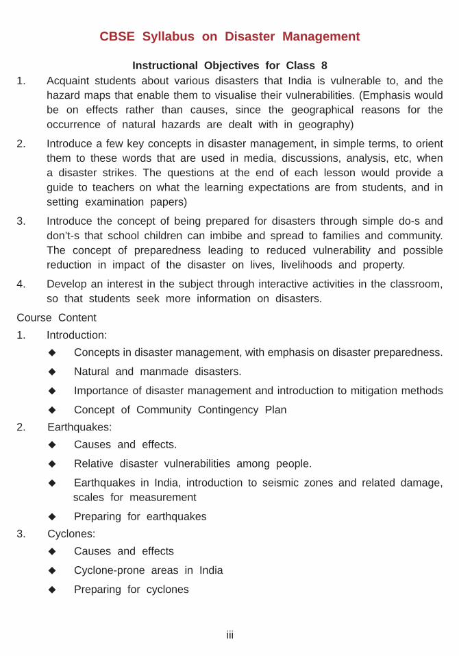
India is one of the most disaster-prone countries in the world. Its unique geo-physicalcharacteristics make different areas vulnerable to various disasters. Over 55% of the landarea is vulnerable to earthquakes. 70% of the land under cultivation is prone to drought,12% to floods and 8% to cyclones. The socio-economic backwardness of the majority of ourpopulation, coupled with the lack of skills in preparing for responding to disasters increasestheir vulnerability, negatively affecting their ability to respond and recover from periodicand intense disasters.
Prevention is better than cure, is an old saying which is very apt in the context of disastermanagement. Every year, colossal amounts of resources are used by our Government as wellas aid agencies in relief and rehabilitation measures. It has now become increasingly evidentthat an investment in disaster preparedness can save thousands of lives, vital economic assets,livelihoods and reduce the cost of overall relief assistance. Further, disaster mitigation isa step forward in attempting to conserve development gains before a disaster strikes.
Awareness and education is an important tool in creating this culture of prevention andpreparedness. Government of India has been stressing the need to sensitise the young learnersto the basic elements of the management of these disasters. Accordingly, the board has decidedto introduce disaster management as part of its front line curriculum in Class VIII inthe subject of Social studies from the Academic year 2003 –2004. It will be taken up graduallyupto Class X and will also become part of our assessment system.
A lot of care has been taken in development of instructional materials. Emphasis has beengiven on preparedness and mitigation of disasters.. This makes the material equally valuablefor parents and the community along with teachers and students. Exercises and activitieshave been built-in to ensure that students get involved in the learning process. Stories andnewspaper articles have been used to show the impact of disasters. Teachers are expectedto evaluate students on written work, project activities and preparation of kits, plans, etc.Special attention will be given to specific vulnerabilities of the areas.
vii

I express my gratitude to Sh. M.P. Sajnani, Director (Disaster Management), Ministry ofHome Affairs, Government of India for his personal involvement in the process of developmentof the instruction material. I am also thankful to the team of experts Dr. Kamala Menon,Ms. A. Venkatachalam and Ms. P. Thakur who have worked on the preparation of thechapters. Under the able guidance of Sh. G. Balasubramanian, Director (Academics) CBSE,Ms. Sugandh Sharma E.O. CBSE and Ms. Aparna Kanda, Programme Associate (VulnerabilityReduction and Sustainable Environment) UNDP coordinated the entire activity and providednecessary assistance. I express my appreciation and thanks to all these persons.
ASHOK GANGULY,CHAIRMAN, CBSE
viii

1
BEING PREPARED – A VITAL PART OF DISASTER MANAGEMENTIndia with its vast population and unique geo-physical characteristics is one of the world’smost ‘disaster-prone’ countries. Natural hazards such as cyclones, earthquakes, drought,floods or landslides occur in different parts of India in varying intensity. This means thatwe are all ‘vulnerable’ in different degrees to disasters caused by these hazards. Onthe East Coast, cyclones occur frequently. In the interior of the Plateau or in the Himalayas– earthquakes, and in the Ganga-Brahmaputra plain, floods are more common.
Rajasthan or Western Orissa often experience severe drought, as do other areas in SouthIndia. In addition to this, social conditionsthat govern the way communities live, furtheraffect the extent to which people are affectedby the hazard. In order that we protectourselves from the harmful effects of adisaster, we have to prepare ourselves inadvance, to face them better.
The process involving activities that help usto face disasters effectively is commonlyknown as ‘disaster preparedness’.
When disaster strikes, it affects us directly, and immediately. While the Government,
INDIA IS DISASTER-PRONE…
OVER 55% OF THE LAND AREA IS
VULNERABLE TO EARTHQUAKES
12% TO FLOODS
8% TO CYCLONES
70 % OF THE LAND UNDER
CULTIVATION IS PRONE TO DROUGHT
Important Terms*
1. Disaster Management: the range of activities designed to mitigate the effects of disasters
and emergency situations and to provide a framework for helping people at-risk to avoid or
recover from the impact of the disaster. Managing disasters includes steps to be taken prior
to, during, and after the disaster, and involve preparedness, mitigation, response and recovery.
2. Disaster-proneness: the likelihood of a place being affected by a disaster
3. Natural Hazard: A physical event or phenomena which may cause injury or loss of life,
damage to property, social and economic disruption or environmental degradation
4. Vulnerability: in simple terms is the potential for loss to an individual, community or place
because of a disaster, which is affected by geographical as well as social conditions
5. Disaster Preparedness: The set of activities and precautions that a community collectively
takes before a disaster occurs, in order to reduce the impact of a disaster, and to cope
with it efficiently.
* All terms are explained in context, to make the student understand important aspects of disaster management.Formal definitions will be attempted in Class 9 & 10
Chapter 1
2
International Agencies such as the United Nations, or Red Cross, and Panchayats in ruralareas assist us when faced with a disaster; the community, however is the first responder.
We students are an integral part of community, and have an important role to play inbeing prepared. Hence it is imperative that we prepare ourselves adequately to prevent,face and respond to disasters. History has shown us that where communities have beenprepared to face disasters, lesser lives have been lost, less significant damage to theenvironment has occurred, and property has been better conserved.
People living in an area may be vulnerable to more than one disaster. For instance, acoastal area may face floods and cyclones frequently, while being located in an earthquakezone. Such an area is called a ‘multi-hazard’ zone. Our country is divided into variouszones based upon the vulnerability of the area to various disasters. When these zonesoverlap, we have a multi-hazard zone.
A hazard in simple terms is a ‘potential’ disaster. It is an event that may lead to a disaster.For instance, a flood is a hazard. When it occurs, and if people are not prepared toface it, it may wash away persons, homes, cattle and valuables. Then, the flood becomesa disaster. But if people are evacuated along with valuables to a safe shelter, cattle isherded onto a higher area such as a mound, and houses are built with adequate featuresto make them flood-resistant, the flood remains a hazard and does not become a disaster.
Natural and Manmade disasters
Important Terms*
1. Community: People who live together in a village or urban area, who can be identified
as a local group with a common way of life
2. First responders: The persons or group of people who are immediately affected by a disaster,
and are the first to respond and help to cope with it, before government or relief agencies
can rush to the area.

3
Important Terms
1. Faults: are places in the earth where the rocks are broken and the rocks on one side
have moved in some direction relative to the other. Faults are planes, not lines
The selfless bounty of nature is a gift to mankind. It is an eternal source of sustenance:it gives us air, water and food, and of course a home to stay. For centuries though,Mother Nature has been combining its gifts with its often-inexplicable moods ofdestruction and fury. These times of turmoil over land and water, or hazards oftenlead to disasters, with large losses to life, livelihood and property. Disasters are sometimes referred to as ‘calamities’.
Common hazards faced by us in India are earthquakes, drought, floods, cyclones,landslides, forest fires, a large number of fire accidents, etc.
Earthquakes: The Earth we live on is made up of large plates of land that float over
an ocean of semi molten rock. Forthousands of years these plates havebeen constantly moving and shifting.(65 million years ago such shiftingcaused the Himalayas.) Thesemovements in the Earth’s crust causeearthquakes, when two plates collidewith each other, releasing energy.
Earthquakes that occur under water,in the oceans, cause huge waves
called tsunamis that have some times raced across the ocean at 8000 km/h. Earthquakesare more likely to occur along faults. Delhi, our capital city lies near a fault, and is hencehighly earthquake-prone. The fact that it is also densely populated and has crowdedresidential areas makes it more vulnerable to disaster.
Drought: is a natural phenomenon, which happens when an area receives lesser rainfall

4
then expected, or in comparison to the normalrainfall levels for the area. It is a dry situationcharacterised by deficit rainfall, lack of waterfor household use or agriculture, or a deficiencyof surface or sub-surface water leading toacute shortage of water.
Environmental degradation is a major factorthat increases the effects of drought. De-forestation, soil erosion (by wind and water),
Important Terms
1. Normal rainfall: When the rainfall for the monsoon season of June to September for a
place is within +/-19% of its long period average, it is categorised as normal. When the
monsoon rainfall deficiency exceeds 19%, it is categorised as deficient or scanty.
2. Environmental degradation: in simple terms is the reduction or deterioration of
environmental resources that harms us in many ways.
3. Bio-diversity: is the term for the variety of life and the natural processes of which living
things are a part. This includes the living organisms and the genetic differences between
them and the communities in which they occur. The concept of biodiversity represents the
ways that life is organized and interacts on our planet. This balance or equilibrium is challenged
by environmental degradation
loss of bio-diversity and excessive use of ground or surface water result in drought. Itcauses large-scale starvation, loss of assets and livestock and death. Drought is aperennial feature in some states of India.
Floods: are caused when water rises above and beyond its normal place or course,
causing areas to be submerged with waterfor prolonged or short periods of time. Theyare caused primarily due to the peculiaritiesof rainfall in the country, and are the mostfrequent and often most devastating disasterin India. While the Ganga and Brahmaputrarivers cause the largest floods in India,other areas in the west, east and southalso experience floods.
Cyclones: A cyclone is a storm that occurs

5
due to a difference in temperature andpressure of air, over the warm watersof the Oceans. It is accompanied bystrong gales and lashing rain, and tidalwaves that cause floods in coastalareas. A cyclone can carry the powerto destroy concrete buildings, blow awaya cement roof, uproot trees, and washaway homes in villages.
Manmade disasters may result from
Iso-Cyanate or MIC, a lethal gas in Bhopal in 1984 in an industrial accident caused thedeath of many persons almost instantly. Almost two decades later, people are still sufferingfrom the after effects of this disaster.
More common manmade disasters are major fires, land, air or water accidents causedby collisions, breakdown, etc., and collapse of bridges and buildings.
major accidents or inadvertent as well deliberate actionsof individuals, groups or governments. For exampleterrorists may blow up a train or building with explosives.Manmade disasters could be nuclear (The nuclear attackon Hiroshima and Nagasaki in Japan in 1945). Nuclearweapons when used cause a lot of destruction throughthe generation of heat, fire and radiation. Biologicaldisasters can be caused by preserving and releasinggerms of deadly diseases such as small pox,jaundice etc,or by polluting water with such germs in a particular area.The use of Anthrax by terrorists to eliminate people in theUSA in 2002 could be called a biological weapon.
Manmade disasters could also be caused by the misuseor spread of dangerous chemicals. The release of Methyl

6
Manmade disasters are preventable. For instance, by adhering to rules that govern theway a building must be constructed (these are called Building Bye Laws, and are issuedby the Government), we could ensure that it is strong and durable. Nuclear Non-Proliferation Treaties are agreements made internationally by countries, mutually agreeingnot to develop nuclear weapons for mass destruction. Further, by adhering conscientiouslyto safety measures in industries, accidents that cause suffering could be prevented.
Natural Disasters too can be mitigated. By being prepared to face and respond to themeffectively, we not only conserve the advances made by civilisations, but also minimisethe losses that disasters inflict upon communities, that some times take us yearsbackwards in progress. Disaster Management hence helps us to adapt ourselves to natureand learn to use it to our advantage
Taking care of our environment plays an important role in the mitigation of disasters.While economic development is necessary to match the demands of increasingpopulation, we have to ensure that it does not result in environmental degradation.Development should therefore be planned in a judicious manner and in tune withsustaining and protecting our environment.
Important Terms
1. Building Bye Laws : a set of rules and regulations that prescribe the standards for
construction of, spacing between and access to buildings. The purpose of these laws is to
ensure that all constructions in the country conform to disaster resistant designs, as well
as layout.
2. Mitigation : Actions that reduce the severity of damage caused by disasters to people
and property such as cyclone resistant houses in cyclone prone areas.
7
To face disasters better, we need to understand their causes and effects, as well aswhat we as students can do to help in the effort toward creating a more disaster-resilientsociety.
In a disaster situation, a large number of agencies, the Government and communitiescome together to help in coping with the after-effects of the disaster. In recent times,these agencies, also called civil-society have been collaborating even in times whenthere is no disaster, to put in place, an effective Disaster Management Plan. A DisasterManagement Plan for a country is made up of a number of plans at various levelssuch as the community, the block/taluka (in rural areas), the district and state integratinginto a National Plan. At the community level, it is called the Community ContingencyPlan, about which you will learn more in Class 9.
Women and Children in DisasterManagement…
Our mothers have an importantrole to play in disastermanagement, since they manageour homes, all our needs and us.
We as future responsible citizensof our country can do wonders inassisting our elders in preparingand coping with disasters.
Form groups in your class toidentify the role of women andstudents in preparedness,mitigation and response and shareyour findings.
29th October is National Day for DisasterReduction. The children in the picture aboveare creating awareness in their neighbourhoodon the importance of being prepared fordisasters.
Important Terms:
1. Disaster-resilient society: is one that can endure the effects of a disaster, while minimising
the occurrence where possible, and the destruction that can be caused by it.
2. Civil Society: a term used to describe the various organisations that come together to
pursue the interests of communities, development goals, etc., including disaster management
in recent times. It includes development organisations such as the United Nations or the
Red Cross, Civil Defence, NCC, NSS, Scouts and Guides, hospitals, ambulance services,
educational trusts, etc. as well as the public and private sector industries and institutions.
Civil Society forms an important part of disaster preparedness and response.

8
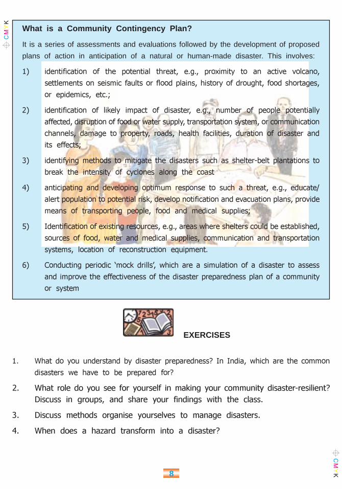
What is a Community Contingency Plan?
It is a series of assessments and evaluations followed by the development of proposed
plans of action in anticipation of a natural or human-made disaster. This involves:
1) identification of the potential threat, e.g., proximity to an active volcano,
settlements on seismic faults or flood plains, history of drought, food shortages,
or epidemics, etc.;
2) identification of likely impact of disaster, e.g., number of people potentially
affected, disruption of food or water supply, transportation system, or communication
channels, damage to property, roads, health facilities, duration of disaster and
its effects;
3) identifying methods to mitigate the disasters such as shelter-belt plantations to
break the intensity of cyclones along the coast
4) anticipating and developing optimum response to such a threat, e.g., educate/
alert population to potential risk, develop notification and evacuation plans, provide
means of transporting people, food and medical supplies;
5) Identification of existing resources, e.g., areas where shelters could be established,
sources of food, water and medical supplies, communication and transportation
systems, location of reconstruction equipment.
6) Conducting periodic ‘mock drills’, which are a simulation of a disaster to assess
and improve the effectiveness of the disaster preparedness plan of a community
or system
1. What do you understand by disaster preparedness? In India, which are the common
disasters we have to be prepared for?
2. What role do you see for yourself in making your community disaster-resilient?
Discuss in groups, and share your findings with the class.
3. Discuss methods organise yourselves to manage disasters.
4. When does a hazard transform into a disaster?
EXERCISES
9
WHEN THE EARTH SHOOK:
More than 13,000 people were killed,
at least 15 lakh injured, 3.4 lakh
buildings damaged, and about 7.8 lakh
houses destroyed in the Gujarat
earthquake of 26th January 2001. Many
bridges and roads were damaged. This
earthquake, with its epicentre at Bhuj
occurred along a fault in the east-west
direction. The stress that caused this
earthquake was due to the Indian plate
pushing northward into the Eurasian
plate.
An earthquake in simple terms is a sudden trembling or shaking movement of theearth’s surface, called the crust. Most earthquakes are minor tremors. Largerearthquakes usually begin with slight tremors but rapidly take the form of one or moreviolent shocks, and end in vibrations of gradually diminishing force called aftershocks.The subterranean point of origin of an earthquake is called its focus; the point onthe surface directly above the focus is the epicenter. The magnitude and intensityof an earthquake is determined by the use of scales, such as the Richter scale andthe Modified Mercalli scale.
Important Terms:
1. Crust: the solid surface of the earth
2. Tremor: shaking of the ground
3. Epicentre: the place on the surface of the earth directly above the hypocentre
4. Richter scale: a scale which classifies the magnitude (force) of an earthquake
5. Modified Mercalli scale: a scale which classifies the intensity (effects) of an earthquake
6. Hypocentre: the place deep in the earth’s crust where an earthquake starts
EARTHQUAKES
Ahmedabad 26th January 2001
Improperly built high-rise buildingscrumbled and cracked
Chapter 2

10
Why do earthquakes happen?
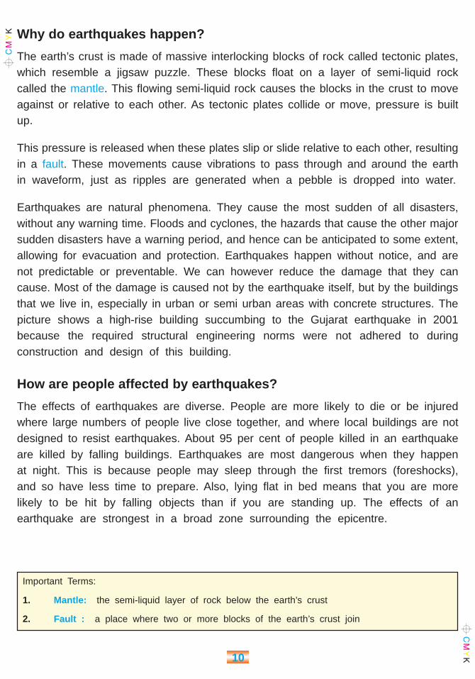
The earth’s crust is made of massive interlocking blocks of rock called tectonic plates,which resemble a jigsaw puzzle. These blocks float on a layer of semi-liquid rockcalled the mantle. This flowing semi-liquid rock causes the blocks in the crust to moveagainst or relative to each other. As tectonic plates collide or move, pressure is builtup.
This pressure is released when these plates slip or slide relative to each other, resultingin a fault. These movements cause vibrations to pass through and around the earthin waveform, just as ripples are generated when a pebble is dropped into water.
Earthquakes are natural phenomena. They cause the most sudden of all disasters,without any warning time. Floods and cyclones, the hazards that cause the other majorsudden disasters have a warning period, and hence can be anticipated to some extent,allowing for evacuation and protection. Earthquakes happen without notice, and arenot predictable or preventable. We can however reduce the damage that they cancause. Most of the damage is caused not by the earthquake itself, but by the buildingsthat we live in, especially in urban or semi urban areas with concrete structures. Thepicture shows a high-rise building succumbing to the Gujarat earthquake in 2001because the required structural engineering norms were not adhered to duringconstruction and design of this building.
How are people affected by earthquakes?
The effects of earthquakes are diverse. People are more likely to die or be injuredwhere large numbers of people live close together, and where local buildings are notdesigned to resist earthquakes. About 95 per cent of people killed in an earthquakeare killed by falling buildings. Earthquakes are most dangerous when they happenat night. This is because people may sleep through the first tremors (foreshocks),and so have less time to prepare. Also, lying flat in bed means that you are morelikely to be hit by falling objects than if you are standing up. The effects of anearthquake are strongest in a broad zone surrounding the epicentre.
Important Terms:
1. Mantle: the semi-liquid layer of rock below the earth’s crust
2. Fault : a place where two or more blocks of the earth’s crust join
11
An earthquake can cause other dangerous events, such as landslides, floods, fires,and huge ocean waves called tsunamis.
Why are some people more at risk from disasters than others? Simply, Somepeople are more at risk because of where they live. Others may be more at riskbecause of their socio-economic situation.
Certain types of disasters are specific to certain geographical areas. Earthquakescommonly happen along a geological fault (a place where two sections of the earth’scrust join). Other types of natural hazards, such as flooding, are widespread acrossthe globe.
Earthquake vibrations last longer and are of greater impact in unconsolidated surfacematerial, such as poorly compacted fill (loose soil) or river deposits; bedrock areasreceive fewer effects. Hence, flexible structures built on bedrock are generally moreresistant to earthquake damage than rigid structures built on loose soil.
When disaster strikes, the poor are usually the worst affected. This is because theyare likely to have less choice about where they live, and many poor communitiesare forced to settle on dangerous land – on steep hillsides, or in river floodplainsfor example. In poorer regions, people often build their own houses, and may nothave access to information about how to make their homes safer. Even when peopledo have information, they may not be able to afford stronger, better-quality buildingmaterials.
After a disaster, poorer people find it hardto recover. The physical injuries anddestruction, the loss of livelihoods can haveserious long-term consequences. If peoplelose vital tools, or means of transport, thenthey will have no way to support themselvesand their families for the future. They areusually people with no insurance, and willprobably have to make do with whateverthey can find.
They may find it very difficult to regain the position they were in before the disasterstruck.
In parts of Iran, which are vulnerable
to earthquakes, the days are hot
and the nights are cold. Houses are
often designed with thick walls and
heavy roofs, which are excellent for
insulating people from extreme
temperatures, but not so good at
resisting earthquakes

12
Earthquakes in India
In one form or another, disasters will always be with us. Technological solutions, whichtry to prevent disasters from happening, may appear attractive, but in reality suchsolutions can never work alone. The best approach is a combination of good educationabout the risks, and better preparation.
But before we discuss possible ways to mitigate the impact of earthquakes, or prepareto face them better, let us find out which areas are most vulnerable to earthquakesin India.
The Himalayas are the world’s youngest fold mountain ranges. This makes thesubterranean area of the Himalayas geologically very active, increasing the probabilityof earthquakes here.
This is evident in the map below, showing the area around the Himalayas in thehighest earthquake risk zones.

13
Delhi our Capital City and Mumbai, our commercial capital both of which are denselypopulated, are in Zone 4, a high risk zone. The entire North East Region and theKutch Region of Gujarat are in Zone 5, meaning that the people of these areas aremost vulnerable to earthquakes. The Deccan Plateau, historically believed to be anarea of low seismic activity experienced two major earthquakes in recent times –inLatur, (1993, magnitude 6.4 on the Richter scale) that caused substantial loss of livesand damage to infrastructure, and in Koyna, (1967 measuring 6.5 on the Ritcher scale)the strongest ever in the Deccan peninsula, confirming that peninsular India is alsovulnerable to earthquakes. 233 out of 597 districts in India fall in seismic zones3, 4 and 5.
Which zone does your village or city fall in? Has your village or city ever experiencedan earthquake?
How do we measure Earthquakes?
The severity of an earthquake is related to magnitude, that is, the seismic energyrecorded on a seismograph and intensity meaning the observed effects that the groundshaking has on people, buildings, man-made structures and natural features.
There are different ways of measuring earthquakes. The Ritcher Scale (which is open-ended) is a method of measuring the energy, or intensity of an earthquake (how strongit is). The Mercalli Scale (which has twelve classes) is a way of measuring the effectsof an earthquake (how damaging it is). An earthquake that is small in magnitude (lowon the Richter scale) can still cause a lot of damage (high on the Modified Mercalli scale).
Hence, an earthquake measuring 8 on the Ritcher Scale is stronger than one thatmeasures 4. Similarly, some of the classes on the Mercalli Scale are explained asfollows:
Class Not felt, except by very few people.
I - III
Class Felt by nearly everyone. Some windows broken. Unstable objects
IV - VI fall over. Pendulum clocks may stop.
Class Everybody runs outdoors. Buildings designed to resist earthquakes
VII - X and made of strong materials are hardly damaged; ordinary
buildings are moderately damaged; buildings not designed to resist
earthquakes, or made from weaker materials, are severely damaged.
Earthquake is noticed by people driving cars.

14
Class Total devastation. Earthquake waves are seen on the surface of
XI - XII the ground. Objects are thrown upwards into the air.
PREPARING FOR AN EARTHQUAKE
When an earthquake occurs, buildings that are not earthquake-resistant may fall, thewalls may collapse trapping people under the rubble. The railway and road routesmay be dislocated, increasing the time taken for external aid to reach the disastersite.
1. It is important to help survivors quickly. We have learnt that people livingin the region usually carry out most of the first-aid and rescue work, who wecall first responders. Hence we have to train ourselves in basic rescue andfirst-aid functions. Contact your nearest Red Cross office or Public HealthCentre or VHW to organise training for your class.
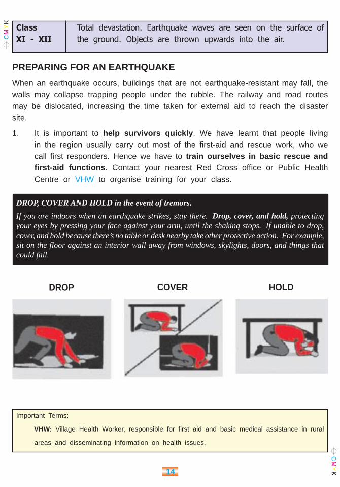
DROP, COVER AND HOLD in the event of tremors.
If you are indoors when an earthquake strikes, stay there. Drop, cover, and hold, protectingyour eyes by pressing your face against your arm, until the shaking stops. If unable to drop,cover, and hold because there’s no table or desk nearby take other protective action. For example,sit on the floor against an interior wall away from windows, skylights, doors, and things thatcould fall.
Important Terms:
VHW: Village Health Worker, responsible for first aid and basic medical assistance in rural
areas and disseminating information on health issues.
DROP COVER HOLD
15
2. In the long run, we can ensure the safety of our homes and schools byretrofitting existing buildings (which we have learnt is to strengthen buildingsstructurally to make them disaster resistant) to make them earthquake resistant,using appropriate technology in building material (you will learn more aboutthese technologies in higher classes), and by insisting that new constructionsadhere to norms such as the Building Bye Laws, about which we have brieflylearnt. In rural areas, we students can create awareness about the earthquakevulnerability of the area, and what housing designs are best suited to withstandthe earthquakes.
3. In case of tremors,
u Duck (bend down) under the desk. Stay away from windows, bookcases, filingcabinets, heavy mirrors, hanging plants, fans and other heavy objects. Stay undercover till the shaking stops.
u If in rural areas, exit your home or school building and move to open fieldsor areas. DO not push others, and practise this simple exercise every 1st Mondayof the month, if you live in zone 4 or 5.
u If your are in a HIGH RISE BUILDING, move against an interior wall and protectyour head with your arms. If you have a scooter helmet wear it. Do not usethe lift. Stay away from the windows because glass windows can shatter andcause injury.
u If your are OUTDOORS move to a clear area, away from trees, signs, buildings,electrical wires and poles.
u If you are DRIVING pull over to the side of the road and stop. Move awayfrom flyovers, power lines and advertisement boards, jump out of the car andcrouch on its side. DO NOT SIT INSIDE THE CAR.
u If your are in a STADIUM, THEATRE, or AUDITORIUM stay inside. Do not rushout towards the exit. Stay in your seat and cover your head with your armsand stay calm till the shaking is over. Then move out in an orderly manner,let younger children, elderly and disabled people leave first.

16
4. AFTER THE TREMORS SUBSIDE….
u Be prepared for after shocks and remember to find placesto hide.
u Check for injuries and first treat yourself. Then help others.
u Remain calm and self-assured and help others who aredistressed.
u Check for fire. If near a phone, call the FireDepartment (101) or Police Control Room (100) orget assistance in case of a fire. Do keep a bucketof sand ready to put out the fire.
5. If you live in a moderate to very high risk zone, it is possible that after an earthquakeyour school could become a relief centre. Your teacher would be a member of theDisaster Management Committee of your village or area. In such a case the schoolwould benefit from ——
u An Activity Kit for children who mayneed to stay at the school after thedisaster. This kit can have books, papers,colour pencils and chalk so that youngchildren can draw and write and copewith the trauma they have been through.
It could also contain games, toys, toffees (which should be replaced before theyare stale), etc.
u A Sewing Kit to repair and stitch clothes
u A Cleaning and Utilities Kit that is very essential for health and hygiene.
It is relatively easy to assess our earthquake risk based on our location with respectto the seismic zones, and other factors such as whether we live in urban or ruralareas, seismically safe buildings, etc. Adequate mitigation and preparedness measurescan be taken, through concerted efforts. You as a student have an important roleto play in educating your people on earthquake risk, as well as creating awarenesson how to cope with sudden disasters. The tips given in this lesson should certainlyhelp to prepare you, your classmates, family and community better, to face earthquakeswith confidence.
Activity:
Discuss in your class and make listsof items for each of these three kitsand what it would cost. Can you allcontribute to the lists?

17
Earthquakes are destructive. But sometimes, they do afford an opportunity forcommunities to start afresh and improve on their pre-disaster conditions, as witnessedin Gujarat and Latur after the major earthquakes that devastated them.
1. What is a seismograph? Where is it usually kept in your city? If you live ina village, can you find out where the nearest seismograph is kept?
2. What would you do if you find that some one is trapped inside a building underthe rubble and you can hear the person, though you can’t see him or her?Can you find out if your village or Gram Panchayat or Block/Taluka hasspecialised search and rescue teams for disasters, if you live in a rural area?If you live in a city, do you know if such teams exist?
3. How would you deal with a person who has lost everything in an earthquakeand is shocked? Find out more about trauma counselling. Who can be a goodcounsellor?
4. How would you prevent bleeding from a wound on the arm?
ACTIVITIES
Organise your School First Aid Kit:
Find out from your teacher or nearest doctor/VHW whatyou can add to this list
1. Sterile gauze Pads
2. Adhesive Tape
3. Bandage to create slings for fractures
4. Fever reducing and anti-inflammatory tablets
5. Anti-diarrhoea tablets
6. Antiseptic liquid and ointment
7. Hydrogen Peroxide skin disinfectant
8. Cotton wool
9. Oral Rehydration Salts
10. ___________________
11. ___________________

18
5. Make posters to tell people what to do when there are tremors. Display themin prominent places in your village or area, if in zones 3-5.
6. Make an illustrated comic type information sheet on the DROP, COVER & HOLDroutine for people or children who cannot read and explain it to them.
7. What precautions should one take when one enters a building that has crackedor collapsed because of an earthquake?
8. Are there Ham Radio Operators in your village or area? Find out more aboutHam Radio.
9. Draw a map of your village or area, locating your school, houses, ponds, tanks,etc., as well as open spaces and high-rise buildings. Mark an emergencyevacuation route plan, for use in case of an earthquake. Take your plan toyour local DMT. Do they have a community contingency plan for your villageor area? Take their help to locate possible relief centres and cattle protectionareas (if in a village). If your village or area does not have a DMT yet, yourteachers could help you with this exercise.
EXERCISES
1. Which earthquake vulnerability zones do you live in? (Use the map)
2. What would you do if you were going home from school and there was anearthquake?
3. Where would you go if you were in the games field and there was an earthquake?
4. What activities would you do with children who have witnessed and experiencedan earthquake when they come to a relief camp or shelter?
5. List simple do’s and don’ts in the event of tremors or an earthquake.
6. How does preparedness help you and your community when an earthquakeoccurs.

19
CYCLONES
The extract on the right from a newspapergives you an idea of the devastatingpower of a cyclone. The Indiansubcontinent is the worst cyclone-affectedpart of the world, as a result of low-depthof the Ocean bed and the way our coastis shaped. The Indian Ocean is one ofthe six major cyclone-prone regions ofthe world.
A school building lies in shambles after the
cyclone, wind and water ravaged the village
Chapter 3
12th May 1990
Andhra Pradesh coast was hit by a
severe cyclonic storm on 8th May
1990 with wind speed about 240-
250 km/h and 5-6 metre-high storm
surges. The area all along the coast
of Krishna and Guntur districts was
affected severely by the storm,
which was accompanied by gales
and heavy rainfall. Other areas were
affected by flooding due to heavy
rainfall. The cyclone affected 9 of
the total 23 districts, while the
number of villages affected was
5,923. The cyclone killed 928 persons
and around 24,000 cattle. A total
of about of 7.8 million people were
affected by the cyclone. About
827,100 houses were partially
damaged while 569,000 were
completely destroyed. More than
500,000 hectares of agricultural and
horticultural land was affected. Total
damage to property was worth Rs
125 million.
Source: Press Release, Government
of Andhra Pradesh

20
Look at this picture. It showschildren standing outside theirschool whose roof was partlyblown off, during the OrissaCyclone on 29th October 1999.
Every year cyclones take theirtoll on thousands of people,and property. But themagnitude of destruction canbe reduced to a large extentthrough knowledge andpreparedness.
What Is a cylcone?
A cyclone is a region of low atmospheric pressure,which occurs in the hot oceans of temperate and tropical latitudes. It is a swirlingatmospheric disturbance, accompanied by powerful winds (exceeding the 300 km/hsometimes) blowing in a clockwise direction in the Northern hemispheres and anticlock wise direction in the Southern hemisphere, by pouring rain, and enormous wavesin the ocean. Cyclones occur due to a combination of warm sea temperature, highrelative humidity and atmospheric instability.
In a cyclone, clouds gather around a centre that is called the “eye of the cyclone”.A zone of calm, accompanied by good weather characterises the eye. It is in edgeof the eye called the “wall of the eye” (in a radius of 20 to 30 kilometres) that theworst conditions prevail, with devastating winds. So, as the eye of the cyclone crossesan area, the wind drops. As it passes, the wind speed rises again, and hence thecalm should not be confused as the ‘end’ of the cyclone.
The diameter of the cyclone is often several hundreds of kilometres. That of the eyevaries between 20 and 50 km and the cloudy mass of the cyclone raises to occupyall of the troposphere.
Important Terms:
Troposphere: The layer of the Earth’s atmosphere that is closest to its surface, between 0-10 km.Most (90%) of the Earth’s atmosphere lies within the Troposphere.

21
What happens during a cyclone?
The principal dangers from a cyclone are:
(i) Gales and strong winds; (that may uproot trees, destroy telephone lines andelectricity poles which may disable power and communication)
(ii) Torrential rain that can cause flooding
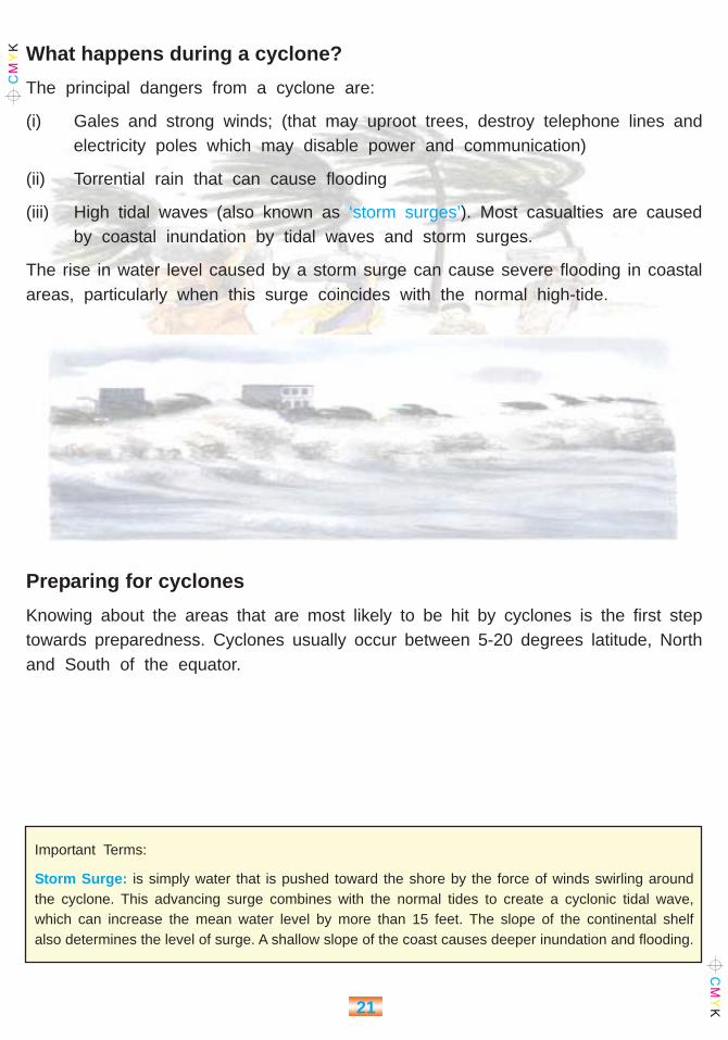
(iii) High tidal waves (also known as ‘storm surges’). Most casualties are causedby coastal inundation by tidal waves and storm surges.
The rise in water level caused by a storm surge can cause severe flooding in coastalareas, particularly when this surge coincides with the normal high-tide.
Preparing for cyclones
Knowing about the areas that are most likely to be hit by cyclones is the first steptowards preparedness. Cyclones usually occur between 5-20 degrees latitude, Northand South of the equator.
Important Terms:
Storm Surge: is simply water that is pushed toward the shore by the force of winds swirling aroundthe cyclone. This advancing surge combines with the normal tides to create a cyclonic tidal wave,which can increase the mean water level by more than 15 feet. The slope of the continental shelfalso determines the level of surge. A shallow slope of the coast causes deeper inundation and flooding.
22
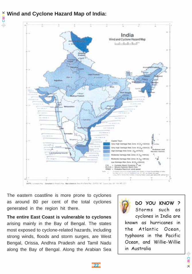
Wind and Cyclone Hazard Map of India:
The eastern coastline is more prone to cyclonesas around 80 per cent of the total cyclonesgenerated in the region hit there.
The entire East Coast is vulnerable to cyclonesarising mainly in the Bay of Bengal. The statesmost exposed to cyclone-related hazards, includingstrong winds, floods and storm surges, are WestBengal, Orissa, Andhra Pradesh and Tamil Nadualong the Bay of Bengal. Along the Arabian Sea
DO YOU KNOW ?
Storms such as
cyclones in India are
known as hurricanes in
the Atlantic Ocean,
typhoons in the Pacific
Ocean, and Willie-Willie
in Australia
23
on the West Coast, the Gujarat and Maharashtra coasts are more vulnerable comparedto the southern part. The frequency of tropical cyclones is the greatest in theBay of Bengal and Arabian Sea as compared to other cyclone-prone areas in theworld.
Cyclones and Environmental Degradation
Forests along the coast act as natural wind and water barriers, shielding the coastalcommunities from the destructive power of cyclones and storm surges. They formnatural windbreakers to reduce the impact of cyclonic storms on the coastal areas.But deforestation and encroachment of the coastal shelterbelt area, as this forestlandis known, by paddy cultivators, prawn farmers, etc. has been depleting these forests.
Are we increasing our own vulnerability?
True, natural calamities are hard to avert. But in Orissa the ordeal was
also man-made. There has been a systematic destruction of mangrove
and other tropical trees having branches that send down roots. This growth
protected the coastal areas. Greedy people have deforested the coastal
areas, leaving no impediment between the sea and habitations.
13 November 1999, Rediff on the Net (adapted from the internet news
site)
Cyclone forecasting and warning
The Indian Meteorological Department (IMD) is responsible for cyclone tracking andwarning. Cyclone tracking is done through the INSAT satellite and 10 cyclone detectionradars. Warning is issued to cover ports, fisheries and aviation departments. Thewarning system provides for a cyclone alert of 48 hours and a cyclone warning of24 hours. There is a special Disaster Warning System (DWS) for dissemination ofcyclone warning through INSAT satellite to designated addresses at isolated placesin local languages.

24
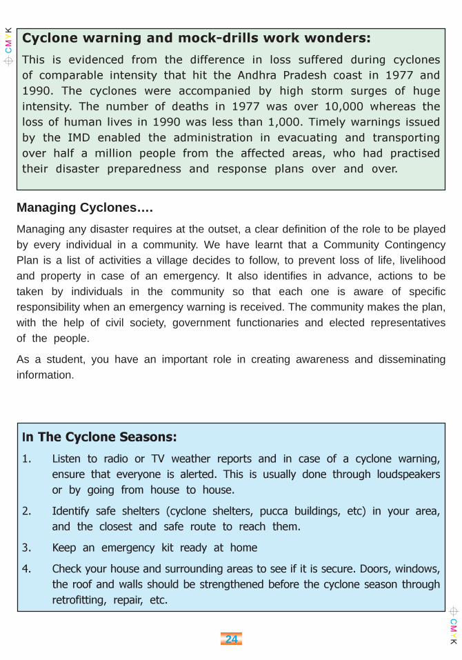
Cyclone warning and mock-drills work wonders:
This is evidenced from the difference in loss suffered during cyclones
of comparable intensity that hit the Andhra Pradesh coast in 1977 and
1990. The cyclones were accompanied by high storm surges of huge
intensity. The number of deaths in 1977 was over 10,000 whereas the
loss of human lives in 1990 was less than 1,000. Timely warnings issued
by the IMD enabled the administration in evacuating and transporting
over half a million people from the affected areas, who had practised
their disaster preparedness and response plans over and over.
Managing Cyclones….
Managing any disaster requires at the outset, a clear definition of the role to be playedby every individual in a community. We have learnt that a Community ContingencyPlan is a list of activities a village decides to follow, to prevent loss of life, livelihoodand property in case of an emergency. It also identifies in advance, actions to betaken by individuals in the community so that each one is aware of specificresponsibility when an emergency warning is received. The community makes the plan,with the help of civil society, government functionaries and elected representativesof the people.
As a student, you have an important role in creating awareness and disseminatinginformation.
In The Cyclone Seasons:
1. Listen to radio or TV weather reports and in case of a cyclone warning,
ensure that everyone is alerted. This is usually done through loudspeakers
or by going from house to house.
2. Identify safe shelters (cyclone shelters, pucca buildings, etc) in your area,
and the closest and safe route to reach them.
3. Keep an emergency kit ready at home
4. Check your house and surrounding areas to see if it is secure. Doors, windows,
the roof and walls should be strengthened before the cyclone season through
retrofitting, repair, etc.
25
5. Store adequate food grains and water in safe places.
6. Keep your important papers in the emergency kit.
7. Keep a list of emergency addresses and phone numbers such as the local
police station, Block or taluka office (in rural areas) on display
8. Conduct mock drills for yourselves, imagining that a warning has been given.
Upon A Cyclone Warning
1. Listen to your local radio, TV or community warning system for further
information
2. Close all windows and doors. Secure doors and stay indoors.
3. Keep food items in waterproof bags.
4. Prepare or update a list of assets and belongings of your house and give
information to volunteers and other authorities about your near and dear ones.
5. Get the emergency kit ready and in case of warning of a severe cyclone,
move with your family to a strong pucca building or cyclone shelter.
6. Do not venture into the sea
7. Wear warm clothing for protection
After The Cyclone.
1. Do not go out till officially advised that it is safe. If evacuated, wait till advised
to go back. Use the recommended route for returning and do not rush.
2. Check for gas leaks before using the stove.
3. Dry electric appliances thoroughly before use.
If You Have To Evacuate
1. Keep track of radio updates and advice.
2. If the wind suddenly drops, do not venture out, as this could be the eye
of the cyclone. Wait till the official ‘all clear’ declaration.
3. If in a vehicle, stop, but away from the sea and trees, power lines and
water courses.

26
4. Be careful of snakebites
5. Beware of fallen power lines, damaged bridges, buildings and trees
6. Do not enter floodwaters.
ACTIVITY I
Read the newspaper article given below :
29 October 1999
Hundreds feared killed as cyclone devastates Orissa coast
Several hundred people were feared killed as the super cyclone with a velocity of more
than 260 kph battered 10 coastal districts of Orissa for more than eight hours today.
The state government called in the army and the air force to help carry out relief
and rescue operations. “You cannot imagine the devastation. More than 200,000 houses
have been destroyed and vast tracts in the coastal areas submerged,” Chief Minister
Giridhar Gamang told the United News of India on telephone. He also spoke to Defence
Minister George Fernandes to send in troops, air force helicopters and transport aircraft.
All the 10 affected districts remained cut off from the rest of the country with power
supply and telecommunication links cut off. According to initial reports, heavy damage
has been reported in the affected areas. Road links in certain areas have been cut off.
The cyclone hit Paradip port this morning at a speed of 260kph. The diameter of the
cyclone was very big and all nine coastal districts of Orissa were affected badly. The
storm of rare intensity left petrified residents fearing for their lives in the capital and
the thickly populated areas along the coast. Massive loss of life and property was feared,
but a clear picture will emerge only after the storm abates.
The hardiest of trees fell to the ferocity of the gales, which swept away much of what
came in their way. Torrential rains continued to lash the capital city, which is about
65 km from the Puri coast. The flat terrain along the coast allowed the strong tidal
waves to reach far inland without obstruction. The cyclone stormed Bhubaneswar at
around 0830 IST. The gale speed had touched a howling 260 kph by 1500 IST. Telephone
and electricity poles snapped like matchsticks, leaving the telecommunication network
in shambles. Power breakdowns plagued the affected areas with little prospects of early
restoration of supply. The air traffic control tower in Bhubaneswar reportedly suffered
damage, leaving little scope for early resumption of air traffic. Fallen trees blocked
the roads and the highway between Cuttack and Bhubaneswar.
The army moved in to provide immediate relief. Two signal attachments were flown
in with INMARSAT terminals to re-establish telecommunication links. Electrical and
mechanical engineers of the army are already trying to restore power supply.
Huts and other fragile structures collapsed, forcing the inmates to seek shelter in temples
and schools. Tidal waves rose two-storeys high, breaking embankments at Talachua
in Paradip and Erasama. Large parts were inundated in the coastal areas. But details

27
were not immediately available. Ships had been taken off the harbour. Several buildings,
including the state secretariat complex, were damaged. Eyewitnesses said no tall tree
was standing in the entire city anymore. Old-timers said they had never seen such
devastation.
The building housing the UNI offices in the heart of the city was among the structures
damaged. It forced the agency to shut down its computerised news operations. The
only means of communication available was the telephone line, which also threatened
to go off anytime.
Full details of the havoc wrought by the cyclone are yet to come in, but it was feared
to have left a ghastly trail, especially in the coastal areas. Meanwhile, the railways
cancelled 14 passenger and mail trains scheduled to run in the cyclone-affected areas.
Source: United News of India
1. Imagine that you were in Bhubaneswar when the storm struck…. Write downwhat you experienced and saw around you in a page. Share your experienceswith your classmates.
2. In your view, what preventive actions could Orissa have taken to reduce thedamage caused when the Super Cyclone struck?
ACTIVITY II
Make a contingency plan with all the members in your class and conduct a mockcyclone drill following a cyclone warning.
ACTIVITY III
How would you increase awareness among your community members aboutpreparedness for cyclones? Make charts and illustrations, which shows this.
EXERCISES
1. What causes a cyclonic storm?
2. What are the hazards associated with cyclones?
3. What is the eye of a cyclone and what are its characteristics?
4. List the steps in preparing for a cyclone.
5. Besides natural causes, what are the man made reasons, which have contributedto increase in the impact of cyclones?
6. Which are the cyclone prone areas of our country?

28
FLOODS
The story of Partho
12 years old Partho lives with his parents andthree little sisters in a small village nearby thebig Mahanadi River in Orissa, close to the coast.His father is a farmer and has a big large fieldwhere he cultivates rice. Rice needs lots of waterto grow and so Partho’s father was very happywhen the monsoon started. If he could get goodrice and sell it, he would have money to sendPartho’s younger sisters to school! One day itstarted to rain and it rained hard for many days.People were happy but the rain didn’t stop. Afterten days, the villager started to get very worried
as the river was swelling. Their fields were at risk of being inundated by the water.Flooding is dangerous for the villagers as it could destroy their houses and crops andalso kill them and their cattle.
Partho was home with his sisters when they heard people screaming that the riverwas starting to overflow. They were all very scared as their house was not very farfrom the river. Suddenly, Partho remembered what the teacher had told them at schoola few weeks earlier during a cyclone and floods preparedness lesson. There was acyclone shelter nearby the village where people could find refuge in case of cyclonesand also floods.
Partho took his sisters to the shelter and they stayed there together with all the othervillagers and also their parents. They had to remain in the shelter for three whole daysand nights, watching helplessly as homes, fields, bullock-carts, everything got submerged.When they finally came out they were scared and very tired but at least they werealive!
Chapter 4

29
Read the story given above. What helped Partho to save himself and his near and dearones from being washed away? This is called PREPAREDNESS. Yes! Disasters occurin all the countries in the world. But the community that prepares itself to face them bettersurvives better.
What is a Flood?
A flood occurs when waterflows or rises above andbeyond its normal place orcourse. The danger this causesto people and buildings iscalled the flood hazard. Themost common kind of floodhappens when a riveroverflows its banks, and waterspreads on to the surroundingland, called a riverine flood.
This is caused by rainwater or melting snow draining into the river faster than the rivercan discharge water into the sea. The amount of water that a river can hold before aflood starts is known as channel capacity.
Other causes of flooding are strong tides, storms at sea, cyclones, and tsunamis.Sediment deposition or silting of riverbeds and the synchronisation of river floods withsea tides compound the problem of floods in the coastal plains.
Important Terms:
1. Flood hazard: the risk of damage to life, livelihoods or property from flooding
2. Riverine flood: a flood caused when a river overflows its banks
3. Sediment: small particles of soil carried in a river which settle on the river bed, or on floodplains
4. Channel capacity: the maximum flow of water in a river

30
Other causes of floods
u Blocking of riverchannels by land slides
u Narrowness of the river
u Change in the courseof the river
u Inefficient engineeringdesign in theconstruction ofembankments, damsand canals.
Activity: Write a caption for the above picture
Where do floods occur?
Unlike cyclones, floods are common to all countries. North and Eastern India areparticularly prone to floods.
The most flood-prone areas are the Brahmaputra, Ganga and Meghana basinsin the Indo-Gangetic-Brahmaputra plains in north and Northeast India, which carry 60 percent of the nation’s total river flow. In India it is spread over 15 states and about 47per cent of India’s population resides in the basin. The other flood-prone areas are theNorthwest regions with the west-flowing rivers like the Narmada and Tapti, Central Indiaand the Deccan Plateau with major east-flowing rivers like the Mahanadi, Krishna,Godavari and Cauvery.
The map here shows the flood-prone areas in India. The Ganga and the Brahmaputracause maximum flooding.

31

32
The main season for floods in India is the west monsoon period of June to September.Nearly 75 per cent of the total rainfall is concentrated over a short monsoon season offour months (June-September). As a result the rivers witness a heavy discharge duringthese months, leading to widespread floods.
Effects of flooding
Flooding is one of the most destructive of all forms of natural disasters causing heavyeconomic and human losses.
Read the following news report:
We should know, that
u floods are an annual feature in some parts of India.
u flooded areas may get isolated from the rest of the country.
u regions near coastal areas and rivers are more vulnerable to flooding.
u Economically and socially backward communities are more vulnerable to thedestructive effects of floods. These communities take longer to come back to thekind of life they were leading before the disaster struck.
FLOOD PREPAREDNESS
Floods, which are a natural hazard, need not become a disaster, if we are preparedto deal with them. We know that trained DMTs (Disaster Management Teams) that arein the process of being constituted in each village or urban neighbourhood, would be
Indians flee monsoon floods
Parts of Assam and the neighbouring state of Arunachal Pradesh remain
cut off from the rest of the country, as flooding waters have destroyed
transport links. Floods in the Northeast of India are an annual
phenomenon. In August 2000, floods in the region killed 100 people,
and left 70,000 people homeless in Assam alone. Environmentalists
blame soil erosion, the silting of riverbeds and the increasing population
in the flood plains.
Sunday, 7th June 2002, The Hindu

33
responsible for preparedness and response. Each one of us must be involved in theprocess of preparedness, creation of awareness and the working of skilled emergencyresponse teams. This would reduce loss of life and minimise human suffering. This guidelists simple things that you and your family can do to stay safe and protect yourself fromfloods.
BEFORE FLOODING OCCURS
u Know the route to nearest safe shelters that you have learnt about earlier. You musthave the following ready, to carry to the safe shelter, if need be. This is yourEmergency Kit:
u First aid kit with extra medication for snakebite and diarrhoea.
u Strong ropes for tying things.
u A radio, torch and spare batteries
u Stocks of fresh water, dry food (chana, mudi, gur, biscuits, etc.), salt and sugar,kerosene, candles and matchboxes.
u Water-proof bags to store clothing and valuables
u Umbrellas and bamboo sticks (to protect you from snakes).
u If in rural areas, identify areas that are higher than the surroundings, or get yourcommunity to build an earthen mound to locate cattle, etc in the event of a flood.
WHEN YOU HEAR A FLOOD WARNING OR IF FLOODING APPEARSLIKELY
u Tune in to your local radio or watch TV for warnings and advice
u Keep vigil on flood warning given by local authorities.
u Keep dry food, drinking water and warm clothes ready
u In rural areas, prepare to take bullock-carts, other agricultural equipment anddomestic animals to safer places or to pre-identified areas such as mounds.
u Check you emergency kit.
IF YOU NEED TO EVACUATE
u Pack clothing, essential medication, valuables, personal papers, etc. in water-proofbags, to be taken to the safe shelter.

34
u Inform the local volunteers or DMT (if available) the address of the place you areevacuating to.
u Raise furniture, clothing, appliances on to beds or tables (electrical items highest)
u Turn off power
u Whether you leave or stay, put sandbags in the toilet bowl and cover all drain holesto prevent sewage back-flow.
u Lock your house and take the recommended or known evacuation routes for yourarea to the safe-shelter
u Do not get into water of unknown depth and current.
DURING FLOODS
u Drink boiled water.
u Keep your food covered, don’t eat heavy meals
u Use raw tea, rice water, tender coconut water etc. during diarrhoea
u Do not let children remain on empty stomach.
u Use bleaching powder and lime to disinfect the surroundings.
u Avoid entering floodwaters. If you must, wear proper protection for you feet andcheck depth and current with a stick. Stay away from water over knee-deep depth.
u Do not eat food that has got wet in the floodwaters.
u Boil tap water before drinking in rural areas. Use halogen tablets to purify waterbefore drinking (ask Village Health Worker for details).
u Be careful of snakes. Snakebites are common during floods.
You as a student have also a very major role to play in preparing for disasters. In recenttimes volunteers have played a key role in helping people to rebuild their lives and restorenormalcy whenever disasters have tormented the country. They have also played a vitalrole in creating awareness on disaster preparedness

35
PROFILE IN COURAGE
BIRA KISHORE GOCHAYAT
Bira Kishore Gochayat who works in Paradip, a port in Orissa, lived up to his
name (Bira mean a brave). It was the fateful day of 30 October 1996, the second
day of the terrible super cyclone, which battered the Orissa coast. Gales blowing
at more than 250 kmph accompanied by lashing rains made the scene frightful,
the strong gales pushing the sea waves inland by a few kilometres. Tidal surges
at a height of 24 feet hit the shoreline washing away whatever lay in its path.
Houses, human beings and cattle were swept off in the dangerously swirling current
of the tidal surge. Bira fought to save himself as did so many others. As he perched
himself atop of two-storied building, a relatively safe place, he spotted a man
desperately battling the strong tidal current. Losing no time, Bira did what his
conscience asked him to. He plunged into the swirling water and managed to catch
hold of the drowning man and pulled him to safety. It was no easy job, he recollects
later, with the strong gales buffeting the water in all directions. Barely had Bira
put the man on dry land, he saw some other desperate hands waving at a distance.
The rest of the morning saw a tireless Bira risking his life several times to fish
out helpless people from the currents. On that day he managed to rescue ten
persons from the jaws of death. The fact that his own hut had collapsed and
all his personal belongings had got swept away did not distract him from worrying
about the well being of others around him.

36
ACTIVITY 1
� Find out if your village or locality (if in a city) has a DMT.
� Ask how you can help to prepare for disasters, and create awareness.
� If your area is flood prone, do a survey and make a list of old people, womenand young children.
� Survey your regions and note down the buildings on raised platforms, whichcan be used during floods as a safe-shelter. You must also find out the nearestroute to the safe shelter, and how many persons it can hold.
� Make posters on how to save yourself from floods and stick them in publicplaces like markets, school buildings, community centre, etc.
� Discuss with your friends and prepare a contingency plan for yourselves. Askyour DMP for the village contingency plans and how you can be part of it.
ACTIVITY 2
Read the newspaper extract of 2002 below:
In Assam, soldiers have helped rescue thousands of people marooned in remote
villages, and more troops have been put on ‘stand by’ for relief operations. An
army spokesman said that disaster management squads in speedboats and
helicopters were also on standby. This is just the beginning of India’s monsoon
season, but the rains have been unusually heavy so far.
A. Find out which are the agencies and organisations that play an important rolein flood preparedness and response.
B. Make a list of their local offices and people heading them. Ask your teacherto contact Red Cross or any of the other agencies to come and tell you howthey prepare for floods and other disasters.
37
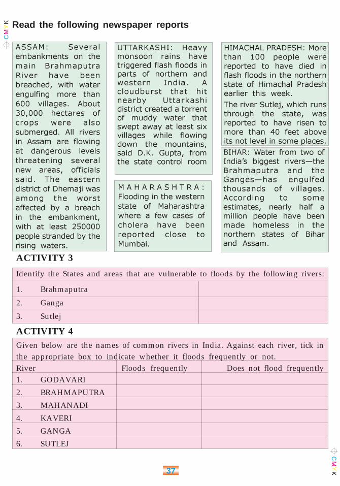
Read the following newspaper reports
ASSAM: Several
embankments on the
main Brahmaputra
River have been
breached, with water
engulfing more than
600 villages. About
30,000 hectares of
crops were also
submerged. All rivers
in Assam are flowing
at dangerous levels
threatening several
new areas, officials
said. The eastern
district of Dhemaji was
among the worst
affected by a breach
in the embankment,
with at least 250000
people stranded by the
rising waters.
UTTARKASHI: Heavymonsoon rains havetriggered flash floods inparts of northern andwestern India. Acloudburst that hitnearby Uttarkashidistrict created a torrentof muddy water thatswept away at least sixvillages while flowingdown the mountains,said D.K. Gupta, fromthe state control room
M A H A R A S H T R A :
Flooding in the western
state of Maharashtra
where a few cases of
cholera have been
reported close to
Mumbai.
HIMACHAL PRADESH: More
than 100 people were
reported to have died in
flash floods in the northern
state of Himachal Pradesh
earlier this week.
The river Sutlej, which runs
through the state, was
reported to have risen to
more than 40 feet above
its not level in some places.
BIHAR: Water from two of
India’s biggest rivers—the
Brahmaputra and the
Ganges—has engulfed
thousands of villages.
According to some
estimates, nearly half a
million people have been
made homeless in the
northern states of Bihar
and Assam.
ACTIVITY 3
Identify the States and areas that are vulnerable to floods by the following rivers:
1. Brahmaputra
2. Ganga
3. Sutlej
ACTIVITY 4Given below are the names of common rivers in India. Against each river, tick inthe appropriate box to indicate whether it floods frequently or not.River Floods frequently Does not flood frequently1. GODAVARI
2. BRAHMAPUTRA
3. MAHANADI
4. KAVERI
5. GANGA
6. SUTLEJ
38
EXERCISES
1. List the causes for floods.
2. Suggest measures to prevent damage from frequent flooding.
Two measures have been suggested, add more.
1. Raising the height of public and private buildings in low lying areas
2. De-silting river beds regularly
3. ____________________________
4 ____________________________
5 ____________________________
3. How can communities prepare to face floods?
4. What should a community do before every flood season, to be prepared?
39
DROUGHT
What is drought?
The word drought instantly brings images of dry, parched land, no rainfall, crop-failures,starvation and bad living conditions to our mind. In simple terms, drought is a conditionof acute scarcity of water, food, fodder and employment due to scanty rainfall in an area.Crop failure is a serious consequence of drought.
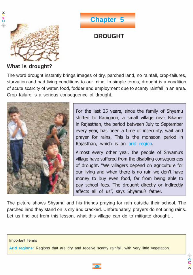
For the last 25 years, since the family of Shyamu
shifted to Ramgaon, a small village near Bikaner
in Rajasthan, the period between July to September
every year, has been a time of insecurity, wait and
prayer for rains. This is the monsoon period in
Rajasthan, which is an arid region.
Almost every other year, the people of Shyamu’s
village have suffered from the disabling consequences
of drought. “We villagers depend on agriculture for
our living and when there is no rain we don’t have
money to buy even food, far from being able to
pay school fees. The drought directly or indirectly
affects all of us”, says Shyamu’s father.
The picture shows Shyamu and his friends praying for rain outside their school. Theparched land they stand on is dry and cracked. Unfortunately, prayers do not bring rains.Let us find out from this lesson, what this village can do to mitigate drought….
Important Terms
Arid regions: Regions that are dry and receive scanty rainfall, with very little vegetation.
Chapter 5
40
Drought can lead to an acute shortage of drinking water and water for normal domesticneeds, caused by deficiency in surface and sub-surface water. This is because scantyrainfall during drought is insufficient to recharge tanks and wells or underground watersources. There is also an acute shortage of water for agricultural operations, includingthe lack of moisture in soil to grow crops, affecting production. Hence lesser personswould be hired in the farms, leading to unemployment.
Are we all vulnerable to drought, like Shyamu?
Drought is one of the most widespread disasters that India faces, affecting more than70% of cultivable land. Often, people do not react to drought like they do to other suddendisasters such as earthquakes, cyclones and floods, since drought conditions developover a period of time, and without immediately perceptible changes to our environment.Hence, drought is called a ‘slow onset’ disaster.
West Rajasthan and the Kutchareas of Gujarat are chronicdrought affected areas.

41
The western belt including major parts of Rajasthan and Gujarat face frequent droughtbecause of weak monsoons as well as degraded environment.
Among other prominent pockets of drought-prone areas figure Western Orissa andRayalaseema & Telangana areas of Andhra Pradesh., Chattisgarh, Jharkhand, CentralMaharashtra, Interior Karnataka, West Bengal, parts of Tamil Nadu and even water richstates like Punjab, Haryana, Bihar and Uttar Pradesh also experience drought due toinsufficient rainfall in certain areas.
In India, 191 districts out of 543 are severely drought prone. In areas that experiencedrought frequently, the people are more vulnerable to its devastating effects. Twoconsecutive years of drought means a higher degree of vulnerability in the second year.In 2003, most parts of Rajasthan is said to be experiencing the fourth consecutive yearof drought.
Also, certain sections of population living in drought-prone areas are more vulnerablethan others. Usually, these sections are people living in rural areas, who depend onagriculture and animal husbandry entirely for a living, or tribals who depend upon forestproduce.
Indirect aggravators of Drought?
We have learnt that prolonged scanty rainfallcauses drought. In some areas, however, theeffects of drought are magnified by otherreasons:
Environmental Degradation, especially the lossof green cover affects rainfall received in theregion, increasing the possibility of water stress.In areas where vegetation has decreased overthe years, rainwater is easily washed away into
What causes Environmental
Degradation?
� Cutting down trees
� Soil Erosion
� Excessive use of ground or
surface water
� Loss of biodiversity
� Global Warming
Important Terms:
Water-stress: Water stress occurs when the demand for water exceeds the available amount duringa certain period or when poor quality restricts its use, and stress causes deterioration of fresh waterresources
rivers and the sea, and not retained by the soil, leading to low productivity. Over exploitationof water depletes the source faster than rainfall could recharge it, especially in areasthat receive scanty rainfall.

42
How does drought affect us?
We have learnt that drought results in acute shortage of water, fodder, food andemployment. It affects us in different ways.
Drought affects Farmers: It causes loss of crops, lack of fodder and water to feedtheir cattle
Drought affects Poor Families: Constant drought reduces agricultural production. Thisleads to insufficient availability or supply of crops in the market. We learn in economics,that when demand is more than supply, the prices increase. Food-grains become costly,and poor people suffer because of inadequate purchasing power.
Drought affects Women: Even today, especially in rural India, women don’t have thesame status as men in society. This means that they are not given their fair sharein access to nutritious food, good living conditions, education, health, etc. In a droughtsituation, when there is a dearth of food, women who are usually the last to eat athome, eat the least, and hence suffer from malnutrition. Drought also increases theirwork burden, since they have to work longer to earn the same wages, and often travellonger to fetch water, fodder and fuel-wood.
It affects people living in desert land: They depend more on animal husbandry thanon agriculture. Severe scarcity of fodder and water and degradation of vegetation leadsto their dependence on assistance from outside, in some areas.
It affects employment: A fall in agricultural production leads to a fall in employmentopportunities for rural people who depend on agricultural labour for a living. It alsocauses people to migrate to other places in search of employment. These are called‘distress migrations’.
Drought affects Children also: Lack of nutritious food in drought affected areas resultsin malnutrition, which makes them more prone to various infections and diseases. Itaffects their health and education, since migrations take them away from school andhealth camps that also provide vaccinations. School-dropouts most often become wageearners, leading to higher child-labour.
Do you know?
Non-availability of moisture over most parts of the year, makes 68 per cent of the
land vulnerable to drought in India. In 2001, more than eight states suffered the
impact of severe drought. Find out how many states are afflicted by drought conditions
this year… and mark them on a map of India.

43
Coping with Drought….
We have learnt that drought is a slow onset disaster, and hence gives us ample timefor mitigation, preparedness and response, unlike sudden disasters.
We know that drought is a result of multiple causes, the main indicator and cause beingabnormally low rainfall. The Indian Meteorological Department tells us the duration andquantity of rainfall expected every season, but this being a natural phenomena, is beyondour control. We can however make planned efforts to conserve natural resources, andprevent misuse of land and water.
Fact:
There is over 100 million
hectares of degraded land in
the country. Protecting,
regenerating and restoring
degraded land can reduce the
pressure of population on
cultivated land and keep
forests and pastures safe to
supply fodder for the animals.
Hence, while we cannot prevent drought, we can certainly reduce its intensity and impactthrough individual and collective actions. It is important to remember that any steps takento mitigate or prepare for drought have to be sustained for a long period of time, andmust involve a cross-section of people such as community, Panchayat representatives,volunteers, government functionaries, teachers and students. Let us now see how wecan help.
Important Terms:
1. Degraded land: where crop yield is reduced due to various reasons such as pollution of topsoil, soil-erosion, over exploitation, cropping patterns, etc.

44
Long- term Drought Mitigation Strategies
� Construction of Community Based Rain Water Harvesting Structures
� Promoting Watershed Programmes
� Increasing Forest cover through plantations
� Adopting drought resistant varieties of paddy and other crops
� Using alternative crops in drought conditions
� Capacity building of communities in Drought Management and introducing
livelihood options besides agriculture and animal husbandry which are water
intensive
� Encouraging crop and Seed insurance schemes
What can we students do?
1. Conserve water: Prevent misuse and wastage of water, and encourage recyclingof water. Set up a Water Management Committee in your school and take turnsto be members. Can you list three ways of recycling domestic water? (In cities,using water from a washing machine to wash your home and car is an example.In rural areas, directing water from the wash area to the fields or garden isanother)
2. Harvest Rain water at home and in schools: Find out how you can collect rainwater and store it, or use it to recharge a well, bore-well source or sump. Canyou use your school as a model for roof-top rain water harvesting in your area?
3. Plant trees and care for them: Carry out campaigns for plantations. Find outthe right trees for your area. This information will be available with the horticulture,forest or agriculture department or VAW if in rural areas. E.g. Eucalyptus treesmust never be planted in dry areas, since they absorb all the water around them
Important Terms:
1. VAW : Village Agricultural Worker, responsible for disseminating information on crops, irrigation,pest-control, etc

45
ACTIVITIES
4. Create Awareness:
� Find out about the various Government Schemes meant to help peoplein drought-affected areas, and help your village or area to understandhow to make use them. Take the help of your teachers to contactGovernment functionaries to find out what are the right crops to growin your area, and what alternative crops can be grown in droughtconditions. Also try and list what alternative employment or livelihoodspeople can seek when drought disables their normal living. Make chartsto display this information in prominent places
� Make charts to disseminate information on water conservation andharvesting. Also create awareness on important Do-s and Don’t-s beforeand during drought.
5. Help your DMT: We are now familiar with the DMT. Find out if there isa DMT in your village or area. Ask if a Community Contingency Plan fordrought exists. Ask how you can help the various task forces. Does it usean early warning system?
6. Make a chart to show important Don’t-s in drought prone areas. Add tothe list below:
Don’t
� Misuse or waste precious water
� Destroy natural vegetation such as forests, pastures, trees, etc
� Overgraze domestic animals
� Grow water-loving plants in water scarce areas
� Promote monoculture, and encourage mixed cropping

46
Historically, conservation of water has been a traditional practise inIndia…..
In the western and central Himalayas,diversion channels – ‘guhls’ were builtto draw water from hill streams orsprings. The length of these channelsvaried from 1 to 15 km, and carried adischarge of 15 to 100 litres per second.
In Meghalaya, bamboo pipes are usedto tap spring water for irrigation, whichfinally reduces to 20 - 80 drops perminute at the site of the plant, functioninglike a drip irrigation system.
The ‘ahar – pyne’ system of irrigationis prevalent in south Bihar. Ahars arerectangular catchment basins, and pynesare channels built to utilise the waterflowing from the seasonal streams.
‘Kunds’ in the Thar desert, are coveredunderground tanks with an artificiallyprepared catchment area to improverun-off. The structure is shaped like abowl with a lid
In the Malabar area, a ‘Surangam’ isa tunnel dug through a laterite hillock,from which water seeps out and collects.
Do you know if there are any traditionalmethods of water conservation in yourvillage or area?

47
Can we now list out what Shyamu’s village and other drought-affected people in Indiacan do to mitigate the effects of drought?
We have learnt that while the natural causes of drought cannot be controlled, the impactof its effects on our lives, livelihoods and environment can certainly be reduced. “…..ifcare is taken and conservation becomes our way of life, even the desert can bloom.In future the needs of our country will be met and once again we can look forward toeconomic development for all. Being prepared and knowing what to do is necessary andeach one of us can play a very important role in helping...”
M. S. Swaminathan, Eminent Agricultural Scientist
How much water can we conserve at home?
Do a simple calculation to find out:
The amount of water that you can conserve depends on the area of your roof and theamount of rainfall that your area receives on an average. Thus the amount of wateryou can conserve can be calculated using the following formula:
Volume of water (V) = Area of House (A) x Amount of rainfall (R) x
Efficiency factor (f)
The efficiency factor (f) denotes the efficiency of rainwater collection in your house (itis a % always less than 100%).
Thus for a house of 200 square metres roof area, and average rainfall of 70 cm andan efficiency factor of 50%, the volume of water that you can collect is
V =A x R x f
= 200m2 x 0.7m x 50% = 70 m3 which is 70,000 litres of water.
If N is the number of members of the family, and w the amount of water needed perperson, then the total water needed by the family in a day is
W = N x w
If we assume that each person needs 100 litres a day (try and calculate how much wateryou consume in a day), and we assume that the family has 5 members, they need 500litres per day.
48
Now we can calculate the number of days of water supply this family can enjoy fromharvested rainwater as
D = V/W
=70,000 (litres) / 500 (litres/day) = 140 days
So this family can use rainwater conserved at 50% efficiency for their household needsfor 140 days in the year, which is more than 4 months of the year!
For your family:
A : Roof area to drain rainwater = _______ m2
R : Average rainfall/year for your area = _______ cm
f : Efficiency Factor = _______ %
V=A x R x f
N :Members of the family = _______persons
w :Amount of water needed per person = _______litres
W: Total water needs of your family/day =_______ litres (N persons*w litres)
D = V/W
Important Terms:
1. Discharge: the volume of water that passes a given location within a given period of time.Usually expressed in cubic feet per second.
2. Drip-irrigation: a common irrigation method where pipes or tubes filled with water slowly driponto crops. Drip irrigation is a low-pressure method of irrigation and less water is lost toevaporation than high-pressure spray irrigation.
3. Run-off: Runoff is water flow in the topsoil layer. Runoff reaches water bodies after it fallsas rain and is discharged from the area
4. Laterite: A kind of soil or rock that water can percolate through. The water carrying capacityof laterite is very low, and hence is unsuitable for cultivation of major crops.
5. Monoculture: The use of land for growing only one type of plant. The practice of monocultureon a landscape has an effect that is the opposite of biodiversity, and can sometimes beresponsible for the spread of plant diseases
6. Aquifer: a geologic formation that is water bearing, that stores and/or transmits water, suchas to wells and springs. These water-bearing formations are capable of yielding water in sufficientquantity to constitute a usable supply for people.

49
EXERCISES
1. Choose the right answer to the following questions
I. The greatest amount of fresh water on the Earth is found in:____________a. theoceans
b. ice caps and glaciers
c. aquifers
d. surface water
II. Groundwater is: ____________
a. not usable because it is dirty
b. another name for watershed
c. too far beneath the Earth’s surface to be used
d. another name for an aquifer
III. Surface water: ____________
a. is used to produce electricity
b. can be easily contaminated
c. can be used for recreation
d. all of the above
2. How does drought affect our lives?
3. List ways to conserve water in day to day use.
4. What actions will help us to mitigate drought, individually as well as collectively?
5. What do you understand by rainwater harvesting?

50
Manmade Disasters - An Overview
We have so far discussed possible disasters that can result from natural hazards. Wehave also seen how human actions in some cases aggravate the disastrous effects ofnatural hazards. For instance, improper constructions can increase vulnerabilities toearthquakes in seismic zones where earthquakes are more probable. In drought proneareas, wastage of water, or environmental degradation by human actions can magnifydrought conditions.
But disasters can also be manmade, as mentioned in the introduction to this book. Forinstance, rail, road or air accidents are manmade disasters. The threat of serious disasterlooms large from the possible use of weapons such as nuclear bombs or the atom bombthat was dropped over Japan during World War II. These weapons are commonly calledWeapons of Mass Destruction (WMD), which lead to the breakdown and collapse of social,political and economic systems that sustain communities. Inevitably agriculture and foodproduction are major casualties.
Man-made disasters cost the most in terms of human suffering, loss of life and long-term damage to a country’s economy and productive capacity.
Let us now look at the various types of manmade disasters briefly:
WMD
WMD can be broadly classified into three categories – as those that facilitate nuclear,biological and chemical warfare.
Chapter 6

51
On August 6, 1945, an American B-29 bomber,
the “Enola Gay” dropped an 8,900-pound atomic
weapon over the city of Hiroshima Two thousand
feet above the ground, the bomb, dubbed “Little
Boy” detonated, instantly leveling almost 90% of
the city. The destruction was incredible. More
than 10 square kilometers of the city were
instantly and completely devastated; a City center
was literally vaporized. The ensuing fireball spread
and engulfed many more kilometers of the City
in fire. 66,000 people were killed, and 69,000
injured
On August 9, another plane dropped a larger
bomb, code-named “Fat Man” over Nagasaki.
Local geography spared Nagasaki from the
near total devastation suffered by Hiroshima;
but one third of the city was destroyed. It killed
39,000 persons, injuring 25,000 more.
With the advancement of scientific research in theworld, several countries have acquired thetechnology to produce Nuclear Arms, which aremore destructive and harmful than the atom bombused more than half a century ago. There is alsoa risk of accidental exposure to harmful radiationfrom the several nuclear reactors that are used forgeneration of power. Theft of nuclear material canenable the creation of crude bombs commonlyknown as ‘dirty bombs’ which can be used by anti-social elements or terrorists.
A young girl who was evacuated from Hiroshima a few days before the explosion said– “Suddenly
I felt something warm on my left cheek and turned back. It seemed like a strong reflection from
a mirror. Then a roaring sound shook the whole village. While I was wondering what had happened,
a column of clouds appeared above the mountains in the south in a bright pink colour. Gradually
it assumed the shape of a mushroom and rose to the sky. I felt something unusual had happened.
However, I didn’t ever imagine that the huge city of Hiroshima had instantaneously become a sheet
of fire.” She lost her parents in the incident.
The cloud caused by the atomicexplosion over Hiroshima
The famous mushroom cloudover Nagasaki caused by
atomic explosion

52
How can we protect ourselves from nuclear radiation and attacks?
� Don’t panic in the event of a nuclear attack or accident. Common indicators ofradioactivity are nausea, dizziness, vomiting and disorientation, with no odour buta wave of heat. A nuclear explosion is followed by a ‘blast’ like the mushroomcloud in the picture above, which can cause instant blindness if viewed.
� Close all doors and windows, and stay indoors till further communication from theGovernment. Radioactivity does not penetrate solid structures, though fire maycause damage to buildings.
Activity
� Find out how Potassium Iodate tablets can be used to counter exposure toradioactivity.
Chemical Disasters
Chemical Disasters are caused by industrial accidents, irresponsible handling ofhazardous chemicals, or by their deliberate use for destruction. Poisonous gases cancause wide spread devastation because of their nature: they spread easily, and affectlarge areas. Chemical WMD are relatively easy to manufacture using simple chemicalprocesses, and chemical agents are easily available. Further, they are difficult to detectsince chemical WMD are colourless and odourless
‘An alarm call to mankind’… The Bhopal Gas Tragedy of December 1984
The Bhopal Gas Tragedy is a catastrophe that has no parallel in industrial history. In
the early hours of December 3, 1984 a rolling wind carried a poisonous gray cloud
past the Union Carbide Plant in Bhopal, Madhya Pradesh. Forty tons of Methyl Isocyanate
(MIC) spread throughout the sleeping city. An estimated 2500 people died, people whose
hopes and dreams were ironically bound with the technology and affluence the plant
symbolised. About 300,000 suffered from agonising injuries from the disastrous effects
of the massive poisoning
Residents awoke to clouds of suffocating gas and began a desperate flight through
the dark streets. No alarm ever sounded a warning and no evacuation plan was prepared.
When victims arrived at hospitals breathless and blind, doctors did not know how to
treat them since emergency information on antidotes was not available.

53
ACTIVITY:
How can we prevent and prepare for chemical disasters?
1. Find out what industries exist close to your city or village, and whether anyof the chemicals they use are hazardous.
2. Find out whether an emergency plan is in place to deal with industrialaccidents, and what antidotes can be used in case of poisoning of people,animals, water sources, etc.
3. Find out whether your local medical association is aware of how to treatpatients suffering from exposure to these chemicals
4. Make a report of your findings and take the help of your teacher to informsuitable authorities such as the District Magistrate, Block or Taluka DevelopmentOfficer, or Municipal Corporation as well as the closest PHC
5. Make a chart of simple Do-s and Don’t-s in the event of a chemical disasterbased upon information gathered from the industry
Do you know
1 That the first symptoms of a possible chemical leakage are irritation,
burning and redness in the nostrils and eyes, followed by nausea, dizziness
and disorientation? Pungent or bitter-sweet smells indicate the presence
of a gas in the air
2 That panic induced fleeing during a gas leakage is harmful? Stay calm,
in the same place, put a wet cloth on your face and breath through it.
Most gases will dissolve in water.
3 Lying down close to the ground may help, since most hazardous gases are
lighter than air, and will tend to rise upwards.

54
Biological Disasters
Monday, 22 October, 2001, 20:57 GMT 21:57 UK
Anthrax ‘likely’ in US postal deaths
Two postal workers in Washington DC who
died from unexplained causes were “likely”
to be infected with anthrax, US officials said.
Their bodies are being tested for anthrax
symptoms amid circumstances described by
health officials as “highly suspicious”. The
revelation came as US authorities confirmed
that a second postal worker in the city had
tested positive for anthrax infection, bringing
the number of cases of infection nationwide
to 10. The new victim had the more serious
inhaled form of the disease. Of the cases
of anthrax that have now been identified in
the US, six are skin anthrax and four are
inhaled anthrax. One man, an employee of
a tabloid newspaper in Florida, died as a
result of anthrax inhalation.
A Postal worker in India with a package fromthe US during the anthrax scare of 2001
Source: BBC News Service
Biological weapons are referred to as a “poor man’s nuclear bomb” because they areeasy to manufacture, can be deployed without sophisticated delivery systems, and havethe ability to kill or injure hundreds of thousands of people. Simple devices such as cropdusting airplanes or small perfume atomizers are effective delivery systems for biologicalagents. In contrast to chemical, conventional, and nuclear weapons that generateimmediate effects, biological agents are generally associated with a delay in the onsetof illness (hours to days). Moreover, illnesses from biological weapons are not likely tobe recognized in their initial stages. With highly transmissible agents (eg, plague andsmallpox), the time delay in recognition can result in widespread secondary exposureto others, including doctors and health staff.
Do you know
� That 100 gms. of Anthrax released over a major city may cause up
to 3 million casualties

55
How do we protect ourselves from Biological WMD?
DO-S and Don’t-s for Biological Disasters:
1. � ���������� ������ �� ���
������� �� ����� �� �����
���������� ����������. ���
����� ���� �� �������, �����
������� � ��� �� ��� ���� �� ��
����� �� ���� ��� ����. ����
���������� ������ ��� �����
���������� ��������, ������ ��
���.
2. � ���������� ������ ��� ��
��� ��� �� �����������
�������. ����� �� �� ��������
���� ��� ���� ��� ����� �� �
���������� ������ �� �� �������
���� ������ ���� ����� ������
���� ������� ���� ������ �
������� �� ������� �������.
3. ��� ���� �������� ����� ��
��� ������ ������� ��
��������� ����� �� ��
���������. �� ����� �����, �
����������� �� ����� �������
���� �� ���� ��� � �������
�������, ��� �� ���� �� ����
���.
4. �� ��� ������ ����� �� ��
������� �� ���������� ������� ��
�� ������� ��������� ������,
�� ������� ���� �� �������
��������.
5. ��� ���� ���� ���
��������� �� ������� ��
��������.
6. ����� ���� ����� ��� ����
���� ������ �� ������ ���� ���
������ ��� ��� ��� ����� �����
���������.
ACTIVITY:
Can you organize a mock drill in your class for the various manmade disasters, to see how you willprepare and respond to them?

56
EXERCISES1. What causes manmade disasters?
2. How do manmade disasters affect us?
3. How would you protect yourself and your family in the case of a nuclear, disaster?
4. What simple Do-s and Don’t-s can you list in case of a biological disaster?
5. How would you recognize the presence of a poisonous gas in the air? Whatprecautions would you take to protect yourself and your family against its harmfuleffects?
6. Describe how you would help people involved in a road accident in yourneighborhood.
Accidental Disasters
A large number of railroad accidents take place in India. Every other day, people getinjured or die in small accidents. Larger railway accidents including collisions andderailments cause huge losses to life and inflict injuries and disabilities to many more.
“We saw railway coaches piled up like a multi-storey building. The one on top was burning.”
- A volunteer at the Gaisal Tragedy ofAugust 1999 in West Bengal.
Various studies being done to analyse theoccurrence of various kinds of disasters are showing that fire accidents are very largein number in India. Moreover, the studies also show that the amount of damage fromfire hazards over a period of time has often been more than the damage caused bynatural hazards such as cyclones or floods. From the nearest fire station, find out whatare the simple Do-s and Don’t-s that you can follow and create awareness on, to reducefire accidents, and respond effectively to them.
The Railway Accident at Gaisal, 1999
Activity:
Organise a Traffic Safety Week in
your school with the help of your
teachers. Ask your local authorities
how you can create awareness
among commuters.