manual navitelnavigator 9 eng
TRANSCRIPT

8/15/2019 Manual NavitelNavigator 9 ENG
http://slidepdf.com/reader/full/manual-navitelnavigator-9-eng 1/27

8/15/2019 Manual NavitelNavigator 9 ENG
http://slidepdf.com/reader/full/manual-navitelnavigator-9-eng 2/27
2
User Guide - Navitel Navigator
Contents
Get startedRecommendations 3Safety Requirements 3
Program Interface 4Map Installation 5Map Update 5
Your RouteCreate route 6Edit route 7Quick search 8Map screen 9Route plan 10Export Route 10Import Route 10Waypoints 10
SettingsMap 11User Maps 12Navigation 13Interface 14
POI Filter 15Online services 16
Alerts 17Regional Settings 18System 19Dashboard 21Profles 21Tracks 22
My NavitelPurchase Maps 23Download Maps 23Updates 23Restore 23News 23Help 23
ExtrasMap 24Satellites 25Weather 26

8/15/2019 Manual NavitelNavigator 9 ENG
http://slidepdf.com/reader/full/manual-navitelnavigator-9-eng 3/27

8/15/2019 Manual NavitelNavigator 9 ENG
http://slidepdf.com/reader/full/manual-navitelnavigator-9-eng 4/27
4
User Guide - Navitel Navigator
1 Toolbar When the map screen is active, the toolbar is displayed in the very top of the screen,containing a number of icons. Some icons on the toolbar may change their lookdepending on the current status of the function that they represent. It is possible tochange the s et of icons to be displayed on the toolbar. More details you can nd in theMap buttons chapter of the guide.
Note that the number of icons displayed on the toolbar can vary depending on thescreen orientation of your device.
2 Point on the map Short tapping on the map marks the point for further operations wi th it, namel y,reveals the Cursor and Save WP buttons. For more details, see chapter Map screen.
3 POI This is an example of how points of interest (POI) are displayed in the program.Different categories of POI have different icons, as well as there is a vast variety oficons for speci c points of interest, such as shopping centers, brand shops, gasstations etc. It is possible to de ne which POI should be displayed or hidden on themap. To l earn more about how to work with POI in Navitel Navigator, please go to thePOI Filter chapter.
4 SPEEDCAM This is an example of how icons of the SPEEDCAM function are displayed onthe map. Speedcams are the data about speed cameras, radars, dangerouscrossroads, speed bumps, and other types of potential obstacles on theroad. To learn more about how to work with speedcams, read the Alerts chapter.
5 Event The sign of a road event marked by other users of the Navitel.Events service.
6 Map buttons These are the buttons for controlling the map view types (2D/3D) and map scaling. Itis possible to hide these buttons from the map. To learn more about that, please seethe Interface chapter.
7 Main menu Tapping this button will open the main menu of the program.
Program InterfaceThe gures below represent main elements of the interface. Their description is provided in the table below. Thedevice in the pictures is shown only as an example. The model of the user’s device and orientation of the screenmay differ from those shown on the picture.
1 2
7
3 4 5 6
8 9
1110
14 15
12 13
16 17

8/15/2019 Manual NavitelNavigator 9 ENG
http://slidepdf.com/reader/full/manual-navitelnavigator-9-eng 5/27
5
User Guide - Navitel Navigator
8 Cursor This button becomes available only when a point is selected on the map. Tappingthis button will open the My route screen, where you can carry out various oper ation with the selected point. To learn how to work with the My route screen, see the Mapscreen chapter.
9 Save WP This button becomes available only when a point is selected on the map. Tapping thisbutton will cause the selected point to be saved in the form of a waypoint. To learn
more about waypoints, please read the Waypoints chapter.10 Upcoming
maneuverThe indication of the distance to the next two upcoming maneuv ers. Tappi ng the signopens a dialog box with a number of con guration settings (see Edit route).
11 Progress bar This bar indicates the elapsed and the remaining part of the route.
12 Route Active route. If the traf c information is on, the route is colored in different colors,which correspond to different traf c density level s. Otherwise, t he route is always blue(for more information about the service, see the Navitel.Traf c page on our website).
13 Street aftermaneuver
The name of a street following the maneuver. Please note that if certain conditionsare met, there will be displayed the upcoming traf c lanes instead of street after
maneuver panel. The upcoming traf c lanes are displayed only before crossroadsand when not all traf c lanes can be used to pass the crossroad.
14 Speed Your current speed.
15 Information panel By default, displays a set of gauges that provide information on remaining traveltime, distance to the point of destination, and estimated arrival time. It is possibleto change the selection of gauges. To learn more about gauges and how to changethem, read the Dashboard chapter.
16 GPS cursor Indicates the current position of the device when the GPS receiver is turned on.
17 Current street The name of the current street (active only when connection with satellites isestablished). If the map does not contain information about the active street name,the direction of movement is displayed instead (North, South, West, and East).
Map InstallationBefore you begin work with the program, you need to acquire the maps for your region:
1 Select > My Navitel > Purchase maps .
2 In the opened window, select the map you need and then purchase the map (see details ).
3 Select > My Navitel > Download maps .4 In the opened window, select the purchased map from the list and then tap Download .
5 After the map is downloaded, tap Install .
Map UpdateIn order to update the maps, complete the following steps:
1 Select > My Navitel > Download maps .
2 From the list of categories, select the map that you want to update and then tap Update .

8/15/2019 Manual NavitelNavigator 9 ENG
http://slidepdf.com/reader/full/manual-navitelnavigator-9-eng 6/27
6
User Guide - Navitel Navigator
Your RouteThis section of the guide contains information on how to create or edit routes in the program and explainsother possibilities of working with routes.
Create route
To plan a route from your current position up to a speci c destination point, follow the steps:
1 Select > Route > Create route .
2 In the Find window, select one of the search options:
By address
Search of a point by using its address
Nearest placesSearch of a point nearby a speci c place
FriendsSearch of a point by the location of a friend
WaypointsSearch of a point among the waypoints
HistorySearch of a point from the history list
FavoritesSearch of a point among the most visited addresses or POIs
By coordinatesSearch of a point by coordinates
On the mapSearch of a point manually, the map search
3 Tap the point to which you would like to plan the route by tapping it.The My route page opens.
4 In the bottom-left corner of the display, tap Go!The route is planned from your position to the given point.
Alternatively, tap the address eld of the selected point in order to open the Properties page, where you canselect other options for working with the point, such as:
Make sure the GPS is turned on before following the steps below.
If you have selected the By coordinates or By address search option, after entering the correspondingdata, in the top-right corner of the screen, tap the Result button. If you have selected the Nearest places search option, rst you will be suggested to select a reference point and then a category of the soughtpoint. After you have nished this, a list of nearest places in regard to the reference point and the selectedPOI category will be displayed.

8/15/2019 Manual NavitelNavigator 9 ENG
http://slidepdf.com/reader/full/manual-navitelnavigator-9-eng 7/27
7
User Guide - Navitel Navigator
• Set startThe selected point becomes the starting point of the route. Please note that to set up the starting pointmanually, you do not need the GPS connection. Thus, the program will request you to turn the GPS receiveroff.
• Route through (with an existing route) Add of the selected point to the route.
• Set fnish (with an existing route)Setting the selected point as the destination point of the route.
The Properties screen also contains more detailed information about the selected point, for example,coordinates of the point, the exact address data, distance from this point to your location, and any otheravailable information.
Edit routeIf you want to change your route, please use one of the two methods described in this chapter.
With the help of the upcoming maneuver (when there is an existing route):1 In the top-left corner of the map, tap the sign of the upcoming maneuver .
The Route dialog box opens.
2 In the newly opened dialog box, select the appropriate option:
Stop Route GuidanceDeleting the route. If the Demo Route is active, you will see the Stop Demo button instead
AvoidPlan a new route saving all the route through points
Demo routeBegin the simulation movement along the route you have planned
Go Next Via PointDeletion of the next route point
Show route Adjusting the map scale so that the entire route is visible on the map
SettingsDisplay of the Navigation screen
CancelClosing the dialog box
With the help of the program menu:
1 Select > Route > Edit route .
2 In the Find menu, select the suitable search option.
3 Select the point to which you would like to plan the route by tapping it.The My route page opens.

8/15/2019 Manual NavitelNavigator 9 ENG
http://slidepdf.com/reader/full/manual-navitelnavigator-9-eng 8/27
8
User Guide - Navitel Navigator
4 In the bottom-left corner of the display tap Go!
The route is planned from your position to the given point.Alternatively, tap the address eld of the selected point in order to open the Properties page, where you canselect other options for working with the point, such as:
• Set startThe selected point becomes the starting point of the route. Please note that to set up the starting pointmanually, you do not need the GPS connection. Thus, the program will request you to turn the GPS receiveroff.
• Route through (with an existing route) Add of the selected point to the route.
• Set fnish (with an existing route)Setting the selected point as the destination point of the route.
The Properties screen also contains more detailed information about the selected point, for example,coordinates of the point, the exact address data, distance from this point to your location, as well as anyavailable information.
Quick searchLearn to create or edit your route with the help of the quick search function:
1 Select > Find .
2 In the Find window, select the suitable search option.
3 Select the point to which you would like to lay the route by tapping it.The My route page opens.
4 In the bottom-left corner of the display tap Go!The route is planned from your position to the given point.
Alternatively, tap the address eld of the selected point in order to open the Properties page, where you canselect other options for working with the point, such as:
• Set startThe selected point becomes the starting point of the route. Please note that to set up the starting pointmanually, you do not need the GPS connection. Thus, the program will request you to turn the GPS receiveroff.
• Route through (with an existing route) Add of the selected point to the route.
• Set fnish (with an existing route)Setting the selected point as the destination point of the route.
If you have selected the By coordinates or By address search option, after entering the correspondingdata, in the top-right corner of the screen, tap the Result button. If you have selected the Nearest placessearch option, rst you will be suggested to select a reference point and then a category of the soughtpoint. After you have nished this, a list of nearest places in regard to the reference point and the selectedPOI category will be displayed.
If you have selected the By coordinates or By address search option, after entering the correspondingdata, in the top-right corner of the screen, tap the Result button. If you have selected the Nearest placessearch option, rst you will be suggested to select a reference point and then a category of the soughtpoint. After you have nished this, a list of nearest places in regard to the reference point and the selectedPOI category will be displayed.

8/15/2019 Manual NavitelNavigator 9 ENG
http://slidepdf.com/reader/full/manual-navitelnavigator-9-eng 9/27
9
User Guide - Navitel Navigator
The Properties screen also contains more detailed information about the selected point, for example,coordinates of the point, the exact address data, distance from this point to your location, as well as anyavailable information.
Map screenIn order to plan or edit the route by using the map, follow these steps:
1 On the Map screen, select a place or a POI, which you want to add to your route.
2 On the information panel, in the bottom part of the screen, tap the Cursor button.The My Route screen opens.
3 In the bottom-left corner of the display tap Go!The route is laid from your position to the given point.
Alternatively, tap the address eld of the selected point in order to open the Properties page, where you canselect other options for working with the point, such as:
• Set start
The selected point becomes the starting point of the route. Please note that to set up the starting pointmanually, you do not need the GPS connection. Thus, the program will request you to turn the GPS receiveroff.
• Route through (with an existing route) Add of the selected point to the route.
• Set fnish (with an existing route)Setting the selected point as the destination point of the route.
The Properties screen also contains more detailed information about the selected point, for example,coordinates of the point, the exact address data, distance from this point to your location, as well as anyavailable information.

8/15/2019 Manual NavitelNavigator 9 ENG
http://slidepdf.com/reader/full/manual-navitelnavigator-9-eng 10/27
10
User Guide - Navitel Navigator
Export RouteTo export a created route to another device:
1 Select > Route > Export .
2 Select the directory, to which you would like to save the route le, and then indicate the type of the le.
3 Type a name to the le of the route.
4 Tap .The route le will be created in the selected folder.
5 Copy the route le to another device.
Import RouteTo import a route:
1 Select > Route > Import .
2 Select the le directory, where the route le is stored, and then select the type of the le.
3 Tap .
Waypoints
To create a waypoint:
1 Mark a point on the map by either selecting a place on the map or nding a place using one of the availablesearch options.
2 Tap Save WP in the bottom right corner of the screen.3 In the Waypoint window, assign a name to the point, ll in the description, and specify its type. If the name
of a point is not set, the program will assign a three-digit number to it.
In Navitel Navigator it is possible to save coordinates or an address of a particular place in the form of a waypoint.Waypoints are marked on the map with a special icon and can be used for quick route planning. To plan a routeusing a waypoint, select the appropriate point from the Waypoints category of the Search function.
It is also possible to create a waypoint using the program menu. To do that, follow these steps:
Although the imported route contains all route points of the original one, it may differ from it due toapparent disperancies in map versions or traf c information.
Route planTo open information about upcoming maneuvers along your route, select > Route > Route plan.The Route screen containing the detailed information about all the maneuvers along the road opens.
To create a waypoint:
1 Select > Find > Waypoint.
2 In the newly opened window, in the bottom left corner of the screen, press the Add waypoint button.
3 Fill out the necessary text elds.Please note that the coordinates of your current position will be assigned to the waypoint created thisway. In case coordinates cannot be determined, the coordinates of the cursor’s position will be usedinstead. It is possible to input your own coordinates by typing them or pasting from the clipboard.

8/15/2019 Manual NavitelNavigator 9 ENG
http://slidepdf.com/reader/full/manual-navitelnavigator-9-eng 11/27
11
User Guide - Navitel Navigator
SettingsThis part of the instruction explains the use of all possible settings and program con gurations. All functions aredescribed in the order of their appearance in the interface of the program.
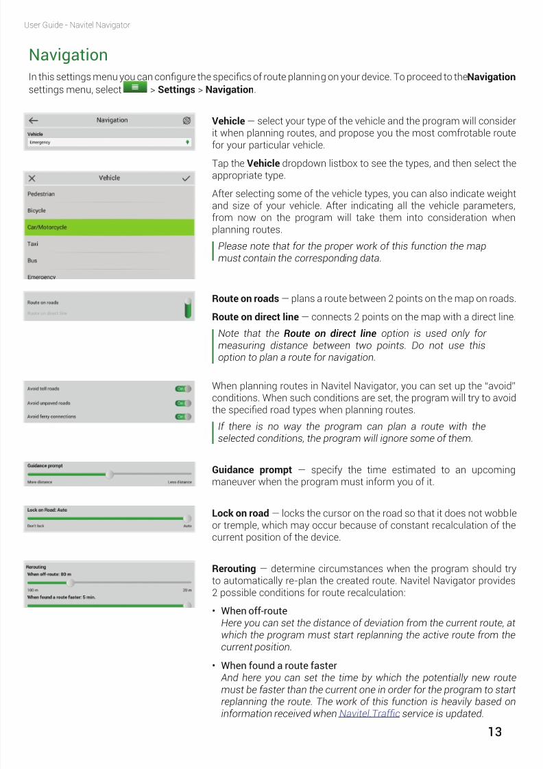
MapNavitel Navigator allows you to easily customize the settings of map display. In order to proceed to the mapcon guration menu, select > Settings > Map . In this menu, you will nd a number of settings that can helpyou to change the properties of the map display.
Map’s north is on top — applies the north-oriented map view.
Rotate map with movement — applies the movement directionoriented map view.
Same options are available on the toolbar by tapping the Compassicon.
Automatic Zoom — enables automatic map scaling during routefollowing. The parameters for automatic scaling adjustment are:
• Used scalesDe ning the range within which the automatic zooming will bescaled.
• Preferred zoomThis con guration allows setting up the preferred zooming scale
value, so that the program will always attempt to t the automaticzoom within the range of this value.
Navitel Navigator allows you to con gure a number of visual settings.Please note that use of visual effects may increase time spent on maprendering.
Draw models from — enables setting of the minimum map scale atwhich the 3D models must be displayed.
Map tilt — sets the map tilt parameters. Minimum tilt makes the maplook more like a 2D map, whereas at greater tilt the 3D elements of themap are more prominent.
Reset position — enables automated return back to your originalposition after you move the map elsewhere. You can set up the timethat has to pass after your last action before the map position is reset.The minimal time is 5 seconds or Never , the maximum time is 20seconds .
When the map is moved away from your position, a special icon willappear on the map, which you can tap to move the map back to yourposition.

8/15/2019 Manual NavitelNavigator 9 ENG
http://slidepdf.com/reader/full/manual-navitelnavigator-9-eng 12/27
12
User Guide - Navitel Navigator
Draw passed route — displays the passed part of the route on the mapin the form of a transparent line.
Show two following maneuvers — displays 2 following maneuversinsead of only one on the upcoming maneuver sign .
User MapsThe map you work with in Navitel Navigator represents a set of maps that you have previously acquired andactivated combined into a le referred to as Atlas . You can create atlases with different sets of maps. Only oneatlas can be active at a time.
To create a new atlas, complete these steps:
1 Make sure the application on your device is not running.
2Connect the device to your PC.
3 Create a folder on your device.Be aware that certain OS may restrict the program from accessingsome folders on your device, for example system folders. Theprocess of access acquisition may differ for different OS.
4 Copy the necessary map les to the newly created folder,then disconnect your device from the PC and run the NavitelNavigator application.
5 Select > Settings > User maps > Add atlas .
6 Find the folder, which you copied the map les to, and then clickthe globe icon to the right of the folder.
7 Wait for the program to complete installation and indexation ofthe atlas.
To switch to a different atlas, select > Settings >User maps , thenselect the atlas which you want to activate and con rm.
Add atlas
Delete atlas
1 Select > Settings > User maps
2 Tap the pencil icon , and then tap . Select Delete .The maps of a deleted atlas remain on the device.
To delete all the atlases at once, in the Atlases window, click Delete allatlases . It is not possible to delete an active atlas.
8/15/2019 Manual NavitelNavigator 9 ENG
http://slidepdf.com/reader/full/manual-navitelnavigator-9-eng 13/27

8/15/2019 Manual NavitelNavigator 9 ENG
http://slidepdf.com/reader/full/manual-navitelnavigator-9-eng 14/27
14
User Guide - Navitel Navigator
InterfaceThis menu of the program contains functions and features that can help you to personalize the program interface.
If you want to proceed to the interface settings, simply go to > Settings > Interface .
Map buttons — tap this button to set which of the icons should bedisplayed in the toolbar and on the map. Simply tap an item and thedisplay setting of this item will change. Take a look at the check markon the item.
• If the check mark is fully green – , the item is displayed, as wellas its all possible status.
• If the check mark is fully grey – , the item will not be displayed atall.
• Lastly, the half green check mark means that only several statusof the selected item will be displayed, but not all.
If you want to change an item’s status display properties, you shouldtap to the left of the item, and then select or deselect the checkmark of the status.
Skin — select a suitable interface color setting from several colorthemes available in the program:
• Day skin
• Night skin
• AutoThis skin switches between the day and night skins. From 6:00 am to6:00 pm – day skin, from 6:00 pm to 6:00 am – night skin.The Nightskin will also activate when entering a tunnel, if it is present on themap.
Hide buttons — set the time that has to pass after the last actionperformed before the buttons on the map screen disappear. The onlybutton on the screen that cannot be hidden this way is the Speedgauge .
All the buttons will display back by touching the screen.
Hide menu — similarly to the previous point, set the time that has topass after the last action performed before the opened context menudisappears.
Show scroll bar — turn the display of the scroll bar in the right part ofthe screen on.

8/15/2019 Manual NavitelNavigator 9 ENG
http://slidepdf.com/reader/full/manual-navitelnavigator-9-eng 15/27
15
User Guide - Navitel Navigator
POI FilterIn this menu option you can manage the POI display properties.
To proceed to the POI lter settings menu, select > Settings > POI lter .
The POI lter window contains a list of POIs divided into categories. Ifyou want to change display settings of an entire POI category, simplytap this category. The display settings of this category will change.Take a look at the check marks on the POI icons.
• If the check mark is fully green – , the entire category isdisplayed.
• If the check mark is fully grey – , none of the category’s POIs aredisplayed.
• Lastly, the half green check mark means that only part of thePOIs in the category are displayed, but not all of them.
Tap to the left of the POI category whose display properties youwant to change and then select or deselect the check mark on the iconof a subcategory of POIs or a speci c POI.
There is also the All types category, with the help of which you canapply same display parameters to all POI categories at once. It is furtherpossible to set individual values for each category/subcategory/POItype.
For more detailed display settings, tap the button to the right ofthe corresponding category or POI type. A new window will open,containing several options:
• Turn on/off allSwitching on/off display of all POI of the category.
• Edit all Additional display settings of the selected item.
• Restore defaultsRestoring the default settings of the given item.
Select the Edit all option to open the menu of additional display
properties. There you can nd the following display parameters:• Seen on scales
Set the minimum and maximum values of the map zoom, within theboundaries of which the category/POI icon(s) should be visible onthe map.
• Show POI namesDe ne the map scale at which object names of the selected category/ POI type should be displayed.
To apply the settings, tap .
Each category of objects has their own visibility scope thatcannot be neglected by the program settings. For example,traf c lights are not visible at the scale of 120m and less.

8/15/2019 Manual NavitelNavigator 9 ENG
http://slidepdf.com/reader/full/manual-navitelnavigator-9-eng 16/27
16
User Guide - Navitel Navigator
Online servicesIn this menu you can turn the online Navitel services on and off as well as con gure parameters of some of them.These services are available only for those devices that have access to the Internet.
To proceed to the Online services settings menu, select > Settings > Online services . Items of the Onlineservices settings menu are described below.
Connection with Internet — specify the application rights to accessthe Internet. Online services require connection to the Internet to beable to function.
Use jams for automatic routing — the program will consider traf cdensity when planning the route. The route will be planned with dueaccount to the data received from the Navitel.Traf c service.
Show jams on map – turns the traf c display on the map on or off.
Update weather manually (see Weather ) — disables auto update.
Update weather automatically — enables auto update.
Show weather on map — displays weather information on the map, inthe direction to the center of the current city.
Allow Navitel.SMS receipt — allows receiving messages from otherusers of the program.
Show Navitel.SMS pop-up window automatically — enables pop-upnoti cation window upon receiving a message.
Turn this function on if you would like to receive noti cations throughthe Navitel.News service about updates and changes in the application.
Allow events displaying — displays events on the map. Events aremarked by other users of the Navitel.Events service.
Enable downloading up to date POI information via the Internet? —enables automatical download of the up-to-date POI information. Youcan nd out more about Dynamic POI on our website .
Enable receiving data from Booking.com — turning this option onwill enable the hotels supporting booking through the Booking.comservice to be visible on the map. See details in Booking.com in Navitel Navigator on our website.
Check for updates automatically — enables automatical check for
available application and map updates.

8/15/2019 Manual NavitelNavigator 9 ENG
http://slidepdf.com/reader/full/manual-navitelnavigator-9-eng 17/27
17
User Guide - Navitel Navigator
Turn on Navitel.Friends — switches the Navitel.Friends service on andoff.
Navitel.Friends Settings — opens the Navitel.Friends Settings menu, where you can con gure functionality of this service. Detailedinformation on the Navitel.Friends service and its settings can be
found on our website, on the Navitel.Friends page.
Turn on Navitel.Cloud — switches the Navitel.Cloud service on and off.
Navitel.Cloud Settings — select this menu entry if you want tocon gure parameters of the Navitel.Cloud function.
Update SPEEDCAM — speci es whether the SPEEDCAM informationshould be updated automatically.
AlertsWith the help of the Alerts settings menu you can con gure the movement alert parameters of the system.
To open this settings menu, go to > Setting > Alerts .
Speed limit — in this settings box you can con gure type of the speedalerts and make conditions for alerts to trigger.
The sound and visual alerts are available in the program. You can
select both of them as well as only one or none of them.When visual alert is turned on, the program will alert when there is aspeed limit signage on this part of the road. The map screen will alsohave a xed sign that will always display the speed limit on the currentpart of the road.
When you switch the sound alert on, you can select the sound alerttype. The sound alert is ready to alert you with special signals or witha voice .
Please pay attention that the voice alert always triggers only once: whenthe speed limit on the current part of the road is different than that of
before, and when you exceed the speed limit. If you keep driving at thespeed exceeding the speed limit, the alert will not trigger anymore.
Similarly to the previous setting, in SPEEDCAM settings box you cancon gure alerts for speed cameras, radars, dangerous crossroads,speed bumps, and pedestrian crossing.
The alert settings are fully identical to those of the Speed limit .

8/15/2019 Manual NavitelNavigator 9 ENG
http://slidepdf.com/reader/full/manual-navitelnavigator-9-eng 18/27
18
User Guide - Navitel Navigator
Selecting SPEEDCAM types — select the SPEEDCAM objects of whichyou would like to be alerted by the program.
Show tra c lanes — displays information about traf c lanes andadmissible maneuvers on the roads with two and more traf c lanesin one side. The information is available only when there is an active
route, before crossroads, and when not all traf c lanes can be used topass the crossroad.
Regional SettingsThis settings menu will help you to con gure the language settings of the program. Additionally, here you can setthe units of measurement used by the program.
To open this settings menu, go to > Settings > Regional settings .
Interface language — setting language of the program interface.
Map language — selecting language for display of street and otherobjects names on the map.
Voice — Navitel Navigator provides you a large number of voicepackages for voice guidance to choose from. In the Voice list, you canlisten through them and select the one you like the most.
To download a voice package, click the button to the right of thevoice package, or click the to listen to its voice. In order to select avoice package, tap it and in the top-right corner of the display click .
Keyboard layout — setting the keyboard layout.
Vibrate on key press — switches the vibration of the device in responseto use of the program keyboard on/off.
Keyboard languages — select the languages which will be available inthe keyboard.
Several languages can be selected at a time.
Qwerty v1 - it is a standard keyboard layout used on mostdesktop PCs. Additional keys are located on the right side ofthe screen.
Qwerty v2 - this layout is similar to that of the above, exceptthat the screen orientation is vertical.
Qwerty v3 - same layout of letters as the rst one, but withadditional symbols located at the bottom of the screen.
Abcd - this is a layout of the alphabetical left to right order ofletters.

8/15/2019 Manual NavitelNavigator 9 ENG
http://slidepdf.com/reader/full/manual-navitelnavigator-9-eng 19/27
19
User Guide - Navitel Navigator
Metrics — con gure which units of measurement will be used inthe program, including: length/speed (metric, nautical, statute),coordinates, address, azimuth, elevation/altitude, depth, and area.
SystemIn this menu you can con gure the general system settings of the program, including background mode, GPSsettings, sound etc.
In order to proceed to the system settings, select > Settings > System .
Autodetect settings — tap this to let the system con gure the GPSsettings automatically. After the settings have been successfully
con gured, you will see a notifying message. To accept the settings,tap .
Gps On/Off — turns the GPS receiver on and off.
In background mode — con guration of the GPS receiver work in thebackground mode (Only for Android devices). There are several options:
• GPS keep onWhen the program runs in the background mode, the GPS receiverremains on and the program continues calculating coordinates ofthe current location and receiving traf c information.
• GPS turn offIn the background mode, the GPS receiver switches off for the sakeof power conservation. The route guidance resumes when programbecomes active again.
• GPS keep on with routeIn the background mode, the GPS receiver remains on and theprogram continues calculating coordinates of the current locationand collecting traf c information, but only if there is an active route.
Operating system (GPS API) — switches to normal operation mode. Also, allows switching on the “ Record low-level data sent to or receivedfrom the GPS receiver to \gps_log.txt” option, which is intended for logrecording. Do not turn this option on unless for diagnostic purposes asit may get your battery down and also ll memory space of your devicevery fast.
Demo track — switches to simulation mode in which you can view theroute of a previously recorded track.
There are several parameters that can be con gured when the Demotrack
function is switched on:• Track fle
Selection of a demo track.

8/15/2019 Manual NavitelNavigator 9 ENG
http://slidepdf.com/reader/full/manual-navitelnavigator-9-eng 20/27
20
User Guide - Navitel Navigator
Update time zone automatically — enables automatical time zoneupdate (the function is not applicable for iOS-based devices as well asWindows Phone).
Keep power on while the application is active — disables the devicefrom switching to the standby mode regardless of the device systemsettings (the function is not applicable for iOS-based devices).
Keep screen backlight on while the appliaction is active — keeps thebacklight switched on regardless of the device system settings.
Turn off sound — switches sound in the program on or off.
Keep volume — applies volume settings of the device to the volumesettings of the program.
Paused sound (for iOS-based devices only) — pauses any otherplaybacks on the device whenever voice prompts are played.
Mu e sound (for iOS-based devices only) — tunes down the volumeof any other sound on the device whenever voice prompts are played.
Sound stream (for Android-based devices) — with this function youcan select an audio stream on your device, whose volume settings youwould like to apply to the sound settings in the program.
Quit prompts: Don’t ask — disables exit con rmation button. It meansthat you will be able to exit the program instantaneously upon tappingthe exit button, without having to con rm it (this function is not
applicable for BlackBerry and iOS-based devices).
Download folder — select path to the folder, in which all the temporaryprogram update les will be stored. By default, the folder directory forstoring those les is \NavitelContent\Download .
Maps folder — select this menu option to indicate a folder for storingNavitel maps. The default directory for storing maps is \NavitelContent\ Maps .
• Play ratePlayback speed con guration.
• Start atSelection of an initial point of track playback. It is measured inpercent up to 100%, which stands for the entire length of the track.
• LoopSwitching this function on will cause the track playback to repeatcontinuously.

8/15/2019 Manual NavitelNavigator 9 ENG
http://slidepdf.com/reader/full/manual-navitelnavigator-9-eng 21/27
21
User Guide - Navitel Navigator
To save the current settings of the program as a pro le, in the Pro leswindow, in the bottom left corner of the screen tap Add, type in thename of the pro le, and then tap .
To reset settings of a selected pro le, in the Pro les window, in thebottom right corner of the screen tap Reset , and then con rm bytapping . The program will restart.
Create profle
DashboardNavitel Navigator includes a big variety of gauges and indicators. To open the Dashboard window, where you canwork with the gauges, select > Settings > Dashboard .
On the Dashboard screen you see values of several gauges. To open
settings menu of a speci c gauge, tap on it. A dialog box will open,containing the options:
• Select gaugeSelection of a gauge from the list of gauges. The new gauge willreplace the one which was selected.
• Reset gaugeClears a gauge’s indications (indications of odometer cannot benulli ed).
• Reset all gaugesClears indications of all gauges. Con rmation will be requested.
• Default gaugesDisplays default gauges on the Dashboard screen. Con rmation willbe requested.
• Big/small dashboardChanges the number of gauges shown on the Dashboard screen byaltering their size.
ProflesNavitel Navigator gives you the possibility to save your settings in pro les. To proceed to the Pro les menu, select
> Settings > Pro les .
In the Pro les menu you can switch between you pro les, create new, and delete old ones.
The number of gauges displayed on the screen may dependon the screen orientation of the device.
Any changes you make in the settings of the program aresaved in the active pro le automatically. You should createnew pro le only when you need a new set of settings. Thenewly created pro le becomes the active pro le automatically(the active pro le is highlighted green).

8/15/2019 Manual NavitelNavigator 9 ENG
http://slidepdf.com/reader/full/manual-navitelnavigator-9-eng 22/27

8/15/2019 Manual NavitelNavigator 9 ENG
http://slidepdf.com/reader/full/manual-navitelnavigator-9-eng 23/27
23
User Guide - Navitel Navigator
My NavitelIn this chapter you will nd a detailed explanation of every menu option in the My Navitel menu. To open the MyNavitel menu, select > My Navitel .
Purchase MapsTap this menu option if you want to purchase maps. For more detailed instruction on how to purchase maps forNavitel Navigator, please see the Program and map purchase instruction on our website.
Download MapsUse this menu option if you want to download or update maps. For more detailed instruction on how to downloadand update maps in Navitel Navigator, please see the Map Installation chapter and the Program and map purchase instruction on our website. To open the download menu, select > My Navitel > Download maps.In addition, the Download Maps screen contains the Navitel Navigator eld, which, when tapped, showsinformation about the current version of the program, license key, and the serial number of the device whenselected.
UpdatesWhen you select this option, the program connects to the update center of Navitel and determines whether or notthe program and maps installed on your device are up-to-date. If the program or maps are missing some updates,it will be proposed to you to update them. It is not possible to update maps without updating the program. If it is
proposed to update only the program, update it and check updates once again. To proceed to the Updates screen,select > My Navitel > Updates.
More detailed information on how to update maps in Navitel Navigator can be found on our website, in theUpdating maps for Navitel Navigator instruction.
RestoreUse this menu option to restore products (maps or program) that you purchased in past. To open the Restore screen, select > My Navitel > Restore .
NewsUpon selecting this menu option, the Navitel.News service opens. Through this service you can receive informationabout updates in the program and other information that may be relevant, such as sale announcements,information about events, etc. To open the News screen, select > My Navitel > News.
HelpTo open the program instruction, select > My Navitel > Help.
On PND that have no Internet connection, tapping My Navitel will open the Download maps section.
This function is available only on iOS, Android, and Windows Phone 8.x –based devices.

8/15/2019 Manual NavitelNavigator 9 ENG
http://slidepdf.com/reader/full/manual-navitelnavigator-9-eng 24/27
24
User Guide - Navitel Navigator
Extras
Map
This section of the guide contains information about various features of the program that can be usefulto know when using the program for navigation.
The Map screen is meant to display the acquired electronic map and track there your current location. Also,it contains a large amount of road information. The Map screen is used to assist in working with routes andwaypoints, object search, etc.
Map viewTo view the map, tap and hold a point on the map and by keeping the nger on the screen move the map to thenecessary direction.
ZoomingUse the / buttons to zoom the map in or out. The max zooming scale is 5m, the least is 2km. Short tappinga zoom button changes the scale by a set value, whereas holding them will change the scale gradually.
GPS-cursor
When GPS receiver is switched on, the GPS-cursor indicates on the map the current position of the device. Thesharp end of the cursor points at the direction of movement.
CompassTapping the compass icon on the toolbar (see Map buttons ) opens the menu of map representation settings,where you con gure the following parameters:
• Map orientationI North up
Static view: north is always in the upper part of the map.
II Track UpDynamic view: the map turns following the maneuver.
• Map viewI Plain view (2D)II Panoramic view (3D)
• SkinsI Night skinII Day skinIIIAutomatic mode

8/15/2019 Manual NavitelNavigator 9 ENG
http://slidepdf.com/reader/full/manual-navitelnavigator-9-eng 25/27
25
User Guide - Navitel Navigator
SatellitesThe Satellites screen is meant for display of the information about the signals received from the satellites (GPSand/or GLONASS) and the number of satellites, from which the data is being received, as well as their location.
To proceed to the Satellites screen, tap the GPS icon in the toolbar onthe Map screen and select Satellites . To display the GPS icon on thetoolbar, select > Settings > Interface > Map buttons > GPS (theicon must be green ). For more details, see chapter Map buttons .
In the top-left part of the Satellites screen, there is a schematic image of the visible horizon with cardinal points,where the circle center is the zenith of the sky. When the GPS/GLONASS receiver is on, satellites are shown on thecircle in different colors. If a satellite is green, the signal from this particular satellite is good, if yellow, the signalis poor.
In the lower part of the screen, there is a graphical representation of the satellite signals intensity, consisting ofmultiple columns. Each column represents the signal quality from a speci c satellite. Identi cation numbers ofsatellites are indicated at the top of columns. The higher is the column, the better is the signal of the correspondingsatellite.
The top-right part of the screen contains the following information:
• The quantity of satellites from which the signals are being received (maximum 12);
• Latitude, longitude, and altitude of the device, determined basing on the data from the satellites.
Detailed information about used satellites, signal strength, and quantity of satellites is not available for iOS,Windows Phone, and BlackBerry devices. Only coordinates are shown on these devices.
Reception of signals from the GLONASS satellites is onlypossible if there is a special module in the device that supports
reception of GLONASS signals.

8/15/2019 Manual NavitelNavigator 9 ENG
http://slidepdf.com/reader/full/manual-navitelnavigator-9-eng 26/27
26
User Guide - Navitel Navigator
WeatherThis screen displays the weather forecast for the next several days as well as detailed weather information forthe present moment.
To proceed to the Weather screen, click the weather icon on the toolbar. To display the weather icon on thetoolbar, select > Settings > Interface > Map buttons > Weather (the icon must be green ). For moredetails, see chapter Map buttons .
The upper part of the Weather screen shows current temperature,pressure, wind direction, and speed. The weather forecast for thefollowing 4 days is located in the bottom part of the screen. Tapping
Tapping the Update button in the lower part of the screen updates weather data. It is also possible to set automaticweather data update by selecting > Settings > Online services and setting the switcher to the Updateweather automatically position.
The number of icons displayed on the toolbar in horizontaland vertical screen orientations is different. If you cannot ndan icon on the toolbar after you have activated it in the Mapbuttons menu, the icon is perhaps hidden due to insuf cientscreen orientation or size. Try changing screen orientation ordeactivate some of the icons.
Update weather data
the More button in the bottom-right part of the screen will open the www.gismeteo.ru website in a browser.
By default, weather forecast is displayed for the city nearest to the current position of the device. In case thecurrent position of the device cannot be found, the weather forecast of the nearest city to the current central pointof the map will be displayed.

8/15/2019 Manual NavitelNavigator 9 ENG
http://slidepdf.com/reader/full/manual-navitelnavigator-9-eng 27/27
© 2015 NAVITEL s.r.o. All rights reserved.The contents of this User Guide, as well as any attached demo materials, are the sole proprietaryof the NAVITEL s.r.o. Any commercial use of this User Guide may be carried out only with written
permission from NAVITEL s.r.o. The information contained in this document shall not be changedwithout prior notice given to NAVITEL s.r.o.