manual of guidelines for platting in minnesota
TRANSCRIPT

MANUAL OF GUIDELINES FOR PLATTING IN MINNESOTA

i
INTRODUCTION The objective of this manual is to produce a statewide guideline to assist land surveyors in the preparation and review of Subdivision Plats and Registered Land Surveys. Statutory requirements are cited along with recommendations in an effort to achieve quality and consistency in Subdivision Plats and Registered Land Surveys recorded in the State of Minnesota. The procedures and guidelines outlined in this Manual are intended to supplement Minnesota Statutes, Chapters 505, 508, 508A as well as other statutes and local ordinances pertaining to platting. Careful consideration should be given to any statute, ordinance, administrative rule or policy that may be in conflict with the recommendations and guidelines contained within this manual. This Manual of Guidelines for Platting in Minnesota is a joint publication of the Minnesota Society of Professional Surveyors (MSPS) and the Minnesota Association of County Surveyors (MACS) and will be reviewed periodically and revised as necessary. Please direct questions regarding the use of this manual to the county surveyor or the plat recording authority in the county where the project is located.
This manual has been reviewed and adopted for use by:
Minnesota Society of Professional Surveyors
Minnesota Association of County Surveyors
December, 2009

ii
Table of Contents PART I DOCUMENT SUBMITTAL.............................................................................. 1 PLAT/REGISTERED LAND SURVEY APPROVAL PROCEDURES............. 2 MEDIA REQUIREMENTS FOR RECORDING A PLAT.................................... 2
MEDIA REQUIREMENTS FOR RECORDING A REGISTERED LAND SURVEY............................................................................................................................. 2
PLAT MONUMENTS FIELD VERIFICATION..................................................... 2 PART II DOCUMENTATION.......................................................................................... 3
1. PLATS.......................................................................................................................... 4 A. PLAT NAME ....................................................................................................... 4 B. ALL PLATS MUST CONTAIN ....................................................................... 4
NOTES ................................................................................................................. 5 C. NOTIFICATION OF INTEREST, DEDICATION OR DONATION, AND OWNER(S) ACKNOWLEDGEMENT(S)
Example 1: Individual .................................................................................. 6 Example 2: Contract Purchaser .................................................................. 7
Example 3: Married Persons ....................................................................... 8 Example 4: Mortgagee’s Consent ............................................................... 9 Example 5: Corporate ................................................................................. 10 Example 6: Limited Liability Company .................................................... 11 Example 7: Partnership................................................................................ 12 Example 8: Trust........................................................................................... 13 Example 9: Life Estate ................................................................................ 14 Example 10: Attorney-In-Fact ................................................................... 15
D. SURVEYOR CERTIFICATE AND ACKNOWLEDGEMENT............. 16 E. ADVISORY REVIEW AND/OR APPROVAL FORMS........................... 17 F. GOVERNING BODY APPROVAL CERTIFICATES .............................. 18 G. TAXATION FORMS ....................................................................................... 20 H. COUNTY SURVEYOR APPROVAL............................................................ 20 I. RECORDING CERTIFICATES .................................................................... 21
2. REGISTERED LAND SURVEYS ........................................................................ 22
A. REGISTERED LAND SURVEY REQUIREMENTS ............................... 22 B. CERTIFICATES.................................................................................................. 23
PART III GRAPHICS........................................................................................................... 27
1. MEDIA TYPE............................................................................................................ 28 2. PLAT SIZE ................................................................................................................. 28 3. BORDER .................................................................................................................... 28 4. SHEET NUMBERING............................................................................................ 28 5. PLAT SCALE ............................................................................................................. 28 6. ORIENTATION OF BEARINGS AND PLATS............................................... 29
A. BEARING ORIENTATION ........................................................................... 29 B. PLAT ORIENTATION .................................................................................... 29

iii
C. BEARINGS OR DIRECTIONS...................................................................... 29 7. LEGAL DESCRIPTION DEPICTION.............................................................. 30 8. ADJOINING AND/OR UNDERLYING PLAT DIMENSIONS................ 30 9. MONUMENTATION ............................................................................................ 31 10. LINE WIDTHS......................................................................................................... 33 11. LETTERING SIZE.................................................................................................. 33 12. BLOCK AND LOT NUMBERS ........................................................................... 33 13. PARKS ........................................................................................................................ 34 14. OUTLOTS.................................................................................................................. 34 15. DETAILS.................................................................................................................... 34 16. MATCH LINES, OVERVIEWS AND INSETS ................................................ 35 17. PUBLIC WAYS ......................................................................................................... 35 18. DIMENSIONS.......................................................................................................... 36 19. CURVE DATA.......................................................................................................... 37 20. WATER BOUNDARIES ........................................................................................ 38
A. WATER BOUNDARY LINES ........................................................................ 38 B. SURVEY LINE.................................................................................................... 38 C. BENCHMARK AND ELEVATIONS ........................................................... 38 D. WET LAND......................................................................................................... 39
21. EASEMENTS............................................................................................................ 40 A. EXISTING DRAINAGE AND UTILITY EASEMENTS......................... 40 B. CREATED DRAINAGE AND UTILITY EASEMENTS......................... 40
22. ADJOINING PROPERTY..................................................................................... 43 23. REPLATS ................................................................................................................... 43 24. LEGEND ................................................................................................................... 43 25. VICINITY OR LOCATION MAP ....................................................................... 43 26. NOTARIAL ACT ..................................................................................................... 44 27. LEGIBILITY ............................................................................................................. 44 28. ABBREVIATIONS .................................................................................................. 44 29. SIGNATURES .......................................................................................................... 45 30. PLATTING REGISTERED LAND (TORRENS) ........................................... 45
PART IV SURVEYOR’S CERTIFICATE OF PLAT CORRECTION.................. 47
1. Minn. Stat. § 505.174 SURVEYOR’S CERTIFICATE OF OWN PLAT ERRORS; CORRECTION ....................................................................................... 48 2. Minn. Stat. § 505.175 CERTIFICATES BY OTHER SURVEYORS ................ 50

1
PART I
DOCUMENT SUBMITTAL

2
GENERAL REVIEW and MEDIA SUBMISSION REQUIREMENTS and GUIDELINES
PLAT/REGISTERED LAND SURVEY APPROVAL PROCEDURES 1. Check with the appropriate County Officials in the County in which your plat is located for:
A. Number of prints B. Plat review fee C. Copies of acceptable ownership and interest documents [Minn. Stat. § 505.03, Subd. 1] D. Copies of recorded documents of all relevant public easements encumbering the property that are
known to the surveyor or disclosed in a title commitment provided to the surveyor E. Mathematical solutions for closure of all lots, outlots, parks, easements, boundaries and ties to lot
clusters F. Other documents relevant to the plat
MEDIA REQUIREMENTS FOR RECORDING A PLAT 1. Submit the required 22 inch x 34 inch x 4 mil, film transparencies of the approved final plat. [Minn.
Stat. § 505.021, Subd. 1] All film transparencies presented for filing shall be made by a photographic reproduction process only. The transparency that is to be the official plat shall be labeled "OFFICIAL PLAT" and any copy shall be labeled "copy." [Minn. Stat. § 505.04]
Common practice has been to place the labels near the center of the top ½ inch margin along the 34 inch side.
2. Check with the local County Recorder/Registrar of Titles for any additional transparencies, paper
prints, reductions, etc. Failure to use a photographic process may result in rejection of the plat. MEDIA REQUIREMENTS FOR RECORDING A REGISTERED LAND SURVEY 1. Submit a minimum of three [Minn. Stat. § 508.47, Subd. 2] 22 inch x 34 inch x 4 mil, film
transparencies of the final registered land survey. All film transparencies presented for filing shall be made by a photographic process only. [Minn. Stat. § 508.47, Subd. 4] Failure to use a photographic process may result in rejection of the transparencies.
PLAT MONUMENTS FIELD VERIFICATION The existence of outside boundary plat monuments may be field verified prior to approval of the final plat. The local governmental unit may require a financial guarantee to ensure the placement of monuments that were not set prior to recording. Plat monuments shall be set at all angle and curve points on the outside boundary lines of the plat prior to recording. Plat monuments shall be set at all other block, lot, outlot, park, survey line, and witness corners within one year after recording the plat. A financial guarantee may be required for the placement of monuments. [Minn. Stat. § 505.021, Subd. 10]

3
PART II
DOCUMENTATION

4
1. PLATS
A. PLAT NAME 1) The plat name shall be in capital letters in all locations that the name appears on the plat. [Minn.
Stat. § 505.021, Subd. 2] Place the name of the plat across the top (34 inch side) of the plat in CAPITAL LETTERS without underlines, identical to the name of the plat as recited in the dedication paragraph and recording certificate(s). Do not show the name of the municipality adjacent to the plat name on the sheet (unless it is part of the official plat name). This will eliminate the possibility of someone assuming that the municipal name is part of the official name of the plat.
2) The plat name shall not duplicate or be similar to the name of any plat that is in the office of the county recorder or registrar of titles in the county in which the land is located. [Minn. Stat. § 505.021, Subd. 2] Examples of unacceptable similarities:
ANDERSENS ADDITION ANDERSONS ADDITION FISCHER ADDITION FISHER ADDITION HAYES ADDITION HAYS ADDITION
3) Keep plat names short and simple, using the English alphabet only. Do not use hyphens, apostrophes, commas, etc. in the plat name.
4) Plat names similar to the examples below are discouraged:
REPLAT OF BLOCK 2, CIRCLE ADDITION
and REARRANGEMENT OF BLOCK 2, CIRCLE ADDITION
B. ALL PLATS MUST CONTAIN
• Notification of Interest (page 6) • Owner(s) Acknowledgement(s) (pages 6-15) • Surveyor Certificate and Acknowledgement (page 16) • Advisory Review and/or Approvals (page 17) • Governing Body Approval Certificates (page 18) • Taxation Forms (page 20) • County Surveyor Approval (page 20) • Recording Certificates (page 21-25) • Graphic Representation of Survey (pages 28-45)
(see next page for notes)

5
NOTES: The plat shall contain a complete and accurate description of each tract of land being platted. [Minn. Stat. § 505.021, Subd. 2] Although Minn. Stat. § 505.021 Subd. 5 states “Bearings, azimuths, and central angles shall be expressed in degrees, minutes, and seconds and labeled with the respective symbols”, Minn. Stat. § 505.021, Subd. 2 provides no specific direction in regard to the legal description. A common reference is the composition standard in Fant, Freeman and Madson, Report Four Metes and Bounds Descriptions – 2004, which recommends that “Bearings are capitalized and spelled out with no punctuation between bearing directions.” It is recommended that legal descriptions shown on plats of land registered in the Torrens system be identical to the Certificate of Title. In the plat description, use English letters and Arabic numerals to designate distances, degrees, minutes, seconds, government lots, sections, townships and ranges, etc. The marital status of individual owners shall appear on the plat. [Minn. Stat. § 505.021, Subd. 3] The marital status of the owner must be stated in the first paragraph of the dedication, and in the acknowledgement. [Atty. Gen. Opinion, Aug. 30, 1961] [Minn. Stat. § 505.021, Subd. 3] The names and signatures of all fee owners, contract for deed vendees and mortgage holders of record of the land being platted shall appear on the plat, together with a statement as to their interest. [Minn. Stat. § 505.021, Subd. 3] Entities shall identify the specific type of entity and the jurisdiction in which the entity is organized. [Minn. Stat. § 505.021, Subd. 3]

6
C. NOTIFICATION OF INTEREST, DEDICATION OR DONATION, AND OWNER(S)
ACKNOWLEDGEMENT(S) Example 1: Individual owner KNOW ALL PERSONS BY THESE PRESENTS: That John M. Doe, a single person, fee owner of the following described property:
The South Half of the South Half of the Northeast Quarter of Section 15, Township 30 North, Range 22 West, ____Principal Meridian, ______County Has caused the same to be surveyed and platted as INDEPENDENT ESTATES PLAT TWO and does hereby dedicate to the public for public use the public way(s) and/or the drainage and utility easement(s) as created by this plat. In witness whereof said John M. Doe, a single person, has hereunto set his hand this _____ day of ___________________ , 20___ . _______________________________ John M. Doe STATE OF _________________ COUNTY OF _______________ This instrument was acknowledged before me on ____(date)___ by John M. Doe.
(Signature of person taking acknowledgement)
(Print Notary’s name)_________________ Notary Public, ____________________ My commission expires _____________

7
Example 2: Contract Purchaser KNOW ALL PERSONS BY THESE PRESENTS: That John M. Doe, a single person, fee owner, and Ryan D. Smith, a single person, contract purchaser, of the following described property:
The South Half of the South Half of the Northeast Quarter of Section 15, Township 30 North, Range 22 West, ____Principal Meridian, ______County Have caused the same to be surveyed and platted as INDEPENDENT ESTATES PLAT TWO and do hereby dedicate to the public for public use the public way(s) and/or the drainage and utility easement(s) as created by this plat. In witness whereof said John M. Doe, a single person, has hereunto set his hand this _____day of___________ , 20___ . _______________________________ John M. Doe STATE OF _________________ COUNTY OF _______________ This instrument was acknowledged before me on _____(date)__ __ by John M. Doe.
(Signature of person taking acknowledgement)
(Print Notary’s name)_________________ Notary Public, ____________________ My commission expires _____________
In witness whereof said Ryan D. Smith, a single person, has hereunto set his hand this _____day of ___________ , 20___ . _______________________________ Ryan D. Smith STATE OF _________________ COUNTY OF _______________ This instrument was acknowledged before me on _____(date)____ by Ryan D. Smith.
(Signature of person taking acknowledgement)
(Print Notary’s name)_________________ Notary Public, ____________________ My commission expires _____________

8
Example 3: Married Persons with mortgage signing plat
KNOW ALL PERSONS BY THESE PRESENTS: That John W. Doe and Mary K. Doe, husband and wife, owners, and Premier Banks, a Minnesota corporation, mortgagee, of the following described property:
Lot 1, Block 1, ABC ADDITION, _______________ County, Minnesota.
Have caused the same to be surveyed and platted as XYZ ADDITION and do hereby dedicate to the public for public use the public way(s) and/or the drainage and utility easement(s) as created herewith, and do hereby donate to the Township of ____________________ the park(s) as shown on this plat.
In witness whereof said John W. Doe and Mary K. Doe, husband and wife, have hereunto set their hands this ____ day of _______________ , 20___ .
______________________________ _______________________________ John W. Doe Mary K. Doe
STATE OF _________________ COUNTY OF _______________ This instrument was acknowledged before me on _____(date)_____ by John W. Doe and Mary K. Doe.
(Signature of person taking acknowledgement)
(Print Notary’s name)_________________ Notary Public, ____________________ My commission expires _____________
In witness whereof said Premier Banks, a Minnesota corporation, has caused these presents to be signed by its proper officer this ____ day of ____________________ , 20___ . Signed: Premier Banks _________________________________ Douglas A. Schultz, President STATE OF ______________________ COUNTY OF ____________________ This instrument was acknowledged before me on ____(date)____ by Douglas A. Schultz, President of Premier Banks, a Minnesota corporation.
(Signature of person taking acknowledgement)
(Print Notary’s name) . Notary Public, ____________________ My commission expires _____________

9
Example 4: Mortgagee’s Consent
A mortgage holder may consent to the plat by a written acknowledged statement in lieu of the mortgage holder’s name and signature appearing on the plat. [Minn. Stat. § 505.021, Subd. 3]
CONSENT TO FILE PLAT DATE: (month day, year) (lender’s name),holder of that certain mortgage dated (month day, year) and filed for record (month day, year), as document number (for the recorded mortgage), in the office of the county recorder/Registrar of Titles of (county name) county, Minnesota, hereby consents to the filing of that certain plat of (name of plat to be recorded), described as follows: (insert legal description) and hereby joins in and agrees that its interest in the land platted is subject to easements and dedications set forth in the plat as recorded in the office of the County Recorder/Registrar of Titles. (lender’s name) BY ________________________________ (officer’s name and title) STATE OF MINNESOTA COUNTY OF _________ This instrument was acknowledged before me on ____(date)______ by _________________(name(s) of person(s)) as ______________(type of authority, e.g., officer, trustee, etc.) of __________________ (name of party on behalf of whom the instrument was executed).
(Signature of person taking acknowledgement)
(Print Notary’s name)_________________ Notary Public, ____________________ My commission expires _____________
This instrument was drafted by: (name) (address)

10
Example 5: Corporate
KNOW ALL PERSONS BY THESE PRESENTS: That National Realty Company, a Minnesota corporation, owner of the following described property:
Tract A, Registered Land Survey No. 500, ________________ County, Minnesota.
Has caused the same to be surveyed and platted as DAISY LANE ADDITION and does hereby dedicate to the public for public use the public way(s) and/or the drainage and utility easement(s) as created herewith, and does hereby donate to the City of ______________ the park(s) as shown on this plat.
In witness whereof said National Realty Company, a Minnesota corporation, has caused these presents to be signed by its proper officers this ____ day of _________________ , 20____ .
Signed: National Realty Company
___________________________ John Q. Smith, President
___________________________ James L. Lake, Vice President
STATE OF ________________ COUNTY OF ______________
This instrument was acknowledged before me on ____(date)____ by John Q. Smith, President, and James L. Lake, Vice President, of National Realty Company, a Minnesota corporation, on behalf of the corporation.
(Signature of person taking acknowledgement)
(Print Notary’s name)_________________ Notary Public, ____________________ My commission expires _____________

11
Example 6: Limited Liability Company (LLC) KNOW ALL PERSONS BY THESE PRESENTS: That Apache Redevelopment, LLC, a Minnesota limited liability company, owner of the following described property:
Lot 7, Block 1, SILVER LAKE CENTER, __________________ County, Minnesota; And
That part of vacated 39th Avenue N.E. lying easterly of the southerly extension of the west line of said Lot 7, Block 1, SILVER LAKE CENTER, ________________ County, Minnesota.
Has caused the same to be surveyed and platted as SILVER LAKE VILLAGE and does hereby dedicate to the public for public use the public way(s) and/or the drainage and utility easement(s) as created by this plat. In witness whereof said Apache Redevelopment, LLC, a Minnesota limited liability company, has caused these presents to be signed by its proper officer this _____ day of _________________ , 20___ . Signed: Apache Redevelopment, LLC ______________________________ , Chief Manager STATE OF ___________________ COUNTY OF _________________ This instrument was acknowledged before me on _____ (date)_______ by _____________________, Chief Manager of Apache Redevelopment, LLC, a Minnesota limited liability company.
(Signature of person taking acknowledgement) (Print Notary’s name)_________________ Notary Public, ____________________ My commission expires _____________
NOTE: The above example reflects the requirements of Minnesota Statutes, Section 322B.673, which is the
governing statute regarding Minnesota limited liability companies.

12
Example 7: Partnership KNOW ALL PERSONS BY THESE PRESENTS: That Falcon Heights Town Square Limited Partnership, a Minnesota limited partnership, owner of the following described property: OUTLOT A, FALCON HEIGHTS TOWN SQUARE, ________________ County, Minnesota; And
Tract A, Registered Land Survey No. 73, ______________ County, Minnesota. Has caused the same to be surveyed and platted as FALCON HEIGHTS TOWN SQUARE SECOND and does hereby dedicate to the public for public use the public way(s) and/or the drainage and utility easement(s) as created by this plat. In witness whereof said Falcon Heights Town Square Limited Partnership, a Minnesota limited partnership, has caused these presents to be signed by its proper partner this ______ day of ___________________ , 20___ . Signed: Falcon Heights Town Square Limited Partnership By: Sherman Associates, Inc., a Minnesota corporation, General Partner _____________________________ George E. Sherman, President STATE OF ____________________ COUNTY OF __________________ This instrument was acknowledged before me on ______(date)_____ by George E. Sherman, President of Sherman Associates, Inc., a Minnesota corporation, General Partner of Falcon Heights Town Square Limited Partnership, a Minnesota limited partnership, on behalf of the partnership.
(Signature of person taking acknowledgement) (Print Notary’s name)_________________ Notary Public, ____________________ My commission expires _____________

13
Example 8: Trust KNOW ALL PERSONS BY THESE PRESENTS: That Richard M. Hansen and Jane A. Hansen as Trustees of the Richard M. Hansen and Jane A. Hansen Revocable Trust, dated _________, owners of the following described property situated in the City of _______________ , County of _________________ , State of Minnesota:
The North 293 feet of Lots 4 and 5, CITY VIEW GARDEN LOTS, except the East 56 feet of said Lot 4, and except the West 3.34 feet of said Lot 5. Have caused the same to be surveyed and platted as DICK AND JANE’S COMMERCIAL CENTER, and do hereby dedicate to the public for public use the public way(s) and/or the drainage and utility easement(s) as created by this plat. In witness whereof said Richard M. Hansen and Jane A. Hansen, Trustees of the Richard M. Hansen and Jane A. Hansen Revocable Trust, dated __________, have hereunto set their hands this _____ day of _____________________ , 20___ . ________________________________ __________________________________ Richard M. Hansen, Trustee of the Jane A. Hansen, Trustee of the Richard M. Hansen and Jane A. Hansen Richard M. Hansen and Jane A. Hansen Revocable Trust, dated __________ Revocable Trust, dated __________ STATE OF _________________ COUNTY OF _______________ This instrument was acknowledged before me on _____(date)_____ by Richard M. Hansen and by Jane A. Hansen, Trustees of the Richard M. Hansen and Jane A. Hansen Revocable Trust, dated _________.
(Signature of person taking acknowledgement) (Print Notary’s name)_________________ Notary Public, ____________________ My commission expires _____________
NOTE: Whenever a plat is executed by trustees, the Trust Instrument or a Certificate of Trust must be filed;
an Affidavit of Trustee must also be filed in the office of the County Recorder and/or Registrar of Titles.

14
Example 9: Life Estate
KNOW ALL PERSONS BY THESE PRESENTS: That John W. Doe and Mary K. Doe, husband and wife, owners, of the following described property subject to the life estate of Beverly J. Taber, widow:
Lot 1, Block 1, ABC ADDITION, _______________ County, Minnesota. Have caused the same to be surveyed and platted as XYZ ADDITION and do hereby dedicate to the public for public use the public way(s) and the drainage and/or utility easement(s) as created herewith, and do hereby donate to the Township of ____________________ the park(s) as shown on this plat.
In witness whereof said John W. Doe and Mary K. Doe, husband and wife, have hereunto set their hands this ____ day of _______________ , 20___ .
______________________________ _______________________________ John W. Doe Mary K. Doe
STATE OF _______________________ COUNTY OF _____________________
This instrument was acknowledged before me on ____(date)_____ by John W. Doe and Mary K. Doe.
(Signature of person taking acknowledgement) (Print Notary’s name)_________________ Notary Public, ____________________ My commission expires _____________
In witness whereof said Beverly J. Taber has hereunto set her hand this ____ day of ____________ , 20___ .
______________________________ Beverly J. Taber STATE OF _______________________ COUNTY OF _____________________
This instrument was acknowledged before me on _____(date)_____ by Beverly J. Taber, a widow.
(Signature of person taking acknowledgement) (Print Notary’s name)_________________ Notary Public, ____________________ My commission expires _____________

15
Example 10: Attorney-In-Fact KNOW ALL PERSONS BY THESE PRESENTS: That John Q. Public, a single person, owner of the following described property: Government Lot 2, Section 12, Township 30 North, Range 22 West, Ramsey County,
Minnesota. Has caused the same to be surveyed and platted as GARDEN OF EDEN ADDITION and does hereby dedicate to the public for public use the public way(s) and/or the drainage and utility easement(s) as created by this plat. In witness whereof, Katherine Randolph, Attorney-In-Fact for John Q. Public, a single person, has hereunto set her hand this _____ day of _____________________ , 20___ . _________________________________ Katherine Randolph, Attorney-In-Fact for John Q. Public, a single person STATE OF __________________ COUNTY OF ________________ This instrument was acknowledged before me on ____(date)___ by Katherine Randolph, Attorney-In-Fact for John Q. Public.
(Signature of person taking acknowledgement) (Print Notary’s name)_________________ Notary Public, ____________________ My commission expires _____________
NOTE: When executed by an Attorney-In-Fact, the original Power of Attorney must be filed in the office of the County Recorder/Registrar of Titles.

16
D. SURVEYOR CERTIFICATE AND ACKNOWLEDGEMENT (Certification must comply with Minnesota Administrative Rules 1800.4200 Certification And Signature on Plans.
I (surveyor’s name) do hereby certify that this plat was prepared by me or under my direct supervision; that I am a duly Licensed Land Surveyor in the State of Minnesota; that this plat is a correct representation of the boundary survey; that all mathematical data and labels are correctly designated on this plat; that all monuments depicted on this plat have been, or will be correctly set within one year; that all water boundaries and wet lands, as defined in Minnesota Statutes, Section 505.01, Subd. 3, as of the date of this certificate are shown and labeled on this plat; and all public ways are shown and labeled on this plat. Dated this ________ day of _________________ , 20___ .
_______________________________________ (Print name of surveyor), Licensed Land Surveyor Minnesota License No. ____________________
STATE OF ___________________ COUNTY OF _________________
This instrument was acknowledged before me on _____(date)______ by (name of surveyor).
(Signature of person taking acknowledgement) (Print Notary’s name)_________________ Notary Public, ____________________ My commission expires _____________
17
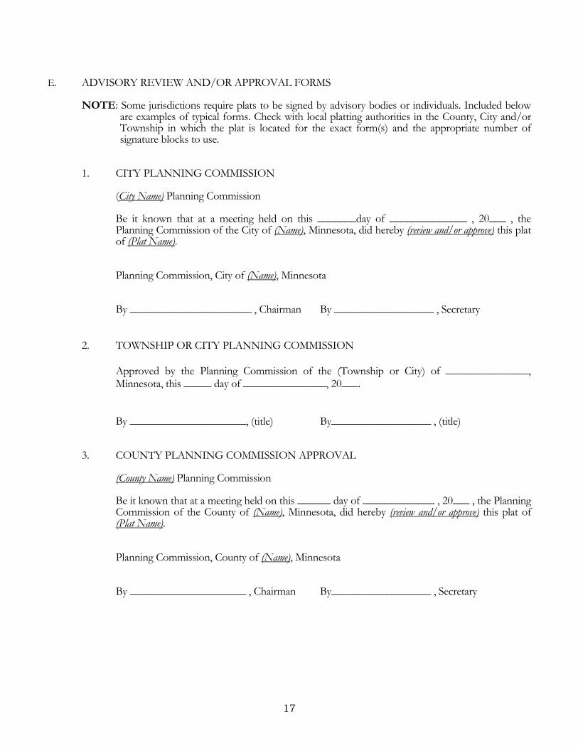
E. ADVISORY REVIEW AND/OR APPROVAL FORMS
NOTE: Some jurisdictions require plats to be signed by advisory bodies or individuals. Included below are examples of typical forms. Check with local platting authorities in the County, City and/or Township in which the plat is located for the exact form(s) and the appropriate number of signature blocks to use.
1. CITY PLANNING COMMISSION (City Name) Planning Commission Be it known that at a meeting held on this _______day of ______________ , 20___ , the
Planning Commission of the City of (Name), Minnesota, did hereby (review and/or approve) this plat of (Plat Name).
Planning Commission, City of (Name), Minnesota By ______________________ , Chairman By __________________ , Secretary
2. TOWNSHIP OR CITY PLANNING COMMISSION
Approved by the Planning Commission of the (Township or City) of _______________, Minnesota, this _____ day of _______________, 20___.
By _____________________, (title) By__________________ , (title) 3. COUNTY PLANNING COMMISSION APPROVAL (County Name) Planning Commission Be it known that at a meeting held on this ______ day of _____________ , 20___ , the Planning
Commission of the County of (Name), Minnesota, did hereby (review and/or approve) this plat of (Plat Name).
Planning Commission, County of (Name), Minnesota By _____________________ , Chairman By__________________ , Secretary

18
4. CITY ATTORNEY APPROVAL (City Name) Attorney This plat of (Plat Name) was reviewed and approved by the City Attorney for the City of (Name),
Minnesota, this _______ day of __________________ , 20____ . City Attorney, City of (Name), Minnesota By _________________________ , City Attorney Approved as to form and execution this ____ day of ____, 20___ . I do hereby certify that proper evidence of title has been presented to and examined by me and I approve the plat as to form and execution this _____ day of _________, 20 ___. By _________________________ , City/County Attorney
5. TITLE OPINION
I, (name of attorney), Licensed Attorney, State of Minnesota, do hereby certify that the owners as indicated hereon represent all ownership interest in the land encompassed by this plat.
____________________________________ (name of attorney), Licensed Attorney F. GOVERNING BODY APPROVAL CERTIFICATES
Plats that subdivide land are subject to the approval of the elected body of the local governmental
units exercising authority over the subdivision of the land. [Minn. Stat. § 505.03, Subd. 1] Plats that only delineate existing parcels or comply with a minor subdivision procedure may be approved by a local government official designated by the governing body of the local governmental unit exercising authority over the subdivision of land. [Minn. Stat. § 505.03, Subd. 1] The intent of this section is to clarify that local governmental units have the option of defining a minor subdivision; the authority to adopt approval procedures for plats of minor subdivisions and plats that only delineate the boundaries of existing parcels; and the authority to designate a plat approval official. NOTES:
Consult with the local governing body for appropriate language used in a certificate of approval by a local government official on a plat of a minor subdivision or a plat used only to delineate the boundaries of an existing parcel. Provide a 2 inch by 2 inch space for the application of the governing body seal adjacent to the governing body approval certificate, when it is required.
The following examples are for city council or township board of supervisors’ approval:

19
1. City Council City Council, City of (Name), Minnesota This plat of (Plat Name) was approved and accepted by the City Council of the City of (Name),
Minnesota at a regular meeting thereof held this _______ day of _________________ , 20___ , and said plat is in compliance with the provisions of Minnesota Statutes, Section 505.03, Subd. 2.
City Council, City of (Name), Minnesota By : ________________________ By : ________________________ (Signature of person and title (Signature of person and title designated by approving authority) designated by approving authority) 2. Town Board or City Council
This plat was approved by the (Town Board or City Council) of (Town or City), Minnesota, this _____ day of _____________, 20 ____, and hereby certifies compliance with all requirements as set forth in Minnesota Statutes, Section 505.03, Subd. 2.
By : ________________________ By : ________________________ (Signature of person and title (Signature of person and title designated by approving authority) designated by approving authority)
3. Township Board of Supervisors Township of (Name)
I/We do hereby certify that on the ___ day of _________________ , 20___ , the Board of Supervisors for the Township of (Name), (Name) County, Minnesota, approved this plat of (Plat Name) and said plat is in compliance with the provisions of Minnesota Statutes, Section 505.03, Subd. 2.
_______________________________ (Signature of person or person and title(s) designated by approving authority)
4. (Name) County Board
I/We do hereby certify that on the ___ day of _________________ , 20___ , the Board of Commissioners of (Name) County, Minnesota, approved this plat of (Plat Name), and said plat is in compliance with the provisions of Minnesota Statutes, Section 505.03, Subd. 2.
_______________________________ (Signature of person or persons and title(s) designated by approving authority) Attest:___________________________

20
G. TAXATION FORMS
NOTE: Each county determines how taxation issues are handled. These are some examples of typical forms. Check with the local governing body for appropriate language used in the county in which the plat is located.
1) Example for a county with a separate Auditor and Treasurer: County Auditor, (Name) County, Minnesota
Pursuant to Minnesota Statutes, Section 272.12, there are no delinquent taxes on the land hereinbefore described on this plat and transfer entered this ____ day of ____________ , 20___ .
(County Name) County Auditor __________________________ , Auditor By ______________________ , Deputy County Treasurer, (Name) County, Minnesota
Pursuant to Minnesota Statutes, Chapter 505.021, Subd. 9, taxes payable for the year 20___ on the land hereinbefore described have been paid this _____ day of _____________ , 20 ___ .
(County Name) County Treasurer __________________________ , Treasurer By _______________________ , Deputy 2) Example for a county with combined Auditor and Treasurer duties: Department of Property Records and Revenue
Pursuant to Minnesota Statutes, Section 505.021, Subd. 9, taxes payable in the year 20___ on the land hereinbefore described have been paid. Also, pursuant to Minnesota Statutes, Section 272.12, there are no delinquent taxes and transfer entered this ___ day of __________ , 20___ .
__________________________ , Director Department of Property Records and Revenue By _______________________ , Deputy
H. COUNTY SURVEYOR APPROVAL
1) All plats prepared for recording are subject to approval by the county surveyor in accordance with
Minnesota Statute section 389.09, subdivision 1, and/or as authorized by their respective county board of commissioners. [Minn. Stat. § 505.021, Subd. 11]

21
2) In any county that requires review and approval of plats by the county surveyor or another land surveyor, the plat shall contain a certification of approval executed by the county surveyor or land surveyor that this plat is in compliance with this section. [Minn. Stat. § 505.021, Subd. 9(c)] NOTE: These sections provide for plat review and approval by the county surveyor or by another
licensed land surveyor when authorized by the county board. County Surveyor
I hereby certify that in accordance with Minnesota Statutes, Section 505.021, Subd. 11, this plat has been reviewed and approved this ___ day of ____________ , 20___ .
____________________________________ (Name) ______________ County Surveyor
For plats that are reviewed and approved by a Licensed Land Surveyor other than a County Surveyor, as authorized by the county board of commissioners, the following example may be used: Licensed Land Surveyor I hereby certify that in accordance with Minnesota Statutes, Section 505.021, Subd. 11, this plat has been reviewed and approved this ___ day of ____________ , 20___ .
______________________________________ (Print name of surveyor), Licensed Land Surveyor Minnesota License No. ____________________
NOTE: Some counties may have specific enabling legislation or a county ordinance that provides for review and/or approval of plats and may require a reference to the legislation or ordinance within the approval statement.
I. RECORDING CERTIFICATES
1) County Recorder. NOTE: check with each individual county.
County Recorder, County of _____________, State of Minnesota I hereby certify that this plat of (name of plat in CAPITAL LETTERS, exactly as it appears in the dedication paragraph) was filed in the office of the County Recorder for public record on this _____ day of ___________________ , 20___ , at _____ o’clock __.M. and was duly filed in Book _________ of Plats, Page ___________ , as Document Number _________________ .
______________________ , County Recorder By ______________________ , Deputy

22
Registrar of Titles. NOTE: check with each individual County. Registrar of Titles, County of ______________, State of Minnesota I hereby certify that this plat of (name of plat in CAPITAL LETTERS, exactly as it appears in the dedication paragraph) was filed in the office of the Registrar of Titles for public record on this ___ day of ____________________ , 20___ , at _____ o’clock ___ .M. and was duly filed in Book ________________ of Plats, Page _______ , as Document Number _______________ . _______________________ , Registrar of Titles By _______________________ , Deputy NOTES: If a plat consists of more than one sheet, provide a sufficient number of blanks to indicate one page for each sheet of the plat in the County Recorder/Registrar of Titles Book of Plats. Examples: …… Book ________________ of Plats, Pages _______ and _______ , …… Book________________ of Plats, Pages _______ , _______ and _______ , If a plat consists of both abstract and Torrens property, a recording certificate for both the County Recorder and the Registrar of Titles must be provided.
2. REGISTERED LAND SURVEYS
NOTE: Check with each individual county for specific requirements.
Registered Land Surveys identify registered (Torrens) lands in accordance with Minnesota Statutes, Section 508.47. Registered Land Surveys shall be approved in the manner required for the approval of subdivision plats, except registered land surveys are not signed by landowners and may not dedicate or donate any public rights.
A. REGISTERED LAND SURVEY REQUIREMENTS:
1) 22 inches by 34 inches in size. 2) Recite the legal description exactly as it appears on the current Certificate(s) of Title. 3) Show all boundary measurements. 4) Show measurements of all tracts. 5) Show the direction of all lines. 6) Show durable monuments at appropriate corners. 7) Show all tracts lettered consecutively beginning with “A”. 8) Show multi-level tracts with an elevation view with the location and elevation of a benchmark. 9) Place a border line one-half inch inside the outer edge of the plat on the top and bottom 34 inch
sides; and the right 22 inch side; and two inches inside the outer edge of the plat on the left 22 inch side.
10) A vicinity or location map is recommended. The aforementioned items are an overview of recommendations to be used together with the requirements of Minnesota Statutes, Section 508.47, Subd. 4, and Section 508A.47, Subd. 4.

23
B. CERTIFICATES
• Surveyor Certificate (page 23) • Governing Body Approval Certificates (page 23) • Taxation Forms (page 24) • County Surveyor Certificate (page 25) • Registrar of Titles Certificate (page 25)
1) Surveyor Certificate
I, (surveyor’s name), hereby certify that, in accordance with the provisions of Minnesota Statutes, Section 508.47 and/or 508A.47 (whichever is applicable), I have surveyed the following described property situated in the County of ______________ , State of Minnesota:
(Legal description of the land shall be the same as on the current Certificate(s) of Title for the property. The words degrees, minutes, seconds and references to
fractions shall be spelled out in all legal descriptions).
I hereby certify that this Registered Land Survey was prepared by me or under my direct supervision; that I am a duly Licensed Land Surveyor under the laws of the State of Minnesota and that this Registered Land Survey is a correct representation of said parcel of land. Dated this ___ day of ________________________ , 20___.
______________________________________ (Print name of surveyor), Licensed Land Surveyor Minnesota License No. ____________________ 2) Governing Body Approval Certificates
Before filing, however, any survey shall be approved in the manner required for the approval of subdivision plats, which approval shall be endorsed on it or attached to it. [Minn. Stat. § 508.47, Subd. 4]
NOTES: Consult with the local governing body for appropriate language used in a certificate of approval by a local government official for a registered land survey that creates a minor subdivision. Provide a 2 inch by 2 inch space for the application of the governing body seal adjacent to the governing body approval certificate, when it is required.

24
The following examples are for city council or township board of supervisors’ approval: a) Township Board of Supervisors
Township of _______________
I/We do hereby certify that on the _____ day of _________________ , 20___ , the Board of Supervisors for the Township of (Name), (Name) County, Minnesota, has approved this Registered Land Survey.
___________________________________ (Signature of person(s) and title(s) designated by approving authority)
b) City Council City of _______________________
I/We do hereby certify that on the _____ day of ___________________ , 20___ , the City Council of the City of ________________ , Minnesota, has approved this Registered Land Survey.
__________________________________ (Signature of person(s) and title(s) designated by approving authority) c) (Name) County Board I/We do hereby certify that on the ___ day of ______________ , 20___ , the Board of Commissioners of (Name) County, Minnesota, approved this Registered Land Survey. _______________________________ (Signature of person or persons and title(s) designated by approving authority)
3) Taxation Forms
NOTE: Each county determines how taxation issues are handled. These are some examples of typical forms. Check with the local governing body for appropriate language used in the county in which the Registered Land Survey is located.
a) Example for a county with a separate Auditor and Treasurer: County Auditor, (Name) County, Minnesota
Pursuant to Minnesota Statutes, Section 272.12, there are no delinquent taxes on the land hereinbefore described on this Registered Land Survey and transfer entered this ____ day of ______________ , 20____ .
__________________________ , Auditor By ______________________ , Deputy

25
County Treasurer, (Name) County, Minnesota
Pursuant to Minnesota Statutes, Section 508.47, Subd. 4 and/or Section 508A.47, Subd. 4, (whichever is applicable) taxes payable for the year 20____ on the land hereinbefore described have been paid on this ____ day of ______________ , 20 ___ .
__________________________ , Treasurer By______________________ , Deputy
b) Example for a county with combined Auditor and Treasurer duties: Department of Property Records and Revenue
Pursuant to Minnesota Statutes, Section 508.47, Subd. 4 and/or Section 508A.47, Subd. 4, (whichever is applicable) taxes payable in the year 20___ on the land hereinbefore described have been paid. Also, pursuant to Minnesota Statutes, Section 272.12, there are no delinquent taxes and transfer entered this ___ day of _______________ , 20___.
__________________________ , Director Department of Property Records and Revenue By _______________________ , Deputy
4) County Surveyor Certificate County Surveyor
Pursuant to Minnesota Statutes, Section 389.09, Subd. 1, this Registered Land Survey is approved this _______ day of __________ , 20___.
____________________________________ (Name) _______________ County Surveyor 5) Registrar of Titles Certificate Registrar of Titles, County of ________________, State of Minnesota
I hereby certify that this Registered Land Survey No. ___________ was filed in this office this ____ day of _________________ , 20___ , at ________ o’clock ___.M., as Document No. __________.
____________________________________ Registrar of Titles By___________________________ , Deputy

26
This page intentionally left blank

27
PART III
GRAPHICS

28
1. MEDIA TYPE
A plat shall be prepared on four mil transparent reproducible film or the equivalent and shall be prepared by a photographic process. [Minn. Stat. § 505.021, Subd. 1]
2. PLAT SIZE
Plat sheet size shall be 22 inches by 34 inches. [Minn. Stat. § 505.021, Subd. 1] 3. BORDER
A border line shall be placed one-half inch inside the outer edge of the plat on the top and bottom 34 inch sides; and the right 22 inch side; and two inches inside the outer edge of the plat on the left 22 inch side. [Minn. Stat. § 505.021, Subd. 1]
4. SHEET NUMBERING
A. If a plat consists of more than one sheet, the sheets shall be numbered consecutively. [Minn. Stat. § 505.021, Subd. 1] Show the individual sheet number and the total number of sheets in the lower right corner of the plat outside of the border.
Example:
Sheet 1 of 3 Sheets Sheet 2 of 3 Sheets Sheet 3 of 3 Sheets
B. Place the dedication portion of the plat on Sheet 1 whenever practicable. 5. PLAT SCALE
A. Use a standard Engineer’s scale to establish the scale of the plat.
B. A graphic scale shall be shown along with the label "Scale In Feet." [Minn. Stat. § 505.021, Subd. 5]
Example:
1 INCH = 50 FEET 0 50 100 SCALE IN FEET

29
6. ORIENTATION OF BEARINGS AND PLATS
A. BEARING ORIENTATION
1) A north arrow and directional orientation note shall be shown. [Minn. Stat. § 505.021, Subd. 5] Examples:
a) The orientation of this bearing system is assumed. b) The orientation of this bearing system is based on the (county name) County Coordinate
System NAD83 (specify adjustment). 2) In the case of an assumed bearing system, place a statement on the plat that describes the bearing
orientation of a monumented line on the plat.
Examples:
a) The west line of the NW ¼ of Sec. 3, T.30N., R.22W. is assumed to bear N 02° 39’ 24” E. b) The north line of Block 1, LAKE ADDITION, is assumed to have a bearing of East.
NOTE: Do not use the statement: “all bearings are assumed”, because it negates the directional
relationship of plat lines. B. PLAT ORIENTATION
1) Orient North toward the top of the plat (34 inch side). 2) If orienting North toward the top is not practicable, orient North toward the left
22 inch side.
3) Orient all dimensions, designations, lot and block numbers, etc., so they can be read from either the bottom or the right-hand side of the plat.
C. BEARINGS OR DIRECTIONS
1) All straight line segments of the plat shall be labeled with the length of the line and bearing or azimuth. All curved line segments of the plat shall be labeled with the central angle, arc length, and radius length. If any curve is nontangential the dimensions shall include a long chord bearing or azimuth, and shall be labeled nontangential. [Minn. Stat. § 505.021, Subd. 5]
2) Bearings, azimuths, and central angles shall be expressed in degrees, minutes, and seconds and
labeled with the respective symbols. [Minn. Stat. § 505.021, Subd. 5]

30
7. LEGAL DESCRIPTION DEPICTION
A. Plat boundaries shall be designated on the plat in accordance with the underlying legal description and survey. [Minn. Stat. § 505.021, Subd. 4]
B. Dimension and descriptive recitals in the legal description shown on the plat shall be depicted and labeled on the graphic portion of the plat. [Minn. Stat. § 505.021, Subd. 5] Designation of plat boundaries on the drawing may be shown in an acceptable abbreviated form.
1) West line of NW¼ of NW¼ 2) N.W. corner of Sec. 3, T.29N, R.23W
3) South line of the North 100 ft. of Govt. Lot 3
C. If the legal description identifies any part of a lot, outlot, registered land survey tract, section,
government lot, etc., label the parcel in dotted or dashed text.
D. Show and label all section lines, quarter section lines, quarter-quarter section lines and government lot
lines that are related to the property being platted; called for in the description; or used as a reference for the plat.
E. Identify all quarter-quarter sections and government lots with dotted lettering on the plat.
Example:
F. When a specific parcel is recited in the description as being an exception or exclusion to the basic plat parcel, and is not part of the plat, use the word “EXCEPTION” to identify the excluded parcel.
G. On the graphic portion of the plat, place the label “EXCEPTION” in solid, fine lined capital letters in
the area being excluded.
8. ADJOINING AND/OR UNDERLYING PLAT DIMENSIONS
A. When a measured distance between found monuments is inconsistent with the distance as shown on a previously recorded plat, show the recorded distance, as well as the measured distance. Show the recorded distance followed by the term “PLAT,” or by the name of the previously recorded plat.
Example: 237.50 237.50
(237.65 PLAT) or (237.65 MOYER ADDITION)

31
B. When the recorded distance is followed by the term “PLAT,” include a note in the legend identifying the recorded plat referred to. See example below:
Example:
PLAT – refers to dimensions as shown on the plat of MOYER ADDITION, recorded in the office of the County Recorder, _____________ County, Minnesota.
C. When platting property from a description of record and the dimensional calls in the description are
inconsistent with the measured dimensions, show the record dimension, as well as the measured dimension. The suggested format is to show the record dimension followed by either the term “Deed” or “Record”.
Example:
(300.00 Deed) (300.00 Record) 298.85 298.85
Note: Include a statement in the legend identifying the deed or record being referred to. Examples:
Deed – Refers to dimensions as stated in Warranty Deed, recorded as Document No. 2902460, filed in Book 362 of Deeds, Page 436, in the office of the County Recorder, ___________________ County, Minnesota.
Record – Refers to dimensions in Document Number 9241960, recorded in the office of
the County Recorder, ___________________ County, Minnesota. 9. MONUMENTATION
A. Plat monuments shall be set at all angle and curve points on the outside boundary lines of the plat prior to recording. Plat monuments shall be set at all other block, lot, outlot, park, survey line, and witness corners within one year after recording the plat. [Minn. Stat. § 505.021, Subd. 10]
B. The license number of the land surveyor that certifies the plat shall be affixed to all set plat monuments. [Minn. Stat. § 505.021, Subd. 10]
C. No previously existing survey or reference monuments or landmarks evidencing property lines or
corner posts shall be removed or destroyed by the land surveyor making the new survey. [Minn. Stat. § 505.32]
D. Include a statement or note on the plat identifying the type and size of monument set or that will be set and the license number of the land surveyor certifying the plat affixed thereto. Plat monuments shall be durable magnetic markers. [Minn. Stat. § 505.01, Subd. 3(g)]
1) Identify the size and type of set monuments. Use differing symbols to identify different types
of set monuments. It is common practice to use an open circle symbol to denote set monuments.
Example:
- denotes ½ inch by 14 inch iron pipe set and marked by License No._________

32
2) Identify the size and type of found monuments. Use differing symbols to identify different
types of found monuments. It is common practice to use a solid circle symbol to denote found iron pipe monuments.
Examples:
- denotes ½ inch iron pipe found and marked by License No. __________, unless shown
otherwise
- denotes 1 inch square solid iron rod, found.
3) If it is impracticable to set a plat monument, a witness plat monument shall be set. [Minn. Stat. § 505.021, Subd. 10]
E. Include a statement on the graphic portion of the plat or in the legend when the certifying land
surveyor has chosen to comply with the requirements of Section 505.021, Subd. 10 in which plat monuments shall be set at all other block, lot, or outlot, park, survey line and witness corners within one year after recording of the plat.
F. Label any judicial landmark found and used as a plat monument as J.L.M. If a judicial landmark is
called for in the description or indicated on a prior survey and was not found, label as J.L.M. Not Found.
G. Show all United States Public Land Survey corners or any witness monuments, which either control
the location of the boundary of the plat or are a part of the plat. Label these corners with reference to section, township and range. Indicate the type of monument and the license number marked thereon, if known. Reference these corners or monuments to the plat by distance and direction.
Examples:
– NW Cor. Sec. 8, T.29N, R.22W, found 3/4 inch Iron Pipe
– W 1/4 Cor. Sec. 17, T.30N, R.22W, ___________ County Cast Iron Monument
– NW Cor. Sec. 6, T.30N, R.23W, 8 inch x 8 inch __________ County
Granite Monument
– Witness Monument to NE Cor. Sec. 25, T.30N, R.23W, ________________ County Cast Iron Monument
NOTE: The Licensed Land Surveyor is required to comply with Minnesota Statutes, Section 381.12,
Subd. 3 in regard to Public Land Survey monument records.
H. For all plats of land described under or referenced to the Public Land Survey, show plat boundary references with distance and direction to at least two existing Public Land Survey corners or other reference monuments. This may apply to other plats as conditions dictate.
I. Wherever plat boundary lines extend into any existing public way, show and monument the angle
points, points of curvature, and points of tangency of the right-of-way line.

33
J. Include a legend on the plat to define specific symbols or lines.
10. LINE WIDTHS
Draft plat lines with distinct line widths according to the following: Widest Boundary of Plat . Blocks, Outlots and Parks . Lots and Tracts Narrowest Easements, Center Lines, Survey Lines, Water Boundaries not establishing parcel boundaries, Section Lines, Description Lines, etc.
11. LETTERING SIZE
Draft text in the graphic portion of a plat with distinct lettering sizes according to the following: Largest Plat Name . Block Numbers, Outlot letters and park names . Public Way Names . Lot Numbers and Tract Letters . Boundary Dimensions . Block, Outlot and Park Dimensions
. Lot, Tract and Survey Line Dimensions Smallest Easement, Description and similar data
NOTE: To facilitate readability of plat information, a minimum text font size of 0.08 inches is recommended
on both the graphic and dedication portions of the plat. Refer to Minnesota Document Standards. [Minn. Stat. § 507.093]
12. BLOCK AND LOT NUMBERS
A. All blocks shall be numbered consecutively with Arabic numerals beginning with numeral 1. [Minn. Stat. § 505.021, Subd. 4]
B. When the plat consists of only one block, spell out the word BLOCK preceding the Arabic numeral 1.
C. All lots in each block shall be numbered consecutively with Arabic numerals beginning with the
numeral 1. [Minn. Stat. § 505.021, Subd. 4]
D. When a plat consists of only one lot in a one block plat, spell out the word LOT preceding the Arabic numeral 1.
E. Blocks are bounded by plat boundaries, public ways, outlots, parks, or bodies of water.
[Minn. Stat. § 505.01, Subd. 3 (a)]
34
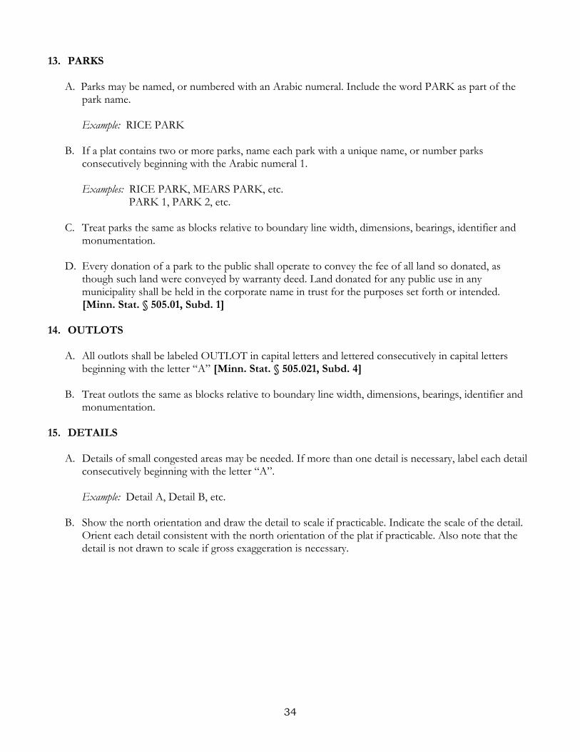
13. PARKS
A. Parks may be named, or numbered with an Arabic numeral. Include the word PARK as part of the park name.
Example: RICE PARK
B. If a plat contains two or more parks, name each park with a unique name, or number parks
consecutively beginning with the Arabic numeral 1.
Examples: RICE PARK, MEARS PARK, etc. PARK 1, PARK 2, etc.
C. Treat parks the same as blocks relative to boundary line width, dimensions, bearings, identifier and
monumentation. D. Every donation of a park to the public shall operate to convey the fee of all land so donated, as
though such land were conveyed by warranty deed. Land donated for any public use in any municipality shall be held in the corporate name in trust for the purposes set forth or intended. [Minn. Stat. § 505.01, Subd. 1]
14. OUTLOTS
A. All outlots shall be labeled OUTLOT in capital letters and lettered consecutively in capital letters beginning with the letter “A” [Minn. Stat. § 505.021, Subd. 4]
B. Treat outlots the same as blocks relative to boundary line width, dimensions, bearings, identifier and
monumentation.
15. DETAILS
A. Details of small congested areas may be needed. If more than one detail is necessary, label each detail consecutively beginning with the letter “A”. Example: Detail A, Detail B, etc.
B. Show the north orientation and draw the detail to scale if practicable. Indicate the scale of the detail.
Orient each detail consistent with the north orientation of the plat if practicable. Also note that the detail is not drawn to scale if gross exaggeration is necessary.

35
16. MATCH LINES, OVERVIEWS AND INSETS
A. In order to adhere to the 22 inch by 34 inch plat size, it may be necessary to separate the graphic portion of the plat with match lines or overviews and insets.
B. Place match lines along obvious divisions within the plat. Show technical data along or to the match
line in a manner that prevents confusion. Duplicate the technical data on every sheet where the match line is used. If a plat includes more than one match line, label each match line consecutively beginning with the letter “A”.
Example: Match Line A, Match Line B, etc.
C. If more than two match lines are necessary, it may be preferable to provide an additional sheet that
shows an overview of the plat to illustrate which portions of the plat are on which sheets. D. Utilizing an overview sheet and insets may be preferable to using match lines. If an overview and
insets are used, follow the criteria described above in regard to labeling and showing technical data.
17. PUBLIC WAYS
A. All public ways within the plat, whether existing at the time of platting or being dedicated by the plat, shall be depicted on the plat together with the name and sufficient mathematical data to locate the position and width of the public way. [Minn. Stat. § 505.021, Subd. 6]
B. Include the road authority name and/or number for any public way that has a dual designation.
Example: Plumb Drive (Co. Hwy. No. 6)
Transit Blvd. (State Hwy. No. 25) C. Show any vacated underlying public way that is part of the plat description with dotted text and
dashed lines.
D. The location of all existing public ways adjacent to the plat boundary shall be depicted on the plat as dashed lines. The name and width of the adjacent public ways shall be shown, if known. [Minn. Stat. § 505.021, Subd. 6] Show the name of the public way in dotted text.
E. Show with dashed lines, and label in dotted text, any intersecting public roads adjacent to the plat.
F. Show the location of existing railroad rights-of-way adjacent to the plat boundary with dashed lines,
along with the names and widths, if known. G. When using public way center line information to clarify right-of-way and boundary relationships,
show the center line with all applicable data.
H. Where an adjacent right-of-way has been surveyed according to the description of record and is shown upon the plat or registered land survey, show the Document Number or Book and Page numbers of the recorded description. Also show all courses of the location line described in the instrument that will control that portion of the right-of-way pertinent to the plat.

36
I. Label the center line when the boundary of a plat is the center line of a public way.
J. Label the right-of-way and show and identify the controlling monumentation when a right-of-way line has been monumented by the road authority.
K. Consult with road authority when showing controlled access notations and symbols on the plat.
18. DIMENSIONS
A. A plat shall show all survey and mathematical information and data necessary to locate and retrace all boundary lines and monuments. [Minn. Stat. § 505.021, Subd. 5]
B. Bearings, azimuths, and central angles shall be expressed in degrees, minutes and seconds and labeled
with the respective symbols. [Minn. Stat. § 505.021, Subd. 5] C. Distances shall be expressed in feet and hundredths of a foot. [Minn. Stat. § 505.021, Subd. 5]
D. All straight line segments of the plat shall be labeled with the length of the line and the bearing or
azimuth. [Minn. Stat. § 505.021, Subd. 5] E. Public way widths or easement widths need not be expressed to the hundredth of a foot if they are
exact values, i.e. 66 or 33, etc. These widths may be defined in the legend.
F. Show the equivalent distance in feet and hundredths of a foot for distances recited in the description as chains, rods, etc.
G. Ditto marks and foot and inch symbols shall not be used on a plat. [Minn. Stat. § 505.021, Subd. 5]
H. For townhouse style or cluster lot style plats, reference all blocks or groups of lots to a parcel
boundary with a minimum of two references (ties).
1) Include both direction and distance from block, outlot or plat boundary corners in the references. I. Show lot dimensions along actual lot lines where practicable.
J. The mathematical closure tolerance of the plat boundary, blocks, lots and outlots shall not exceed
2/100 of a foot. [Minn. Stat. § 505.021, Subd. 5] K. Dimension all boundary and easement lines in a manner that permits interpretation without
ambiguities. Use dimension leaders where necessary to clearly indicate the applicable line.
L. Draft arrowed/leader lines, used with dimensions or descriptors, as dashed or dotted lines.

37
19. CURVE DATA
A. All curved line segments of the plat shall be labeled with the central angle expressed in degrees, minutes and seconds, and radius and arc lengths expressed in feet and hundredths of a foot. [Minn. Stat. § 505.021, Subd. 5]
B. Segments of center line curves may show arc length and central angle only. Show each arc length and
central angle to the same technical precision as noted in Subsection 9A.
C. If any curve is nontangential the dimensions shall include a long chord bearing or azimuth, and shall be labeled nontangential. [Minn. Stat. § 505.021, Subd. 5] Show the long chord direction and long chord length with the following abbreviations:
C. Brg. denotes chord bearing C. Az. denotes chord azimuth C. denotes chord length D. Show the central angle, arc length and radius length on all curved lines that are not concentric with
dimensioned center line curve data. E. The use of L= for the length of curve is optional, however, if the length of any curve is labeled L=,
label all other lengths of curve on the plat consistently.
F. Extend dashed radial lines at the ends of all curves far enough toward the radius point to clearly indicate the direction of curvature.
G. If a curved line constitutes a line of more than one lot or outlot, show the central angle, arc length and
radius for each segment.
H. Tabulation of curve data is not preferred and should only be used when necessary.
J. Show a complete set of curve data on both sides of a public way when both right-of-way lines are within the plat. At a minimum, show the central angle, arc length and radius of the curve along the right-of-way when center line data is not shown.

38
20. WATER BOUNDARIES A. WATER BOUNDARY LINES
Any water boundary abutting or lying within the plat boundaries shall be shown and identified on the plat as a solid line delineating the then existing shore line…..The shore or margin of wet lands which do not form a boundary of or within the plat shall be shown as a dashed line. [Minn. Stat. § 505.021, Subd. 8] See Section 10 for line width suggestions.
B. SURVEY LINE
1) When any parcel depicted on the plat includes water as a boundary, a dashed survey line shall be shown and labeled with sufficient mathematical data to compute a closure of said parcel.
[Minn. Stat. § 505.021, Subd. 8] 2) Show survey lines as dashed lines with the label “SURVEY LINE”.
3) Show bearings or azimuths on each straight-line segment of the survey line.
4) Show the overall distance between angle points of the survey line.
5) Show the distance between lot lines, as measured along the survey line.
6) Distances shall be shown between the survey line and the water boundary at all angle points, lot
and boundary lines. [Minn. Stat. § 505.021, Subd. 8]
7) Plat monuments shall be set at all locations where the survey line intersects a plat boundary line, or block, lot or outlot line. [Minn. Stat. § 505.021, Subd. 8] It is also recommended that monuments be set at angle points along the survey line.
8) Prior to recording, it is recommended that a monument be placed at the intersection of a survey
line with an exterior plat boundary line (as a witness corner to the boundary line angle point at the shore) to be consistent with the intent of Minn. Stat. § 505.021, Subd. 10.
9) Survey line plat monuments that are not on the outside boundary line of the plat shall be set
within one year after recording the plat. [Minn. Stat. § 505.021, Subd. 10]
C. BENCHMARK AND ELEVATIONS
1) The water elevation of any lake, stream, or river depicted on the plat shall be shown to the tenth of a foot along with the date the elevation was measured. [Minn. Stat. § 505.021, Subd. 8]
2) The highest known water elevation shall be indicated on the plat if the data is available from the
Department of Natural Resources, the United States Army Corps of Engineers, or another appropriate governmental unit. [Minn. Stat. § 505.021, Subd. 8]
3) If the highest known water elevation data is unavailable from the agencies listed above, include a
note stating such.
39
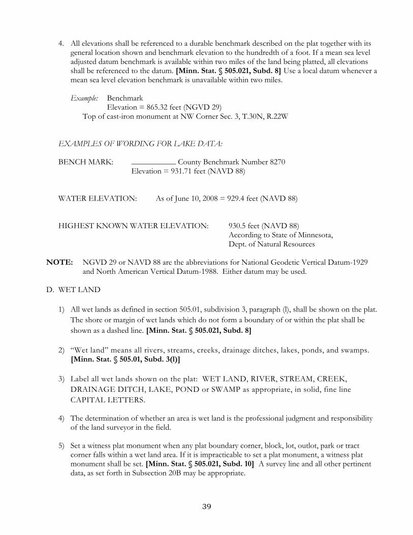
4. All elevations shall be referenced to a durable benchmark described on the plat together with its general location shown and benchmark elevation to the hundredth of a foot. If a mean sea level adjusted datum benchmark is available within two miles of the land being platted, all elevations shall be referenced to the datum. [Minn. Stat. § 505.021, Subd. 8] Use a local datum whenever a mean sea level elevation benchmark is unavailable within two miles. Example: Benchmark
Elevation = 865.32 feet (NGVD 29) Top of cast-iron monument at NW Corner Sec. 3, T.30N, R.22W
EXAMPLES OF WORDING FOR LAKE DATA: BENCH MARK: ___________ County Benchmark Number 8270 Elevation = 931.71 feet (NAVD 88)
WATER ELEVATION: As of June 10, 2008 = 929.4 feet (NAVD 88) HIGHEST KNOWN WATER ELEVATION: 930.5 feet (NAVD 88)
According to State of Minnesota, Dept. of Natural Resources
NOTE: NGVD 29 or NAVD 88 are the abbreviations for National Geodetic Vertical Datum-1929 and North American Vertical Datum-1988. Either datum may be used.
D. WET LAND
1) All wet lands as defined in section 505.01, subdivision 3, paragraph (l), shall be shown on the plat. The shore or margin of wet lands which do not form a boundary of or within the plat shall be shown as a dashed line. [Minn. Stat. § 505.021, Subd. 8]
2) “Wet land” means all rivers, streams, creeks, drainage ditches, lakes, ponds, and swamps.
[Minn. Stat. § 505.01, Subd. 3(l)] 3) Label all wet lands shown on the plat: WET LAND, RIVER, STREAM, CREEK,
DRAINAGE DITCH, LAKE, POND or SWAMP as appropriate, in solid, fine line CAPITAL LETTERS.
4) The determination of whether an area is wet land is the professional judgment and responsibility
of the land surveyor in the field. 5) Set a witness plat monument when any plat boundary corner, block, lot, outlot, park or tract
corner falls within a wet land area. If it is impracticable to set a plat monument, a witness plat monument shall be set. [Minn. Stat. § 505.021, Subd. 10] A survey line and all other pertinent data, as set forth in Subsection 20B may be appropriate.

40
NOTE: Be aware that the Department of Natural Resources, U.S. Army Corps of Engineers and other water management agencies have categorized various wetlands and water bodies. Development of these lands may be subject to special conditions or limitations. Wetland identification and delineations are typically performed by a wetland specialist.
21. EASEMENTS
Show the boundary lines of drainage easements and utility easements as a thin dashed line. A. EXISTING DRAINAGE AND UTILITY EASEMENTS
1) It is recommended that the surveyor show and label any recorded drainage easement and/or
public utility easement existing at the time of platting, together with the county recorder’s/registrar of titles’ document number of the instrument describing said easement.
B. CREATED DRAINAGE AND UTILITY EASEMENTS
All easements to be dedicated on the plat shall be depicted on the plat with purpose, identification, and sufficient mathematical data to locate the boundaries of the easements. Easements created on the plat shall be limited to public utility and/or drainage easements as defined in section Minnesota Statute 505.01, Subdivision 3, paragraphs (b), (h), and (j). Easement boundaries shall be shown as dashed lines. Temporary easements, building setback information, and building floor elevations shall not be shown on a plat. [Minn. Stat. § 505.021, Subd. 7]
Example 1: Typical statement and illustration where widths of the easements vary and the
boundary lines of the easements are parallel with lot lines.
Drainage and utility easements are shown thus:
Being five feet in width and adjoining side lot lines and being 10 feet in width and adjoining public ways and rear lot lines, unless otherwise indicated on this plat.

41
Example 2: Typical statement and illustration where boundary lines of easements are uniform in width throughout this plat.
Drainage and utility easements are shown thus:
Being five feet in width and adjoining lot lines, as shown on this plat.
NOTE: If perpendicular dimensions do not adequately define the extents of the easement, it
will be necessary to include the direction and distance along the easement lines.

42
Example 3: When drainage and/or utility easements cross each other, the following example may serve as a guideline.

43
22. ADJOINING PROPERTY A. The name and adjacent boundary line of any adjoining platted lands shall be dotted on the plat.
[Minn. Stat. § 505.021, Subd. 4] B. Show and identify any adjoining lakes, streams or rivers.
23. REPLATS
A. Show relevant underlying platted property including plat names, blocks, lots, public ways, together with names, numbers, widths, etc.
24. LEGEND
The plat should include a legend defining lines and/or symbols. For example, the following items could be included in a legend:
North arrow Scale
Denotes monument set (define) Denotes monument found (define)
Water boundary line not establishing a parcel boundary (define) Benchmark Utility easement detail
Denotes monument to be set within one year after recording of this plat (define) [Minn. Stat. § 505.021, Subd. 9 (a)(3) and Subd. 10]
25. VICINITY OR LOCATION MAP
Include a map showing the location of the property being platted with sufficient information to locate the property within a section. Orient the vicinity map to match the north orientation of the plat. These examples show the ¼ section where the subject property is located:

44
26. NOTARIAL ACT
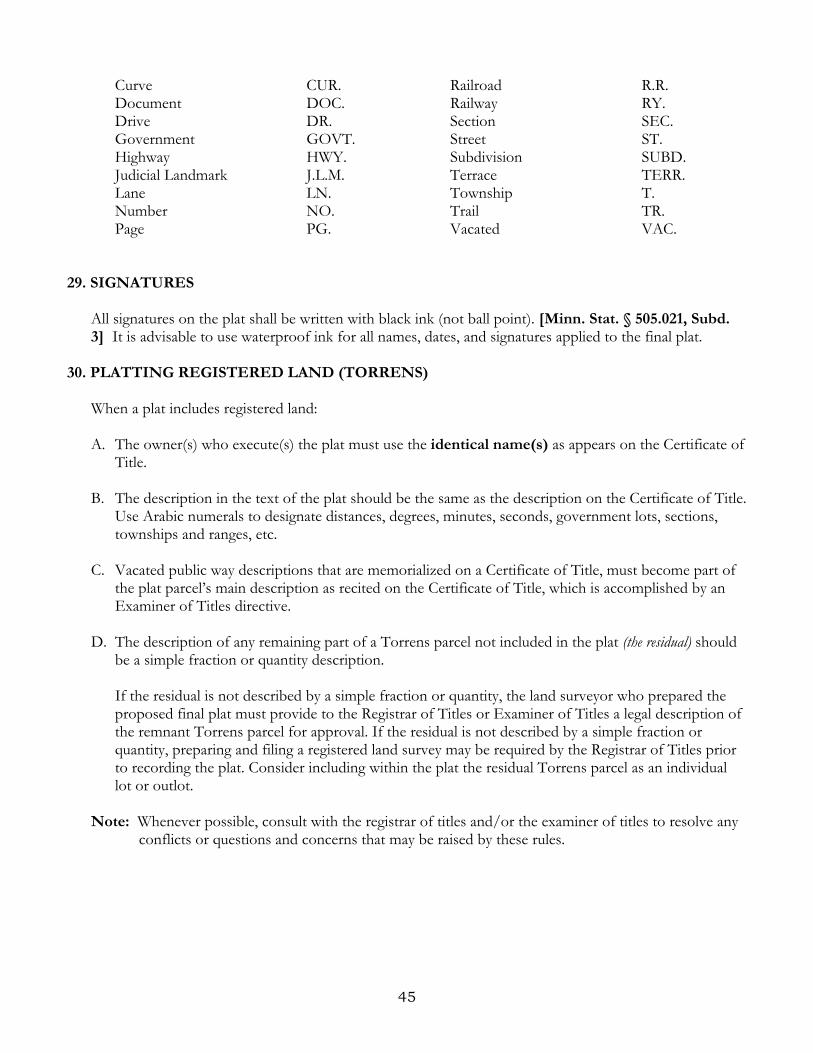
The notary’s name and commission expiration date shall be printed next to their acknowledgement. See [Minn. Stat. § 359.05] The seal of every notary public may be affixed by a stamp that will print a seal which legibly reproduces under photographic methods the seal of the State of Minnesota, the name of the notary, the words "Notary Public," and the words "My commission expires ...," with the expiration date shown thereon. See [Minn. Stat. § 359.03, Subd. 3] If a certificate of notarial act on a plat includes the jurisdiction of the notarial act, the name of the notarial officer, the title of the notarial officer, and the date the notary commission expires, printed in pen and ink or typewritten on the plat, a plat shall be recorded regardless of whether a notary stamp was used or was illegible if used. All signatures on the plat shall be written with black ink (not ball point). [Minn. Stat. § 505.021, Subd. 3] NOTES: Care must be taken that notarial stamps are compatible with media. Out of state jurisdictions
may differ from the examples provided herein. A notary stamp is not necessary if the requirements of Minn. Stat. § 505.021, Subd. 3 are satisfied.
27. LEGIBILITY
All letters, numbers and symbols that have spherical parts i.e., 5, e, g, 8, 0, etc., which also include degree symbols must be open to ensure legibility. This is a critical item with plats that are drawn at one scale and then photographically reduced for the final plat. Do not use dashes between degrees, minutes and seconds. A document presented for recording must be sufficiently legible to reproduce a readable copy using the county recorder’s or registrar of title’s current method of reproduction. [Minn. Stat. § 507.093, Subd. 7]
28. ABBREVIATIONS
To be used in the graphic portion of the plat.
Examples: R = Radius of curve L = Length of curve T = Tangent of curve C. = Chord of curve C. Brg. = Chord Bearing ∆ = Central angle
Addition ADD. Parkway PKWY. Auditor AUD. Place PL. Avenue AVE. Point of curvature P.C. Benchmark BM. Point of compound curvature P.C.C. Block BLK. Point of reverse curvature P.R.C. Book BK. Point of tangency P.T. Boulevard BLVD. Range R. Circle CIR. Registered Land Survey R.L.S. County CO. Right-of-way R/W Court CT. Road RD.
45
Curve CUR. Railroad R.R. Document DOC. Railway RY. Drive DR. Section SEC. Government GOVT. Street ST. Highway HWY. Subdivision SUBD. Judicial Landmark J.L.M. Terrace TERR. Lane LN. Township T. Number NO. Trail TR. Page PG. Vacated VAC.
29. SIGNATURES
All signatures on the plat shall be written with black ink (not ball point). [Minn. Stat. § 505.021, Subd. 3] It is advisable to use waterproof ink for all names, dates, and signatures applied to the final plat.
30. PLATTING REGISTERED LAND (TORRENS)
When a plat includes registered land: A. The owner(s) who execute(s) the plat must use the identical name(s) as appears on the Certificate of
Title. B. The description in the text of the plat should be the same as the description on the Certificate of Title.
Use Arabic numerals to designate distances, degrees, minutes, seconds, government lots, sections, townships and ranges, etc.
C. Vacated public way descriptions that are memorialized on a Certificate of Title, must become part of
the plat parcel’s main description as recited on the Certificate of Title, which is accomplished by an Examiner of Titles directive.
D. The description of any remaining part of a Torrens parcel not included in the plat (the residual) should
be a simple fraction or quantity description.
If the residual is not described by a simple fraction or quantity, the land surveyor who prepared the proposed final plat must provide to the Registrar of Titles or Examiner of Titles a legal description of the remnant Torrens parcel for approval. If the residual is not described by a simple fraction or quantity, preparing and filing a registered land survey may be required by the Registrar of Titles prior to recording the plat. Consider including within the plat the residual Torrens parcel as an individual lot or outlot.
Note: Whenever possible, consult with the registrar of titles and/or the examiner of titles to resolve any conflicts or questions and concerns that may be raised by these rules.

46
This page intentionally left blank.

47
PART IV
SURVEYOR’S CERTIFICATES OF PLAT CORRECTION
48
1. Minnesota Statutes, Section 505.174
Surveyor’s Certificate of Own Plat Errors; Correction
A. In any case where a land plat or subdivision, or what purports to be a land plat or subdivision, has been executed and filed in the office of the county recorder of the county where the land is situated, which fails to identify or correctly describe the land to be so platted or subdivided, or to show correctly upon its face the tract of land intended or purported to be platted or subdivided thereby or is defective by reason of the plat or subdivision and the description of the land purported to be so platted or subdivided thereby being inconsistent or incorrect, the licensed surveyor who prepared such plat or subdivision may execute a certificate stating the nature of the error, omission or defect and stating the correct information to correct such error, supply such omission or cure such defect, referring, by correct book and page, to such plat or subdivision and designating its name, if there is a name. Such certificate shall be dated and signed by such licensed surveyor.
B. When the surveyor’s certificate has been approved by the governing body and executed by the governing body, the county recorder of the county in which the land so platted is located shall accept each such certificate for filing.
C. A surveyor’s certificate of plat correction should be prepared on white paper measuring 8.5 inches by 11 inches or 8.5 inches by 14 inches. The top 3 inches must be left blank for county recording data and the County Recorder certificate. Graphic exhibits may be allowed to supplement the surveyor’s certificate of plat correction. If graphic exhibits are used they must be referred to on page one of the surveyor’s certificate of plat correction and must also be labeled “Exhibit A”; Exhibit B”; etc.
NOTE: The governing body that approved the original plat is the same governing body that needs to
approve a Certificate of Plat Correction. The following example is based upon a municipality being the governing body. If a County Board or a Township Board of Supervisors was the governing body, then appropriate language would be necessary for the County Board or Township Board of Supervisors to approve the Certificate of Plat Correction.
(see next page for example)

49
LAND SURVEYOR’S CERTIFICATE OF PLAT CORRECTION
Pursuant to the provisions of Minnesota Statutes, Section 505.174, I, (land surveyor’s name), a duly Licensed Land Surveyor in and for the State of Minnesota declares as follows: 1. That I prepared the plat of (Plat Name) dated (date of surveyor’s signature on the plat) and filed on
(date of recording) in the Office of the County Recorder/Registrar of Titles, ______________ County, Minnesota, as Document No. (Document Number indicated in the County Recorder’s/Registrar of Titles’ records).
2. That said plat contains errors, omissions or defects described in particular as follows:
(Itemize Errors, Omissions or Defects) 3. That said plat is hereby corrected in particular as follows:
(Itemize Corrections)
I hereby certify that this Surveyor’s Certificate of Plat Correction was prepared by me or under my direct supervision and that I am a duly Licensed Land Surveyor under the laws of the State of Minnesota. Dated this ______________ day of _____________________ , 20____ . _____________________________________ (print name of land surveyor), Licensed Land Surveyor Minnesota License No. ____________ This Surveyor's Certificate of Plat Correction to the plat of (Plat Name) was approved by the City/County/Township of __(City/County/Township Name) , Minnesota, at a regular meeting held this ____ day of ____________ , 20___ . City/County/Township of (City/County/Township Name), Minnesota __________________________________ , Mayor/Supervisor __________________________________ , Administrator/Clerk (name) County, Minnesota County Surveyor This Surveyor’s Certificate of Plat Correction has been reviewed and is approved this _________ day of _______________ , 20___ . __________________________ , (name) County Surveyor _______(print name of county surveyor)_______

50
2. Minnesota Statutes, Section 505.175
Certificates by Other Surveyors Whenever the licensed surveyor who prepared such plat or subdivision shall not be available, or whenever such plat or subdivision shall not have been prepared by a licensed surveyor, such certificate may be executed by any licensed surveyor, but shall state the reason why the licensed surveyor who prepared the plat or subdivision is not available, or, if the plat or subdivision was not prepared by a licensed surveyor, shall state that fact.
NOTE: The governing body that approved the original plat is the same governing body that needs to approve a Certificate of Plat Correction. The following example is based upon a municipality being the governing body. If a County Board or a Township Board of Supervisors was the governing body, then appropriate language would be necessary for the County Board or Township Board of Supervisors to approve the Certificate of Plat Correction.
(see next page for example)
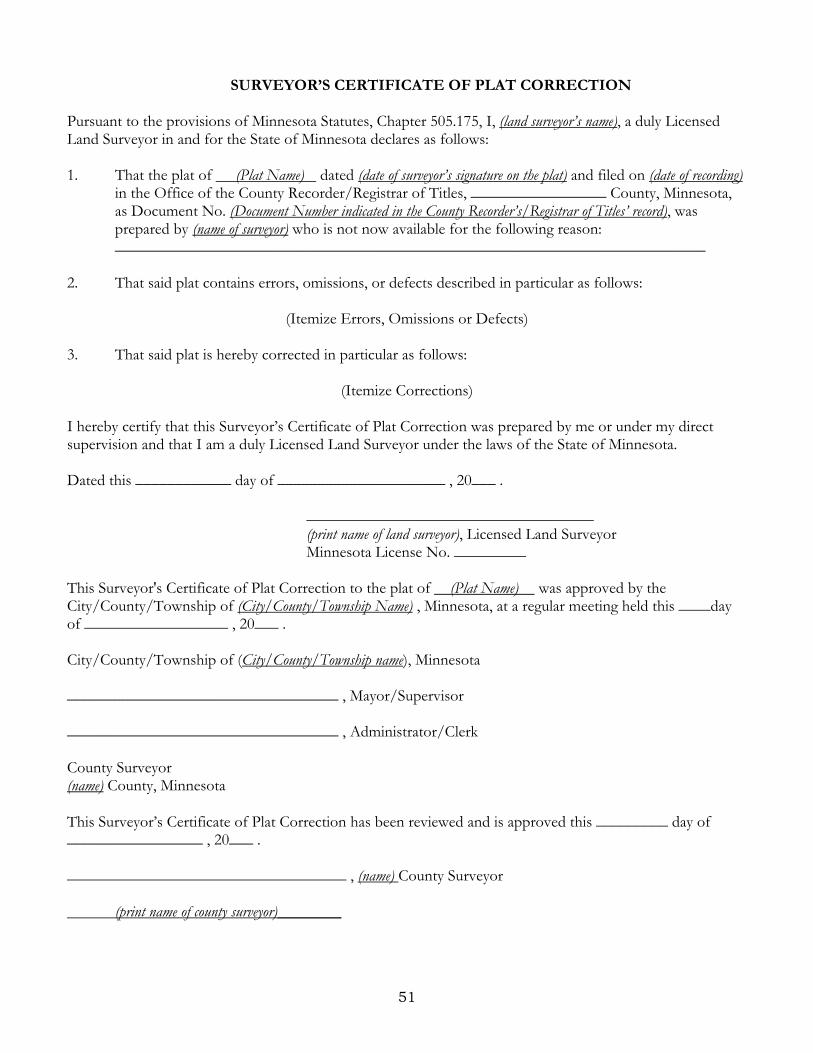
51
SURVEYOR’S CERTIFICATE OF PLAT CORRECTION Pursuant to the provisions of Minnesota Statutes, Chapter 505.175, I, (land surveyor’s name), a duly Licensed Land Surveyor in and for the State of Minnesota declares as follows: 1. That the plat of (Plat Name) dated (date of surveyor’s signature on the plat) and filed on (date of recording)
in the Office of the County Recorder/Registrar of Titles, _________________ County, Minnesota, as Document No. (Document Number indicated in the County Recorder’s/Registrar of Titles’ record), was prepared by (name of surveyor) who is not now available for the following reason: __________________________________________________________________________
2. That said plat contains errors, omissions, or defects described in particular as follows:
(Itemize Errors, Omissions or Defects) 3. That said plat is hereby corrected in particular as follows:
(Itemize Corrections) I hereby certify that this Surveyor’s Certificate of Plat Correction was prepared by me or under my direct supervision and that I am a duly Licensed Land Surveyor under the laws of the State of Minnesota. Dated this ____________ day of _____________________ , 20___ . ____________________________________ (print name of land surveyor), Licensed Land Surveyor Minnesota License No. _________ This Surveyor's Certificate of Plat Correction to the plat of (Plat Name) was approved by the City/County/Township of (City/County/Township Name) , Minnesota, at a regular meeting held this ____day of __________________ , 20___ . City/County/Township of (City/County/Township name), Minnesota __________________________________ , Mayor/Supervisor __________________________________ , Administrator/Clerk County Surveyor (name) County, Minnesota This Surveyor’s Certificate of Plat Correction has been reviewed and is approved this _________ day of _________________ , 20___ . ___________________________________ , (name) County Surveyor (print name of county surveyor)________