manual of united states surveying - bureau of land …€¦ · town sites, act of 1867 ..... 161...
TRANSCRIPT
011'
I ElI:PLOYED III SUliDIVIDIIiG THB
ALSO
INSTRUCTIONS FOR SUBDIVIDING SECTIONS AND RESTORING LOST CORNERS OF THE PUBLIC LANDS.
COIlSTITUTING A
FOR THE USE OF U. S. DEPUTY SURVEYORS, COUNTY SURVEYORS, AND ALL WHO CONTEIIIPLATE ENTERING THE PUBLIC SURVEYING SERVICIi:..
TO WHICH IS ADDED
AN APPENDIX
CONTAINING INFORMATION IN REGARD TO ENTERING, LOCATING, PURCHASING AND SETTLING LANDS UNDER THE
VARIOUS LAND LAWS, ETC. ETC.
.. . ; ..
. .. . . . . . ~ ....... (, .. .. ,. . ~ .. ...
PHILADELPHIA:
J. B. LIPPINCO'l'T & 00.
1
".0/1" ", ~.. ..~"" .... : "',. f
. . . . . . . . . . . . .
Entered, according to Aot of Congress, in the year 1868, by
J. H. HAWES,
In the Clerk's Office of the District Court. of the United States in and for the District of Columbia .
Digitized by Google
P E o E s.
pages have been to a want known and felt. The General Land Office is
and others,
etc. etc. It is the custom of the in answer to these varied
within ",.cl1n,,,·,,, limits of an official communication; but it is
in such a communication to set forth in detail the and the with their multifarious and
"'tJliJ!"',,",CJ'vu,", which affect or control the surveyor in obliterated surveys, or and the boundaries of legal subdivisions not before established in the field; and this information is essential to the surveyor who would execute his work and in accordance with law.
In view of the number of of this character received General Land years had of the
commenced the of a circular to be for the use of the which should be sive to meet the class of referred to.
of
surveyors all the information necessary to enable them to dis. their duties was not to down
rules in eases, but to a full and ""Tnn',,'" ( iii )
iv PREFATORY REMARKS.
tion of the and the laws and instructions directions how to restore a lost corner
without also into the laws and O"UU"IJ,t:u, would be like
nn'p ..... T.I(1'n in civil to one not conversant with that branch...of mathematical
The and unlike any
been afforded surveyors not make themselves with its rules and it is in many cases to make instructions to the local surveyor, without first some to the manner in which the public surveys are executed.
The writer has been and this when
have
understood the instructions become and are
a manual of instructions to the field oper-ations of United States surveyors, was and
under the direction of the General Land Office. Other instructions had becn
in 1855 embraced the of the was much more the kind which had ... ,.,>t·""i"rl
seco.nd section of an act of : " 'I'hat the
tions of the instructions of the when not in conflict
with said manual or the instructions of said Commi8-shall be taken and deemed to be a of every contract
the lands of the United States." many recent
I " II
PREFATORY REMARKS. v
authorized the use of the fications made a such
are now of course to
to time be found necessary.
These rules and instructions are intended to be furnished the to persons in the
the aim of the writer bas been to embody them in a form for the use of the student and the , he has endeavored to furnish a TEXT-BoOK which will enable surveyors to fit themselves for the To this end the work has been Il.TTll.llITen in convenient divisions and subdivisions under ,,,,,nrn,nr, and illustrated
and maps; To tbe Manual proper arc added instructions for """Tnrm
extinct lines and corners of the surveys, and for subdivid-sections. These directions are based upon the laws of Con-
gress and the well-established of the General Land and are very it is the at of every case that will arise in
land states know well the diffi-culties in this kind of surveys, and will find these instructions a aid in their work.
The manner of to have certain in advance of the progress of the
under the of the lOth section of the act of 1862, known as the i also how to
in of land to states and for universi· ties and other purposes, and the survey and settlement of
vi PREFATORY REMARKS.
land under titles and acts of etc.
index attached to the book will enable the
his indebtedness to RON.
the instruc-He also takes this occasion
to HON. JOSEPH S. the uniform and kindness
to obtain the llel~ellll!l.IY
it down to current date. that he has to some extent succeeded in a
hand-book of the land suited to the wants of a ',""'''H'M''''" class of his the
pages to the earnest wish that may be instrumental in
in the laws and in the several land con-LV""""');; to the laws of and the decisions of the United States Courts.
T OF C E
PAOlI
PRIIl'ATOIlY RlIliARKS................................................................... 8 The Public Land System ............................................................... 11 The Public Land Department ......................................................... 15 Su'rv"vin .. Districts ..................... ......... ......... ......... ..................... 15 Rates paid for Surveying ............................................................ _ 16 Areas of the States and Teritories, and public lands surveyed in each .•• 18 Comparative Table of Land Measures of the United States .................. 19 United States Land Offices, where located ....................................... 20
U. S. SYSTEM OF REOTANGULAR SURVEYING. Introduction .............................................................................. 23
ETO.
Townships-Sections-Subdivisions of sections-Principal meri-dians and base parallels....... ..• ...... 25
AND MARKING LINES. Burt's solar compass-Standll.rd chain-Tally pins-Marking tools
-Horizontal measurement-Process of chaining-Line trees-lines-Insuperable objects on line-Random lines-
Lines, how run.. ............ ............... ......... ......... ............... 27
PERPETUATION OF CORNERS. of comers and mode of perpetuat
Corner trees; Stone corners; (8) Posts Posts and mounds-Manner of constructing
J.U"'''L1,uo,-~,.'' • .n""K trees-Witness pits ................................. 80
STANDARD AND CLOBING CORNERS, Standard "v,cU"C"'-'J.vOU'"K corners ........................................... 88
"Q1j01UlfUV Corners. Township coruer posts: Standard township comers; Clos-
ing township oorners - Township corner stones - Township corner trees--Townehip corner mounds ............................... 84
Section Corners. Section comer posts - Section comer mounds - Seotion corner
etones-Section corner trees..... ........ ....... .......... ...... ......... 87 ( vii)
TABLE OF CONTENTS •
.... "':u;r',.,r Section Corners. PAn
Quarter section section mOllnds-Quarter section stones-Quarter section trees.......... ...... ......... •.••.•.•• •••••.••• 88
Corners. Meander posts-Meander mounds--Meander stones or trees........ 40
FIELD BOOKS........... ......... •••••• ......... ......... ••• ...... ••••••••• ...... ...... 40
and data to be noted in the Field Book. Township and rang&-Variation of needle-Courses and measure
ments-Beuing trees-Mode employed to perpetuate corners -Line treell-Intersection of land objeots-Intersection of hills, etc.-Intersection of water objects-Bottom landsLakes and and improvements-SpringsMinerals and coal beds-Roads and trails-Rapids, cascades, etc.-Precipices, caves, etc.-Natural objects-Land lIurface-Timber-Dates-General description-Names of surveying of deputy surveyors-Verification of assistants-Approval and certifioate of Surveyor-General.. 42
OF MEANDElUNG. Meandering of navigable rivers-Meandering of rivers not navi·
gable-Wide fiats-Islands in rivers-Lakes, ponds, etc........ 46
SURVEY OF SWAMP ~""U''' .. 49 ORDER OF CARRYING FORWARD THE PUIILIC SURVEyS ......................... . 61
liIeridians and base lines ..................................................... . 61 Initial point ....................................................................... . 62 Standard parallels or correction lines ..................................... . 62
The six principal meridians ....................................................... . 62 Independent meridians ............................................................. .. 68 Townships west of the meridian, how surveyed .............................. . 63 Townships east of the meridian, how RnY· .. ~,.,,1l 66 EXlerior or township lines ......................................................... .. 68 Sub divisional or section lines, mode of running them ...................... . li8 Laws, regulations and instructious relating to deputy surveyors ......... . 60 Contract and bond of surveyor ........................................ .. 62 Oath prescribed to be taken by all persons in the public service ........ . 64 When one does the work under a ,joint contract he may verify
the same ......................................................................... .. 65 Two active deputies, under a joint oontract, ell.Oh to verify his own
work ................................................................................ . 6/J Form of affidavit for joint surveys ............................................... . 66 Operations in the field, when to oommenoe ..................................... . 66
1
TABLE OF CONTENTS.
PAGS The ,m,.".,>vlna manual and instructions of the Commissioner part of
"n,ov"""'n,,, oontract._............................................. .•.••••••...••• 67 Contracts must be approved by the Commissioner...................... .•...• 67 Prescribed limits for closings, and lengths of lines in certain cases...... 68 Measuring distances over lakes and rivers........ ............................. 69 Short method of finding the area of a multangular field.................... 72 Rules for conecting the course of random lines. ......... ..................... 74 Table showing the dPlference of latitude and departure in running 80
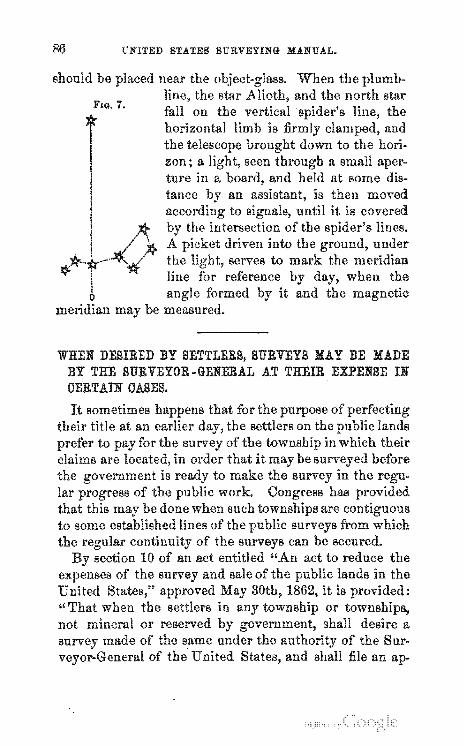
chains at any course from 1 to 60 minutes.. .............................. 76 Variation of the needle............................................................... 76 Methods of &!!certaining the variations............ ............ ...... ...... .....• 79 To find the true meridian with the theodolite................................... 81 To find the true meridian with the compass.................................... 83 Surveys may be made at expense of settlers in advance of the reg-
ular progress of the public surveys. •••••• ••••.••••• ...... ......... ......... 86 Certain small islands may be surveyed at the cost of applicants......... 88 Specimen field book................................ .................................... 91 Specimen township plat.. ..................... ...... ..................... ............ 118 The boundaries of the public surveys not to be changed .................... 119
RESTORING OBLITERATED 121
MODE OF RIiSTORING LOST CORNERS. •••••• ........................ ......... ...... 123
To restore extinct interior section corner8 ......... ....... _. ......... 125
To restore Section Corners on cases:
in the fo1-
1. Where it is common to four sootions............... ......... ............ 125 2. Where double section corners were established, one
of which is still standing ............................................... 125 3. Where both corners are missing, and it is required to restore
the one established when the township line was run ............ 126 4. When it is required to restore the corner established when the
township was subdivided._...... ...... ............... ......... ......... 127 6. When triple corners have been established on range lines, one
or two of which have become obliterated, and it is required to restore either of them ................................................ I\!7
6. Where triple corners on range lines arll all missing. ......... •.•••• 128
To restore LJ"""'r."'''' Section u,,,n«;n •. in the cases:
1. On township boundaries ...... ...... ••••••••• .••••• •••••• ....... .... ....... 128 2. On section lines, closing on the north and west township
boundaries...... ...... ...... ...... .......... ..... ............ ...... .... ..... 128 8. Interior quarter section corners .......................................... 129
x TABLE OF CONTENTS.
To restore in the cases: lI'AOII
1. When common to four townships ......................................... 129 2. When on a correction line and common to any two townships ... 129
To restore Meander Corners ................................................. 130 Laws relating to t,he mode of surveying the public lands ................... 130
OF SUBDIVIDING !o<"".,.,rn"". 136 Instructions of the General Land Office in regard to restoring lost
corners and subdividing sections ....................................... 142
APPENDIX. Regulations of the General Land Office in regard to furnishing oer-
tified copies of plats, records, etc ........................................... 149 Of uncovered meandered lakes ..................................................... 161 Accretions--Riparian rights............ ......... ......... ......... ...... ...... ...... 162 Coal lands ................................................................................ 156 Public timber •..••...• ............... ......... ............... ......... .................. 158 Town sites............................................ ......... ............ ...... ......... 16'8 Town sites, Act of 1867 ............................................................... 161 Repayment of purchase money and changes of entry ........................ 162 Graduated lands ........................................................................ 164 Agricultural and Mechanical College scrip ..................................... 164 Indian scrip ............................................................................. 166 RevoluHonary bounty scrip ......................................................... 167
HOMESTEAD LAW ................................................................... 168 General Land Office circular in regard to homestead law............ 171 An act to secure homesteads to aotualsettlers on the publio domain 174
OF MILITARY BOUNTY LAND 178 Assignment and location of land warrants ................................ 178 General Land Office circular to land warrants.... 181 An aot to authorize the reissue of land warrants in certain cases .. 184
State selections.............. ...... ............ ............ ...... ...... .................. 186 Grant to states and 186
OF PRE-EMPTIONS ...................................... _ .......................... 189 Educational grants ..................................................................... 192 Salt spring lands ....................................................................... 194 Internal improvement lands .......................... : .............................. 194 Mining claims-Circular ............................................................ , 195
MINERAL RESOUROES OF THE UNITED 206
HOMESTEAD 221
T E P BeL
them.
(xi)
xii THE PUBLIC LAND SYSTEM.
THE PUBLIC LAND SYSTEM.
various more and more until when the whole
im-
xiv THB PUBLIC LAND SYSTEM.
and
acres have been states for internal and to aid in the
THE PUBLIC LAND SYSTEM. :xv-
THE PUBLIO LAND DEPARTMENT.
SURVEYING DISTRIOTS.
xvi THE PUBLIC LAND SYSTEM.
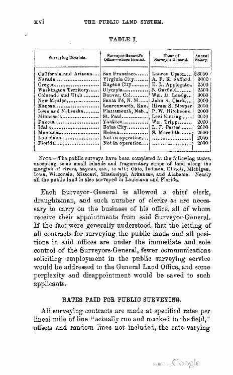
TABLE I.
SUM'oylng Districts.
RATES PAID FOR PUBLIO SURVEYING.
All contracts are lineal mile of line"
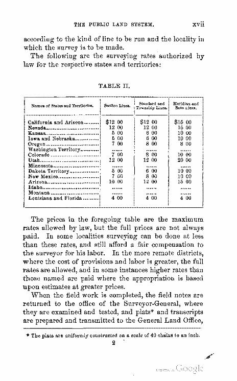
THE PUBLIC LAND SYSTEM:. xvii
run and 111
TABLE II.
Nam ... of States and Terrllorl ...
7 00 8 00 10 00 1200 1200 2000
500 6 00 1000 7 00 800 10 00
1000 1200 15 00
400 400 4 00
.. The plats a.re uniformly constructed on a scale of 40 chains (0 an inch. 2 .
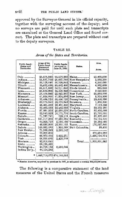
THE PUBLIC LAND SYSTEM.-
TABLE III.
and Territories .
.. R ..... fan America, acqnlred by pureb_ In 1867, 18 ... Umated 10 conlaln 369,529,600 atr ....
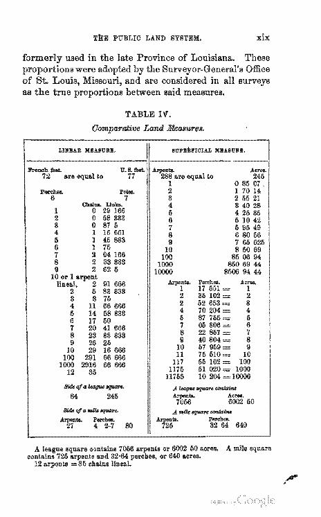
THE PUBLIC LAND SYSTEM.
TABLE I".
GO'ln7:l,ar.:Jtit,e Land Measures.
LINEAIl XEA8URlI. lIupzil.rIcIAL XEAIIURE.
are equal to are to 1 085 07. 2 1 70 14 8 2 55 21 4 8 40 28
1 5 4 26 85 2 0 58 888 6 5 10 4:'. 8 0 87 5 7 5 96 49 4 1 16 661 8 68056 5 1 46 888 9 7 65 625 6 1 75 10 85069 7 2 04166 100 850694 8 2 83 833 1000 860 69 44 9 2 62 I) 10000 8506 94 44
10 or 1 arpent lineal, 2 91 666
2 5 83 333 2 35102 = 2 8 8 75
4 11 66 666 2 52653 = 8 li 14 68838 4 70204 = 4 6 50 5 87 755 = 5
7 41 666 7 05806 6
8 23 83 833 8 22857 = 7 9 26 25 9 40804 = 8
10 29 16 666 10 57959 = 9 100 291 66 666 11 75610 = 10
1000 2916 66 666 117 55 102 = 100
12 85 1175 51 020 = 1000 11755 10204 10000
SUitqfe~~ A !tagt<o Iq1UIre COfttaim
84 245 50
SUit life lIRa. ~ A ",a. Iq1UIrt COftta':M
640
or 6002 50 acrell. A mile square or 640 aores.
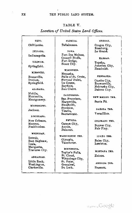
THE PUBLIC LA.ND SYSTEM.
Location
OBIO.
Chillioothe.
INDIANA.
ILLINOIS.
KIlISOUII.I.
Booneville,
ALABAHA.
XIS SIS SIPPI.
Jackson.
LOUISIANA.
New Orleans, Monroe, Nl!.Chitoches.
IIIIOBIGAlJ.
ARItANSA8.
Little Rook,
TABLE V.
United States La.nd
PLOII.IDA.
Tallahassee.
IOWA.
Fort Des Moines, Counoil Bluffs, Fort Sioux
WISOONSIN.
OALD'ORNIA.
San Francisoo,
Stockton, Visalia, Saoramento.
:liBVAnA.
Carson City,
WASBINGTON TEll.
Olympia, Vanoouver.
Du Luth.
OREGON.
Junotion Humboldt.
NEBII.ASItA.
lIlBW :MEXIOO TEll..
Santa F6.
DAKOTA na.
Vermillion.
OOLOlLADO TlIR.
Denver City, Fair Play.
IDAIIO TlilR.
Boise City, Lewiston.
KONTANA TER.
Helena.
ARIZONA TEa.
Prescott.
S STE OF
EMPLOYED IN SUBDIVIDING
(ui)

u 10
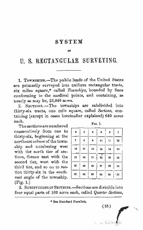
THE the United in its state of per-
-,--_. __ • and most beautiful that could be devised. our own in the
tioD of its surveys. A state when subdivided bas the
of a. well-laid out on a scale j corre-to the blocks and the sections and subdivisions to the
but with this difference in favor of the one and six miles square,
to the cardinal ""'n".n"1 meridian and base
which form the
streets of a bered j so that anyone J)o:sse'sslng can determine the
was not reached at once j is the result of many trial and ment was done in the State of
of was at that time
The first governin 1796. The
the first seven tiers The
direction of the (xxiii )
xxiv INTRODUCTION.
l"Iec:ret:arv of the Hon. Albert U".'''CIU, and the work was executed under the immediate of Rufus the first The in these seven ranges
with number one on the river and number mode of and ranges
of the meridians was soon found to be a where range lines were pro-
were tried to overcome this in the "correction
are now to be run every five miles north or south of the base line.
and slow; gone on
has been attained. We may now, th",."t'",·"
to put forth a Hand-Book on this the facilities for the first time afforded the
with the of
who are interested in the ~ .. I"~~'n
* The General Land Office was organized as a distinct bureau of the .,.~" •• ,.,." Department by act of Congress, 26th, 1812.
s 011'
G s
, I 3 :I 1
9 10 11 12
1t1 IIi 14 13
21 22 23 24
30 29 28 21 26 26
---- --------81 32 88 M 3,S , 36
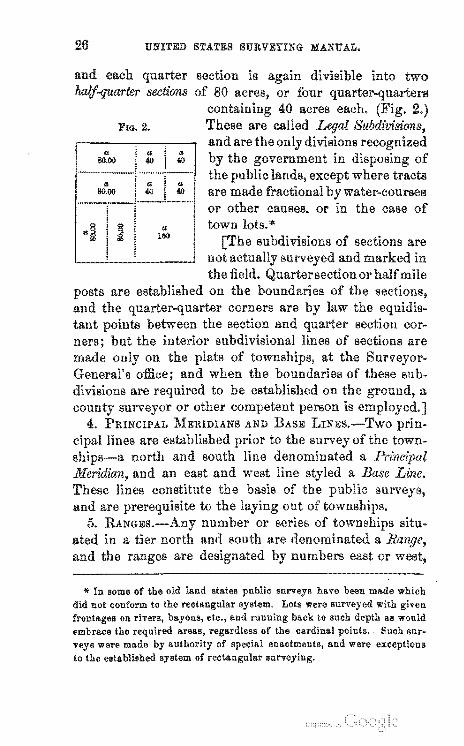
3. SUBDIVISIONS OF into of 160 acres
* See Standard Parallels. (25)
UNITED STATES SURVEYING MANUAL.
'" In some of the old land states public surveys have been made which did not conform to the rectangular system. Lots were surveyed with given fronta.ges on rivers, bayous, etc., and running back to such depth 11.8 would 4!mbrace the areas, regardless of the cardinal points .. Such surveys were wade by authority of special enactments, and were exceptions to the establi~hed system of rectangular surveying.
RECTANGULAR SURVEYING.
LINES ••
* Standard were formerly run every 24 miles north of the base line, and every 30 miles south of it. The present system was in 1866.
UNITED STATES SURVEYING MANUAL.
RECTANG ULAR SURVEYING. 29
8.
UNITED STATES SURVEYING MANUAL.
PERPETUATING OORNERS.
RECTANGULAR SURVEYING. 81
(3) Posts and WUnesses.-It frequently happens iu a timbered country that suitable stones cannot be obtained. When this is the case, and trees are at hand for "witnesses," posts may be planted at the corners, and evidenced as directed under the head of "bearing trees" on page 32. All posts must be made of the most durable wood of the forest at hand.
In loose or alluvial soil, section, quarter-section, or meander posts may be driven into the ground, instead of digging holes and planting them; but no posts should be so driven unless, from the nature of the soil, they will be thereby rendered more firm and enduring.
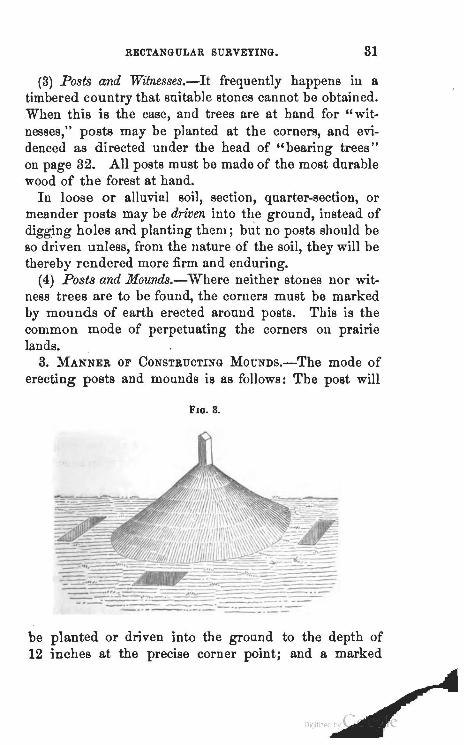
(4) Posts and Mounds.-Where neither stones nor witness trees are to be found, the corners must be marked by mounds of earth erected around posts. This is the common mode of perpetuating the corners on prairie lands.
3. MANNER OF CONSTRUCTING MOUNDs.-The mode of erecting posts and mounds is as follows: The post will
Flo. 8.
----
be planted or driven into the ground to the depth of 12 inches at the precise corner point; and a marked
UNITED STATES SURVEYING MANUAL.
IS
of these memorials; them must in case be the must state in the field book which is
must be of the same of corner 12
RECTANGULAR SURVEYING. 33
be
can
of
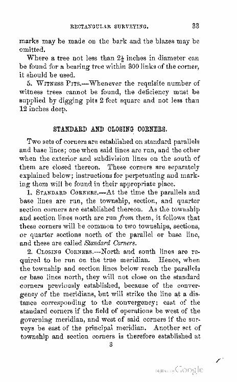
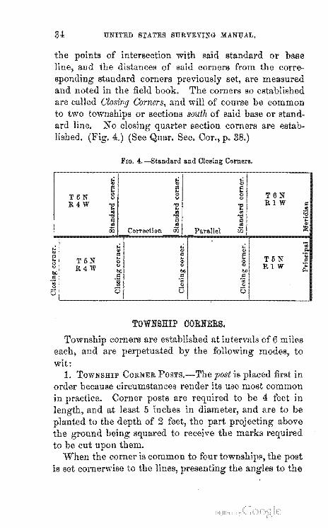
STANDARD AND CLOSING CORNERS.
/
34
T6N R4W
..: '" " .. T5N 0 ., R4W
I,
UNITED STATES SURVEYING MANUAL.
or corre
are measured
are estab-
FIG. 4. -Standard and Closing Corners .
.: ,.; ,.; ., ., '" E e e
0 0 0 T6N '" <> '"' 1: .." .." RIW = .. .. .. .. .. cO :a .." '"d '"d ~ J'l = .;:: .. .. .. .,
00 Correction 00 Parallel 00 ::E
.: ,.; ..: ~ ., '" ., '" = ~ .. .. .. T5N
.., '" 0 '" '" '"
., .., RIW .;:: lOll btl
! Il;
I:l '" °00 °00 0 '" 0 0
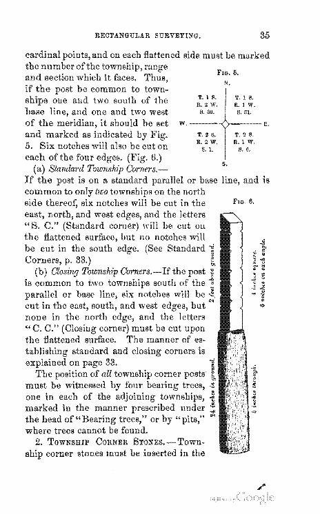
TOWNSHIP CORNERS.
RECTANGULAR SURVEYING. 35
must be
FIG. o. N.
T. 1 S. T. 1 ~. R.2
W.------~;~-----E.
is
FIG. 6 .
./
86 UNITED STATES SURVEYING MANUAL.
above the mound.
their sides to the
stances.
O"'JU'U be
corlike circum-
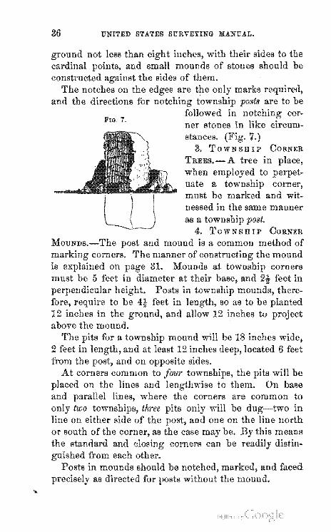
3. TOWNSHIP CORNER
-A
as a Ten""n,,,,
4. ']'OWNSHIP
and mound is a common method of The manner of "' .... "'ty.,,
31.
RECTANGt::LAR SURVEYING.
'SEOTIOB' OOBJrEBS.
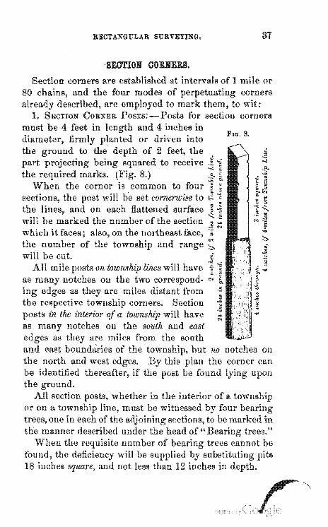
of 1 mile or corner8
to wit: for section corners
4 inches in
.. .. ~~ il
"" range ::,.
WIL7fI .. ~lun lines will have
Scction in the interior a have
notches on the south and east
18 inches square, and not less than 12 inches in
FIG. 8 .
on
upon
88 UNITED STATES SURVEYING MANUAL.
2.
corners common to two of the will fat:e the cardinal
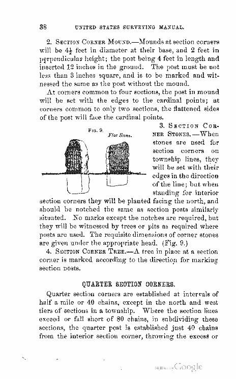
3. SECTION COR-FIG. 9.
Flat $ro".. NER
comer IS
section DostS.
stones are used for section corners on
SEOTION OORNERS. corners are of
west the section lines
these
RECTANGULAR SURVEYING.
and the "~".OcA'·" be
section corners are not on the north of
for the purpose will not
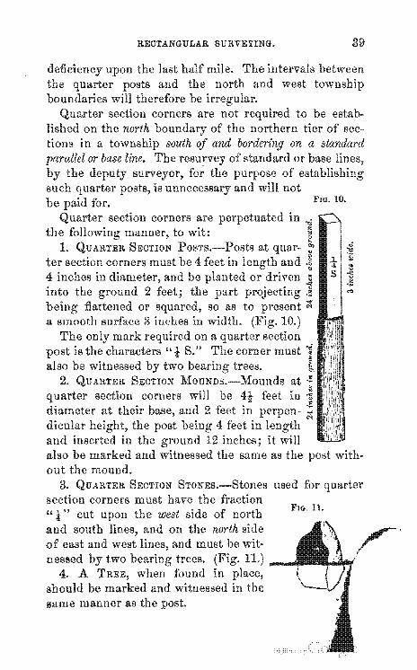
FlO. 10.
4 inches in into the
corners are no'rn£l,,.,
section corners diameter at their aud 2 feet dicular the post 4
inserted in the also be marked out the
3. SECTION STONEs.-Stones used for section corners must have fraction "t" cut upon the west side north
FIG. 11.
and south and on the north side
same manner as the
~ 4-S
39
.. ::! 1I ~ .... " ·5 ""
40 UNITED STATES SURVEYING MANUAL.
meander corners. 1.
MEANDER OORNERS.
to
its III
used must be witnessed
FIELD BOOKS. surveyor are the official
of
RECTANGULAR SURVEYING.
5. notes should in all cases be taken
must show
UNITED STA.TES SURVEYING MANUA.L.
"14 x 12 x 3," the same of
names must never be often their recurrence .
however
. 8.
contained matter believed it to be his interest to
OBJEOTS AND DATA TO BE NOTED IN THE FIELD BOOKS.
2.
notes of measurement. in where any material in the variation is found, such __ , •• '>-, __ , with the exact where occur, must be
\
RECTANGULAR SURVEYING. 43
corners, witness corners to true ones.
5. MODE EMPrt)YED TO
if it
the
it is erected in the courses and distances of the
and with their courses
the land of the 9. INTERSECTION OF
line to all
of
with instructions, and the center of
from
and distance on
at
feet
to in-
44 UNITED STATES SURVEYING MANUAL.
15. ROADS AND
I1P'I"O'lY\tlllth III
each mile of line. 21.
RECTANGULAR SURVEYIYG.
any matter or he may be able to
to be 23.
45
book
t'NITED STATES SURVEYING MANUAL.
MEANDERING.
and water-courses are in some cases meandered.
At those where the lines of the surveys bodies of
or stream.
corners. 1. rivers are to
RECTAYGULAR SURVEYING.
marshes or " .. ,,'rrArrI"
Sufficient courses must be
on ISLANDS IN i.!T'''''T''''
a township same are
of the river embrace all the
in ",.«c,""v, but
render4
he may meanders as far as
bank to
UNITED STATES SURVEYING MANUAL.
on the baAe line near the
RECTANGULAR SURVEYING. 49
The defi-
the corner from tional section are to be
and bars are to be their exact situa-tion indicated intersections to their upper and lower
also the head and mouth of all at the end of
notes of the the work is performed, field notes. notes will be a
to which the bottoms are to overflow. The and so much of meanderable
rivers as lie within the of a meandered at the
notes of No blazes or marks of any
on meandered between CaCJHO'llCU corners .
. SURVEY OF SWAMP LANDS.
EO UNITED STATES SURVEYING MANUAL.
stnte the swamp it is necessary that the field of surveys, in addition to the other of to·
to be
to
or lakes should be stated. The words" unfit for cultivation" are to be
in to
RECTANGULAR SURVEYING. 51
ORDER OF OARRYING FORWARD THE PUBLIO SURVEYS.
In the
mode of of
the order in which the in the field.
surveys are in state or terri-
52 UNITED STATES SURVEYING MANUAL.
to the in-pages. lines may be
run on either a due west course from and cor-
III
a meridian and a base will be to select some prom-inent natural land-mark convenient to locality where the earliest surveys ,vill be an initial or start-
An well-defined or of confluence of two
indicated.
Pmrall'rls or Correction may also be necessary to run one or more standard lines in the
of for it will be borne in
Meridian runs north from the mouth of the Little the center of the State of Indiana. to its northern
RECTANGULAR SURVEYING.
1. EXTERIOR OR TOWNSHIP LINES •
.comer of Townon the
establish-
section 3, where measure and llote the distance at
which the eastern of the true or a
Meridian runs north from the month of the Ohio center of the State of Illinois, at its
Meridian runs from the Illinois river of Illinois and the center of Wisconsin to Lake
Meridian runs north from the confluence of the the of the
on the Arkansas river, in the eastern part of Kansas
(54 )
RECTANGULAR SURVEYING. 55
course that will run a true line to corner the random run and measure
4, which is identical with 2, nf'rmn'TIP:lH corners on said line and rary corners on the excess or de-
in measurement Qn the west end of the line. If in line the
fall short or overrun in or intersect the at more than 3 chains and 50 links or south
of the true corner, either of which error in the the lines must
necessary to remeasure the of the
on mile corners
is reached at the ex-under 480 chains upon the last
to law; and the intersection corner," and
the distance to the nearest " on said
may be
of
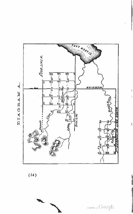
not interline. The manner of
A.
56 UNITED STATES SURVEYING MANUAL.
I1S be to I'un a Iv .. r.'.c"·~1!1W'
therefrom to serve as a base for the desired surveys. The manner of the exteriors from
and indi-
and measured west and the true lines be run
the
measurement with thc
480 chains on the west end will therefore commence his
of the excessive or deficient half section
the on the west and
measurements will all be exact miles and miles.
"With the notes of the exterior lines of the IS to BU bmit a of lines run, on a
scale of 2 inches to the on which are to be noted all of on line necessary to illustrate
to wit: The distances on line at the of streams, so far as such can be noted on the paper, and the direction of each indicated an arrow-head down stream; also intersection of lines
ponds, swamps, all other matters
extent
32 (II)
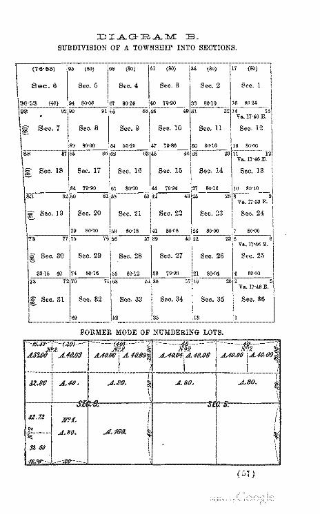
DIAGBA:b.1: E. SUBDIVISION OF A TOWNSHIP INTO SECTIONS.
lV'?:f.
.A.. 80.
FORMER MODE OF NUMBERING LOTS.
i
f .4.16'/9. ~ ,
\ )
f i
~ \
UNITED STATES SURVEYING MANUAL.
2. SUBDIVISION OR SEOTION LINES.
Before 'n""""Ati,
will be common to sections 35 and 36-B-theuce due north 40 where
north
either or south of the section corner, of' the of intersection from said corner measured and and a course calculated that will
RECTANGULAR SURVEYING.
on the section corner nr.~_n'IT" of the intersection from said corner must
and a that will
manner to survey the on the interior section corners just
same as he did those on east
59
UNITED STATES SURVEYING MANUAL.
In the fifth and sixth
and corrected back the same as between the sections in the first that
section corner must be established exchains from the interior section corner, as re-
on the north excess or V'""'''-''-'''.1 of measnrement upon the last half mile or out·
cascs.
section. his instructions for subdivisional surveys,
will fumish the with a dia-
npon which measurements of each mile on said
variations of each mile and the
are shown and order described are to be followed in all
AND INSTRUOTIONS RELATING TO DEPUTY SURVEYORS.
RECTANGULAR SURVEYING. 61
Buch cases as the Commissioner shall order; but it be understood that the
Land to whom
trol
contracts is to them alone ernment surveyors be made.
The of
nor.to exercise any con
of an
are let to out of these
and
act
"An act to
UNITED STATES SURVEYING MANUAL.
in demonstrates that those
who have trusts, have ever been suc~ceissl:u
OONTRAOT AND BOND. upon the survey, the
to execute a contract and bond with in the to wit:
of purposes," as
RECTA5GULAR SURVEYING.
-IN have hereunto set their written.
SOLOMON SHARP,~urvEivo~Gfenera.1. PETF.R TRAVERSE,
sealed, and us,
JOHN SMITH, THOMAS JONES.
Sworn to Rnd subscribed before at (Golden in the
W ALTER CARROLL, Public.
64 UNITED STATES SURVEYrNG MANUAL.
I (William above bond are and
Witness my hand and seal at 1867.
Idaho T.
OATH
the sureties to the the same.
1. this of
WILLIAM BROWN.
RECTANGULAR SURVEYING.
the duties or the office on which I am about to enter. So
} 8$,
Sworn and snbscribed to before 1867.
65
.. UNITED STATES SURVEYING MANU At.
of line WIlS run.
wit:
FORIl OF AFFIDAVIT FOR JOINT I-IfTlRV"'VR,,_"
do swear aDd C. D. are era! for
be to
RECTANGULAR SURVEYING.
tions is <:!'[7.",j-o'rn is to cause an undue of the season
In
THE SURVEYING MANUAL AND INSTRUOTIONS OF THE OOMMISSIONER ARE MADE A PART OF THE SURVEYING OONTRAOTS BY LAW.
OONTRAOTS MUST BE APPROVED BY THE n"""VT<""T."""'''''''
68 UNITED STATES SURVEYING MANUAL.
by the Commissioner of the General Land Office, except in such cases as the Commissioner shall otherwise especially order.
In the more remote districts, as for instance California, Oregon, and Washington Territory, the Commissioner's approval is given in adv~nce, with certain limitations, to avoid 'impracticable delays.
PRESORIBED LIMITS FOR OLOSINGS .AND LENGTH OF LINES IN OERTAIN OASES.
1. Every north-and-south section line, except those terminating in the north boundary of the township, must be 80 chains in length.
2. The east-~nd-west section lines, except those terminating in the west boundary of the township, are to be within 100 links of the actual distance established on the south boundary line of the township for the width of said tier of sections.
3. The north boundary and south boundary of anyone section, except in the extreme western tier, are to be within 100 links of equal length.
4. The meanders within each fractional section, or between any two meander posts, or of a pond or island in the interior of a section, must close within 1 chain and 50 links. .
5. In· running random township exteriors, if such random lines fall short or overrun in length, or intersect the eastern or western boundary, as the case may be, of the township, at more than 3 chains and 50 links north or south of the true corner, the lines must be retraced, even if found necessary to remeasure the meridianal boundaries of the township.
Digitized by Google
RECTANGULAR SURVEYING. 69
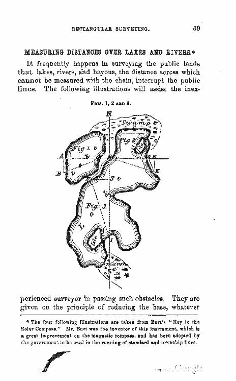
MEASURING DISTANOES OVER LAKES AND RIVERS ....
FIGS. I, 2 AlII> 3.
* The four following iIlustr!l.tions Are tAken from Burt's .. Key to the SolAr Compalls." Mr. Burt wall the inventor of thill Instrument, which III II> great improvement on the m!l.gnetic compalll. and h!l.8 been by the government to be uBed in the of standard and Lo"m","n
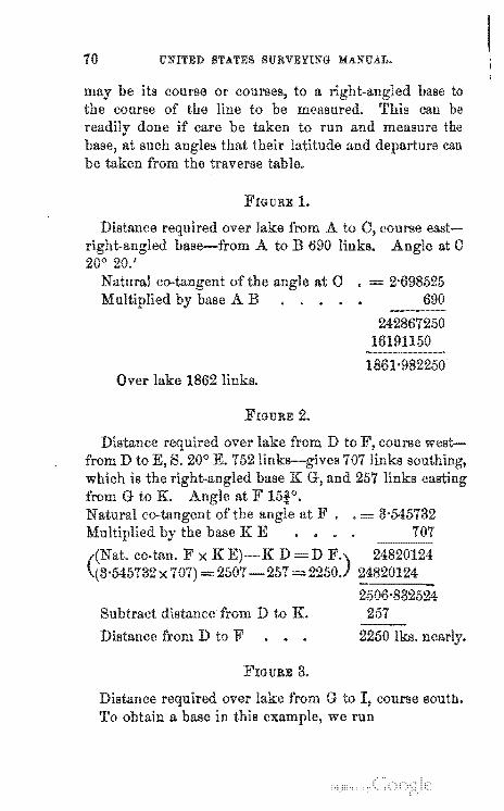
10 UNITED STATES SURVEYING MANUAL.
1.
over lake from A to ''''U.-'''",,''A.A. DflSe--Ir'om A to B 690
20° 20.'
lake
of AB
at C
2.
co-tan. F x K D =D x =2507-257=
distance D to K.
D to F
3.
course eastat C
690
24820124 24820124
G to I, course Boutb. we run
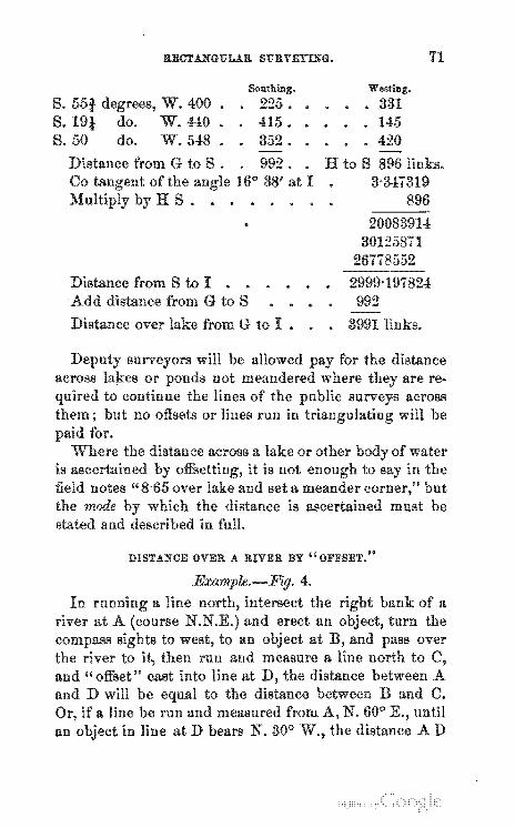
s. S. S.50
RBCT.L,,{GULAR St'BVEYL'OG.
&nthing •
., • .Fn",.,,,,_ W. 400. • 225. • W.440 • 415.
do. W.548. 352.
Westing.
• 331 • • 145
• 420
71
. 992. • H to S at I .
896
30125871
S to I . . Add distance from G to S
from G to I •
of water is ascertained to say in the field notes" 8-65 over lake set a meander corner," the mode which distance is must be stated in full.
DISTANCE OVER A R.IVER. BY "OFFSET,"
and" offset" east into line at D to the distance
if a nne be run and measured from an in at D bears 30°
of a
until AD
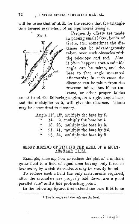
UNITED STATES SURVEYING MANUAL.
will be twice thus TO,.'Tn"·"
A
5. 4. 3. 2·5. 2.
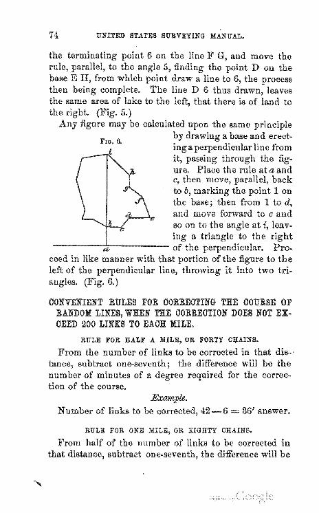
SHORT METHOD OF FINDING THE AREA OF A ANGULAR FIELD.
base E H to an
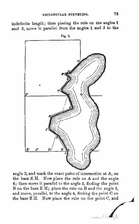
RECTANGULAR SURVBYI.NG. 78
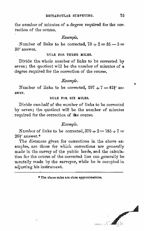
6.
74 UNITED STATES SURVEYING MANUAL.
d/
c, to h, Ion
base; then from 1 to and move forward to c and
in like manner of
OONVENIENT RULES FOR OORREOTING THE OOURSE OF RANDOM WHEN THE OORREOTION DOES NOT EX-OEED 200 LINKS TO EAOH MILE.
RULE FOR HALF A MILE, OR FORTY C:ijAINS.
ilie ~ ~ ili~
be a
the course.
42-6 = 36' answer.
RECTANGULAR Sl7RVEIT.'S'G.
of a np' ...... ·p
to
RULE FOR THREE MILES.
to an-Bwer.
RULE FOR SIX MILES.
185+7=
• The above 1'1lles are close apl)foltilllaticllIUI.
UNITED STATES SURVEYING MANUAL.
TABLE VI.
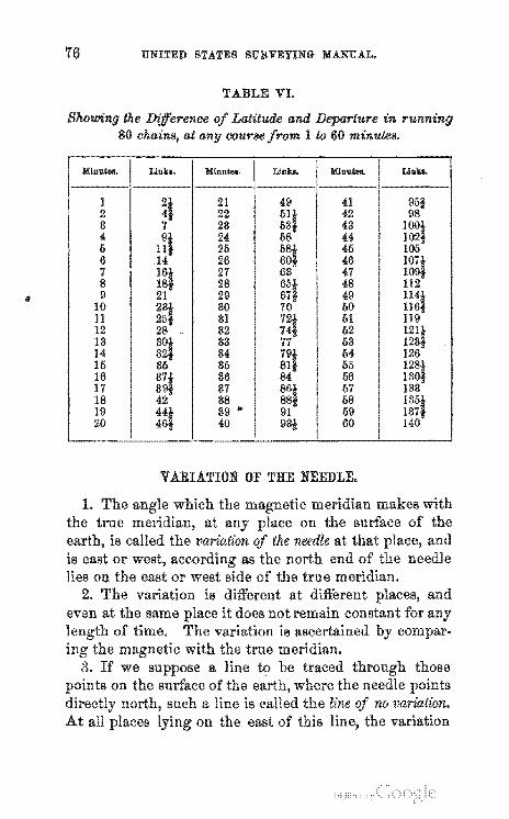
Latitude and in 1 to 60 minutes.
Mlnllw. Llllln. Mlnllw. Llilb. M111"w. Lillb.
1 21 49 41 2 22 42 8 28 48 4 24 44 6 26 46 6 26 46 7 27 47 8 28 48 9 29 49
10 80 60 11 81 61 12 82 62 13 83 63 14 84 64 16 86 65 16 86 66 17 87 67 18 88 68 19 89 .. 69 20 40 60
VARIATION OF THE NEEDLE.
RECTANGULAR SURVEYING.
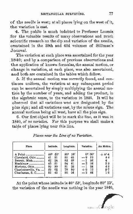
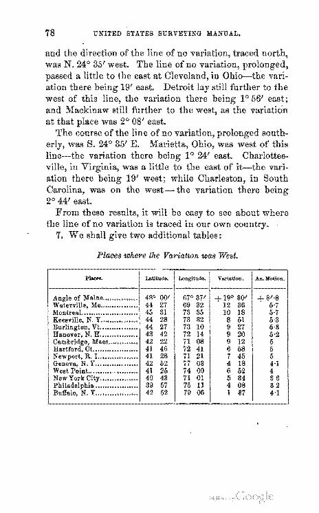
Places near the Line Variation.
PI""", Latlll'lde. Longill'lde. V &rlatlon. An. Motion.
A Point •...•.••• •••••••.• 400 63' 800 18'
... ".~u,u" is 40° 53',
+4"4 4,4 4 8,9 4'3 8'1 1-8
UNITED STATES SURVEYING MANUAL.
and the of was N. 24° 35' west.
a little to the east at
where
Places where the Variatton was West.
73 85 ]S 5·7 28 78 32 61 6·3 27 73 10 27 6·3 42 72 14 20 6·2 22 71 OS 12 6 46 72 41 68 6 28 71 21 46 6 62 77 03 18 H 26 74 00 62 4 43 71 01 84 86 67 76 11 OS 32 62 79 06 87 H
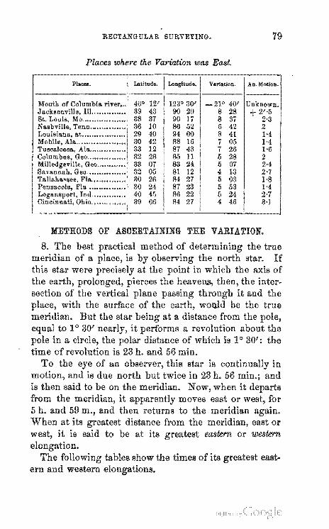
RECTANGULAR SURVEYING.
Places where the Variation was East.
PI ....... Latitude. Lougltude. Varlation. An. Motion.
46° 12' 1230 30' _210 40' 39 43 90 20 8 28 + 2',5 88 87 90 17 8 87 2'3 36 10 80 52 6 42 2 29 40 94 00 8 41 1·4 80 42 88 16 7 05 1-4 33 12 87 43 7 26 1·6 82 28 85 11 5 28 2 33 07 83 24 6 07 2·4 32 05 81 12 <1 13 2'7 80 26 84 27 6 03 1·8 80 24 87 23 6 58 1·4 40 45 86 22 I) 24 2·7 89 06 84 27 4 46 3·1
METHODS OF ASOERTAINING THE
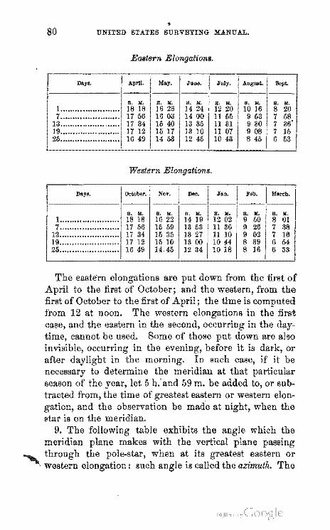
.. UNITED STATES SURVEYING MANUAL.
Eastern El'lnllail:onll.
Western J!ilIOn(latl:on./i.
October. Nov. Dec. JaIl. Feb. M"."h.
or if it be
the
RECTANGULAR SURVEYING.
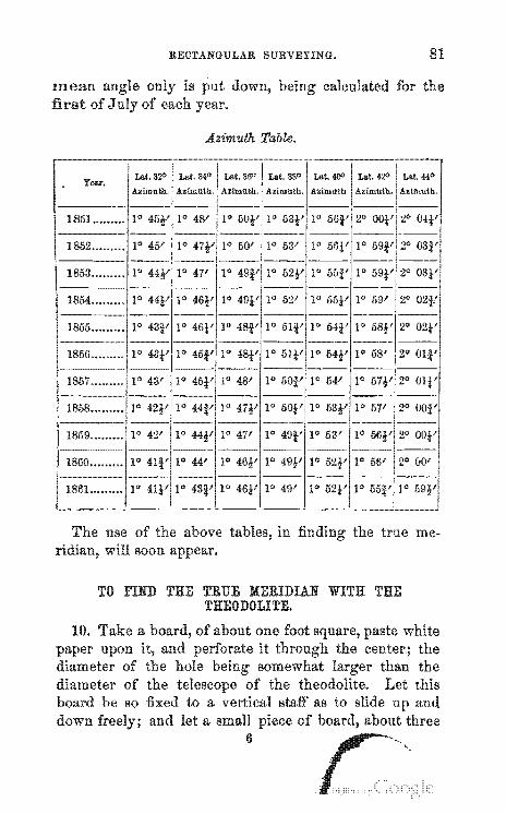
Azimuth Table.
1861 .••.•••••
The use of the in soon 0""' .... ">< ....
Lat. 42" Lat. 440
Azimuth. Azimuth.
true me-
TO rIND THE TRUE MERIDIAN WITH THE THEODOLITE.
82 UNITED STATES SURVEYING MANUAL.
of for the
it
care
RECTANGULAR SURVEYING.
TO FIND THE MERIDIAN WITH THE OOMPASS.
84 UNITED STATES SURVEYING MANUAL.
1. azimuth 04' needle on west, 06'
Variation . . 6°10' west.
2. azimuth. 10 59' needle on eut, 40 50'
Variation . . 20 51' eut.
\
3.
4.
RECTANGULAR SURVEYING.
azimuth ..... needle on the west,
Variation • . • • ••
azimuth. • • • needle on the east,
Variation • • • • ••
REMARK 1. The
can be re-run. 12. It has
2° 05' 8°30'
85
60 25' west.
10 57' 80 40'
• 100 37' east.
R6 UNITED STA.TES SURVEYING MA.NUAL.
WHEN DESIRED BY SURVEYS MAY BE MADE BY THE SURVEYOR -GENERAL AT THEIR EXPENSE nr OERTAIN OASES.
RECTANGULAR SURVEYING.
are. money should be
H'''''''''Ul<:,. of the
UNITED STATES SURVEYING MANUAL.
the contract
is the survey must include all the surveysuch
OERTAIN SMALL ISLANDS MAY BE SURVEYED AT THE OOST OF APPLIOANTB.
of its area.
RECTANGULAR SURVEYING.
Office will
an estimate of cost of into eftect the 10th section of
that
90 . UNITED STATES SURVEYING MANUAL •
..... ,_ ........ "' .... in contracts
\
E
I OJ' TilE
SUB
OF TOWNSHIP NO. --, RANGE NO. --, OF THE --TH PRINCIPAL MERIDIAN.
I
ES
SURVEYED BY -- ---, DEPUTY SURVEYOR, UNDER
HlS CONTRACT, DATED --. 18-.
SURVEY COMMENCED --.
SURVEY COMPLETED ---
(91 )
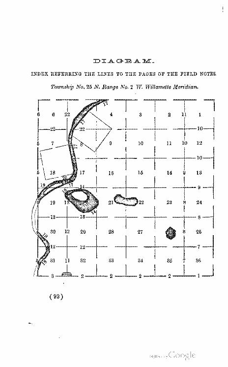
INDEX REFERRING THE LINES TO TIlE PAGES OF THE FIELD NOTES.
"OWlrLSn"!1) No. 25 N. No.2 W. Wz7lamette MeN·dt·an.
8
--1--9
22
+ --1--8
26
--l...-2-'""--2--'--1
( 92)
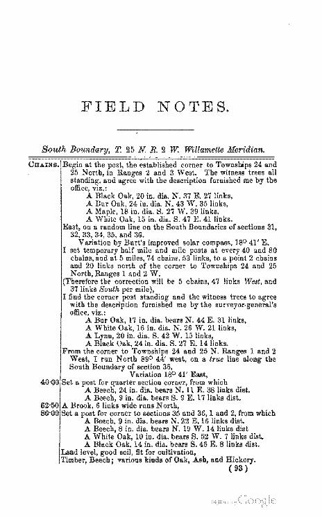
I
W. Willamette Meridian.
and the witness trees to agree me the
17 in. dill.. bears N. 44 E. 31
41' East, from which
links diet. diet.
1 and from which
and (93 )
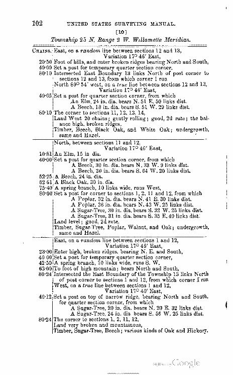
UNITED STATES SURVEYING MANUAL.
[2]
T. 25 N R. 2 W. Willamette Meridian.
Variation ISO 41', section from which
8 in. dill.. bears N. E. 8 links diet. made trench around
hill; bears N. and for corner of sections 34 and 35, 2 and
diet. di~t.
and
3 and 4. with as per ill-
and 4 in. for
I
\
FIELD ;NOTES.
[3]
T. 25 N. R. 2 W. Willamette Meridian.
II. in line river, and from II. corner offset 56 links the which
.A 10 in. dill.. bears N. 2 E. 12 links dil<t •
.A 12 in. dill.. bears N. 80 W. 16 links dist. corner above described,
II. for section from which Bur 20 in. dill.. bears 37 E. 26 links dist.
UNITED STATES SURVEYING MANUAL.
[4]
2 and 3 W. T. 25 N. Willamette Meridian.
from which
Asb.
Variation East, fractional sections 25 and 30 on the
of River, a stream, which runs S. E. from which A 6 in. dill.. bears S. 37 W. 55 links dist. A in. dia. bears S. 30 E. 11 links dist.
to be set on the left bank of the in the line sections 25 and 30. From the corner I run 'Vest 333 chains to It from which the bears N. 16°30' E. which for the distance across river on the line 1l'27 chains, to which add 27'73, makes
.,,,.,,,,''l'_ the on the I here set a post for corner to fmc-tional 25 and from which
A 8 in. dill.. bears N. 44 E. 17 links dist. A White 8 in. dill.. bears N. 15 W. 8 links dist.
for section from which 9 in. dill.. bears 16 E. 16 links diat.
DUCIH~ve. 10 in. dill.. bears S. 16 E. 18 links dist.
30.
and Ash.
Variation 180 20 in. dia. on the left bank Cbickeeles
corner to fractional sections 19 and 24, from
chains the
'''''''U''"O''VU as the mean distance across the
FIELD NOTES.
[6 ]
2 and 3 W. T. 25 N. WillameUe Meridian.
to
for
un·
Variation 53' East, bottom and enter ; bears N. E. and S. W.
Red 20 in. dill. White 24 in. dia.
section corner, from which
.A. White road from
22 in. dia. bears N. 27 W. 27 links dist. 23 in. dia. bears S. 28 E. 92 links dist .
bears East and West, Black Walnut, 21 in.
for corner to sections from which White 12 in. dia. N. E. links dist.
A Black in. dill.. bears N. 53 W. 40 links dist. A Black 16 in. dia. bears S. 40 W. 55 links dist . .A. Red Oak, in. dill.. bears S. 44 E. 50 links dist.
and next the bottom soil 2d rate, varions kinds of Oak and
Oak and Hazel.
T
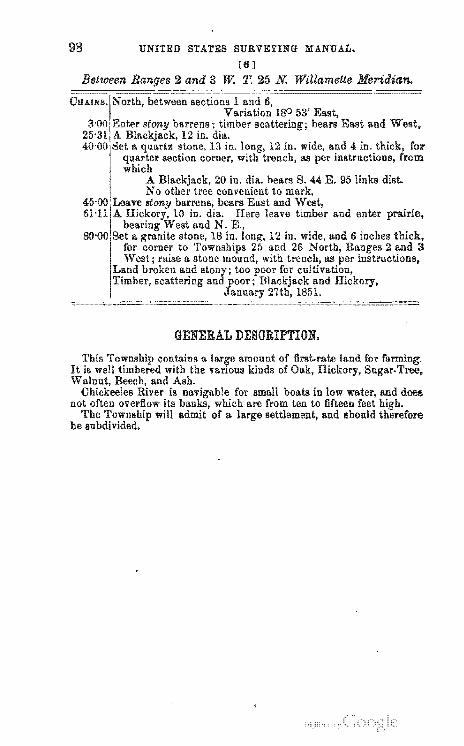
98 UNITED STATES SURVEYING MANUAL.
[6]
2 and 3 w: T. 25 N. WillameUe Meridian.
GENERAL DESORIPTION.
is m.'""",",,,,, for small boats in low not often overflow its which are from ten to fifteen
The will of a and should therefiore be subdivided.
Field Notes
FIELD NOTES.
[7]
99
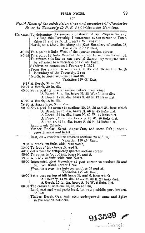
the subdivision lines and meanders Tnl1lTUffl1'l, 25 N R. 2 W Willamette
18 in.
from which 8 in. dia. bears N. W. 45 links dist. 15 in. dill.. bears S. 48 E. 12 links dist.
and 36,
30 in. dia. for corner t.o sections 35 and 36, from which
28 in. dia. beal's E. 45 links dist. 24 in. dia. bears N. 62 W. 17 links diet.
2U in. dill.. bears S. 70 W. 50 links dist. 36 in. dia. bears S. 66 E. 34 links dist.
rate, nnder-
at post corner to sections 25 and
broken,
nndel~lITowth. same and
(
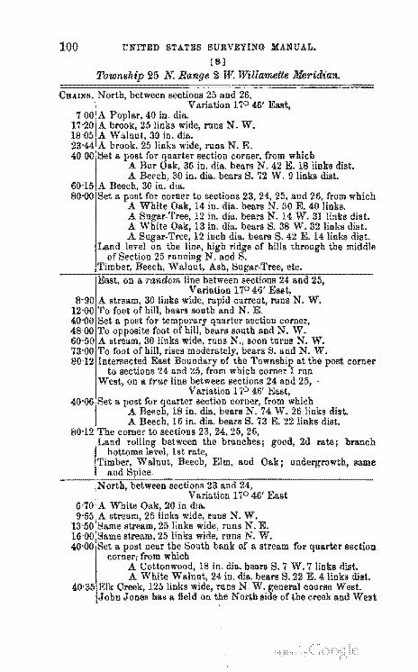
UNITED STATES SURVEYING MANUAL.
[8]
from which
corner
2d rate; branch
rip.r'D'f'f.wth, sllme
section
FIELD NOTES.
[9]
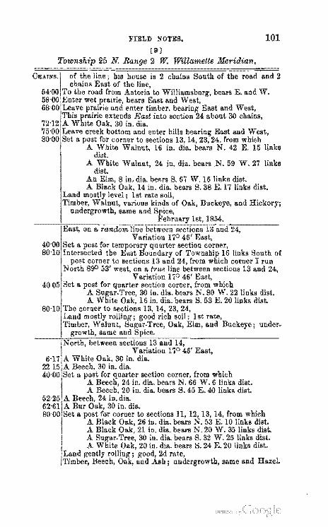
2 w: Willamette Meridian.
2
W.iIIilllml.bnfl!'. bears E. and W.
East and West, from which
N. 42 E. 15 links
24 in. dia. bears .N. 59 W. 27 links
and
links South of corner I run
from which 24 in. dill.. bears N. W.6 links dist. 20 in. dill.. bears S.45 E.4O links dist.
; under-
un,derlrfclwth. same and Hazel
UNITED STATES SURVEYING MANUAL.
[10J
2 W. Willamette ~Jleridian.
post corner to
2d rate i the bal.
Oak;
from which 30 in. dia. beaTS N. W. 9 links dist. 20 in. dia. bears S. 64 W. 20 links dist.
12, from which
links North corner I run
FIELD NOTES.
[11]
2 W. Willamette Meridian.
the foot of the mountain, we the line we observed
to be rich auriferous
of corner to
Beech, and various kinds of Oak;
the distance from swamp,
from which 20in. dill. bears N. W. 4f) links dist.
20 in. dia. bears S. 12 E. 13 links diet.
104 UNITED STATES SURVEYING MANUAL.
[12]
corner to
to be set on the bank of the sections 30 and 31. l!'rom the on
at 8'00 I rUll South 245 links the bank bears N.
16 in. dill.. bears N. 50 E. 16 links dist. ru",,,'u,,ccy, 15 in. dia. bears S. 79 E. 14 links dist.
to inundation 3 or 4 feet Oak, and
PIELD NOTES.
[13]
2 W. Willamette Meridian.
36 in. dia. corner to sections
15 in. diu.. bears dist. 24 in. dill.. bears N. 79 W. 10 links dist-in. dis. bears S. 14 W. 10 links dist. 8 in. dis. hears S. 11 E. 14 links di&t.
and Oak and Hazel; etc.; !lnder-
106 UNITED STATES SURVEYING MANUAL.
[14 J
from which
\
12 in. dia. bears tl. 45 W. 21 dist. A dia. bears S. 23 E 24 links dist.
IFrom this corner off~et n'est 7'50 chains to a ; thence North on an offset line 24'00 chains to a ; thence East 750 chains to a in the line between sections 19 and 20-50 links in of lake thence South to N. W.
of 50 w here a post for corner to frll.c-sections from which
A Red 20 ill. bears N. 27 E. 31 links diat. A Bur 15 in. dill.. bears N. 36 W. 24 links dist.
corner is chains North of the corner to sections 19, 20,29 30, and from which I continue the Iiue between sections 19 and 20 the distance from the corner to sections 19, 20, 29,
for corner to sections, from which Chestnut, 10 in. dia. bears links dist.
A 12 in. dia. bears N. 86 W. 13 links diet. A in. dia. bears S. 13 W. 16 links dist. A 20 in. dia. bears tl. 27 B. 35 links dist.
level soil, but too wet for cultivation, Walnut, and Beech; and vines.
corner to sec·
quarter section
same, briers
at the corner to fractional sections 19 and on the N. of the lake, and run thence the W. mar-in fractional section 20, as follows, viz.:
E. chains, thence 84 E. 20"43 to the meander corner 150 links South
of the section corner on the line between sections 17 and
\
FIELD NOTES.
[15]
2 W. Willamette l!feridian.
73 E. 16-00 chains, thence 61 E. 14'00" "
E. 19'22 chains to the corner to fractional sections 20 21, on the N. K bank of at 52'33 chains . .At 18'00
chains on this line cross the of a branch, 30 links wide, from N. E. the corner to fractional sections 20 and
of at 28'94 chains, and run thence the Southern of said lake in Cractional section 20, as Col-lows: 70 W. 20-00 thence 85 W. 23-00" " } *.At 14'50 chains cross outlet 70 W. 12-00" " to lake, 30 links wide, 30 \V. 18-00*" " W. about 5 chains into 63 W. 20'24 " to the corner to fractional sections 19
and at 49'00 thence in section 19, as viz.: 5'00 thence
60 2'00 " 10 \V. 6'00" " 10 E. 6-00 " " 25 K 300 " "
E. 8'48 " to the corner to fractional sections 19 and 20 on the bank of lake at 72'50 chains.
lake has banks, and has an island of tim-ber in the to be meandered. Timber, aronnd Hed Oak. I cause a to be set on the of the island South of the meander
whieh is 150 links South of the section cor-ner on line between sections 17 and From the mean-der corner run a base 7'50 East to a from which the
bears 8. 45 W. which for across the to the on the 7'50 chains. Set a meander
in the of the from which a Red 15 in. bears S. W. 24 and an .Ash, 10 in. dia. S.
20 E. 17 links dist. From meander post I run around the island !LS follows: 62 E. 7'50 chains, thence 55 E. 10-00" " 20 E. 5'00 "
4'00 " " 25 W. 6-00" " 62 W.5·00" " 80 W.4·00" "
3'50 " " 70 W. 5'00 '41 "
62 W. 15'00 " " 45 W. 10'00 " " 35 W. 6-00" " 40 E. 6.50" " 82 E. 8'00" "

UNITED STATES SURVEYING MANUAL.
(16)
2 w: Willamette Meridian.
",,,.o.;U"'/4 the range line, 1 therefore run it on a tru.e line between sections 18 aud 19,
Variation 17°40' LJUo.;""v". 15 in. dia.
'" u u u
" u

B. S. S. H. S. 1::1.
FIELD NOTES.
[17]
2 W. Willamette Meridian.
sections 18 of
same
at the corner to fractional sections 4 and in the of the and on the left S. E.
nnd run down stream with the bank of s;J.id river, in fractional sec·
Remarlu.
the corner to fractional sections 4 and .5; thence in section 5-
the corner to fractional sections .5 and 8; thence in section 8-
fractional fractional section 8,
to inundation. are 37'00 chains
esT.lLm8,reU faUI0 feet.
8 and 17. rich bottom;
bottom;
J
s.
s. s. s. s. s. s. s. s. s. s. S. s.
s. S. S. S.
S. S.
S. s. S. S.
S.
UNITED STATES SURVEYING MANUAL.
[18]
2 W. Willamette Meridian.
across the river to Wilside of the river.
the corner to fractional sections 17 and 18; thence in section 18-
the corner to (mctional sections 18 8lld 19. section 19.
2 cbains cross ontlet to and lake, 50 wide, to the corner to sections 19
and 24, on the range 32'50 chains North of the corner to sections 24 and 25.
to fractional sections 30 and 31; section 31-
mouth of Elk River, 200 links East.
200 links across the creek.
comes (rom
15 chains mouth of stream, 25 links wide; comes from S. E.
the corner to fractional sections 31 and 36, on the range line, and 8'56 chains North the cor-ner to sections 1, 6, 31 8lld 36, or S. corner to this
River is to
and Elm; not much
1854.
FIELD NOTEtS.
[19]
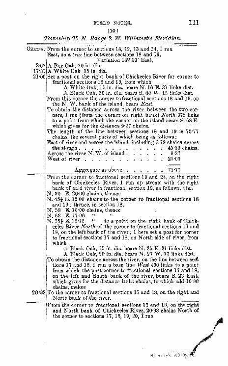
dill.. bank of Chickeeles River for corner to and 19, from which
15 in. dill.. bears N. 10 E. 31 links dist.
IractloDill sections 18
I<~: 10'00 E.17-00" "
. E. 32'12 " to a point on the bank of Chick-eeles River North of the corner to fractional sections 17 lind
on the left bank of the river; I here set a post for cornel' to n'''Lmmu sections 17 and 18, on North of river, from which
A Black 15 in. dill.. bears N. 25 E. 21 links dist. A Black 20 in. dill.. bears N. 27 W. 17 links
obtai n the distance across the tiona 17 and 18, I run a base line 430 links to a from which the corner to fractional sections 17 on the left and bank of the bears l::!. 23 which for the distance 10'13 which add chains, makes the corner to fractional sections 17 and 18, on the
North bank of the river.
and bank of Chickeeles the cornel' to sectiona 17, 18, 19,20,
and
UNITED STATES SURVEYING MA.NUA.L,
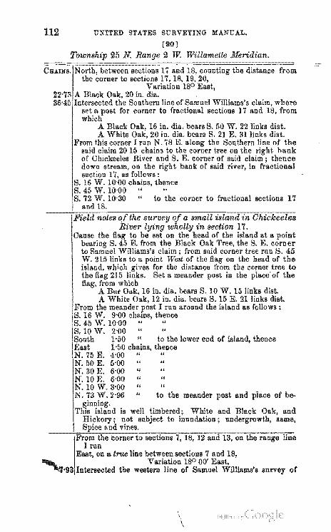
[20]
2 W.
"",,',""""'" line of Samnel Williams's for corner to fractional sections 17 and
16 in. dill.. bears S. 50 W. 22 links dist. A White 20 in. dill.. bears S. 21 E. 31 links dist.
this corner I run N. 'i8 E. the oonthern line of the said claim 2015 chains to the corner tree on the hank of Chickeeles River and S. E. corner of said claim; thence down stream, on the bank of said river, in fractional section as follows: 16 W. chains, thence 45 W. 10'00 " 72 W. 10'30 " to the corner to fractional sections 17 and 18.
in section 17. the of the island at a
S. E. from Black Oak Tree, the S. E. corner to Samnel Williams's claim from said corner tree run S. W. 215 links to a of the on the head of island, which for distance the corner tree to the 215 Set a meander post in the the
which A Bur 16 in. dill.. bears S. 10 W. 15 links A White 12 in. dill.. bears S. 15 E. 21 links
the meander I run around the island as follows: 16 W. 9'00 thence 45 W.lO·OO " 10 W. 2'00" "
1'50 " to the lower end of thence I-50 thence 4'00 " 5-00 " 6'00" "
10 E. 6'00 " 10 W. 3'00" " 73 W. 2-96 " to the meander and of be-
White and Black Oak, and
I run on a true line between sections 7 and 18,
Variation ISO lII\!'l,g3iIntersec:ted the western line of
\
\
same,
survey of
=
---., --- -
~. -.~-- -"'~~ ~. --- ~- .
.-.11111:9_~----
;::-------~--------------- ---------~~--------
4t-i- ! :::- : .... - -:::..=!~
e~ L" ~ ...... ~~~_
;:~ -;t. ~ lr '!"'tJ.b._ ~L.:.:J.: _!.: " ~_~~...:.l.'!!';;"1r::::
:-..:......c ......::II-~ :':::-':':=_ :£- 'L...:'': n.,;:-- - -!;- -: .... ~
~ n:;:- _ ~~ 1... ~~' ... ': tr.~ :!;' - ... ~
~~ ~t. ~ ;{t ~:~ Y.::~ r":!!h f"~:
:a~i:<t ~-L ~~"-.ll. ,;;:::::..- ,
~
i..;,"~ -"!::"t- :-'rr X " ~~~.' \. :~t~'
.A BiBer: (~ui;; ] t: iL ib .. _ i>es"!'!' ~ -: It::: i'n:"" fl:",,,
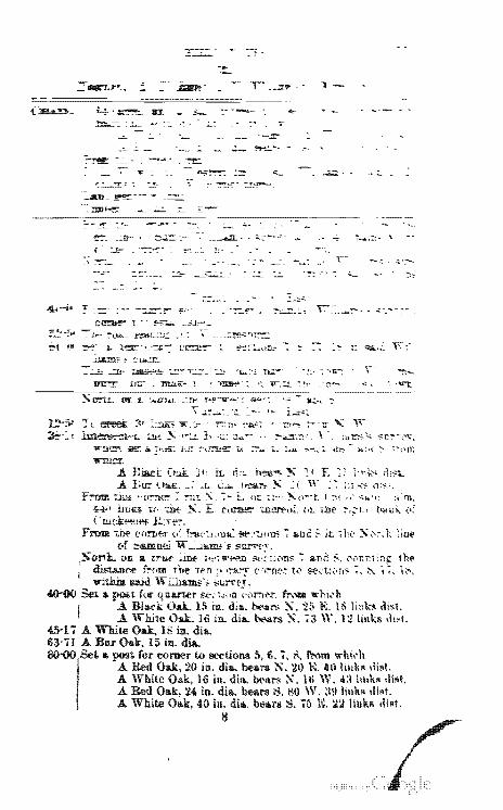
.A LIl!" '--~ __ , .1. c .... 1.-::-'- ~ _ ( ,,' :: 1:1 ~>- ,1:,,-F~ ~ "O':"1le = :1lI..\ :- i. or. -;1:'· ~n ... ~t ! ~,~ H' 'l.!'C :1:1'"0,
44<' illl" 1(' :Dt ~, E ("ll'tIt!:" ;.J):!l'f',,;_ ,.r: ,.hi' ~,.:L; t>..u;" <.:' Cllidi:~tet' I:.:.e~, ,
From W ('nroer c.' f:-al':L.lltil: !!f':'-:::WIl$ '; &.nc S il: ,he :s- ,,~; 't; :illf of :::ia.muci ".:...lIl.Irn"~ SUl'rt'T,
Oil .. t:"'tM- lllll' l<:'; ,"'t"!'ll :!'t·(',ji.ns '; I>nc :;, (,<'I:r:l 1 h~ ~ee fi{im t.he terr.!1 )':"a..'""T (,C,!"'De: t",i ~.\.'t..!~\ni" :~ ~ f, l~. 1IIithD said Wi:lJJi.m;;:'s 5~rT,
4()-OO 5et .. fiJI!' S(-(14,.n :'"rn;:-;r, frNIII ,..hi,·b Oak. 15 in, du •. b;>~ :s-. 2:> K 1 c> Ii n k" ,li~t,
A White Oak. 16 in. dia.. ~rs:S-. ';3 W. 121m"" .!l~t. 45-17 A White 18 in.. dia.. 63-71. A Bar in. dia.
a comer to ~tions 5, 6. 7, ::'<. !'rom ""hh'lI 20 in. dia. bears ~. 20 K .1111 hl\k~ \1i~1.
16 in. dil\. b{,I\r!l~. 111 W. 4:lllI\k~ ,H~t, in. dill.. bears t-l. !l0 W. :W \11~t.
40 ill. dia. bears S. 7() N. :1:1 11I~t. 8
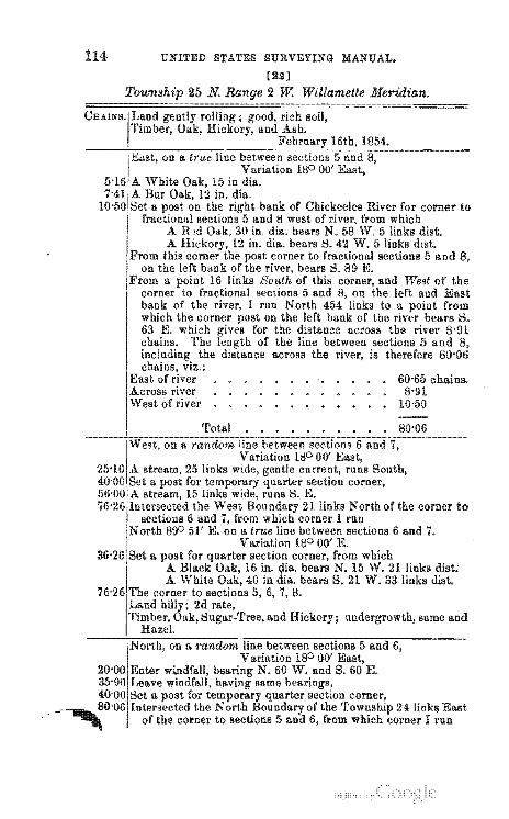
UNITED STATES SURVEYING MANUAL.
[:.Jil]
bank of Chickeeles River for corner to sections and 8 west of from which
30 in. dill.. bears N. W.5 links dist. in. dill._ bears S. 42 W. 5 links dist.
corner to fractional sections 5 and 8, bears S. 89 K
16 links of this and West of the corner fractional sections 5 and 8, on lert and East bank of the river, 1 run North 454 links to a from which the corner post on the left bank of the river bears 1::1. 63 E. which for the distance across the river 8-91 chains. The of the line between sections 5 and
the across the river, is therefore
60-65 chains. 8-91
10-50
nOliler'!!Tc)wlth same and
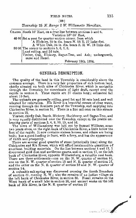
FIELD NOTES.
[23]
2 w: Willamette Meridian.
1854.
GENERAL DESORIPTION.
115
1st and 2d rate land, and well River a beautiful stream of clear water,
the Southern part of the and into River, in section 31. There is a fine "''','-~'O'''
in section 22. Timber, and
is very em-
of There are
Cbickeeles and Elk excellent diRcovered bank of River,oP11J0slite 'l'here are three settlements-one ou the N. quarter of section one on the N. W. of section Hi and N. E. quarter of section and the other on N. E. quarter of section 23 and N. W. quarter secti'on 24.
A valuable salt of section the left
was discovered also the remains
in section 30. Fossil on the West bank a small lake in 26, and ancient works on the left bank of Elk in the N. E. quarter of section 27
116 UNITED STATES SURVEYING MANUAL.
LIST or NAMES.
A list of the Dames of the individuals emlDIO'vea or the lines and corners in the
field notes of No. 25 North of the base line of West of the meridian, the which acted:
Pr:TER Uhainman. JOHN SHORT, Chainman. Gr:ORGE Axman. ADAM DUl.L,
HENRY FLAGG,
North Willamette merHlIan. to the best of our kn"wl"rl"" and the IImllnU:ll.rV
nished
Subscribed and sworn to the above·named persons, before me, a Justice of the Peace for the county of , in the State Terri-
of , this of 186 . HENRY
Peace.
I I j I
I, Robert • ance of a the Unitted States in the State the of of the United and the ~O'W"h';h'"O General, I have and as the case may North of the line of number two meridian, in the aforesaid, and do swear that . j the are the true and field notes of such survey. 1
ROBERT .l1.\.JL>"'O,
said Robert Acres, of the Peace for
, this of , 186 . HENRY
Peace.
FIELD NOTES.
SURVEYOR-GENERAL'S OFFICE AT
The executed 186 ,in month of the necessary corrections and and the surveys describe, are
A.B.
To the of the field notes transmitted to the seat of the "Y<JC-,-,,""'''lU will to each the tificate:
I of the base standard and meanders of a of , has been ""., .. ".t.J"
this office. A.B
117
186
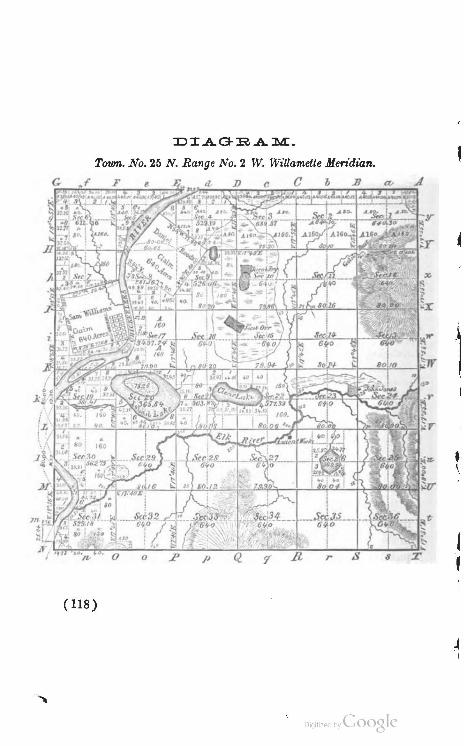
Town. No. 25 N. Range No.2 W. WiUamette Men"dian.
Feb ~
p r
( 118)
Digitized by Google
"1;
• \
RECTANGULAR SURVEYING. 119
THE BOUNDARIES OF THE PUBLIO SURVEYS NOT TO BE OHANGED.
surveys returned the shall be GJ3 the proper corners oj
of sections which they were intended to of' half and
shall be as two corners which
UNITED STATES SURVEYING MANUAL.
States ill In this case the
of a fractional section divided iuto two lots of unusual form and
"There authorize
it duties of'
full sectioll and of 1820. The
RECTANGULAR SURVEYING.
RESTORING OBLITERATED BOUNDARIES.
source fi'om which to derive such enable the surveyor to no'"",,,,,,",
manner, and instructions them in the
has from time to time in response
vate surveyors; and the numerous of which follow are based
the upon the
of the
122 UNITED STATBS SURVE!ING MA.NUA.L.
it is to meet
cases.
modes
were east
RECTANGULAR SURVEYING. 123
last interior section corner to corners were thereon at
will seen that this of corners on
corners were on were made in the same
the
from the corner, and new corners were
intersection with the line. method of
of the sur-
we
MODE OF RESTORING LOST
UNITED STATES SURVEYING MANUAL.
the field. corner on
trees or witness u.n.'""u",,,,
field notes.
error.
PROPORTIONATE MEASUREMENTS,
In urements do not ment field notes. a difference in or a want of proper care in
the but
into
to an error in committed chainman.
these differences in measurement occur, the
RECTANGULAR SURVEYING.
surveyor must in all cases PROPORTIONATE to those This rule must be one or more tallies too many or too few.
EXTINOT INTERIOR SEOTION OORNERS.
restore a "Il£t'~~!I'(U section corner in the interior
between the nearest noted station trees and
of '''''c·rum corner, with new
the nearest
EXTINOT SEOTION OORNERS ON TOWNSHIP LINES.
1. the corner on a sections. In tions in one restored in .,(>"".',1<,
is common to
interior section corners. '2.
lines were run, west of those lines rebe
UNITED STATES SURVEYING MANUAL.
in lines and by
surveyor should content himself the distance bet.ween the -double corners,
all cases test his work on trial to known corners. It may be remarked
and the remark to all cases of referred to in these that the chain used should be
the United States surveyor, stated distances between noted or corners
in the survey, and where it is found to be either or shorter than the chain allowance must be made mind that all distances in the re-
to those of the meas-
extinct corners.
3. TP.rnmrpf1. to restore
RECTANGULAR SURVEYING.
section corner result.
remeae-
4. both corners are uu,lSlSt",rH/. 'l"NIlI?l, .. ri to restore the one when
5. or two restore either of them.
corners are not stated
on said corner, as corners
6.
corners which
-UNITED STATES SURVEYING MANUAL.
corners
EXTINOT SEOTION OORNERS.
section corners; it is an easy store of become
1. To restore nW7'r'T,''r' section corners on a WUTlISfI771
is also true in
are
care must be taken not to mis-
2. "''',VI;rlA':/" section C&rneTS on on west WUlIfi5.f!tlJ hmrnI11n.ri'p_'1_
These corners must be at chains from
rior section corner. If the measurements do not -';VIlU\.O'U""
excess or must be
2.
RECTANGULAR SUItVEYING.
EXTINOT TOnSHIP OOR::NERB.
1.
corners.
mu~8UI!);J corner is on a correction W tWOln~~u;nl'u~
9
common
UNITED STATES SURVEYING MANUAL.
EXTINOT MEANDER OORNERS.
same manner. 2. It may not
to restore a
EARLY LA we OF OONGRESS RELATING TO THE PUBLIC LANDS.
RECTANGULAR SURVEYING. 131
run as the southern boundary of the State of Pennsylvania, and the first line running east and west should begin at the same point, and extend through the whole Territory."
The townships were to be designated by numbers from south to north, beginning each range with number one;
,and the ranges were to be distinguished by numbers from east to west, the first range extending from the Ohio river to Lake Erie. The first seven of these series of townships constitute what was called "ihe seven ranges." .
The first law passed by the FederafCongress in regard to surveying the public domain was approved May 18th, 1796, and applied to "the territory northwest of the river Ohio and above the mouth of the Kentucky river."
The second section of said act provided for dividing such lands as had not already been surveyed or disposed of, "by north and south lines run according to the true meridian, and by others crossing them at right angles; so as to form townships of six miles square," etc. It was also provided that "one-half of said townships, taking them alternately, should be subdivided into sections containing, as nearly as may be, 640 acres each, by running parallel iines through the same each way at the end of every two miles, and marking a corner on each of said lines at the end of every mile."
An act amendatory of the above, approved May 10th, 1800, directed that "the interior lines of townships intersected by the Muskingum, and of all the townships lying east of that river, which had not before been actu-ally subdivided into sections, should also be run and marked in the manner prescribed by the said act for running and marking the interior lines of townships directed to b" sold in sections of six hundred and forty acres each." And in all cases where the exterior lines of the townships thus to b. subdivided exceeded or fen short of six mil~
Digitized by coole
UNITED STATES SURVEYING MANUAL.
was to
RECTANGULAR SURVEYING.
THE BOUNDARIES AND CONTENTS OF SUBDIVISIONS.
"AN ACT (,'(>Iocelrniin the mode or l'Il1I'Vevi~I"" United States.
lands of the
COf
lines due north
to the water. notmG:8rv of such frac-
the contents whereof shall this shall be returned
an."",mr of the lands south of held considered liS con-
UNITED STATES SURVEYING MANUAL,
the exact half sections and
thus rH'.IIT"'''.'. the OnIMI{)U1'tn
section of which
"An act for the division of certain quarter sections in future sales of the lands," 22d, 1817, it is pro-vided that from and after the first of that year," in every case of the division of a quarter section" the sections nated numbers 2, 5, 20, 30, and "the shall be made
due north and south." In all other respects the same as in the case of other lands.
further for the sale of the lands," 1820, that from and after the first of
"in every case of the division of a quarter section, the line for the division thereof shall run north and south, and the corners and contents of half quarter sections which may therearter be sold, shall be ascertained in the manner and on the directed and
the second section of the act of nth, 1805," to the laws for the sale of the
lands," 1832, that from and after the first of "in every case of a division of II. half quarter
section" lands of the United " the line for the division thereof shall run east and west, and the corners and contents of quarter. quarter sections, which may thereafter be sold, shall be ascer-tained, as as may be, in the manner and on the directed and the 2d section of the act of 11th, 1805;
fewer, or more than 160 acres, shall in like manner, as as may be be subdivided into quar-ter-quarter sections, such rules and as may be pre-scribed the "'"".PN"UU"V ofthe
RECTANGULAR SURVEYING.
SUBDIVIDING OF SEOTIONS.
sections in correct the error in the survey.
of at least three of
UNITED STATES SURVEYING MANUAL.
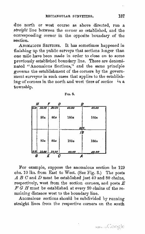
BECTANGULAR SURVEYING.
FlO. S.
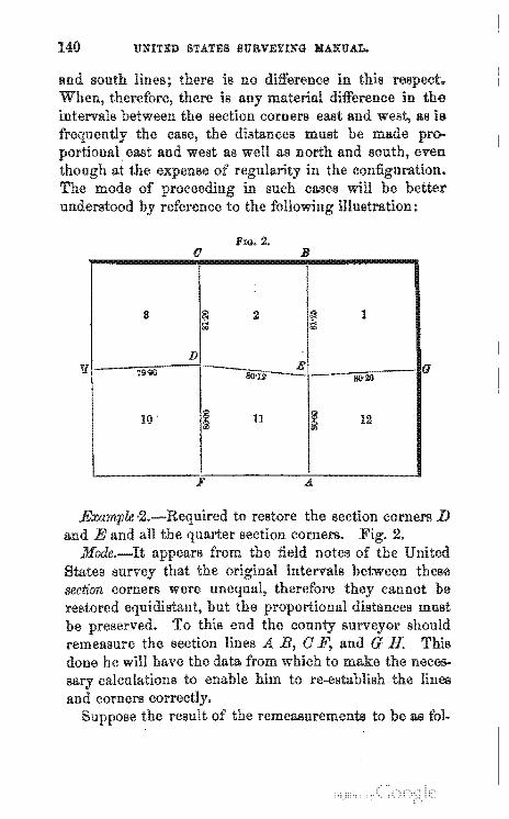
H , D B #0.00
I 4O.0fJ
800 80a 1604 1604
I , :/I, "'. '"
80a sOa 1600 lOOa
9.J 2.D.fKI )l1J.00 ..moo 40.00
s £ c A
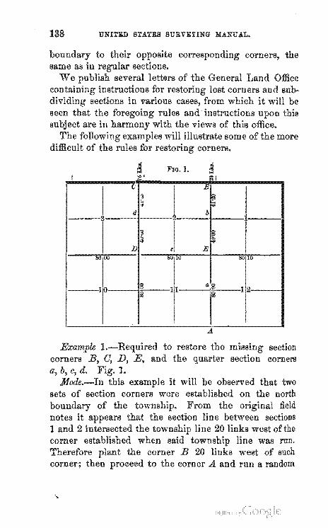
UNITED STATES SURVEYING MANUAL.
corners,
FIG. 1. I "'I ~I
() B
'1 ~ :., .. d b
~ ~ ]) c E
"" w ~u 10 "" 10
:" 13 1 0'8 _1
116 ri
A
RECTA.NGULA.R SURVEYING.
UNITED STATES SURVEYING MANUAL.
FIG. 2. o B
8 ~ 2 I~ 1 .... '"
D E
7lH1() lIO'12 - 80'21) o
10 I 11 I~ 12
F
remeasurements to as
RECTA.NGULAR SURVEYING.
same manner to restore to
UNITED STATES SURVEYING MANUAL.
LAND OFFIOE LETTERS.
DEPART1RNT OF THE IN·rR~,mlll.
Ill.
GENERAL LAND June
comers shall have been established, the section will be sublines from comer to corner.
etc., "A)'''V,,,,''. Commissioner.
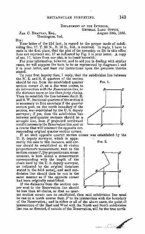
RECTANGULAR SURVEYING.
JAIl. C.
FIG. 1.
8'.------.0
~-_--ID
the
FIG. 2.
UNITBD STATES SURVBYING MANUAL.
west corner land H, ir
RH.
corners.
m.
DIIP ARTHIINT OF THE GENERAL LAND
June
It will be Been Crom the ""'"",,,m,,_ sections is ter
surveyor.
WARREN BIICKWITH, Geneva.
GENIIRAL LAND March
u ... ,", .. "' .... 1o
RECTANGULAR SURVEYING.
2d. All line .. of Buhdivisions which not have been run and marked in field, shall be ascertained lines from the established corner to the cOl'rellpo,nding
D. W. MUON, Cedar Creek,
"~""'''HM'''''U at the distances mUll"'.'"" 4th. Half
from the The first
GENERA.L LAND Jane
Wis.
UNITED STATES SURVEYING MANUAL.
the third head, the section corners were
distances in the re-establish them.
is, that the established in
notes, and the surveyor
Extinct quarter section corners, on fractional section when can no I! be identified as above, should be re·established distant the in a line between the nearest noted "line trees" side of it, there are any, but if none are found, then in a line between the section corners. Extinct section posts on section lines which elope on the north and of should be re-established, to the measure-ment at 40 chains froffi' the last interior section corner.
Extinct section corners be re-established a line the nearest noted trees" north south and east and
west of the lost corner. if there any such trees within the distance of the nearest section, or section corners but if no" line trees" be found, thl'n the nearest or section corners, and at the of intersection of lines thus run, establish the sec-tion corner, with new to the nearest lind most desirable
'rhe mile are not established in surveys, but are, to be from section and quarter section corners, as stated under fourth head, and should be so estab-lished the
It may be n:LUI .. ""'U.
the
Commissioner.
(141 )
I
TO OERTIFIED REGULATIONS IN OOPIES or ....... ,'"'v.u • ...,"'. ETO. ON :FILE IN THE GEN-ERAL LAND orrIOE.
wit:
as Q'o'~ernment nor to unverified
proper to furnish."
(149 )
APPENDIX.
"First.-From and after until the cost thereof shall first be
"&cond.-The "~I;Jm; .. u must address a communication to the Com-missioner of the General Land Office, the tract or tracts in
to which the verified are wanted, as accu-as the record, papers, or of which transcripts are
desired, and II. sum of money sufficient to cover the' cost to the extent of the ; and should the sum
sent to this office be in excess of the actual cost under the act, such excess will be returned to the
is the tariff established under the statute for fnr'11i •. hin
"1st. Fifteen cents for every hundred words in a URn .. ",rlll,T,.
"2d. Two dollars for copy of or ''''''!!in.lll. "3d. One dollar for the Oommissioner's certificate of verification
and official seal. "4th. One dollar
mitted."
cer'tlll'ClI.te and seal to offi-
APPENDIX. 151
UNOOVERED MEANDERED LAKES.
that are not when the surround-are embraced in the subdi-
vIsions in which and are sold with them. in the uncovered land vv.LV",''''''
ment surveys, and the contents the
structions islands.
hh·",,·h:,,-j from the areas If from any cause such
the land be-to
to unsur-
within the
APPENDIX.
AOORETIONS.-IUPABIAN RIGHTS".
stream." -13 " of land bounded

APPENDIX.
154 APPENDIX.
ination on the lake was north of the piers and contiguous to the new-formed land, and therefore entitled it to its share of the increment.
The defendant contended that no part of its boundary was on the lake north of the harbor, and therefore no part connected with or adjoining this land new formed.
III CONrtIOVIi:RSY.
II
In regard to the point in the case which we are considering, the court held that the inquiry should be made whether or not at the time of the deed to the plaintiff lot No. 34 had a water-line upon the lake north of the north pier of the harbor; if it did, then the question would probably arise in respect to its right to a share of the alluvial accretion formed since that time.
As to the manner of dividing the accretions, the court laid down the rule that each riparian proprietor was E!nti~ tIed to his prop(JT'tional share of the entire line of the newlymade shore.
The case was again before the Supreme Court of the
Digitized by Google
APPENDIX.
the whole extent of the ancient
this new as he owned lines are to be drawn from the
or river equals, or said: "It may cumstances. For
of the
bounded on the
indentations or case, it should be reduced an
under cir-the rule to the ancient
to the available line of the land upon the river."
156 APPENDIX.
"To this rule we adhere. With the it may be considered as the views of the court upon the sub-
In this case, if lot 34 had been found to have had a water front north of the north at the time the front
had to do with the to be made. where the accretion "".,·",..rorl could have
should have been taken been ,."0.",.,'1,,(1 The whole of that as the basis of the
etc. which were
that are
OOAL LANDS.
commerce," to enter
APPENDIX.
acres, or their
of The
commerce." The facts must be stated in
within six mcmths from and must be made
APPENDIX.
If ."II1~/W'.,,.n after the passage of said statement shall be filed within three months from the return of to the and
PUBLIO TIMBER.
the tracts upon sale or trade.
TOWN BITES.
are not aI-
~ef~!,\!,\11rv steps taken to are but few of old cases re~
of
restriction as to size.
executed. 2d. Also the
exhibit the name of and
APPENDIX.
surveys, where
any
at the
may hereafter
have
said map and statement to be for and of the
of two witnesses
APPENDIX.
where it can be of others.
are to issue for all act as in cascs.
the second section of act of 1st
the lots are to be I'Itt" .. c.rI
bidder at a minimum of" ten per where the area of each lot ex~
. of
I:
APPENDIX. 161
Ton BITE AOT OF 1867.
AN ACT (or the relief o( the inhabitants of cities and towns upon the lands.
Be it P.nlrL",elL.
...
APPENDIX.
REPAYMENT OF PUROHASE MONEY AND OHANGES OF ENTRY.
in this class of cases, the with:
accompany the papers in all cases of money submitted you for the action of this office. WhfJre it has been lost or the mUllt advertise and
notice of his intention to to have refunded the pur-chase money, which must be inserted for six in some paper of extensive circulation in the of the land. A copy of this must be filed with you, davit of the that it was inserted the number of times.
2d. The ferred or
must make affidavit that he has not transencumbered the title to the land. 'rhis affi-
davit may be taken before either of you before Ii
Public Ii or Ii Justice of the Peace; in the last case, a certificate of must accompany it.
3d. Where a patent has been issued and delivered to the a deed of the title the
This deed of
books in which conveyances are that said deed is so
office do not exhibit any other conveyance or encumbrance of the title to the land.
4 tho I n cases of a as the will rea-wish to hold some evidence of his title until the
of the he must first the tract he desires to enter, and effect the of and then across the face of the issued upon the will be returned to you from this office when the case has been "'OO',L'.«;U
the Receiver should note the facts of the case, to wit: that the "llI'u~r"u from the tract for said
the and the number of certificate
APPENDIX.
issued thereon. The to be surrendered when the
must then be delivered to the is delivered to him.
ORANGE OF ENTRY.
The ~
OF ENTRY which may be ordered UU,''''Ul'''''
of 3d and 24th
163
"The Receiver will take a for the I-'UI~'-'U"'''t: money of the tract ..,ITlll"'"
was refund~d, which will be a voucher to the Receiver's to be introduced into the proper monthly and
venience. an act of 3d all moneys
receivable from customs, and from all other sources, are to be into the "without abatement or
" etc. To avoid any
that act, when a with
the 0-1' n~""m' as in cases, his certifi-
one, the the ,w",,,,,,rI
to it a MARGINAL NOTE
from the erroneous to the new to the date and number of the the date of for the proper references to
on the books and of the local office. in such a case is to be issued the
unless the area of the new is than the old one; of course, such excess must
issued for the same. in the
in each case, when from the old and
also when there is a further and
APPENDIX.
the EXCESS PAID FOR is to be carried into the Receiver's QUARTERLY account.
Such entries must appear at the foot of the returns as ADDENDA, and must not affect the IU!'ll!'rCl!'a-[c
either as to or money, further than the EXCESS in areas, and PURCHASE money for the same.
In any case which be for which the may decide that the
will be made warrant
GRADUATED LANDS.
the act or June
the been
entries of land under the said act can be made; and it only remains to close up such entries as have been made and not the issue of patent. This may be done-
1st. actual Se1;LI€,m()flt the act of l854; or
the difference between the at the date of and the
land at
cancellation IJ,,,-cu __ q-"'vu or Homestead Laws; and
as other
AGRIOULTURAL AND MEOHANIOAL OOLLEGE SORIP. This class of land was authorized
aid to and mechanical in the several States. The flxtent of the is 80,000 acres for each Senator and to which the State is entitled in the
of the United States. States which contained a suffi-cient of land to the must take the land within their own boundaries; but those no United States lands within their may demand
......

APPENDIX.
Each of to 160 acres.
It can be located not take a same section.
It must be located upon land per acrej that land which has and not and which remains at the above named.
one section of land-
It will in the
It cannot be locatcd upon mineral nor ean it be received in of lands claimed or homestead-nor can more than onc milllion of acrcs be located in anyone State.
The cannot be located but must bc sold and located the
There is no restriction as to the "m,nT.lTV which may be located
cannot be located upon or double minimum ".ltlhnl",O'h the States in which such lands are situated may
the in satisfaction of their claim.
The fee of the local land officers is of
The States to which tIed to it under the
connecticut .••.••.•.•••• Illinois ••.•••..•.••.•.•.•.• Indiana ................. .. Maine.: ................. . Massachusetts ........ .. New '"U>&''''IJ'''''
New New york ............. .. Ohio ................... ..
Rhode Island .......... .
has been are as follows:
AcrE'S.
dollars upon each
or which are enti-
AcrM.
Total issued and to be issued ....................... ..
166 A.PPENDIX.
list select lands within their own
to the States not "PY"'PI~pn
INDIAN SOBIP.
class of "'''', .. Y'n Tn land issued to the Sioux
lands upon which the
prel-elilpti,on. whe-
a tract, and main-tained in such a manner as to bc fair notice to all other persons of the claim to and occupancy of the ; and within three months aftcr the survey of the tract the United and the return of the of such survey to the local land the
must to such local office and make claim to the proper subdivisions covered the Ul.,vrUlU
7th. No fees are to be on the location of this class of officers.
is for the same by the local
8th. Said officers are to send up to the General Land Office the "PIJHC""e'Ull, ",.,mo"'" certified and at-
a certificate to the effect: "We that the within certificate has
APPENDIX.
been located on the con-acres to the section of the
article of the of with the and the authorized to make the location."
Excess for any fraction less than acres or the smallest subdivision, which it may be necessary to include in the. AU"'" LlVU, in excess of the number of acres called for the
REVOLUTIONARY BOUNTY LAND SORIP.
This is a class of Land issued under the act of the 3-1st of ] in favor of the
the is the" of an
infant" or the husband of a "femme covert," the evidence of their such or husband must appear.
This is attested two wit-nesses," in the manner, upon the back of the certificate:
For value received or we, as the case may ",.rm,.,IP>tr,,. of the within certificate of do
of and his heirs a.nd forever.
Witness my hand and seal this the Attest:
This the
A.B. C. D.
, 18 E. F.
or are settled upon and cul-at the rate of per acre, in the
same manner as money, in all cases where the tract for contains the area in the wins the excess of the but may be denoted in the other tract.
money, to any
APPENDIX.
THE HOMESTEAD LAW. WHO ARE ENTITLED TO ITS BENEI'ITS.
person who isa citizen of the United or has de· clared his intention to become such under the laws of the United
and who is: 1st. The head of a 2d. Who has arrived at the age of years. 3d. Who has served in the army or navy of the United States
actual war, for at least fourteen and who has never arms the United States or aid
or comfort to its enemies. \ person .. ,,,uo.;".'CII..'" may enter
160 acres or a less lands of the United States; the land to be in a and in con·
and to the lines of the per acre. Double
or railroad reserved sections may be taken at the 80 acres of land may be
on land may enter owned and shall not
aP"'O"I"AO'a1r.A 160 acres.
for the district in which the lands are his follows:
HOMESTEAD.
LA.ND OFFIClil at No.
should be added:
'::"1\"''''''''''' of aplmcan ...
APPENDIX.
LAND OFFICII: at 186 •
HOMESTEAD.
LA.ND OFFICE at
Sworn to and subscribed, this before
of
Receiver's . No.
Received of
the Land
HOMESTEAD.
RECEIVER'S OFFICII
No. the sum of dollars cents
the amonnt of and one-half the COlnll~~llJ!lltlc,n or for entry of of section in town
, under the act of entitled "An act to secure homesteads domain."
Receiver.
APPENDIX.
Should the homestead settler so he may, after settle-ment and cultivation of the tract entered as prove such settlement and cultivation disinterested to the satis-faction of the Commissioner of the General Land will have the to pay for the same, instead of five years for his title as in the law; in which case he will receive a certificate in the him to a
for the land.
CERTIFICATE. } No.
IT IS HEREBY CERTIFIED, of ~'U,IJ"['''~M A.nlor",,,.<l steads has made
containing THEREFORE, BE IT
LAND OFFICE.
{
of section of range
No.
cate to Uommissioner of the llnlse'nta,tio'n of this certifi
Office, the said shall be entitled to a for the tract of land above
described.
The fee
each of the the commission has licate.
on a homestead is for and one per cent. commissions to
and Receiver--on the value of pcr acre, as the case may be. A like
to be upon a Patent Certi-
Lands entered under this act are not liable for debts contracted to the issue of
An abandonment of the land for more than six months within the five years residence is cause of unless the land shall have been paid for under the 8th section of the act as above
In case of death of the homestead the land may be sold for the benefit of infant but for no other purpose.
upon lands may be transmuted into homesteads if no other shall have intervened.
at a distance from the proper land office may before the clerk of the in which he or
APPENDIX.
she and transmit the same with the necessary fee and commissions to the in which case the same forms will be the necessary alterations as to the officer before whom the affidavit and are made.
on,"''''ron in the or naval service of may enter land under the Homestead
or The necessary affidavits and as well as the power of must be verified before the immediate officer. The time which he remains in the service will be counted as residence upon and occupancy of the land j upon the he must within a reasonable time to the and remain upon, and cultivate the same in his claim will become forfeited.
The Homestead Law has been further modified R.n.W()'IlP/1 June which is
circular and copy of the statute:
1 This section of the act of 1866 further that the hene-
fits of the law shall be extended citizens of the United SLatfls without distinctlOn or discrimination as to race or color, and that
AN ACT for the tlement in the and Florida.
APPENDIX.
APPENDIX. 1
APPENDIX.
shall, in addition to the oath hereinbefore he has not borne arms the United fort to its enemies.
SEC. 3. And be homestead and
Act of June 1 restriction which persons who have borne arms the United States or aid or comfort to the enemies ceased to be operative on the 1st of and any citi-zen of the United States the other site may now enter land under the Homestead Law.
Mineral lands in the States named in the act of 21st do not fall under the restrictions of that and may there-
now of over the and the law under which a
it is of the utmost understood. For this reason the law with the amendments of 1864 and 1866 are here
any of this which not, with the land 80
the aggregate one hundred and
APPENDIX.
never borne aid and com-
is for his or her ex-
founded. 81':c. 4. And be it
of this debt or debts
as the
is malle for the of
enacted. That no lands event become liable
to the
to settler, to the of the the person filed such her residence, or abandoned the said land for more than any time. then and in that event the land 80 entered government.
SEC. 6 . .And be it mitted to visions of Office is consistent
or t;EC. 8. And be '.-t
so construed as to the
APPENDIX.
in this act shall be him or herself of
the minimum for the quaD
""."j ... ,tj",n of the Ii ve years, as in other cases
and cultivation as pro-
AN ACT amendlat()rv of the Homestead Law, and for other purposes.
Be £t enacted United States
desirous twentieth
of actual service unable to do the which the said of ,,,u,uu,,,,. and whose
he desi res to
the
and settlement have been be lawful for such per-son to make the affida.vit said before th~ officer com-~U_~'UI!I in the branch of the service in which the party may be enlZali1'~Ii.
which affida.vit shaH taken before the filed with the the same shall the sa.id
APPENDIX. 177
12
APPENDIX.
MILITARY BOUNTY LAND WARRANTS. This class of land warrants has been issued under various acts
of ; but most of the warrants in circulation are author-the acts 1 or nil of which sub-
"""'R1.,on have been made to assimilate in and are now locatable nnder the same of the which are as follows:
1st. These warrants are now carryall the of the
the transfer valid the must be will not in blank.
two witnesses.
and transTo make
dians must be executed before the United States Indian for the tribe of which the is a member. If not a member of any the Indian may as other
Warrants cannot be located upon it be to any to which such V"'"U~J"ll
be entitled.
ASSIGNMENT OF LAND WARRANTS AND LOOATIONS. 'An,,,,,",,,,,,, entitled "An act
___ .. ,.,. ___ .. _, and for other purposes," ap-: "That all warrants for
or may hereafter be under any law of the United and all valid locations of the same, which have or may hereafter be declared to be deed or instrument of and executed after the effect of this act, "''''Orl.lHlV
form and as may be the Commissioner of the General Land so as to vest the .. ,.oHM'''''' with all the of the or location."
In accordance with the forms are said commissioner for the 1Io1>~!lgllW'~ll~ the warrants and locations referred to wit:
FORM FOR THE ASSIGNMENT OF THE WARRANT-NO. 1..
,."r,,,i,,·,,d. I, A. B., to whom the within waITant, No. • Willi and unto U. D., of and to bioi
APPENDIX.
of 18 . B.
FORM OF ACKNOWLEDGMENT WHERE THE VENDOR IS KNOWN TO
THE OFFICER THE ACKNOWLEDG:\IENT.
State of , On this of , before me, pelrsonall.')
insert the name of to me well known. and the his act and deed; and I
the said the name of the warrantee) is the m"uc.'" ... pertion, to whom the within warrant issued, and who executed the fore
thereof.
FORM OF ACKNOWLEDGMENT WIIERE THE VENDOR IS NOT KSOWN
TO THE OFFICER,
State of On this
insert the name residence ,I It terested
AND HIS IDENTITY HAS TO BE
of
PROVED.
,in the "''''''IlI'H.''V came the wa~rranree
FORM FOR TElE ASSIGNMENT OF THE LOCATION-NO.2.
rec:el'\l'ea. I, A.
FORM OF ACKNOWLEDGMENT WHERE THE VENDOR IS PERSONALLY KNOWN TO TAKING THE SAME.
APPENDIX.
FORM OF ACKNOWLEDGMENT WHERE TilE VENDOR IS NOT PERSONALLY KNOWN TO THE OFFICER, AND WHERE IDS IDENTITY
BE PROVED.
'''U,!';ULl''.H upon the certwo witnesses ac-
or Receiver of a Land a .'-«'''ViU. a Justice of the or a Com
resident in the State from which he derives ; and in every instance where the
ment is made before either of the officers above except the or Receiver of a Land it must be accompa-nied a under seal of the proper of the official character of the person before whom the
and also of the of his O'I'l,U"OU'
of land warrants issued under the net of made before the date of this act, are
where the lands at
take any two 8
acres; and the bolder of a warrant for one hundred and acres can take two or four tracts, a of one hundred and acres.
This act does not authorize the bolder of an
acre in full satisfaction the acres as near as may
APPENDIX. 181
and pay the difference in cash. So also of one hundred and warrants.
may desire to avail themselves of the their warrants located the Genera!
for the act of 28th 1 the necessary
ceiver the fees to which The same course must be observed persons remote from the district land officers in making letter to those officers. Without the payment of those fees the warrants cannot be located.
the terms of this the fees of officers are as follows: For a 40-acre cents each to and Re-
ceiver. Total For an SO-acre warrant, one dollar each to and Re-
ceiver. Total For a 160-acre two dollars each to and Re-
ceiver. 'rotal The is a form
locations under powers of must invIL-be indorscd on the warrant, or
FORM OJ!' A POWER OF ATTORNEY.
Know all men that I (here insert the name warrantee), 01' the and State of do constitnte and of true and lawfnl ... u,,,rflIHV.
for me, and in my name, to sell and convey within land No. for acres of land, which issued under the act of tember, 1850.
in presence of ( Warrantee's s1(Jnal,ure.
The of this power of "tt",.""".
and certified in the same manner as the sales of the warrant or certificate of location hereinbefore pre
and must also be indorsed on the warrant.
GENERAL LAND
nnrmrAn June to land in certain cases."
act, the title to land warrants issued the
APPENDIX.
death of the warrantee vests in the" if there be none, in the heirs or I"o·".t"""
All such warrants are he hy "such widows," "
of the deceased
the date of the warrant, then to the law of domicile.
died intestate, there
as in aforesaid.
If the warrantee died should be with an executors, wbere will does not
but in that case a the transfer.
the names
the warrant as his
use of the heirs ,but the ment mu"t be administration.
a certified copy of the letters of
5th. In virtue of the 2d section of said act of 3d warrants under the act of 1 as well as those
may be to lands" which are minimum than" acre,
"in the difference between value such war-rants one dollar and cents per acre, and the tract of land located on."
for on 160 in or
APPENDIX. 18S
2 warrants of 80 acres of 40 acres, may be to IGO-acre to be located on a
subdivision of the 160 acres-and the all cases be in cash.
In to all
to covcr a rant must
it is
acre tract, and so on. 40-acre
use onc, two, each warrant
a 40-acre wartract, au 80 on an 80-
When a subdivision is and overruns the number of fractional excess must be acres called for the
for in cash. The sections are added for the information of
7th. Patents for land locations are issued iu the exact order of date of location j and are sent to the district land office
before the in this sent to
cate warrant.
AN ACT "'_ ... i __ i~~ the title to land warrants in certain cases.
enacted, That the of the first sec-
184 APl'ENlJIX.
.AN .ACT to authorize the reissae of land warrants in certain cases, and for other pnrposes.
Be it enarted the Senate and House United States shall law of
1st. entitled to receive it, and to whom it was sent, or has been
lost or after been in order to the to a fraudulent holder of the same, the actual owner must at once file in the General Land Office a caveat in the form of an forth the nature of his title to the warrant, and the as to its
and his address. 2d. He must notice of the facts in the case, at least
once a week for six successive in some newspaper of gen-at Of nearest the to which the
warrant was or where the loss occurred. In such licatiun copy of which must be fUfnished to Commissioner of
~
j
I
APPENDIX.
" .... ",vu". with the affidavit of the .... 'kJ:,_k •• _ as to its due appear-of to the
Commissioner of Pensions for a. reissue of the lost warrant, which must be minutely described.
3d. The of the caveat in the General Land and the advertisement of the loss the observance of the
towards the owner of the lost warrant
of the
of a warrant is on the of the the or
person to whom it was sent must unite with the warrantee or make a affidavit as to its
5th. If the for the reissue be not the person to whom the warrant was but claims to be the owner thereof
UH''''''''''' for a valuable he must the name and residence of the warrantee, the name and residence of the person of whom he it, as far as he may or can ascer·
the names and residences of each of the several whom the title of the warrant descended to him from the warrantee, and adduce evidence in of
each and all his statements in reference thereto. 6th. The of the estab-
of each and every affiant must be certified the and his official character and the proper officer under his seal of office.
7th. '],he Pension Office will for the space of three warrant and the p"L ..... "U"J'
"PJl'",."'Lj,VU for its reissue in the "Constitution" newspaper, at the seat of and no warrant will be reissued under the act until after the of three months from the date of the of the f''''''UV'U
and not then if it shall appear that the in existence.
APPENDIX.
STATE SELEOTIONS.
circular of the General La.nd to Selections for Railroad pur
poses. to State Selections under other
Each list should state "'1"O"',u"""q under which the land is its face reference to the act can fen-
the and be veri-fied All of the necessary forms for State or Selection and for the proper verification of the same, may be obtained at the or at the local land offices.
GRANTS FROM OONGRESS TO STATES AND OORPORATIONB.
GENTLEMEN: the first section of the art of Statutes I QU.'-U"',
from and after the passage States and
roads and other purposcs and Receivers the for the
in the districts where such lands may be for their services shall be entitled to receive a fee of one dollar for each final location of one hundred and be paid the State or such; the samc to accounted for in as fees Ilnd com-missions on warrants and with limitations as to maximums of in accord-ance with such as shall Commis-sioner of the General Land Office,"
1st. Under this law the """'''T"rQ and Receivers are each en-titled to receive a fee of one for each final location of one hundred and when the deficit
2d. When the several shall have been certained to inure to the grant, as hereiuafter the fees be due thereon.
3d. The State its may be, is
road act , the tracts so selected "
After the selections are the lists will be
evidence of the 4th. The fees will
have been rendered 5th. The Receiver
and
APPENDIX.
PACIFIC RAILROAD.
and
in
1864.
,th. section 21 of the latter act, these are re-to pay cost of " and conveying" the
APPENDIX.
in addition to the "'''!T''''''''" and Receiver's fees exacted the act of mentioned. This cost of
and decision of the "'''''r.,r .... r'v
Interior of limited to the lands
action as invest the It l'(lTnn,,p,,p
These instructions will Circular No.9. The forms
will be followed in same may be "'Pit"'""'''''''.
.... """,J ..... "",
to the
in secshall coal
but all and must
to this Gencral Land such definite
the view to
where
You will the date of
APPENDIX.
the
.Tos. B. To the REGIsTERS AND RECEIVERS
the U. S. Land
The 'V''',,'V''''',," rules are "nn,.,'v~.rt o. H.
PRE·ElIPTIONB.
189
of this
Commissioner.
The act of to settlers upon the IIUI .... :1J"."'''. known as the pre-
The individual the benefits of said act must be-1st. A citizen of the United or have filed his declara-
tion of intention to become 6 citizen. 2d. Either the head of a or a man
over the age of years. 3d. An inhabitant of the tract upon
in person, he has made a settlement and erected a dwell-
4th. The tract claimed to be in and consist of 8 section or other subdivisions of sections.
5th. Claims initiated to the surveys will be the lines of the surveys when in such manner as to cover the of the claimants.
If the lands are at the date of I5C];UCIDCIH
person on a section is n1"l·.t"~,t,,rt
the one who made the conformed to the other
A person who has once uuailed this act cannot, at any future
another under it. No person who is the
acres of land in any State or ... "Y'1"it".'V
entitled to the benefits of this act. No person who shall or abandon his residence on his own
APPENDIX.
land to reside on the land in the same State or 7'",..."1",,-,,
is entitled to the benefits of this act. No exists reason of a. settlement on and
unless at the date of such settlement the Indian title thereto had been
The of the is the evidence of the of the survey; but in accordance with the and intent of the and for the purpose of the settler within its nr')V'''''',n<::
the land is to be construed as when the are run on the field and the corners established surveyor.
No or transfer are The must issue in the name of the claimants shown to be entitled to the land under the law.
The of lands are from the of this act:
First. Lands included in any reservation or upon which are situated any known salines.
Second. Mineral lands. 'l'hird. Lands l:Ielected for or upon which is situated any town
or Persons
to file in the local land office as and to furnish one or more disinterested witnesses
of the facts necessary to establish a full with the re-of the statute, and to the
of the actual bona purpose of the claimed.
Forms for affidavits and will be found at all the local United States Land and must be made.
Careful attention to the ,,,,.,Vll". and corn-with the to
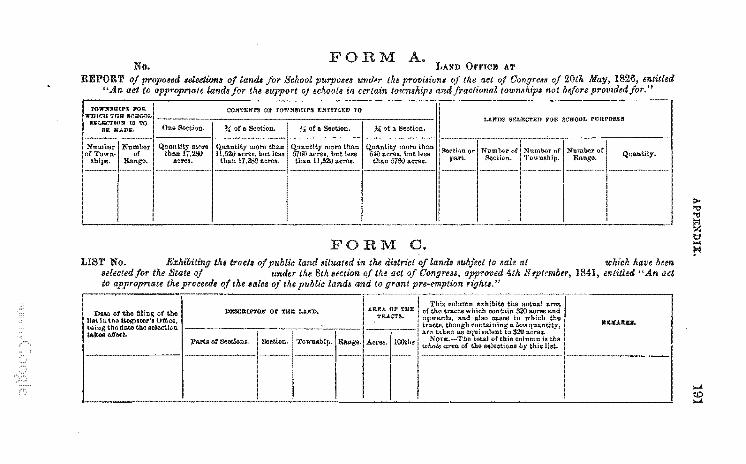
No. F RM A.
FORM C. LIST No. th, tTactl oj public land situaled in the diatrict
,elected Jor the State under the 8th lection of the act to appropnate the proceed, oj the lalcI of the public lande
DZSOltlFrOl'll' 01' mE Lure.
Pm! ot Sections.
LAND OJ)'J)'ICE AT
landl lub/ect 10 ,ale at !Chich have bem 4th S 'plrmber, 1841, entitled "An act
1>0-'"tj '"tj t>:l Z t:l .... !'I
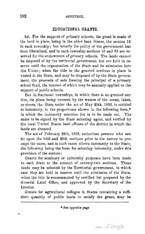
APPENDIX.
EDUOATIONAL GRANTS.
been served for the endowment of be of serve until the of the State and its admission into the Union; when the title to the vested in the and may be
pr()celeas of sale the interest of which may be
schools.
same to be and verified the local United States land officers of the district in which the lands are situated.
The act of authorizes persons who set-36th sections to the
under this
Grants for or purposes have been made to each State to the amount of sections. These lands may be selected by the Territorial in which case are held in reserve until the admission of the when the title is consummatl'd certified list the Genera! Land and by the
IOV ...... "U •• O a sum· cient may be
«' See opposite page
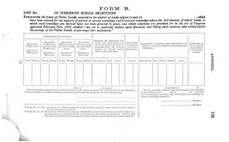
o g" ~ "J
o o o ~
...... ~
FORM B. LIST No. OF INDEMNITY SCHOOL SELECTIONS EXHIBITING the tracta 0/ Public Landi, .itualed in the d.atrict of landa ,ubject to .ale at , which
ha~e bun aelected for the ,upport of achoolt in certain towmhip. and fractional tOlDmhipa where the full amount of ,cholll landl to whIch auch toumahip. are entitled have not bun granted in place, and which ,eltctiom are provided for in the act of Congrell approved February 26th, 1859, entitled "An act to autlwrize ,ettler, upon Sixteenth and Thirty .izth ,ectiona, who ,ettled before the IlUrvty' of the Public Landa, to pre-empt their ,ettlement8."
To"~sUlPS COSUl~INC- II 1/ II II PORTIO:fS or !ECTlO:orS nx·
Jlf)r~ thOR ~Jll)r,. tltnn Mlir~ than TEP."1'f' ",so TltmTY-:UX R'- i D~rlCIE:rfCT SI:LECTIOS!\ TO tcrPLT TilE DErlCIEXCT nr R')fARItS A~ J(nu Otn" ",~ 0""", .. ,,'""", OM .. , ,,"n., 00" 'W"'" , •• " , ' .. ",,,, I " 0'''",' I """ ,,'00 .... ",. " .... " ... , I" "., " .. 17,1jO (Jcrtll. a~'l1'" /hUR l<u,l"m 11,~;W lu. "'v,,, 6700 • .,I8, .. -rrO)l or ","1001, I, .,VS Or I ESTITLEV. I D£V/C'.Scy It ,2tIO u('rel. aerel. acn" LA!'!'))S TO wnlC'l1 1'O"~ · TOWN!UIf'S. HI IK'tlOOL
l:ntiU("ll to .!!IOIPS .. ME E!'fTITLItO. I t..l.Z'{OS. 12:,0 acre •. Entitled to F.ntitle,l to Enhtlt"d to
~"~ ~~~ a~~ I ----- ----- ----- - """ t-I~ - R"_ ~I Town. R.ln~". Toltoo. I Range . TowJ),. RAnle . TOWD. Range. lk .. cr;pfion . • 'ltJc. -Area . ---- ---- ---- -- -- ---- -- ----
:1 ,f...,""tf> 0/ • ('ljpt"'Vn.! •
WI': .M IIFREIIY Ttf'On:'mend the rLht.Vl" At:lecUon!l. ftnd .~ t() Ilfftl't the ""nus in l~cn of tbe deflcicnc1 tn IchoollllDd. to wrtaJn wW'n!hil'~ aDd fr"cllonal t.cJ .... n.hlJI., U .ho" n In tho turego.ng lilt..
II
• NOTE No. I.-The QI[ItrPltate f" column .. nllmhen 11 Ant.! t:! mUit Ctlutll tha eXlct are,- of Ichl'Olllod to II "hkh til" n!lthil' i~ "ntltlNI.
• NOTE No. 2.-Xo Ind"'11D.itV 8chH<l1 :4"I~ct ionl ,,"' atlmlulble hy ):\w (.l r til'" Dlhip. co\'ered wholly by l\ II l ,rh'a te claim. (If eol't'",·t "" holly flr In p:t.rt t.y an lntll:Lu rt'SI.ln>4ti un . r:elthcr Ub lndl)u\ulty W wken by .electionl of mlD8r.llianda or hind. which ha\'o been ruerved.
I lAnd O,ffi"t nt 18 .
'VI: no nr.Rr.ftT rEaT"Y that the (onsoio,c lilt wu flied at thiA ()fhoe on the dill flf I 18 • and tbat the ~'lectillu, ara ("orrtct; lod that there h no ad,-er .. lot«lren COO iHcti og therewith.
_ ...•... _ ................. _._ ... , &gilw.
........... _ .......•••...•.. _ ....•. " RMfIt'1'.
~ ..., ;:g Z t:;j H
?'l
..... ~ ~
194 APPENDIX.
selected the and upon t.he list General Land Office and the of the vests in the State.
SALT SPRING LANDS.
Saline reservations are made in each a State and admitted into the
the title
and upon 00-these reser-
vations to the amount of to each State.
sections ha.ve been
INTERNAL IMPROVEMENTS.
Form page in this class of Lands. The
cation and certificate are to be attached to the selections when made.
State of 186 . I in behalf of the State of
for the tracts described in this as selected for said State under the 8th section of the act of
I the
1841.
18 . IOrl~II'Omll list was filed in this office on
and that no valid eVLILlU:.UJiK
the selections are correct, is known to exist.
I I I UNDER
THE ACT OF CONGRESS APPROVED JULY 26, 1866.-U. S. PAGE 251, UHA.PTER CCLXII.
Herewith
citizens of the their intention to become to and also" to the local customs or rules of miners
districts not in conflict with the laws of the
I t therefore becomes selves with the local
"
in which be upon to do those acts which whether the snme are reduced to authentic
or are to be ascertained the testimony of intelli-which you arc to obtain as occasion in individual
be taken and nr""pnr,'11 and and to be aCC!O[Ilpam
the out boundaries of the exist. second section of the act declares that" whenever any
person or association of n",,'"OT''' claim a vein or lode of or other rock in hav-
same to the custom or rules of miners the district where the same is
and in actual labor and thereon an amount less than one thousand
to w hose there is no
APPENDIX.
or associsof
or
or rules of miners is to be for
surface of the vein or and the are ascertained and well such
APPENDIX.
wall
be I1S
the same, und the connection with the vein or be included within the embrace the same 8S
Where the and
vein, it shall the of the
and marked on the dio,.
deso much
CU::ltoms, or rules
custom under which he or claim such surface such evidence consist either of the written rules tho of the district or of two credible witnesses to the uniform custom or the actual use and u<.:t:u fJtl.LH
which shall be redurcd to and in the '~P"""TP"
a record thereof to be made as in the
the of the
the ,,'>',u",,'J"'''
10th and
APPENDIX.
ascertain from the the amount of all for survey with
APPENDIX.
for different districts inconvenient for one sur-
several calls for in not to exceed ten per
all expenses incident thereto. Such surveyors enter bonds of 0,000 for the faithful of
their duties in the survey such claims as the Gen-eral may be to execute in pursuance of the aforesaid law and these
The entry of a of public
to the thereof. In surveying such
is authorized to vary from the form suit the circumstances of the local
and customs of miners. The extent of the locations made from and after the of the act exceed two hundreu feet the vein for each tor, with an additiollal claim to tbe discoverer of the lode, with the to to any depth, with all its dips, and with a reasonable
of surface for the of the same as rules: No person make more than
one on the same lode, and no more three thousand feet shall be taken in anyone claim association of lJ'" "'Ull".
The should be of ex-fully on every lode will su;-vey, and
of the ore, one of which other the
turned over with the
series of ference in that bers in each each where the such corners can be
j but the corners are !l. well built solid mound at each
corner of the claim nearest to to be connected course and so as to ascer-
tain relative each claim in reference to and range when same have been ; but in those parts
APPENDIX.
been
districts as may be
use of water for for the
and this
APPENDIX.
as have occurred to this of the statute, and
as the in actual administration of the may
your obedient Jos. S. Oommissioner •
.......... ""..".'" and Receivers
AN ACT
one vein or lode, which be
SEC. 4. And be of a mine shall be after the extension
APPENDIX.
to ditch and caDal owners over the other purposes.
as fixed by make more than one three thousand teet shall of
APPENDIX. 203
in the snf-the circumstances
customs of miners: Pro.
APPENDIX.
E CO L D I E ESO CES or THE
U NIT E D S TAT E S.
statements in to the mineral wealth of the "''''l1ni·,..,. are extracted from advance sheets of the Commissioner's Annual of the General Land for for which the writer makes due
were In 1829 were
and from 1830 to 1861 success. In 1852
APPENDIX.
southern and has
iron interest in the furnaees
America. The
APPENDIX.
coal field of Illinois extends into an estimated area to 7700
one-fifth of the surface. of six feet thick. In
thickness are found. Some of
in
and
",.,.nun> of the state is 1,500,000 tons, the as the coal is of
one of the most
of the river south western
area of about in J 0 Daviess
APPENDIX.
tons
that dis-
two tons ore. coal is mined on an
. meet the demand of manufactures. the investment of
APPENDIX. 209
Beautiful of elaborate
Buena. in this mineral. Zinc and
are the same localities in close association with it. is abundant and accessible.
MISSOURI.-Missouri is endowed with mineral wealth. The iroo around Iron mountain and Pilot Knob is unsur-
in world for the abundance and of On the Maramec river and in some other
small of lead. is found
La. Motte mines. and All of
APPENDIX.
ore j also been discovered. crop out all over the state. ful color has been and is now used in
NEW his
mines to Brevet who Pinos
of fifteen The
APPENDIX. 211
has hours.
within a radius of six miles from the town Altos had been discovered at the time of his visit six hundred lodes of and
of them as rich as the lode 'I'here a of water for
season, in mllny of the ravines 01' the there will be water so that miners can wash five to six
dollars per diem to the Silver . ....."Numerous veins of silver ore
been discovered the year in the
uses.
but none have their value or extent. The
in New Mexico yields also more I believe the of silver
"""'HY>i""" ultiinterest in this section of the
no works in for tbe re-
of
APPENDIX.
common minerals hILi sufficien t per-
but a.s there is ilie ~ ~
a would consume it j there none mined or smelted. For the same reasons the mountains of iron ore remain untouched the manufacturer.
,sali.-Almost the amount of salt used in New Mexico is obtained from salt lakes on the to miles ea.st of the Rio Grande. The the of the water the sun, is the
a crust several and is shoveled thence the wagons and dried There are some mixed with which it a dark appearance, but
."", ... ,.,<ou. or it becomes white as snow. The sup-seems inexhaustible.
Minerals.-Jn addition to those above pmlm,p,. .. tpo
and other minerals are known to shall reach this and the current of iill-
turns in this and to and work the to the gen-
eral wealth. COLORADO. - The of Colorado as
follows: Gold and SillJer.-Of the
of the wealth of the method of SelJar'aLI
lam will be found second to none
Coul.-Coal exists in the base of
an extensive basin exists eastward from the mountains.
an excellent gas and steam used for iron.
and has been traced and and the indications are
extent of terri-is It
and some of could be
Iroll.-lron in abundance the base of the moun-and at some distance from and with abundance of
coal Dear it, will prove in time invaluable. As has been made to any extent to work it, to of labor.
C ALIFORNIA.-The lomia is its UU't"AI~WP'~;U of were made in
feature of Califirst discoveries
were taken. from
APPENDIX.
in a.nd of
course, a. it from one
But estima.te of the minera.l
APPENDIX.
leads lodes
have detected gold, in small 'l'he width of vein is fl'om to four
recent discoveries of have been made near Jefferson some Snlen,[UO
Silver Mine~.-The first of silver mines in the terri-was made Professor New York, on Rattlesnake
town of The mineral was About the same time silver was rito,(>'T",,,,·,,/i
Pear above Beavertown. Subse-both and silver were discovered at in the of
Ten and Helena. The most recent on
}'lint a branch of Hell Gate river. On the head this stream a district has been found in silver the
of which have been of "".<JllJ'Olli
MineJil.-The first mines worked in this .~~~ •• "~~ were found on the Hell Gate river in 1862. In the fall the mines at Bannock were discovered. In the mines on Alder
APPENDIX. 215
now were prospecting, and about
have been from there since that time. About a ward mil'les were discovered on where stands.
Valuable mines were discovered on the eastern side of the Misha\"e been taken from Confederate
were struck on the Black.
Colum. within
llOo and ll4° and almost
either sue· cessful results thus far have has been embarked in the work been prose-cuted with an energy the confidenl,'tl of the nO'f'rn.Tfll'"
and assurance of success. At Summit above near the head of Alder
is carried on. The lodes are numerous and rich j several mills are in and others built. From
this
On Ten summit of the there is a fine lot of
of
APPENDIX.
creek a.nd the
"''''HV,U. there are many valuable
and
enormous abstracted are
Several thousands of taken up and """"W"on expenses under which
in near the will
APPENDIX.
when the resources of the {',,"mh-v
into notice.
IRON. In 1810 there was
the tons; in 1830 it
to tons; in 1 duties of the"
the iron has advanced from
123 tons in 1864. favor an extended exhaustible of iron above a It is
surface. contains west of Pilot ore, to the
APPENDIX.
OOAL.
The known of coal in the United States transcend in extent and richness those of all the residue of the world combined.
In 1845 our coal area was stated at 133,000 square miles. It is now known to be over square or times the known available coal area all the rest of the
Of the American coal-fields the one of the ~mallest in area, is now the most and the most available to the commercial of the nation.
Of our coal of were mined in the
I'.,.,,..,,,,,,r,t a commercial value of
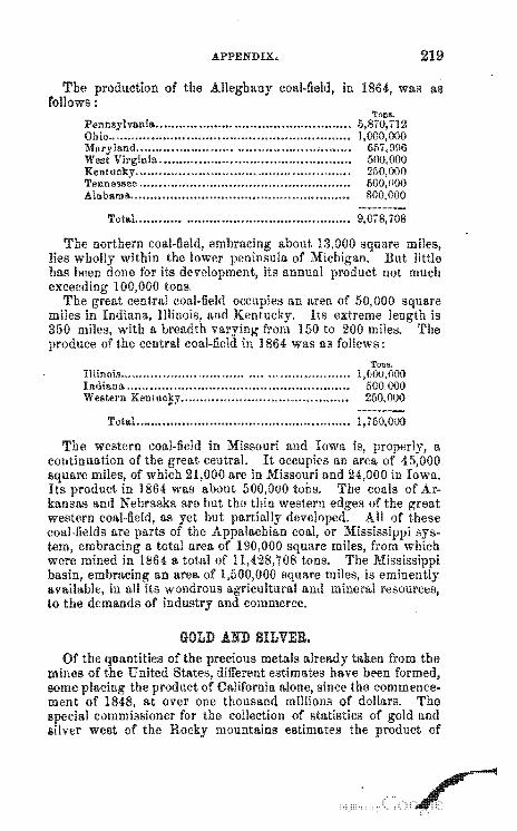
The follows:
of the
APPENDIX.
in
Pennsylvania ................................................. . Ohio ............................................................. .
219
was as
Kentucky ...................................................... . Tennessee .................................................... .. Alabama ....................................................... .
Total ...................................................... 9,078,708
about 13,000 square of But little
its annual not much
"",'nn"',, an area of 50,000 square Its extreme is
from 150 to 200 miles. The 864 was as follews:
Illinois ....................................................... .. Indiano. ....................................................... .. Western 250,000
Total. ...................................................... 1,760,000
The western coal-field in Missouri and Iowa continuation of the
of 1864 was about
kansas and Nebraska are but tho but
is and mineral resources,
commerce.
GOLD A.ND SILVER. metals taken from the
different estimates have been California since the commence-
over one thousand of dollars. The for the collection of statistics of and
mountains estimates the of
A.PPENDIX.
cl",,,,,,,it~·cl at the mints for the year 1866 was leI!>' the mint returns about
four-sevellths of amount of bullion that year upon which a revenue tax was '''''''''':''''''1
A CASE was before the cancel homestead in which the have been made while claimant was the United States that he was mustered
1866 soon built a small to
not at distant
to it to
the army of out of the service in
and commenced the same, with
was held that the had not abandoned his tract i the chUI'acter of his und manner of residence were not such as the law 'I'he cancellation of tbis was declined on the evidence while It more
was called for under the law. It was the settler must upon the land such a house as may answer for of resort
with the make statute actual homestead. A from the date of notice was allowed within
house and move' it of that time that he should
and show
222
ment.
APPENDIX.
cannot be '''''''1£':-'''''"' from enters
the same as 1862 j actual settlement upon
in all cases. of the law of 20th
to settlers that in the case infant child or children under
and fee shall inure ; and that the
"''''UlU,U may sell the for the of time within two after death of the
accordance with law of the domicile. been made as to whether it is the
thus be sold uuder the statute for the benefit of the or whether they can retain title under the settle-
The Commissioner rules that there is no under the of the law to the maintenance of settlement
on the of the and the issue of the in their names the time;
such case the minor heirs must continue to reside upon and the settlement and cultivation of the same must
be continued for their benefit. In the case of a homestead settler who
whose father for
HOMESTEAD OOMMUTATIONS WITHIN RAILROAD LIMITS.
In the ~p",..,.·t.n .. v'"
APPENDIX.
upon the abandonment of the pre-emp-
have been at law desirous of act.
The with that the UUl:ea:suu
ments of the statute
as to what is of heirs under tho 8th section of the
to the date of decease; that the been continued and residence maintained
the homestead after the death of the settler j Rnd cultivation had not been the a sufficient time had not to a forfeiture of the claim.
upon case residence at thc date of
since the decease
Instances have occurred in which a widow has made a homestead settlement and thereaftcr marries a person who likewise made a similar settlement on another tract. It is ruled that the
elect which tract will retain for under
the ti tie to the the original settler.
THE RIGHTS OP POREIGNERS IN RELATION TO THE AO-OP TITLE TO LANDS.
APPENDIX.
s.
APPENDIX. 225
FOREIGN TITLES WHIOH ORIGINATED UNDER THE ." ..... J''''.u., BRITISH AND MEXIOAN GOVERNMENTS.
States have for and of
This has been done not as a measure of coincidence with the law.
CALIFORNIA.-Under the several acts of ,.,'JllUn.".,,.. for the set-tlement of and Mexican claims in have'been in three hundred and
five six hundred and acres i and of these have and and Slx:tv··m:ree
ernment. 'l'hese statutes authorize the ""'(''''ntl''
claims tracts within the several U!~'H!'"L''' from to the
15
226 APPENDIX.
cession to the United Sta.tes in authorities exercised the
n"",nn,I>n, to of Louisiana n""w,.,.n
continued to
LEGISLATION IN RELATION TO DISOONTINUANOE OF SURVEYING DISTRIOTS.
A.n act for the discontinuance of the office of ::Surve'volr-(jew~ra. in the several so soon as the
,.,,.,.,,, .. ,,,n June 1840.
A.PPENDIX.
the IJoIIUm,naLOI'V
Land Office the statute
for free access to the been delivered to the state.
Pursuant to those enactments the to the authorities of
and
same. archives for Louisiana
States land office at New Tallahassee.
of the United for Florida are at
LEGISLATION RESPEOTING THE LAND OrrWES.
law of June 1840 orders that whenever
district f.hall be less
or
shall be and the land unsold to sale at the land office most convenient to the
in the land office shall have been discontinued. The 7th section of the act of 1841
vol. v. p. declares that land be the land unsold does not acres, sIJ'Ch continuance be or in order to close the land
The Jaw of March that land offices
whenever cost of in 0. district amounts to of the whole revenue
in his the consolidation is not incom-
228 APPENDIX.
1853 vol. x. p. au-chief executive to the seats
as con-nected lands.
Under the above-mentioned act, additional land offices have created and established as follows:
At district of Sierra Nevada; and Sacramento.
At At
river Under
land office for the and the site of a
has been fixed at Prescott. In nccordance with the
all that range of
,"VIlllf.'V"<;U of the
a land office the district the Salmon
of the act of 3d
APPENDIX. 229
1853, the Presideni, under date of 16th February, 1867, directed that the office for the sale of public lands, in the southwestern district of. Alabama, be removed from St. Stephen's to the city of Mobile, in that state.
In April, 1867, an order was given for the discontinuance of Elba land district, in the state of Alabama, and the vacant public lands therein were made subject to sale at Montgomery.
By notice, dated 8th May ultimo, the land offices at St. Augustine, Newnansville, and Tampa, in the state of Florida, were discontinued, and the vacant lands in the several districts were made subject to sale at Tallahassee, thus consolidating all the land office8 in the 8tate at the capital.
Digitized by Google

I
162 Anoma.lous 187 Areas of the States and Territories........... .................................... 18
Base lines ............................................................................ 26, 61 treee ............................................................................ 32
DU'UlIlUH.n"S and contents of subdivisions............... .......... ............... 133 Boundaries of the public surveys not to be 119
standard ....................................................................... . of ................................................................. .
surveyor ......................................... .. may
must
public ................................................................ . me&!lder ......................................................................... . mode of
qua.rter section ................................................................ . section ........................................................................... . IItandard ....................................................................... .. standard township ........................................................... . township ........................................................................ .
COlTection lines ........................................................................ .
27 28
163 68 27 62 66 65
67 67
149 83 30 40 30
1:.!3 38
36 84 62
surveyors, laws and ""'ll'UIRLlOI'S concerning..................... .•.•• 60
Field books ......... ......... ...... ............ ......... ................. ................ 40 Bnd data to be noted in......... ........ ............... ............ 42
Field specimen of ............. .. Field UUI,rnLllln •• when to commence ........................................... .. Flats, of surveying....................................... ..................... 47
(231 )
INDEX.
General Land Office letters relnting to the subdivision of sections nnd restoring of lost corners .•.••.•...•••••.•••••••...............•... 142-146
Graduated lands ........................................................................ 164
Homestead law .......................................................................... 168 Act of June 1866 ...................................................... 172 Act of May 1862 ....................................................... 174 Act of March 1864 ..................................................... 176 Genernl Lnnd Office circulnr in regard to ............................... 171
Homestead rulings ..................................................................... 221 Horizontal meaBurements ......... .... ..... ......... .................... ............. 28
Initinl point ......... ............... ......... ......... ...... ...... ........................ 62 Introduction ...... ............ ...... ...... ...... ......... ...... .......................... 28 Islands in rivers, how 47 blands may be 88
Lakes, ponds, etc., how ...................................... , ......... 48 uncovered meandered. ...... ...... ...... ............ ............... ......... 161
Land, selections of.......... ••. ............... ........................ ......... 186 coal ................................................................................ 156 educational grants of ........................................................ 192 internal improvement ........................................................ 194 salt ............................. 194
Land public......... ............................................... Hi Land gl"ll.nts to and 186
ill" .... '·.,.". comparative of.................................. ............ 19 where located............ ...................................... 20
le~:isl."tion in regard to disoontinuance of ..................... 227 U. S..................................... ........................... 11
titles to ... '" ......................................................... 225 within railroad limits ................................. 222
public, rights foreigners in regard to acquiring .................. 223 Land warrants ........................................................................... 1i8
Act of June 1868 ......................................................... 183 Act of June 1860 ........................................................ 184 assignment of ................................................................... 178 General Land Office circular to ................................. 181
Laws of relating to surveying publio lands ................... 180 Legal ............................................. 26 Line trees...... ...... .... .••.• ...... ...... ......... ......... ................ ...... ........ 28 Lines, of 29
coursing measuring ...... ...... ......... ......... ....................... 27 how run .......................................................................... 29 insuperable objects on......................... ............................. 29
28 .................................................................. 46
Meridians, principaL .............................................................. 26, 51 COIDivelr2e:ncv of the. .......... ......... .................. ...... ......... ...... 27
..................................................... 63 62
INDEX. 233
Measuring distnnces over lakes and rivers...... •.••••..•.•••...•.•.....•..•.... 69 Minera! re80urces of the Gnited States .......................................... 205
Ohio, 206 Indiana, 207; Illinois, 208 Wiscon-sin, Iowa, 209; Min-nesota, Kan~as, 210; New 212; California, ; Nevada, 218; Montana, ; Idaho,
Coal ............................................................................... 218 Gold and silver ................................................................. 219 Iron ................................................................................ 217
cJ.dms ........................................................................... 195 mode of oonstructing...... ..................... ...... ..................... 31
Oath prescribed to be tllken by nll persons in the public service ........ .
Pacific railroad ......................................................................... . Pits, witness .......................................................................... .. Post and witnesRes .................................................................... . Posts and mounds ..................................................................... . Pre-emptions ......................................................................... ..
remarks .................................................................... . rm""·[um • .,.,, measurements ....................................................... .
Random lines ........................................................................... . Ranges .................................................................................. .
of .................................................... .
m!ss!ng interior section corners .......................................... . nllssmg meander corners .................................................. . missing quarter section corners ......................................... .. missing ~ection corners on township lines .............................. .
township corners ................................................. .. how surveyed ................................................. .
nliVl.",.' •• ". how surveyed ............................................. .
64
187 33 81 31
189 3
124
29 26
162 121 123 125 laO 128 125 129
46 47
Scrip, 164 .................................... 166
revolutionary bounty ........................................................ 167 ",,'CHUHI., subdivisions of.............................................................. 25
parallels .................................................................. 27, 52 Station trees........................ ......... ................................... ......... 28 Subdividing of sections ............................................................... 135 Subdivisional or sec lion lines....................................................... 58
districts................................. ......... ........................... 15 to discontinua.nce of .............................. 227
............................................................ 16 LmlVnMlllfU" west of the meridian .......... ......... ......... ......... 53
east of the meridian............ ................................ 56 Surveyors·General............... .................. .................................... 15 ",",rv .. v~. order of forward the public..................... ........... 51
form of in the case of.................. ...... ............ 66 made at expense of settlers in certain cases. ............ ..... ........ 86
Swamp lands ....... ......... .............................. .................. ...... ...... 49
284 INDEX.
pius ................................................................................. 27 ............................................................................ 158
26 lines .......................................................................... 53
Town sites ................................................................................ 158 Act of 1867 ..................................................................... 161
True to find the, with the theodolite ........ ............ ...... ...... 81 with the compass ...... ...................... ...... ............ 83
V&riation of the needle ......... _ .................................................. , ....... 58,76