map 5 relevant geographic region - basic portal
TRANSCRIPT

00030357
06050610
06110612
06130613
06140614
0709
0740
0755
0756 0793
0854
0860
0861
0793
Scale of Metres
0Legend:
Map 5 Relevant Geographic Region
16
92 Elizabeth Avenue, Rosebud West. Residential Village and Developments - CHMP 13320
Topographic map used for Location Plan: 1:30,000 Number T7821-2-4-2, T7821-2-1-3, T7821-2-2-4, T7821-2-3-1
Zone 55
Parish:LGA:
Activity Area Boundary29.9 hectares (approx)
31
3000
31
6000
5749000
5751000
Archaeology At Tardis
31
5000
31
4000
31
2000
5752000
5750000
5748000
VAHR 7821-xxxxArtefact Scatter
Shell Midden
Object CollectionVAHR 7821-xxxx
VAHR 7821-xxxx
xxxx
Relevant Geographic Region
xxxx
xxxx
1000500

92 Elizabeth Avenue, Rosebud West. Residential Village and Developments – CHMP 13320
Archaeology At Tardis cultural heritage advisors 17
5. 3 Aboriginal Places in the Geographic Region
Evidence of pre and post-Contact Aboriginal occupation may be found throughout the
Victorian landscape in a variety of different forms and condition. What remains of this
evidence comprises archaeological sites or Aboriginal cultural heritage places. These sites
have been classified into different ‘types’ usually based on a set of consistent
characteristics. These characteristics can relate to: the type of artefact found at the site
(i.e. stone artefact), what function the site itself may have served (i.e. quarry site) or they
may be utilitarian (i.e. rock-well) or ceremonial in nature (i.e. stone arrangement). Most
sites represent evidence or the remains of the exploitation of a particular resource
therefore they are often associated with the surrounding environment and landform. The
association between environment/landform and site type is used to create predictive
models to assess the likelihood of a particular landform to contain specific site types or
Aboriginal cultural heritage.
Number of Places
There are nineteen places registered in the geographic region. Site types which have been
previously found throughout the geographic region are: stone artefact scatters (n=13
(68%)), shell middens (n=4 (21%)) and two object collections (n=2 (11%))
Landform
A significant proportion of these places were located on low lying dunes (n=12 (63%)),
however occasional places have been located in swamp (n=4 (21%)), coastal plains and
flats (n=3 (16%)).
Vertical Distribution
No surface finds have been recorded in the geographic region. The majority of stone
artefact scatters have been recorded at depths between 200mm and 680mm below
current ground surface. One exception to this is a stone axe recorded at 1100mm below
ground surface. This was recovered during uncontrolled mechanical excavation.
Contents
Stone artefact scatters and low density artefact distributions are dominated by isolated
stone artefacts (n=5 (38%)). Distributions of two to five artefacts accounted for three
places (23%), while more populous scatters are extremely rare. Artefact totals was
unrecorded for two places (14%).
Raw Material Types
The dominant raw material types found within the geographic region are silcrete and
marine flint. Silcrete appears at eight of the thirteen stone artefact scatters (62%) and
accounts for twenty-seven artefacts (24% of the total artefact assemblage), while coastal
flint appears in five places (38%) and accounts for 50 stone artefacts (45% of the total
artefact assemblage). Minor components of quartz, quartzite and have been found at
places within the geographic region.

92 Elizabeth Avenue, Rosebud West. Residential Village and Developments – CHMP 13320
Archaeology At Tardis cultural heritage advisors 18
Artefact Types
Stone artefact analysis within the geographic region has been only broadly discussed.
Flakes are the predominant artefact type within the geographic region, and are present in
8 places (62%). Minor components of cores, angular fragments, and one anvil, hand axe,
mill stone and pestle are also recorded. In general, insufficient data has been collected to
carry out any meaningful quantitative analysis across the geographic region.
Shell Middens
There are four shell middens in the geographic region. These are all located on the dune
landform on the former margins of Tootgarook Swamp, and range between surface and
680mm below ground surface. Three of the middens contained a combination of rocky
and sandy shore shellfish species, and one contained rocky shore species only. No
distinct patterning in shellfish species is observable, and common species include
Subninella, Cabestana, Abalone, Brachidontes, Dicathais, Chiton, Limpet, Nerita, Mytilus,
Donax, and Ostrea. This demonstrates that Aboriginal people were harvesting shellfish
from coastal rock platforms and returning with them to the Tootgarook Swamp for
consumption.
Quarry
There are no quarries registered in the geographic region.
Scarred Trees
There are no scarred trees registered in the geographic region. The majority of native
vegetation on the Mornington Peninsula was cleared during the lime burning industry
period (1840-90s), meaning that the potential for culturally scarred trees to have survived
is extremely low.
Burials
There are no arborial or subsurface burials recorded in the geographic region. Burials will
likely be present within dunes adjacent to swamps and waterways. As the majority of
native vegetation on the Mornington Peninsula was cleared during the lime burning
industry period (1840-90s), the probability of arborial burials being present will be
extremely low to none. Internments within dune landforms remain a possibility.
Notable Dated sites within Mornington Peninsula
A range of sites have been subject to formal dating on the Mornington Peninsula,
including East Swan Lake 4/1 (Wk-2001) at 6560±60 BP, Pickering Point (Gak-2856) at
6850±150 BP, and Nobles Rocks 3/2 (Wk-1141) at 6870±70 BP (Godfrey et al. 1996: 39).
One of the oldest sites along the Victorian coastline being 7121-0237 (VAHR) at Cape
Bridgewater 3/1, being 9850±70 (Wk-3649) (Godfrey et al. 1996: 42). However, the age
for site 7821-0755 (VAHR) is quite anomalous compared to the majority of midden sites
located within the Mornington Peninsula region. The majority of the midden sites dated
around this area are much earlier, and range from present day to around 2000 BP (Davey

92 Elizabeth Avenue, Rosebud West. Residential Village and Developments – CHMP 13320
Archaeology At Tardis cultural heritage advisors 19
Point 1, 230±50 BP (Beta-88049), The Sisters 3, 340±70 BP (SUA-2036), The Sisters 3,
1940±60 BP (Beta-05818)(Godfrey et al. 1996: 35; Porch, 1996: 9).
The closest archaeological place that has been subject to formal dating are approximately
1km to the east of the activity area in Boneo. Murphy & Thomson 2008 & 2013 carried out
radiometric dating on charcoal and burnt shell from VAHR7821-0755 and obtained dates
of 6288±55 BP (Wk-37127) and 6622±87 BP (Wk-22925). This correlates with the set of
the Holocene Climatic Optimum (8/5ka BP), when high precipitation and increased sea
level likely resulted in the formation of a large open water body where Tootgarook Swamp
is currently located. Saline water invaded the landscape, providing a habitat for marine
mollusc communities of Katelysia ryhtiphora, Mytilus edulis planulatus, Austromytilus
rostratus, Mactra sp and Anadara trapezia (Geological Survey of Victoria 1967; Murphy &
Thomson 2008). Increased water levels within the area would have created small ‘islands’
out of the remnant sandy rises and hillocks, providing high points in the landscape that
were close to water and food sources, and provided attractive dry and resource rick
campsite locations. Place VAHR 7821-0755 is in a comparable landform to the dunes
located in the north of the activity area.
5. 4 Previous Work in the Geographic Region
Regional Investigations
In a very early archaeological investigation by a geologist, Keble (1928) provides a
descriptive account of Aboriginal occupation of the Mornington Peninsula. Keble
suggested that sand country of the Peninsula was the preferred campsite location. He was
also able to demonstrate that the large social networks and distribution systems may have
operated prior to European settlement. Such extensive trade and social network systems
have since been clearly demonstrated (McBryde 1984). Keble considered that the ocean
shoreline between Portsea and Rye would contain the highest density of sites in the area.
Keble suggested that the hinterland of this coastline was once grassland regions rich in
native fauna. He also suggested that after harvesting shellfish from the coast, Aboriginals
would then travel to a known water supply (1928: 153). One of the recorded
archaeological sites near to the study area, Blacks Camp (7821-0014) was first noted by
Keble during his field excursions. Keble's study is important as it highlights the rate of
archaeological loss that has occurred in the region over the past eighty years in terms of
site density and content. Spillane (1974, 1971) also noted large campsites on the
Peninsula including Black’s Camp.
Although the activity area has been included within a previous regional study (Sullivan
1981), it was not subject to specific survey coverage. A high density of coastal sites, many
of which were found to be situated along the cliff line were recorded (see Table 2 & Figure
10). These sites are comprised of surface scatters of rock platform shellfish midden, often
with a small lithic component and mostly in poor state of preservation. The present activity
area is adjacent to Sullivan’s Coastal Unit 5, and was found to have a minimum site
density of one site in every 240m (Sullivan 1981: 66, Table 9) of coastline. Sullivan noted
that this coastal unit, whilst containing some large rock platforms, was mostly sandy; yet
has a high site density.
During Sullivan’s survey the vast majority of known Aboriginal sites were recorded along
the Port Phillip Bay and Bass Strait coastline. A total of 289 new sites were recorded

92 Elizabeth Avenue, Rosebud West. Residential Village and Developments – CHMP 13320
Archaeology At Tardis cultural heritage advisors 20
during her study with nearly 90% identified within 100 metres of the shoreline. Sullivan
considers that the proportionally low number of inland sites recorded during her study may
be a function of low ground surface visibility in these areas rather than an accurate
indication of site distribution. The majority of sites recorded are middens and
midden/surface scatter sites. Less frequently located were surface scatter sites. The
dominant shellfish species exploited at these midden sites were Turbo (Subninella
undulata) and Limpets (Cellana tramoerica), both rock platform species. The dominant
stone materials utilised within these sites were Tertiary silcrete, Palaeozoic chert and
marine chert (Sullivan 1981: 82).
From the conclusion presented in Sullivan's study (1981: 95), general predictive
statements can be made about Aboriginal site distribution and site contents on the
Mornington Peninsula. These predictive statements are of particular interest to the present
study.
Archaeological sites will occur on all prominent landforms on the Peninsula, including
cliffs, dune swales, hind-dunes, bluffs and escarpments.
The greatest concentration of sites occurs on the Bass Strait coastline.
Shell midden sites on the Peninsula represent specific exploitation of the rock platform
species Mytilus. There is evidence that these sites were linked with hinterland base
camps located in the western foothills of the central spine of the Peninsula.
The stone artefact assemblage associated with these sites is primarily a flake and
blade industry that dates these sites to the last 4,000 years.
The archaeology of the Peninsula must be interpreted as representing a single element
that is part of a wide ranging and complex exploitation strategy used by the Bunurong
people prior to European contact.
Sullivan considers it unlikely that the Peninsula would have been exploited on a single
seasonal basis, but with several trips made by small groups to areas of the Peninsula
each year.
Goulding (1988) undertook an investigation of the Melbourne Area, District 2 for Aboriginal
occupation. The research for this assessment was literature based and no ground surface
survey was undertaken. The aims of this study were to detail Aboriginal society pre- and
post-European settlement and provide information on known Aboriginal archaeological
places within public land. In a summary of the archaeology of the area, Goulding believes
the area to have been extensively investigated and surveyed, which has shown that the
entire region has been occupied by Aboriginal people at some time during the past.
However, even given this information, Goulding states that “we still know very little about
the activities of Aborigines across the diverse landscape” (Goulding 1988: 61-62).
ACHRIS shows there are twenty-four approved CHMPs in the geographic region (Hislop
2014, Beaton 2014, Walker 2013, Murphy & Thomson 2013, Barker & Barker, 2013, Brown
et al. 2013, Falvey et al.. 2013, Murphy & Owen 2011, St George 2011, Howes 2011,
Barker 2011, Dugay-Grist & Cowled 2011, Robb 2011, Whincop & Howell-Meurs 2011,
Hislop 2011, Barker 2010 a & b, Murphy et al. 2010, Stevens et al. 2009, Hobbs et al.

92 Elizabeth Avenue, Rosebud West. Residential Village and Developments – CHMP 13320
Archaeology At Tardis cultural heritage advisors 21
2009, Barker 2009 & Mitchell 2009). None of these has included the current activity area.
The approved CHMPs have the following characteristics:
1. The approved CHMPs comprise two desktop assessments, one standard
assessment and twenty-one complex assessments.
2. The majority of CHMPs have investigated land within the low lying dune formations.
3. Aboriginal cultural heritage has been found only during complex assessments.
4. Seven of twenty-one complex assessments found sixteen new Aboriginal cultural
heritage places, comprising fourteen low density stone artefact scatters and two
shell middens.
5. Seventeen of the assessments found no Aboriginal cultural heritage.
6. Complex assessments have excavated approximately 361.31m2 and located eighty
stone artefacts.
7. Two of the CHMPs conducted radiometric dating. Murphy & Thomson 2008 & 2013
carried out radiometric dating on charcoal and burnt shell from VAHR7821-0755
and obtained dates of 6288±87 and 6622±87.
8. No CHMPs have demonstrated Pleistocene Aboriginal places are present in the
geographic region.
9. CHMPs typically identify elevated dunes adjacent to creeks and swamps as areas
of cultural heritage sensitivity for stone artefact scatters, shell middens and burials.
Activity Area Specific Investigations
Murphy (2006) carried out a cultural heritage assessment, including ground surface survey
of the activity area. The ground surface survey was constrained by very poor ground
surface visibility, and only 10% of the activity was inspected in detail, and effective survey
coverage was less than 1%. The survey identified the small elevated sections of land in the
north of the activity as having moderate to high archaeological potential. The southern low
lying flat ground was identified as the Tootgarook Swamp, which would have been
inundated until its draining in the 1890s, and therefore would be unlikely to contain
Aboriginal cultural heritage.
Summary
The activity area has been subject to previous ground surface survey;
There are no previously registered Aboriginal heritage places within the activity
area, or within 50m of the activity area boundaries;
There is one previously registered Aboriginal cultural heritage place within 200m of
the activity area boundary (stone artefact scatter VAHR7821-0854). There are no
other Aboriginal cultural heritage places within 500m of the activity area boundary.
No correlation between site identification and the probable pre-Contact banks of
Chinaman’s Creek has been demonstrated;
The activity area has been subject to previous ground surface disturbance through
vegetation clearance and repeated ploughing and grazing;

92 Elizabeth Avenue, Rosebud West. Residential Village and Developments – CHMP 13320
Archaeology At Tardis cultural heritage advisors 22
The majority of previously registered Aboriginal heritage places within the
geographic region have been low density surface stone artefact scatters with small
spatial extents.
5. 5 Historical and Ethno-Historical Accounts in the Geographic Region
The information used to establish pre-settlement Aboriginal spatial organisation is mostly
based on observations made by Europeans during the initial period of contact and
subsequent settlement of the activity area region. Early historical accounts of Aboriginal
land use within and surrounding the activity area are scant, with information provided by
Bunce (1858), Smyth (1878), Gellibrand (1836), Jamieson (1853), Haydon (1846), G
McCrae (1911) and H McCrae (1966). Each of these people recorded some details about
the Peninsula's Bunurong people such as language, traditions and customs. However, the
majority of information is derived from papers and Journals of the Assistant Protector of
Aborigines, William Thomas and Chief Protector George Augustus Robinson.
The activity area lies within the traditional lands of the Bunurong tribe. The Bunurong
(Western Port) tribes belonged to the inter-marriage network and language ties group
known as the Kulin that inhabited areas around Melbourne. At the time of contact the Kulin
nation was made up of the Bunurong, Woiworung, Jajowrong, Taunguong and
Wathaurong (Presland 1994: 40). The Bunurong clan whose estate included the activity
area were the Bun wurrung balug (Map 6 – clan 1) meaning ‘Bun’ speaking people (Clark
1990: 366) and their territory is thought to have been around Point Nepean and Cape
Schanck (Barwick 1984: 177). Their clan leader at the time of European settlement is
thought to have been Bobbinary (c. 1799-1849), a famed healer and sorcerer reputed to
be able to charm away rain (Clark 1990: 366).
One of the first to mention local Aboriginals was Captain Matthew Flinders when in 1802
he climbed ‘Bluff Mountain’ (Arthur’s Seat), noting: “There were many marks of natives,
such as deserted fire places and heaps of oyster shells; and upon the peninsula which
forms the south side of the port a smoke was rising, but we did not see any of the people”.
European contact with the Bunurong around the Peninsula was initially made by sealers
and whalers frequenting Bass Strait from the late 1790’s.
Early Aboriginal population numbers made by observers are, at best, estimates. An 1839
census of the Bunurong by Thomas suggested that at the time of colonisation, this tribe
comprised of approximately 500 persons or ‘six square miles per person’ (Thomas ML 9:
47).
Thomas was appointed Assistant Protector in 1839, in charge of the welfare of Aboriginal
people in the Western Port and Gippsland districts. From 1839 to 1841 Thomas worked
from a hut near Arthur's Seat. Thomas saw the demise of Aboriginals once they moved to
Melbourne and made concerted efforts to encourage them to settle in agricultural areas.
However, this attempt to keep Aboriginals out of Melbourne was a failure, and by 1843
Thomas was totally preoccupied with keeping order in the Aboriginal camps around
Melbourne and visiting Aboriginals in jail. In 1850, the Protectorate system was abolished
(Sullivan 1981: 15).

92 Elizabeth Avenue, Rosebud West. Residential Village and Developments – CHMP 13320
Archaeology At Tardis cultural heritage advisors 23
Map 6 East Kulin Language Areas & Clans (from Clark 1990: 364)
The journals Thomas kept during his period at Arthur's Seat are of particular interest as the
Aboriginals in this area were then still practising aspects of their traditional lifestyle. In
1839, European settlement had already severely affected the Aboriginal population as
Thomas counted only 83 members of the Bunurong tribe remaining (Sullivan 1981: 17). As
a result of granting grazing licenses, Aboriginals became dispossessed of their land and
were forced to rely on handouts of food from Thomas and other settlers.
The Bunurong was one of the first groups of Aboriginals to feel the full impact of European
settlement. Aboriginal population numbers decreased rapidly after European settlement of
the Mornington Peninsula due to dispossession of land and associated resources, and the
spread of diseases brought into the area by European settlers. Thomas notes that their
N Approximate location of activity area

92 Elizabeth Avenue, Rosebud West. Residential Village and Developments – CHMP 13320
Archaeology At Tardis cultural heritage advisors 24
mortality rates were dramatic, with numbers declining to 28 in 1850 (Sullivan 1981: 18).
The major causes of this high death rate were venereal disease, intemperance, murder,
executions, shooting by the authorities and death in jail. Several hostilities occurred during
the early period of European contact and contributed to the decline in Bunurong
population. The Bunurong were last seen on the southern Peninsula in 1856 (Byrne 1932:
183). The remaining mainland members then moved to a small reserve at Mordialloc. By
1856, the remaining Bunurong lived mostly at ‘Moody Yallock’ (Mordialloc), exploiting the
resources of the swamp and adjacent coastline.
Intermarriage and exchange of goods between the Kulin tribes is known to have occurred
(Sullivan 1981: 36). Kulin people often met for inter-clan gatherings. The Bunurong held
meetings every three months and corroborees were held at full and new moons (Thomas
ML 21: 97). Notices of planned gatherings were distributed to neighbours via message
sticks and during these inter-tribal gatherings marriages were arranged and disputes
settled.
Thomas and early settlers in the Western Port region have recorded aspects of the
seasonal movements by the Bunurong through their territory. Gaughwin (1981: 75)
considers that the Bunurong continued their seasonal exploitation in a circular pattern from
Melbourne to the Mornington Peninsula. This trip was thought to take about one month
with an average stay of one to two nights at each campsite while the resources within a 10
kilometre radius were exploited (Sullivan 1981: 37). It can be seen from Map 7 that there
are at least three routes observed of Aboriginal movements in ethno-historical literature in
close proximity to the activity area. It appears from Thomas’ descriptions that larger base
camps utilised during this route were located roughly 5 kilometres inland, suggesting that
coastal, wetland and hinterland forest could be readily exploited from these base camps.
Base camps consisted of six to eight huts made from a lean-to of bark sheets.

92 Elizabeth Avenue, Rosebud West. Residential Village and Developments – CHMP 13320
Archaeology At Tardis cultural heritage advisors 25
Map 7 Routes of Movement and Site Locations (Sullivan 1981: 120)
Robert Jamieson wrote in 1853 that there were about 300 Aborigines on his Cape
Schanck Run in 1838. During his seven years in the bush, Jamieson testified that he spent
a great deal of time with them and invariably found them quiet, inoffensive and willing in
their way to be helpful (Hollinshed 1982: 29).
A resident who owned Manton’s Creek Station just north of Flinders, Mr Tuck, also makes
several interesting comments regarding Bunurong people:
‘In the early days a tribe of about thirty Aborigines wandered about the Peninsula.
They travelled about three miles per day, living on possums, which they roasted
whole, unskinned and uncleaned. The possum was left in the fire until it burst from
the pressure of the steam. The lubra got what the blackfellow threw to her over his
shoulder, while she in turn threw her leavings to the dogs. The aborigines could be
got to do any sort of service for a piece of damper or bulgonna (beef). Mr. Barker
(at Cape Schanck) employed them very often at skinning cattle for his boiling down
works, giving the carcase as payment. The blacks were expert in climbing trees by
cutting notches in the bark. They could knit fine baskets of reeds. They were
generally very peaceable. Only one charge is to be laid to them – they are accused
of killing the child of Mrs. W. Willoughby’ (Moorhead 1971: 36).
Members of the Kulin were known to both bury their dead, as well as place them in tree
hollows that were often burnt. Based on this scant information, burial sites, although a
rarity within the region, may still exist in undisturbed sandy locations. Currently, there are

92 Elizabeth Avenue, Rosebud West. Residential Village and Developments – CHMP 13320
Archaeology At Tardis cultural heritage advisors 26
few locations within Bunurong land where Aboriginal burials are known to exist and these
are within sandy fore dunes.
There is historical evidence that Bunurong burial sites were both common and
conspicuous. Besides the location near Tooradin noted by Clow, there were others along
the coast. Thomas saw a burial location near the Lang Lang Creek in 1840:
'wood was pulled up to the height of 3 feet & the ground burnt all around, this was of
long standing as the woods were literally decayed & dirt over them, I suppose there
were 50 sticks all laid horizontal thus. At the end was a large dead trunk and hollow
burnt in it rather as if not done by chance' (Gunson 1974: 10).
The ethnohistorical information provides evidence that the Bunurong tribe occupied the
Mornington Peninsula in an organised manner. Clans generally had areas where they
spent much of their time and that provided the basis for all their needs. There is evidence
for scatters of stone tools and middens along many coast sections and inland of Western
Port, Port Phillip Bay and Bass Strait.
Today, the members of the Bunurong/ Boon wurrung communities actively participate in
management of cultural heritage sites within this former clan's estate.
Apart from the above information, there is no readily available ethnographic information
that relates specifically to the activity area. The Traditional Owners Groups did not provide
any additional historic, traditional or contemporary information specific to the activity area.
5. 6 Landforms, Geomorphology and Geology (Map 8)
Landform and Geomorphology
The activity area lies on the downthrown southern edge of the Nepean Peninsula,
approximately 2km from the postulated Selwyn Fault (Vandenberg 1997). The region is
part of the greater Port Phillip Sunklands geomorphic region in Victoria (Joyce et al 2003).
The peninsula is a moderately elevated, sedimentary ridge of dune calcarenite topped by
unconsolidated dunes (Hills 1975; Abele 1977). Topography of the peninsula is variable
and due mostly to the variation in dune structures present, with the younger calcarenite
having the most pronounced relief in the form of irregular blowouts and ridges, locally
termed ‘The Cups’ (Geological Survey of Victoria 1967). There is a sharp break in relief
where The Cups landform changes to the Tootgarook Swamp, where relief is subdued
and broken only by sandy rises between 2-5m high, particularly towards the eastern edges
of the swamp (Geological Survey of Victoria 1967). Bordering the swamp to the east are
subdued inland aeolianite dune deposits of siliceous and calcareous content (Geological
Survey of Victoria 1967).
The drainage pattern follows the topography, and is almost absent from the dune sands to
the east and west of the swamp due to the high permeability in the sands (Jenkin 1974).
Within the swamp, Chinaman’s Creek flows from south to north, a re-cut channel that lies
to the east of the old, natural channel (SPIFFA 2011). To the north of the activity area, the
swamp contains permanent fresh water, as it lies on a base of peat and mud instead of
porous calcarenite (SPIFFA 2011). Small swamps are only slightly more common, and
form ponded swamps with peaty bases, and were probably created during sea level

92 Elizabeth Avenue, Rosebud West. Residential Village and Developments – CHMP 13320
Archaeology At Tardis cultural heritage advisors 27
regressive events that stranded various bodies of water (Cupper et al 2003). Smaller
streams flow into the swamp, and are likely ephemeral, flowing only during periods of
higher precipitation.
Geology
The activity area lies on Quaternary-age dune deposits surrounded by Late Pleistocene-
Holocene swamp deposits (Geological Survey of Victoria 1967). The swamp deposits are
comprised mostly of peat, calcareous mud, clay & silt with some shell beds and middens,
and lie in the lower parts of the landscape as part of Tootgarook Swamp (Keble 1946;
Jenkin 1976). Calcareous nodules are commonly found interspersed in the soil,
particularly the lower horizons, resulting from mobilisation of carbonate from the
surrounding and underlying calcareous dune systems (Abele 1977; Geological Survey of
Victoria 1971). Grey cracking clays dominate the soils of the swamp sediments, and
contain a thin layer of peaty-silt at the surface before grading sharply into cracking clay
(Joyce et al 2003). Interspersed in the local area with the swamp sediments are small
sandy rises, which are remnant surficial expressions of the underlying calcareous sand
dunes (Geological Survey of Victoria 1967). The sand dunes contain fine- to medium-
grained calcareous grey and brown soils up to 1m deep, with fragments of calcarenite
beginning at approximately 0.5m deep in the profile (Figures 1 & 2) (Geological Survey of
Victoria 1967; Zhou et al 1994).

1\.)
co
Lege
nd:
' } A
ctiv
ity A
rea
Bou
ndar
y I
92
Eliz
abet
h A
venu
e, R
oseb
ud W
est.
Res
iden
tial V
illag
e an
d D
eve
lop
me
nts
-C
HM
P 1
3320
Om
1
HIS
CO
CK
RO
AD
Ma
p C
ourt
esy
of D
SE
Web
site
0
250
500
---.
....
.i--
1
Od1
In
land
Dun
e D
epos
its:
Gen
eric
O
m1
Sw
amp
& L
ake
Dep
osits
: G
ener
ic
Oxr
B
ridge
wat
er F
orm
atio
n: G
ener
ic
Odl
1 C
oast
al D
une
Dep
osits
: G
ener
ic
Sca
le o
f M
etre
s
Ma
p 8
A
ctiv
ity A
rea
Geo
log
y A
rcha
eolo
gy A
t T
ardi
s cu
ltura
l her
itage
adv
isor
s
@
/{
GOA
Zo
ne
55

92 Elizabeth Avenue, Rosebud West. Residential Village and Developments – CHMP 13320
Archaeology At Tardis cultural heritage advisors 29
Landscape Evolution
To the west of the Selwyn Fault, the landscape is part of the Port Phillip Sunklands, a
landscape that is considered a failed arm of the Otway Basin which began to form as a rift
basin in the Jurassic (161-146 Ma BP) (Duddy 2003). The rifting was a consequence of the
tectonic splitting of Antarctica and the southern coast of Australia, a process that broke
Gondwana apart and lasted until the Tertiary (Duddy 2003; Ollier 1995). In response to
crustal extension, rapid subsidence occurred under the weight of over 105
km3
of
deposited volcanic and fluviatile sediments that washed into the basin during the period
from flanking terrestrial surfaces (Duddy 2003; Jenkin 1974). Substantial tectonic
reorganisation continued in the Mid-Late Cretaceous during the initial separation of the
two continents, and included folding, faulting and uplifting of the landscape (Duddy 2003;
Hills 1975). The Mornington Peninsula was formed in the Mid-Cretaceous during tectonic
reorganisation as part of the southwest-trending Mornington Peninsula-King Island High
which separated the Gippsland and Otway Basins (Duddy 2003). In response to rapid
uplift, stripping of sediment occurred along the Mornington surface, exposing the
Palaeozoic rock strata (Duddy 2003).
The Older Volcanics were erupted onto this landscape intermittently over sedimentary rock
across the Mornington Peninsula and most of Western Port Basin, with the largest volume
erupting to the east of the activity area in the Mid-Eocene (48-42 Ma BP) (Holdgate &
Gallagher 2003; Wellman 1974). This basalt field, named the Flinders Flow Field, was one
of the most voluminous, up to 600m thick in places and containing at least 1000km2
of
material, spread as far south as the King Island Ridge (Holdgate & Gallagher 2003; Abele
1976; Day 1989). Outcrops of the flow field are visible along coastal cliffs east of the
Selwyn Fault where they have been gradually uplifted over time. Shortly after extrusion of
these flows, the sea level rose and flooded many parts of the southern coastlines of
Victoria (Abele 1976). Sequences of marine and marginal marine sediments were
deposited unconformably over the basalt from the Oligocene (~32Ma BP) onwards;
however most of the sedimentation was restricted to the northern parts of the Mornington
Peninsula in the form of the Brighton Group (Holdgate & Gallagher 2003; Keble 1950).
Sea level retreated from the landscape in the Late Miocene in response to glacial
expansion in Antarctica, revealing much of the current land surfaces by the end of the
Pliocene and the beginning of the Early Pleistocene (White & Mitchell 2003; Holdgate &
Gallagher 2003). Erosion increased in response to the decrease in base level, and was
compounded by a tectonic event that dropped the landscape surface elevations on the
adjacent basins in the Pliocene (Holdgate & Gallagher 2003; Abele 1976; Jenkin 1974).
Tectonic movement culminated in the Late Pliocene and Early Pleistocene, with high
magnitude movement becoming more localised and less intense in the Mid-Late
Pleistocene (Lawrence et al 1976). Throughout the Quaternary, movement along the
Selwyn Fault occurred, and to a lesser extent, along the Flinders Fault to the south, and in
conjunction with sea level fluctuations, caused periods of erosion and sedimentation of
the landscape. The greatest amount of tectonic activity along these structures was centred
in the Late Pliocene and Pleistocene (Jenkin 1974). This movement was in part
responsible for the removal of thick layers of regolith from the slopes, exposing the
Palaeozoic geology (Hill 1999).

92 Elizabeth Avenue, Rosebud West. Residential Village and Developments – CHMP 13320
Archaeology At Tardis cultural heritage advisors 30
Sea level continued to fluctuate during the Early Quaternary, and by the beginning of the
Last Interglacial (~125ka BP) sea levels reached a height of 6-7m above present levels.
These higher sea levels created a seaway that ran from south to north along the
Tootgarook Swamp, connecting the bay with the Bass Strait (Keble 1950; Jenkin 1974).
This period of higher sea level was short, and by 120ka BP, sea levels were receding
apace with cooling and drying temperatures (Webb 1999; White & Mitchell 2003). Dune
movement quickly covered the path of the seaway across the peninsula, as evidenced by
offshore bathymetry (Keble 1950; Jenkin 1974). By the Early-Mid Pleistocene, global sea
levels began an overall gradual retreat up until the Last Glacial Maximum (LGM) when sea
levels were approximately 120 metres lower than present (Webb 1999).
The Late Pleistocene was a period of rapid change in the Victorian coastal landscape, a
pattern that can be observed in the several depositional patterns of the aeolianite on the
Nepean Peninsula (Zhou et al 1994). After the climatic optimum and sea level highstand of
6-7m above current levels of the Last Interglacial (~125ka BP), temperatures and available
moisture levels dropped, with several periods of aeolianite dune building occurring from
~118ka BP to the peak of the Last Glacial Maximum at 22-16ka BP (Zhou et al 1994).
These dune building episodes were interspersed with short periods of climatic
amelioration, leaving thin palaeosols interbedded with the aeolianite (Zhou et al 1994). In
the past, the aeolianite deposits may have extended across the mouth of Port Phillip Bay,
blocking flow between the bay and Bass Strait during periods of lower sea level (Cupper et
al 2003; Holdgate et al 2011).
After the LGM, climates warmed, and at approximately 10ka BP, Westernport Bay and Port
Phillip Bay were flooded by waters from the Bass Strait, with water eventually able to break
through the cemented barrier of the aeolianite (Wallbrink & Hancock 2003). During the
Mid-Holocene (Holocene Climatic Optimum), sea level rose to approximately 2-2.5 metres
above the present level, and was accompanied by deposition of beach ridges, dune
fields, cliff-top dunes and swamp deposition within Tootgarook Swamp (Bryant 1992;
Jenkin 1974; Zhou et al 1994). The swamp probably formed in response to the blocking of
Chinaman’s Creek by beach foredunes to the north along Port Phillip Bay, allowing water
to build up behind the blockage. During the latter half of the Holocene, climates stabilised
to those seen today, while streams began to cut down and deposit large amounts of
alluvium to the north of the region as sea levels dropped (Jenkin 1974).
European arrival heralded a series of landscape changes, the most dramatic of which was
the draining of the landscape and the modification of stream channels. To drain the area,
Chinaman’s Creek was modified, with a straight channel cut to the east of the original
stream (SPIFFA 2011). This cut allowed excess flood waters to flow into Port Phillip Bay,
reducing the original size of the swamp from ~800 hectares to 450 hectares (Condina
1997). Clearing was widespread, freeing up land for agriculture, particularly market
gardens on adjacent calcareous sandy landscapes.
92 Elizabeth Avenue, Rosebud West. Residential Village and Developments – CHMP 13320
Archaeology At Tardis cultural heritage advisors 31
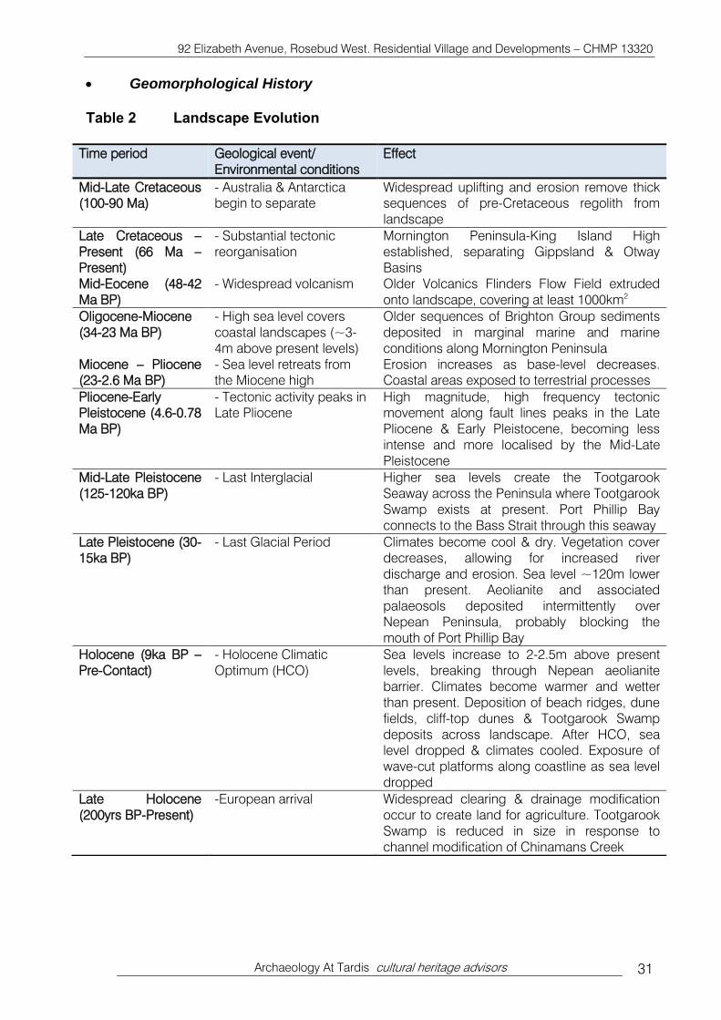
Geomorphological History
Table 2 Landscape Evolution
Time period Geological event/
Environmental conditions
Effect
Mid-Late Cretaceous
(100-90 Ma)
- Australia & Antarctica
begin to separate
Widespread uplifting and erosion remove thick
sequences of pre-Cretaceous regolith from
landscape
Late Cretaceous –
Present (66 Ma –
Present)
- Substantial tectonic
reorganisation
Mornington Peninsula-King Island High
established, separating Gippsland & Otway
Basins
Mid-Eocene (48-42
Ma BP)
- Widespread volcanism Older Volcanics Flinders Flow Field extruded
onto landscape, covering at least 1000km2
Oligocene-Miocene
(34-23 Ma BP)
- High sea level covers
coastal landscapes (~3-
4m above present levels)
Older sequences of Brighton Group sediments
deposited in marginal marine and marine
conditions along Mornington Peninsula
Miocene – Pliocene
(23-2.6 Ma BP)
- Sea level retreats from
the Miocene high
Erosion increases as base-level decreases.
Coastal areas exposed to terrestrial processes
Pliocene-Early
Pleistocene (4.6-0.78
Ma BP)
- Tectonic activity peaks in
Late Pliocene
High magnitude, high frequency tectonic
movement along fault lines peaks in the Late
Pliocene & Early Pleistocene, becoming less
intense and more localised by the Mid-Late
Pleistocene
Mid-Late Pleistocene
(125-120ka BP)
- Last Interglacial Higher sea levels create the Tootgarook
Seaway across the Peninsula where Tootgarook
Swamp exists at present. Port Phillip Bay
connects to the Bass Strait through this seaway
Late Pleistocene (30-
15ka BP)
- Last Glacial Period Climates become cool & dry. Vegetation cover
decreases, allowing for increased river
discharge and erosion. Sea level ~120m lower
than present. Aeolianite and associated
palaeosols deposited intermittently over
Nepean Peninsula, probably blocking the
mouth of Port Phillip Bay
Holocene (9ka BP –
Pre-Contact)
- Holocene Climatic
Optimum (HCO)
Sea levels increase to 2-2.5m above present
levels, breaking through Nepean aeolianite
barrier. Climates become warmer and wetter
than present. Deposition of beach ridges, dune
fields, cliff-top dunes & Tootgarook Swamp
deposits across landscape. After HCO, sea
level dropped & climates cooled. Exposure of
wave-cut platforms along coastline as sea level
dropped
Late Holocene
(200yrs BP-Present)
-European arrival Widespread clearing & drainage modification
occur to create land for agriculture. Tootgarook
Swamp is reduced in size in response to
channel modification of Chinamans Creek

92 Elizabeth Avenue, Rosebud West. Residential Village and Developments – CHMP 13320
Archaeology At Tardis cultural heritage advisors 32
Stone Sources
There are no known stone sources within the geographic region.
Stone sources for the broader region include sources of silcrete, coastal flint, chert and
quartz. The flint is likely to be sourced along the coastline, having been washed onshore
from offshore outcrops of limestone (Scott-Virtue 1982).
Silcrete boulders in southeastern Australia are typically sub-basaltic silcrete, and are
associated with basalt flows of the Older Volcanic group along the Mornington Peninsula,
French Island and Phillip Island. Erosion of the basalt can promote subsequent erosion of
the underlying silcrete deposits, and these boulders can form aprons along slopes and
stream courses (Webb 1995).
Chert and quartz can be sourced from the Silurian and Ordovician marine sediments
along the Mornington Peninsula, with the quartz occurring in hydrothermal veins that have
been weathered and exposed to the surface over time
Though each of these raw materials was available within the lands of the Bunurong, and
commonly appears in stone assemblages of the geographic region, no quarry sites have
been previously recorded within the Nepean or Mornington Peninsula.
Bioturbation of Sediments
Most sediment on the surface of the earth has undergone some form of disturbance.
Forms of syndepositional and post-depositional disturbance can range from macroscale
such as earthquakes and bushfires, to the mesoscale such as slope failure, and to the
microscale such as bioturbation of sediments by fauna (Morin 2006). These processes
can alter the horizontal and vertical placement and internal structure of artefacts in an
assemblage (Morin 2006). Bioturbation is an important factor in nutrient mixing and
redistribution in the soil, as well as in the observed arrangement of artefacts in the soil
profile, and if not understood properly, can cause a lowering of archaeological importance
assigned to artefacts (Peacock & Fant 2002; Pillans et al. 2002; Eggleton & Taylor 2008).
Bioturbation is defined as “The churning and stirring of sediment and regolith by animals
and plants” by Eggleton (2001:10), and can be classified into faunalturbation (disturbance
attributed to animals) and floralturbation (disturbance attributed to plants) depending on
the origin of the disturbance (Wood & Johnson 1978). Faunalturbation by displacing and
mixing soil particles through mounding and burrowing usually occurs through the actions
of soil biota such as earthworms and ants (Balek 2002). Rates of bioturbation differ
according to the climate, landscape, and sediment at each site, with bioturbation rates
higher in tropical climates than in temperate climates, and rates can be higher in sand
than in clay sediments (Eggleton & Taylor 2008; Peacock & Fant 2002). In sandy
sediments, artefacts have been found to have moved over 1 metre down the soil profile,
indicating bioturbation processes in sandy sediments can affect artefact placement to a
high degree (Cahen & Moeyersons 1977). For example, Pillans et al. (2002) identified an
accumulation rate of sediment to be approximately 0.018-0.025mm per year from the
erosion of termite mounds in northern Australia.

92 Elizabeth Avenue, Rosebud West. Residential Village and Developments – CHMP 13320
Archaeology At Tardis cultural heritage advisors 33
Bioturbation results in a redistribution of the superposed layers of sediment, and the
artefacts associated with each horizon (Cahen & Moeyersons 1977). Movement of
artefacts can occur either upwards or downwards, even laterally, through the soil profile,
with smaller objects generally moving up and larger objects moving down the profile
(Wood & Johnson 1978; Balek 2002; Johnson & Johnson 2010). Uprooting by tree-fall can
cause artefacts in the upper soil horizons to be displaced laterally as well as upward in the
profile (Eggleton & Taylor 2008; Wood & Johnson 1978). Artefacts can be sorted by size
and temporally mixed once buried in the sediment due to soil biota creating voids through
which artefacts fall into (Balek 2002).
Sea Level During the Last 9,000 Years
Since the Middle Holocene (5ka BP), sea level has fluctuated in Port Phillip Bay from the
highstand during the Holocene Climatic Optimum (HCO) (9-5ka BP) when sea levels were
approximately 1 to 2m above current levels, to the hypothesized drying up of the Bay
between 2.8 to 1ka BP (White & Mitchell 2003; Holdgate et al 2011). During the recovery of
sea level since the lowstand of the Late Pleistocene and Early Holocene, sea levels
increased steadily before hitting a threshold at approximately 9ka BP where recovery was
very rapid, with levels reaching +1-2m above present sea levels between approximately
7ka to 5.5ka BP (Sloss et al 2007; Holdgate et al 2011). These higher levels set the
benchmark for the Holocene sea level highstand before a period of consistent decline
from about 4.5ka BP onwards (Holdgate et al 2011).
Evidence of a trend toward hypersalinity at approximately 3.9ka BP is supported by
channelling and low foraminifera percentages in the lowest parts of the bay, a state that
heralded a period of low bay levels up until approximately 1ka BP (Holdgate et al 2011).
Lower sea levels after 3.9ka BP could have occurred concurrent with cooler, drier
temperatures, allowing the Nepean Peninsula dunes to mobilise, creating a blockage
across the bay, bisecting Mud Island, in the form of the Nepean Bay Bar (Holdgate et al
2011). There is evidence of a period of dune building along the Nepean Peninsula at the
end of the HCO, indicating climates were dry enough to facilitate dune movement, and
these conditions probably persisted up until the Late Holocene (Holdgate et al 2001; White
& Mitchell 2003; Zhou et al 1994).
The lowest bay levels were reached in the Late Holocene at approximately 2.8ka BP, as
shown by a cessation of marine deposition and the beginning of a period of subaerial
erosion (Holdgate et al 2011). Bay levels dropped to -22m below current levels, creating
Lake Phillip, a saline lake that lay approximately 15km northeast of Sorrento (Holdgate et
al 2011). Bass Strait sea levels during this period were at present levels, indicating the
presence of the Nepean Bay Bar that prevented the two bodies of water from converging
as seen at present (Holdgate et al 2011; Holdgate et al 2001). Breakthrough was achieved
around 1ka BP when the entrance to the bay was unblocked, allowing modern bay levels
to be reached shortly thereafter (Holdgate et al 2011).
The sea level changes can be summarised as follows:
1. Early Holocene (9-7.5ka BP): Sea levels were increasing from the Last Glacial
Maximum lowstand.
2. Early-Middle Holocene (7.5-5ka BP): Peak sea levels reached 1-2m above modern
levels in Port Phillip Bay.*

92 Elizabeth Avenue, Rosebud West. Residential Village and Developments – CHMP 13320
Archaeology At Tardis cultural heritage advisors 34
3. Middle Holocene (5-4ka BP): Sea level begins to retreat after Middle-Holocene
highstand. High bay salinity levels indicate low water levels.
4. Late Holocene (4-2.8ka BP): Low water levels and climatic aridity allow sand
movement and consolidation of the Nepean Bay Bar.
5. Late Holocene (2.8-1ka BP): Lake Phillip established on northerly side of Nepean
Bay Bar. Water levels in lake are 22m lower than modern levels at 1ka BP.
6. Late Holocene (2.8-1ka BP): South Channel and Bass Strait contained present sea
levels, but blocked from interacting with northern section of Port Phillip Bay by
Nepean Bay Bar.
7. Late Holocene (1ka-Present): Breakthrough of sea water through Nepean Bay Bar.
Northern sections of Port Phillip Bay floods. Modern-day sea level equivalent was
achieved quickly. Sea level still-stand exists up until present.
5. 7 Strategic Values
Ecological Vegetation Classes (EVC) (Map 9)
Prior to 1750 the activity area was comprised entirely of Wetland Formation (EVC 74) (Map
9). This EVC can consist of herbland, sedgeland and rushland elements and is
characterised by the lack of woody plants (shrubs and trees). In close proximity were large
pockets of Coast Banksia Woodland (EVC 2) to the north, Coastal Alkaline Scrub (EVC 1)
to the west, and Damp Sands Herb-rich Woodland (EVC 3) to the east. These late
Holocene EVCs are characterised by a woodland overstorey of Banksia and Eucalyptus to
15m, and a range of herbs, shrubs and grasses.
Aboriginal groups generally would have chosen long-term campsites close to the richest
and most diverse resources outside the activity area and in close proximity to permanent
potable water such as large waterholes along watercourses, permanent springs, swamps
and lakes. The closest sources of potable water occur outside of the activity area was
Tootgarook Swamp in the south of the activity area, and the original course of Chinaman’s
Creek, situated approximately 0.5 km west of the activity area.
The activity area region would have been one of high strategic value for Aboriginal people.
Areas of high strategic value are those which have several (3) Ecological Vegetation
Classes within close proximity (Map 9).

w
01
',~
-"S
t ~
~
·1 --
'L._
_ M
ca.lm
n st
~
I -j
~ -~o
cenr
St
5750
000
----
-1 -
1 --~~
~t ~
I
Lege
nd:
, \ I I
--
---
Den
otes
Act
ivity
Are
a 1 2 3
92
Eliz
abet
h A
venu
e, R
oseb
ud W
est.
Res
iden
tial V
illag
e an
d D
eve
lop
me
nts
-C
HM
P 1
3320
\f.~~ ~
'G{~
~ ti
·.~
fl.~.
---
·Jl.
,("
'f
-tsl
i
-!1'1
N
ll"et
een\
l\ "'
" -j ~--
II
Gol
t' lm
ks ,D_
I
----
J-
r ,
I ~
Ma
p C
ourt
esy
of D
SE
Web
site
Coa
stal
Alk
alin
e S
crub
53
S
wam
p S
crub
C
oast
Ban
ksia
Woo
dlan
d 7 4
W
etla
nd F
orm
atio
n D
am
p S
ands
Her
b-ric
h W
oodl
and
83
Sw
am
py
Rip
aria
n W
oodl
and
Map
9
17
50
Eco
log
ical
Veg
etat
ion
Cla
sses
A
rcha
eolo
gy A
t T
ardi
s cu
ltura
l her
itage
adv
isor
s
Cai
n S
t ~"sg
:2-
~
I \
\ ~t
-Y
~ ~HJ
\'Pr ~{\\ ~
1 ~
BeSg
roo.l
e 5t
.~4Y~~~ f
~/ ~3
3
~
0 ~,
~
~f
~ J
~ D
en~m~
.ll}.~
,
:um:~~\~:~\
~-::::::-:·
;:::;.
. .
: :::::
~:::.·:
0 25
0 50
0
----
-1
Sca
le o
f M
etre
s
@
/{
GOA
MG
A55

92 Elizabeth Avenue, Rosebud West. Residential Village and Developments – CHMP 13320
Archaeology At Tardis cultural heritage advisors 36
Resource Structure and Availability within the Nepean Peninsula
Historical and ethno-historical references can provide insight into the range of plant and
animal resources exploited by Aboriginal people in the past, however, the detail provided
by these accounts is often limited with minimal reference made to the importance or
abundance of particular resource sets. A limited list of resources available on the Nepean
Peninsula is provided below in order to gain a better understanding of what resources may
have been exploited near the activity area for the past 6,000 years. It is beyond the scope
of this study to reconstruct the resource structure at a local scale or during the early
Holocene. However, an extensive list of food resources of the Nepean Peninsula is
provided in Sullivan (1981: 22-29 & Appendix 2).
Flora
Plants, trees and roots were exploited for food resources, weapons and implements. Table
3 provides a list of the different species of plants used as food resources.
Table 3 Plant Food Resources Obtained From Historical Sources. Reproduced from (Sullivan 1981: 26).
Plant Foods Historic Observation Reference
Wattle gum ‘Great luzury and support to the black, eaten
raw or dissolved in water’
Thomas ML9: 72
Roots Women and children subsist principally on
roots which during the summer and autumn
ripen in succession, myrnyong and yam
obtained in great abundance. Also roots of
rushes and flage
Thomas LT n. d.: 93
Thistle Young stalks Thomas LT n. d.: 93
Grass tree cactus Pulp inside Thomas ML3: 53
Blossoms Box and honeysuckle, pound in water to
make sweet drink
Haydon 1846: 85
Kangaroo apple Frequently eaten Haydon 1846: 85
Grass tree Collected as a resinous gum Haydon 1846: 85
The fern Pulp of stem immediately beneath crown of
leaves
Haydon 1846: 85-87
Common mushroom,
several other fungi
Made is of at certain seasons Haydon 1846: 85-87
Plant and tree materials were also utilised for weapons and other utilitarian purposes.
Thomas (n.d: ML21: 249) states that a typical wooden assemblage for a traditional
Aboriginal man included five spears (two of which were barbed), waddy, bludgeon,
throwing stick (for fighting or for hunting birds), boomerang and two shields (one for close
and one for far combat). Women required digging sticks and a variety of drinking and
water-carrying vessels (Thomas n.d: ML21: 89).

92 Elizabeth Avenue, Rosebud West. Residential Village and Developments – CHMP 13320
Archaeology At Tardis cultural heritage advisors 37
Fauna
The pre-European settlement faunal inhabitants of the Nepean Peninsula would have been
wide-ranging and varied. The dominant native animals associated with this region are
small marsupials such as wallabies, possums, bandicoots, koala, mice, rats as well as the
larger grey kangaroo. Bird species for the area are extensive, with 271 species listed
including ducks, terns, gulls, cormorants, pelicans, ibis, black swan and herons (Sullivan
1981: 151, Appendix 2). The majority of these bird species inhabited the region on a year
round basis and would have congregated around and within the Tootgarook Swamp
(situated to the east of the activity area). Elsewhere in Victoria (East Gippsland Lakes
Systems) extensive wetlands similar to Tootgarook Swamp have been cited as enabling
semi-permanent occupation by Aboriginal people due to the richness of local resources.
There is no specific data relating to the abundance of the fauna; however, early explorers'
and settlers' reports indicate a rich environment. Early land owners in the region, Jamieson
and McCrae, state that all the country from Pt Nepean to the Cape was home to large
numbers of kangaroo, emu and native dog, the first of these running literally in large herds
(Jamieson 1853: 89-90; Daley 1940: 63). Tuckey (1974: 162) also notes large numbers of
kangaroos in the neighbourhood of the Sorrento settlement along with “native dog,
opossum, flying squirrel and field rat”. Horace Wheelwright, a professional hunter on the
Mornington Peninsula between 1853 and 1857, provides detailed descriptions of fauna
(Wheelwright 1862, cited in LCC 1991: 107-109). Wheelwright describes how:
‘the eastern grey kangaroo was abundant…..and seems as if they could never be
shot out; although as the country becomes more peopled, their numbers must
decrease…the potaroo was excellent eating and common throughout the whole
bush’. ‘…pied goose and brolga generally frequent the open swamps and wet
plains in small companies, black cockatoos, which fed on the seeds of the
drooping she-oak, ducks and ground parrots, which were common in the long
grass in the plains, on the heather and often in low tea-tree scrub’.
Littoral and Coastal Resources
Fishing appears to have been a dominant activity (Thomas ML 8, 1840), and was most
often undertaken by women who would catch them at night. The capture of the fish was
achieved by driving the fish into a wall of people who would then either spear or enclose
them in a net. Collecting shellfish receives little attention in archival documents.
Sullivan (1981: 144) lists the following shellfish species available along the coast of Port
Phillip Bay and Bass Strait: Common Blue Mussel (Mytilus planulatus), Turbo (Subninella
undulata), Limpets (Cellana tramoserica, Hipponyx conicus, Patella peroni, Patelloida),
Inter-Tidal Snail (Austrocochlea), Dog Winkles (Dicathais textilosa), Mussel (Brachidontes
rostratus), Mud Oyster (Ostrea angasi), Clam (Katelysia rhytiphora), Nerita (Melanerita
melanotragus), Seagrave’s Cone (Conus segravei), Chiton (Poneroplax costata), Elephant
Fish (Scutus antipodes), Tritons (Cabestana spengleri).

92 Elizabeth Avenue, Rosebud West. Residential Village and Developments – CHMP 13320
Archaeology At Tardis cultural heritage advisors 38
Resource Structure and Availability within the Geographic Region
The activity area was an area of high strategic value at Contact. Within the broader
peninsula, resources available for Aboriginal subsistence in the past would have been rich.
The geographic region contains a variety of productive ecological zones that would have
been attractive for hunter-gathers, in particular the Tootgarook Swamp.
It is likely that areas associated with water bodies were the focus of exploitation, with
drainage systems forming transport routes and temporary campsites. Within each of the
above-mentioned ecological zones, there would have been variations in staple species
diversity and abundance, and this in turn would have influenced site location (Walsh
1987). It is possible that the activity area could have been occupied on a regular or semi-
permanent basis as groups utilised the Tootgarook Swamp and surrounding areas for a
range of flora and fauna.
Summary
In summary the resources potentially available to Aboriginal people in the geographic
region included the following:
Prior to clearance of the Peninsula, a range of native eucalypt species occurring
within low-lying floodplain areas: utilised for manufacture of wooden implements
also non-utilitarian purposes;
Tootgarook Swamp and associated drainage lines: potential exploitation of many
different flora and fauna species with potential for semi-permanent occupation
around swamp areas;
Eels and fish in swamps and creeks;
Local raw material sources: chert, flint, silcrete, quartz and basalt; and,
Littoral resources such as fish, shellfish and kelp
The exploitation of these resources may have left the following archaeological remains
within the activity area:
Low to moderate (1-60/m2
) density stone artefact scatters situated on coastal
plains and especially on elevated landforms (dunes) overlooking resource rich
areas.
Shell middens
5. 8 Land Use History of the Activity Area
The most significant historical change to have occurred to the Peninsula is the extensive
clearing during the lime burning industry period (1840-90s). This would have resulted in
many dunes becoming exposed and liable to erosion. Tea-tree (Leptospermum
langigerum) quickly established itself in areas previously cleared by the lime burners and
was found to be highly suitable for baker's ovens. Its demand as fuel peaked during the

92 Elizabeth Avenue, Rosebud West. Residential Village and Developments – CHMP 13320
Archaeology At Tardis cultural heritage advisors 39
1850s and 1860s. By 1870-1880, the vast majority of the Tea-tree had been removed,
paving the way for rabbits to infest the area in plague proportions. Tea-tree needs regular
burning to prevent seeding, a practise not undertaken by many absent landowners during
this period, and by 1890 thick tea-tree rendered approximately 15,000 acres on the
Mornington Peninsula as useless. Prior to this, the region was being utilised as stock runs.
Early historic features such as wattle and daub houses were abandoned in the Tea-tree
scrub (Hollinshed 1982: 36).
Up to the 1850’s, not much attempt had been made to intensively farm on the Peninsula
where economic development relied on “cheap land, hard work, rugged self sufficiency in
family groups and makeshift” (Hollinshed 1982: 35). This was due to the isolated nature of
the area and the relatively slow development of roads and rail to the area. The first to see
the potential of the soils to be utilised for farming was JL Brown who cleared 200 acres of
tea-tree by bullock in Rye to sow two tons of King Island lucrene seed in c. 1909. From
Brown’s success, news spread and early settlers went to the region to farm or make lime
in scattered locations (Hollinshed 1982: 34, 36).
The activity area has been used for grazing and crop farming. Plates 1 to 3 show the
activity area at 1957, 1972 and 2009. In all of these photos, parallel plough lines can be
seen in various locations throughout the activity area. Past land-use activities are
considered to have disturbed much of the surface and some sub-surface Aboriginal
cultural material that may have existed within the activity area. Only limited areas will have
remnant and relatively intact landforms. However, due to the nature of past vegetation
clearance and its effect on relatively unstable sand dune formations, all of the activity area
is considered to have suffered some degree of ground surface disturbance since
European occupation. As a result, any potential Aboriginal sites located within the activity
area will have also suffered disturbance, subsequently diminishing their scientific
significance.
Activities that have occurred within the activity area and acted to degrade archaeological
resources are:
Land clearing;
Repeated ploughing; and
Agricultural and farming activities.
The impact on Aboriginal places within the activity area is considered high including:
The removal of potential scarred trees;
Surface archaeological sites have been heavily modified or destroyed;
Only stone artefact scatters and disturbed midden material are likely to remain on
the current land surface;
Only deeply buried stone artefact scatters and/or middens are likely to remain
relatively intact.; and,
Aboriginal burials may be found in deep sandy profiles that have incurred limited
disturbance/erosion.

92 Elizabeth Avenue, Rosebud West. Residential Village and Developments – CHMP 13320
Archaeology At Tardis cultural heritage advisors 40
Plate 1 1962 Aerial Photograph of the Activity Area Project M 7S 539, Run 36, Film 1529, Photo 71
Activity Area Boundary
Proposed Development Envelope

92 Elizabeth Avenue, Rosebud West. Residential Village and Developments – CHMP 13320
Archaeology At Tardis cultural heritage advisors 41
Plate 2 1972 Aerial Photograph of the Activity Area Project M39S 985, Run 77, Film 2603, Photo 44
Activity Area Boundary
Proposed Development Envelope

92 Elizabeth Avenue, Rosebud West. Residential Village and Developments – CHMP 13320
Archaeology At Tardis cultural heritage advisors 42
Plate 3 2009 Google Earth Image of the Activity Area 5. 9 Conclusions from the Desktop Assessment
The activity area has been subject to previous ground surface survey (Murphy
2006);
The activity area comprises areas of cultural heritage sensitivity as defined in the
Aboriginal Heritage Regulations 2007 (Regulation 23 – land within 200m of a
named waterway (Chinaman’s Creek Drain), Regulation 37 – dunes, and
Activity Area Boundary
Proposed Development Envelope

92 Elizabeth Avenue, Rosebud West. Residential Village and Developments – CHMP 13320
Archaeology At Tardis cultural heritage advisors 43
Regulation 38 – sand sheets), and the activity is a high impact activity (Regulation
46 (1) – Subdivision of land).
There are no previously registered Aboriginal heritage places within the activity
area, and no Aboriginal cultural heritage places within 50m of the activity area
boundaries.
There is one previously registered Aboriginal cultural heritage place within 200m of
the activity area boundary (stone artefact scatter VAHR7821-0854). There are no
other Aboriginal cultural heritage places within 500m of the activity area boundary.
There are nineteen previously registered Aboriginal heritage places within the
geographic region (Appendix 2).
Site types which have been previously found throughout the geographic region are:
stone artefact scatters (n=13 (68%)), shell middens (n=4 (21%)) and two object
collections (n=2 (11%))
Soil profiles within the activity area will likely be composed of deep sands in dunes,
and shallow silts and overlying clay deposits in the swamp;
The most likely place type within the activity area will be low density stone artefact
scatters in a sub-surface context, and will likely be composed of quartz, silcrete
and quartzite, basalt or marine flint;
Due to historic vegetation removal, there is no possibility for Aboriginal scarred
trees to exist within the activity area;
The activity area has suffered disturbance via historic clearing of trees, repeated
ploughing and cropping, grazing and erosion, therefore the integrity of any
archaeological material within the activity area will be poor.
The following model predicts the likely Aboriginal cultural heritage values within the activity
area are presented below. The relevant information for the model is presented in Table 4:
1. The dunes in the north are considered to have low to moderate potential for
Aboriginal cultural heritage, primarily stone artefact scatters and shell middens.
2. The flat and low lying Tootgarook Swamp, which comprises the southern two-thirds
(approx.) of the activity area is unlikely to contain Aboriginal cultural heritage.
3. Place-types unlikely to be present include earth features, quarries, rock art and
stone features.
4. Stone artefact scatters
Extremely low density stone artefact scatters are most likely to occur in
association with middens on dunes, rises, undulations and sand sheets,
although they can also be found on the plain.
Artefact scatters are typically dominated by flakes and angular fragments.
Artefact raw materials are dominated by chert/ flint, silcrete, basalt and
quartz.

92 Elizabeth Avenue, Rosebud West. Residential Village and Developments – CHMP 13320
Archaeology At Tardis cultural heritage advisors 44
Artefacts have been found to a maximum depth of 60cm in sandy profiles
(typically residuals from bioturbation) with the majority being located
between 20 – 40cm in depth.
Due to the nature of disturbance no high integrity occupation deposits are
expected.
Stone artefact scatters likely date to the Middle -Late Holocene to Contact.
5. Shell Middens
Shell middens are most likely to occur on sandy profiles on dunes, rises,
undulations and sand sheets, although they can also be found on the plain.
The most common species of shellfish likely to be found will be rocky shore
species Mytilus, Subninella, Chiton & Limpet and sandy shore species
Katelysia & Donax.
Due to the impact of bioturbation and the nature of past historic disturbance
within the activity area no high integrity occupation deposits are expected.
VAHR 7821-0755 charcoal sample dated to 6622 +/- 87 BP (Wk-22925).
Shell middens will likely date to the Middle -Late Holocene.
6. Scarred Trees
Due to historic vegetation removal, there is no possibility for Aboriginal
scarred trees to exist within the activity area;
7. The activity area has been subject to ground disturbance via vegetation clearance,
ploughing, long term grazing and stock trampling.
8. Ground disturbance reduces the spatial and temporal integrity of stone artefact
scatters and shell middens, and consequently reduces their scientific significance.
9. It is unlikely that any places above moderate scientific significance are present.
10. Human Remains
There is a potential for human burials to occur in any sandy
environment.
Arboreal burials will not be possible given the level of historical
vegetation clearance.
Aboriginal Cultural Heritage Prediction Model for the Activity Area and Implications for this Investigation
The results of the desktop assessment have been used to assess the likelihood of the
activity area to contain Aboriginal cultural heritage. The most likely place types to occur
within the activity area are stone artefact scatters. Table 4 assesses the potential of the
activity area to contain Aboriginal cultural heritage.
Table 4 Site Prediction Model for the Activity Area
Place Types Landform / Land Use Sensitivity
Shell midden
Elevated Dunes Likely (Moderate)
Isolated stone artefacts /
Stone artefact scatters
Elevated Dunes Likely (Moderate)

92 Elizabeth Avenue, Rosebud West. Residential Village and Developments – CHMP 13320
Archaeology At Tardis cultural heritage advisors 45
Place Types Landform / Land Use Sensitivity
Human remains (Burial &
Arboreal) Elevated Dunes Unlikely
Earth features, stone quarries,
rock art, stone features, &
scarred trees
Entire activity area None

92 Elizabeth Avenue, Rosebud West. Residential Village and Developments – CHMP 13320
Archaeology At Tardis cultural heritage advisors 46
6 STANDARD ASSESSMENT
The desktop assessment (Section 5) has shown that it is reasonably possible that
Aboriginal cultural heritage is present in the activity area, and therefore a standard
assessment is required.
The activity area was subject to ground surface survey in accordance with proper
archaeological practice (Burke & Smith 2004).
6. 1 Standard Assessment Methodology
The standard assessment was conducted on 11th
November, 2014 by Andrew Morris
(Project Archaeologist and Supervisor, Archaeology At Tardis Pty Ltd), Karen Kapteinis
(Geomorphologist, Archaeology At Tardis Pty Ltd) and Aaron Dalla-Vecchia
(Archaeologist, Archaeology At Tardis Pty Ltd) and Marbee Williams (field representative,
BWFL).
Ground surface survey was restricted to areas which will be subject to impact associated
with the activity (ie northern portion (Maps 2-4 & 10).
Linear pedestrian transects were carried out at 2.0m spacings, and surveyed areas which
will be subject to impact associated with the activity (Map 11a & b). No mature trees
capable of bearing cultural scars were present within the activity area. Detailed notes were
taken including description of landform elements, ground surface visibility, ground surface
disturbance, geology, geomorphology, vegetation, water sources and potential Aboriginal
cultural heritage sensitivity (Burke & Smith 2004: 69-80). Photographs were taken using a
standard scale with 20cm divisions.
There are no previously registered Aboriginal heritage places within the activity area, and
no Aboriginal cultural heritage places within 50m of the activity area boundaries.