map gallery - home | library of congress · 2017-09-15 · map gallery . 435 entry 40. gerardus...
TRANSCRIPT

434
MAP GALLERY
435
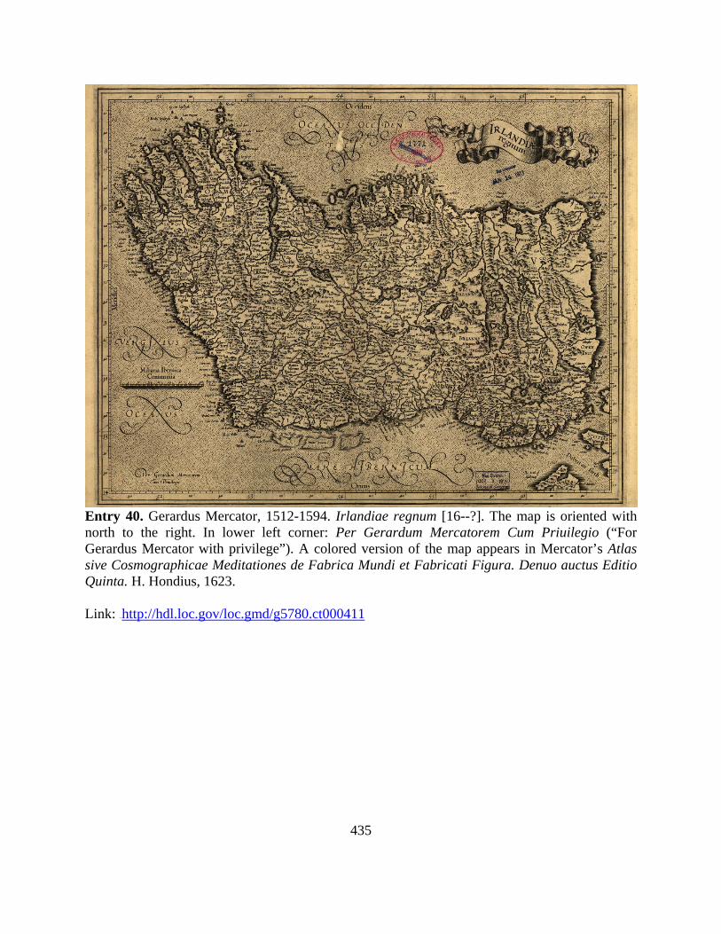
Entry 40. Gerardus Mercator, 1512-1594. Irlandiae regnum [16--?]. The map is oriented with north to the right. In lower left corner: Per Gerardum Mercatorem Cum Priuilegio (“For Gerardus Mercator with privilege”). A colored version of the map appears in Mercator’s Atlas sive Cosmographicae Meditationes de Fabrica Mundi et Fabricati Figura. Denuo auctus Editio Quinta. H. Hondius, 1623. Link: 33TUhttp://hdl.loc.gov/loc.gmd/g5780.ct000411
436
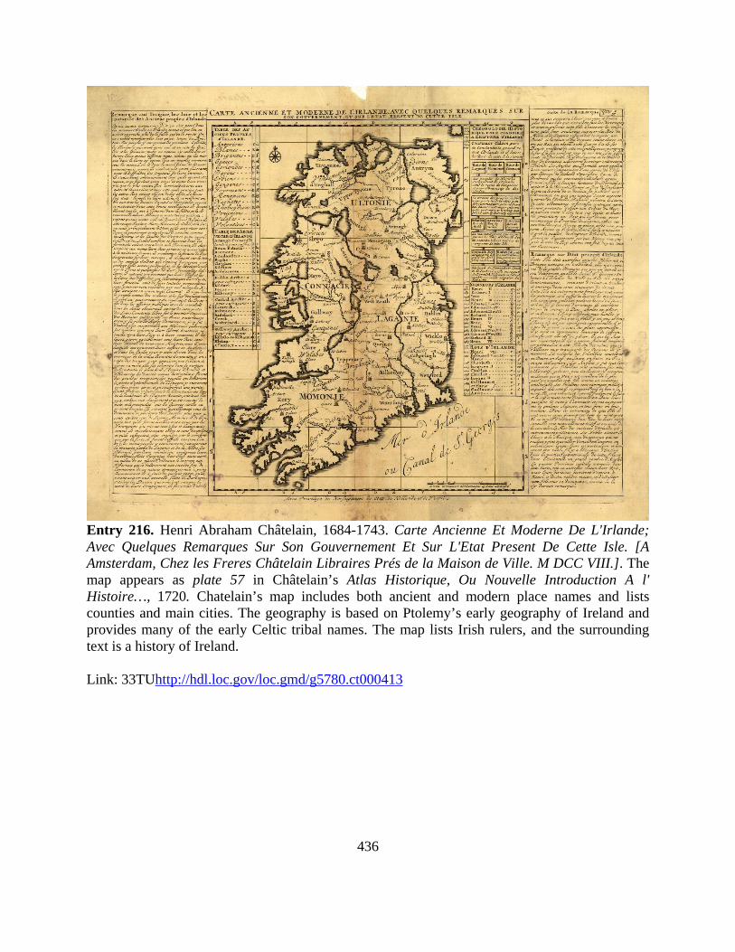
Entry 216. Henri Abraham Châtelain, 1684-1743. Carte Ancienne Et Moderne De L'Irlande; Avec Quelques Remarques Sur Son Gouvernement Et Sur L'Etat Present De Cette Isle. [A Amsterdam, Chez les Freres Châtelain Libraires Prés de la Maison de Ville. M DCC VIII.]. The map appears as plate 57 in Châtelain’s Atlas Historique, Ou Nouvelle Introduction A l' Histoire…, 1720. Chatelain’s map includes both ancient and modern place names and lists counties and main cities. The geography is based on Ptolemy’s early geography of Ireland and provides many of the early Celtic tribal names. The map lists Irish rulers, and the surrounding text is a history of Ireland. Link: 33TUhttp://hdl.loc.gov/loc.gmd/g5780.ct000413
437
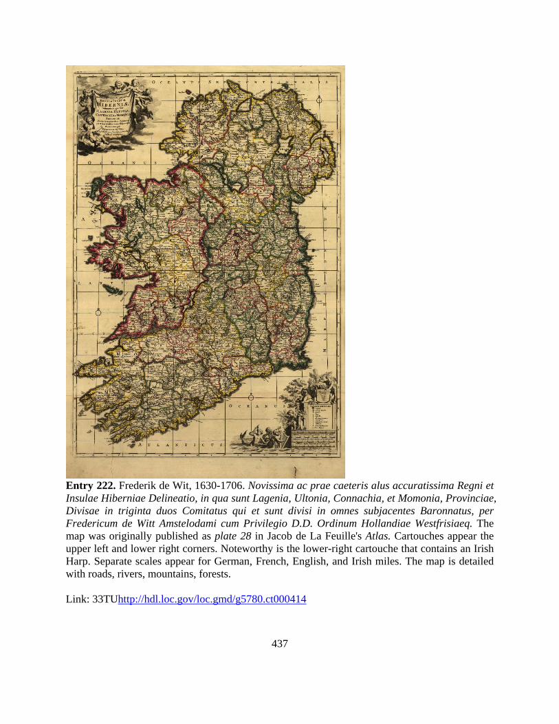
Entry 222. Frederik de Wit, 1630-1706. Novissima ac prae caeteris alus accuratissima Regni et Insulae Hiberniae Delineatio, in qua sunt Lagenia, Ultonia, Connachia, et Momonia, Provinciae, Divisae in triginta duos Comitatus qui et sunt divisi in omnes subjacentes Baronnatus, per Fredericum de Witt Amstelodami cum Privilegio D.D. Ordinum Hollandiae Westfrisiaeq. The map was originally published as plate 28 in Jacob de La Feuille's Atlas. Cartouches appear the upper left and lower right corners. Noteworthy is the lower-right cartouche that contains an Irish Harp. Separate scales appear for German, French, English, and Irish miles. The map is detailed with roads, rivers, mountains, forests. Link: 33TUhttp://hdl.loc.gov/loc.gmd/g5780.ct000414

438
Entry 334. Louis Brion de la Tour, 1756-1823. L'Irlande divisée Par Provinces Civiles et Ecclesiastiques. Par Mr. Brion Ingénieur-Géographe du Roi. à Paris, Chez Le S. Desnos, Ing? Géog? pour les Globes et Sphères, Ruë St. Jacques, au Globe, 1766. The map appears as plate 26 in Jean Charles Maclot's Atlas General Méthodique Et Élémentaire...M.DCC.LXXXVI. Text pasted in margins reads, "Analyse De la Carte de l'Irlande." Above top neat line: “Géographie Moderne, Historique Et Politique.” Link: 42T32T42TUhttp://hdl.loc.gov/loc.gmd/g5780.ct000415U32T

439
Entry 420. Daniel Augustus Beaufort, 1739-1821. A New Map of Ireland Civil and Ecclesiastical by the RevD. D.A. Beaufort. L.L.D. Member of the Royal Irish Academy. Second Edition 1797. Engraved by S.J. Neele 352 Strand; London. S.I. Neele sculp. London. Published as the Act directs, March 1st. 1792, by Wm. Faden, Geographer to the King, Charing Cross London, and William Allen, Dublin. In the lower right corner, a dedication reads: “To His Majesty King George the Third, The Patron and Promoter of every useful Science, This Map is by His Majesty's gracious permission, most humbly & respectfully dedicated, by the Author.” Relief is shown by hachures. Primary roads, cities, and towns are depicted. Link: 33TUhttp://hdl.loc.gov/loc.gmd/g5781f.ct000402

440
Entry 702. James Balance. Home Rule Map of Ireland. Compiled & Published By Jas. Ballance, Engineer & Surveyer: 39 Park St., Malden, Mass. Copyrighted July, 1893. Printed by Geo. H. Walker & Co., 160 Tremont St., Boston, Mass. The margins include statistical data and historical text pertaining to population, topography, climate, the general election of 1892 and the new Irish Home Rule Bill. The map ringed with portraits of important Irish and British leaders Charles Stuart Parnell, William E. Gladstone, Justin McCarthy, John Dillon, William O'Brien, Thomas Sexton, Michael Davitt, and Tim Healy. Link: 32TUhttp://hdl.loc.gov/loc.gmd/g5781f.ct000405U32T
441
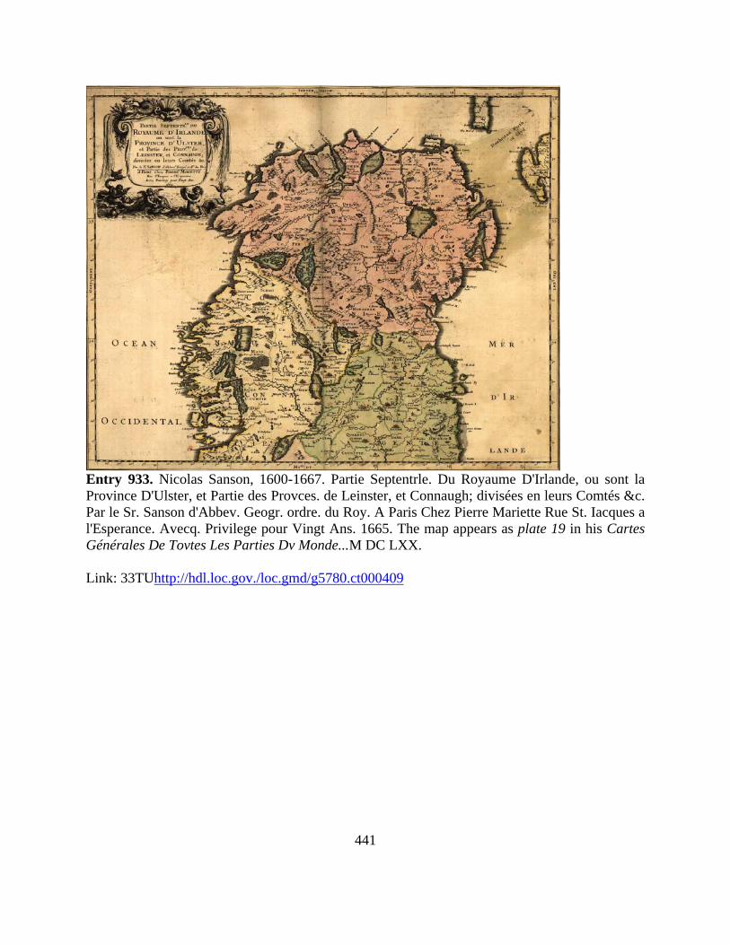
Entry 933. Nicolas Sanson, 1600-1667. Partie Septentrle. Du Royaume D'Irlande, ou sont la Province D'Ulster, et Partie des Provces. de Leinster, et Connaugh; divisées en leurs Comtés &c. Par le Sr. Sanson d'Abbev. Geogr. ordre. du Roy. A Paris Chez Pierre Mariette Rue St. Iacques a l'Esperance. Avecq. Privilege pour Vingt Ans. 1665. The map appears as plate 19 in his Cartes Générales De Tovtes Les Parties Dv Monde...M DC LXX. Link: 33TUhttp://hdl.loc.gov./loc.gmd/g5780.ct000409

442
Entry 975. Sanson, Nicolas, 1600-1667. Partie Septentrle. Du Royaume D'Irlande, ou sont la Province D'Ulster, et Partie des Provces de Leinster, et Connaugh; divisées en leurs Comtés &c. Par le Sr. Sanson d'Abbev. Geogr. ordre. du Roy. A Paris Chez Pierre Mariette Rue St. Iacques a l'Esperance Avecq. Privilege pour Vingt Ans. 1665. Link: 32TUhttp://hdl.loc.gov/loc.gmd/g5780.ct000410U32T