map unit description mn - usda unit description (mn) rock county, minnesota [data apply to the...
TRANSCRIPT

Map Unit Description (MN) Rock County, Minnesota
[Data apply to the entire extent of the map unit within the survey area. Map unit and soil properties for a specific parcel of land may vary somewhat and should be determined by onsite investigation]
GP--Pits, gravel-Udipsamments complex Pits, gravel Extent: 50 to 100 percent of the unit Soil loss tolerance (T factor): Landform(s): moraines, outwash plains, stream terraces Wind erodibility group (WEG): Slope gradient: 0 to 45 percent Wind erodibility index (WEI): Parent material: sandy and gravelly outwash Kw (surface layer): Restrictive feature(s): Land capability class, nonirrigated: Flooding: Hydric soil: Ponding: Hydrologic group: Drainage class: Potential frost action: Available water Representative soil profile: Texture Permeability capacity pH
Udipsamments Extent: 15 to 30 percent of the unit Soil loss tolerance (T factor): 5 Landform(s): moraines, outwash plains, stream terraces Wind erodibility group (WEG): 2 Slope gradient: 0 to 6 percent Wind erodibility index (WEI): 134 Parent material: outwash Kw (surface layer): Restrictive feature(s): Land capability class, nonirrigated: Flooding: Hydric soil: Ponding: Hydrologic group: A Drainage class: excessively drained Potential frost action: Available water Representative soil profile: Texture Permeability capacity pH
M-W--Water, miscellaneous
This report shows only the major soils in each map unit Tabular Data Version: 4 Tabular Data Version Date: 11/27/2006 Page 1 of 36

Map Unit Description (MN) Rock County, Minnesota
[Data apply to the entire extent of the map unit within the survey area. Map unit and soil properties for a specific parcel of land may vary somewhat and should be determined by onsite investigation]
M-W--Water, miscellaneous Water, miscellaneous Extent: 100 percent of the unit Soil loss tolerance (T factor): Landform(s): Wind erodibility group (WEG): Slope gradient: Wind erodibility index (WEI): Parent material: Kw (surface layer): Restrictive feature(s): Land capability class, nonirrigated: Flooding: Hydric soil: Ponding: Hydrologic group: Drainage class: Potential frost action: Available water Representative soil profile: Texture Permeability capacity pH
P3A--Biscay silty clay loam, 0 to 2 percent slopes, occasionally flooded Biscay, occasionally flooded Extent: 80 to 90 percent of the unit Soil loss tolerance (T factor): 4 Landform(s): flats on outwash plains Wind erodibility group (WEG): 7 Slope gradient: 0 to 2 percent Wind erodibility index (WEI): 38 Parent material: outwash Kw (surface layer): .28 Restrictive feature(s): Land capability class, nonirrigated: 2w Flooding: occasional Hydric soil: yes Ponding: none Hydrologic group: B/D Drainage class: poorly drained Potential frost action: high Available water Representative soil profile: Texture Permeability capacity pH Ap,A1 -- 0 to 16 in silty clay loam moderate 3.2 to 3.6 in 6.1 to 7.3 A2 -- 16 to 21 in clay loam moderate 0.8 to 0.9 in 6.6 to 7.3 Bg -- 21 to 31 in clay loam moderate 1.7 to 1.9 in 6.6 to 7.3 2Cg -- 31 to 60 in coarse sand rapid 0.6 to 1.1 in 7.4 to 8.4
P4A--Calco silty clay loam, 0 to 2 percent slopes, frequently flooded
This report shows only the major soils in each map unit Tabular Data Version: 4 Tabular Data Version Date: 11/27/2006 Page 2 of 36

Map Unit Description (MN) Rock County, Minnesota
[Data apply to the entire extent of the map unit within the survey area. Map unit and soil properties for a specific parcel of land may vary somewhat and should be determined by onsite investigation]
P4A--Calco silty clay loam, 0 to 2 percent slopes, frequently flooded Calco, frequently flooded Extent: 75 to 85 percent of the unit Soil loss tolerance (T factor): 5 Landform(s): flats on flood plains Wind erodibility group (WEG): 4L Slope gradient: 0 to 2 percent Wind erodibility index (WEI): 86 Parent material: alluvium Kw (surface layer): .28 Restrictive feature(s): Land capability class, nonirrigated: 5w Flooding: frequent Hydric soil: yes Ponding: none Hydrologic group: B/D Drainage class: poorly drained Potential frost action: high Available water Representative soil profile: Texture Permeability capacity pH A1,A2 -- 0 to 36 in silty clay loam moderate 7.5 to 8.2 in 7.4 to 8.4 Cg -- 36 to 60 in silty clay loam moderate 5.0 to 5.5 in 7.4 to 8.4
P5A--Calco silty clay loam, 0 to 2 percent slopes, occasionally flooded Calco, occasionally flooded Extent: 75 to 85 percent of the unit Soil loss tolerance (T factor): 5 Landform(s): flats on flood plains Wind erodibility group (WEG): 4L Slope gradient: 0 to 2 percent Wind erodibility index (WEI): 86 Parent material: alluvium Kw (surface layer): .28 Restrictive feature(s): Land capability class, nonirrigated: 2w Flooding: occasional Hydric soil: yes Ponding: none Hydrologic group: B/D Drainage class: poorly drained Potential frost action: high Available water Representative soil profile: Texture Permeability capacity pH Ap,A1,A2,A3 -- 0 to 36 in silty clay loam moderate 7.5 to 8.2 in 7.4 to 8.4 Bg -- 36 to 44 in silty clay loam moderate 1.7 to 1.9 in 7.4 to 8.4 Cg -- 44 to 60 in silty clay loam moderate 3.3 to 3.6 in 7.4 to 8.4
P6A--Colo silty clay loam, 0 to 2 percent slopes, occasionally flooded
This report shows only the major soils in each map unit Tabular Data Version: 4 Tabular Data Version Date: 11/27/2006 Page 3 of 36

Map Unit Description (MN) Rock County, Minnesota
[Data apply to the entire extent of the map unit within the survey area. Map unit and soil properties for a specific parcel of land may vary somewhat and should be determined by onsite investigation]
P6A--Colo silty clay loam, 0 to 2 percent slopes, occasionally flooded Colo, occasionally flooded Extent: 75 to 85 percent of the unit Soil loss tolerance (T factor): 5 Landform(s): flats on flood plains Wind erodibility group (WEG): 7 Slope gradient: 0 to 2 percent Wind erodibility index (WEI): 38 Parent material: alluvium Kw (surface layer): .28 Restrictive feature(s): Land capability class, nonirrigated: 2w Flooding: occasional Hydric soil: yes Ponding: none Hydrologic group: B/D Drainage class: poorly drained Potential frost action: high Available water Representative soil profile: Texture Permeability capacity pH Ap,A1-3 -- 0 to 34 in silty clay loam moderate 7.1 to 7.8 in 5.6 to 7.3 BA,Bg -- 34 to 52 in silty clay oam moderate 3.3 to 3.6 in 5.6 to 7.3 l Cg -- 52 to 60 in silt loam moderate 1.4 to 1.6 in 6.1 to 7.3
P7A--Comfrey clay loam, 0 to 2 percent slopes, occasionally flooded Comfrey, occasionally flooded Extent: 75 to 85 percent of the unit Soil loss tolerance (T factor): 5 Landform(s): flats on flood plains Wind erodibility group (WEG): 6 Slope gradient: 0 to 2 percent Wind erodibility index (WEI): 48 Parent material: alluvium Kw (surface layer): .28 Restrictive feature(s): Land capability class, nonirrigated: 2w Flooding: occasional Hydric soil: yes Ponding: none Hydrologic group: B/D Drainage class: poorly drained Potential frost action: high Available water Representative soil profile: Texture Permeability capacity pH A1,A2 -- 0 to 26 in clay loam moderate 4.7 to 5.7 in 6.6 to 7.3 Bg -- 26 to 35 in clay loam moderate 1.4 to 1.8 in 6.6 to 7.3 BCg,Cg -- 35 to 60 in clay loam moderate 3.7 to 4.7 in 6.6 to 8.4
P8A--Cylinder loam, 0 to 2 percent slopes, occasionally flooded This report shows only the major soils in each map unit Tabular Data Version: 4 Tabular Data Version Date: 11/27/2006 Page 4 of 36

Map Unit Description (MN) Rock County, Minnesota
[Data apply to the entire extent of the map unit within the survey area. Map unit and soil properties for a specific parcel of land may vary somewhat and should be determined by onsite investigation]
P8A--Cylinder loam, 0 to 2 percent slopes, occasionally flooded Cylinder, occasionally flooded Extent: 75 to 85 percent of the unit Soil loss tolerance (T factor): 4 Landform(s): flats on outwash plains Wind erodibility group (WEG): 6 Slope gradient: 0 to 2 percent Wind erodibility index (WEI): 48 Parent material: alluvium over outwash Kw (surface layer): .24 Restrictive feature(s): Land capability class, nonirrigated: 2s Flooding: occasional Hydric soil: no Ponding: none Hydrologic group: B Drainage class: somewhat poorly drained Potential frost action: moderate Available water Representative soil profile: Texture Permeability capacity pH Ap,A1,A2 -- 0 to 18 in loam moderate 3.6 to 4.0 in 6.1 to 7.3 Bg1,Bg2 -- 18 to 28 in loam moderate 1.7 to 1.9 in 6.1 to 7.3 2BC -- 28 to 39 in gravelly sand very rapid 0.2 to 0.4 in 7.4 to 8.4 2C1,2C2 -- 39 to 60 in gravelly sand very rapid 0.4 to 0.8 in 7.4 to 8.4
P11A--Dempster silt loam, 0 to 2 percent slopes Dempster Extent: 85 to 95 percent of the unit Soil loss tolerance (T factor): 4 Landform(s): flats on outwash plains Wind erodibility group (WEG): 6 Slope gradient: 0 to 2 percent Wind erodibility index (WEI): 48 Parent material: loess over outwashKw (surface layer): .28 Restrictive feature(s): Land capability class, nonirrigated: 2s Flooding: none Hydric soil: no Ponding: none Hydrologic group: B Drainage class: well drained Potential frost action: moderate Available water Representative soil profile: Texture Permeability capacity pH Ap,A -- 0 to 10 in silt loam moderate 1.9 to 2.2 in 6.1 to 7.3 Bw1,Bw2 -- 10 to 29 in silty clay loam moderate 3.3 to 3.9 in 6.1 to 7.3 Bk -- 29 to 36 in loam moderate 0.9 to 1.1 in 7.4 to 8.4 2C -- 36 to 60 in gravelly sand rapid 0.7 to 1.4 in 7.4 to 8.4
This report shows only the major soils in each map unit Tabular Data Version: 4 Tabular Data Version Date: 11/27/2006 Page 5 of 36

Map Unit Description (MN) Rock County, Minnesota
[Data apply to the entire extent of the map unit within the survey area. Map unit and soil properties for a specific parcel of land may vary somewhat and should be determined by onsite investigation]
P11A--Dempster silt loam, 0 to 2 percent slopes
P11B--Dempster silt loam, 2 to 6 percent slopes Dempster Extent: 85 to 95 percent of the unit Soil loss tolerance (T factor): 4 Landform(s): hills on outwash plains Wind erodibility group (WEG): 6 Slope gradient: 2 to 6 percent Wind erodibility index (WEI): 48 Parent material: loess over outwashKw (surface layer): .28 Restrictive feature(s): Land capability class, nonirrigated: 2e Flooding: none Hydric soil: no Ponding: none Hydrologic group: B Drainage class: well drained Potential frost action: moderate Available water Representative soil profile: Texture Permeability capacity pH Ap,A -- 0 to 12 in silt loam moderate 2.2 to 2.6 in 6.1 to 7.3 Bw1,Bw2 -- 12 to 27 in silty clay loam moderate 2.6 to 3.1 in 6.1 to 7.3 2C -- 27 to 60 in gravelly sand rapid 1.0 to 2.0 in 7.4 to 8.4
P12B--Everly silty clay loam, 2 to 6 percent slopes Everly Extent: 75 to 85 percent of the unit Soil loss tolerance (T factor): 5 Landform(s): hills on till plains Wind erodibility group (WEG): 7 Slope gradient: 2 to 6 percent Wind erodibility index (WEI): 38 Parent material: loess over tillKw (surface layer): .24 Restrictive feature(s): Land capability class, nonirrigated: 2e Flooding: none Hydric soil: no Ponding: none Hydrologic group: B Drainage class: well drained Potential frost action: moderate Available water Representative soil profile: Texture Permeability capacity pH Ap -- 0 to 10 in silty clay loam moderate 1.7 to 1.9 in 6.1 to 7.3 Bw -- 10 to 18 in silty clay loam moderate 1.2 to 1.4 in 6.1 to 7.3 2Bk,2BC -- 18 to 80 in clay loam moderately slow 8.7 to 11.1 in 7.4 to 8.4
This report shows only the major soils in each map unit Tabular Data Version: 4 Tabular Data Version Date: 11/27/2006 Page 6 of 36

Map Unit Description (MN) Rock County, Minnesota
[Data apply to the entire extent of the map unit within the survey area. Map unit and soil properties for a specific parcel of land may vary somewhat and should be determined by onsite investigation]
P12B--Everly silty clay loam, 2 to 6 percent slopes
P12C2--Everly silty clay loam, 6 to 12 percent slopes, eroded Everly, moderately eroded Extent: 75 to 85 percent of the unit Soil loss tolerance (T factor): 5 Landform(s): hills on till plains Wind erodibility group (WEG): 7 Slope gradient: 6 to 12 percent Wind erodibility index (WEI): 38 Parent material: loess over tillKw (surface layer): .24 Restrictive feature(s): Land capability class, nonirrigated: 3e Flooding: none Hydric soil: no Ponding: none Hydrologic group: B Drainage class: well drained Potential frost action: moderate Available water Representative soil profile: Texture Permeability capacity pH Ap -- 0 to 7 in silty clay loam moderate 1.2 to 1.3 in 6.1 to 7.3 Bw -- 7 to 16 in silty clay loam moderate 1.4 to 1.5 in 6.1 to 7.3 2Bk,2BC -- 16 to 80 in clay loam moderately slow 8.9 to 11.5 in 7.4 to 8.4
P13A--Fairhaven silt loam, 0 to 2 percent slopes
This report shows only the major soils in each map unit Tabular Data Version: 4 Tabular Data Version Date: 11/27/2006 Page 7 of 36

Map Unit Description (MN) Rock County, Minnesota
[Data apply to the entire extent of the map unit within the survey area. Map unit and soil properties for a specific parcel of land may vary somewhat and should be determined by onsite investigation]
P13A--Fairhaven silt loam, 0 to 2 percent slopes Fairhaven Extent: 80 to 90 percent of the unit Soil loss tolerance (T factor): 4 Landform(s): flats on outwash plains Wind erodibility group (WEG): 6 Slope gradient: 0 to 2 percent Wind erodibility index (WEI): 48 Parent material: loess over outwashKw (surface layer): .32 Restrictive feature(s): Land capability class, nonirrigated: 2s Flooding: none Hydric soil: no Ponding: none Hydrologic group: B Drainage class: well drained Potential frost action: moderate Available water Representative soil profile: Texture Permeability capacity pH Ap -- 0 to 8 in silt loam moderate 1.7 to 1.9 in 6.1 to 7.3 A1 -- 8 to 13 in loam moderate 1.0 to 1.1 in 6.1 to 7.3 Bw1,Bw2 -- 13 to 36 in loam moderate 4.6 to 5.0 in 6.1 to 7.3 2C -- 36 to 60 in gravelly sand rapid 0.5 to 1.0 in 6.1 to 8.4
P13B--Fairhaven silt loam, 2 to 6 percent slopes Fairhaven Extent: 75 to 85 percent of the unit Soil loss tolerance (T factor): 4 Landform(s): hills on outwash plains Wind erodibility group (WEG): 6 Slope gradient: 2 to 6 percent Wind erodibility index (WEI): 48 Parent material: loess over outwashKw (surface layer): .32 Restrictive feature(s): Land capability class, nonirrigated: 2e Flooding: none Hydric soil: no Ponding: none Hydrologic group: B Drainage class: well drained Potential frost action: moderate Available water Representative soil profile: Texture Permeability capacity pH Ap -- 0 to 7 in silt loam moderate 1.6 to 1.7 in 6.1 to 7.3 A1 -- 7 to 12 in loam moderate 0.9 to 1.0 in 6.1 to 7.3 Bw1,Bw2 -- 12 to 27 in loam moderate 3.1 to 3.4 in 6.1 to 7.3 2C -- 27 to 60 in gravelly sand rapid 0.7 to 1.3 in 6.1 to 8.4
This report shows only the major soils in each map unit Tabular Data Version: 4 Tabular Data Version Date: 11/27/2006 Page 8 of 36

Map Unit Description (MN) Rock County, Minnesota
[Data apply to the entire extent of the map unit within the survey area. Map unit and soil properties for a specific parcel of land may vary somewhat and should be determined by onsite investigation]
P13B--Fairhaven silt loam, 2 to 6 percent slopes
P14A--Flandreau silt loam, 0 to 2 percent slopes Flandreau Extent: 85 to 95 percent of the unit Soil loss tolerance (T factor): 4 Landform(s): flats on outwash plains Wind erodibility group (WEG): 6 Slope gradient: 0 to 2 percent Wind erodibility index (WEI): 48 Parent material: loess over outwashKw (surface layer): .28 Restrictive feature(s): Land capability class, nonirrigated: 2s Flooding: none Hydric soil: no Ponding: none Hydrologic group: B Drainage class: well drained Potential frost action: moderate Available water Representative soil profile: Texture Permeability capacity pH Ap -- 0 to 8 in silt loam moderate 1.6 to 1.7 in 6.1 to 7.3 AB,Bw1 -- 8 to 30 in silt loam moderate 3.5 to 4.9 in 6.1 to 7.3 2BC -- 30 to 47 in sandy loam moderately rapid 1.4 to 2.2 in 6.1 to 7.3 2C -- 47 to 60 in loamy sand rapid 0.8 to 1.3 in 7.4 to 8.4
P14B--Flandreau silt loam, 2 to 6 percent slopes
This report shows only the major soils in each map unit Tabular Data Version: 4 Tabular Data Version Date: 11/27/2006 Page 9 of 36

Map Unit Description (MN) Rock County, Minnesota
[Data apply to the entire extent of the map unit within the survey area. Map unit and soil properties for a specific parcel of land may vary somewhat and should be determined by onsite investigation]
P14B--Flandreau silt loam, 2 to 6 percent slopes Flandreau Extent: 75 to 85 percent of the unit Soil loss tolerance (T factor): 4 Landform(s): hills on outwash plains Wind erodibility group (WEG): 6 Slope gradient: 2 to 6 percent Wind erodibility index (WEI): 48 Parent material: loess over outwashKw (surface layer): .28 Restrictive feature(s): Land capability class, nonirrigated: 2e Flooding: none Hydric soil: no Ponding: none Hydrologic group: B Drainage class: well drained Potential frost action: moderate Available water Representative soil profile: Texture Permeability capacity pH Ap -- 0 to 8 in silt loam moderate 1.6 to 1.7 in 6.1 to 7.3 AB,Bw1,Bw2 -- 8 to 30 in silt loam moderate 3.5 to 4.9 in 6.1 to 7.3 2BC -- 30 to 36 in loamy sand rapid 0.4 to 0.6 in 6.1 to 7.3 2C -- 36 to 60 in loamy sand rapid 1.4 to 2.4 in 7.4 to 8.4
P15B--Galva silty clay loam, 2 to 5 percent slopes Galva Extent: 75 to 85 percent of the unit Soil loss tolerance (T factor): 5 Landform(s): hills on till plains Wind erodibility group (WEG): 7 Slope gradient: 2 to 5 percent Wind erodibility index (WEI): 38 Parent material: loess Kw (surface layer): .28 Restrictive feature(s): Land capability class, nonirrigated: 2e Flooding: none Hydric soil: no Ponding: none Hydrologic group: B Drainage class: well drained Potential frost action: high Available water Representative soil profile: Texture Permeability capacity pH Ap,A -- 0 to 11 in silty clay loam moderate 2.1 to 2.4 in 6.1 to 7.3 BA,Bw1,2 -- 11 to 31 in silty clay oam moderate 3.4 to 4.0 in 6.1 to 7.3 l BC -- 31 to 45 in silt loam moderate 2.3 to 2.8 in 6.1 to 7.3 C -- 45 to 60 in silt loam moderate 2.5 to 3.0 in 7.4 to 8.4
This report shows only the major soils in each map unit Tabular Data Version: 4 Tabular Data Version Date: 11/27/2006 Page 10 of 36

Map Unit Description (MN) Rock County, Minnesota
[Data apply to the entire extent of the map unit within the survey area. Map unit and soil properties for a specific parcel of land may vary somewhat and should be determined by onsite investigation]
P15B--Galva silty clay loam, 2 to 5 percent slopes
P15C2--Galva silty clay loam, 5 to 9 percent slopes, eroded Galva, moderately eroded Extent: 75 to 85 percent of the unit Soil loss tolerance (T factor): 5 Landform(s): hills on till plains Wind erodibility group (WEG): 7 Slope gradient: 5 to 9 percent Wind erodibility index (WEI): 38 Parent material: loess Kw (surface layer): .28 Restrictive feature(s): Land capability class, nonirrigated: 3e Flooding: none Hydric soil: no Ponding: none Hydrologic group: B Drainage class: well drained Potential frost action: high Available water Representative soil profile: Texture Permeability capacity pH Ap -- 0 to 8 in silty clay loam moderate 1.5 to 1.7 in 6.1 to 7.3 Bw1,Bw2 -- 8 to 34 in silty clay oam moderate 4.4 to 5.2 in 6.1 to 7.3 l C -- 34 to 60 in silt loam moderate 4.4 to 5.2 in 7.4 to 8.4
P16A--Graceville silty clay loam, 0 to 2 percent slopes
This report shows only the major soils in each map unit Tabular Data Version: 4 Tabular Data Version Date: 11/27/2006 Page 11 of 36

Map Unit Description (MN) Rock County, Minnesota
[Data apply to the entire extent of the map unit within the survey area. Map unit and soil properties for a specific parcel of land may vary somewhat and should be determined by onsite investigation]
P16A--Graceville silty clay loam, 0 to 2 percent slopes Graceville Extent: 85 to 95 percent of the unit Soil loss tolerance (T factor): 4 Landform(s): flats on outwash plains Wind erodibility group (WEG): 6 Slope gradient: 0 to 2 percent Wind erodibility index (WEI): 48 Parent material: loess over outwashKw (surface layer): .28 Restrictive feature(s): Land capability class, nonirrigated: 1 Flooding: none Hydric soil: no Ponding: none Hydrologic group: B Drainage class: well drained Potential frost action: moderate Available water Representative soil profile: Texture Permeability capacity pH Ap,A -- 0 to 20 in silty clay loam moderate 3.4 to 3.8 in 5.6 to 7.3 Bw1,Bw2,Bw3 20 to 53 in silty clay loam moderate 5.6 to 7.3 in 5.6 to 7.3 -- 2C -- 53 to 60 in gravelly sand rapid 0.2 to 0.4 in 6.1 to 7.8
P16B--Graceville silty clay loam, 2 to 6 percent slopes Graceville Extent: 85 to 95 percent of the unit Soil loss tolerance (T factor): 4 Landform(s): hills on outwash plains Wind erodibility group (WEG): 6 Slope gradient: 2 to 6 percent Wind erodibility index (WEI): 48 Parent material: loess over outwashKw (surface layer): .28 Restrictive feature(s): Land capability class, nonirrigated: 2e Flooding: none Hydric soil: no Ponding: none Hydrologic group: B Drainage class: well drained Potential frost action: moderate Available water Representative soil profile: Texture Permeability capacity pH Ap,A -- 0 to 20 in silty clay loam moderate 3.4 to 3.8 in 5.6 to 7.3 Bw1-3 -- 20 to 53 in silty clay loam moderate 5.6 to 7.3 in 5.6 to 7.3 2C -- 53 to 60 in gravelly sand rapid 0.2 to 0.4 in 6.1 to 7.8
This report shows only the major soils in each map unit Tabular Data Version: 4 Tabular Data Version Date: 11/27/2006 Page 12 of 36
Map Unit Description (MN) Rock County, Minnesota
[Data apply to the entire extent of the map unit within the survey area. Map unit and soil properties for a specific parcel of land may vary somewhat and should be determined by onsite investigation]
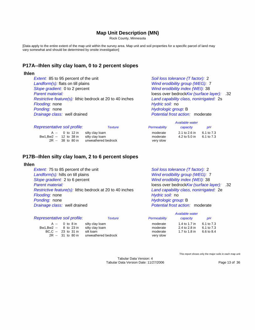
P17A--Ihlen silty clay loam, 0 to 2 percent slopes Ihlen Extent: 85 to 95 percent of the unit Soil loss tolerance (T factor): 2 Landform(s): flats on till plains Wind erodibility group (WEG): 7 Slope gradient: 0 to 2 percent Wind erodibility index (WEI): 38 Parent material: loess over bedrockKw (surface layer): .32 Restrictive feature(s): lithic bedrock at 20 to 40 inches Land capability class, nonirrigated: 2s Flooding: none Hydric soil: no Ponding: none Hydrologic group: B Drainage class: well drained Potential frost action: moderate Available water Representative soil profile: Texture Permeability capacity pH A -- 0 to 12 in silty clay loam moderate 2.1 to 2.6 in 6.1 to 7.3 Bw1,Bw2 -- 12 to 38 in silty clay loam moderate 4.2 to 5.0 in 6.1 to 7.3 2R -- 38 to 80 in unweathered bedrock very slow
P17B--Ihlen silty clay loam, 2 to 6 percent slopes Ihlen Extent: 75 to 85 percent of the unit Soil loss tolerance (T factor): 2 Landform(s): hills on till plains Wind erodibility group (WEG): 7 Slope gradient: 2 to 6 percent Wind erodibility index (WEI): 38 Parent material: loess over bedrockKw (surface layer): .32 Restrictive feature(s): lithic bedrock at 20 to 40 inches Land capability class, nonirrigated: 2e Flooding: none Hydric soil: no Ponding: none Hydrologic group: B Drainage class: well drained Potential frost action: moderate Available water Representative soil profile: Texture Permeability capacity pH A -- 0 to 8 in silty clay loam moderate 1.4 to 1.7 in 6.1 to 7.3 Bw1,Bw2 -- 8 to 23 in silty clay oam moderate 2.4 to 2.8 in 6.1 to 7.3 l BC,C -- 23 to 31 in silt loam moderate 1.7 to 1.8 in 6.6 to 8.4 2R -- 31 to 80 in unweathered bedrock very slow
This report shows only the major soils in each map unit Tabular Data Version: 4 Tabular Data Version Date: 11/27/2006 Page 13 of 36

Map Unit Description (MN) Rock County, Minnesota
[Data apply to the entire extent of the map unit within the survey area. Map unit and soil properties for a specific parcel of land may vary somewhat and should be determined by onsite investigation]
P18B--Ihlen-Rock outcrop complex, 0 to 4 percent slopes Ihlen Extent: 50 to 60 percent of the unit Soil loss tolerance (T factor): 2 Landform(s): hills on till plains Wind erodibility group (WEG): 7 Slope gradient: 0 to 4 percent Wind erodibility index (WEI): 38 Parent material: loess over bedrockKw (surface layer): .32 Restrictive feature(s): lithic bedrock at 20 to 40 inches Land capability class, nonirrigated: 2e Flooding: none Hydric soil: no Ponding: none Hydrologic group: B Drainage class: well drained Potential frost action: moderate Available water Representative soil profile: Texture Permeability capacity pH A -- 0 to 11 in silty clay loam moderate 2.0 to 2.4 in 6.1 to 7.3 Bw1,Bw2 -- 11 to 32 in silty clay loam moderate 3.3 to 4.0 in 6.1 to 7.3 2R -- 32 to 80 in unweathered bedrock very slow
Rock outcrop Extent: 20 to 30 percent of the unit Soil loss tolerance (T factor): Landform(s): till plains Wind erodibility group (WEG): Slope gradient: 0 to 4 percent Wind erodibility index (WEI): Parent material: Kw (surface layer): Restrictive feature(s): Land capability class, nonirrigated: Flooding: Hydric soil: Ponding: Hydrologic group: Drainage class: Potential frost action: Available water Representative soil profile: Texture Permeability capacity pH
P18C--Ihlen-Rock outcrop complex, 4 to 35 percent slopes
This report shows only the major soils in each map unit Tabular Data Version: 4 Tabular Data Version Date: 11/27/2006 Page 14 of 36

Map Unit Description (MN) Rock County, Minnesota
[Data apply to the entire extent of the map unit within the survey area. Map unit and soil properties for a specific parcel of land may vary somewhat and should be determined by onsite investigation]
P18C--Ihlen-Rock outcrop complex, 4 to 35 percent slopes Ihlen Extent: 40 to 50 percent of the unit Soil loss tolerance (T factor): 2 Landform(s): hills on till plains Wind erodibility group (WEG): 7 Slope gradient: 4 to 35 percent Wind erodibility index (WEI): 38 Parent material: loess over bedrockKw (surface layer): .32 Restrictive feature(s): lithic bedrock at 20 to 40 inches Land capability class, nonirrigated: 7e Flooding: none Hydric soil: no Ponding: none Hydrologic group: B Drainage class: well drained Potential frost action: moderate Available water Representative soil profile: Texture Permeability capacity pH A1,A2 -- 0 to 14 in silty clay loam moderate 2.6 to 3.1 in 6.1 to 7.3 Bw1,Bw2 -- 14 to 27 in silty clay loam moderate 2.1 to 2.5 in 6.1 to 7.3 2R -- 27 to 80 in unweathered bedrock very slow
Rock outcrop Extent: 35 to 45 percent of the unit Soil loss tolerance (T factor): Landform(s): till plains Wind erodibility group (WEG): Slope gradient: 4 to 35 percent Wind erodibility index (WEI): Parent material: Kw (surface layer): Restrictive feature(s): Land capability class, nonirrigated: Flooding: Hydric soil: Ponding: Hydrologic group: Drainage class: Potential frost action: Available water Representative soil profile: Texture Permeability capacity pH
P19A--Judson silty clay loam, 1 to 3 percent slopes
This report shows only the major soils in each map unit Tabular Data Version: 4 Tabular Data Version Date: 11/27/2006 Page 15 of 36

Map Unit Description (MN) Rock County, Minnesota
[Data apply to the entire extent of the map unit within the survey area. Map unit and soil properties for a specific parcel of land may vary somewhat and should be determined by onsite investigation]
P19A--Judson silty clay loam, 1 to 3 percent slopes Judson Extent: 75 to 85 percent of the unit Soil loss tolerance (T factor): 5 Landform(s): hills on till plains Wind erodibility group (WEG): 7 Slope gradient: 1 to 3 percent Wind erodibility index (WEI): 38 Parent material: colluvium Kw (surface layer): .28 Restrictive feature(s): Land capability class, nonirrigated: 1 Flooding: none Hydric soil: no Ponding: none Hydrologic group: B Drainage class: well drained Potential frost action: high Available water Representative soil profile: Texture Permeability capacity pH Ap,A1,A2 -- 0 to 22 in silty clay loam moderate 4.2 to 4.9 in 6.1 to 7.3 AB,Bw -- 22 to 35 in silty clay loam moderate 2.5 to 2.9 in 6.1 to 7.3 BC,C -- 35 to 60 in silty clay loam moderate 4.2 to 5.5 in 6.1 to 7.3
P20B--Judson silt loam, 3 to 8 percent slopes Judson Extent: 75 to 85 percent of the unit Soil loss tolerance (T factor): 5 Landform(s): hills on till plains Wind erodibility group (WEG): 6 Slope gradient: 3 to 8 percent Wind erodibility index (WEI): 48 Parent material: colluvium Kw (surface layer): .28 Restrictive feature(s): Land capability class, nonirrigated: 2e Flooding: none Hydric soil: no Ponding: none Hydrologic group: B Drainage class: well drained Potential frost action: high Available water Representative soil profile: Texture Permeability capacity pH Ap,A -- 0 to 36 in silt loam moderate 6.8 to 7.9 in 6.1 to 7.3 Bw1,Bw2 -- 36 to 56 in silty clay loam moderate 3.8 to 4.4 in 6.1 to 7.3 C -- 56 to 60 in silty clay loam moderate 0.7 to 0.8 in 6.6 to 7.8
P21A--Marcus silty clay loam, 0 to 2 percent slopes This report shows only the major soils in each map unit Tabular Data Version: 4 Tabular Data Version Date: 11/27/2006 Page 16 of 36

Map Unit Description (MN) Rock County, Minnesota
[Data apply to the entire extent of the map unit within the survey area. Map unit and soil properties for a specific parcel of land may vary somewhat and should be determined by onsite investigation]
P21A--Marcus silty clay loam, 0 to 2 percent slopes Marcus Extent: 75 to 85 percent of the unit Soil loss tolerance (T factor): 5 Landform(s): hills on till plains Wind erodibility group (WEG): 7 Slope gradient: 0 to 2 percent Wind erodibility index (WEI): 38 Parent material: loess Kw (surface layer): .28 Restrictive feature(s): Land capability class, nonirrigated: 2w Flooding: none Hydric soil: yes Ponding: none Hydrologic group: B/D Drainage class: poorly drained Potential frost action: high Available water Representative soil profile: Texture Permeability capacity pH Ap, A1,2 -- 0 to 17 in silty clay loam moderately slow 3.6 to 3.9 in 6.1 to 7.3 BA,Bg1-3 -- 17 to 44 in silty clay oam moderately slow 4.9 to 5.4 in 6.1 to 7.3 l Cg1 -- 44 to 57 in silt loam moderately slow 2.6 to 2.9 in 7.9 to 8.4 2Cg2 -- 57 to 60 in loam moderately slow 0.5 to 0.5 in 7.9 to 8.4
P22A--Havelock clay loam, 0 to 2 percent slopes, frequently flooded Havelock, frequently flooded Extent: 75 to 85 percent of the unit Soil loss tolerance (T factor): 5 Landform(s): flats on flood plains Wind erodibility group (WEG): 4L Slope gradient: 0 to 2 percent Wind erodibility index (WEI): 86 Parent material: alluvium Kw (surface layer): .28 Restrictive feature(s): Land capability class, nonirrigated: 5w Flooding: frequent Hydric soil: yes Ponding: none Hydrologic group: B/D Drainage class: poorly drained Potential frost action: high Available water Representative soil profile: Texture Permeability capacity pH A1,A2 -- 0 to 32 in clay loam moderate 5.4 to 7.3 in 7.4 to 8.4 Cg -- 32 to 60 in clay loam moderate 4.8 to 5.6 in 7.4 to 8.4
P23A--Havelock clay loam, 0 to 2 percent slopes, occasionally flooded This report shows only the major soils in each map unit Tabular Data Version: 4 Tabular Data Version Date: 11/27/2006 Page 17 of 36

Map Unit Description (MN) Rock County, Minnesota
[Data apply to the entire extent of the map unit within the survey area. Map unit and soil properties for a specific parcel of land may vary somewhat and should be determined by onsite investigation]
P23A--Havelock clay loam, 0 to 2 percent slopes, occasionally flooded Havelock, occasionally flooded Extent: 75 to 85 percent of the unit Soil loss tolerance (T factor): 5 Landform(s): flats on flood plains Wind erodibility group (WEG): 4L Slope gradient: 0 to 2 percent Wind erodibility index (WEI): 86 Parent material: alluvium Kw (surface layer): .28 Restrictive feature(s): Land capability class, nonirrigated: 2w Flooding: occasional Hydric soil: yes Ponding: none Hydrologic group: B/D Drainage class: poorly drained Potential frost action: high Available water Representative soil profile: Texture Permeability capacity pH Ap,A1,A2 -- 0 to 32 in clay loam moderate 5.4 to 7.3 in 7.4 to 8.4 Cg -- 32 to 60 in clay loam moderate 4.8 to 5.6 in 7.4 to 8.4
P24B--Moody silty clay loam, 2 to 5 percent slopes Moody Extent: 80 to 90 percent of the unit Soil loss tolerance (T factor): 5 Landform(s): hills on till plains Wind erodibility group (WEG): 7 Slope gradient: 2 to 5 percent Wind erodibility index (WEI): 38 Parent material: loess Kw (surface layer): .28 Restrictive feature(s): Land capability class, nonirrigated: 2e Flooding: none Hydric soil: no Ponding: none Hydrologic group: B Drainage class: well drained Potential frost action: moderate Available water Representative soil profile: Texture Permeability capacity pH Ap -- 0 to 10 in silty clay loam moderate 1.9 to 2.2 in 6.1 to 7.3 Bw1,Bw2,Bw3 10 to 35 in silty clay loam moderate 4.3 to 5.0 in 6.1 to 7.3 -- Bk -- 35 to 48 in silt loam moderate 2.2 to 2.6 in 7.4 to 8.4 C -- 48 to 60 in silt loam moderate 2.0 to 2.4 in 7.4 to 8.4
This report shows only the major soils in each map unit Tabular Data Version: 4 Tabular Data Version Date: 11/27/2006 Page 18 of 36

Map Unit Description (MN) Rock County, Minnesota
[Data apply to the entire extent of the map unit within the survey area. Map unit and soil properties for a specific parcel of land may vary somewhat and should be determined by onsite investigation]
P24C2--Moody silty clay loam, 5 to 9 percent slopes, eroded Moody, moderately eroded Extent: 75 to 85 percent of the unit Soil loss tolerance (T factor): 5 Landform(s): hills on till plains Wind erodibility group (WEG): 7 Slope gradient: 5 to 9 percent Wind erodibility index (WEI): 38 Parent material: loess Kw (surface layer): .28 Restrictive feature(s): Land capability class, nonirrigated: 3e Flooding: none Hydric soil: no Ponding: none Hydrologic group: B Drainage class: well drained Potential frost action: moderate Available water Representative soil profile: Texture Permeability capacity pH Ap -- 0 to 8 in silty clay loam moderate 1.5 to 1.7 in 6.1 to 7.3 Bw1,Bw2 -- 8 to 34 in silty clay oam moderate 4.4 to 5.2 in 6.1 to 7.3 l Bk -- 34 to 50 in silt loam moderate 2.7 to 3.2 in 7.4 to 8.4 C -- 50 to 60 in silt loam moderate 1.7 to 2.0 in 7.4 to 8.4
P25C2--Nora silt loam, 4 to 10 percent slopes, eroded Nora, moderately eroded Extent: 80 to 90 percent of the unit Soil loss tolerance (T factor): 5 Landform(s): hills on till plains Wind erodibility group (WEG): 6 Slope gradient: 4 to 10 percent Wind erodibility index (WEI): 48 Parent material: loess Kw (surface layer): .32 Restrictive feature(s): Land capability class, nonirrigated: 3e Flooding: none Hydric soil: no Ponding: none Hydrologic group: B Drainage class: well drained Potential frost action: moderate Available water Representative soil profile: Texture Permeability capacity pH Ap -- 0 to 8 in silt loam moderate 1.5 to 1.7 in 6.1 to 7.3 Bw1,Bw2 -- 8 to 24 in silt loam moderate 2.7 to 3.2 in 6.1 to 7.3 Bk -- 24 to 33 in silt loam moderate 1.5 to 1.8 in 7.4 to 8.4 C1,C2 -- 33 to 60 in silt loam moderate 4.6 to 5.4 in 7.4 to 8.4
This report shows only the major soils in each map unit Tabular Data Version: 4 Tabular Data Version Date: 11/27/2006 Page 19 of 36

Map Unit Description (MN) Rock County, Minnesota
[Data apply to the entire extent of the map unit within the survey area. Map unit and soil properties for a specific parcel of land may vary somewhat and should be determined by onsite investigation]
P25C2--Nora silt loam, 4 to 10 percent slopes, eroded
P25D2--Nora silt loam, 10 to 18 percent slopes, eroded Nora, moderately eroded Extent: 75 to 85 percent of the unit Soil loss tolerance (T factor): 5 Landform(s): hills on till plains Wind erodibility group (WEG): 6 Slope gradient: 10 to 18 percent Wind erodibility index (WEI): 48 Parent material: loess Kw (surface layer): .32 Restrictive feature(s): Land capability class, nonirrigated: 4e Flooding: none Hydric soil: no Ponding: none Hydrologic group: B Drainage class: well drained Potential frost action: moderate Available water Representative soil profile: Texture Permeability capacity pH Ap -- 0 to 8 in silt loam moderate 1.5 to 1.7 in 6.1 to 7.3 Bw1,Bw2 -- 8 to 32 in silt loam moderate 4.1 to 4.8 in 6.1 to 7.3 Bk -- 32 to 40 in silt loam moderate 1.3 to 1.6 in 7.4 to 8.4 C -- 40 to 60 in silt loam moderate 3.4 to 4.0 in 7.4 to 8.4
P26C2--Nora-Crofton complex, 6 to 12 percent slopes, eroded
This report shows only the major soils in each map unit Tabular Data Version: 4 Tabular Data Version Date: 11/27/2006 Page 20 of 36

Map Unit Description (MN) Rock County, Minnesota
[Data apply to the entire extent of the map unit within the survey area. Map unit and soil properties for a specific parcel of land may vary somewhat and should be determined by onsite investigation]
P26C2--Nora-Crofton complex, 6 to 12 percent slopes, eroded Nora, moderately eroded Extent: 40 to 60 percent of the unit Soil loss tolerance (T factor): 5 Landform(s): hills on till plains Wind erodibility group (WEG): 6 Slope gradient: 6 to 12 percent Wind erodibility index (WEI): 48 Parent material: loess Kw (surface layer): .32 Restrictive feature(s): Land capability class, nonirrigated: 3e Flooding: none Hydric soil: no Ponding: none Hydrologic group: B Drainage class: well drained Potential frost action: moderate Available water Representative soil profile: Texture Permeability capacity pH Ap -- 0 to 8 in silt loam moderate 1.5 to 1.7 in 6.1 to 7.3 Bw1,Bw2 -- 8 to 22 in silt loam moderate 2.4 to 2.8 in 6.1 to 7.3 Bk -- 22 to 30 in silt loam moderate 1.3 to 1.6 in 7.4 to 8.4 C -- 30 to 60 in silt loam moderate 5.1 to 6.0 in 7.4 to 8.4
Crofton, moderately eroded Extent: 20 to 40 percent of the unit Soil loss tolerance (T factor): 5 Landform(s): hills on till plains Wind erodibility group (WEG): 4L Slope gradient: 6 to 12 percent Wind erodibility index (WEI): 86 Parent material: loess Kw (surface layer): .43 Restrictive feature(s): Land capability class, nonirrigated: 3e Flooding: none Hydric soil: no Ponding: none Hydrologic group: B Drainage class: well drained Potential frost action: moderate Available water Representative soil profile: Texture Permeability capacity pH Ap -- 0 to 8 in silt loam moderate 1.7 to 1.9 in 7.4 to 8.4 Bk -- 8 to 14 in silt loam moderate 1.1 to 1.4 in 7.4 to 8.4 C1,C2 -- 14 to 60 in silt loam moderate 8.2 to 10.0 in 7.4 to 8.4
P26D2--Nora-Crofton complex, 12 to 18 percent slopes, eroded
This report shows only the major soils in each map unit Tabular Data Version: 4 Tabular Data Version Date: 11/27/2006 Page 21 of 36

Map Unit Description (MN) Rock County, Minnesota
[Data apply to the entire extent of the map unit within the survey area. Map unit and soil properties for a specific parcel of land may vary somewhat and should be determined by onsite investigation]
P26D2--Nora-Crofton complex, 12 to 18 percent slopes, eroded Nora, moderately eroded Extent: 40 to 50 percent of the unit Soil loss tolerance (T factor): 5 Landform(s): hills on till plains Wind erodibility group (WEG): 6 Slope gradient: 12 to 18 percent Wind erodibility index (WEI): 48 Parent material: loess Kw (surface layer): .32 Restrictive feature(s): Land capability class, nonirrigated: 4e Flooding: none Hydric soil: no Ponding: none Hydrologic group: B Drainage class: well drained Potential frost action: moderate Available water Representative soil profile: Texture Permeability capacity pH Ap -- 0 to 8 in silt loam moderate 1.5 to 1.7 in 6.1 to 7.3 Bw1,Bw2 -- 8 to 30 in silt loam moderate 3.7 to 4.4 in 6.1 to 7.3 Bk -- 30 to 38 in silt loam moderate 1.3 to 1.6 in 7.4 to 8.4 C -- 38 to 60 in silt loam moderate 3.7 to 4.4 in 7.4 to 8.4
Crofton, moderately eroded Extent: 30 to 40 percent of the unit Soil loss tolerance (T factor): 5 Landform(s): hills on till plains Wind erodibility group (WEG): 4L Slope gradient: 12 to 18 percent Wind erodibility index (WEI): 86 Parent material: loess Kw (surface layer): .43 Restrictive feature(s): Land capability class, nonirrigated: 4e Flooding: none Hydric soil: no Ponding: none Hydrologic group: B Drainage class: well drained Potential frost action: moderate Available water Representative soil profile: Texture Permeability capacity pH Ap -- 0 to 6 in silt loam moderate 1.2 to 1.4 in 7.4 to 8.4 Bk1,2 -- 6 to 20 in silt loam moderate 2.6 to 3.1 in 7.4 to 8.4 C -- 20 to 60 in silt loam moderate 7.2 to 8.7 in 7.4 to 8.4
P27A--Primghar silty clay loam, 1 to 3 percent slopes
This report shows only the major soils in each map unit Tabular Data Version: 4 Tabular Data Version Date: 11/27/2006 Page 22 of 36

Map Unit Description (MN) Rock County, Minnesota
[Data apply to the entire extent of the map unit within the survey area. Map unit and soil properties for a specific parcel of land may vary somewhat and should be determined by onsite investigation]
P27A--Primghar silty clay loam, 1 to 3 percent slopes Primghar Extent: 75 to 85 percent of the unit Soil loss tolerance (T factor): 5 Landform(s): hills on till plains Wind erodibility group (WEG): 7 Slope gradient: 1 to 3 percent Wind erodibility index (WEI): 38 Parent material: loess Kw (surface layer): .28 Restrictive feature(s): Land capability class, nonirrigated: 1 Flooding: none Hydric soil: no Ponding: none Hydrologic group: B Drainage class: somewhat poorly drained Potential frost action: high Available water Representative soil profile: Texture Permeability capacity pH Ap,A1,A2 -- 0 to 21 in silty clay loam moderate 4.0 to 4.6 in 6.1 to 7.3 Bw1,Bw2,Bw3 21 to 42 in silty clay loam moderate 3.6 to 4.3 in 6.1 to 7.3 -- C -- 42 to 60 in silty clay loam moderate 3.0 to 3.5 in 7.4 to 8.4
P28A--Ransom silty clay loam, 1 to 3 percent slopes Ransom Extent: 75 to 85 percent of the unit Soil loss tolerance (T factor): 5 Landform(s): hills on till plains Wind erodibility group (WEG): 7 Slope gradient: 1 to 3 percent Wind erodibility index (WEI): 38 Parent material: loess over tillKw (surface layer): .32 Restrictive feature(s): Land capability class, nonirrigated: 1 Flooding: none Hydric soil: no Ponding: none Hydrologic group: B Drainage class: somewhat poorly drained Potential frost action: high Available water Representative soil profile: Texture Permeability capacity pH Ap,A,AB -- 0 to 16 in silty clay loam moderate 2.9 to 3.6 in 6.6 to 7.3 Bw1,Bw2,Bw3 16 to 33 in silty clay loam moderate 2.7 to 3.2 in 6.6 to 7.3 -- 2BCk,2BC -- 33 to 80 in clay loam moderately slow 6.6 to 8.4 in 7.4 to 8.4
This report shows only the major soils in each map unit Tabular Data Version: 4 Tabular Data Version Date: 11/27/2006 Page 23 of 36

Map Unit Description (MN) Rock County, Minnesota
[Data apply to the entire extent of the map unit within the survey area. Map unit and soil properties for a specific parcel of land may vary somewhat and should be determined by onsite investigation]
P29A--Rushmore silty clay loam, 0 to 2 percent slopes Rushmore Extent: 75 to 85 percent of the unit Soil loss tolerance (T factor): 5 Landform(s): hills on till plains Wind erodibility group (WEG): 7 Slope gradient: 0 to 2 percent Wind erodibility index (WEI): 38 Parent material: loess over tillKw (surface layer): .28 Restrictive feature(s): Land capability class, nonirrigated: 2w Flooding: none Hydric soil: yes Ponding: none Hydrologic group: B/D Drainage class: poorly drained Potential frost action: high Available water Representative soil profile: Texture Permeability capacity pH Ap,A,AB -- 0 to 18 in silty clay loam moderate 3.3 to 4.0 in 6.6 to 7.3 Bg1,Bg2 -- 18 to 24 in silty clay loam moderate 0.9 to 1.1 in 6.6 to 7.3 BCg -- 24 to 32 in silty clay loam moderate 1.3 to 1.5 in 7.4 to 7.8 2BCkg,2BCg - 32 to 80 in clay loam moderately slow 6.7 to 8.6 in 7.4 to 8.4
P30B--Sac silty clay loam, 2 to 5 percent slopes Sac Extent: 75 to 85 percent of the unit Soil loss tolerance (T factor): 5 Landform(s): hills on till plains Wind erodibility group (WEG): 7 Slope gradient: 2 to 5 percent Wind erodibility index (WEI): 38 Parent material: loess over tillKw (surface layer): .32 Restrictive feature(s): Land capability class, nonirrigated: 2e Flooding: none Hydric soil: no Ponding: none Hydrologic group: B Drainage class: moderately well drained Potential frost action: high Available water Representative soil profile: Texture Permeability capacity pH Ap,A -- 0 to 11 in silty clay loam moderate 2.3 to 2.5 in 6.1 to 7.3 BA,Bw1 -- 11 to 28 in silty clay loam moderate 3.0 to 3.4 in 6.1 to 7.3 2Bw2 -- 28 to 33 in clay loam moderately slow 0.7 to 0.9 in 6.1 to 7.3 2BCk,2BC -- 33 to 60 in clay loam moderately slow 3.7 to 4.8 in 7.4 to 8.4
This report shows only the major soils in each map unit Tabular Data Version: 4 Tabular Data Version Date: 11/27/2006 Page 24 of 36

Map Unit Description (MN) Rock County, Minnesota
[Data apply to the entire extent of the map unit within the survey area. Map unit and soil properties for a specific parcel of land may vary somewhat and should be determined by onsite investigation]
P30B--Sac silty clay loam, 2 to 5 percent slopes
P30C2--Sac silty clay loam, 5 to 10 percent slopes, eroded Sac, moderately eroded Extent: 75 to 85 percent of the unit Soil loss tolerance (T factor): 5 Landform(s): hills on till plains Wind erodibility group (WEG): 7 Slope gradient: 5 to 10 percent Wind erodibility index (WEI): 38 Parent material: loess over tillKw (surface layer): .32 Restrictive feature(s): Land capability class, nonirrigated: 3e Flooding: none Hydric soil: no Ponding: none Hydrologic group: B Drainage class: moderately well drained Potential frost action: high Available water Representative soil profile: Texture Permeability capacity pH Ap -- 0 to 8 in silty clay loam moderate 1.7 to 1.8 in 6.1 to 7.3 Bw -- 8 to 26 in silty clay loam moderate 3.3 to 3.6 in 6.1 to 7.3 2BCk -- 26 to 60 in clay loam moderately slow 4.7 to 6.1 in 7.4 to 8.4
P31A--Spicer silty clay loam, 0 to 2 percent slopes Spicer Extent: 80 to 90 percent of the unit Soil loss tolerance (T factor): 5 Landform(s): hills on till plains Wind erodibility group (WEG): 4L Slope gradient: 0 to 2 percent Wind erodibility index (WEI): 86 Parent material: loess Kw (surface layer): .28 Restrictive feature(s): Land capability class, nonirrigated: 2w Flooding: none Hydric soil: yes Ponding: none Hydrologic group: B/D Drainage class: poorly drained Potential frost action: high Available water Representative soil profile: Texture Permeability capacity pH Ap,A,AB -- 0 to 17 in silty clay loam moderate 3.0 to 4.1 in 7.4 to 8.4 Bg1,Bg2 -- 17 to 35 in silty clay loam moderate 2.9 to 4.0 in 7.4 to 8.4 Cg -- 35 to 60 in silty clay loam moderate 4.0 to 5.5 in 7.4 to 8.4
This report shows only the major soils in each map unit Tabular Data Version: 4 Tabular Data Version Date: 11/27/2006 Page 25 of 36

Map Unit Description (MN) Rock County, Minnesota
[Data apply to the entire extent of the map unit within the survey area. Map unit and soil properties for a specific parcel of land may vary somewhat and should be determined by onsite investigation]
P31A--Spicer silty clay loam, 0 to 2 percent slopes
P32A--Spillco silt loam, 0 to 2 percent slopes, frequently flooded Spillco, frequently flooded Extent: 80 to 90 percent of the unit Soil loss tolerance (T factor): 5 Landform(s): flats on flood plains Wind erodibility group (WEG): 6 Slope gradient: 0 to 2 percent Wind erodibility index (WEI): 48 Parent material: alluvium Kw (surface layer): .24 Restrictive feature(s): Land capability class, nonirrigated: 5w Flooding: frequent Hydric soil: yes Ponding: none Hydrologic group: B Drainage class: moderately well drained Potential frost action: moderate Available water Representative soil profile: Texture Permeability capacity pH A1,A2 -- 0 to 35 in silt loam moderate 6.7 to 7.4 in 6.6 to 7.3 C1,C2 -- 35 to 60 in loam moderate 4.7 to 5.2 in 6.6 to 8.4
P33A--Spillco silt loam, 0 to 2 percent slopes, occasionally flooded Spillco, occasionally flooded Extent: 80 to 90 percent of the unit Soil loss tolerance (T factor): 5 Landform(s): flats on flood plains Wind erodibility group (WEG): 6 Slope gradient: 0 to 2 percent Wind erodibility index (WEI): 48 Parent material: alluvium Kw (surface layer): .24 Restrictive feature(s): Land capability class, nonirrigated: 1 Flooding: occasional Hydric soil: no Ponding: none Hydrologic group: B Drainage class: moderately well drained Potential frost action: moderate Available water Representative soil profile: Texture Permeability capacity pH A1 -- 0 to 10 in silt loam moderate 1.9 to 2.1 in 6.6 to 7.3 A2,A3,A4 -- 10 to 35 in silt loam moderate 4.8 to 5.3 in 6.6 to 8.4 C -- 35 to 60 in loam moderate 4.7 to 5.2 in 6.6 to 8.4
This report shows only the major soils in each map unit Tabular Data Version: 4 Tabular Data Version Date: 11/27/2006 Page 26 of 36

Map Unit Description (MN) Rock County, Minnesota
[Data apply to the entire extent of the map unit within the survey area. Map unit and soil properties for a specific parcel of land may vary somewhat and should be determined by onsite investigation]
P33A--Spillco silt loam, 0 to 2 percent slopes, occasionally flooded
P34B--Splitrock silty clay loam, 2 to 5 percent slopes Splitrock Extent: 75 to 90 percent of the unit Soil loss tolerance (T factor): 5 Landform(s): hills on till plains Wind erodibility group (WEG): 7 Slope gradient: 2 to 5 percent Wind erodibility index (WEI): 38 Parent material: loess over tillKw (surface layer): .32 Restrictive feature(s): Land capability class, nonirrigated: 2e Flooding: none Hydric soil: no Ponding: none Hydrologic group: B Drainage class: moderately well drained Potential frost action: moderate Available water Representative soil profile: Texture Permeability capacity pH Ap -- 0 to 10 in silty clay loam moderate 2.1 to 2.3 in 6.1 to 7.3 Bw1,Bw2 -- 10 to 30 in silty clay loam moderate 3.6 to 4.0 in 6.1 to 7.3 2Bk,2BC -- 30 to 80 in clay loam moderately slow 7.0 to 8.0 in 7.4 to 8.4
P34C2--Splitrock silty clay loam, 5 to 9 percent slopes, eroded Splitrock, moderately eroded Extent: 75 to 85 percent of the unit Soil loss tolerance (T factor): 5 Landform(s): hills on till plains Wind erodibility group (WEG): 7 Slope gradient: 5 to 9 percent Wind erodibility index (WEI): 38 Parent material: loess over tillKw (surface layer): .32 Restrictive feature(s): Land capability class, nonirrigated: 3e Flooding: none Hydric soil: no Ponding: none Hydrologic group: B Drainage class: moderately well drained Potential frost action: moderate Available water Representative soil profile: Texture Permeability capacity pH Ap -- 0 to 8 in silty clay loam moderate 1.7 to 1.8 in 6.1 to 7.3 Bw -- 8 to 26 in silty clay loam moderate 3.3 to 3.6 in 6.1 to 7.3 2Bk,2BCk -- 26 to 60 in clay loam moderately slow 4.7 to 5.4 in 7.4 to 8.4
This report shows only the major soils in each map unit Tabular Data Version: 4 Tabular Data Version Date: 11/27/2006 Page 27 of 36

Map Unit Description (MN) Rock County, Minnesota
[Data apply to the entire extent of the map unit within the survey area. Map unit and soil properties for a specific parcel of land may vary somewhat and should be determined by onsite investigation]
P34C2--Splitrock silty clay loam, 5 to 9 percent slopes, eroded
P36A--Talcot silty clay loam, 0 to 2 percent slopes, occasionally flooded Talcot, occasionally flooded Extent: 80 to 90 percent of the unit Soil loss tolerance (T factor): 4 Landform(s): flats on outwash plains Wind erodibility group (WEG): 4L Slope gradient: 0 to 2 percent Wind erodibility index (WEI): 86 Parent material: alluvium over outwash Kw (surface layer): .28 Restrictive feature(s): Land capability class, nonirrigated: 2w Flooding: occasional Hydric soil: yes Ponding: none Hydrologic group: B/D Drainage class: poorly drained Potential frost action: high Available water Representative soil profile: Texture Permeability capacity pH Ap,A1,A2 -- 0 to 22 in silty clay loam moderate 4.0 to 4.9 in 7.4 to 8.4 Bg -- 22 to 33 in silty clay loam moderate 1.9 to 2.2 in 7.4 to 8.4 2Cg -- 33 to 60 in coarse sand rapid 0.5 to 1.1 in 7.4 to 8.4
P37B--Talmo gravelly sandy loam, 2 to 6 percent slopes Talmo Extent: 85 to 95 percent of the unit Soil loss tolerance (T factor): 3 Landform(s): hills on outwash plains Wind erodibility group (WEG): 8 Slope gradient: 2 to 6 percent Wind erodibility index (WEI): 0 Parent material: outwash Kw (surface layer): .10 Restrictive feature(s): Land capability class, nonirrigated: 4s Flooding: none Hydric soil: no Ponding: none Hydrologic group: A Drainage class: excessively drained Potential frost action: low Available water Representative soil profile: Texture Permeability capacity pH A -- 0 to 7 in gravelly sandy loam moderately rapid 0.7 to 0.9 in 6.1 to 8.4 AC -- 7 to 10 in gravelly loamy sand rapid 0.1 to 0.1 in 7.4 to 8.4 C1,C2 -- 10 to 60 in very gravelly coarse sand rapid 1.0 to 2.0 in 7.4 to 8.4
This report shows only the major soils in each map unit Tabular Data Version: 4 Tabular Data Version Date: 11/27/2006 Page 28 of 36

Map Unit Description (MN) Rock County, Minnesota
[Data apply to the entire extent of the map unit within the survey area. Map unit and soil properties for a specific parcel of land may vary somewhat and should be determined by onsite investigation]
P37B--Talmo gravelly sandy loam, 2 to 6 percent slopes
P37D--Talmo gravelly sandy loam, 6 to 35 percent slopes Talmo Extent: 85 to 95 percent of the unit Soil loss tolerance (T factor): 3 Landform(s): hills on outwash plains Wind erodibility group (WEG): 8 Slope gradient: 6 to 35 percent Wind erodibility index (WEI): 0 Parent material: outwash Kw (surface layer): .10 Restrictive feature(s): Land capability class, nonirrigated: 7s Flooding: none Hydric soil: no Ponding: none Hydrologic group: A Drainage class: excessively drained Potential frost action: low Available water Representative soil profile: Texture Permeability capacity pH A -- 0 to 9 in gravelly sandy loam moderately rapid 0.9 to 1.1 in 6.1 to 8.4 AC -- 9 to 12 in gravelly loamy sand rapid 0.1 to 0.1 in 7.4 to 8.4 C1,C2 -- 12 to 60 in very gravelly sand rapid 1.0 to 1.9 in 7.4 to 8.4
P38B--Thurman sandy loam, 2 to 6 percent slopes
This report shows only the major soils in each map unit Tabular Data Version: 4 Tabular Data Version Date: 11/27/2006 Page 29 of 36

Map Unit Description (MN) Rock County, Minnesota
[Data apply to the entire extent of the map unit within the survey area. Map unit and soil properties for a specific parcel of land may vary somewhat and should be determined by onsite investigation]
P38B--Thurman sandy loam, 2 to 6 percent slopes Thurman Extent: 85 to 95 percent of the unit Soil loss tolerance (T factor): 3 Landform(s): hills on outwash plains Wind erodibility group (WEG): 3 Slope gradient: 2 to 6 percent Wind erodibility index (WEI): 86 Parent material: outwash Kw (surface layer): .20 Restrictive feature(s): Land capability class, nonirrigated: 3e Flooding: none Hydric soil: no Ponding: none Hydrologic group: A Drainage class: somewhat excessively drained Potential frost action: low
Available water Representative soil profile: Texture Permeability capacity pH Ap,A -- 0 to 10 in sandy loam moderately rapid 1.3 to 1.5 in 6.1 to 6.5 AC -- 10 to 20 in sand loam moderately rapid 1.2 to 1.4 in 6.1 to 7.3 y C1,C2 -- 20 to 60 in sand rapid 0.8 to 2.8 in 6.1 to 7.8
P38C--Thurman sandy loam, 6 to 12 percent slopes Thurman Extent: 85 to 95 percent of the unit Soil loss tolerance (T factor): 3 Landform(s): hills on outwash plains Wind erodibility group (WEG): 3 Slope gradient: 6 to 12 percent Wind erodibility index (WEI): 86 Parent material: outwash Kw (surface layer): .20 Restrictive feature(s): Land capability class, nonirrigated: 4e Flooding: none Hydric soil: no Ponding: none Hydrologic group: A Drainage class: somewhat excessively drained Potential frost action: low
Available water Representative soil profile: Texture Permeability capacity pH Ap,A -- 0 to 10 in sandy loam moderately rapid 1.3 to 1.5 in 6.1 to 6.5 AC -- 10 to 20 in sand loam moderately rapid 1.2 to 1.4 in 6.1 to 7.3 y C1,C2 -- 20 to 60 in sand rapid 0.8 to 2.8 in 6.1 to 7.8
This report shows only the major soils in each map unit Tabular Data Version: 4 Tabular Data Version Date: 11/27/2006 Page 30 of 36

Map Unit Description (MN) Rock County, Minnesota
[Data apply to the entire extent of the map unit within the survey area. Map unit and soil properties for a specific parcel of land may vary somewhat and should be determined by onsite investigation]
P40A--Bluemound silt loam, 0 to 3 percent slopes Bluemound Extent: 80 to 90 percent of the unit Soil loss tolerance (T factor): 1 Landform(s): flats on till plains Wind erodibility group (WEG): 6 Slope gradient: 0 to 3 percent Wind erodibility index (WEI): 48 Parent material: loess over bedrockKw (surface layer): .28 Restrictive feature(s): lithic bedrock at 10 to 20 inches Land capability class, nonirrigated: 6s Flooding: none Hydric soil: no Ponding: none Hydrologic group: D Drainage class: well drained Potential frost action: moderate Available water Representative soil profile: Texture Permeability capacity pH A -- 0 to 14 in silt loam moderate 2.6 to 3.1 in 6.1 to 7.3 2R -- 14 to 80 in unweathered bedrock very slow
P41A--Rosedell silty clay loam, 0 to 2 percent slopes Rosedell Extent: 90 to 98 percent of the unit Soil loss tolerance (T factor): 5 Landform(s): flats on lake plains Wind erodibility group (WEG): 4 Slope gradient: 0 to 2 percent Wind erodibility index (WEI): 86 Parent material: lacustrine deposits and/or till Kw (surface layer): .28 Restrictive feature(s): Land capability class, nonirrigated: 3w Flooding: none Hydric soil: yes Ponding: none Hydrologic group: C/D Drainage class: very poorly drained Potential frost action: high Available water Representative soil profile: Texture Permeability capacity pH Ap -- 0 to 10 in silty clay loam moderately slow 2.1 to 2.3 in 6.1 to 7.3 2Bg -- 10 to 30 in clay loam moderately slow 3.6 to 4.0 in 6.1 to 7.3 3Bkg -- 30 to 44 in silty lay moderately slow 2.6 to 2.8 in 7.4 to 8.4 c 3Cg1,3Cg2 -- 44 to 80 in clay moderately slow 6.4 to 7.2 in 7.4 to 8.4
P42A--Whitewood silty clay loam, 0 to 2 percent slopes This report shows only the major soils in each map unit Tabular Data Version: 4 Tabular Data Version Date: 11/27/2006 Page 31 of 36

Map Unit Description (MN) Rock County, Minnesota
[Data apply to the entire extent of the map unit within the survey area. Map unit and soil properties for a specific parcel of land may vary somewhat and should be determined by onsite investigation]
P42A--Whitewood silty clay loam, 0 to 2 percent slopes Whitewood Extent: 65 to 80 percent of the unit Soil loss tolerance (T factor): 5 Landform(s): hills on till plains Wind erodibility group (WEG): 7 Slope gradient: 0 to 2 percent Wind erodibility index (WEI): 38 Parent material: alluvium Kw (surface layer): .28 Restrictive feature(s): Land capability class, nonirrigated: 2w Flooding: none Hydric soil: yes Ponding: none Hydrologic group: B/D Drainage class: poorly drained Potential frost action: high Available water Representative soil profile: Texture Permeability capacity pH Ap,A,Bw -- 0 to 25 in silty clay loam moderately slow 4.8 to 5.5 in 6.1 to 7.3 Bg1,Bg2 -- 25 to 43 in silty clay loam moderately slow 3.0 to 3.5 in 6.6 to 7.8 Bkg -- 43 to 60 in silty clay loam moderately slow 2.9 to 3.4 in 7.4 to 8.4
P43A--Wilmonton silty clay loam, 1 to 3 percent slopes Wilmonton Extent: 80 to 90 percent of the unit Soil loss tolerance (T factor): 5 Landform(s): hills on till plains Wind erodibility group (WEG): 7 Slope gradient: 1 to 3 percent Wind erodibility index (WEI): 38 Parent material: loess over tillKw (surface layer): .28 Restrictive feature(s): Land capability class, nonirrigated: 1 Flooding: none Hydric soil: no Ponding: none Hydrologic group: B Drainage class: somewhat poorly drained Potential frost action: moderate Available water Representative soil profile: Texture Permeability capacity pH Ap,A -- 0 to 15 in silty clay loam moderate 3.0 to 3.9 in 6.1 to 7.3 Bw -- 15 to 20 in loam moderate 0.9 to 1.2 in 6.1 to 7.3 2Bw -- 20 to 25 in clay loam moderately slow 0.7 to 0.9 in 6.1 to 7.3 2Bk -- 25 to 55 in clay loam moderately slow 4.2 to 5.4 in 7.4 to 8.4 2BC1,2BC2 -- 55 to 80 in clay loam moderately slow 3.5 to 4.5 in 7.4 to 8.4
This report shows only the major soils in each map unit Tabular Data Version: 4 Tabular Data Version Date: 11/27/2006 Page 32 of 36

Map Unit Description (MN) Rock County, Minnesota
[Data apply to the entire extent of the map unit within the survey area. Map unit and soil properties for a specific parcel of land may vary somewhat and should be determined by onsite investigation]
P43A--Wilmonton silty clay loam, 1 to 3 percent slopes
P44E--Shindler clay loam, 15 to 45 percent slopes Shindler Extent: 80 to 90 percent of the unit Soil loss tolerance (T factor): 5 Landform(s): hills on till plains Wind erodibility group (WEG): 4L Slope gradient: 15 to 45 percent Wind erodibility index (WEI): 86 Parent material: till Kw (surface layer): .32 Restrictive feature(s): Land capability class, nonirrigated: 7e Flooding: none Hydric soil: no Ponding: none Hydrologic group: B Drainage class: well drained Potential frost action: moderate Available water Representative soil profile: Texture Permeability capacity pH A -- 0 to 7 in clay loam moderately slow 1.1 to 1.3 in 7.4 to 8.4 Bw -- 7 to 11 in clay loam moderately slow 0.6 to 0.6 in 7.4 to 8.4 Bk1,Bk2 -- 11 to 35 in clay loam moderately slow 3.4 to 3.8 in 7.4 to 8.4 BC -- 35 to 60 in clay loam moderately slow 3.5 to 4.0 in 7.4 to 8.4
P45E--Moneta clay loam, 15 to 45 percent slopes
This report shows only the major soils in each map unit Tabular Data Version: 4 Tabular Data Version Date: 11/27/2006 Page 33 of 36

Map Unit Description (MN) Rock County, Minnesota
[Data apply to the entire extent of the map unit within the survey area. Map unit and soil properties for a specific parcel of land may vary somewhat and should be determined by onsite investigation]
P45E--Moneta clay loam, 15 to 45 percent slopes Moneta Extent: 80 to 90 percent of the unit Soil loss tolerance (T factor): 5 Landform(s): hills on till plains Wind erodibility group (WEG): 4L Slope gradient: 15 to 45 percent Wind erodibility index (WEI): 86 Parent material: till Kw (surface layer): .32 Restrictive feature(s): Land capability class, nonirrigated: 7e Flooding: none Hydric soil: no Ponding: none Hydrologic group: B Drainage class: well drained Potential frost action: moderate Available water Representative soil profile: Texture Permeability capacity pH A -- 0 to 9 in clay loam moderately slow 1.3 to 1.6 in 7.4 to 8.4 BA -- 9 to 13 in clay loam moderately slow 0.6 to 0.7 in 7.4 to 8.4 Bk,BC1 -- 13 to 53 in clay loam moderately slow 5.6 to 7.2 in 7.4 to 8.4 BC2 -- 53 to 80 in clay loam moderately slow 3.7 to 4.8 in 7.4 to 8.4
P47A--Whitewood silty clay loam, overwash, 0 to 2 percent slopes Whitewood, overwash Extent: 75 to 90 percent of the unit Soil loss tolerance (T factor): 5 Landform(s): hills on till plains Wind erodibility group (WEG): 7 Slope gradient: 0 to 2 percent Wind erodibility index (WEI): 38 Parent material: alluvium Kw (surface layer): .28 Restrictive feature(s): Land capability class, nonirrigated: 2w Flooding: none Hydric soil: no Ponding: none Hydrologic group: B/D Drainage class: somewhat poorly drained Potential frost action: high Available water Representative soil profile: Texture Permeability capacity pH Ap,A1,A2 -- 0 to 48 in silty clay loam moderately slow 9.1 to 10.6 in 6.6 to 7.8 Bkg -- 48 to 70 in silty clay loam moderately slow 3.7 to 4.4 in 7.4 to 8.4 Cg -- 70 to 80 in silty clay loam moderately slow 1.7 to 2.0 in 7.4 to 8.4
This report shows only the major soils in each map unit Tabular Data Version: 4 Tabular Data Version Date: 11/27/2006 Page 34 of 36
Map Unit Description (MN) Rock County, Minnesota
[Data apply to the entire extent of the map unit within the survey area. Map unit and soil properties for a specific parcel of land may vary somewhat and should be determined by onsite investigation]
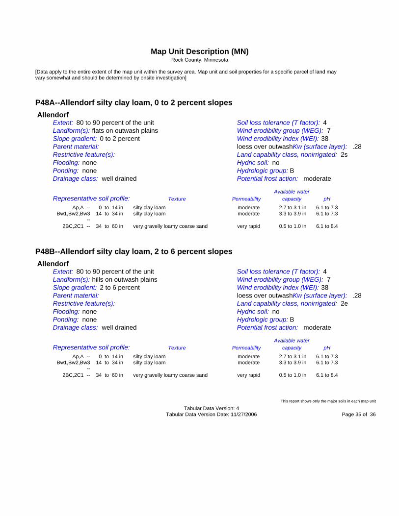
P48A--Allendorf silty clay loam, 0 to 2 percent slopes Allendorf Extent: 80 to 90 percent of the unit Soil loss tolerance (T factor): 4 Landform(s): flats on outwash plains Wind erodibility group (WEG): 7 Slope gradient: 0 to 2 percent Wind erodibility index (WEI): 38 Parent material: loess over outwashKw (surface layer): .28 Restrictive feature(s): Land capability class, nonirrigated: 2s Flooding: none Hydric soil: no Ponding: none Hydrologic group: B Drainage class: well drained Potential frost action: moderate Available water Representative soil profile: Texture Permeability capacity pH Ap,A -- 0 to 14 in silty clay loam moderate 2.7 to 3.1 in 6.1 to 7.3 Bw1,Bw2,Bw3 14 to 34 in silty clay loam moderate 3.3 to 3.9 in 6.1 to 7.3 -- 2BC,2C1 -- 34 to 60 in very gravelly loamy coarse sand very rapid 0.5 to 1.0 in 6.1 to 8.4
P48B--Allendorf silty clay loam, 2 to 6 percent slopes Allendorf Extent: 80 to 90 percent of the unit Soil loss tolerance (T factor): 4 Landform(s): hills on outwash plains Wind erodibility group (WEG): 7 Slope gradient: 2 to 6 percent Wind erodibility index (WEI): 38 Parent material: loess over outwashKw (surface layer): .28 Restrictive feature(s): Land capability class, nonirrigated: 2e Flooding: none Hydric soil: no Ponding: none Hydrologic group: B Drainage class: well drained Potential frost action: moderate Available water Representative soil profile: Texture Permeability capacity pH Ap,A -- 0 to 14 in silty clay loam moderate 2.7 to 3.1 in 6.1 to 7.3 Bw1,Bw2,Bw3 14 to 34 in silty clay loam moderate 3.3 to 3.9 in 6.1 to 7.3 -- 2BC,2C1 -- 34 to 60 in very gravelly loamy coarse sand very rapid 0.5 to 1.0 in 6.1 to 8.4
This report shows only the major soils in each map unit Tabular Data Version: 4 Tabular Data Version Date: 11/27/2006 Page 35 of 36

Map Unit Description (MN) Rock County, Minnesota
[Data apply to the entire extent of the map unit within the survey area. Map unit and soil properties for a specific parcel of land may vary somewhat and should be determined by onsite investigation]
P55A--Kato silty clay loam, 0 to 2 percent slopes Kato Extent: 85 to 95 percent of the unit Soil loss tolerance (T factor): 4 Landform(s): flats on outwash plains Wind erodibility group (WEG): 7 Slope gradient: 0 to 2 percent Wind erodibility index (WEI): 38 Parent material: loess over outwashKw (surface layer): .28 Restrictive feature(s): Land capability class, nonirrigated: 2w Flooding: none Hydric soil: yes Ponding: none Hydrologic group: B/D Drainage class: poorly drained Potential frost action: high Available water Representative soil profile: Texture Permeability capacity pH Ap,A,AB -- 0 to 21 in silty clay loam moderate 4.2 to 4.6 in 6.1 to 7.3 Bg1,Bg2 -- 21 to 31 in silty clay loam moderate 2.0 to 2.3 in 6.1 to 7.3 BCg -- 31 to 35 in sandy loam rapid 0.5 to 0.6 in 6.1 to 7.3 2Cg1,2Cg2 -- 35 to 60 in coarse sand rapid 0.5 to 1.0 in 7.4 to 8.4
W--Water Water Extent: 100 percent of the unit Soil loss tolerance (T factor): Landform(s): Wind erodibility group (WEG): Slope gradient: Wind erodibility index (WEI): Parent material: Kw (surface layer): Restrictive feature(s): Land capability class, nonirrigated: Flooding: Hydric soil: Ponding: Hydrologic group: Drainage class: Potential frost action: Available water Representative soil profile: Texture Permeability capacity pH
This report provides a semi tabular listing of some soil and site properties and interpretations valuable in communicating the concept of a map unit. It also includes commonly used conservation planning information in one place for easy access. Major soil components are always displayed and minor components are also displayed if they are included in the database and they are selected at the time the report is generated. This report shows only the major soils in each map unit Tabular Data Version: 4 Tabular Data Version Date: 11/27/2006 Page 36 of 36